Category Archives: The Thames

The Broomway and a London Airport

I am fascinated by both London, and the impact that London has had on the wider country. Even some of the most remote parts of the surrounding counties have felt the threat of London’s continual growth, and the infrastructure needed to service the rapacious city. To find such a place, and to walk what has been called the country’s most dangerous footpath, took me to Wakering Stairs in Essex last Sunday morning at 7am, ready to walk the Broomway.

Wakering Stairs

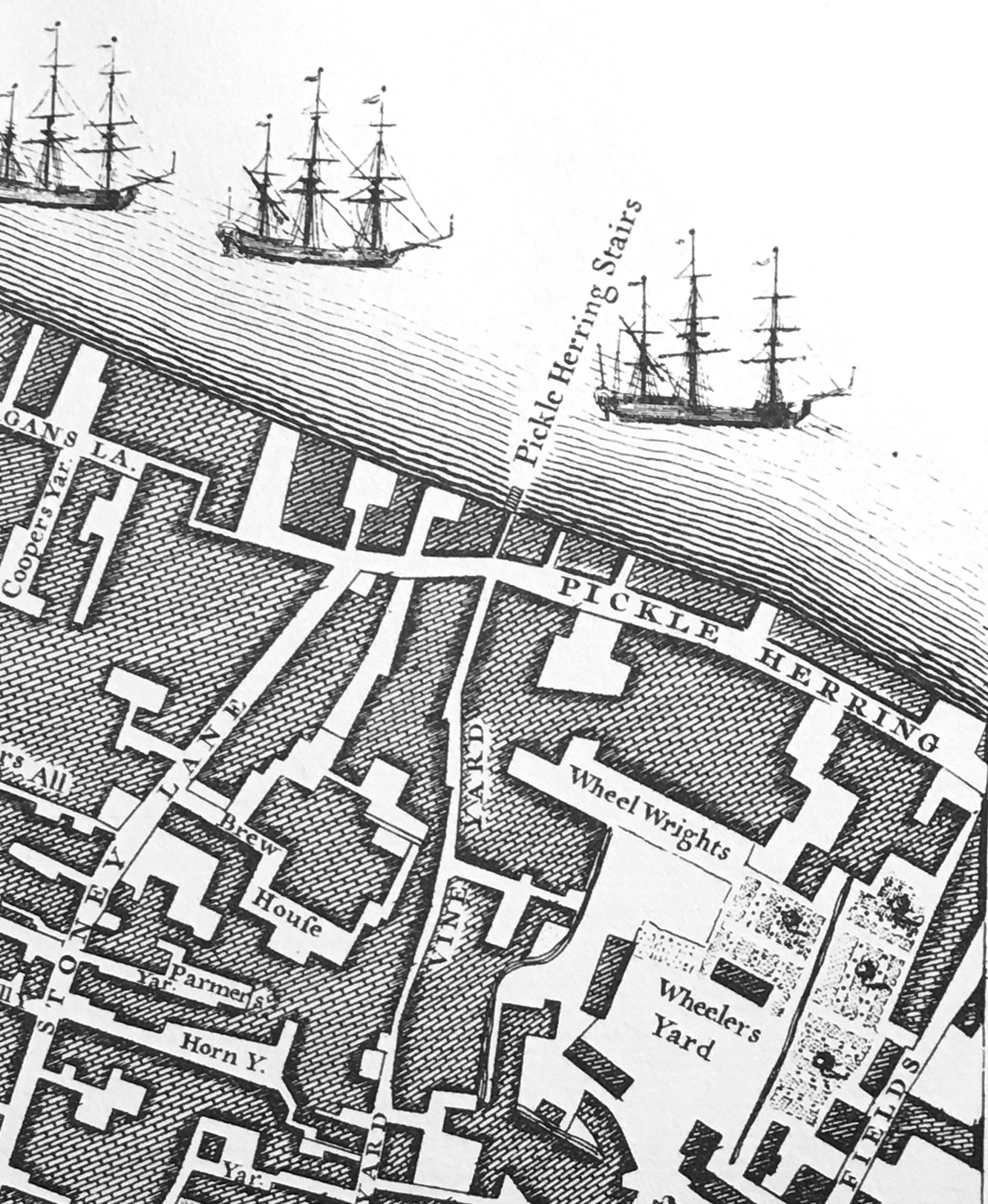
The Broomway is an ancient footpath, several hundred years old, that links mainland Essex at Great Wakering with Foulness Island.

Foulness is now mainly Ministry of Defence property, although it does have a small community living on the island. The MoD have built a bridge connecting with the mainland, however before the bridge was constructed, the only way for residents to get to and from the island was via a boat across one of the creeks and channels that surrounded the island, or via the Broomway.

The shore facing the wider Thames Estuary / extreme southern part of the North Sea is extremely flat and extends a considerable distance from land. This has resulted in a large area of flat sands that are either covered by water, or as exposed sand, mud and low lying water, depending on the tide.

The part of the shore close to land is comprised of a black organic mud, that is very sticky, can drag down someone who walks into this area, and is very difficult to get out of.

Further out, there are reasonably stable sands, however these still have their dangers. It is these sands that offer a route to travel between the mainland and Foulness when the tide allowed, and was marked by poles of Broom and was used for centuries as a route to and from Foulness.

I have long wanted to walk the Broomway. I am reasonably good at planning routes which involve the tide, walking over tidal mudflats etc. however the Broomway is not a route I would take without an expert guide.

Tom Bennett is qualified in a number of outdoor activities, and offers guided walks along the Broomway. These sell out quickly, but a number of months ago I was able to book a walk in October, not my preferred month due to the risks of autumn weather, but in the end, it turned out to be a perfect day’s walking.

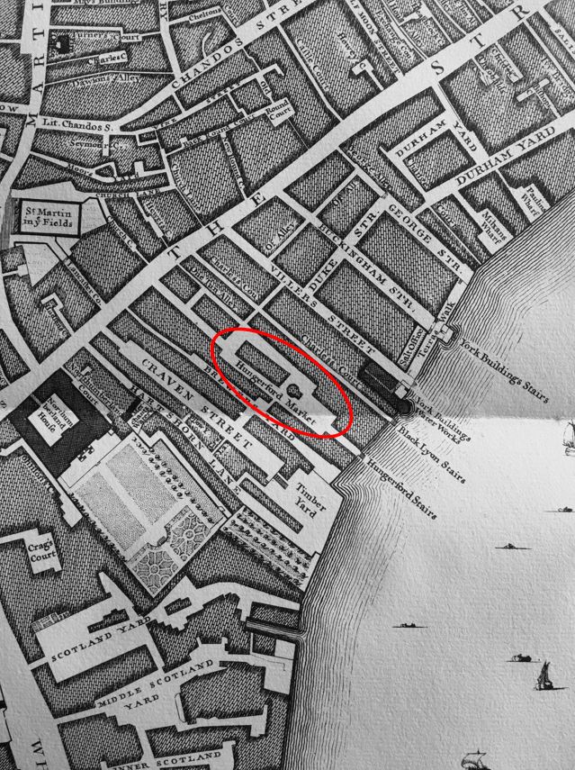
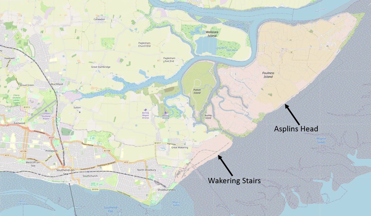
The route taken was between Wakering Stairs and Asplins Head, and the following map shows the location of these points, along with the location of Foulness, to the north-east of Southend (© OpenStreetMap contributors).

Foulness

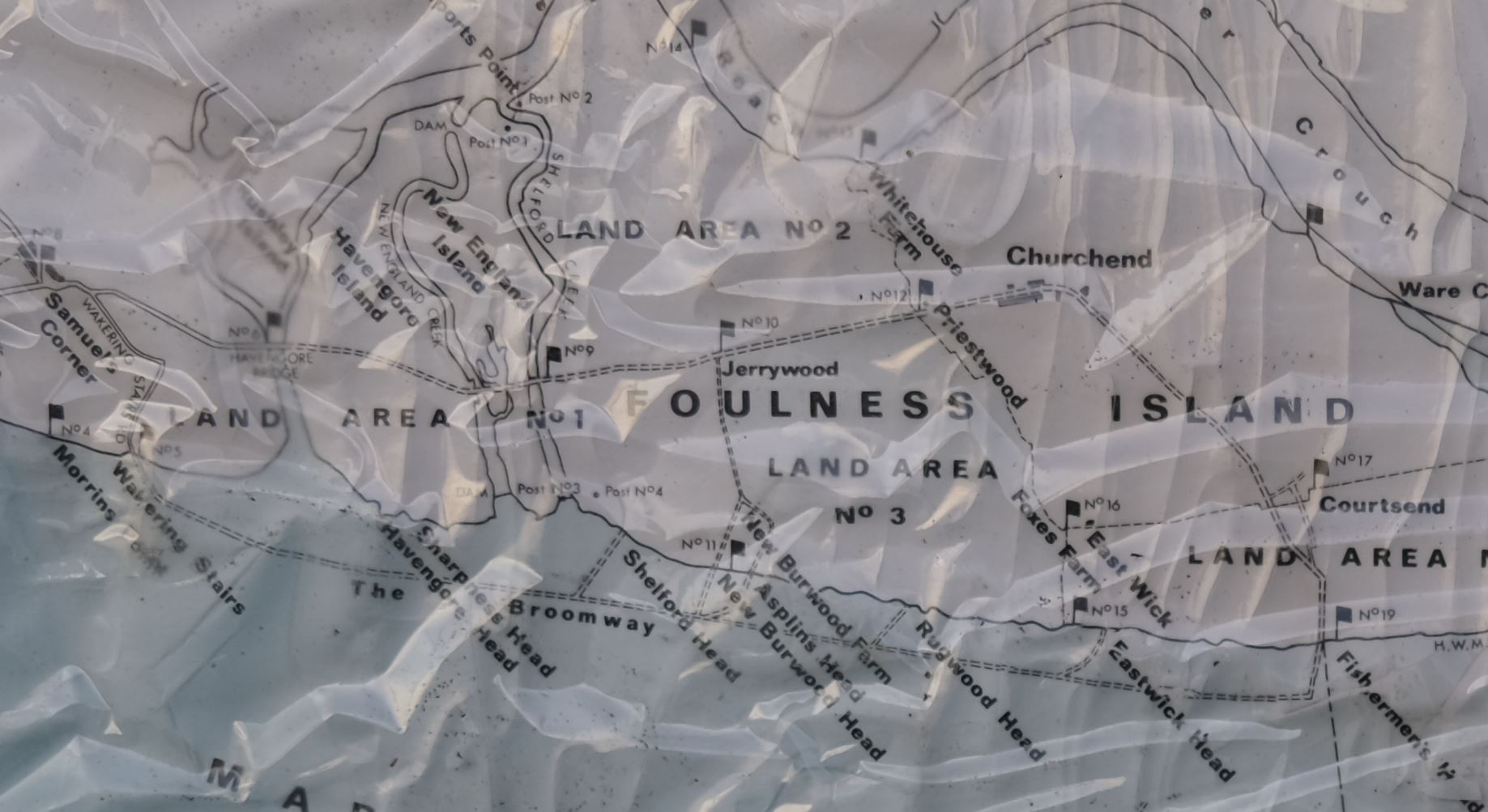
This is not the full route of the Broomway which originally went all the way along the easterly coast of Foulness, and there were a number of access points between the Broomway and the land.

I photographed the map on an information panel at Wakering Stairs, where there are plenty of warnings about the dangers of the area. The map shows the Broomway running parallel, but a distance offshore, to Foulness, and also shows the full length of the path, and the points where it is relatively safe to travel through the dangerous areas of mud near land and reach Foulness.

Map of Foulness and the Broomway

The time needed to walk the whole footpath, and return along the same route is such that it is difficult to avoid the incoming tide, so the walk last Sunday covered half the route.

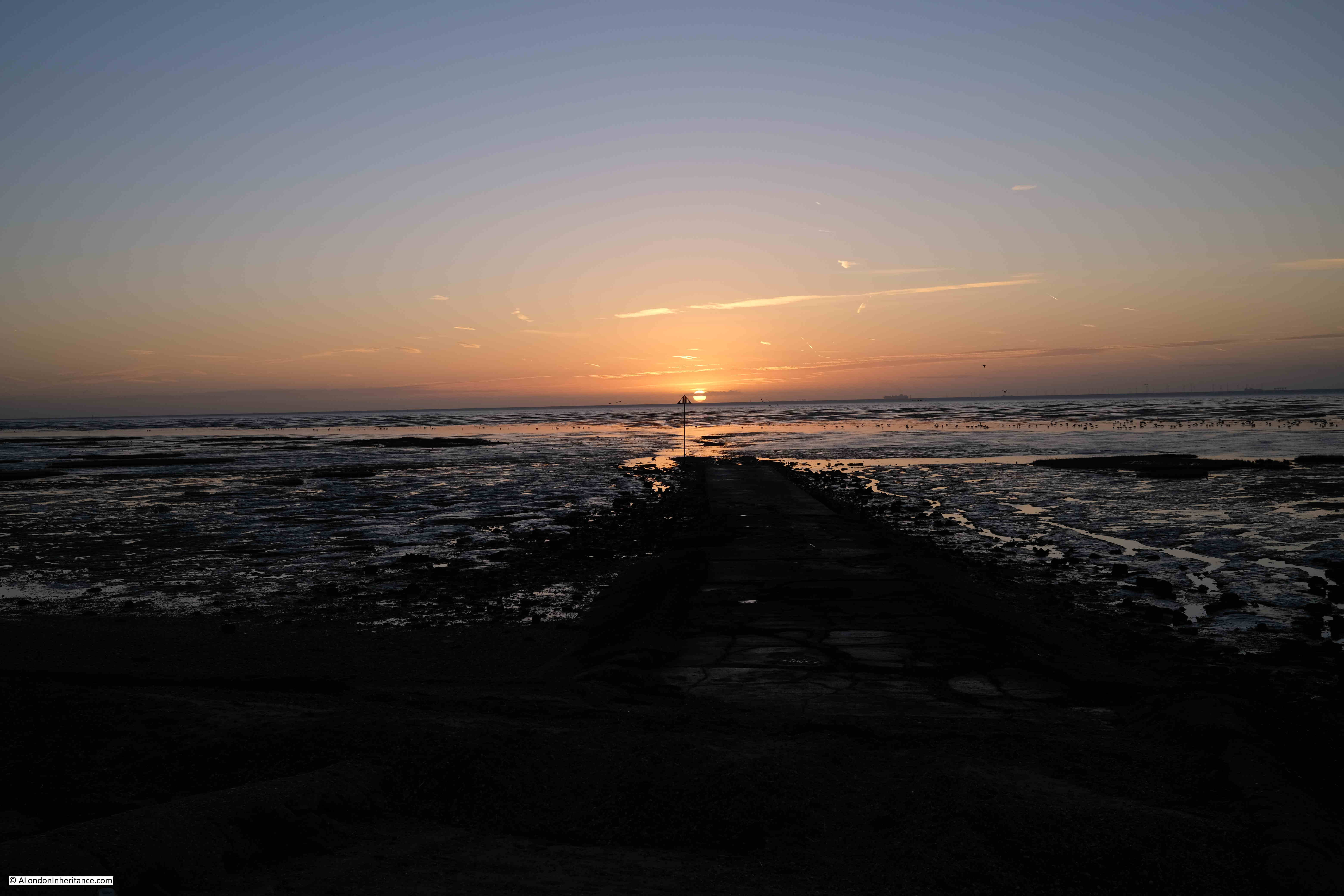
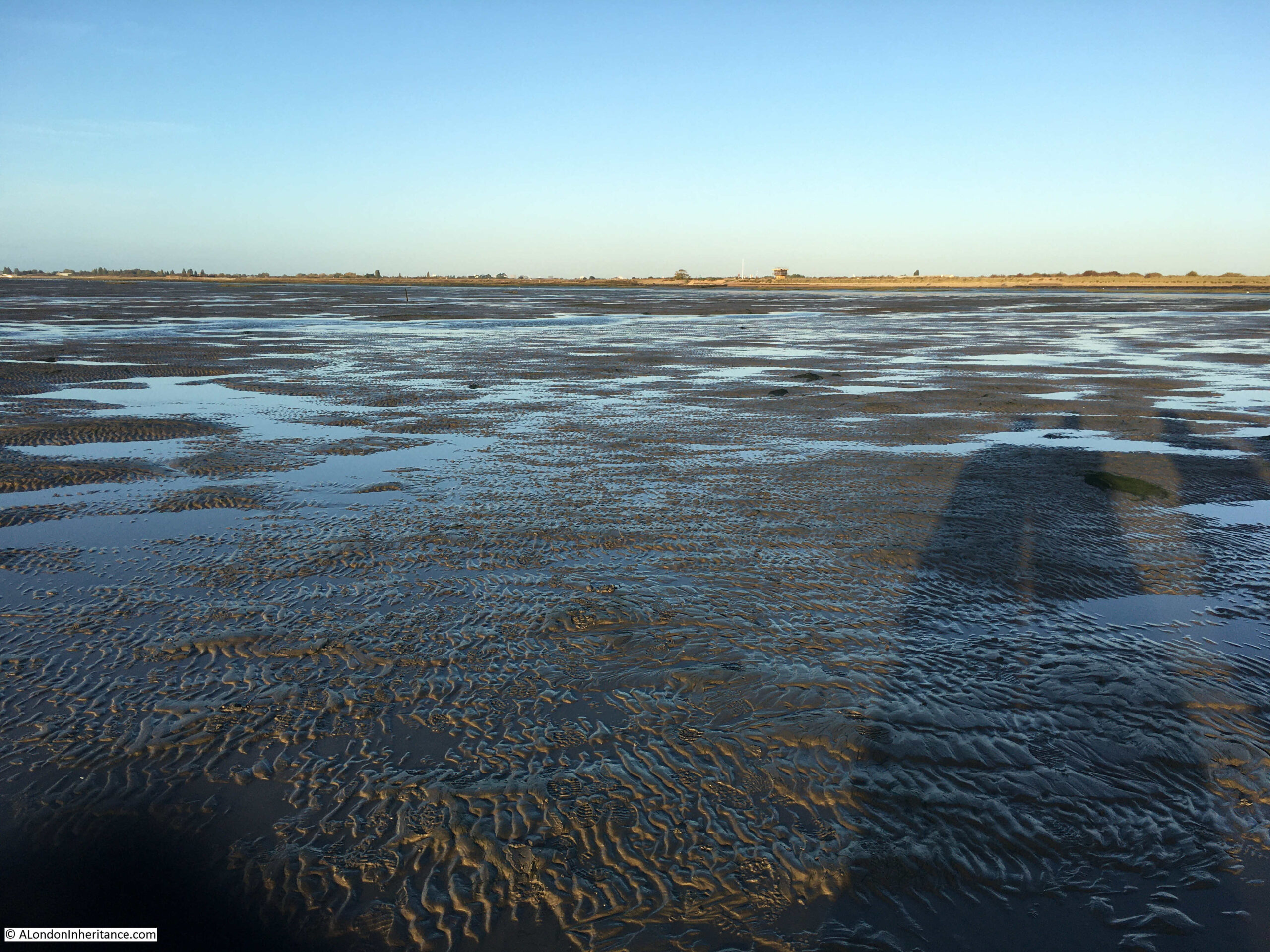
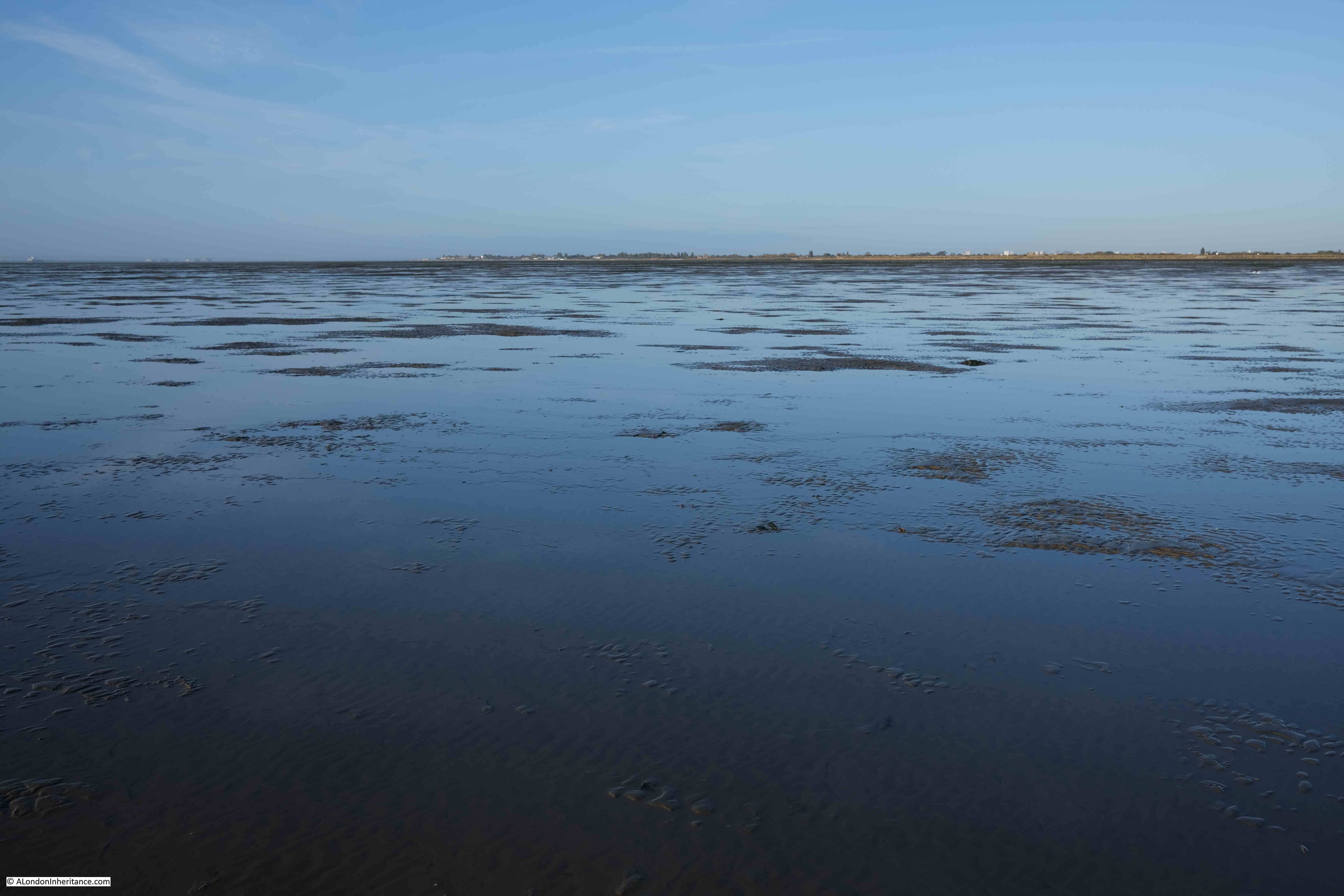
Standing at Wakering Stairs at seven in the morning, looking out over the mudflats is rather magical. The sun rising above the distant sea, the sounds of flocks of birds on, and flying above the mud flats:

Broomway

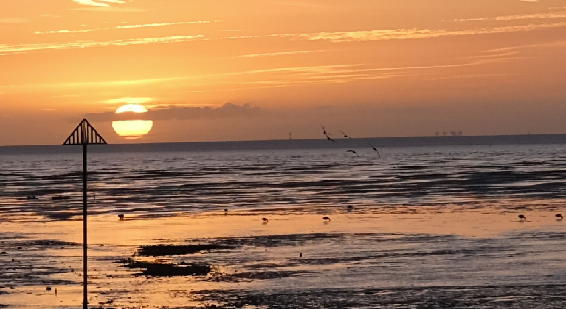
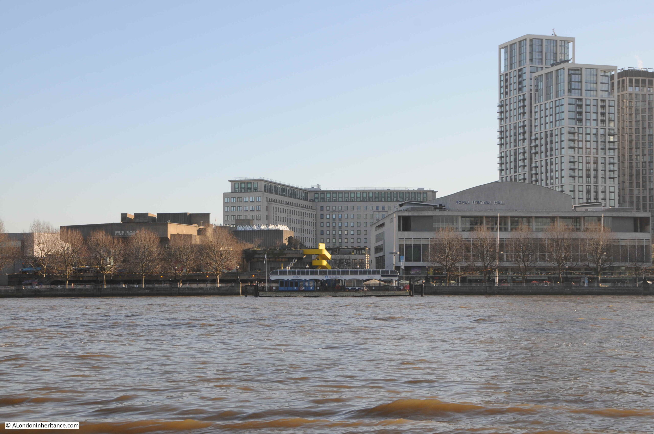
In the above photo, on the right, where the sea meets the sky, the Redsands Maunsell Fort can be seen.

So what is the London connection?

Maplin Sands is the name of the large area of sands offshore Foulness, and in the early 1970s, it was Maplin Sands and Foulness that almost became London’s third airport.

In the 1960s, London had two main airports, Heathrow and Gatwick. Air travel was growing rapidly, and this growth was expected to continue well into the future, so the search began for the site of a new airport.

In 1968 the Roskill Commission, also known as the Commission on the Third London Airport was formed, with the aim of investigating options, and making a recommendation for the location of the new airport. The commission was named after High Court Judge Eustace Roskill.

The locations were narrowed down to four, Cubington in Buckinghamshire, Foulness in Essex, Nuthampstead in Hertfordshire and Thurleigh in Bedfordshire.

The commission published their report in 1971, with a recommendation that Cubington in Buckinghamshire should be the site of the third London airport. The commission turned down the Foulness option mainly due to issues with accessibility, as Foulness was on an isolated part of the Essex coast, with no current, or easy to implement transport options. The commission feared that if transport options could be put in place, they would still be too far from central London, and airlines would continue to prefer Heathrow and Gatwick.

The Government turned down this recommendation, and went for Foulness which had been put forward in a separate report by Professor Colin Buchanan, a dissenting member of the Roskill Commission.

The reasons for this decision were the avoidance of significant impact to countryside and people, there was pressure from well funded groups opposing Cubington. Essex County Council were in favour of Foulness, and it was seen as a way to regenerate the area around Southend.

In the 1972-73 Parliamentary Session, the Maplin Development Bill was introduced and the Maplin Development Authority was set-up, which would have the responsibility for the development of the land, which, as well as the airport, would include a deep water port and new town, along with the transport links needed to connect the new airport to London, and the rest of the country.

The airport was supported by the then Conservative Prime Minister, Edward Heath, however it would not last long, with only minimal works to test whether the Maplin Sands could be reclaimed for the construction of the airport.

In March 1974 the Labour Party took over in Government, and commenced a review into the airport. In july 1974 the review was published and Peter Shore, the Labour MP for Stepney and Poplar announced that the Foulness / Maplin Airport project would be abandoned.

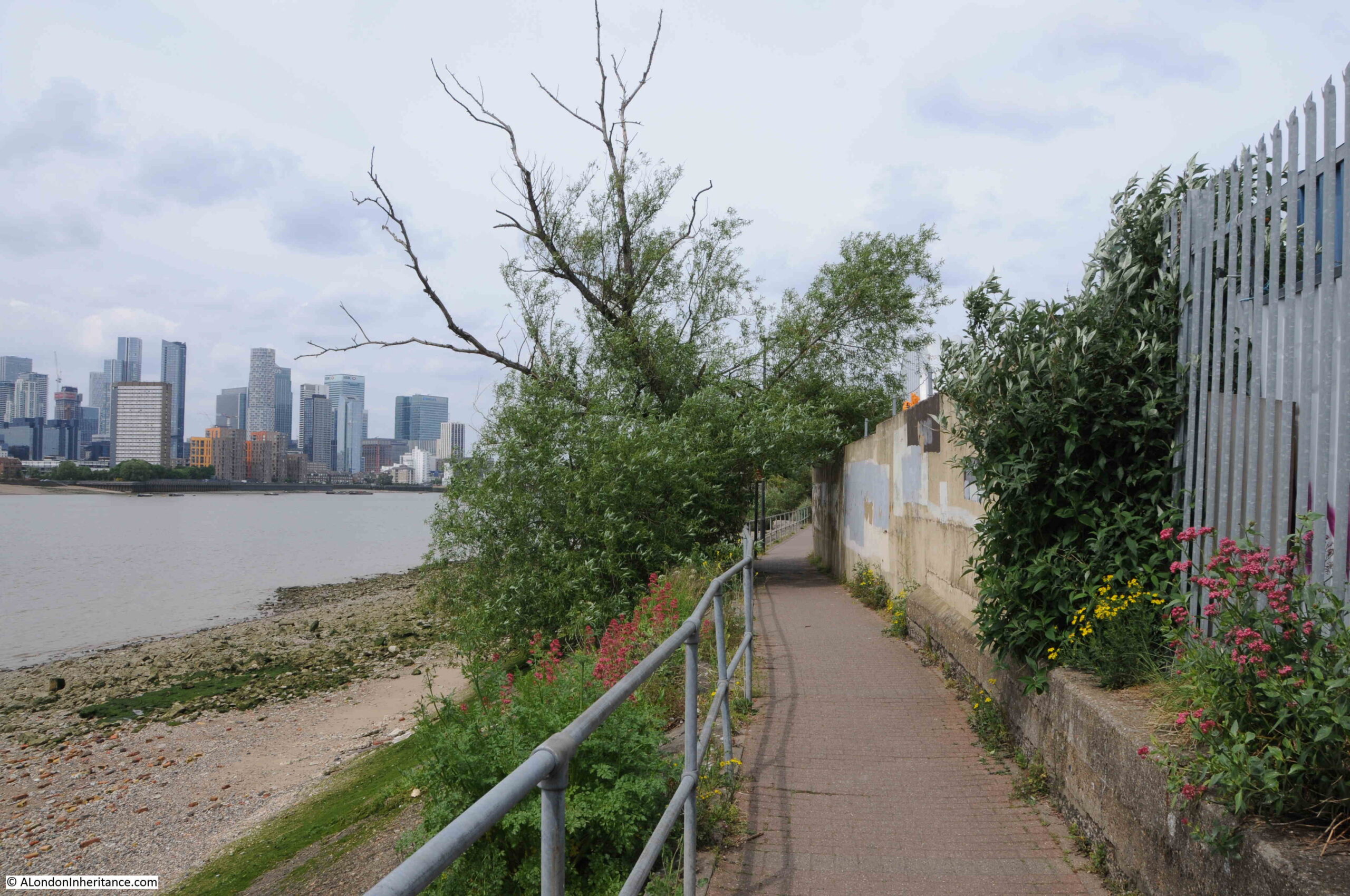
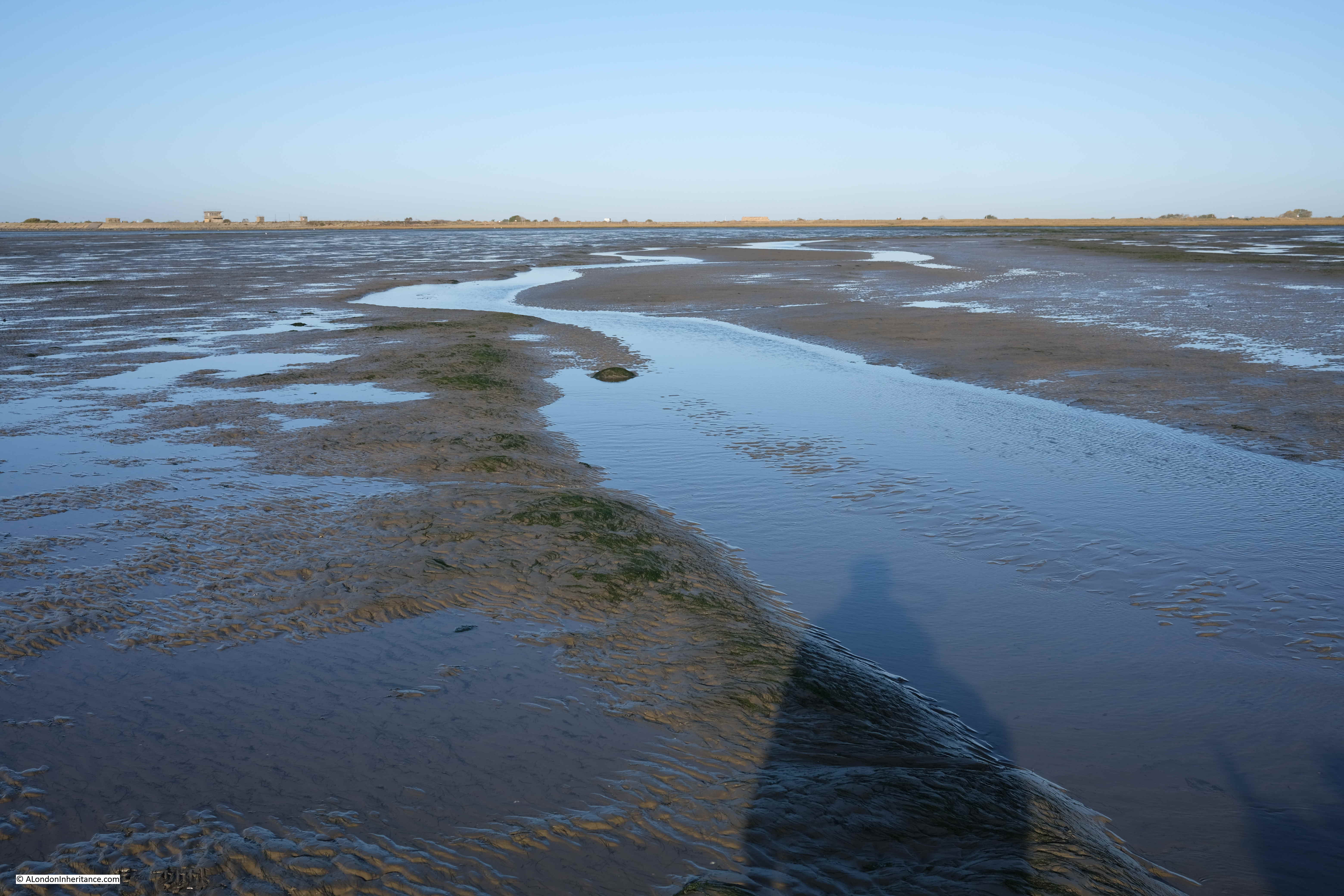
Back to the Broomway, and the walk over what could have become the third London airport, started at 7:30 am. The walk left Wakering Stairs and headed out, away from the coastline, and the dangerous mud. The following view is out on the Broomway, looking back towards Wakering Stairs:

Broomway

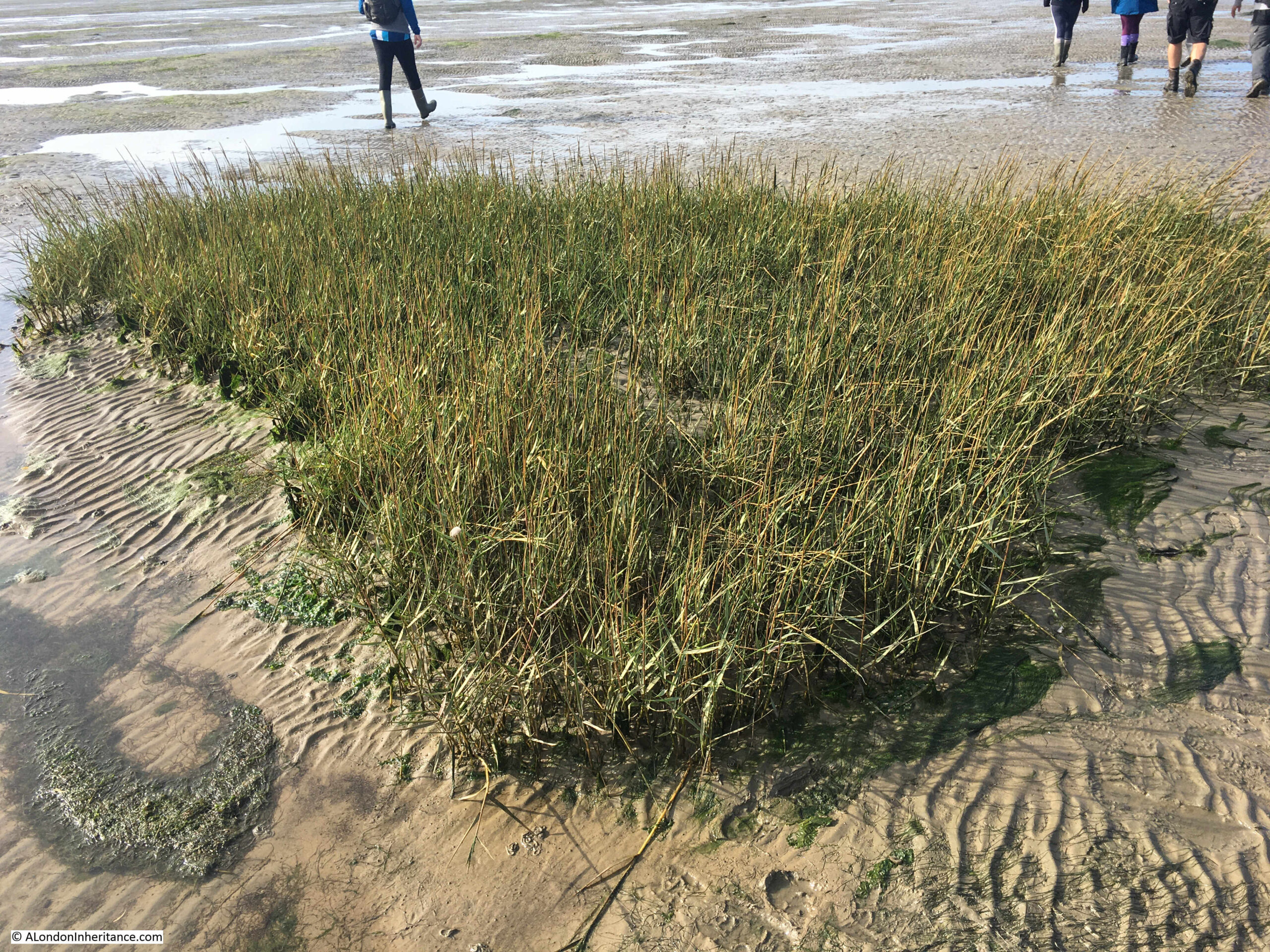
The above photo shows large expanse of sands and water with hardly any landmarks. The first we reached was a small patch of grass growing in isolation:

Broomway

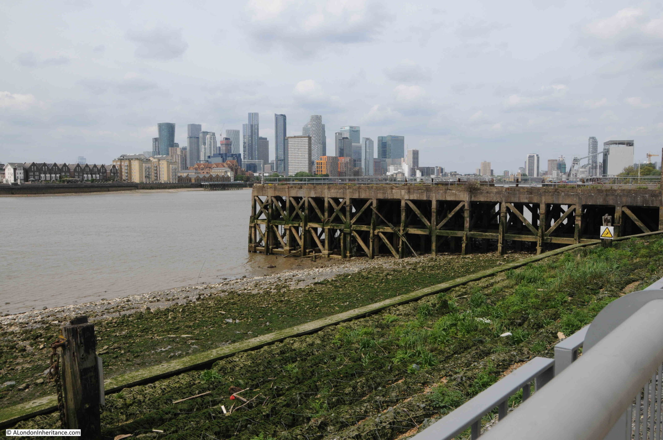
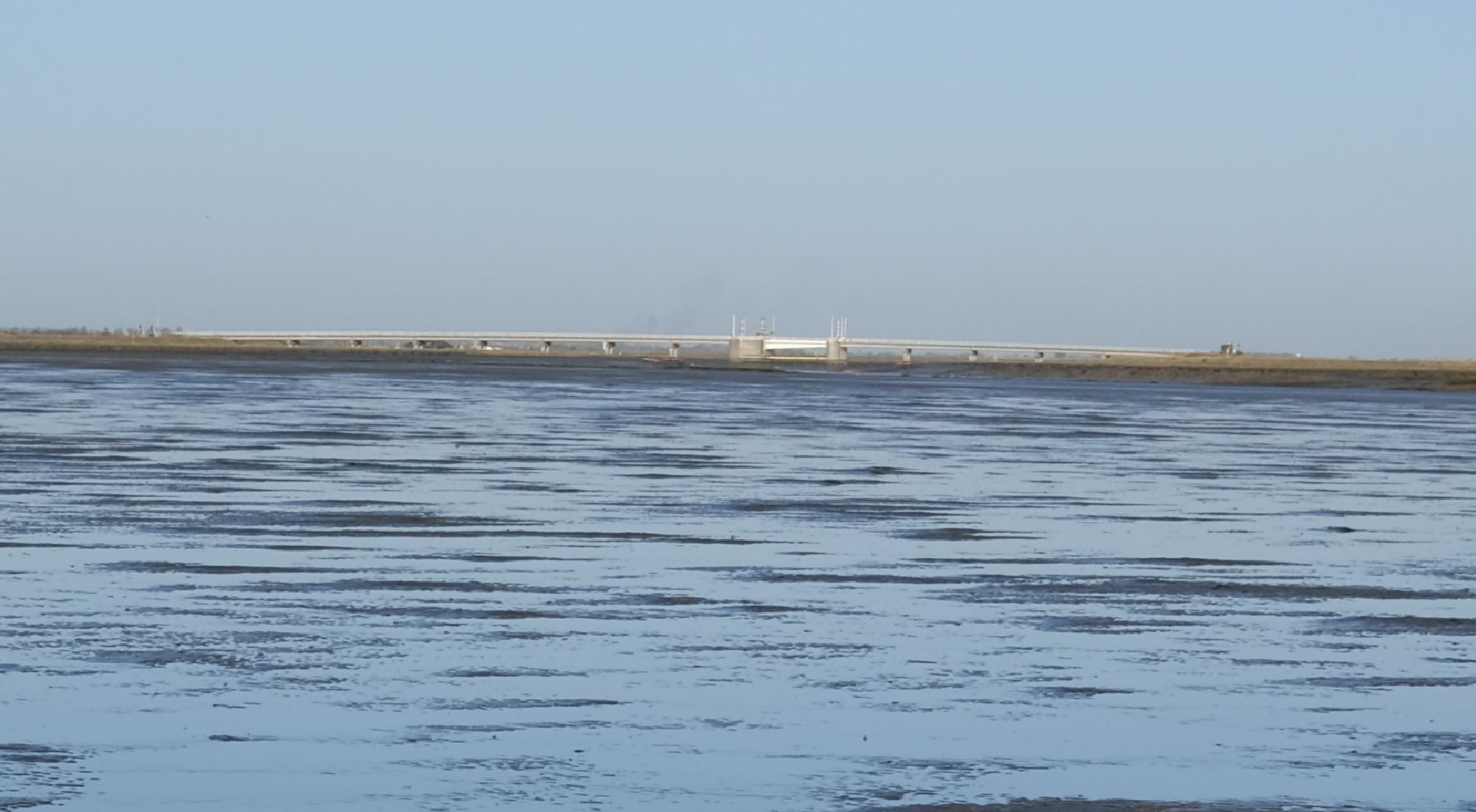
To the south, Foulness is separated from the mainland by the Havengore Creek. Today, there is a bridge over the creek which is part of the upgraded roads along Foulness used by the limited number of occupants, and primarily by the Ministry of Defence (MoD).

In the following photo the Havengore Bridge can be seen in the distance as we walk over the sands where the creek flows into the sea.

Broomway

The island’s connection with the MoD starts in the mid 19th century when the War Office used sands to the south as an artillery range. The War Office tried to expand to the north and attempted to purchase Foulness Island from the Lord of the Manor, however he refused, although the War Office started to buy up any land or farms that became available.

When Alan Finch, the Lord of the Manor died in 1914, his half-brother inherited the estate and agreed to sell to the War Office, who then owned over two thirds of the island.

Since 1915, Foulness has effectively been a closed island. Mainly used by the MoD for weapons testing, but with a small community remaining and some farming.

The Essex Weekly News on the 18th of December 1914, described the island as:

“AN OLD WORLD PLACE – If Foulness island becomes simply a military area we shall see there after two thousand years an instance of how history repeats itself. The Romans selected Mersey Island further along the Essex shore as a military camp, and fortified it against invasions by Norsemen. Now another foe, equally barbarous again threatens us from the North Sea.

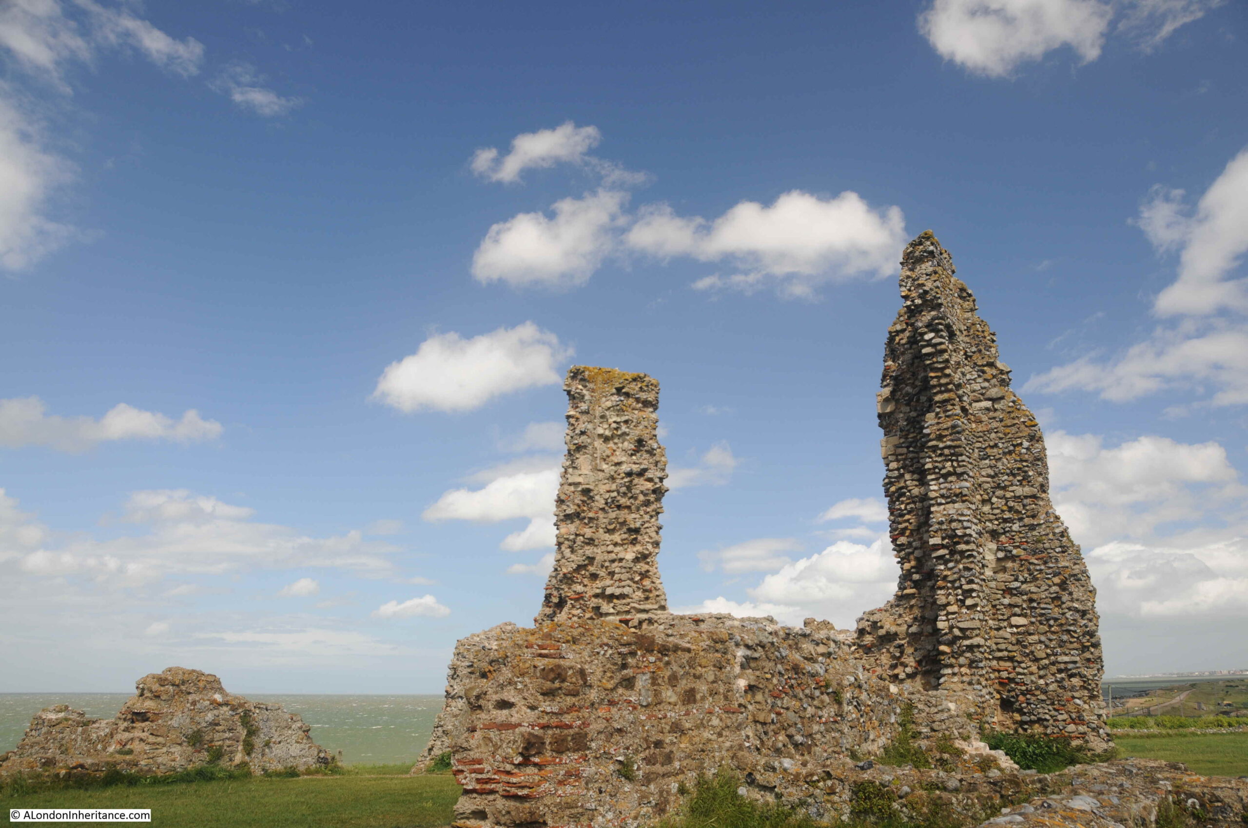
Foulness is very flat and scantily wooded, and but few farm houses and cottages are in view, although there is a population of about 480. The island was constituted a parish in 1550. The Parish Church erected in 1850 on the site of a series of wooden buildings, is dedicated to St Mary.

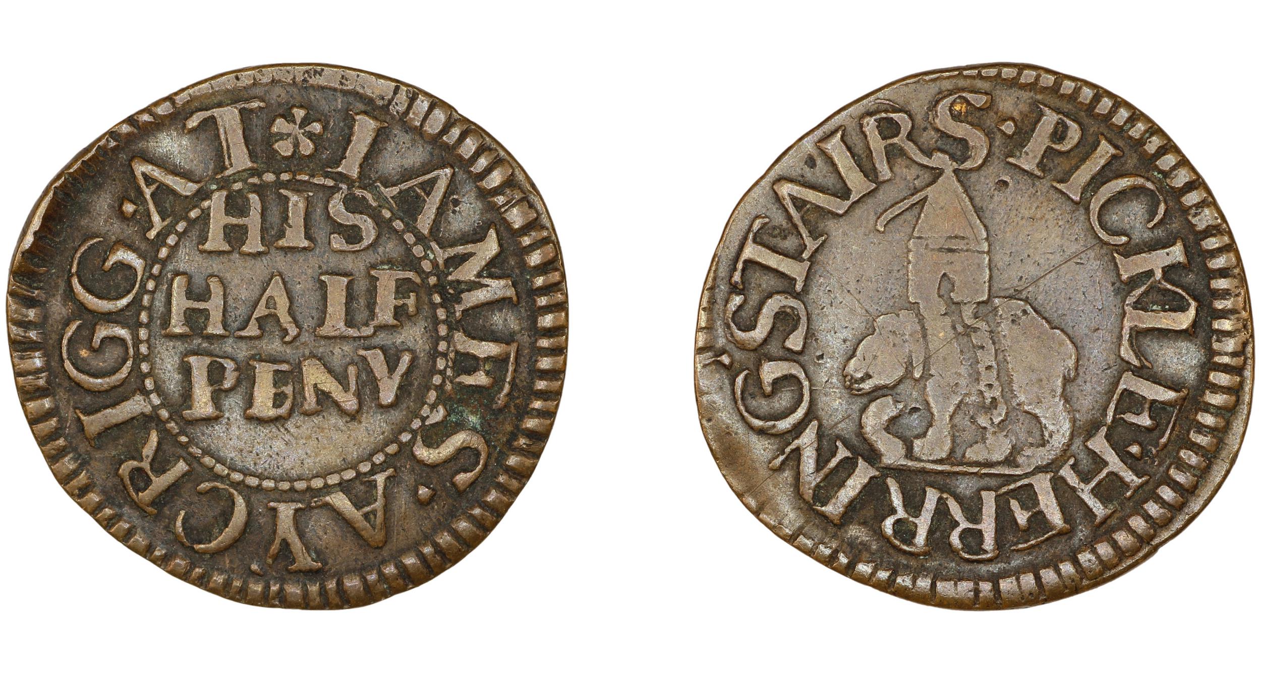
The nearest point on the mainland to Foulness is Great Wakering from whence as a spot known as “The Stairs” it is reached at low tide by a headway over the sands. Stubby tufts of broom stuck in the sand about thirty yards apart mark the way for the traveler. There have been some narrow escapes by those who have ventured along this wave-washed road; and indeed few experiences are more alarming than to find one-self along the ‘Broom-way’ as the road is called, a couple of miles from land in the dusk of a winter’s day with the tide beginning to race across the Maplins.”

Once out on the Broomway, it is easy to appreciate the risks whilst walking along this “wave-washed road”. You are separated from land by a dangerous area of mud. There are no visual reference points. The land is so flat that when the tide comes in, it does so rapidly. Not an incoming visible wave of water, rather a deceptive rise in the water level all around that cuts you off from the land.

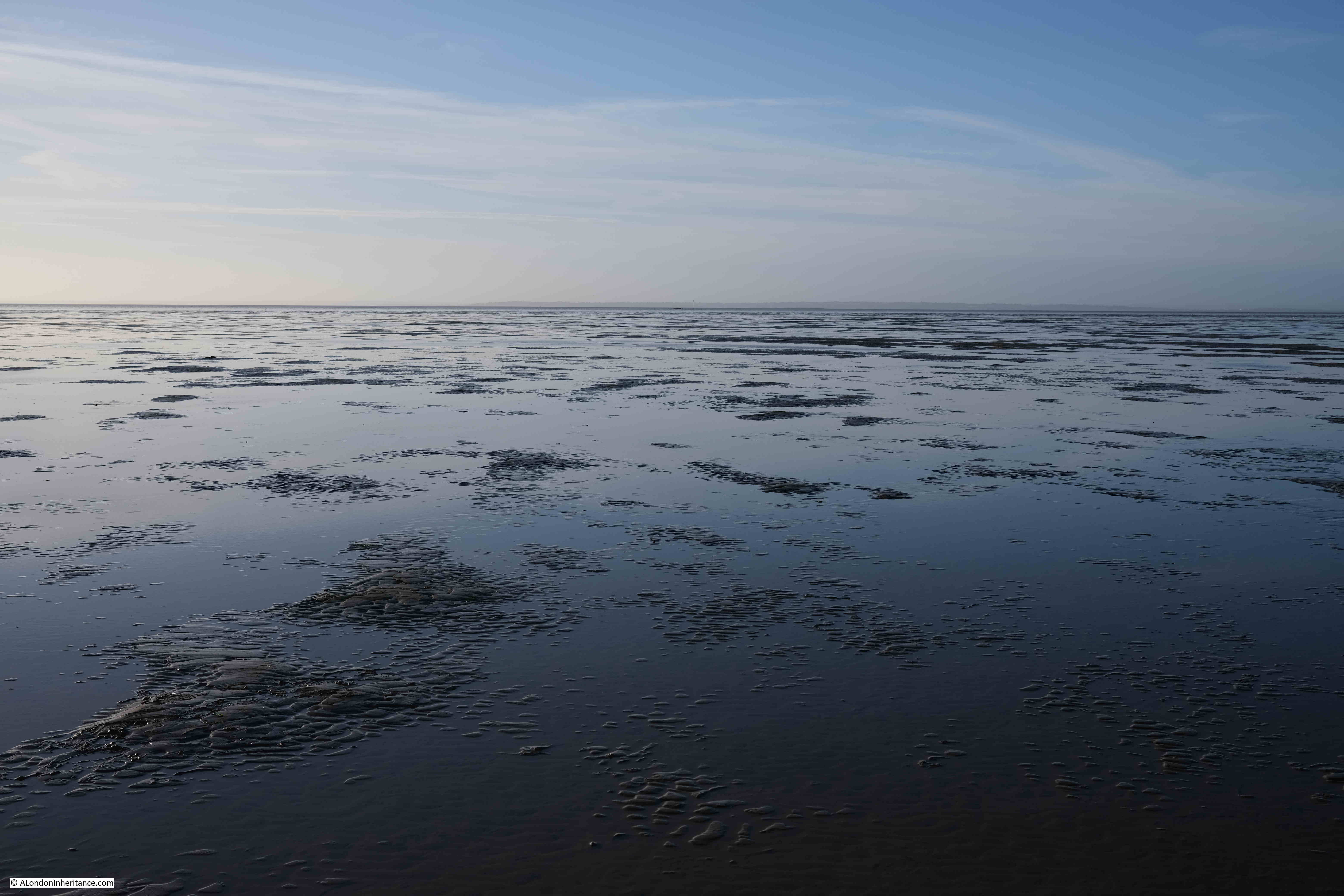
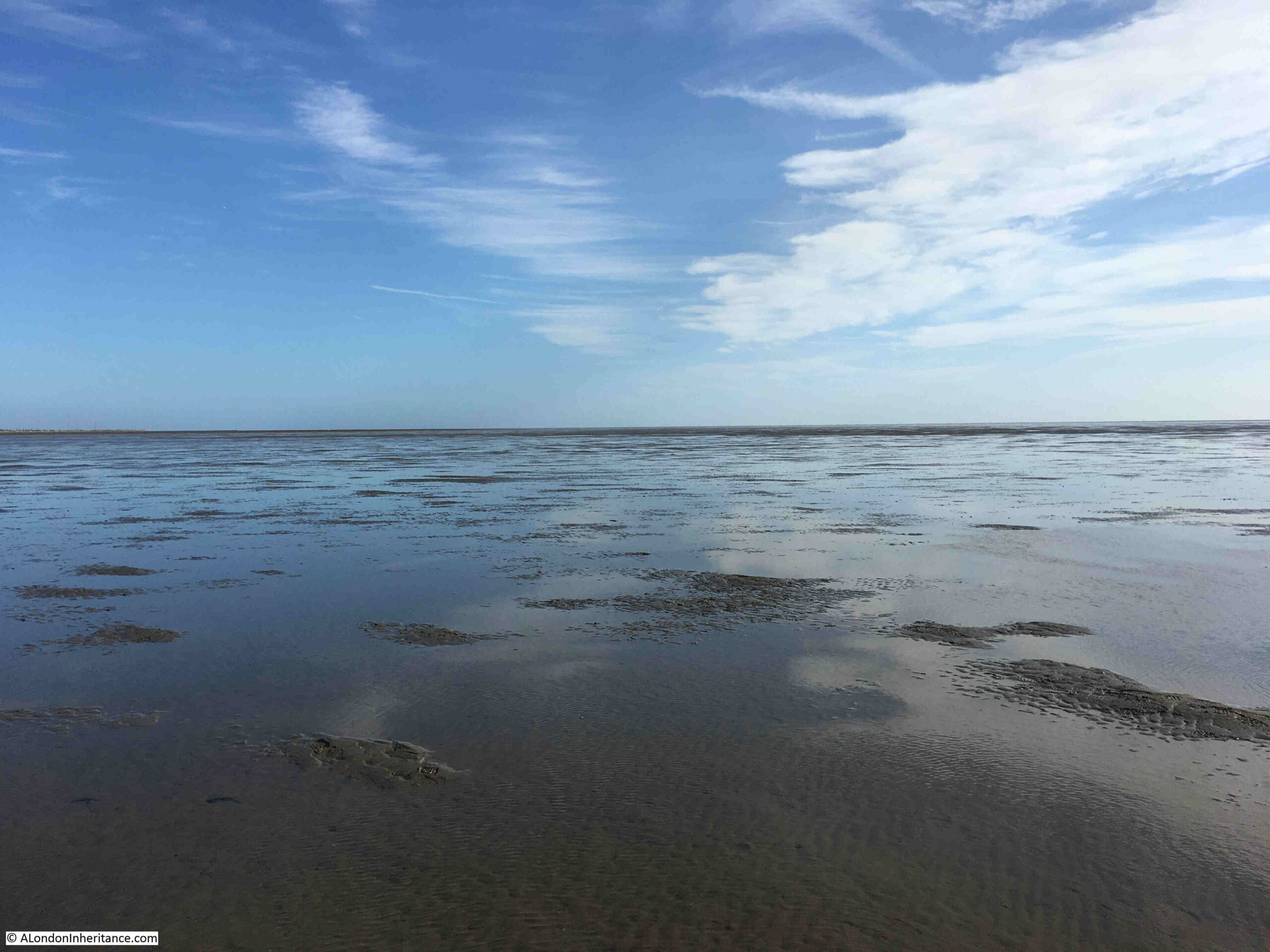
The following view is looking out to sea from the Broomway. The sea is not visible, just an endless scene of sand and water until the horizon meets the sky:

Broomway

And in the following photo, looking back to land from the Broomway, which is now a narrow strip on the horizon, with the “Black Grounds” of dangerous mud separating you from the safety of the land.

Broomway

The military use of Foulness caused additional risk to those navigating the Broomway. The area was used for training and the test firing of guns and ammunition. This use continues to this day, and there are large warning signs at Wakering Stairs advising that “Do not approach any object or debris as it may explode and cause serious injury or kill”.

Newspaper reports illustrate the risk when the Broomway was in use by Foulness residents, as the following from the Southend Standard and Essex Weekly Advertiser on the 1st of December 1910 reports:

“FACING DEATH AT FOULNESS – EXCITING INCIDENT ON THE BROOMWAY: For a long time there have been many loud complaints from the people whose vocation causes them to use the road known as the Broomway from Wakering Stairs to Foulness Island, as to the serious danger which is caused by the gun practice from the Garrison at Shoeburyness.

On Tuesday last two people were driving across the Broomway when they had the narrowest of escapes from death, or serious disablement, by the bursting of a shell. They were in two traps, a few yards behind each other, and their attention was drawn to the gun firing which was going on from the Garrison. Naturally enough they felt no fear of danger, as the Broomway is on the edge of space allowed for practice is a mile or more away.

Several shots passed a safe distance away, but suddenly one great shell ploughed into the mud not more than thirty yards away and burst with a loud explosion. Vast quantities of mud and water were thrown out in all directions, and some of it, in great lumps, struck the two gentlemen who were driving, So great was the force of the explosion that a hole many feet long and deep, big enough to hold a wagon and team, was dug out. The horses were scared, and it was only with considerable difficulty that they could be prevented from bolting.”

The Broomway is only accessible from Wakering Stairs at the weekend as during the week, Foulness is still used for live firing.

Continuing the walk along the Broomway, and the most significant landmark on the sands comes into view. This is the Havengore Maypole:

Havengore Maypole

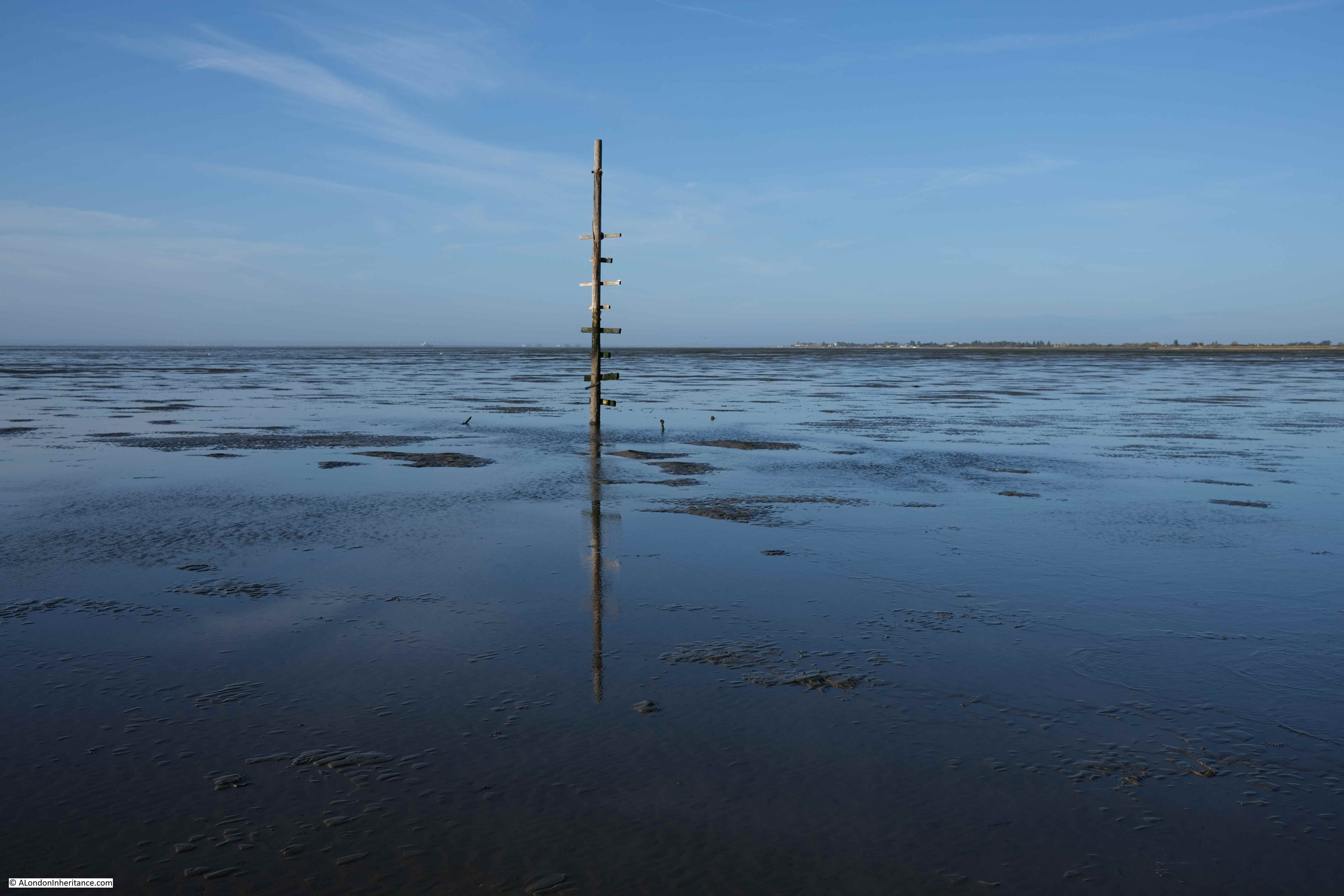
It is known as the Havengore Maypole as it marks a channel into Havengore Creek much further to the coast, and was once held in place by cables extending from the top of the pole to moorings in the sands, one of which can be seen to the left of the pole on the following photo:

Havengore Maypole

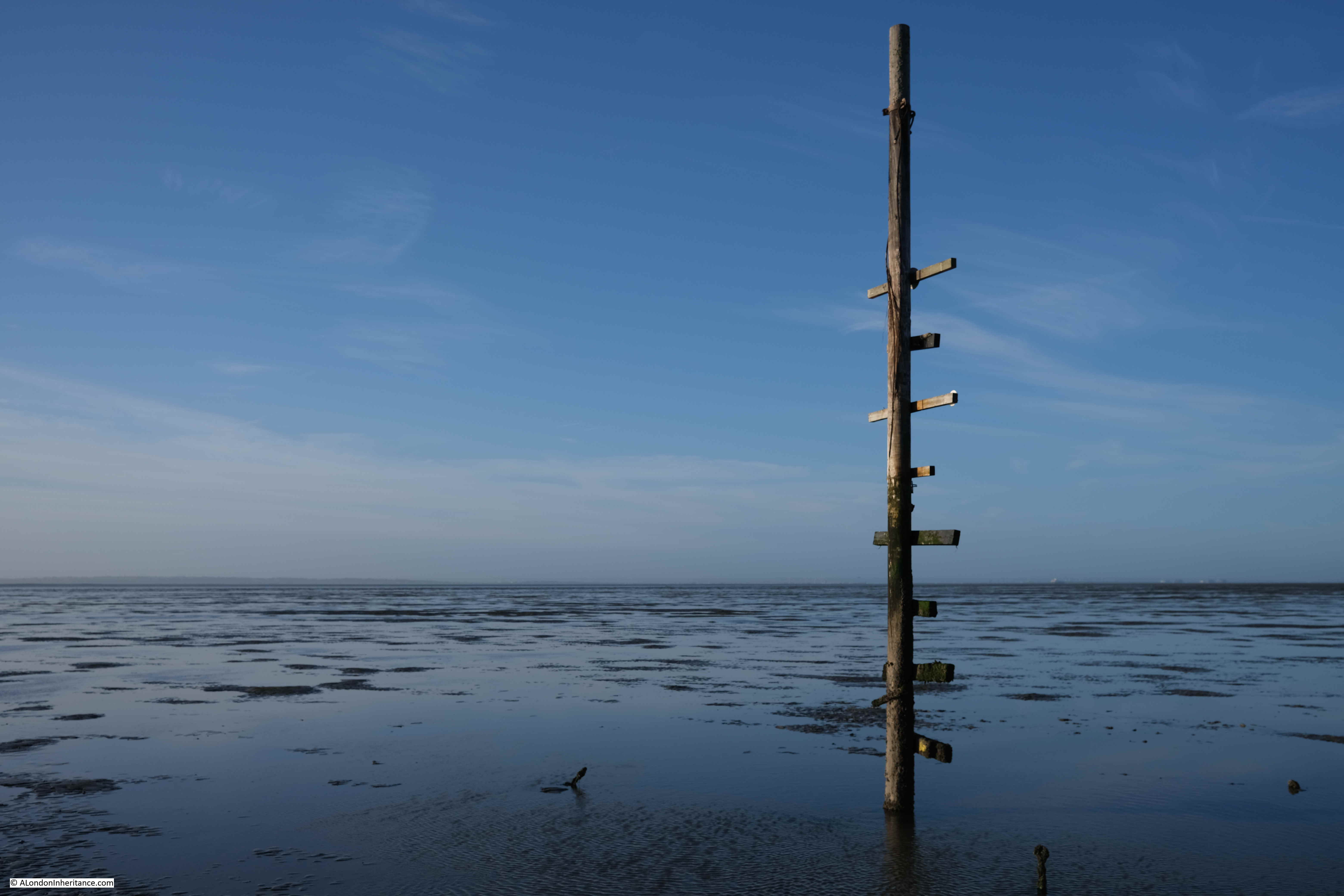
The Havengore Maypole is a significant marker in the wide expanse of featureless sand and water, however it was surprising how difficult it was to see from any distance. This is a problem with navigating the Broomway in that everything seems to blend into a featureless landscape, including the distant sea and land.

The weather on the day of my walk was really good. Clear skies, light wind and good visibility, however the Broomway is also at risk from sea fogs and mists which can roll in rapidly leaving a walker lost in a grey fog with no idea of the direction of travel.

There are stories of people being lost in fogs and walking out to sea rather than towards land.

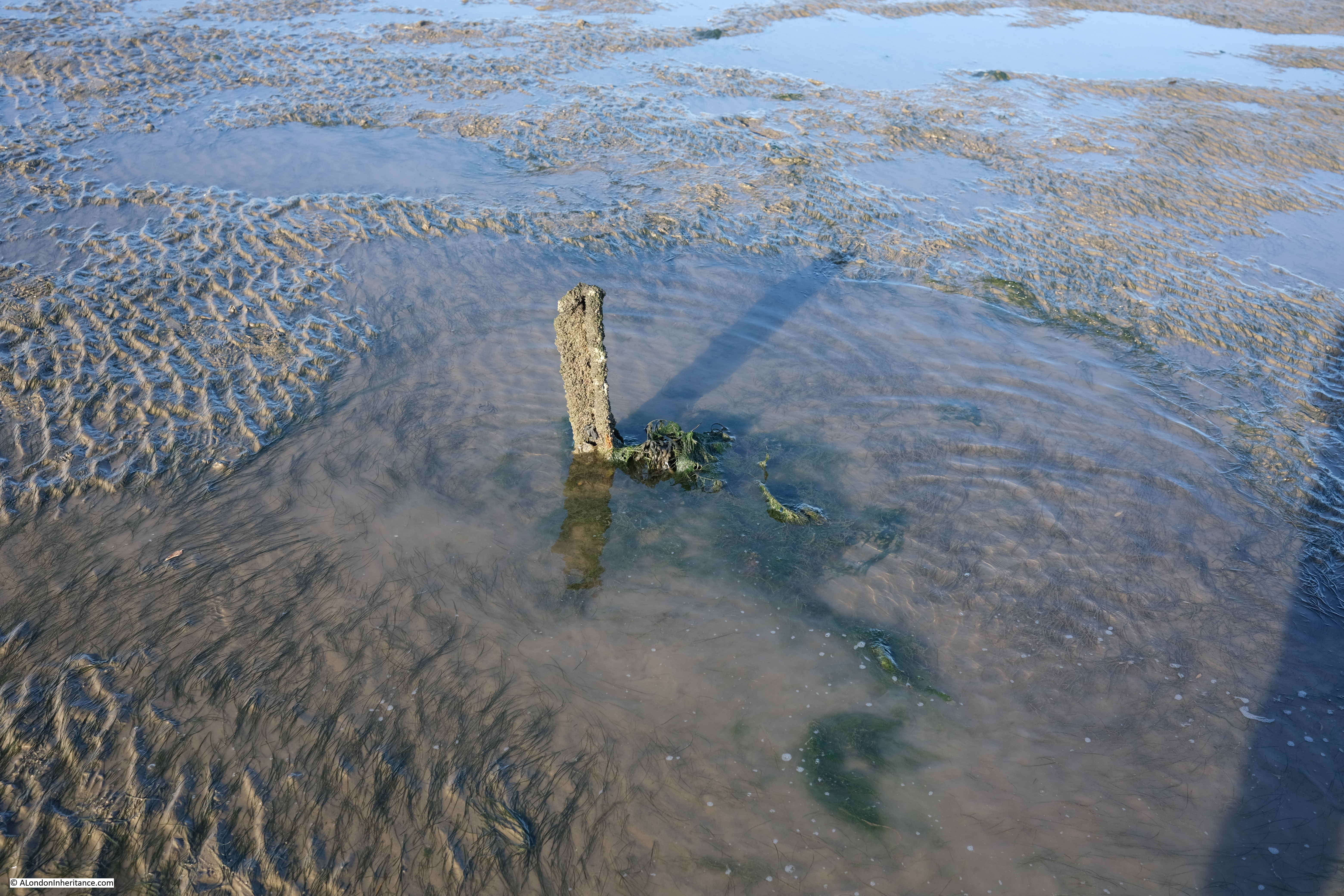
The name Broomway comes from the use of sticks of Broom placed in the sands at regular intervals. By following these sticks, the traveler had confidence that they were on a safe route. They only then had the tide, fogs and the risk of an exploding shell to worry about.

There are very few of these markers left today, just the occasional base of a pole sticking out of the sands:

Broomway

For centuries the Broomway was the main route between Foulness and the mainland. There is written evidence of its existence back to the 16th century, and it is probably much older.

It was used by all manner of means of transport. Coaches, pony and traps, bikes, walkers. Newspaper reports of travel along the Broomway mention that the Postman had one of the most dangerous jobs as he had to travel the Broomway on an almost daily basis.

Even at low tide the sands are covered by pools of water and there are a number of larger channels of water to cross:

Broomway

Maplin Sands – Nothing but sand, water and sky, and somewhere in the distance is the sea with the returning tide:

Maplin Sands

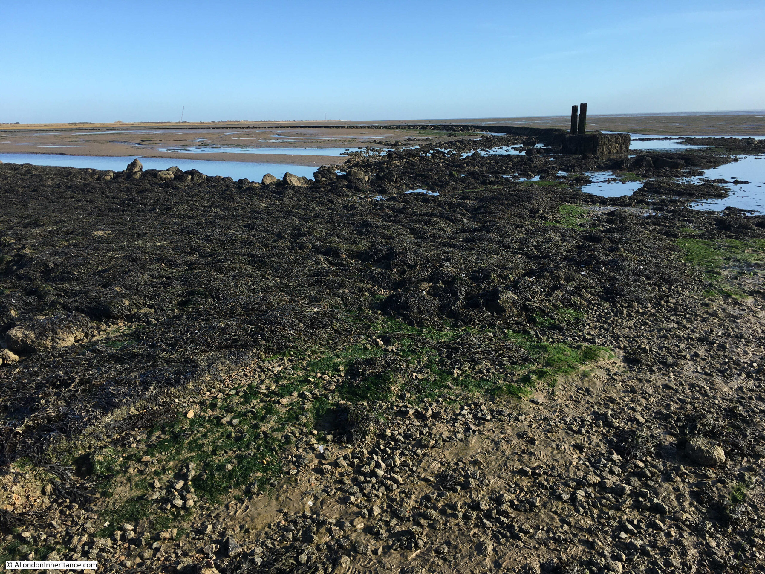
After 5km of walking across the sands, we reached Asplins Head, the point where there is a causeway across the dangerous muds providing a safe route onto Foulness. The following photo shows the end of the causeway furthest from the land. It is a jumble of rocks and broken concrete.

If you look to the left half of the photo, where the sands meet the sky, you can make out a low wall. Apparently this enclosed an area that was used to test how fuel burnt with fuel being pumped into the space bounded by the wall and set on fire.

Asplins Head

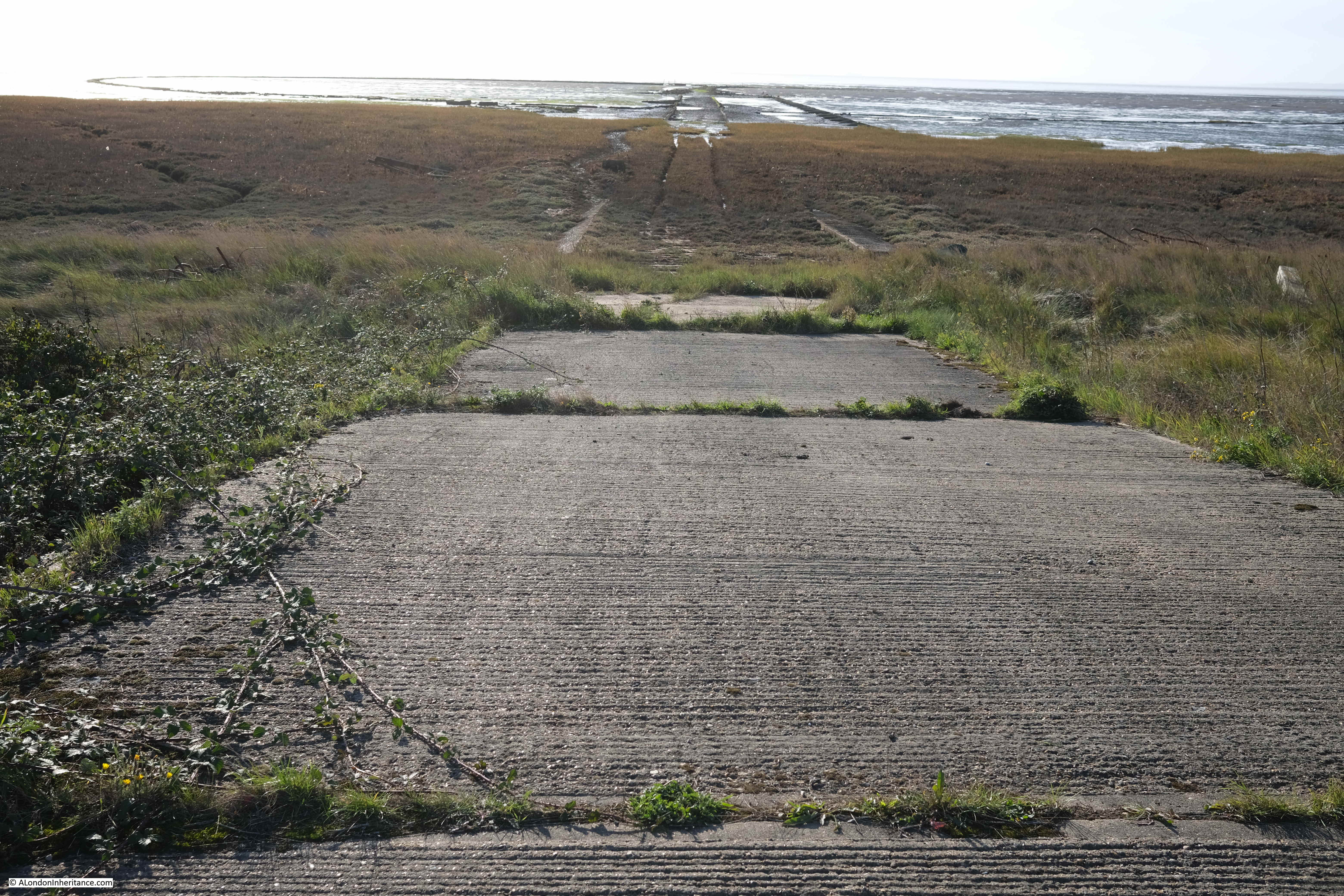
The view towards Foulness showing the length of the causeway:

The view from Foulness along the Asplins Head causeway. The low wall of the circular enclosure for fuel testing can be seen on the sands to the left:

Asplins Head

Whilst the Broomway continues further than Asplins Head, continuing on the route at a reasonable walking pace, and being able to return to Wakering Stairs is a risk with the returning tide, so Asplins Head is as far as the walk took us along the Broomway.

After a short break, it was then a final 5km walk back along the Broomway to Wakering Stairs.

The Broomway is a fascinating walk. Despite the proximity of the MoD, and the use of the sands for weapons testing, Maplin Sands still feels very natural. Large flocks of wadding birds are further out on the sands, and the casts of lugworms are frequently seen on the sands.

The area had a lucky escape in the 1970s when plans to build the third London Airport on Foulness and Maplin Sands were cancelled.

The remote areas of the Thames Estuary have been the focus for a number of airport proposals over the decades. See my post on the Crow Stone, London Stone and an Estuary Airport for an example of the most recent proposals for an airport on the Isle of Grain and the Hoo Peninsula in north Kent.

Researching the history of the airport proposals, and at the time there was much support for an airport at Foulness, both within the local area, and from around London.

Two examples show very different reasons for supporting the proposals.

Toby Jessel, the MP for Twickenham was a vocal supporter of the Foulness airport. He had long been raising issues with the increasing number of flights at Heathrow, the disruption that noise caused to residents, and even the risk of an aircraft crash in heavily populated areas of London as the number of flights increased. He also saw Foulness as the option that would result in less damage to the countryside compared to the inland options.

There was also an article in the Stage and Television Today on the 19th of October 1972, which I found amusing as it relates to the opening of a club / disco in Southend that I frequented in the late 1970s – Talk of the South (better known as TOTS), and that its opening was down to the possibility of Foulness Airport:

“Southend, and more generally speaking the South of England, have been left out on a limb as it were as far as good cabaret facilities are concerned and it is fair to say that it was not without consideration of the new Foulness Airport, Britain’s new number one air terminal, that the idea of a delux cabaret club was formed.”

TOTS closed a couple of years ago, but it lasted for much longer than the airport proposals.

The Broomway is not a walk to take without the experience and skill needed to plan and navigate a path a long distance from shore, covering dangerous sands, and at risk of a rapidly incoming tide and changing weather conditions.

I booked my walk via Tom Bennett Outdoors, and his walks can be booked here.

alondoninheritance.com

Pickle Herring Stairs

Today’s photo from my father’s collection is one I scanned a while ago, but had not investigated until planning my guided walked between Bankside and Tower Bridge. It was taken from the foot of Pickle Herring Stairs. a name that will be familiar to readers as I have written a couple of posts about Pickle Herring Street.

Pickle Herring Stairs

The photo was taken at the bottom of Pickle Herring Stairs, looking towards Tower Bridge, with the travelling cranes that lined the foreshore on the right.

The stairs have disappeared in the considerable redevelopment of the area, and the walkway along the river and embankment have been extended into the river, so it is impossible today to be exactly sure where the stairs were located, however by lining up with features on the opposite side of the Thames, I suspect they were roughly where I took the following photo. The perspective is different as I used a wider lens compared to my father’s photo to show some of the nearby features to help with locating the stairs.

Pickle Herring Stairs

To the right is the old City Hall for the Mayor of London, now closed following the move of the Mayor’s office further east towards the Royal Docks.

The following extract from the 1895 Ordnance Survey map shows the exact location of Pickle Herring Stairs (‘Reproduced with the permission of the National Library of Scotland“):

Pickle Herring Stairs

The above map shows that by the end of the 19th century, the side of the river was lined by warehouses, however the cranes seen in my father’s photo had not yet arrived.

These would be installed during the early decades of the 20th century when the warehouses were expanded, and large cranes were installed to handle the quantity and range of goods that needed to be moved from river to warehouse.

They were called “travelling cranes” as they moved on rails along the platform on which they were built, so they could easily get to the cargo that needed to be moved.

By the 1952 Ordnance Survey map (just a few years after my father’s photo), the jetties had been built on the foreshore, and the travelling cranes had been installed. The following extract from the map shows the length of the jetty which supported the cranes. Pickle Herring Stairs are circled to the left, and the map confirms that my father’s photo is looking at both Tower Bridge, and the end of the jetty (‘Reproduced with the permission of the National Library of Scotland“).

Pickle Herring Stairs

Looking from across the river, the following photo shows where the stairs were located:

View of the south bank of the River Thames

I have written about the area, and Pickle Herring Street, including theories as to the origins of the name in two posts – The Lost Warehouses of Pickle Herring Street, and Pickle Herring Street Revisited.

What is not clear is what came first, the name of the stairs or the name of the street, or whether they were named at the same time.

I suspect the name of the stairs came first, and this could support one of the possible sources of the name down to the landing of Pickle Herring at this point on the river. however I have no evidence to support this.

What is certain is that both stairs and street are old names.

Regular readers will know that I find these stairs fascinating. Not only the physical stairs (where they remain), but that they can tell us so much about life in the area.

I looked back at some early newspaper articles that mentioned the stairs, and found the following sample from the 18th century.

The first is a report about a fire, a very common event in the warehouses full of inflammable goods along the river:

15th January 1740: On Thursday night about 11 o’Clock, a fire broke out at Mr. Brooks’s a Hoop bender near Pickle Herring Stairs, opposite the Tower, that raged with such violence that in three hours time above 20 dwelling houses, besides warehouses were consumed.

A young fellow, a Waterman, who had rescued his wife and child, returning to preserve some of his goods, is missing, and supposed to have perished in the flames.

Last night, Joseph Chitty, one of the Candidates for the Borough of Southwark, sent over a present of 20 Guineas to be distributed among the most necessitous of the sufferers by the said fire.”

There were so many suicides along the Thames, and one of the methods used would be to get a Waterman to row you out into the centre of the river, as this very tragic report of a woman abandoned after becoming pregnant tells:

26th January 1748: Yesterday a young woman took a boat at Pickle Herring Stairs and desired to be ferried over; when the boat came to the middle of the river, she threw down six pence, and jumped over. The Waterman with great difficulty drew her again into the boat; on which she confessed that being far gone with Child by a Noble Lord, and being refused any assistance, had determined her to put a period to her existence.”

Papers were full of so many strange events across the City. One, where someone was tarred and feathered, also ended with what was probably some of the day to day racism which foreign seamen had to endure:

18th October 1784: Friday the following singular occurrence took place. A seaman arriving after being discharged from a vessel lying off Pickle Herring Stairs, on account of his having rendered himself extremely obnoxious to the rest of the crew, was imprudent enough to return on board the ship, upon which he was seized by some of the men, stripped, and tarred and feathered, with as much dexterity as ever that discipline was inflicted in the Country where it was invented, and still practiced.

In this situation he walked to the Public-Office in Shadwell, followed by an immense concourse of people, and exhibited his complaint before Peter Green, the presiding magistrate, by whole order of several pounds of butter and some quarts of oil, were administered, to clear the man from the disagreeable covering.

During the above operation, proper persons were dispatched by the Magistrate in search of the delinquents and in something more than an hour they brought to the Office the Mate and five of the seamen belonging to the ship on board of which the act had been committed, against whom a charge for an assault was substantiated. The Captain bailed the Mate and four of the men, but the other, a youth about twenty, a native of Nevis, was committed to New-Prison, Clerkenwell.”

The earliest newspaper report I could find was the one from 1740, however the stairs are certainly much older. They appeared on the 1746 John Rocque map, as can be seen in the following extract:

John Rocque 1746 map

I suspect these stairs went back to the medieval period, or even earlier. Stairs were such an important way of accessing the river, and naming stairs would have been incredibly important, as:

  • If you were arriving or departing on a ship, you needed to know where on the river the ship would be moored, and the nearest set of stairs to use for arrival or departure. There are plenty of newspaper references where a name of stairs are quoted for the location of a ship;
  • If you asked a Waterman to row you across or along the river, you would have needed to tell the Waterman the destination;
  • For sales of cargo or goods, a location was needed to advertise the sale. There are very many adverts over the centuries using the names of stairs to locate a sale;
  • For events on the river, the stairs provided a reference point, and newspapers used the stairs to refer to the many accidents, deaths, ships departing and leaving, thefts of goods, crimes against people, where press gangs were operating etc.

The unique naming of each individual stair was also important to avoid confusion, so even when stairs almost had the same name, and were in a very similar location, the name always had something to make them unique, for example Wapping Old Stairs and Wapping New Stairs on Wapping High Street.

An example of how the names of stairs were used can be seen in the following 17th century token, of the type issued by merchants and traders to be used instead of cash. The token references the trader’s location as at Pickle Herring Stairs  (© The Trustees of the British Museum):

Pickle Herring Stairs

The name on the token is that of James Acrigg. The only record I could find of him was his marriage in London in February 1675.

The very last newspaper report I found about an event at Pickle Herring Stairs was dated the 16th of August 1928, when “The body of an unknown man aged about 40 was found today floating in the Thames near Pickle Herring Stairs. It is believed the man has been in the water for several hours.”

Following the above report, the story of Pickle Herring Stairs goes silent. They would still have been in use, however this would be much reduced. Better street and underground transport removed the need for a Waterman to row you along or across the river.

Access to ships on the river was now mainly from piers or when ships were docked alongside the infrastructure on the waters edge (such as the jetty seen in my father’s photo).

They were finally lost under the redevelopment of the area between London and Tower Bridges, when the open space and riverside walkway was built and extended out into the river.

I will leave the final words in today’s post to the London Rivers Association, who were quoted in the Illustrated London News on the 1st of May 1996, which reported on their campaign that “The London Rivers Association believes that the Thames should be made better use of for both public and freight transport. ‘Getting in touch with the Thames’ is endeavouring to open up all access points to the river – steps and stairs which once had such distinctive names as Elephant Stairs, Hoy Steps or Pickle Herring Stairs. Some of the Millennium projects are very glamorous, said a spokeswoman for the association. this scheme is more modest and will benefit everyone.”

Too late for Pickle Herring Stairs – but a scheme that I would fully support.

alondoninheritance.com

Pleasure Boats on the Thames

This photo was taken by my father in 1951, from one of the bridges over the Thames (no idea which one), and shows one of the pleasure boats that have been a feature of London’s river for many years.

Pleasure boats on the Thames

It was the only photo featuring the Thames on the strip of negatives, so I suspect he was walking over the bridge, saw the boat about to pass under the bridge, and quickly took the photo.

It is one of those photos that probably seemed of not much importance at the time. A scene that was, and continues to be, very common on the river, but 71 years later it is a snapshot of a group of people travelling along the River Thames.

The boat was called the Skylark. I cannot find any details about the boat, however the year was 1951 and I vaguely remember reading somewhere that the Skylark was one of the boats that served the Festival of Britain site on the Southbank, taking people to and from the pleasure gardens at Battersea. I have checked the indexes in my books on the Festival, but cannot find a reference to the Skylark so it may be my memory playing tricks – a lesson to keep better notes.

The following extract from the photo shows the people on the rear deck. Mainly adults, a couple of children, and all rather formerly dressed for a trip on the river:

Pleasure boats on the Thames

Pleasure boats have been a feature of the Thames since the 19th century, when newspapers were full of adverts for pleasure trips on the river. The majority of these seemed to be a trip to somewhere, rather than a trip along the river with no stopping point, apart from a final return to the point of departure.

For example, in 1899, a return trip in the “magnificent new steamers Boadicea or Cleopatra” from Westminster to Gravesend to see the gardens could be had for one shilling and six pence.

The number of ships on the river did cause passengers some concern. A letter writer to the London Evening Standard complained of two steamers appearing to race each other on the river, and one almost crashing into his boat in attempt to overtake. He finishes off his letter with “I for one, will never again take a pleasure trip on the Thames”.

The river is much quieter today, but with the return of tourism to London, the pleasure boats are again filling up and can be seen taking passengers on tours up and down the river.

This was my attempt to emulate my father’s photo:

Pleasure boats on the Thames

This is the view from Waterloo Bridge showing one of the mooring places for pleasure boats:

Pleasure boats on the Thames

As well as general tours, you can take a Horrible Histories themed tour telling the story of the Terrible Thames:

Pleasure boats on the Thames

A full City Cruises boat with one of the smaller Thames Clippers on the left:

Pleasure boats on the Thames

The small Thames Clipper boat seems to have a specialised role to shuttle passengers from the cruise ships that moor alongside HMS Belfast, across the river to Tower Stairs.

The Silver Barracuda, one of the Woods Silver Fleet, owned by a family who have been Thames Watermen for over 150 years:

Pleasure boats on the Thames

One of the dining boats that cruise up and down the river:

Pleasure boats on the Thames

With the closure of the London docks, traffic on the river significantly declined with the late 1970s and early 1980s being a period where it was so sad to see the quiet river.

The river has though, long been a way to travel across London – a liquid Central Line.

Going back centuries, it was often the fastest and safest method of travel, with watermen being the taxis of the day, rowing passengers between the numerous Thames stairs. Although they did have frequent accidents, and negotiating a fixed price was often a challenge until the gradual regulation of watermen services on the river helped to clamp down on poor practices.

Today, the ferry services once provided by a waterman rowing you along the Thames has been replaced by the Uber Boats run by Thames Clippers:

Uber Boat

The Thames Clippers have been a 21st Century success story along the Thames. Since starting with a single boat in 1999, the company now has around 20 boats serving passengers on the Thames. The majority were made in Australia, however three, Jupiter, Mercury and Venus, were built on the Isle of Wight.

Each of the boats has their own unique flash of colour on the side of the bow (front) of the boat. In the above photo, the colour is (I think), mint, which identifies the boat as the Tornado Clipper (helpfully the name is also above the flash of colour, however the colour helps with identification at a distance).

Cyclone Clipper:

Thames Clippers

The Thames Clippers are the latest in a series of post-war attempts at running passenger services on the river. Some more successful than others.

Starting in 1905, the London County Council launched a number of steam-boat ferries along the Thames, with 30 boats at the peak of services. The following photo shows the “Opening of the L.C.C Steamboat Service by H.R.H The Prince of Wales”.

Thames ferries

The post-war reduction in the population of east London, along with the closure of industry and docks along the river reduced the need for a ferry service, however there were a number of attempts at launching ferry services.

1968 saw a Hovercraft service along the river. The first hydrofoil, Shearwater 5 started passenger services in 1969. In 1988 Thamesline offered a service between the developing docklands and the City and a limited River Bus service was launched in 1989.

The launch of the Thames Clippers in 1999 came at a time when the redevelopment of the docklands resulted in increasing populations of residents and office workers, as well as significant increases in tourist numbers. investment by the company that owned the O2 also helped with the growth of the Thames Clipper services that we see today.

In 2019, the last year before Covid, Thames Clippers carried a total of 4.3 million passengers.

An addition to the Thames over recent years has been the ribs that offer visitors a high speed trip down the river to the east of Tower Bridge. Yellow ribs:

Thames Rib Experience

And red ribs, with a London Eye River cruise moored at the London Eye pier in the background:

Thames Rockets

Ribs moored up at the Festival Pier on the Southbank:

Thames Rockets

As well as tourist and passenger traffic, there are many other users of the Thames.

The Thames River Police can frequently be seen speeding along the river:

Thames River Police

And much of London’s waste is compacted into containers at depots along the river, from where it is then transferred by barge to an incinerator in Belvedere, where it is burnt to generate electricity.

Waste transport on the Thames

Although the central Thames alongside the City will not see the cargo shipping that was a feature of this part of the river for centuries, it is good to see that the river is busier than it was in the late 1970s.

Tourist boats, work boats, and the Thames Clippers, ensure that there is much to see along the river.

One of the best Twitter accounts and blogs for monitoring the range of traffic on the Thames, is the Tidal_Thames95 Twitter account and the Tidal Thames blog, both by Patricia Stoughton.

Hopefully there will be pleasure, ferry and work boats on the River Thames for many years to come.

alondoninheritance.com

Lovells Wharf and Enderby House, Greenwich Peninsula

I recently scanned some negatives from 1986, and came across three photos taken in Greenwich, where the walk along the river heads past the power station and the Cutty Sark pub, and joins the Greenwich Peninsula. This is the first of the three:

Lovells Wharf

Very roughly the same view today – despite lots of walking around I could not get exactly the same view, as the area has been remodeled considerably since the mid-1980s.

Lovells Wharf

Along the wall in the 1986 photo there were painted white letters for C. Shaw & Sons Ltd and Lovell’s Wharf:

Lovells Wharf

The books by Mary Mills are my go to source for anything about the Greenwich Peninsula, and Mary has recently published “The Greenwich Riverside. Upper Watergate to Angerstein”:

Greenwich Peninsula

For a detailed history of the peninsula and the considerable industrial heritage of the area, the book is invaluable.

The book states that the company Shaw Lovell leased the site in the 1920s. A company with a Bristol heritage, their business was as a “Shipping and Forwarding Agent”.

The company handled non-ferrous metals, including in the 1920s, scrap from the Great War battlefields.

A view of the methods that the company used to transport material between shipping on the river and the land is shown in the following photo from a bit further along the Greenwich Peninsula:

Greenwich Peninsula

The same view today:

Greenwich Peninsula

I found the exact position for the above photo. The chimneys of the power station, and domes to the right help, but in the foreground there is the low concrete wall on the left, and behind the barges in the 1986 photo is where the shore wall extends out into the river. If I had timed my visit better, I could have got the tide in the same position.

The main differences between the two photos is the lack of shipping moored alongside the wharf, and the cranes being used to transport materials.

The cranes were significant local landmarks. They may have dated from around 1950 and were originally in use in Dublin. The cranes moved to Greenwich in the 1970s, and remained on site until 2000, when the owner of the land had them removed.

To put the locations of this week’s post in context, the following map shows where I will be covering. Starting at the red circle, with the above photos just north of this circle, and finishing at the end of the post at the blue circle  (© OpenStreetMap contributors).

Greenwich Peninsula

As can be seen by comparing the above then and now photos, the area has changed considerably. What was an area of considerable industry has been derelict for some years, and over recent years the northward expansion of apartment buildings has started along the western side of the peninsula, and will no doubt meet the southward run of buildings close to the O2 dome.

Greenwich Peninsula

Looking along the foreshore towards the dome at the northern tip, with new apartment buildings replacing the industries that once occupied the area:

Greenwich Peninsula

View across the river to the towers of the Isle of Dogs:

Greenwich Peninsula

Two colour apartment blocks:

Greenwich Peninsula

Of the many industries along this stretch of the river, one was a company that was key in the provision of a technology that enabled communications across the world. This was the manufacture of submarine communication cables which took place at Enderby Wharf and it is here that we can see the remains of some of this activity.

Here was manufactured the first cable to cross the Atlantic and up until the mid 1970s much of the world’s subsea communication cables had been manufactured here. The web site covering the history of the Atlantic Cable and Undersea Communications has a detailed history of Enderby Wharf.

The tower structure that can still be seen is part of the mechanism, along with the smaller wheel on the left, used for transferring cable from the factory on the right to cable ships moored in the Thames on the left. Cable would be run across the walkway to the top of the tower then to the round hold-back mechanism on the left then onto the ship:

Enderby House

It was here that I was really surprised to see a new pub – Enderby House:

Enderby House

Enderby House is a historically important building. Grade II listed, the Historic England listing provides more details about the building:

Enderby House belonged to the firm of Samuel Enderby, the largest whalers and sealers in Britain, and pioneers of Antarctic exploration. Hermann Melville describes their flagship and crew in “Moby Dick”. The decline of British whaling led to the Enderbys ceasing to have an interest in Enderby’s Wharf in 1854.  It was then taken on by Glass, Elliott and Company, a contractor for the first transatlantic telegraph cable (lost while being laid in 1857) then the second in 1858 which operated for a few weeks.  The business was reconstituted in 1864 as the Telegraph Construction and Maintenance Company, who manufactured cable at Enderby’s Wharf to an improved design for another attempt in 1865, and a fourth in 1866, both times with the Great Eastern as the cable-laying ship, and by the end of 1866 had achieved the first successfully working transatlantic telecommunications cable connection. “

The last time I walked along this stretch of the peninsular in 2015, from Cutty Sark pub to O2 dome, Enderby House was looking in a very poor condition:

Enderby House

I walked around the outside of the pub, but could not see any references to the history of the site, or to the impact on communication technologies that the products manufactured here would bring, however the pub sign did appear to illustrate what I assume to be a representation of a telecommunications cable:

Enderby House

Opposite, within the fenced off wharf, was an example of a length of cable and the housing for the repeater equipment that would amplify the signal as it travelled for thousands of miles under the sea:

Enderby House

I get really conflicted when I see a building such as Enderby House. I am pleased that it is still there, and that it is a new pub (too many of these are closing), however it appears to be heavily altered, and does not appear to offer any information as to the importance of the site, apart from retaining the name and the pub sign.

Perhaps there is information inside and I am being unfair. I did not have time for a visit, having a meet arranged at the Cutty Sark pub on the walk back.

View of the northern side of Enderby House – if I was responsible for decorating the building I would have an artwork representing a trans-Atlantic cable running along the side of the building to break up the rather bland cream paintwork.

Enderby House

Fenced off access to the wharfs near Enderby House:

Tunnel Wharf

There is a flat wall of stone to be found among the apartment buildings and facing on to the walkway along the river:

Greenwich Peninsula

Rather than repeat what the information panel to the right of the wall states, I will summarise Mary Mills comments from her book.

There was a road that ran underneath the new apartment buildings between Lovell’s and Granite Wharf (which was to the north of Lovell’s).

Much of the boundary wall of Granite Wharf along this roadway was made up of an extraordinary range of what appeared to be random stone, and was thought to have been quarried in Dorset, shipped to Greenwich where it was stored until it was sold for use in a construction project. Some of this stone had been used to construct the wall.

This stone wall was important as it was a visual demonstration of the stone trade from along the English Channel.

When the wall, along with the rest of the site was being demolished, Mary Mills was instrumental in getting the importance of the stone recognised, however the wall created by the developer using the stone is very far from how it was originally used, and what had been rough stone had been tided up considerably and placed in what is now a smooth wall of stone. Again, good that it has been retained, but it could have been so much better.

Soon after walking past Enderby House, development has stopped and the river path changes from a new, wide path in front of apartment buildings, to a narrow path alongside the derelict sites that are probably scheduled for development:

Greenwich Peninsula

Where tour buses go to park:

Greenwich Peninsula

I really love this part of the walk along the peninsula. A narrow path along the river’s edge, quiet, and a chance to think about what was here:

Greenwich Peninsula

I still had my third 1986 photo to track down, and I suspect it was taken from the following pier:

Greenwich Peninsula

This was the view looking back towards central Greenwich in 1986:

Greenwich Peninsula

The following photo was the closest I could get to recreating the above. The landmarks of Greenwich all line up reasonably well. The barges moored alongside the pier in 1986 have all disappeared.

Greenwich Peninsula

To the side of the footpath, there are the remains of structures that once provided access to the long gone industrial premises that lined the river:

Greenwich Peninsula

A long closed gateway:

Greenwich Peninsula

Looking back along the footpath – this stretch of the river is so very different to that which has already been developed, and I assume that at some point in the future, this footpath will become the same wide pedestrianised area next to new apartment buildings, as found at the start of the post:

Greenwich Peninsula

A welcome sign:

Morden Wharf

The sign points to what looks like a temporary bar / pizza area built in front of Morden Wharf:

Morden Wharf

Morden Wharf was named after Morden College, the freeholder of much of the land in the vicinity of the wharf.

The last time I walked along the peninsular, Morden Wharf was fenced off from the footpath with high, wooden panels, these have now been removed with only their vertical metal supports remaining.

Having reached Morden Wharf, I turned back towards Greenwich.

The area that I have walked which has not yet been developed, is planned to undergo a significant transformation. The footpath winding its way between the river and the derelict industrial sites will disappear and large new towers will be built.

The developed is called Morden Wharf, and the website describing the development can be found here.

Scroll to the bottom of the page, on the Morden Wharf website, and the area I have walked can be seen to the right of the old brick Morden Wharf building, and the bar and pizza area will apparently become “The reinstated Sea Witch pub”, a very different recreation of a pub that was once close to the river, and that was badly damaged by a V1 flying bomb on the 12th of July 1944.

The 1986 photos captured some of the last years of some of the industry along this side of the Greenwich Peninsula. It would then remain derelict for some years, and is now undergoing a significant transformation. It is a good time to walk the western side of the peninsula before this happens.

My 2015 walk along the peninsular to the O2 dome can be found here and shows how the area is changing, and the final part of the walk.

alondoninheritance.com

St Saviour’s Dock

Before heading to St Saviour’s Dock, a quick thank you for ordering tickets for this year’s walks. At the time of writing, the Barbican walks and Wapping walks are sold out. Many of the Bankside dates have sold out, but there are some tickets remaining on later dates, and there are a few on the Southbank walks.

St Saviour’s Dock is an inlet from the Thames in Bermondsey, just to the east of Tower Bridge on the south bank of the river. We can look across the river near Hermitage Moorings on the north bank, and see St Saviour’s Dock just to the left of Butlers Wharf.

St Saviour's Dock

I have circled the location of St Saviour’s Dock in the following map (© OpenStreetMap contributors):

St Saviour's Dock

Cross over to the south bank of the river, and on approaching the dock, there is a walkway spanning the entrance:

St Saviour's Dock

View from the footbridge across to the north bank of the river, at low tide, with thick mud across the foreshore:

St Saviour's Dock

Looking along St Saviour’s Dock – a carpet of mud:

St Saviour's Dock

St Saviour’s Dock is a very old feature of this section of the river. Originally the mouth of the River Neckinger, although it is very hard to pin down exactly where the Neckinger ran with any certainty, and how much of the water course was a natural river.

There were many streams and ditches in this area of Bermondsey and much of the land was low lying marsh. Some of the ditches which may have once been part of the Neckinger can be seen on 18th century maps, which I will come to later in the post.

Looking south along St Saviour’s Dock, the bends in the dock give the impression of a natural feature. Early maps show the sides of the dock as relatively straight, so the curves we see today may have been the result of extending some of the warehouses that line the dock as an attempt to maximise warehouse space.

At the far end of the dock, it comes to an abrupt halt at “Dock Head” at the junction of Jamaica Road and Tooley Street.

St Saviour's Dock

It is impossible to know for sure as to the origins of St Saviour’s Dock. It appears to have been part of the lands of Bermondsey Abbey, and what was then a natural watercourse, had banks created on either side, and a mill built on one side of the dock by the abbey at some point around the 13th century.

Just to the east of St Saviour’s Dock is Mill Street, apparently named after a mill stream which ran along the route of the street and which powered the mill, which was used to grind corn for the abbey. Mill Street is on the other side of the warehouses that line the eastern side of the dock, so is very close and complicates the mapping of waterways in the area.

The land around St Savoiur’s Dock was fully developed between the 16th and start of the 19th centuries, as maps from the 17th and 18th centuries confirm.

The following is an extract from William Morgan’s map of London from 1682. St Saviour’s Dock is located just to the lower right of centre of the map:

St Saviour's Dock

Note that the name of the dock in the map is Savory’s Dock. This may be a simple corruption of the name, or it could have been a rather sarcastic description of the dock given that there was much pollution from the surrounding buildings, and Bermondsey’s growing industry, that ended up in the dock.

I like the depiction of a small boat in the dock. It looks too wide to be a waterman’s boat, and could have been a lighter that transported goods between boats moored in the river and the warehouses lining the dock.

By the time of Morgan’s map in the late 17th century, it appears that buildings were lining the majority of the dock, and streets had been built to the east.

If you click on the above map to enlarge, you can see that to the right of St Saviour’s Dock were a number of water channels, and that to the lower centre edge of the map, there are what appear to be two water channels either side of a road, with a name of “The Neckincher” along the street. presumably this name applies to the water channels, and is a version of the name Neckinger.

This is the problem with being sure as to the route of the Neckinger, and how much of the route was a natural feature, and how much were artificial channels and ditches used to perhaps provide water to the industries in the area, or to drain what was low lying, marshy land.

Seventy three years after Morgan’s map, a 1755 map has St Saviour’s Dock on the edge of the map, with the surrounding area looking much the same as in 1682:

St Saviour's Dock

It is interesting that the name Savory Dock was again used on this later map. This name does not appear to be used when reporting anything about the dock in newspapers. For example on the 10th of January 1730, the Kentish Weekly Post used the name Saviour in a report that “Last Sunday, a Man, well dressed, was found drowned in St Saviour’s Dock”.

I can find no newspaper reference to the Savory spelling of the dock’s name.

Newspaper’s do give us an idea of the type of businesses and properties that surrounded the dock in the years around the publication of the above map. For example, on the 11th of January 1762 there was a report of a fire in one of the buildings along the dock:

“Thursday morning a fire broke out in a granary belonging to Mess. Hemmock and Co. Corn Lightermen, at St. Saviour’s Dock, near Dock Head, which was consumed, together with 8 dwelling houses, and a great many warehouses, and other out-buildings; three other dwelling houses were greatly damaged. Mr Allport, a biscuit maker, and his family, ran into the street almost naked, not having time to save anything. It being low-water, it was with difficulty a whole tier of ships was preserved, as they lay upon the mud close to the Dock, and nothing parted them from the flames but a crane house, which took fire several times, but by the activity of the firemen was prevented from getting to a head. We hear no lives were lost.”

So in 1762, St Saviour’s Dock was surrounded by a granary, dwelling houses, and a great many warehouses, which does align with the view presented in the above maps. As well as the granary, there are also mentions of a “Mr John Robinson’s Rope Warehouse” in the dock in the mid 18th century.

The following map is dated 1813 and includes the names of the wharfs along the dock. Only two also have the names of products stored, with a granary at lower left of the dock and a lime yard at upper right.

St Saviour's Dock

What is interesting about the above map is the area to the left (east) of St Saviour’s Dock.

On this map there are a number of streams / ditches shown, along with bridges over these. I have highlighted the waterways with arrows.

The area between the waterway on the left and St Saviour’s Dock is the area that would become known as Jacob’s Island (after Jacob Street running through the centre). It was Charles Dickens who would bring some notoriety to this small patch of Bermondsey when he apparently located Fagins den and Bill Sykes death in Jacob’s Island in his novel, Oliver Twist.

In the lower left of the map, I have included the photo of Bridge House, a house that was built over one of the bridges (arrowed). I have researched and written about the location of Bridge House in my post “A Return To Bermondsey Wall – Bevington Street, George Row And Bridge House”.

The above map does confirm that the area was still a place of ditches and streams in the early 19th century, all possibly once part of the Neckinger, but would disappear during the rest of the 19th century as new warehouses and roads were built. The ditches do not appear to have any connection to St Saviour’s Dock or the River Thames, so must have just held stagnant water.

The following print shows a view of St Saviour’s Dock around 1840 – but the print is not quite what it seems (© The Trustees of the British Museum):

St Saviour's Dock

Underneath the name St Saviour’s Dock is the name “Southwark” rather than Bermondsey. The above print is really of the dock just to the north west of Southwark Cathedral, where the replica of the Golden Hind is now located.

Southwark Cathedral was originally the church of St Mary Overie. The church was renamed St Saviour’s at some point around the Dissolution of the Monasteries in 1539, and this name would remain in place until 1905 when it became Southwark Cathedral.

The small dock just to the north west of Southwark Cathedral was originaly Mary Overie Dock, but with the renaming of the cathedral, the dock took on the name of St Saviour’s Dock and is shown with this name in Rocque’s map of London from 1746, and in this 1811 print which shows the church of St Saviour (Southwark Cathedral) at lower centre, and St Saviour’s Dock to upper left.

St Saviour's Dock

The 1895 OS map continues to show the Southwark dock as St Saviour’s Dock.

So there were two St Saviour’s Docks, and we need to be careful with references to the name. Today the Southwark dock is the location of the Golden Hind replica, and the address on the Golden Hinde’s website is back to the original name of St Mary Overie Dock.

The 1895 Ordnance Survey map of the Bermondsey St Saviour’s Dock shows that the dock was lined with warehouses, wharfs and factories, including a flour mill, coal wharf, packing case factory and lime wharf – the typical mix of industries that you would find along any stretch of the industrial Thames in the 19th century.

As with so much of the London docks, St Saviour’s Dock went into decline after the war. Warehouses located down a narrow inlet just were not suitable for the size and type of ships, and containerisation would kill off any hope of using warehouses such as those found in the dock.

St Saviour’s Dock remained as an open inlet to the Thames, but the buildings along the edge of the dock started a path to dereliction.

St Saviour’s Dock has been used in a number of films. One of these in the years before the buildings were transformed is Derek Jarman’s 1978 film Jubilee.

Jarman lived for a time in Butler’s Wharf, between the dock and Tower Bridge, and the film, which is still available as a DVD, whilst a typical Jarman film and very much of its time, is good to watch for one interpretation of punk and the late 1970s, but also for some London location spotting.

In the following clip, the characters Bod, Mad and Chaos are about to throw a body over the side of St Saviour’s Wharf, to the mud below, with the empty warehouses in the background:

St Saviour's Dock

From the 1980s onwards, the majority of the wharfs lining St Saviour’s Dock would be converted to apartments and offices. A walk along the side streets that follow the dock to the east and west reveals how many have survived.

Starting in Mill Street which runs along the eastern side of the dock, and to the north east corner is New Concordia Wharf:

New Concordia Wharf St Saviour's Dock

New Concordia Wharf was originally built in 1882 as St. Saviour’s Flour Mill, however after one of the fires that seemed to be a frequent risk to the wharfs along the river, it was rebuilt between 1894 and 1898.

St. Saviour’s Flour Mill / New Concordia Wharf included a flour / corn mill, continuing a tradition of milling flour that goes back to the original mill built on the banks of the dock by Bermondsey Abbey in the 13th century.

Rather than being powered by water, the mill was steam powered, and the water tank and chimney remain, although the water tank has been somewhat hidden by changes to the roof of the building.

The chimney was truncated in 1979, and now looks rather ungainly with what appears to be a concrete slab on the top of the chimney, but is still an unusual sight on the end of a warehouse.

New Concordia Wharf St Saviour's Dock

Conversion of New Concordia Wharf to apartments was carried out between 1982 and 1983 and was one of the first examples of the warehouse conversions that would become the standard for the type of building along the Thames.

We then come to Grade II listed St. Saviour’s Wharf:

St Saviour's Wharf

St. Saviour’s Wharf was built in 1868, and was for sale by auction in 1870. The advert for the auction provides some details of this 1868 building:

“Saint Saviour’s Sufferance Wharf, together with the modern pile of warehouses in Mill Street erected in 1868 in the most substantial manner under the superintendence of an eminent architect and so arranged as to fulfil all the requirements of the Metropolitan Buildings Act and of the Fire Insurance Companies. The premises comprise three double warehouses each with five floors and basement, having a frontage of 117 feet next Mill-street.

The various floors are carried on columns from basement to roof, and are strongly timbered. The ground floor is asphalted. The party walls are 2 feet 3 thick, and there is no communication between the three warehouses, except on the basement.

There are two staircases to each warehouse, and loophole doors and windows on each floor fronting the land and waterside.

The floors of two of the warehouses are divided by brick walls 2 feet 3 thick, communicating by chambers, enclosed by wrought iron folding double doors.”

The details of the construction of the buildings were important for potential buyers. Not just to show the strength of the building, but also that the building was designed to limit the spread of fire.

Fires in warehouses were a continual risk. Buildings on top of each other, all crammed with highly combustible goods resulted in frequent fires, and the newspapers almost always had reports of fires in warehouses along the Thames (for example, see my post on the “The Great Fire at London Bridge”).

No idea what the purchaser of St Saviour’s Wharf paid for the buildings, however today, a 2 bedroom apartment is for sale at £1.2 million.

The view along the southern end of Mill Street, with more wharfs and warehouses. Unity Wharf nearest.

Mill Street St Saviour's Dock

Unity Wharf is Grade II listed and is now mainly office / commercial space. In the 1953 publications “London Wharves and Docks”, Unity Wharf is listed holding Canned and Cased Goods, Bagged produce and General.

To the side of Unity Wharf is the entrance shown in the following photo:

Unity Wharf St Saviour's Dock

It was gated half way along on my visit, but appears to be one off, if not the only passage through the wharfs to the side of St Saviour’s Dock.

In the 1895 Ordnance Survey Map, the passage is shown, and marked as “Free Landing Way”, which I assume meant that it could be used by anyone to land something by boat in St Saviour’s Dock, and the passage provided a route between water and Mill Street. I would have loved to have got to the end of the passage and looked over the edge into the dock.

At the end of Mill Street, we reach the junction of Jamaica Road and Tooley Street. In the following photo, the steps to the left of the red bins lead up to the wall at the very end of St Saviour’s Dock – the point labeled Dock Head in the 17th and 18th century maps earlier in the post.

Dock Head St Saviour's Dock

Climb the steps, look over the wall, and we can look down on St Saviour’s Wharf:

St Saviour's Dock

Towards the northern end of the dock where it meets the River Thames and is spanned by the footbridge:

St Saviour's Dock

We can now walk along Shad Thames, the street that runs along the wharfs on the western edge of the dock.

Shad Thames St Saviour's Dock

The buildings have a couple of footbridges between the wharfs on the right and additional warehouse space on the left. These were used to transport goods between buildings without having to travel up and down floors and across the street, although looking closely at one of the bridges, I doubt these are original, they look either very good restorations or new copies of what would have spanned the street.

St Andrew's Wharf St Saviour's Dock

The following photo shows the “B” warehouse of St Andrew’s Wharf:

St Andrew's Wharf St Saviour's Dock

This building dates from 1850 and is Grade II listed, but as can be seen by the changes in brickwork, it has been partially rebuilt a number of times, most recently when it was converted for residential use.

We then come to the point in Shad Thames where it leaves the wharfs that line St Saviour’s Dock, and turns west to head towards Tower Bridge.

At this corner point is the much rebuilt and restored Butler’s Wharf:

Butler's Wharf St Saviour's Dock

And that brings me to the end of a look at St Saviour’s Dock, and the wharfs and warehouses that line this ancient inlet from the River Thames.

Although the buildings have been converted to residential and commercial, they do still provide a really good impression of what the dock would have looked like from the late 19th century onwards.

The thing that is missing is noise and activity. Walking the area today and it is quiet. No lighters in the dock, no goods being loaded and unloaded and very few people walking the streets.

The dock itself is always thick with mud, and I have never seen anyone searching the dock or foreshore. A good thing as it looks highly dangerous, but intriguing to imagine what is buried beneath the mud given the centuries of use of St Saviour’s Dock.

alondoninheritance.com

Hungerford Bridge and Hungerford Market

My father took the following photo of Hungerford Bridge from the south bank in 1947:

Hungerford Bridge

The same view in 2022:

Hungerford Bridge

The photos are seventy five years apart, and as could be expected the core of the bridge is much the same now as it was in 1947.

There are some minor differences. The brick structure above the pier on the right was missing in 1947, although its appearance today may suggest it is part of the original structure.

Two signal gantries can be seen above the tracks in 1947, and on the left of the bridge the entrance to Charing Cross Station can just be seen, where today, the 1991 office block, Embankment Place, above the station is the major feature at the end of the bridge.

The white structures along the length of the bridge in the 2022 photo support the Golden Jubilee Foot Bridge which was completed in 2002. There is a second foot bridge on the other side of the railway bridge, to an identical design.

These foot bridges replaced a single, narrow footbridge that originally ran along the far side of the bridge. It was not that pleasant a foot bridge, always had large pools of water across the walkway after rain, and was often not the route of choice after dark.

Hungerford Railway Bridge was opened in 1864. It was built by the Charing Cross Railway Company to provide a route into the new Charing Cross Station from across the river.

It was not the first bridge on the site, and investigating further reveals the source of the name, a failed market, the original bridge, and a very strange death.

Charing Cross Station was built on the site of the 17th century Hungerford Market, and the site had originally been home to Hungerford House, owned by Sir Edward Hungerford.

The Hungerford family name dates back to at least the 12th century with an early reference to one Everard de Hungerford. The family name came from the Berkshire town of Hungerford, and over the centuries, the family amassed a considerable amount of land and property and became very rich.

Many of the Hungerford’s had key roles in the governance of the country (in  January 1377, Sir Thomas Hungerford was elected speaker of Parliament), and in national events (for example during the Civil War Sir Edward Hungerford was in command of the Parliamentary forces in Wiltshire, where it was reported that he carried out his responsibilities with an unpleasant zeal).

The first record of the Hungerford’s owning a house in the Strand was when Sir Walter Hungerford took up residence in 1422.

The Hungerford’s would own a house in the Strand until the late 17th century, when Sir Edward Hungerford (the nephew of the Civil War Hungerford of the same name) decided to try and create a market to rival the recently opened, nearby, Covent Garden Market.

An Act of Parliament in 1678 granted Sir Edward Hungerford permission to let some of the grounds occupied by Hungerford House for building leases and also to open a market on the site on Mondays, Wednesdays and Saturdays. The market opened in 1682.

Despite being in what seemed to be an ideal location, the market was not really a success. It was sold to Sir Christopher Wren and Sir Stephen Fox in 1685 and after their deaths, it was sold on to Henry Wise around the year 1717.

It would stay with Henry Wise and his descendants until 1830.

The following print from 1825 shows the original Hungerford Market:

Hungerford Market

The image at lower left shows the bust that is on the wall of the market building, and the text below names Edward Hungerford and confirms the opening date of 1682. The coat of arms on the right is that of the Hungerford family.

In the above drawing of the market, there is a sign on the building on the right about Watermen. The text below is too small to be readable. This is probably some reference to the stairs and access to the river at the far end of the market.

The following print from 1830 shows a busy market scene, with the River Thames visible in the gap between buildings in the distance.

Hungerford Market

John Rocque’s map of 1746 shows the market between the Strand and the river, and shows Hungerford Stairs running down to the river:

Hungerford Market

As usual, to help with research, I checked newspapers for mentions of the old Hungerford Market. Papers of the 18th and 19th centuries record the numerous accidental and strange deaths that happened across London. I have read hundreds of these and one of the most unusual concerns a worker from Hungerford Market. This is a report from the Ipswich Journal on the 3rd of July, 1725:

“On Sunday Evening, an elderly Man that carried a Basket in Hungerford Market for his Livelihood, was drowned in an excessive Quantity of ‘Strip and go Naked’ alias ‘Strikefire’ alias ‘Gin’, at a notorious Brothel in the Strand; the poor miserable wretch expiring under too great a Dose of that stupefying Benediction.”

I have never heard of “Strip and go Naked” or “Strikefire” as a drink, and assume it was a form of Gin as this was the last alias.

It was with some trepidation that I put the name into Google, and the search results imply that it is now an American drink made out of beer, vodka and lemonade, also a cocktail made from beer, gin, vodka, lime juice, orange juice and grenadine.

Whatever it was in 1725, its description as a “stupefying Benediction” does sound rather appropriate.

18th century newspapers provide a view of the trades within Hungerford Market. These were in the paper for events such as bankruptcy so are not a complete list, but provide an indication: Wine Merchant, Butcher, Slaughter House, Oyster Merchant, Indigo Maker, Ironmonger, Coal Merchant.

As with any location which attracted people, there was also a public house – the Bull’s Head.

During the early decades of the 19th century, the market was becoming rather run down, dirty and surrounded by squalid housing.

The descendants of the Henry Wise, who had owned the building since 1717, sold the land and buildings to the Hungerford Market Company which had been formed in 1830.

The new company believed that by rebuilding, and providing a much improved market environment, the Hungerford Market could be just as big a success as Covent Garden and could also tempt some of the fish trade away from Billingsgate.

The new market buildings were much increased in size compared to the original market. New houses were built alongside, which included a number of pubs. The market buildings pushed the river embankment out by a further 150 feet and a set of stone stairs were constructed down to the river.

The following three prints of the opening ceremony on the 2nd of July, 1833, give an impression of the scale of the new market buildings and the grandeur of the opening, which was intended to give the market a considerable amount of publicity, and attract Londoners from as far afield as possible into the market.

The following print shows the view from the river, with crowds of people in front of the market and on boats on the river.

Hungerford Market

The opening of Hungerford Market was the place to be seen for the fashionable Londoner of 1833 as the following account from the Morning Advertiser on the 3rd of July, 1833 records:

“It having been announced that the opening of this splendid work was to take place yesterday at two o’clock in the afternoon, crowds began to assemble in the forenoon. By the specified hour, the concourse of people which thronged every part of the market, and all places adjoining, whence a view of what was going on could be had, was truly immense.

Of the numbers present it was impossible to form any conjecture which could be depended on. The large hall was most densely crowded with an assemblage of the most respectable kind, including much of the female beauty and fashion of this vast metropolis. The lower quadrangle was no less densely filled with an assemblage of the same class. The same may be said of the space appropriated to stalls and benches, underneath the colonnade. The quadrangle fronting the Strand, being open to all, was literally crammed with human beings. Indeed the open space in that particular part looked like a living mass of human beings.

The pavement on the south side of the magnificent building, which projects into the Thames, was so crowded with persons of all descriptions, that it was next to impossible to move from one part of it to another. The balconies at the top of the building, though a much higher price was demanded for admission to them, were filled with an assemblage of ladies and gentlemen. The view from these balconies was exceedingly interesting. It commanded an extensive prospect of the Surrey hills, and of a very considerable part of London, including a large portion of the Thames. Westminster and Waterloo Bridges were crowded with spectators, as were the tops of a great many houses in the neighbourhood of Hungerford-market.

The river was a most interesting scene; it was covered with boats, all as full as a regard to safety could justify. The coal barges in the neighbourhood of the market were so numerous and so close and so well filled that one could scarcely persuade himself they floated on water.

Taken altogether, we should say, it is very seldom indeed that so many human beings are congregated together.”

The following print shows the main attraction during the opening of Hungerford Market, a balloon ascent:

Hungerford Market

And the following print shows the balloon taking of from the quadrangle of Hungerford Market.

Hungerford Market

The balloon was piloted by George Graham, a prolific 19th century balloonist, who took two passengers with him in the basket.

The balloon took of at 4:30 in the afternoon. It went straight up for about sixty feet before heading in a south-easterly direction. Those in the basket waved their hats to cheers from the crowd as the balloon gained height.

By the time it had been up for 20 minutes it was described as being as small as a kite and after 30 minutes it was all but invisible, as it headed in the direction of Gravesend.

George Graham undertook many flights during the first half of the 19th century, and his wife was also a balloonist.

Margaret Graham was the first British woman to undertake a solo balloon flight, when in 1826 she took off from White Conduit Gardens in Islington, the location of her first flight with her husband just a couple of years before.

Individually, the couple would have a number of accidents. In one flight in 1838 George’s balloon hit a chimney on take off causing bricks to fall on an onlooker who died as a result. In a flight with his wife in 1851, the basket hit a rooftop just after launch causing him to fall from the basket and sustaining serious injuries.

In 1836, Margaret sustained serious injuries when during landing, her passenger stepped too early from the basket causing the balloon to rise, and Margaret to fall from a height.

In 1850 she suffered serious burns when a balloon caught fire.

George and Margaret had three daughters and the couple got them involved with ballooning. In 1850 Margaret flew with her three daughters causing something of a public outcry for taking all her children with her on what was considered a dangerous activity.

Despite having taken part in very many balloon flights Margaret died peacefully in her bed in 1880 at the age of 76.

Back to the opening of Hungerford Market, and in the evening there were fireworks and a ball was held which was “numerously and fashionably attended, and was kept up till a late hour with great spirit”.

The market buildings cost around £100,000 to build, and were expected to be a considerable success and rival Covent Garden and Billingsgate. At opening, all the market space had been rented out.

In the main hall, shops on the eastern side sold fruit and vegetables, butchers, selling meat, poultry and animal food took shops on the western side. There were large cellars and store rooms beneath the building and space for a large number of fish mongers. Space was provided for small traders with benches and stalls.

To try and tempt customers to the market, steam boats were run from east and west London along the Thames to the river stairs at the market. The market had one final trick to tempt what they called “the housewives of Lambeth and Southwark” to the market, and that was a bridge.

Hungerford Bridge

The above and below prints show the Hungerford Suspension Bridge which was opened to provide direct access to the market from the south bank of the river, and to provide another route over the river, as compared to cities such as Paris, London was believed to have too few bridges.

Hungerford Bridge

The bridge was designed by Sir Isambard K. Brunel and consisted of four individual chains running the length of the bridge, with two brick piers providing support for the chains.

The bridge was a considerable financial success. In their 1845 report for the first year of operation, the Directors recorded that tolls to cross the bridge raised £9,000 in a year. When the bridge was built it was expected that the daily traffic would be about 8,000 people, however after opening the bridge was attracting nearly 14,000 people.

The success of the bridge was such that the Board decided to pay the Directors £500 for their services to the company.

In a sign of what was to come, at the Board meeting in 1845, the Directors agreed to lease the bridge to the Central Terminus Rail Company for a fee of £186,000.

In the 1830s / 1840s, the area around Hungerford and Waterloo Bridges was being seen as a location for a railway terminus that would service the south east and south of the country, and connect into London Bridge – a subject way out of the scope of today’s post.

An interesting print from 1850 about flooding caused by a high tide shows some of the advertising for the Hungerford Bridge. The following print shows flooding in Vine Street which once ran where the Shell Centre building now stands on the South Bank, up to York Road. A large banner across the street directs people to the bridge, with another sign on the side of the terrace of houses towards the end of the street on the right:

Vine Street flooding

The south bank, being part of low lying Lambeth Marsh was subject to frequent flooding at high tides as shown in the print.

In the following extract from the 1894 Ordnance Survey map, I have ringed the location of Vine Street (‘Reproduced with the permission of the National Library of Scotland“):

Vine Street

Despite the optimistic opening, steam boats bringing customers from along the river and the bridge to tempt customers from south London, the market was not a success.

In 1851 a Hungerford Hall was built on part of the site for lectures and exhibitions, however this building burnt down during an accident when lighting gas lamps. The fire also caused damage to the main market hall.

The market would close by the end of the 1850s.

Plans for new railways and stations had been developing during the mid 19th century, and the entire site of the market was purchased by the Charing Cross Railway Company in order to construct Charing Cross Station.

The station would serve as a terminus of a route from the south of the river, therefore a new bridge was needed, and this resulted in the demolition of the original Hungerford Bridge. The railway bridge was approved by the 1859 Charing Cross Railway Act, and construction of the new bridge started in 1860.

Charing Cross Station (and therefore the bridge) opened on the 11th January 1864, and quickly became a busy rail route between south and north sides of the river.

Demolition of the bridge was not the end for parts of the original suspension bridge.

One of Brunel’s projects had been the Clifton Suspension Bridge. This had run into delays and financial problems and Sir John Hawkshaw and William Henry Barlow took over construction of the bridge as consultant engineers, working to complete the bridge.

They were aware of the demolition of the Hungerford Bridge, and to help with the financial difficulties in completing the Clifton Suspension Bridge, they purchased the chains and ironwork from the original Hungerford Bridge for £5,000.

Many of these chains still remain, and look out on a very different view than when they spanned the River Thames (see my post on the Clifton Suspension Bridge and my visit to the hidden chambers beneath the bridge in this post):

Clifton Suspension Bridge

As well as some of the chains still being in use, the core of the piers from the first bridge were used in the construction of the piers for the new railway bridge.

The new Hungerford Railway Bridge initially provided a route for pedestrians across the river, with two footpaths on either side of the bridge. A toll of a half penny was charged up to 1878.

Initially the bridge provided four tracks across the river, however this was later widened to six tracks by the removal of the pedestrian routes, which were moved to a pedestrian way along the outside of the bridge.

The pedestrian route alongside the bridge as it appeared in the early 1950s:

Hungerford Bridge footbridge

The entrance to Charing Cross Station as it appears today:

Charing Cross Station

The ornate construction in the forecourt is a reconstruction (not a replica) of the Eleanor Cross that was located nearby and destroyed in 1647. The original Eleanor Cross was one of several built across the country in the late 13th century to mark the route when the body of Queen Eleanor was carried from Nottinghamshire for burial in Westminster Abbey.

Although the main market buildings were very slightly further back from the front of the above building, they were built on the site of part of the building, the station concourse and the platforms down to roughly where Villiers Street is today, with the steps extending down into the river. The later construction of the Embankment pushed further into the river

The following postcard shows Charing Cross Station as it appeared at the turn of the 19th / 20th century when the main building served the planned purpose of a hotel. Designed by Edward Middleton Barry in the French Renaissance style and which became one of the most fashionable hotels in London. Barry also designed the cross in the station forecourt:

Charing Cross Station

Plans for the reconstruction of London after the war proposed demolishing bridges such as Hungerford Bridge and routing rail traffic in tunnels, however there was no way in which this could be financially justified and the plans did not progress further than a paper proposal.

Hungerford Bridge now stands as a reminder of a centuries old family name, who had a house off the Strand in the 15th century, a site which became a market and is now occupied by Charing Cross Station.

All prints in this post are from the British Museum collection and reproduced under Creative Commons Attribution-NonCommercial-ShareAlike 4.0 International (CC BY-NC-SA 4.0) license.

alondoninheritance.com

The South Bank Shot Tower and Riverside Buildings

I have written a number of posts about the South Bank, and the transformation of the area from industrial and terrace housing, via the Festival of Britain, to the place we see today with the Jubilee Gardens and Royal Festival Hall. The majority of my father’s photos of the area were taken in the streets of the South Bank, however there is one that was taken from across the river featuring the Shot Tower, and part of the Thames foreshore between Waterloo Bridge and the site of the Festival Hall.

1947 view of the Shot Tower and South Bank

The above photo was taken on Saturday 23rd August 1947, and shows the Shot Tower, and the buildings along the river. The approach to Waterloo Bridge can just be seen on the left of the photo, and on the right would today be part of the Royal Festival Hall.

The same view in 2022 (although a bit too much of the Royal Festival Hall):

View of the South Bank

The Shot Tower was just behind and to the left of the yellow stairs seen in the centre of the above photo.

The South Bank today, and the Shot Tower would have been just to the right and further back from the yellow concrete stairs, and the edge of the Queen Elizabeth Hall:

Location of the Shot Tower

The purpose of the Shot Tower, and the process which gave its name to the tower, was the manufacture of lead shot for shotguns.

The Shot Tower was built in 1826 for Thomas Maltby & Company, and in 1839 was taken over by Walker, Parker & Company, who would continue to operate at the site until closure in 1949.

The Shot Tower was designed by David Riddal Roper and stands 163 feet from ground level to the top gallery. A spiral staircase within the tower provided access to two galleries, one half way up from where molten lead was dropped to produce small lead shot, and a gallery at the top of the tower which was used for large lead shot.

It was a considerable brick construction, with 3 foot thick walls at the base of the tower, tapering to 18 inches at the top.

There were a number of shot towers across London, including one on the other side of Waterloo Bridge which I will show later in the post. There was also one in Edmonton and a film was made using the Edmonton tower to show how lead shot was made within the tower.

The film can be found here on the British Pathe site, and shows the process which would have taken place within the South Bank Shot Tower.

The Shot Tower survived the demolition of all the other buildings on the South Bank as part of the clearance for the Festival of Britain, and was included as part of the festival.

It was finally demolished in 1962, clearing the site for the construction of the Queen Elizabeth Hall. A real shame that it was not preserved and space made for it in the design of the new hall. It would have been a fitting reminder of the industrial history of the South Bank.

The Shot Tower survived and was included in the Festival of Britain as it was considered a well known landmark, and as with the lion on the top of the Lion Brewery, there was public concern that such a landmark would be demolished.

The festival organising committee wanted vertical features on the South Bank to draw attention to the site (the Skylon was the primary feature, designed specifically for the festival) and they also wanted the festival to demonstrate Britain’s scientific and technical achievements and advanced British manufacturing, as the country faced the economically difficult post war years and was in desperate need of foreign trade and currency.

The answer was to save the tower, and include it as part of the displays. The very top of the tower was removed and a new structure installed that consisted of a large lamp, emulating a light house, and a large radio dish antenna mounted on an anti-aircraft gun carriage.

The following photo shows the Shot Tower with the additions to the top of the tower for the Festival of Britain:

Shot Tower with radio dish and lighthouse

The intention with the radio dish at the top of the tower was described in the Festival of Britain Guide Book, as: “The radio beacon is above the lighthouse optic. The most obvious part of it is a large reflector which beams a signal to the moon. This is part of the radio telescope and is connected with the display in the Dome of Discovery by underground cable. In the Dome visitors can transmit signals to the moon and actually see them reflected back to the earth after about two and a half seconds”.

The display was in the Outer Space section of the Dome of Discovery, and the use of an anti-aircraft gun carriage at the top of the tower on which the radio dish was mounted, was to enable the dish to move to follow the moon in the sky.

The above description of the intended use of the radio dish is from the official festival guide, and the majority of books on the Festival of Britain repeat this planned use, however it seems that a different use for the dish had to be found after the technically advanced parts for such as radio transmitter / receiver were not available in time.

The Illustrated London News on the 21st April 1951 (not long before the opening of the festival on the 3rd of May 1951) records the new use of the radio dish: “There is to be no moon radar telescope on the top of the 200-ft shot tower on the South Bank: instead , visitors will see radio ‘noises’ or atmospherics from outer space on a television screen.” I assume the guide book had already been printed when the change was made.

The display on a TV of radio noise from sources such as the sun was probably far less visibly dramatic than the radio dish on the top of the old Shot Tower, but it did follow one of the Festival’s aims of showing scientific and technical advancements, just not in such a dramatic way as bouncing a radio signal off the moon.

Mounting an anti-aircraft gun carriage at the top of the tower was not without its dangers as this report from the Evening Telegraph on the 26th of October 1950 describes: “GUN CRASHES INSIDE SHOT TOWER – The gun mounting of a 3.7 A.A. gun being hoisted to the top of the Shot Tower at the Festival of Britain site fell 120 feet inside the tower to-day.

A 20-year-old soldier, Edward Bradley, was taken to St Thomas’s Hospital with slight bruises.

The mounting which weighs about five tons was being placed at the top of the Shot Tower. The gun is to carry a radar set which will send pulsations to the moon during the Festival.

Mr. Morrison told the Commons yesterday the equipment would cost £25,000 and would help in the development of radar astronomy.

Gunner Bradley was half-way up the staircase inside the tower, guiding the load, when he was struck by a falling plank. The gun mounting landed squarely in the centre of the tower and broke through the concrete floor to a depth of a foot.

Also inside the tower at the time were Captain Elliott, in charge of the operation, and a sergeant. The sergeant said ‘We heard a noise as if there was something amiss and we baled out of the tower as quickly as possible'”.

Underneath the radio dish was the “lighthouse” which was in operation from dusk until the evening closure of the festival. It was an electrically operated light (described as “of the most modern all-electric design”) with a lamp of three thousand watts, with a second lamp available should the main fail. The glass of the lighthouse optics which focused the light was made by Chance Brothers, the company that had made the glass for the original Crystal Palace in 1851.

The beam from the lighthouse could be seen up to 45 miles away from the South Bank site.

The following postcard showed the Shot Tower at Night. The lighthouse is the lit section at the very top of the tower, not the beam of light shining down from the tower.

Shot Tower at night

There were discussions on how to decorate the brick tower. Aluminum was suggested (the material was used for the Dome of Discovery and the Skylon), but was deemed too expensive. Cellophane was also suggested but considered a very poor choice. In the end, it was left as the original brick

The two vertical features of the South Bank, Festival of Britain – the Shot Tower, and much taller (300 feet from ground to tip) Skylon:

Skylon

As well as the Shot Tower, a brick building at the base of the tower was retained and used for a small exhibit showing the development of the South Bank site, as well as some control equipment for the radio system at the top of the tower.

A walkway from this building led into the Shot Tower where visitors could look up and see the top of tower, and below a kaleidoscope of changing London scenes was shown.

The following page from the Festival of Britain, South Bank Guide Book shows the Shot Tower and the recommended route:

The Guide Book also included a rather good colour advert from the construction engineers who had completed the work to extend the steelwork at the top of the Shot Tower for the lantern and for supporting the anti-aircraft gun and radio dish:

The following postcard shows the base of the Shot Tower and the adjacent brick building which provided the access route to the tower during the festival:

Shot Tower

My father took the following photo at the base of the Shot Tower:

Base of the Shot Tower

Time to return to my father’s original photo and look at the other buildings facing onto the river:

View of the South Bank in 1947

From left to right:

On the far left edge of the photo is the approach road to Waterloo Bridge. Behind the red arrow pointing to the approach road is one of only two buildings that have survived from the photo, the building is now part of King’s College, London.

To the right is a travelling crane and Canterbury Dock that were part of Grellier’s Wharf.

The name Grellier’s Wharf came from Peter Paul Grellier, who opened a stone and marble business at the site between Belvedere Road and the Thames. Auctions were held at the site of imported stone and marble, for example, on the 20th July 1843, there was an auction of “a very large importation of very fine marble, consisting of statuary, black, black and gold, vein, dove and bardilla. This importation is recommended to the attention of the trade, as being of a very superior description”.

Canterbury Dock was a small inlet of the river into the site. The name Canterbury came from the Archbishop of Canterbury who was a major landowner in the area (and is also why many of the streets with housing developed in the area between Belvedere Road and Waterloo Station in the 19th century were named after Archbishops of Canterbury).

Slightly to the right, in the background can be seen a small part of the main entrance to Waterloo Station, the second building that remains from the 1947 photo.

The buildings of the lead works are next with the Shot Tower behind.

To the right of the Shot Tower, along the buildings facing the river, there is one with the name “Embankment Fellowship Centre” along the top of the building. An enlargement from the original photo is below:

Embankment Fellowship Centre

The Embankment Fellowship Centre was a charitable organisation with an aim of helping unemployed ex-servicemen who had fallen into poverty. Established in 1932 by Mrs. Gwen Huggins the wife of the Adjutant of Chelsea Hospital. She decided to do something to help the ex-servicemen she saw sleeping rough in London, and along the Thames Embankment.

Originally known as H10, and changing name to Embankment Fellowship Centre in 1933, the following article from The Sketch on the 30th of August, 1939 provides a good summary of the organisation’s approach and what took place on the south bank:

“The EMBANKMENT FELLOWSHIP CENTRE provides a constructive solution to the unemployment problem where it affects its most difficult victim, the middle-aged ex-Service man from the Navy, Army, R.A.F., or Mercantile Marine. The Centre does not cater for the vagrant, the work-shy, or the waster, but can claim that every man helped has been reduced by sheer misfortune and no fault of his own to the lowest ebb of poverty.

Painters, doctors, miners, schoolmasters, chauffer’s, stockbrokers, plasterers, mechanics and clerks are all among those who have been assisted. The credentials of all applicants who must be over forty-five, are carefully examined before admission to the Centre, where they are housed, fed and re-clothed and maintained for a period averaging 47 days per case. When a man reaches the Centre he has usually been through a bad period of stress, so the first task is to ‘recondition’ him. To that end he is surrounded by an atmousphere of cheerfulness, comfort and companionship. In the daytime he has occupational work, and every evening he has something to look forward to – a lecture, a show by an amateur dramatic society, a game of darts or billiards, or a film.

Meanwhile officials endeavour to find suitable employment for him; and since many applicants belong to overcrowded or depressed trades, the Fellowship Centre undertakes free training in its own workshops for employment in which middle-age is only a slight handicap, such as valeting, housework, cookery, carpentry, boot and shoe repairs, and so on.

Last year employment was found for 549 men, at an average age of 53 years. The total could have been larger had the premises been capable of accommodating more men. During the past four years some 2000 men have been found employment at an average age exceeding 50 years. Included in the Centre is the Ward of Hope, where a period of free convalescence is provided, following discharge from hospital for homeless and friendless men.

The Council are trying to solve the problem of expansion. They are also trying to raise capital for maintaining a country home, to be modelled on Chelsea Hospital, where veterans of good record with no pension and past the working age can be housed.

Subscriptions to this excellent cause to be sent to Major R.M. Lloyd, Appeal Director, the Embankment Fellowship Centre, 59 Belvedere Road, S.E.1.”

The Embankment Fellowship Centre made a film in 1939 telling the story of a middle aged man named Smith, who lost his job, and could not get another because of his age. Things went downhill quickly with the family possessions being repossessed until he was recommended to the centre. With the centre’s help, he found a new job, and the last scene of the film is Smith and his wife agreeing to donate his recent pay rise to the Embankment Fellowship Centre.

The film “Smith” can be watched here.

The centre on the South Bank was closed not long after my father took the photo, and Hansard records a question in Parliament about the closure, when on the 23rd September 1948, Commander Noble “asked the Minister of Health why the Embankment Fellowship Centre, Lambeth, which provides accommodation for ex-Service men, has just been given notice to quit by 1st December”

Mr. Bevan answered “I understand that this and other notices are occasioned by a London County Council scheme for the redevelopment of the area of the South Bank in which this centre lies.”

The redevelopment of the South Bank would lead to the Royal Festival Hall and the Festival of Britain.

The Embankment Fellowship Centre relocated, and in 2007 changed name to  ‘Veterans Aid’, and is still in operation.

Veterans Aid have their main London centre at ” New Belvedere House”, which is rather nice as hopefully the intention was to name the building after the original location at 59 Belvedere Road on the South Bank.

On the right edge of the 1947 photo is part of the Lion brewery. It would be demolished to make way for the Royal Festival Hall which would be built on the land to the right of the Shot Tower.

The South Bank Shot Tower was not the only shot tower along the south bank of the river. The following postcard is a view from the top of the Shot Tower, looking towards the City of London:

View from the Shot Tower

Between the two chimneys is a much wider tower, with a dome shaped top. This was also a shot tower, and was older than the one on the South Bank.

Built around 1789, it was described as “a new structure, which cost near six thousand pounds, but cannot be considered as an object ornamental to the River Thames”. It was 150 feet high, and in 1826 the top part was destroyed by fire, which was not surprising given the activity carried out within the tower.

The lead works which included this second shot tower were also owned for a period by Walker, Parker & Company, the same company that owned the South Bank Shot Tower. They left the works in 1845 to concentrate on their South Bank site. The site was advertised in the Morning Chronicle on the 9th October 1845 as: “EXTENSIVE LEAD WORKS, Shot Tower, Wharf, Dwelling-house, and Buildings, Commercial-road, Waterloo-bridge. To be LET on LEASE for twenty one years, from Michaelmas next, when possession will be given in one or two lettings, all those capital and spacious PREMISES, with Wharf, extending about 120 feet next the river Thames, with the lead works, shot tower, and buildings lately occupied by Messrs.’ Walker and Co. Also a counting house, extensive stabling and premises, lately occupied by Mr. Sherwood”.

By the time of the above photo, the large advertising sign on the side of the shot tower was advertising that the works were “Lane, Sons & Co Limited. Lead and Shot Works”.

The street name in the advert is given as Commercial Road. This was a short lived name for the street which is now Upper Ground.

The shot tower was demolished in 1937 after having been out of use for several years. Today, the IBM offices (in the photo below) occupy the site of this second shot tower and lead works:

It is such a shame that the South Bank Shot Tower could not have been included in revised plans for the Queen Elizabeth Hall, and could today be seen between the Queen Elizabeth and Royal Festival Halls.

A reminder of the industrial history of the area, and adding some historical complexity to the buildings we see today, lining the side of the river.

alondoninheritance.com

County Hall and a Roman Boat

Today, the River Thames runs between embankments on the north and south sides of the river, embankments built over the last 160 years, and were still being completed in the 1980s. For centuries the river had an extended foreshore which would shift with the tides, and particularly on the south bank, large areas of wet, marshy land.

One stretch of the embankment, built during the first decades of the 20th century, is the stretch in front of County Hall, the purpose built home of the London County Council, then the Greater London Council, and now home to hotels and tourist attractions.

County Hall photographed from Westminster Bridge:

County Hall from Westminster Bridge

The London County Council was formed in 1889 to replace the Metropolitan Board of Works and to gradually take on powers covering Education, Health Services, Drainage and Sanitation, Regulation and Licensing of a whole range of activities, dangerous materials, weights and measures, street Improvements – there was hardly an aspect of living in London that would not be touched by the LCC.

The problem with having all this responsibility was that the LCC also needed the space for all the elected officials and the hundreds of staff who would deliver the services.

The LCC initially had an office at Spring Gardens, near Trafalgar Square, the old home of the Metropolitan Board of Works, but quickly started looking for a new location as staff began to be scattered across the city.

A wide range of locations were suggested, but they were either too small, too expensive or too close to the Palace of Westminster – the London County Council wanted to be seen as a completely separate authority to the national government, but still wanted a prominent location, suitable for the governance of London.

The LCC already had a Works Department which occupied a small part of a site on the South Bank, to the side of Westminster Bridge.

The new St Thomas’ Hospital on the other side of Westminster Bridge had already started the improvement of the Lambeth side of the river, which included the creation of a large formal embankment.

The land across Westminster Bridge Road from the hospital provided a sufficient area for the LCC with space to grow. It was in a prominent position, directly facing onto the river, and importantly was on the opposite side of the river to the Palace of Westminster so was close to, but separate from the national government.

As the site was being acquired, attention turned to the design of the new building, and a competition was organised to invite designs for the new home of the LCC.

There were some incredibly fancy and ornate designs submitted, however the winning design was one of relative simplicity by the 29 year old architect Ralph Knott.

Construction of County Hall began in January 1909 with the construction of a coffer dam in the river, which allowed the new river wall to be built, reclaiming an area of land from the river. Work then began on excavation of the ground, ready for laying a concrete raft on which County Hall would be built.

Work was sufficiently advanced, that by 1912 the laying of the foundation stone could take place, and to commemorate the event, a booklet was published, providing some history of the construction of County Hall up to 1912, along with some plans and photographs of the original river frontage, and an important find during digging ready for the construction of the concrete raft.

County Hall foundation stone

County Hall would be built on a 6.5 acre site, and to achieve this area, a significant part of the foreshore and river needed to be reclaimed. In total two and a half acres of the river were reclaimed and a new river wall constructed to hold back the Thames.

A new river wall had been part of the construction of St Thomas’ Hospital, and the alignment of this wall would be continued with the construction of County Hall.

588 feet of new river wall was constructed. the most difficult part being where the wall would come up against Westminster Bridge. The piers of Westminster Bridge had been built on timber piles, and the foundations of the river wall would go a further 6 feet deeper than those of the bridge, so careful construction was needed to avoid damage to the bridge. This included steel piles driven around the foundations of the bridge to provide some protection from the excavations of the river wall.

Construction of the wall started in January 1909 and was completed in September 1910 at a total cost of £58,000.

The booklet includes the following diagram which shows the outline of County Hall, the alignment of the new river wall, and within the outline of County Hall, the original buildings on the site and the alignment of the old river wall, showing just how much was reclaimed from the river.

County Hall

The site was occupied by businesses such as Cross and Blackwell with a jam and pickle factory, and the engineering firm of Peter Brotherhood who had their radial engine factory on the site. Their radial engine was an innovative machine used to power the Royal Navy’s torpedoes, as well as being a source of power for other machines including fans, and dynamos for the generation of electricity.

The booklet also includes the following photo of the site from Westminster Bridge. I suspect the embankment wall now runs roughly where the photographer was standing.

County Hall original river frontage

If you look at the edge of the photo on the right, there are a large flight of stairs leading down to the river, and at the top of the stairs can just be seen part of a pub. The pub had one side facing onto Westminster Bridge Road, and the other facing a small square and the river stairs. With limited research time, I have been unable to find the name of the pub, and it is not mentioned in the County Hall booklet.

This is the view of County Hall today, the photographer for the above photo was probably standing a bit closer to the river wall than I am, but everything in the following photo was built on reclaimed land.

County Hall

The new river wall and embankment was a significant construction, and before work on this could start, a timber dam had to be built to hold back the Thames from the construction site. The dam consisted of a wall of tongue and groove timber piles, which had to be driven through four feet of mud, then eleven feet of ballast (sand, gravel etc.) before reaching London Clay, then driven further into the clay to provide a firm fixing.

This was needed as the dam would have to hold back a significant wall of water, as the tidal range could be over 20 feet, so the dam had to hold back sometimes no water (at very low tides) and at very high tides, a wall of over 20 feet of water pressing on the dam.

The embankment wall was a very substantial construction, reaching down over 35 feet below the original Trinity high water mark. Between the river wall and County Hall, a new public walkway was constructed, and under the walkway there were large vaults within the open space between the walkway and the concrete raft at the base.

The following drawing shows the construction of the wall and embankment:

County Hall Embankment Wall

Behind the wall, a large area was excavated. Due to the marshy, damp nature of the ground a concrete raft was needed across the whole area on which County Hall would be built. It was during the excavation to build that raft that a significant discovery was made of the remains of a Roman boat, seen in the following photo as discovered:

County Hall Roman Boat

The booklet provides a description of how the boat was found:

“The discovery was primarily due to Mr. F.L. Dove, the present chairman of the Establishment Committee. While inspecting in January 1910, with Mr. R.C. Norman, the then Chairman of the Committee, the excavation for the concrete raft, he noticed a dark curved line in the face of the excavation immediately above the virgin soil, and some distance beneath the silt and the Thames mud. The workmen engaged suggested that it was a sunken barge, but Mr. Dove realised from its position that it must be of considerable antiquity, and accordingly requested the Council’s official architect to have the soil carefully removed from above.”

Mr. Dove was right about the considerable antiquity of the find. When excavated, it was found to be a Roman boat, constructed out of carved oak. It was lying 19 feet, 6 inches below high water, and 21 feet 6 inches below the nearby Belvedere Road.

The size of the boat was about 38 feet in length, and 18 feet across.

Within the boat were found four bronze coins, in date ranging from A.D. 268 to 296, portions of leather footwear studded with iron nails, and a quantity of pottery. There were signs that the boat had been damaged as several rounded stones were found, one of which was embedded in the wood, and there was indication that some of the upper parts of the boat had been burnt.

After excavation, the boat was offered to the Trustees of the London Museum, who accepted, and the boat was removed from site, with the following photo showing the transport of the boat from the excavation site. It is within a wooden frame to provide some protection.

Roman Boat

The boat was put on display in Stafford House, then the home of the London Museum. (Stafford House is now Lancaster House, in St. James, a short walk from Green Park station).

The following photo shows the boat on display:

Roman Boat

I contacted the Museum of London to see if parts of the boat were available to view, and was told a sorry story of the limitations of preservation techniques for much of the 20th century.

The boat was found beneath the silt and Thames mud in an area of damp ground. This created an oxygen free environment which preserved the boat’s timber.

As soon as the boat was exposed, it started to dry out, and over the year the timbers cracked and disintegrated. Museum of London staff tried to patch up with fillers, but this was long before the chemical means of conservation that we have today were available.

When the Museum of London moved to its current site on London Wall, only a small section was displayed, and this was removed from display when the gallery was refurbished in the mid-1990s.

Some key features of the boat such as joints and main timbers have been preserved as well as they can be after so many years, and are stored in the Museum of London’s remote storage facility, so not available for public display.

The Museum of London did donate some of the fragments to the Shipwreck Museum in Hasting, so I got in contact with them to find out what remained.

I had a reply from the former City of London archaeologist, Peter Marsden, who advised that much of what was preserved at Lancaster House was modern plaster of paris painted black. He also confirmed that only some ribs and a few bits of the planks survive, and are no longer on display.

Peter Marsden has written some fascinating books on Ships of the Port of London. They are very hard to find, however the English Heritage Archaeology Data Service has the book “Ships of the Port of London, First to eleventh centuries AD” available to download as a PDF from here. It is a fascinating read which includes many more discoveries in the Port of London as well as the County Hall Roman boat.

The age of the boat seems to be around 300 AD which is confirmed by the coins discovered in the boat all being earlier, and Peter Marsden managed to get a tree ring date of around 300 AD from one of the planks.

It is difficult to confirm exactly why the boat was lost on the future site of County Hall. There was much speculation at the time, including in the County Hall booklet, that the boat had been lost during battles in AD 297. The burning on parts of the wood written about in the booklet has not been confirmed, and the stones could have been ballast.

It seems more likely that the boat may have been damaged, or simply lost on what was the marshy Thames foreshore and land of the south bank. Away from the City of London, the boat was left to rot, gradually being covered by the preserving mud and silt of the river until discovery in 1910.

There is another feature on the plan of the new County Hall that suggests the boat could have been on the edge of the Thames foreshore.

On the opposite side of County Hall to the river is a street called Belvedere Road. This was originally called Narrow Wall. The first written references to the name Narrow Wall date back to the fifteenth century, and it could be much older. The name refers to a form of earthen wall or walkway, possibly built to prevent the river coming too far in land, and as a means of walking along the edge of the river.

In the following extract from John Rocque’s 1746 map of London, Westminster Bridge is at the lower left corner, and slightly further to the right, Narrow Wall can be seen running north.

Narrow Wall

Although straightened out and widened, Belvedere Road follows the approximate route of Narrow Wall.

If Narrow Wall was built along a line that formed a boundary between river and the land, then the Roman boat was close to this and would have been in the shallow part of the reed beds that probably formed the foreshore.

I have annotated the original plan from the booklet with some of the key features, including the location of the Roman boat:

County Hall

The following view is looking along Belvedere Road / Narrow Wall, with County Hall to the left:

Belvedere Road

The following photo is a view of the entrance to County Hall from Belvedere Road. The Roman boat was found just behind the doors to the left:

County Hall

There is a curious link between the finding of the Roman boat and the laying of the foundation stone commemorated by the booklet.

The foundation stone was laid on Saturday the 9th of March 1912 by King George V. Underneath the foundation station was a bronze box, the purpose of which was described in newspaper reports of the ceremony:

“Depositing a ‘find’ for some archaeologist of the future, the King and Queen watching the foundation stone of the new London County Hall being lowered into position. Before the stone was lowered into position and declared by the King to be well and truly laid, his Majesty closed a bronze box containing certain current coins and documents recording the proceeding, and caused it to be placed in a receptacle in the stone. Perhaps at some dim future day, when London ‘is one with Nineveh and Tyre’ this box and its contents will come to light beneath the spade of an excavator, burrowing amid the ruins of a forgotten civilisation.”

So having been the site of excavation of a Roman boat, the hope was that the bronze box would form an archeological discovery in some distant future.

I assume the bronze box is still there, below the foundation stone, in the north-east lobby adjacent to the old Council Chamber.

Construction of County Hall continued slowly. It was a large building requiring large numbers of workmen and materials.

The coal and dock strikes of 1912 and building workers strike of 1914 delayed construction. Work continued during the First World War, however war demands such as on the rail network caused problems with the transport of granite from Cornwall to London.

As parts of the building became useable, they were taken over by rapidly growing Government departments such as the Ministry of Munitions and Ministry of Food, who were able to prioritorise their needs over the LCC due to the demands of war.

By the end of September 1919, the LCC were able to retake possession of the building, and work on completion continued quickly, with over one thousand men working on the site by March 1921.

The building was soon substantially complete, was gradually being taken over by an ever expanding LCC staff, and was officially opened in July 1922.

The London County Council continued until the 1st April 1965. The London Government Act of 1963 restructured how London was governed, and this led to the Greater London Council (GLC) which took over from the LCC.

The GLC lasted to the 31st of March, 1986 when it was abolished by the 1985 Local Government Act, primarily down to conflict between the Labour held GLC and the Conservative government of Margaret Thatcher across the river.

The building was sold to the Shirayama Shokusan Corporation, a private Japanese company, for £60 million. and in the following years it would be converted to a hotel and the ground floor facing the embankment walkway hosts tourist destinations such as Shrek’s World of Adventure, a Sealife Centre and the ticket offices for the London Eye.

County Hall is Grade II listed, and the original Council Chamber of the LCC has been preserved, and is now available to hire and is used as a theatre.

The architect Ralph Knott worked on County Hall for most of his career. He had been called up into the Royal Air Force during the First World War where he was responsible for the design of airfield buildings, but he still kept in touch with County Hall construction. He returned to the County Hall project after the war to see the main building through to completion.

He was still working on plans for extension of the building late in his career, which were not finished at the time of his death at the young age of 50 on the 25th of January 1929.

County Hall is a fitting tribute to Ralph Knott. A relatively simple, but grand and imposing building facing onto the river, suitable for an institution that was to have so much impact on the 20th century development of London. A building of contrasting design to the Palace of Westminster on the opposite bank of the river.

Sad that the Roman boat has been substantially lost. Preservation of organic remains that have been in waterlogged soil for centuries is difficult, but thankfully now much better, as seen for example, with the preservation of the Mary Rose in Portsmouth.

I hope that no readers comment that the bronze box beneath the foundation stone has been removed. It would be great that it is still there for archaeologists in the distant future to dig up.

alondoninheritance.com

Pickle Herring Street Revisited

It is remarkable how some places in London have changed beyond all recognition within living memory, and this week’s photo is a prime example. It was taken by my father in 1947 in Pickle Herring Street, a lost street that ran behind the warehouses on the south bank of the Thames, west from Tower Bridge.

I last wrote about Pickle Herring Street six years ago, when I featured a photo taken from underneath the arch on the approach road to Tower Bridge. This photo was on the same strip of negatives, but I was not sure of the location, whether west of Tower Bridge, or east along Shad Thames, so I put the photo aside to look at later.

I recently spent some time checking maps, and aligning some of the features between map and photo and can now confirm that the following 1947 photo shows an additional section of Pickle Herring Street, not seen in my original 2015 post.

Pickle Herring Street

It is difficult to be precise with the exact location of the photo given the total redevelopment of the area, however as best as I can estimate, my father was standing somewhere on the grass between where I am standing to take the photo, and the tree, looking towards City Hall:

Pickle Herring Street

The building behind the tree is City Hall, the current home of the Mayor of London, which will soon be moving to an existing building called the “Crystal” at the Royal Docks in Newham. (Strangely on the Mayor of London website, the pages describing City Hall have text that refer to the existing building, but with a photo of the new building at the Royal Docks).

To find the location of the photo, I checked the features in the scene against the 1950 revision of the Ordnance Survey map, published three years after the photo had been taken.

In the following graphic, I have aligned features in the photo with those on the map  (‘Reproduced with the permission of the National Library of Scotland“):

Pickle Herring Street

The red dot and arrow show where my father was standing to take the photo and the arrow is the direction of view.

The first two arrows point to the overhead walkways connecting warehouses on either side of Pickle Herring Street.

A patch of light can then be seen on the street, this is coming from the street Potters Fields which runs to the left of the photo.

The street than narrows with a building seen blocking part of the street, and a narrow section to the right, where in the distance, a larger overhead structure can be seen spanning the street. This is the greyed in block in the map with an X which shows this is an upper floor which runs over a street.

The southern approach to Tower Bridge can be seen on the right of the map.

So having located this 1947 photo, I can add to the photo from my 2015 post to give a fuller view of Pickle Herring Street. This was the view from under the approach to Tower Bridge:

Pickle Herring Street

If you refer to the 1950 map, you can see the point in the street where the building on the right juts out into Pickle Herring Street, and it was there that my father was standing to take the photo at the top of today’s post.

The following photo is my 2015 version of the above, from underneath the approach to Tower Bridge:

Pickle Herring Street

Pickle Herring Street is an old street, and is shown in Rocque’s 1746 map of London. The following extract shows the western extent of the street, the part in my father’s photo was in the join on my printed copy of the map so did not photograph well.

John Rocque map of Southwark

The map does show that there was also a Pickle Herring Stairs to the western end of the street. I do not know what came first, the stairs or the street, but I suspect the stairs as the river stairs are some of the oldest features along the river’s edge.

There are also multiple theories as to the source of the name of the street and stairs. I cannot find any confirmed written reference to the source, but it is probably safe to assume it has some reference to the fish herring that may have been landed at the stairs, but it is impossible to be sure.

The first written references to activities within the street date to the start of the 19th century, and a newspaper advert from the Public Ledger and Daily Advertiser on the 14th of February, 1805 refers to the street, and also an interesting way of buying access to a property at the time:

“WHARF, DWELLING-HOUSE and WAREHOUSE, PICKLE HERRING STREET, Southwark, at Garraway’s Coffee-House, Cornhill. The Life Interest of Two Persons, aged 45 and 44, in the above estate, is now to be sold, and the purchaser will be entitled to the property for the life of the longest liver; both are insurable at a very trifling premium, but as there are now two lives, no insurance is necessary”.

Interesting way of buying access to a set of buildings, where the length of time you have access is entirely dependent on the remaining length of life of two people. Presumably they still held the freehold, which at the death of the last, would then pass to whoever was named in their will, and the person who had purchased the property would either have to leave, or negotiate with the new owner.

There is an earlier written reference to Pickle Herring Stairs, which dates from the 16th October 1727, when a newspaper reported that a Waterman’s Boy had fallen in the Thames at the stairs and drowned.

It is safe to assume that Pickle Herring Street has been in existence for centuries, and served the warehouses and wharves that lined the river.

That would all end not long after my father took the above photos. The 1953 edition of London Wharves and Docks, published by Commercial Motor lists the two wharves that were still in operation.

Mark Brown’s Wharf and Cold Stores are the buildings in the first photo at the top of the post. These were owned by the Hay’s Wharf Company and dealt with “provisions, dried fruit, spices, canned goods and refrigerated produce”.

As seen in the 1950 map, there was a long jetty in the river to serve the wharf, with travelling cranes. The jetty could accommodate and fully unload ships up to 420 feet in length.

The buildings seen from underneath the approach to Tower Bridge in the second photo were part of Tower Bridge Wharf, which dealt with “hides, skins, wool and leather”.

The buildings were empty and derelict for much of the 1960s and 70s, were demolished, and for some years the space became a temporary car and lorry park before the building of the area as we see it today.

The grass in the photo is part of Potters Fields green space, an area that runs from close to Tower Bridge, round the back of City Hall and up to Tooley Street.

The space where City Hall is located occupies the western end of Pickle Herring Street, at the far end of the photo at the start of the post.

It is interesting how streets dissapear, and the space occupied by these streets become part of private developments.

Large parts of London have long been owned by individuals. In the past these tended to be members of the aristocracy, who owned the land, then built and developed as the city expanded, and ended up owning large areas of streets and buildings. Many of these are still in existence, however they have reduced from their peak.

Property companies have built significant collections of buildings, and a change over the last few decades has been the rise of the foreigh property owner.

The area from City Hall, almost to Hays Galleria and up to Tooley Street now goes under the name of More London.

The area is owned by St Martins Property, which is the UK investment vehicle of the sovereign wealth fund of Kuwait.

So the space occupied by Pickle Herring Street is now under private ownership, and in common with many of these spaces, is patrolled by private security.

The name Potters Fields referred to the street that ran from Tooley Street to Pickle Herring Street and was the street that allowed light to fall on the street in the distance in my father’s photo. It can still be found as a small stub of the street remains off Tooley Street, and in the name of the green space.

Originally, Potters Fields was the name given to the space to the west of the approach to Tower Bridge, and today occupied by City hall. Part of this space was occupied by a pottery, set up by the Dutchman Christian Wilhelm in around 1618, and which went by the name of Pickle Herring Pottery.

I suspect the name of the pottery came from the street or stairs as it is a rather strange name to give to a pottery.

The pottery operated on the site for around 100 years, before moving to Horsley Down to the east of Tower Bridge, early in the 18th century.

The British Museum has a collection of what is attributed as Pickle Herring Pottery, including the following dish dating from 1668 and showing Charles II crowned and in armour (© The Trustees of the British Museum):

Potters Field pottery

Much of the early output of the Pickle Herring Pottery appears to have had a delftware influence, which was probably down to the Dutch founder of the pottery.

Sad that the centuries old name Pickle Herring which referred to both the street and river stairs can no longer be found in the area, however I am pleased to have confirmed the location of another of my father’s photos and at least these two photos help to remember this lost London street.

My original 2015 post on the street can be found here.

alondoninheritance.com

The Medieval Church at Reculver

I hope you have had a good Christmas in whatever form that may have taken in these strange times. As well as Christmas, last week also saw the shortest day of the year, and slowly the days will start to lengthen. The weather has also been very grey and cloudy and the period between Christmas and New Year is often a good time to get out for a walk.

The Thames Estuary is an ideal place for a walk. Close to the Thames and the sea, usually a good breeze to blow away any late December lethargy, and plenty of historic places to explore.

One of these is the ancient church of Reculver on the north Kent coast. The remains of a church built in an old Roman camp, with two distinctive towers that for long were navigation markers for those sailing on the estuary.

Reculver

Reculver is a few miles to the east of Herne Bay, and as the above photo shows is on a prominent location on a cliff top next to the sea. The location is ringed in the following map ( © OpenStreetMap contributors):

Map of Reculver

This has long been an important location, with the first major construction on the site being an early Roman fort. A Saxon church was built at some point around the year 669, with the church forming the core of a small monastic settlement.

The towers were added when a series of alterations were made to the church at the end of the twelfth century. This work included a new, large west facing doorway.

The church was built in the centre of the original Roman fort, and the church was originally almost a mile from the sea, however erosion has taken the sea up to the edge of the church, and the land occupied by almost half of the Roman fort has been lost.

The beach (now occupied by large rocks to prevent further erosion) and the church has long been a tourist destination, and the following early postcard shows what would have greeted visitors in the early 20th century:

Reculver postcard

The Monastic establishment came to an end in the year 949 when the building took on the role of a parish church. The rebuild of the late twelfth century utilised the remains of the old monastery to construct the new church.

Over the centuries, land was gradually being eroded, and by 1780, the northern corner of the church was only 50 yards from the sea. In 1802 much of the core of the church collapsed and by 1805, the two towers were at risk.

The prominence of the two towers, on the cliff, overlooking the sea and the Thames estuary was critical to navigation. The minutes of Trinity House from 1662 record the need to make repairs to the steeples of a building that was long regarded as an “ancient sea mark”.

With the two towers at risk in 1805, Trinity House took action and purchased the remains of the old church in 1810 and built groins along the beach in front of the cliff, to break up the action of the waves. They also faced the cliff with stone to prevent further erosion, and following this work, the two towers have been able to continue to help those navigating at sea.

Trinity House also rebuilt the wooden steeples at the top of the towers, which had been blown down (it can get very windy along this exposed coast).

Navigation markers, such as the towers at Reculver, were becoming less relevant in the early 20th century for navigation on the Thames estuary, so Trinity House handed over the site to the Government’s Office of Works in 1925, and it is now the responsibility of English Heritage.

The following print from 1834 shows the new wooden steeples installed by Trinity House at the top of the towers. Note also to the right of the church two structures with flags which were probably used for signaling to ships at sea  (© The Trustees of the British Museum).

Reculver

Getting closer to the church and the original west facing entrance can be seen, now blocked up.

Reculver church towers

A legend associated with the twin towers of the church is that they were either caused to be built, or where repaired around the year 1500 by  Frances St. Clair, Abbess of a Convent of Benedictine Nuns at Davington.

There are a number of variations to the legend, with the majority recording that Frances, along with her sister (also a nun) were travelling on a ship that was shipwrecked near Reculver. They were brought ashore at the church. Some variations record that her sister Isabelle died in the ship wreck, other that they were both saved.

Either way, due to the shipwreck, Francis had the towers built / repaired as a result of being saved, or in memory of her sister.

A drawing from 1784 shows Frances and Isabella being reunited in front of the church at Reculver, with some serious artistic license and creativity being used to show the buildings of the church in the background  (© The Trustees of the British Museum).

Reculver

The site of the church has probably been in use for well over 2,000 years. Archaeological excavations have shown that the Roman fort probably started as a small initial camp for the invading Roman forces in the year 43. Excavations have also revealed that Reculver was the site of an earlier Iron Age farmstead.

The site was occupied throughout the Roman period, and the main walled fort was built early in the third century. It became one of the line of forts known as the Saxon Shore Forts which were established along the eastern and southern coast of England, and the northern coast of France, in the late third century, to protect against raiding parties as the Roman empire started to face many of the threats that would result in Rome abandoning England in the early 5th century.

The remains of a number of the walls of the fort can still be seen around the site, and Roman tiles and stone were used in the construction of the church. The distinctive red / orange Roman tiles can be seen embedded in many of the remaining walls of the church:

Reculver

My last visit to Reculver was on a brilliant sunny day, and the ruins of the church stood out against a blue sky.

Reculver

However it is a wonderful place to walk at any time of year, and has frequently been illustrated as part of a windy / stormy scene with the waves crashing up to the cliff showing how easily this part of the north Kent coast is eroded, and that the church would have been victim to the waves if not for the work of Trinity House. The following print is from 1829  (© The Trustees of the British Museum):

Reculver

Another scene from 1796 showing the nave of the church before this collapsed in 1802. The scene also shows a house between church and cliff, however as well as the collapse of the church, a few years later this house would also be lost and the cliff would be up against the church  (© The Trustees of the British Museum).

Reculver

Whilst today there are very few sailing ships off Reculver using the towers as navigation markers, the view from Reculver includes the Kentish Flats wind farm, roughly six miles offshore, and in the middle of the following photo, just visible on the horizon, is the Red Sands fort:

Red Sands Fort

Reculver is a fascinating place to visit at anytime of year. It is also a good place to see the impact of coastal erosion, with getting on for a mile of land having been lost in recorded history. Without the work of Trinity House, it is doubtful whether the two towers, the remains of the body of the church, and some of the walls of the Roman fort would remain for us to see today.

That’s my last post for 2021. Thanks for reading over the last year, and can I wish you all a very happy and healthy 2022.

alondoninheritance.com