
I have a couple of shoe boxes stuffed with London postcards collected over the years. They serve as reminders of events and places and provide views of London back to the time when cheap photographic printing and postal rates kicked off a new form of communication.
With Facebook, Instagram, Twitter, WhatsApp etc. killing off postcards as a means of communication, here is a rather random selection of postcards showing the diverse way in which London has been photographed and posted across the world.
My first postcard dates from 1984 when the GLC created an exhibition on the Southbank, celebrating 95 years of the London County Council / Greater London Council working for London. The rather novel form for the exhibition was within a giant birthday cake.
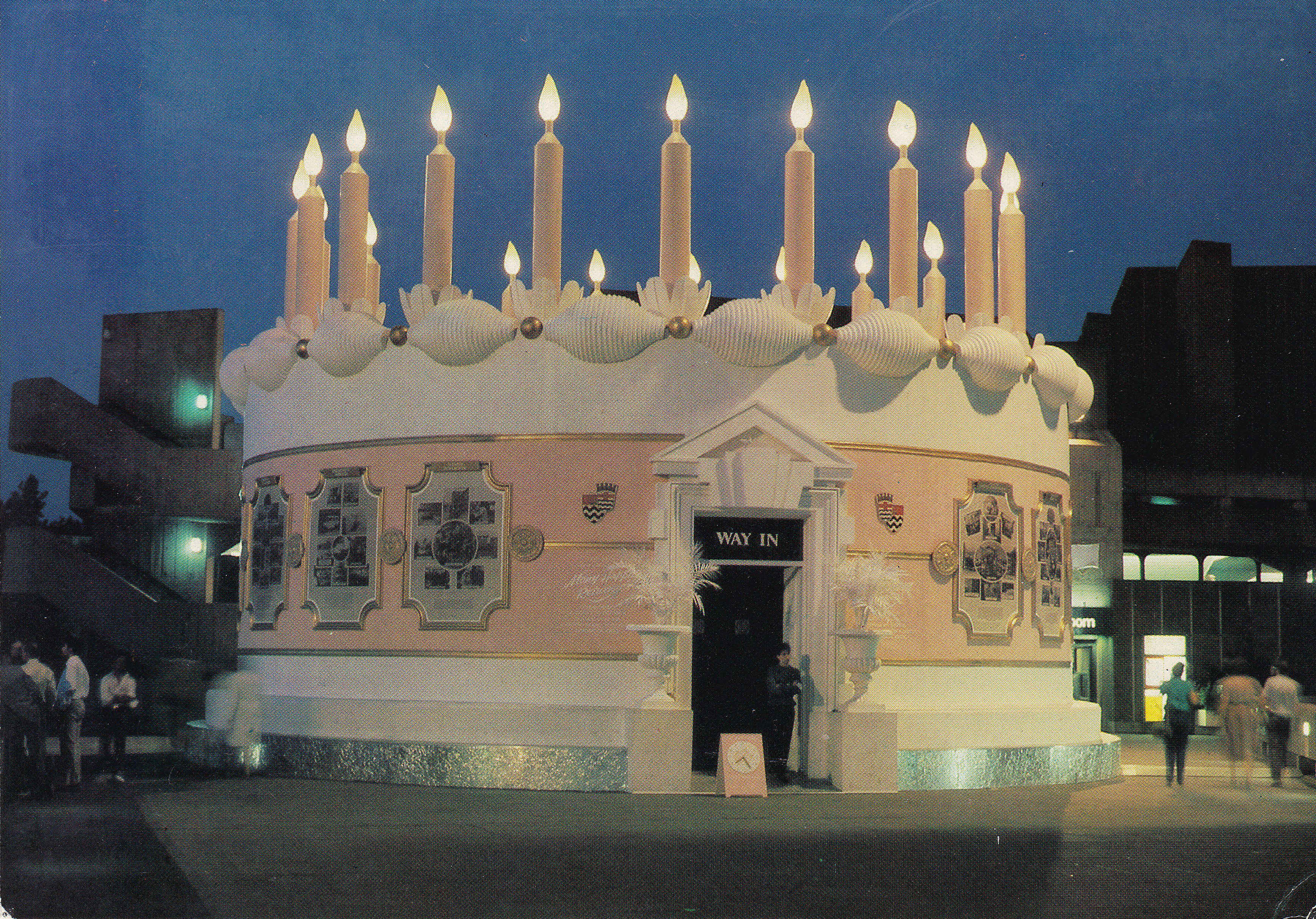
I had completely forgotten about this until I looked at the postcard again. I was working on the Southbank at the time and have some of my own photos of the exhibition on some unscanned negatives I need to find.
The exhibition ran from the 9th August to the 31st October 1984 and was held at a time of political friction between the Conservative Government and the Labour majority GLC. This would lead to the GLC being disbanded two years later.
The birthday cake was even mentioned in Parliament during a question from Tony Banks (Labour MP for Newham North West) and William Waldegrave (Conservative Minister of State). The questioning was regarding the abolition of the GLC (who had put considerable sums of money into the development of the Southbank) and what would happen to the area after the GLC was abolished and the Southbank came under the proposed South Bank Board. The birthday cake is referenced in one of William Waldegrave’s replies:
“I can understand why the hon. Gentleman is worried. He and his colleagues at county hall must be wondering where to put their great pink birthday cake. This was another triumph for the GLC! It was forecast in a committee paper last March that 1 million visitors would see this object and unfortunately 950,000 of them have not turned up. Only 50,000 had come by the end of September. If we assume, charitably, a last-minute rush of another 25,000 in the remaining weeks that the cake is open, that still works out at a cost of £3.30 per visitor. I am sure that hon. Members, and perhaps even the hon. Gentleman, would agree that the £250,000 could have been spent in much better ways to help the arts.”
Whatever the rights and wrongs of the later years of the GLC, the previous 95 years were worth celebrating as the London County Council and Greater London Council had achieved much in raising standards across London and bringing a much needed central coordination and investment to the city’s infrastructure.
An example of one of these investments is illustrated on the following card, titled “Opening of the L.C.C Steamboat Service by H.R.H The Prince of Wales”
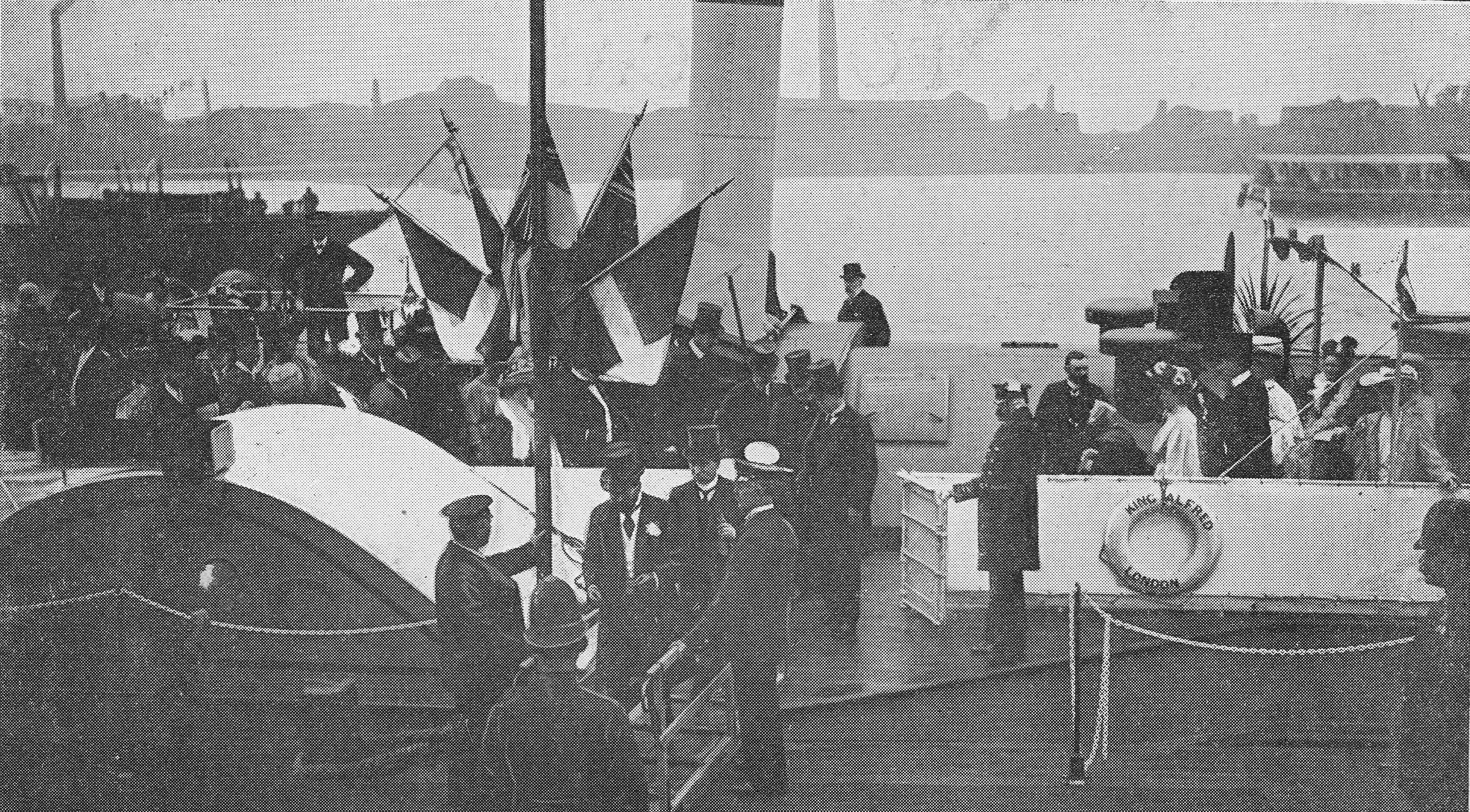
The photo shows the steamboat service being opened in June 1905. The LCC had acquired and built piers along the river along with a fleet of 30 paddle steamers. There were expectations that the new service would provide an efficient and fast method for transporting passengers to locations along the river, however it quickly became apparent that the service would not be economic.
Although the steamboat service was not intended to generate profits, it was expected to cover costs, however passenger numbers were not as expected and the service rapidly went into debt, finally closing only two years later in 1907.
There may also have been issues with the frequency of steamboats as this letter to the Globe on the 29th June 1905 illustrates. Mr Arthur Tuff of Barnsbury writes:
“Sir,-I purchased a penny ticket to London bridge on the Temple Pier at 3:50 pm today. I waited there till 4:30 pm. No boat going down the river called there during the 40 minutes, nor was there one in sight, although one can see nearly as far as Westminster. Several others, like myself, were compelled to leave the pier in consequence of this delay. This seems to be very bad management, and if not remedied, must mean a great loss to the ratepayers.”
The steamboats were sold at considerable loss and the press was highly critical of the service and the loss of money to the London ratepayer. The Illustrated London News included a full page cartoon titled “Posers for Posterity : Strange Finds 500 Years hence”:
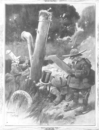
The caption to the cartoon reads: “Unearthing The Popular L.C.C. Steamboat – While a party of scientists were burrowing about in the Thames Valley last week, they found a structure that has been identified as belonging to an early form of soup kitchen. The evidence suggests it has been run more as an amusement than as a paying concern, although we should imagine that large profits were earned by it, especially in the winter months, when it would be so greatly in demand among the poorer classes.”
The River Thames features in another postcard from May 1954, titled “The Royal Homecoming – Britannia Enters The Upper Pool Of London”.
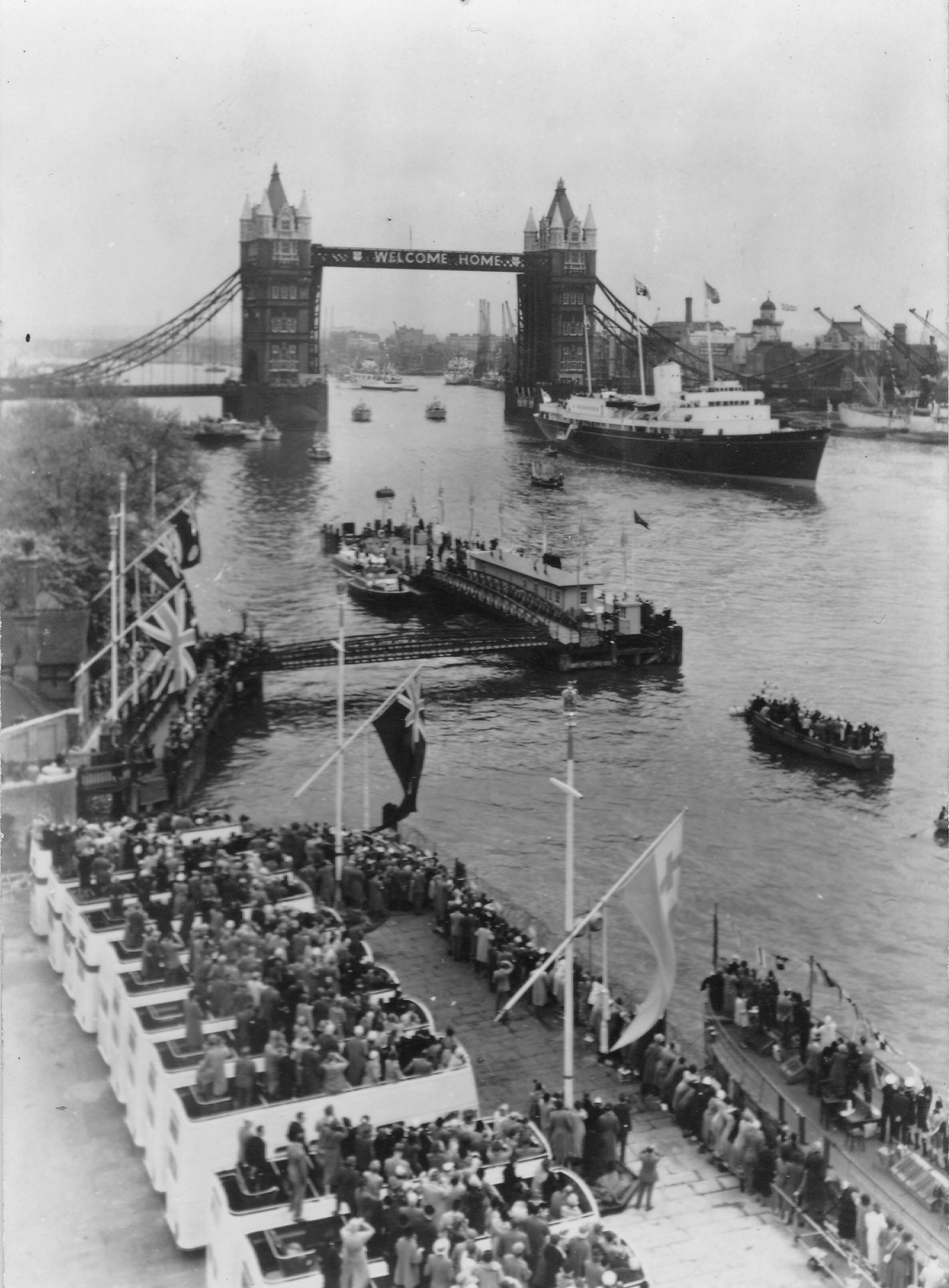
This was the return of Queen Elizabeth and the Duke of Edinburgh following a world tour. Tower Pier is on the left of the photo.
It must have been a dramatic arrival as it was accompanied by a large flypast. The following newspaper report explains:
“As the Britannia approached Woolwich, along Gallions Reach, 180 jet fighters and bombers roared overhead in the R.A.F. and Canadian Air Force ‘Welcome Home’ fly-past.
Leading were four tight arrowhead formations of Meteors flying at about 1,000 feet, followed by two formations of 24 Sabres each. Then, half a minute later, and flying just above the low scurrying clouds through which they were seen at intervals, came four echelon formations of nine Canberra bombers each.
With a tremendous roar flying at 350 miles an hour, the jets swept over the Britannia’s bow in a majestic and graceful salute. The sirens of tugs and small boats added to the tumult.”
A much more peaceful view, especially compared to the same view today is this postcard showing Parliament Square and looking across to St. Margaret’s Church and Westminster Abbey.
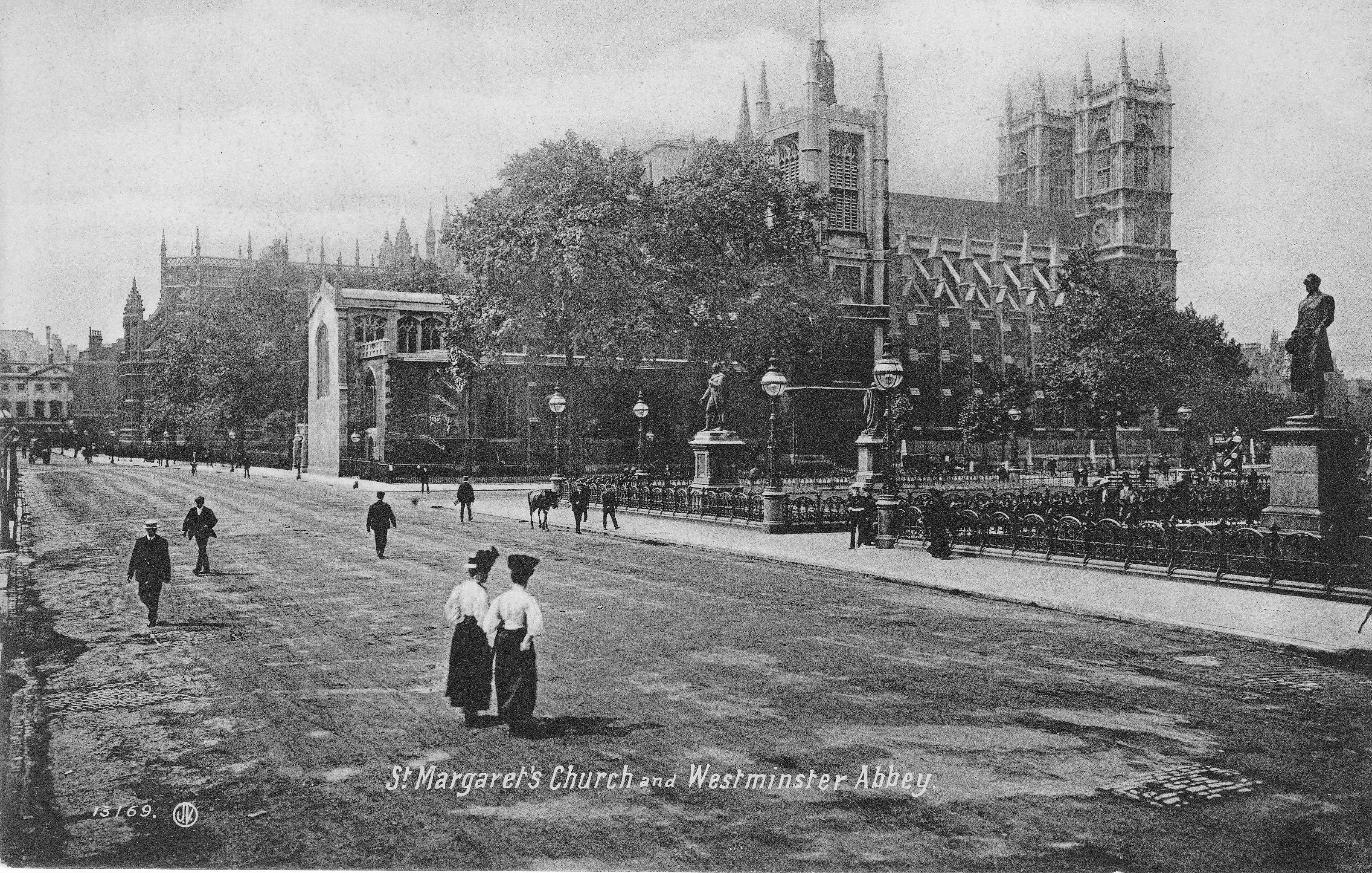
Whilst the view today is much the same, there are a number of significant differences. The road appears empty of traffic, but today is an almost constant stream to traffic – no chance for a casual wander across the street today.
The area is also a tourist hot spot and on almost every day of the year the streets are full, although I suspect that the current state of the Elizabeth Tower, surrounded in scaffolding, must be a serious disappointment if you have traveled halfway across the world.
One area that fascinates me is the Barbican. My father took a number of photos of the area in 1947 / 1948 showing the remains of the bombed buildings, St. Giles Cripplegate, Redcross Street Fire Station and what was left of once densely built streets.
I have not yet posted these photos as I want to map out the area, align the photos, gather more detail and show the area before bombing. There do not appear to be that many pre-war photos of the ordinary streets of the Barbican, however I have found a number, one of which was a postcard of Tranter’s Hotel, Bridgewater Square, Baribican:
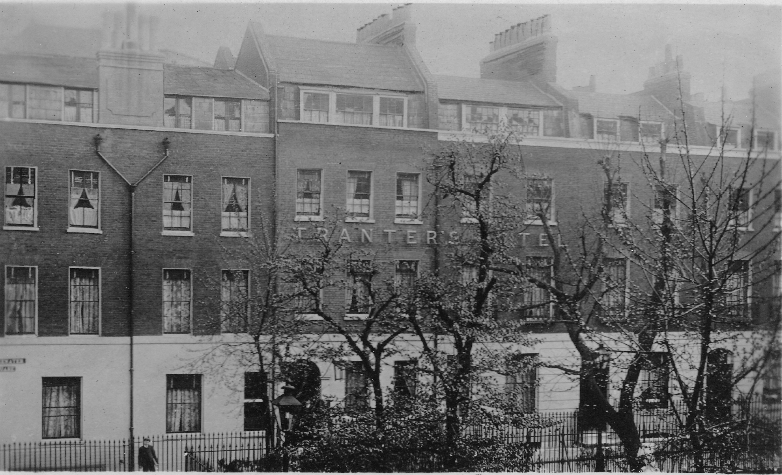
The square was badly damaged during the war and completely rebuilt as part of the overall Barbican development. The square looks completely different today and will feature in my future set of posts on the Barbican, however for now, this link to Google Maps shows the location of the square today.
The following postcard was sent from a visitor to London to an address in Folkestone, Kent. It includes a photo of St. Paul’s Churchyard as “The Shopping Quarter” – a function we would not associate with the area today.
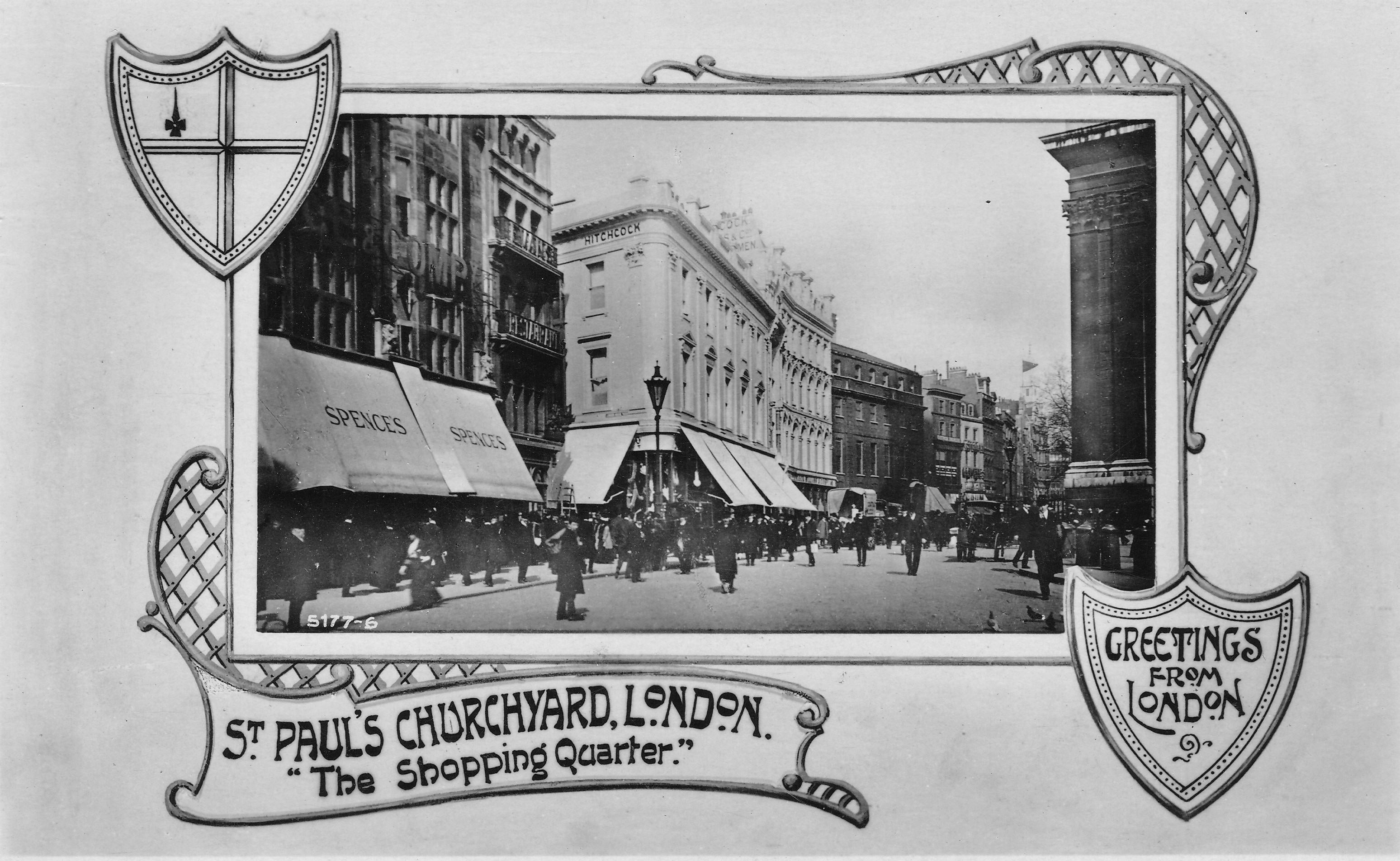
St. Paul’s Churchyard was a popular pre-war shopping destination with a range of different shops including clothes, materials and book shops. The large white building in the centre of the photo is that of Hitchcock, Williams & Co. I wrote about their business in a post at the end of last year. All the buildings in this photo would be destroyed in December 1940.
The following postcard is from the Widow’s Son pub, best known for the custom on Good Friday which the postcard explains.
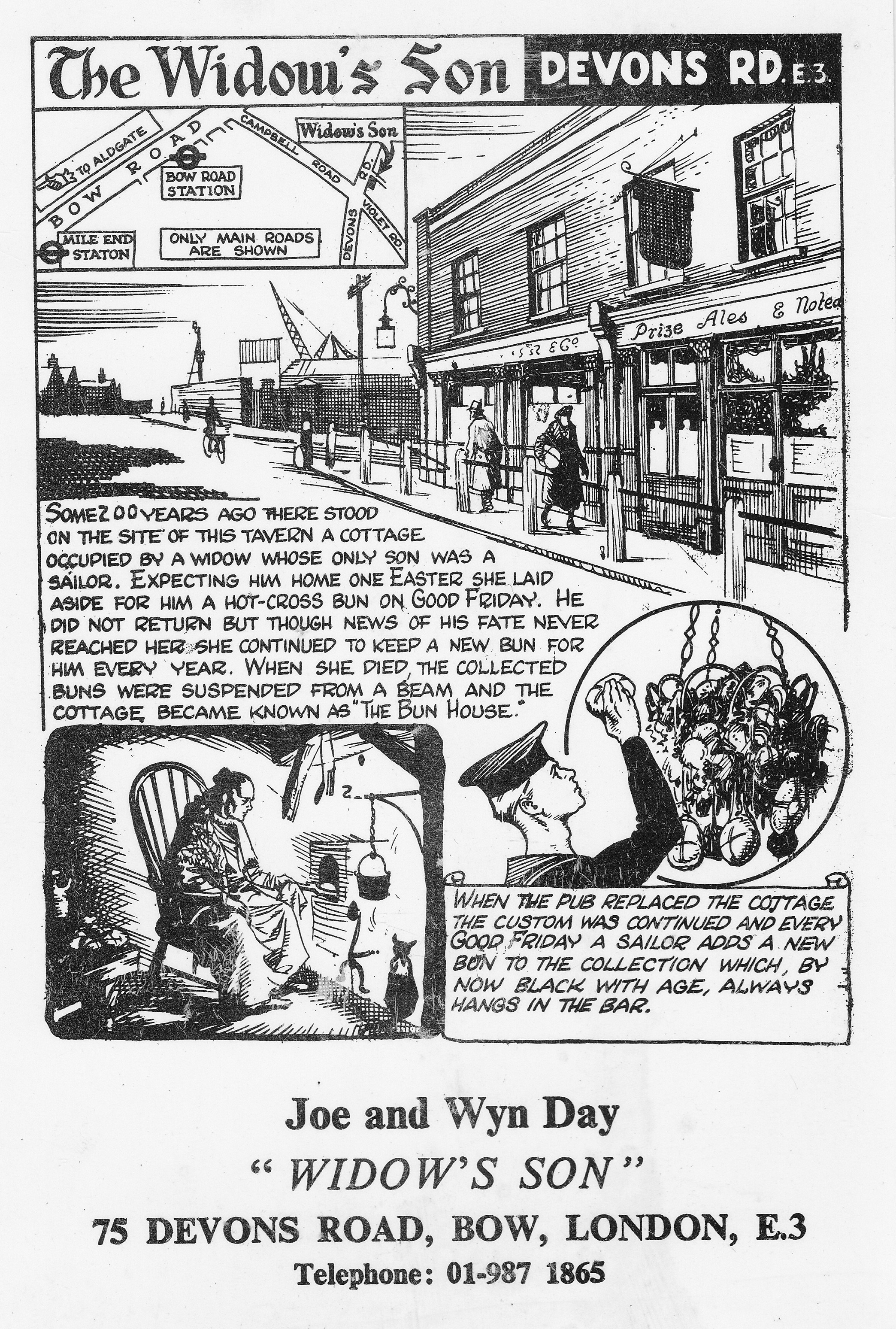
The Widow’s Son is one of the reasons why I seem to have developed a fascination with London’s history. It was the early 1970s and I was listening to BBC Radio London (dreadful choice of music for my young age at the time, but interesting as a London local radio station – this was just before Capital Radio started). It was Good Friday and they had a reporter live at the Widow’s Son. For some reason that event stuck in my mind and helped with the realisation that there was a world of interesting history out there to be discovered.
Postcards have always been used for advertising, and London’s hotels made good use of the format. The Hotel Metropole looks rather impressive in this card.
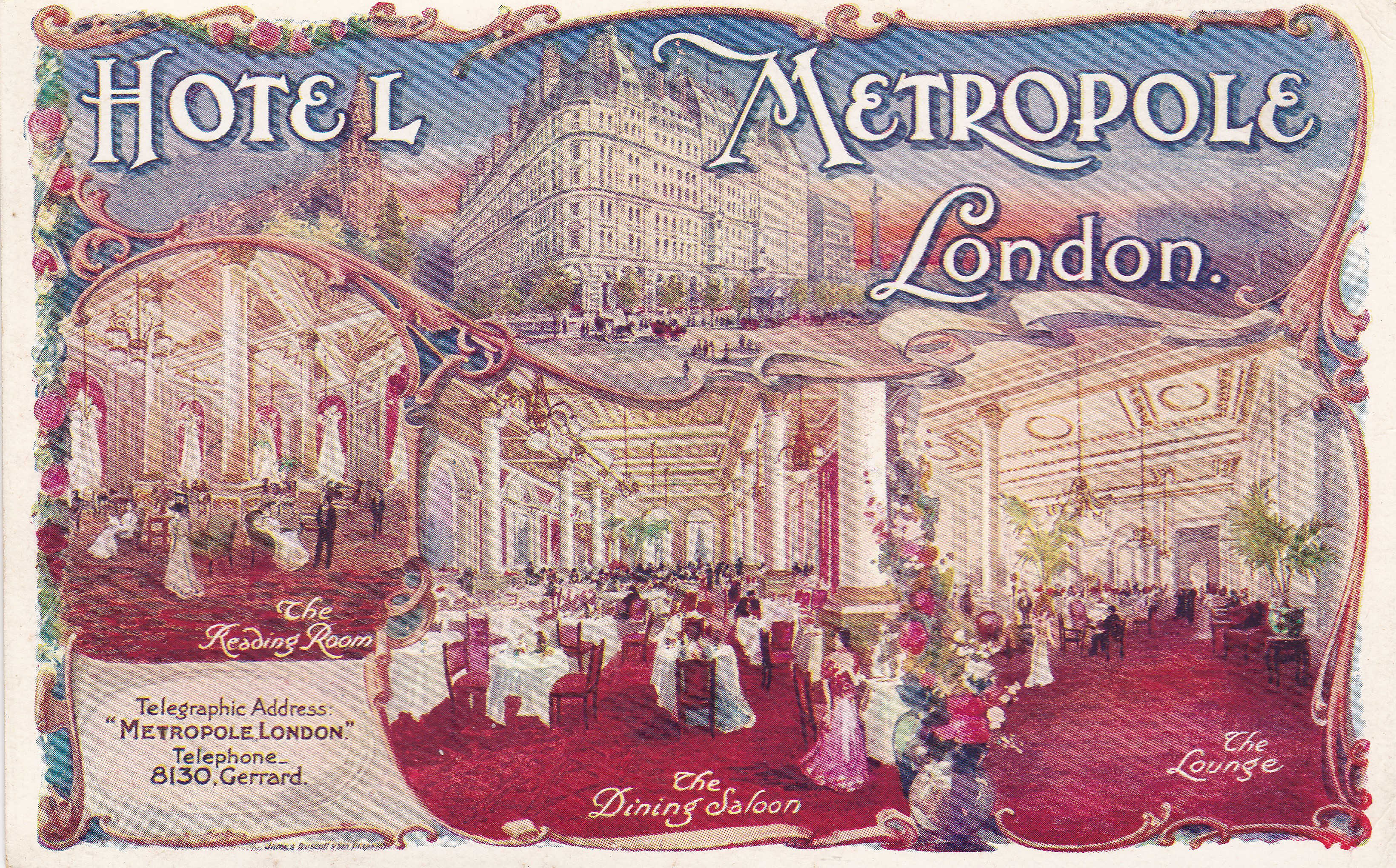
The Hotel Metropole was located on the corner of Northumberland Avenue and Whitehall Place, and opened in 1885. The building is still there and is now the Corinthia Hotel.
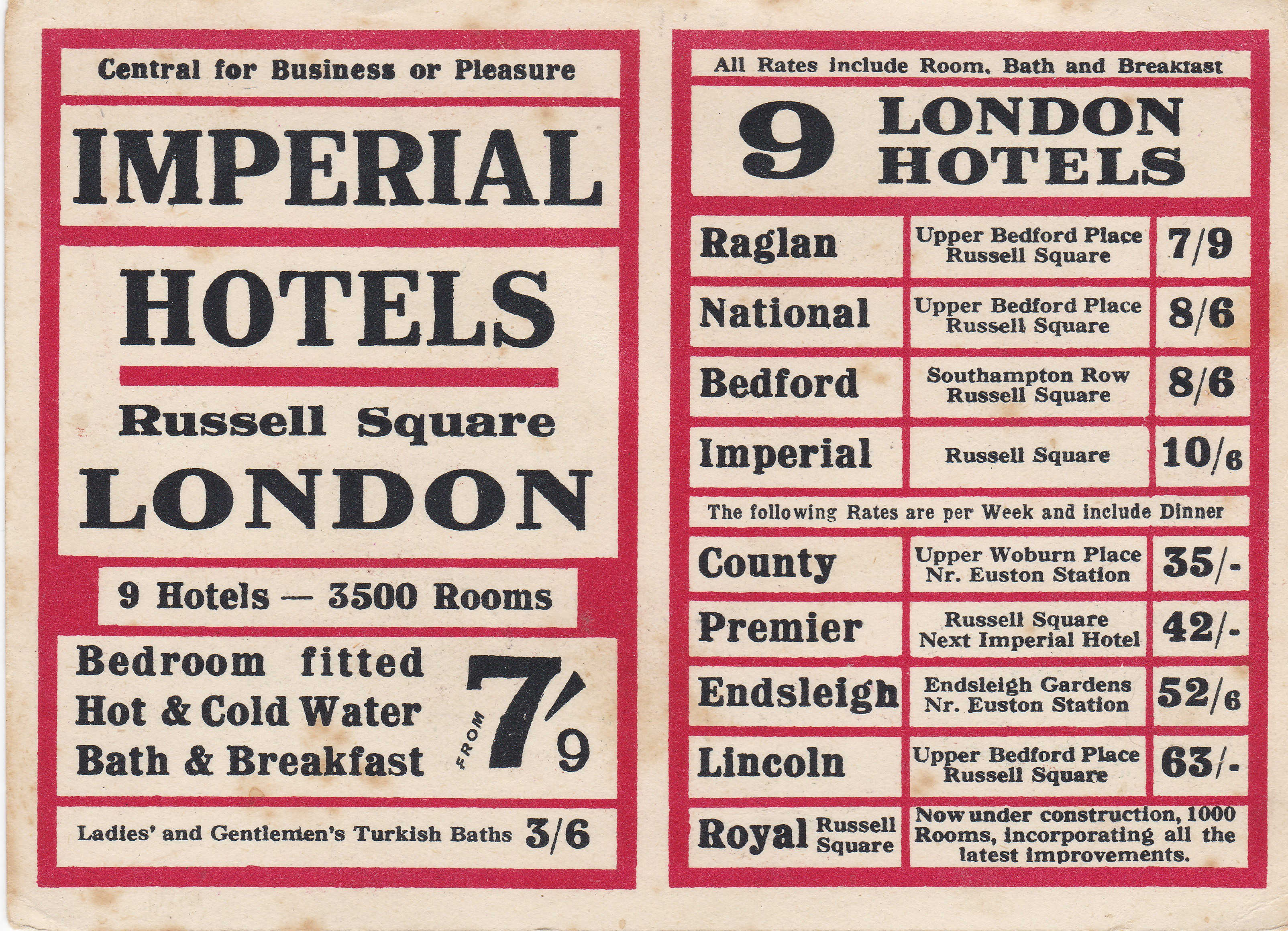
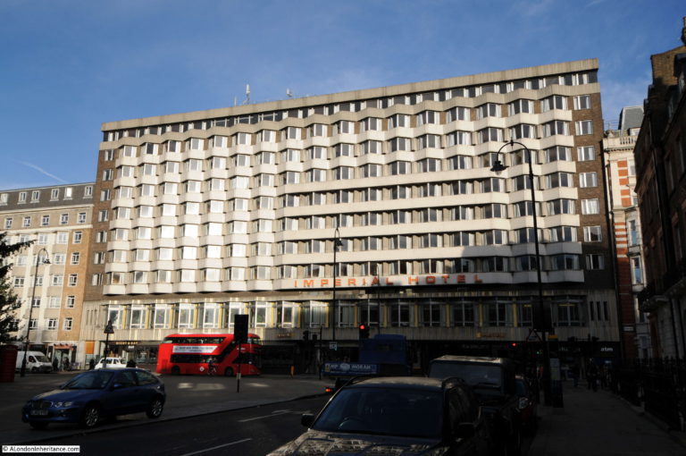
Another hotel that used a postcard format for advertising was the Imperial Hotel, Russell Square.
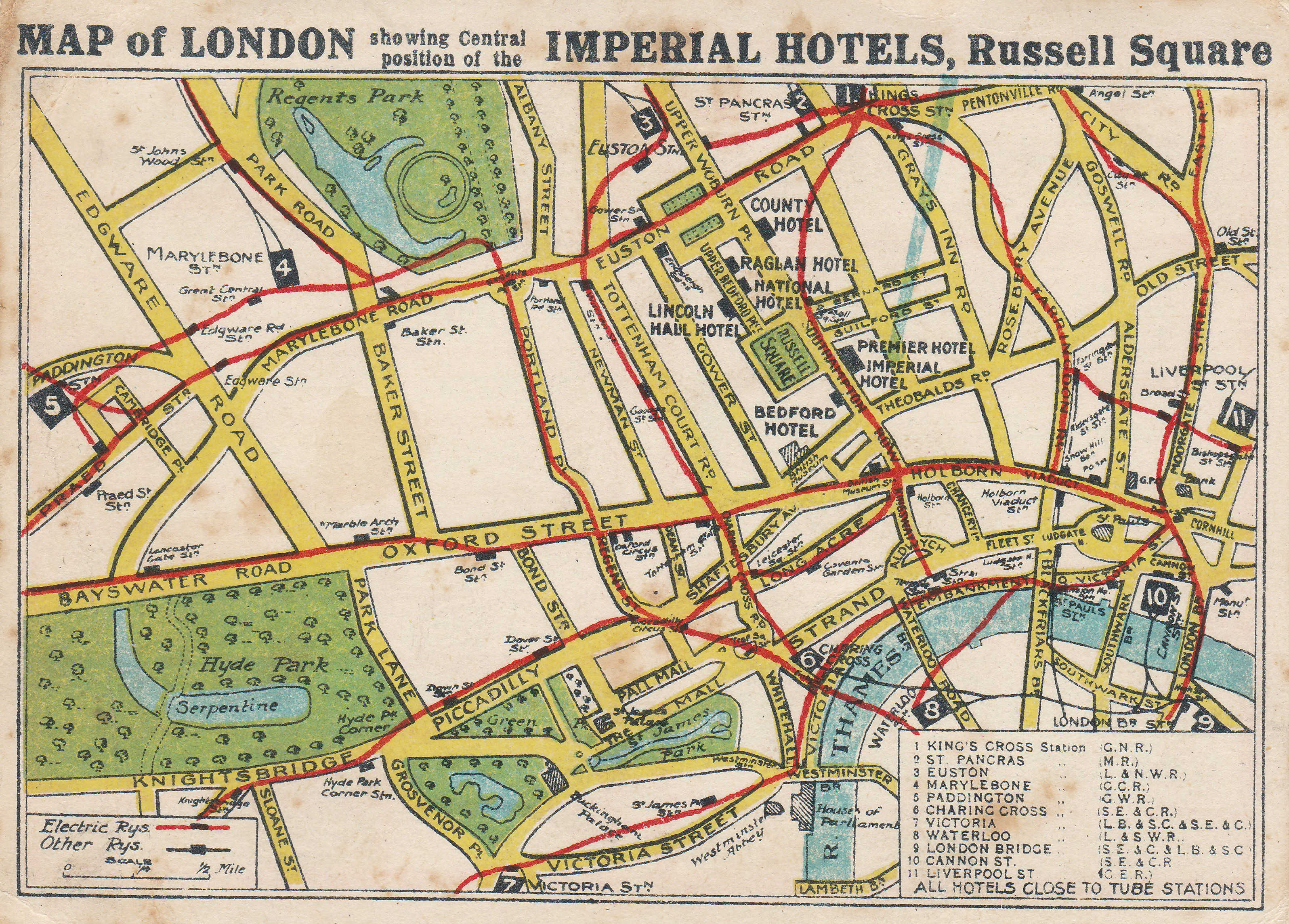
This is a far more interesting use of the format, compared to the Metropole Hotel as it has a map.
The map shows the location of the Imperial Hotel in Russell Square, as well as the eight other hotels that belonged to the group. All the main London stations are numbered, and the red lines show the “Electric Railways”, or the Underground train network, which is shown as a rough geographic layout of the network, rather than in the traditional underground map format.
This card was used for advertising rather than as a card you would post to a friend as rather than a space for writing on the reverse, this card has a list of all the other hotels in the group along with the room rate.
The Imperial Hotel still operates in Russell Square (although a later incarnation of the building). This was the hotel when the above card was in use:
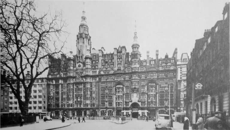
And this is the hotel today, where rooms start at £101 for an overnight stay, compared to roughly 39p when the card was issued. The Imperial Hotel today:
There are a variety of cards that provide a rather surreal view of London. This card is titled “If London were Venice – Fleet Street”:
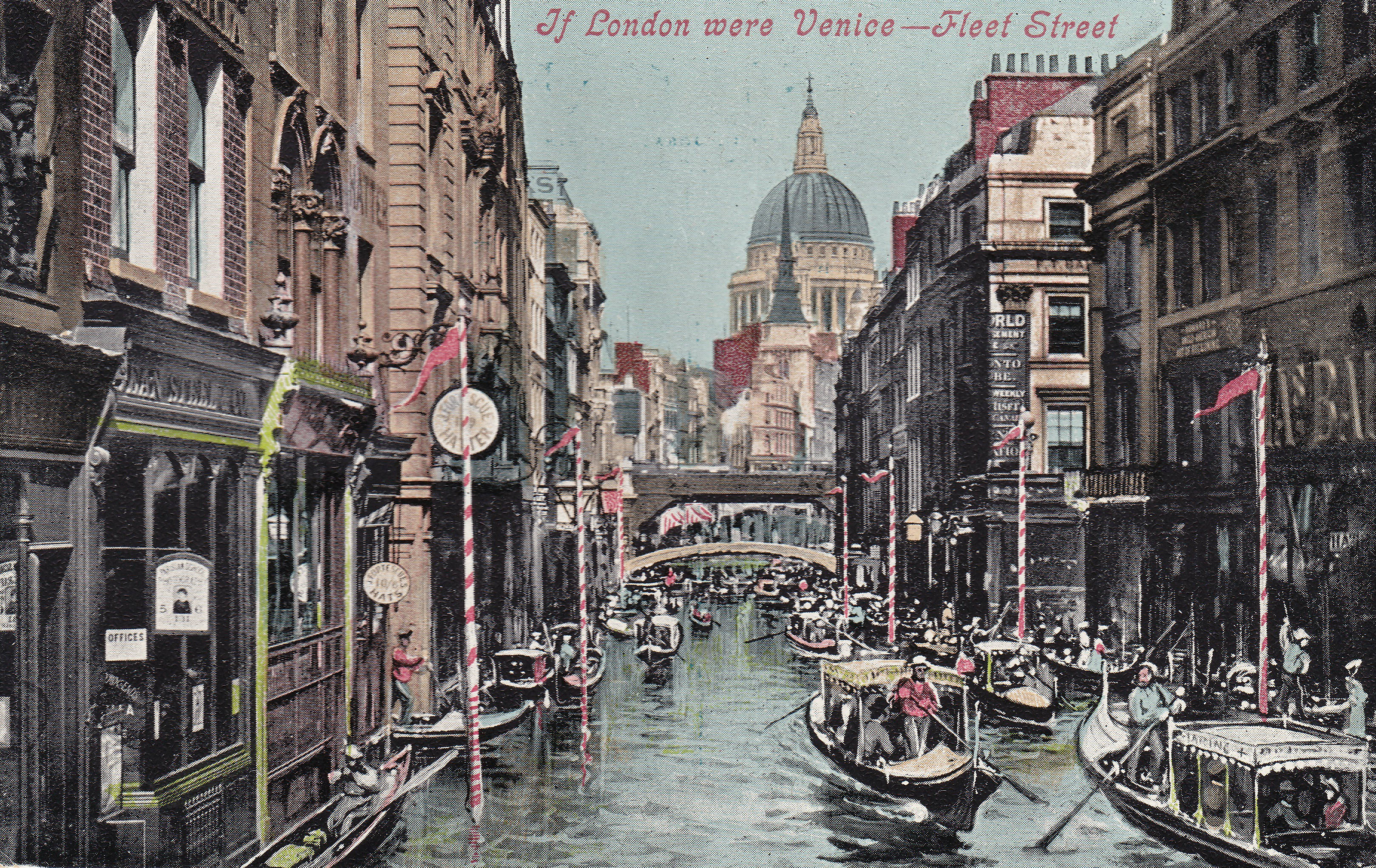
The card was printed in the days before global warming and the risks of rising sea levels were understood, and was probably seen as a rather fanciful view. However with predictions of the impact of long term increases in sea level and the impact of storm surges, this may not be so far away from some longer term future flood (but without the Venetian poles and boats)..
Full colour, photographic postcards, with their glorious, brilliant colours, started in the 1950s and presented a different view of London to a global audience. I find them interesting as they show how London has changed in the last half of the 20th century.
The first postcard is a view across the River Thames to St. Paul’s Cathedral from Bankside.
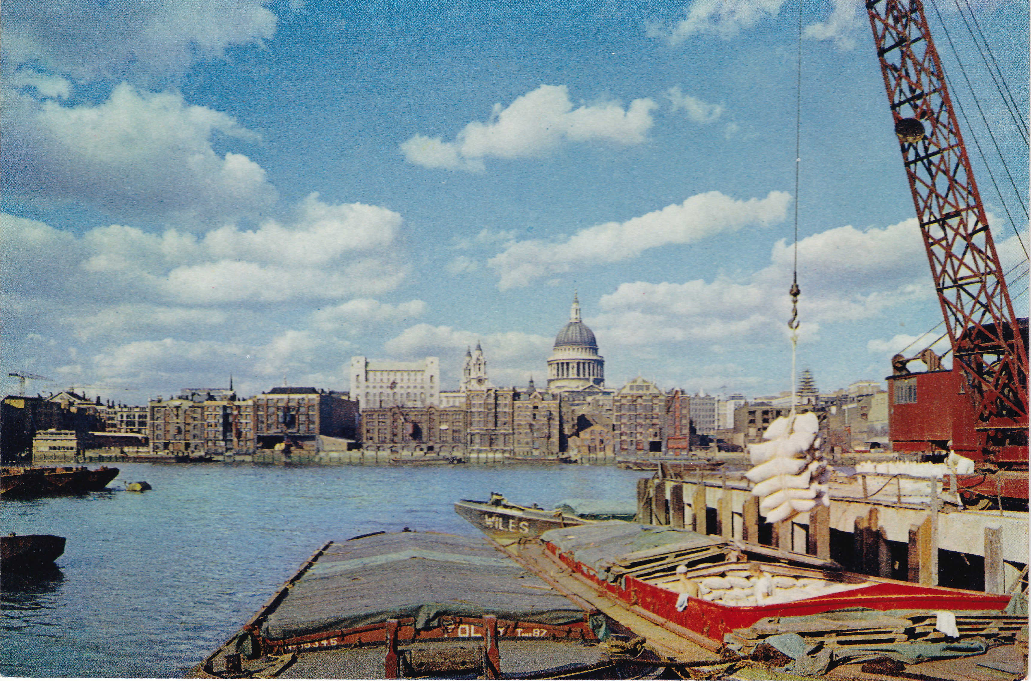
This shows the old warehouses along the north bank of the river as well as a working wharf at Bankside with cargo being loaded / unloaded from a barge. A view that has changed significantly since this photo was taken.
Another view that shows an activity no longer practiced by those visiting Trafalgar Square is this postcard showing pigeon feeding.
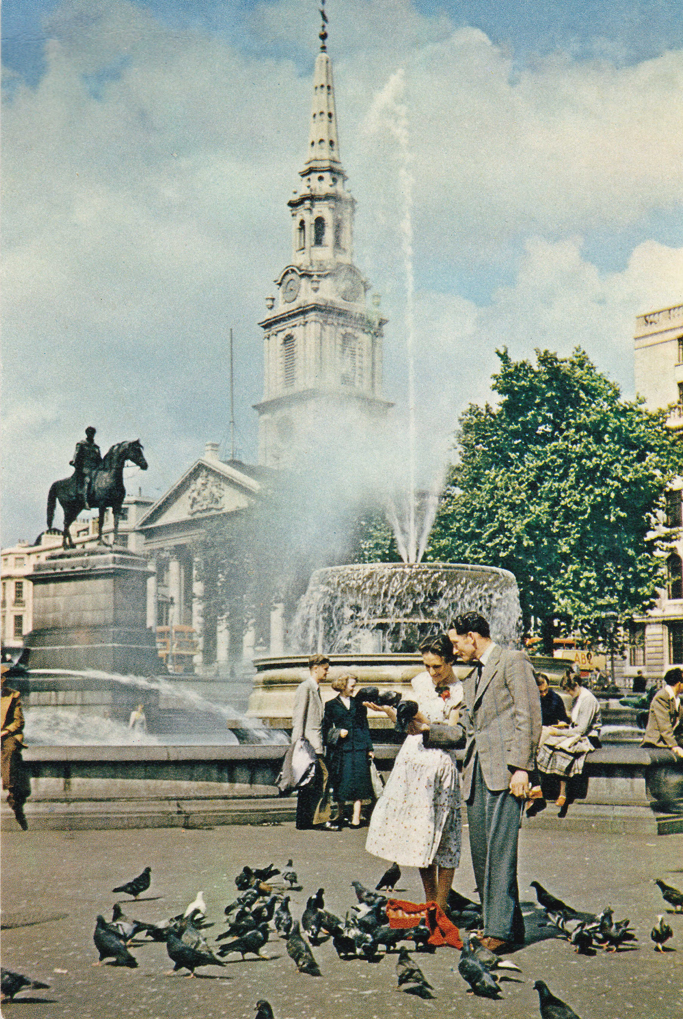
The photo shows a rather relaxed view of pigeon feeding, however it did get out of control and the thousands of pigeons that would flock to Trafalgar Square created a significant nuisance and mess.
Pigeon feeding in Trafalgar Square was banned in 2003 and a new by-law introduced that included the potential for a £50 fine for anyone caught feeding pigeons.
The Post Office / BT Tower was a remarkable structure when first built. This postcard was posted from Kew to Newmarket, Suffolk in December 1969.
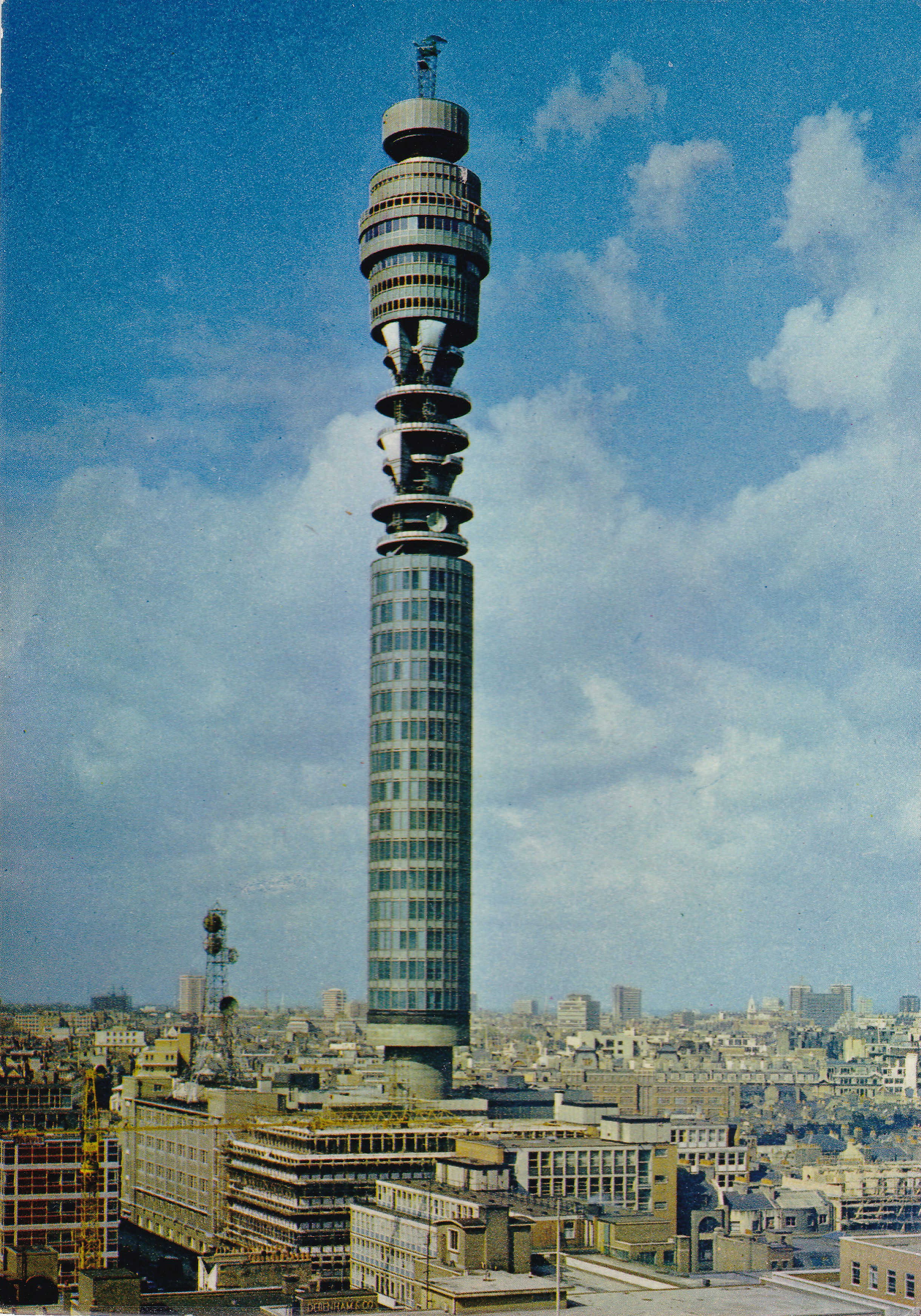
I find it amusing when the urban myths about the towers secrecy are mentioned. There was no way that the tower could be kept secret and the text on the rear of the postcard makes clear the tower’s role: “619 feet high, this tower is the centre of a new communications system which supplies long distance telephone services and additional television channels. Two lifts convey the public to the top where there is an observation platform, a cocktail bar, and a revolving restaurant”.
The postcard emphasises the height of the tower and the generally low rise construction of buildings across London at the time.
Development in London is continuous, and is often seen to be negative, however there have been times when development considerably improved an area. This postcard dating from 1978 is looking towards Westminster from the west. Millbank Tower is on the right, adjacent to the Thames, where we can see first Lambeth Bridge, then moving up the river, Westminster Bridge, Hungerford and Waterloo Bridges.
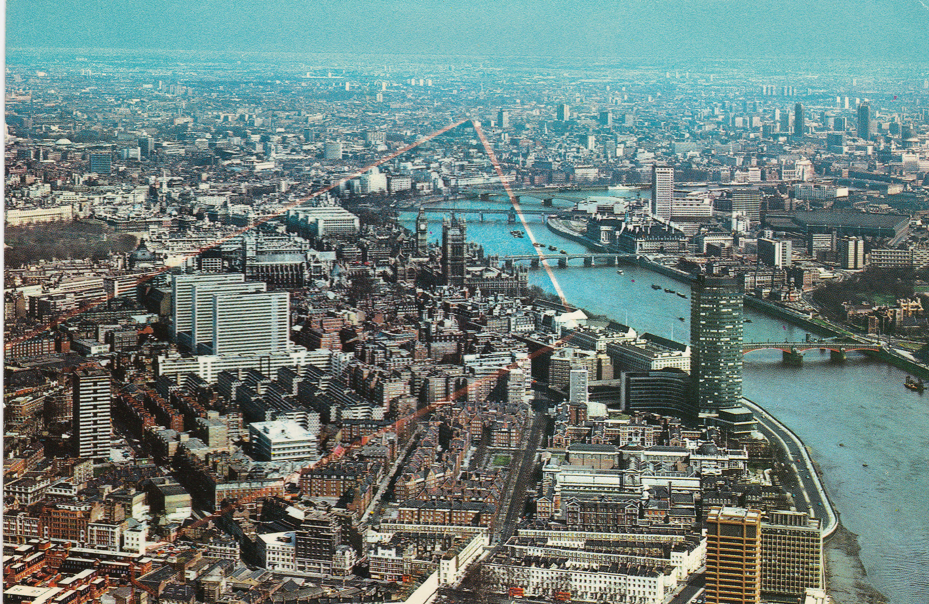
To the left of the photo there are three identical, tall office blocks. These were government buildings along Horseferry Road and Marsham Street.
Their height was such that they were in the background of the view when looking across the river towards the Palace of Westminster / Houses of Parliament and Westminster Abbey. Fortunately they were demolished and replaced by lower rise buildings which do not have the same visual impact.
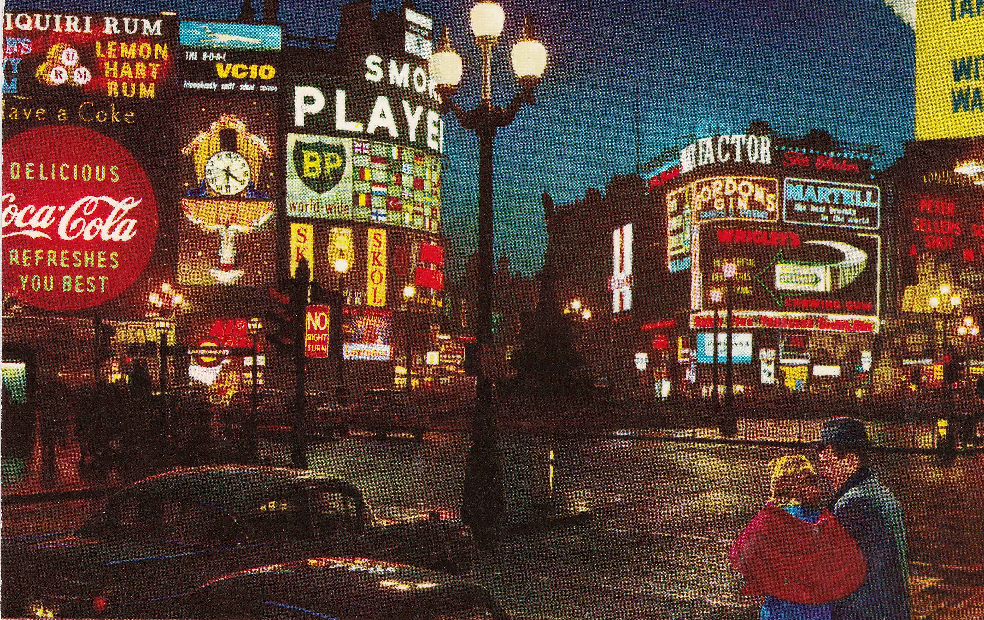
A favourite location for postcard photographs is Piccadilly Circus. Night photos bring out the lights, which looking back over the years provide a snapshot of how brands and their branding have evolved.
Piccadilly Circus also features during the day.
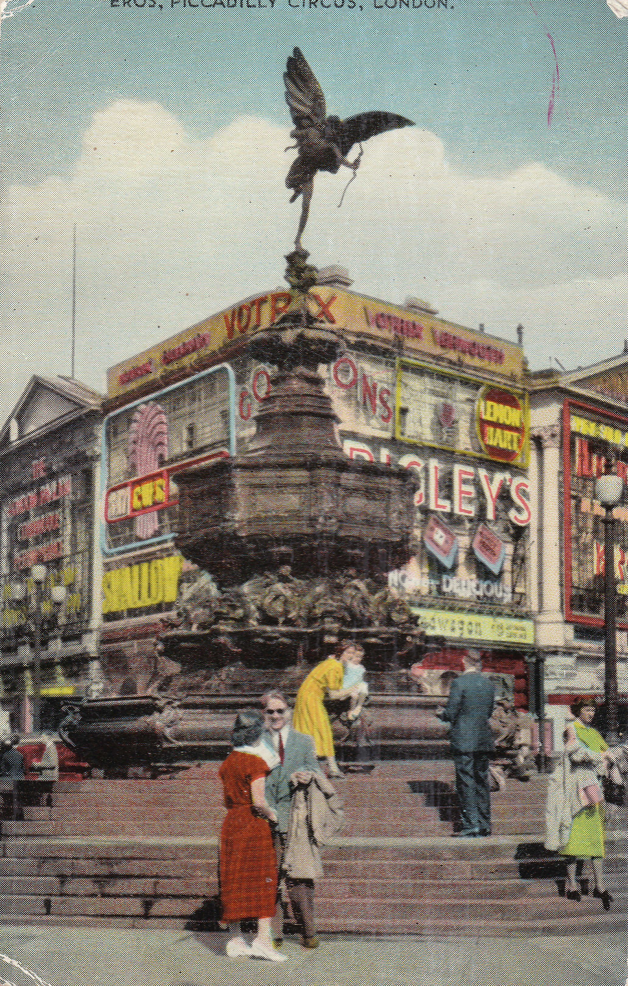
The text for both postcards emphasises the global nature of the city – “There’s an old saying that if you stand in Piccadilly Circus for long enough, you’ll see the whole world pass before you. If you stand there for 10 minutes you’ll soon understand what it is that makes London famous throughout the world, At night, theatre land awakes, heralded by many thousand of bright lights”.
This postcard takes me back to visits when I was a child. This is the London Planetarium.
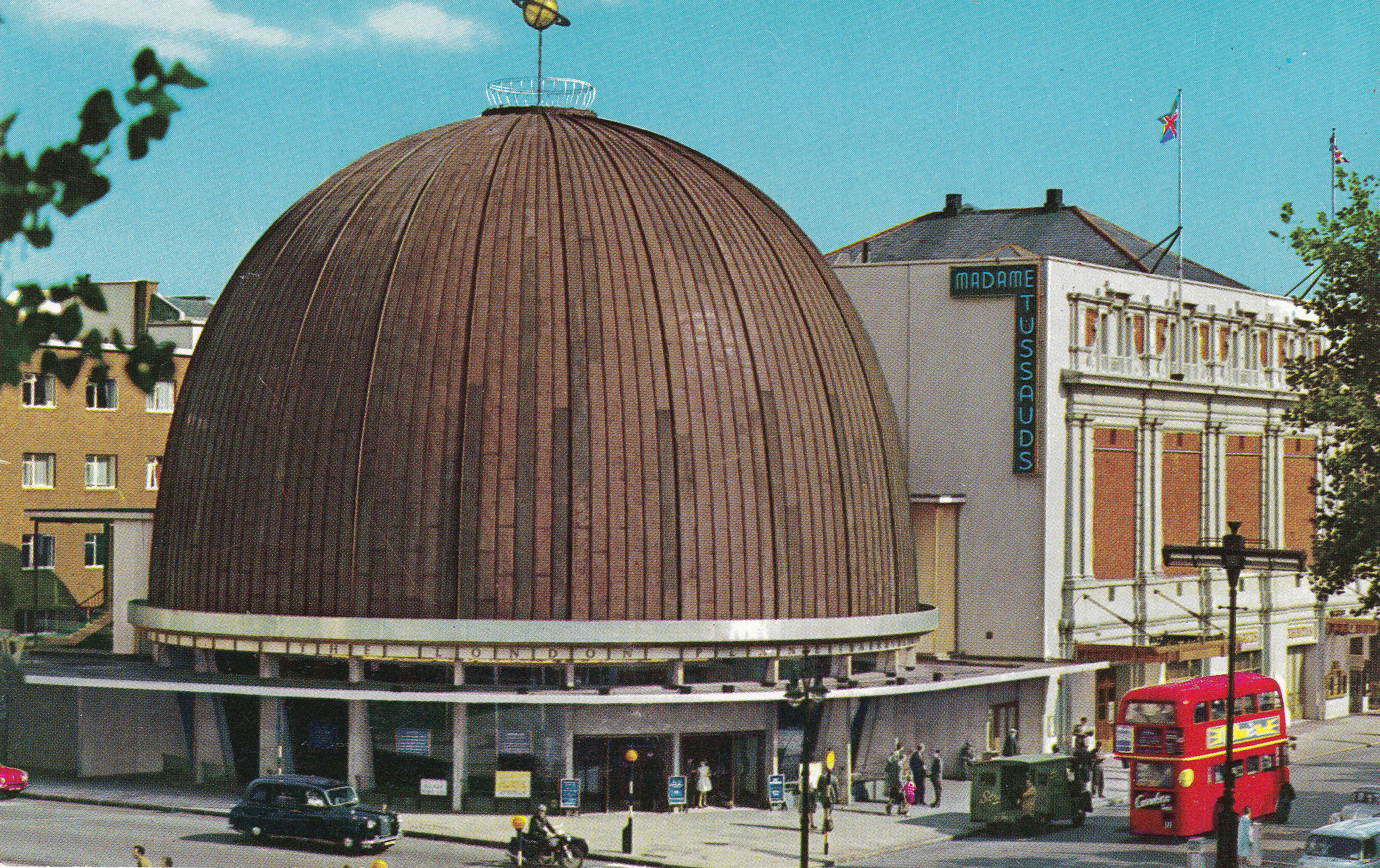
The London Planetarium was a magical experience. You would walk into a large circular auditorium under the dome. Seats were arranged in circular rows and in the centre there was a large, strangely shaped projector.
The lights would go down and the night sky would light up on the interior of the dome.
Unfortunately, educational attractions such as the planetarium are not commercially attractive, and the London Planetarium closed in 2006. It is part of the adjacent Madame Tussaud’s and now shows a Marvel Superheroes 4D attraction.
There is still a planetarium in London, at the Royal Observatory, Greenwich, which is well worth a visit.
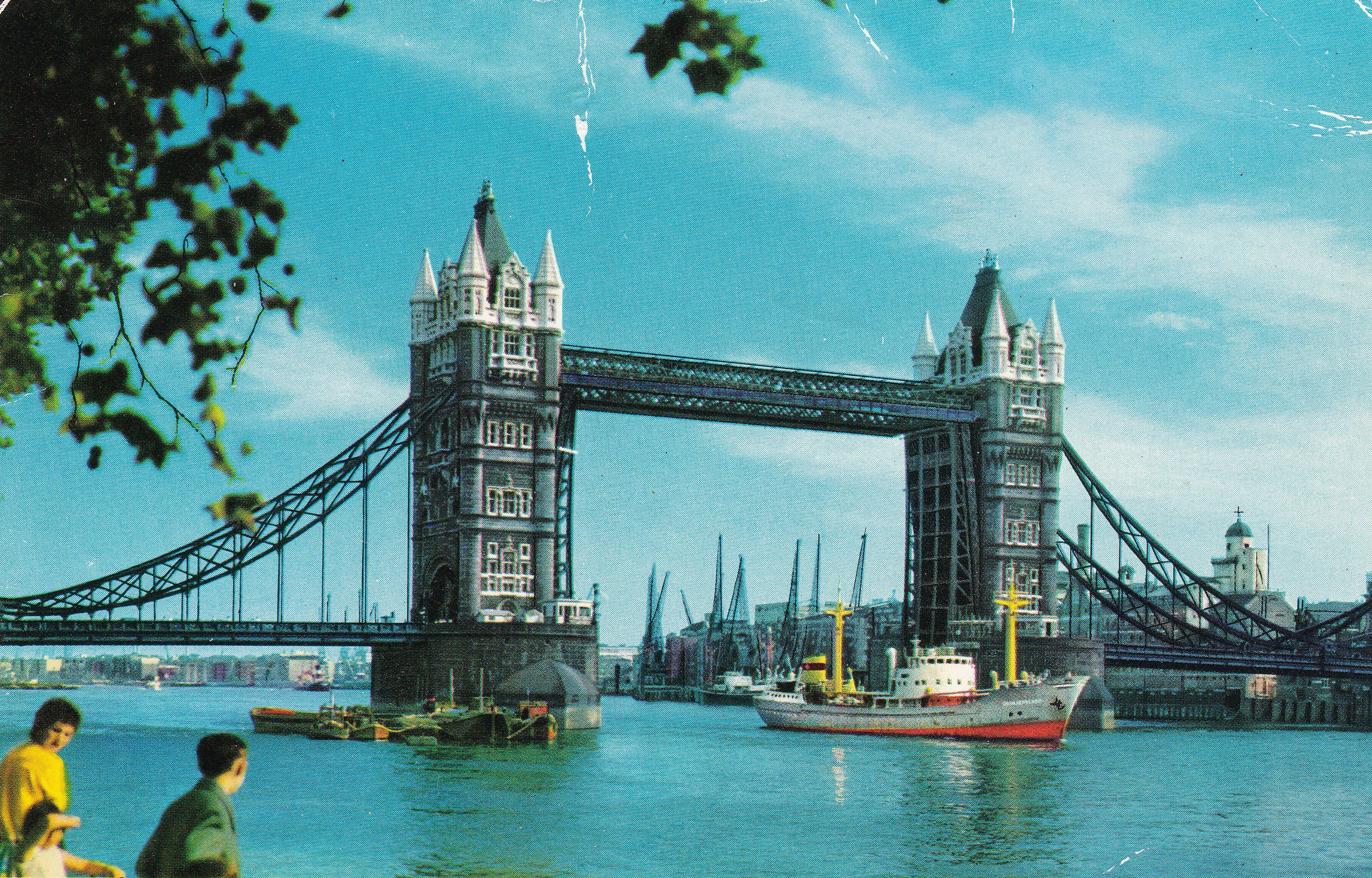
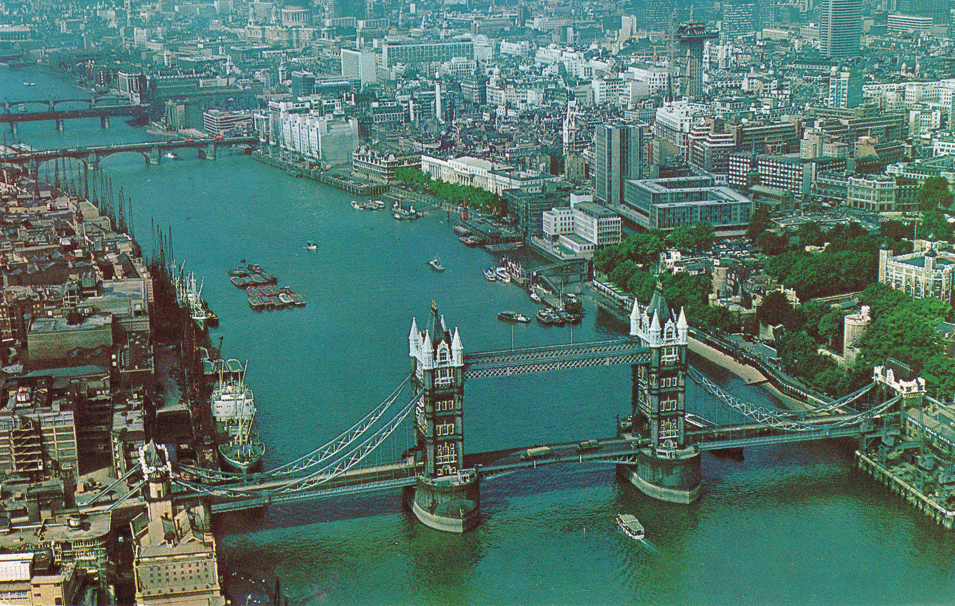
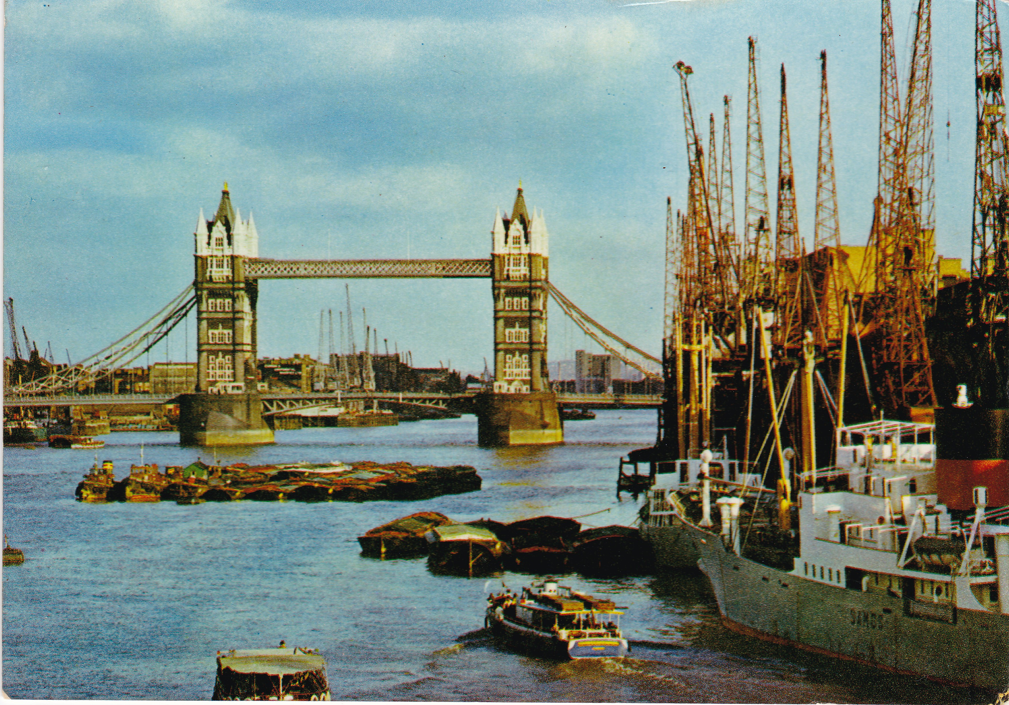
My final three postcards are all from the same area, and show different aspects of the River Thames around Tower Bridge. These are all from a time when this part of the river was still a working port.
The first photo is from the walkway alongside the Tower of London, looking across to Tower Bridge and the southern bank of the river. The tower of the old Anchor Brewery building can be seen on the right and cranes lining the river bank can be seen along the river past Horselydown Old Stairs.
The following postcard shows an aerial view looking up river towards London Bridge. The river bank on the left is lined with cranes between Tower and London Bridges. This is where City Hall and HMS Belfast are now located. In the years after this photo was taken, the majority of the buildings lining the river, along with the cranes, would disappear.
Another view of the same area, probably taken from London Bridge, again shows the cranes that lined the south of the river between the two bridges.
These views of London were sent across the UK and the world and set expectations for future visitors. Many postcards featured red buses and phone boxes and I have a theory that these only became associated with London in the way they have, once colour postcards emphasised their distinctive colour.
They are a means of communication, art form and historical record that I suspect will soon disappear. They are still to be found for sale, but it is sometime since I have seen anyone buy one. No point in posting a card with days or weeks delay, when with a couple of taps on the phone, a photo and message can be sent anywhere within seconds.
I also doubt I will ever again see a giant birthday cake on the South Bank.
These are brilliant. Re the Post Office Tower, there is an excellent short film about it as part of the Look At Life series, to be found on YouTube. Beware – I have spent hours of my life watching these information films about London. Still, it is cold outside so there are worse ways to spend a Sunday.
Great post! These are a highlight of the weekend. There’s an app we use which echoes the postcard called TouchNote. You can upload pictures of your holiday (or anything else) into a postcard format, write text on the back and send it anywhere in the UK for £1.99. My daughter is currently sending me a weekly one from her travels in SE Asia. We usually send ourselves one when we’re away and put them
In an album when we get home – usually the only pictures we look at again of the hol, even though we have many more on our phones.
Fascinating Sunday morning fare, as ever. What is the faint red box drawn on the postcard showing the government buildings on Marsham Street? Something to do with sight lines? If I remember rightly a good portion of those three blocks were occupied by the Department of Environment. I remember walking past them, and the replacements being built – but not how long ago that was. Mid 1990s?
Looking forward to your post on the Barbican. I’ve always been fascinated about what was there before.
Did they ever manage to demolish the concrete bunkers at the corner of the Marsham Street block?
Not sure… I think so… but I do remember them sticking up…. I don’t go down that way as often as I used to… but I’ll keep my eyes open next time I do.
The postcard from the Imperial Hotel made me look again at my 1948 Batholomews Reference Atlas of London. The underground is shown as red dashed lines, and the routes are the same as on the postcard. But the University of London now occupies a large area next to Russell Square.
Once again great post. Went up to the top of the new PO tower in 1970. Ambition was to be able to afford to eat in the revolving restaurant. Sadly by the time that came it was closed !!
As ever, a great article and I, too, am looking forward to the Barbican posts, having spent a lot of lunchtimes there over the years 🙂
Interesting to see the railings and lamps in Parliament Square, the latter I think the same as on the Embankment. I assume that they all went in WWII
Thanks again for a very interesting post
What a fantastic mad confection the Imperial Hotel was. Shame it’s gone…although maybe not surprising.
I treasure these posts, save them for a special treat. What a truly wonderful endeavor. I don’t have adequate words to thank you. I am 87, still regard England as home, still miss it, especially now from the U.S.
Interesting and nostalgic – thank you. Am an ex Londoner & Greater London Council worker now living in Somerset
Another interesting post – thank you and I do like post cards – in fact, I have a couple of the ones above in my collection. Looking forward to your post on the Barbican.
Lovely pics of the river and its industry -bring on the barbican.
Marsham Street: I worked at the Department of Transport on the south side of Horseferry Road, opposite the triple towers (actually one building, mostly only three floors but with three slabs sticking up) from 2001-2005. It was during this period that the triple towers were demolished and the new building, partly occupied by the Home Office, was built. They used dynamite to demolish the concrete bunkers, so there were ofte nsome loud bangs.