The Port of London Authority book “Access to the River Thames – Steps, Stairs and Landing Places on the Tidal Thames” lists 240 of these places between Teddington and Southend, and as you may have noticed from a number of blog posts, I am trying to visit all of them.
The 240 ranges from a causeway at Two Tree Island, near Southend, the last of the sites listed, via multiple sites as the Thames winds through London, out to Teddington, the end of the tidal river.
Back in May, I featured Bell Watergate Stairs in Woolwich, and today I am returning to visit another set of stairs in Woolwich – Nile Street Stairs.
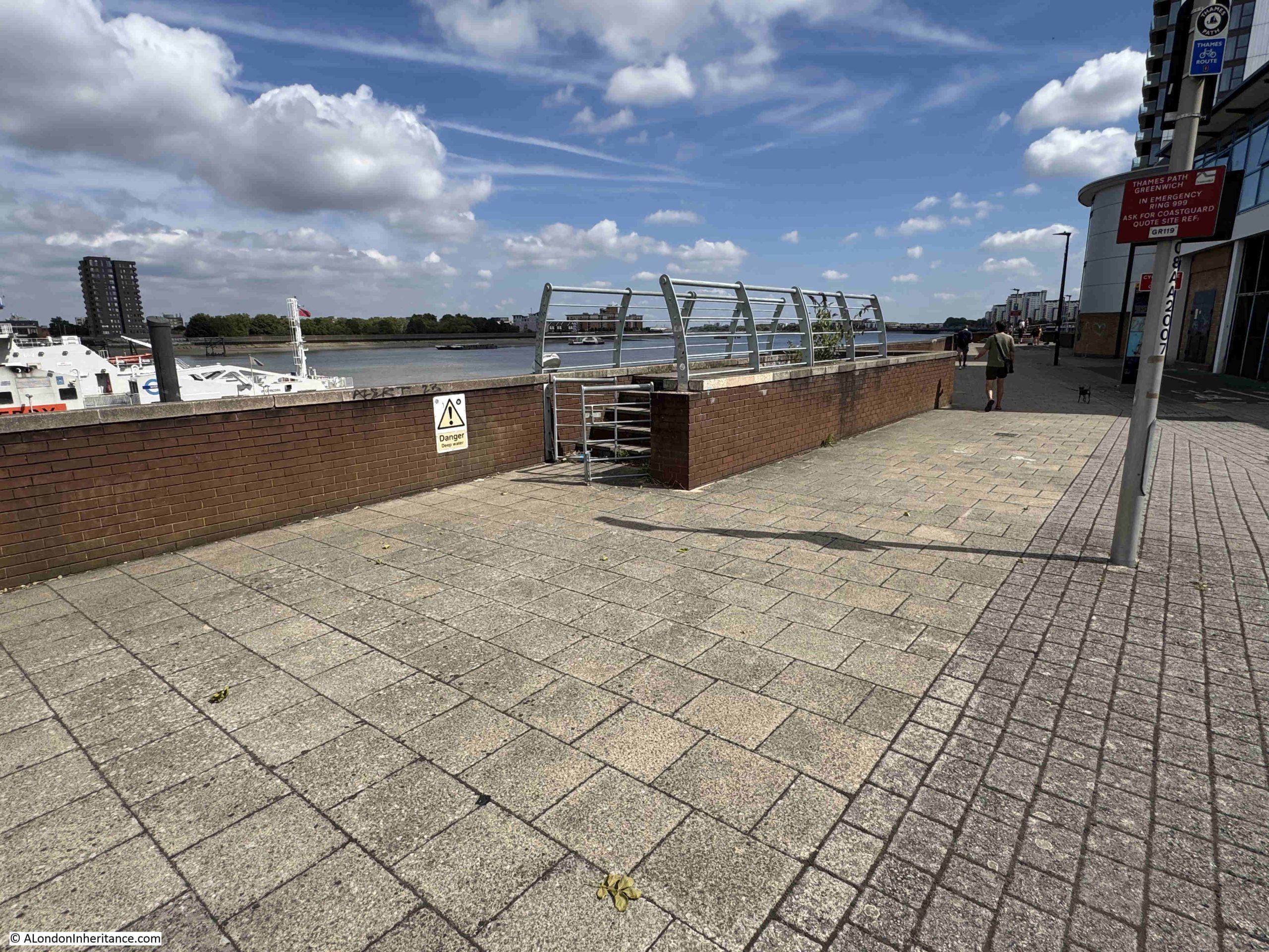
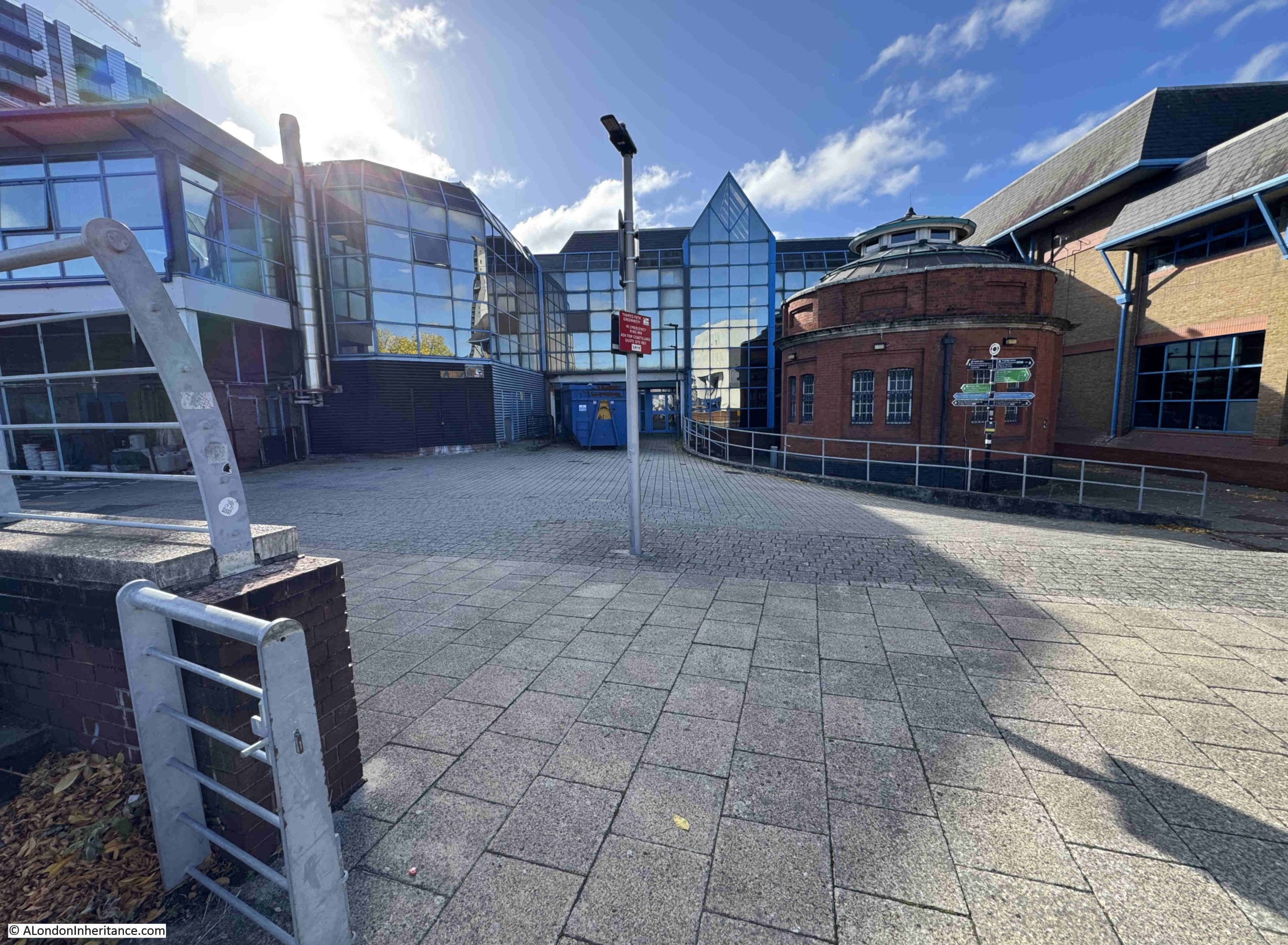
This is the entry point to Nile Street Stairs from the embankment walkway:
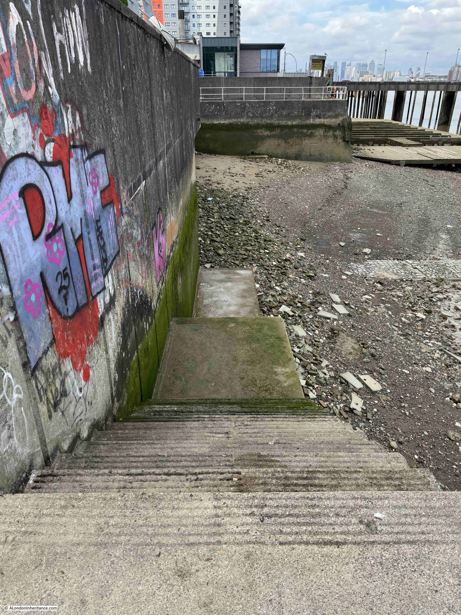
The location of the stairs down to the foreshore has changed slightly, as concrete stairs now run parallel to the river wall, down to where the causeway that led from the original stairs can be seen to the right:
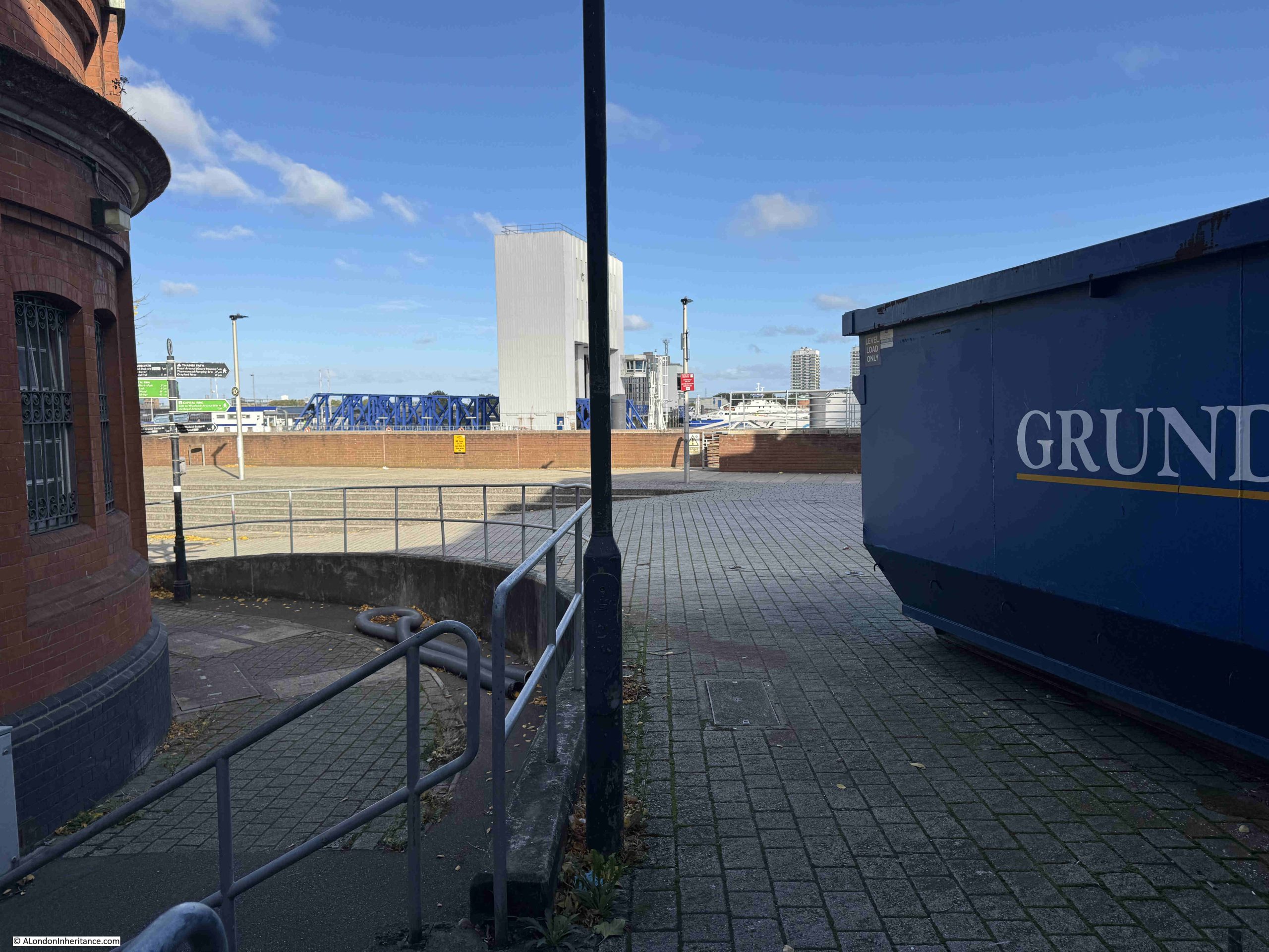
Looking to the right, we can see the full length of the causeway that ran from the stairs, with the access jetty to the Woolwich Free Ferry visible at top right:
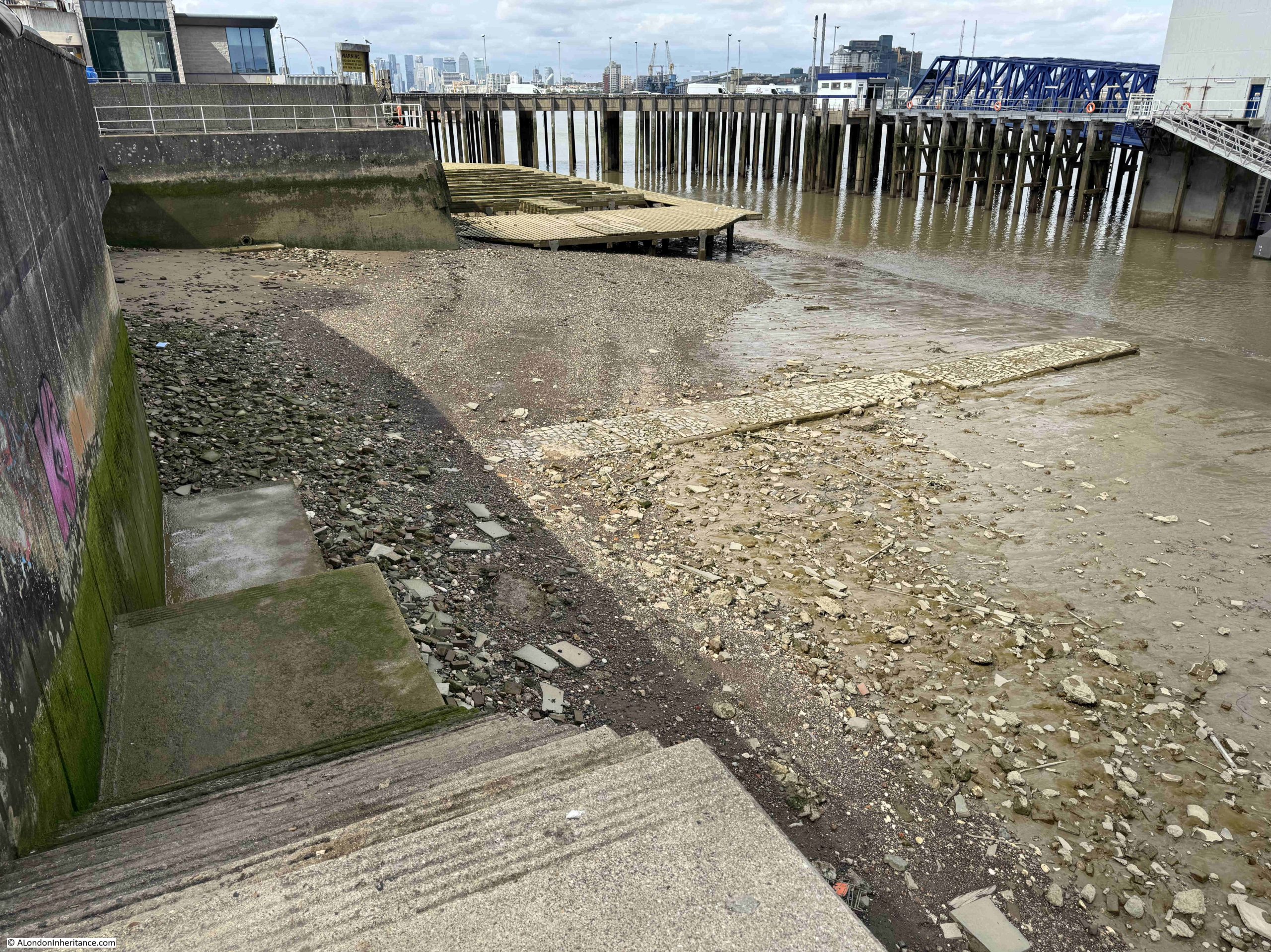
Nile Street Stairs and Causeway, with the Woolwich Free Ferry:
The causeway runs for some length across the foreshore, and provided a reasonably dry, mud free route between the base of the stairs and your boat which would have been alongside the causeway.
It is in a remarkably good condition. I do not know when it was last repaired, but it is a remarkable survivor given that the original pier to the Woolwich Free Ferry was built immediately to the right of the causeway. The pier and docking point for the ferry we see today is a mid 20th century change from its first location.
As with many other Thames stairs, they have been very many events related directly to the stairs, and a strange headline concerning the stairs in the Kentish Independent on the 3rd of May 1957 read – “The Affair Of The Wet Footprints”, and the article goes on to state “After police boats had been alerted to scour the Thames near the Woolwich Free Ferry on Friday night to look for a youth who was reported to have fallen feet first into the water, P.C. Booth found wet footprints leading from the ferry stairs. He followed them as far as the Odeon cinema where they petered out.
The pier master told police that he had seen an 18 year old youth in Edwardian clothes stagger down the Nile Street stairs alongside the ferry. He then hit the rails, straightened up and slipped feet first into the river.
Later another youth said he had seen a man come up the stairs soaked to the skin.”
A rather mysterious story, with the wet footprints and the youth in Edwardian clothes in 1957.
What is remarkable about Nile Street Stairs and the causeway leading across the foreshore is their survival, as it was here where the original access to the Woolwich Free Ferry was built.
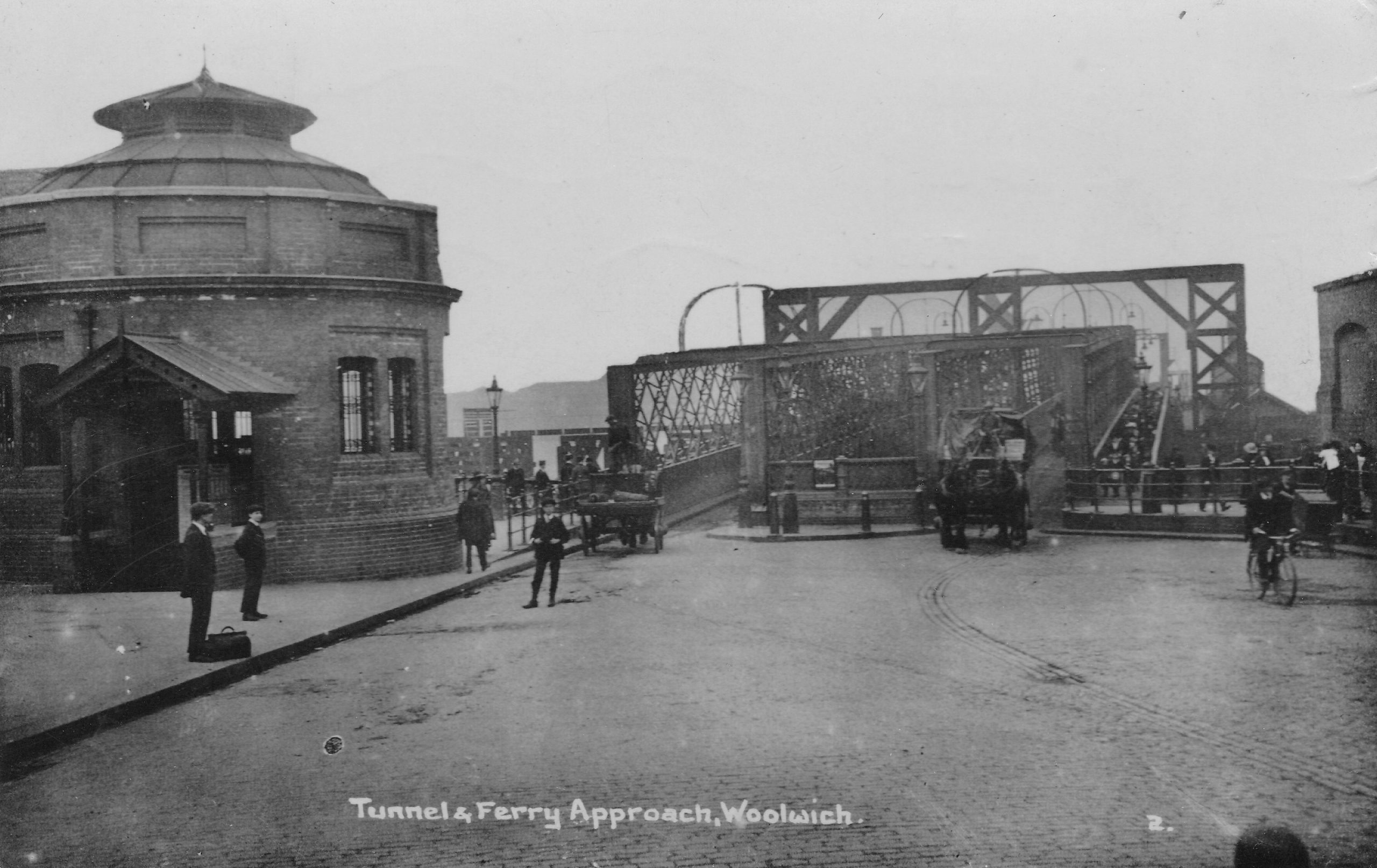
The following photo shows the entry to the foot tunnel to the left, and the pier providing access to the ferry straight ahead.
The stairs and causeway were immediately to the left of the ferry pier:
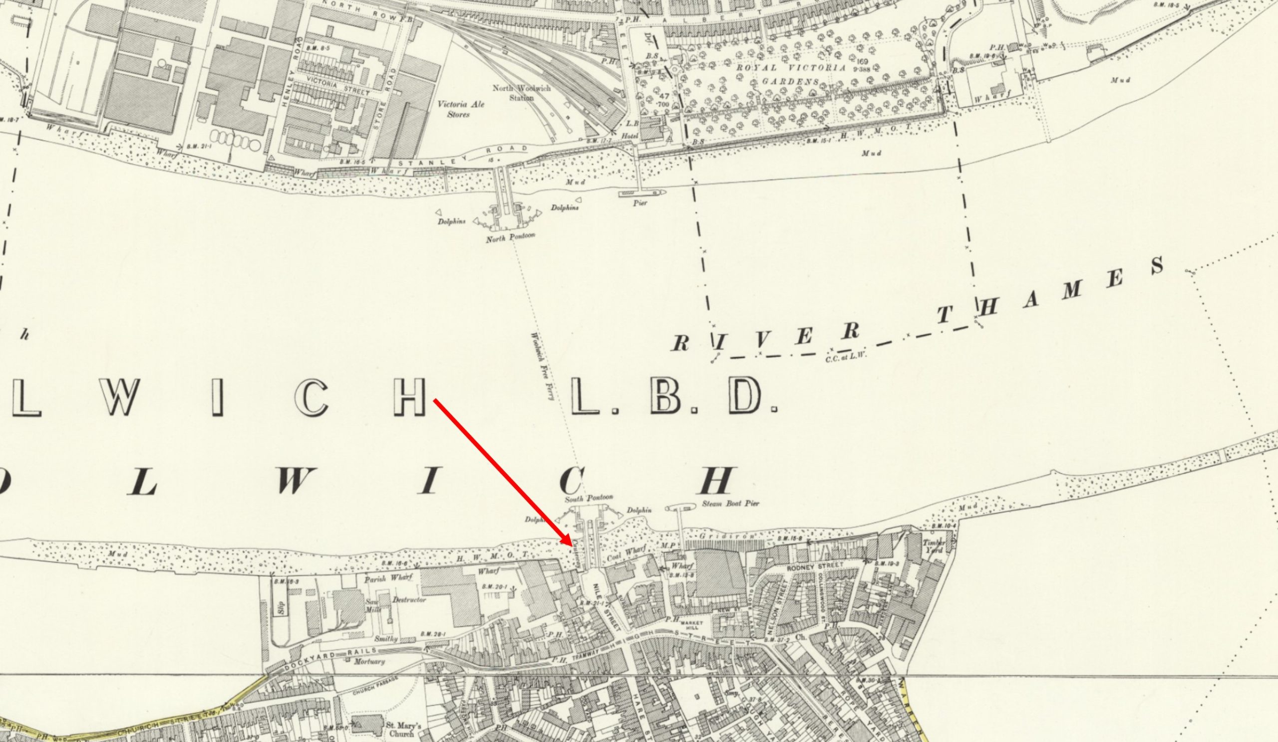
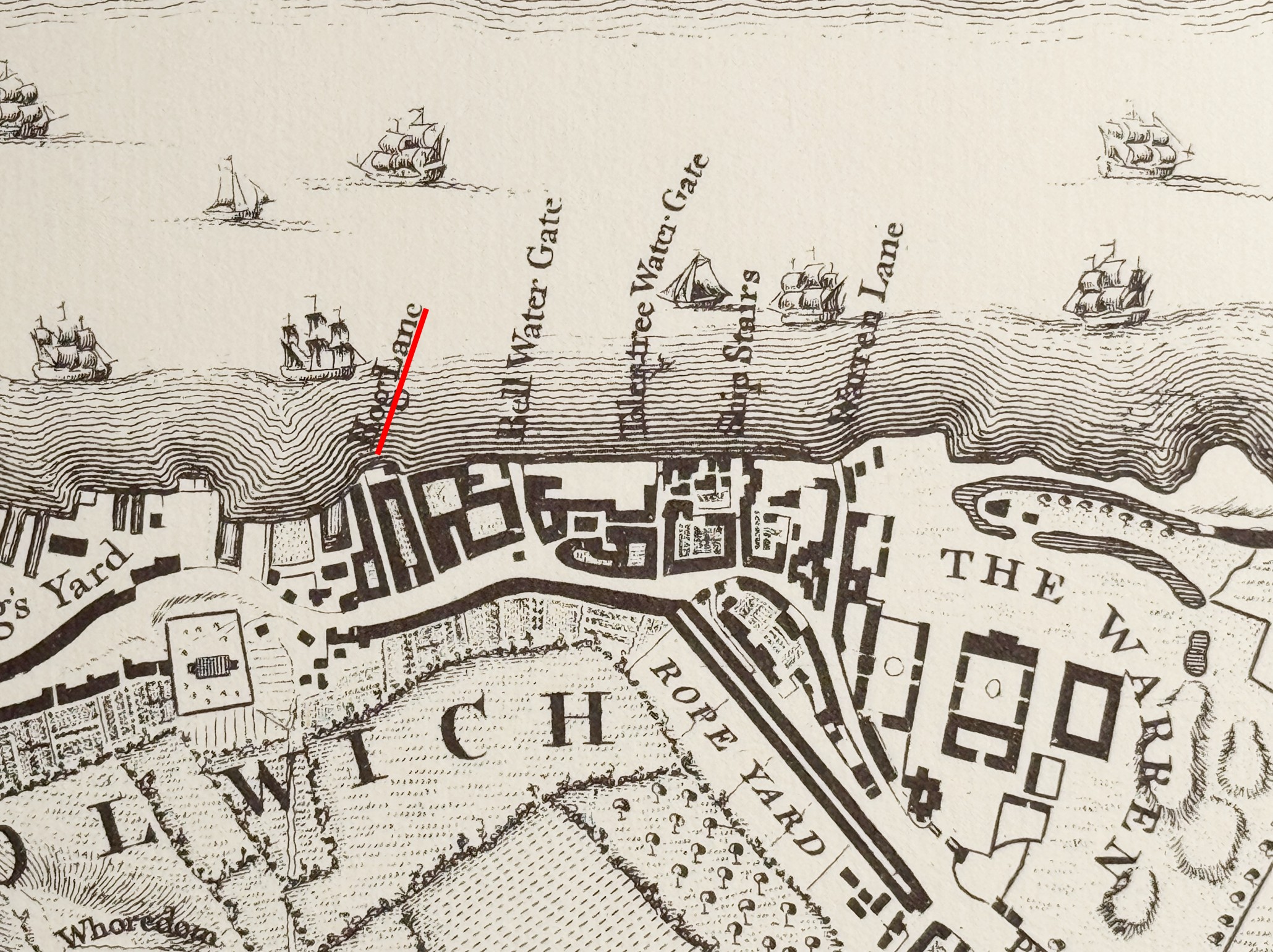
Which is much clearer in the following extract from the above map, where we can see Nile Street Stairs leading down, immediately to the left of the pier, and the causeway running out along the foreshore:
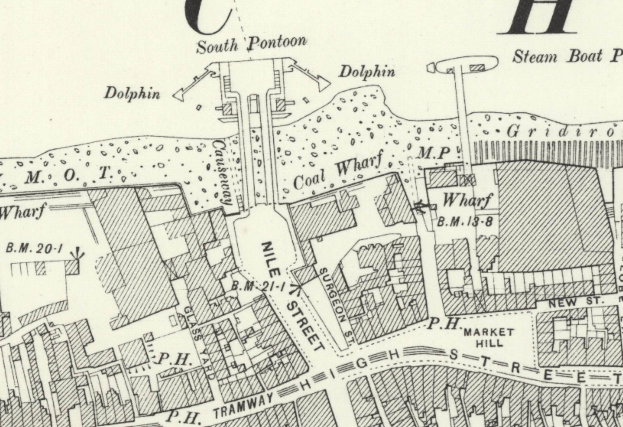
In the above map, the round entrance to the foot tunnel cannot be seen, as this had not yet been built. It was completed and opened in 1912, and in the following 1956 revision of the map, we can now see the round entry building to the foot tunnel, slightly inland from the pier and to the left of what was Nile Street, now named Ferry Approach, with the stairs and causeway still in place (Map ‘Reproduced with the permission of the National Library of Scotland):
The Woolwich foot tunnel had been built after the opening of the Free Ferry as an alternative method of crossing the river, when the ferry was not operational due to weather conditions such as fog and ice, maintenance problems etc.
Both OS maps only use the name “causeway”, rather than give the name Nile Street Stairs. It is named on earlier maps, one of which I will show later in the post. I suspect that the construction and use of the pier for the ferry diminished the importance and use of the stairs and causeway, which may have contributed to the failure to provide a name in these maps.
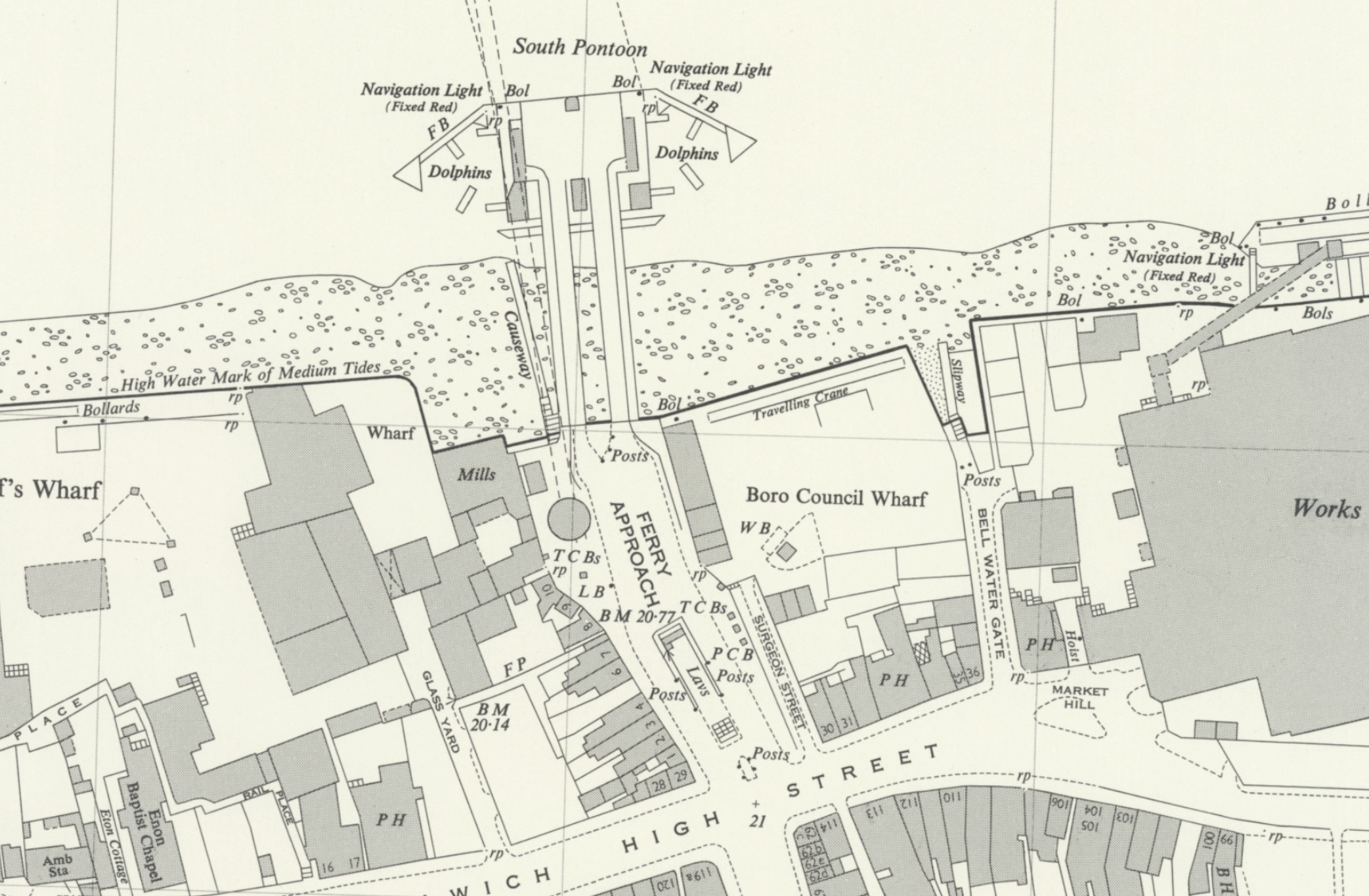
The above map also shows some brilliant street planning, as you have both the ferry and foot tunnel entrances side by side, so if you were in a hurry to get to your job at the Royal Docks across the river, and when you arrived, the ferry was not working, you could just detour to the tunnel entrance, and walk under the river rather than sail across.
You can also see in the middle of Ferry Approach, a space with the word “Lavs” – some public toilets, also possibly essential in what must have been a place with a very high footfall, as thousands of workers once used either the ferry or tunnel to get to their place of work, either at Woolwich Arsenal, the Royal Docks, or the very many industrial premises that lined the river on northern and southern sides.
In the following photo from the current top of the stairs, I am looking back along what was Nile Street. The round brick access building to the Woolwich foot tunnel is to the right, and the Woolwich Waterside Leisure Centre is the building to the rear of, and surrounding the foot tunnel entrance. The Leisure Centre was also built over Nile Street:
The following photo was taken from the edge of the leisure centre, as far back as I could get, to try and recreate the old photo earlier in the post. I should have been much further back, but the leisure centre now sits above Nile Street:
The area around Nile Street, the old ferry pier, and north towards Woolwich High Street has been considered as the original nucleus of the town of Woolwich, and many of the old street names recall rural surroundings. Streets in the area had names such as Hog Lane, Dog Yard, Hare Street and Cock Yard, and Hog Lane was the original name of Nile Street, as we can see from Rocque’s 1746 map of London, where I have underlined the name in red, as it was also used to name the stairs:
Rocque’s map shows the origins of Woolwich as a number of streets and buildings clustered along the river, with a total of five stairs providing access to the river. Hog Lane was both the name of the stairs and the street running back from the stairs, both of which would later change to Nile Street.
I cannot find out when the name changed, but I did wonder, given the ship building, naval and military aspect of Woolwich, with the Royal Arsenal (part seen to the right of the above map by the name of “The Warren”, whether the name changed in the late 18th / early 19th century following the 1798 Battle of the Nile where a fleet led by Nelson defeated a French fleet at Aboukir Bay, at the mouth of the River Nile where it flows into the Mediterranean.
This theory falls apart though as Hog Lane still appears in use for much of the 19th century, so in 1861 there is a newspaper report of a drunken man being robbed in Hog Lane, after he had gone to Hog Lane Stairs to wait for a boat, fell asleep, and on waking found that he had been robbed of his hat, handkerchief, boots and money.
Also in 1861 there was a report of a woman’s suicide at Hog Lane Stairs. She was wandering the foreshore and was asked by two boatmen whether she wanted a boat, but replied that a boat was coming for her. After going up the stairs, and returning sometime later, they found the same woman face down in the river.
The use of Hog Lane seems to die out after the 1860s, and in 1882 there is a report of the theft of timber from a wharf . It had been stolen from the pond adjacent to the owners wharf, and was re-landed at Nile Street Stairs, where the timber was sold for chopping into fire wood.
In 1915, Police Constable Taylor received the Royal Humane Society’s certificate for rescuing a boy from drowning at Nile Street Stairs.
The above news reports show why I find Thames stairs so fascinating. It is not just their physical nature, it is the very many stories of London life that can be pinpointed to their specific location. Looking over the river wall at the causeway and thinking about the thousands of Londoners who have used the steps and causeway, their stories, mostly just using the stairs to travel across or along the river, but also what drove some of them to suicide, crime, and the heroism of a rescue of a child from the dangerous waters of the Thames.
I have a theory that the majority of Thames stairs had a pub alongside. This seems true for nearly all stairs in Wapping, Shadwell, Limehouse, Rotherhithe etc. but also seems to be true for Woolwich.
There was a pub called the Nile Tavern adjacent to the stairs. In 1848 this pub was to be Let or Sold, and the following details were in the Morning Advertiser on the 15th of June 1848:
“Woolwich, Kent – Most excellent FREE WATER-SIDE PUBLIC HOUSE and TAVERN – to be LET or SOLD, with immediate possession, the Nile Tavern, Hog-Lane, Woolwich, situated adjoining the stairs next the Royal Dockyard, close to the Steam-boat Piers, and directly opposite the Eastern Counties Railway. The house is at present doing upwards of 20 puncheons of porter per month, with spirits , &c. in proportion, but which may be considerably increased.”
In other adverts for the pub it is described as “river facing”, so must have been at the river end of Hog Lane / Nile Street and facing onto the river.
I wonder if the pub was named after the Battle of the Nile, and the street changed name to reflect the name of the pub.
The Eastern Counties Railway refers to the railway and station that had just arrived in North Woolwich, and the steam boat piers refer to piers for boats travelling along the river, as well as the ferry set up by the Eastern Counties Railway to transfer rail passengers between their station of the north bank, and Woolwich on the southern bank of the river.
And if you fancy trying to order a “puncheon of porter” for Christmas from your local off licence, a puncheon is a third of a tun, which was a large barrel that held 252 gallons of wine.
In another advert, the Nile Tavern was described as “fronting the Thames and conveniently arranged for doing an extensive Public house and Tavern Trade, which its situation is always sure to command, being the nearest house to the shipping lying off the Royal Dockyard, and the place for embarkation for all persons connected therewith, and others employed on the river, the waterside premises” – a description which perfectly summarises why there was nearly always a pub next to a set of Thames Stairs, when the river was the working heart of the city.
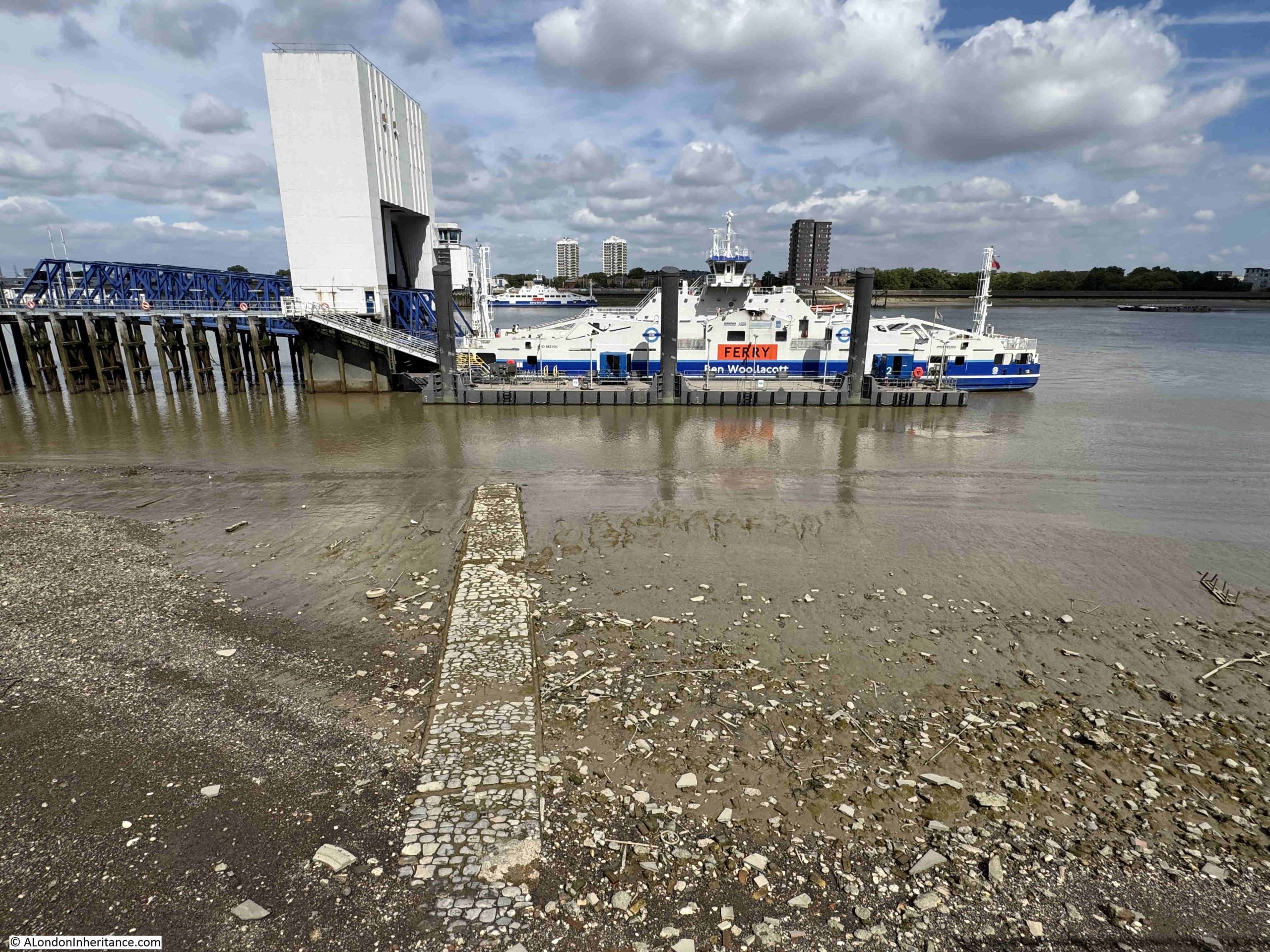
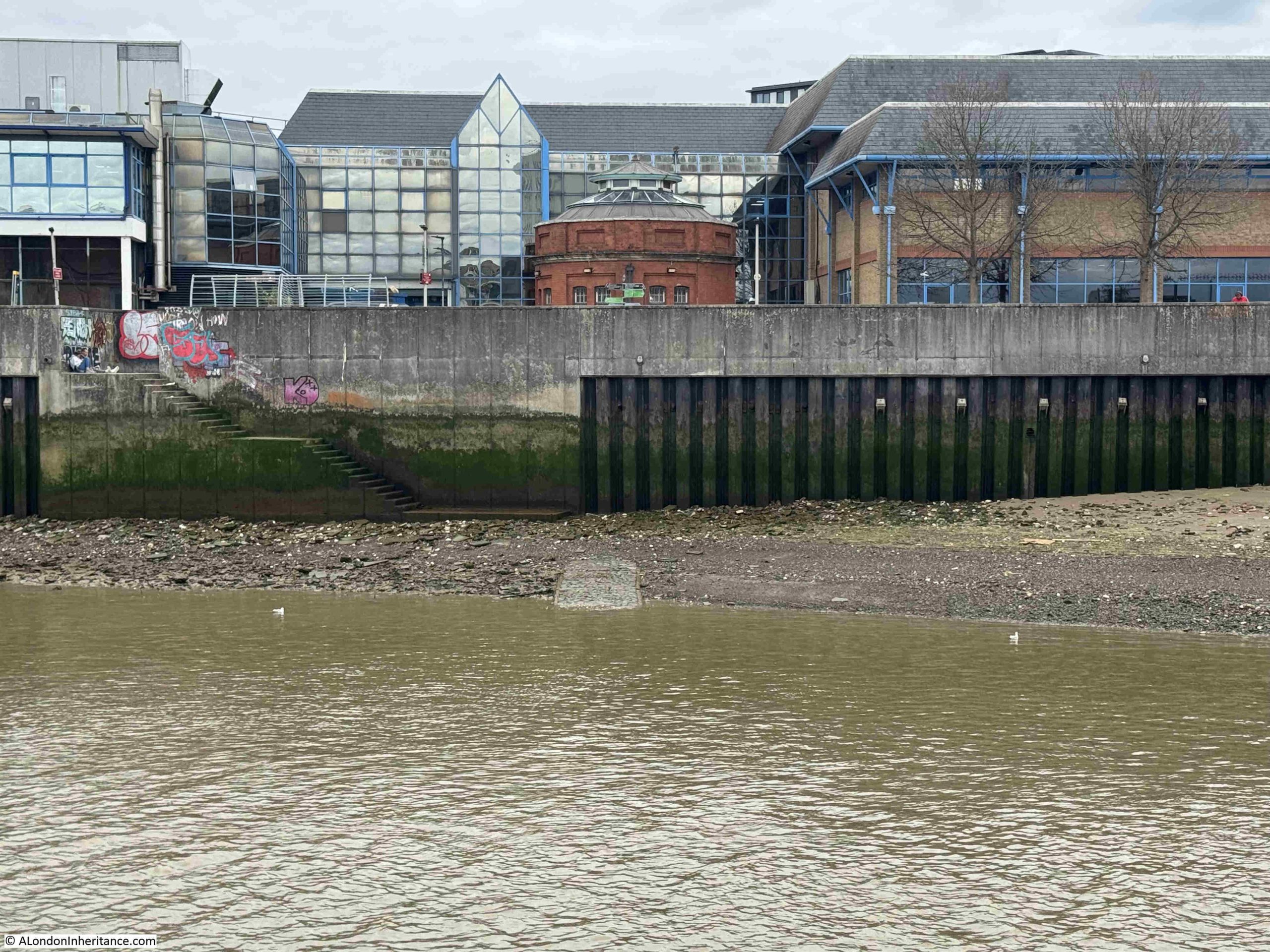
In the following photo from the Woolwich ferry, part of the causeway is just visible emerging from the receding tide. The stairs are now on the left, but originally followed the causeway back and up to the land. The Nile Tavern must have been to left or right of the stairs, and Nile Street / Hog lane headed back to the left of the round foot tunnel entrance, under what is now a sports centre, and up to Woolwich High Street:
Woolwich is protected from the river by high concrete walls, as is the opposite shore along North Woolwich. The above photo provides a view of these defences.
They are needed as Woolwich is downstream of the Thames Barrier, and is therefore not protected by the barrier. When the barrier is closed, the height of the water is a remarkable spectacle.
Whilst the Thames has for centuries been the source of London’s economic growth, prosperity, work, trade and travel, it has also been a source of danger to the low laying land along the sides of the river.
Nile Street and the Nile Tavern were mentioned in reports of a major storm during the first week of January 1887 when the “weather had been rough and stormy during the greater part of the week. Heavy rain had fallen every day and the temperature has continued unseasonably high”.
In Woolwich, several houses in Nile Street were flooded, as was the cellar of the Nile Tavern, and along the length of the Thames there was flooding from the lower portions of Chiswick and Hammersmith, where barriers were erected. Parts of Kew and Richmond were flooded, and in central London, Nine Elms, Wandsworth, Lambeth, Blackfriars, Deptford and Rotherhithe were all reported as suffering from flooding.
In Shadwell there was an “inundation”, and the “sailors and waterside characters turned out en masse, and beguiled the small hours of the night with songs in praise of the ocean and the river. The poorer of the people who worked in the docks were great sufferers of the inundation, which at one time threatened to wash away their wretched houses.”
In a similar way to the storm and floods of 1953, the 1877 storm also caused flooding along parts of the east coast, and in Lincolnshire and Cambridgeshire.
Nile Street / Hog Lane Stairs – that is another of the 240 river access points on the tidal Thames.
Each has been a part of the development of their local area, both on the river and on land. For many thousands of people over the centuries, they were an important place for so many reasons.
We have lost that connection with the river, but it would be good if the name of these stairs was on display, along with a brief bit of their long story and how important they once were to the people of Woolwich.
Woolwich has the distinction of having two unique ways of the crossing the River Thames. There is one of two, dedicated foot tunnels under the river (the other is at Greenwich), and it is the only place on the river where there is a combined vehicle and foot passenger ferry across the river, which has the added bonus of being free.
I have not used either of these crossings for around 20 years, so when I was walking around the Royal Docks for my previous posts, it seemed the idea opportunity to use the tunnel and ferry again, and I could also use London’s latest bit of transport infrastructure, the Elizabeth Line which runs to Woolwich, to get there.
The river is a short walk from the Elizabeth Line station, and a short distance away, there is a sign offering the two choices to cross the river:
The location of the entrance to the foot tunnel is not immediately clear. There is a small street (Glass Yard) heading off Woolwich High Street, where the above sign is located, you need to walk to the end of this street, turn right, and the tunnel entrance is hidden behind the Waterfront Leisure Centre:
The entrance on the north bank of the river is far more obvious as it stands alone, as can be seen in the following photo from across the river:
Although the entrance to the foot tunnel is hidden behind the leisure centre, it is the crossing point of a number of walking and cycling routes as illustrated by the rather comprehensive sign outside the entrance:
The Thames Path – where to the east it is 8.75 miles to Crayford Ness. The Capital Ring, where it is 35 miles to Richmond Bridge, The Thames Cycle Path with Greenwich to the west (6 miles) and Erith to the east (6.5 miles),
The bottom left sign informs that North Woolwich Station is a quarter of a mile away via the foot tunnel, which is rather out of date as North Woolwich Station closed in 2006.
The brick entrances to the Woolwich foot tunnel are Grade 2 listed, and the Historic England listing describes these structures in a far better way than I can:
Despite the fact of the Grade II listing, the unique status as being one of only two foot tunnels under the Thames in London, and that the tunnel is still in use, the Leisure Centre has been built up against the structure, as closely as it possibly could be, as illustrated by the following photo:
The Woolwich Foot Tunnel opened in 1912, when Woolwich already had a free ferry across the river, so you may well ask, if there was a ferry, why go to all the expense of building a tunnel under the river?
The local newspapers covered the opening of the tunnel, and the first paragraph in their accounts provides the justification for the tunnel:
“In spite of the County Council’s efforts to provide a frequent and regular service between North and South Woolwich, two causes have mitigated against the continuous working of the ferry – fog, and, in exceptionally severe winters, ice. The stoppages, especially those from fog, usually occurred during the early morning when workpeople had to cross the river to their labours, and serious hardship was thus inflicted on a large number of people. With these facts before it, the County Council recognised that the service would have to be supplemented, and in November 1908, they submitted to Parliament a scheme for the construction of a tunnel for foot passengers between the north and south districts.
It was pointed out that if such a tunnel were constructed it would no longer be necessary to provide a continuous service of ferry boats. The necessary sanction having been obtained tenders were invited and that of Messrs. Walter Scott and Middleton Ltd., amounting to £78,860 was accepted.”
My last few posts on the Royal Docks has hopefully highlighted the size of these docks, and therefore the amount of people needed to work across them. Add to that, the industry that occupied the land between the docks and the river, all contributed to a significant demand for workers, many of whom would have lived on the south of the river in Woolwich, and for whom, the ferry would have been essential to their employment on the north of the river.
The following postcard was issued to mark the opening of the tunnel on the 26th of October, 1912 by Lord Cheylesmore, who was Chairman of the London County Council:
The photo for postcard was by a Woolwich photographer, although I cannot be sure whether the photo is off the Woolwich or the North Woolwich tunnel entrance. The opening ceremony was held at the southern entrance, however I cannot place the features seen around the entrance in maps of the area around the time of the tunnel opening.
When the tunnel was opened, the entrance was in Nile Street, a short, wide street that led to the South Pontoon, from where the Woolwich Ferry could also be taken, so unlike today, the foot tunnel entrance was collocated with the ferry approach, so if the ferry was not running, the passengers could simply divert down the tunnel.
Today, the tunnel entrance is separate to the tunnel approach.
Early photos and postcards often had crowds looking at the photographer, possibly the novelty of seeing a photographer. In the above photo there is a baby or young child in white, in the centre of the crowd. It would be fascinating to know the stories of these young Woolwich residents:
Walking into the entrance to the tunnel, and there is a large No Cycling sign above a spiral stairway that leads down to the tunnel:
The view along the tunnel from the base of the southern entrance:
Lift at the base of the southern entrance:
The newspaper article covering the opening of the tunnel provides some background to its design and construction:
“The new tunnel, which was begun in May, 1910, was designed by, and carried out under the supervision of the Chief Engineer of the London County Council, Sir Maurice Fitzmaurice. It closely resembles the Greenwich Tunnel, which was opened in 1902. It consists of a cast iron tube, of 12ft. 6in. outside diameter, connecting two vertical shafts of 25ft. inside diameter, and about 60 ft. deep.
The length between the shafts is 1,635 ft., or nearly one third of a mile. The thickness of the river bed between the top of the tunnel and the river is about 10 ft. at the deepest place. Electric lifts have been provided to accommodate forty passengers each. A fair day’s progress in tunnelling was 8ft. 6in. The ground passed through was almost entirely chalk, with numerous fissures, which were in free communication with the river. The cost has been about £85,000.”
Sir Maurice Fitzmaurice, who designed and supervised the construction of the Woolwich foot tunnel was also responsible for the Rotherhithe tunnel, where construction started in 1904 and the tunnel opened in 1908.
As you walk through the tunnel, it is good to know that there is 10 feet between the top of the tunnel and the bed of the River Thames:
There are plenty of very obvious signs that state there is to be no cycling through the tunnel. During my walk through there were two cyclists. One was wearing a high-vis jacket, obviously going either to or from work, and was cycling very slowly – which was fine given how empty the tunnel was of walkers (only me and one other), however half way along I heard a whooshing sound behind me, and one cyclist, on a racing bike, wearing a helmet, sped past, looking like he was doing a time trial through the tunnel. In the time between passing me, and me lifting my camera, he was the distance from me as shown in the following photo:
The problem of cycling through the tunnel has been around since the tunnel opened. In June 1913 the Woolwich Gazette and Plumstead News reported the following:
“FOOT TUNNEL CYCLING – Hebert F. Clarke of 1. Chertsey Road, Leytonstone was summoned for riding a bicycle through Woolwich Foot Tunnel. George Hunter of 28 The Parade, Grove Green Road, Leytonstone, was also summoned. Each fined 2s.”
It is remarkable how many tunnels under the Thames opened in a very short period of time, and much was made of the cost of the Woolwich tunnel compared with the others:
1897 – The Blackwall Tunnel. Cost £1,300,000
1902 – Greenwich Foot Tunnel. Cost £180,000
1908 – The Rotherhithe Tunnel. Cost £1,000,000
1912 – The Woolwich Foot Tunnel. Cost £87,000
Infrastructure getting cheaper is something we can only dream of today.
Approaching the southern end of the tunnel:
The decision to build a foot tunnel at Woolwich, highlights the challenges of planning for the future.
At the opening ceremony, it was stated that the need for a subway had been emphaised by recent fogs, which had interfered with the working of the ferry.
Lord Cheylesmore stated during his speech at the opening ceremony that (referencing the decision to open the ferry. twenty-one years earlier) “If future requirements had then been realised it was possible that a vehicular tunnel would have been constructed in the first place.”
It is always a problem when constructing any large transport / infrastructure project, to know whether an alternative design would better serve future requirements. The problem is that waiting for those future requirements to become clear, results in nothing being built. Building now risks it being outdated in the future.
The opening ceremony was held in Nile Street, the access road to the ferry, with the tunnel entrance alongside. Nile Street is now under the Waterfront Leisure Centre, and the ferry pier has moved slightly to the west.
At the southern end of the tunnel, the lift was not working, so it was up the stairs for the 60 ft. of the access shaft:
Back up to the surface on the north of the river, and here the access building is identical to that on the south of the river, although here it is in open space, with no surrounding buildings:
Outside there are direction signs for the Capital Ring and on a separate post, direction signs for local buses and a DLR station. Fortunately no sign for North Woolwich Station on this side of the river:
One of the new Superloop branded buses stops outside the tunnel entrance:
New building close to the entrance to the tunnel which is alongside the approach road to the Woolwich Ferry:
The new tunnel had an impact on one of the oldest professions on the river. In the year after the tunnel was opened, the London County Council paid out £15 to each of the sixteen remaining Woolwich ferrymen, who once rowed people across the river.
One of the ferrymen was a 60 years old who had been on the river “since he was six weeks old”, and knew “every mudbank and creek from Kingston to Dover and Yarmouth”, and as well as a ferryman had worked on lighters, as well as being a sailor.
He complained that “I’ve worked hard and straight, I’ve helped the police and I’ve helped my passengers. I have saved lives and property. I have been proud to be a freeman of the river, and now, when I am old, they go and dig a hole below it and rob me of my trade. It isn’t fair.”
Following the opening of the tunnel, there were ongoing challenges with the costs of running and maintaining both the ferry and the tunnel, with some attempts to reduce the hours that the lifts down to the tunnel operated (which were soon restored), and the number of ferry crossings, which were reduced slightly, however the ever increasing volumes of motor traffic meant that any reduction in ferry crossings was short lived.
The northern tunnel entrance:
From close to the tunnel entrance, we can see the current terminal of the Woolwich Free Ferry:
The northern tunnel access which is in a very different environment from the hidden and enclosed location of the southern. Hopefully with all the new building planned for this part of North Woolwich, it will stay in the open:
The opening ceremony for the tunnel was held in Woolwich on the southern side of the river. After the speeches and formal parts of the ceremony, Lord Cheylesmore along with the other dignitaries who had attended the ceremony descended down to the tunnel and walked to North Woolwich.
After emerging from the tunnel entrance shown in the above photo, they took the Woolwich Free Ferry back to Woolwich, and that it what I will now do.
Walking to the pier that leads to the ferry – the access road bends to the left at the end of the end of the orange cones:
As you walk onto the road leading up to where the ferry boards, we can see the old walkway that was to the immediate west of the approach to the ferry. In the following photo, there is a large anchor in the gap between the bushes:
Looking along the approach to where the ferry boards:
As you walk up to the ferry, there are some brilliant views along the river. In the following photo, the Thames Barrier stretches across the river, and on the right is where the ships carrying sugar cane dock for unloading into the Tate & Lyle factory:
Where vehicles and foot passengers board the ferry:
The Woolwich Ferry is currently a two ferry service, with a departure every 15 minutes from five in the morning until nine in the evening. Whilst waiting for the ferry to arrive, you can watch the two ferries perform their synchronised crossing of the Thames:
Facilities are basic, but then with a 15 minute service there is no need for anything more sophisticated. The footpath on the western side of the approach road takes you up to the boarding point, where a bus shelter provides some limited protection from the elements:
The earliest references to a ferry at Woolwich date back to 1308, when it was included in the sale of a house by a waterman named William de Wicton.
The ferry in the 14th century, and the following centuries would have been similar to services provided by watermen along the length of the Thames, where for a fee they would row you across the river.
These services were generally provided from a defined point, usually a set of Thames Stairs or a named place where a street reached the river. This was the case for the ferry at Woolwich, where it ran from Warren Lane at Woolwich (circled red in following 1746 map extract):
To and from the end of the lane in the following map. This point was covered by two separate pages in my copy of Rocque’s map so I have had to show two different map extracts. Where the tip of the red arrow is located was where the lane met the Thames:
The ferry service run by a waterman must have been a very ad-hoc serviuce and he probably spent more of his time rowing people up and down the river. During the 18th century there was very little where North Woolwich is now located. It was all fields, marsh and streams as the above extract demonstrates.
The early years of the 19th century saw the start of more formal ferry services, with the military setting up a ferry for their own use, from Woolwich Arsenal in 1810, and in 1811 a ferry was established by an Act of Parliament, and was run by a company that was called “The Woolwich Ferry Company”, however this service only lasted until 1844.
The demand for a regular, high volume service would come with the development of the area to the north of the river with the Royal Docks and associated industry in the 19th century.
On the 16th of October, 1880, the Kentish Independent reported that “A meeting is advertised for Monday next at the Town Hall to consider the proposed establishment of better communications between South and North Woolwich, embraced in the scheme of the Thames Screw Ferry Company. From the company’s prospectus we learn that they contemplate building two large twin screw boats, with turn-tables on deck and other conveniences for transporting horses and vehicles, together with a saloon for passengers, and that they propose to have landing stages at various positions below London Bridge. As we are chiefly interested in the Woolwich section of the river, where facilities of communication are perhaps more needed than anywhere else, we hope that the promoters will give us their earliest attention. At a moderate calculation it is computed that some 200 carriages will cross the river daily, and with a charge of 6d to 2s according to the number of horses, it is estimated that the speculation will be a profitable one.”
On the same page as the above report, there was a fascinating article on the impact of the electric lights at the Royal Albert Dock, which had only just opened, and was the first London dock to be lit by electric lighting.
Consider that the following was written when London must have been very dark at night, very limited electric lighting, some gas lighting, and not much else after dark:
“THE ALBERT DOCKS – The appearance of the electric lights at the new docks, seen from any eminence where a full view of the whole sweep can be obtained, is on a clear night very striking and beautiful, especially if a position is chosen from which any of the brilliant sparks are seen reflected in the river. In another sense beyond pleasure to the eye, they are beacons of satisfaction to the people of Woolwich, for they typify better days in store, increase in trade, and reduction of local burdens.”
It must have been quite something to stand in Woolwich and look across the river to see the light from the new electric lights along the new dock, and the article also highlights the positive impact that the docks were hoped to have on Woolwich – and for which a ferry was really important, so the residents of Woolwich could benefit from the opportunities opening up on the north of the river.
One of the two Woolwich ferries arriving at the northern pier:
The two new ferries entered service in early 2019, after being delivered from where they were built in Poland.
The ferry in the above photo is named the Ben Wollacott, after the 19 year old deck hand who died in the river in 2011, after being pulled from the ferry while mooring ropes were being untied.
Serco, the company then in charge, was found guilty of failing to ensure the health and safety of its crew, and fined, with costs, a sum of £220,000.
The second of the two new ferries was named the Dame Vera Lynn.
The above photo shows a packed ferry, with a mix of lorries, vans and cars making the free crossing across the river.
And whilst I was waiting for the ferry to arrive, there was a queue of vehicles building to cross from north to south:
There is no ceremony for foot passengers boarding the ferry, the barrier across the walkway lifts and you walk onboard, whilst vehicles are still leaving the ferry:
Which provides a perfect opportunity to see the deck of the ferry before any vehicles have boarded:
The ferries before the current pair had a passenger area below the vehicle deck. With the two new ferries, there is a passenger area at deck level, on one side of the ship, where a corridor is lined with blue plastic seating:
The meeting in Woolwich Town Hall in October 1880 was strongly in support of a new ferry, with the “rapid growth of townships on the north of the river” being a key driver of the need for Woolwich residents to be able to cross the river via regular and reliable services.
In the October 1880 meeting, we also see the demands that the ferry should be free. Many of the bridges over the Thames in west London had recently had the fee dropped for a crossing, so west London bridges were now free to cross, and the Woolwich argument was that the three million people east of London Bridge were paying their rates, which went towards the Metropolitan Board of Works ability to drop the charges for west London bridges, east Londoners should have the same facilities.
Plans then moved quickly, and in 1884, the Metropolitan Board of Works agreed to deliver a free ferry across the river, and in 1887, the construction company Mowlem (who were also responsible for much construction work across the whole of the London docks right up to their closure), was awarded a contract to build the approach to the ferry, pontoons and boarding infrastructure.
The Woolwich Free Ferry opened on the 23rd of March, 1889, and such was the importance of the event that reports of the opening also mentioned that it was made “the occasion of a public holiday in the neighbourhood of Woolwich”.
The service was opened by Lord Rosebery, the chairman of the London County Council, who had just taken over the responsibilities of the Metropolitan Board of Works (and after whom Rosebery Avenue was named).
Two steam ferries had been built for the opening of the service, the Gordon and the Duncan, and they were reported as being “capable of carrying a thousand people and at least a dozen vehicles upon the upper deck”.
The ability to take a thousand people and only twelve vehicles highlights the original need for the ferries, being able to transport large numbers of residents from Woolwich and surrounding areas, to the new employment opportunities that were opening up across the Royal Docks, and the industry along the river.
Local business soon took advantage of the new free ferry in their advertising, with, for example T. Gordon, a maker of hand-sewn boots in 9 Hare Street, Woolwich, heading his adverts with the opening of the Woolwich Free Ferry, and that residents of South and North Woolwich, Silvertown, Canning Town, Plumstead, Charlton and the Surrounding Vicinity could all now “Come and judge for yourselves”, the quality of his boots.
The new service was not without its problems. The ferries were built of pitch-pine “a wood chosen for its self preservative qualities, but unfortunately very inflammable”, and there were occasional fires on the ferry as a result.
There was also a case where the steering on a ferry jammed mid river, with the Captain stopping power so it would not ram the jetty, however the ferry then started drifting in a busy river. On checking the steering gear it was found that a bolt had dropped and jammed the gear, and on removal, the ability to steer was restored.
The bolt was found to be unlike any used in the ferry, so it was assumed to be sabotage.
The ferry crossing in the 1970s:
The following photo shows two of the three ferries built in 1963, and which were replaced by the ferries that we see on the river today. The photo dates from the 1980s, as behind the ferry, on the left edge of the photo, some of the dishes of the BT Docklands Satellite Ground Station, can be seen:
I took the following photo on a Sunday in 2015, I know it was a Sunday as two of the three ferries are moored in the river just to the right of the pier on the left, where there is a single ferry docks:
The following photo shows the Duncan – one of the first boats built for the opening of the ferry service:
The deck is crowded with passengers with what appears to be a mix, including children along with men in military uniforms. The upper deck is crowded with vehicles.
The following photo shows the Gordon, the second of the three ships built for the opening of the ferry. It was named after General Gordon of Khartoum:
Although it does not look that much different from the above ferry, the photo below is of the Will Crooks, built in 1930 as one of the replacements for the original fleet of ferries:
The following photo from the 1920s books “Wonderful London” shows the ferry crossing the river, with a man at one of the Thames stairs in the foreground. There is a rowing boat tied up, so perhaps he is one of the old waterman still hopeful of some business:
The text with the above photo claims that the ferry “conveys about half a million vehicles a year free of charge”, and that the cost to run the ferry was about £25,000 a year.
My view from the ferry of the landing place on the north of the river, from where the ferry had just departed. The round brick building of the tunnel entrance can be seen to the right:
The Tate & Lyle factory:
As I arrive at the southern pier, the Dame Vera Lynn is arriving at the north:
The crossing between Woolwich and north Woolwich is brief, however it does provide the opportunity for some wonderful views across the river. Another view of the Thames Barrier, with the towers of the Isle of Dogs in the background:
Arriving at Woolwich:
The ramp descending:
As with boarding the ferry, when leaving, the barrier lifts and you walk off. A quick look back at the ferry:
The Woolwich ferry approach road:
As I was leaving, a queue was building up ready for the following ferry, and at Woolwich, there is a separate queuing area where vehicles queue before be let on to the approach to the ferry.
The route from south to north seemed much busier than that from north to south. That may just be a time of day thing. I tried to find any detailed statistics of ferry usage on the Greater London Authority and the Transport for London websites, but after a quick search, nothing seemed to be available.
The headline statistics seems to be that the Woolwich ferry carries around two million passengers a year. The vast majority of these will be the occupants of vehicles rather than foot passengers.
The following photo shows the entrance to the ferry at Woolwich:
I did not notice one on the north of the river, but at Woolwich on the south, the ferry has a “River” TfL roundel:
The combination of the two methods of crossing the river at Woolwich are unique. Whilst there is another foot tunnel at Greenwich, there is no other large passenger / vehicle ferry.
The fact that the Woolwich ferry continues to be free is remarkable in today’s financial environment, where so much starts to be attracting a price.
When the new Silvertown tunnel opens, there will be a fee for using the tunnel, and to stop people continuing to use the currently free Blackwall tunnel, a new fee will be introduced for using this old tunnel, the first time in 130 years.
It will be interesting to see if the Silvertown tunnel has an impact on traffic levels on the Woolwich ferry. Theoretically not, as the Silvertown Tunnel follows a similar route to that of the Blackwall tunnel. It could be that traffic on the Woolwich ferry increases to avoid the fees at the Blackwall and Silvertown tunnels, such are the unintended consequences of change.
To introduce a fee for the Woolwich ferry would require an Act of Parliament to amend the act originally brought forward by the Metropolitan Board of Works to introduce the ferry, which specified that the ferry should be free to use.
Today, foot passengers wanting to travel between the north and south sides of the river at Woolwich also have the choice of the DLR which runs from Woolwich Arsenal to the north, as well as the Elizabeth Line which runs from Abbey Wood, to Woolwich, before heading north of the river.
The loss of the docks in the 1980s significantly reduced the number of jobs for residents of the south to commute to on the north. The DLR and Elizabeth Lines have added alternative options, however for a quick, free crossing of the river, the Woolwich Ferry is a wonderful way of seeing the river and getting between north and south Woolwich, and the foot tunnel provides an historic alternative using one of only two surviving foot tunnels under the Thames.