Monthly Archives: June 2023

Samaritans, Physicians, Cutlers, the YMCA and Freemasons

Firstly, a quick apology for an error in last week’s post. I had confused the size of the floors in the Swan pub, at Wapping Dock Stairs. The newspaper article I referred to stated they were 30 feet square on each floor, which I stated would have been just over 5 feet on each side (30 square foot, rather than 30 feet on each side of a floor), so a much larger room, and a reminder to me to read through my posts a couple of times before sending.

Thanks to those who let me know about the error.

For this Sunday’s post (and after reading through three times), a return to discover some of the fascinating stories told by the plaques that can be seen whilst walking around the City of London, starting with;

The Samaritans – St Stephen Walbrook

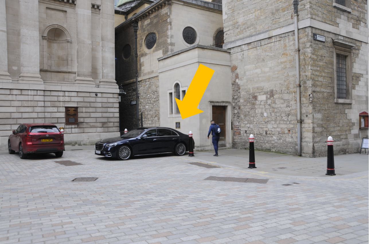
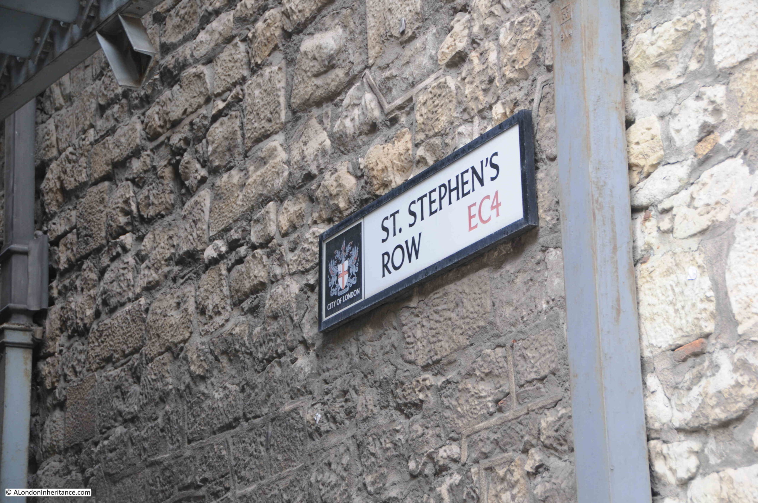
There is a blue City of London plaque on the side of St Stephen Walbrook, where St. Stephen’s Row heads along the rear of the Mansion House, arrowed in the following photo:

Samaritans

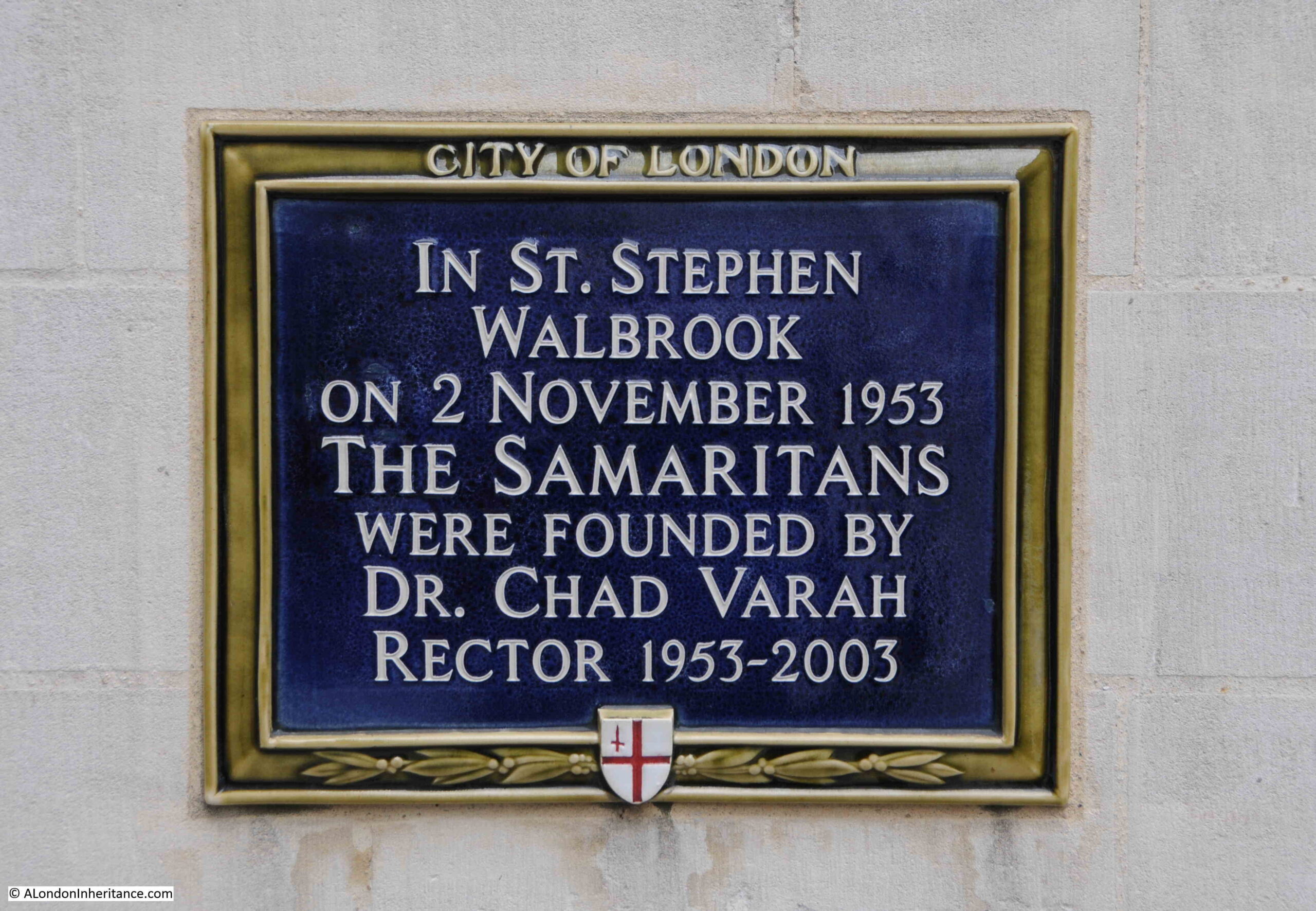
The plaque records that the Samaritans were founded in the church in 1953 by the rector, Chad Varah:

Samaritans

Edward Chad Varah. to give him his full name, was born on the 12th of November 1911 in the Lincolnshire village of Barton-on-Humber. He was the eldest of nine children and the name he would be known by came from St Chad, founder of the parish.

He did not intend to follow his father into the church, however he was persuaded by his godfather, Archbishop Hine.

In the early 1950s, he was based at Clapham Junction, carrying out house visits, and working as the chaplain of St John’s hospital, Battersea, however despite these activities, his stipend was very low, with hardly any money available for his work, and just enough to pay for a secretary. To help generate additional income, he took on a second career as a scriptwriter for children’s comics.

Varah had very liberal views for the time, particularly for a person of the church. He was a strong believe in sex education, and believed this was key for poorly educated young people.

His believe in the importance of sex education, and willingness to listen to people, to provide advice, and eventually to start the Samaritans may have come from an event in 1935 when Varah was an assistant curate in Lincoln. He had to conduct his first funeral which was for a 13 year old girl who had taken her own life. The girl had started her period, however without knowing what was really happening she feared she had a sexually transmitted disease which would result in a slow, painful and shameful death.

His lack of money whilst working in Clapham Junction, along with the responsibility of a parish, prevented any formal development of a system of help for those at risk of suicide, of which there was an average of three a day in London in the early 1950s.

Help came when he was offered the living of St Stephen Walbrook by the Grocers’ Livery Company. This was a City church without any parishioners when compared to Clapham Junction, and this provided Varah with the time to set up the service which would become the Samaritans.

Varah started with a single telephone on the 2nd of November 1953.

His connections in the publishing industry through his work on comics immediately led to some publicity for his new service, such as the following from the Daily Mirror on the 7th of December 1953:

“DIAL 9000 FOR WORDS OF COMFORT – A telephone emergency service, run on the same lines as the police 999 calls, will soon be available to people in distress who need spiritual aid.

All Londoners need do is dial Mansion House 9000, the number of the Telephone Good Samaritans, and advice will be given immediately.

The scheme has been thought up by the Rev. Chad Varah, 42, Vicar of St. Stephen’s in the City, and will be in operation within the next few months.

If a case is sufficiently urgent, a Good Samaritan will dash to the caller and try to comfort and help him or her, said Mr. Varah yesterday.

The Vicar hopes to enroll Samaritans – volunteer workers for his service – from all parts of London.

I want to spread the organisation so that there are at least two Samaritans for every four square miles of Greater London and the suburbs, he said.

I first got the idea from the many letters I received from people in mental and spiritual distress. And I have found that a chat, a kind word and some good advice from an outsider can often save a person’s life.

He said that he intended to deal with personal spiritual problems concerning everything from quarrels between married couples to would be suicides.

The qualifications Samaritans need are tact, patience and the ability to keep other people’s confidences, he said. Religion is a secondary requirement.”

The Daily Herald had a similar report, but ended with the following paragraph, which provides an indication of how many calls Chad Varah was receiving:

“Mr. Varah is now missing meals to keep up with the phone calls he is getting. The former vicar of St. Paul’s Clapham Junction, he has just taken over St. Stephen’s.”

He soon collected a group of volunteers together to take calls, and in February 1954 he handed over the responsibility to take calls to the volunteers leading to the organisation of the Samaritans.

Chad Varah was involved with the Samaritans for the rest of his life. He retired from St Stephen, Walbrook in 2003 after being rector of the church for 50 years. He died in 2007, just a few days before his 96th birthday.

A remarkable man, who started an organisation that must have saved countless lives since starting seventy years ago in St. Stephen Walbrook in 1953.

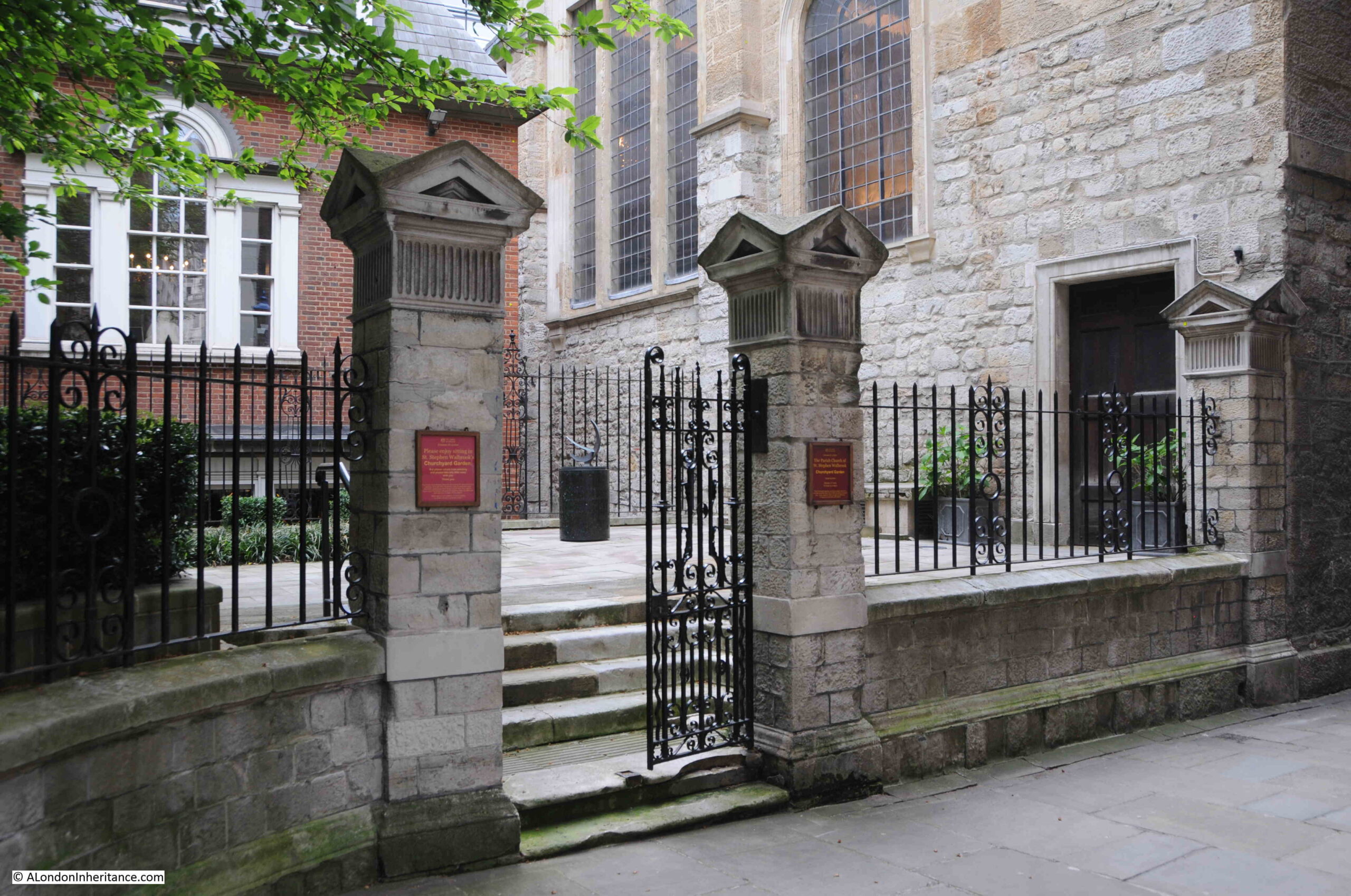
The City of London plaque to the founding of the Samaritans is next to a small alley, St. Stephens Row which runs alongside the church, and the rear of the Mansion House.

On the wall of the Mansion House close, to the plaque is a stone block, which I think warns that anyone sticking bills or damaging the walls will be prosecuted. There is no date, but from the faded script, and style, it is of some age:

St. Stephen Row Samaritans

St. Stephen’s Row leads between the church and Mansion House:

St. Stephen Row Samaritans

I suspect St. Stephen’s Row dates from the construction of the Mansion House.

The first stone of Mansion House was laid in 1739 and the home of the Mayors of the City of London was completed in 1758.

Although it was still under construction, by the time of Rocque’s 1746 map of London, it is shown on the map, and there is an alley between the Mansion House and St Stephen’s, which continues to the right of the Mansion House. Although it is not named on the map, it is the route of St. Stephen’s Row today:

St. Stephen Row Samaritans

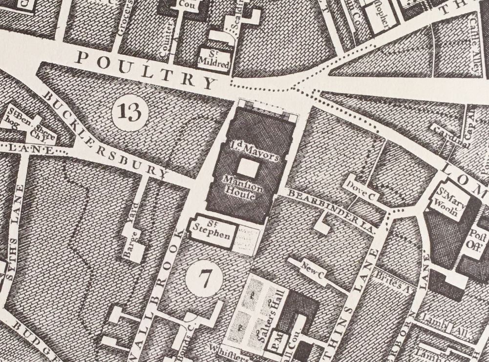
Going back to William Morgan’s 1682 map of London, and the space for the future Mansion House was then occupied by the Woolchurch Market. There looks to be buildings between the market and church, but there is no sign of the alley:

St. Stephen Row Samaritans

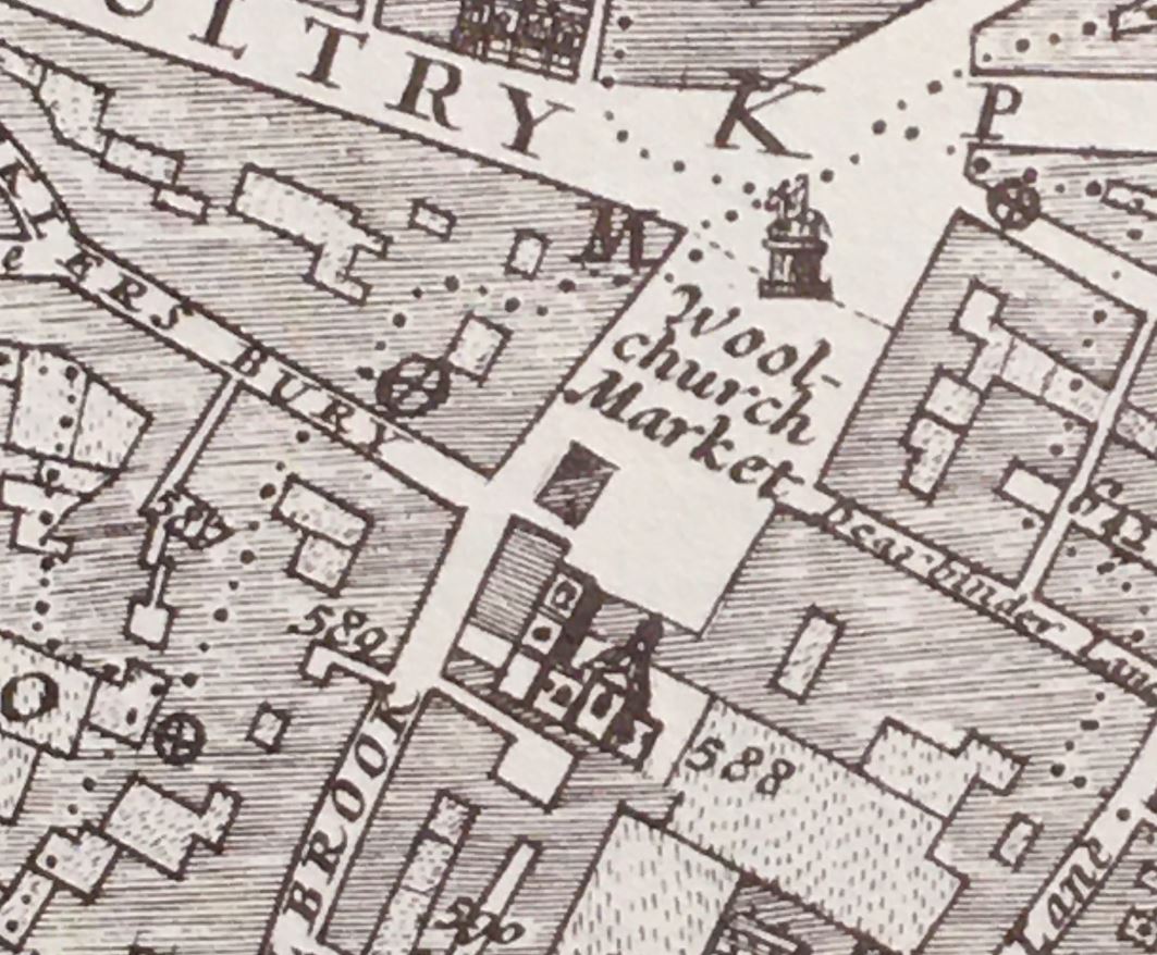
There was a church which stood where the Mansion House now stands called St Mary Woolchurch Haw. The church was lost during the Great Fire of 1666 and not rebuilt, and the market took the name of the church.

I have written about the church and the market towards the end of the post at this link.

The view along St. Stephen’s Row, with the church on the left and Mansion House on the right:

St. Stephen Row Samaritans

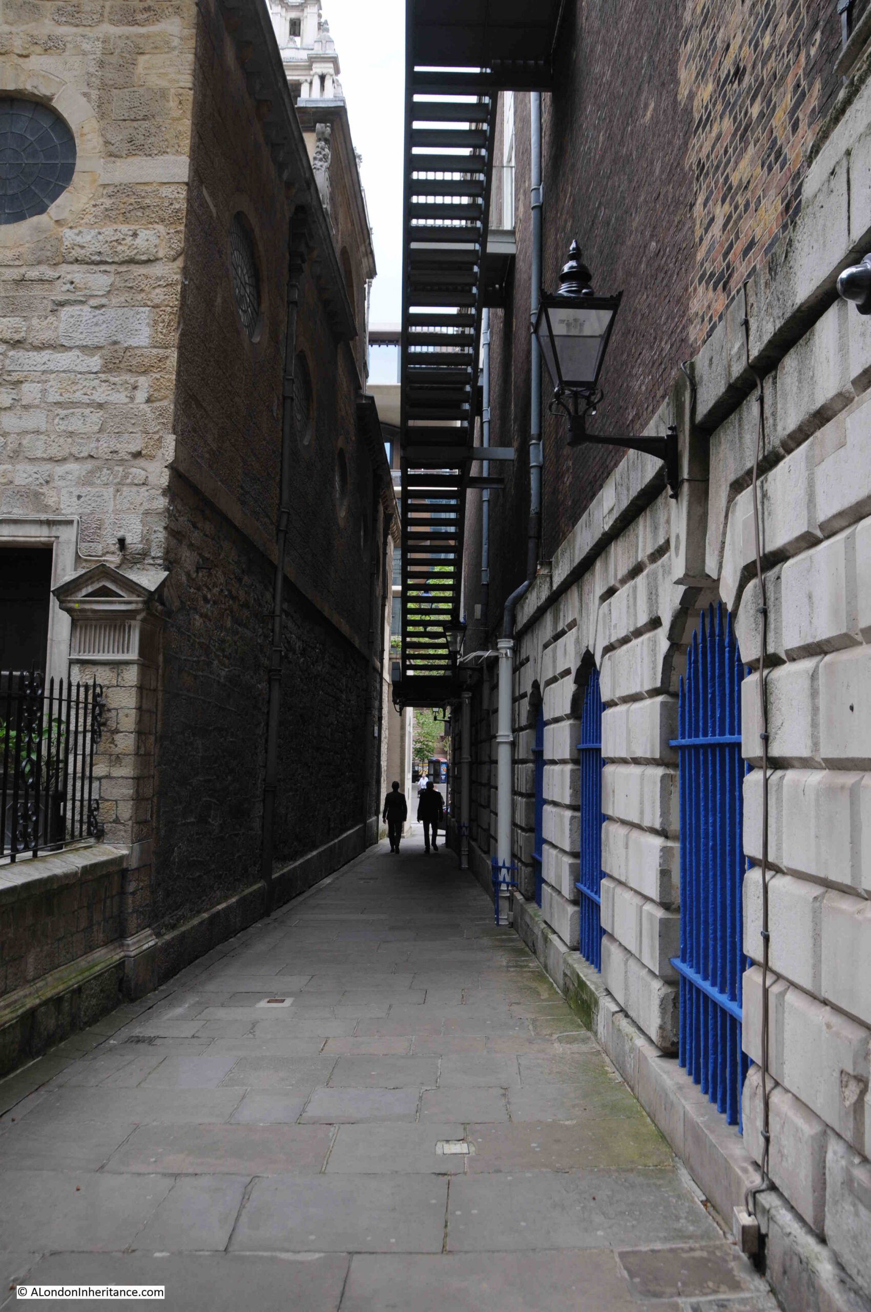
The entrance to the churchyard at the rear of St. Stephen Walbrook from St. Stephen’s Row:

St. Stephen Walbrook Samaritans

Now to a very different location:

The Royal College of Physicians

In Warwick Lane, which runs between Newgate Street and Ave Marie Lane, to the west of St. Paul’s Cathedral, there is a plaque shown arrowed in the following photo:

Royal College of Physicians

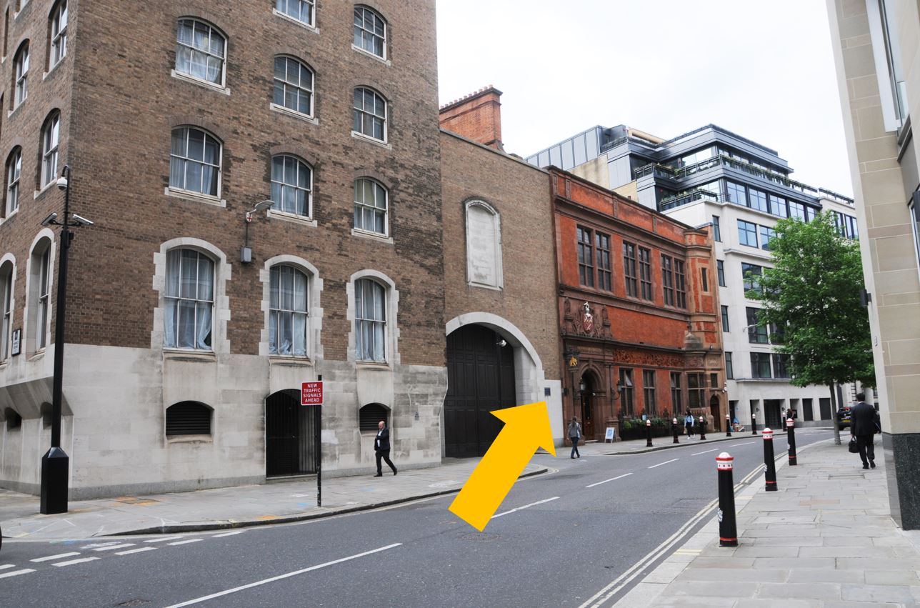
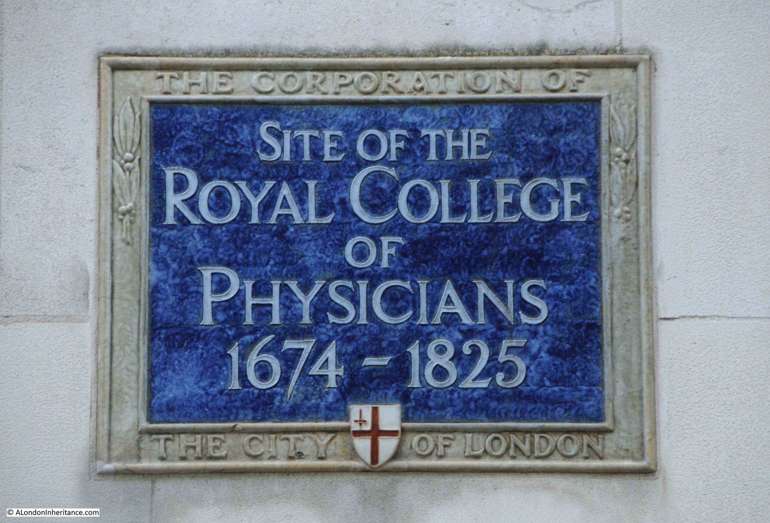
Recording that this was the site of the Royal College of Physicians between 1674 and 1825:

Royal College of Physicians

The origins of the Royal College of Physicians dates back to the early 16th century when a number of leading medical men, including Thomas Linacre, the physician to King Henry VIII became concerned about the state of medical practice in the country, the lack of any regulation, and the impact that untrained physicians were having on their patients.

Thomas Linacre, along with five other leading physicians, persuaded the kIng to allow the founding of a College of Physicians.

A Royal Charter was received and the College of Physicians was founded in London on the 23rd of September, 1518, and an Act of Parliament in 1523 extended the authority of the College from London to the whole of the country.

The “Royal” was added to the name after the restoration of the monarchy with Charles II in the later part of the 17th century.

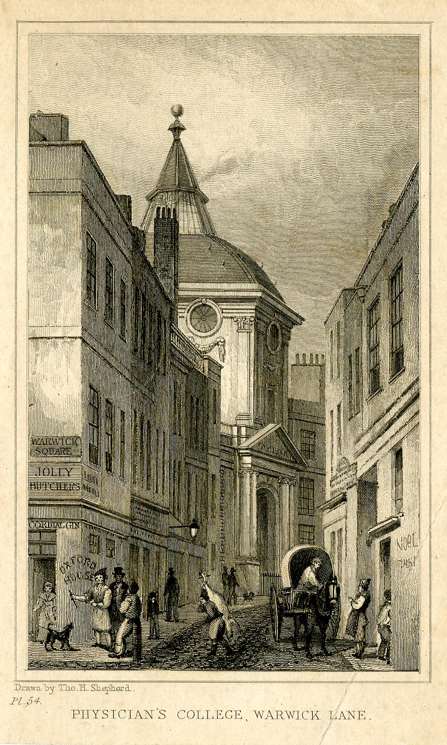
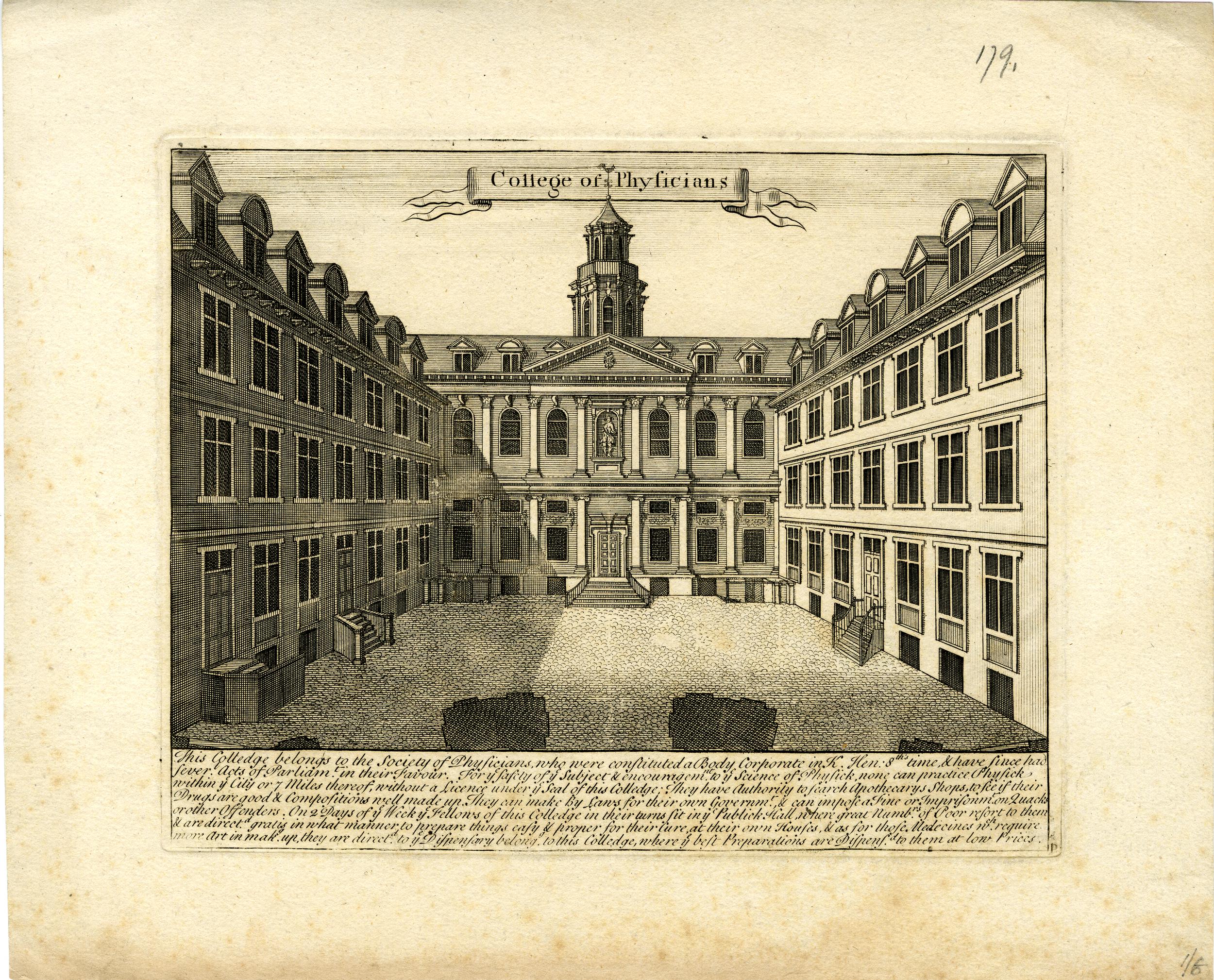
The Royal College of Physicians original home in the City of London was destroyed in the 1666 Great Fire, and nine years later, following some successful fundraising, the Royal College purchased land and property in Warwick Lane.

The new building was designed by Robert Hooke, and had a large central courtyard with wings either side. There was a public gallery, an anatomy theatre which was topped by an octagonal dome, and a large library which was designed by Christopher Wren.

The view of the Royal College of Physicians in Warwick Lane  © The Trustees of the British Museum):

Royal College of Physicians

The large courtyard at the rear of the block facing onto Warwick Lane  © The Trustees of the British Museum):

Royal College of Physicians

By the early 19th century, the City was becoming a crowded, busy and dirty place, and the building in Warwick Lane had deteriorated so was sold in 1825, and finally demolished in 1890.

Following the exit from Warwick Lane in 1825, the College moved to Pall Mall, before moving in 1964 to Regents Park, where they remain to this day.

Although not marked by a plaque as it is still in use, there is an interesting building next to the plaque:
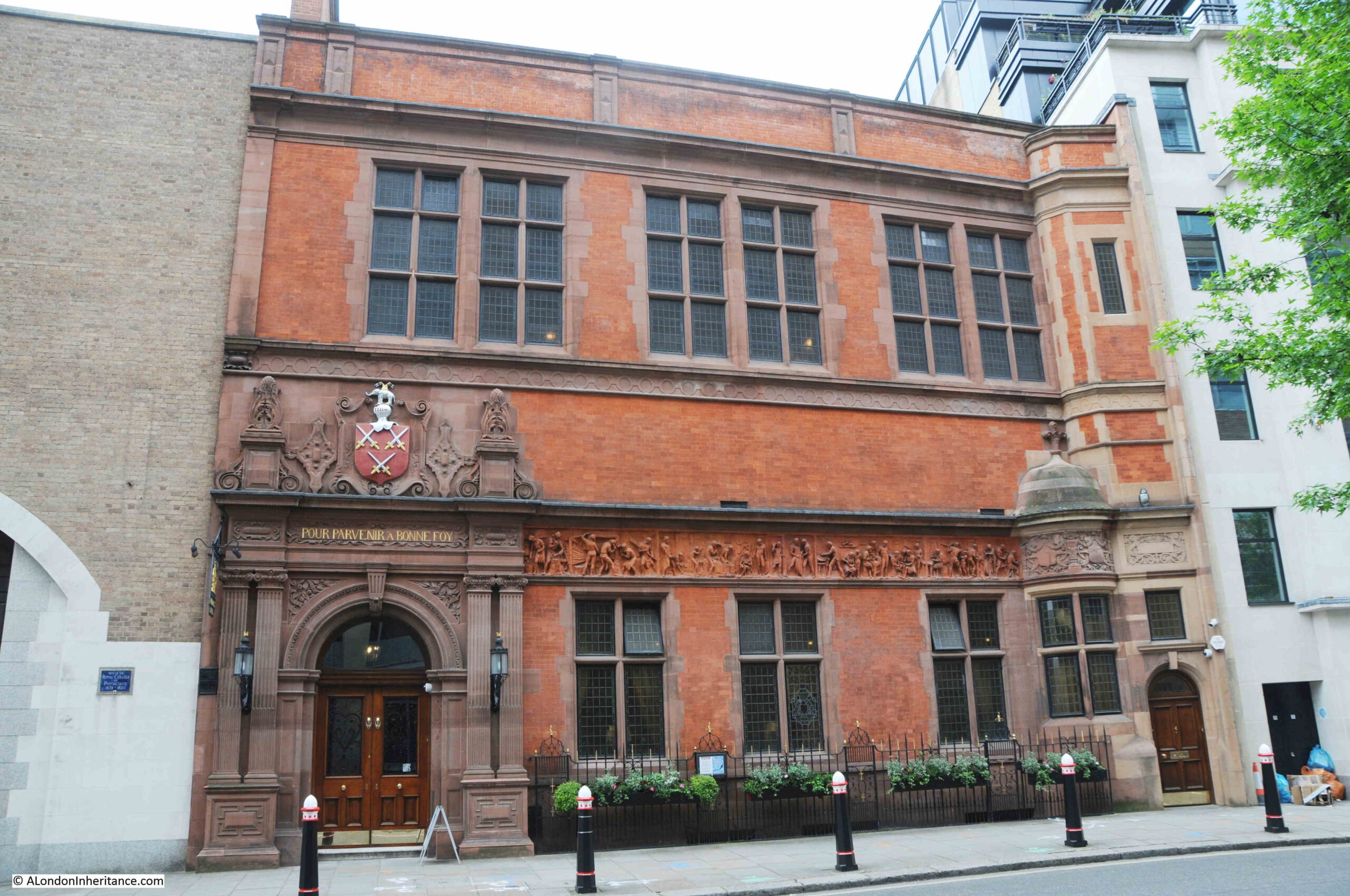
Cutlers Hall

This is Cutlers Hall:

Cutlers Hall

My go to book on the City’s Companies (The Armorial Bearings of the Guilds of London by John Bromley, 1960) records the following about the Cutlers:

The cutlery trade of the Middle Ages included the making of swords, daggers and knives of all kinds. originally it was a highly specialised industry, comprising the separate trades of hafters who made handles or hafrts, bladesmiths and sheathers, with the cutlers acting as assemblers and salesmen. Both hafters and sheathers were ultimately merged into the Cutlers Company while the bladesmiths were first united with the Company of Armourers, and then allowed by a decision of the Court of Aldermen of 1528 to depart unto the fellowship of Cutlers at will.”

Given their trade, you would expect the Cutlers to be one of the old Company’s of the City, and they are indeed, with the first mention of an organised craft of Cutlers in 1328 when seven cutlers were elected to govern the craft and search for false work.

The Cutlers moved to the hall we see today in Warwick Lane in the 1880s, when their original hall in Cloak Lane was demolished to make way for the construction of the Inner Circle Line by the Metropolitan and District Railway Company (now the route of the Circle and District lines between Mansion House and Cannon Street stations).

I wrote a post about the original hall, and the construction of the railway in this post: Cloak Lane, St John the Baptist, the Walbrook and the Circle Line

The arms of the Cutlers can be seen above the entrance to the hall, and the following image shows the arms:

Cutlers Company

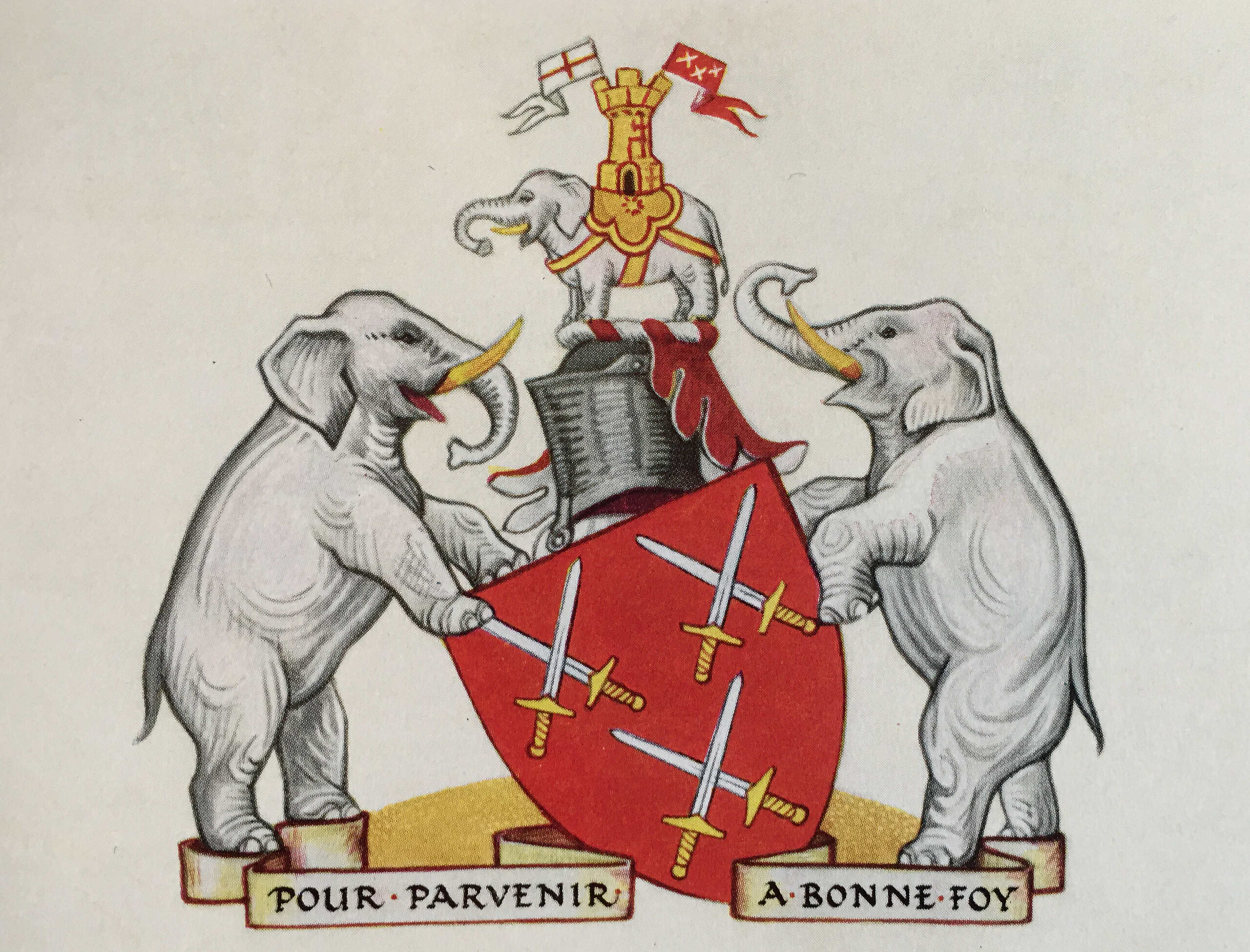
The swords are an obvious reference to one of the products of the Cutlers. The use of elephants in the arms is old, and was recorded in 1445 where members of the Cutlers wore elephants as decorations on their coats or shields when the City welcomed Queen Margaret on her marriage to Henry VI in 1445.

The use of the elephant may be down to the use of ivory in the hafts (handle of a knife) made by members of the Company.

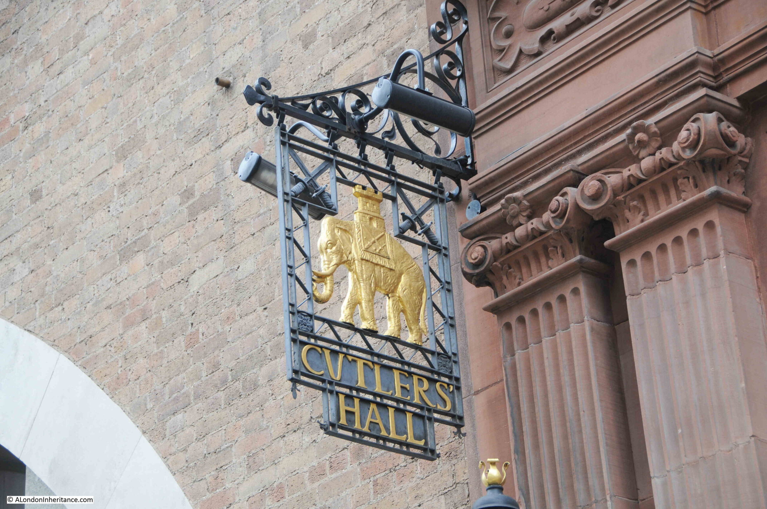
The elephant is featured in the sign hanging from the side of Cutlers Hall:

Cutlers Hall

One remarkable feature of Cutlers Hall is the frieze along the façade of the building. The frieze is a detailed view of the work of cutlers, and was created by the sculptor Benjamin Creswick.

The following image shows the frieze, with the left most panel at the top:

Cutlers Hall

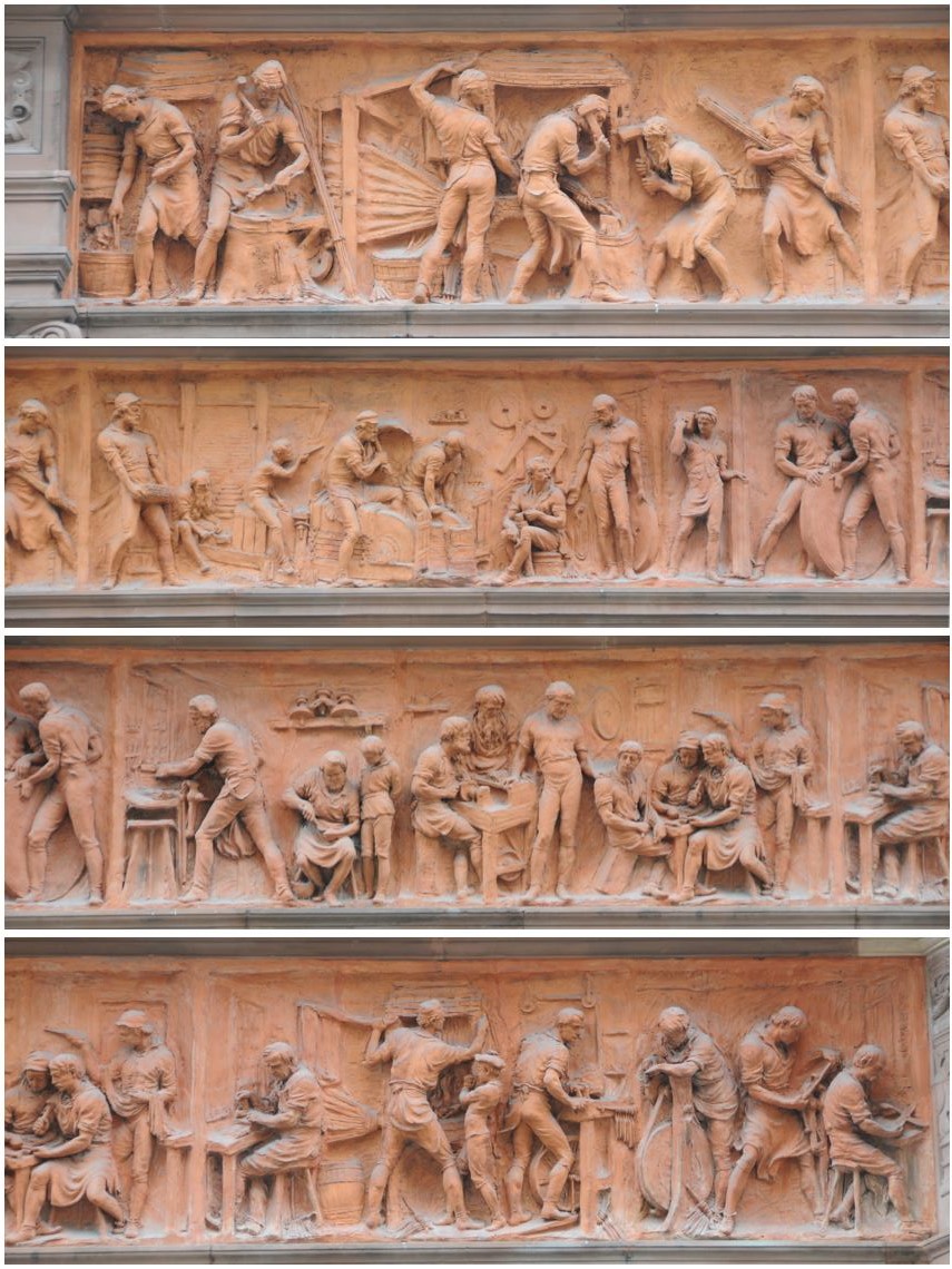
The red terracotta frieze is a wonderful record of the work of the trades that formed the Cutlers Company.

Now to St. Paul’s Churchyard to find two very different organisations, starting with the:

Young Men’s Christian Association

In front of the cathedral, there is an office block with shops on ground level running along the line of St. Paul’s Churchyard. There is a covered walkway in front of the shops, and at the western end of this walkway, next to the old gate of Temple Bar are two plaques, the first arrowed in the following photo:

YMCA

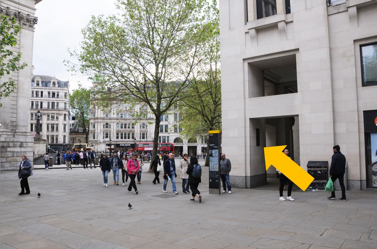
The arrow is pointing to a plaque on the wall recording the founding of the Young Men’s Christian Association:

YMCA

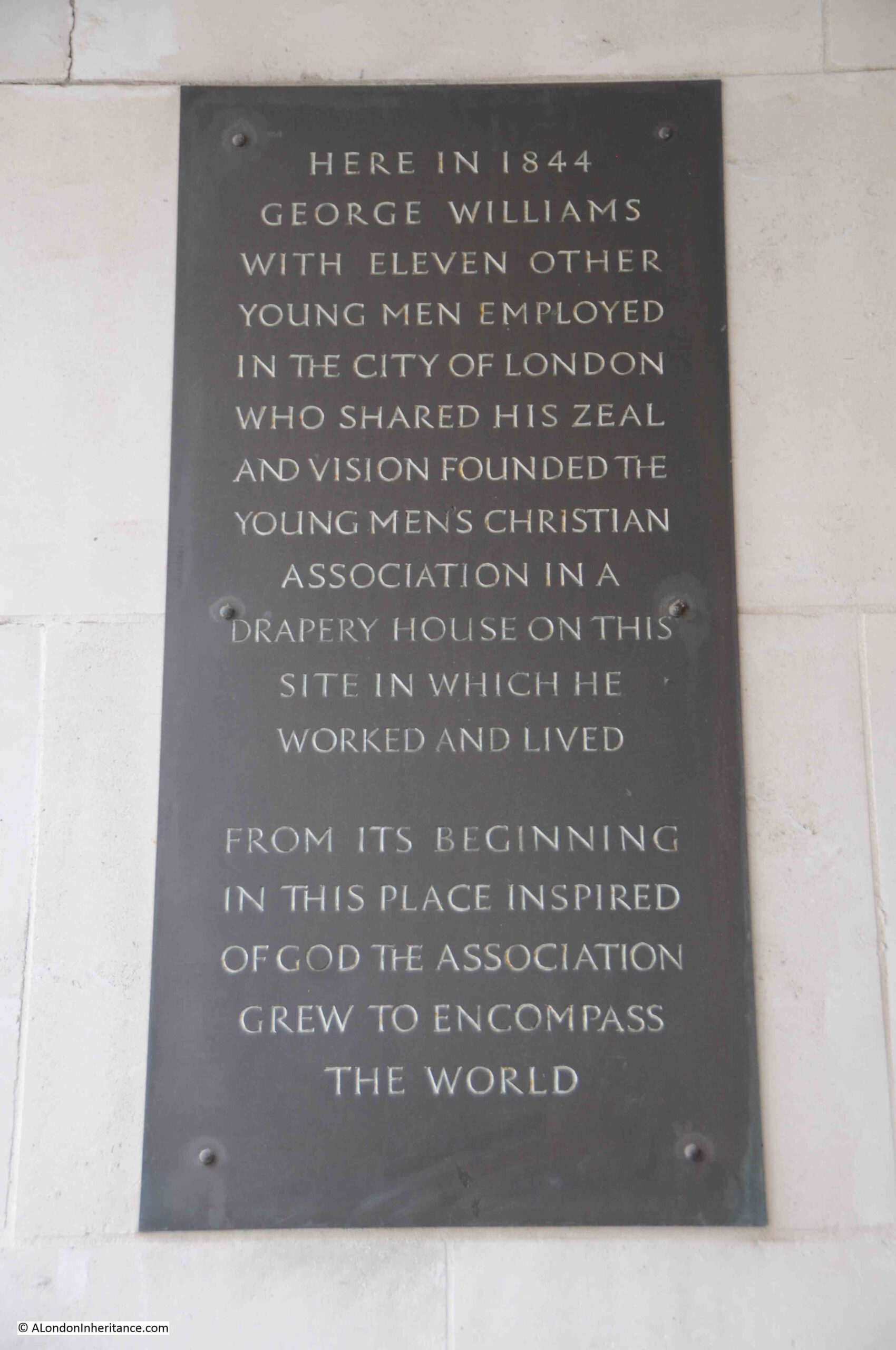
The plaque states that in 1844, George Williams with eleven other young men employed in the City of London…….Founded the Young Men’s Christian Association. But why here?

The Drapery House mentioned in the plaque was the offices, factory and warehouses of Hitchcock, Williams & Co.

The firm was established in 1835 by George Hitchcock and a Mr. Rogers, who would leave in 1843.  George Williams (mentioned in the above plaque) who originally joined the company as an apprentice, became a Director with Hitchcock in 1853 when the partnership Hitchcock, Williams & Co was formed. Always based in St. Paul’s Churchyard, firstly at number 1, then at number 72, with the firm expanding to take in many of the surrounding buildings.

George Williams, as well as becoming a partner with Hitchcock, received a knighthood from Queen Victoria for services, which included the inauguration of the Young Men’s Christian Association (YMCA)  which was founded in a room of the company’s premises in St. Paul’s Churchyard.

The history of the YMCA states that the group founded the YMCA as “a refuge of Bible study and prayer for young men seeking escape from the hazards of life on the streets of London”.

The buildings of Hitchcock, Williams & Co. were destroyed during the raids of the 29th December 1940. A paragraph in the newspaper reports of the raid included a mention of the company and the YMCA:

“The historic room in which the Young Men’s Christian Association was started was among the places destroyed on Sunday night. With seven other buildings, the George Williams Room – named after the founder, the late Sir George Williams – was burned to ashes. It was situated in the premises of Messrs. Hitchcock, Williams and Co, manufacturers, warehousemen and shippers, of St. Paul’s Churchyard, and was originally one of the bedrooms used by the 140 assistants employed in the Hitchcock drapery business.”

As stated in the plaque, “from its beginning in this place inspired of God the association grew to encompass the world” and all because George Williams started as an apprentice here, in one of the many businesses that once lined St. Paul’s Churchyard.

I wrote a post dedicated to the company’s experience in the 1940s in this post: Operation Textiles – A City Warehouse In Wartime.

The Grand Lodge of English Freemasons

There is another plaque in the same place as the plaque recording the YMCA. Directly opposite, in the entrance to the covered walkway shown in the photo of the location of the YMCA plaque is the following:

Freemasons

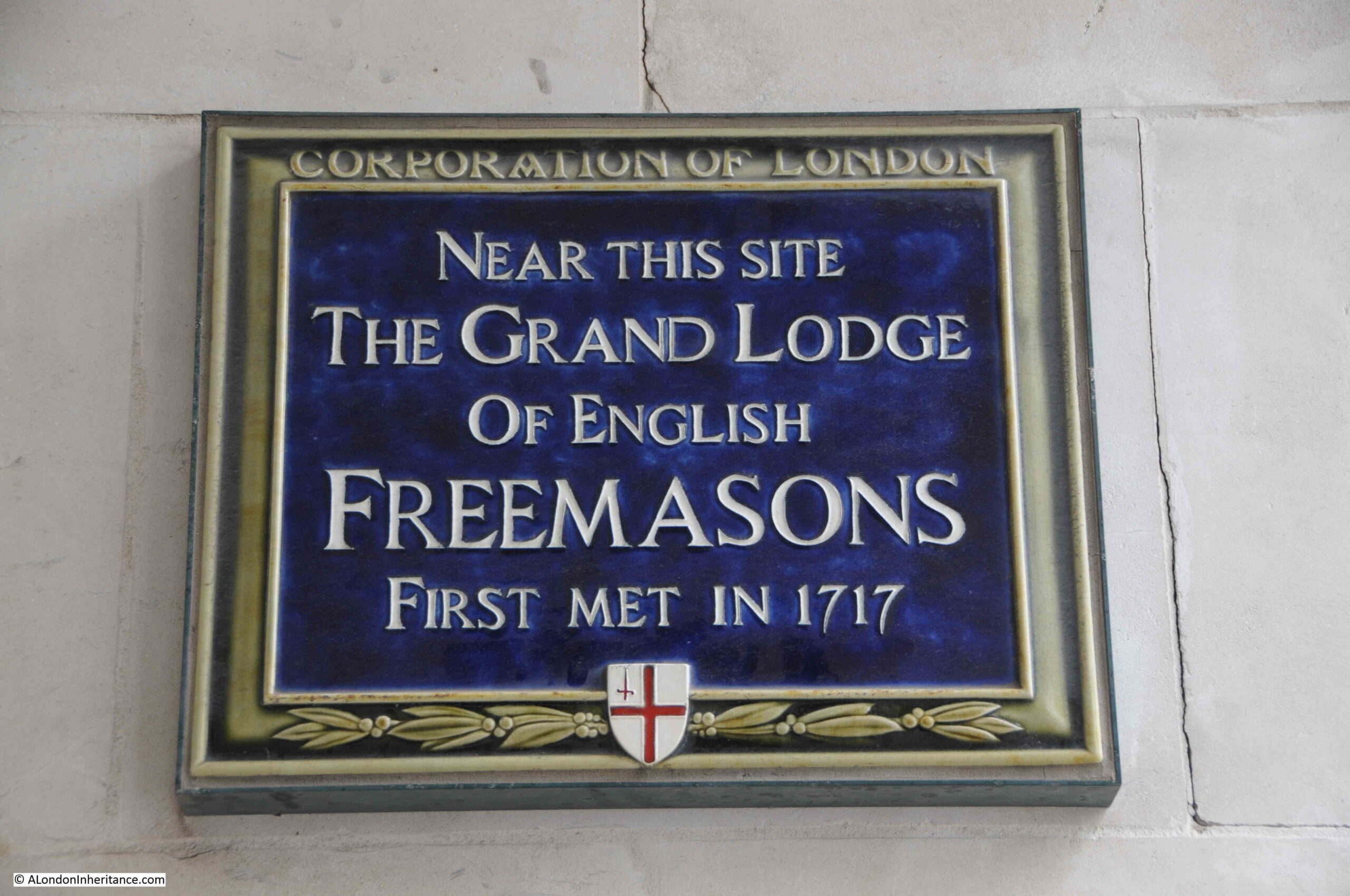
The significance of the plaque and the site is the reference to the Grand Lodge, as prior to 1717 there had been four London lodges, and on the 24th of June 1717, they met at the Goose and Gridiron Tavern in St Paul’s Churchyard, and elected Anthony Sayer as the first Grand Master.

This was the first Grand Lodge not only in the country, but also across the world of Freemasons.

The four original lodges had all met in pubs; the Goose and Gridiron in St. Paul’s Churchyard, the Crown in Parkers Lane, the Apple Tree in Covent Garden, and the Rummer and Grapes (no location given).

Pubs continued to be used for meetings, but in 1767, the Grand Master, the Duke of Beaufort had the idea for a Central Hall, and a committee was formed to purchase land for a new hall, and a “plot of ground and premises consisting of two large, commodious dwelling houses, and a large garden situated in Great Queen Street” were purchased.

The hall built on the site was opened in 1776, and the Freemasons still occupy the same site, with the current hall being built between 1927 and 1933.

The plaques featured in today’s post show the wide range of organisations that have made the City of London their home over the centuries, or have been founded in the City.

From organisations such as the Samaritans, who must have been responsible for saving and helping so many people since 1953, to global organisations such as the YMCA, City Livery Companies, Medical Institutions and the Freemasons.

And they all continue to make their mark today.

alondoninheritance.com

Wapping Dock Stairs

If you have been on my Wapping walk, you will hopefully recognise the following view, and it is a view that I find fascinating as it represents the history of crossing the Thames between Wapping and Rotherhithe..

Wapping Dock Stairs

The main feature in the photo is Wapping Station, a station on the London Overground that from Wapping crosses under the river to the next stop on the route south at Rotherhithe.

I will touch on the station later in the post, but the main focus of today’s post is at the end of the walkway to the right of the station, a walkway that leads up to Wapping Dock Stairs.

If you have been reading the blog for a few years, you will realise I have a strange fascination with Thames Stairs.

Not so much the physical stair, although these are really interesting, historical structures, rather what the stairs represent.

For centuries, these were the main interface between the land and the river. If you were travelling up, down, or across the river you would use one of the Watermen who would cluster at the base of the stairs, to row you to your destination.

If you were leaving London, you would reach the boat taking you to your destination via a river stair, or if you were arriving back in London, you would return to the land via the stairs.

Countless thousands of people have used these stairs. For some, arriving at the stairs would be their first view of London, for those leaving, it could be their last view of London.

Many of those who have had to flee the country, for political or religious reasons, would have left the country via Thames stairs. Perhaps leaving in disguise, or in the dead of night to avoid recognition, to catch a boat to take them away from the country.

I have covered many such stories in previous blog posts, and will provide links at the end of today’s post, but for now back to Wapping Dock Stairs.

As with nearly all the stairs in Wapping, Wapping Dock Stairs are old, and date back to at least the end of the 17th century, and are probably much older.

In Rocque’s map of 1746, the stairs are shown in the centre of the following extract, with Wapping Dock Street being the street that leads up to the stairs:

Wapping Dock Stairs

Richard Horwood’s map of London from 1799 also shows Wapping Dock Stairs, and when compared to Rocque’s map, Horwood adds a level of detail with individual buildings lining the streets:

Wapping Dock Stairs

The location today, with the stairs and station circled, is shown in the following map  ( © OpenStreetMap contributors):

Wapping Dock Stairs

Turning off Wapping High Street, this is the approach to the stairs. The walkway on the right leads to an entrance to the building on the right. The walkway on the left leads to the stairs.

Wapping Dock Stairs

Nearly every set of stairs in Wapping had a pub by the side of the approach to the stairs. Only two can be seen today, the Town of Ramsgate by Wapping Old Stairs, and the Prospect of Whitby by Pelican Stairs.

Wapping Dock Stairs also had a pub, the Swan, and we can get a view of the pub from an advert in the Morning Advertiser on the 2nd of December,1806 when the lease came up for sale:

“A lease for 21 years, and immediate possession, of the SWAN PUBLIC HOUSE, situate at the corner of Wapping Dock Stairs, as eligible a spot for business as any along the coast; it contains in the basement, an extensive dry cellar; on the ground floor, a convenient bar, large tap-room, and good parlour, and three stories above, with a space of about 30 feet square on each floor, divided into numerous well-proportioned rooms; here is an abundance of accommodation for lodgers, as well as ample conveniences for an extensive business; common industry and attention would assuredly beget here a very lucrative trade. May be viewed at any time for a week prior to the sale. Particulars to be had of Mr. Harris, No. 12, Gracechurch Street.”

There are many newspaper references to these pubs by stairs, and so often they offer a glimpse into a story which you really want to know more about, for example, from the Morning Advertiser on the 26th of August, 1808:

“If the next of Kin of Hendrick Steerwell, late belonging to the West India Merchant ship Ranger, dec. will apply at the Swan, Wapping Dock Stairs, they will hear of something to their advantage.”

This brief advert leaves so many questions unanswered. Who was Hendrick Steerwell, where and how did he die (presumably whilst serving on the West India Merchant ship Ranger). What did he leave that would be of advantage to his next of kin, did they benefit, and also what happened if there were several next of kin.

A whole story could be written based on that single advert from 1808.

The advert also highlights that the stairs were a key part of the pub’s location. Rather than giving an address on Wapping High Street, the pub is specifically mentioned as being at the stairs.

Back to Wapping Dock Stairs, and approaching the stairs there is a strong metal gate preventing any access to the stairs. Behind the gate are the stone steps often found at these stairs which added a bit height and therefore flood prevention from high tides:

Wapping Dock Stairs

Looking over the gate, and we can see why they were fenced off so securely:

Wapping Dock Stairs

There are stone steps that run down to where a series of wooden steps once led down to the foreshore. These wooden steps have completely eroded away.

From the bottom of where the wooden steps should have been, the remains of a causeway leads out across the foreshore, into the river.

Much of the causeway has also eroded, leaving only the wooden stakes on either side that would have held the causeway in position.

From the top of Wapping Dock Stairs, we can look across the river to Rotherhithe. This view would once have been full of ships, with ships being moored around the stairs, some of which were often for sale, such as on the 20th of November, 1805 when the following auction was advertised:

“This day, the 20th Instant, at Three precisely, The good Smack Ocean, built at Burnham in Essex, in 1798, is a strong, clinch-built vessel, and is well adapted for the Oyster Trade, a Pilot Boat, &c, well founded in stores. Lying at Wapping Dock Stairs.”

Wapping Dock Stairs

To pursue my rather nerdy interest in Thames Stairs, I have finally got hold of a copy of a book published by the Port of London Authority, titled “Access to the River Thames. A Port of London Authority Guide”, with the sub-title of “Steps, Stairs and Landing Places on the Tidal Thames”:

Port of London Authority

Although the book is not dated, I believe it was published around 1995.

It covers all the steps, stairs and landing places on the part of the Thames managed by the PLA, the tidal Thames, and covers from Richmond down to Southend.

There is an outline map, based on the area covered by a PLA chart for sections of the river, with the stairs along that stretch of the river marked and named.

There is a table for each set of steps, stairs and landing places describing key features of each. I copied the details for Wapping Dock Stairs into the following table:

Wapping Dock Stairs

The categories for each set of stairs, landing places etc. in the book are the same, allowing them to be compared.

For Wapping Dock Stairs the stairs are described as having a broken causeway and wooden stairs. This probably means that the wooden stairs were part there, but in the following 30 years they have disappeared completely.

Bathing is dangerous, and public access to the stairs is blocked by a fence which the London Borough of Tower Hamlets will remove when the stairs below Mean High Water Mark are made safe.

I have always wondered about responsibility for these stairs. The London Borough of Tower Hamlets were responsible for putting in the metal gate, but are they responsible for the stairs down to the foreshore, or is it the Port of London Authority who, along with the Crown Estate are the primary owners of the foreshore.

I have emailed the PLA asking who is responsible for the stairs, it will be interesting to see the reply.

The tables for all stairs, from Richmond to Southend list whether the stairs were a landing place in 1708 and 1977. Wapping Dock Stairs is listed as a landing place in 1708, which sets a minimum age for the stairs as over 300 years.

I do not know why 1708 has been used for all stairs, steps and landing places along the tidal Thames. A few quick searches have not revealed any surveys or maps that were made of the whole tidal river in 1708 – probably another question for the PLA.

The Grade 2 listed building that the table states that the stairs are adjacent to is the 1920s Gun Wharves that runs along 124 to 130 Wapping High Street.

I wrote at the start of the post that the photo of Wapping Station and Wapping Dock Stairs show the methods of crossing the river that have been in use for hundreds of years.

In the early 19th century, the increase in the numbers of people crossing the river by boat resulted in a proposal for a foot tunnel under the river.

The result was a foot tunnel where the rail route under the river is today. I walked through the tunnel in 2014, and the following is a brief extract from my post on the tunnel, which you can find here.

A Thames Tunnel was badly needed. It was a four mile circuit between Rotherhithe and Wapping via London Bridge and ferries carried 4,000 people across the Thames every day at Rotherhithe.

Marc Brunel was convinced that a tunnel could be built and had the concept of a shield to protect workers at the face of the tunneling work. A meeting with investors was held on the 18th February 1824 and a company formed with Brunel appointed as engineer.

The shaft was started in March 1825 and all appeared to be going well, however in January 1826 the river burst through, but work pressed on and by the beginning of 1827 the tunnel had reached 300 feet.

As work progressed, in addition to the risk of the river breaking through, there were all manner of problems including strikes, mysterious diseases (the River Thames was London’s main drain, polluted with a considerable amount of sewage) and explosions from “fire-damp”.

The river continued to burst through. On Saturday 12th January 1828 six workman were trapped and drowned and despite the hole being filled with 4,000 bags of clay the project was temporarily abandoned due to lack of funds. The tunnel was bricked up and no further work carried out for seven years.

Work started again on the 27th March 1835 and carried on for a further eight more years.

In March 1843 staircases were built around the shafts and Marc Brunel  led a triumphant procession through the tunnel. Marc Brunel’s son Isambard worked with his father during the construction of the tunnel and was appointed chief engineer in 1827, however his work with the Great Western railway took him away from the tunnel during the later years of construction. Marc Brunel worked on the tunnel from start to finish.

As one of the sights of London, the Thames Tunnel was a huge success. Within 24 hours of the tunnel’s opening fifty thousand people had passed through and one million within the first fifteen weeks.

It did not remain a foot tunnel for long. The Thames Tunnel was purchased by the East London railway in 1866 and three years later was part of London’s underground railway system.

View along one of the tracks in the tunnel:

Wapping tunnel

The wall between the two tracks in the tunnel had arches spaced at roughly regular intervals along the length of the tunnel.

When the tunnel first opened for foot passengers, a number of enterprising Londoners set out stalls in these arches selling to those who had come to walk through the tunnel. There were reports at the time of how all these stalls selling food, souvenirs etc. degraded the walk through the tunnel. Low level crime was also attracted to the tunnel.

Looking at the arches in what is now a railway tunnel shows a quality of design and finish that was meant to be seen by people walking through, rather than speeding past in a train.

Wapping tunnel

So in summary, the view across to Wapping Station and the adjacent Wapping Dock Stairs shows:

  • The means of crossing the river between Wapping and Rotherhithe for hundreds of years by taking a boat from a Thames Stair
  • The introduction in 1843 of a foot tunnel which offered a new and unique way of crossing the river, and;
  • The purchase of the tunnel by the East London railway in 1866 and integration into London’s rail network, part of which it has remained to this day

There was another feature that I wanted to find related to the station. Walking slightly in land, along Clave Street, then Clegg Street, where on the corner is this building, part of the landscape of Wapping prior to the development of recent decades:

Industrial history

With some lovely metal fittings that allow the wooden door to be rolled along the front of the building:

Industrial history

Which I suspect have not worked for many years:

Industrial history

At the back of the building, there is a small green space, with a children’s playground in Hilliards Court. At the side of the playground is this structure:

Tunnel air vent

Stand here for a few minutes and you will soon hear the very clear sound of a train, either pulling away from, or slowing down into, Wapping Station. An unexpected sound in this very quiet Wapping green space, coming from an air vent to the tracks below.

Openstreetmap includes the route of the railway, even though it is underground at this point. I have circled the air vent at the top of the following map  ( © OpenStreetMap contributors):

Wapping Station

The PLA book on Steps, Stairs and Landing Places on the Tidal Thames lists a total of 241 from Richmond to Southend, along both banks of the river – so I have only scratched the surface.

If you are interested in reading about the other Thames stairs I have covered, then:

alondoninheritance.com

London in the 1920s

The last week has been really busy, and I am somewhat behind on post research, so for this week’s post I will revisit a set of books I have looked at a couple of times over the years, and discover some of the photos which show London in the 1920s, the 1926 book Wonderful London.

This was a three volume set, edited by the poet and novelist Arthur St John Adcock. The aim of the books was to show “The world’s greatest City. Described by its best writers and pictured by its finest photographers”.

The individual photos are not dated, however they must be from the years immediately before 1926, so these photos show London as it was 100 years ago – a very different place.

As the weather this weekend is forecast to be a hot one, I thought I would start with three photos from a set under the heading “London’s Annual Heat Wave Always Forgotten By The Next Year”

The following photo is captioned that “The road-menders seem uncomfortable at any time of the year”, which is a rather strange comment as the focus is on the hot temperatures – perhaps a miss-print.

London in the 1920s

It is always difficult to judge how far these were posed photos. The men in the above photo certainly look as if they have been asked to stand in a particular way, although I suspect that preparation for the photo did not go to the length of digging a hole in the road.

The following photo is of a man with an ice-cart, a job that involved pushing a cart around the city streets, loaded with a large block of ice, and making delivers to customers:

London in the 1920s

Whilst the above two jobs involved exposure to the heat of the city, the book shows a job that would be envied by those working across the streets on a hot summer’s day – the cold storage man, who was responsible for managing and moving the goods stored in a cold storage facility:

London in the 1920s

A typical summer sporting activity in London “Looking towards the pavilion from the Mound Stand at world-famous Lord’s”:

London in the 1920s

The books provide a bit of background history to many of the photos, and for the Lord’s photo, there is: “Lord’s the property of the Marylebone Cricket Club, consists of some 10 acres of property acquired at various times. The club originated at Finsbury, where it became known as the Artillery Ground Club. Cricket had been played there since about 1700. In 1780 the Artillery Ground Club moved to White Conduit Fields. There one of the attendants was named Lord. In 1787 the club ground was moved to Dorset Square and called Lord’s. In 1811 another move was made to a site near the Regent’s Canal, and in 1814 the final move to the present site. Lord took up and re-laid the turf at each move. the ground has a character of its own with the dignity of long establishment behind it which appeals to all Londoners.”

If your preferred game was golf rather than cricket, there was, what was described as “the only golf course in the City of London”. Not so much a golf course, but rather a putting green on the roof of Adelaide House, next to London Bridge. A building which is still there, and with the monument just behind:

London in the 1920s

The books include many photos of London’s streets as they were 100 years ago.

The following photo is captioned: “Turning south from Hammersmith High Road one walks down Hampshire Hog Lane, named after an inn at the corner, eventually reaches High Bridge, seen in the distance. this crosses the Creek, the mouth of the Stamford Brook, and is thought that the earliest settlement of Hammersmith centred here”:

London in the 1920s

Some of these photos can be a puzzle. For example, the caption to the above photo states that you turn south from Hammersmith High Road to walk down Hampshire Hog Lane, however Hampshire Hog Lane leads south from King Street. It did at the time of the photo and it does still.

Today, Hampshire Hog Lane is a small stub of a street. There is a pub on the corner as there was in the 1920s, the Hampshire, which is now more a restaurant than a pub.

You cannot walk down to where the bridge was, which has also disappeared, as has the creek. The Great West Road, the A4 has now carved across the southern part of the lane, and Furnivall Gardens now covers the location of the southern part of the creek and the bridge.

Although the scene in Hampshire Hog Lane has gone, the building in the following photo taken in Glebe Place, Chelsea can still be found. The book records that it “was probably a cottage used by factory hands in the employ of Bentley, Wedgewood’s partner”:

London in the 1920s

Streets in central London are also covered, with the following view of “George Court, an alleyway to the Adelphi from the Strand”. Very different buildings now line the alleyway:

London in the 1920s

Buckingham Palace has been seen on TV screens cross the world this year, however its only gained its current appearance just over 100 years ago – “George III bought Buckingham House in 1762 and in 1825 it was much altered by Nash for George IV. Edward VII was born here in 1841, and six years later the building was extended into a quadrangle. It then appeared as in the photo with an ugly and undignified frontage”:

Old Buckingham Palace

The following photo of the palace as it is now is captioned “In 1913 Sir Aston Webb undertook to improve the one view that the public ever get of their King’s residence, with the result seen in the photograph”:

Buckingham Palace

One of the trends in how London’s streets have changed over the years, is the grouping together of plots of land, and the construction of a large building on a plot which was once occupied by a number of smaller buildings.

Such an example can be seen where the Albany meets Piccadilly. The Albany was a house occupied by the Earl of Sunderland in 1725, then the first Lord Melbourne acquired it and spent vast sums on the building, only to exchange it with the Duke of York, for a house in Whitehall.

The Albany was set back from Piccadilly, and approached through a narrow driveway. In 1926, this driveway was accessed through an arch leading through a building facing onto Piccadilly:

London in the 1920s

Today, the house is still there, however, the buildings seen in the above photo have been replaced by two larger buildings, and the access shown in the above photo has been replaced by a narrow, open street. It is opposite the bookshop Hatchards.

I suspect that as long as there has been photography, ‘Then’ and ‘Now’ photos have been a theme, and there were a number in Wonderful London. The following photo is of Oxford Street in the 1880s:

Oxford Street

And the following is 40 years later in 1926, with included in the caption that “the only features of the old order left for the new are the two buildings on the right-hand side of the road and nearest the right edge of both photographs”:

Oxford Street

The following photo is titled “A Fine Morning In June: The Rose Day Of Queen Alexandra”, with the caption “Rose Day is an annual effort for raising funds for various charitable causes, including hospitals. it was founded by Queen Alexandra in the fiftieth year of her residence in England and persists after her death. The flowers used are made by blind and crippled workers and represent the dog rose, which was the Queen’s favourite flower. London’s streets are extensively patrolled by hundreds of ladies deputed for the task, who in return for two pence, or even a penny, will sell a rose – and a smile”:

Alexandra Rose Day

The Alexandra Rose Charity is still running, and Rose Days ran between 1912 and 2012. Today, the charity is focused on providing “families on low incomes access to fresh fruit & vegetables in their local communities”.

Many of London’s markets feature in the books. The following photo shows the “Gracechurch Street entrance to Leadenhall Market – City Clearing House for Poultry”:

Leadenhall Market

The book provides some historical background to Leadenhall Market: “In 1411 the Corporation of the City of London obtained the property of the manor of Leaden Hall from Sir Richard Whittington – of pantomime fame – who in turn had purchased it from the Nevilles. The market has flourished ever since, though the Great Fire destroyed it. The present premises date from 1881, when £140,000 was spent on new approaches alone. The market stands on the south side of Leadenhall Street with its main entrance in Gracechurch Street and Lime Street to the south”.

I was in Gracechurch Street a couple of weeks ago, and the main entrance to Leadenhall Market is getting somewhat over shadowed by the new buildings near by:

Leadenhall Market

One of the other London markets featured in the books, is Covent Garden, with a view of “Stalls that display the products of many climes in the fruit department at Covent Garden”:

Covent Garden

And this photo of “Early morning in the Covent Garden”, as “soon after their journeys from the market gardens beyond outer London to reach Covent garden in time”:

Covent Garden

We just had a few Bank Holidays during May, and in previous Bank Holidays, Hampstead Heath would have been the destination of many Londoners seeking a day away from the streets of the city.

The description in Wonderful London of a Bank Holiday Monday on the heath, reads “It is a scene of riotous joy, the centre of promiscuous revelries. There are merry-go-rounds with loaded horses sinuously revolving, swings that thrill the most blasé patron, and booths where mild games of chance are played. Steam organs , wheezing and panting, grind out different popular airs simultaneously. Men shout, women scream, and children are cacophonous in every possible manner.

Performers on assertive musical instruments, particularly trombones and accordions, abound. The atmousphere is heavy with cheap perfumes, engine oil, the smell of cooking and sun-baked shell fish. Here Cockney London enjoys a ‘fresh air’ holiday.”

Hampstead Heath

Although the book was highly critical of the result of these Bank Holiday revelries: “Garbage-littered tracks of the vandals who invade Hampstead Heath on every Bank Holiday”:

Hampstead Heath

“On the day after a Bank Holiday dirty paper, empty cans, orange peel and banana skins give even the most Arcadian, the most freshly green avenues and glades of Hampstead Heath, and indeed all the parks and commons of London, an air of sordid debauch. The lover of open space is not so much angered by the site as filled with pity for his thoughtless fellow creatures. Many appeals have been made to the trippers, begging them not to cover the grass with rubbish, but all to no purpose. It is all the more extraordinary when we consider that all these defilers of natural beauty have a certain amount of education, and should be able to realize the ugly effects of carelessly throwing refuge in every direction”.

The above commentary to the photo is the most negative of any I can find across the three volumes of Wonderful London. There were many other aspects of London in the 1920s that could have warranted criticism, such as the working conditions of many of the city’s manual workers. poverty and the state of much of London’s poorer housing, but the focus was on the litter on Hampstead Heath.

If you did not want to spend a Bank Holiday on Hampstead Heath, you also had the option to go to Margate, by train:

London in the 1920s

Or by Paddle Steamer:

Steamship to Margate

Here again the commentary is interesting: “It might be thought that the Cockney would want to have his holiday in the contrast of a comparative loneliness, but no! The first thing he does is to choose an August day, a platform hidden by moist humanity from which a dusty and uncomfortable train will take him to an almost equally crowded ‘watering place’. All this is lucky for the few others since England is not large enough for everyone to be by himself. A more ventilated way to is to go to Margate by boat from the Old Swan Pier just above London Bridge and opposite Fishmongers Hall.”

The commentary seems to lump everyone who was probably working class at the time as a “Cockney”. The commentary also ignores the fact that those who went on such trips often had extremely limited cash for a day away, did not have the time and opportunity to plan anything else, and probably went to places where they were accepted and catered for.

They did not have the means to plan or afford a trip which the lucky few could afford, such as – “All this is lucky for the few others since England is not large enough for everyone to be by himself.

A couple of months ago I wrote a post about a tram route to Highgate, and included a bit about the Angel pub, not knowing that there was a photo in Wonderful London that included part of the Angel.

The following photo is looking down Highgate High Street (Pond Square is off camera to the right). The Angel is the pub on the right:

Angel Highgate High Street

Assuming that photo was taken shortly before the books publication in 1926, it must have been one of the last photos of that version of the pub, as it was completely rebuilt between 1928 and 1930, with the pub we see today being the result.

The book also includes a number of photos of life on the canals – a trade that must have been challenging and difficult given the significant decline in canal trade following the transfer of the movement of goods to the railways.

The book paints the people who worked on the canals in a somewhat idyllic light: “Some quiet moments of peaceful canal life”, and comments that “While employment as a whole in England tends to more and more hurry and less of that spirit now old fashioned, but which produced so much fine craftsmanship and an individuality which came to be associated with English craftsmen, yet it is pleasant to reflect that there is still one calling where contemplation is possible.

Here we see an old wife, born and bred on the waters, busily making fast the stern of her barge”:

Canal transport

“While the bargee and his mates are at dominoes in the hold”:

Canal bargees

I doubt that the “old wife, born and bred on the waters” had much time for contemplation.

A horse could tow a cargo of twenty-five tons at about three miles an hour:

Canal toe path

The following photo is titled “A Canal Washing Day”, and that “On the barges there is no room to stand upright in the cabin, and washing is done in the well. it is to be wondered what happens when it is raining on washing day”:

Canal family

Barges on the canals into and around London would often carry goods to and from ships in the London docks. A profession that would dissapear in the decades following these photos.

The photo below is of a bargee pushing his boat through the lock at Brentford:

Brentford Lock

The books also feature some photos of the areas around the fringes of London. Places that were still rural, but were starting to feel the expanding influence of London in the 1920s.

The following photo shows some “elderly timber cottages hard by Hadley Green. the village atmousphere has survived even the advent of the villa and the bus”:

London in the 1920s

The following photo shows the Cherry Tree at Southgate (the pub which is on the right hand end of the terrace of buildings). The Cherry Tree is still there, as is the whole terrace. The streets in front of the terrace, the street furniture and the traffic look very different to this scene from 100 years ago:

London in the 1920s

These photos show a very different London in the 1920s. In the following 100 years, the city has changed dramatically. Buildings, street scenes, jobs, entertainment. It is only some of the buildings of state institutions that have stayed the same, such as Buckingham Palace.

It is fascinating to see the city in these old photos, but working with my father’s old photos has really emphasised to me that photos show a snapshot of the city at a specific point in time. London will always change, and someone in 100 years time, looking back on the city of today, will probably find what we take for normal, just as so very different as we view the 1920s.

alondoninheritance.com

Wells, Somerset – A Cathedral, Water and Swans

In August 1953, my father was cycling / youth hosteling around Somerset, as part of his post National Service trips with friends around the country. One of the places visited was the City of Wells in Somerset, and this is his photo of Wells Cathedral:

Wells Cathedral

Seventy years later, and the view is the same:

Wells Cathedral

Apart from the loss of a couple of chimneys to the right of the Cathedral, the view has not changed, not really surprising given the age of the building and its significance. The only feature that will confirm the top photo dates from 1953 are the clothes worn by the people at the very bottom of the photo.

There are a couple of minor changes and restorations to the façade. For example, in 1953, some of the niches at the top of the central part of the façade were empty. Today, there is a statue and carved objects in these niches:

Wells Cathedral

Wells is a smallish town in Somerset, not that far to the north of Glastonbury. The town’s status as a City dates back to the medieval period and the importance of the Cathedral. This was formally recognised in 1974 when Queen Elizabeth II confirmed city status on Wells.

Evidence of a Roman settlement at Wells illustrates the long history of the place, and the name provides a clue as to why people would want to settle here, and why the city has such a significant Cathedral.

Wells takes its name from wells that can still be found, wells that seem to provide an almost continuous flow of large amounts of water, and water makes it presence known across the city, including along the High Street and the Market Place where channels of water flow between the road and the pavement:

Wells Market Place

The Market Place today is today mainly lined with shops and cafes targeting visitors, however there were a large number of locals in the cafes during our visit. The Market Place, with the towers of the Cathedral in the background, does look like the dream location for a tourism advert, but it has not always been so peaceful.

After the Monmouth Rebellion, in 1685, Judge Jeffreys held what were known as the Bloody Assizes in the Market Place and condemned 94 people to death for supporting the Monmouth rebellion. Judge Jeffreys would later be found hiding in Wapping, where he was recognised by someone who had the misfortune to come up before him. See this post for the story.

Even if you have not been to Wells, you may find some of the places in the city familiar. Wells was the location for many of the exterior scenes of the film Hot Fuzz by Edgar Wright (who grew up in Wells) and Simon Pegg.

The Cathedral was digitally removed from the film, but many other locations are recognisable, including the pub, the Crown at Wells (or Sandford as the town was named in the film):

The Crown at Wells and Hot Fuzz

View looking back along the Market Place, close to the entrance to the Cathedral. The board in front of the bin advertises both a Heritage Walk and a Hot Fuzz Location Walk:

Wells Market Place

There may have been some form of religious establishment on the site of the Cathedral before the first known church to be built close to the current site when around the year 705, Ine, the Saxon King of Wessex built a Minster.

The first documented reference to the Minister dates from 766 when the Minster was recorded as being near the “Great Spring of Wells”, highlighting that the wells have always been a focal point for having both the church and a settlement here.

Wells prospered due to its surrounding agricultural land, the wells, and the growing importance of the church, and in the year 909, Wells became the centre of a new Somerset diocese.

Wells has long had a religious relationship with Bath, and in 1088, King William Rufus granted the estates to Bishop John of Tours, who relocated to Bath, and the church at Wells ceased to be a Cathedral.

Wells was still an important church, and in 1175, construction of the new church commenced. Work on the church continued for the next few centuries, resulting in the magnificent building we see today.

Whilst the front of the church, seen in my father’s and my photos, is really impressive, in the Medieval period it would have been even more so, as it was brightly painted, and some small remaining traces of paint have been found in niches among the statues.

The interior of the Cathedral would also have been brightly painted, however over the years it was painted over, whitewashed, and any remaining traces of paint were lost in the 1840s when the building was vigorously cleaned.

Of the statues on the front of the church, three hundred of what were around 400 of the original medieval statues survive.

The interior of the Cathedral is magnificent, and at the end of the nave there is a scissor shaped structure:

Wells Cathedral scissor arch

The scissor arches were built between 1338 and 1348 to provide additional support to a high tower and spire that had been built above the Cathedral in 1313.

The weight of the tower caused large cracks to appear in the tower structure, and the scissor arches were the innovative solution to provide additional support. 

Dating from around 1390, the Cathedral has what is believed to be the second oldest working clock in the world. The mechanism was replaced in the 19th century, however the dial is the original from the 14th century. The original mechanism is now on display in the Science Museum.

Wells Cathedral clock

Above the clock face there is a turret, where every quarter hour, jousting knights appear and circle the turret. The same figure of the jousting knight has been knocked down for over 600 years.

To the right of the clock, and high up on the wall, is a figure, dressed in Stuart costume, that strikes the bell at every quarter:

Wells Cathedral clock

Steps leading up to the Chapter House:

Steps leading to the Chapter House

At the top of the stairs is the entrance to the Chapter House, which has a remarkable roof, consisting of thirty two ribs or tiercerons (which give the name of tierceron vault to the structure), which spring from the central pillar:

Chapter House at Wells Cathedral

The Chapter House was completed in 1306, and provided a place for the governing body of the Cathedral (called the Chapter), to meet.

Above each of the seats around the edge of the room are brass plaques which name the “Prebend” which was the farm or estate from where the income came to fund the “Prebendaries” who were the priests who were part of the Chapter.

The Chapter House did have stained glass, however it is believed that these were smashed by Cromwell’s soldiers during the English Civil War.

Interior of the Chapter House:

Chapter House at Wells Cathedral

Wells Cathedral organ:

Wells Cathedral

Seating for the choir, with covered seats at the rear for Cathedral officials:

Wells Cathedral

Wooden door within the Cathedral:

Old door with ornate ironwork

I could not find a date for the door, however the decoration is impressive. The decorative ironwork gives the impression of plants growing across the door:

Door ornate ironwork

Many of the floors within the Cathedral would have once been covered with colourful floor tiles, however today, only the following small patch of medieval floor tiles remain:

Floor tiles at Wells Cathedral

The Lady Chapel:

Lady Chapel at Wells Cathedral

The Lady Chapel was ransacked during the English Civil War, when many of the Puritan soldiers thought that the decoration and stained glass of the Lady Chapel was still adhering to the Catholic faith.

In the Cathedral gardens:

Wells Cathedral

There are a number of wells and springs surrounding the Cathedral, and in the following photo I am looking down into one of these in the Cathedral gardens. The sound of running water rises from the darkness of the entrance:

Well

The Bishop’s Palace was the next place in Wells to find the location of one of my father’s photos.

This is the entrance to the Bishop’s Palace, across a moat that surrounds much of the palace:

Wells Bishop's Palace

This is my father’s photo from 1953 showing the moat, a couple of swans and part of the surrounding wall / gatehouse, in which there is an open window:

Swan bell at Bishop's Palace

The open window is the point of interest, as zooming in on this, it is just possible to see a bell mounted on the wall, and a rope hanging down to just above the level of the water:

Swans pulling the bell at Bishop's Palace

The bell is still there today, although in a slightly different position, and the rope had been taken inside the window.

Swan bell at Bishop's Palace

There is a tradition with the swans at wells, which is believed to date back to the 1850s, when a Bishop’s daughter taught the swans to ring the bell for food.

The swans still ring the bell for food, however to stop them doing it at random times throughout the day, the rope hanging from the bell is tucked into the window, until the time for feeding.

Once through the gatehouse, we can see the Bishop’s Palace. The Chapel in the centre, and the walls of the ruined Great Hall on the right:

Lawn in front of Bishop's Palace

And what must be one of the most tourist friendly scenes – croquet on the lawn of the Bishop’s Palace, with Wells Cathedral in the background:

Croquet on the lawn

Inside the Chapel of the Bishop’s Palace. The Chapel was built between 1275 and 1292 for Bishop Burnell who was Lord Chancellor for Edward I. The Chapel has been used by the Bishop of Bath and Wells for many centuries.

Chapel at the Bishop's Palace

Interior of the Bishop’s Palace:

Bishop's Palace

In the gardens of the Bishop’s Palace, between the palace and the cathedral, we find the main evidence of the wells and springs that gave the city its name and led to the original religious establishment.

The Bottonless Well

The wells and the streams running from the wells have been enclosed, with large gardens around the main wells. Originally, water would have risen from the ground here, and flowed away through a number of streams and marshy land.

There are five large springs that rise through the artificial pond seen in the photos above and below. Four of these springs rise through the sand and gravel at the bottom of the pond. The fifth source of water is at the far end of the pond in the above photo, and is water that is piped from wells beneath the lawns close to the cathedral.

In the photo below is the spring that was once called the Bottomless Well, due to the assumed depth of the well. It has been partly filled and lined with gravel, to prevent the flow of water from undercutting the stone walls of the pond.

The features where the water rises up through the ground at the bottom of the pond are known locally as “pots”, and after periods of heavy rain, the surface can be seen to bubble with the flow of the rising water.

The Bottomless Well

The waters that rise through the ground in Wells originate across the southern side of the Mendip Hills, to the north and east of Wells.

A story of farmers in a hamlet to the east of Wells throwing waste chaff from their corn threshing, into a swallet hole, where a stream sinks into limestone, with the chaff reappearing at the springs in Wells was one of the first demonstrations of where the water was coming from, a distance of three miles.

Later tracing activities would identify eight or nine underground streams that were feeding the springs, with the time taken to travel underground dependent on the amount of rain that had fallen.

An experiment with one of the more remote swallets demonstrated that water would normally take 24 hours to reach Wells, however at times of drought it could take up to a week or more.

When dye has been used to trace the flow of water, the concentration of dye is the same at any of the springs in Wells, from any of the sources of water. This proves that the water from the remote swallets, where streams disappear below the surface, is carried to Wells along a single underground river, where it then rises to form a number of springs.

As the underground river rises in height, it breaks through the surface at different places to form the “pots” where it rises up from the limestone, through marl and finally through the gravel just below the surface.

The average daily output of the springs is about 4 million gallons. This can fluctuate between 40 million gallons after periods of high rainfall and flood, down to 1 million gallons during a drought.

Water is drawn of from the pond through an underground tunnel and a separate sluice, that both feed water into the moat around the Bishops Palace.

Water in Bishop's Garden Place

Some of the water from the springs is used to feed the streams running along the gutters of the High Street, as seen in one of the photos earlier in the post.

Whilst the springs and water from the springs rose in the land owned by the Bishop, in 1451, Bishop Beckington built a well house and laid lead pipes from the well house into the Market Place to provide water for the inhabitants of Wells.

The 15th century well house in the foreground of the following photo, surrounded by plants:

Bishop's Palace gardens

Part of the moat surrounding the Bishops Palace, with the cathedral in the background:

Moat around Bishop's Palace

The above scene creates the impression of a smooth and calm flow of water, however there have been times when the level of rainfall has created some very dramatic conditions at Wells, such as this description of the springs from 1937, when “a torrent bursting up and even heaping sand above its level, making in gardens gaping holes out of which water gushes, at times leaping into the air, overflowing lawns and, with impetuous torrent, doing its best to sap ancient foundations”.

The closest part of the cathedral to the ponds and springs is the Lady Chapel, and there has been concern over the years that the amount of water in the springs after periods of high rainfall, could damage the buildings and undermine the structure.

Pipes take water from the springs closet to the cathedral away to the ponds, but at times in the past, water has been seen to erupt through the lawns.

On a sunny and warn late spring day, the gardens are glorious and the constant presence of water provides a connection with the geology below the ground and the water flowing in from the surrounding countryside.

There was one last place that I wanted to visit, and to find it, we walked to the side of the Cathedral, where there is another clock:

Cathedral Clock

The clock on the exterior of the Cathedral is driven by the same mechanism as drives the clock inside the Cathedral. This clock is believed to have been added around the 14th and 15th centuries, but has been restored a number of times since.

Not far from the clock is Vicars Close, dating from 1348, it is believed to be the oldest, mainly original, medieval residential street in Europe:

Vicars Close

The houses were originally built to accommodate vicars, however since the 1660s, some of the houses have been leased out to other residents.

At the end of the street (see above photo), is a chapel. The Chapel, as well as a number of the houses are now used by Wells Cathedral School.

All the houses are Grade I listed.

View from the chapel end of the street, looking back to the Cathedral:

Vicars Close

Wells is a really fascinating place to visit. I wish my father had taken more photos of the place in 1953, however the cost and limitations of film at the time, as well as how much could be carried on a bike probably limited the number.

What I like about Wells is it reminds us that towns were usually built at a location due to what was there at the time. Wells was built at this site because of the springs / wells that gave the place its name. Wells that are only there due to the unique geology of this part of Somerset.

You may also be interested in my visit to nearby Glastonbury, which can be found here.

alondoninheritance.com