Monthly Archives: January 2021

Priory Church of the Order of St John

A couple of months ago, I wrote about St John’s Gate in Clerkenwell which was once part of the Priory of the Order of St John of Jerusalem. The priory occupied a large amount of land in Clerkenwell, and today I am exploring another part of the history of the area with a visit to the Priory Church of the Order of St John.

The Priory Church of the Order of St John visible when standing outside today is a post war building, but down in the crypt there is still evidence to be found of the original Norman and Medieval building, part of the church’s long and fascinating history, and some of the oldest in London.

The following map is from my earlier post on St John’s Gate showing the outline of the inner and outer precincts of the original priory. The solid blue rectangle is the location of the gate and I have added the location of the church, in the heart of the old inner precinct, by a blue, dashed rectangle.

Priory Church of the Order of St John

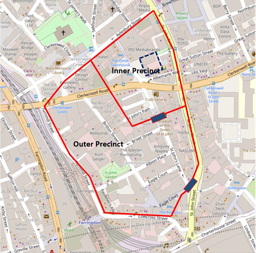
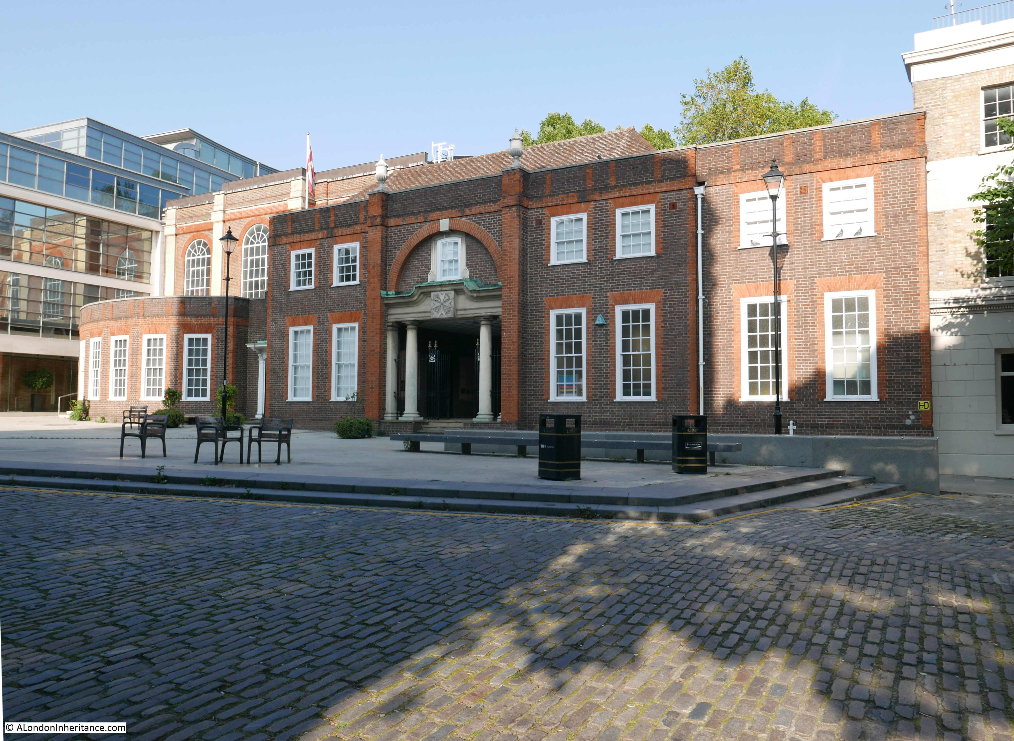
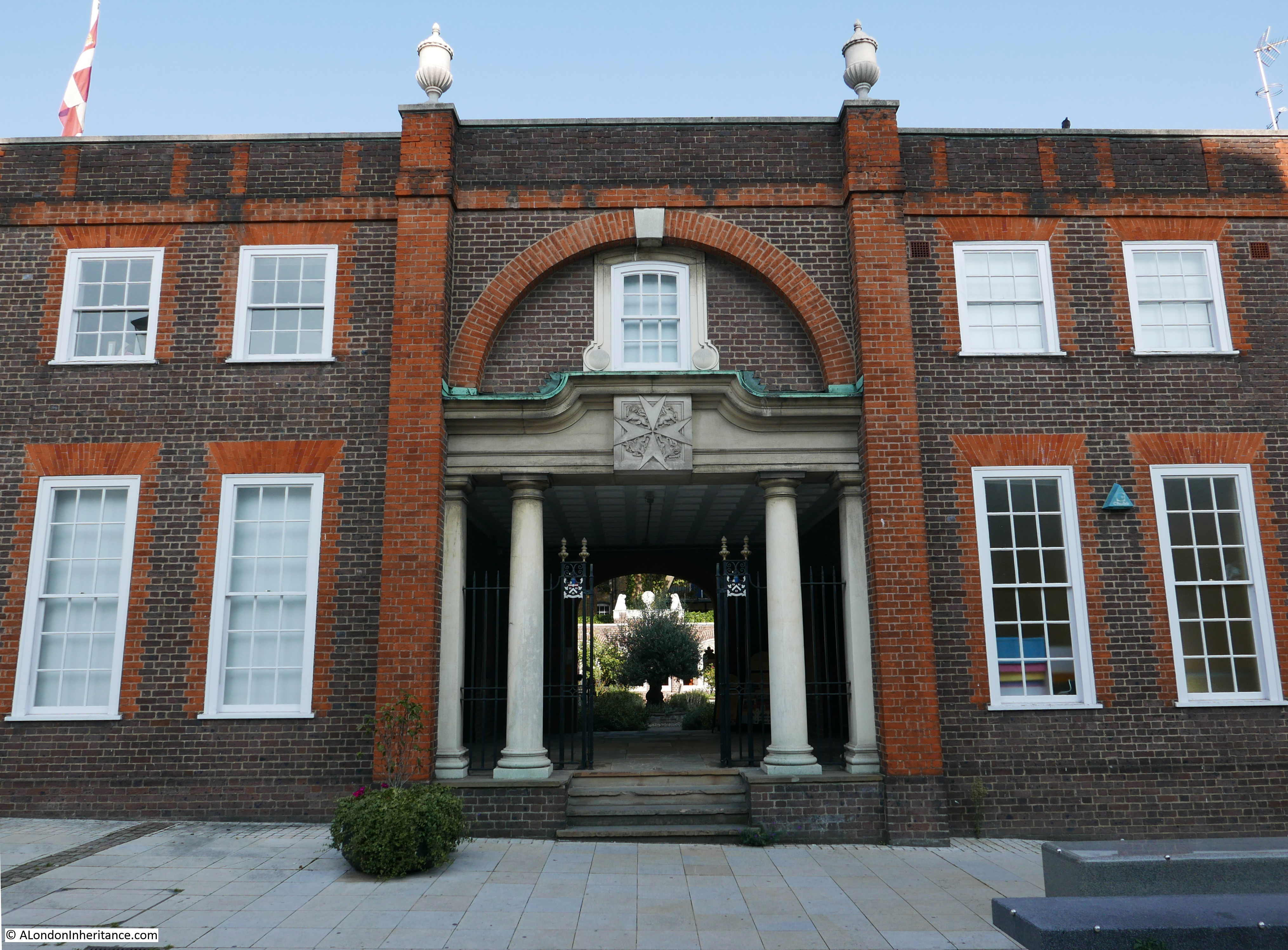
If you walk up from the location of St John’s Gate, cross Clerkenwell Road and stand in St John’s Square, you will find the Priory Church of the Order of St John, a rather fine brick building. The main body of the church is to the left, and the entrance to the Cloister Garden is through the large central entrance.

Priory Church of the Order of St John

The current church is built on the site of the original 12th century priory church. The design of the 12th century church was based on the Church of the Holy Sepulcher in Jerusalem, in that it had a large round nave, leading back to a narrow raised chancel built over a crypt.

This design was used by both Hospitaller (the order which occupied the Clerkenwell priory) and Templar churches. We can get an idea of what the circular nave may have looked like by comparing with the London Temple church:

Priory Church of the Order of St JohnParts of the original circular nave were discovered in 1900, and today the outline of the nave is marked by granite setts which we can see in the photo below, in front of the church:

Priory Church of the Order of St John

As the Priory grew in wealth and influence, so did the church, and the church was quickly expanded, including rebuilding the circular nave as a more traditional rectangular nave.

Prior Thomas Docwra carried out some major restoration work on the church at the end of the 15th century, and the English antiquarian William Camden would describe the church as “increased to the size of a palace, and had a beautiful tower carried up to such a great height as to be a singular ornament of the City”.

A similar description of the church was recorded by Stowe who wrote: ‘a most curious peece of workemanshippe, graven, gilt, and inameled to the great beautifying of the Cittie, and passing all other that I have seene’

Docwra’s work on the church included the addition of his own private chapel on the south wall of the church.

It must have been an impressive sight, however the church would soon suffer the same fate of many other buildings connected with religious orders, when King Henry VIII seized the properties and dissolved the original Order of St John, including the Priory Church.

Various parts of the fabric of the church were taken to be used for buildings within the Royal Palace at Westminster, and in 1549 the nave and tower of the church were blown up by Lord Protector Somerset so the materials could be used for the construction of his house in the Strand (Lord Protector Somerset. or Edward Seymour, took the title of Lord Protector between 1547 and 1549 following the death of Henry VIII and whilst Henry’s son, King Edward VI, was still a child. As was typical with many ambitious members of the Tudor court, he would have a rapid fall from grace and was executed at Tower Hill in January 1552).

The remains of the church were then used for various purposes, storage, further demolition, and some locals used Docwra’s chapel as a place of worship, parts of the church were converted to a private house, and the chancel being rebuilt as a private chapel.

It was not until the early 18th century that the building became a formal church again. It was used as a meeting house by the Presbyterian preacher William Richardson, who would go on to be ordained as a Church of England minister. He then reopened the church as a Church of England building, which was a timely decision as during the early part of the 18th century, London’s rapid expansion created the need for additional churches to service a rapidly growing population.

Richardson proposed to the commission that had been set up to build fifty new churches across London, that they should acquire the church as a second parish church for Clerkenwell as the only other church (St James, just north of Clerkenwell Green) could not support the number of people then living in Clerkenwell.

Richardson’s proposal did not succeed and lawyer Simon Michell then purchased the church, and had better luck with the Commission as they agreed to purchase the church for the sum of £3,000. The building was consecrated as St John’s, Clerkenwell’s second parish church on the 27th December 1723.

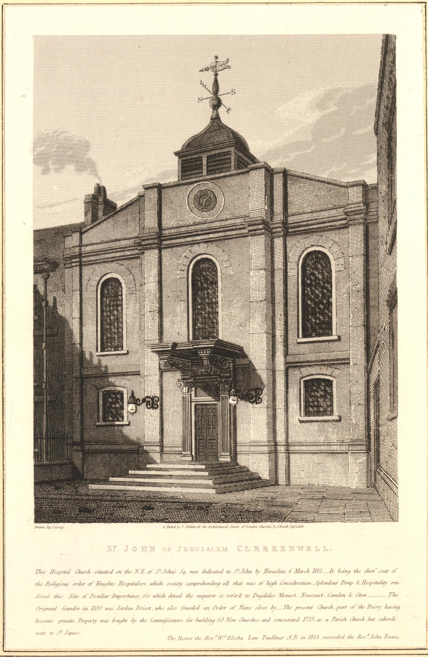
Following building works between 1721 and 1723 carried out by Simon Michell, and further work between 1812 and 1813 by James Carr, the church took on the appearance of a more traditional London church, although with a small rectangular tower, rather than the larger tower and spire seen on many other London churches. The following print shows St John’s, Clerkenwell, in 1818  (©Trustees of the British Museum).

Priory Church of the Order of St John

St John’s would continue as the second parish church of Clerkenwell until 1931. The population of Clerkenwell had been in decline during the first decades of the 20th century. Industry was transforming from small workshops, to larger establishments requiring larger buildings which were replacing many of the 18th and early 19th century housing.

The modern Order of St John was formed during the later years of the 19th century in the original gatehouse of the Priory between the inner and outer precinct, known as St John’s Gate.

The modern Order provided a perfect solution for the future of the church, as the Order had been using the church for their religious services since the 1870s, and the Order had contributed to the maintenance and restoration work that took place towards the end of the 19th century.

In 1931 the parish of St John was returned to St James, and the church of St John was formerly handed over to the modern Order, thereby reuniting the gatehouse and church for the first time in almost 400 years within a modern Order of St John.

Use of the church by the Order in the form of the original parish church building would not last for long. During bombing raids on London in May 1941, the church was hit by incendiary bombs and the resulting fires destroyed the interior of the building along with the roof leaving only the outer shell of the building standing.

The following photo from 1946 shows a service taking place in the roofless church, the Order’s annual service on St John’s day with the Archbishop of Canterbury who had recently been enthroned as the Prelate of the Order of St John of Jerusalem.

Priory Church of the Order of St John

Soon after the destruction of the church, the Order of St John had started planning for a rebuild, and as the original outer walls were intact the intention was to rebuild around the walls rather than a complete new church.

The first new design came from the Gothic architect J. Ninian Comper.

In his 80s, Comper was known for his extravagant and expensive designs, and his proposal for the new priory church was based on a recreation of an original Hospitaller church, with a large, ornate octagonal nave. The cost of the design was estimated at £200,000 – a considerable sum of money to be raised when so much else needed to be rebuilt in the city.

Comper’s age was also a concern and he tended to work on his own. When asked who in his office would take over his design if he died, his response was apparently “Did Michelangelo have an office?”.

Comper would go on to design the magnificent new window in St Stephen’s Porch at the south end of Westminster Hall. A magnificent 50 foot high, 28 foot wide ornate, stained glass window. The window is the main memorial to members and staff of both Houses of Parliament and replaces an earlier Pugin window that was destroyed by bombing in December 1940.

The architects Paul Paget and John Seely were called in to provide an alternative and much cheaper design for a rebuilt church. They had already been responsible for restoration of some historically significant houses in nearby Cloth Fair where they lived and had their office, and they both had the role of surveyor to St Paul’s Cathedral.

Their design was for a much more restrained building. Brick facing St John’s Square and a relatively plain rebuild of the church using the original outer walls.

The following drawing from 1955 shows their proposed design.

Priory Church of the Order of St John

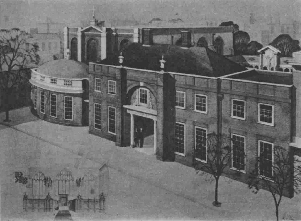
The church today looks almost identical to their original design, however if you look at the main body of the church on the left and the domed front of the church we can see that some decoration did not get built – probably to save money.

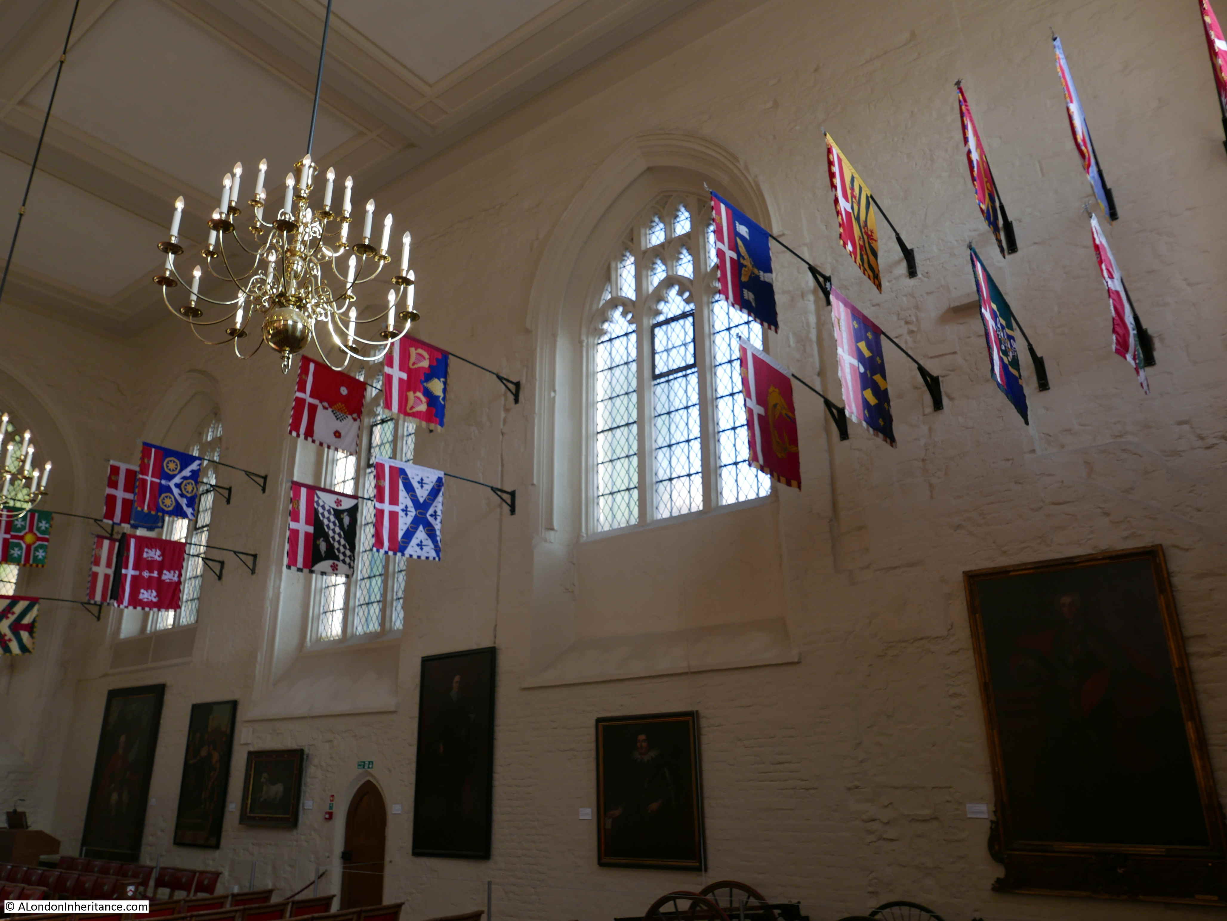
The interior of the church is relatively plain, with the white painted original walls and a black and white checkerboard floor.

Priory Church of the Order of St John

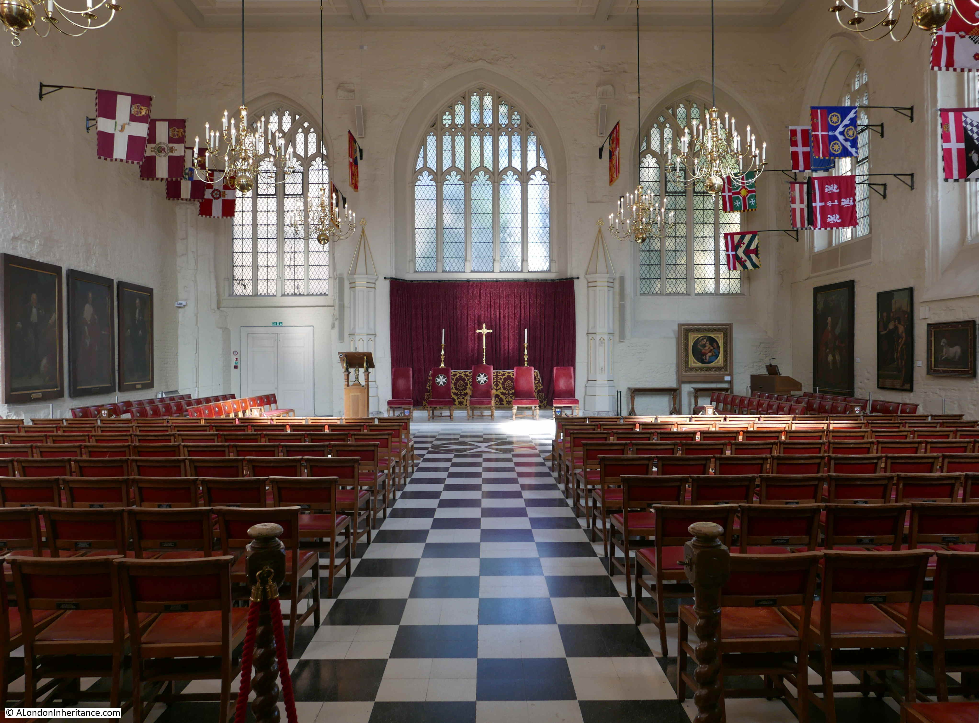
On the left of the church as we face the altar are the banners of the other priories of the Order of St John, in countries such as Canada, the USA and South Africa:

Priory Church of the Order of St John

Whilst on the right are the banners of the current Knights and Dames of the Order:

Priory Church of the Order of St John

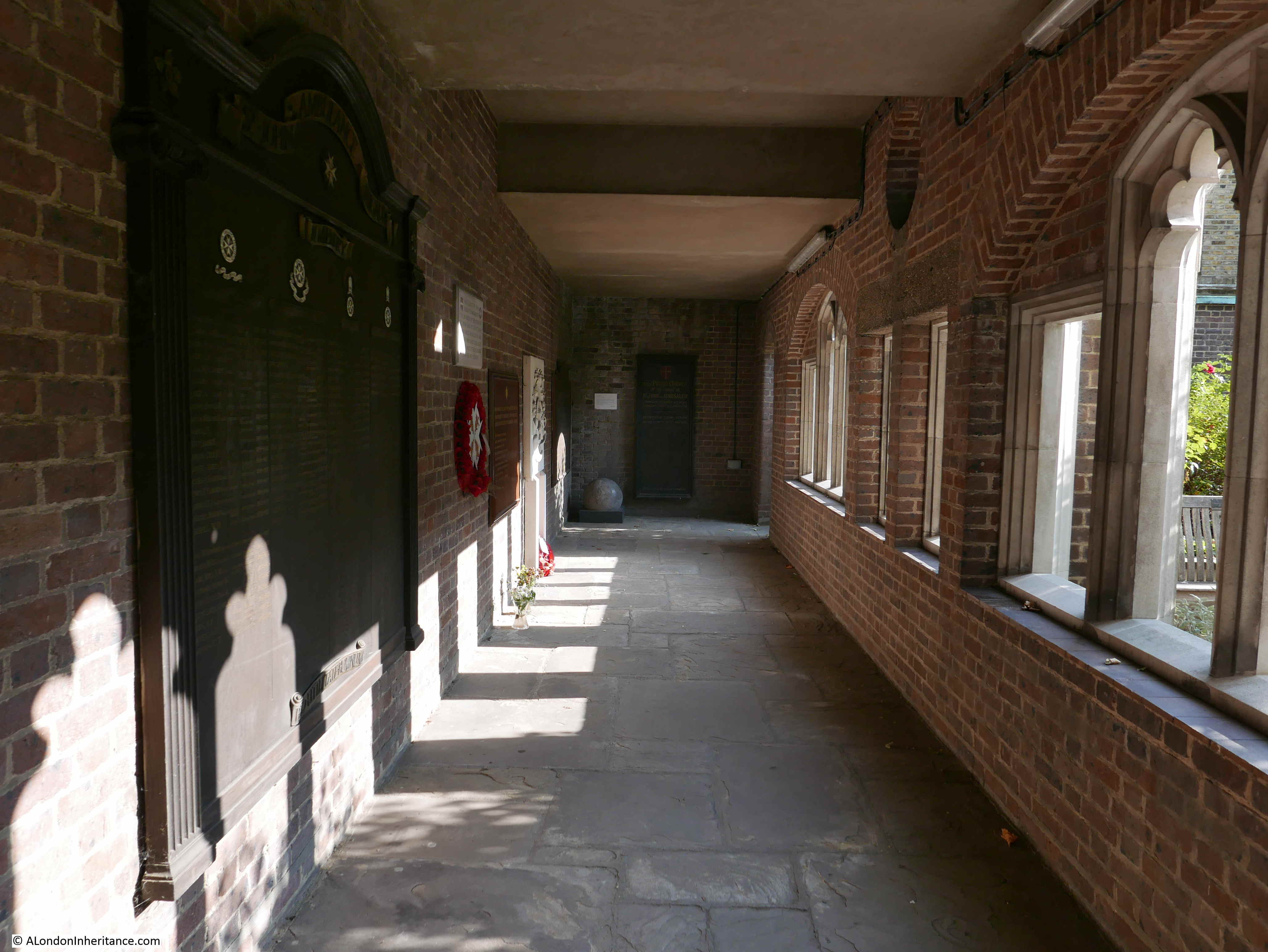
On one of the walls is a reminder of when the building was a parish church for Clerkenwell:

Priory Church of the Order of St John

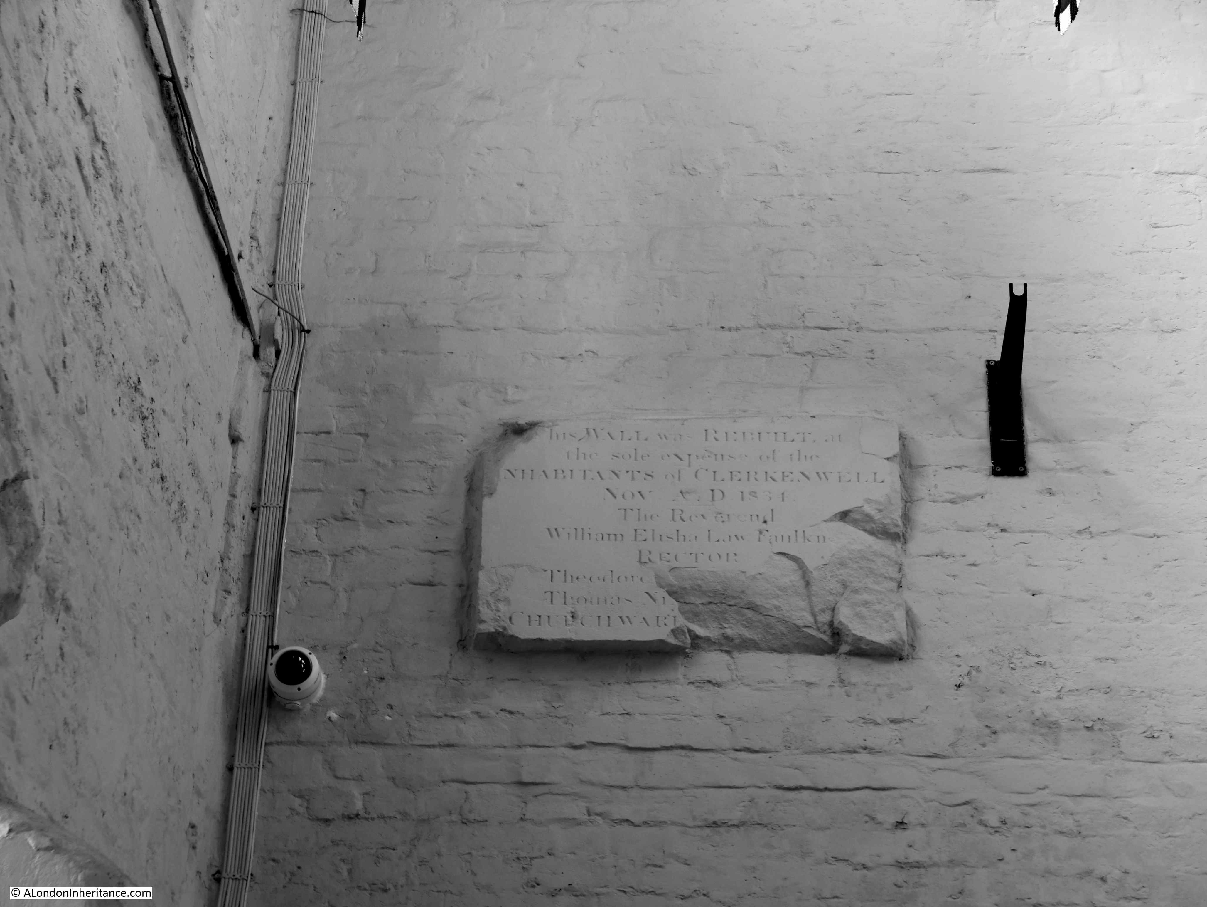
The plaque reads: “This wall was rebuilt at the sole expense of the inhabitants of Clerkenwell, Nov AD 1834. the Reverend William Elisha Law Faulkner, Rector”. The surnames of the churchwardens at the bottom right have been lost.

In a corner of the church is some of the original equipment used by the St John Ambulance which the new Order of St John set-up in 1877.

Priory Church of the Order of St John

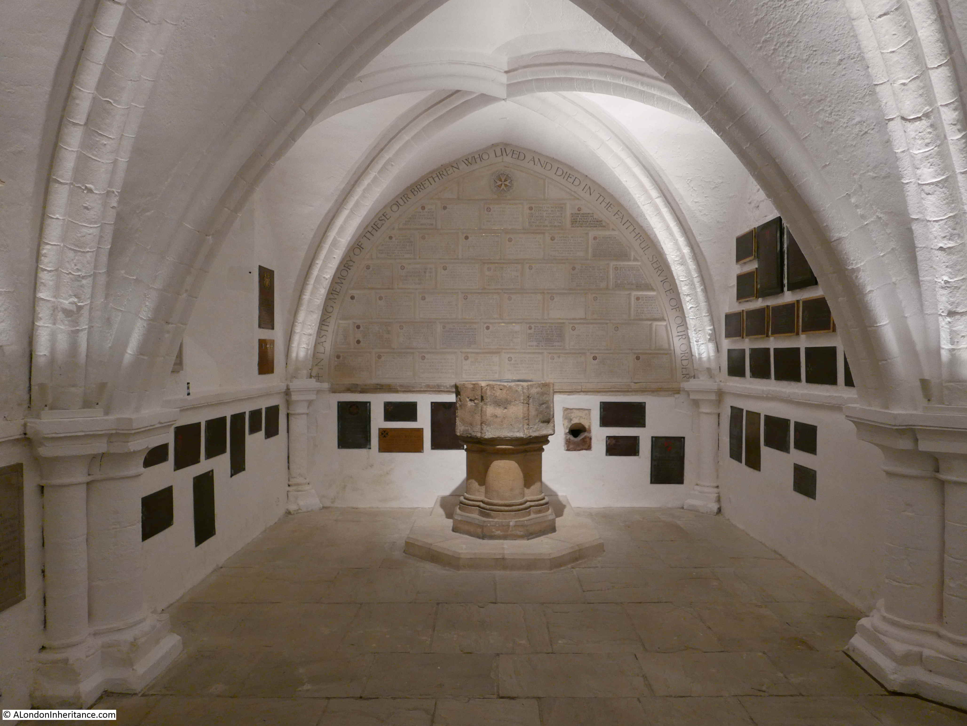
If we want to see parts of the original 12th century Norman church of the Priory of the Order of St John of Jerusalem we need to descend to the crypt. The fact that the church was hit by incendiary bombs rather than high explosive meant that the crypt survived the war with minimal damage, and as we enter the crypt, we have the following view:

Priory Church of the Order of St John

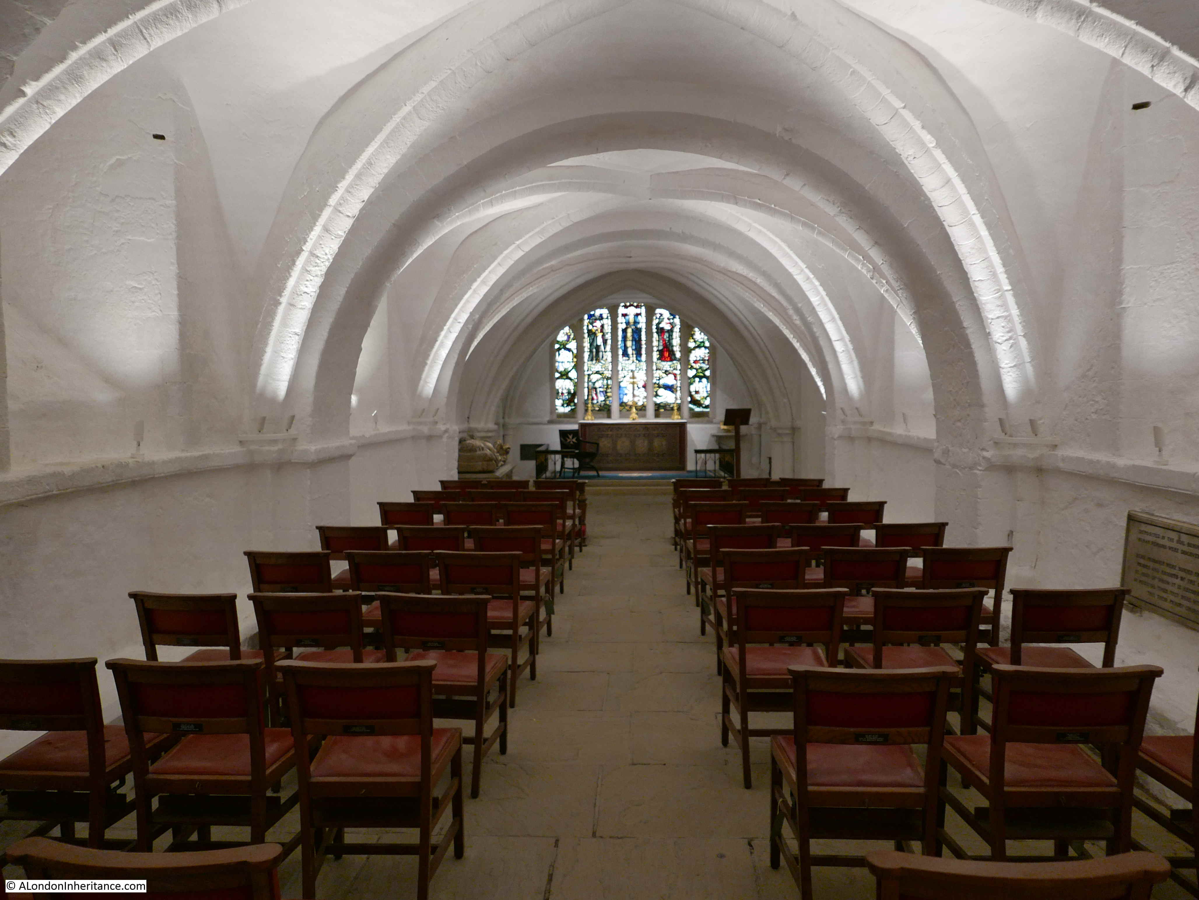
The stained glass at the end of the crypt gives the impression that this is above ground and that sunlight is behind the windows. In reality, artificial lighting is behind the stained glass.

As we look towards the altar, the first three arched sections are mid 12th century and the two furthest are slightly later dating from around 1170.

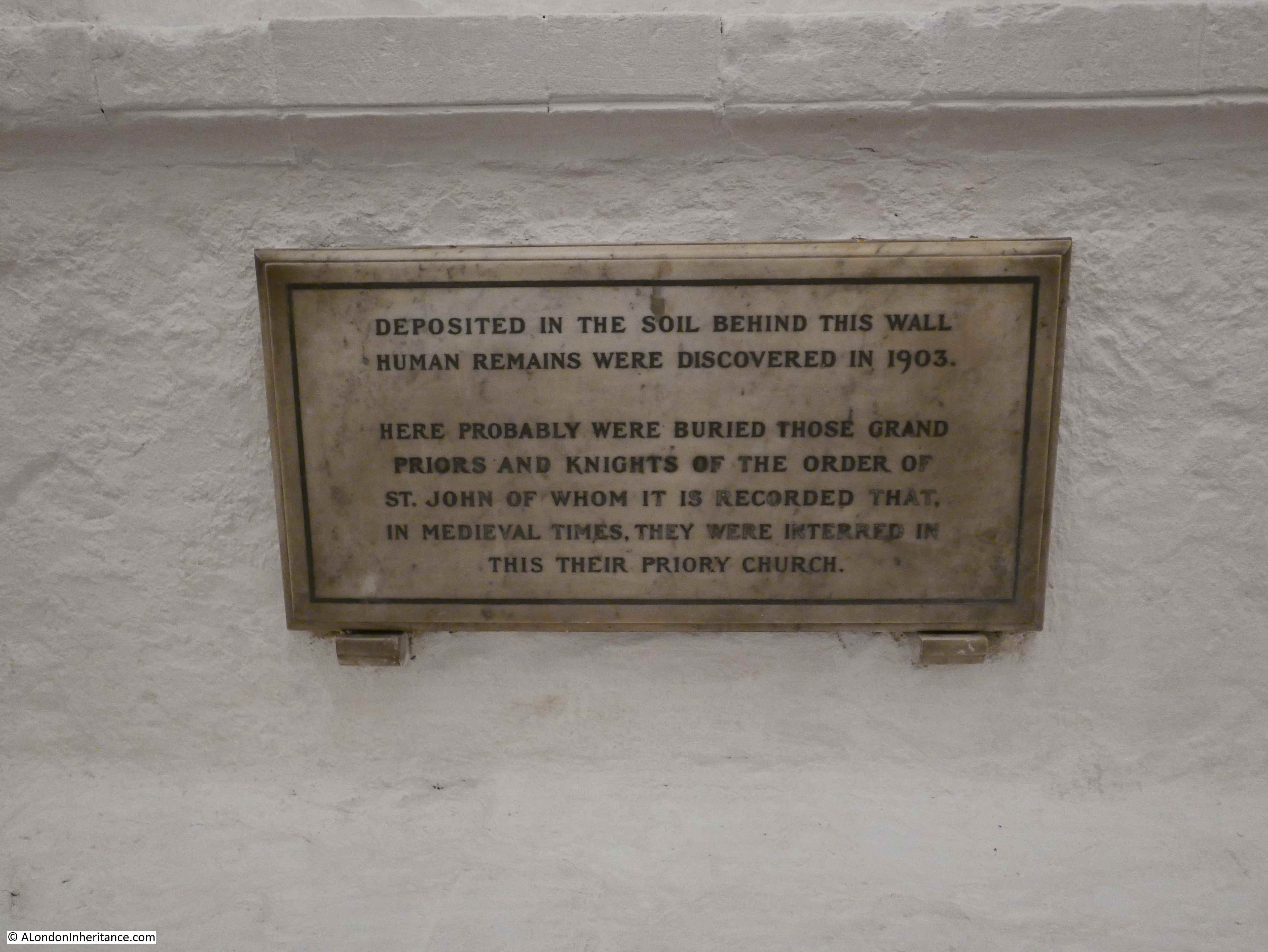
The white painted crypt today is a bright space, but during the crypt’s years as part of the parish church this would have been a very different place, with the crypt piled high with coffins.

The crypt was finally cleared in 1894 following the burials act of 1853 which outlawed the use of London’s crypts and churchyards for burials. Many coffins were removed to Brookwood Cemetery, however some were bricked up in the side vaults that line the central part of the crypt and older remains were discovered in 1903:

Priory Church of the Order of St John

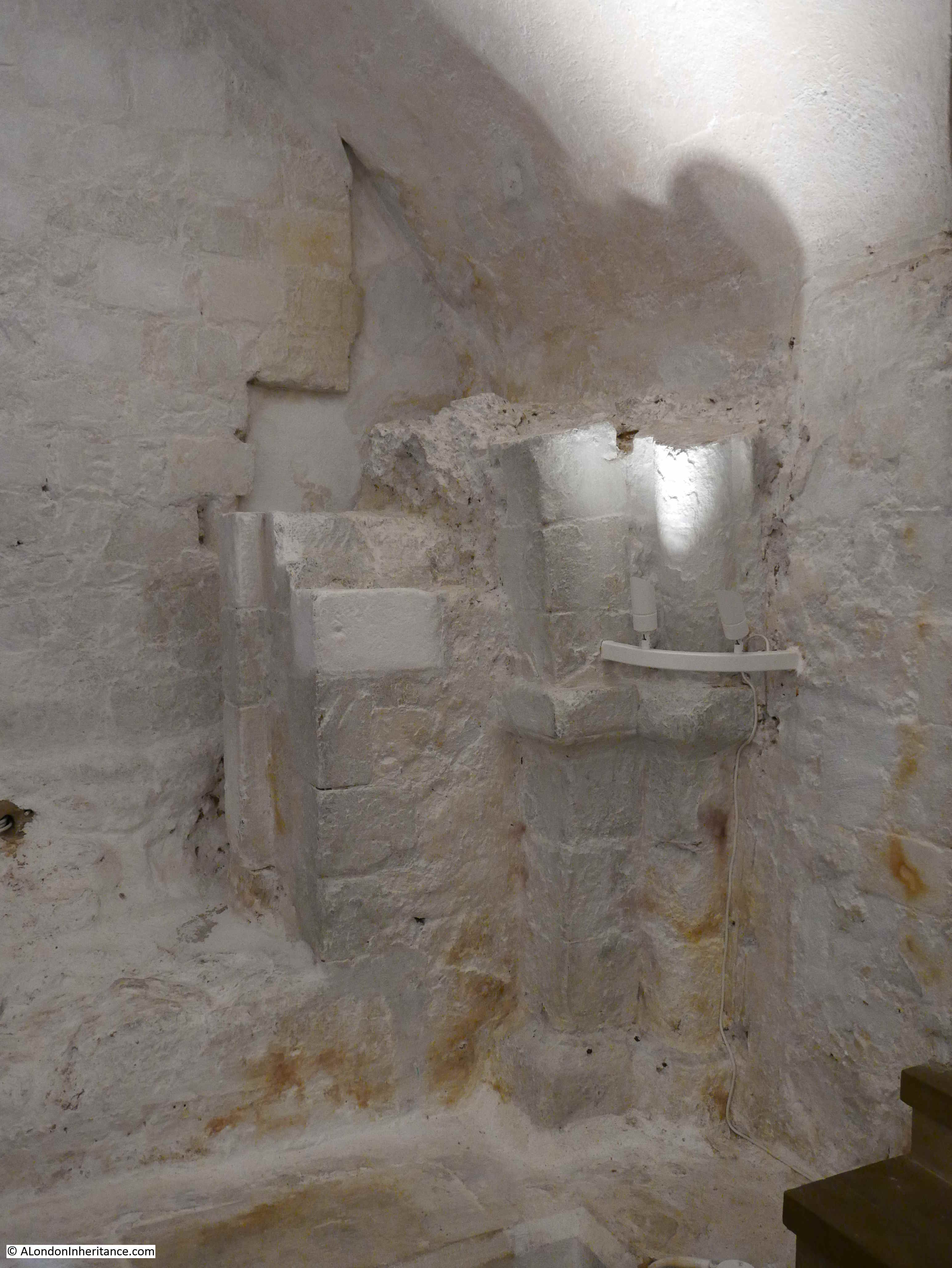
Just to the left of the crypt entrance is part of one of the original mid 12th century arches:

Priory Church of the Order of St John

Although the crypt is today painted white, it originally may have been more colourful. P.H. Ditchfield writing about the church and crypt in 1914 in his book London Survivals states that “Traces of colour can still be seen on the arches and ribs”.

The Islington Antiquary Society visited the crypt in 1910 and were told two interesting stories about the crypt:

  • That when the crypt was used for burials, a sexton was working with body snatchers and on investigation, many of the coffins were found to be empty
  • That Fanny Parsons, also known as scratching Fanny, the young girl who convinced visitors that the sounds she created were caused by the Cock Lane ghost, had been buried in the crypt. An attempt had been made to find Fanny’s coffin, but it was believed that the name plate had been removed

The view along the crypt towards the entrance.

Priory Church of the Order of St John

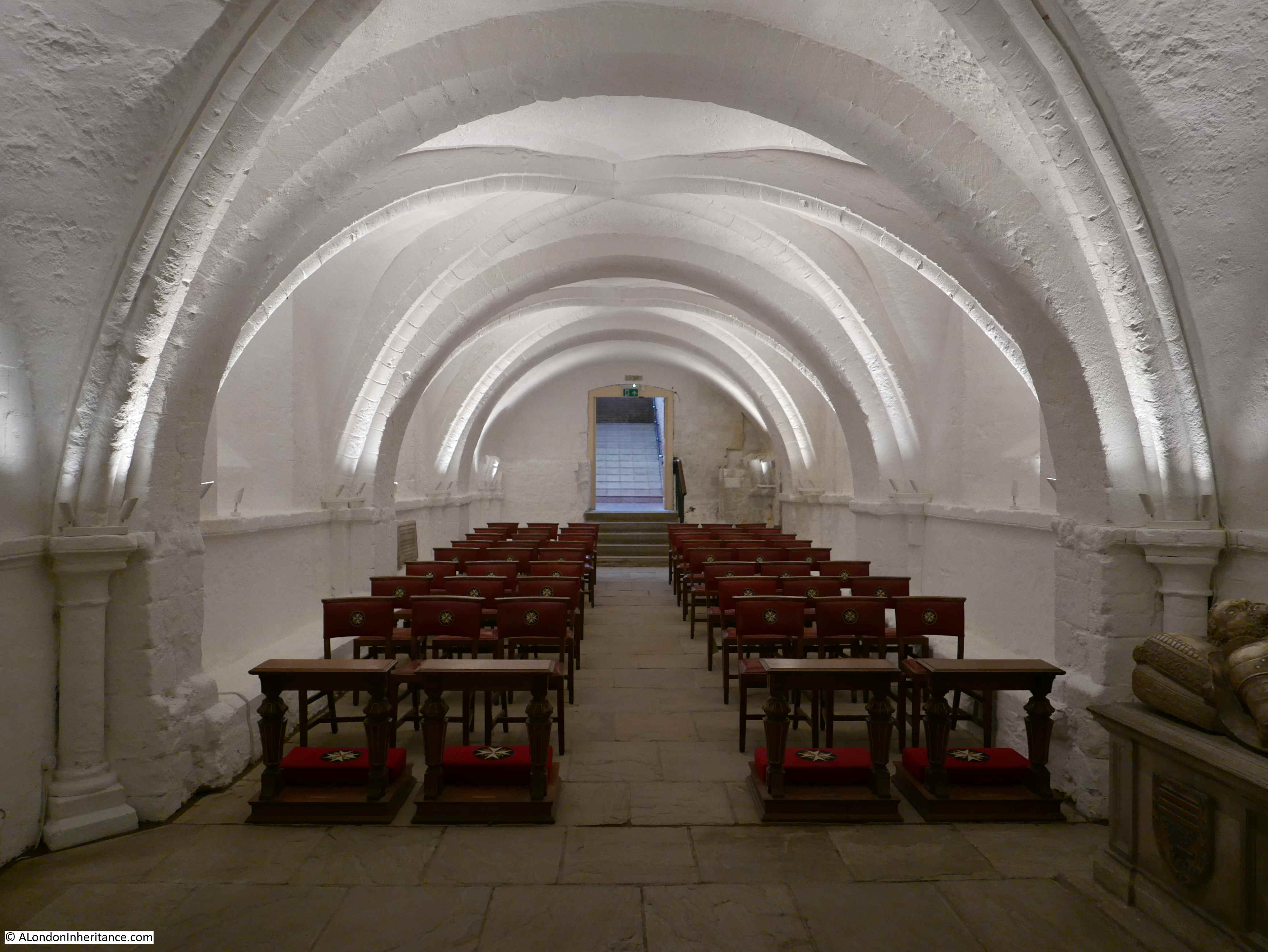
Along the side of the crypt are low stone benches running the length of the wall, implying that these may have been used for communal seating and during the Archbishop of Canterbury’s visit in 1946, Knights of the Order were seated along these benches.

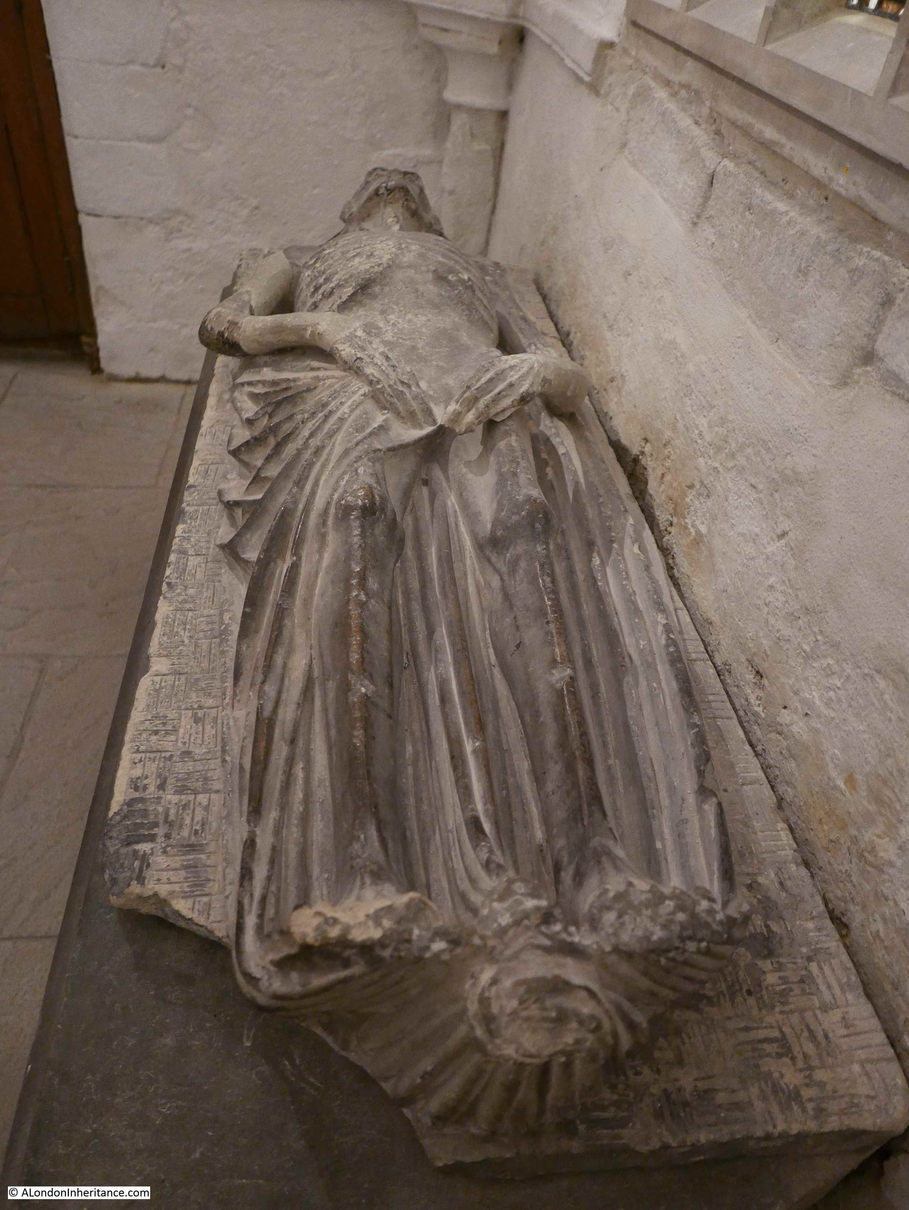
To the side of the crypt is a rather impressive effigy of a knight. Donated by a member of the Order in 1915, the effigy is believed to have come from Spain, and does portray a member of the original Order, with the Maltese Cross emblazoned across the knight’s chest.

Priory Church of the Order of St John

The identity of the knight is not known for certain, however it is one of the most impressive alabaster figures in the country.

Towards the end of the crypt, there are two rooms on either side of the central crypt. The room on the left as you face the altar may have been used as a Treasury by the original Order. the room on the right is today the South Chapel:

Priory Church of the Order of St John

Turn left as you face the altar and there is a morbid reminder of death:

Priory Church of the Order of St John

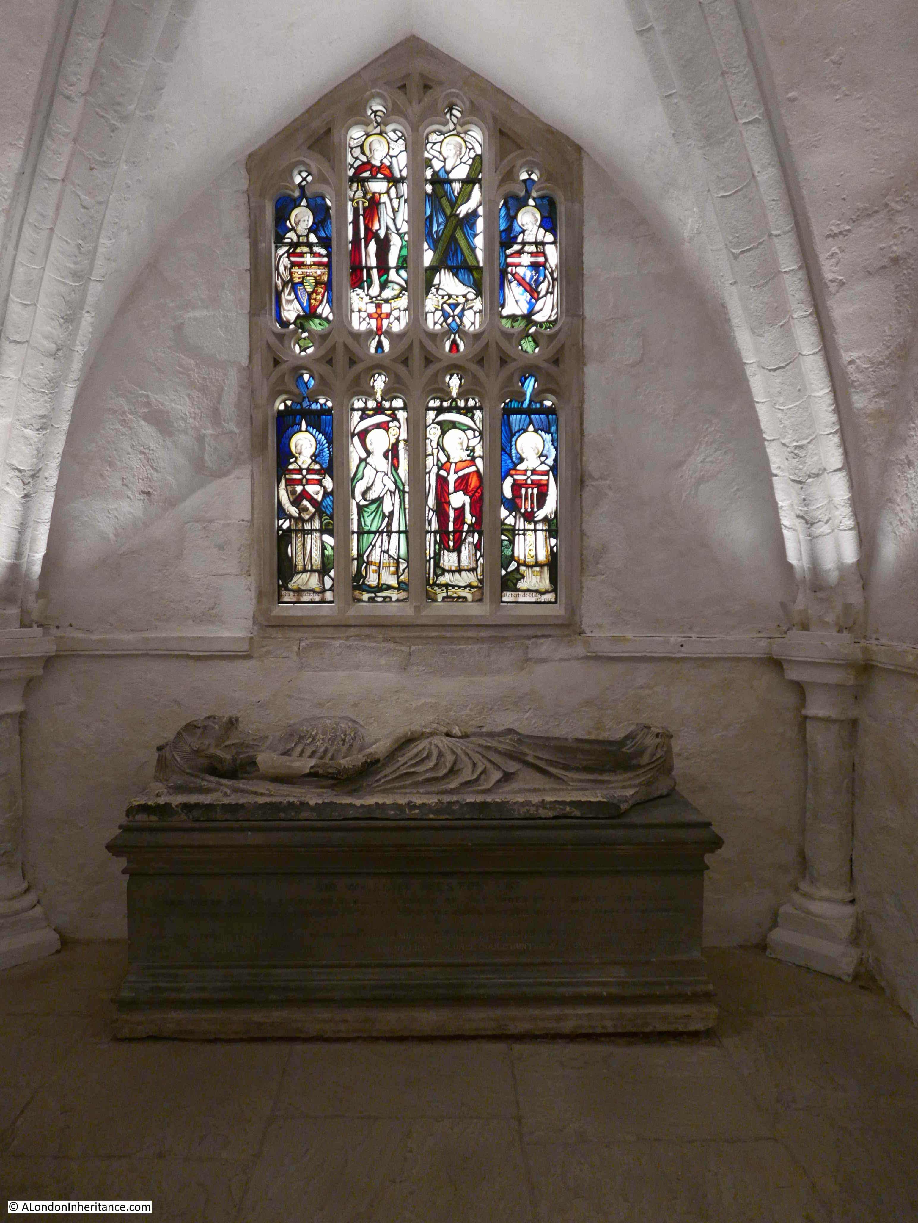
This is all that is left of the canopied marble monument to Prior Weston, the last prior of the original order at the time of the reformation.

The windows above show the four saints of the British Isles, with figures and shields representing former priors, including Prior Robert Hales. Again, the window is backlit by artificial light to give the impression of natural light.

The monument was erected in St James Church, in nearby Clerkenwell Close, but was pulled apart when the church was demolished for a rebuild. The effigy remained in the crypt of the new church, but was moved here in 1931.

Priory Church of the Order of St John

The effigy is a momento mori, where the figure is portrayed almost as a hollow eyed, emaciated corpse. The intent was to remind people of the fleeting nature of earthly pleasures, and to focus their minds on the afterlife.

Priory Church of the Order of St John

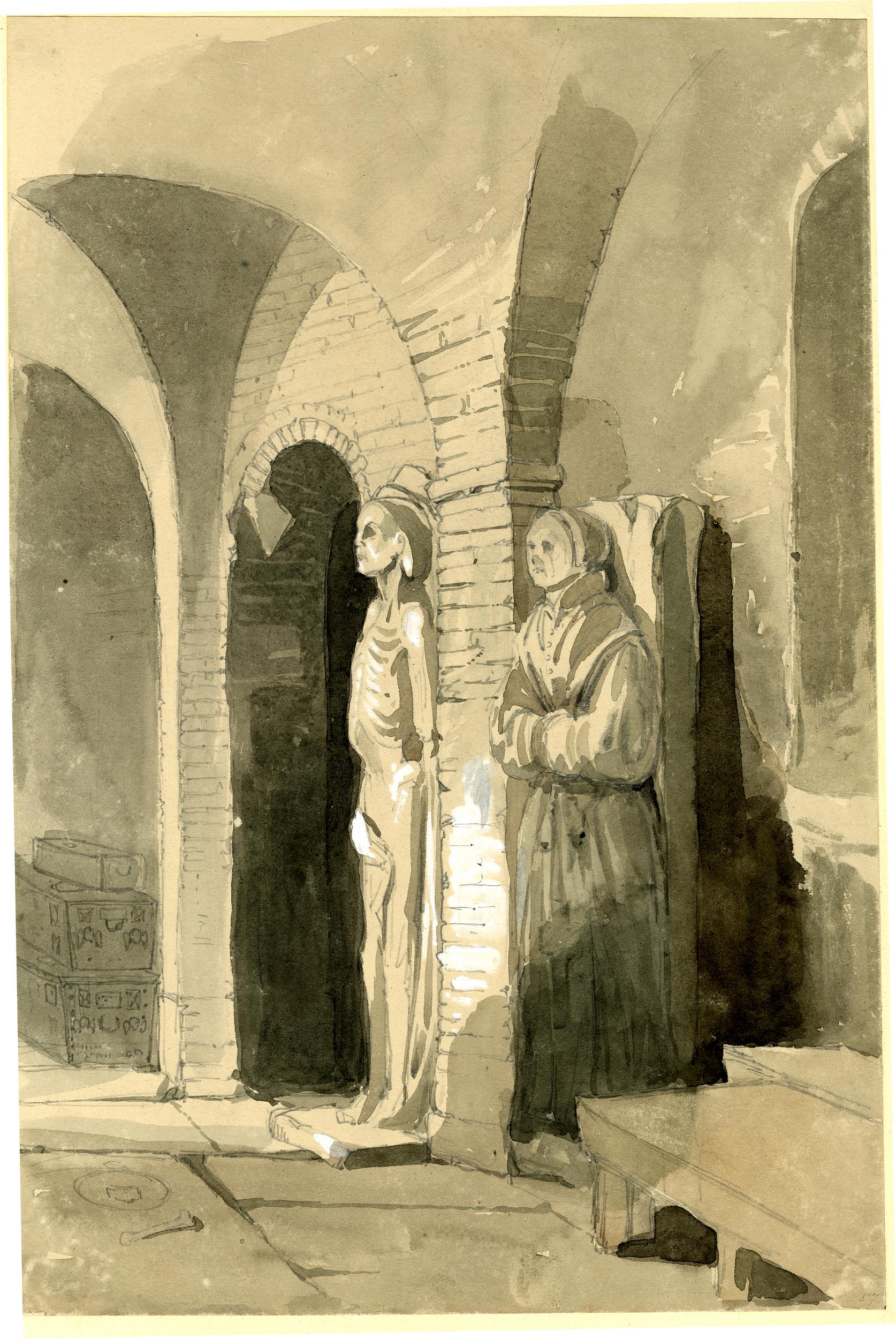
The following print from 1842 shows the effigy of Prior Weston in the vaults of St James Clerkenwell along with an effigy that may have been Lady Elizabeth Berkeley  (©Trustees of the British Museum).

Priory Church of the Order of St John

There is one more feature of the Priory Church of the Order of St John to explore. This is back outside and through the entrance and gates in the building to the right of the church, where we find the Cloister Garden.

Priory Church of the Order of St John

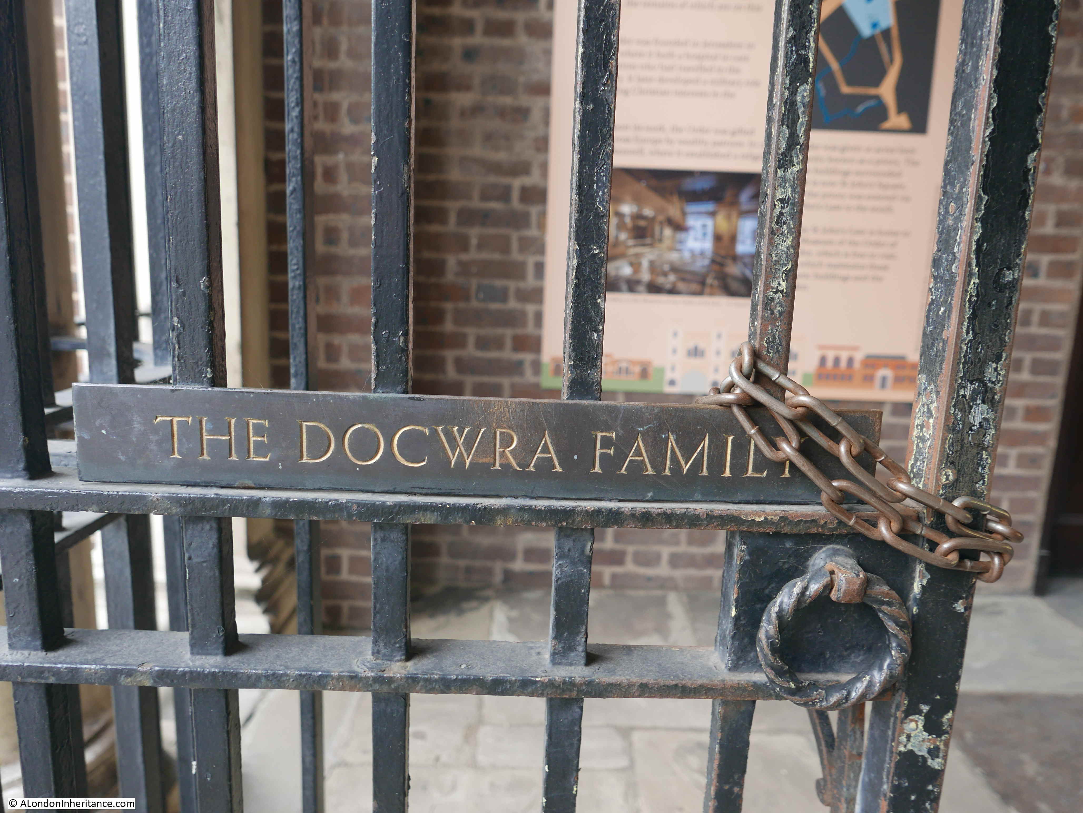
The entrance to the garden is formed by the Docwra Memorial Gates.

Thomas Docwra was one of the 16th century Priors of the Order, when the fortunes of the priory were at their highest and substantial building work was being done around the Priory.

As an example of the centuries of continuity that you can often find in the city of London, the same Docwra family donated the money for the gates as part of the post-war creation of the gardens.

Priory Church of the Order of St John

Following the post war restoration of the church, the garden was relatively plain, consisting of grass and a central fountain. A recent grant from the Heritage Lottery Fund and the Wellcome Trust has supported a redesign of the garden and new planting.

Planting takes us back to the original Medieval Hospital of the Order of St John, as the planting consists of a range of herbs which would have been used in the treatment of patients for a range of complaints.

  • Rose petals – antiseptic qualities
  • Peppermint – helps relieve stomach aches
  • Lavender – used to treat burns, scratches and other minor skin ailments
  • Chamomile – used to reduce swelling and helps to heal wounds

Priory Church of the Order of St John

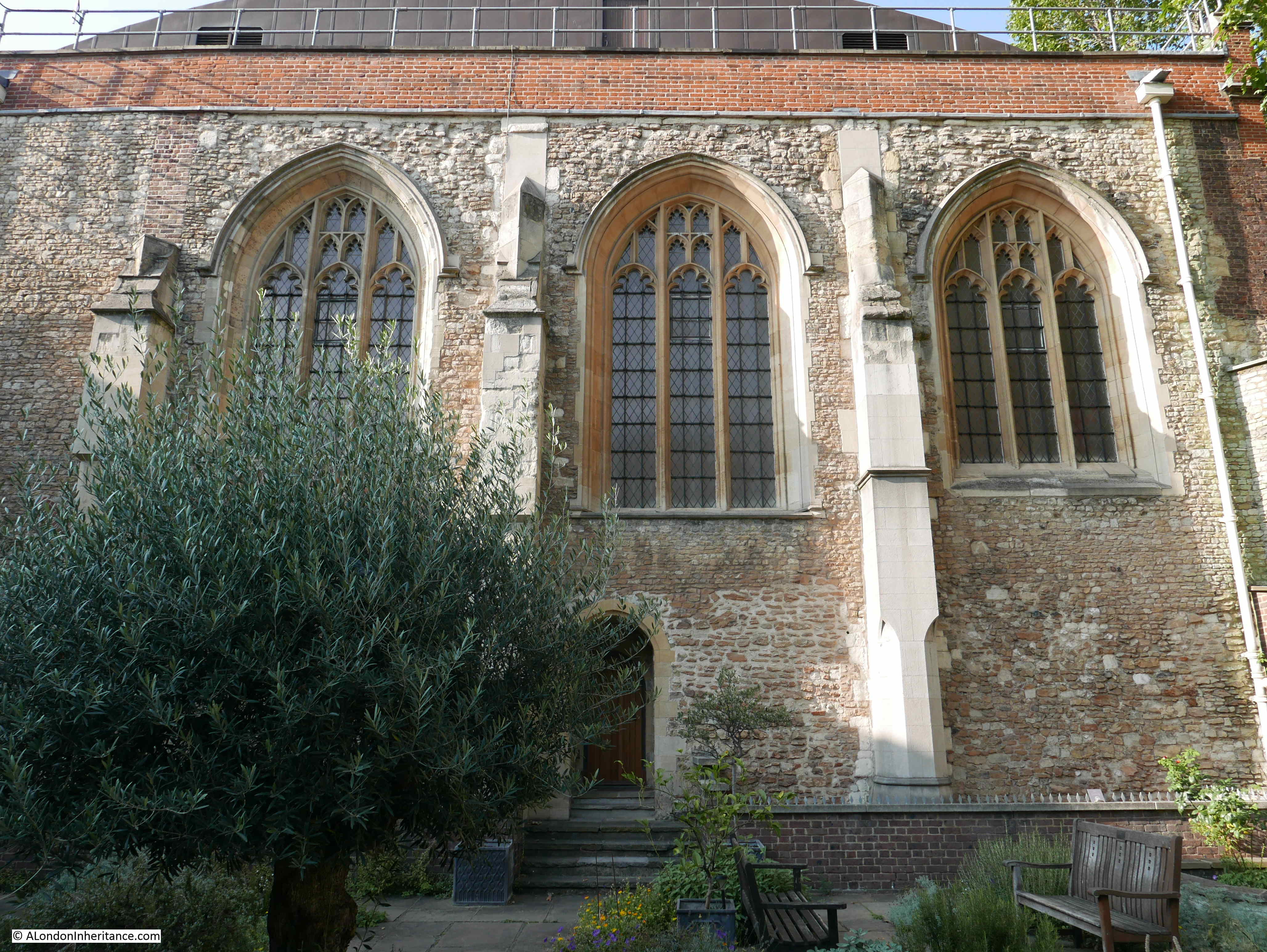
From the garden. we can see the south wall of the church and the mix of architectural features, brick and stonework that come from the centuries of different use of the building, many of which have left their mark in the walls.

Priory Church of the Order of St John

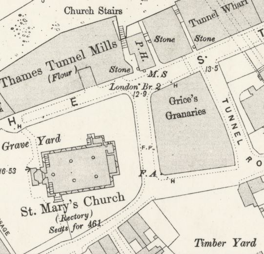
Prior Docwra had his own memorial chapel in Jerusalem Court which originally ran along the garden, with the chapel up against the church. In the following extract from the 1894 OS map, up against the south wall of  the church are two buildings labelled Side Aisle. These were later buildings, one of which was reported to still contain evidence of Docwra’s chapel  (‘Reproduced with the permission of the National Library of Scotland’).

Priory Church of the Order of St John

Jerusalem Court is shown running from St John’s Street on the right, then through a ground floor gap in the buildings (the box with an X), and alongside the buildings up against the church wall.

This section of Jerusalem Court is now part of the Cloister Garden, directly in front of the camera in the photo below.

Priory Church of the Order of St John

The intention with the post-war development of the Cloister Garden, was to have a four sided cloister which would form a memorial for those of the St John Ambulance Association and Brigade who had lost their lives during the two world wars, but again money was short so the planned cloister and memorial was only built along the eastern end of the garden.

Priory Church of the Order of St John

The gardens form a tranquil and peaceful place, in what in more normal times is a very busy part of Clerkenwell, and whether it is the herbs we are surrounded by, or the medieval stone work of the southern wall of the church, the garden brings to the 21st century both the origins and the current work of the Order of St John.

The Priory Church of the Order of St John is a fascinating place. A tangible link with the original medieval Order, the present day Order and the crypt where part of one of the oldest buildings in London can be found.

Tours of the church will be available through the Museum of the Order of St John at St John’s Gate, and the Cloister Gardens are often open.

alondoninheritance.com

Essex Road, Islington

One of the pleasures of London is a random walk through the city’s streets. I have found very few streets where there is not something of interest. Unusual buildings, hidden bits of history, the new and the old showing how the city’s long expansion and development has taken place, and continues. One such street is Essex Road, Islington, and for today’s post, join me for a walk along part of this busy north London street.

Essex Road starts at Islington Green, where it runs from the north east corner of the green up to Balls Pond Road. To keep the post a manageable size, I will only cover the southern section from Islington Green up to the New North Road.

This stretch of the road is shown in the following map, starting at the Start (S) at upper right, and finishing at the Finish (F) at lower left (Map © OpenStreetMap contributors).

Essex Road is an old street, going back very many centuries. In 1746, the upper part of the street was called Newington Green Lane – because that is to where the street led, with the lower section called Lower Street, which continued on along the eastern edge of Islington Green. The Lower part of the name was because of the drop in height across Islington Green from Upper Street on the west, down to Lower Street on the east.

In 1746, the area was still rural. Fields surrounding the upper part of the street, with a number of large houses and inns lining the lower section. The New River crossed and ran under the street in a tunnel which continued further south to where the river emerged as it headed to New River Head.

London was fast approaching these Islington fields, and whilst Essex Road would continue as a main route from Islington Green, the large houses and fields would soon disappear under a dense network of new building that would leave the area unrecognisable by the end of the 19th century. The following map shows the area in 1894. Islington Green is the triangle of land at lower left, and Essex Road as it was now called, follows the same route, up from the north east corner of the green (‘Reproduced with the permission of the National Library of Scotland’).

I am starting at the junction of Essex Road and the New North Road (S) in the map at the start of the post, and walking south to Islington Green.

The New North Road is, as the name suggests, a new road, although new is relative. It was not on the map in 1746, but was constructed in the first couple of decades of the 19th century as a more direct route from Shoreditch to what is now Highbury Corner.

On the southwest corner of the junction is Essex Road station, opened in February 1904 by the Great Northern and City Railway, and is now part of the Great Northern rail network, with trains running to and from Moorgate in the City of London.

Essex Road

The station is unusual as it is the only underground station in London operated by a rail company. The original British Rail symbol can still be seen on the corner of the building:

Essex Road

On the opposite corner to the station is the old Three Brewers pub, now the Akari Japanese restaurant.

Essex Road

Most sources seem to date the pub to around 1830, however this may be the current building. The earliest reference I can find is to December 1808 when the Morning Advertiser carried an advert for a sale of general household furniture at a location near the Three Brewers, Islington. Pubs were often used as landmarks when describing a local location.

The view south along Essex Road near the station – a wide, busy street.

Essex Road

Heading south, we come to a rather ornate old cinema building. This is the old Carlton Cinema which opened on the 1st September, 1930.

Essex Road

The cinema really stands out due to its Egyptian façade which was the creation of Architect George Coles. The Egyptian theme was probably due to the discovery in 1922 of the tomb of Tutankhamun.

The Carlton offered not just film, but also stage shows, and in February 1931 the residents of Islington could be entertained by Al Davison and his band.

The Carlton became the ABC in 1962, but closed as a cinema ten years later in August 1972, when it was then converted into a Mecca Bingo Club, which would run to 2007. It was then purchased by Resurrection Manifestations, who use the old building as a place of worship.

The view along the side road (River Place, which runs up to the old route of the New River), shows typical cinema construction of a very ornate front façade, with a simple and functional rear of the building.

Essex Road

The old Carlton Cinema is Grade II listed.

To the left of the cinema, an end of terrace building extends into the street, and on the side of the building is a part exposed sign.

Essex Road

The sign refers to the Eagle Dining Rooms. I found a couple of references to the dining rooms to confirm the full name in the Islington Gazette. On the 1st July 1902, there was an advert for:

“Wanted, a young girl for Stove Work; one used to the business. The Eagle Dining-rooms, 159 Essex Road, Islington”, and on the 13th June, 1910, under the advertisement section of the Islington Gazette, which had the remarkable title of “Servants and Girls Wanted”, there was;

“Respectable Girl Wanted, about 18, to Assist House and Kitchen; sleep out; closed Sunday. Eagle Dining Rooms, 159 Essex Road”.

Adverts mentioning the Eagle Dining Rooms in the Islington Gazette appear limited to between 1902 and 1910, so perhaps this gives an indication of the period of time that the establishment was in operation.

The following photo shows the opposite side of the street. Essex Road has a mix of architectural styles and building age. The photo shows some buildings (the smaller central terrace) that probably date back to the early years of the development of Essex Road, and where their original front gardens have been replaced with shops as the street developed and there was a growing population to serve.

Essex Road

The Green Man pub on the corner of Essex Road and Greenman Street.

Essex Road

Greenman Street was named Greenmans Lane in the 1828 C&J Greenwood map, so is probably an old lane.

The site of the Green Man pub was apparently the site of the first Congregationalist Chapel in Islington. The chapel was built in 1744, and grew during the following decades as the congregation expanded. The lease on the building expired in 1865 and the chapel moved to a new location in River Street.

In March 1866, there was a license application by a George E. Muddyman, and a Mr Sleigh opposed the application as there were already many licensed houses in the district. The license was granted as the Peabody Buildings just behind the pub (which are still there) had recently been completed and were now occupied by “700 or 800 persons” and the Superintendent of the Peabody buildings stated that “all the tenants had signed the petition in support”.

So the Green Man pub probably dates from 1866, the occupants of the Peabody buildings behind the pub must have made up the majority of the pubs initial customers, and it was built on the site of the first Congregationalist Chapel in Islington. The pub must have originally been larger, as if you look at the photo, the Domino’s take-away occupies the ground floor of a building with exactly the same architectural features as the pub.

Opposite the Green Man is the closed shop of Attenborough Jewellers, who have now moved to their original main branch in Bethnal Green Road (I have some 1980s photos of the Bethnal Green branch to re-visit).

Essex Road

The shop also operated as a pawnbroker. Note the door marked as the entrance to the Pledge Dept on the left.

Essex Road

And the traditional sign of a pawnbroker on the front of the building:

Essex Road

Continuing along Essex Road and we come to the South Library:

Essex Road

The foundation stone was laid in 1915 and the library opened in December 1916. A plaque inside the library states that it was presented by Andrew Carnegie, so it must have been one of the many libraries that Andrew Carnegie, the wealthy Scottish-American industrialist funded.

Essex Road

The coat of arms above the door of the library provides a quick history lesson on original land ownership in Islington. This version of the coat of arms was granted in 1901, and the four quarters of the shield are each part of the coat of arms of significant Islington landowners.

The Order of St John is at top left. George Colebrooke who owned the Manor of Highbury is at top right. Below that the arms of the landowners the Berners family and at bottom left is part of the coat of arms of Sir John Spencer who owned the Manor of Canonbury.

These arms were replaced in 1966 when the larger borough of Islington was formed, and the council probably thought that historical landowners did not reflect modern Islington, but it is good to see that the earlier coat of arms can still be found.

Opposite the library is this terrace of houses, which again reflect the diverse range of architectural styles, and the haphazard way that the buildings lining Essex Road have developed over the years.

Essex Road

The third building to the left is strange, The upper floors jut out without being in line with the adjacent building of the terrace. It would be interesting to understand the reasons behind this unusual design.

The small road to the right of the above terrace is Dibden Street, and in the entrance is a mural of Gandhi by graffiti artist Gnasher.

Essex Road

The text reads: “You must be the change you wish to see in the world”.

Further south at the junction with Cross Street is this collection of small shops with some interesting, concrete, architectural detail running along the top.

Essex Road

A short distance further along is the Alpaca pub:

Essex Road

The Alpaca is a very new name, dating from when the pub reopened in March 2020 – unfortunately probably the worst time for a new pub to open in recent years.

It was the New Rose, and originally the Half Moon.

The Half Moon dates from the early 19th century, and the first written record I can find of the pub dates from the 15th July 1824, when the London Sun recorded an inquest being held in the pub “on the body of Thomas Smith, aged 23, a Kentish town stage-coachman, whose death was occasioned in a pitched battle with a person of the name of Harry Bastie”. The inquest records how Thomas Smith’s brother described the battle, when he found him at:

“Copenhagen-house; he spoke to him, endeavouring to persuade him from fighting, saying that he was too fat, and had not an equal chance with the person he was going to fight, who was a good man, and had two ways of fighting: the deceased replied that unless he was to fight now that it had come to such a pitch, he would not be able to stand by his coach and get a single passenger.

A ring was formed, and his brother entered the ring first, and threw up his hat. The deceased was knocked down several times by his antagonist, who had the knack of tripping him up: witness was informed that the fight lasted two hours and fifteen minutes. During the fight the witness entered the ring and saw his brother lying on his back and was desirous of ending the fight, but the seconds interfered and turned him out of the ring.

He did not go to his brother until the fight was over, when his brother said ‘I’ll fight no more’. The deceased requested to sit down on witness’s knee, and he died soon after”.

The inquest was adjourned so the seconds could be found and interviewed. What the report does not record is the reason for the fight and why Thomas Smith would not be able to get a single passenger in his coach without going ahead with the fight.

The scene of the fight, Copenhagen-house is also in Islington, and I have written about the site in a previous post.

Opposite the Alpaca is another early terrace with on the side of the terrace facing Popham Street, another faded advertising sign.

Essex Road

The sign is advertising an American treatment which was advertised as a night cure of problems such as Catarrh and Influenza. The product went by the rather unusual name of X-Zalia, which probably sounded scientific during the first decades of the 20th century when it was sold.

Essex Road

A view of the same terrace from the opposite end, another good example of the mix of architectural styles of the early houses along Essex Road.

Essex Road

The tallest building on the right is Grade II listed as it dates from the early 18th century and was one of the buildings on the 1746 map. The building was once the home of John C. Aston & Sons, Wholesale Ironmongers and Builders Merchants and behind the house, running along the lane we can see in the photo was a long, two-storey range of warehouses. The shop facing onto the street was the shop for John C. Aston’s business. Today it is a very different shop providing hair extensions.

Across the road is a business that has been in operation for over 100 years. Established in  1918, W.G. Miller is the oldest family run funeral directors in Islington.

Essex Road

Further on is the Cumming Estate:

Essex Road

A rather functional block of flats, however they are named after two brothers who were responsible for much development around Islington and Pentonville. The brothers were John and Alexander Cumming who were one of the main developers of the Penton Estate in the late 18th century.

The brothers were Scottish and had built a reputation as watchmakers and businessmen. Alexander appears to have had royal and aristocratic patronage which probably explains their ability to fund their developments along Pentonville Road, centered around Cumming Street.

The housing block in Essex Road was developed by the London County Council and bears the typical coat of arms of the LCC, which can be found on many of their developments, although the one in Essex Road looks to be in a rather poor condition.

Essex Road

On the opposite side of Essex Road is Horse Yard. A narrow, cobbled alley that leads up to a yard, and which almost certainly was once the site of stables.

Essex Road

We now come to another pub, the Kings. When I was walking Essex Road, the pub was boarded up, which is always a very worrying sign with London pubs, however it was only for a change in ownership and the pub reopened at the end of 2020 – again not a good time to open a pub.

Essex Road

The pub was until recently called the King’s Head, and although the current building dates from the 19th century, this is an old pub and was probably one of the cluster of buildings on Lower Street in the 1746 map, as this stretch of Essex Road was then named.

The earliest reference I can find to the pub dates to the 22nd July 1758 when an article in the Oxford Journal reads:

“Sunday Morning early died Mr Cupit, master of the King’s Head in the Lower-Street, Islington. He went to bed on Saturday Night seemingly in good Health, and ordered his Wedding Sheets to be put on his Bed, saying, as they were his Wedding Sheets, perhaps they might be his Dying Sheets”.

An article that raises more questions than it answers.

And almost opposite the King’s Head is rather appropriately the Old Queen’s Heads (Essex Road really does have a lot of pubs).

Essex Road

The Old Queen’s Head is a lovely tiled 19th century pub, but like the King’s Head, a pub has been here for a long time. and the earliest reference I can find dates to the 24th February 1748, when the following incident was reported:

“On Sunday Evening, about Seven o’Clock, three Persons returning to Town, were attacked in that part of Frog Field that leads to the Queen’s Head in the Lower Street, Islington, by three Fellows, but Mr John Scott, Foreman to Mr Gregory, a Taylor, Old Broad-street, thinking to save what he had, ran from them, when immediately one of the Roques followed him with a drawn Hanger, and cut him down on the back Part of his Head, so as to let out his Brain; they then made their Escapes, leaving his two Companions, whom they had robbed, to take care of him”.

18th century newspapers were always graphic in their descriptions of violence. A Hanger is a small sword.

The Frog Field does not exist anymore, however the 1746 map at the top of the post shows Frog Lane and Frog Hall to the east of Lower Street. At the time the area was still rural and after dark, it was a dangerous place to be.

I like photographing shops and this is Natur House on the corner of Essex Road and Colebrooke Row.

Essex Road

And a final pub before we reach Islington Green – the Winchester on the corner of Essex Road and St Peter’s Street.

Essex Road

Originally the Market Tavern and the Carved Red Lion, this is the first of the many pubs on Essex Road that travelers heading north along the street would meet.

And we now reach Islington Green after a short walk along part of Essex Road. To keep the post a manageable size, I have missed out a number of buildings and have tried to show a sample of what can be found in just one London street.

Digging a bit deeper into the streets and buildings around us is what makes walking London so interesting.

alondoninheritance.com

74 Miles from London

Before getting into this week’s post, can I thank readers for all the feedback on last week’s post, and the mystery building to the left of the National Theatre. This was identified as the curved riverside end of a multi-storey car park and some of the comments included links to photos which clearly show the overall building, and the end wall that was in my photo.

The building partly visible behind this structure was the London warehouse of HMSO and also the Cornwall Press print works. This building can still be found along Stamford Street, and is  now part of King’s College.

Again, my thanks for all the feedback.

Now for today’s post. I have always been interested in London’s relationship with the rest of the country. Frequently, this is seen as a negative. The north / south divide, London getting the majority of available infrastructure investment, higher wages in the city etc.

London’s central role in the country started many hundreds of years ago with the founding of the Roman City of London, located on a crossing point on the Thames, and where the new city was accessible from the sea.

Roads spread out from London, and the city became a cross roads for long distance travel. This was accentuated with the city becoming the centre for Royal and Political power, the Law and also a centre for trade and finance.

Look at a map of the country today, and the major roads that run the length and breadth of the country still start in London (A1 – London to Edinburgh, A2 – London to Dover, A3 – London to Portsmouth, A4 – London to Bath and Bristol, A5 – London to Holyhead).

Many of these major roads have been upgraded and follow new diversions, but their general routes have been the same for many hundreds of years. These A roads have now been mirrored by a similar network of Motorways.

The railway network follows a similar approach, with the main long distance routes running across the country to stations in London – (Waterloo, Liverpool Street, Euston, Paddington, St Pancras, Kings Cross etc.).

There are still tangible reminders to be found across the country’s roads that London has long been a destination for long distance routes, and in this post I will explore examples from around the counties close to London, starting with this 18th century milestone to be found in Southampton, indicating that it is 74 Miles from London.

Milestone

A number of these milestones can still be found in central London. There is a very fine example on the side of the Royal Geographical Society at the junction of Kensington Gore and Exhibition Road:

Milestone

This rather fine example, with pointing hands, dates from 1911, with Hyde Park Corner being the London point from where distances have been measured.

Milestone

To get really geeky, on the same wall as the above milestone, there is another marker that was used to measure the country. Loads of these can be found across London, and in the days before GPS they had an important role with accurately mapping and surveying the country.

This is a benchmark.

Milestone

It was used during the 1931 to 1934 re-levelling of Greater London, when the height of the city above the Newlyn reference point in Cornwall was measured. The flush bracket rather appropriately on the side of the Royal Geographical Society was on a survey line from Staines to the British Museum, and was levelled at a height of 67.8260 feet [20.6734 metres] above mean sea level at Newlyn.

This was how the Ordnance Survey were able to show all the contour height lines on their maps.

The above milestone measured the distance to Hyde Park Corner, and before there was any standard for where distances to London should be measured, routes usually used the first point at the boundary of the city that the route reached.

The Mayflower pub in Rotherhithe has a milestone set into the wall of the building.

Milestone

This example indicates a distance of 2 miles to London Bridge, which would have been the entry point to the City of London.

Milestone

The 1894 Ordnance Survey map shows the Mayflower milestone marked as M.S. to the front of the pub (P.H.) in the following map extract, and includes the distance to London Bridge.

Milestone

For centuries, London Bridge was the main crossing point from south of the River Thames into the City of London, and then to the northern routes which stretched out from the City, There is another fine example of a distance marker in Rochester, Kent where, on the front of this 1928 building above the word Furniture:

Milestone

Is this example, indicating a distance of 29 miles from London Bridge.

Milestone

Although the building dates from 1928, it replaced an earlier milestone or wall sign, as the OS map revision of 1896 shows a marker and distance of 29 miles at the same spot as the above building. This is circled red in the extract below (‘Reproduced with the permission of the National Library of Scotland’).

Milestone

Milestones marked the long distance routes from London. Camberley in Surrey is on the road that now has the designation of the A30. This was originally the main London to Exeter road.

The following photo shows the A30 at the eastern boundary of Camberley. Traffic lights, road signs, a car dealers – all the signs of 21st century travel, but look to the lower left of the photo and an old stone can be seen.

Milestone

Indicating 29 miles to London. If you were a coach traveler from Exeter, bumping along poorly maintained roads for many hours, you would be counting down these milestones till you reached your destination.

Milestone

As well as London, the milestone indicates the next village, town, turnpike boundary etc. that would be found on the route. These are shown on the side of the milestone facing traffic heading in the destination of the name. So, for example, Bagshot is on the opposite side of the milestone to the town of Bagshot as if you were travelling to Bagshot you would see the name and distance as you were heading to the town.

Coach travelers passing the above milestone would have to tolerate a very tough journey. In 1790, the typical times for a journey from London to Exeter would be:

  • Leave London at 8pm
  • Arrive Bagshot at 11:55 pm
  • Arrive Salisbury at 7:15 am
  • Thirty minute stop in Salisbury for breakfast
  • Arrive Blandford at 10:45 am
  • Arrive Dorchester at 12:55 pm
  • Thirty minute stop in Dorchester for dinner
  • Arrive in Honiton at 6:40 pm
  • Arrive in Exeter at 8:50 pm

So if you were traveling the full journey from London to Exeter, you would have been on the coach for 24 hours, 50 minutes, covering a distance of 179 miles. We can now fly from London to Australia in the same time.

In the days before any form of electronic communication, these long distance routes supported mail coaches, and individual riders who were carrying important news and information to and from London.

A good example of this is commemorated by a plaque to be seen in Salisbury which commemorates the route taken by Lieutenant John Richards Lapenotiere in October 1805 when he brought the news of the Battle of Trafalgar, and the death of Nelson from Falmouth in Cornwall to London. A journey that took 37 hours to cover the 271 miles with 21 changes of horse.

Milestone

Although Camberley is not mentioned on the map, Hartford Bridge and Bagshot are listed. These are the two locations shown on the Camberley milestone, so Lieutenant Lapenotiere would have passed along the same road carrying the news to London.

Signs indicating distance took many forms. In Wroxton, Oxfordshire, there is an unusual example:

Milestone

This Guide Post dates from 1686 and is a marker on one of the routes from Wales and the west to London. Allegedly used by salt merchants, the route follows the A422 down to Wroxton where it breaks from the road and heads to the south of Banbury.

The top of the guide post was originally a sundial and around the middle of the post are carved hands pointing to the towns along the adjacent roads.

The guide post was restored in 1974 and still looks in good condition with the directions and carved hands clearly visible.

This would have been the route to travel between London and Stratford-upon-Avon.

Milestone

As well as milestones and guide posts, the first printed route maps were of the strip map form showing the full route of a road from source to destination. John Ogilby was one of the first to produce this type of map in the 17th century and the following is one of his maps showing the route from Chester to Holyhead, one map of a sequence showing the complete route from London to Holyhead (Attribution: John Ogilby (1600–1676), Public domain, via Wikimedia Commons)

The Ogiby map includes the incremental distance in miles marked along the road, and milestones would have provided physical verification as the traveler passed along the road.

Many routes out of London still have lots of milestones tracking the distance from London.

This is the village of Ingatestone in Essex.

Milestone

Ingatestone was on the original London to Colchester road, and has now been bypassed by the dual carriageway of the A12. In the centre of the village is a Grade II listed milestone from when the road was a turnpike and carried traffic from London to north Essex, Suffolk and Norfolk.

Milestone

23 miles to London, 6 miles to Chelmsford and 5 miles in the direction of London to Brentwood.

Milestone

The passing coach trade was often a reason for the expansion of villages on major roads, as they needed Inns and horse changes to serve the coaches.

Today, if a house for sale is close to a train station with a good service to London, it will increase the value of the property, and estate agents will emphasise the fact in their advertising. This was exactly the same in 1822, when the following advert appeared in the Morning Post:

“Stock Lodge, near Ingatestone, Essex – To be Let, handsomely Furnished or Unfurnished, for a term of five or seven years. The above healthy and cheerful Villa Residence, erected within these five years, for the reception of a Family of respectability, in the pleasant village of Stock, 26 miles from London, six miles from Chelmsford, three miles from Ingatestone where numerous coaches pass daily”.

Although this was almost 200 years ago, proximity to a good transport network, with numerous coaches passing daily was just as important as it is today.

Coaches would depart London for Essex from multiple Inns. In 1804, the Spread Eagle Inn, Gracechurch Street, was advertising:

  • Chelmsford, Ingatestone and Brentwood Coach, Tuesday, Thursday and Saturday afternoon, two o’clock
  • Chelmsford, Ingatestone and Brentwood Post Coach every morning, half past seven o’clock

Today, the train has replaced the coach to carry commuters between Ingatestone and Liverpool Street station, and the eastern end of Crossrail terminates at Shenfield, one stop towards London from Ingatestone further improving connectivity for this part of Essex with London.

This stretch of the London to Colchester road still has many milestones in place. These were frequently installed at each mile point, and were often a mandatory requirement when the road was administered by a turnpike. A turnpike trust was responsible for the maintenance of a major road, and for collecting fees from those travelling along the road to fund the upkeep.

Heading out of Ingatestone towards Chelmsford is a milestone that has the original stone marker to the rear, with a later metal marker in front. We are now 24 miles from London.

Milestone

Then 25 miles from London.

Milestone

Heading from Ingatestone towards London and 21 miles:

Milestone

The coach route through Ingatestone went to Colchester, a town from where you could transfer to other coaches heading across north Essex, Suffolk and Norfolk. Many milestones extended their London connection on past Colchester. This was often the case where the end point was of some importance, and there would be frequent direct travel to London.

An example can be seen with the following milestone in the village of Bradfield in north Essex on the road to the sea port of Harwich.

Milestone

Harwich has long been an important port, serving northern Europe and also serving as a Royal Naval dockyard for periods, dependent on who the country was at war with at the time. A good coach service between Harwich and London would have been essential, and the milestones along the route between Colchester and Harwich provide a reminder.

The perils of travelling along these roads is clear from an inquest held in the Spread Eagle Inn in Ingatestone in 1828:

“Friday an Inquest was held at the Spread Eagle Inn, Ingatestone, on the body of a Yarmouth pilot, named Simkin, who was killed by the Telegraph coach, about nine o’clock on Wednesday night. The deceased was returning from London as an outside passenger on the above coach, and when at Ingatestone, the coachman, perceiving he was very much intoxicated, prevailed upon him to get inside; but this, it appears, was rather against the will of the deceased, who frequently expressed a wish to be ‘aloft’, and opening the door whilst the coach was proceeding at a brisk rate, he fell out, and the hind wheel passed over his thigh and across his body. He expired in a short time”.

There are still plenty of these milestones to be found across the country, however so many have been lost over the years. Road widening, vandalism, hit by passing vehicles, general lack of care, have gradually reduced their number.

They serve no purpose today. Travel these roads and a SatNav is probably guiding you to your destination, and telling you exactly how many miles you have to go, however they are an important link to when road travel was far more difficult than it is today, and coaches provided an important link between London and the rest of the country.

What has not changed is the importance of good travel connections, and looking at estate agent adverts for houses around Ingatestone and Stock today, they still list the benefit of frequent connections to London, but this time by train rather than by coach.

alondoninheritance.com

The National Theatre – Denys Lasdun’s theatre on the Southbank

In 1979 I photographed the recently opened National Theatre on the Southbank:

National Theatre

In 2020 I photographed the same building again:

National Theatre

Before getting into the history of the building, the two photos highlight an issue I have with the Southbank – trees.

The trees along the Southbank illustrate a really difficult problem with landscaping public space. When walking along the Southbank, the trees add considerably to the environment. Providing shade, colour, breaking up and adding texture to an open space, as well as their environmental benefits.

However from an architectural perspective, I am not sure they are in the right place.

The National Theatre building has always been a rather controversial design. In 1988 the Prince of Wales described the theatre as “a clever way of building a nuclear power station in the middle of London without anyone objecting”, which is a rather good description.

Personally I really like the building. Close up, with the textured concrete, the external stairways and the diagonal columns that stretch out to support the lower cantilevered terrace. The building also looks good at night:

National Theatre

When the large glass windows to the lower floors, and the external stairways stand out well:

National Theatre

However it is only from a distance that the building can be really appreciated.

It was constructed on land next to the River Thames as part of the post war plan for cultural development of the Southbank, and it is from across the river that the overall design of the building can be fully seen.

Compare my two photos and standing on the north bank in 1979, we can see the complete façade of the building, the full width of the stacked terraces and the two rectangular concrete towers that rise above the building. In 2020 the trees obscure the majority of the tiered terraces.

The architect of the National Theatre building, Sir Denys Lasdun, probably designed the river facing façade expecting this view of the building to be seen from across the river, and the trees that have been planted along the Southbank obscure this view – as shown in my 2020 photo.

I am not against trees in a city environment. Far more are needed in London. They considerably improve the walking experience, they improve the environment, they cut down the wind tunnel effect produced by the clustering of tall buildings. I am just not sure that the trees along the Southbank are in the right place, in respect to the architecturally important buildings that line this part of the river.

We can see the same issue a short distance further west, where trees also obscure views of the Queen Elizabeth Hall complex to the left, and the Royal Festival Hall to the right.

National Theatre

The Royal Festival Hall also has a problem with the development around the Shell Centre tower, where the tower is the only remaining part of the original office complex. The earlier 9 storey office blocks surrounding the tower have been demolished, to be replaced by much taller blocks which dominate the view of the Royal Festival Hall from the east.

National Theatre

The National Theatre has a fascinating history.

Ideas for a National Theatre started in the mid 19th century, however first plans for a National Theatre would come fifty years later in 1903 when the actor and director Harvey Granville Barker published plans for a National Theatre.

Fund raising and campaigns continued through the first decades of the 20th century, however it would need the post war consensus that something good should come out of the war, along with the availability of space on a bomb damaged Southbank to turn almost one hundred years of ideas and campaigning into a physical building.

The 1943 County of London Plan proposed a radical development of the Southbank, with Government Offices, a Youth Centre, and in the centre, a Theatre.

National Theatre

The Festival of Britain went on to occupy the site and the Royal Festival Hall remained as the only permanent building from the festival. The Festival of Britain did not include a National Theatre.

In 1949 a National Theatre Bill committed £1M of central government funding towards the project, but the project would have to wait until 1961 when the London County Council committed to the rest of the funding for the theatre.

The Royal Institute of British Architects (RIBA) appointed a panel of architectural experts to evaluate proposals for the building’s design, and after a shortened evaluation process, Denys Lasdun was appointed as the architect for the National Theatre.

Denys Lasdun’s career started in the 1930s, but was interrupted during the Second World War by a period in the Royal Engineers.

Restarting his career after the war, his early work included east London developments such as Sulkin House and Keeling House (see this detailed exploration of these two buildings on the Municipal Dreams site).

In the early 1960s his work included the Royal College of Physicians in Regent’s Park, and the University of East Anglia campus, which included rather novel pyramidal shaped student halls.

The initial plans for the National Theatre included not just the Theatre, but also an Opera House. Land was made available for these by the LCC, between County Hall and Hungerford Bridge. The land that had been occupied by the Dome of Discovery during the Festival of Britain.

Lasdun created a model of his proposed National Theatre and Opera House in the original location. I photographed a photo of the model from a magazine a number of years ago (hence the poor quality). In the model below, the National Theatre is on the right and the Opera House is on the left. The ghostly form of the Shell Centre tower hovers in the background. The site today is occupied by the Jubilee Gardens (see this post for the story of the gardens).

National Theatre

The two buildings almost mirror each other, and the designs are very similar to that of the National Theatre we see today, with terraces running along the length of the buildings and the large concrete towers above.

They almost look like two cruise ships in dock alongside the river.

Going back to my comments earlier on trees, Lasdun’s model includes trees along the river side of the buildings, so it must have been part of his original thinking, however I wonder if he considered the visual impact these would have after years of growth on the visibility of his design from across the river?

The designs for the two buildings were highly regarded, however late 1960s budgetary constraints scaled back the project to just the National Theatre, along with a location change to a site immediately to the east of Waterloo Bridge.

Construction began in 1969.

Work during the 1970s was relatively slow due to a number of strikes, shortage of workers and the 1973 oil crisis.  There were also funding problems, with the cost of the project going significantly over the initial budget. There had already been many design changes to address budgetary issues, for example, the terraces which run along the river facing side of the building were originally to have run around all sides of the buildings. Terraces on all but the river façade were dropped to save costs.

Additional funding was provided by the Arts Council and Government during the 1970s. In March 1975, Hugh Jenkins the Minister for the Arts made the following statement in Parliament in support of the National Theatre, in reply to a question “Our attitude to the arts has changed. We no longer take the view that only that which pays can and should be done. We now say that we must do it the best way it can be done. We must do it even if it is expensive because the theatre is as necessary to urban civilisation as an art gallery, a library, or a museum”.

As well as the National Theatre, the Government also had another costly project in view, the extension of the Royal Opera House in Covent Garden. With the planned move of the market to Nine Elms the Arts Council had already purchased the land, however Hugh Jenkins was not in a position to confirm any future plans or funding for the Royal Opera House.

Construction of the National Theatre was complicated not just with the building, but by the three theatres that were within the overall structure. These were planned to make use of the latest technological advances, which again caused delays and cost overruns.

The three theatres were:

  • The Olivier. Named after Laurence Olivier, the first artistic director of the theatre. Seating 1160 in two main stepped tiers, linked by intermediate tiers
  • The Lyttelton. Named after Oliver Lyttelton, the first chairman of the National Theatre. Seating 890 across two levels
  • The Cottesloe. Named after Lord Cottesloe, the Chaiman of the Southbank Theatre Board. Seating between 200 and 400, dependent on the layout of stage and seating. The name of this theatre has since changed to the Dorfman, after Lloyd Dorfman, who donated £10 million towards the National Theatre Future redevelopment.

Each theatre had its own machinery to move scenery and equipment across the theatre, elevators to raise up to the stage floor, lighting and lighting control systems, sound systems and stage management systems. The Olivier also had an 11.5 metre drum revolving stage as part of the theatre’s construction.

The aim was to make each theatre as flexible as possible so as to support a wide range of future productions.

Attention to detail was not limited to the technically advanced theatres. Although the concrete construction of the building could appear to be a simple and cheap construction method, in reality great care was taken with the shuttering into which the concrete was poured. The wood used was sawn Douglas Fir, with a six-inch module being used for most parts of the building. This gives the building the appearance of being constructed from the concrete equivalent of wooden planks.

The Queen officially opened the National Theatre on the 25th October 1976, and the three individual theatres gradually opened between 1976 and 1977 as they were completed.

In five years time, the National Theatre will be celebrating 50 years since being opened by the Queen. The theatre has been redeveloped and upgraded during the past decades and still continues to serve the purpose first proposed in the mid 19th century.

Sir Denys Lasdun was knighted in 1976. He would continue with his architectural practice, with projects including the European Investment Bank in Luxembourg. He died in 2001.

I will leave the last word on the National Theatre to the architect Denys Lasdun who, when the theatre opened in 1976, said “Nothing takes priority over the atmosphere and the dramatic space created by the building. Although we’ve opened the theatre, it’s not the end but the beginning of something, from my point of view. The nature and the quality of something won’t be known for a couple of years; it depends on the directors and what they create within the new space”.

The building does indeed create an atmospheric and dramatic space.

Before closing the post, going back to the original 1979 photo, there is a mystery structure which I just cannot remember anything about. To the left of the National Theatre, on space which is now occupied by the IBM building, there is a strange, apparently circular structure which appears to spiral into or out of the ground.

I have enlarged this feature in the photo below:

National Theatre

Any suggestions would be most welcome.

alondoninheritance.com

Billingsgate Excavation and London Docklands

Two apparently unconnected subjects for this week’s post. A Billingsgate excavation, and the London Docklands. What connects the two is that whilst sorting a box of papers this last week, I found leaflets handed out to visitors when it was possible to visit the archeological excavation in the old lorry park at Billingsgate Market, and the London Docklands Development Corporation Visitor Centre on the Isle of Dogs.

I had posted some photos of an excavation a few months ago, asking for help to confirm the location, and a number of readers suggested Billingsgate. I was really pleased to find the Billingsgate leaflet because it helped to confirm the location.

Billingsgate Excavation

Billingsgate fish market moved to a new location between the Isle of Dogs and Poplar in February 1982, and whilst the buildings of the fish market were to be retained, the adjacent lorry park was to be redeveloped with an office block. The lorry park was in a prime position between the River Thames and Lower Thames Street and offered a sizeable area for new offices.

Archeologically, the site of the lorry park was important. It had been built on the area of land that was once the shifting waterfront between land and river. The Thames has only relatively recently been channeled within concrete walls, many centuries ago, the river’s edge would have been marsh, inter-tidal land up to where the ground rises north of Lower Thames Street.

As the importance of the City as a trading port grew, the edge of the City expanded into the river, building quayside, docks and buildings from the Roman period onwards.

It was this advance of the waterfront that the excavation hoped to uncover below a tarmac lorry park.

In 1982, the Museum of London published a leaflet explaining the Billingsgate Excavations and it was this leaflet I found in a box of London guides and leaflets.

Billingsgate excavation

The leaflet was published during the early weeks of the excavation, and provided some background to the location and included a drawing showing the results from a previous nearby excavation at St Magnus House which had found evidence of the Thames waterfront as it expanded southwards from the Roman period to the 13th century. A continuation of this Roman to 13th century strata was expected to be found under the Billingsgate lorry park.

Billingsgate excavation

Long before the fish market, Billingsgate had been one of the three docks or harbours dating from the Saxon period, along with Queenhithe and Dowgate. These later two sites had been lost to archeological investigation due to development in the 1960s and early 1970s, so access to the Billingsgate lorry park was of considerable importance.

Preparation of the site began on the 20th January 1982 when the tarmac was removed, along with rubble found in the basements of the buildings beneath the tarmac. A cofferdam needed to be installed to shore up the sides of the site and prevent water entering the excavation at times of high tide. The waters of the Thames would still try and seep through the land the river had lost. The work to excavate the site began in March.

The leaflet explains the source of funding for the excavation, from the Corporation of the City of London, the Department of the Environment and from a number of private contributions. A reminder of the expense of such projects and the considerable challenges of raising funds for such important work, as when these sites have been lost, there will never again be a chance to explore the history of the site.

Billingsgate excavation

I had photographed the lorry park in 1980, when the market was still open. Rather a bland view when you consider what would be found below ground.

Billingsgate excavation

I took a number of photos of the excavations when I visited the site. When I originally scanned the negatives I was not sure of their location (I was not good at keeping records of the location of my photos), and I published a couple in a post a few months ago asking for help with the location. A number of readers suggested Billingsgate, and finding the leaflet helped jog my memory of visiting the site.

Billingsgate excavation

The Billingsgate excavation uncovered a significant amount of evidence of the waterfront as it developed, and the buildings that lined the river.

Excavation of the upper levels found evidence of the waterfront dating back to the 12th century, along with tenements that lined the river (extending into the Billingsgate lorry park from other tenements discovered during earlier excavations to the west). A small inlet from the river was also discovered under the lorry park.

The church of St Botolph Billingsgate was originally just north of the site, where Lower Thames Street is today, however part of the church did extend into the area of the lorry park, and evidence of the southern wall was found, along with two tiled floors from the church and a number of burials.

Numerous small finds were uncovered, including a rare 14th century buckle, a lead lion badge, which could have been a pilgrim’s badge and intact 17th century bottles.

A number of fabrics dating back to between the 12th and 14th centuries were found. These were made of undyed, natural fibres, the type that have been used for sacking, probably evidence of the transport of goods from ships at the inlet and Billingsgate waterfront.

The Billingsgate dock may have been used by larger ships that would have been used for cross channel trade. Documentary evidence from the 14th century implies that these ships were encouraged to use Billingsgate rather than navigate through London Bridge to Queenhithe.

If you look in the middle of the following photo, there appears to be a number of twigs and branches laid out to form a mat. This is wattle consolidation in front of the 12th century waterfront.

Billingsgate excavation

In the following photo, a three sided wooden long rectangular box like structure can be seen:

Billingsgate excavation

This is a wooden drain that dates to the 13th century, possibly around 1270. The drain extended for a length of 8.8 metres, parts also had the top covering, and the drain was in exceptionally good condition allowing the detail of construction to be examined.

The results of the Billingsgate and related excavations, were published in the 2018 book “London’s Waterfront 1100-1666: excavations in Thames Street, London, 1974-84” by John Schofield, Lyn Blackmore and Jacqui Pearce with Tony Dyson. The book is a detailed examination of London’s historic waterfront as it developed over the centuries.

The book is published by Archaeopress, and is available for download under Open Access. 

The book includes a photo of the same drain that was in my photo, and as Archaeopress appears to state that the book comes with a Creative Commons licence, I have copied the photo from the book below.

Billingsgate excavation

The drain is exactly the same as in my photo, so final confirmation that my photos were of the Billingsgate excavation.

The Billingsgate excavation was a significant dig during the early 1980s. I found some of my old copies of Popular Archeology from the time, and there are a number of articles by John Schofield providing updates on the work.

Billingsgate excavation

The following photo shows how far down the excavation had reached when I photographed the site, however it would continue downwards to reach the timbers of the Saxon and Roman waterfront, showing just how far below the current surface of the City that these remains are found.

Billingsgate excavation

The excavation was initially scheduled to end in November 1982, however agreement with the developer allowed work to continue into 1983.

Excavation finally worked down through the Saxon waterfront to the substantial timbers of the Roman waterfront.

The BBC history series Chronicle made a programme on the Billingsgate excavation and this can now be found here on YouTube.

As well as providing comprehensive coverage of the excavation, told by those working on the site, it also shows how this type of work was carried out in the early 1980s, and “because the dig has extra funding from sponsors, the Museum of London can invest in computers for the first time”. Very early use of computer technology to record a large excavation.

When work completed, a large number of finds were ready for further investigation. Wood from the various waterfronts had been removed, and sections of wood cut out to allow the age of the tree and when it was cut down to be investigated.

The BBC Chronicle programme shows the pressures of City archeology, the pressure to complete by a date driven by the developer, negotiations for extensions and how work is planned to retrieve as much as possible within a limited period of time.

Today, the site is under the building at the western end of the old Billingsgate Market building, at the far end of the following photo.

Billingsgate excavation

The following photo shows a very different view from roughly where I was standing to take the 1980 photo of the old lorry park.

Billingsgate excavation

Finding the leaflet on the dig, along with reading the book and watching the Chronicle episode brought back a load of memories from visiting the site almost 40 years ago. An advert in Popular Archaeology of July 1982 states that the site was open for visitors every day of the week except for Monday, and admission to the viewing platform cost 50p for adults and 25p for children.

Preserving timbers exposed to the air, when they have been buried in waterlogged soil for centuries is a considerable problem, however it would have been really good if some section of the old Roman and Saxon waterfront could have been preserved in situ. It would have provided a really good demonstration of how the present City has been built on the layered centuries of previous development, and as the City has risen in height, so the Thames has been pushed back into the the confined channel that the river runs in today.

Another of my finds whilst sorting through a box of London papers was a reminder of a very different visit.

London Docklands – The Exceptional Place

In the late 1980s / early 1990s, the redevelopment of the old docklands, around the Isle of Dogs and the Royal Docks further to the east was moving forward under the management of the London Docklands Development Corporation (the LDDC).

The LDDC opened a visitor centre at 3 Limeharbour on the Isle of Dogs, where a brochure on the London Docklands – The Exceptional Place was available:

Billingsgate excavation

The rear of the brochure, shows a train on the recently opened section of the Docklands Light Railway (DLR).

Billingsgate excavation

The brochure opens up to reveal a large map of the area, from the City of London in the west, to the edge of the Royal Docks in the east. Having a map is probably why I picked up and kept the brochure – anything with a map.

Billingsgate excavation

The focus of the map is on the transport links connecting the docklands to the City and the surrounding road network. Only recently this area of London had seemed a remote and derelict land and if the LDDC were to entice the investment needed, along with the businesses and people to relocate to the docklands, they had to demonstrate that travel was easy.

The map charts the growth of the Docklands Light Railway, and shows the extent of plans in 1990, along with some station changes to the DLR network we see today.

By 1990, the DLR extended from Tower Gateway in the City, to Stratford, and Island Gardens on the southern tip of the Isle of Dogs. The eastern route onwards from Poplar was shown as a dashed route to show that this section of the route was under construction.

Billingsgate excavation

The following section shows the north eastern tip of the isle of Dogs and Leamouth, with the River Lea / Bow Creek curving around an area of land that has now been redeveloped as City Island.

Billingsgate excavation

The red dashed line shows the 1990 expectations for the planned Jubilee line extension, where the line would continue from Canary Wharf, to a new station called Brunswick, then to Canning Town and on to Stratford.

As built, the Jubilee line extension took a different route, and headed across the river to North Greenwich from Canary Wharf, before heading back across the river to Canning Town. Brunswick station would never be built.

Comparing the planned to the built route of the DLR shows a similar loss of the name Brunswick for a station. In the 1990 plans, there was to be a Brunswick station on the DLR, however as built, this would be named East India. The following map marks the location of DLR stations today:

Billingsgate excavation

The route further east to Beckton shows the loss of a station. Connaught Station was planned between Prince Regent and Royal Albert stations, however when looking at the map, Connaught would have been so close to Royal Albert that it made little sense to build the station.

Billingsgate excavation

The yellow area in the above map is London City Airport, which had opened three years earlier in 1987. The map also shows the 1990 planned extension to the DLR, and the map below shows the line as built today.

Billingsgate excavation

The 1990 plan was for the line to run along the north of the Royal docks, however in the late 1990s and early 2000s, the line was further extended to Greenwich, Lewisham, City Airport and Woolwich.

The route south of the Royal Docks is shown on the 2020 map above, not on the 1990 map, and in the 1990 map, the line terminates at Island Gardens to the south of the Isle of Dogs, rather than crossing under the river and continuing on to Lewisham as it does today.

The map also identifies another element of transport infrastructure that has not been built  – the East London River Crossing is shown on the eastern edge of the map from Gallions Reach, heading under the river towards the A2.

Billingsgate excavation

Ideas for this tunnel keep resurfacing, however it is not on Transport for London’s list of new river crossings for London, and I suspect given current financial conditions, the Silvertown Tunnel will be the only new river crossing built for a very long time.

Two very different topics, the only apparent connection being the leaflet and brochure coming from a box of London papers. There is though another connection – they both tell of the development of London. With Billingsgate we can discover the growth of London’s waterfront from the Roman timbers found many feet below the current surface level, through the Saxon and Medieval to a lorry park that served the old fish market.

In the London Docklands, development continues to this day, and the brochure records some of this and shows how the 1990 plans developed to the transport network we see today.

It is interesting to speculate whether archeologists in 2000 years time will discover any remains of the DLR and what they will make of a 20th century transport system.

alondoninheritance.com