Monthly Archives: November 2020

Rotherhithe Gas Works and a soon to be lost Gas Holder

If you have a gas boiler or cooker, the chances are that the gas you use could come from the North Sea, Norway, or via ship carried liquefied natural gas from countries such as Qatar, Russia and Trinidad to the terminal on the Isle of Grain in the Thames Estuary. When gas started to be used as an energy source in the 19th century, the production of gas was very local to consumers, and for this week’s post I am exploring one such production facility, the Rotherhithe Gas Works.

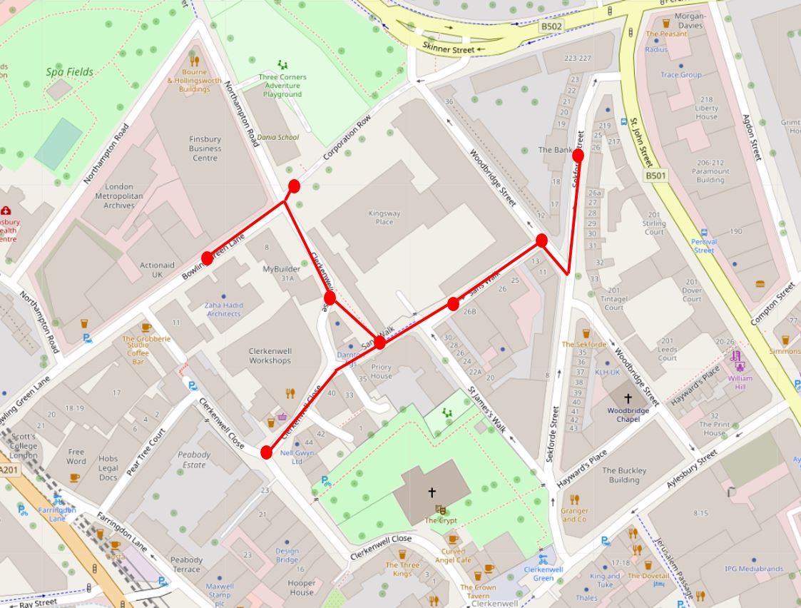
I have marked the location for today’s post by the red star in the following map  (Map © OpenStreetMap contributors):

Rotherhithe Gas Works

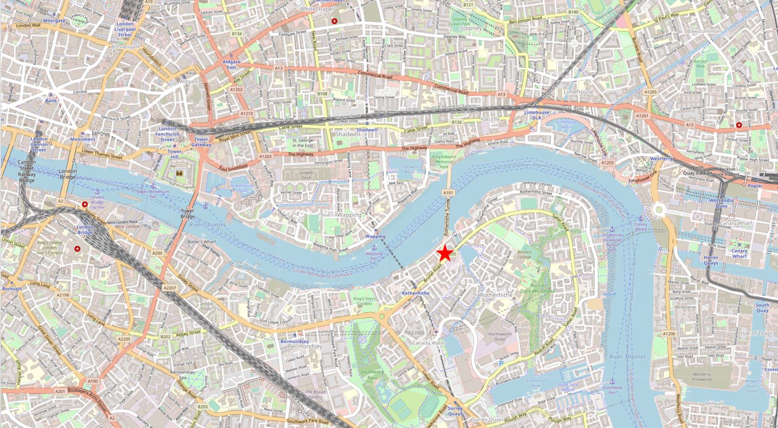
That is not a bridge across the Thames at the point of the star, it is the way Openstreetmap shows the Rotherhithe Tunnel.

The reason for the post on the Rotherhithe Gas Works is because of a photo taken by my father in 1948. The following photo shows what is probably open space following the demolition of bomb damaged houses, with in the background, parts of two large gas holders.

Rotherhithe Gas Works

I wanted to find the location of the photograph. I knew from my father’s notes that the location was Rotherhithe, but not from where the photo had been taken. The two gas holders were obvious clues, however the area is very different today, so I started off with the 1950 edition of the Ordnance Survey map of the area.

I have copied the photo below, added the map extract and marked up key points shown in both photo and map, and the approximate location where my father was standing to take the photo. I needed to rotate the map to get a similar orientation to the photo, so north is at the bottom and south at the top of the map.

Rotherhithe Gas Works

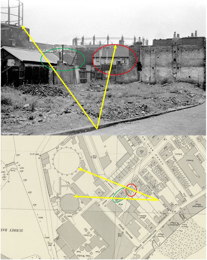
The red oval marks a semidetached pair of houses. To the left of these houses, there appears to be a tall wooden fence, and next to the fence, a terrace of older houses (you may need to click on the photo and enlarge to see the details of these clearly). These are the terrace houses shown by the green oval on the map.

In the background are the two large gas holders. The one on the right appears to be a larger circumference than the holder on the left, which matches both photo and map. Part of the gas holder on the left is obscured by a large building, again the same in both photo and map.

Extending the alignment of these features back, and they converge at a point on a street which again aligns with the photo as part of a street is in the lower right corner.

Rotating the map back to the correct orientation, and the street is Neston Street, marked below with the red star. The terrace of houses on the right of the street ends in a blank space on the map which corresponds with the 1948 photo (‘Reproduced with the permission of the National Library of Scotland’).

Rotherhithe Gas Works

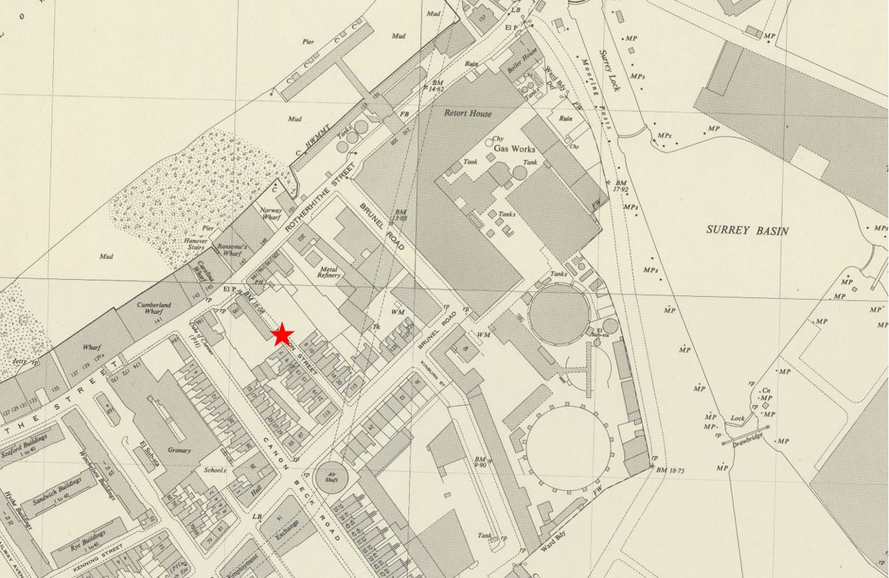
So it should be simple to find the location today? Not very, as the area has changed so much. In the 1950 map above, All the large buildings between the round gas holders and the River Thames at top left, were part of the Rotherhithe Gas Works. To the left, there was some housing, along with other industrial buildings, and the area had also suffered bomb damage.

The Rotherhithe Gas Works closed in 1959, and over the last few decades, the area has been considerably redeveloped with new housing now covering all the original site of the gas works (with one exception). Roads have changed, and Neston Street has disappeared.

Marking Neston Street on today’s map of the area (red line) allows the location of the 1948 photo to be identified (red star),

Rotherhithe Gas Works

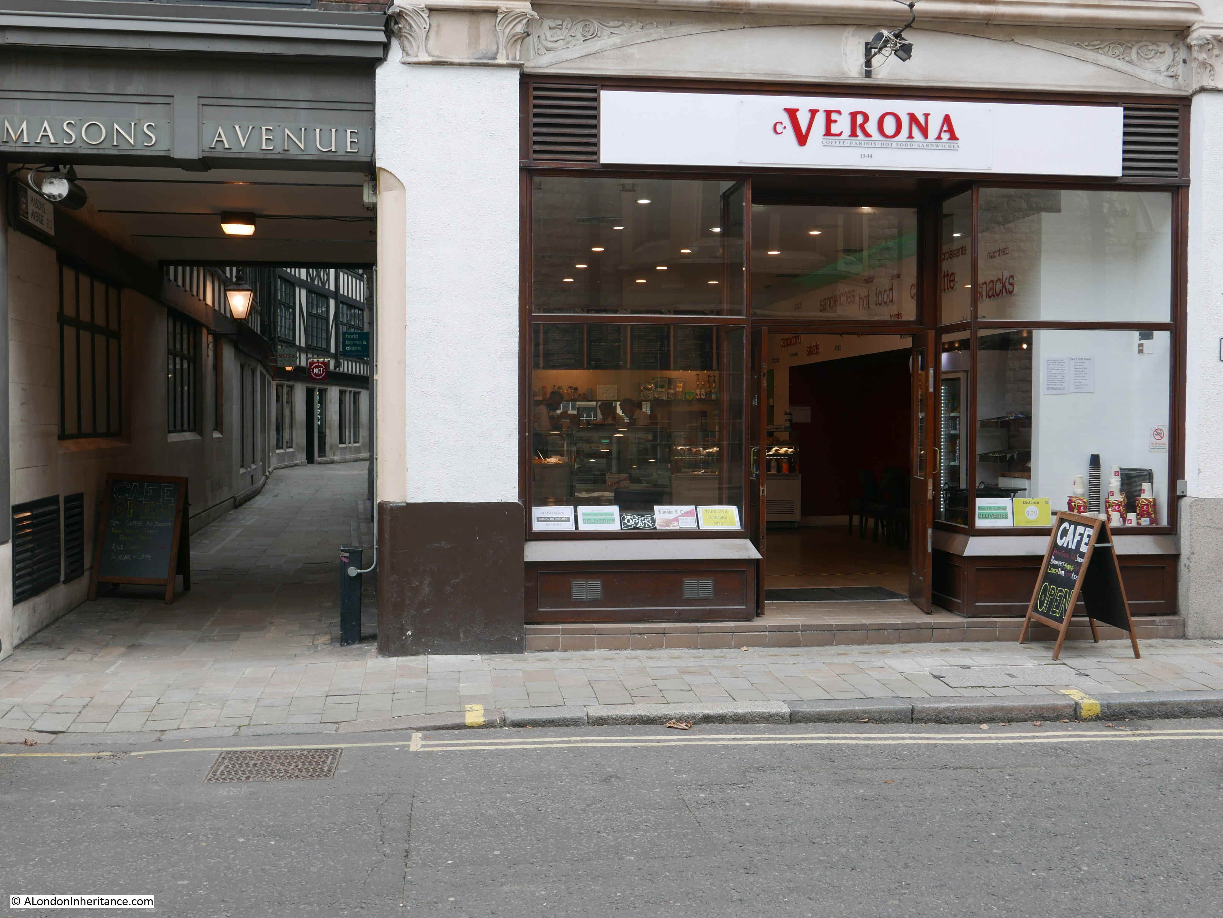
I needed to visit the site to see the area today, and to find one of the two remaining elements of the Rotherhithe Gas Works infrastructure, one that may not be around for too much longer.

I walked along Rotherhithe Street from the west, and walked up Canon Beck Road (to the left of the red line), a road that appears on both today’s and the 1950 map.

Just over half way along Canon Beck Road is a short entrance road to a residential square, Clifton Place. This is shown in the photo below:

Rotherhithe Gas Works

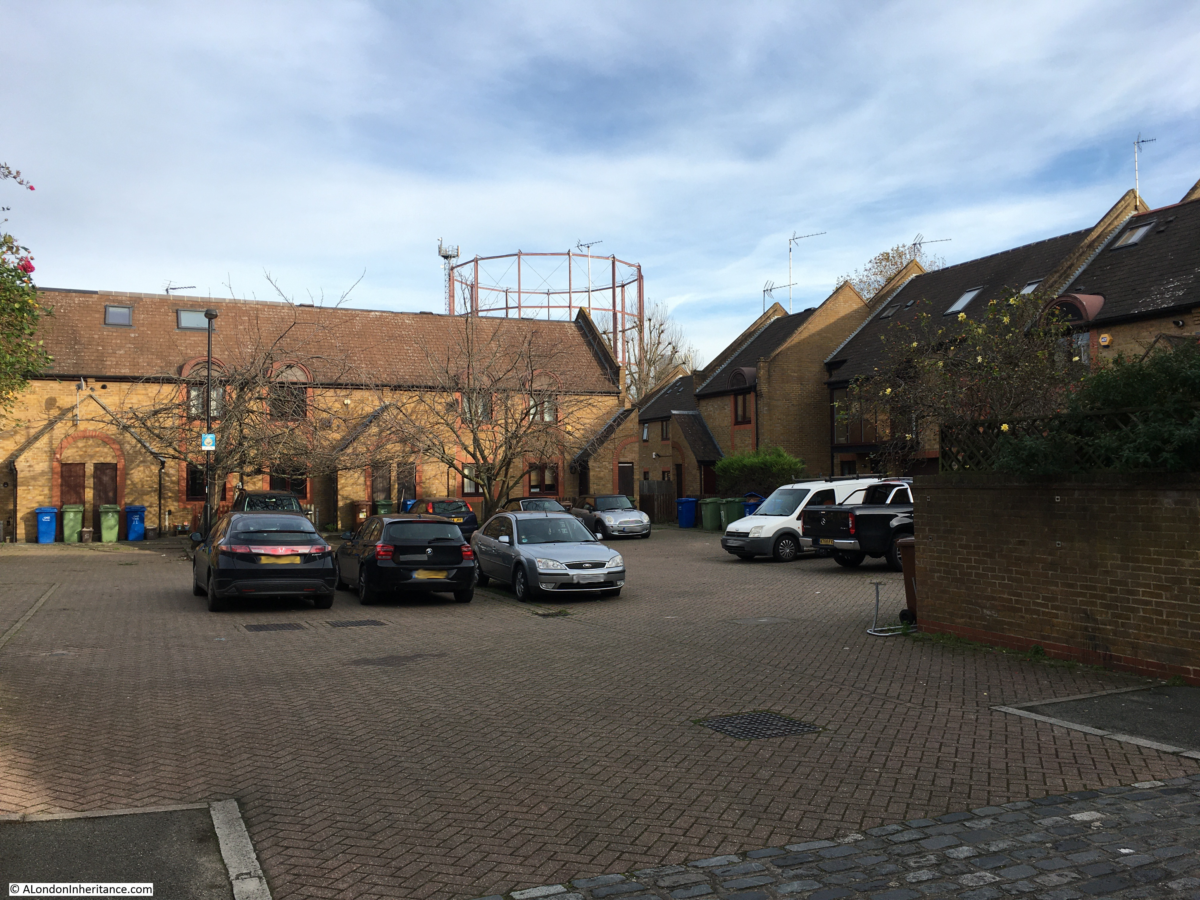
Neston Street would have run, left to right along the front and over part of the houses at the far end of the photo. To take the 1948 photo, my father was probably standing somewhere around the green and blue bins to the left of the photo.

Looming in the back of the above photo is one of the two remaining parts of the Rotherhithe Gas Works – the gas holder also seen to the left of the 1948 photo.

As well as visiting the site of my father’s photo, the gas holder was the second reason for wanting to visit, as it may well be soon disappearing as a local landmark, and a reminder of the industrial history of this part of Rotherhithe.

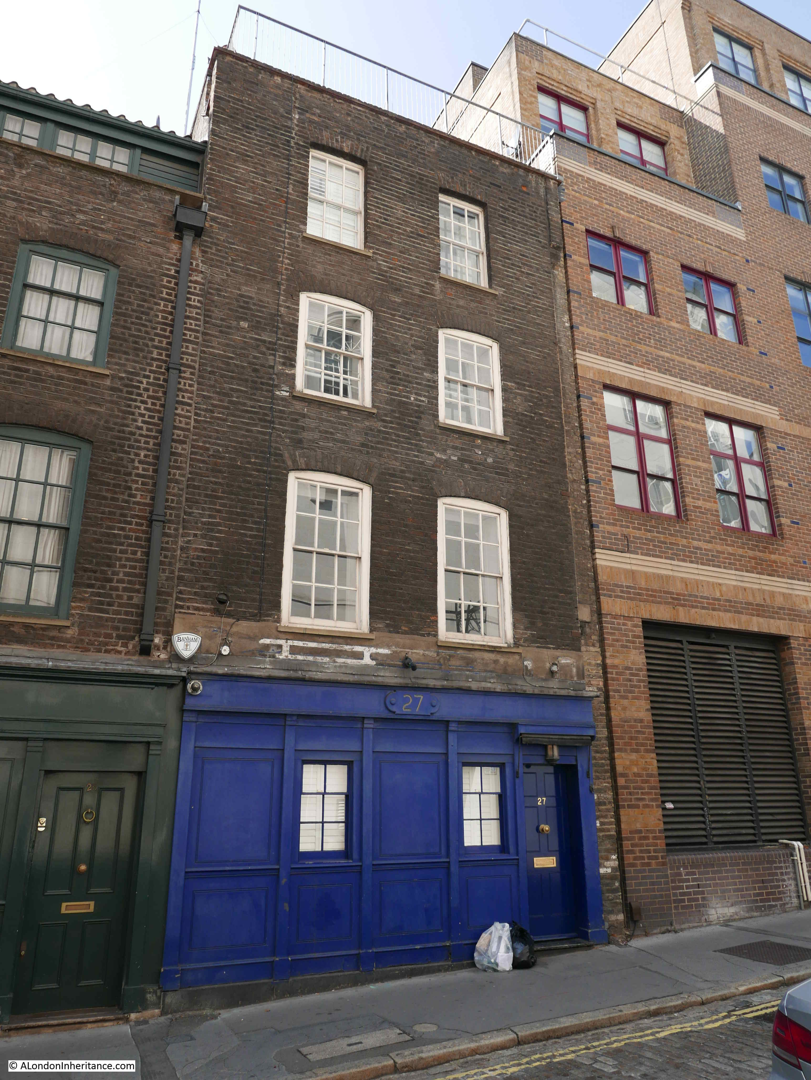
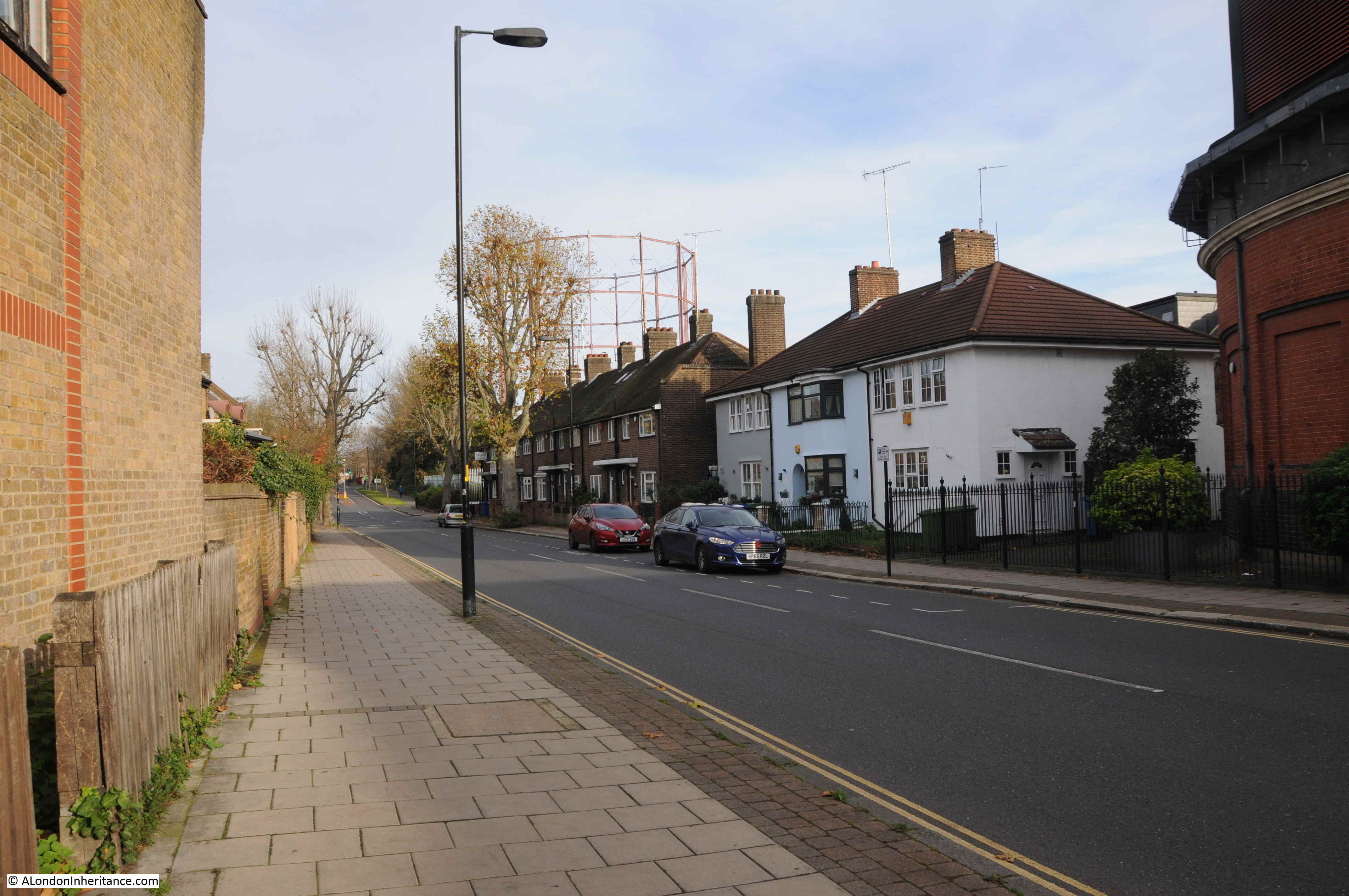
I walked up to Brunel Road. The terrace of houses along Brunel Road are not part of the redevelopment of the last few decades, they are much earlier. The gas holder can be seen in the background.

Rotherhithe Gas Works

Walking along Brunel Road up to the location of the gas holder, to find the one remaining holder from the gas works, sitting in the space that was also once occupied by the second gas holder in the 1948 photo.

Rotherhithe Gas Works

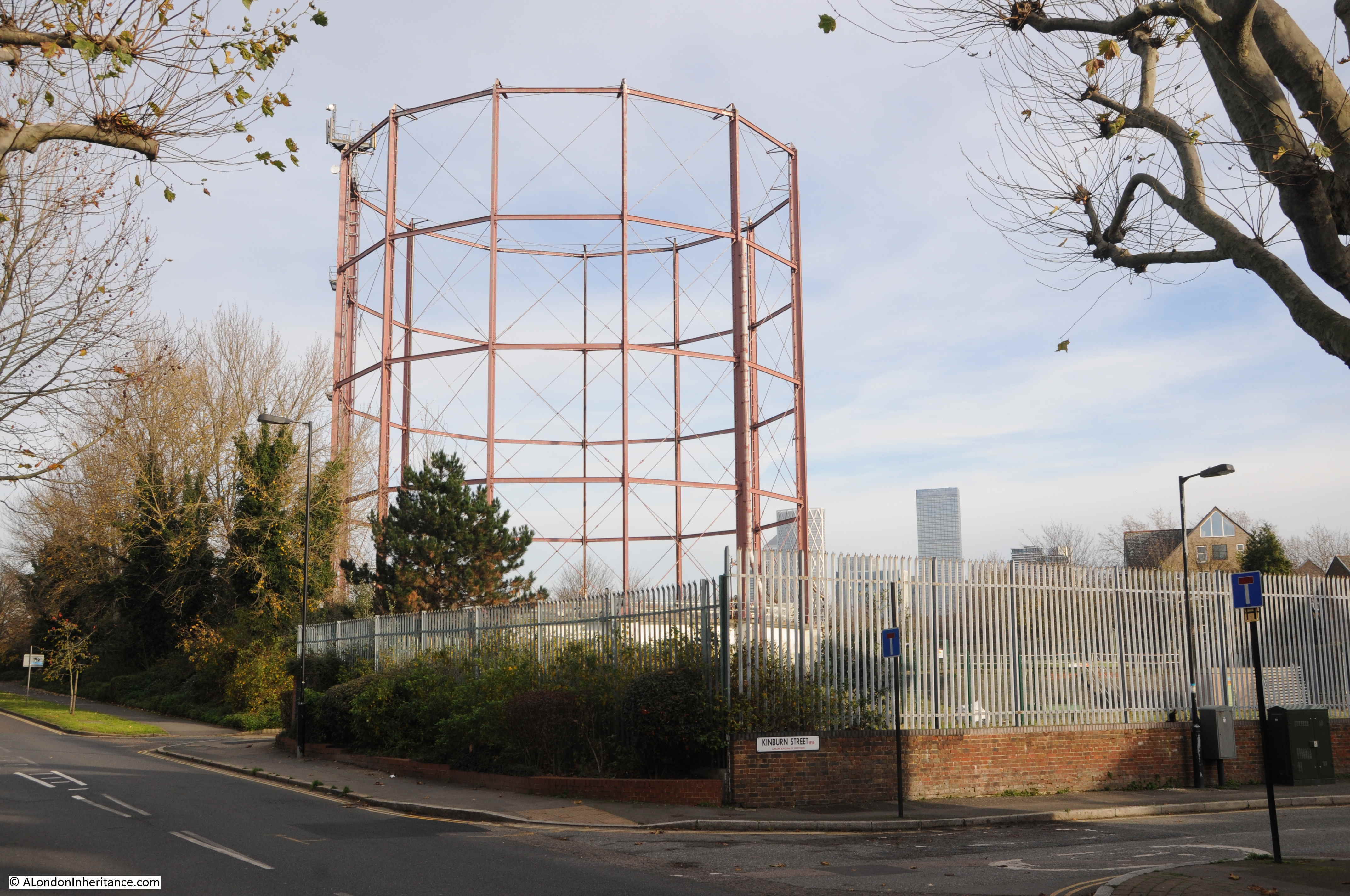
The remaining gas holder may not be here for long. Plans have been submitted for a complete redevelopment of the site which includes the land occupied by the gas holder, and the surrounding land.

The work will involve the demolition of the gas holder, and the infill of the tank below the gas holder, and the tanks below ground of the gas holders that have already been demolished.

Considerable work will involve removing contamination of the land and the move of operational gas piping and controls that still occupy the site.

The current plans appear to cover the construction of:

  • 40 dwellings for social rent
  • 39 dwellings for discount market rent
  • 198 private dwellings

The plans include the intention “To celebrate the character of the site and its industrial heritage”, which as far as I can see runs to “Balconies and stairways take reference from the industrial metal work” and “Pitched roofs reference the storage sheds associated with the Surrey Water Docks” along with the use of the colour red to accentuate certain features to recall the colour of the existing gas holder.

There is a web site for the proposed development, which includes presentations on the proposed work. It can be found under the name of the development Rotherhithe Holder Station.

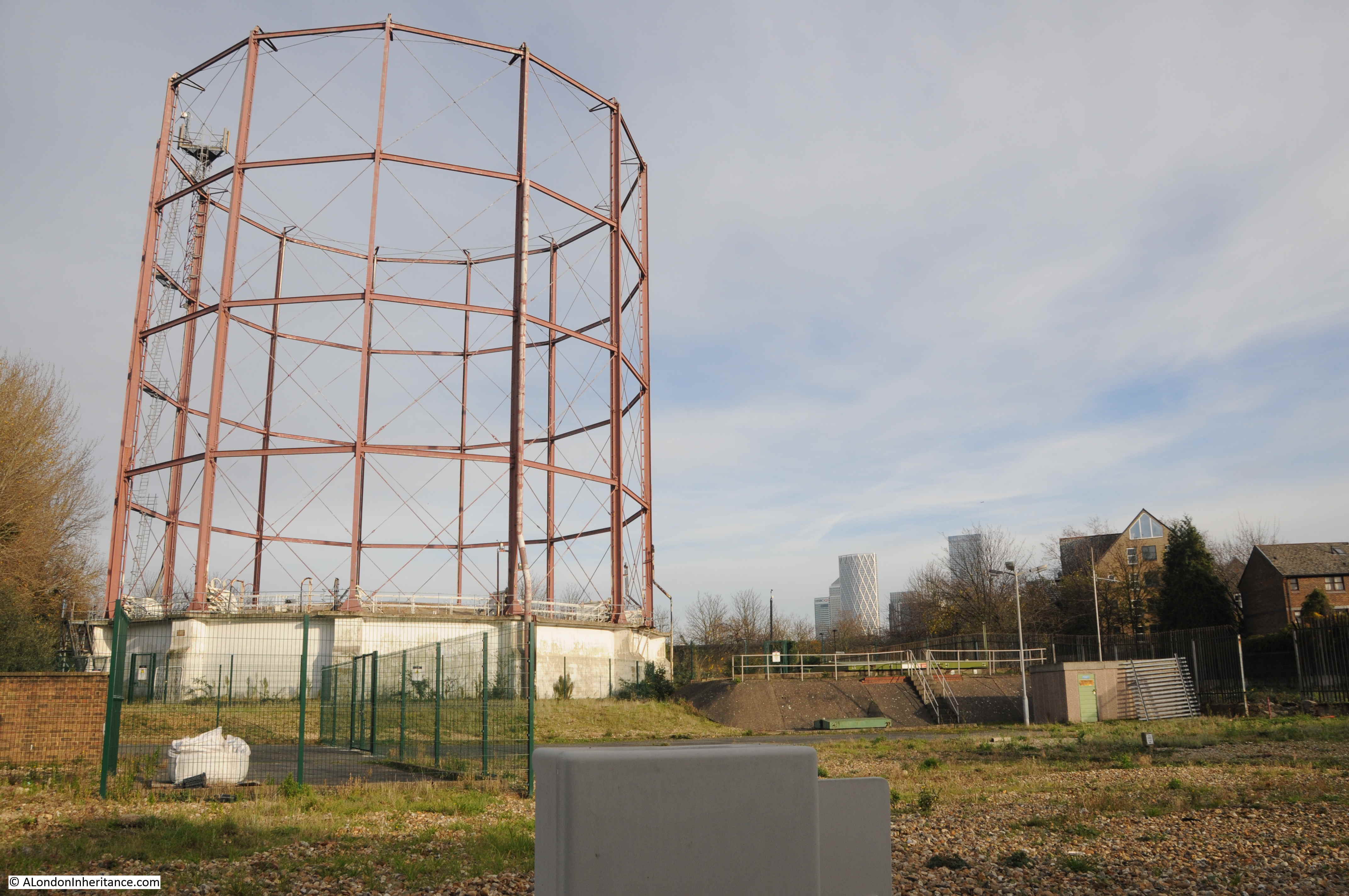
A view of the gas holder and the surrounding land which is in-scope of the proposed development:

Rotherhithe Gas Works

The history of the Rotherhithe Gas Works is complex, and tells the story of the consolidation of the local gas companies throughout the 19th century and nationalisation in the 20th century.

Using a number of resources (which I will list at the end of the post), I have attempted to put together a graphical history of the Rotherhithe Gas Works, their ownership, and mergers with other gas companies. Be aware that there are various conflicting dates for some events, and also definition of a date, for example when a gas works became operational, the incorporation of a company by Act of Parliament etc.

Any corrections would be appreciated.

The following graphic shows how the Rotherhithe Gas Works (starting at left and highlighted by the red dotted line) integrated with London’s gas companies through to closure in 1959.

Rotherhithe Gas Works

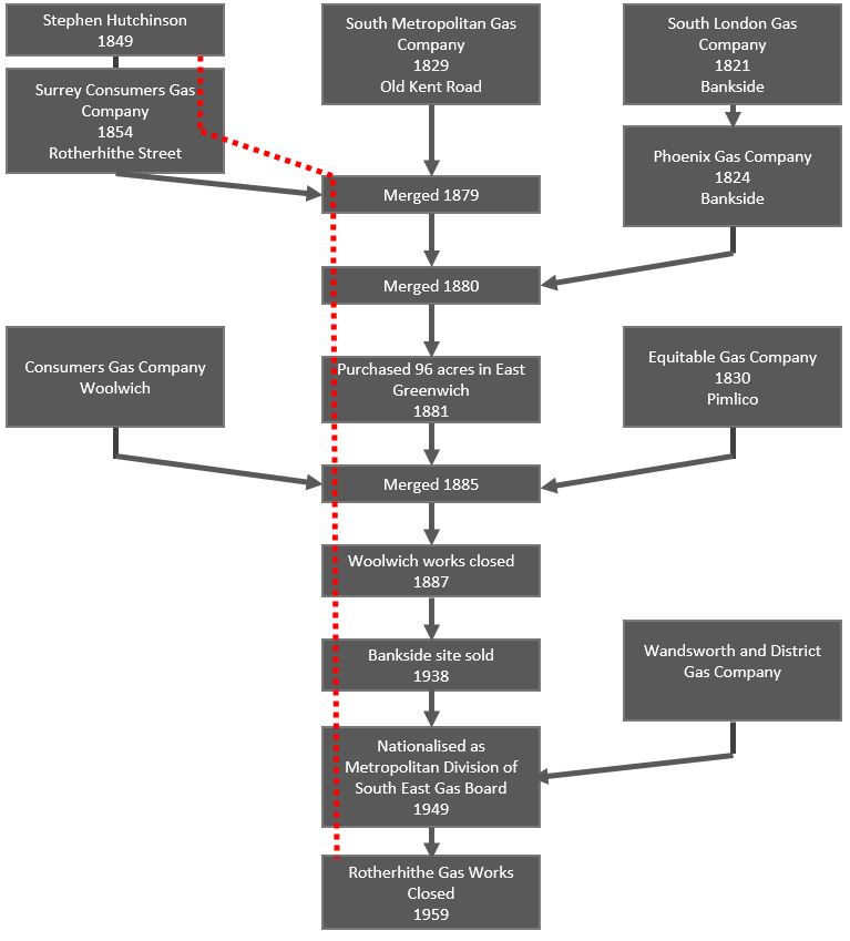
The first gas works in Rotherhithe seem to have commenced construction by Stephen Hutching in around 1849, with the works becoming part of the Surrey Consumers Gas Company, a company incorporated by Act of Parliament in 1854.

In the mid 19th century there were many concerns about the quality of the gas provided to consumers and the cost, with companies having a monopoly within their local supply area. An 1849 article in The Era titled “Gas Monopolists In A Fever”  talks about the need for gas companies who can supply gas “free from sulphureted hydrogen, acid and ammonia” and the extortionate price charged with upwards of 15 shillings per 1,000 cubic feet, where independent calculations estimate that gas can be produced using modern methods for 2 shillings per 1,000 cubic feet.

The Surrey Consumers Gas Company merged with the South Metropolitan Gas Company in 1879, which brought together two gas companies serving south and south east London.

In 1881, the South Metropolitan purchased a large area of land on the Greenwich Peninsula and started the construction of the gas works which would go on to be one of London’s major gas producing centres for many years.

The South Metropolitan Gas Company would continue to integrate other, smaller companies, including the Phoenix Gas Company based in Bankside in 1880, the Consumers Gas Company in Woolwich and the Equitable Gas Company in Pimlico, both in 1885.

Probably because of the growth of sites such as the Greenwich Peninsula and Rotherhithe, the South Metropolitan closed and sold off sites at Woolwich and Bankside.

Reading newspaper references to London’s gas companies throughout the 19th and early 20th centuries, there are very many references to the monopoly position of these private companies, the cost of gas and frequently the quality of the gas, and pollution from the gas producing works.

In January 1860 the Surrey Consumers Gas Company were at Southwark Police court being charged by the Bermondsey vestry under the Nuisance Removal Act “for that they, in the manufacture of gas on their premises at Rotherhithe, did, on or about the 16th inst. cause an intolerable nuisance to exist as to be dangerous and injurious to the inhabitants of the parish of Bermondsey”.

The issue in January 1860 seems to have been a considerable amount of ammonia in the gas supply which had not been removed by the purifiers at the Rotherhithe gas works, and was causing a very bad smell, and health problems to those in Bermondsey who consumed the gas.

In 1875 at the half yearly meeting of the Surrey Consumers Gas Company, the news reports stated that the meeting “must have been attended with considerable interest by the fortunate individuals who hold shares therein. They have been too long accustomed to their unfailing profit of 10 per cent per annum. The balance sheet was as good as had ever been issued by the company”.

Consumer groups were frequently formed and south London’s vestries were often complaining about the costs and quality of gas, and there were many arguments that such companies should be publicly rather than privately owned.

London’s gas consumers would have to wait until 1949 for this to happen, when the countries gas companies were nationalised by the post war Labour government and the South Metropolitan Gas Company along with other London gas companies were merged into local gas boards under public ownership.

Ownership of gas provision came full circle when the nationalised gas board was privatised in 1986 as British Gas, and since then many of the arguments about the cost of gas are very similar to those in 19th century newspapers.

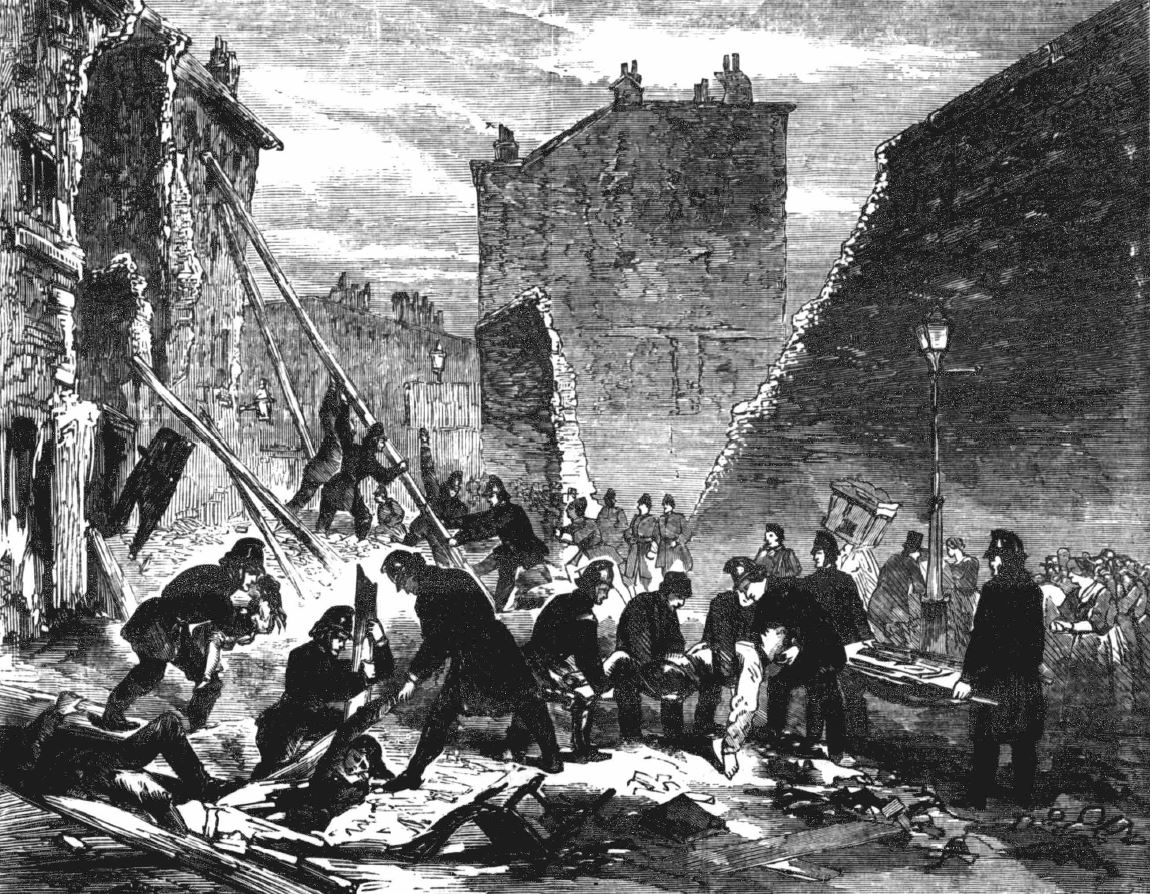
The production of gas was a very dirty business. Coal was heated in a furnace, which produced a range of gases including hydrogen and carbon monoxide. These gases were passed through a condenser where solids and liquids such as tar would be removed, before passing through a purifier where impurities such as sulpher and ammonia would be removed.

The gas was then fed to the gas holders ready for distribution at pressure to gas consumers.

An impression of the interior of the Rotherhithe Gas Works can be had from the following artwork dated 1918, with women working in the “retort” area (retorts are the furnaces where coal was heated to produce gas).

Rotherhithe Gas Works


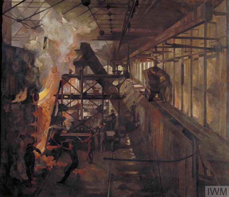
 Copyright: © IWM. Original Source: http://www.iwm.org.uk/collections/item/object/105

Work at the Rotherhithe gas works was dangerous and there are newspaper accounts of accidents within the works. For example, when one of the gas holders was being built in 1890, a labourer named Barnes, aged 23, working for the contractors Clacton & Son of Leeds, died after falling twenty feet to the base of the holder.

Workers at the gas works had the Rotherhithe Gas Works Institute, and in October 1894, five crews from the institute raced on the Thames from the coal jetty at the gas works to Deptford Creek.

Discovery of North Sea gas in the 1960s resulted in the replacement of so called Town Gas from gas works such as that at Rotherhithe, by gas piped from below the North Sea. Although Rotherhithe has already closed in 1959, the majority of coal based gas works in the country had closed by the 1980s.

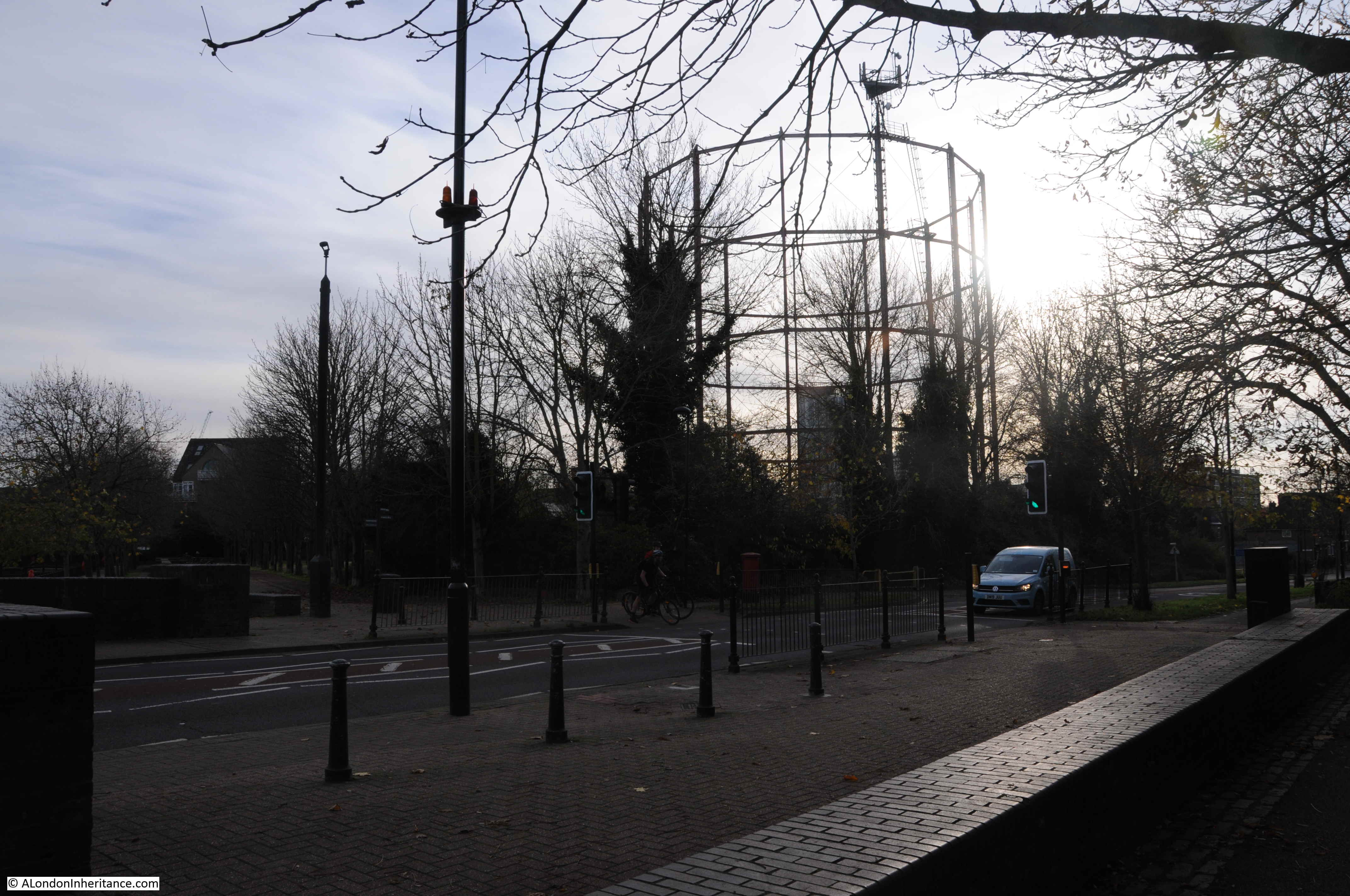
The lone gas holder at Rotherhithe now stands as an isolated reminder of this period of south London industrial history.

Rotherhithe Gas Works

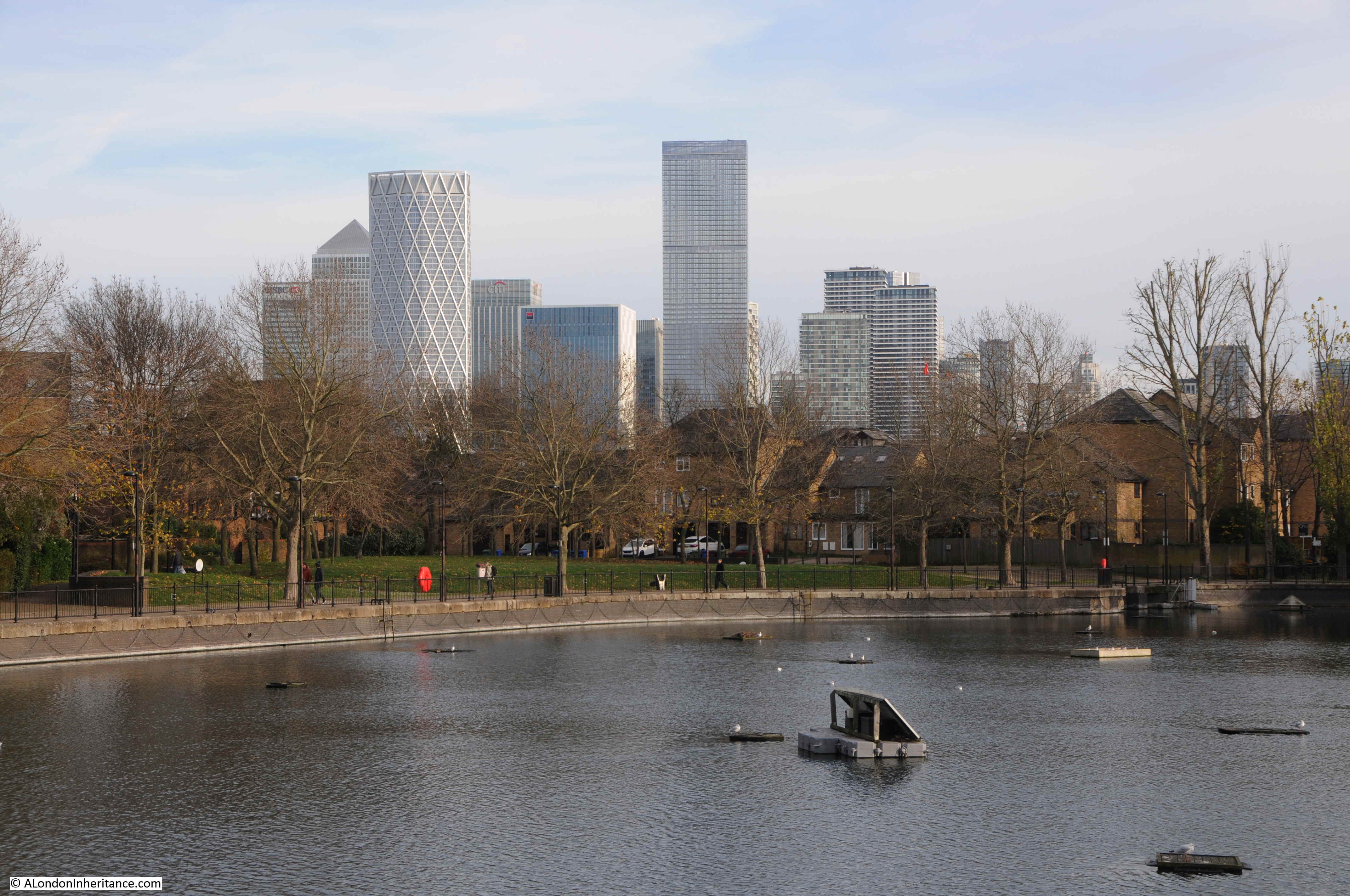
The gas holder stands next to the remains of another of the areas lost industries. This is the Surrey Basin, one of the few reminders of the large area of docks that once occupied this area of Rotherhithe. The towers of the Isle of Dogs are in the background.

Rotherhithe Gas Works

The following photo is from Salter Road, a road that did not exist when the Rotherhithe gas works were in operation. The space in front of the camera, and the space occupied by the houses behind the trees was the space covered by the buildings of the gas works, which fed gas to the gas holders which are to the left of where I was standing to take the photo.

Rotherhithe Gas Works

Crossing Salter Road and looking back at the gas holder, which now supports mobile phone antennae’s at the very top.

Rotherhithe Gas Works

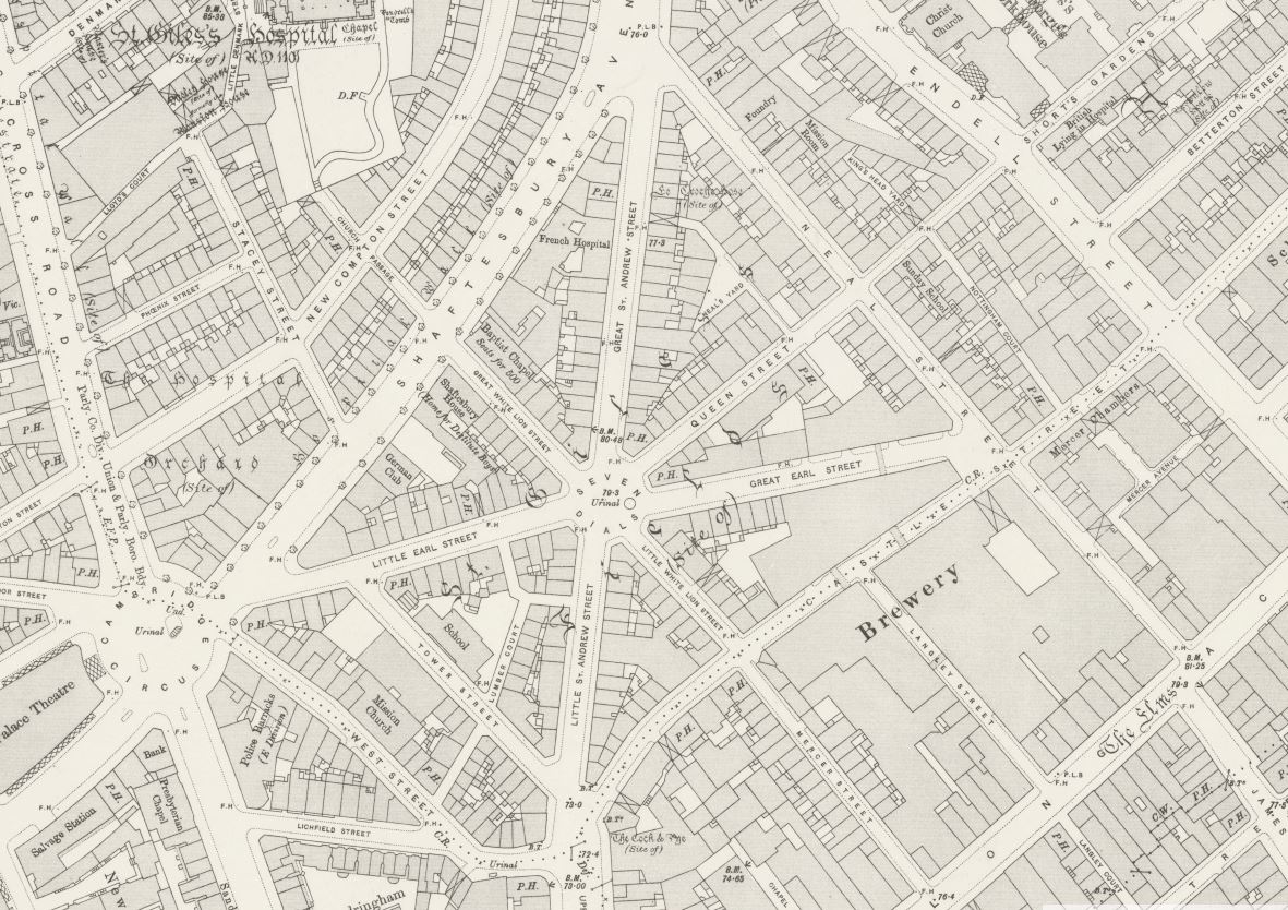
The following map from 1895 shows three gas holders with the main buildings of the Rotherhithe Gas Works to their north. There were a total of four gas holders over the life of the gas works (‘Reproduced with the permission of the National Library of Scotland’).

Rotherhithe Gas Works

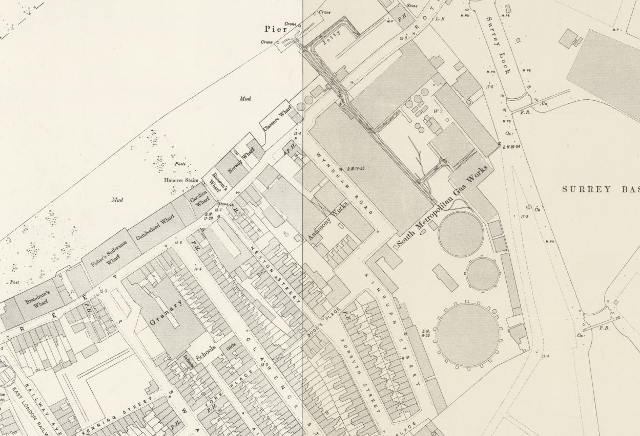
Of the three shown in the map above, one was destroyed by war time bombing. I suspect that this was the smaller holder between the two outer holders, as it is not shown in the 1950 map, or in my father’s photo. The larger of the two gasholders was demolished at the same time as the rest of Rotherhithe gas works in the 1960s and 70s, leaving only the holder that remains today.

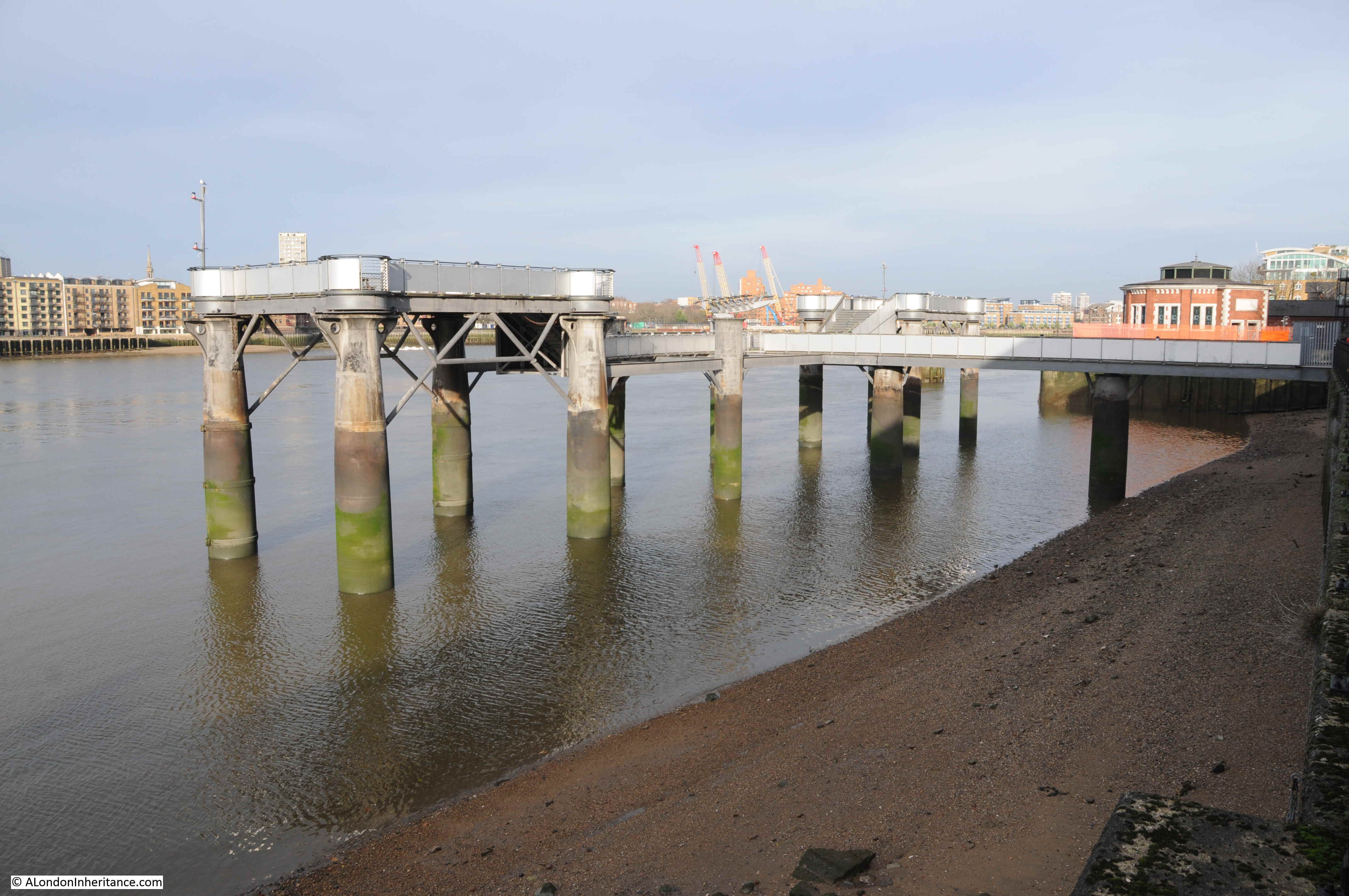
Apart from the gas holder, there is part of the site wall remaining alongside the Surrey Basin. Another part of the gas works infrastructure that we can see today is shown in the above map. If you look at the very top centre of the map there is a pier extending into the River Thames.

This was the pier used by ships bringing coal to the gas works, and looking at the map, you can see the conveyor system that carried coal from the pier, over Rotherhithe Street, to the retorts where the coal would be heated to produce gas.

The Rotherhithe Gas Works pier remains today. The view looking west:

Rotherhithe Gas Works

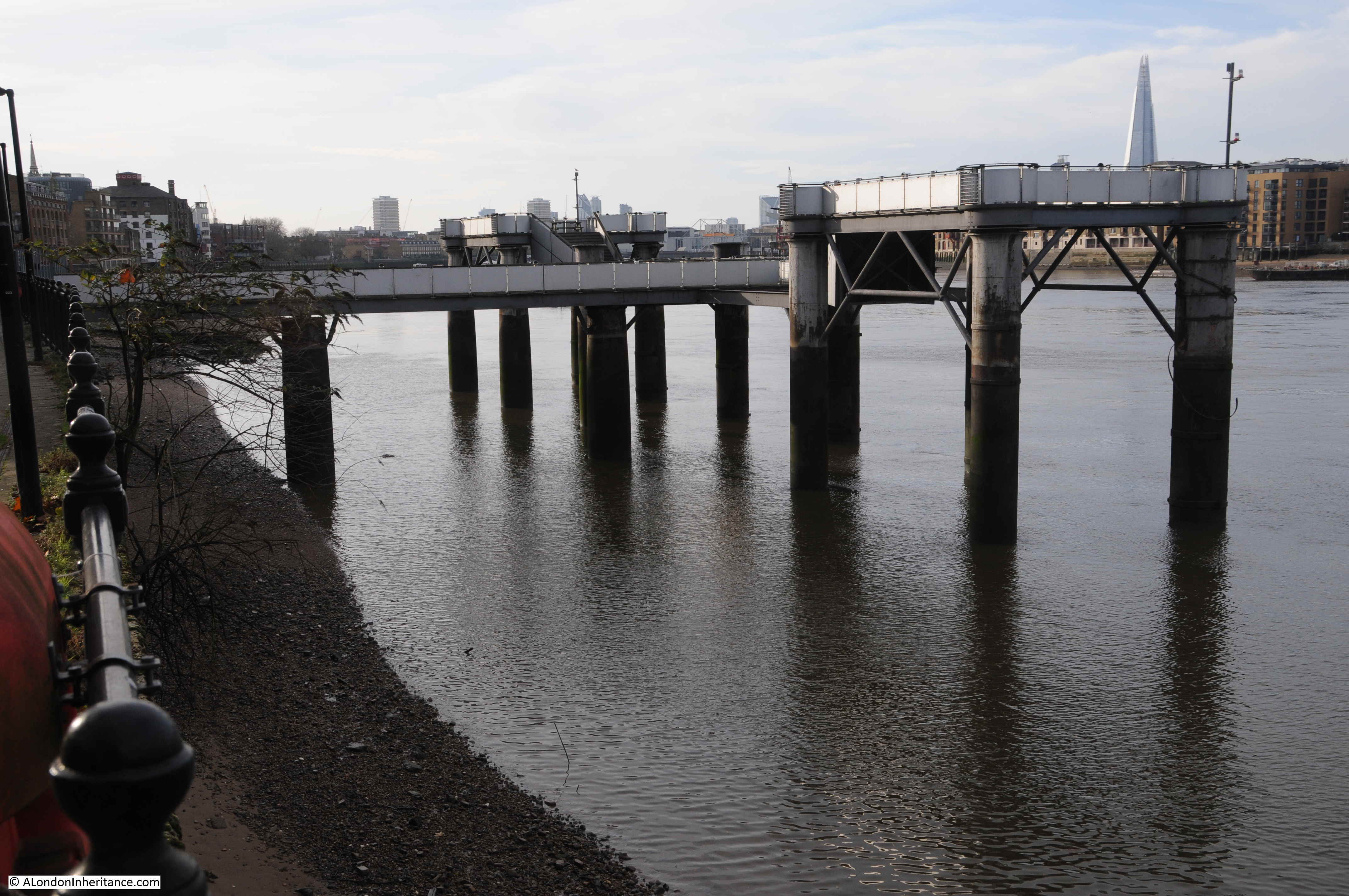
Looking east along the river with the gas works pier, and the round air shaft building for the Rotherhithe Tunnel behind the pier on the right.

Rotherhithe Gas Works

The Rotherhithe Tunnel was built under part of the site of the gas works, and during Parliamentary inquiries into the tunnel, the South Metropolitan Gas Company objected to the construction of the tunnel. Mr. George Livesey, chairman of the gas company stated in his evidence that “the proposed tunnel would pass under a corner of the works of the gas company where they had important buildings, retort houses, coalhouses, and so forth. These structures were of considerable weight, and the foundations were thoroughly sound. If there was any disturbance to the foundations – which were taken down to the gravel – it would put the retort house out of use, and if that happened in winter time it would be a very serious matter.

Pumping operations such as would have to be carried out by the County Council in constructing their tunnel might be a source of serious damage to the company’s works. The gas tanks were set into deep excavations full of water, and if this water and the sand in the foundations were interfered with the results would be that the tanks would leak”

it appears that the company had suffered damage to their operations on the Greenwich Peninsula when the Blackwall tunnel had been built, and they had not received any compensation for this damage, and they wanted a clause in the bill for the Rotherhithe tunnel to ensure they received compensation for any damage to the Rotherhithe works.

The statement about the gas tanks being set into deep excavations, full of water explains why the site today is a complex site to prepare for new building. The tank below ground of the existing gas holder is still in place, as is the tank of the demolished gas holder which was simply capped at the time. These tanks will need to be drained of polluted water and sludge and the hole refilled ready for building above.

I am not sure what the current state of the proposals for the site development are, I suspect that COVID has delayed the process.

Whilst there is an obvious need for more housing across London, it is a shame that another part of London’s industrial history will be disappearing.

This post has covered the history of the gas companies and the Rotherhithe gas works at a very superficial level, this is the problem with a weekly blog, I can only cover topics to a limited level.

The National Archives have a brief summary of the history of each gas company. Use the search box on their site to search for a company. The Early London Gas Industry site by Mary Mills is a fantastic resource covering the gas industry in London.

Although the area has changed significantly since 1948, I am pleased to have found the location of another of my father’s photos. Rotherhithe and Bermondsey is an area I will be returning to in the future.

alondoninheritance.com

Sans Walk, a Fenian Outrage and the Edge of London

There are three photos in my father’s collection that I have not been able to identify. They were labelled “Sans Walk area”. Sans Walk is in Clerkenwell, and the first photo shows what appears to be an empty shell of a building, probably damaged during the war.

Sans Walk

The second photo shows a corner house, in good condition and still occupied, with a lovely street lamp on the corner of the building:

Sans Walk

The third and final photo shows part of a terrace of houses, with a streetlamp and bollards in the foreground.

Sans Walk

No street names, or any other identifiable features to help locate the photos.

I thought if I walked the area around Sans Walk, I should be able to identify some of the locations. I had no idea whether the houses in the photos had been restored or demolished, but armed with printed copies of the photos I set off to walk the area on an early Autumn day.

Although I could not find the locations of the photos, what I did discover was an area packed full of history, and that once formed the edge of London as the city gradually expanded to the north.

The following map shows the places covered in the rest of the post (Map © OpenStreetMap contributors):

Sans Walk

Sans Walk is the nearly horizontal street in the centre of the map. I did walk the rest of the streets around Sans Walk, but this post was getting rather long with just the stops shown.

I started in Clerkenwell Close, opposite the Horse Shoe pub, a very traditional pub that probably dates back to the 18th century. The earliest written records I could find date to 1824 when a newspaper report referred to an inquest into a suicide which was held in the Horse Shoe.

Sans Walk

This area of Clerkenwell is full of narrow streets. Some new buildings intrude, but many 18th and 19th century buildings survive, along with warehouses and factories from the 19th and early 20th centuries.

Looking east along Clerkenwell Close:

Sans Walk

Clerkenwell Close is a strange street as it consists of a number of branches. Starting at Clerkenwell Green, it runs north-west, up to Pear Tree Court and the Clerkenwell Close Peabody Estate, with the branch I am walking along turning off and running up to Bowling Green Lane and Corporation Row. At one point the street runs parallel to a pedestrian alley, both called Clerkenwell Close, and indicative of how the area has developed as large warehouses replaced earlier streets, alley and buildings.

Sans Walk

New buildings had been added, but they are generally at the same height as the existing buildings, so despite the architectural and material changes, they blend in. Providing they are in keeping with the scale of the area, and there is a justification to replace rather than restore the  original building, it is good to have new buildings. The streets in the area have buildings from the last few centuries and 21st century additions are part of the continuous development of London.

Sans Walk

The above building was built on the corner of the playground of a Victorian school. The curving wall at street level retains a plaque recording the gift of Sir Robert Wood to the parish in 1844. I suspect this refers to the land:

Sans Walk

We are still in Clerkenwell Close, and the following building tells of the late 19th century expansion of London schools and the London School Board.

Sans Walk

The London School Board was responsible for the development of many of the large, brick, late 19th century schools that can still be found across London. As well as their construction, the London School Board was also responsible for their operation, and the supply of all the goods and materials needed to fit out, and keep a school running.

The Board consolidated the process of standardisation and supply, and one of the methods used was large central warehouses. The buildings in Clerkenwell Close were built between 1895 and 1897 as warehouses for school furniture, stationery and needlework supplies.

The growth in the volume of space needed grew in the early 20th century, and in 1920 an extra floor was added to the top of the Stationery and Needlework warehouse on the right of the above photo, and this addition is still visible in the change of brick colour from red/orange to  a brown brick for the 20th century addition of the top floor.

In the above photo, the furniture store was on the left, and the Stationery and Needlework departments were on the right, and these functions are still recorded in stone, above the doors.

Sans Walk

The initials at the top are those of the London School Board.

One of the schools that the warehouse would have supplied is directly opposite:

Sans Walk

The school was the Hugh Myddelton School, built by the London School Board in 1893 and with the distinction of being the only London School Board school opened by a member of the Royal family after it was opened by the Prince of Wales in December 1893.

Such was the importance of the visit of the Prince of Wales that the London School Board allocated £100 towards preparations for the visit, which caused some consternation as the money was thought better spent on education.

In his opening speech, the Prince of Wales said that the London School Board had contributed to a “marked advance in education, diminution in crime and an undoubted increase in general intelligence”.

Lesson in the Hugh Myddleton School in 1906:


Image credit: London Metropolitan Archives, City of London: catalogue ref: SC_PHL_02_0208_3943

Drill in the open area outside the school, also 1906:

Sans Walk

Image credit: London Metropolitan Archives, City of London: catalogue ref: SC_PHL_02_0208_68_4984

When opened, the school was the largest and most expensive built by the London School Board. The school had a number of special departments, including the Hugh Myddleton School for the Deaf. The site on which the school stands has an unusual history.

From 1845, the space occupied by the school had been the site of the Middlesex House of Detention, built as a short stay prison due to overcrowding in other prisons, the Middlesex House of Detention was demolished in 1886.

Some of the reception cells of the prison were in the basement, and these survived the demolition of the main building and were incorporated in the basement of the Hugh Myddelton School, and are presumably still there.

The school closed in 1971, was a Further Education College for the next couple of decades before being sold for development into flats and offices in 1999.

The site of the school, when occupied by the Middlesex House of Detention was the site of a bomb explosion in December 1867 reported extensively as the Fenian Outrage in the newspapers of the time.

This took place at the perimeter wall of the prison which ran along the northern edge of the site, in Corporation Street:

Sans Walk

The Fenians was another name for the Irish Republican Brotherhood, an organisation formed in the 1850s to fight for an independent, democratic Ireland.

The bomb was an attempt to free Ricard O’Sullivan Burke and Joseph Casey who had been arrested earlier regarding Burke’s attempts to purchase arms and ammunition in Birmingham, and a previous attempt to free a prisoner in transit, when a guard had been killed.

The view along Corporation Row in the immediate aftermath of the explosion:

Sans Walk

The Illustrated London News carried the following report of the explosion:

“The whole neighbourhood of Clerkenwell was startled at a quarter to four on Friday afternoon by an explosion, which resembled an earthquake. The houses were shaken violently, the windows in many cases were broken, and in some instances persons were thrown to the ground by the violence of the concussion. The scene of the explosion proved to be the wall of the House of Detention, opposite Corporation-row, some sixty feet of which were knocked down, and it was not long before the discovery was made that numerous persons were seriously, and some fatally injured, and that the calamity had been wilfully caused. It was at once attributed to the Fenians, the motive alleged being a desire to rescue Burke and Casey, who are confined in the prison, and facts which have since come to light show that this theory is the correct one.

The clearest account of what actually took place is given by a boy about thirteen years of age, named John Abbott, who is now in St Batholomew’s Hospital, happily not very much hurt.

This youth who lived in Corporation-row, says that at about a quarter to four o’clock he was standing at Mr Young’s door, No 5, when he saw a large barrel close to the wall of the prison, and a man leave the barrel and cross the road. 

Shortly afterwards the man returned with a long squib in each hand. One of these he gave to some boys who were playing in the street, and the other he thrust into the barrel. One of the boys was smoking and he handed the man a light, which the man applied to the squib. The man stayed a short time until he saw the squib began to burn, and then he ran away. A policeman ran after him, and when the policeman arrived opposite No 5, the thing went off.

The boy saw no more after that, as he himself was covered in bricks and mortar. The man, he says, was dressed something like a gentleman. He had on a brown overcoat and black hat, and had light hair and whiskers. He should know him again if he saw him. 

There was a white cloth over the barrel, which was black, and when the man returned with the squib he partly uncovered the barrel, but did not wholly remove the cloth. There were several men and women in the street at the time, and children playing. Three little boys were standing near the barrel at the time. Some of the people ran after the man who lighted the squib.

The effects of the explosion were soon visible in all directions. The windows of the prison itself, of coarse glass more than a quarter of an inch thick, were to a large extent broken, and the side of the building immediately facing the outer wall in which the breach was made, and about 150 feet from it, bears the marks of the bricks which were hurled against it by the explosion. The wall surrounding the prison is about 25 feet high, 2 feet 3 inches thick at the bottom, and about 14 inches thick at the top.

As to the number of persons injured it was impossible for some hours to learn anything satisfactory. It was found, however, that something like fifty at least had been hurt, and that two or three were killed. Thirty six of the sufferers were removed to St Bartholomew’s Hospital, where three died in the course of the evening, and six to the Royal Free Hospital in Gray’s Inn Road. Of the wounded some were mere infants, and the husband of a women, who has since died of injuries she sustained, lies in St Bartholomew’s; shockingly bruised and prostrated. Others are missing”.

In the following days, 12 were confirmed to have died in the explosion, with very many injuries.

A number of Fenian sympathisers were arrested, but after trial only one, Michael Barrett, was found guilty, and was sentenced to death. Barrett was the last person to be publically hung outside Newgate Prison.

The scene in Corporation Row after the explosion. A temporary wall has been erected to plug the gap caused by the explosion, and the walls of the opposite houses are being held up with timber supports.

Sans Walk

On a quiet autumn day in 2020 it is hard to imagine the explosion and devastation in Corporation Row.

As well as the Hugh Myddleton School built on the site of the prison, there is another closed school near by. Parts of the wall surrounding the playground and one of the entrances for infants can be seen in front of the recent building that now occupies part of the playground space.

Sans Walk

This is Bowling Green Lane School, built in 1874:

Sans Walk

Another London Board School, part of the site was originally a parish cemetery, along with housing and a tavern.

When the Hugh Myddleton School opened, Bowling Green Lane School became the junior school for the Hugh Myddleton.

Sans Walk

Having built and run many schools in the later part of the 19th century, the London School Board would become part of the London County Council when the authority took over responsibilities for education across London.

A rather nice London County Council coat of arms can still be seen on the side of the school facing the street.

Sans Walk

Bowling Green Lane school closed in 1970, but continued to provide additional space for Islington Green Secondary School until 1982 when it was converted into a range of business spaces, and today, a sign adjacent to the Girls and Infants entrance confirms that Zaha Hadid Architects now occupy the old school.

Sans Walk

The name of the school is after Bowling Green Lane, the street that runs in front of the school. This is both an old street and name and is named after the Bowling Greens that once occupied the land to the north of the street as shown in this extract from Ogilby and Morgan’s map of London published in 1677:

Sans Walk

For many years, Bowling Green Lane and Corporation Row were the northern edge of this part of London, with open space on the northern side of the streets.

The following map extract is from a map produced in 1755 for Stowe’s survey of London. The orientation is rather strange as north is to the left, east is at the top of the map.

Sans Walk

The built areas of Clerkenwell are to the right (south) and open space to the left (north) until we come to the New River Head.

Hugh Myddleton was the driving force behind the construction of the New River and round pond at New River Head, and the large new London School Board school was named after him.

Sadler’s Wells were just north of New River Head and the open space between Sadler’s Wells and Clerkenwell was often a dangerous place for those returning in the dark from entertainments – see my post on Sadler’s Wells.

I now reached Sans Walk, the street that was apparently the centre for the three photos.

Sans Walk appears to have been in existence at the time of the Middlesex House of Detention, but seems to have gone by the name of Short’s Buildings – the name of a terrace of buildings on the southern edge of the street.

The name Sans Walk seems to have come into use by 1893 and the name comes from Edward Sans, the oldest member of the parish vestry at the time.

In the western side of Sans Walk, there are new buildings on the southern edge and the old Hugh Myddleton School on the northern edge of the street:

Sans Walk

Ornate, carved name of the school, high up on the wall to the left of the building.

Sans Walk

The initials of the London School Board are also prominently displayed on the right of the school building:

Sans Walk

The eastern stretch of Sans Walk – I could not match any of the buildings in the street with those shown in my father’s photos.

Sans Walk

On the side wall of the house at the eastern end of Sans Walk is this plaque making clear that the entire wall is the property of the County of Middlesex. No idea if that applies to the rest of the house behind the wall, or just the wall.

Sans Walk

Looking down Sans Walk from the east.

Sans Walk

The building on the left does look like a restored version of one of the terrace of houses in the first photo, however the location is completely wrong. the house above is only a single house on the end of a very different terrace, and there is a road passing immediately in front of the house, with Sans Walk on the right.

At the end of Sans Walk is Woodbridge Street. I could not find any houses that matched the photos.

Sans Walk

Running along the opposite side of the houses to Woodbridge Street is Sekforde Street, lined with early terrace houses, but again nothing that matched my father’s photos.

Sans Walk

Half way along the street is an interesting building. painted white, that stands out from the terrace of houses on either side.

This is the former head office of the Finsbury Bank for Savings.

Sans Walk

The Finsbury Bank for Savings opened in August 1816 at St. John’s Square, Clerkenwell Green. Formed to provide a service for small traders, labourers etc.

The bank moved premises to the building in Sekforde Street shown in the photo above in April 1841 after being built for the bank during the previous year.

Although the bank was intended for customers with limited savings, it was used by many more affluent customers, including the author Charles Dickens.

The Finsbury Bank for Savings went through a series of mergers, eventually becoming part of TSB, which in turn was taken over by Lloyds Bank.

I failed in the aim of the walk, to find the locations of my father’s photos around Sans Walk, although one of the aims of searching for these locations is to explore the surrounding area, and there was plenty to be found around Sans Walk.

The schools and warehouses of the London School Board, a 19th century bomb planted by the Fenians, the northward limit of Clerkenwell in the 18th century and streets that record lost bowling greens and one of London’s early saving banks – all within a short walk.

London is always best explored on foot and almost every street tells a story.

alondoninheritance.com

George Inn, Borough High Street, Southwark

The George Inn, along Borough High Street, Southwark is the only remaining galleried coaching inn in London of the many that once serviced the numerous coaches that connected the city with the rest of the country.

The George remains thanks to the London and North Eastern Railway. Although they did demolish large parts of the original buildings leaving only one side of the complex, they sold to the National Trust in 1937, who continue to own the property with it currently being leased to the pub chain and brewer, Greene King.

Back in 1977, I took the following photograph of the George with the main building and galleried upper floors.

George Inn

There was something being filmed at the time of my visit, as the lights facing into the building demonstrate – cannot remember what it was – a late 1970s period drama.

On a rather overcast September day, I went back to Borough High Street to photograph the George Inn.

George Inn

The George still has the narrow entrance from Borough High Street. These are days of COVID precautions and the sign indicated a separate side for entrance and exit.

George Inn

I did not want to challenge the restrictions in place, so did not walk into the yard just to take photos. I was short of time, having to be in Clerkenwell that afternoon so could not stop for a drink. The George is on the list for a return visit, and some better photos.

George Inn

The George looks much the same as in my 1977 photo, however the building at the end of the yard in 1977 has been demolished and replaced.

The George is a very old Inn, dating back to at least the 16th century. It was mentioned by Stowe in 1598 as one of the “fair inns” of London.

It was originally called the St. George, but because of changes in sentiment towards religious iconography, Popery and saints, the inn became the George in the mid 16th century.

In 1622 the inn is described as being built of “brick and timber”. In 1670 a Mark and Mary Wayland were running the George for an annual rent of £150. That year the pub was damaged by fire. Wayland rebuilt and had his rent reduced to £80 and a sugar loaf.

A much larger fire in 1676 that burnt through much of the surrounding area, totally destroyed the George, but again it was rebuilt by the tenant who had the rent further reduced to £50 and a sugar loaf, along with an extension of the lease.

In 1825, the George is recorded as being “a good commercial inn in the Boro High Street; well known, whence several coaches and many wagons depart laden with the merchandise of the metropolis, in return for which they bring back from various parts of Kent, that staple article of the country, the hop, to which we are indebted for the good quality of the London porter”.

In 1855, a description of the stables area of the inn included “a round room for the ostlers in the days of pack-horses, and a stable below ground with steps leading down to it”.

For many years, the George was owned by the trustees of Guy’s Hospital, which was on the eastern boundary of the original George Inn – the building we see today is a small part of the original inn and the associated buildings to support the coaching business.

In 1874, St Guy’s Hospital sold the George Inn to the Great Northern Railway. The coming of the railways had seen a rapid decline in travel by horse and coach, so the sale of the inn to the GNR, who used the site as a receiving station for goods to be transported on their rail network, was in many ways a logical continuation of the main transport function of the inn.

The following photo shows the courtyard of the George, looking towards Borough High Street, with a sign above the entrance to the offices of the Great Northern Railway:

George Inn

The location of the George Inn was key to the success of the inn as a coaching inn, as one of many inns located in courtyards along the main road that led south from London Bridge.

The following map extract is from a map of the Parish of St. Saviours Southwark by Richard Blome (late 17th century but published by John Stow in 1720).

It shows the road leading from London Bridge at the top of the map, down to the Marshalsea Prison at the bottom of the map. This road had long been the only southern route out of the City of London.

George Inn

To the right of the road are numerous alleys and courts. Many of these were inns such as the Spur Inn, Queen’s Head Inn, Talbot Inn, White Heart Inn, King’s Head Inn, Black Swan Inn, Ship Inn and Bores Head Inn. Southwark really did have a lot of Inns.

At number 35, with the red circle is the George Inn. The narrow access from the street leads on to a large courtyard.

There were a number of reasons for the high number of inns. The road was originally the only road from the City of London to the southern counties of England. The area was outside the control of the City of London, there was more land available and rents were cheaper than on the other side of London Bridge.

Catching a coach from one of the Inns in Southwark was almost the equivalent of walking across London Bridge today and catching a train at London Bridge Station.

Coaches from the Southwark Inns served numerous destinations in the counties of Kent, Sussex and Hampshire and in 1809, W.S. Scholefield who was running the George at the time, published a list of the destinations from the inn, and their frequency:

George Inn

The table demonstrates just how busy the George Inn must have been. Numerous destinations, with some having four coaches a day. Horses being stabled at the George, passengers staying in the rooms of the George before an onward journey, luggage and other goods for onward transport across London.

The table includes coaches, which were mainly for passenger transport, and also wagons, which were used for the transport of goods, so the George was also the hub for a transport network for products, raw materials and personal / household goods that needed to be sent to destinations from Kent to Hampshire, and returning goods for sale in the City.

I plotted the coach network onto a map to give a graphical view of the geographic spread and number of destinations (Map © OpenStreetMap contributors):

George Inn

The majority of destinations are in the county of Kent, with some in Sussex. There is a  significant gap between the main Kent services and the five destinations to the west of the map, with no services to towns such as Edenbridge, East Grinstead, Uckfield and Lewes.

It may have been that there was no market for these destinations, or that they were served by coaches from other Southwark based coaching inns. I did consider trying to put together a map showing the destinations from the different inns, where these are known, colour coding based on the Southwark inn. An 18th century / early 19th century equivalent of a 21st century rail network map, but as usual have the idea but not the time.

What the list of destinations does not show is whether each was a single route with multiple stops, or whether these were individual destinations, or a mix of both. Or, whether some of these destinations were reached through a change in coach.

There is a brilliant book called “Paterson’s Roads – An Entirely Original and Accurate Description of all the Direct and Principal Cross Roads in England and Wales”.

I have the 1826 edition, and the book is basically an early 19th century SatNav, It provides detailed routes to get from Town A to Town B, listing all the intermediate towns, turnpikes, and where other destinations could be reached through turning off from the main route. The routes are annotated with descriptions of the towns and villages along the route, milestones, turnpikes and important buildings.

One of the routes is from London (the Surrey side of London Bridge) to Dover. An important destination, as from Dover boats provided the shortest crossing of the channel over to continental Europe. As Dover is one of the destinations from the George, I plotted the route from 1826 as the red line on the following map:

George Inn

The route is the most direct route, but with a short diversion for a stop at Gravesend – a long route in a horse drawn coach on 18th / early 19th century roads.

Paterson’s Roads describes Gravesend as “the first port in the Thames, and by a grant of Richard II, enjoys the privilege of conveying passengers to and from London; the vessels depart from Billingsgate every day at high water, on the ringing of a bell, and from Gravesend every flood tide. All outward bound vessels are obliged to bring-to here, till they have been examined by the proper officers, and receive their clearances; here also all foreigners are detained on arriving from abroad; till they have obtained permission from the Secretary of State’s office to proceed, and all foreigners departing must receive their clearance  from the Aliens office here”.

Paterson’s Roads also provides points where there is a route to a secondary destination, shown as the blue lines on the map. So a stop at Chatham provides a route south to Maidstone, a stop at Faversham provides a route to Ashford, and a stop at Canterbury provides a route north to Whitstable.

The infrastructure needed to support the number of coaches and wagons departing from and arriving at the George Inn was significant and originally the Inn was much larger than we see today.

The coming of the railways destroyed the coach and wagon business and Inns such as the George lost much of their business over a relatively short period of time.

Buildings and land that were originally part of the George were sold, and part was demolished or converted by the Great Northern Railway to be used as storage space.

The Great Northern Railway became the London and North Eastern Railway, and in 1937, the LNER sold the George to the National Trust, who still own the building. As part of the sale, the LNER produced a plan created in 1847 when the previous owner, Guy’s Hospital, had sold to the Great Northern Railway.

This plan provides a detailed view of the original scale of the George, not just the yard in front of the current pub, but extending much further back towards Guy’s Hospital, where there were a large number of stables for the horses that once pulled the coaches and wagons across the counties south of London:

George Inn

The following photo, dated to the 1880s shows the yard outside the current pub. The archway at the end of the yard is that shown in the plan above which leads into the stable yard and extensive stabling.

George Inn

Image credit: London Metropolitan Archives, City of London: catalogue ref: SC_PHL_02_0970_X72_310

Newspaper records mainly reference the George Inn for coaching services rather than the alcoholic problems that a 18th / 19th century inn would often have, for example, even in 1812 it was not a good idea to fraudulently claim expenses:

“28th October 1812 – MIDDLESEX SESSIONS. Thomas Pearson, lately employed as office keeper in the office of his Majesty’s Quarter-Master-General, stood indicted for fraudulently altering, in a bill from the coach-office of the George Inn, Southwark, the sum of 3s 1d to 13s 1d for the carriage and porterage of a parcel from Hythe; and thereby defrauding his Majesty”.

There were adverts of coach services from the George, and the mention of reduced fares probably indicates the competitive nature of coach services. From the Maidstone Advertiser on the 20th September 1842:

Reduced Fares. Direct to London in three and a half hours by the favorite 4-horse coach, from the Swan Inn, Maidstone, every afternoon at 4 o’clock. Returning from the Ship, Charing Cross, Belle Sauvage, Ludgate Hill; Bull and Mouth, St Martin’s Le Grand; Blossoms Inn, Lawrence-lane; every morning at nine o’clock; and the George Inn, Borough, at half past nine, Fares 10 Shillings Inside. 6 Shillings Outside”.

On the same page as the above advert, is another that tells of the coming demise of the horse drawn coach services, and is probably why the above advert was advertising reduced fares:

“South-Eastern Railway Booking Office. Swan-Inn, High-street, Maidstone.

To and from London in three and a quarter hours!

Superior appointed coaches start punctually at the stated times from the above office to the station Paddock Wood, passing through Testom, Wateringbury and Peckham. Fares 2 Shillings Inside, 1 Shilling Outside”.

The above advert is interesting as it shows the hybrid nature of early train services and how the railway companies used the coach services they wanted to replace as feeder services to their stations.

The South Eastern Railway had reached Paddock Wood in Kent in May 1842, but would not reach Maidstone until 1874, so the South Eastern Railway ran coach services to take customers from nearby towns such as Maidstone to the nearest station.  A clever idea as it not only grew traffic on the new rail network, but also encouraged those who had to use a feeder service to support the extension of the rail network to their own town.

The railways would quickly kill off the horse and coach services, and with them the need for coaching inns, and in the latter half of the 19th century London lost nearly all the coaching inns, with the exception of the George Inn. Even the nearby Tabard Inn, which seems to have been older than the George was demolished in 1873.

By 1899, the importance of the George was being recognised. From the 4th September 1899:

“I am glad to observe that London is not to be deprived of the old George Inn at Southwark – the last of the picturesque galleried hostelries of London. It was reported in one quarter that this ancient inn was to come down; in another, that it was to be turned into a common-place gin palace. 

It was frequently visited by the sixth Lord Digby, a benevolent member of the Peerage, who midway in the eighteenth century, used to disguise himself in a shabby old blue dress and visit the old Marshalsea prison, and free a number of prisoners by paying their debts in full. He did this twice a year, at Christmas and Easter, and then took them to the George, celebrating the occasion by entertaining the liberated prisoners to a repast”.

An earlier story about Lord Digby tells of thirty people he had released from the Marshalsea prison, sitting at dinner at the George Inn.

Late 19th century view of the George:

George Inn

The George Inn is one of the many London locations that claim an association with the author Charles Dickens, although with the George it is almost certainly true that he did visit the inn and it does get a brief mention in Little Dorrit.

There are many original features inside the pub, dating back to the 19th, 18th and 17th centuries, and there is possible reuse of medieval beams and stone.

The George Inn is still owned by the National Trust, is Grade I listed and the inn is currently run by Greene King.

The George was a key location for transport to Kent, and there are plenty of other reminders in this area of Southwark of how Kent produce was taken to, traded and sold in Borough.

A couple of weeks ago I wrote about Borough Market and the Hop Exchange, and a short distance in Borough High Street from the George is this facade:

George Inn

WH and H Le May were William Henry and his brother Herbert. Born in Gun Lane, Limehouse, they went on to establish a very successful hop trading business based on Borough High Street.

Their trade extended to all the hop growing areas of the country, not just Kent, but counties such as Herefordshire where newspapers had adverts for the business encouraging growers to consign their hops to WH and H Le May, to be “sold in London, the best market for hops”.

Advertising included pricing updates and in 1911 they reported that “the demand for all types of hops continues, and prices have again advanced on all the hop markets of the world”.

George Inn

The business may be long gone, but the ornate facade provides a reminder of this area of Southwark’s connection with the trade of agricultural produce from Kent, southern England and further afield.

One of the books I have used to research this post is “The Old Inns of Southwark and their Associations”, by William Rendle and Philip Norman. The book was published in 1888.

Old books help as they provide information closer to the time they are recording. Some care must be taken to double check, but they are a good source of information.

These books also have their own history as they pass from owner to owner over the years, accumulating a memory of their time with some of the owners of the book.

In the Old Inns of Southwark, on the rear of the title page, I found the following photo glued onto the page.

George Inn

I have no idea who A.H, Lucas was, perhaps the owner of the book in December 1959 when the photo was taken.

I was considering adding my 1977 photo, but I did not own the book at the time, so when it is possible to get back to the George, I will take another photo and add to the book.

Another book which takes this to a more extreme level, with additions that tell of the coaching history of Chatham is “The Medway River and Valley” by William Coles Finch, an author and resident engineer of the Chatham and District Water Company. The book was published in 1929 and is a fascinating history of the River Medway, and the towns along the Medway.

The book was purchased when published by a Mr A.C. Holliday, a local teacher.

In 1934 A.C. Holliday had written to William Coles Finch, apparently praising his books as Coles Finch replied, and A.C. Holliday glued the reply into the book:

George Inn

A.C. Holliday also glued into the book, on every empty page at the start and end of the book, newspaper cuttings on the history of Chatham.

This cutting tells of the first train to arrive in Chatham, and also recalls the state of the roads which the old horse drawn coaches would have used to reach Chatham from London from inns such as the George Inn, with dust in dry weather and mud in winter:

George Inn

The article includes mention of the Vans that once ran to London, loaded with goods. The sense of London as being a distant place of mystery and adventure, and of the problems that a traveler would encounter with thieves on Shooters Hill:

George Inn

William Coles Finch died in 1945, and an obituary is glued in the book:

George Inn

William Coles Finch wife, Emily wrote to A.C. Holliday regarding the article, and the letter is also glued into the book:

George Inn

There is no free space in the book to add any further contributions, however I printed one of my photos of the London Stone at Yantlet Creek to use as a book mark, and have this in the book as my addition to its history.

I have always used the latest London Underground folded maps, exhibition or concert tickets, or photos as bookmarks and leave these in the book when finished – my contribution to their history.

The George is now much smaller than the original establishment, when horses needed to be stabled and coaches and wagons set out for the southern counties, but it still shows what an inn would have looked like when horse drawn vehicles were the main mode of transport.

As the George Inn is owned by the National Trust (a brilliant decision by the LNER), the long term future looks assured, and it is the perfect place to stop for a drink and consider the many thousands of travelers who must have departed or arrived here, each on their own special journey through, what was described in Coles Finch’s book as “London, being a distant place of mystery and adventure”.

alondoninheritance.com

Seven Dials and Monmouth Street

The following photo shows a brick terrace house, advertising a saddler and harness maker, but in a rather poor condition. We are in Monmouth Street in Seven Dials and the photo was taken by my father in 1984.

Seven Dials

Thirty six years later and the building is in a far better condition, with the advertising signage restored.

Seven Dials

I was going to try and be clever and title the post “Seven things about Seven Dials”, but as I dug into the history of the area there are far more than just seven things of interest.

The sign is advertising the business of B. Flegg, a Saddler and Harness Maker, established in 1847.

B. Flegg was a William Flegg and the building in Monmouth Street was not his only premises. I suspect this may have been his central London sales room, where he would sell everything needed for the thousands of horses that kept London moving in the 19th century.

William Flegg’s main location seems to have been on the Old Kent Road in south London where he occupied numbers 585, 586 and 592. Adverts in the South London Chronicle stated that he had “Stable utensils of every description. Whips and all kinds of horse clothing always on hand. A waggonette to let, to hold four or six persons”.

It could be that saddler and harness maker was a family trade and that the family were from south London. As well as William Flegg there was an H. Flegg, also a saddler and harness maker, who had premises at 7 Deptford Bridge, but had to move to 2 Church Street, Deptford in 1880 due to rebuilding of the bridge over the Deptford Creek.

Flegg is not that common a name so I suspect that H. and William Flegg were related.

The final references to the name Flegg as a saddler are in 1905, when a George Flegg, aged 40 and a saddler of 654 Woolwich Road, Charlton was found drunk in Woolwich Road and fined two shilling and six pence, or three days if he did not pay the fine.

Monmouth Street is the street leading off to the south from the central Seven Dials junction, just to the east of Charing Cross Road and south of Shaftesbury Avenue. The seven streets radiating out from the central junction form a distinctive pattern on the map (Map © OpenStreetMap contributors):

Seven Dials

The layout of the streets around Seven Dials has not changed for a very long time. The 1895 Ordnance Survey map shows the same distinctive layout (‘Reproduced with the permission of the National Library of Scotland’):

Seven Dials

Going back to a 1755 map of the Parish of St Giles’s in the Fields, and the same distinctive layout is in the lower left corner:

Seven Dials

Detail of Seven Dials from the above map:

Seven Dials

Comparison of the maps tells us a number of things about Seven Dials. Firstly the streets radiating out from the central junction have changed names over the years:

Seven Dials

In 1755 the street name stayed the same as the street crossed the central junction, however by 1895 the names had been changed slightly to give each branch a distinctive name, so St. Andrew’s Street became Little and Great St. Andrew Street.

By 2020, the 1755 approach of extending the same street name across the junction had been put back in place, and a new set of names given.

When William Flegg was in Monmouth Street, he would have known the street as Little St. Andrew Street.

The maps also tell us something about the pillar in the centre of the junction. The 1755 map shows the pillar, however by 1895 the pillar had gone, and there was a Urinal in the junction. By 2020 the pillar was back in place.

I will come on to this later, however for now, lets take a walk along the southern section of Monmouth Street.

The terrace of houses with William Flegg’s premises in the centre:

Seven Dials

Looking up Monmouth Street from the southern end of the street:

Seven Dials

Buildings along the western side of Monmouth Street:

Seven Dials

The rather magnificent Two Brewers pub, Monmouth Street:

Seven Dials

The streets around Seven Dials are now full of clothing and jewelry shops, restaurants and cafes. Mainly small, one off shops rather than the large chain shops that can be found across much of London.

We can also walk through the street in 1895 and look at the businesses that occupied the houses by using the 1895 Post Office Directory.

Seven Dials

We can see William Flegg occupying numbers 16, 17 and 18, so not just the single house with the sign on the wall. The numbers are different to today’s numbering as this was when this branch of Monmouth Street was Little St. Andrew Street.

The directory has a few abbreviations of which I have not yet found the meaning such as the “size ma” for George Oliver at number 11 and “rms” for John Thomas Blake at number 20.

This was a street of small manufacturers and traders, trading in everything from bread and meat to birds and fishing rods.

At the top of the southern branch of Monmouth Street is the Seven Dials junction, where the seven streets come together:

Seven Dials

The streets running around the central Seven Dials junction were built during the later part of the 17th and early 18th centuries. Thomas Neale obtained the lease for the land in 1693. Prior to this, the area was already built-up, but with Cock and Pye Fields occupying the space where part of Earlham and Monmouth Streets now run.

In the following extract from William Morgan’s 1682 map of the city of London, I have marked the location of the central Seven Dials junction with a red circle.

Seven Dials

There is only a single street that remains to this day. White Lion Street can be seen running through the red circle. This would stay White Lion Street when the central junction and seven streets where completed. Today White Lion Street is Mercer Street.

Note also that the street that would become Shaftesbury Avenue was Monmoth Street in 1682.

The central feature of the junction of the seven streets in Thomas Neale ‘s plans was a pillar.

The British Museum has a copy of the original drawing of the pillar designed by Edward Pierce (©Trustees of the British Museum):

Seven Dials

The text at the bottom of the drawing states “A Stone Pillar with Sun Dyals to which are directed 7 streets in St Giles’s Parish commonly called the Seven Dyals, formerly a Laystall”.

The word Laystall can refer to a place where rubbish or dung is deposited. It can also refer to a place where cattle are kept. This might be related to the location of the sun dial being at the entrance to Cock and Pye Fields in the 1682 Morgan map.

The 1895 Ordnanace Survey map shows the central junction without the pillar. It had been removed over 100 years earlier as it had become the focal point for so called undesirables and in 1773 the Paving Commissioners ordered the removal to prevent this nuisance.

The pillar eventually turned up in Weybridge, where the pillar, without sun dials, can be seen today at the junction of Monument Hill and Monument Green.

By the 1980s, the majority of Seven Dials was derelict, and there were plans for the demolition of the majority of buildings in the area. Restoration plans were proposed by the Seven Dials Monument Charity and fortunately this approach was supported, otherwise we would see a very different Seven Dials today.

There were efforts to bring the original pillar back from Weybridge, however the local council refused.

Architect A.D.Mason designed a new pillar based on the original design by Edward Pierce, which included making measurements of the original pillar in Weybridge. The new pillar and sun dials were unveiled on the 29th of June, 1989.

The new pillar would become the focal point for the restoration work of the streets surrounding the pillar, and the work has been a considerable success with the area packed with people in more normal times.

Looking down the southern branch of Monmouth Street from the central junction:

Seven Dials

The Crown pub facing the central junction, between the northern branch of Monmouth Street and Short’s Gardens.

Seven Dials

A plaque on the pub shows how the solar time shown by the pillar can be converted to Greenwich Mean Time:

Seven Dials

The new central pillar:

Seven Dials

The Cambridge Theatre (opened on the 4th September 1930), between Earlham and Mercer Streets:

Seven Dials

The Crown pub, then Short’s Gardens, then Earlham Street:

Seven Dials

During the first decades of the 1700s, the new area of Seven Dials quickly become a reference point for news reports and a sample of reports between the years 1723 and 1749 tells us much about life in these brand new streets:

21st March 1723: There is just finished by Mr John Noble, living near Seven Dials, an Organ, which by using bellows only, without the help of an Organist, sounds several Tunes to Perfection.

6th February 1725: One Murphy, a Centinel in the 2nd Regiment of Guards, was on Saturday last seized near the Seven Dials, on Suspicion of being concerned in the robbing of the Chester Mail. One of the Chester Bags (out of which letters were stolen) having been found near a hedge, was brought to the General Post-Office yesterday morning.

1st November 1729: Late last night one Welch, who buys and sells old Cloths, was set upon by two Street-Robbers at the Corner of St Andrew’s-Street, near the Seven Dials, who took from him in Cloths and Money to the value of seven pounds and upwards.

There was a pillory at the Seven Dials in the early decades of the 18th century, and the risks of being sentenced to the Pillory can be seen from the following newspaper report:

22nd June 1732: Last night, the Coroner’s Inquest upon the body of John Waller, who stood in the Pillory at the Seven Dials in the Parish of St. Giles’s in the Fields last Tuesday, and brought in the Verdict wilful murder with unlawful weapons.

Later in 1732, the person who had killed John Waller was included in a list of those sentenced to death, but the report does not provide any background as to why he was murdered:

14th September 1732: Richard Griffith, for being concerned in the Death of Waller who was killed in the Pillory at Seven Dials.

24th November 1733: Last Saturday Mr Rambert, a Coal Merchant in Tower Street, near the Seven Dials, received an Incendiary Letter threatening to set his House on Fire, and kill him, if he did not leave twelve Guinieas in a certain place mentioned in the letter, which was written in French. That night Mr Rambert left twelve Half-pence in the Place, and at about One in the morning, some Neighbours who watched to see the consequence, observed four fellows pass by, when one of them took up the half pence and walked off with the imaginary prize. We hear nothing however of their being pursued.

Strangely, 16 years later, there is a report of someone being arrested for writing incendiary letters:

24th November 1749: On Saturday night, one Franks, a shoemaker, was taken at a house near Seven Dials, on the Oaths of his Accomplices, for writing Incendiary Letters to several persons, in order to extort Money thereby.

People living in the streets leading off from the Seven Dials pillar could be very wealthy:

15th October 1741: On Saturday last died at his House in Earl-street, near the Seven Dials, Mr. Philips, a Distiller, said to have died worth 30,000 pounds, and on Thursday Morning his Corpse was carried out of Town, in order to be interred near his deceased relations, about three miles from Nottingham.

29th November 1744: The same day, Hannah Moses, otherwise Samuel, the Widow of one of the three Jews who were hanged about three sessions ago, was committed by the same Gentleman to New-prison, and her accomplice, Benjamin David Woolf, to Newgate, for stealing out of the shop of Mr John Barber, a Silversmith, at the Seven Dials, an Ingot of Silver.

19th May 1749: A few days since a Sailor went into a Chandler’s Shop in Earl-street, near the Seven Dials, to ask for a Lodging; but the man telling him there was none to let, he asked for a Halfpenny-worth of Tobacco, which as the Shop-keeper was serving, he drew his Hanger, cut him down behind the Counter, and made off; and yesterday the unfortunate man died of the wounds he received.

25th August 1749: Two Sawyers belonging to Mr Neale’s Yard in King’s-Street, Seven Dials, quarreled and fought, and one of them, by a fall, fractured his skull and died immediately, and the other being carried before a Magistrate, was by him committed o New-prison, Clerkenwell.

By the late 19th century, many of the streets around Seven Dials were crowded, with many poor occupants. Gustave Dore drew the entrance to Monmouth Street from Seven Dials. People crowd the street, shops and basements with shoes for sale line the side of the street and children play in street, blocking the path of a carriage (©Trustees of the British Museum).

Seven Dials

George Cruikshank had earlier produced a drawing around 1836 as an illustration to Charles Dickens’s Sketches by Boz. The drawing shows two women being urged to fight in front of a gin palace in Seven Dials (©Trustees of the British Museum):

Seven Dials

Despite the impression created by Gustave Dore, Charles Booth’s poverty map of London, between 1898 and 1899 shows most of the streets around Seven Dials as “Fairly comfortable. Good ordinary earnings”, although the dark blue along Queen Street is classed as “Very poor, casual. Chronic want”.

Seven Dials

The following photo from the 1897 publication “The Queen’s London” shows a street leading up to the Seven Dials junction. The photo gives a different impression of the area to that of Gustave Dore’s drawing.

Seven Dials

By the 1970s, the area was very much in decline. The streets were all open to traffic, there was no central pillar and cars would pass across the central junction between streets. Some of the space in the streets was used for purposes that seem very strange when looking at the area today.

In 1974, a Texaco petrol station occupied the space between Earlham and Monmouth Streets. This is the space to the right of my earlier photo looking down the southern branch of Monmouth Street from the central junction,

Seven Dials

Image credit: London Metropolitan Archives, City of London: catalogue ref: SC_PHL_01_152_74_21025

There is much to discover in the streets that lead off from the central junction of Seven Dials. I have only covered the southern branch of Monmouth Street and a general history of area. It would take a very much longer post to cover the whole area.

There are a couple of houses in the southern section of Mercer Street that I want to show. They are a pair of late 17th century terrace houses that date from the original construction of Seven Dials. This is number 27 Mercer Street:

Seven Dials

And number 25. Both are Grade II listed.

Seven Dials

The view looking up Mercer Street towards the pillar from the junction with Shelton Street:

Seven Dials

During the summer and autumn period, many of the streets have been closed, providing more space for pedestrians and the cafes in the area.

Seven Dials is usually very busy. Tourists, visitors to London, those visiting the theatres and restaurants of the West End add to those who live and work in the area.

in the run-up to Christmas, the streets around Seven Dials are crowded, and a couple of years ago I photographed a Saturday evening around Seven Dials. Here are three examples.

Looking up Monmouth Street towards the central junction:

Seven Dials

Around the central pillar:

Seven Dials

Crowds and the Cambridge Theatre:

Seven Dials

Many of the buildings of Seven Dials have been redeveloped, and the original pillar is now to be found in Weybridge, but the general layout is still the same, and some of the original buildings survive.

I suspect that Thomas Neale would be rather pleased that his Seven Dials development is still here 300 years later.

alondoninheritance.com

City of London – October 2020

Back in July, I wrote three posts about a walk through the City of London to photograph the pubs. The majority were closed, and being a weekend, the City was quiet. A couple of Monday’s ago I had to be in Clerkenwell, so as usual, I took the opportunity for a walk, this time through the City.

In decades of walking London, I have never seen the City of London as it is today. Offices empty, shops closed, the streets deserted.

The pandemic will pass, but it will be interesting to see whether the City of London will return to a pre-COVID city, or perhaps changes in working patterns will result in a different city.

Last August, I downloaded data from the Department for Transport which shows the impact on transport systems. I have downloaded the latest data which runs from the 1st March to the 26th October 2020. The data provides usage as percentages of an equivalent day or week.

The following graph shows usage on the London Underground.

City of London

The graph shows that after the initial lock down, there was a gradual increase in use, however the graph is now on a downward trend as a second wave arrives.

Interesting that the peaks are the weekends, so as a percentage of the equivalent week, the reduction is not as bad as weekdays, however they are still very low, with the weekend of the 24th and 25th October coming in at 37% and 41% for the two days.

The Monday I was walking through the City, underground usage was 32% of the equivalent day  pre-COVID.

London bus travel has returned to a slightly higher level, but is still averaging 56% of pre-COVID usage, and the initial growth in use has stalled and possibly reducing as shown in the following graph:

City of London

The drop to zero is the period when Transport for London introduced the middle-door only boarding policy, with no requirement to touch in, so obviously lost any meaningful passenger number data.

I started on the south bank of the river as I had been looking at alleys in Bankside and at 10:20 on a Monday morning, walked across a very quiet Millennium Bridge:

City of London

10:45 – standing on the steps of St Paul’s Cathedral, looking down Ludgate Hill:

City of London

St Paul’s Cathedral has reopened to visitors and a security tent has been erected on the steps:

City of London

Waiting for the visitors:

City of London

If you want to avoid crowds, now is probably a good time to visit the cathedral, although the Whispering Gallery and the Golden Gallery at the very top are currently closed.

10:50 on a Monday morning and Paternoster Square:

City of London

10:57, and looking down Cheapside from the junction with New Change:

City of London

Many of the City’s streets have been closed to traffic, made into one-way streets, and have additional pedestrian and cycle spaces. Cheapside is now closed as a through road with the exception of cycles.

City of London

11:18, the Bank junction:

City of London

The view looking down Old Broad Street, now a single lane street for one way traffic, with the other lane now allocated for cycle lanes.

City of London

I am unsure of the changes being made to the City’s roads. Cycling is far better than traffic, there is no doubt about that, however ever since I started working in London in 1979, the city has been busy and noisy. Busy pavements and busy roads with red busses, black cabs and general traffic, and it is that which makes a city live. Without people, without busy roads, the city feels very hollowed out.

There is a wealth of data made available online by various Government departments and the Mayor of London. I have shown some of the Department for Transport statistics earlier in the post, and the Mayor of London makes data available on the utilisation of the Santander Cycle Hire Scheme. This covers the whole of the scheme rather than just the City.

I downloaded the spreadsheet and created the following graphs.

The first graph shows the number of bicycle hires each month from the start of 2019 till the end of September 2020.

City of London

Whilst in the summer of 2019, bicycle hires peaked once at just under 1.2 million a month, in 2020, they have been running just under the same number for about 4 months which shows a sustained increase in cycling, rather than just a single peak.

The data also includes the average hire time, and throughout the whole of 2019 and early 2020 this averaged just under 20 minutes, since April of this year average hire times increased significantly, although they now appear to be falling back.

City of London

I could not find any 2020 data on taxi usage in London, but this must also be a trade that is suffering significantly.

The Department for Transport does publish data showing the number of licensed taxis (Black Cabs) and Private Hire Vehicles (Uber etc.) going back to 1965 which makes an interesting study in how this form of transport has changed over the years.

The following graph shows the number of licensed taxis in London from 1965 to the end of 2019 (in thousands):

City of London

The DfT spreadsheet is missing data for some years between 2020 and 2019, but the trend is clear.

There was a continuous rise in the number of licensed taxis from 1965, which flattened off from 2010 and now appears to be decreasing possibly due to the rise of private hire vehicles using apps such as Uber. Plotting the number of private hire vehicles in London on the same graph as licensed taxis shows the impact that this new form of transport must be having (left hand column in thousands):

City of London

Private hire vehicles are the orange dots, and the DfT spreadsheet only has data on these from 2005, but the rapid rise in numbers in the last few years is clear, and there is now over a 4 to 1 ratio of private hire vehicles to licensed taxis.

It will be interesting in the years ahead to watch how road usage in the city changes.

Back to walking the City of London.

Many of the take away food shops were closed. Those that were open were frequently empty:

City of London

11:45 Gresham Street:

City of London

Photography helps to record change, and I have been photographing the closed shops in the City to return to later and see how many have reopened.  It is also important to remember that behind each closed shop, there are multiple jobs and lives that are suffering financial impact.

City of London

12:15 An empty Pret:

City of London

The main visible sign of work in the City of London seems to be road works, clsoing roads, diversions and making space for cycle lanes and pavement widening.

City of London

12:30 The North Wing entrance to the City of London Corporation offices:

City of London

12:42 Empty space between the office blocks

City of London

Looking east along London Wall.

City of London

Looking west along London Wall:

City of London

The majority of the city office blocks were open, but there appeared to be very few people working in them. Most entrance foyers just had reception and security staff pacing up and down, waiting for the visitors that will not be arriving.

City of London

At the start of Aldersgate Street:

City of London

The Old Red Cow – Long Lane. The interior of the pub is a small space and a sign on the window states that the Old Red Cow is now closed “until normality ensues once again”.

City of London

Costa – Long Lane. I suspect that the hi-vis workers from the nearby Crossrail works are helping to keep this coffee shop open.

City of London

Ask for Janice bar and resturant – Long Lane. Closed until “this is all over”.

City of London

15:15 Old Bailey

City of London

Closed shops in Old Bailey. Two of the hardest hit industries – travel and hospitality:

City of London

15:28 City Thameslink Station

City of London

WH Smith store temporarily closed in the station entrance:

City of London

Fleet Street – old Vodafone shop up for sale.

City of London

Fleet Street has many closed take away food shops. Itsu:

City of London

Sainsbury’s Local – Fleet Street, temporarily closed

City of London

A hopefully temporary halt to fresh Mexican food:

City of London

Along with Thai food:

City of London

A number of shops and takeaways have been boarded up, adding to the impression of a City and business model in trouble.

City of London

Photographing the signs that will one day be a distant memory:

City of London

Just outside the border of the City of London, Simmons Bar closed and boarded.

City of London

The City without people is really a collection of buildings without purpose, and this is probably the City of London until next Spring. It will be fascinating to watch how the City develops next.

alondoninheritance.com