Monthly Archives: December 2019

Fitzrovia Chapel or the Middlesex Hospital Chapel

A brief post for this Sunday, with a visit to a stunning building that is almost all that remains of one of London’s early hospitals. This is the chapel of the old Middlesex Hospital, now known as the Fitzrovia Chapel.

Turn off Tottenham Court Road into Goodge Street, then cross over to where it becomes Mortimer Street, and a short distance along is this rather bland entrance to a recent development – Fitzroy Place.

Fitzrovia Chapel

This is the site of the old Middlesex Hospital, now occupied by a development of apartments, restaurants and office space. There is one main survivor of the hospital, located at the core of the new development that is well worth a visit. This is the chapel of the Middlesex Hospital, now known as the Fitzrovia Chapel. Located in a central square, partly behind a row of trees is the brick built chapel, looking very different from the buildings that now surround.

Fitzrovia Chapel

The exterior of the Fitzrovia Chapel is relatively plain, constructed mainly of red brick with very little in the way of exterior decoration, but step inside the building and a very different experience awaits.

Looking along the nave of the chapel towards the altar (behind the TV screen), and the chancel.

Fitzrovia Chapel

Looking up at the decoration of the chapel.

Fitzrovia Chapel

The interior decoration of the chapel is the complete opposite to the exterior. Colour and decoration cover almost every surface.

Fitzrovia Chapel

The Fitzrovia Chapel is of relatively recent construction. Dating from 1891, with the interior decoration completed by 1929, although the origins of the Middlesex Hospital of which the chapel was part, date back to the 1740s.

The chapel was commissioned by the governors of the hospital in the 1880s as a memorial to Major Alexander Henry Ross, MP who had been Chairman of the Board of hospital governors for 21 years. The architect was John Loughborough Pearson who used a background in Gothic religious architecture to his design for the Middlesex Hospital Chapel.  He would not live to see the chapel completed as he died in 1897, however work on the chapel was continued by his son, Frank Loughborough Pearson, and the chapel was finally completed in 1929.

One of the reasons for the length of time it took to complete the chapel was that a commitment was made that no money meant for patient care would be used for the chapel, so as well as the time needed for building and the complex decoration, it was also the time needed to collect sufficient donations to finish such as beautiful building.

The vaulted roof of the chapel is decorated with stars against a stunning gold background with bands of decoration meeting at the centre.

Fitzrovia Chapel

Another view of the roof.

Fitzrovia Chapel

Stained glass windows add to the impression of a religious building, which indeed it is, however the chapel was not consecrated (there was no legal Deed of Consecration), but was dedicated by the Archbishop of Canterbury in February 1939, who described the building as “without question one of the most beautiful hospital chapels in the realm”.

Fitzrovia Chapel

A weekly service held in the chapel was relayed across the hospital to patients.

The chapel was used for many different purposes over the years. Services, concerts by touring choirs, funerals, however one of the more unusual was probably after the death of Rudyard Kipling at the Middlesex Hospital in January 1936. Kipling, who was described in newspaper reports of the time as the “poet of the British Empire”, was taken to the chapel, where his coffin, draped in a Union Jack, was placed before the altar. A bunch of violets were placed on the coffin. These had been sent by Mrs Baldwin, the wife of the Prime Minister. His body was later cremated and his ashes interred in Westminster Abbey.

Since the original establishment of the Middlesex Hospital, the hospital buildings have been through a number of waves of extension and rebuilding, and the last major rebuild was at the time when the chapel was completed, when virtually the whole of the hospital was rebuilt during the late 1920s and early 1930s.

Fitzrovia Chapel

Either side of the entrance to the nave of the chapel is an apse. The south-west apse is decorated in rich blue and golds.

Fitzrovia Chapel

Which provides space for a font, built from a solid block of deep green marble.

Fitzrovia Chapel

The north-west apse includes a roundel of Saint Barnabas just below the vaulted roof.

Fitzrovia Chapel

The organ gallery above the main entrance to the nave.

Fitzrovia Chapel

The vestibule between the entrance to the chapel and the nave is lined with plaques recording the names of those who donated towards the costs of the chapel, eminent hospital staff, as well as hospital staff who died on duty, including nurses such Dorothy Adams, Maudie Mason, and Grace Briscoe who died from influenza and scarlet fever in 1919.

Fitzrovia Chapel

There are also plaques commemorating John and Frank Loughborough Pearson, the architects of the chapel.

Fitzrovia Chapel

The central square of Fitzroy Place, in which the chapel is located, is called Pearson Square, after the architect(s) of the chapel.

From the 1980s onward, the functions of the Middlesex Hospital were gradually relocated to other London hospitals, with final closure of the site in 2005 when the remaining services were moved to University College Hospital.

The site was sold off for private development, and with the exception of the chapel which was Grade II listed, the entire hospital was demolished in 2008, leaving a large expanse of land with the chapel at the centre. The financial crash of 2008 delayed redevelopment of the site, which was finally commenced in 2011.

As with any large development in London during the last few decades, development included going down as well as up, and the space for four floors of car parking and other facilities was excavated around the chapel, which was underpinned and supported on piers to protect the structure of the chapel.

A condition of Westminster City Council’s planning permission for the overall site was that the developers would fund the restoration of the chapel, which had deteriorated as the hospital gradually contracted and closed. Following restoration, the chapel opened in 2015, having also been transferred to an independent charitable foundation, the Fitzrovia Chapel Foundation to maintain, preserve and run the chapel. It is now open for public viewing on  Wednesday’s, as well as being available for hire for secular wedding ceremonies (I assume because the chapel was dedicated rather than consecrated), exhibition space, private functions etc.

At the time of redevelopment of the site and restoration of the chapel, there was a campaign to retain the name of the Middlesex Hospital Chapel, however this original name probably did not fit with the developer’s intentions for the branding of the new development. The Middlesex Hospital Chapel became the Fitzrovia Chapel to reflect the wider area of Fitzrovia, rather than the old hospital.

I am no expert, but it does seem a trend of the last few decades where public institutions are gradually dispersed allowing a central site to be closed and sold off. Middlesex Hospital had been in operation for over two hundred years and had built up a long tradition of expertise, team work and institutional memory – things which take many years to develop, but are quickly lost and almost impossible to replace.

The Fitzrovia Chapel is all that is left to recall the hospital that once occupied the wider site for over two hundred years. Although it has a new name, hopefully, it will always be the Middlesex Hospital Chapel.

alondoninheritance.com 

Tintern Abbey – Summer 1947 and 2019

As long-term readers of the blog will know, as well as photographing London, my father also took many photos across the country, on National Service and whilst cycling the country and staying at Youth Hostels. For this week’s post, I am visiting a site photographed in 1947. Tintern Abbey in South Wales. I returned in August of this year on a hot sunny day, when a clear blue sky emphasised the beauty of this part of the country, that runs along the valley of the River Wye.

It seemed the right time for the post, on the weekend with the shortest day of the year and the winter solstice, to remember and look forward again to long, sunny summer days.

This was the 1947 view, approaching Tintern Abbey on the road from Chepstow:

Tintern Abbey

A closer view of the abbey:

Tintern Abbey

Tintern Abbey is alongside the River Wye which forms the border between England and Wales, so the abbey sits just inside the Welsh border. The River Wye runs through a valley carved through the hills that run along both sides of the river. The majority of the hills are covered in trees, indeed there seems to be more tree cover in 2019 than there was in 1947.

The following map shows the location of Tintern Abbey (circled). The River Severn is the large area of water to the right. the new Severn Crossing is at the bottom of the map and the River Wye curves and loops up from the Severn to create the most wonderful landscape, and to pass alongside Tintern Abbey  (Map © OpenStreetMap contributors).

Tintern Abbey

Within the grounds of the abbey. The surrounding hills provide a tree covered background to the ruins.

Tintern Abbey

The origins of Tintern Abbey date back to 1131 when Walter Fitz Richard of Clare, the Anglo-Norman Lord of Chepstow founded the abbey for Cistercian monks who established a basic abbey consisting of timber buildings, alongside the River Wye. Stone buildings soon followed, but it would not be until 1269 when construction would start on the abbey we see today.

The borders between England and Wales were a frequently contested area and Marcher Lords, appointed by the Crown, held land in both Wales and England on either side of the border. It was the patronage of one of the Marcher Lords, Earl Roger Bigod, Lord of Chepstow, who contributed significantly to the funding of the abbey built from 1269. The Bigod family were also responsible for much of the construction of nearby Chepstow Castle.

Work continued through to the early years of the 14th century, when the stunning Gothic church was completed, surrounded by the building and infrastructure of an important Cistercian Abbey of the 14th century.

The abbey would last for a further 200 years, until King Henry VIII’s Reformation when Tintern Abbey was taken by the Crown in 1536.

There then followed centuries of decay. The lead roof was melted down, the arches supporting the roof of the magnificent nave would collapse, the surrounding buildings would be demolished, mainly down to foundation level and much of the stone of the abbey would be robbed and reused for other construction in the area.

The following photo shows the view in 1947, looking along the south transept. The group of men in Army uniform in the foreground were probably with my father, as from other photos he was also in uniform, as part of his National Service was in nearby Chepstow.

Tintern Abbey

After centuries of neglect, Tintern Abbey was rediscovered in the 18th century. The ruins were covered in ivy, small trees and plant growth. The remains of parts of the roof and stone work from the walls covered the abbey grounds.

This “Romantic” view of the British countryside, and antiquities from the past, were the fashion of the time, and became the focus of early forms of tourism.

The romantic view of Tintern Abbey was fed by authors such as Reverend William Gilpin, the poet William Wordsworth, and by the artist JMW Turner, who in 1794 completed the following painting of the east window of Tintern Abbey.

Tintern Abbey

The Chancel and Crossing of Tintern Abbey, Looking towards the East Window 1794 Joseph Mallord William Turner 1775-1851 Accepted by the nation as part of the Turner Bequest 1856 http://www.tate.org.uk/art/work/D00374 Image released under Creative Commons CC-BY-NC-ND (3.0 Unported)

By 1947, tree and plant growth had been removed, rubble and stone covering the floor of the abbey had been cleared, but the east window still looked exactly the same as when Turner visited the site at the end of the 18th century.

Tintern Abbey

And the east window in the summer of 2019:

Tintern Abbey

The central church of Tintern Abbey looks glorious on a sunny summer’s day. Although the roof has been lost, there is enough of the medieval architecture and craftsmanship remaining to understand what a significant building this must have been.

What is not obvious today, is that many of the standing piers of the abbey ruins have a steel core. After the abbey was handed to the Crown, many of the walls were found to be in such a state that temporary piers were built below the arches. This allowed the original piers to be dismantled, with steel stanchions then being installed, with the original facing stones then being replaced around the new steel core.

The following photo looks along the nave towards the west window.

Tintern Abbey

Although the nave is clear today, when Tintern Abbey was in use, the nave would have been split into separate areas with partition walls, and passages running along the length of the side walls.

The view looking towards the south transept.

Tintern Abbey

Substantial columns, arches and walls, again demonstrate the scale of the original church.

Tintern Abbey

The eastern view of the central church, with the east window:

Tintern Abbey

The view from the north is shown in the following photograph. To the north of the central church, there are the foundations and many of the remaining walls of the buildings that once supported the many functions associated with the abbey – living spaces, store rooms, kitchens etc.

Tintern Abbey

The location contributes so much to the history of Tintern Abbey. The following photo, taken slightly further north, shows the River Wye, the surrounding hills and to the right, the tops of the walls of Tintern Abbey can be seen.

Tintern Abbey

This helps understand why Tintern Abbey was built in such a location.

It was probably a suitable area of flat ground, but being next to the River Wye provided easy access to the River Severn, and therefore out to sea. The River Wye also provides access inland with the town of Monmouth being further north along the river. Transport along the river would have been so much easier than along medieval roads, and probably much safer. The river also must have provided a supply of fish to supplement the monk’s diet. The surrounding hills provided a large supply of timber and wood for burning.

As well as the painting by Turner, Tintern Abbey was the subject of a large number of paintings and drawings that focused on the Gothic / Romantic nature of the ruins.

Tintern Abbey

A south view of Tintern Abbey after S.C. Jones and dated to 1825:

Tintern Abbey

An 1805 hand coloured print of Tintern Abbey:

Tintern Abbey

From the late 18th century onward, Tintern Abbey has attracted significant numbers of visitors. Although the abbey today is not the overgrown, romantic vision which attracted early tourists to the site, it is still remarkably impressive, not just the abbey ruins, but the location which seems to complement the abbey perfectly. The 12th century monks could not have picked a better location.

Tintern Abbey was sold to the Crown in 1901 and is now the responsibility of Cadw, (the Welsh Government’s historic environment service).

Although much of the surroundings of the abbey, not occupied by the church, walls and foundations, are grass lawns, there is a large oak tree that dates from 1911, and the plaque demonstrates that the abbey grounds were seen as the appropriate place to commemorate national events.

Tintern Abbey

The abbey is named after the village of Tintern, which is strung out along the road that passes the abbey, and in the surrounding hills. Evidence of occupation in the Bronze Age can be found in the surrounding hills. In the 6th century, the West Saxons had started to expand into South Wales and in 765 a small church is recorded at Tintern Parva (little Tintern, at the northern end of the village).

According to the Penguin Dictionary of British Place Names, the name is of Celtic origin. The Welsh form of the name is Tyndyrn and means “king’s fortress”.

According to legend, Tewdric, the King of Gwent won a battle against the Saxons near Tintern. In 1849 a sculpture of the event was exhibited in the Sculpture Room of the Royal Academy. The work by J.E. Thomas shows the wounded King Tewdric urging on the pursuit of the fleeing Saxons, attended by his only daughter, Marchell and an aged Welsh bard.

Works such as this, as well as the many prints and paintings of the abbey added to the historical and romantic interest in visiting the area.

From the mid 16th century, a number of iron works were established in the surrounding hills and brass was produced for cannons. Iron works and wire production continued to the late 19th century.

Construction of the Chepstow to Monmouth road in 1829 improved access to the abbey and village, which was further enhanced in 1876 with the opening of the Wye Valley Railway. This must have been one of the most picturesque railways in the country, however it seems to have permanently run at a loss and passenger services closed in 1959, with the line continue to carry limited volumes of production from quarries close to the route, however this trade also finished in 1990 when the railway closed.

To the west of the abbey is a large, relatively flat field:

Tintern Abbey

Goal posts on the field give a clue that this is a community resource. The field also backs onto a pub and cafes between the field and Tintern Abbey.

Tintern Abbey

My father also took a number of photos in this field during his visit to Tintern Abbey in 1947:

Tintern Abbey

I have no idea what was happening, whether this was some village event, or perhaps part of the facilities put on for tourists visiting the abbey on a sunny, summer’s day – I suspect the later.

Tintern Abbey

Today, the road leading to the abbey, to the side of the field, is lined with a couple of cafes, gift shop, pub and car parks. The location is popular not just for the abbey, but for walking along the River Wye and the surrounding hills. In 2019 though, there were no horse rides available.

Tintern Abbey

Tintern Abbey

Tintern Abbey

Whether for the history, architecture, the River Wye or the surrounding landscape, Tintern Abbey is a fascinating place to visit. And revisiting on the weekend of the shortest day of the year, after weeks of rain and overcast skies, it is a reminder for me that the days will now get longer and the sun will start to rise higher in the sky.

alondoninheritance.com

The Albert Memorial – A 19th Century World View

The Albert Memorial in Kensington Garden’s is far more than just a memorial to Prince Albert. It is also an embodiment in stone of the Victorian world view. The gleaming gold statue at the centre provides the focal point, but look around the memorial and we can catch a glimpse of how the Victorians saw the world.

The memorial was photographed by my father using Black & White film on a gloriously sunny winter’s day in 1948:

Albert Memorial

The same view on a rather overcast late summer day, 71 years later in 2019:

Albert Memorial

A landscape photo to get a wider view of the base of the memorial:

Albert Memorial

And the same view in 2019:

Albert Memorial

As could be expected, the view is almost the same across 71 years. The Albert Memorial, and the immediate surroundings are the same, as are the majority of the trees in the background.

With London’s ever changing built environment, it is good that there are some places where you can look at a view which has not changed for many years.

The only difference to the memorial is the lack of a cross at the top in the 1948 photo. This was part of the original build, and is part of the memorial today, but was missing in 1948. Bomb damage had knocked off the cross in 1940, and caused damage to the overall memorial. The cross had been replaced by 1955, along with repairs to the overall structure. The following photo shows the Albert Memorial covered in scaffolding in 1954 during post war restoration work:

Albert Memorial

The Albert Memorial as it appeared soon after completion in 1876, with the gold cross at the top of the monument (Image © Victoria and Albert Museum, London).

Albert Memorial

Prince Albert died on the 14th of December 1861 at the age of 42. There had been plans for a statue of Prince Albert in Hyde Park following the 1851 Great Exhibition, however these had not progressed and the prince had made it known that he was not in favour of statues of himself.

After his death, there were many memorials planned and implemented across the country, but the one that attracted the majority of attention, was for a memorial in London. Hyde Park seemed the obvious location as this would build on the original plan for a statue following the 1851 Great Exhibition, however the location would be moved to Kensington Gardens, opposite the Albert Hall which was completed in 1871, a few years prior to the Albert Memorial.

In 1862 a committee was formed to raise funds for a memorial, and proposals were submitted for a memorial from a range of sculptors and architects. Many of the initial designs featured an obelisk. The following is one such early design for the Albert Memorial (Image © Victoria and Albert Museum, London):

Albert Memorial

The obelisk idea would be dropped in favour of designs that featured a central statue of Prince Albert, surrounded by ornamental statues. Options included the central statue being both covered and open.

Proposals for the memorial took on more of an architectural influence, and one of the submissions was by George Gilbert Scott, who commissioned a model of his proposed design from Farmer and Brindley of Westminster Bridge Road. The model in the following photo shows a Gothic inspired canopy, with spire and cross enclosing a gilded statue of Prince Albert (Image © Victoria and Albert Museum, London):

Albert Memorial

Scott’s plans were included in plans submitted to Queen Victoria for approval, and in 1863 Scott’s plans for the Albert Memorial were approved and given the go-ahead, including a sum of £50,000 voted by Parliament to add to the sums already raised by subscriptions.

Construction of the overall Albert Memorial was divided across a number of builders and sculptors.

The builder John Kelk was responsible for the central memorial. The initial sculptor of the central statue of Prince Albert was Baron Carlo Marochetti, however Marochetti died before the work was complete, and the sculptor J. H. Foley was chosen to complete the statue of Prince Albert.

Albert Memorial

The gilding of Albert’s statue was rather controversial after being unveiled. The Globe on Thursday, March 9th 1876 reported:

“The statue of the Prince Consort, facing the Albert Hall, appeared uncovered this morning, glittering in all the splendour of gold. It is most difficult to judge of the artistic value of the work, from the fact that it is very dazzling to the eye, but this result of the work, so long waited for, does not upon a first glance leave a very favourable impression.”

In addition to Prince Albert, there are eight statues to the practical arts and sciences on the pillars and niches of the canopy. There are also eight works surrounding the central canopy.

Four, mounted at each corner on plinths extending from the base of the central canopy represent the “industrial Arts”. These are Agriculture, Manufactures, Commerce and Engineering.

The four outer works, at the corners of the railings that separate the memorial from the granite steps leading down to the street, represent the four corners of the globe – Europe, Asia, Africa and America.

All of these works were created by a different sculptor, but in overall form and size had to conform with Scott’s overall design for the memorial.

These eight surrounding works were to represent the interests to which Prince Albert devoted his life, along with the global view of the British Empire, and the memorial was to be viewed as a whole, not just the central statue of Prince Albert.

Construction of the memorial was over a number of years, with the gilded statue completing the memorial in 1876.  As well as the newspaper report on the controversial gilding of the statue, completion finally allowed the memorial to be viewed as a whole, as this report from the Globe on the 10th March 1876 describes:

“The Albert Memorial has at last been completed, and was yesterday dedicated to the public, the statue of the Prince having been uncovered without any attending ceremony.

It is scarcely possible as yet to fairly criticise the effect which the final addition to the monument produces. The colossal statue of the Prince dazzles the eye from the brilliancy of the fresh gilding, and makes the rest of the structure appear rather to disadvantage in point of contrast. An English climate and a city atmousphere will, however, soon correct these defects. Even as it is, the merits of the statue are apparent. hitherto, the memorial had a straggling and incomplete appearance. the several groups which composed it, admirable in point of detail and as separate pieces, wanted concentration and unity. The superb designs representing the four quarters of the world had no structural identity with the architectural part of the monument, and seemed isolated and disconnected. the public can now judge how happy was the idea of giving to the central figure a gilded surface. This mass of glowing lustre attracts the eye at once, and by its importance reduces all the rest of the sculpture to its true subsidiary position.

The gilding of the figure connects the gilding of the roof and shrine above with the gilding of the railwork that forms the extreme limit beneath, and thus makes the whole harmonious. It is necessary, perhaps to insist a little on this advantage, for other points have necessarily been sacrificed to attain it.

A gilded statue can neither be as satisfactory in resemblance, taken by itself, as bronze or as marble. But the true view of the memorial is to regard it as an example of decorative art. Its perfection consists in its entirety. The shrine is as valuable as the treasure which it encloses. We are not to treat the memorial which “Queen Victoria and her people have erected for posterity as a tribute of their gratitude” simply as a statue of the Prince Consort, with suitable surroundings. That would be to miss the whole scheme and design of its originator.

The monument of the Prince happily illustrates those arts and sciences which the devotion of his life nobly fostered in the midst of a not too enlightened people.

The whole structure is as much a memorial of Prince Albert as the statue which recalls his well-known presence.

We see it at last completed after a lapse of ten years, and welcome it as an answer to that piece of flippant generalisation which proclaims that nothing in this country which attempts to be artistic can be successful.”

Around the base of the central canopy and out to the railings that surround the memorial are eight groups of sculpture. The inner four represent the “Industrial Arts” and the outer four represent the four corners of the globe. Each work was by a different sculptor.

Three of my father’s photos were of these works. Photographed on a sunny day, with the sun in the right position, and in black & white film, which after looking at my colour photos, I am of the view that black & white is one of the best ways to photograph this type of work.

Europe:

Albert Memorial

Another view of the Europe sculpture grouping with the central canopy in the background:

Albert Memorial

Africa:

Albert Memorial

On a rather dull, late summer’s day, I photographed all the sculpture groupings, starting with the outer works of four corners of the globe.

This is Asia by John Henry Foley:

Albert Memorial

Europe by Patrick Macdowell:

Albert Memorial

The figures in each of these works were symbolic of the countries they represented, so in the Europe grouping above, the central figure as viewed from this perspective is that of France – a military power, holding a sword in the figure’s right hand, and a laurel wreath in the left hand.

America by John Bell:

Albert Memorial

Africa by William Theed:

Albert Memorial

Now come the inner groupings, the industrial arts, starting with Agriculture by Calder Marshall:

Albert Memorial

Manufacturers by Henry Weekes:

Albert Memorial

Engineering by John Lawlor:

Albert Memorial

Commerce by Thomas Thornycroft:

Albert Memorial

There are further works, around the base of the podium with a continuous frieze of reliefs which represent poets, musicians, painters, architects and sculptors. The frieze was split between two sculptors, J.B. Philips was responsible for architects and sculptors and H.H. Armstead for the rest of the works.

Albert Memorial

Detail of part of the musicians section of the frieze:

Albert Memorial

Each individual is named either above or below the figure.

Detail from the musicians frieze:

Albert Memorial

The Albert Memorial is a complex object, and was both loved and criticised when revealed as a completed work.

The gilding of the statue of Prince Albert, the arrangement of the surrounding sculptures, the sculptural work and interpretation of the theme of each work. The Gothic canopy. The whole memorial needs to be considered as a single piece of work, and was intended to reflect the interests of Prince Albert. The choice of characters and their interpretation reflects the mid Victorian outlook on the world, and the central frieze acts as an encyclopedia of those considered important in their respective cultural fields.

Towards the end of the 20th century, the Albert Memorial was in a critical state.

The statue of Prince Albert had been blackened during the First World War, to prevent it being a target during Zeppelin raids. The surrounding sculptures were damaged, and the whole memorial was in need of cleaning and repair.

A decade long restoration of the memorial was completed in 1998, which included Prince Albert being re-gilded. He now shines in the sun, as intended, as he looks out over south Kensington.

alondoninheritance.com 

Rosebery Avenue, St John Street and Amwell Street

A couple of week’s ago I wrote about the New River Head. Whilst in the area, I took advantage of a walk along Rosebery Avenue, St John Street and Amwell Street to visit the location of some of our 1985 photos, and also to explore the area in a bit more detail. What follows is therefore a rather random walk, but as with any London street, there is so much interesting architecture, history and people to discover.

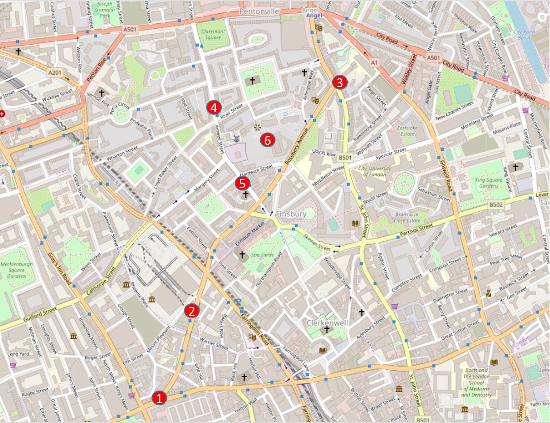
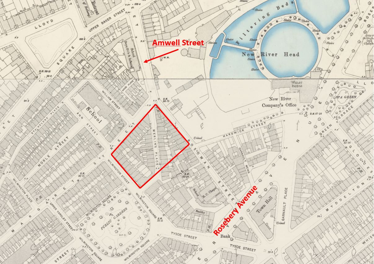
The following map shows some of the key locations in this week’s post (Map © OpenStreetMap contributors):

Rosebery Avenue

  • Location 1 is the starting point, at the junction of Rosebery Avenue and Clerkenwell Road
  • Location 2 is the site of a hairdressers photographed in 1985
  • Location 3 is a row of 18th century houses which in 1985 looked doomed to demolition, and also where Rosebery Avenue meets St John Street
  • Location 4 is a long open chemist in Amwell Street
  • Location 5 is an old engineering business also in Amwell Street
  • Location 6, for reference, is New River Head, the location of the post a couple of weeks ago.

Rosebery Avenue runs from points 1 to 3 on the map, and is one of those late Victorian streets, built to support the increasing volume of traffic across London, and to provide a wide through route where before only a maze of narrow streets existed.

Clearance of the route commenced in 1887, and the new street was opened in July 1892. The new street was named after Lord Rosebery, the first chairman of the London County Council. Lord Rosebery had resigned from the LCC a few days before the opening of Rosebery Avenue, so John Hutton, the vice chairman took on the task of formally opening the street.

Compared to many other 19th century London street openings, that of Rosebery Avenue seems to have been rather subdued. The Illustrated London News reported simply that:

“The new street from the Angel at Islington to the Holborn Townhall, Gray’s Inn Road, called Rosebery Avenue, was opened on Saturday, July 9, by the Deputy Chairman of the London County Council. It is 1173 yards long, straight and broad, with a subway under it for laying gas and water mains and electric wires. It has cost £353,000, but part of this expenditure will be recovered by the sale of land”.

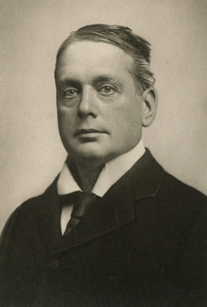
As well as being the first chairman of the LCC, Lord Rosebery was a prominent politician of the late 19th century and was a Liberal Party Prime Minister between March 1894 and June 1895 after William Gladstone had retired. In 1895 Rosebery’s government lost a vote of confidence and the resulting general election returned a Unionist Government. He continued to lead the Liberal Party for a year, then permanently retired from politics.

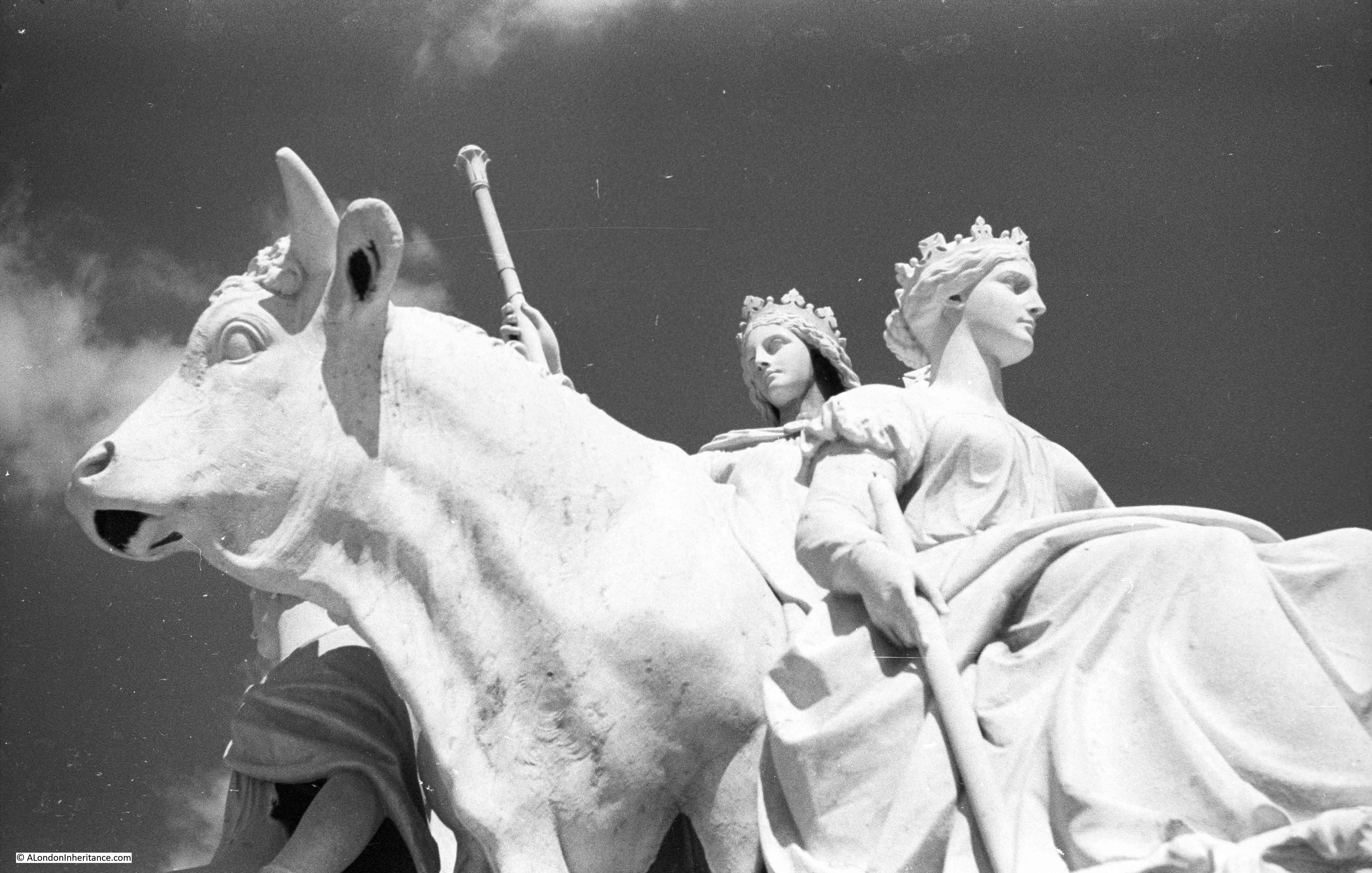
Lord Rosebery after whom Rosebery Avenue is named:

Rosebery Avenue

The following map extract is from “Reynolds’s Splendid New Map of London; Showing The Grand Improvements for 1847”, and shows the area before the construction of Rosebery Avenue.

Location 1 is the same as in the above map, where the future Rosebery Avenue would meet Clerkenwell Road. Point 3 is where the new street will meet St John Street and point 6 is New River Head, with the ponds as they were in 1847.

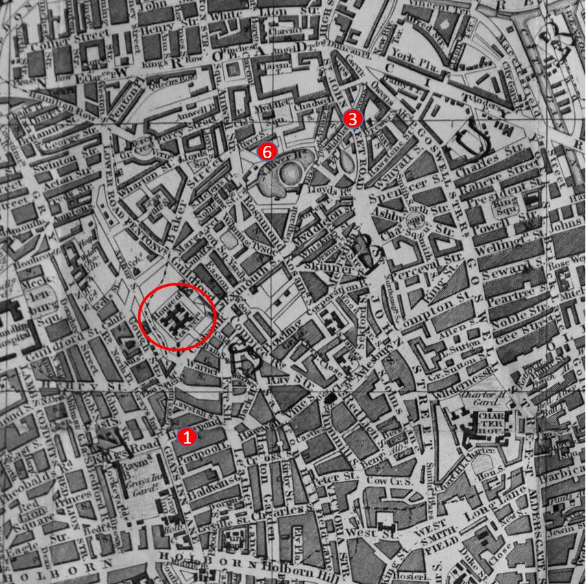
The red oval is around a House of Correction. This was Coldbath Fields Prison, where the Mount Pleasant Post Office buildings would later be constructed. The south-east corner of these buildings are close to Rosebery Avenue.

Rosebery Avenue cut across the Fleet valley, cut through numerous streets, and cut short many streets including Exmouth Street which originally ran up to the site of the prison.

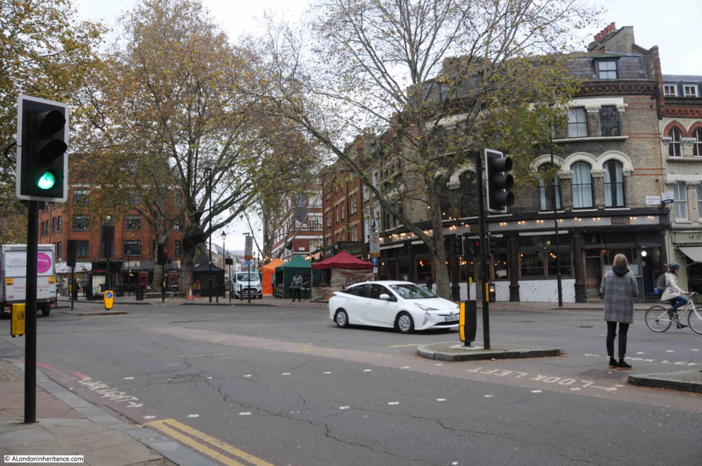
The following photo is at location 1, looking from Clerkenwell Road, across to the start of Rosebery Avenue:

Rosebery Avenue

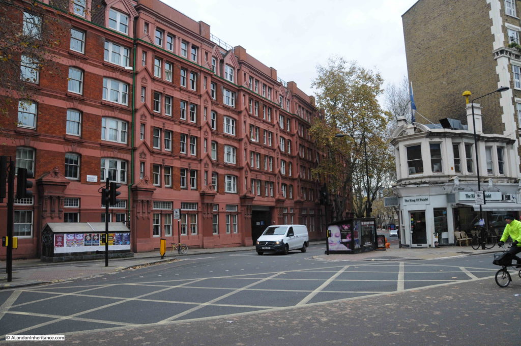
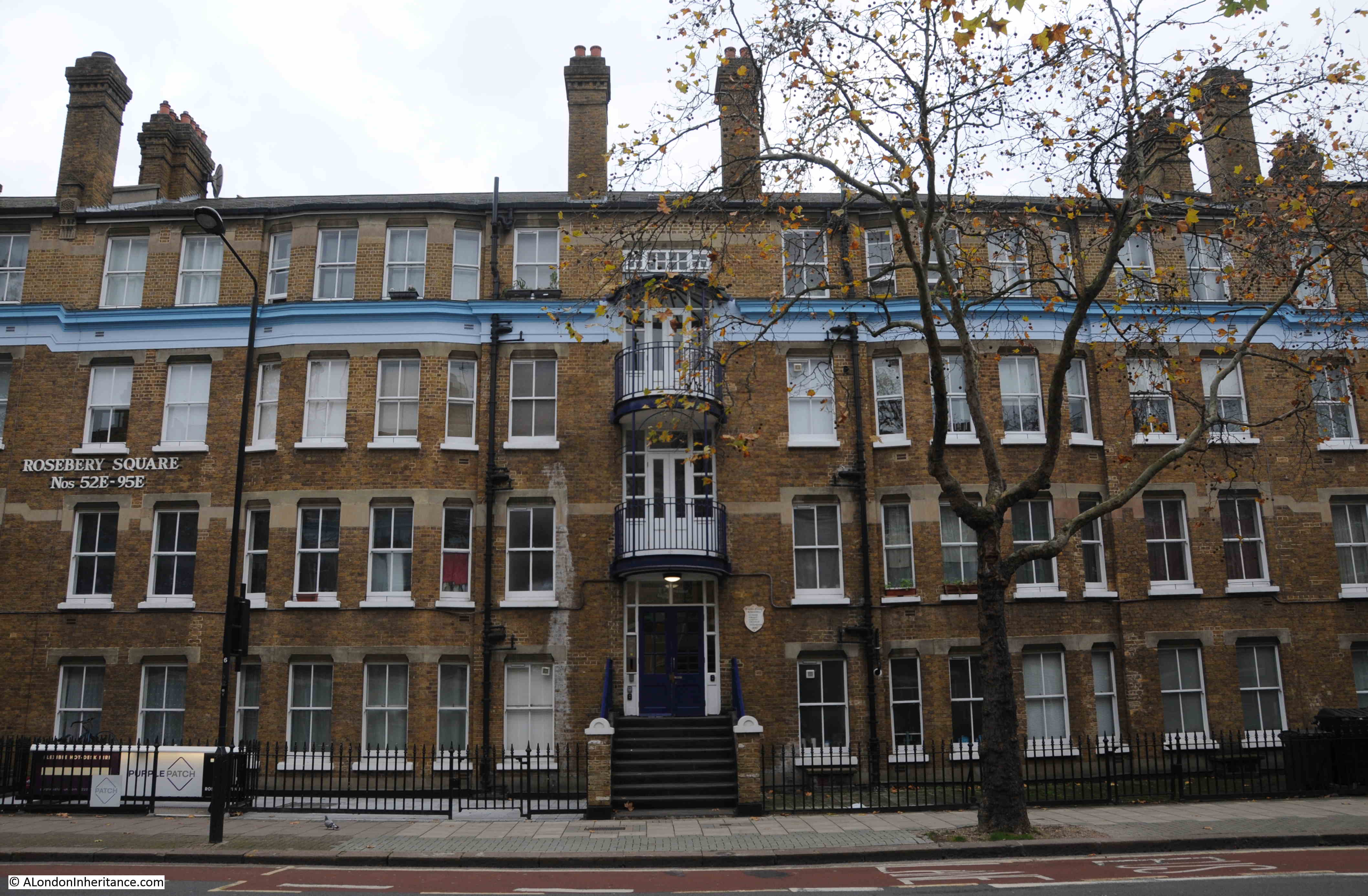
Construction of Rosebery Avenue would displace a large number of people, as housing would be demolished to make way for the new street. The LCC mandated the construction of new housing to the south of the street before work commenced on the northern sections.

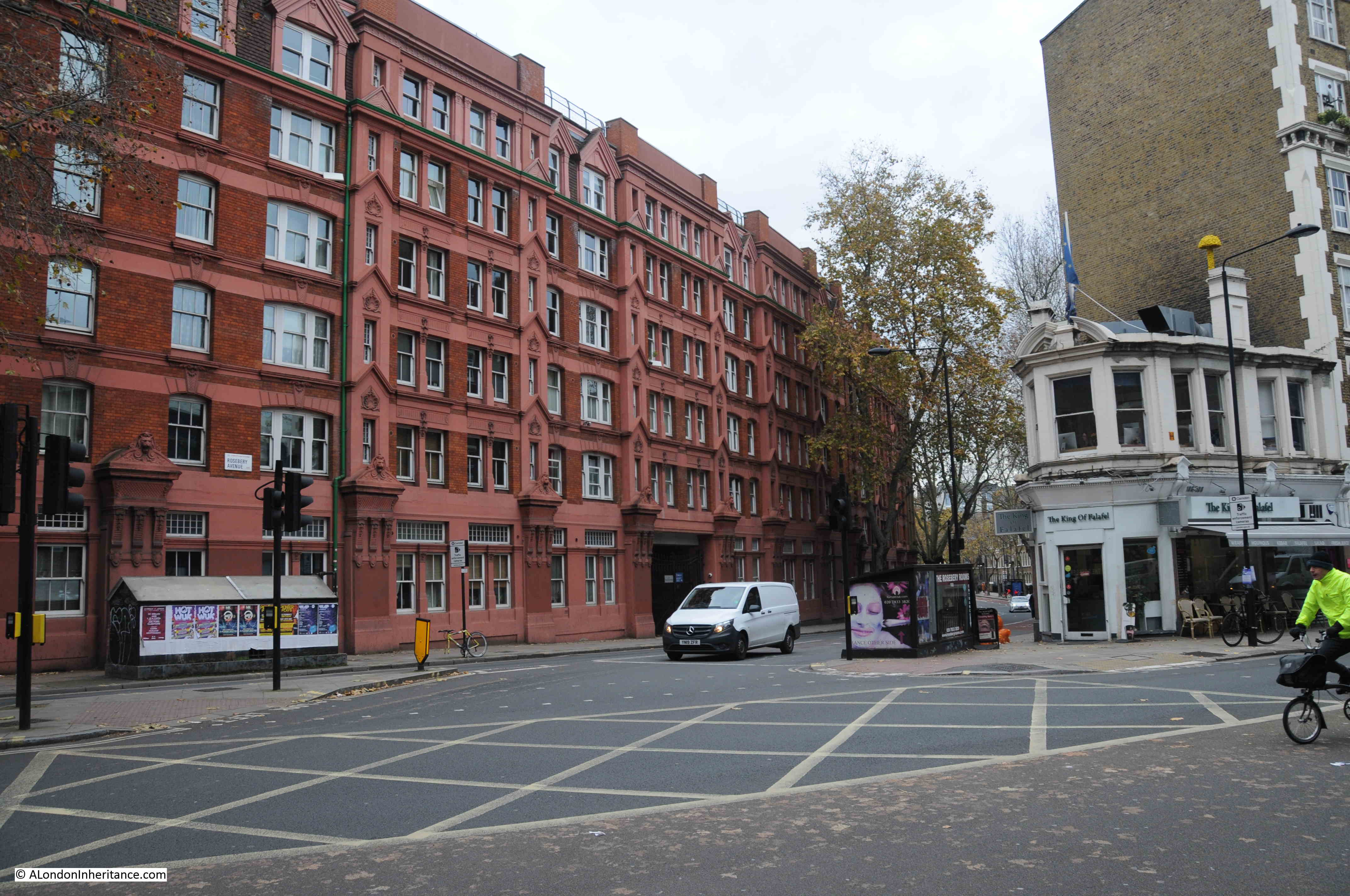
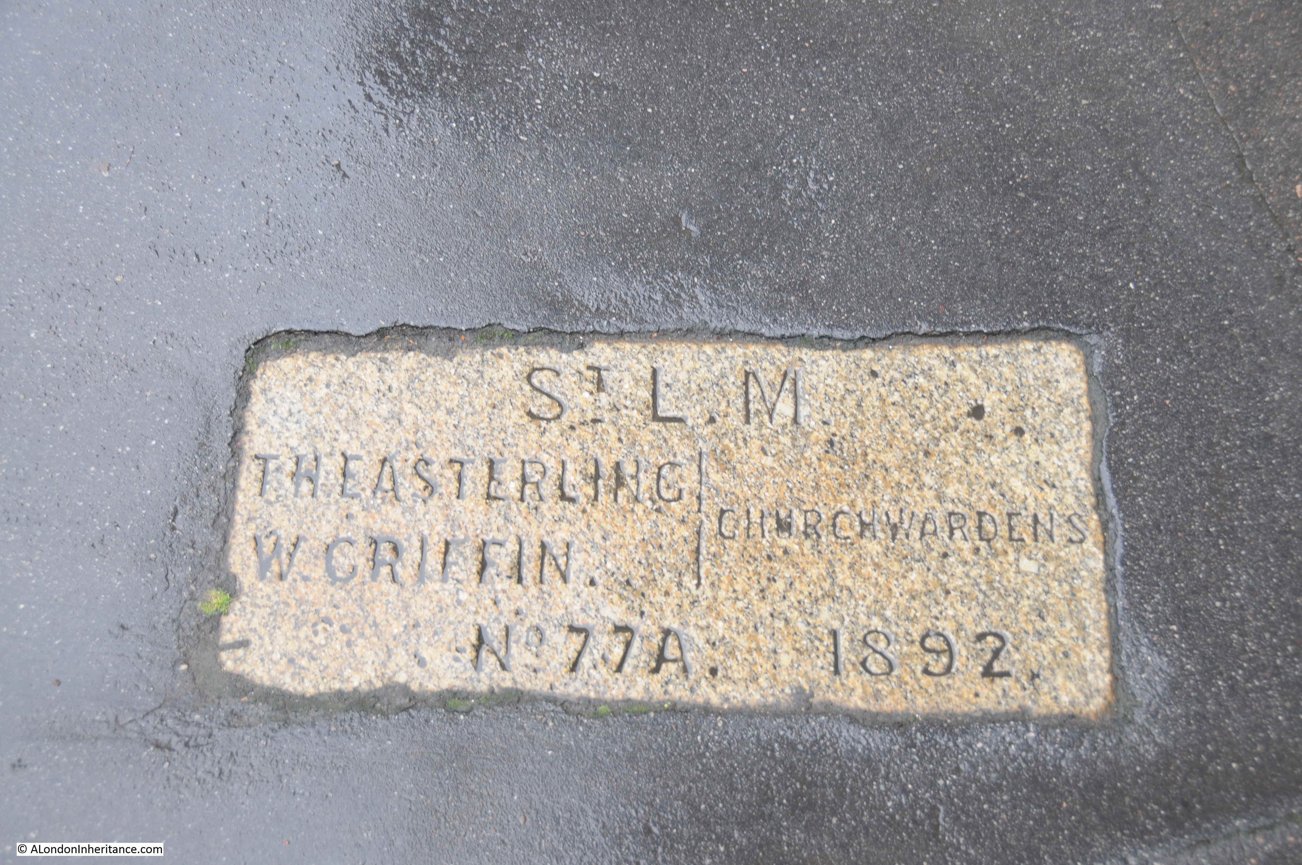
A short distance along Rosebery Avenue we can see the evidence of the LCC’s requirement with two identical blocks of flats lining the street – Rosebery Square, east and west. The following photo shows Rosebery Square east.

Rosebery Avenue

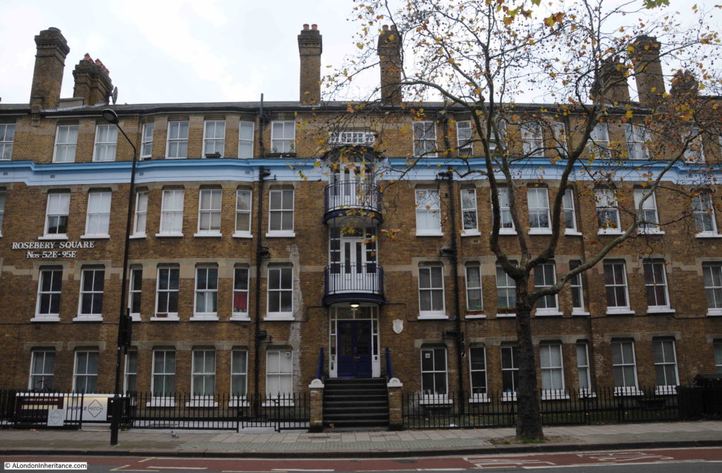
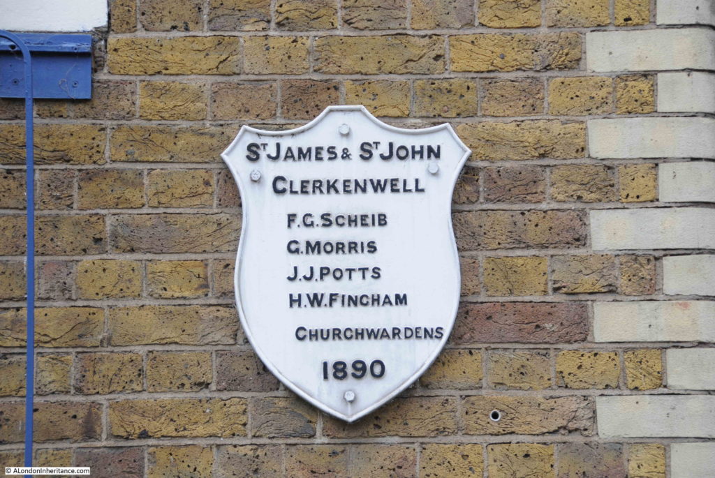
The new buildings were completed and ready to house those displaced by the new street in July 1891. A plaque on the wall records the names of the parish church wardens at the time of construction:

Rosebery Avenue

Parts of the southern section of Rosebery Avenue, between Laystall Street and Coldbath Square, are higher than the surrounding land. (See this post on Laystall Street) This allows extra lower floors to be part of buildings such as Rosebery Square, and also requires a viaduct as shown in the photo below where the street crosses Warner Street.

Rosebery Avenue

The photo above also shows how the buildings facing onto Rosebery Avenue drop down below the level of the street, and are therefore much larger than they appear.

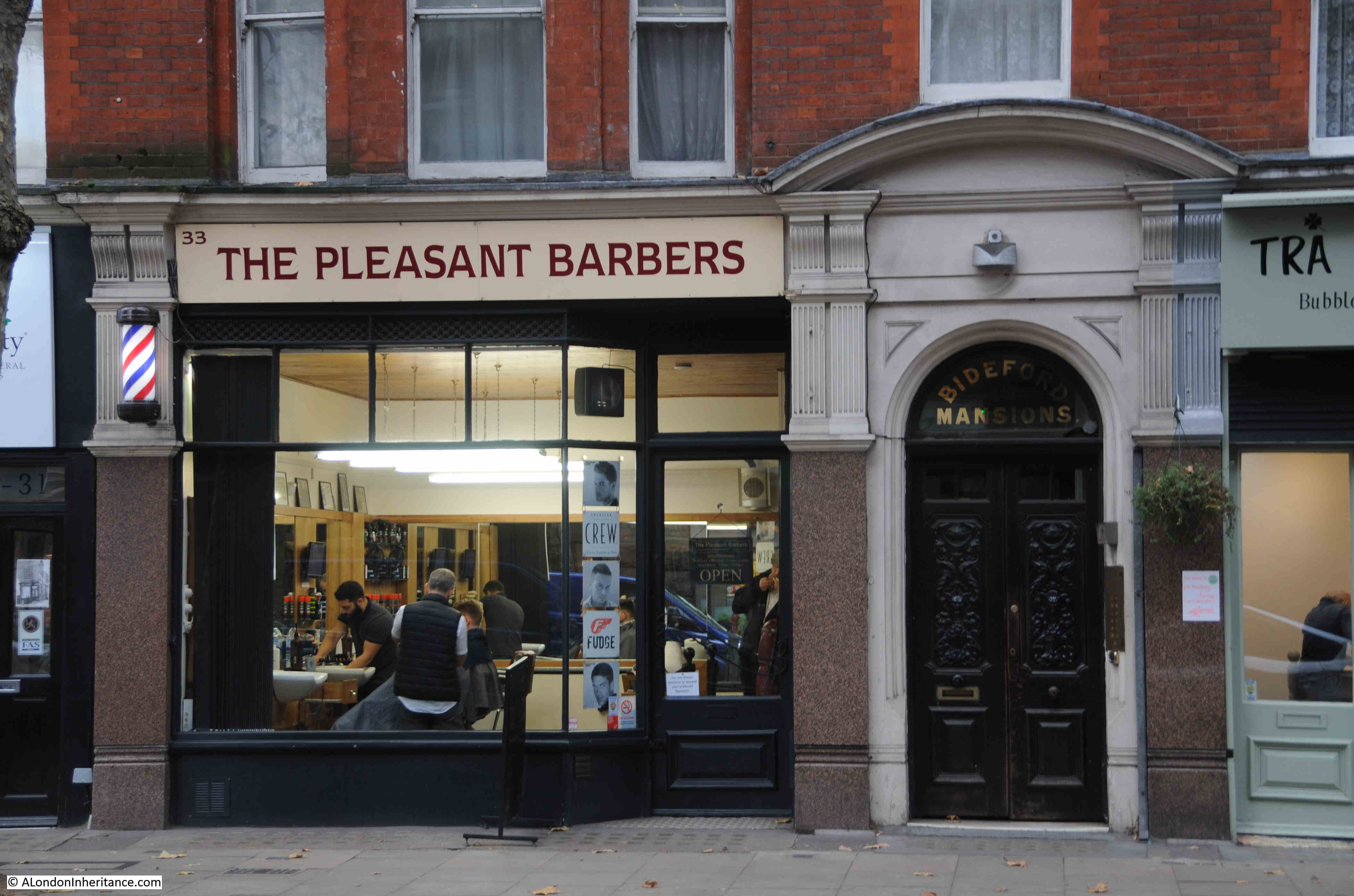
A short distance further along, just before the junction with Mount Pleasant and Coldbath Square is the first of the locations photographed in 1985. In 2019, this is the Pleasant Barbers:

Rosebery Avenue

Who twenty-four years ago, were The Pleasant Gent’s Hairdresser, but at the same location:

Rosebery Avenue

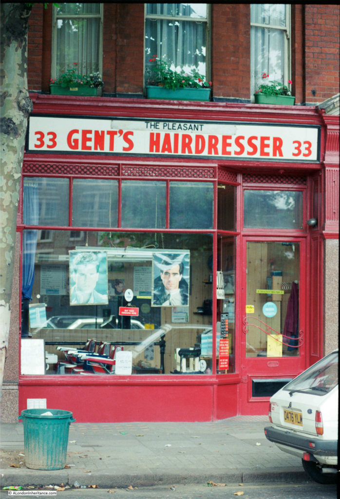
It is interesting how the name of a trade changes over time. In the 1980s, to get your hair cut (for a man) you went to a Hairdresser. Today, you go to a Barber.

Hairdressers / Barbers are a type of shop we have been photographing for the past 40 years. They are usually local businesses, not part of a chain and have individual character. One of the few types of business that is not under threat from the Internet.

A few years ago I wrote a post about Hairdressers of 1980s London, featuring a selection from 1985 and 1986. Many have since disappeared, but there are still plenty to be found across London.

After the building with Pleasant Barbers, we find the south-east corner of the Royal Mail sorting office at Mount Pleasant.

Rosebery Avenue

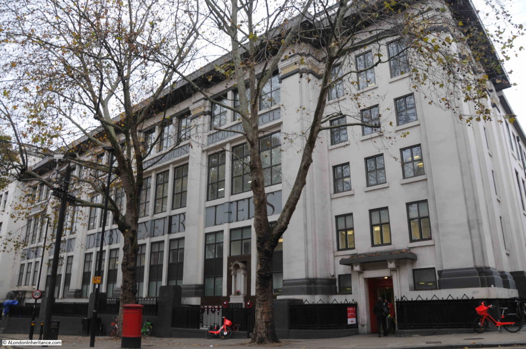
The area occupied by the Mount Pleasant sorting office was the site of the House of Correction shown in the 1847 map – a location that deserves a dedicated article.

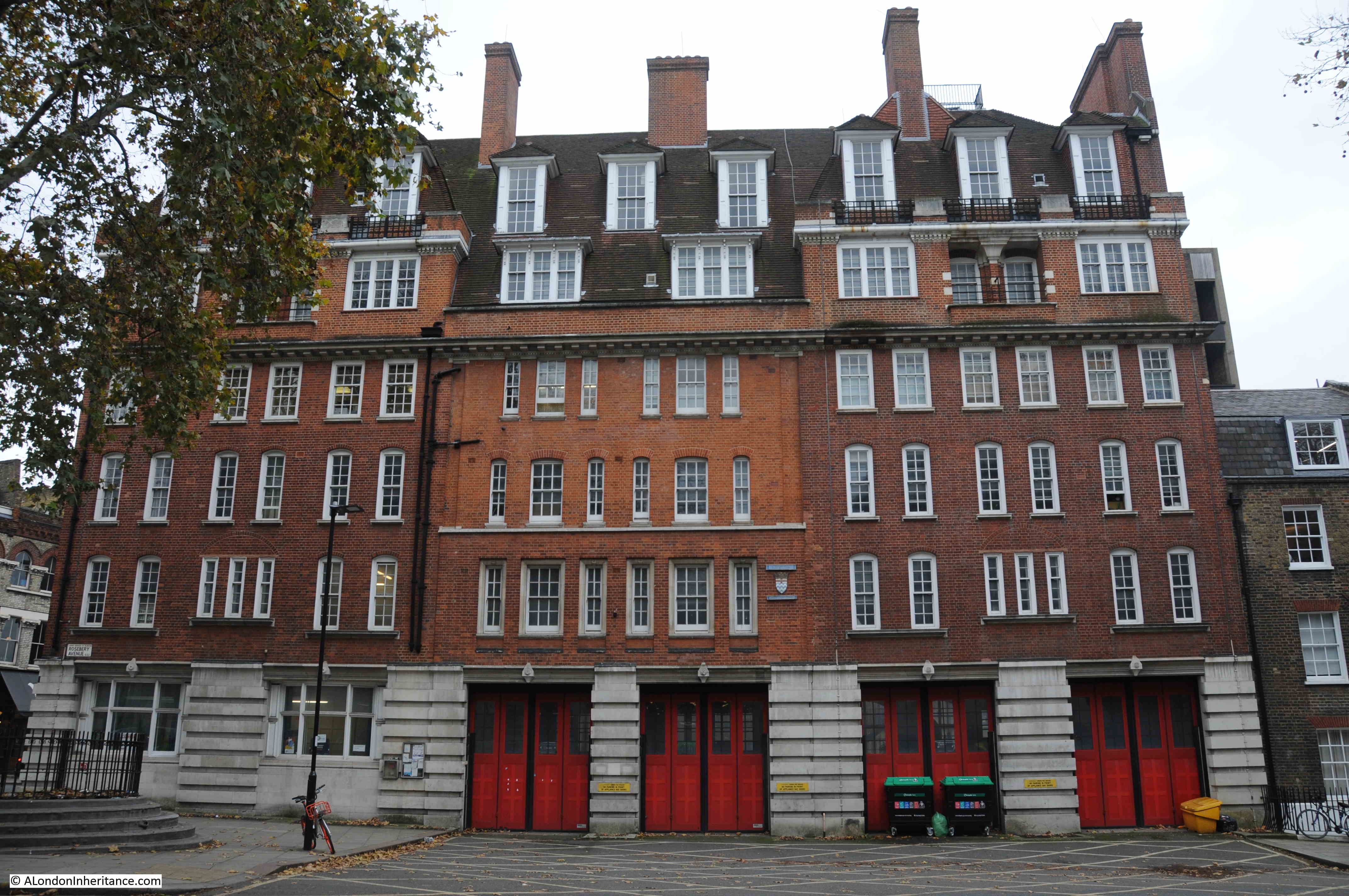
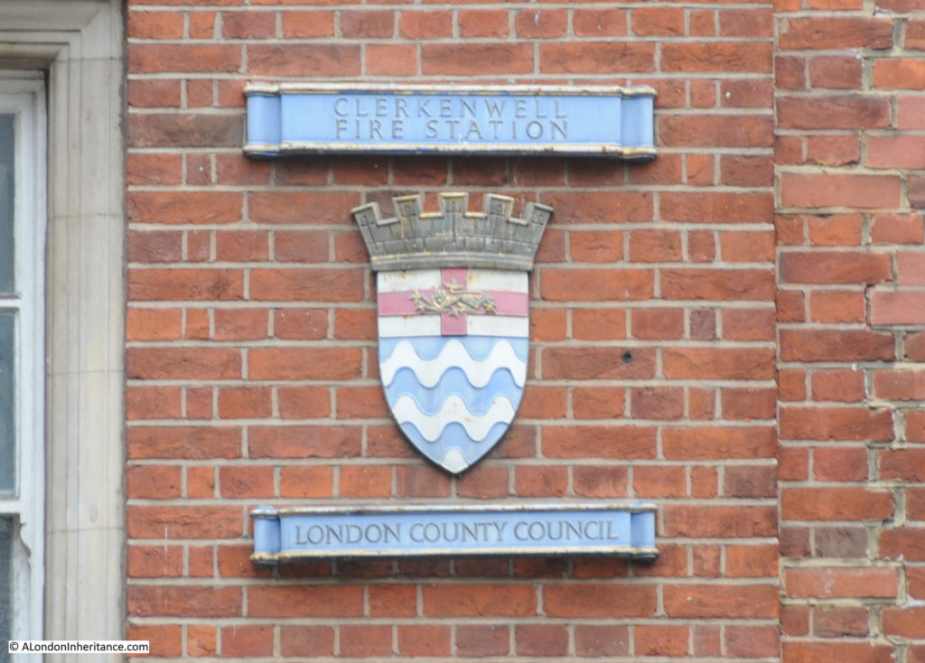
On the opposite side of Rosebery Avenue is the Grade II listed, former Clerkenwell Fire Station.

Rosebery Avenue

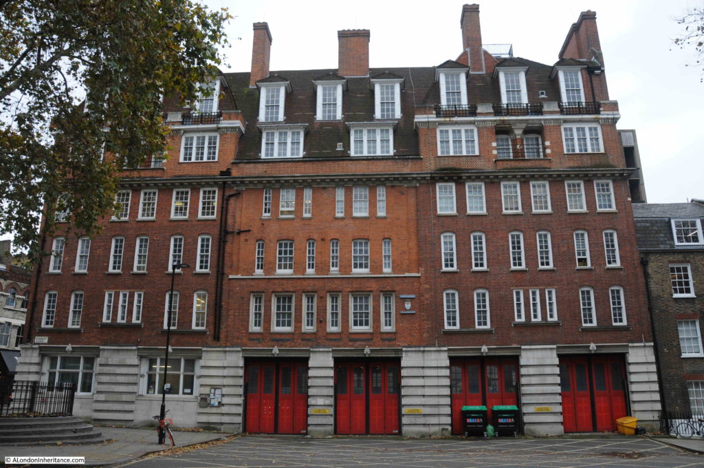
A fire station had existed on the site before the construction of the building we see from Rosebery Avenue. The site increased in importance over the years, becoming the Superintendent’s Station for the Central District by 1890.

The original fire station was extended over the years, and the section facing onto Rosebery Avenue was constructed between 1912 and 1917, and included parts of the original fire station buildings and the 1896 extensions to the building.

The architectural quality of the building draws from the London County Council’s development of London housing, as architects from the LCC housing department also had responsibility for fire station design from the start of the 20th century.

Clerkenwell Fire Station closed in 2014 – one of the ten London Fire Stations closed in the same year due to budget cuts when Boris Johnson was Mayor.

A reminder of the London County Council origins of Clerkenwell Fire Station:

Rosebery Avenue

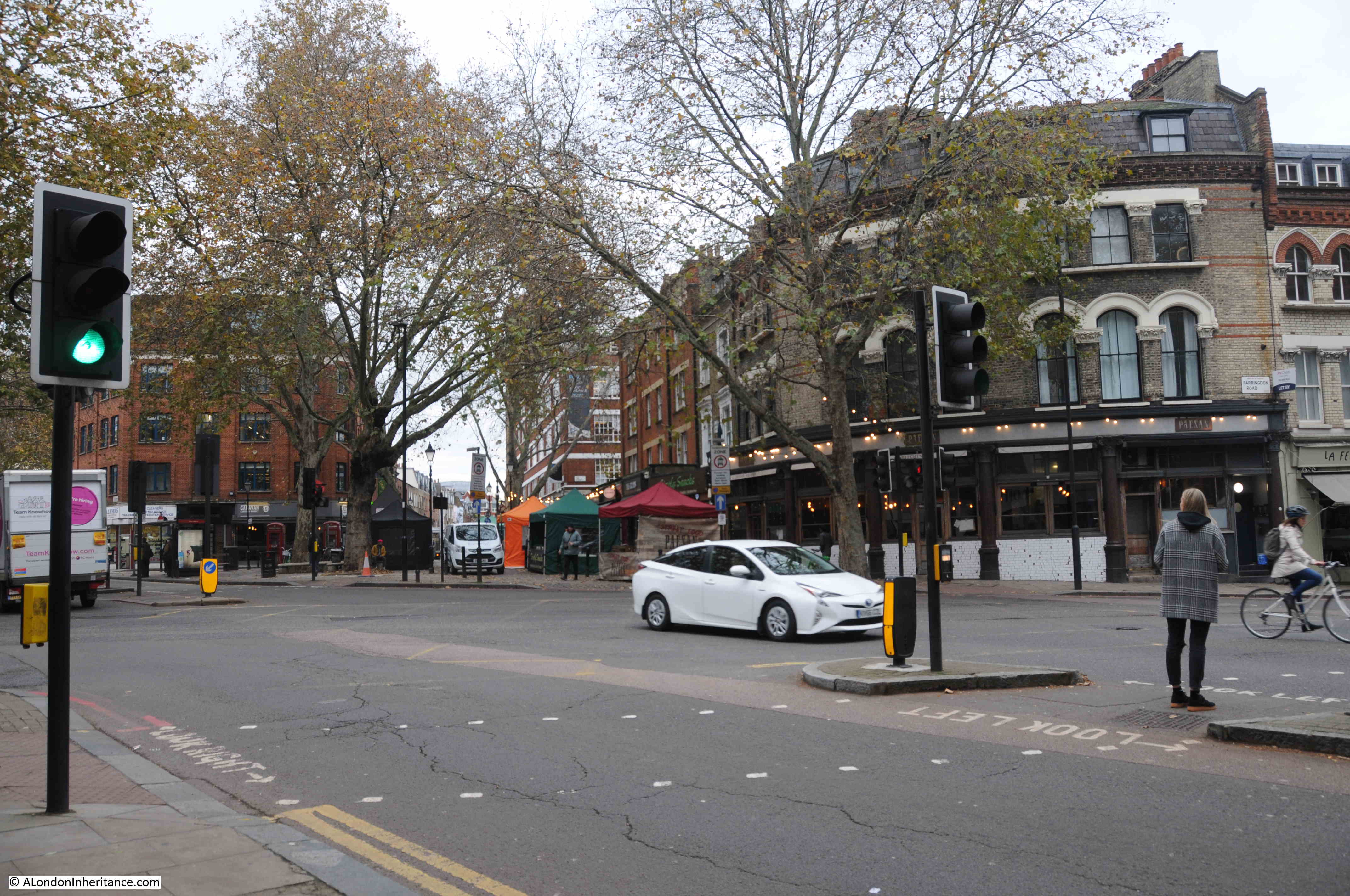
The fire station stands at the south-eastern corner of the junction of Rosebery Avenue and Farringdon Road. This is where Exmouth Street was shortened slightly. In the photo below, I am looking across the junction to Exmouth Street.

Rosebery Avenue

If you look at the 1847 map, Exmouth Street was originally on a main route between Goswell Road and Gray’s Inn Road, along with Myddelton Street (a New River reference).

The construction of Rosebery Avenue faced a number of legal challenges and one of these was from the Marquis of Northampton who was after £22,000 of compensation due to the impact on his properties around Exmouth Street and that “the remainder of the estate would be seriously depreciated by the diversion of traffic from Exmouth Street to the new thoroughfare, thus converting that street into a back street”.

Exmouth Street today is a back street as far as traffic is concerned, but now is the location of the Exmouth Street market.

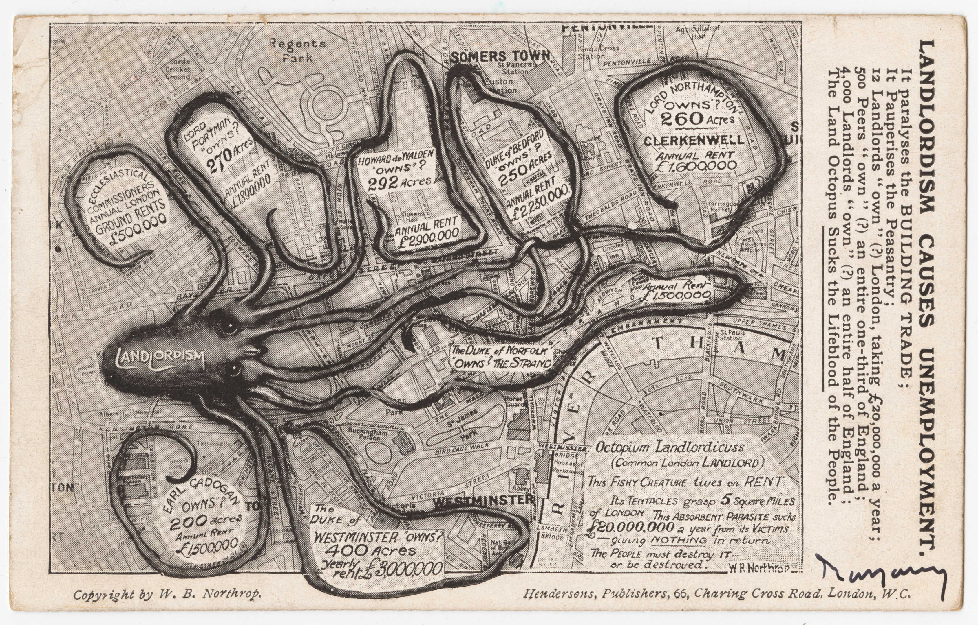
The Marquis of Northampton, or Lord Northampton and his landholdings in Clerkenwell featured in a map created in 1909 by William Bellinger Northrop and titled “Landlordism Causes Unemployment”.

Rosebery Avenue

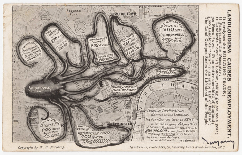
Map from Cornell University – PJ Mode Collection of Persuasive Cartography and reproduced under Creative Commons Attribution-NonCommercial-ShareAlike 3.0 (CC BY-NC-SA 3.0) Unported License

The aim of Northrop’s map was to show how “Landlordism” was strangling London, with large areas of the city being owned by the rich and powerful. Northrop claimed that Lord Northampton owned 260 acres in Clerkenwell and that this estate produced an annual rent of £1,600,000.

Continuing along Rosebery Avenue and the gradual increase in height is more apparent now, showing again why New River Head was located at close to the end of Rosebery Avenue as the drop to the city aided the flow of water from reservoir to consumer.

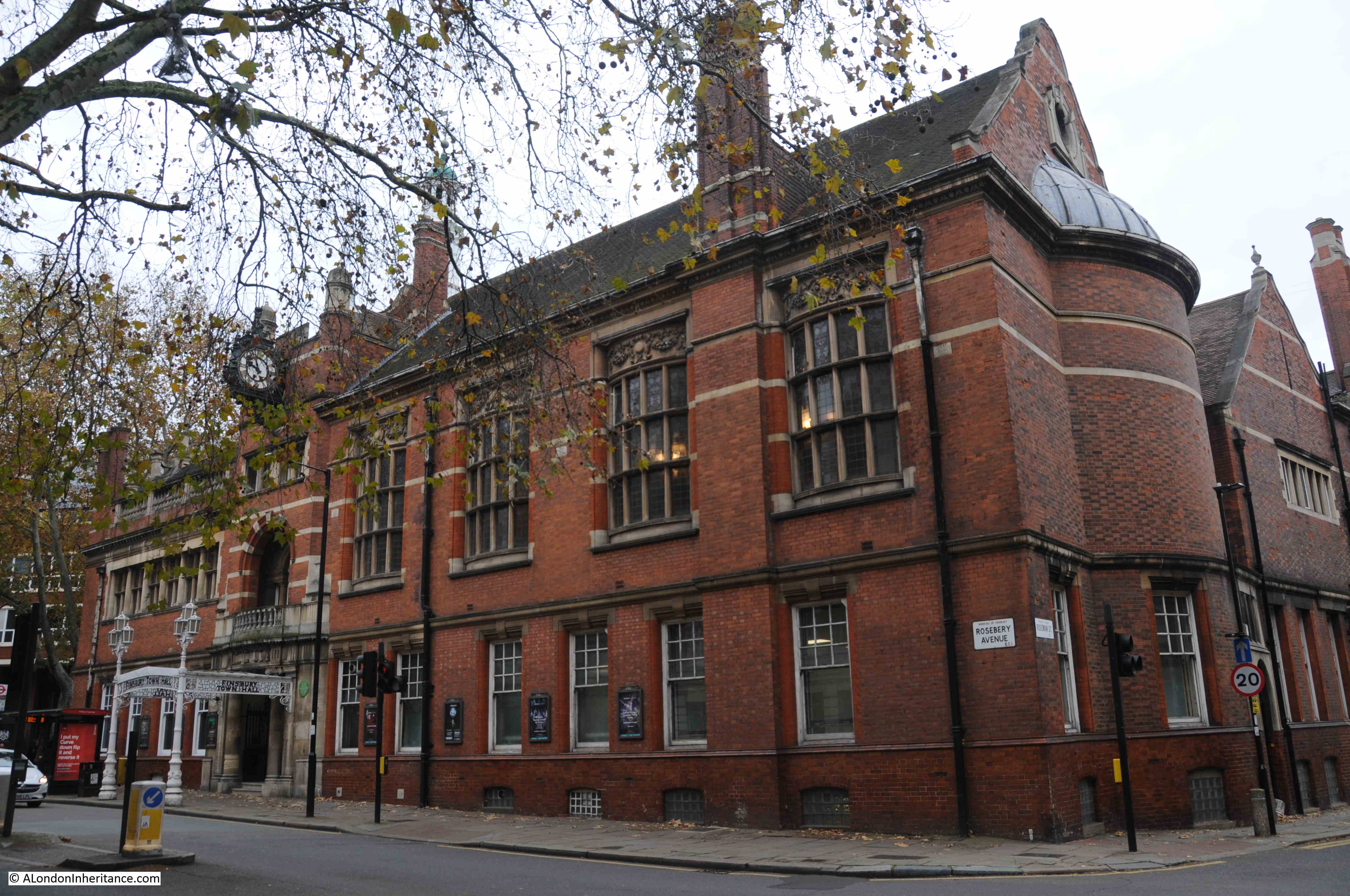
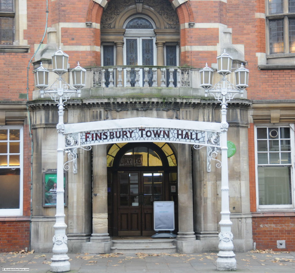
There are plenty of interesting buildings along the street, and a mix of architectural styles, one rather ornate building is the old Finsbury Town Hall:

Rosebery Avenue

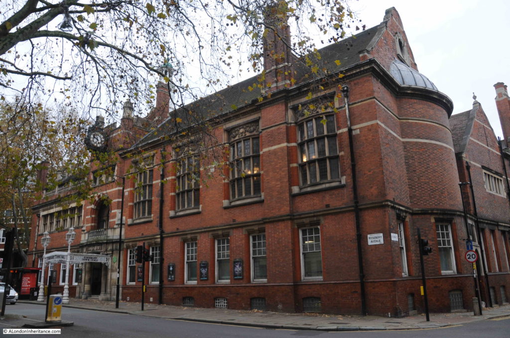
Finsbury Town Hall was built between 1894 and 1895 on land cleared following the construction of Rosebery Avenue. The original vestry building was in a southern corner of the same plot, however a much larger triangular plot of land had been reduced to a much smaller triangular plot as Rosebery Avenue cut through Rosamond Street (now Rosoman Street).

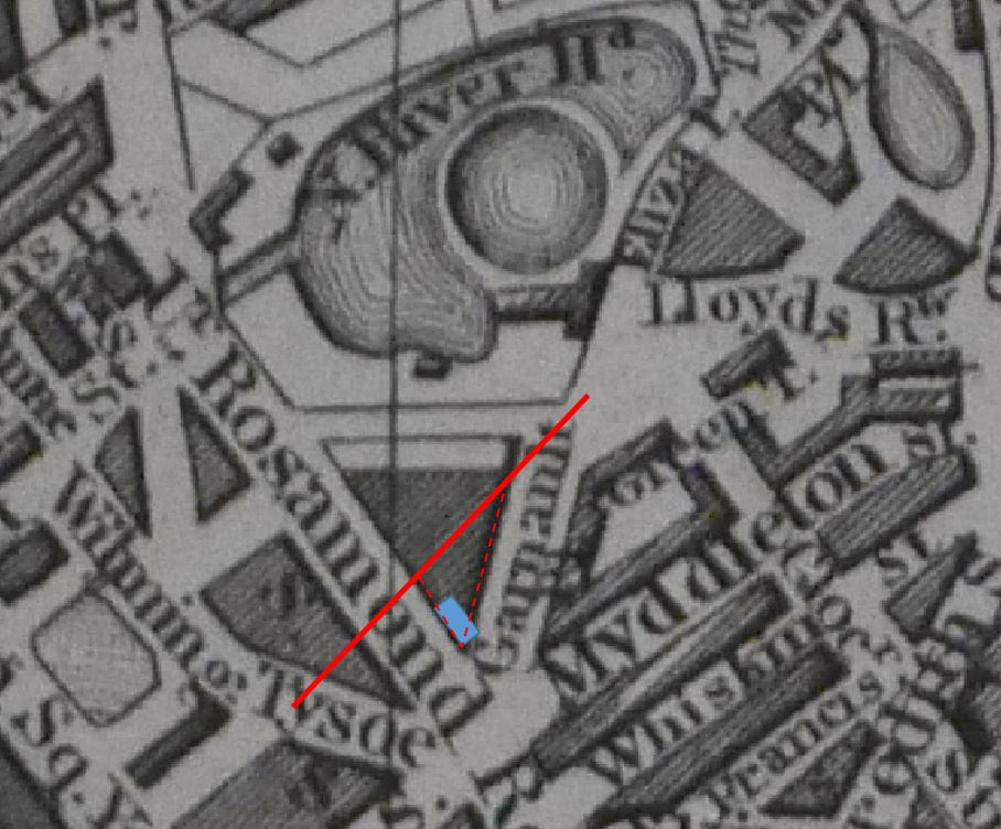
In the following extract from the 1847 map, the red line is the rough alignment of how Rosebery Avenue would cut through the area. The blue rectangle is the original vestry building, and the red dashed lines show the location of the Finsbury Town Hall which now faces onto Rosebery Avenue.

Rosebery Avenue

Soon after completion, in 1900, the building became the town hall of the new Metropolitan Borough of Finsbury.

As well as conducting council business for the borough, the town hall also had two large rooms available for council functions and public hire.

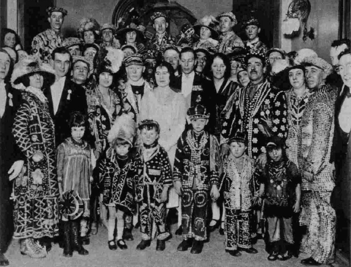
Typical of the events held in the town hall was a Carnival Ball of Costermongers belonging to the National Association of Street Traders held at Finsbury Town Hall on the 30th January 1928:

Rosebery Avenue

Local government changes meant that in 1965 the Metropolitan Borough of Finsbury was integrated with the London Borough of Islington, and the majority of council functions moved to Islington Town Hall, with only a small number of council operations remaining in the old Finsbury building.

The building entered a gradual state of decay, and by the end of the 1980s, council functions had to be moved out of the building.

Finsbury Town Hall almost fell to the “luxury flat” fate of so many other buildings across the city, however in 2005 the dance school, the Urdang Academy commenced the redevelopment of the building, moving in, in 2006.

The building continues to be the home of the Urdang Academy, with some of the large halls still available for hire.

The ornate entrance to the old Finsbury Town Hall from Rosebery Avenue:

Rosebery Avenue

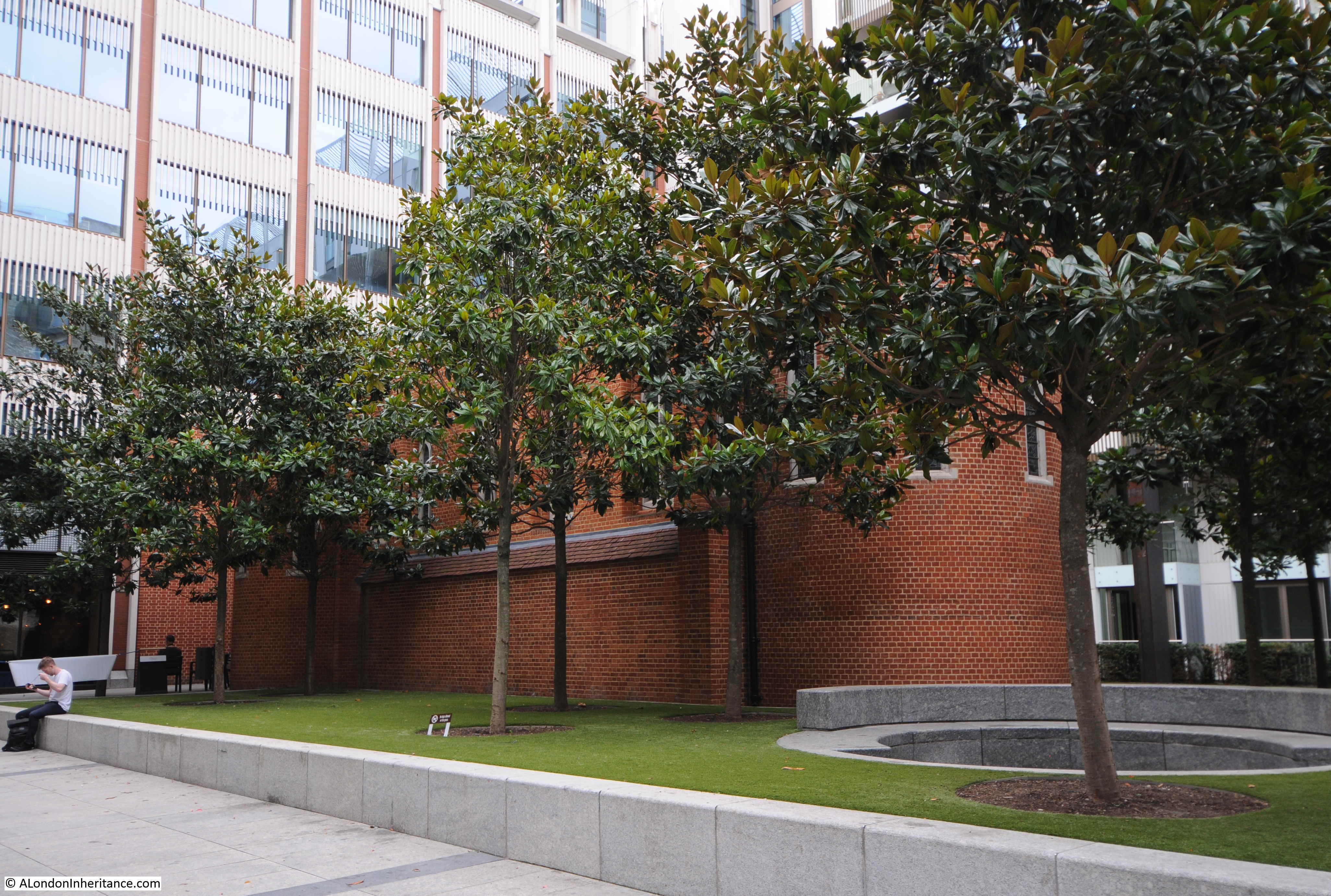
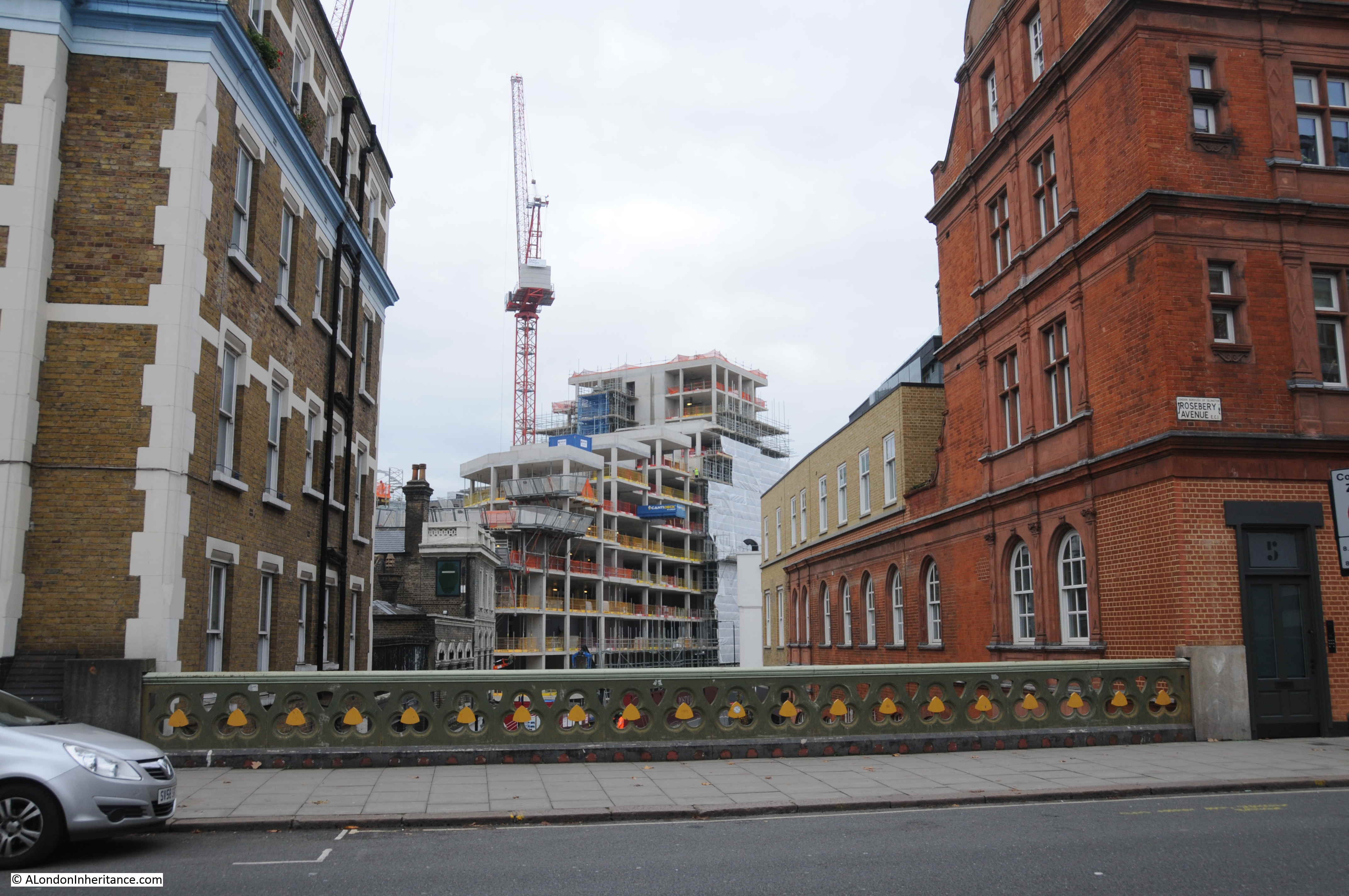
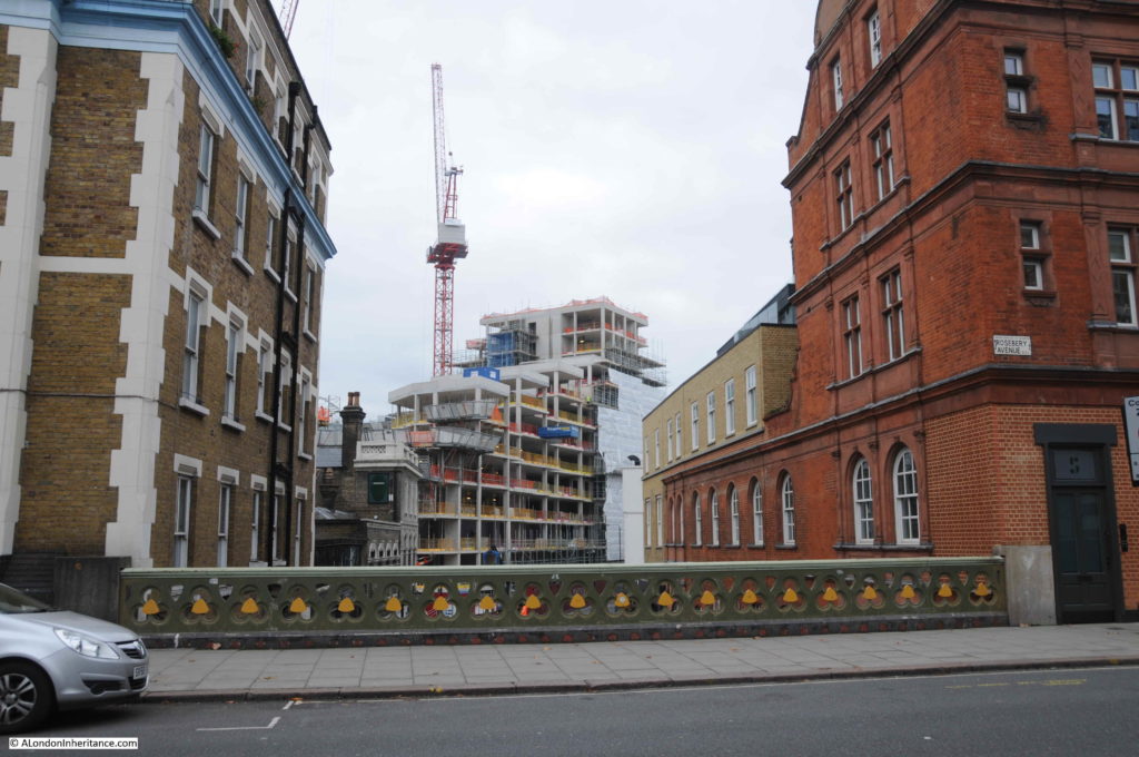
Leaving Finsbury Town Hall, we reach New River Head, which I explored a couple of weeks ago, and then Sadler’s Wells, which demands a dedicated post, so I will continue to the end of Rosebery Avenue, and to the junction with St John Street, where the next location of my 1985 photos is to be found.

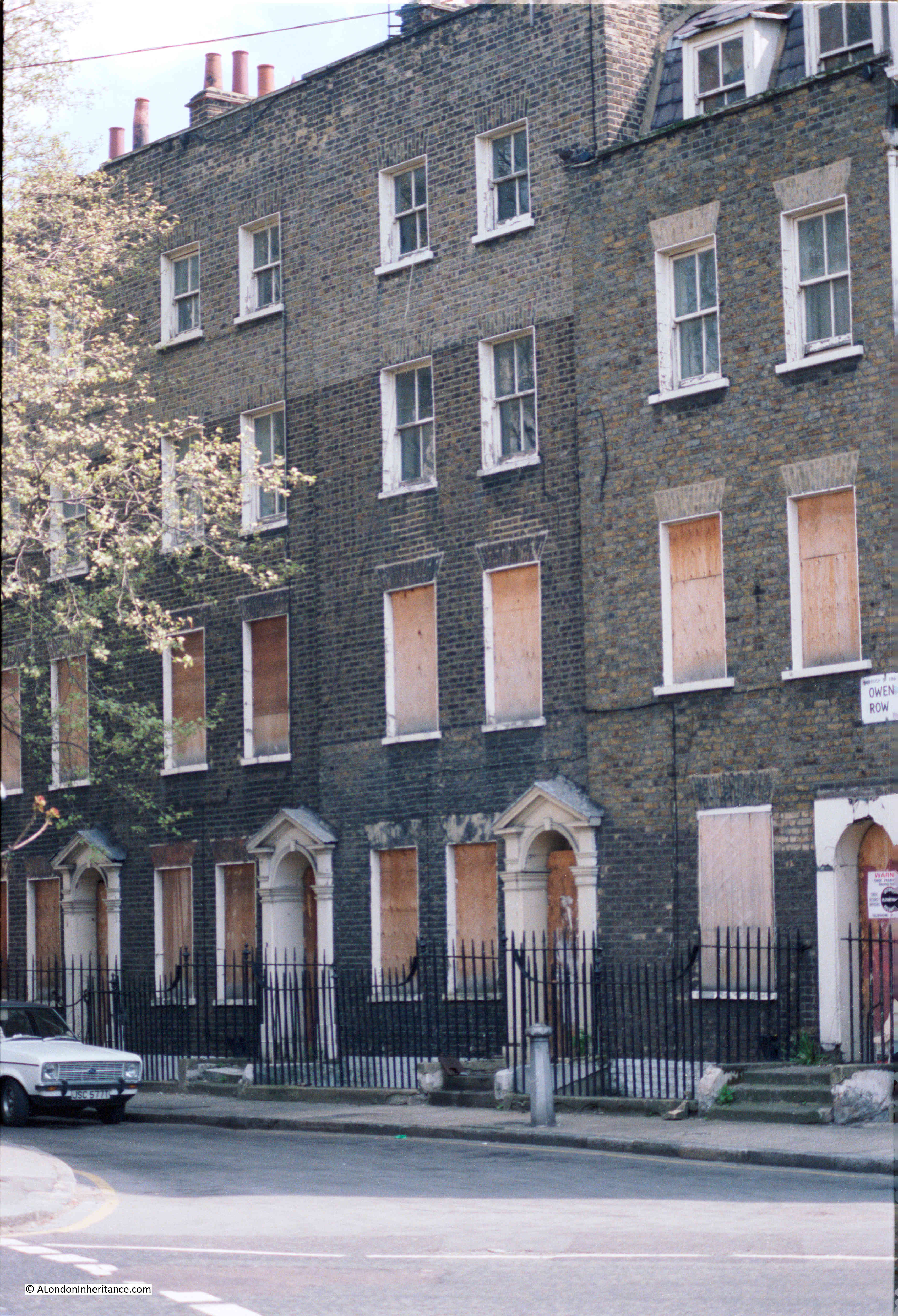
Across St John Street, and just to the south of the junction with Rosebery Avenue is a short stub of street by the name of Owen’s Row, with a terrace of late 18th century houses. In 1985 these were boarded up, and appeared to be at risk:

Rosebery Avenue

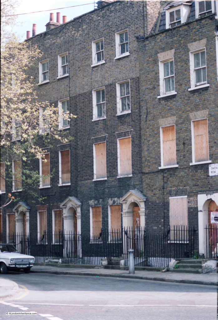
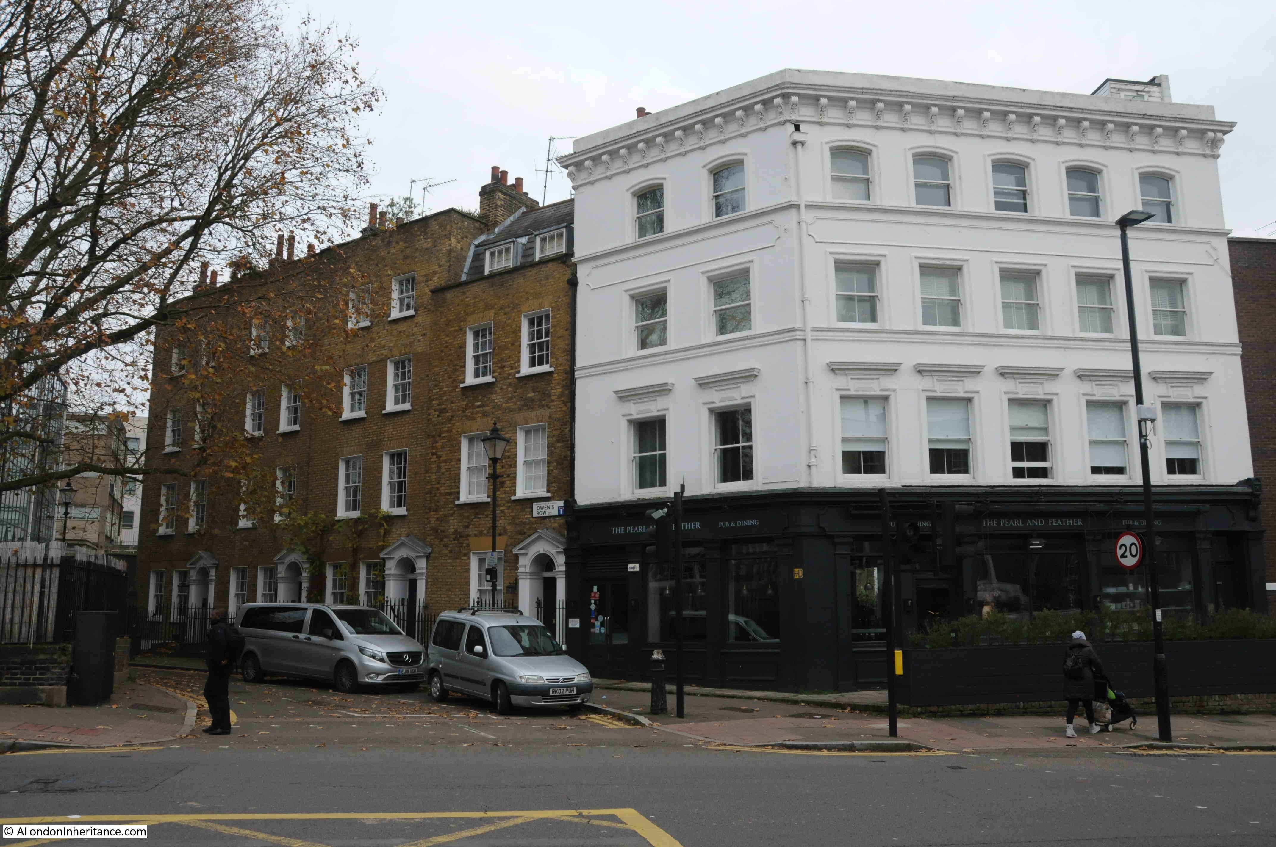
Thankfully in 2019, they are still here and looking in good condition. A wider view in the photo below to the 1985 photo, showing Owen’s Row with the terrace, and the former Empress of Russia pub on the corner with St John Street.

Rosebery Avenue

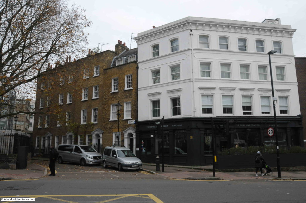
The Empress of Russia pub dates to the early 19th century. The pub closed in 2000, went through a series of food related businesses, before returning to a pub in the form of the Pearl and Feather.

From 1985 the Empress of Russia was the regular London performance venue of the Ukelele Orchestra of Great Britain, where it was usual to hear the music of the Rolling Stones and the Velvet Underground played on the Ukelele.

The alignment of Owen’s Row is down to the New River.

Building of a row of houses along the eastern bank of the New River commenced in 1773 by Thomas Rawstorne, who started building from the St John Street junction. When built, the houses faced onto the New River.

Look in the centre of the following extract from the 1847 map. Just above the S in the word Street of St John Street, is the word Owens, and to the left of this is the channel of the New River, flowing to the bottom of the map towards New River Head. In 1847 this section of the New River was still uncovered.

Rosebery Avenue

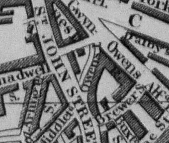
Owen’s Row would not become a street until 1862 when this section of the New River was enclosed and covered.

Today, the terrace consists of just four houses, but following the start of the street in 1773, houses extended further along the eastern edge of the New River. The following photo from 1946 shows the extended terrace, with a row of three floor buildings after those with four floors. These were later demolished, and the end of the original Owen’s Row is now occupied by the Sixth Form College of the City and Islington College.

Rosebery Avenue

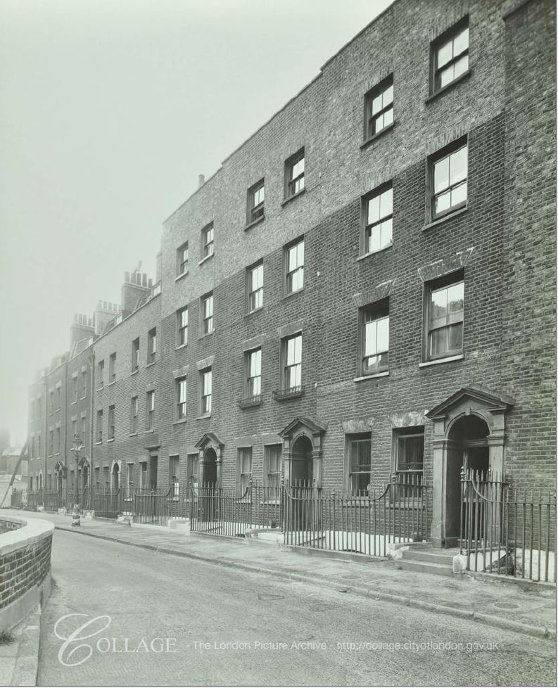
Image credit: London Metropolitan Archives, City of London: catalogue ref: SC_PHL_01_087_F3305

What is interesting in the above photos, is that in all photos of the remaining terrace, the bricks of the fourth floor are a very different shade to those on the lower three floors. It is more clearly visible in the 1946 photo, and would indicate that the terrace was originally built with three floors, with a later addition of a fourth floor.

Really good to see that part of the terrace remains, and that although boarded up in 1985, they were not demolished. Owen’s Row is also a physical reminder of the route of the new river, and when this terrace of houses looked out onto water flowing through the channel to New River Head.

Although I still had two 1985 photos to track down, I find wandering the streets fascinating, and in the streets around St John Street there are so many interesting places.

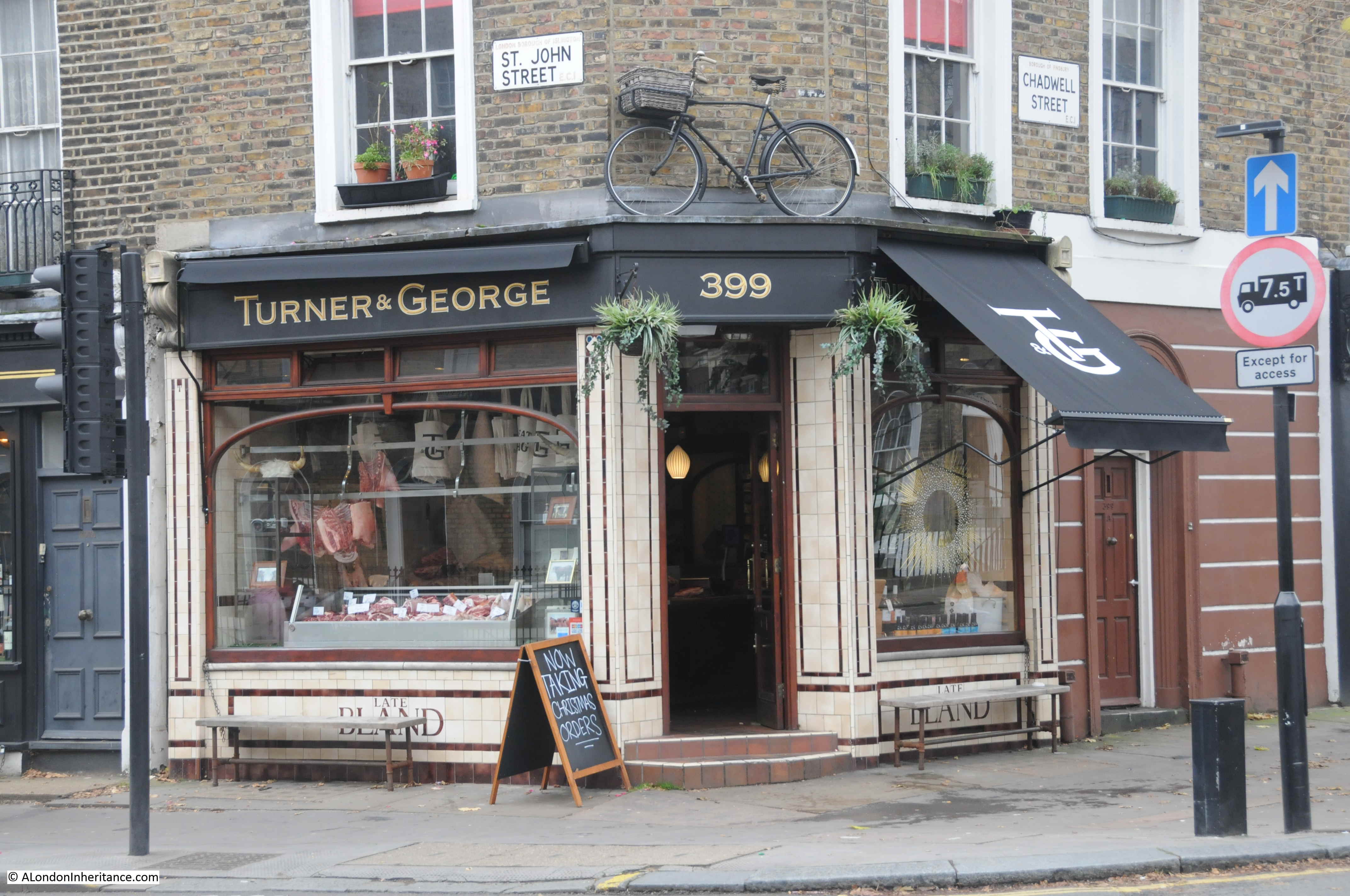
On the corner of St John Street and Chadwell Street are Turner & George, butchers.

Rosebery Avenue

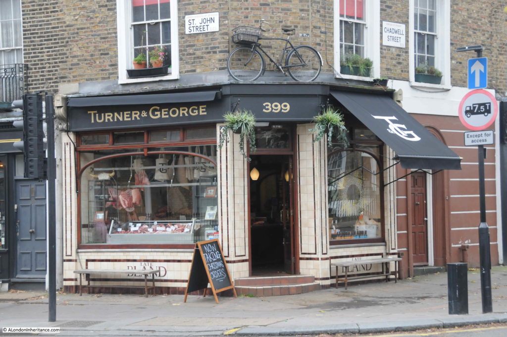
The Turner & George business is new, only opening in the last few years, however the shop has long been a butchers.

In the tiling below the windows is the word BLAND. This refers to the Bland family who ran a butchers in St John Street from 19th century.

In 1882, there was a Mrs Sarah Bland recorded as Butcher of 563 St John Street-road, Clerkenwell, The present building is at number 399 St John Street, so Sarah Bland’s butchers may have been at a different location, or more likely, at the current corner location, which has changed number, as streets were frequently renumbered as streets changed over the years.

On the corner of Arlington Way and Chadwell Street is the business of Thomas B. Treacy – Funeral Directors.

Rosebery Avenue

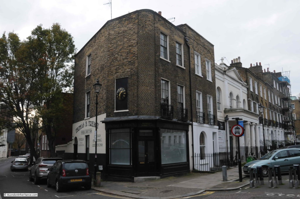
I have not been able to find any evidence, however I suspect the building may have originally been a pub. The corner location, and the round corner for the building are typical of 19th century pubs.

One pub that does survive is The Harlequin in Arlington Way.

Rosebery Avenue

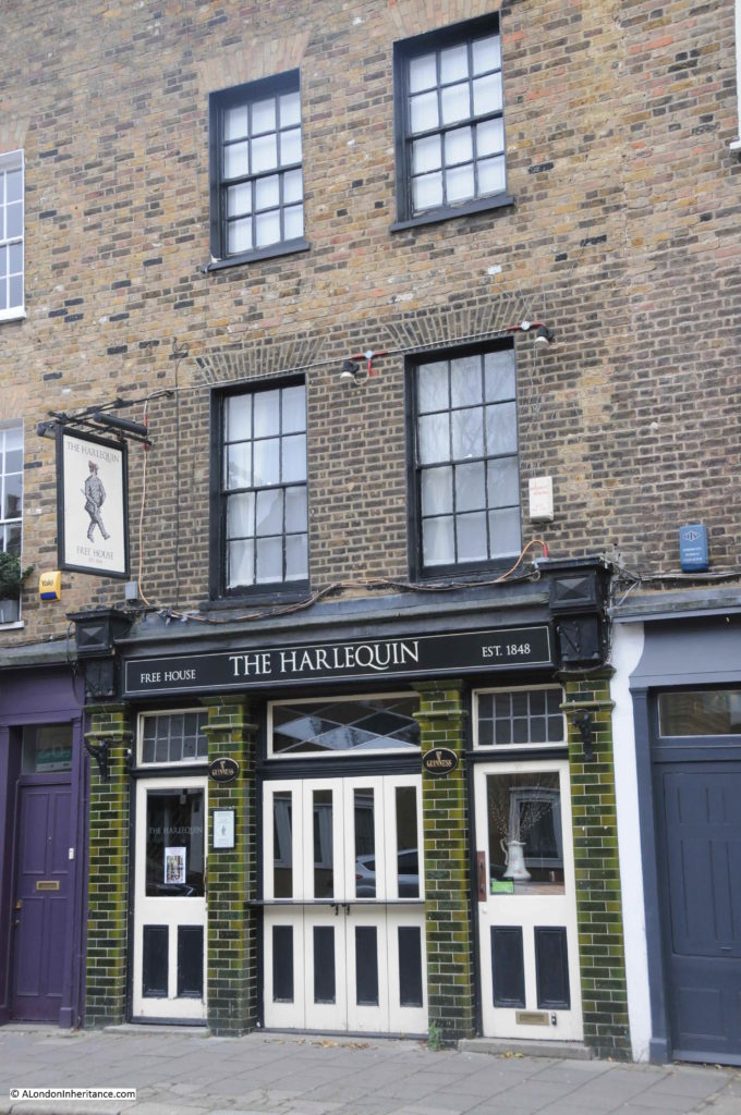
The Harlequin was first recorded as a beer house around 1848, with the current name being in use by 1894.

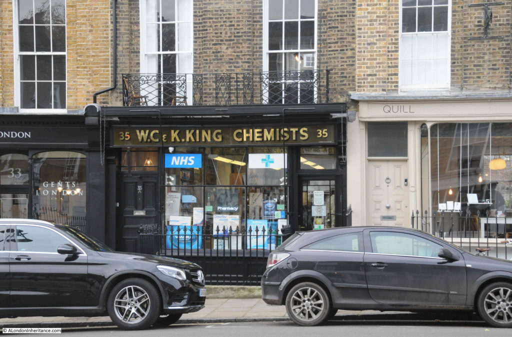
Although there is plenty of interest in the streets around Rosebery Avenue and St John Street, I had two more 1985 photo locations to find, so I walked across to Amwell Street to find the location of W.C. & K. King, Chemists, who had this wonderful lantern hanging outside the shop in 1985.

Rosebery Avenue

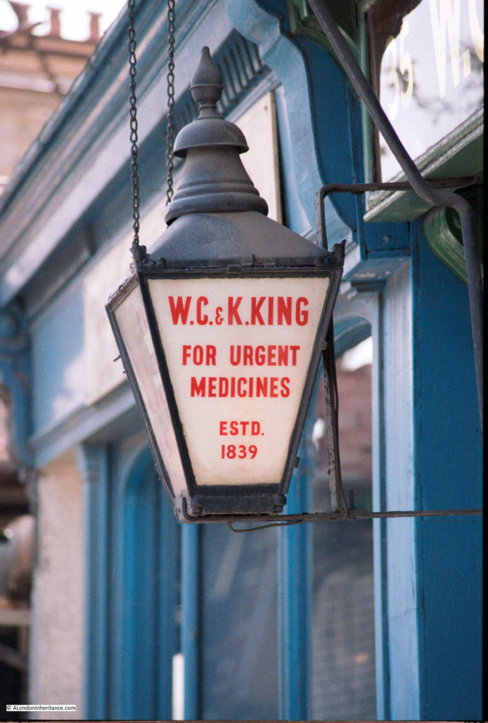
In 2019, the shop is still a chemists, and the same shop front survives, however the lantern has disappeared.

Rosebery Avenue

The lantern claims 1839 as the year the business was established, however I can find no evidence of when the business opened, or when W.C. & K, King where proprietors.

I continued walking down along Amwell Street, past the point where I photographed the base of the New River Head windmill, and then found this rather magnificent building – giving the appearance of a large brick built castle guarding Amwell Street:

Rosebery Avenue

This is the Grade II listed Charles Rowan House.

Built between 1928-1930 to provide accommodation for married police officers, the building was design by Gilbert Mackenzie Trench who was the architect for the Metropolitan Police.

Built of red brick, the large rectangular building provided 96 two and three-bedroom flats, arranged around a central courtyard. The longer sides of the building are along the roads leading off from Amwell Street, and it is in these two side streets that the arched entrances to the central courtyard and the flats can be found.

The building transferred to local council ownership in 1974. I am not sure how much of the building remains as council provided housing. I suspect many of the flats have transferred to private ownership through right to buy, and today, a 2 bedroom flat in Charles Rowan House can be had for £650,000.

The building is named after Sir Charles Rowan, the first Chief Commissioner of the Metropolitan Police, and his obituary published on the 11th May 1852 in the London Daily News, reveals a link between the Metropolitan Police and the Battle of Waterloo:

“Death of Sir Charles Rowan K.C.B. – Sir Charles Rowan, later Chief Commissioner of the Metropolitan Police, died at his residence in Norfolk-street, Park-lane on Saturday the 8th inst. he entered the army as an ensign in the 52nd Light Infantry, in 1797, and served with that distinguished regiment in the expedition to Ferrol in 1800; in Sicily, in 1806-7; and with Sir John Moore’s expedition to Sweden in 1808. He joined the army in Portugal after the Battle of Vimiera, and served from that time with the reserve forces of Sir John Moore, and in the Battle of Corunna. he also served with great distinction both in Spain and Portugal, and commanded a wing of the 52nd at the Battle of Waterloo, when he was wounded; he was also wounded at Badajoz, on which occasion he received the brevet rank of lieutenant-colonel. In 1815 he was appointed companion of the Bath. From 1829, the year the Metropolitan Police Force was instituted, until 1859, he was chief commissioner, and for his services in that capacity was, in 1848, nominated a knight commander of the Bath”.

Fascinating that the building is named after someone who fought at the Battle of Waterloo, and that same person became the first chief commissioner of the Metropolitan Police.

The construction of Charles Rowan House obliterated a street and a large number of houses, and it was here that Amwell Street ended.

In the following extract from the 1896 edition of the Ordnance Survey map, I have marked the location of Charles Rowan House with the large red rectangle.

Rosebery Avenue

Credit: ‘Reproduced with the permission of the National Library of Scotland’ 

Amwell Street ran to the northern tip of what would later become Charles Rowan House, and from then down to Rosebery Avenue, the street was named Rosoman Street.  Today, Amwell Street extends onto Rosebery Avenue, replacing the Rosoman Street name.

This is relevant as it helped me find more details of the following location, photographed in 1985:

Rosebery Avenue

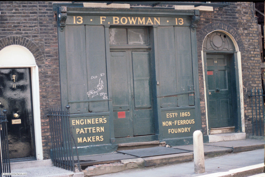
In the 1901 census, the address was 95 Rosoman Street rather than 13 Amwell Street.

The building was occupied by:

  • Frederick Bowman, aged 52 and occupation Brass Founder
  • Ellen Bowman, aged 39, his wife
  • Irene Bowman, aged 14, daughter
  • Ruby Bowman, aged 13, daughter
  • Theophilus Bowman, aged 11, son
  • Christie Bowman, aged 7, daughter
  • Helen Munto, aged 32, servant

If the business was founded in 1865 as recorded on the front of the building, then I am not sure it was the Frederick Bowman of the 1901 census, as he would have been too young, and all his children were recorded as being born in Chingford, Essex.

I cannot find any reference to an earlier F. Bowman. In the 1911 census, Frederick Bowman was still living at 95 Rosoman Street, aged 64 and still working as a Brass and Aluminium Founder. All his children still lived at home, however Helen Munto had left (perhaps returning to her native Scotland), and the new servant was Edward Redgrave, aged 30.

Frederick seems to have been a name used by the family over the generations, as Theophilus middle name was Frederick. Chingford also seems to have been a family connection as Theophilus would marry Florence May Jerome at Chingford in 1922.

Theophilus would go on to live in Chingford, but he would also carry on the family trade, as in the 1939 census, his occupation is given as Brass Moulder – what is not clear is whether he worked in Chingford, or commuted to the Rosoman / Amwell Street business.

The same location in 2019:

Rosebery Avenue

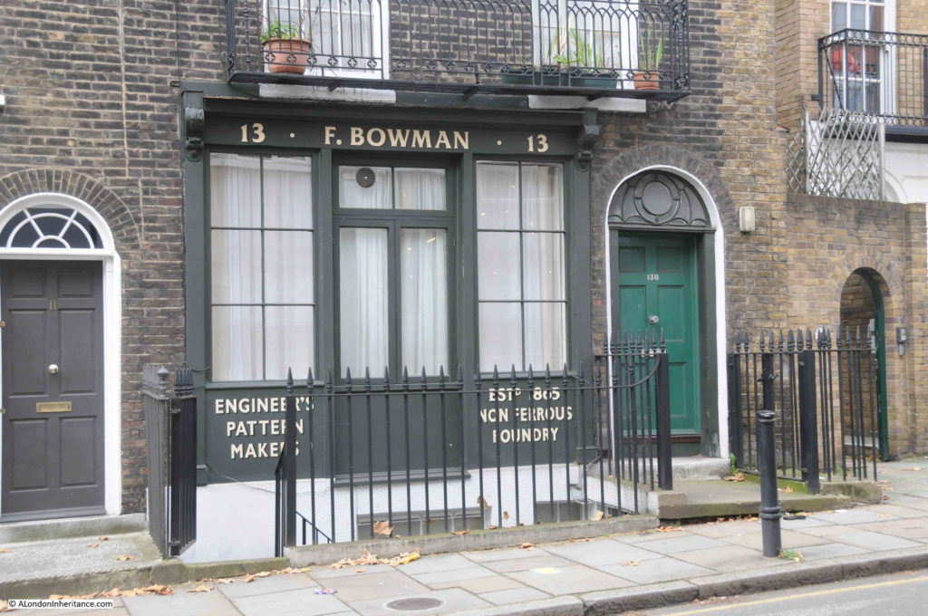
The 1985 photo implies that the entrance to the business was in the centre, with the entrance to the family home to the right.

In 2019 it looks as if the building has been converted to a home, with a single entrance door to the right, and the paving leading to the business door removed to open up the cellar.

Frederick Bowman’s name still looks onto Amwell Street.

A short distance on, and I was back on Rosebery Avenue. Although the walk did not have a theme, to me it is the fascination of what can be found on random walking across London, on this walk using some 1985 photos as a guide.

Businesses that continue to (hopefully) thrive on London’s streets such as the Pleasant Barbers, Lord Northampton’s hold over the land of Clerkenwell, a row of houses that owe their alignment to the New River, a block of flats named after a Waterloo survivor, and a street named after the first chairman of the London County Council, and future Prime Minister are typical of the fascinating stories to be found all over London.

alondoninheritance.com

Hotwater Court, Fann Street and Golden Lane Estate

For today’s post, I am back in the area of the Barbican, Golden Lane Estate and Fann Street, searching for the locations of the photos taken by my father and showing a very different scene to that of today.

A few week’s ago, I wrote about the Baltic Street School as this appeared in one of the photos. This week’s photos are from roughly the same position, however looking east rather than to the north, and this was the post war view:

Fann Street

In the following photo, he had walked up closer to the building that remains on the site, and we can see part of the name of the business that occupied the building.

Fann Street

Locating the building was easy as I had already located the position from where the first photograph was taken to identify the Baltic Street School, and there is some overlap in the buildings in the distance.

The following map extract shows the large area, with all the buildings demolished and cleared following wartime destruction, ready for the future construction of the Golden Lane Estate.

Fann Street

The building circled by the red oval is the building that appears in my father’s photos. The premises of Maurice Rosenberg – Skirt Manufacturer. The edge of the building is on to Fann Street and the long side of the building faces the wonderfully named Hotwater Court.

Hotwater Court, although not visible, would have been in front of the building in my father’s photos.

This is the same location today  (Map © OpenStreetMap contributors):

Fann Street

The overall length of Fann Street has been straightened out, however the section where Maurice Rosenberg’s premises were located is very much the same, and possible to identify in the street pattern of today.

To the right of the junction of Viscount Street and Fann Street is the Jewin Welsh Church. This is marked on the 2019 map, and is marked as a “ruin” in the earlier Ordnance Survey map, however the current incarnation of the church stands on the same site as the original.

Hotwater Court was just across and to the right of the Viscount Street / Fann Street junction, and today’s map shows a narrow street leading north in the same location as the original Hotwater Court.

On a wet and overcast day, this was the view looking across from Fann Street to where Hotwater Court was located, which today provides an entrance from Fann Street into the Golden Lane Estate.

Fann Street

I tried some very amateur Photoshopping to show where the building in the original photo, facing onto Hotwater Court, would appear today – this was the result:

Fann Street

However, I can show a much better photograph. Post war London was used in a wide range of films in the late 1940s and 1950s, and following one of my earlier posts on the Golden Lane Estate, I was sent a reference to a 1950 film “No Place for Jennifer”, and a link to the wonderful Reel Streets site which features a number of locations from the film, including Fann Street and Hotwater Court.

I found a copy of the DVD online for £3.66, and ordered. The film dates from 1950 and tells the story of the impact on Jennifer of her parents divorce. Towards the end of the film, she runs away through the streets of London, Euston Station, the Underground, and at one point, hides from a strange pursuer in the ruins around what is now the Golden Lane Estate.

It is very much of its time, much of the dialogue is in received pronunciation, but the London street scenes are brilliant, and include a brief sequence looking across Fann Street to Hotwater Court, with the premises of Maurice Rosenberg on the corner:

Fann Street

The building on the right edge of the above still from the film is part of the ruins of the Jewin Welsh Church.

The building still looks intact, with none of the damage that the rest of the area suffered. No idea whether the building was just lucky, or whether it had been repaired after the bombing and resultant fires devastated so much of the area in 1940 / 41.

Checking the 1942 Kelly’s Post Office Directory, and the address of Maurice Rosenberg is still given as 40 Fann Street (although the longer edge of the building was on Hotwater Court, it had a Fann Street address). The entry also has an emergency address for Maurice Rosenberg at 87 Aldersgate, so he may have kept the original building and had some operations remain there, but had also moved to a building on Aldersgate Street possibly due to the damage around Fann Street.

Hotwater Court is an interesting name. I cannot find a source for the name, and Henry Harben in A Dictionary of London, states:

“Hot Water Court – North out of Fann Street at No. 49. A portion only within the City boundary. First mention: L.C.C List, 1901”

Although Harben gives 1901 as the first mention of the name, I did find earlier references to Hotwater Court, including the following letter printed in the Police Intelligence section of the London Sun on the 15th November 1847. It is a rather grim read, but does confirm the existence of the name at a much earlier date, and illustrates the dreadful conditions around Golden Lane in the mid 19th century:

“Sir, – I respectfully beg to submit the following report for your information, in consequence of illness and death in the neighbourhood of Barbican, Bridgewater-square &c, supposed to be caused by exhalations emanating from a burial ground situated in Golden-lane, part of which is within the City, belonging to a man named Bamford, who has it on a lease.

I sent police-constable 125 (Eade), who is on the beat, to the burial ground on Sunday last, when he saw 11 graves open, about 28 feet deep; one of them contained nine coffins on each other. the graves are merely covered over with planks, until they are quite full, leaving them about a yard from the surface when the ground is covered in. 

They are frequently left open as described, for a week or ten days; the ground is therefore seldom free from the effluvium of decomposed matter. On my rounds at night I have witnessed the obnoxious smell arising from the rear of the graveyard in Sun-court, which is almost suffocating. I am also informed by police-constable 125 (Eade), that a shopkeeper named Bouverie, 10, Golden-lane, opposite the burial ground, states, that during the last three of four years he has kept the house, 32 persons have died there; and at certain times he has absolutely been compelled to fumigate his shop, the smell from the graveyard and sewers being so offensive.

A publican named Duffy, in Golden-lane, is very seldom without a medical man in his house attending his family. A person named Parrock,, 12, Brackley-street, is compelled to leave his business (although a good one) through illness.

The courts leading from Golden-court, Crown-court, Collins-court, Sun-court, Hotwater-court, Turk’s Head-court, and Willis’s-court are thronged by very poor persons, and are much affected by the stench.

The houses in those courts are small and thickly inhabited, nine or ten persons living in a room, which causes the fever to rage rapidly. A metropolitan police-constable informed police-constable Eade that six persons are now lying dead and a great number are lying very ill in the locality of Golden-lane, between the burial ground alluded to and another burial ground being only 300 yards apart in Golden-lane.

I further beg to call your attention to the undermentioned names, persons who have died within the last three weeks in the immediate neighbourhood of Golden-lane; also to the names of persons who at the present time are labouring under illness – it is presumed fever.”

An appalling account of conditions around Golden Lane in 1847. Not just how nine to ten people were crowded together in a single room, but they were also living almost on top of the dead.

The article does at least confirm that Hotwater Court was, along with a number of other courts, in existence in 1847.

The area around Golden Lane is very different today, with empty space in the post war Ordnance Survey map now occupied by the 1950s and early 1960s Golden Lane Estate.

The building on the left of what was Hotwater Court is now Cuthbert Harrowing House, built between 1954 and 1956 and named after Public Health Committee former chair, Thomas Cuthbert Harrowing .

Fann Street

Adjacent to the entrance is this brilliant 3D map of the Golden Lane Estate, which I understand dates to around the time of construction of the estate.

Fann Street

Whilst I was taking a photograph, I was talking to a resident of the estate, who knew about the map, but had not looked at the map in detail. Whilst the Community Centre is still there, he was not sure what building 12, the workshop was or is.

Building number 6, Bowater House, is the building where the Maurice Rosenberg building was located, and between buildings 6 and 7, and up alongside building 11 was the location of Hotwater Court.

Directly opposite, on the corner of Fann Street and Viscount Street is the Jewin Welsh Presbyterian Chapel:

Fann Street

This is the building marked as a ruin in the Ordnance Survey map, and a corner of the building is seen in the film clip.

The roof and interior of the church had been destroyed during the war. The following photo from the LMA Collage site shows the front of the church in Viscount Street.

Fann Street

Image credit: London Metropolitan Archives, City of London: catalogue ref: M0078083CL

The Jewin Welsh Church or Chapel is the oldest Welsh church in London, although it has not always been at this location. Formed in Cock Lane, Smithfield in the 1770s, the church moved a couple of times before arriving in Jewin Crescent in 1823 (Jewin Cescent is one of the many streets lost under the Barbican development, I wrote about the street in my post on the Cripplegate Institute and Jewin Crescent.

The church moved from Jewin Crescent to the current location in 1879. A new church was built at a cost of around £10,000, and the church retained the name of Jewin, thereby providing a link between a church we can see today, and a street lost under the Barbican.

Apart from the outer walls, the church was destroyed in 1940, but rebuilt after the war, with the building we see today opening in 1960.

Dwindling attendance almost resulted in the closure of the chapel in 2013, however a campaign to raise awareness of the chapel resulted in closure being avoided, and although a relatively new building, it is good to see that the chapel remains and continues serving much the same function as when the original church formed in the 1770s.

There are a couple of interesting plaques along the Fann Street side of the church, one in the pavement, the second on the wall.

Fann Street

The plaque on the wall records the Huguenot Fan Makers who settled around Fann Street, and that the Worshipful Company of Fan Makers had their common hall nearby.

Fann Street

It would be an obvious association between the street name, and the fan making occupation, however this does not appear to be the case.

A number of references I checked with confirmed there was no association between the Fan making trade and the street name. Henry Harben in A Dictionary of London writes:

“Fann Street – east out of Aldersgate Street, at No 106 to Golden Lane. Part of the street is in Aldersgate and Cripplegate wards Without, and part is in the Borough of Finsbury outside the City boundary.

First mention: Fan Street (Horwood, 1799)

Former names: Fanns Alley (Ogilby and Morgan’s map of London 1677, Strype 1720)

Fanns Alley (Rocque, 1746)

Stanns Alley (Strype, 1720 and 1755)

Bridgewater Gardens (Company of Parish Clerks 1732, ordnance Survey, 1875)

In former times the street extended only from Aldersgate to Bridgewater Gardens, but in 1878 the name Fann Street was adopted for the whole street to Golden Lane, including Bridgewater Gardens.

The early forms suggest that it was named after an owner or builder.”

Other references suggest the same origins of the name, with The London Encyclopedia by Ben Weinreb and Christopher Hibbert stating that “The origin of the name is uncertain but it is thought to be that of a 17th-century land owner or builder.”

So no connection between the name of Fann Street and fan makers, however the Worshipful Company of Fan Makers is an interesting company, and demonstrates how a traditional City Livery Company has had to adapt to changing technologies and fashions, whilst maintaining an interest in the traditional craft.

The origins of the formation of the Fan Makers Company go back to the late 17th century, when there was a large influx of protestant fan makers from the Continent to London after the revocation of the Edict of Nantes in 1685. These were the Huguenot Fan Makers mentioned on the plaque on the side of the chapel.

The native fan makers started to organise to preserve their trade, and the Fan Makers were Incorporated on 19th April 1709 as a result of a petition to Queen Anne. They were concerned with both the impact of dilution on the indigenous trade by those migrating to the country, and also with the unrestricted import of fans.

The Company was granted Livery status in 1809, however by then the Company was past its peak as the Fan trade had peaked in the 18th century. It was then a story of gradual decline, but with occasional highlights including fan making competitions in the 1870s, the support of Queen Victoria (who donated £400 for prizes), and regular presentations of fans at events such as Coronations.

In the 20th century, the Fan Makers had to adapt further, and in 1939 extended their scope to the manufacture of industrial fans, and post war with aerospace technologies such as the fans used in jet engines.

The Fan Makers continue to champion the traditional fan, and have established an endowment fund to support the development and retention of fan making skills.

The Harben explanation of the street name includes a reference that part of the street is outside the City boundary, and physical proof of this can be seen along the pavement outside the Welsh Chapel where there is a boundary marker showing the boundary between St Luke’s Middlesex and the City of London.

Fann Street

The area bounded by Fann Street, Goswell Road, Golden Lane and Baltic Street is now unrecognisable from the dreadful description of the area in 1847. By the late 19th century many of the courts seem to have disappeared, although Hotwater Court, Turks Head Court and Bridgewater Square remained.

Late 19th / early 20th century development produced buildings of the type occupied by Maurice Rosenberg, however the area was devastated during the raids of 1940, and only recovered with the build of the Golden Lane Estate.

Few traces remain of the pre-war landscape, however the rebuilt Jewin Welsh Chapel continues the religious role, and association with the Welsh community of London from pre-war, and the lost Jewin Crescent.

Hotwater Court is an intriguing name. Names often had some local meaning, but I have not been able to find any reference as to the origins of the name.

The space occupied by Hotwater Court is today an entrance to the Golden Lane Estate – it would be nice to see the name return to maintain a link with the area’s history.

alondoninheritance.com