Monthly Archives: May 2024

Bedford Square

I have just put a couple of my Limehouse and Wapping walks on Eventbrite for the month of June. Click here for details and booking.

Bedford Square, Bloomsbury must be one of the best preserved, late 18th century squares in London, and in this part of London there is plenty of competition.

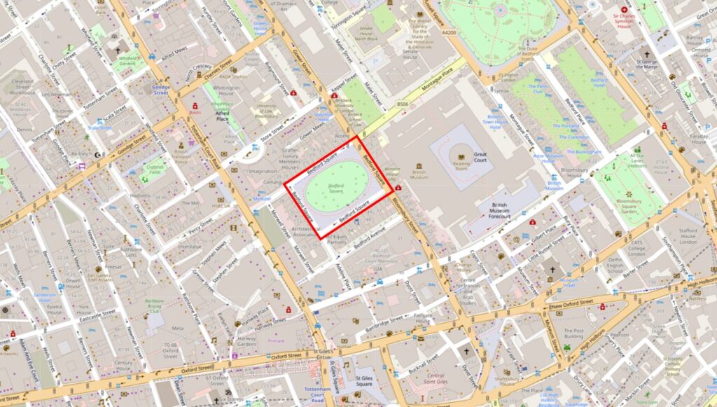
Bedford Square is just north of New Oxford Street, and has the British Museum to the east, and Tottenham Court Road a short distance to the west. The following map shows the location of the square in red:
Bedford Square

Bedford Square was planned and built between 1775 and 1780 as part of the development of the land owned by the Duke of Bedford (hence the name) within his Bloomsbury Estate.

This was a time when London was expanding northwards and the fields, streams, ponds and footpaths that comprised the Bloomsbury Estate would soon be part of the built city, however it would be a unique area due to the number of large squares which provided open, green space for the occupants of the new houses to enjoy.

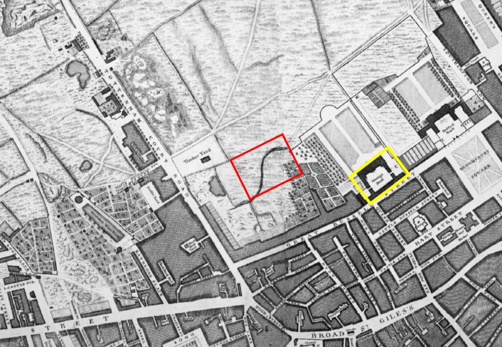
The following extract shows the area as it was not long before the development of Bedford Square. This is from Rocque’s map of 1746 and I have marked the future location of Bedford Square with the red rectangle, and much of the approximately 112 acres of the Bloomsbury Estate then open space:
Bedford Square

The yellow rectangle is around Montague House, the future site of the British Museum.

Plots of land around Bedford Square were leased by the architect Thomas Leverton and builders, Robert Crews and William Scott.

it is believed that Thomas Leverton was responsible for the overall plan of the buildings lining the four sides of the square, although there is no firm evidence to support this.

Thomas Leverton was the son of the builder Lancelot Leverton who was based in Woodford, Essex.

He seems to have designed a number of country houses, and where there is firm evidence of his connection with Bedford Square is with number 13 where he worked on the interior of the building and lived in the house from 1796 until his death in 1824.

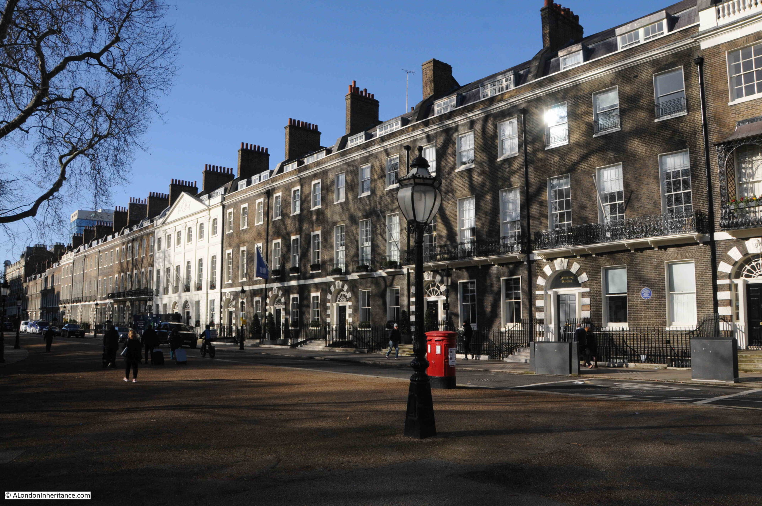
Each of the sides of the square has the same basic design, which was intended to emulate the appearance of a large country house, with the central building decorated with stucco, along with pilasters and pediments.

The “wings” of this central house are the row of brick terrace houses on either side of the central house and that run to the corners of the square:
Bedford Square

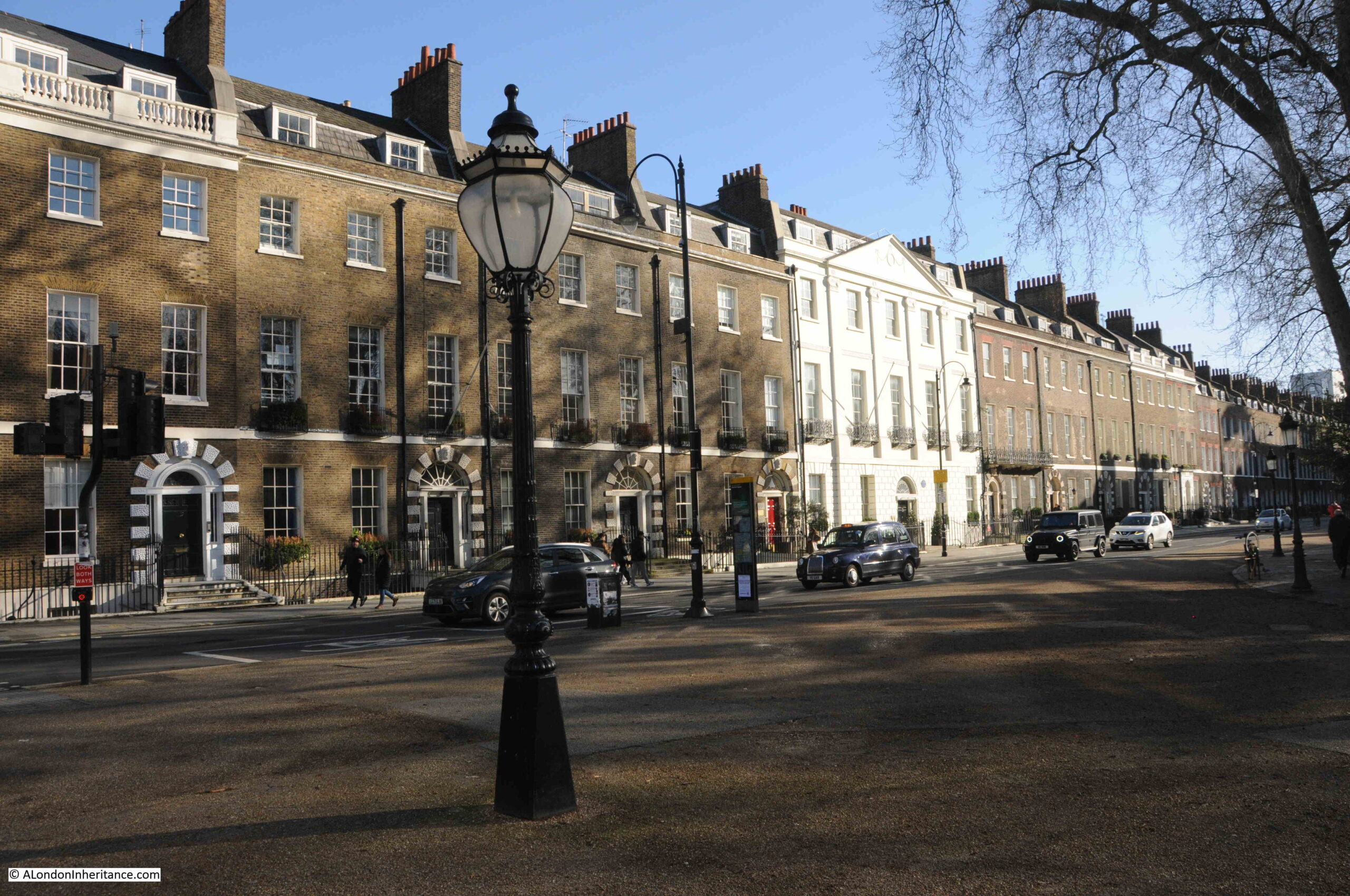
The above photo is of the northern side of the square and the photo below is of the eastern side. The overall design is the same however there are subtle differences, for example the central house on the north side has six bays, whilst that on the eastern side has five:
Bedford Square

This seems to be down to the fact that the square is not really a square, rather a rectangle with the north and south sides being 520 feet long whilst the east and west are 320 feet.

To show how little Bedford Square has changed, the following print from 1851 is of the same view as the above photo:
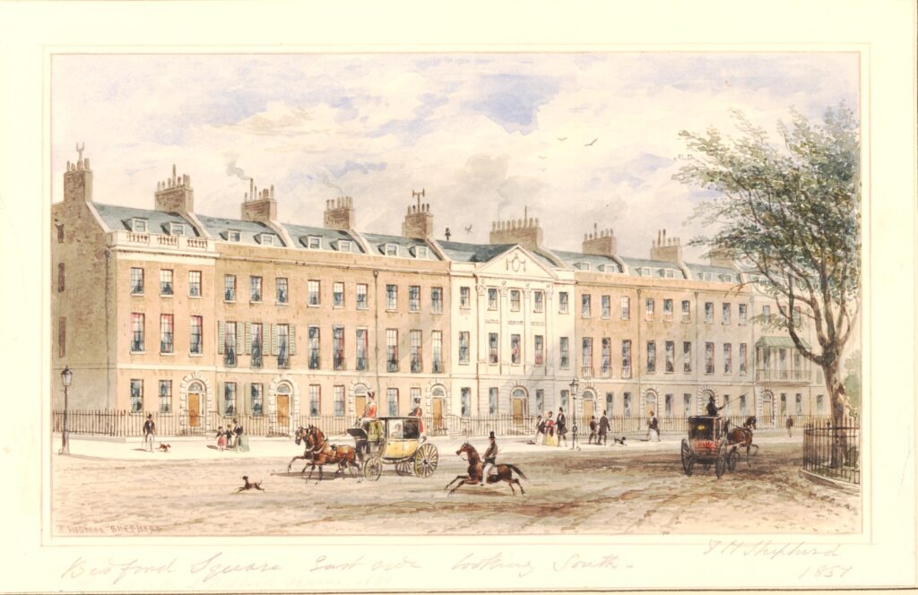
Bedford Square

 © The Trustees of the British Museum Creative Commons Attribution-NonCommercial-ShareAlike 4.0 International (CC BY-NC-SA 4.0)

The only things that have changed is the replacement of coach and horses by cars, wider paving and the amount of street furniture we see today.

The remarkable preservation of the houses in Bedford Square appears to be due to the way that the Bedford Estate has managed the square since its original construction.

Steen Eiler Rasmussen writing in “London: The Unique City” (1948 edition) gives a fascinating insight into how this worked.

The original land was leased as a number of lots where a house would be built, and for the first 99 year lease, the annual ground rent was £3 for each lot.

After 99 years, the Bedford Estate than became the owner of not only the ground, but also the house that had been built on the land, and it was then leased for an additional period for a new annual sum that reflected both the land and the house, so by the end of the 99 years of the first leasing period, houses were then leased at different values to reflect the type, design and condition of the house on the land.

After the first 99 years, as well as different financial values, the leases were also for different periods, between twenty and fifty years. This seems to have been based on the work that the new leaseholder was planning to put into the building, so a leaseholder making a considerable investment on repairs, rebuilding and improvements would have a longer lease period.

One of the benefits to the Bedford Estate of then having leases expire at different times was that it avoided the risk of the leases for all the houses surrounding the square being renewed, for example, during a period of financial depression and low demand, when lease values would have been reduced.

It also means that any plans for radical change across the square are difficult, as the leases all expire at different times, and so the leases that make up a large block of land would not all become available at the same time.

I have no idea whether the Bedford Estate still takes this approach, however it does help explain why the houses in Bedford Square have externally hardly changed since their original build.

Although the external appearance has hardly changed, the interior of the houses on Bedford Square may be very different, reflecting the changes that have taken place over the last few centuries. Different uses, different types of owner, all would have left their mark on the interior.

There are also subtle different to the external façade of the houses, for example, this end of terrace house has a metal veranda structure above the balcony that runs the full width of the house:
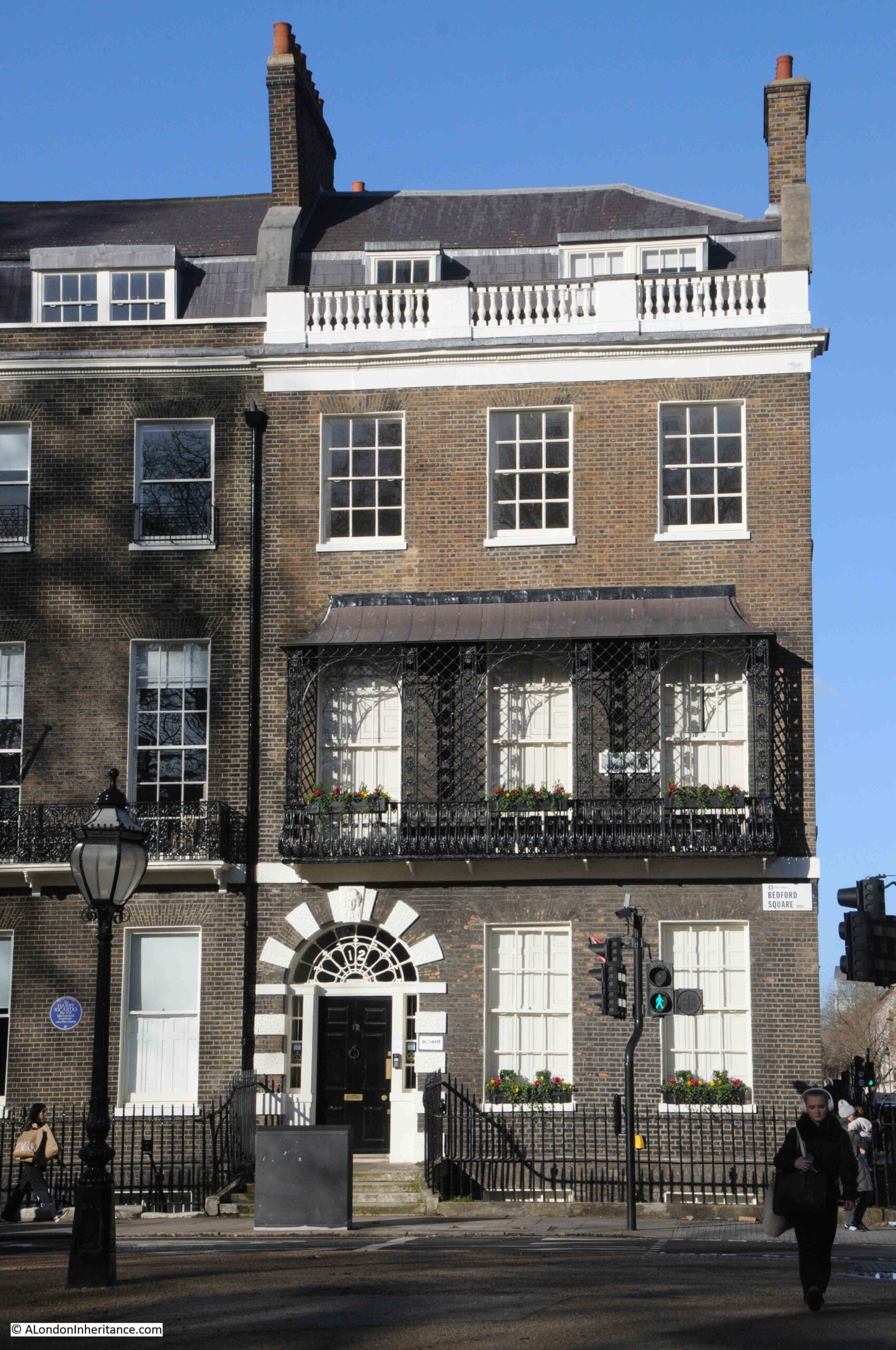
Bedford Square

From the street, these houses look relatively narrow, however clever design results in a sizeable interior.

The following plan from the book London: The Unique City shows the layout of a typical house in Bedford Square:
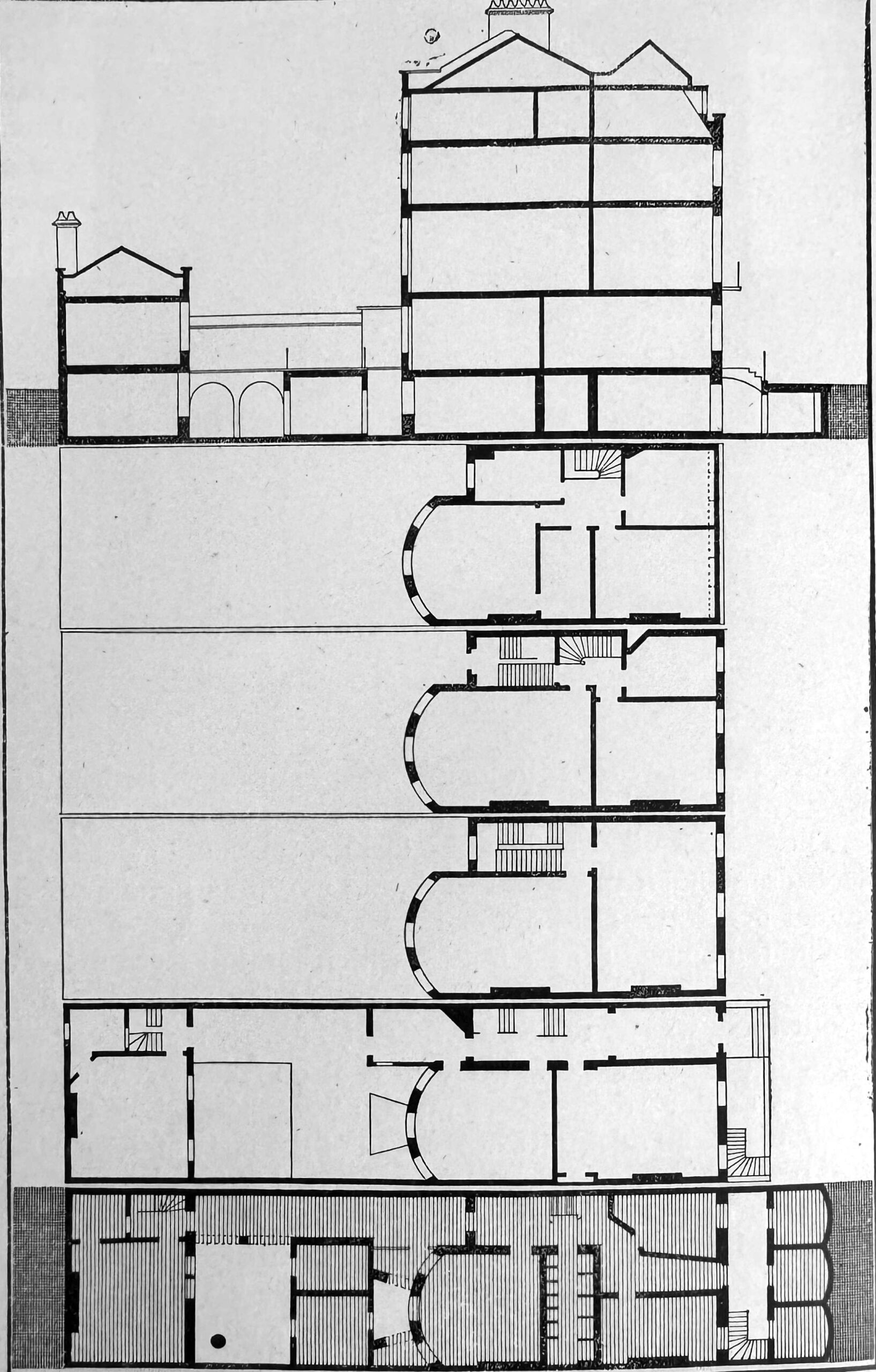
Bedford Square

Despite the narrow front facing onto the square, each house does extend a fair way back, with both the basement and the ground floors extending some distance, and storage areas which would have held consumables such as coal, extending underneath the pavement from the basement.

On the north east corner of Bedford Square, the house in the photo below has street signs indicating that it is at the corner of Gower Street and Montague Place:
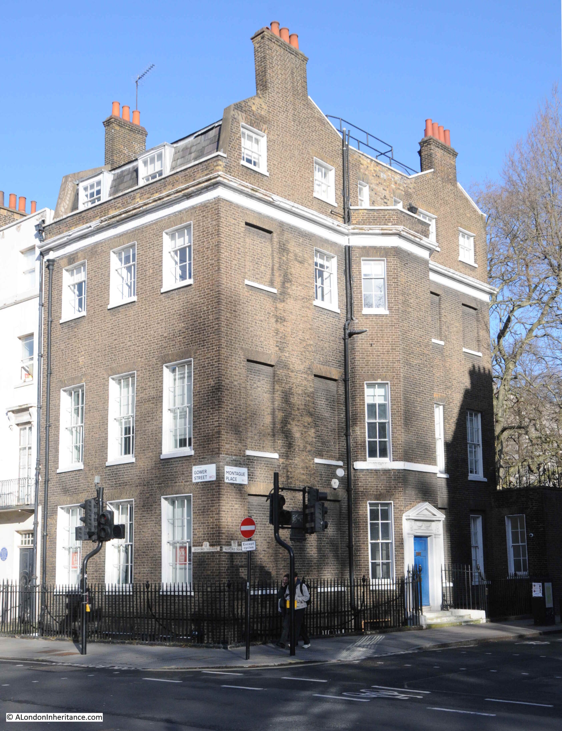
Bedford Square

However below the signs for these two streets are these much older signs indicating a Bedford Square address:
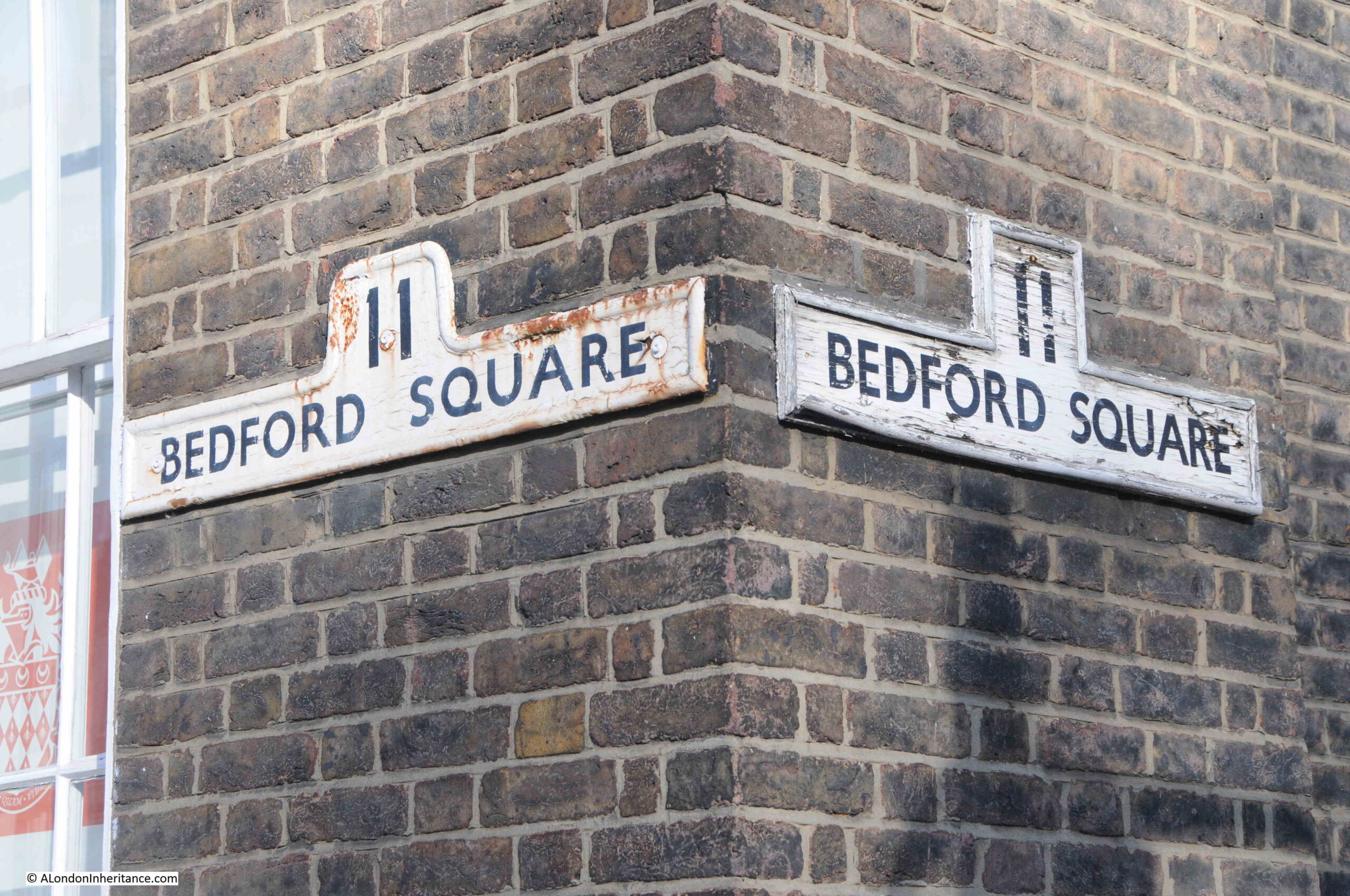
Bedford Square

Much of the decoration around the doors of the houses is of Coade Stone, which was made in the factory owned by Eleanor Coade on the south bank of the river, just to the west of the Royal Festival Hall, and in the following photo Coade stone alternates with brick around the main entrances to the house:
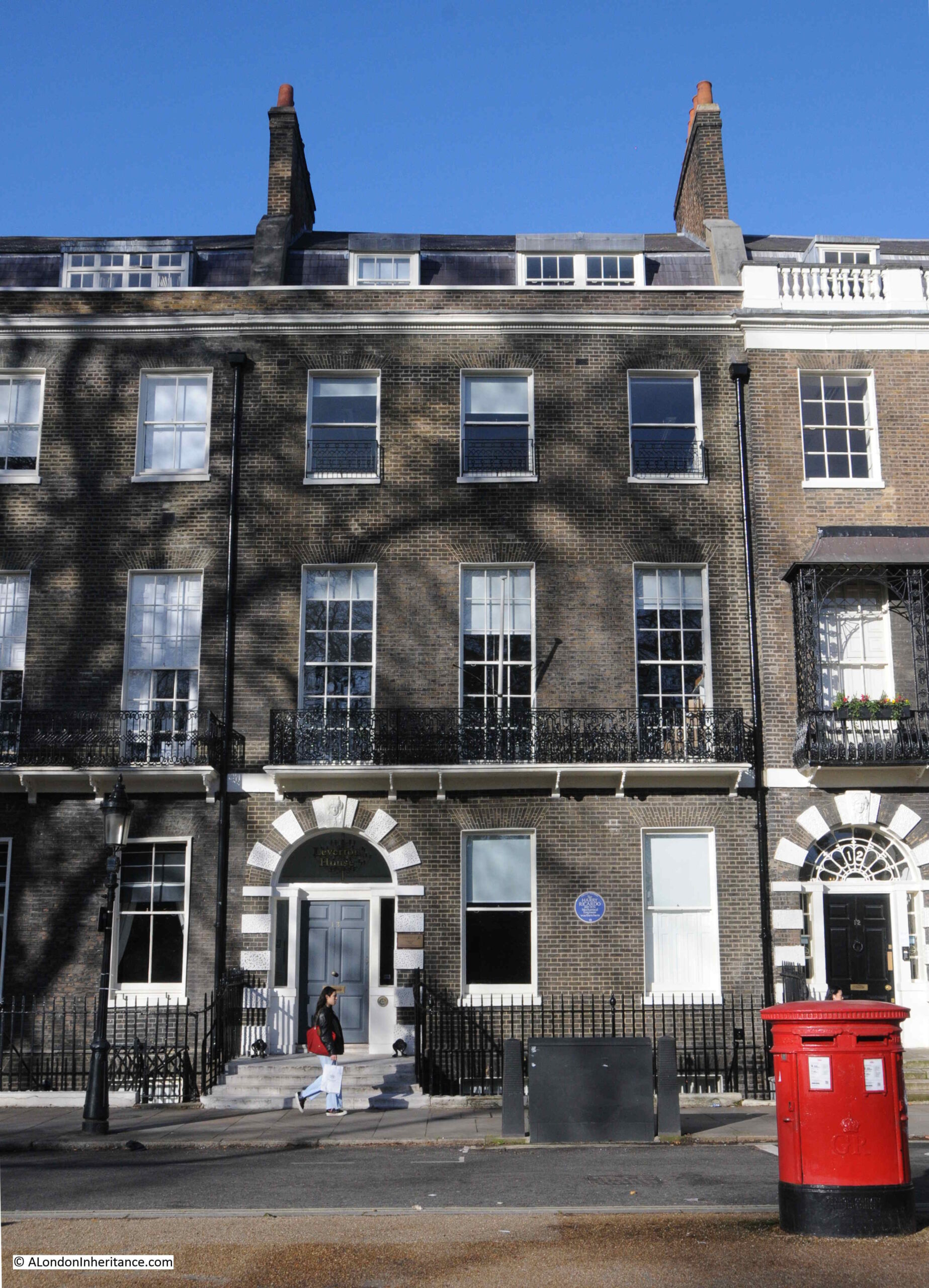
Sir Harry Ricardo

As could probably be expected for a location such as Bedford Square, there are a large number of blue plaques on the houses. On the house in the above photo is an English Heritage plaque to Sir Harry Ricardo:
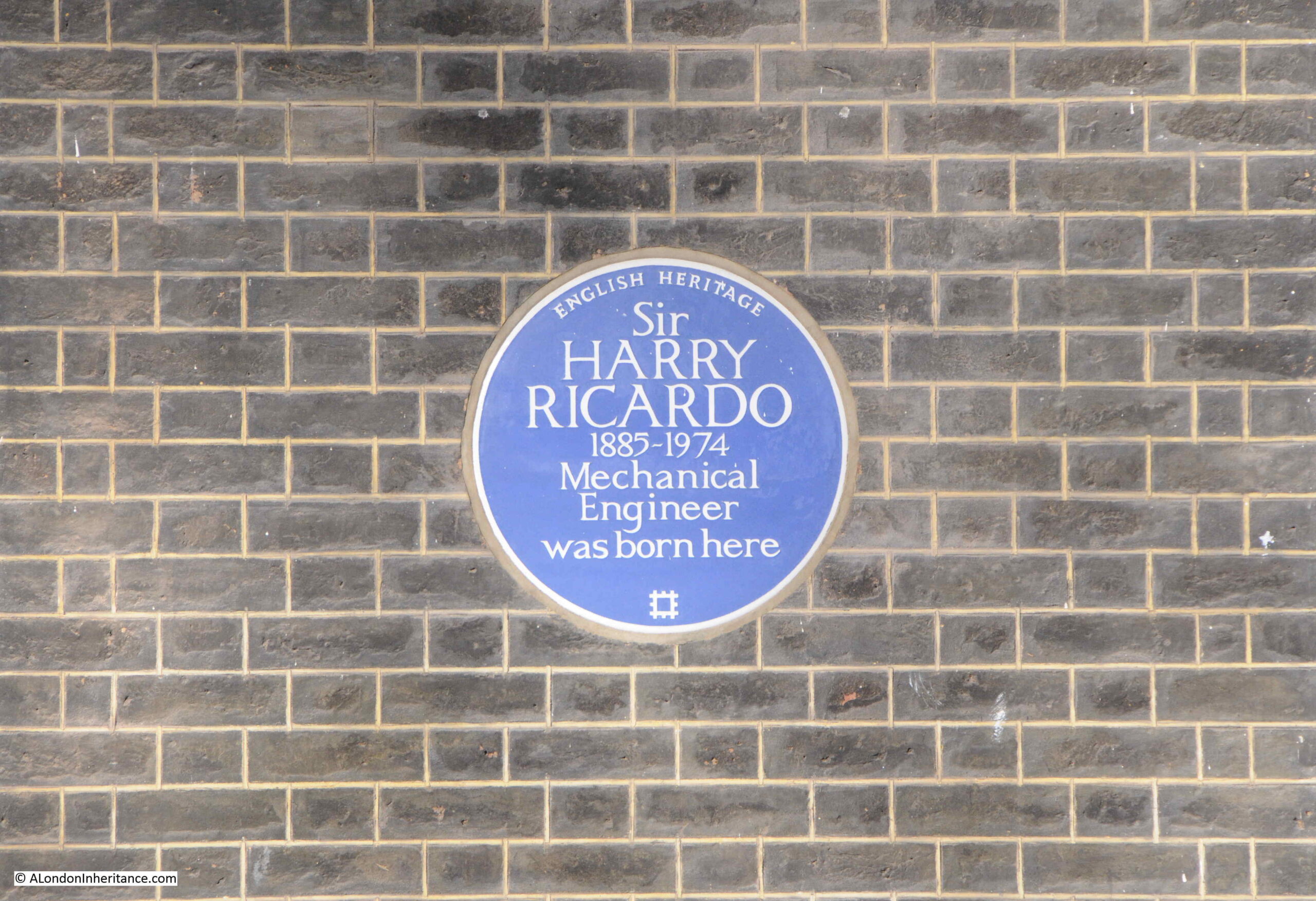
Sir Harry Ricardo

As stated on the plaque, Sir Harry Ricardo was a Mechanical Engineer, and much of his work was centred around the development of the internal combustion engine for both vehicles and aircraft, and his work contributed to the outcome of the First World War as he developed the engines that were used by the tanks on the battlefield.

And if you fill up a car with petrol, and check the octane rating of the petrol, that is also down to Sir Harry Ricardo as his work on the chemical composition of fuels resulted in the octane classification system

The company he founded is still going strong, and is still named Ricardo, and is based at Shoreham-by-Sea in West Sussex.

The large central houses on the north and south sides of the square have six window bays, and two large entrances:
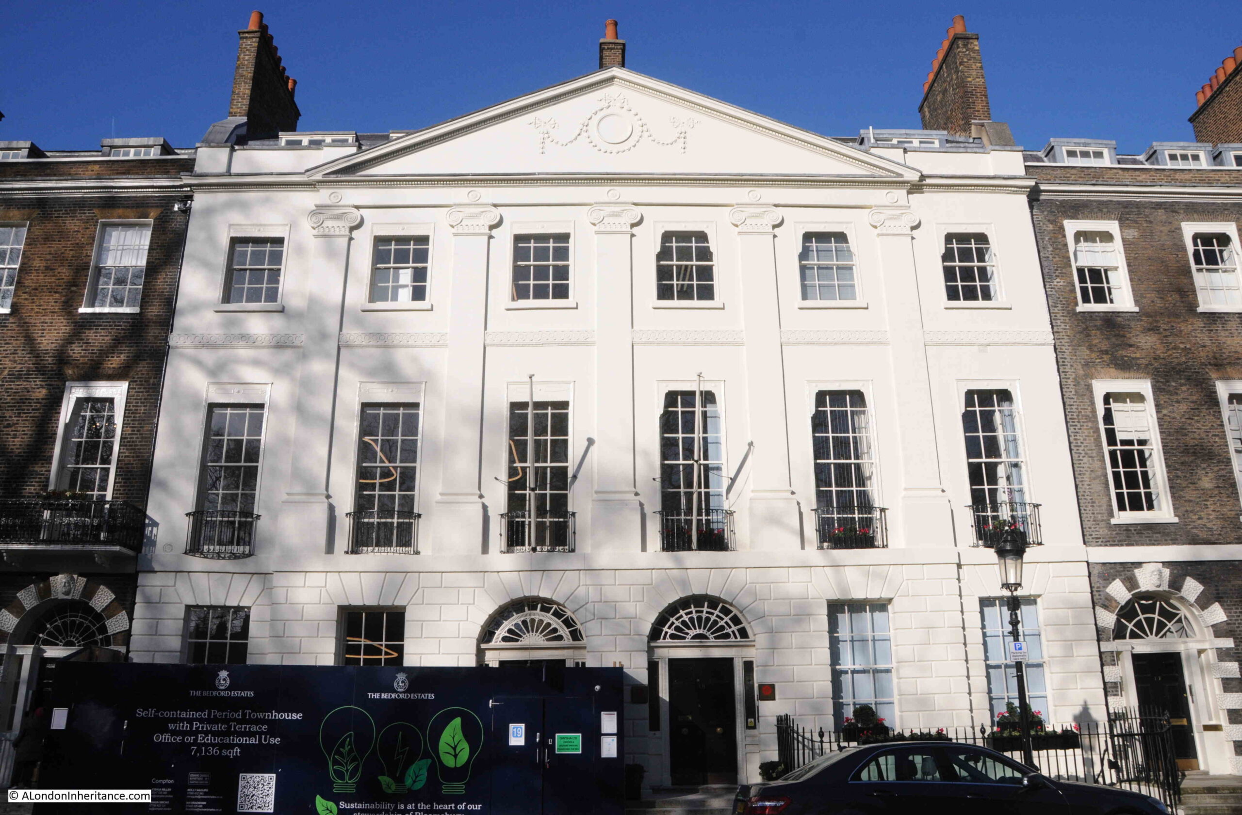
Bedford Square

Whilst those in the centre of the other two sides, have five window bays, and a single entrance from the street:
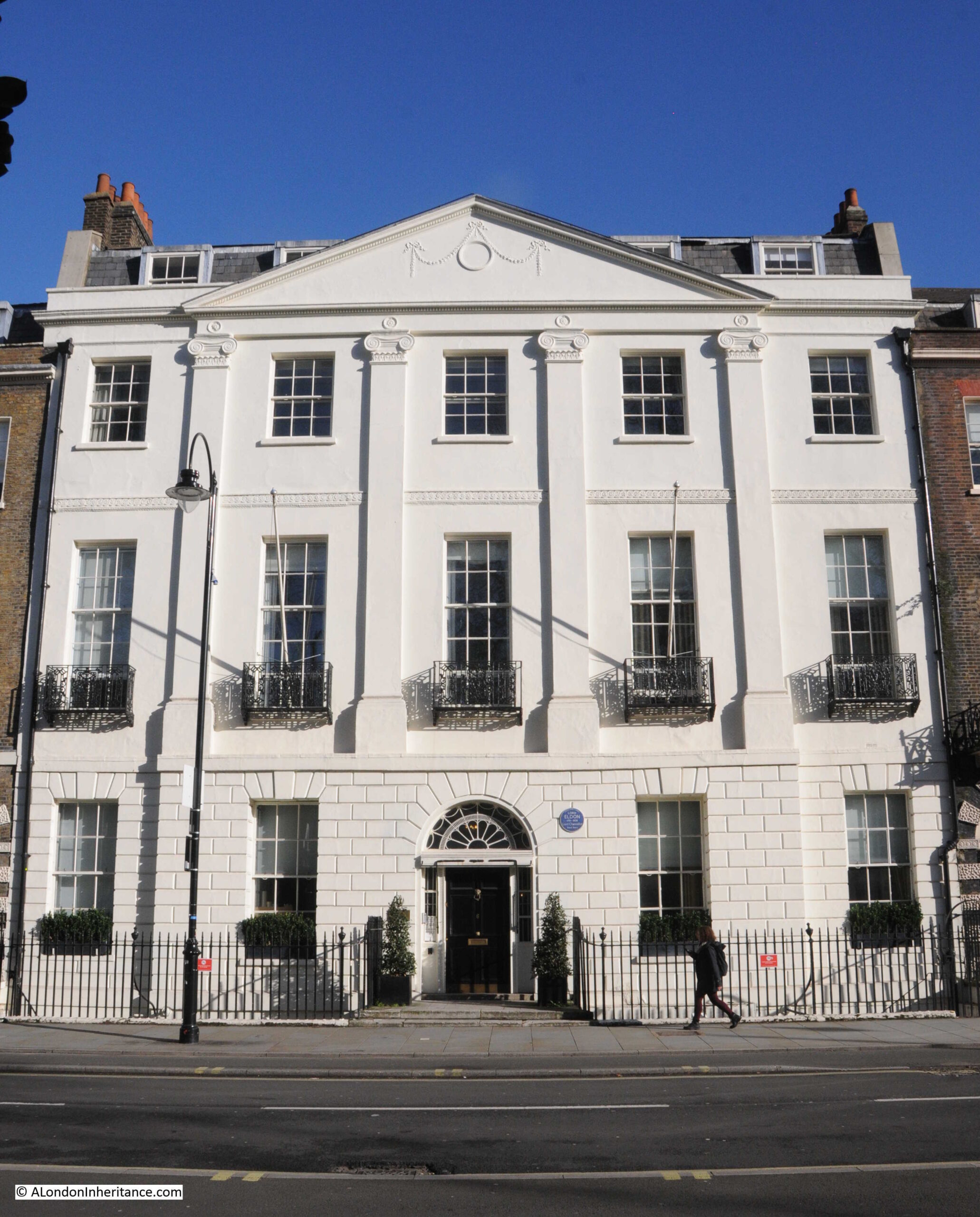
Lord Eldon

To the right of the entrance to the building in the above photo, a London County Coucil blue plaque record that Lord Eldon (1751 – 1838), Lord Chancellor, lived in the house.

He does not appear to have been very popular in the role of Lord Chancellor as the following is typical of the obituaries that were published after his death;

“For five-and-twenty years Lord Eldon held possession of the woolsack. Here was a position and a power of doing good in the hands of any man honestly disposed towards his country. For a quarter of a century he had absolute authority over the very stronghold of legal corruption – over the crying grievance of the nation – over the engine which broke the happiness, destroyed the fortunes, and wore away even the lives, of no small portion of his fellow men.

What did Lord Eldon do? Did he make one effort to palliate the evil? Did he, in a single instance, exert his power to rescue its victims? Did he, by one gesture, encourage those who were labouring day and night to work out the reformation he could at once have accomplished?

No. Lord Eldon was their bitterest, their most determined foe. He exerted his mighty power, in his court, in the cabinet, and in the closet, to stifle all enquiry, to destroy all opposition, to render hopeless every effort for amendment. He threw his protection over every harpy which fattened upon the corruption of his court, and verily they flourished.”

He also does not appear to have been that popular with his daughter, as she eloped with G S Repton, who was the son of Humphry Repton, the designer of the gardens in nearby Bloomsbury and Russell Squares.

View along the western side of Bedford Square:

Bedford Square

The above photo shows that there are subtle differences to the apparent identical design of the houses in the terrace. Look at the decoration around the entrances, and the central two have solid white stone decoration, whilst the outer two have a mix of white Coade stone and the same brick as the rest of the house.

The central gardens are private, and are for the residents of the square.

As well as the majority of the surrounding houses being listed, these gardens are also Grade II* listed.

They have not changed that much since originally being set out. The shrubbery around the perimeter of the gardens appear to be a long standing feature. In the 19th century, paths across the grass were removed.

There was limited damage to the square during the last war, with a single house in the southern side of the square damaged, along with the houses in the south east corner.

The shrubbery limits the views across the gardens, but glimpses are available as shown in the following photo:

Bedford Square gardens

Another Bedford Square blue plaque on the house in the photo below:
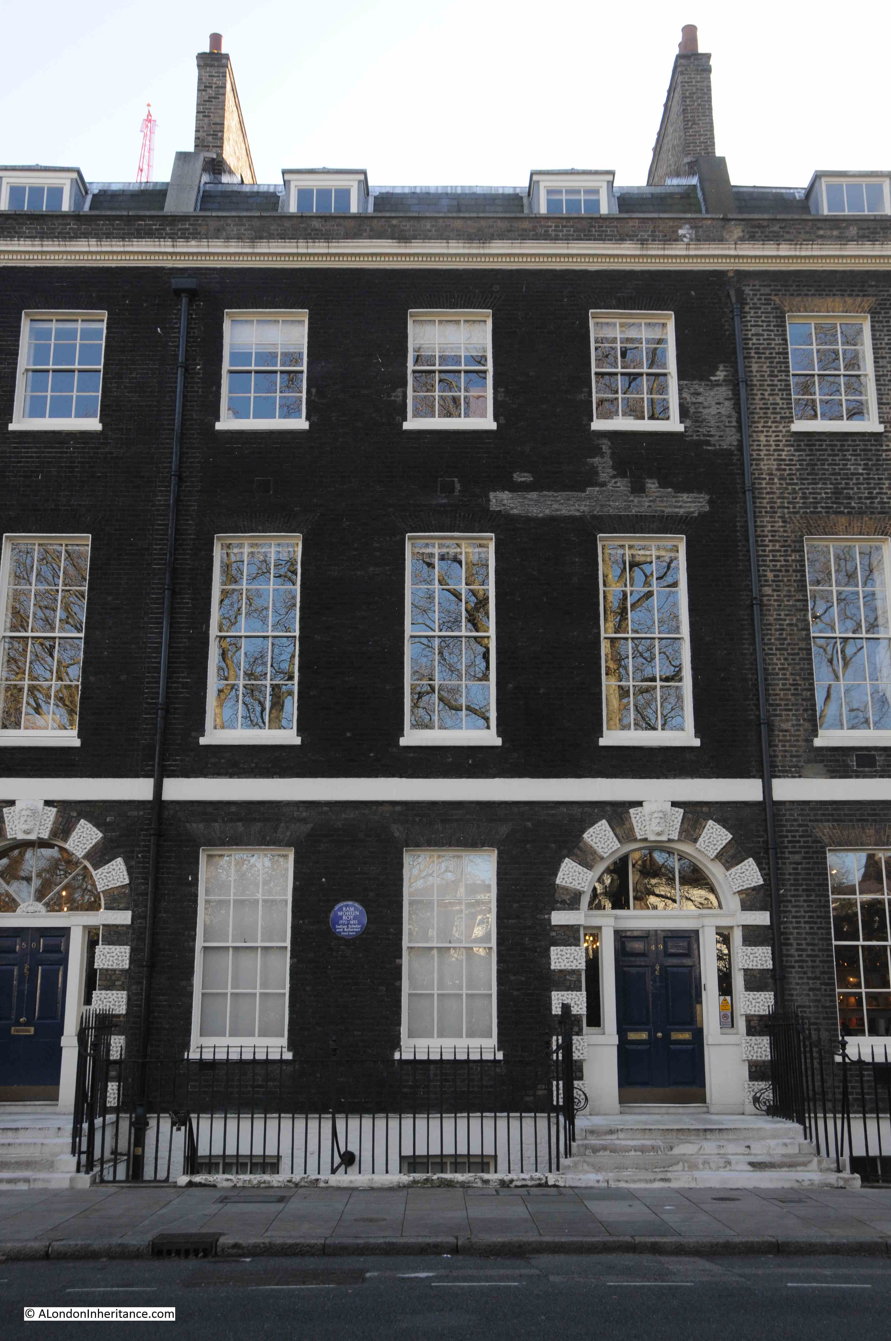
Ram Mohun Roy

This plaque is a perfect example of the range and diversity of people who have passed through London over the centuries.

The plaque records that Ram Mohun Roy, Indian reformer and Scholar lived in the house.

Ram Mohun Roy was born in Radhanagar, Bengal, India, in 1772. Although a Hindu, Roy studied all the religions he could find in India. He wrote and campaigned against religious superstition, and the caste system.

He was the founder of two of India’s earliest newspapers, but after the British imposed censorship of the Calcutta press in the 1820s, he started to campaign for freedom of speech, and became more involved in social reform.

He had come into contact with the East India Company, working as a translator as well as an assistant to East India Company staff.

in 1830, Roy came to England. An ex-emperor of Delhi had made Roy his ambassador so that he could plead the emperor’s cause with the authorities of the East India Company.

He was well received in London society (no doubt a Bedford Square address helped), and addressed the Unitarians (a dissenting Christian approach, where members follow their own beliefs rather than the doctrine of the Church of England). The Unitarians are still based in Essex Street off the Strand, where their first meeting was held in 1774, so it was probably here that Roy made his address.

He did not return to India, but died in Bristol during a visit at the invitation of Unitarian friends, and is now buried at Arnos Vale cemetery in Bristol.

On an adjacent house is a green plaque:
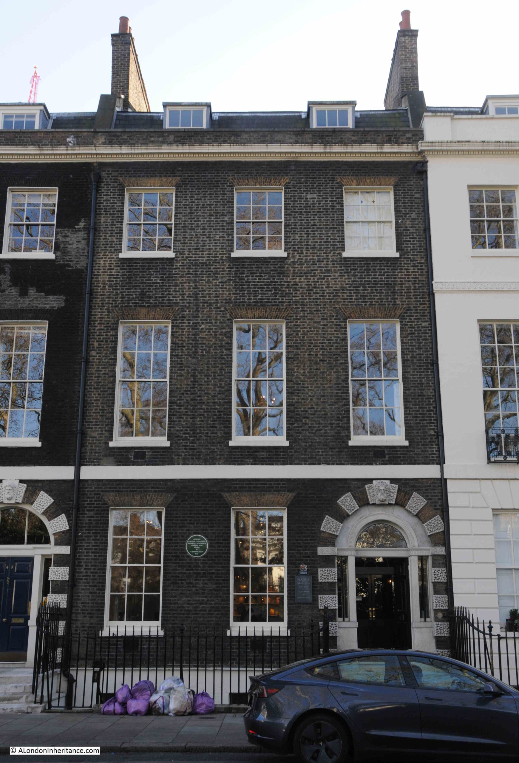
Bedford College for Women

Recording that the Bedford College for Women, the University of London was founded in the house in 1849 by Elizabeth Jesser Reid.

There is a connection between Ram Mohun Roy and Elizabeth Jesser Reid, as she was the daughter of a wealthy Unitarian ironmonger and was born in 1789. She married Dr. John Reid, a nonconformist, and in 1849 she founded the Ladies College or College for Women, using her Unitarian and Bloomsbury connections to gather support, and to get teaching staff and professors to teach at the college.

The College was the first higher education establishment for women in the country.

It would stay in Bedford Square to 1874, when the lease came up for renewal. The Bedford Estate did not want to renew the lease with the college, so the college moved to larger premises near Baker Street.

Yet another blue plaque:
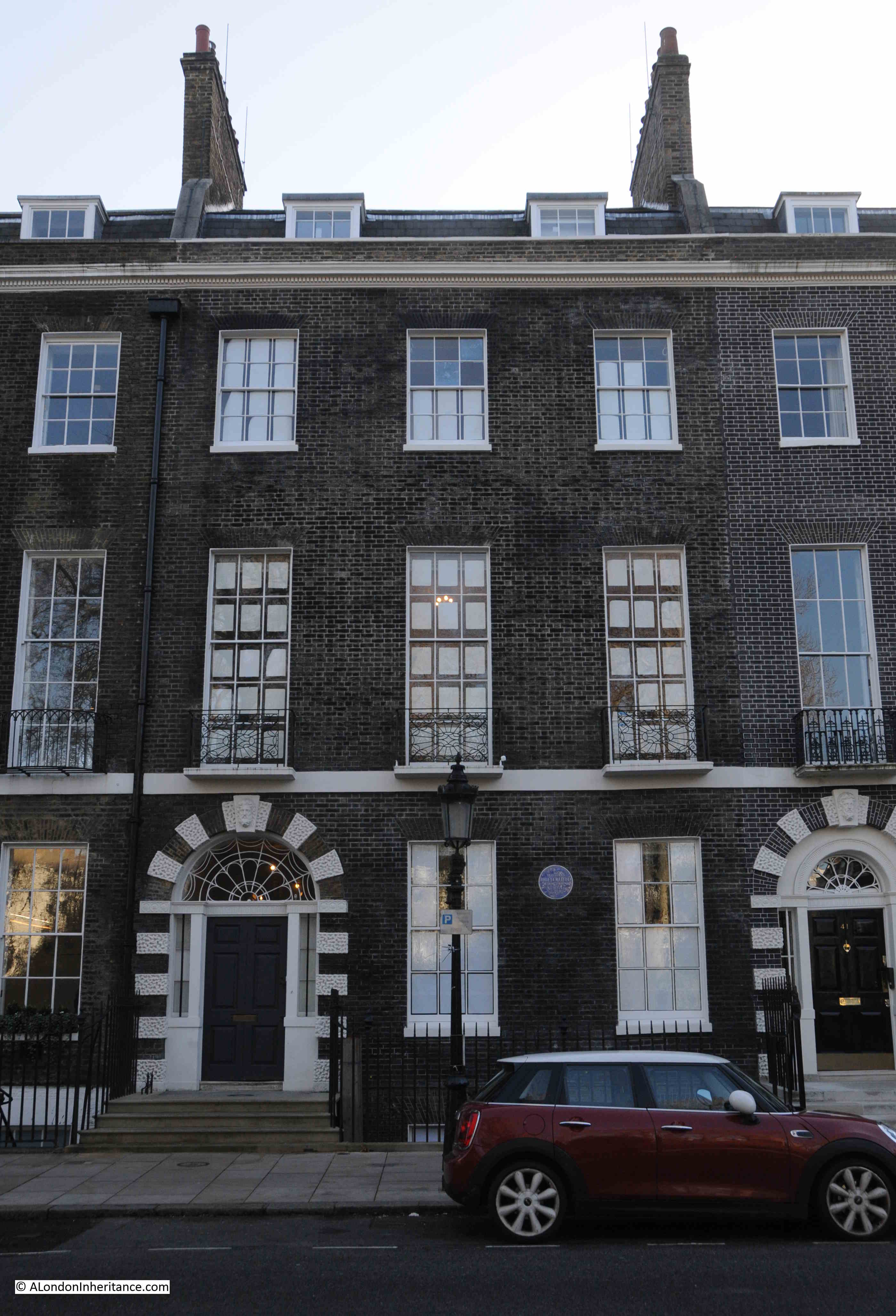
William Butterfield

This one to an architect, William Butterfield.

Born in London in 1814, Butterfield trained as an architect and established his own architectural practice in Lincoln’s Inn Fields, before moving to the Adelphi.

He was involved with the study of Gothic Architecture, and the Victorian revival of religious architecture. This resulted in a considerable amount of work on churches and their associated building both in London and across the country.

William Butterfield died in his house in Bedford Square on the 23rd of February, 1900.

That is just a sample of the plaques to be found in Bedford Square.

Today, Bedford Square is home to a number of cultural institutions, including Sotheby’s Institute of Art, Yale University Press, and the New College for Humanities.

Bedford Square is one of those rare places in London, where, if you took away all the cars, a resident from the late 18th century, just after the square was completed, could return today and externally, the square would be perfectly recognisable.

It is also interesting to consider that whilst there is so much change across London, and there have been multiple different buildings on sites across much of London, when we stand in Bedford Square, we are looking at the only houses that have been built here, since the land was fields.

It is a lovely example of architecture and street planning.

alondoninheritance.com

Hanover Stairs and The Ship – Rotherhithe

For this week’s post, I am continuing with one of my favourite London subjects – Thames Stairs, and I am in Rotherhithe to find Hanover Stairs, and also to check whether the stairs confirm my theory that nearly every Thames stair had an associated pub.

This was the view, early on a sunny morning, walking along the footpath beside the Thames, with Hanover Stairs signposted next to the steps down to the river:

Hanover Stairs

There is a gate at the top of the stairs, with a warning sign showing someone falling down the stairs, along with the danger warnings of Slippery Steps, Sudden Drop and Deep Water – all of which make sense for these stairs:

Hanover Stairs

A look down the stairs reveals that they are in very good condition and consist of brick steps leading down to a sandy foreshore:

Hanover Stairs

The Port of London Authority list of access points to the River Thames has very little information about these stairs. It just states that they were in use in 1977, consisted of concrete stairs and were in good condition.

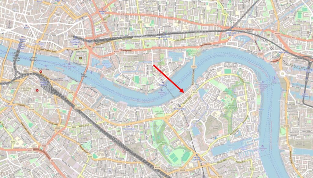
Hanover Stairs are in Rotherhithe, and I have marked their location with the red arrow in the following map (© OpenStreetMap contributors):

Hanover Stairs

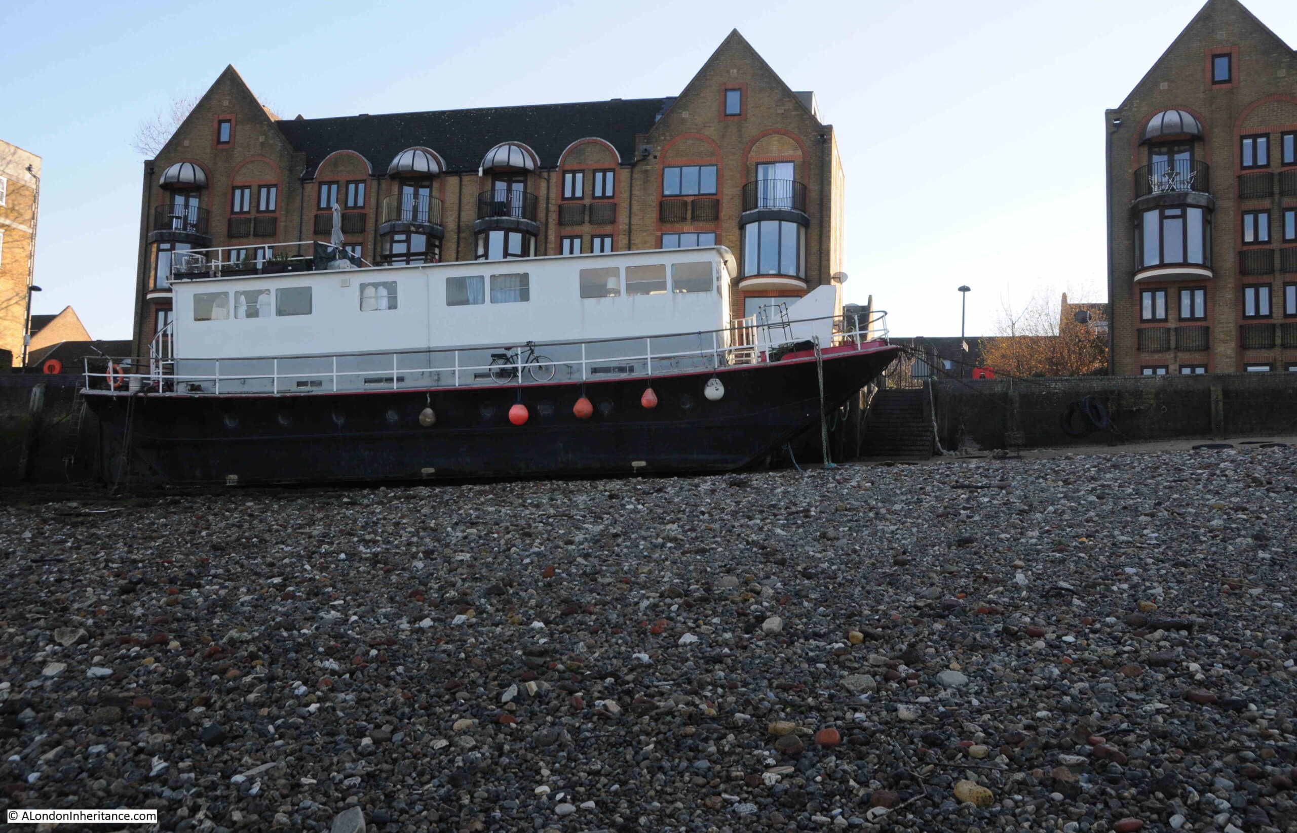
Hanover Stairs are rather unusual in that there is a ship moored at the foot of the stairs. A scene that was probably rather common when the river was in use and ships would have moored in the river and along the foreshore.

Hanover Stairs

Presumably a house boat, and equipped for permanent occupation as there are a range of pipes plumping in services between the ship and the shore.

During my visit it was a low tide and I could walk out for a reasonable distance across the foreshore. In the following photo, I am looking back from the water’s edge to the shore line, and the photo shows how the shore here drops considerably away from the edge of the land:

Hanover Stairs

Looking east, with Shadwell and Limehouse visible across the river:

Rotherhithe Gas Works Pier

On the right of the photo, just along the foreshore from Hanover Stairs, is the jetty that once served Rotherhithe Gas Works, which I explored in this post.

Looking across to Wapping on the northern shore of the river, and we can see New Crane Wharf:

New Crane Wharf

There is a gap to the left of New Crane Wharf. This gap is to allow access for another set of Thames Stairs – New Crane Stairs, which I wrote about in this post.

The narrow gap for New Crane Stairs, between two large buildings, shows the importance and persistence of Thames Stairs.

The following photo is looking west along the river, and in this photo we can clearly see how steep is the drop in the foreshore from the edge of the river out towards the centre:

Hanover Stairs

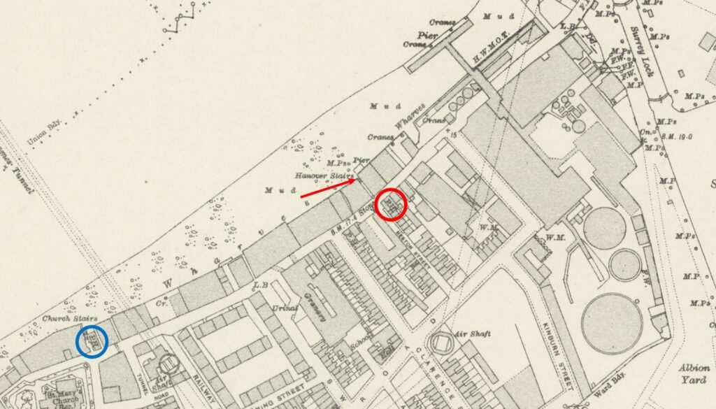
I have marked the location of Hanover Stairs with a red arrow in the following extract from the 1894 edition of the Ordnance Survey map  (‘Reproduced with the permission of the National Library of Scotland“):

Hanover Stairs

Next to the stairs, where the house boat is today, there was a small pier. On the foreshore, there is the abbreviation M.P.s – This stands for mooring posts and shows that ships and boats would have been moored along the foreshore at Hanover Stairs.

Large buildings line the river, warehouses and industrial sites, with a small number of terrace streets leading back in land.

To the upper right of the above map, is the pier for the Rotherhithe Gas Works, and these works can be seen running back in land, where the circular feature of the gas storage tanks can be seen.

I have a theory that nearly all Thames Stairs in populated and industrial areas, had a pub located next to the stairs, and Hanover Stairs continues to confirm this theory.

In the above map, I have ringed the PH of Public House which was opposite the stairs, where an alley led between two adjacent large buildings, down to the stairs.

I found the name of the pub by doing a newspaper search for Hanover Stairs, and found the pub had a good Thames related name of the Ship.

A typical example of where the Ship was mentioned in relation to the stairs, and an advert which shows how these pub were important for more than just drinking is the following advert which appeared in the Kentish Independent on the 24th of January, 1852, where an auction was being advertised for the “Stock of Mr. Little, Timber Dealer, who is retiring from business”.

The auction of Mr. Little’s stock included a very large quantity of timber, a “capital nearly new Timber Cart”, and rather strangely “a Sow and Four Pigs”.

The advert then goes on to list where the catalogue for the auction could be had, and this is where I found the reference to the Ship:

“Catalogues had: the Lord Duncan and Dover Castle, Broadway; Bratt’s New Cross Inn: Shard’s Arms, Old Kent Road: The Ship, Hanover Stairs, Rotherhithe; Prince of Orange, Greenwich; Three Tuns, Blackheath: Tiger’s Head, Lee: Dartmouth Arms, Sydenham Common; of Mr. Little on the premises, and of Mr. Rogers, Auctioneer, Valuer, Estate and House Agent, Lewisham.”

Another advert which mentions the pub was from June 1825 shows the type of excursion you could have taken on a summer’s day, early in the 19th century:

“GRAND NOVEL EXCURSION. A. READ, Captain of the FAVOURITE, Steam Packet, begs to inform his Friends and the Public that he has engaged the above elegant and commodious Vessel for an EXCURSION round the ISLE of SHEPPY, passing the Nore, Whitstable, Queenborough, and his Majesty’s Fleet at Sheerness, on Thursday, the 29th Instant, and return the same evening. A grand Band of Music will be provided. refreshments may be had on board at the usual moderate charges.”

Tickets for this “Grand Novel Excursion” were 5 shillings and 6 pence each, and the Ship was one of the places where you could buy tickets, and in this advert, Mr. Rounce was mentioned as the landlord of the Ship. Tickets were for sale widely across London, from the Rose by the Old Bailey, pubs in east London, both north and south of the river, a grocer in Tower Street, and offices in Fenchurch Street.

Both of these adverts show the importance of these local pubs to other commercial activities. They were places where you could advertise to the local community and use as local distribution hubs.

The importance of the relationship between the Ship and Hanover Stairs is that in these two examples, and many other reference I found, although the pub is in the street opposite the stairs, the name of the street is not mentioned, just the name of the pub and the name of the stairs.

The Ship closed around 1960, and sadly I cannot find any photos of the pub.

The majority of the Thames Stairs have lost their associated pub. A few still exist in Wapping (Pelican Stairs next to the Prospect of Whitby and Wapping Old Stairs next to the Town of Ramsgate).

In Rotherhithe, a surviving example is the Mayflower, where to the left of the pub can be found Church Stairs:

The Mayflower, Rotherhithe

21st century detritus washing up on the foreshore at Hanover Stairs:

On the foreshore

The earliest written references I could find to Hanover Stairs dates from the 1790s, where for example, on the 11th of January, 1796, in a list of Dividends to be paid to Creditors, there was the following “Alexander Christall and James Church of Hanover Stairs, Rotherhithe, Surrey, Sail-makers”.

On the 28th of November, 1761, it was reported that “The John and Thomas, Blickenden, loaded with Corn, is sunk in the River near Hanover Stairs”.

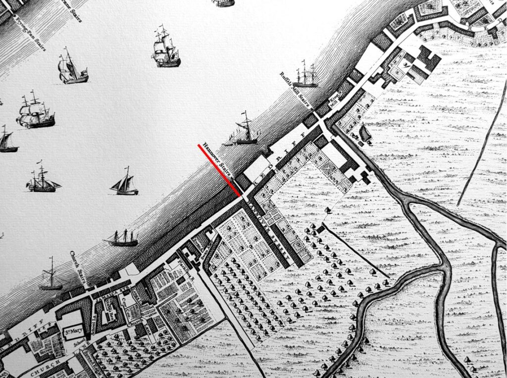
Hanover Stairs can be seen in Rocque’s map of 1746 (underlined in red):

Hanover Stairs

The map shows that in the 1740s, whilst the river’s edge was developed, a short distance inland it was still orchards, farmland, fields, marsh and streams. The section of the road that is now Rotherhithe Street was then named Redriff.

One of the few streets that leads inland from Redriff is directly opposite Hanover Stairs, and is named Hanover Street. I suspect the street took the name from the stairs, as these were probably a much older feature than the street.

I cannot find the source of the name Hanover as used for the stairs. Possibly there may have been local merchants from Hanover in Germany, of it may have been after George I, who became the first British King from the German House of Hanover who was on the British throne between 1714 and 1727.

Hanover Street changed named to Heston Street, and in the rebuilding of the area over the last few decades, the street that was one of the first running inland from the river, was built over and is now one of the many lost streets of the area.

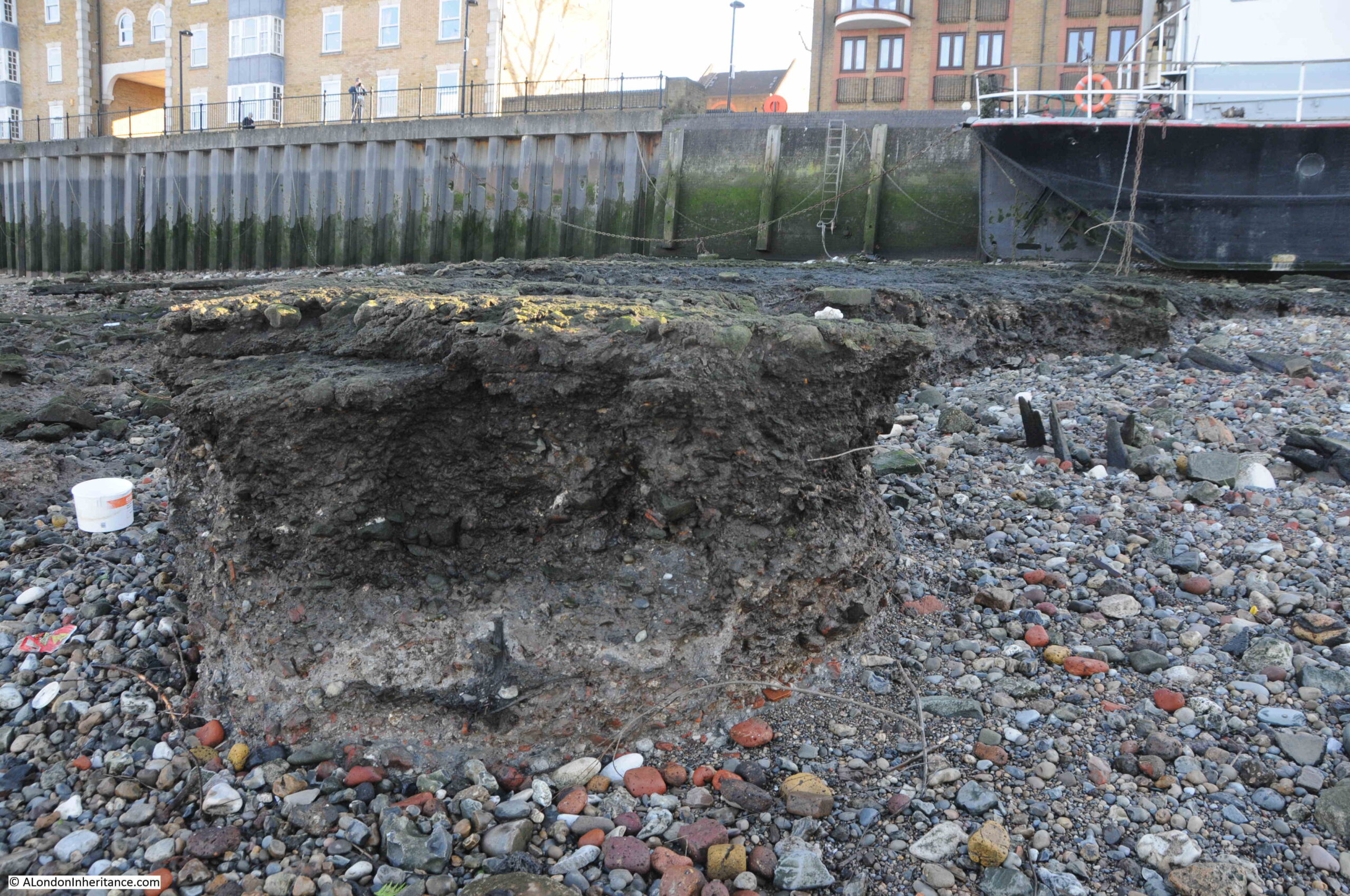
So the stairs along the foreshore have been here for at least 275 years, and features from the long industrial history of the area can still be seen along the foreshore, for example, large stretches of consolidated stone and concrete, much eroded by the river:

Hanover Stairs

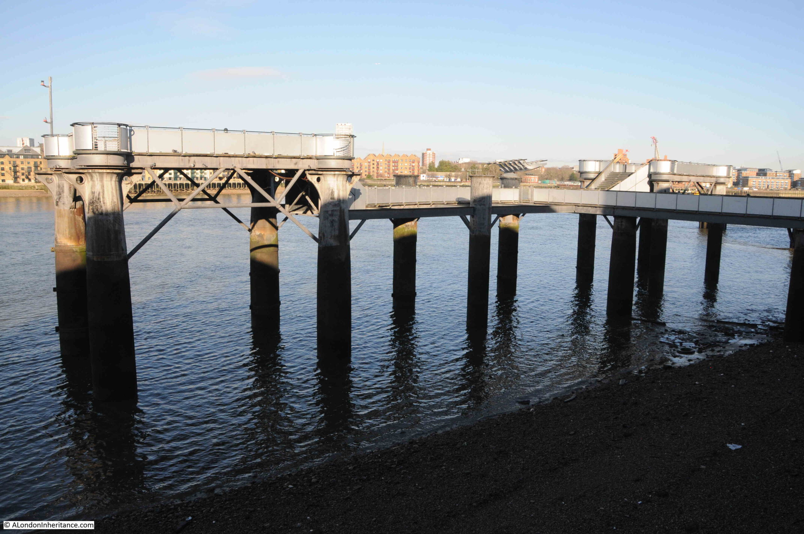
Looking along the foreshore from Hanover Stairs to the pier that once supplied the Rotherhithe Gas Works with coal arriving along the river:

Rotherhithe Gas Works Pier

Looking back at the steps of the stairs, with in the foreground some of the chains and weights used to keep the house boat securely moored alongside the river wall:

Hanover Stairs

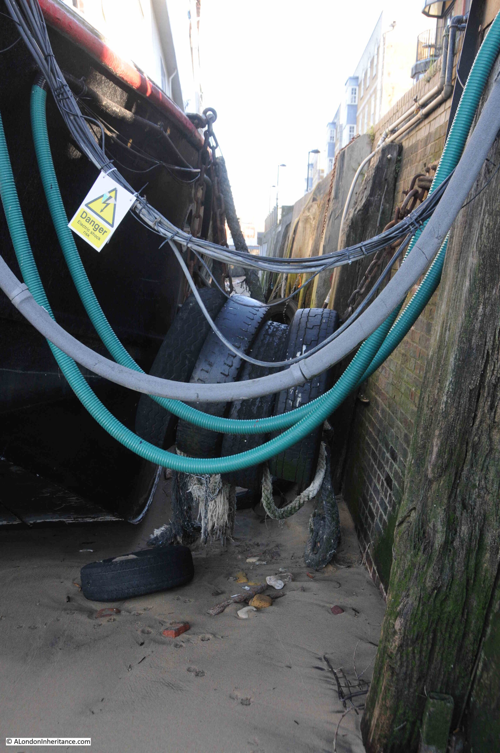
Cables and pipes carrying services to the house boat and tyres to protect the side of the boat:

Hanover Stairs

There are frequent mentions of Hanover Stairs in newspapers up to the 1930s, when the last two reports are about an 11 year old boy who drowned after falling into the river when he and his friends were playing on barges next to the stairs, and a thief who was caught in Rotherhithe Street with a sack full of Gin bottles, which had been stolen from a barge lying next to the stairs.

After the 1930s, there seems to have been very little happening at the stairs (or at least anything that was considered newsworthy). That may have been due to the level of bomb damage at the stairs and the surrounding streets, which was considerable.

After leaving the stairs, I walked along the river path to take a closer look at the former gas works pier:

Rotherhithe Gas Works Pier

The pier is in good condition, and is a suitable reminder of the connection between the river and the industries activities that once occupied so much of Rotherhithe:

Rotherhithe Gas Works Pier

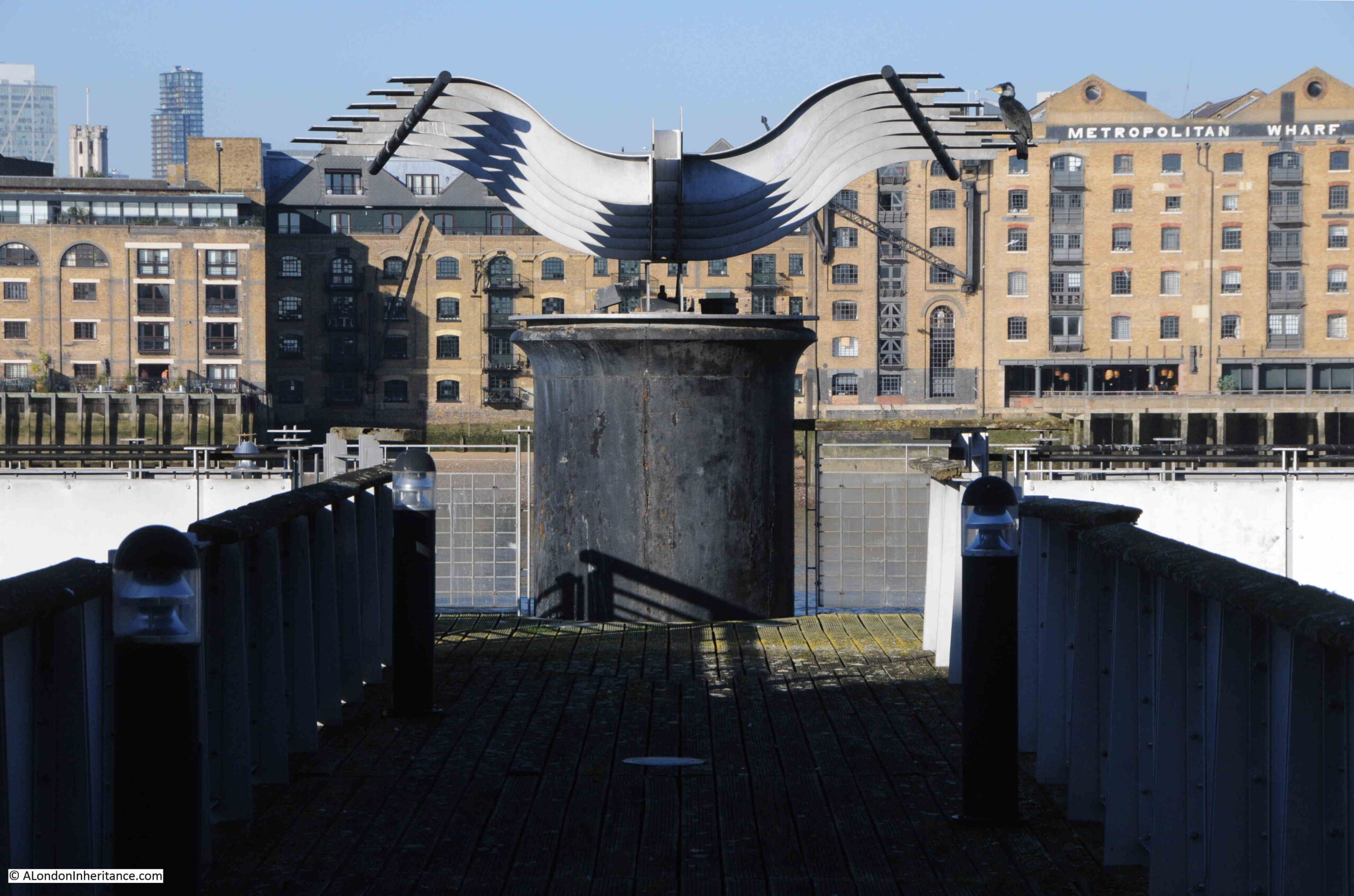
I have often wondered what the metal structure is on the rivers edge at the centre of the pier, shown in the photos above and below. I assume it is part of the equipment which once carried coal from ships moored alongside the pier to the gas works, however now standing isolated of any other infrastructure, it almost looks like a work of art.

Seen from head on, the curves of the shaped metal on either side almost give the whole thing the appearance of a bird flying in from the river:

Rotherhithe Gas Works Pier

Another set of Thames Stairs ticked off the list, and one that continues the link between a local pub and stairs.

They were an important combination in the day to day life of the working river. The stairs provided access to the river and the barges and ships moored nearby, the watermen that would take you to your destination along the river, a place where those working or travelling on or along the river would have known well.

The stairs were also a landmark, referenced whenever you needed to refer to something happening on the river, on land, or to get to this part of Rotherhithe.

The pub was not just a place to buy alcohol, it was an important part of the local community, a place where other commercial activities could take place, such as selling tickets or distributing auction catalogues, where inquests to those who died on the river were held, where those working on the river probably went in for a drink after returning via the stairs, a local meeting point next to the stairs etc.

And that relationship is strengthened by the names frequently given to these pubs, which often referred to some aspect of river life, as with the Ship next to Hanover Stairs.

alondoninheritance.com

London from the Roof of Albion Mill

I have just put a couple of my Limehouse and Wapping walks on Eventbrite for the month of June. Click here for details and booking.
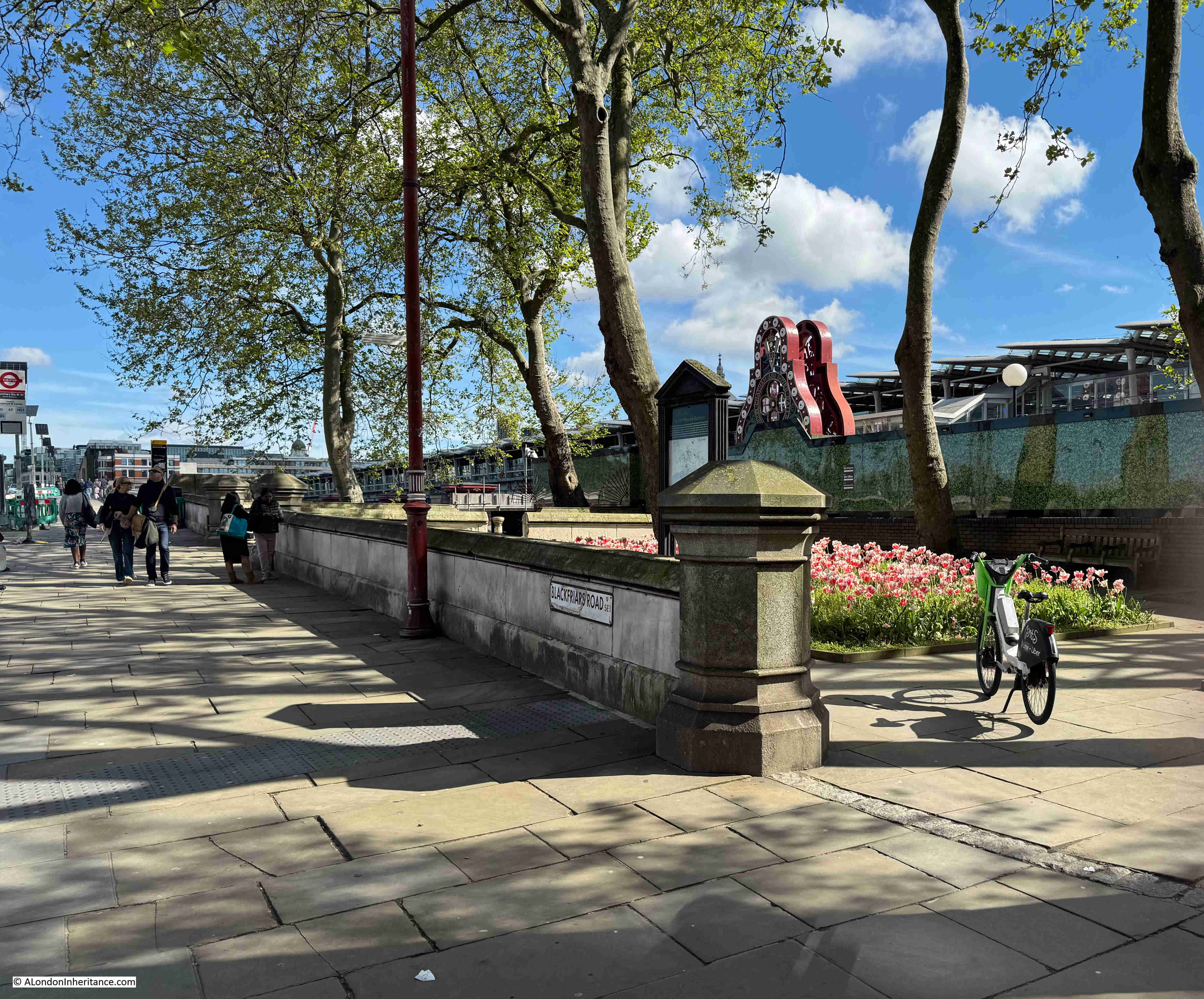
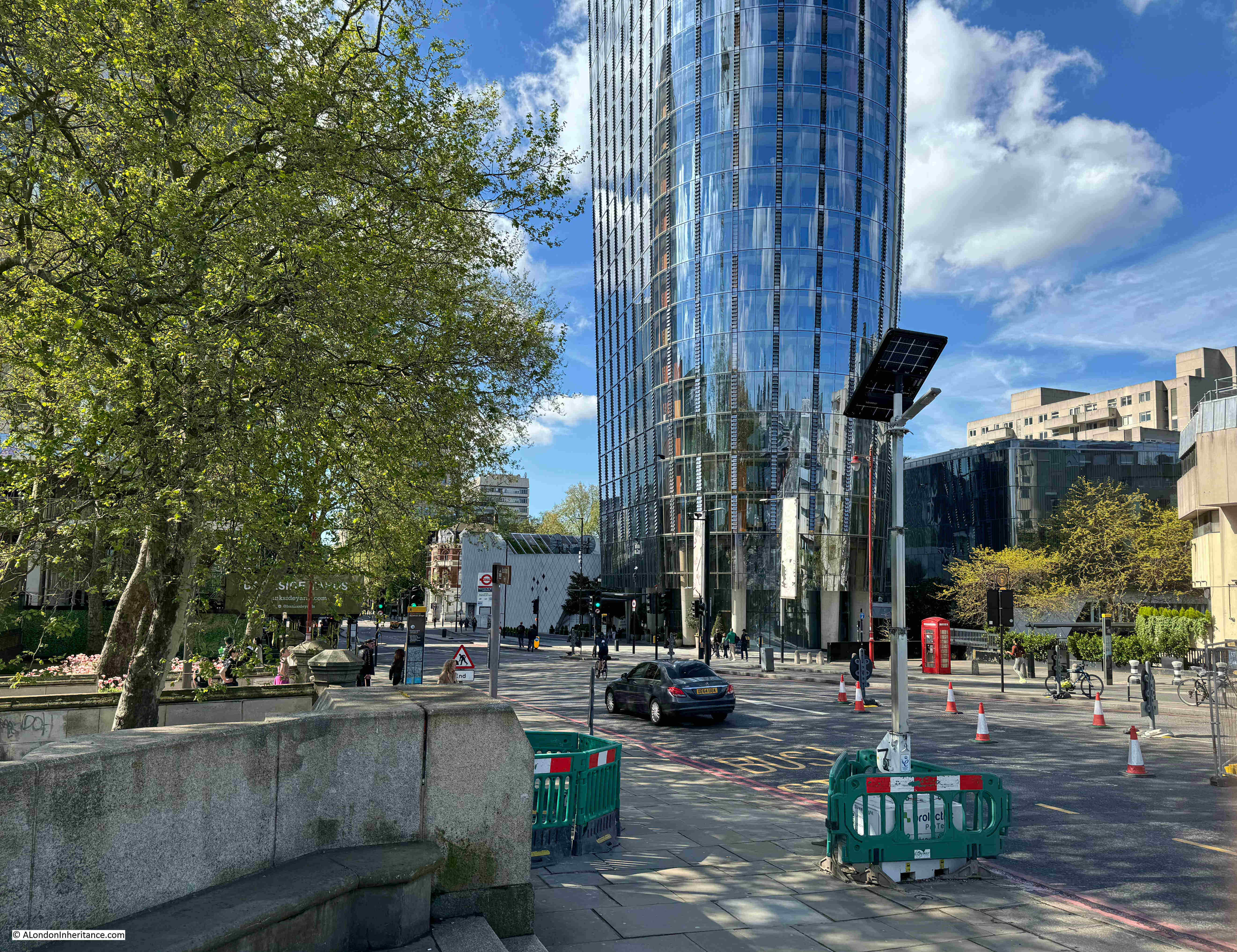
If you walk to the southern end of Blackfriars Bridge, on the eastern side of the bridge there is a small garden, and it is a perfect example of how places in London can tell multiple stories, and for the garden the story is of the engineer John Rennie, the Albion Mill, a unique view of London, as well as the price of grain and flour in London.

This is Rennie Garden alongside the path that runs up to, and along the eastern side of Blackfriars Bridge:

Rennie Garden

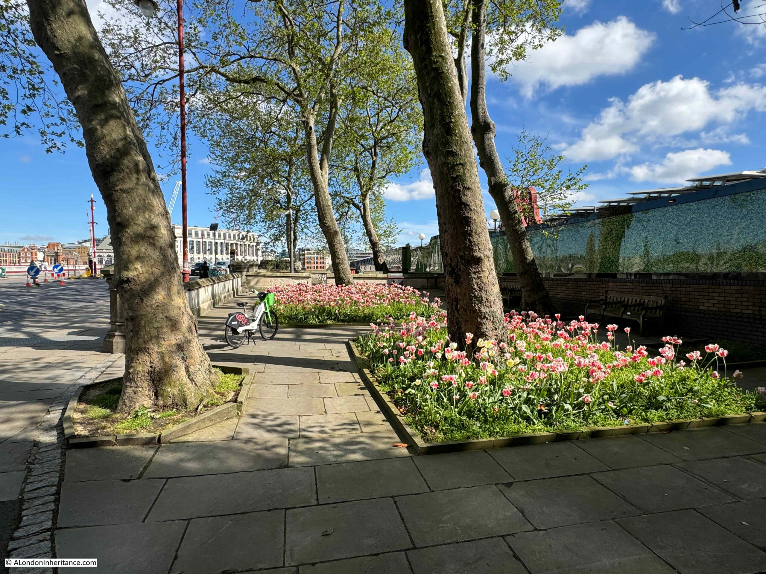
This is a very small garden and consists of a few trees and two blocks of planting:

Rennie Garden

Which really look good, and bring a splash of colour on a sunny May morning:

Rennie Garden

The gardens were created in 1862 by the Corporation of London and named the Rennie Garden after the engineer John Rennie.

Rennie Garden

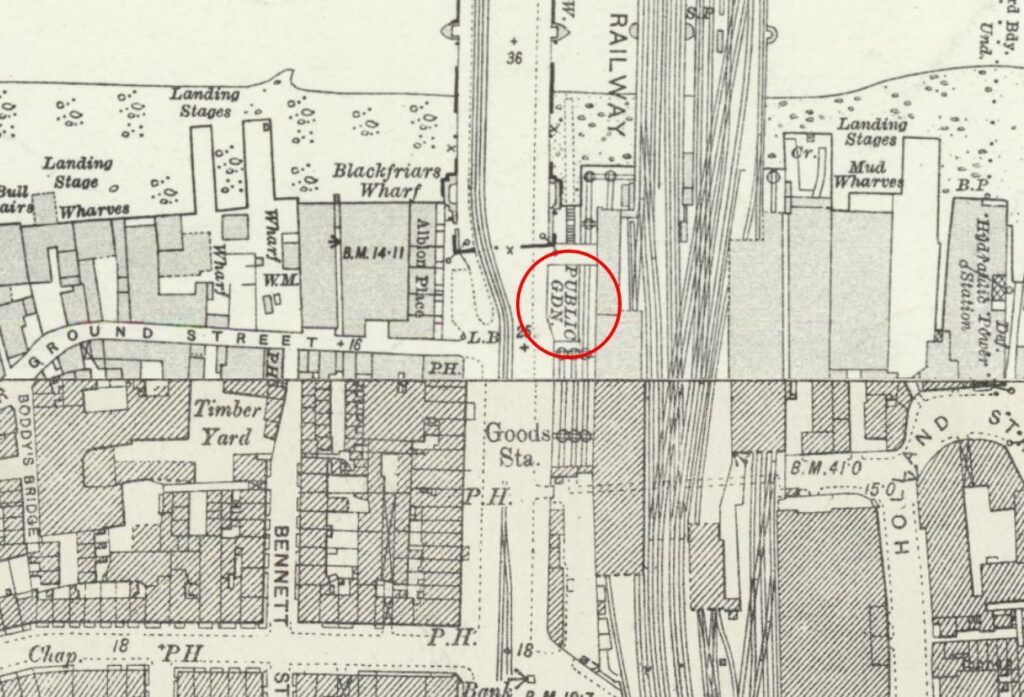
The following extract from the 1894 edition of the Ordnance Survey map shows the gardens (ringed in red), as a very small patch of public gardens squashed between the railway and the road, both of which were running on to the bridges which crossed the Thames (‘Reproduced with the permission of the National Library of Scotland“):

Rennie Garden

In the above map, some stairs can be seen running down to the foreshore from the north of the gardens. The stairs are still there today, however they now lead down to the walkway along the side of the river:

Rennie Garden

There are though stairs on the other side of the river wall which lead down to the foreshore. This is not a historic set of stairs and they seem to have been built around the same time as the bridge.

So why are the gardens named after John Rennie, and what is the connection with a mill, the price of flour and a view of London?

John Rennie was the architect of London Bridge (the version of the bridge that was later demolished and moved to Arizona in the US). After Rennie’s death in 1821, the bridge was built by his son, also named John, who continued his father’s practice as a civil engineer.

According to “A Biographical Dictionary of English Architects” by H.M. Colvin, (1954), John Rennie (1761 to 1821) “was the younger son of a Scottish farmer, and was born in Phantassie in East Lothian on June 7th, 1761. As a child he showed a remarkable aptitude for mechanical pursuits, and he afterwards found congenial employment with a millwright. His earnings enabled him to study at Edinburgh University for three years before establishing himself as a millwright and general engineer. In 1784 he went to Birmingham in order to assist Boulton and Watt in designing and executing the machinery for the Albion Flour Mill ay Southwark”.

And that is the connection between John Rennie and the gardens, as they are on part of the site of the Albion Flour Mill, the first steam powered flour mill in London and at the time of completion, the largest in the world.

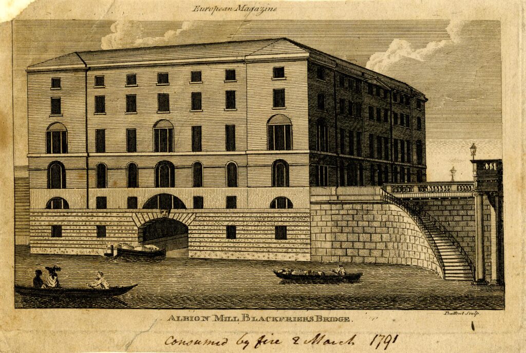
The Albion Flour Mill, Blackfriars Bridge is shown in the following print, with the edge of the bridge (the version before the Blackfriars Bridge we see today) at the right edge of the print:

Albion Mill

Before the Albion Mill, there had been a number of much smaller mills scattered across London and the counties surrounding the city, using a range of power sources such as wind and water.

The introduction of steam power rendered all these other mills redundant as the Albion Mill could process large quantities of grain with a reduced level of manpower. Being next to the river enabled both coal and grain to be delivered directly to the mill.

Newspapers reported on the opening of the Albion Mill, and the following from the 10th of April 1786 is typical “A few days since the Albion Mill, on the Surrey side of Blackfriars Bridge, commenced working. This mill, the largest in the world, has been erected by the proprietors for the beneficent and salutary purpose of supplying this great metropolis with flour, and of course reducing the price of bread, the greatest blessing the poor can experience on this earth. The machinery is worked by the operation of steam, and we are happy to say, there is every reason to expect it will amply fulfil the intent, and fully reward the ingenuity and public spirit of those gentlemen who have risked their money in this arduous and laudable undertaking”.
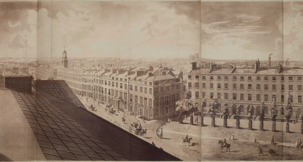
As well as being the first use of steam power in London to produce flour, the Albion Mill’s name was associated with a panoramic drawing made from the roof of the building “London from the roof of Albion Mills”.

The panorama as a form of painting and exhibition was invented by a Scottish painter, Robert Barker. One of the 19th century accounts of the history of the panorama claims that Barker had been imprisoned for debt in Edinburgh in 1785. “His cell was lighted by an air-hole in one of the corners, which left the lower part of the room in such darkness that he could not read the letters sent to him. He found, however, that when he placed them against the part of the wall lighted by the air hole the words became very distinct. the effect was most striking. It occurred to him that if a picture were placed in a similar position it would have a wonderful effect. Accordingly on his liberation he made a series of experiments which enabled him to improve his invention, and on June 19, 1787, he obtained a patent in London, which established his claim to be the inventor of the panorama”.
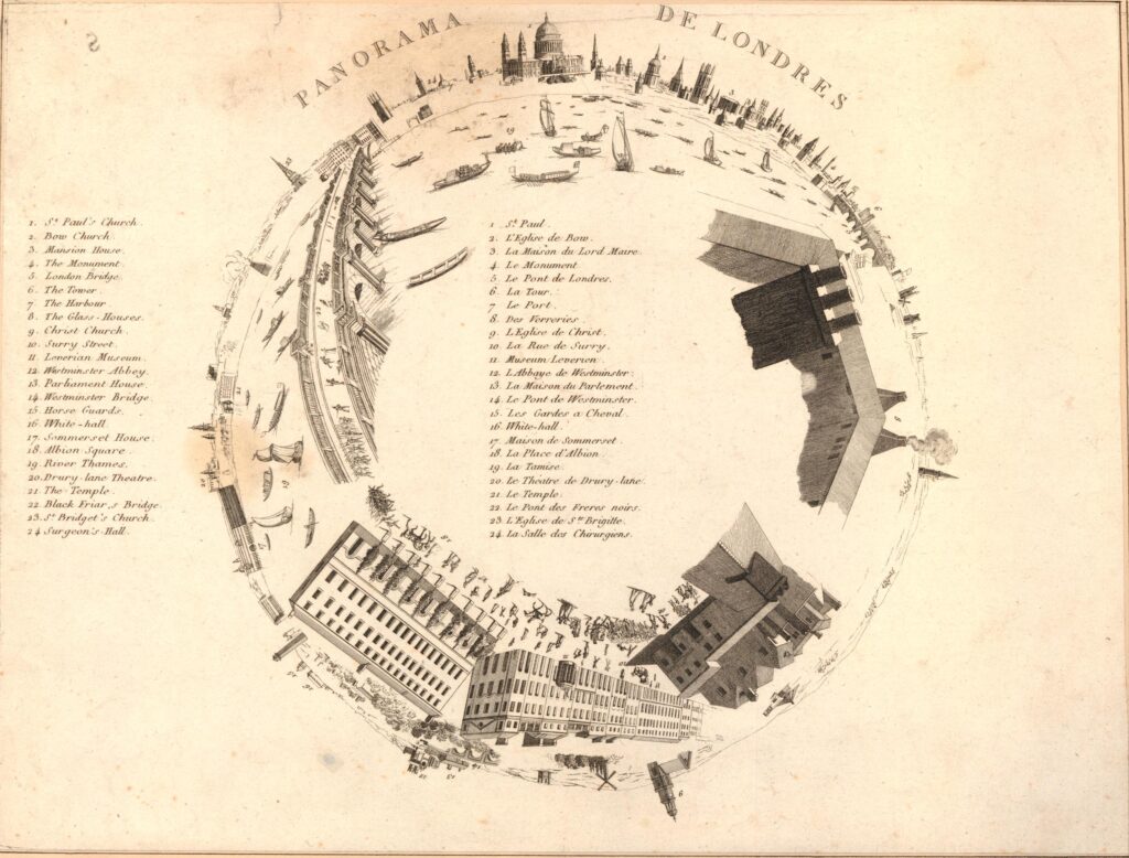
To display his new invention, Barker raised enough money to build “an entire new Contrivance or Apparatus for the Purpose of displaying Views of Nature at large by Oil-painting, Fresco or any other mode of painting and drawing”. This was to be found next to Leicester Square, with a small entrance from Cranbourn Street.

Barker gave his display the name “Panorama”, and once inside, spectators would stand on a raised circular platform in the centre of a round building. They were about 30ft away from the circular wall on which was painted the scene to be viewed, stretching for the full 360 degrees around the spectators.

After entering in the dark, light was then let in from the roof, and it was focused on the scene painted on the surrounding wall – the panorama.

The lighting and the quality of the painting on the wall gave the effect of standing in the middle of the real scene that was portrayed around the wall.

To keep paying spectators returning, Barker regularly changed the panoramas on display, and they were not limited to landscapes. One very popular panorama was of the Naval Grand Fleet lying at Spithead, with Portsmouth and the Isle of Wight in the background.

Robert Barker’s panoramas were very successful and always drew a crowd wherever they were on display. He opened panoramas in France, Holland and Germany, and the panoramas on display in Leicester Square would also go on tour around the country, as the following from Aris’s Birmingham Gazette on the 22nd of October, 1798 illustrates:

“By particular Desire of a Number of Families of Distinction in Birmingham and its Environs; the PANORAMA, Union-street, or perspective VIEW of the GRAND FLEET at Spithead, will continue open till Saturday next, the 27th instant, on which day it will positively and finally close, in order to embark for Hull, where it is engaged. That part of the public who have not yet had an opportunity of seeing the Grand Exhibition, will do well to take the present Opportunity of seeing the Wooden Walls of England before their Departure. Admittance One Shilling.”

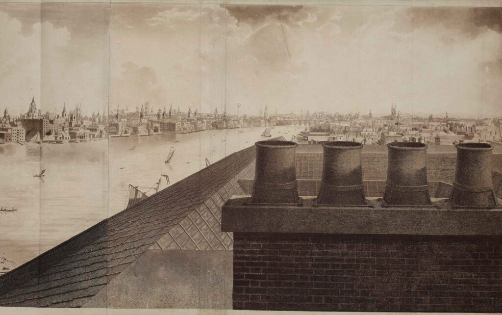
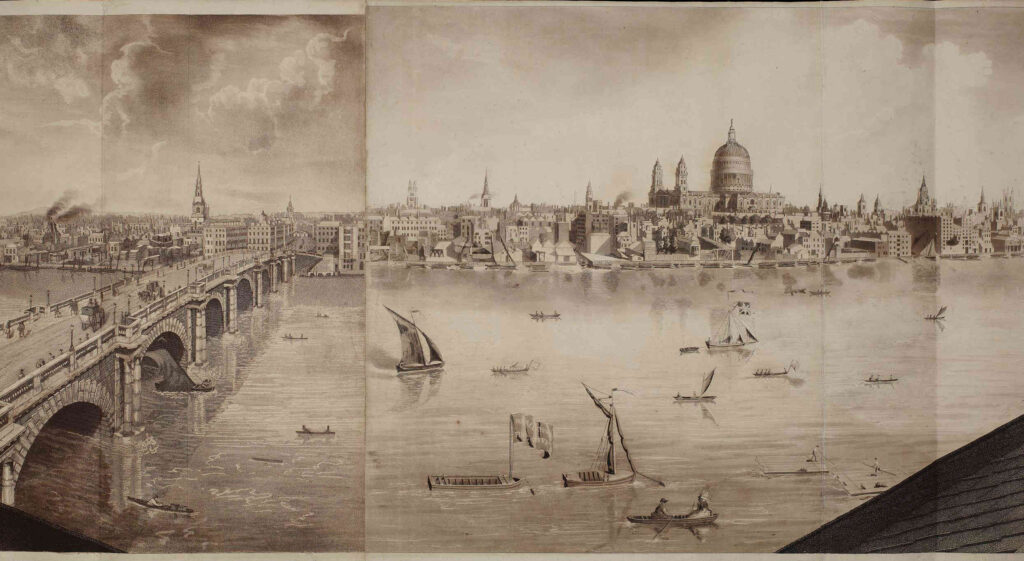
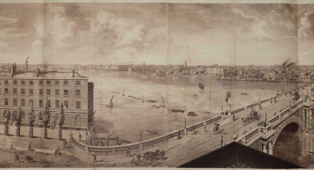
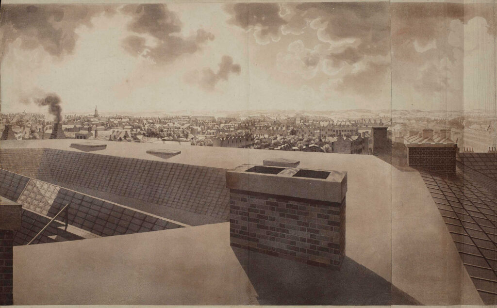
After completion, the Albion Mill was the highest building between St. Paul’s Cathedral and Westminster Abbey, so it was the ideal location from where to make another panorama, and to do this Barker sent his 16 year old son up to the roof of the mill in the winter of 1790 to 1791 to paint the view for the full 360 degrees – a vast panorama of London at the end of the 18th century.

The British Museum have a copy of the panorama from the roof of Abbey Mill in their collection, and it is available for use under a Creative Commons license, so although today I cannot get to the same height and specific location from where the panorama was made, below is a very rough comparison of the early 1790s with the view of London today.

All the prints in this post are  © The Trustees of the British Museum Creative Commons Attribution-NonCommercial-ShareAlike 4.0 International (CC BY-NC-SA 4.0)

Looking to the east:

Panorama from the roof of Albion Mill

Looking to the north and we can see St. Paul’s Cathedral, spires of the City churches, and the Blackfriars Bridge on the left:

Panorama from the roof of Albion Mill

To the west:

Panorama from the roof of Albion Mill

To the south-west:

Panorama from the roof of Albion Mill

A very different view today:

Panorama from the roof of Albion Mill

To the south:

Panorama from the roof of Albion Mill

To mirror the above view, I would be looking straight at the Rennie Garden as in the photos earlier in the post.

As with Robert Barker’s other panoramas, the View from the Roof of Albion Mill also travelled across the country, and internationally, so for example, in 1796 it was on display in Philadelphia in the US, where you could walk in to see the view of London for half a dollar.

The panorama was also printed onto single sheets to give an idea of the view of London:

Panorama from the roof of Albion Mill

The Albion Mill did not last for long as in March 1791, a couple of months after the panorama was completed, the entire building burnt down.

The following report from newspapers of the time covers the fire, and also provides a possible cause:

“Yesterday morning, soon after six o’clock, a most dreadful fire broke out in the Albion Mills, on the Surrey Side of Blackfriars Bridge, which raged with such unbaiting fury, that in about half an hour the whole of that extensive edifice, together with an immense quantity of Flour and Grain, was reduced to ashes; the corner wing, occupied as the house and offices of the Superintendent, only escaping the sad calamity from the thickness of the party wall.

It was low water at the time the fire was discovered, and before the engines were collected, their assistance was ineffectual; for the flames burnt out in so many directions, with such incredible fury, and intolerable heat, that it was impossible to approach on any side till the roof and interior part of the building tumbling in completed the general conflagration in a column of fire, so awfully grand as to illuminate for a while the whole horizon.

The wind being easterly, the flames were blown across Albion place, the houses on the west side of which were considerably scorched, and the inhabitants greatly alarmed.

In the lane adjoining the Mills one house was burnt to the ground, and others considerably damaged. The Accident is supposed to have been occasioned by the Machinery having been overheated by Friction.

Another circumstance has been mentioned, that might operate either as an original or secondary cause in producing the above catastrophe:- A quantity of Grain that lay contiguous to the Machinery had been damaged by the late Floods, and was Yesterday Morning observed to have acquired such a degree of Heat, as made some of the Workmen conceive that it might be dangerous to put the Mills in motion. The Remark was not attended to, and the Consequence has been what we have related.”

So after 5 short years the Albion Mills had completely burnt down.

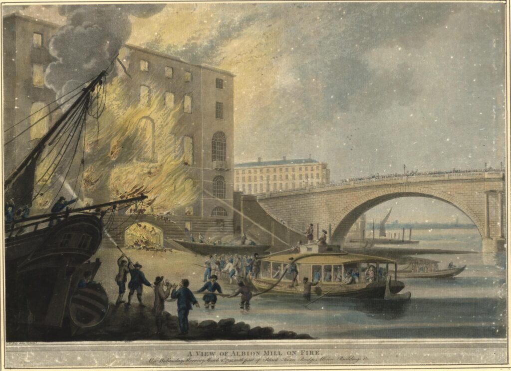
The following print shows the mill on fire, attempts to pump water from the river at low tide, into the fire, and watching crowds lining the side of Blackfriars Bridge:

Albion Mill

The total loss of the Albion Mill was estimated by the companies that had insured the mill at around £90,000. There were also concerns about the loss of a large quantity of grain, and what this would do to the price and availability of flour. The proprietors of the mill were able to assure concerned Londoners that whilst a large quantity had been lost at the Albion Mill, they still had large quantities at other grain stores.

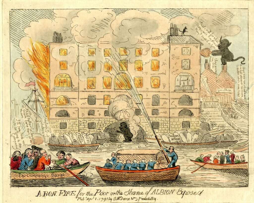
There were many though, who celebrated the loss of the Albion Mill, and a number of satirical prints were published about the fire:

Albion Mill

In the above print, the dejected owners can be seen in the boat at lower left. In front of the building there are two barges on the river. The left barge is filled with sacks labelled Pot80 (potato), and the barge on the right with sacks of Indian Wheat. These sacks were implying that the flour produced at the mill had been adulterated. A number of demons can be seen rejoicing at the fire.

The opening of the Albion Mill had a very serious impact on all the millers in London and the counties surrounding the capital. The use of steam power had allowed the mill to produce flour quickly and efficiently, and the impact of this resulted in the closure of many other mills.

As an example of both the impact of the working Albion Mill, and the after effects of the fire, the following is from the Hampshire Chronicle on the 14th of March 1791:

“The Berkshire millers are sensibly affected by the late fire at the Albion mills, but not with grief. Many of them, who gave over working two years since, have again set their wheels in motion.

The flour-mills at Blackwall, Poplar, Limehouse, Rotherhithe, and many other places, which have stood still upwards of these three years, have also begun working again, owing to the Albion mills being burnt down.”

The price of flour had increased during the time of the mill’s operation. In the five years prior to opening, the average price of flour had been 44 shilling, 6 and a quarter pence. During the years the mill was in operation, the average price had increased to 45 shillings and 2 pence. A small increase, but still an increase.

It was argued that the increase in price was down to two bad harvests and that there had been a scarcity of wheat throughout all of Europe.

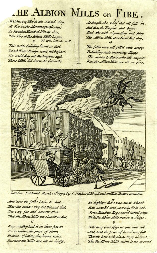
The following print also had a celebratory theme to the fire at Albion Mills, with a demon playing a fiddle on Blackfriars Bridge as the mill burns, whilst another demon fans the flames:

Albion Mill

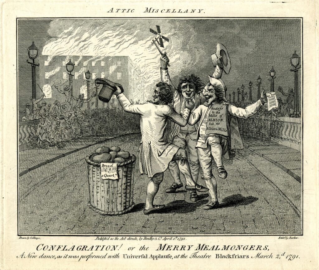
The following print is titled “A New Dance, as it was performed with Universal Applause, at the Theatre Blackfriars March 2nd 1791” and shows a celebrating crowd on the bridge, and three men dancing in the foreground. The man on the right has a sheaf of papers over his shoulder on which is written “Success to the Mills of Albion but no Albion Mills”:

Albion Mill

One of the main complaints against the Albion Mill was that by being able to process so much grain and flour, and by forcing so many other mills to close, it was becoming a monopoly. These allegations may have had some truth, as soon after the fire, it was reported that:

“However well or ill informed the charge of monopoly against the Albion Mill Company may have been, the destruction of their mill has been followed by an almost immediate fall of three shillings per quarter in the price of wheat. This is proof that they were generally considered as having it in their power to keep up the price artificially.”

There were proposals to rebuild the mill in the years following the fire, however permission was not granted for the project, and houses were later built on the site of the Albion Mill.

I always find it surprising how you can take one very small spot in London, in this post, Rennie Garden at the southern end of Blackfriars Bridge, and find layers of history, and so many other connections. The story of John Rennie, a leading mechanical engineer in the later decades of the 18th century, the first steam driven mill in London, the story of the panorama and a unique and innovative view of London in the late 18th century, and the price of grain and flour.

alondoninheritance.com

British Empire Exhibition, Wembley, 1924

I am a couple of weeks late with this post, as it should have been towards the end of April to coincide with the opening on the 23rd of April, 1924, of the British Empire Exhibition at Wembley.

A look at the exhibition is interesting as it shows how much has changed in the space of one hundred years. Physical change at a place where London was expanding in the 1920s, change in Britain’s place in the world, and a change in attitudes.

I have a copy of the plan of the exhibition site, and it is wonderful example of mid 1920s graphic design:

British Empire Exhibition

The plan was created by Stanley Kennedy North (a small box to lower left states “Done by Kennedy North 1923”).

Kennedy North was an interesting character who worked across a wide range of media including stained glass, maps and advertising posters.

The plan was created 10 years before Harry Beck’s innovative map of the London Underground, which still forms the basis of the map in use today, so Kennedy North portrayed the routes across London leading to Wembley Park in his own style, and across the lower part of the map are the routes and stations that will take the visitor to the stations in Wembley for the exhibition.

The text at the bottom left corner of the plan informs the visitor that “The Exhibition is 6 miles from Marble Arch by road. There are 120 stations in the London area from which it may be reached in an average time of 18 minutes, and from 120 it is possible to travel to the Exhibition without changing. Trains from Baker Street and Marylebone take 10 mins; Piccadilly Circus 15 mins; and Charing Cross 18 mins. Trams pass the South Entrance from Finchley, Hampstead, Paddington, Willesden, Hammersmith, Putney, Acton, Ealing. Omnibus services run to all the entrances”.

Wembley in the 1920s was an area transforming from a rural landscape to a built suburb of London, and many Londoners would probably not have known the area, or visited before, so the travel details in the plan with timings demonstrated how easy it was to reach the exhibition site.

The Wembley site was chosen in 1920, when the Government gave the go-ahead for the exhibition, and it would be built on the site of some pleasure gardens built in the 1890s Sir Edward Watkin.

The focus of the 1924 exhibition was the new stadium, which had been built for the exhibition, and would be the site for the opening and closing ceremonies, as well as a wide range of events during the exhibition.

It was intended to demolish the stadium after the exhibition, however it was kept open afterwards and used for major football events, as well as hosting the 1948 Olympics.

The Britain from Above website has a number of photos showing the site, with the stadium to the south, built alongside the railway, and the Empire Exhibition site around the east, west and running north of the stadium:

British Empire Exhibition

Source: https://www.britainfromabove.org.uk/image/EPW010737

The idea that the stadium was intended as a temporary structure may seem remarkable given the size and construction effort, however a glimpse of the overall site as shown in the above photo gives an indication of how much building work was required to complete the exhibition site.

This was also a time when Wembley was transforming from a rural landscape of fields, hedges. trees etc. into a fully built part of the wider London.

The following photo of the exhibition, looking to the east shows that fields were still surrounding much of the overall exhibition site. The tracks of the railway which would facilitate much of the development of the land can be seen to the right of the stadium, and along the northern edge of the site, splitting off at Neasden which would be at top right:

British Empire Exhibition

Source; https://www.britainfromabove.org.uk/image/EPW010844

Britain from Above dates the following photo of the stadium to 1923, and again it shows how rural Wembley was, one hundred years ago:

Wembley Stadium

Source: https://www.britainfromabove.org.uk/image/EPW008545

This photo is looking north, with the very first stages of construction of the new stadium. The photo is dated 1922, and the trees in the photo appear to be in leaf, so if 1922 is correct, then the stadium would be built in less than a year which seems remarkable if the date is correct:

Wembley Stadium

Source: https://www.britainfromabove.org.uk/image/EPW007831

The aim of the 1924 Empire Exhibition was to demonstrate and celebrate Britain’s place in the world, along with the British Empire which was portrayed as “Co-operation Between Brothers”.

The exhibition was opened on the 23rd of April, 1924 by King George V. Some excerpts from his opening speech serve to show some of the thinking behind the exhibition:

“The Exhibition may be said to reveal to us the whole Empire in little, containing within its 220 acres of ground a vivid model of the architecture, art, and industry of all the races which come under the British Flag.

It represents to the world a graphic illustration of that spririt of free and tolerant co-operation which has inspired peoples of different races, creeds, institutions, and ways of thought to unite in a single commonwealth, and to contribute their varying national gifts to one great end.

This Exhibition will enable us to take stock of the resources, actual and potential, of the Empire as a whole; to consider where these exist and how that can be best developed and utilised; to take counsel together how the peoples can co-operate to supply one another’s needs and to promote national well-being.

It stands for a co-ordination of our scientific knowledge and a common effort to overcome disease and to better the difficult conditions which still surround life in many parts of the Empire.”

The speech demonstrated a very paternalistic view of the Empire, and that the focus of the Empire was on the common good, but the sentence that “of all the races which come under the British Flag”, and the comment that the exhibition will “enable us to take stock of the resources, actual and potential, of the Empire as a whole”, demonstrate why the Empire was considered important to the country, and Britain’s place in the world.

Built to the north, and around the stadium were a whole series of buildings and pavilions, as well as a lake.

The buildings and pavilions were each dedicated to a specific country or region in the Empire, as well as two large buildings, one each for Industry and Engineering, and a smaller building for Art.

The size of the country buildings perhaps illustrates the relative importance at the time of each, with large buildings for Australia, Canada and India, and smaller buildings for South Africa, East Africa, the Gold Coast etc. down to Malta which appears to have had the smallest building on the site.

Each of these buildings featured displays from the country, customs, resources, products and people, and many of the country buildings included indigenous people demonstrating some of their local crafts. Looking at some of the film from the exhibition and it is hard to see these indigenous people as being just part of the exhibits on show to the visitors to the exhibition.

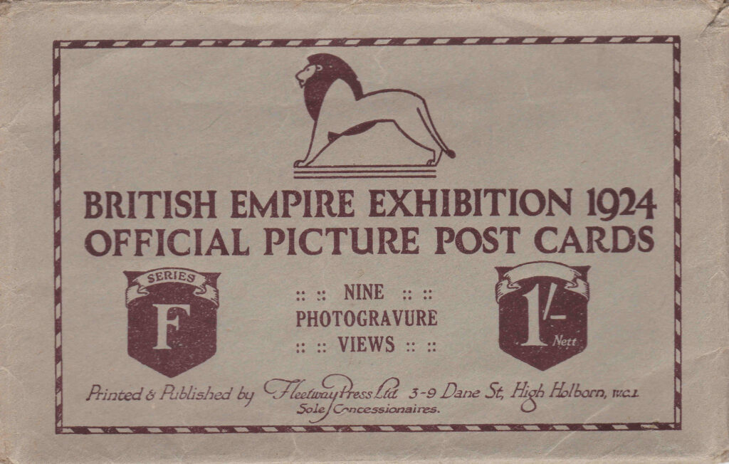
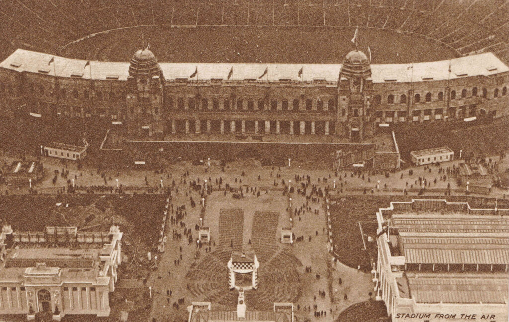
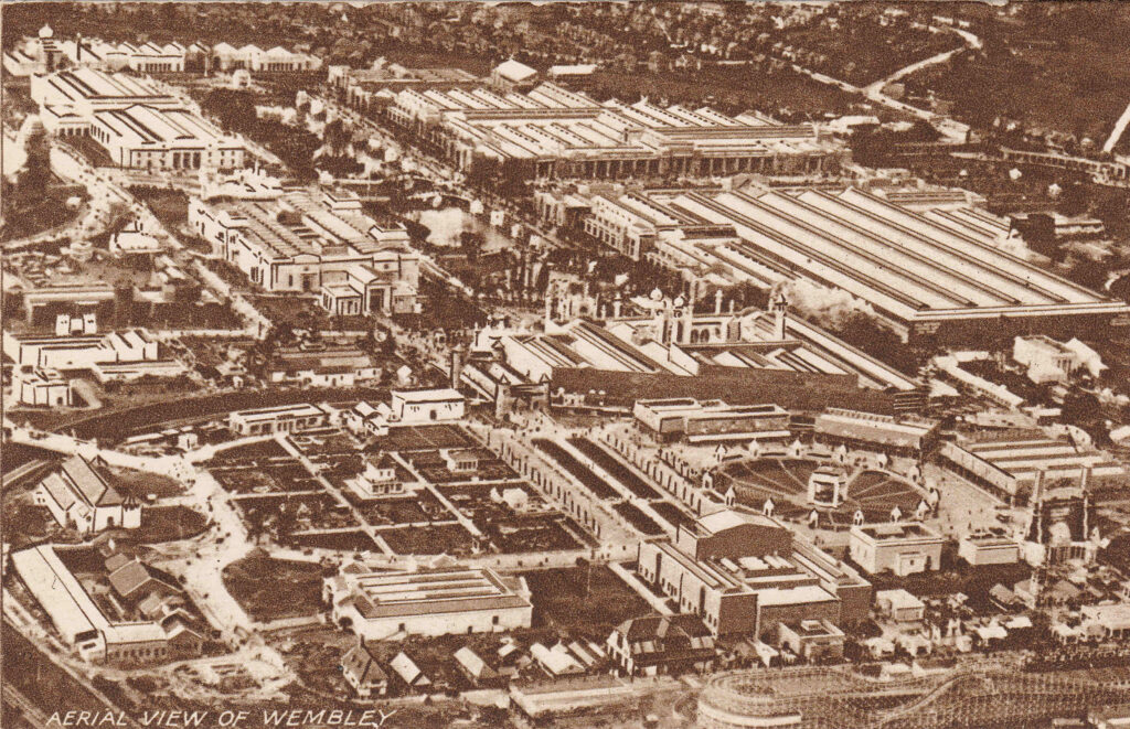
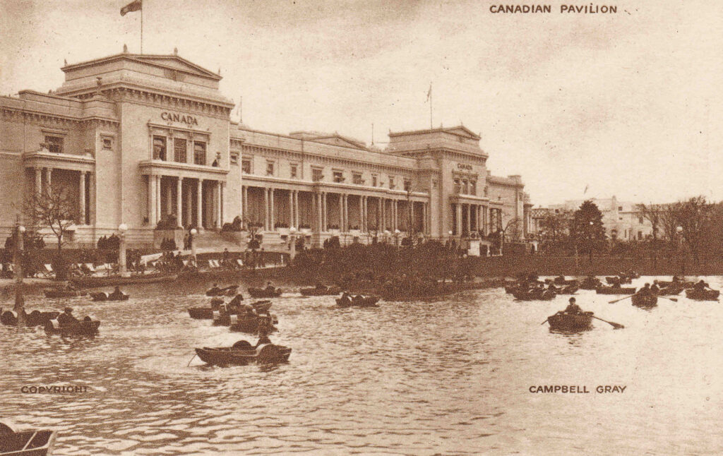
If you were a visitor to the 1924 British Empire Exhibition then you may have wanted to return home with a souvenir, and some of the most popular were a range of postcard packs showing various scenes from the exhibition.

I have a couple of these, and they show what it would have been like to walk around the exhibition, and to appreciate the substantial scale of the exhibition which had been built on a green field site in a couple of years.

British Empire Exhibition

The first shows the approach to the Empire Stadium as it was named for the exhibition, with the twin towers on either side of the main entrance. Of the two buildings in the lower part of the photo, the Australian pavilion is on the right, and that of Canada on the left:

Wembley Stadium

The first game of football hosted by the Empire / Wembley Stadium was in the year before the exhibition, when the 1923 FA Cup Final was held between Bolton Wanderers and West Ham, and which Bolton went on to win 2 – 0. The stadium had only just been completed and there was some doubt whether it would be ready in time. The Football Association were though keen to stage the event in the new, large stadium.

The result was crowds of much higher numbers than the stadium could accommodate, and scenes of chaos before the match could be completed.

The stadium had been built for 127,000 people, however the numbers that crammed in to watch the final were anywhere between 200,000 and 300,000. There were too many to make an accurate count, and the higher number was the estimate by the Police.

Headlines from the following day given an indication of the problems at the stadium, for example, from The People (London, Sunday April 29th 1923):

“1,000 Casualties at the Cup Final, Mob Overruns the Ground, Barriers Stormed and Pitch Invaded, Unparalleled Scenes, 200,000 Crush into Space For 127,000, Mounted Police 40 Minutes Tussel, F.A, Disclaim Responsibility.

Scenes without parallel in the history of football occurred at Wembley Stadium yesterday when mob-law spoiled the match for the Cup between West Ham United and Bolton Wanderers, which the latter won by two clear goals.

Crowds swarmed onto the playing pitch and for some time perfect chaos reigned. It is estimated that about 1,000 people were treated for minor injuries. mounted police were sent for, and they had to be used to clear the ground, the players themselves doing their best to persuade the unruly spectators to give them sufficient space to play the game.

Eventually, after wild scenes, the teams managed to begin the match, but even then the crowd persisted in interrupting play, and at one period the game had to be suspended for 12 minutes while the pitch was again cleared.

Mr. F.J. Wall, Secretary of the F.A, made the following statement – The F.A. greatly regret the inconvenience caused to the spectators during the match, but can assure the public that the arrangements were not in their hands and that they cannot, therefore accept responsibility.”

The F.A, were indeed correct, as the responsibility for managing the stadium during the F.A. Cup Final had been transferred to the management of the British Empire Exhibition, who do not seem to have been prepared for such a large, public event being held at the site, much of which was still under construction.

The following photo is from the 1920’s books Wonderful London, and although it is not dated, it may show the 1923 FA Cup Final:

Wembley Stadium

The crowds and numbers on the pitch are similar to the newspaper reports, and there seems to be little building around the stadium, which would have been the situation in April 1923, one year before opening of the Empire Exhibition.

The postcards continue to show the site in detail. The following photo is looking to the north west, and the two large buildings in the upper right corner are the Industry Pavilion (top) and the Engineering Pavilion (below and to the right):

British Empire Exhibition

Industry and Engineering focused on Britain’s expertise and capabilities in these areas, and a statement from the Gas Industry explains why they wanted to be at the exhibition:

“As you are doubtless all aware, the British Empire Exhibition will be opened at Wembley in April, and the Gas Industry felt it should do something worthy of the Exhibition and of itself on this occasion. The industry is arranging a suitable exhibit, and this Company is contributing its share in providing money for this purpose.

The main object of the British Empire Gas Exhibit will be to show the public the domestic and industrial applications for gas and educate them in all the ways in which gas can serve in the house and in business. I hope that those of you who visit Wembley will not omit to visit the Gas Exhibit in the Palace of Industry.”

With the inclusion of major exhibitions of Industry and Engineering, the 1924 Empire Exhibition was very similar to the 1851 Great Exhibition and the 1951 Festival of Britain.

It is one of the strange trends of the last 50 or so years, how industry and engineering have gone from being an important part of the country’s core capabilities and national pride, to be something that only really gets mentioned now when a factory closes.

Industry and engineering feature on TV in programmes such as Gregg Wallace Inside the Factory and programmes on projects such as Crossrail which often seem to focus on the created tension of “will X activity be finished on time”.

I suspect that much of this was down to the closure of so much industry during the 1970s an 1980s along with the transfer to foreign ownership of so many British industrial and engineering companies.

For a fascinating, but depressing read about how this happened, “The Slow Death of British Industry: A Sixty-Year Suicide 1952-2012” by Nicholas Comfort is excellent.

Back to a walk around the Wembley exhibition site, and this is the Canadian building:

Canadian Pavilion

The photo shows the scale of some of the buildings at the exhibition, and also shows the boating lake that was set between the Canadian and Australian buildings and those of Industry and Engineering.

Part of the Australian building on the right (Australia had the largest building of all the countries represented at the exhibition), and the building of Malaya on the right:

Australian Pavilion

It was a common theme of 20th century exhibitions that they also had / needed an amusement park. For example, the 1951 Festival of Britain also had the Festival Gardens at Battersea.

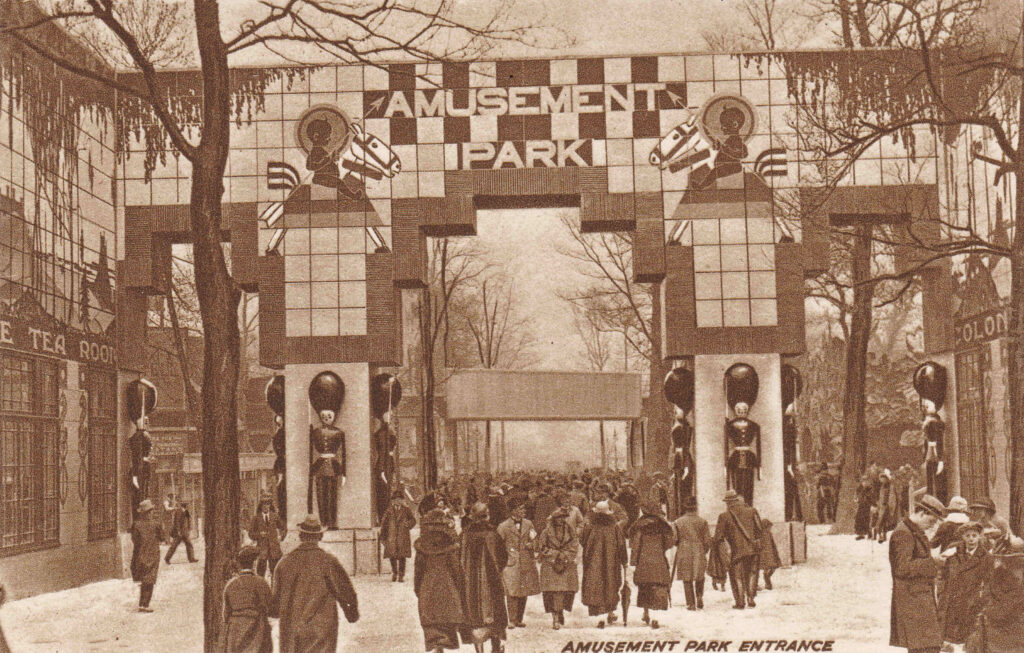
The 1924 exhibition was no exception and the following photo shows the entrance to the amusement park:

British Empire Exhibition amusement park

What was in the amusement park was probably one of the final parts of the planning and build process, as the plan of the site, created the year before, shows the area covered in blue and white stripes, with a flag bearing the text “The unrivalled and entrancing mysteries and the miles of smiles in the amusement park will be disclosed when this fine dustsheet is removed on opening day”.

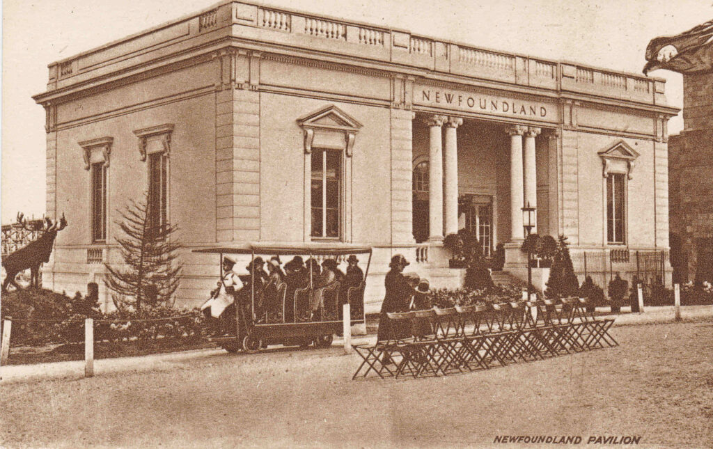
The Newfoundland (part of Canada) Pavilion:

Newfoundland

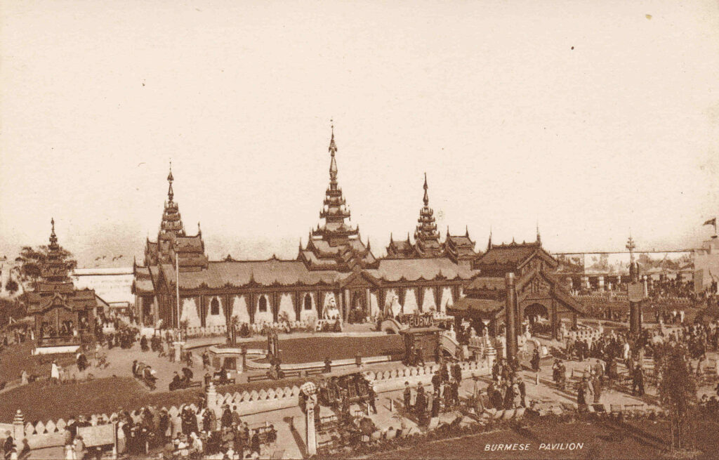
The Burmese Pavilion:

Burmese Stadium

Many of the country buildings, were constructed in the style of traditional architecture from the country concerned, as with the Burmese (now Myanmar) Pavilion shown in the photo above.

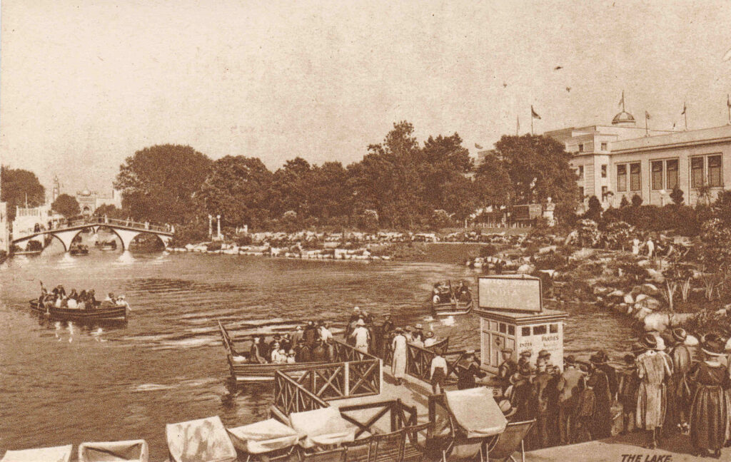
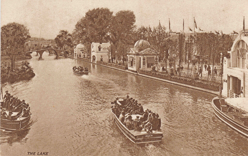
Another view of the boating lake:

Boating lake

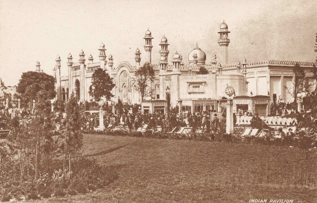
The Indian Pavilion, along with Australia and Canada was one of the largest pavilions, and was built in the style of grand buildings in India:

Indian Pavilion

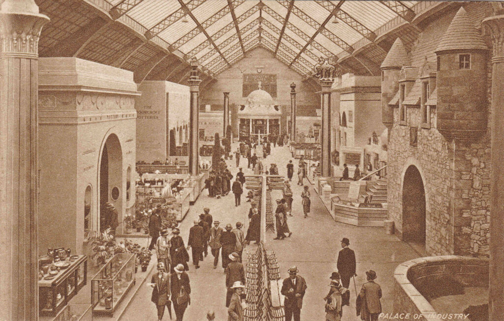
The following postcard is labelled the Palace of Industry, however apart from what may be in the display cabinets, there does not seem to be much industry on display:

Palace of Industry

As well as exploring all the country pavilions, and then going to the amusement park, the stadium was the scene of major events throughout the time of the exhibition.

One such event that ran for a couple of weeks until the 1st of June, 1924 was titled “London Defended” and could be watched in the stadium every evening starting at 8:15pm.

London Defended consisted of: “Two hours of intense yet joyous excitement. Thrill follows thrill, with not one moment of dullness. deeds of daring that claim your admiration and hold you spellbound with the wonder of it, the skilful horsemanship of the Metropolitan Police, the dash and daring of the London Fire Brigade, the breathless exploits of the Royal Airforce, Massed Bands, counter marching to the flickering glow of 200 torches, London Scottish pipers and Highland Dancing; and then the Great Fire of London, giving a fitting finish to an amazing night of adventure”.

Who could resist that for 4 shillings for the best covered seat, down to 6 pence standing on the upper terraces or free on the lower terraces.

Another event featured “a spectacular chariot race”, with six Roman chariots racing abreast. The race was supported by “Hundreds of Performers, Troops of Wonderful Horses, Flocks of Clowns, Marvelous Acrobats, Daring Trick Riders, hers of Elephants, Performing Bears, High Wire Acts, Dare-Devil Raymond in 100 foot Land Dive, Roman Riding, etc. etc.”

In 1924, there was no public television service, the first public radio transmission had only started four years earlier in 1920, and films with sound were not widely available until 1927, also the majority of the population had not travelled outside the country, so this type of entertainment, and the pavilions at the exhibition, would have been a significant and exciting experience for the majority of people.

View along the lake:

British Empire Exhibition boating lake

The British Empire Exhibition was open between the hours of 10 am and 11 pm, with admission costing one shilling six pence for adults and nine pence for children.

The exhibition was the first major event in London where I have seen specific mention of the car as a means of transport to the event. Publicity material for the exhibition stated “Visitors are advised to park their cars in the B.E.E. Official Car Park ONLY. Accommodation for 2,000 vehicles at popular prices”.

The 1920s were the start of wider car ownership, which would explode after the 2nd World War, and would influence planning for the city over the 20th century.

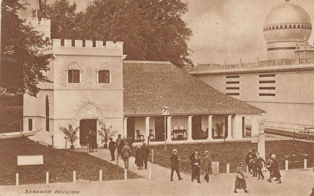
The Sarawak (a Malaysian state) Pavilion:

Sarawk pavilion

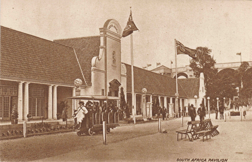
The South African Pavilion, which featured along the front a colonial architectural style of a long covered terrace and a colonnade:

South African pavilion

The above photo also includes a rather strange means of transport that appears in a number of photos of the exhibition. Obviously motorised, with a driver in the front, and a row of covered seats behind.

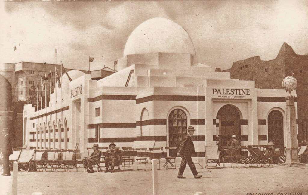
And a reminder of British involvement in the middle east – the Palestine Pavilion:

Palastine Pavilion

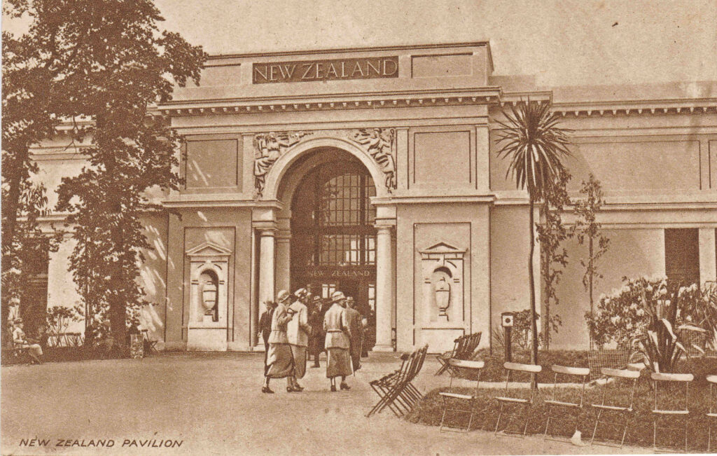
The New Zealand Pavilion:

New Zealand Pavilion

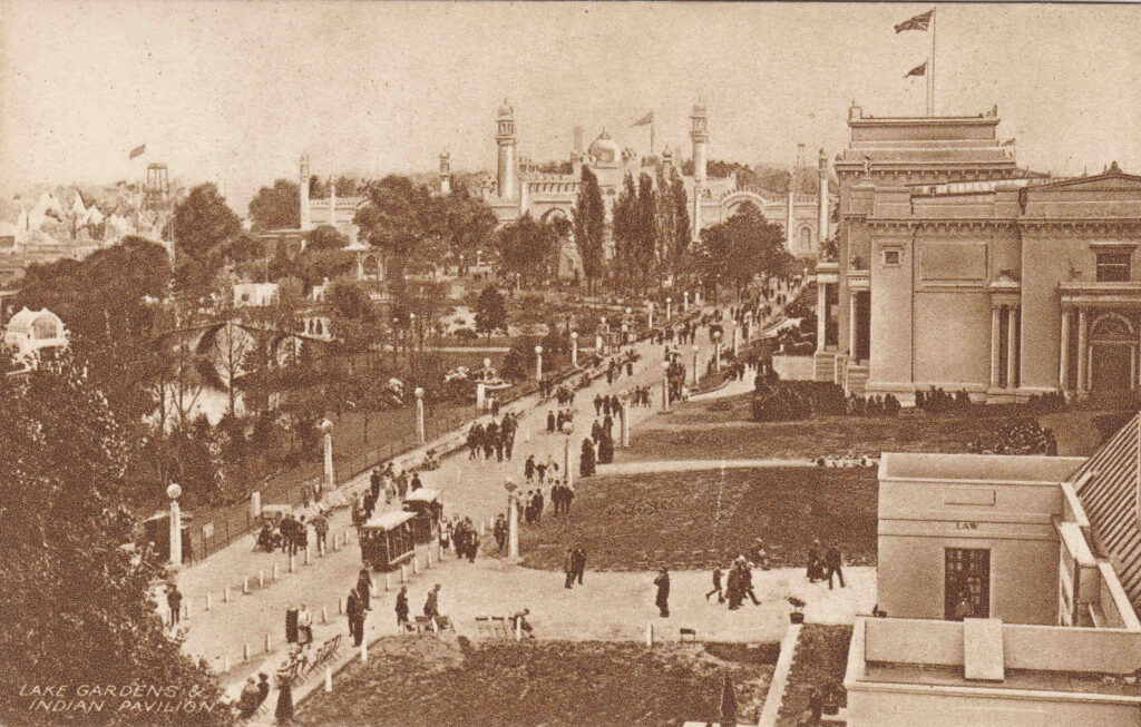
The area between all the pavilions was landscaped, as shown in the following photo with the caption of Lake, Gardens and Indian Pavilion:

British Empire Exhibition

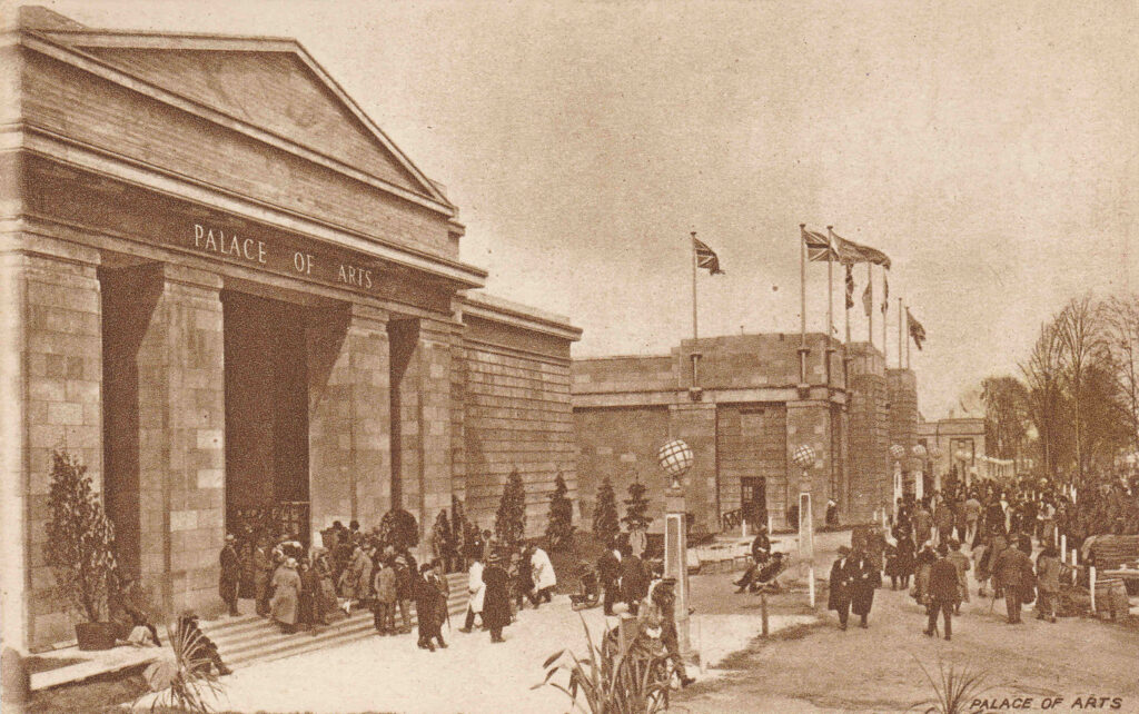
The Palace of Arts:

Palace of Arts

The Palace of Arts was divided into a number of rooms, including period rooms of 1750, 1815, 1852, 1888, and 1924, rooms covering the art of the theatre, watercolours, oil paintings, sculpture, modern oil paintings and art from India, Burma, Australia and Canada.

The guide to the Palace of Arts introduced the exhibition with “The British Empire Exhibition has for the first time made possible the assembling under one roof of the paintings of today, not only from the United Kingdom, but from every Dominion of the Crown. now first can be seen in one place how the Daughter Nations have developed their art from that English School which is represented so splendidly in the Retrospective Galleries.

All the Dominions were invited to send the best of their own choice, and if it be questioned that the space given to the painters of the past is small compared with the whole of the varied collection, the answer is that, in a living Empire, the art best worthy of study is the work of living men.”

The guide apologised for the lack of sculpture from the countries of the Empire, but explained that this was due to the difficulties and risk of transporting sculpture over such long distance.

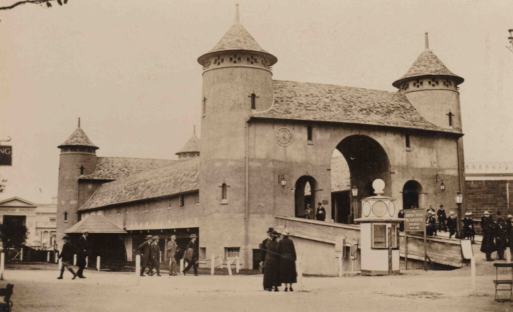
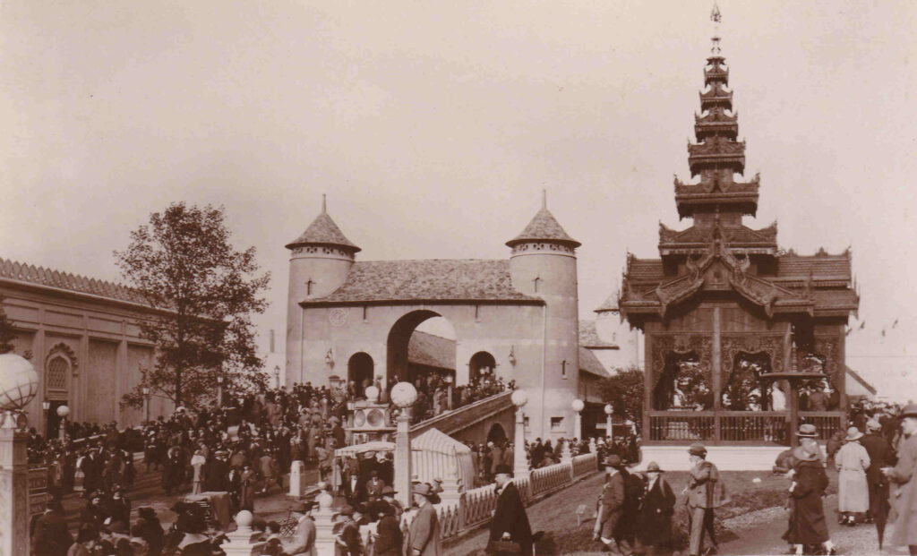
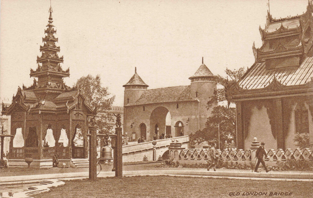
A rather strange part of the exhibition was a recreation of Old London Bridge, as shown in the following three photos:

British Empire Exhibition

The sign on the right of the photo, by the ramp is indicating that the station for trains to Marylebone can be found across the bridge.

British Empire Exhibition

I do not know what was used as the source for recreating London bridge, but it does not look like the majority of prints and drawing of the bridge.

British Empire Exhibition

Although the plan of the exhibition shown at the start of the post stated it was the British Empire Exhibition 1924, it actually ran over two years, and was open from the 23rd of April to the 1st of November 1924 and then from the 9th of May to the 31st of October 1925. The second year of opening was not originally planned, however the success of the exhibition led to the second year of opening.

The final closing ceremony on the last day of October 1925 was held in a very full stadium and was attended by the Duke of York (the future George VI) who gave the closing speech.

The ceremony suffered some very typical British weather as it was held in pouring rain, however the papers of the time reported that “In spite of the mist and the fog which enveloped the British Empire Exhibition today, thousands of people travelled to Wembley to attend the final scenes”.

The Duke of York closed the exhibition with the words “Further, the Exhibition, in its pavilions and by its spectacles in the Stadium has presented a picture of Empire which has kindled our imagination and stirred our pride in the Union Jack. In declaring the British Empire Exhibition closed, I am confident that its results will endure for the benefit of the British Empire and of its peaceful mission in the world.”

The British Empire Exhibition was considered a major success.

As well as the photos above, a number of films were made of the exhibition, a sample of which are below:

The videos cannot be played in the version of the post sent out via email. Click here to go to the post on the blog where the videos can be played.

First, some remarkable colour film of London, building the site, the opening and the exhibition site (note that in the film it states that the closing ceremony was held 6 months later by the Prince of Wales. this was the closing ceremony for the first year, and a full ceremony was held as at the time it was not certain that the exhibition would open again in 1925. The decision to reopen would be taken in the following months):

A British Pathe film showing King George V and Queen Mary walking around the exhibition site:

The State Opening of the British Empire Exhibition, including a fly past by RAF byplanes:

Will It Be Ready In Time – film of the site during construction following concern about delays due to a strike by workers:

Film of one of the pageants held in the Empire / Wembley Stadium:

A variety of scenes from the exhibition:

I started the post with a comment that a look at the exhibition is interesting as it shows how much has changed in the space of one hundred years. Physical change at a place where London was expanding in the 1920s, change in Britain’s place in the world, and a change in attitudes, and I hope the above has shown how.

Wembley as a place is now so very different. A built up place, part of the wider London. The original Wembley Stadium, built for the 1924 exhibition was closed in 1999, demolished, and the stadium we see today opened in 2007.

The rest of the festival site is now full of apartment blocks, hotels, shops, and what is now the SSE Arena, was the Empire Pool Wembley, which was built over part of the artificial lake shown in some of the above photos, and completed in 1934.

Britain’s place in the world has changed dramatically. No longer an industrial and military power (of any size) and a lost empire.

And a change in attitudes from 1924, when you look at the paternalistic approach to the countries “under the British Flag” and the emphasis on resources, along with the sentence in the guide to the Palace of Art “how the Daughter Nations have developed their art from that English School“.

The 1924 exhibition did indicate some aspects of the future. it was the first major event which recognised the car as a significant means of personal transport, and it was the first time that the King’s voice had been heard via the radio, as the fledgling BBC had broadcast the opening ceremony.

The one thing that has not changed, as can be seen in the films, are the uniforms, carriages, and approach to Royalty.

The opening ceremony was probably one of the first big stadium opening events, and these continue, for example with the opening of the 2012 Olympics in Stratford.

I wonder how this will be looked at, one hundred years later in 2112.

alondoninheritance.com