Monthly Archives: September 2021

Whitecross Street – Sunday 31st May, 1953

Whitecross Street runs between Old Street and Beech / Chiswell Streets, just north of the Barbican.

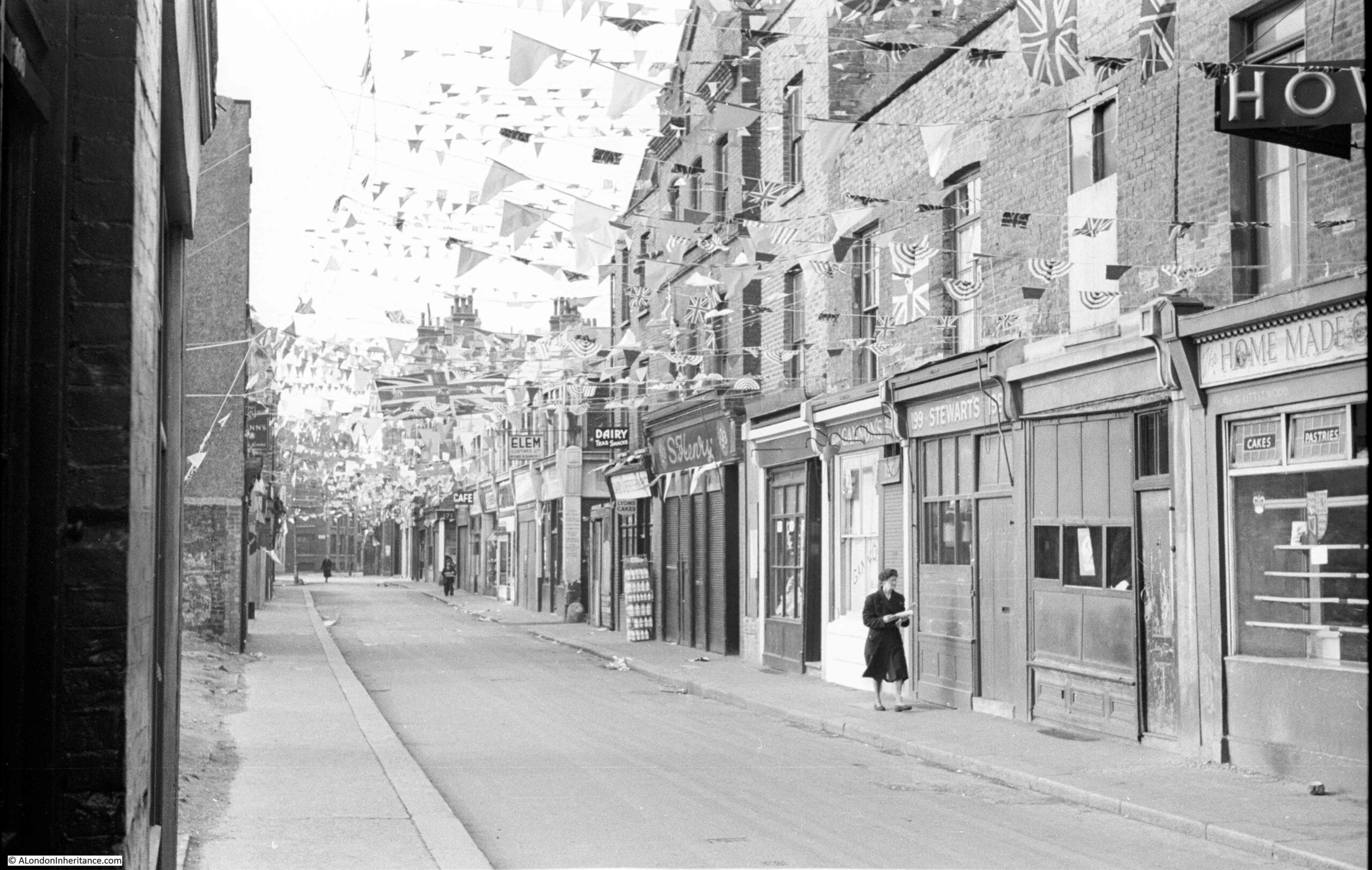
Many of my father’s photos were taken on bike rides around the city, early on a Saturday or Sunday. This worked due to periods away on National Service, work during the week, and other commitments. Early on Sunday, 31st May 1953 he was at the northern end of Whitecross Street and took the following photo looking south along the street:

Whitecross Street

One lunch time a couple of weeks ago I was in the area, and the following photo shows the same view as the above, sixty eight years later:

Whitecross Street

My father’s photo was one of a number he took on the same day in the area of Whitecross Street and also in Hoxton. The 1953 photo was taken a couple of days before the Coronation of Elizabeth II, on Tuesday, 2nd June 1953, and this explains the flags and bunting across the street.

A second photo, a short distance further into Whitecross Street. I suspect he was waiting for the woman to walk further up the street to add a focal point to the photo:

Whitecross Street

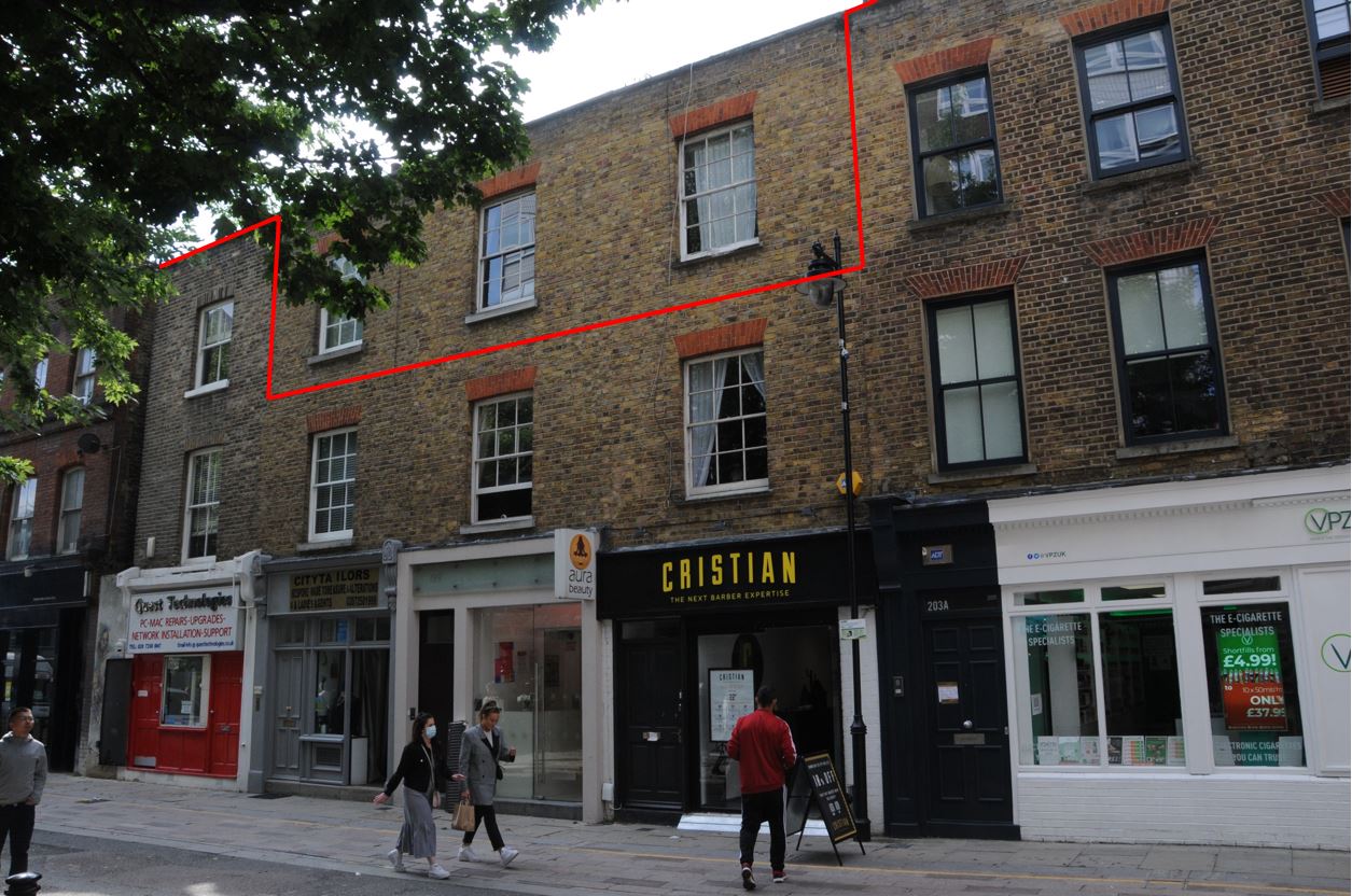
The terrace of buildings on the right of the photo have changed in the years between the two photos. The one building that confirms the two views are of the same street is the building with the pediment (the triangular shaped top to the wall) about two thirds of the way down on the right of the street.

Comaprison of the photos also shows that you cannot always trust the age of buildings at first sight. In the above 1953 photos, if we walk towards the camera from the pediment building, there is a narrow, three storey building with a single window at each floor. There is then a terrace of three houses / shops of two storeys, with a shop at ground level and single window / storey above each shop.

in the 2021 photo, this terrace has had an additional floor added to create a three storey terrace along the western side of Whitecross Street.

I have marked how the terrace has changed in the following photo, with the red line indicating the 1953 height of the buildings.

Whitecross Street

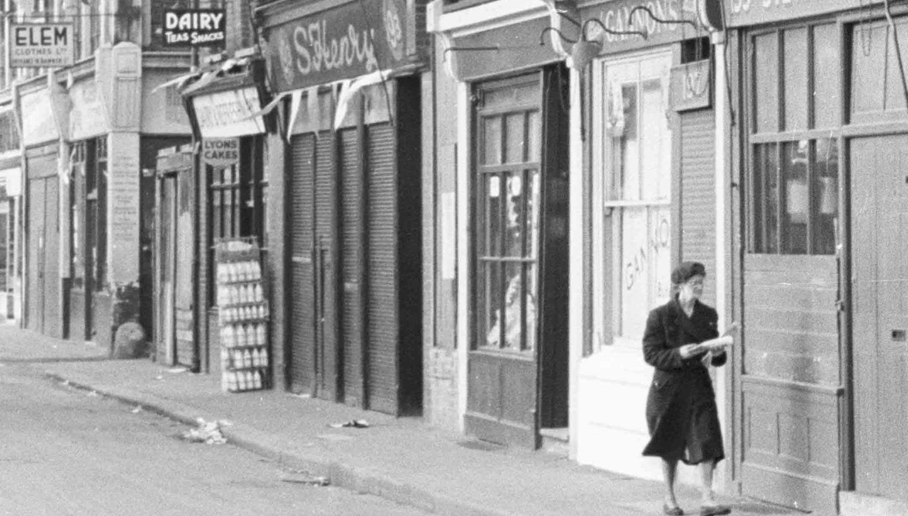
In 1953, the shops were the type of local shop serving the daily needs of those who lived in the area. The following is an extract from the second photo. Note the rack of milk bottles standing outside the dairy:

Whitecross Street

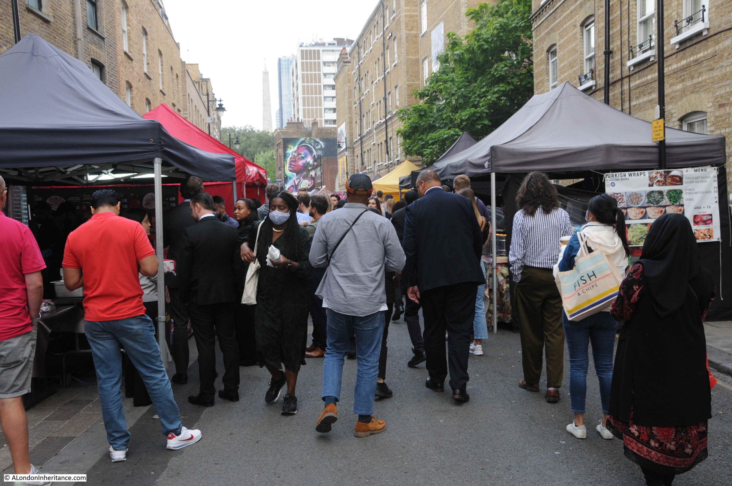
Today, there is a more diverse range of shops, and what was obvious during my walk along Whitecross Street was that the food market running down the centre of the street now serves the local working population, as the street was crowded with those out to buy their lunch.

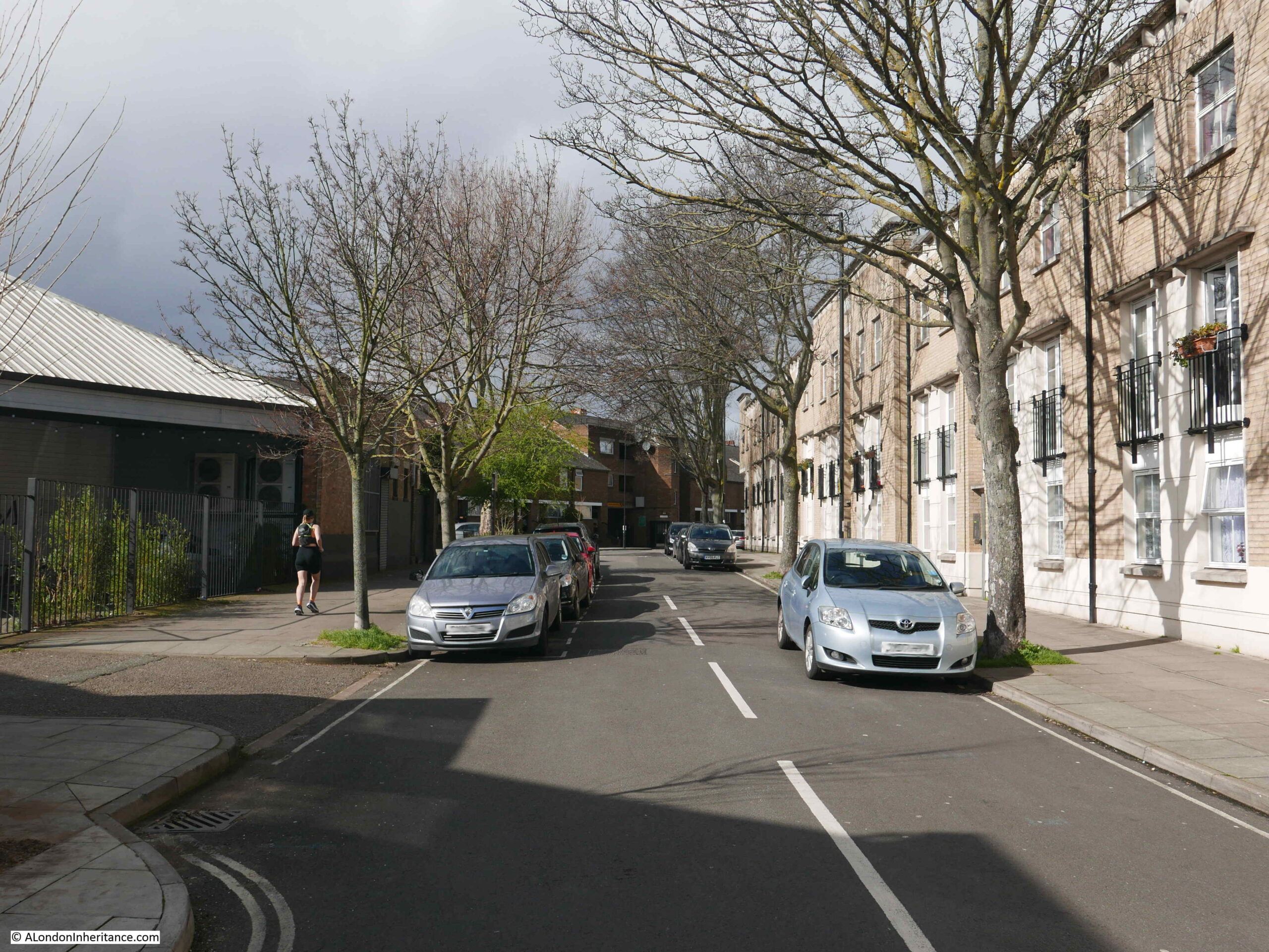
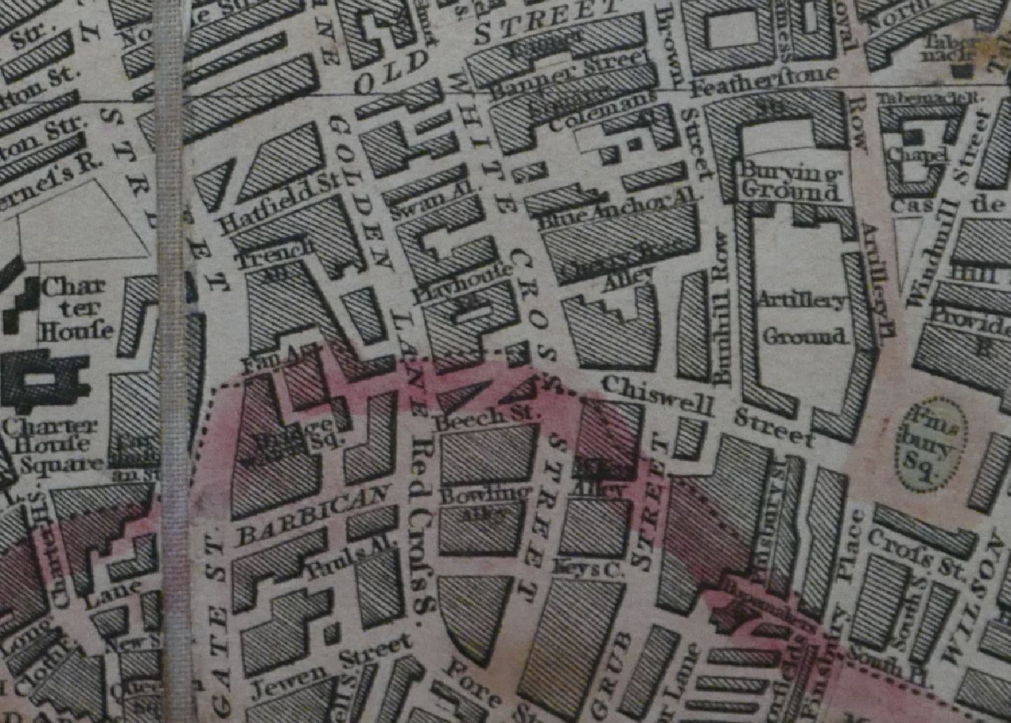
Whitecross Street can be found just north of the Barbican, linking Beech / Chiswell Streets at the southern end with Old Street to the north. In the following map, Whitecross Street is the street running vertically, in the centre of the map (Map © OpenStreetMap contributors).

Whitecross Street

Whitecross Street was originally much longer than it is now, and it’s southern end was in the heart of Cripplegate. Considerable damage during the last war, and the construction of the Barbican estate has erased roughly one third of the original street.

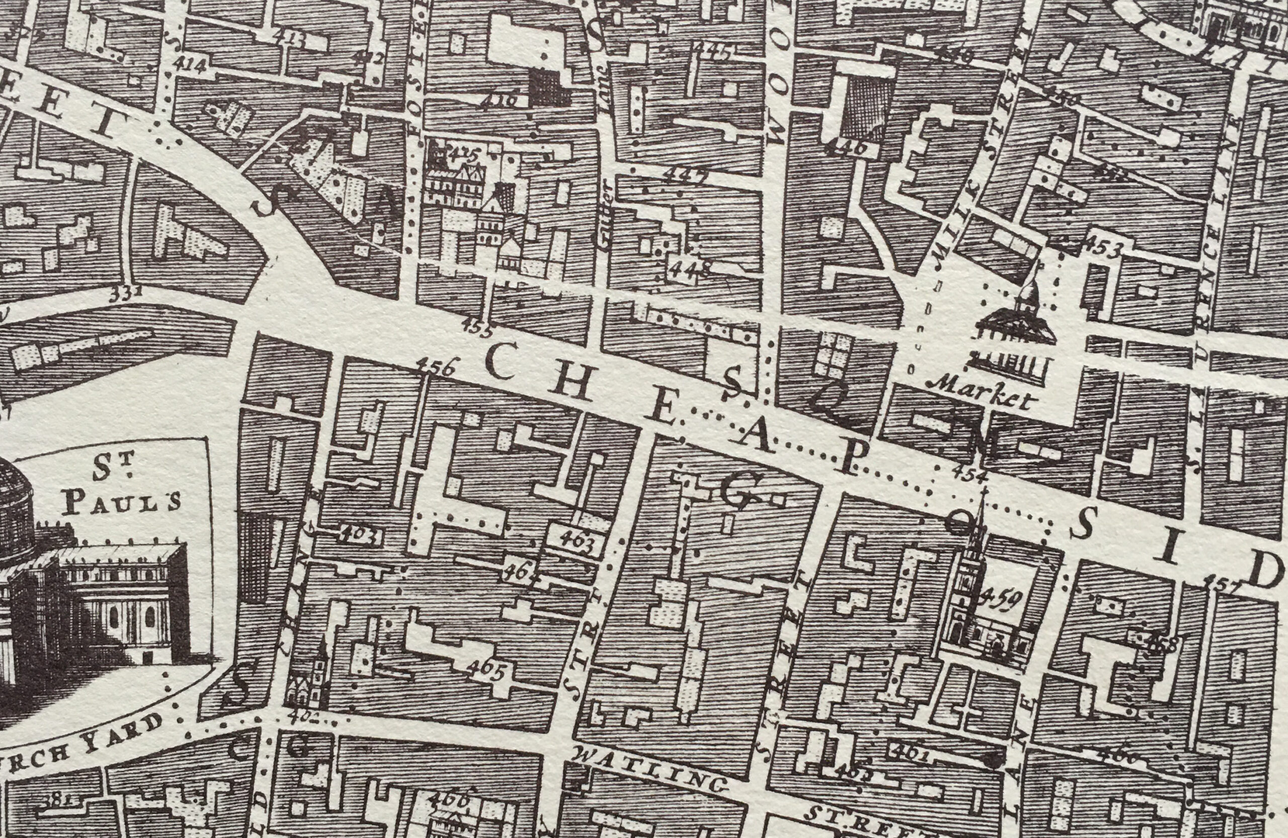
In the following extract from the 1894 Ordnance Survey Map, I have highlighted the street we can walk today by the red arrow (‘Reproduced with the permission of the National Library of Scotland’.

Whitecross Street

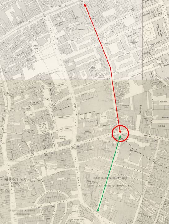
The green arrow identifies the missing third of Whitecross Street. Today, a short section is now Silk Street before it terminates at the Barbican.

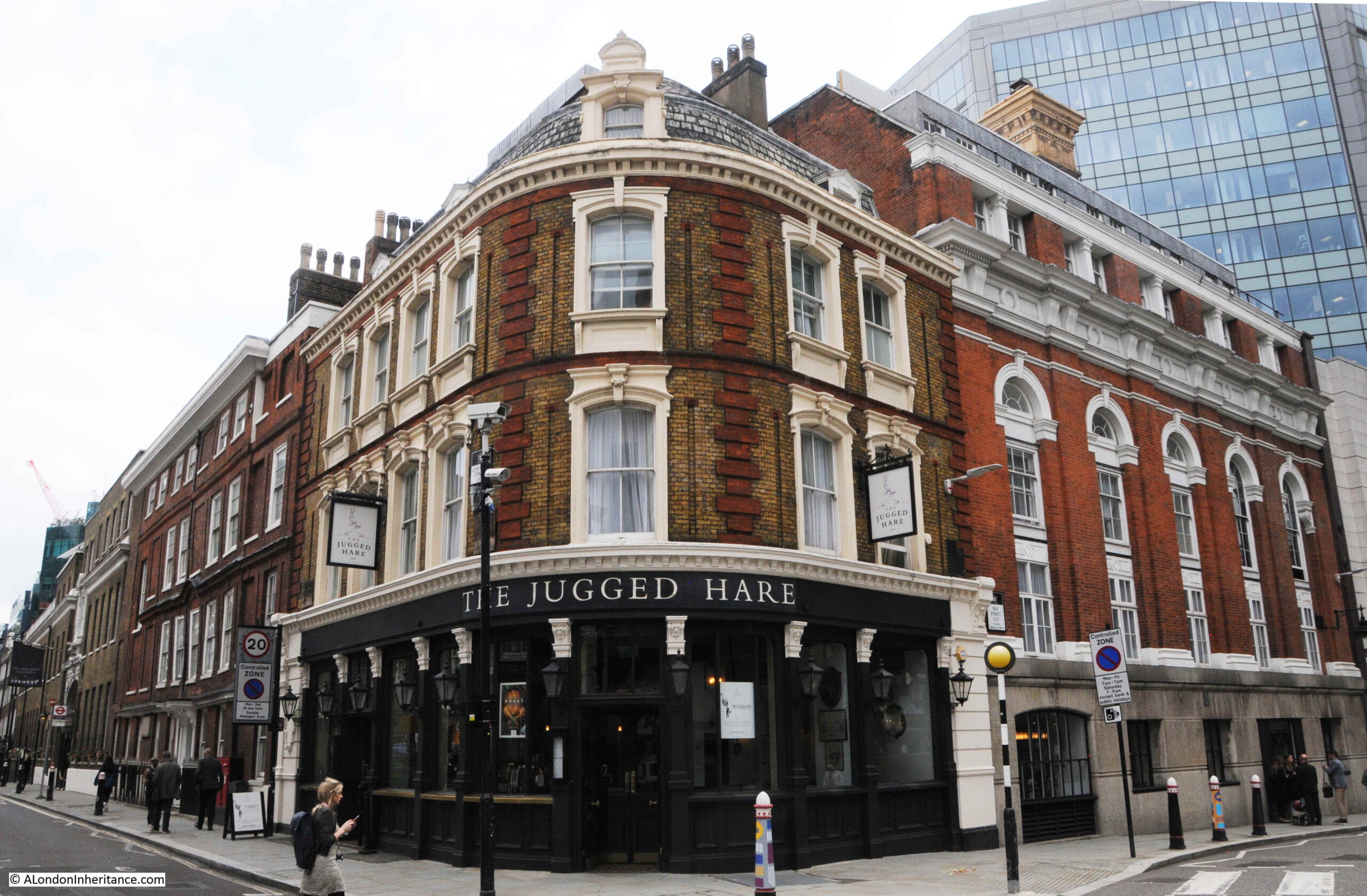
In the red circled area in the above map, there is the PH symbol for a pub on the corner of the lower section of Whitecross Street. The pub, the Jugged Hare, is still there today as shown in the following photo. Originally, Whitecross Street continued to the right, however this has now been renamed Silk Street as it curves to the north of the Barbican to Moor Lane.

Whitecross Street

As can be seen in the 1894 map, Whitecross Street originally joined Fore Street at the north east corner of St Giles, Cripplegate.

In the following photo, this would have been just behind and to the left of the car, and Whitecross Street would have run in front of / underneath the Barbican apartment block Gilbert House, the large block on the left of the photo.

Whitecross Street

Whitecross Street dates back to at least the 13th century, with the first written records of the street as Wytecroychestrate.

The name of the street seems to derive from a white cross located in the street, which seems to be connected to the Abbot of Ramsey who had a house between Whitecross and Redcross Streets (Redcross Street is another old street that was just to the west of Whitecross Street and took its name from another cross in the street. Redcross Street was lost during the construction of the Barbican).

Strype, writing in 1720 includes the following reference to the street: “In this street was a white cross and near it was built an arch of stone under which ran a course of water down to the Moor which is now called Moorfields. Which being too narrow for the free course of water, and so an annoyance to the inhabitants, the twelve men presented it to an inquisition of the Kings Justices, and they presented the Abbot of Ramsey and the Prior of St Trinity, whose predecessors six years past has built a certain stone arch at Whyte Croyse, which arch the aforesaid Abbot and Prior, and their successors ought to maintain and repair.”

Writing in 1756, William Maitland described Whitecross Street as “a place well built and inhabited. It begins in Fore Street and runs northward into Old Street, which is of a great length. But the part within the Ward goes but a little beyond Beech Lane, where the City posts are set up, as they are in Grub Street and in Golden Lane, being the circuits of the Freedom. The street is inhabited by considerable traders and dealers in various branches.”

The Ward that Maitland refers to is Cripplegate Ward and the City posts were the boundary markers showing the extent of the City. The section of the street that was in Cripplegate is now that renamed Silk Street, along with the section under the Barbican.

The City boundary can be seen in the following extract from Smith’s 1816 New Plan of London, where the boundary is the dotted line and pink highlighting. The boundary can be seen cutting across Whitecross Street at the junction of Chiswell and Beech Streets.

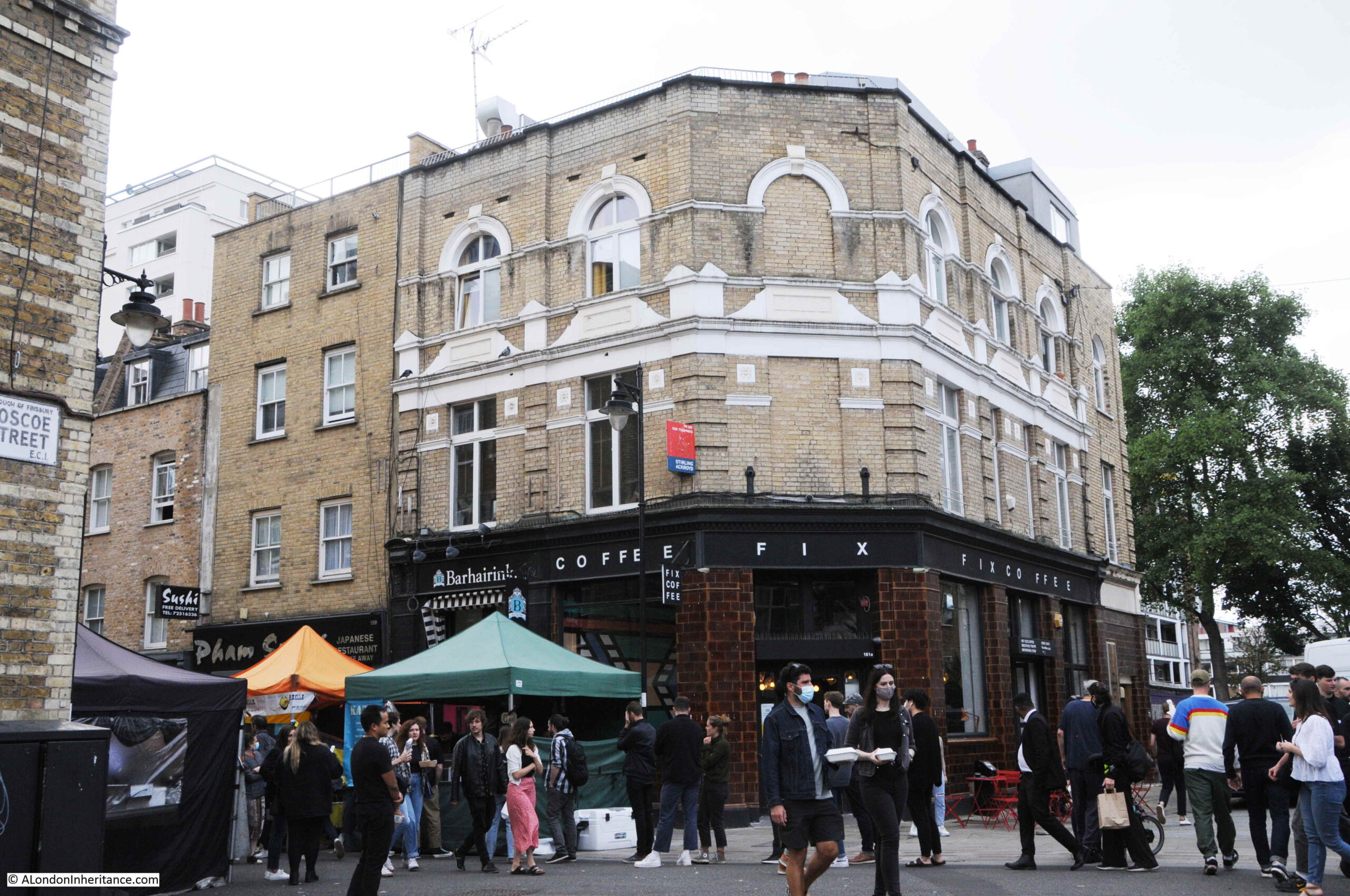
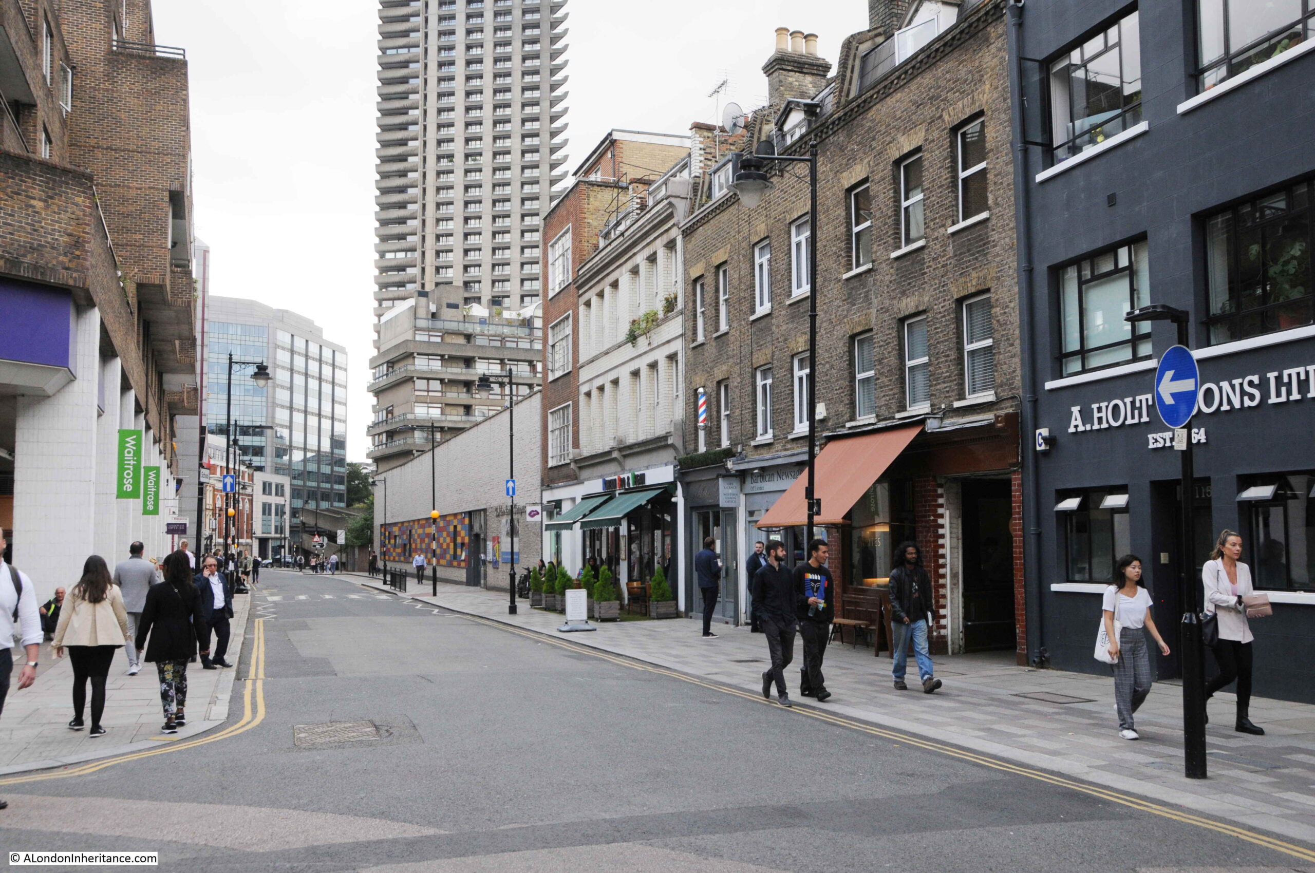
Today, there are still “considerable traders and dealers” in Whitecross Street, and the street is also a centre for public art that can be found covering many of the walls along the street. The entrance to Whitecross Street from Old Street:

Whitecross Street

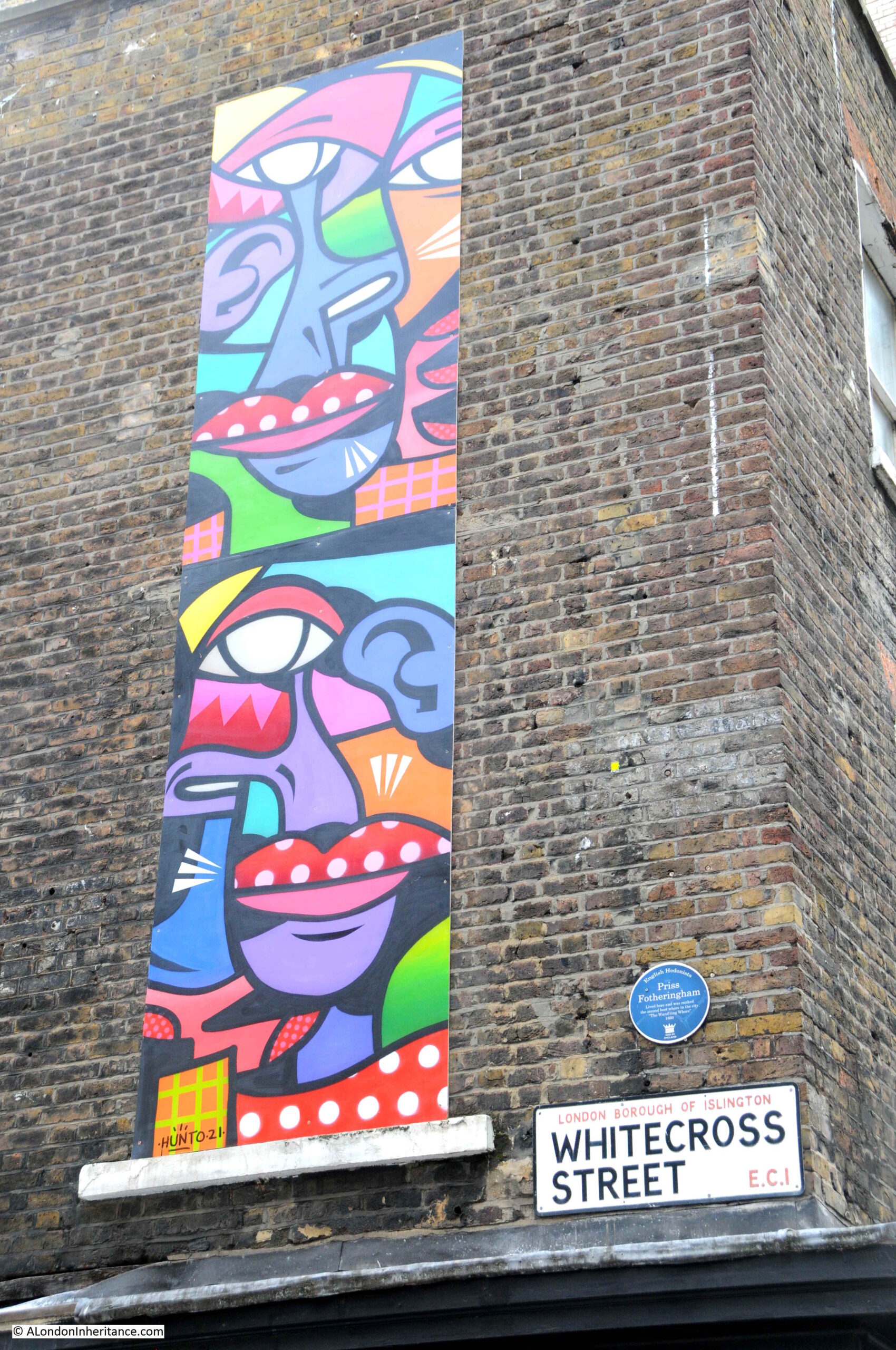
The blue plaque was put up by English Hedonists, and is to Priss Fotheringham, who “Lived here and was ranked the second best whore in the city”.

Priss was mentioned in the collection of pamphlets under the name of “The Wandering Whore” by John Garfield, published between 1660 and 1661, where, in a contrived conversation between two sex workers (probably invented by the author), the activity which seems to have brought Priss fame and some wealth is described “Priss stood upon her head with naked breech and belly whilst four Cully-Rumpers chuck’t in sixteen Half-crowns into her Comodity”.

Whitecross Street is mentioned a number of times in the pamphlets, including the lists of “Common Whores, Night-walkers, Pick-pockets, Wanders and Shop-Lifters and Whippers”, where for example “Mrs Smith, a Bricklayers wife in Whitecross” is mentioned, along with “Mrs Savage in Whitecross-street, who broke her husband’s head with a marrow-bone, and had liked to have kill’d him with it”.

The street was much improved by 1800, when it was described as “A good street, and has among the buildings, the Peacock brew house, the Green Yard, where strayed cattle are pounded, and where the Lord Mayor’s state coach is kept.”

Walking down the street, and this is the building that helped with identification of my father’s photo:

Whitecross Street

The following building appears further down the street in my father’s photos, so although not an 18th or 19th century brick terrace, the building is pre-war. I obviously read too many archaeology websites and books, as every time I see the café on the corner, Museum of London Archeology is the first thing I think of.
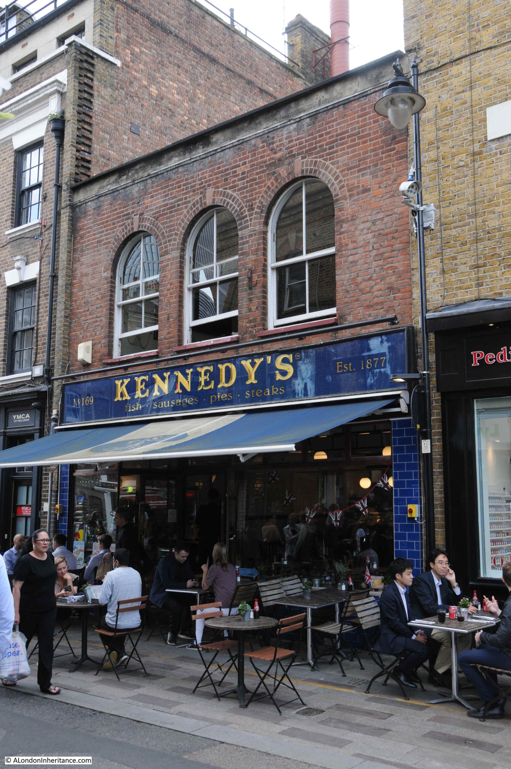
Whitecross Street

The Whitecross Tap:

Whitecross Street

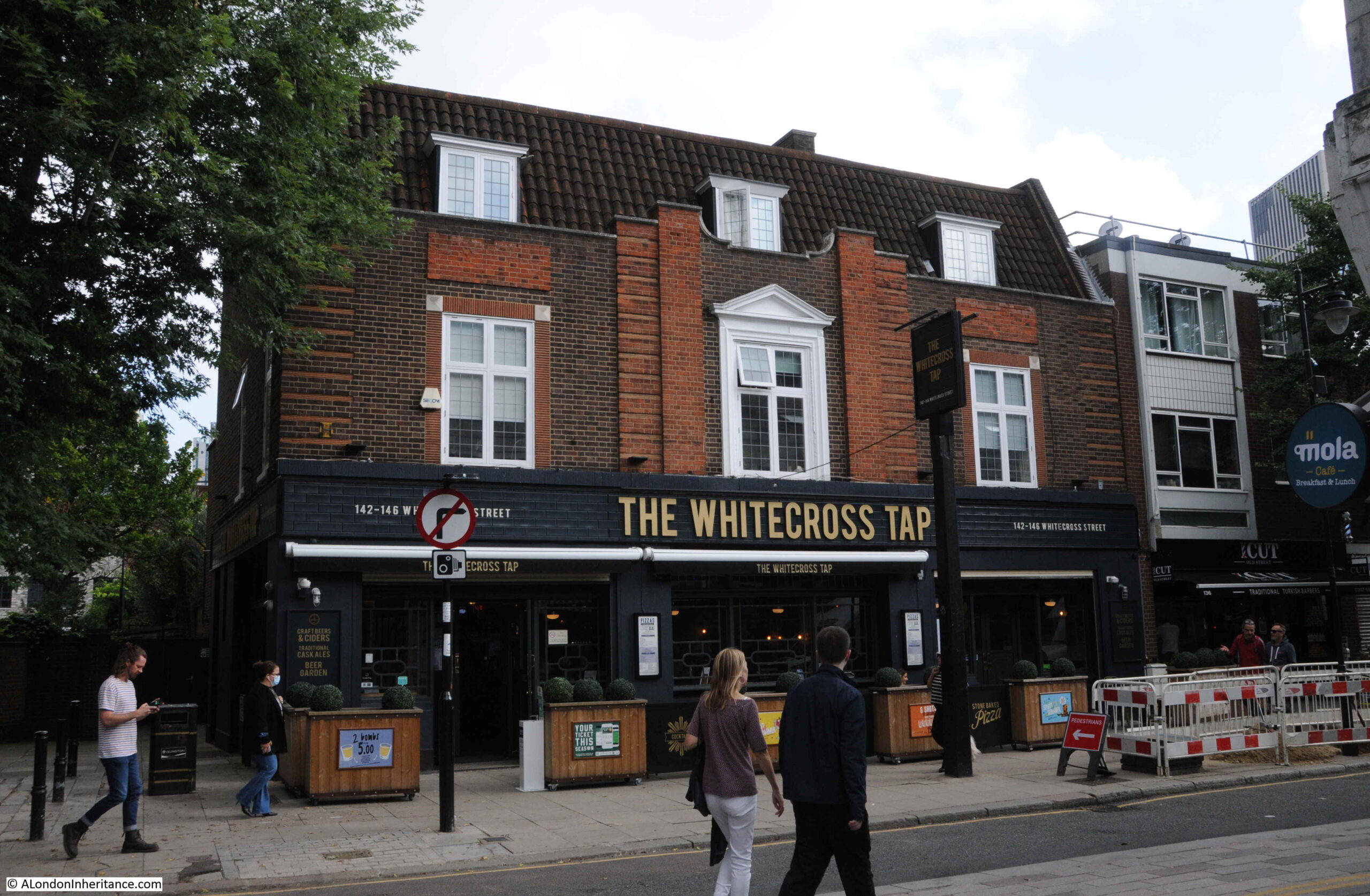
The Whitecross Tap is a relatively recent name, dating from 2018, however a pub has been on the site since the 18th century.

Looking south along Whitecross Street at the junction with Banner Street:

Whitecross Street

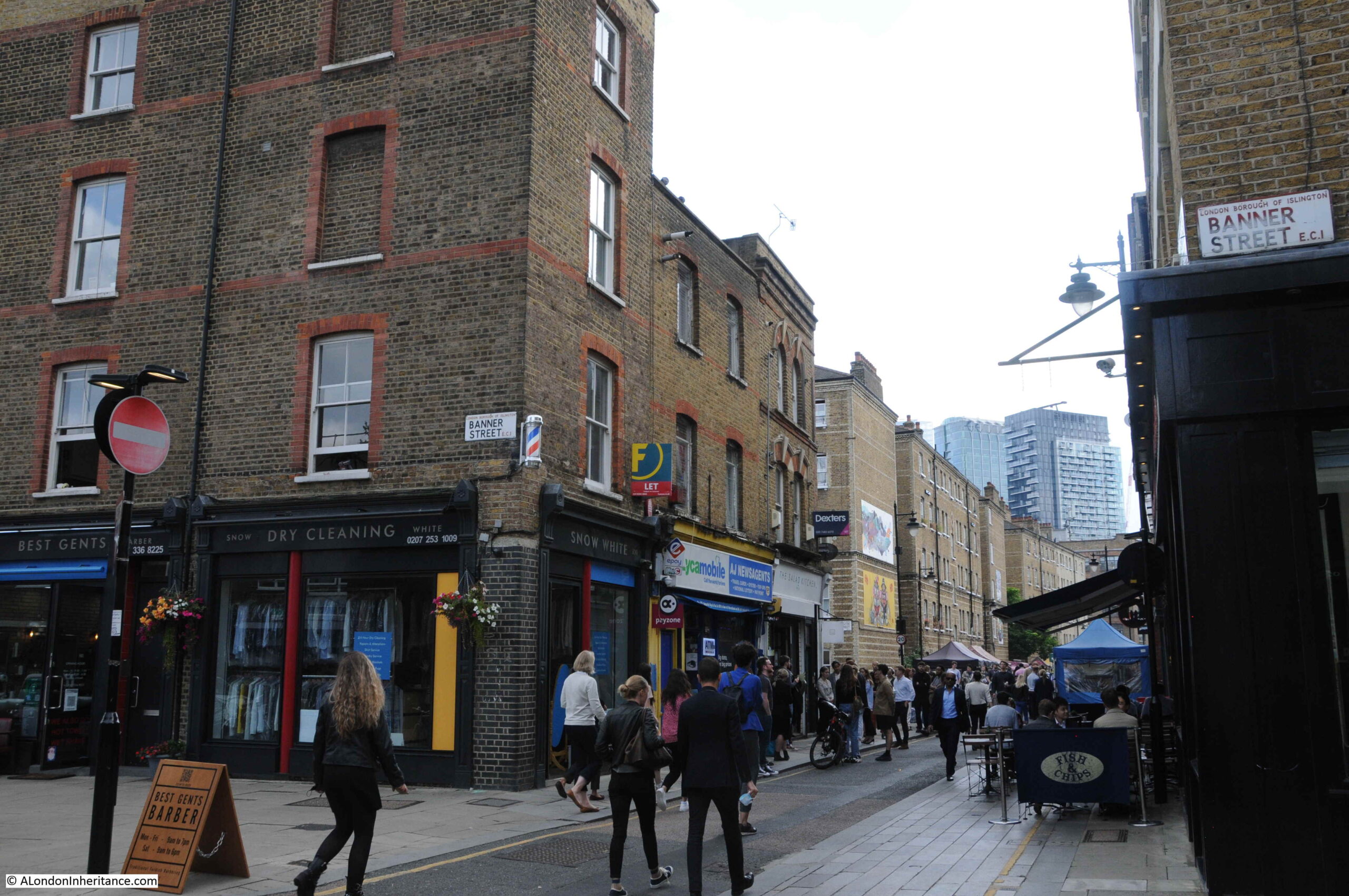
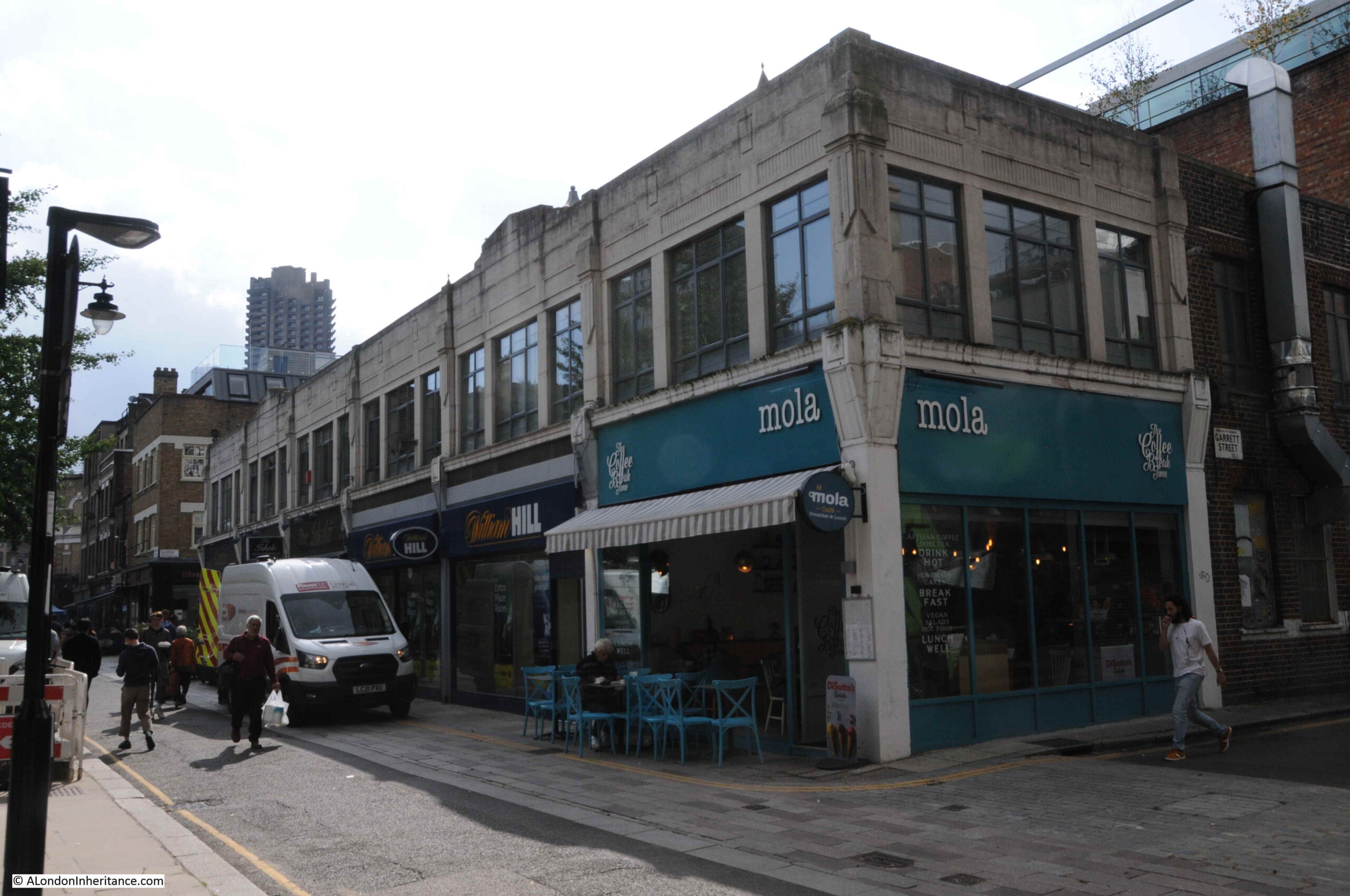
The street has a very diverse mix of architectural styles, which make the street interesting. Different heights, materials, windows and function all jostle for prominence.

Whitecross Street

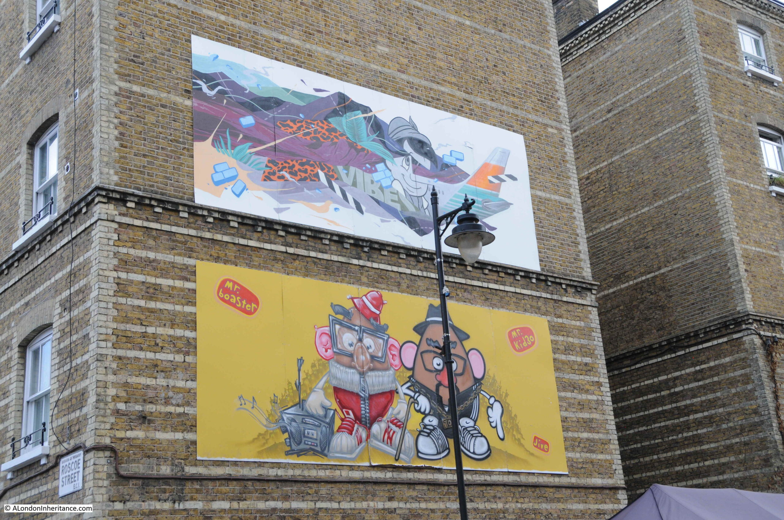
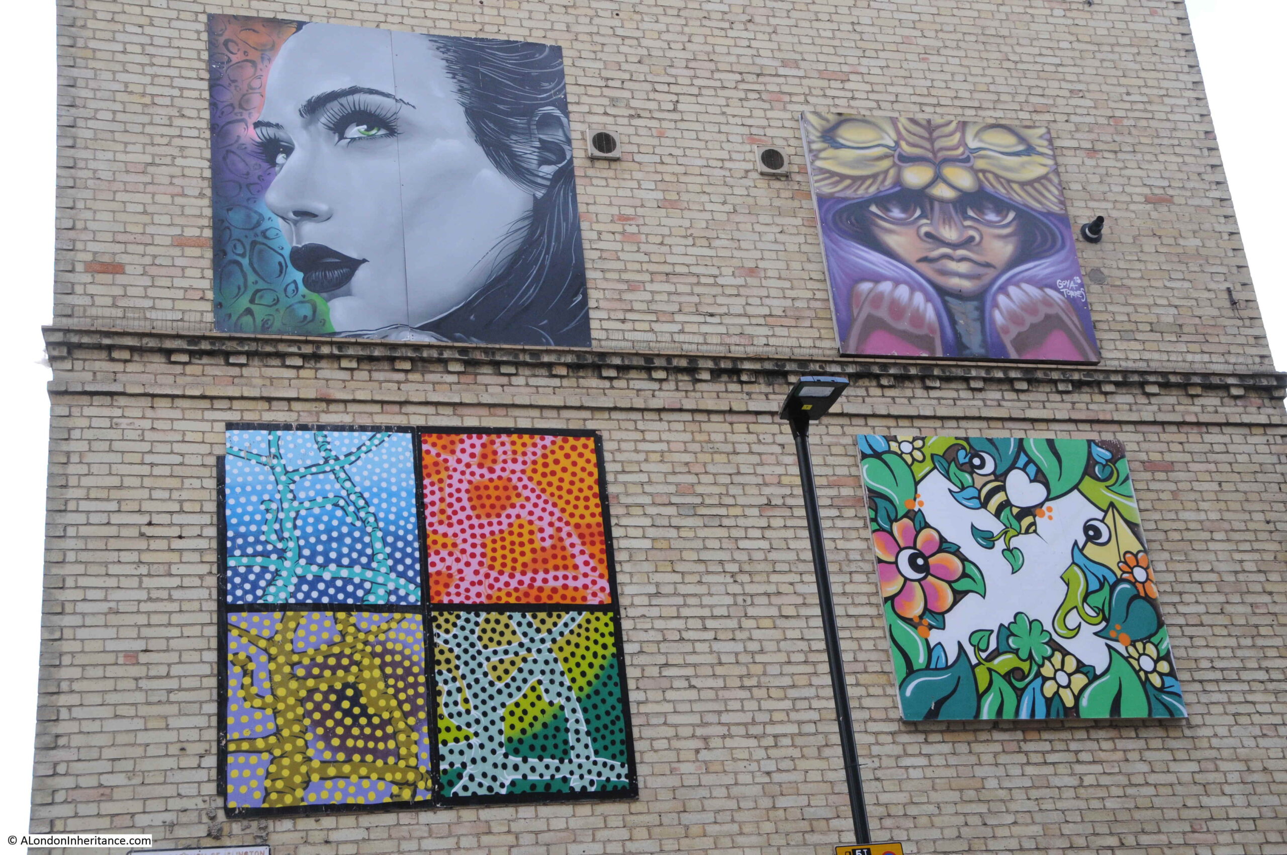
Street art is visible along much of the street:

Public Art

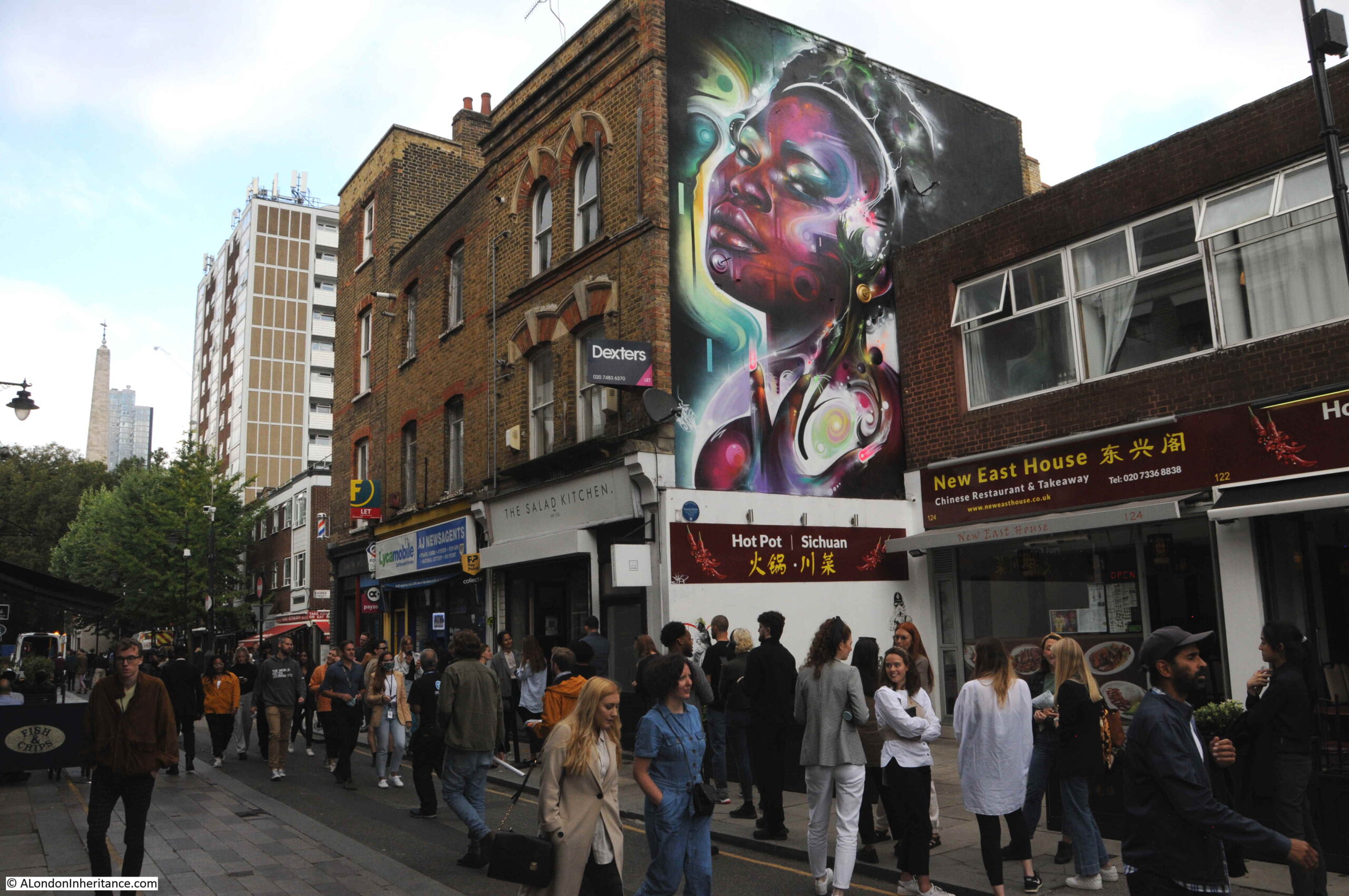
The art along the street is the result of the Whitecross Street Party and the Rise of the Nonconformists exhibition, an annual event that has been taking place for the last 11 or 12 years, taking place over a weekend when there are multiple events in the street, and street artists can be watched as they create new works.

Public Art

A pub that has been converted to a coffee shop. This was the Green Man pub:

Whitecross Street

More art on the side of the Peabody Estate between Whitecross Street and Cahill Street. Most of the estate was built in the 1880s.

Public Art

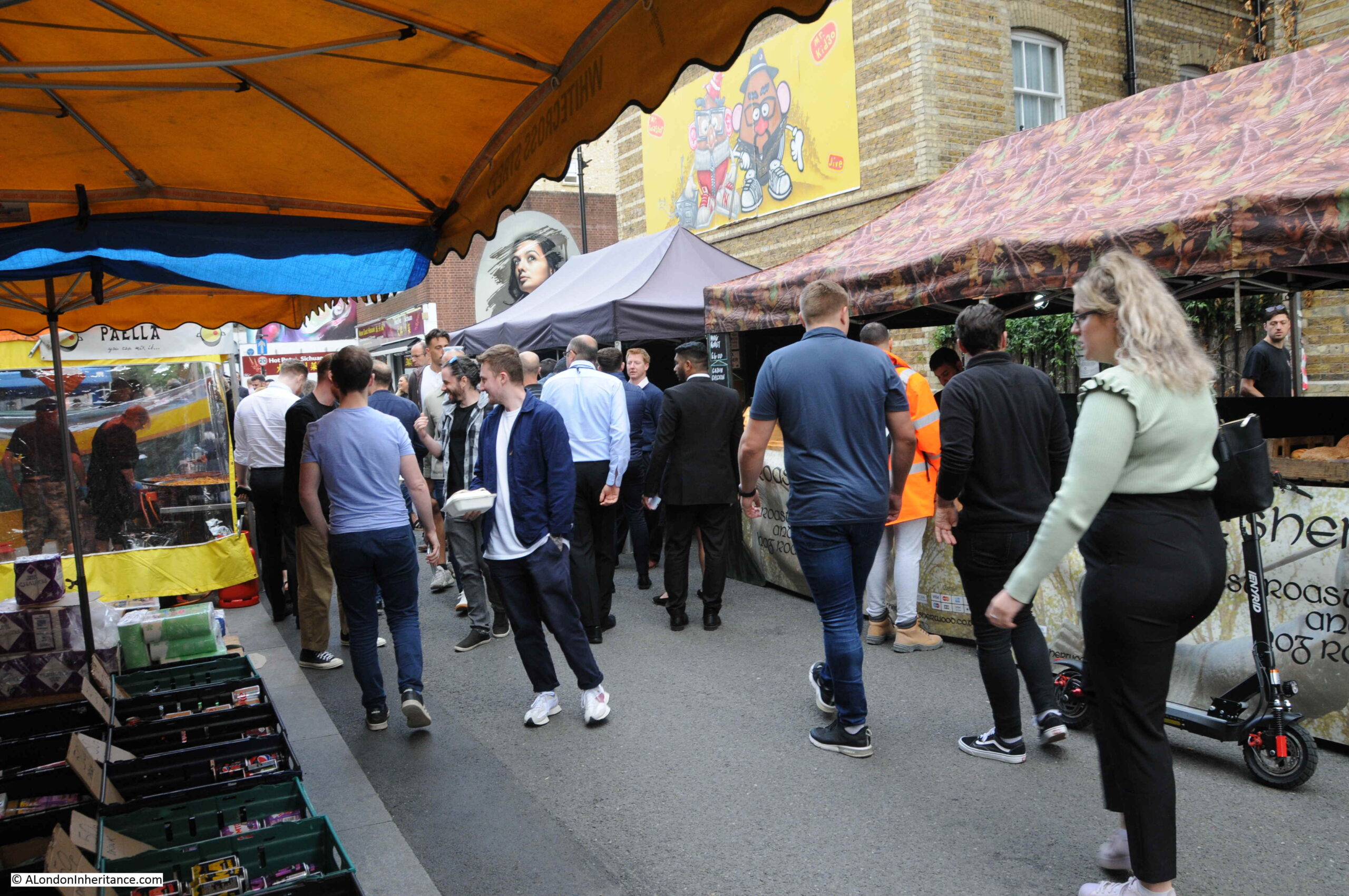
Whitecross Street has had a market for very many years. It was once a street market that sold the everyday needs of those living in the area; a typical London street market, however like the majority of other London street markets, today it mainly caters for the lunchtime needs of those who work in the area.

Whitecross Street Market

It was a very different place not that many years ago, and the change to the food market we see today has been relatively recent. A newspaper report from February 1871 provides a graphic description of the market as it was;

“Out-dinning the din of the Whitecross-street Sunday morning market, the roar of leather lunged costermongers and barrowmen, the deafening eloquence of the clashing knives and steel of opposition butchers, the shrill cries of women who have potherbs, and children’s toys and second-hand shoes and boots on sale. The wrathful high pitched voice of the street preacher at this corner of an alley, unable to make himself heard amid the laughter created by a quack dealer in sarsaparilla at the other corner, over all these conflicting noises the sound of a bell was heard distinctly – not the measured chiming of a church bell, nor the preemptory clatter of a factory bell, but a fitful and uncertain ringing, now loud and heavy like a fire bell. A gentlemen in the baked potato interest, however, to whom I applied for information on the subject, ruthlessly stripped the bell of everything in the shape of romance. it is the Costers Mission Bell, said he.”

The market seems to have started around 1830. In the Clerkenwell News dated the 2nd November 1865, there is a report of a Vestry meeting, where the work of a recently appointed “street keeper” who was responsible for the upkeep and cleanliness of Whitecross Street and the adjacent alleys, courts and streets was discussed. The concern was the work was too much, as “Amongst other things he was required to be in attendance during the day in Whitecross-street as a market”.

There was consideration given to removing the market, however the Vestry Clerk stated “As to the market in Whitecross-street, stalls had been allowed to be there for upwards of thirty years, and could not very easily be removed now”.

No idea if there is a similar role as a “street keeper” today, however the market is very busy each lunch time.

Whitecross Street Market

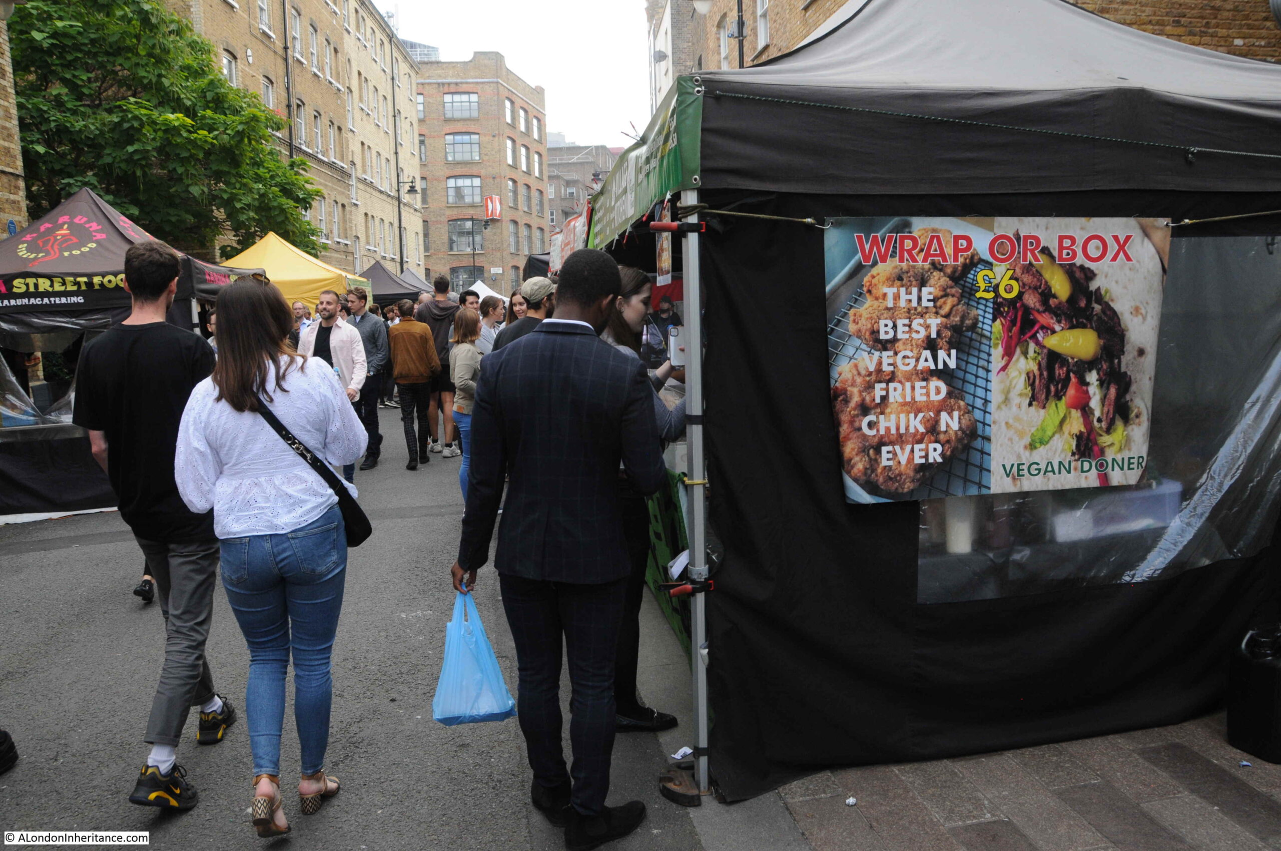
With almost any combination of street food you could want:

Whitecross Street Market

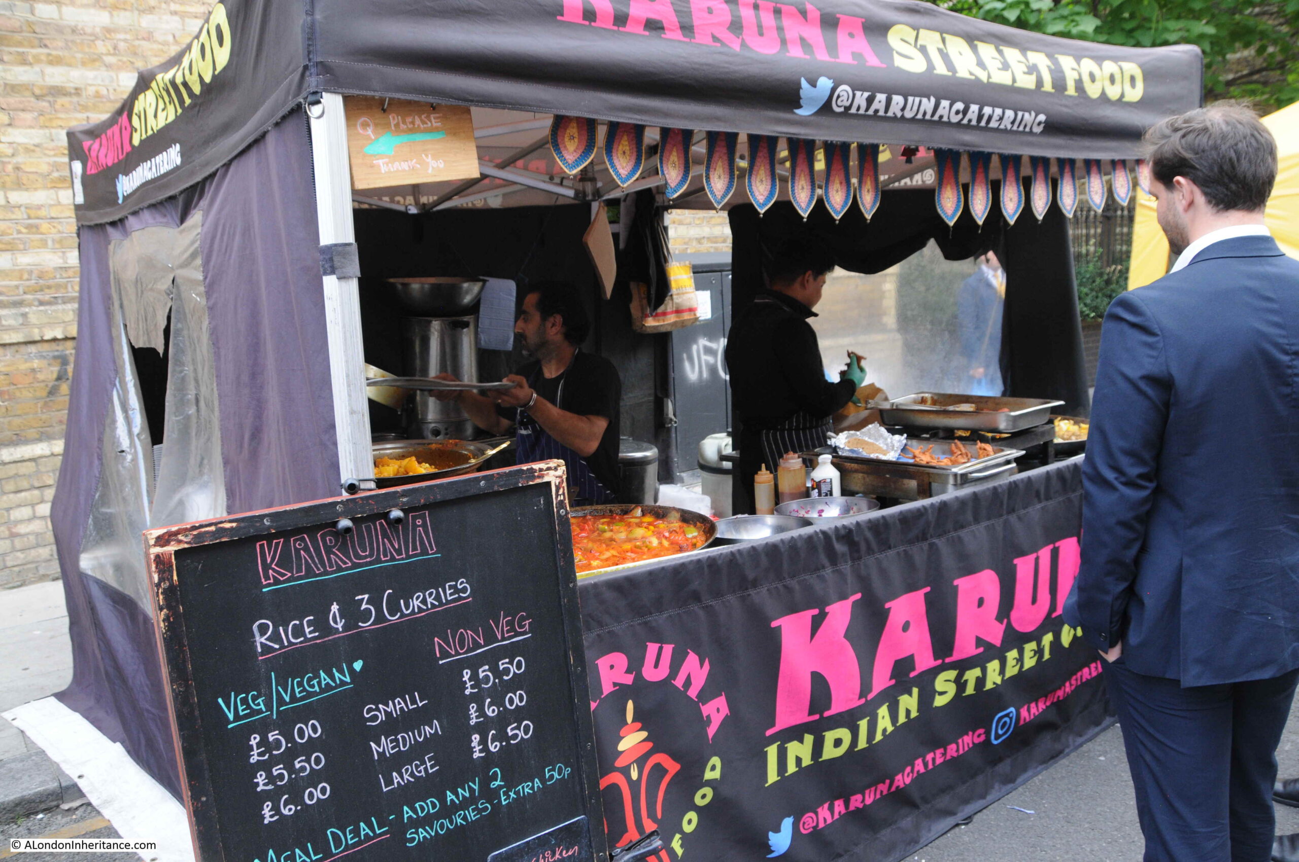
With queues forming at many of the stalls:

Whitecross Street Market

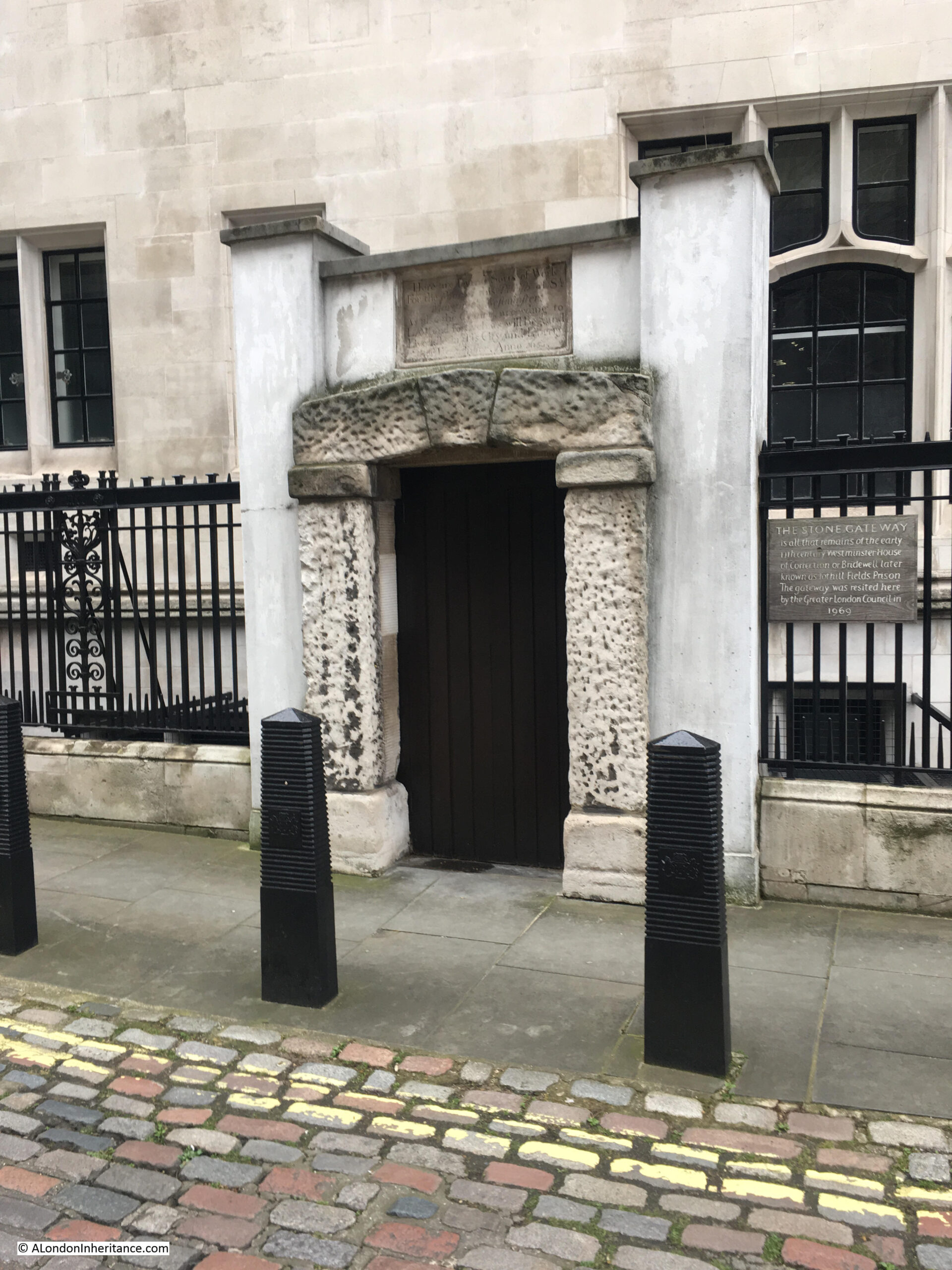
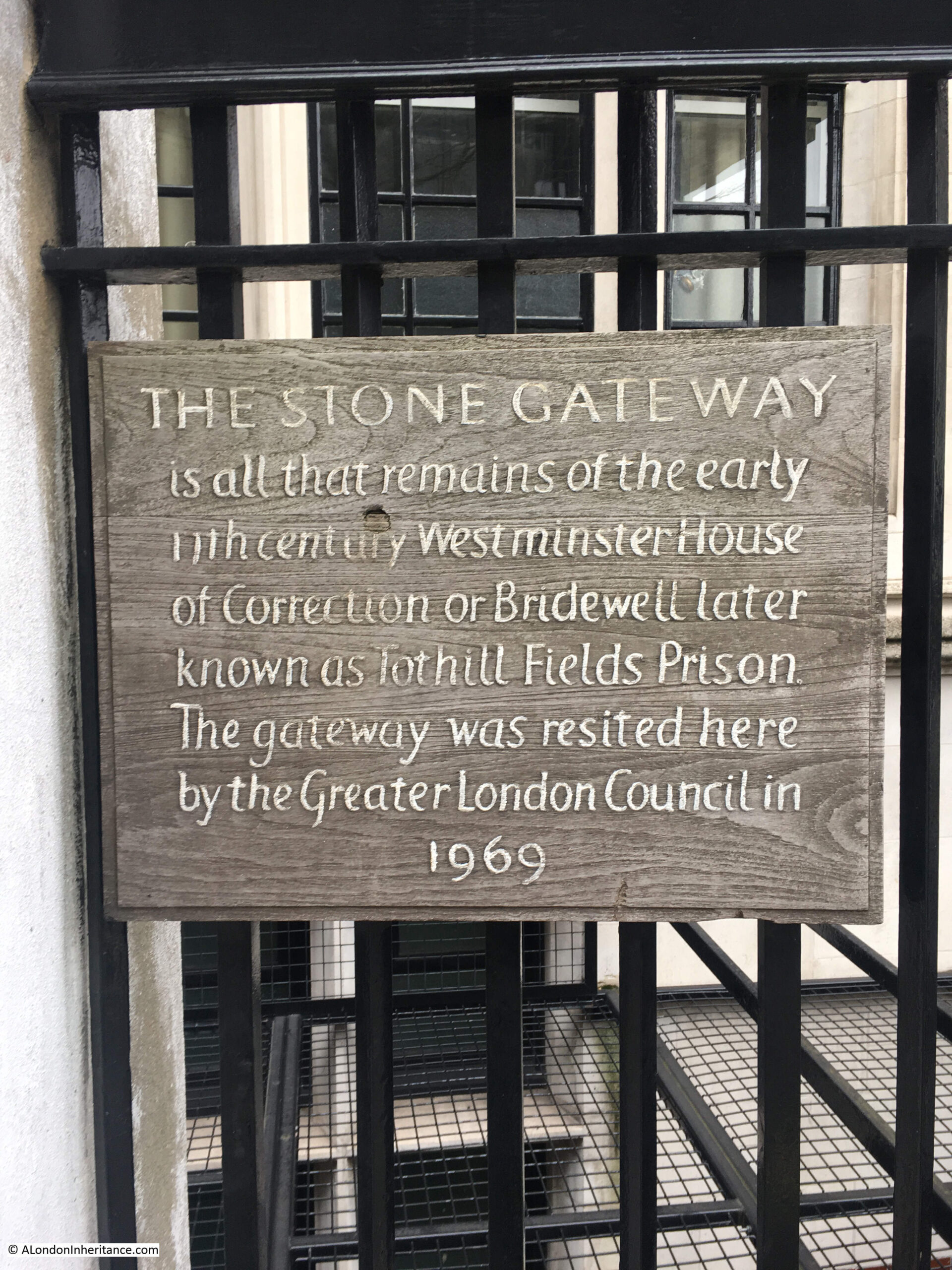
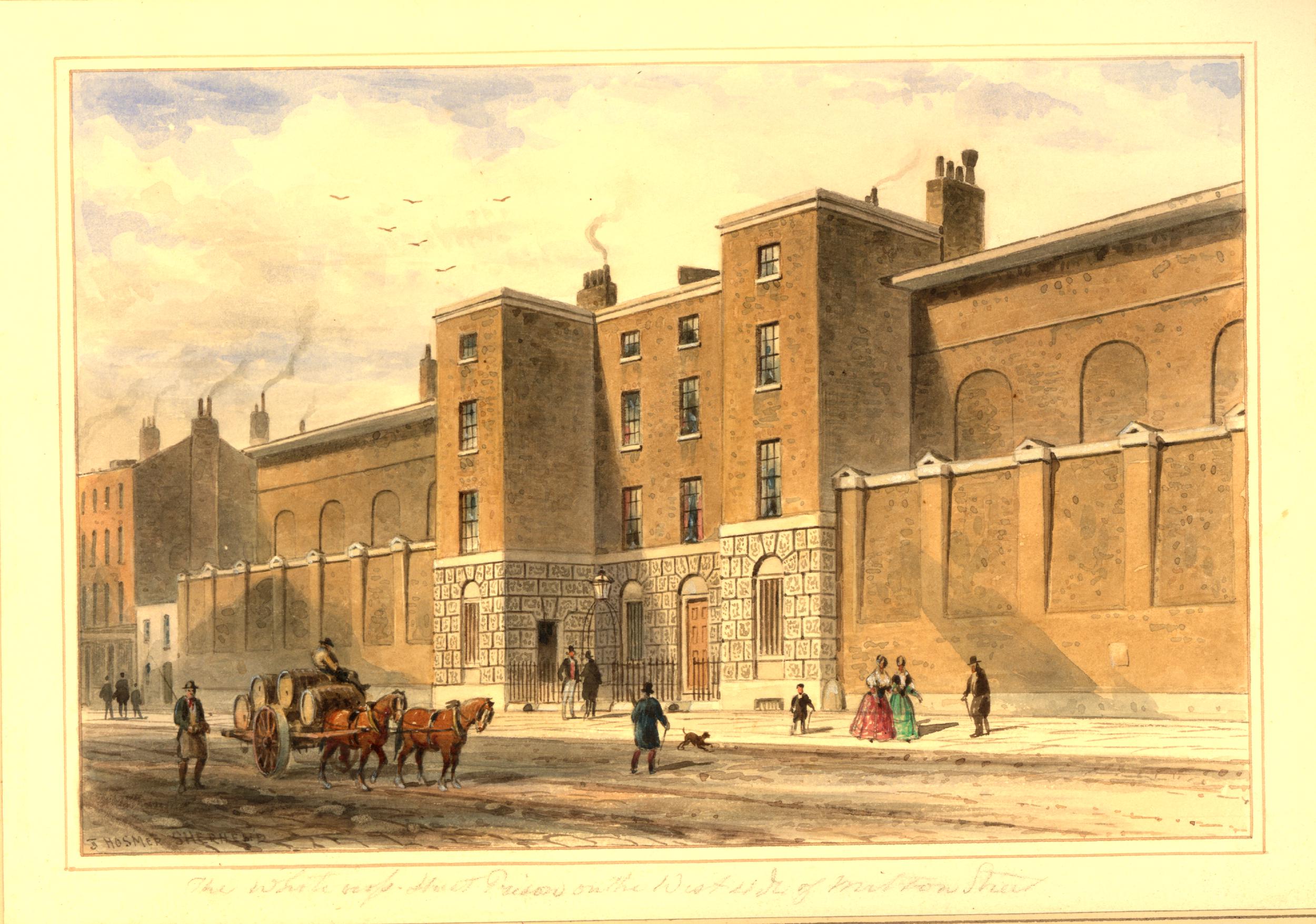
There is a plaque on the corner of Whitecross Street and Dufferin Street:

Whitecross Street Prison

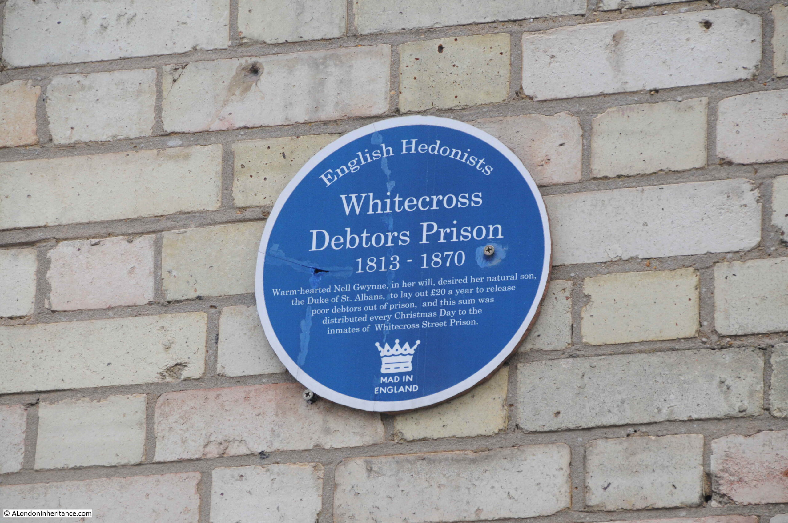
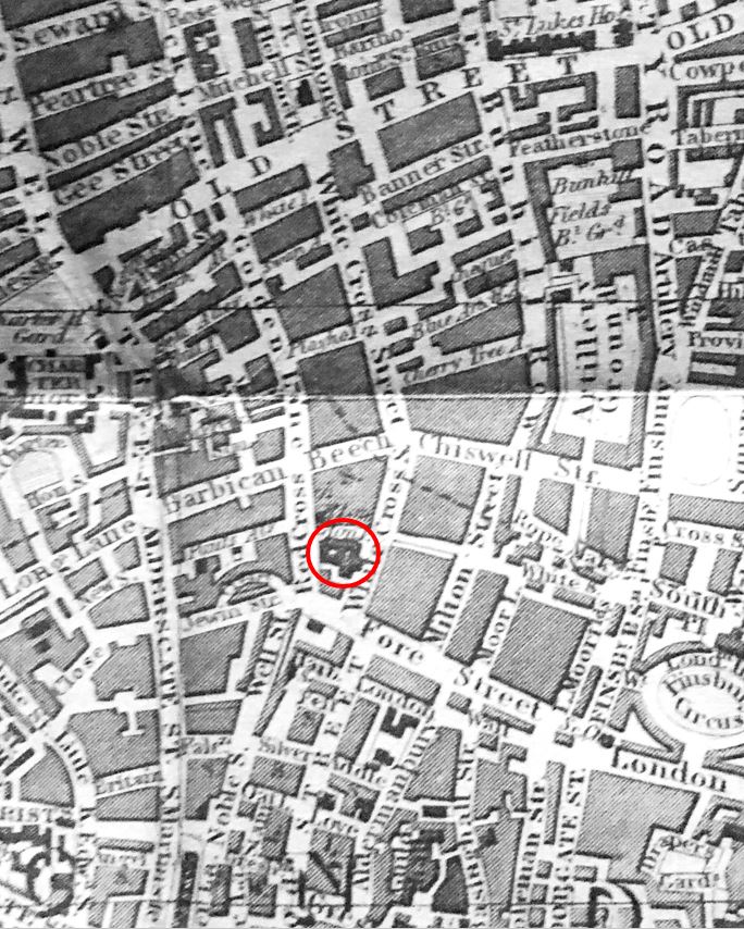
The plaque is a long way from the actual location of the prison, which was at the southern end of Whitecross Street, between Whitecross, Redcross and Fore Streets. The following extract from the 1847 edition of Reynolds’s Splendid New Map of London shows the location of the prison, circled in red.

Whitecross Street Prison

Today, the site of the prison is underneath the Barbican. In the following photo, I am looking across to the Barbican Centre from near the tower of St Giles. Gilbert House is on the right. The Whitecross Street prison was on the site of the building with white panels on the lower floors. Redcross Street ran to the left of the photo. Whitecross Street ran under / in front of Gilbert House.

Whitecross Street Prison

The prison was a debtors prison. Prior to Whitecross, if you were in debt and could not pay these off, then you could find yourself in a prison along with those being tried or convicted of a criminal offences ranging from petty crimes to murder.

In the early years of the 19th century there was a campaign to separate debtors from criminals, and the Whitecross Street prison was the result, being built between 1813 and 1815.

Although a prison full of debtors could be just as difficult to manage as a normal prison, as this article from the London Commercial Chronicle on the 17th September, 1816 reports:

“RIOT IN WHITECROSS-STREET PRISON. On Saturday evening another riot broke out in this prison among the confined debtors. it appears that a prisoner had committed some offence, for which the other prisoners thought proper to pump him. Mr. Kirby, the keeper, being informed of the transaction, found out two of the principals, and insisted upon locking them up, which was accordingly done. The rest of the prisoners resisted, and at length broke out into open rebellion, refusing to be locked up in their wards. Finding them continue refractory, a reinforcement of officers was sent for; and the City Marshal, accompanied by a posse of constables, speedily arrived, when the rioters submitted, and tranquility was restored.”

However, by 1834, the prison seems to have established a community feel. The Monthly Magazine reported the views “From an Inmate of Whitecross prison”:

“I have been a wanderer over a large portion of the globe during the last fifteen years, and have had various opportunities of seeing and studying men of many nations. In earlier life I saw much of France and Frenchmen; from them I have received the greatest kindness – and great hospitality. I have dwelt with Germans and Dutchmen, and the most agreeable recollections are connected with my sojourn among them. After years in official life, thousands of miles from ‘fair England’ circumstances threw me into the midst of Swedes, Danes and Spaniards, all of whom have given me opportunities of lending their kindness and generosity; but I have never in my life saw so perfect a display of the best feelings of our nature, as are in daily action and continual exercise under this roof. The society here appears one large brotherhood.

Association in sorrow softens and ameliorates the heart; selfishness is, perhaps, less known in this place than in any other ‘haunt of society’. The poorest captive shares with real pleasure his meagre meal with his less fortunate neighbour; kindness of heart shines in brightest splendour”.

Whitecross Street prison closed in 1870. The number of debtors had been declining, and an Act of Parliament had come into force abolishing imprisonment for debt. A report from the 8th January 1870 illustrates the unusual scenes when the prison was closed:

“SCENE AT WHITECROSS STREET PRISON: Release of the Prisoners – On Saturday, just after twelve, being the 1st of January, the day on which the new act to abolish imprisonment for debt came into force, Mr. Constable, the keeper of Whitecross-street Prison, gave as many as 94 prisoners leave to go out of prison. Of that number 63 prisoners availed themselves of the offer, and 31 asked to remain in the place for another day. Only 41 remain in custody on county court commitments, penalties, and orders for payment by magistrates. About eleven o’clock, a person named Barnacles, who had been twenty-seven years a prisoner, on an order from the Court of Admiralty, was told by Mr. Constable to leave the place, and he went out staring about him after his long imprisonment. Mr. Constable has acted in a humane manner, instead of prolonging the imprisonment of the parties until applications were made to a judge at chambers.”

One can only imagine Barnacles confusion as he left prison. He had been in the Whitecross prison for half of the prison’s existence.

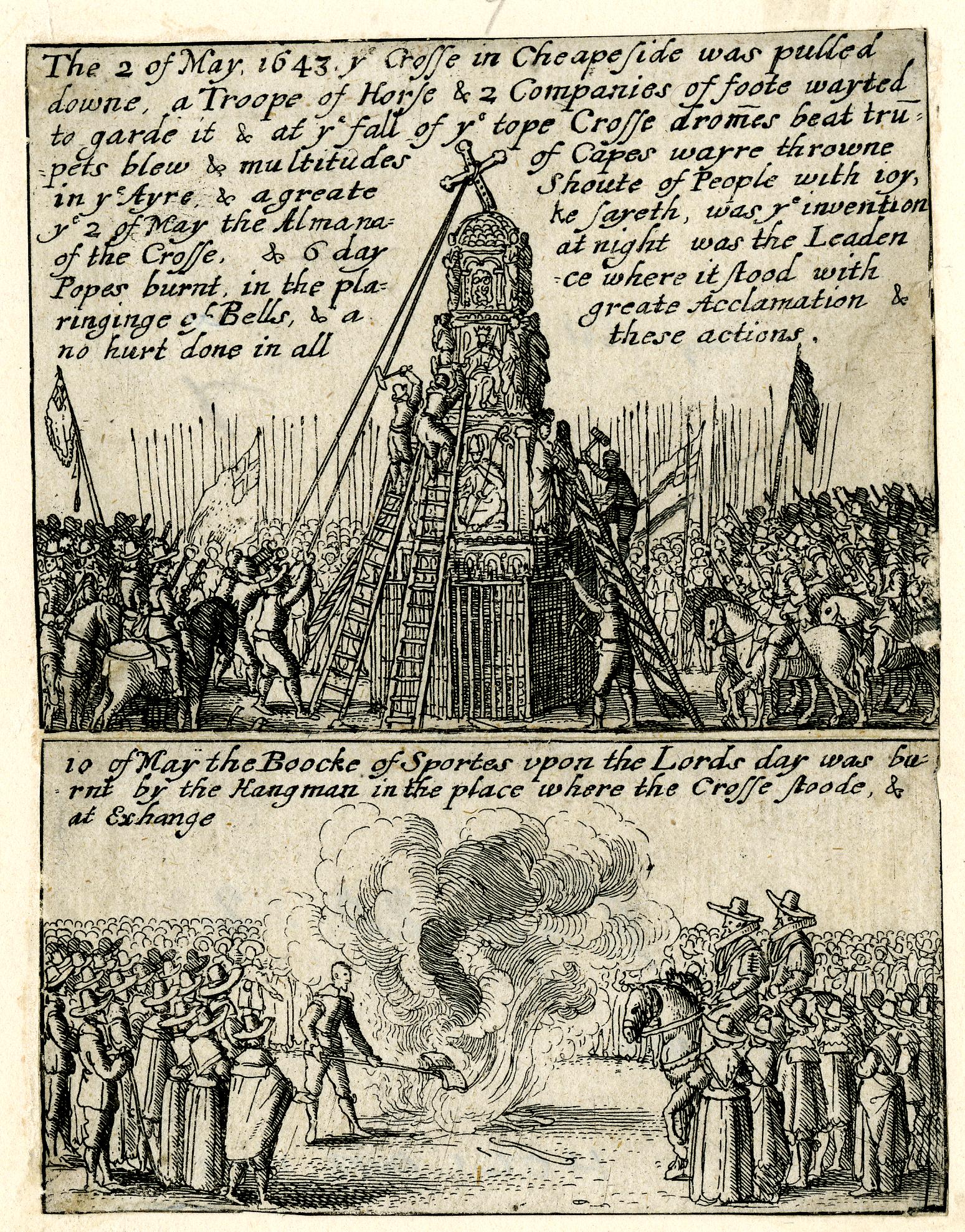
Whitecross Street Prison for Debtors as it appeared in 1850 (© The Trustees of the British Museum):

Whitecross Street Prison

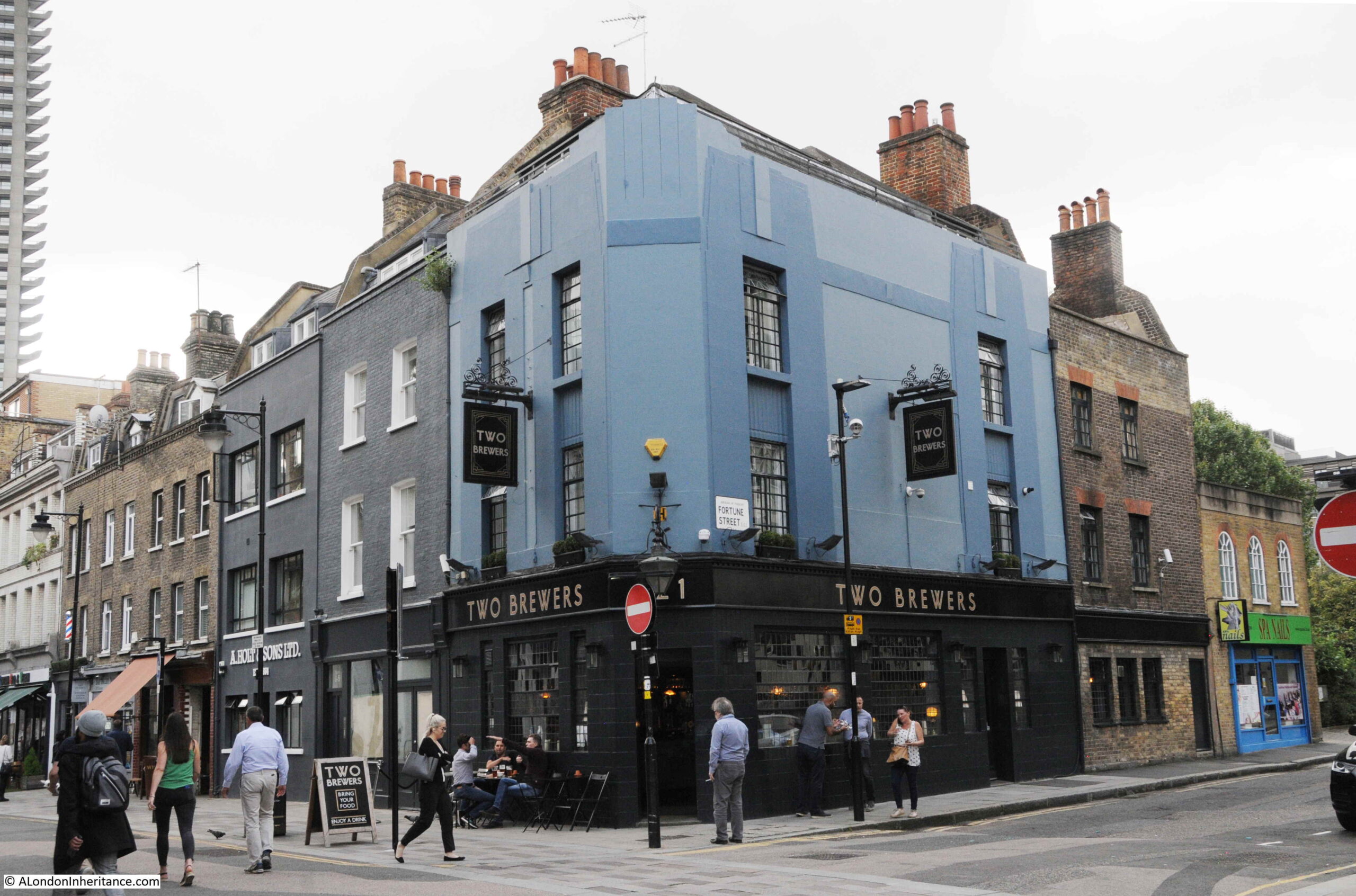
The Two Brewers pub on the corner of Whitecross Street and Fortune Street. A pub has been here since the mid 18th century.
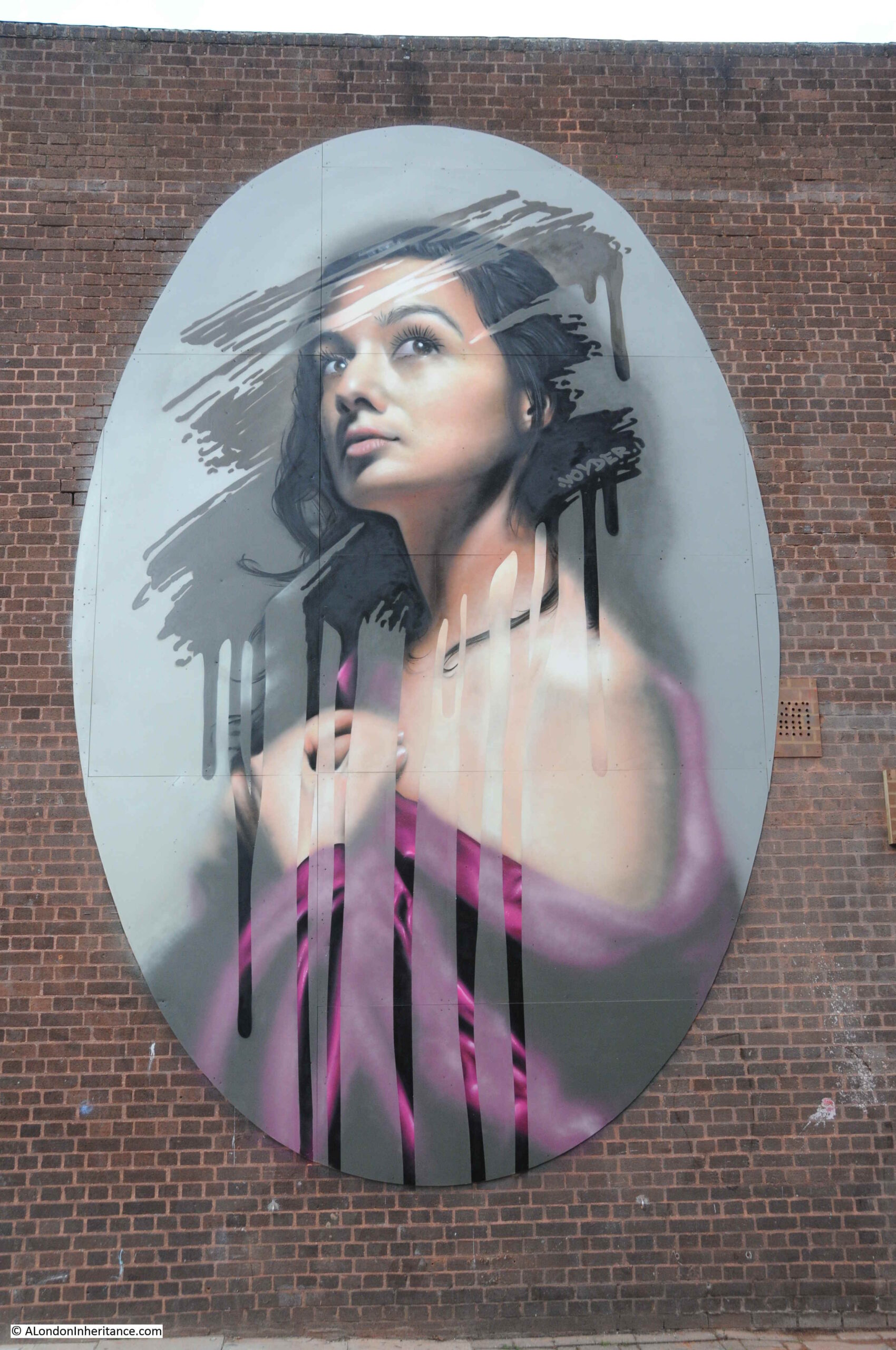
Whitecross Street

More street art:

Public Art

The market occupies the northern section of Whitecross Street, leaving the southern section free. The Barbican can be seen at the end of the view, which now covers the lower section of the original Whitecross Street.

Whitecross Street

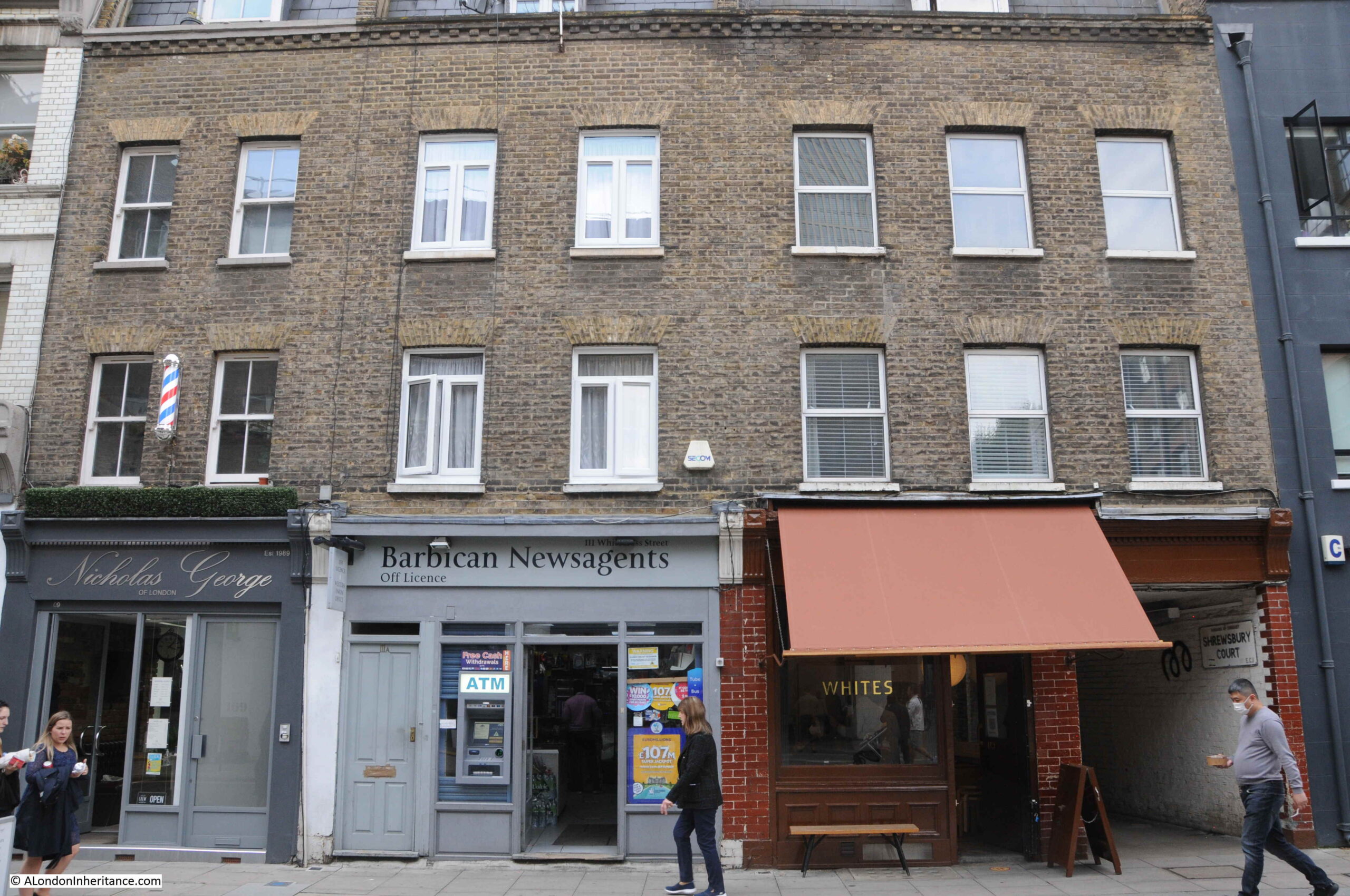
Much of Whitecross Street suffered severe damage during the bombing of the early 1940s. Whilst a number of the original brick terrace houses did survive, others have been significantly repaired and some have been rebuilt to look similar to the original building.

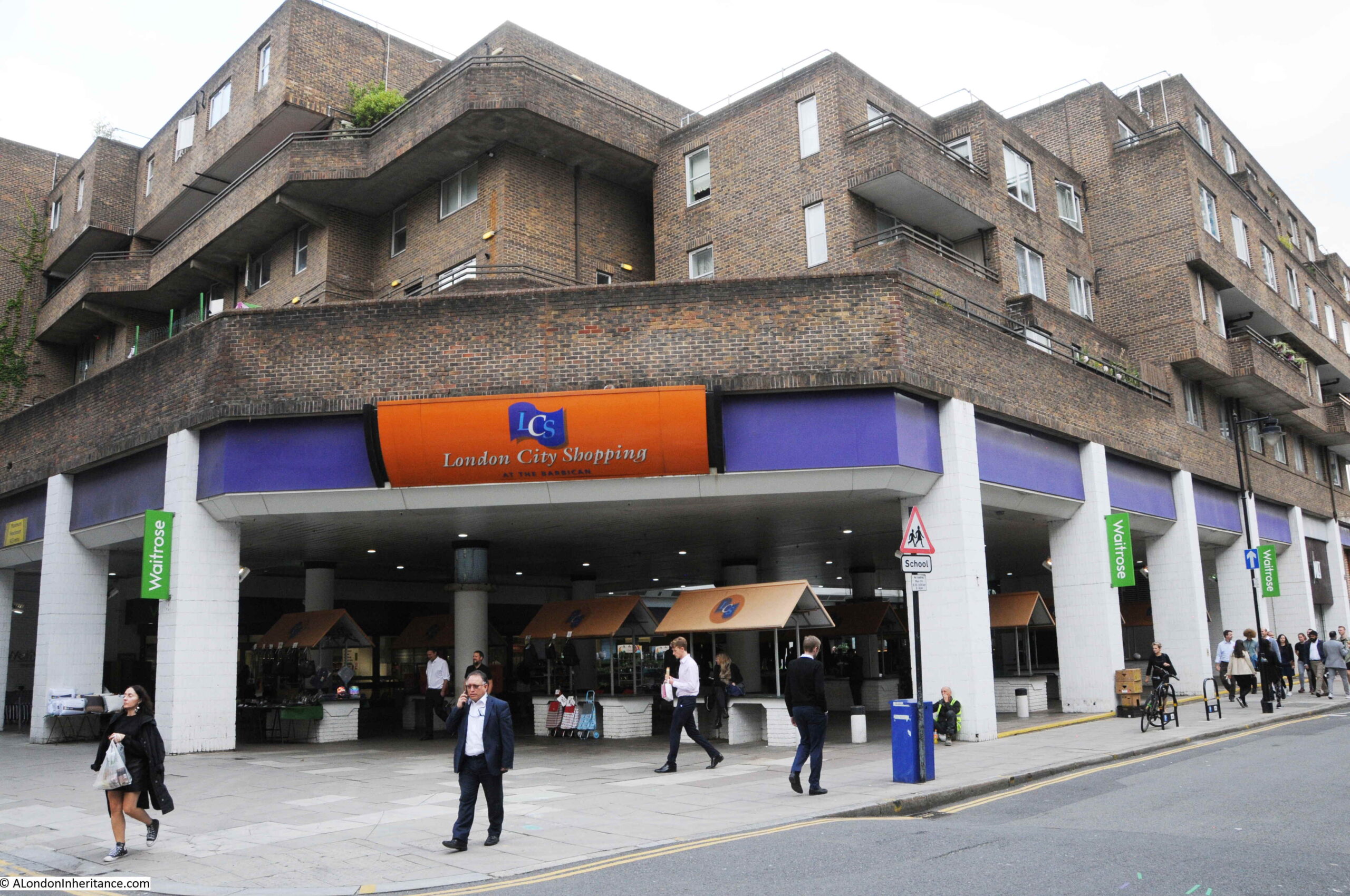
At other places along the street, completely new blocks have been constructed over bomb damaged areas, including this large block on the south-eastern side of the street, which includes a Waitrose on the ground floor behind the covered market area.

Whitecross Street

However the pleasure of Whitecross Street is that there are many of the buildings and small shops remaining, similar to those photographed by my father in 1953.

Whitecross Street

Whitecross Street is today much shorter than the pre-war street. As with so many streets in the area between Old Street and London Wall, post war development of the Barbican and Golden Lane estates have obliterated so many historic streets.

The side streets also have much to tell of the history of the area, and it is a fascinating area to explore. Although best not to follow Barnacles example of a long period of imprisonment, his approach on leaving Whitecross Street prison of “staring about” is a good approach when wandering the area.

alondoninheritance.com

Middlesex Guildhall, City of London School and White Swan Pub

One of the brilliant things with writing the blog posts is the feedback from readers in the comments section. Readers frequently provide additional information, or clarify questions that I had not been able to answer, and last week’s post was no exception.

The reason I could not find any further UK census information or references to the later life of Llewellyn Wooderson is that it appears that he emigrated to New Zealand. The answer to the age difference between Henry Wooderson and his wife Sarah in the 1881 census appears to be an error in Henry’s year of birth, in addition to the spelling of Leicester Square as Lester Square – you cannot always believe everything in census data and need to double check with multiple sources where possible. There was also some feedback on the Toronto, Canada birth of their son.

I had taken the 2021 photo of the old shop not that long ago, and Cards Galore, the shop that now occupies that of L&R Wooderson is reported to have closed. If so, a sad casualty of the lack of office workers in the City.

My thanks for the feedback to last week’s post, and indeed, feedback to all posts.

Now to the subject of this week’s post. Two rather lovely London buildings, and an update on another city pub at risk.

Middlesex Guildhall

The Royal Aquarium was the subject of one of last year’s posts, and to illustrate the location of the building, I included the following map. To the right was another building, marked as “Guildhall”, circled in red in the map below:

Middlesex Guildhall

Middlesex Guildhall is a rather impressive building, facing onto Parliament Square. Once the home of Middlesex County Council and Quarter Sessions, the building is now home to the Supreme Court.

The inclusion of Middlesex in the name refers to the old County of Middlesex that once included much of London, dating from a time when the country was split into counties, rather than many of the City and Metropolitan Boroughs and administrative divisions that we have today, for example Greater London, which took over much of the County of Middlesex following the London Government Act 1963, although London had already been chipping away at the boundaries of counties such as Middlesex and Essex for some time.

The site of the Middlesex Guildhall was the site of Westminster Abbey’s Sanctuary Tower and Old Belfry. The name sanctuary refers to the expectation that fugitives could claim sanctuary from pursuers if they could make it into the building. The name can still be found today as I will show later in the post.

An old court house had existed on the site during the 19th century, however in 1889 this was replaced by the first Middlesex Guildhall, however this was too small for both the administrative and legal functions carried out in the building, and the building that we see today was built between 1906 and 1913. This was the building in the early 1920s:

Middlesex Guildhall

And 100 years later the building remains exactly the same, although now cleaned, and the trees in the foreground have grown:

Middlesex Guildhall

The architect was James Gibson, who designed a late Gothic style building, faced with Portland Stone, although with a steel frame which helped take on much of the load bearing functions and supported features such as the tower which rises from the centre of the façade facing onto Parliament Square.

Gibson’s other work in London included West Ham Technical College, completed in 1895.

Some of the very distinctive features of the building are the sculpture by Henry Charles Fehr, which can be found across the building. Fehr was also responsible for some of the carving on the wood seating and panels in the Court Rooms. The Middlesex Guildhall would be considered the peak of his career.

The following photo shows the cluster of sculpture above the main entrance to the building:

Middlesex Guildhall

This shows Henry III (on the left), granting a charter to the Abbey of Westminster. Above are the arms of the County of Middlesex (the three Seaxes, or swords, with the crown above), and below is what looks to be a view of Westminster Hall:

Middlesex Guildhall

There is more on either side of the main entrance, including Lady Jane Grey being offered the crown by her father-in-law, the Duke of Northumberland:

Middlesex Guildhall

And King John with the Barons at Runnymede:

Middlesex Guildhall

Fehr’s work is finely carved and very detailed:

Middlesex Guildhall

The building was designed with courts of law for the administration of justice, and this role has continued to this day as the building is now home to the Supreme Court. Figures holding the symbols of Justice:

Middlesex Guildhall

The courtrooms within the Middlesex Guildhall have seen many trials over the years. Some of the more unusual were possibly the court martial of spies during the First World War. For example from the Evening Telegraph on the 14th July 1915:

“TWO GERMANS ARRESTED ON CHARGE OF BEING SPIES, On His Majesty’s Fleet – The authorities announce the arrest of two alleged German spies. Their trial will take place by Court Martial on Friday next at Middlesex Guildhall. The whole proceedings will be held in camera.

They will be charged with collecting and attempting to communicate with the enemy, information about His Majesty’s Fleet.”

The above trial followed an earlier trial of the alleged spy Robert Rosenthal which was the subject of some publicity at the time as the London Daily News reported on the 7th July 1915:

“TRIAL OF ROSENTHAL. Proceedings in Camera at Middlesex Guildhall – The trial of the alleged spy, Robert Rosenthal, began before a general court martial at Middlesex Guildhall yesterday. He is accused of coming to this country for the purpose of obtaining information both of a naval and military character.

Originally it was announced that part of the evidence would be taken in public, but at the last moment it was decided that the whole trial should take place in camera.

Prisoner was defended by Mr. Frampton. A large crowd assembled outside Middlesex Guildhall to witness the arrival of the members of the court. None of the public was allowed in the building. The entrance to the court where the trial was conducted was guarded by soldiers, and inside Rosenthal was placed between soldiers with fixed bayonets.”

Robert Rosenthal was a German, born in Magdeburg in 1892. At the age of around 16, he went to sea, and spent time in America where he presumably learnt, or improved his American accent as in 1914 he was in England using the assumed name of Harry Berger and travelling as an American.

He travelled between England and the continent a couple of times without any problems, but on his final trip in May 1915 he was arrested as he tried to board a ship.

His arrest was down to a strange error in the direction of post. He would travel back to Copenhagen as travel to Germany was not possible, and when in Copenhagen he had posted a letter to Germany, detailing his plans. This letter was accidently put into a mail bag heading to England, which was opened on arrival by the postal censorship authorities, revealing his identity and travel plans.

The court martial at Middlesex Guildhall found Rosenthal guilty and he was sentenced to death as a spy. Rather than the typical execution by firing squad, Rosenthal was hanged at Wandsworth prison just 8 days after the trial, on the 15th July 1925.

Whilst the Middlesex Guildhall today does not see any court martials, as the home of the Supreme Court, the building will now often see the ultimate determination of justice. Probably the most high profile recent cases have been the challenges to the Brexit vote and the process of leaving the European Union a few years ago.

As well as the historic and legal sculpture, there are also a number of cultural references, including the following reclining figure with an artist’s palette and brushes.

Middlesex Guildhall

A walk to the rear of the Middlesex Guildhall will be rewarding. The name of the street, Little Sanctuary, recalls what was here when Westminster Abbey allowed privilege of sanctuary to law-breakers who took refuge in its north west precincts.

Middlesex Guildhall

More of Henry Charles Fehr’s ornate sculpture can be found:

Middlesex Guildhall

And then there is a rather different entrance:

Middlesex Guildhall

The stone gateway surround is all that remains of Bridewell or Tothill Fields prison which originally stood roughly where Westminster Cathedral is today, set back from Victoria Street.

The plaque above the door reads:

“Here are ….. Sorts of Work for the Poor of this Parish of St Margaret’s Westminster. As also the County according to Law and for Such as will Beg and Live Idle in this City and Liberty of Westminster. Anno 1665.”

A sign adjacent to the door explains how the gateway arrived at the Middlesex Guildhall:

Middlesex Guildhall

The Middlesex Guildhall is Grade II* listed, however this did not stop some significant internal change when the building was reconfigured to be ready to function as the Supreme Court.

The three Court Rooms, with the main court room originally being the Council Chamber for Middlesex Council, were planned to have much of their wooded seating, paneling and decoration removed and many of the internal rooms reconfigured for their new purpose.

Save Britain’s Heritage campaigned for the changes to be abandoned, however although they had the support of many in the arts and architecture communities, judges and MPs, Westminster Council approved the plans, and on appeal it was decided that it was in the national interest to have a Supreme Court and for the court to be located in Middlesex Guildhall, and that these national interests over-rode listed buildings law.

The original plans had included the removal of the arms of Middlesex from above the main entrance doors, however, as the photograph shows earlier in the post, the arms remain as a reminder of the original function of the building.

The second building for this week’s post is the:

Old City of London School

Viewed from across the River Thames, just to the west of Blackfriars Bridge, and between the cranes of the works for the Thames Tideway Tunnel is the building that was home to the City of London School.

City of London School

The origins of the school date back to around 1442, when John Carpenter, a former Town Clerk of the City left a property for the education of four choristers at the Guildhall Chapel.

In the early 19th century, the City of London decided to review the provision of education in the City, including that provided to the Guildhall Choristers, and in 1883 decided to found a school for the “religious and virtuous education of boys, and for instructing them in the higher branches of literature and in all other useful learning”.

The result was the first City of London School which was built on the site of Honey Lane Market, north of Cheapside. This market was not far from the site of last week’s post on the corner of Wood Lane and Cheapside, see the same map from the post showing the location of Honey Lane Market:

City of London School

The Honey Lane Market school opened in 1837, however by 1878 the school was becoming far too crowded, and the decision was taken that a new site and larger school was needed. The school was described as “affording educational facilities, to, on an average, upwards of 600 boys at one time. The sons of people residing in, and within a few miles of the City of London, and engaged in commercial, professional or trading pursuits, at moderate cost, and without removing them from the care or control of their parents”.

The original school on the site of Honey Lane Market:

City of London School

Source: Wikimedia Commons – Engraving by J. Woods of the City of London School in Milk Street. Original steel engraving drawn by Hablot Browne (1815-1882) after a sketch by Robert Garland (1808-1863). This was published in The History of London Illustrated by Views in London and Westminster (1838)

By coincidence, Henry Charles Fehr, who was responsible for the sculpture on the Middlesex Guildhall, had been a pupil at the City of London School on the Honey Lane Market site.

A site alongside the recently constructed Victoria Embankment was chosen, and in December 1882, the new school was opened by the Prince of Wales.

The new school would support up to 700 children and was intended to provide a level of education that would “lead to Universities for those who seek it”.

The new school photographed at the end of the 19th century, about 15 years after opening:

City of London School

To the rear of the building facing the Victoria Embankment were a number of additional school buildings along with a large playground and gym. Below ground there was a rifle range.

In 1937 for the centenary of the school, a biology lab was opened along with “one of the finest swimming pools in London”. In 1956 a Junior School was added to the site and two years later new Science rooms were added.

View of the school from Blackfriars Bridge, partly hidden by the Thames Tideway Tunnel works where a new intercept junction is being built, so that flow from the city sewer system can be intercepted and fed into the new tunnel. A new public space will be created when the work has completed.

City of London School

In the above photo, it looks as if the new river wall to the new space is being installed. Taking a closer look at this I was fascinated to see that the words “Bazalgette Embankment, Tunnel 48m Below”. Brilliant to see that the creator of the Embankment is being remembered, along with the latest engineering project at the site, with the depth of the tunnel far below.

Detail on the new river wall:

City of London School

A side view of the old City of London School shows the different materials used, with stone facing to the front of the building and much cheaper brick to the sides:

City of London School

The school on the Embankment would continue in use until 1986, when a new school was built, a short distance along the river, on a large site between Queen Victoria Street and the river. Part being constructed over Upper Thames Street.

The front of the building from the Victoria Embankment:

City of London School

If you look at the above photo, just below the parapet that lines the base of the roof, you will see four statues which reflect the educational focus of the school in literature, poetry and science with Shakespeare, Bacon, Milton and Newton being represented, however one of these has a strange spelling:

City of London School

Look at the statue to the left, and the spelling of the name on the plinth is Shakspeare, missing out the “e” between the k and s, as in the normal spelling of Shakespeare.

I know there have been alternative spellings of Shakespeare’s name, however the version with the “e” seems to have been the standard for many years.

Was it a simple spelling mistake? Did one letter need to be dropped so the longer name would fit across the plinth? or is there some other reason? I would love to know.

Following the move of the school in 1986, the building was refurbished and is currently occupied by the asset management company J.P. Morgan.

The Middlesex Guildhall and the City of London School have found new uses, and appear safe for the time being from any further redevelopment, however for my final building of this week’s post, there is a pub that may be at risk:

The White Swan – Fetter Lane

I photographed and wrote about the Swan in Fetter Lane last July when I went on a walk to find all the pubs of the City of London.

White Swan

Plans have recently been approved for the redevelopment of 100-108 Fetter Lane, however these plans include two options for the pub:

Option A is for a new office building, but with the White Swan Pub relocated and “reimagined in an enhanced manner”.

Option B is for flexible office space, a pedestrian route, gardens and the White Swan retained as part of an extension of new commercial space.

Source: Buildington

Option A, where the pub appears to be demolished, and a new pub built in the dreaded words of “reimagined in an enhanced manner” sound rather ominous.

White Swan

Just three buildings out of the thousands that can be found across London, and representative of the change that always has, and will continue to take place across the city’s streets. I do hope though, that the White Swan survives. A fine example of a 1950’s brick built, London pub.

alondoninheritance.com

On the corner of Cheapside and Wood Street

For this week’s post, I am in Cheapside in 1986, looking across to the shop of Shirt Makers L&R Wooderson, on the corner of Wood Street:

Wooderson

Thirty five years later and the building is still there, however L&R Wooderson have now been replaced by a card shop, Cards Galore:

Wooderson

A wider view, showing Wood Street leading off Cheapside to the right:

Wooderson

The location is shown in the map below, by the red circle. For reference, part of St. Paul’s Cathedral can be seen to the left  (Map © OpenStreetMap contributors):

Cheapside

There is much to discover in this small, corner plot of land, part of which has a large tree which towers over the top of the shop, and can just be seen in the above photos.

The tree has been a significant landmark on Cheapside for very many years, and it was mentioned frequently in newspapers throughout the 19th century, for example in the following from the London Sun, when on the 1st April 1846 the paper reported:

“A ROOKERY IN CHEAPSIDE AND A CHERRY TREE ON LONDON BRIDGE – It is a singular fact that at the present times there are two crows’ nests on a lofty tree at the corner of Wood street, Cheapside; the birds are mated. One day last week, a furious fight took place between the four of them, which ended in the partial demolition of one of the nests. The damage has been since repaired. On the City end of London bridge a cherry tree, growing from one of the chinks in the granite, is now putting forth leaves. It is almost three years old.”

The tree appears to have been under threat in 1881, when multiple newspapers carried the following report:

THE CHEAPSIDE TREE – A flagrant act of arboricide is about to be perpetuated of malice aforethought and in open day. If there is one tree in London the position of which, apart from all personal charms and apart from the rest due to venerable age, deserves to be saved from the innovating axe, it is ‘the Cheapside tree’. For generations its pretty group of foliage has peeped out as a surprise and contrast to the surrounding masses of stone and brick. It has been a standing emblem to thousands of fagged and dust-stained city clerks of their annual fortnight holiday. It is blessed amongst trees. A tree of the street is infinitely more precious than ‘a tree of the field’. But it is doomed, and bad luck to the ruthless contractor or avaricious land-jobber by whose instigation the Cheapside tree is to be laid low.”

The tree did survive, no doubt helped by the number of references to the possible destruction of the tree in newspapers using such graphical descriptions as in the above report.

The tree was also used in adverts and references to shops and businesses in the immediate vicinity of the tree, adding the tree to their location to help potential customers find their business. L&R Wooderson were also using the tree as a reference in the 1986 photo, as shown by the following extract from the photo of the shop door:

Wooderson

The term “Under the Tree” was used by a number of businesses operating in the terrace of buildings of which L&R Wooderson is part, for example:

  • Illustrated London News: 13th August 1853 – Rowe’s 25,000 Cab-Fares to and from all the Railways, Public Buildings, &c in London. Samuel Row, Under the Tree, Cheapside
  • Kentish Mercury: 31st January 1890 – The Express Dairy Company’s new branch at 130, Wood Street, Under the Tree, Cheapside is now Open for Business
  • The Bystander: 2nd August 1905 – For Gentlemen, the H.W. Velvet Grip Boston Garter. The Acme of Comfort, the Height of Perfection. L&R Wooderson, Under the Tree, 122/4, Cheapside, E.C.

It is difficult to determine the age of the tree. It is a London Plane tree, and the Woodland Trust define the tree as a cross between the Oriental plane and the American sycamore. They also state that the tree was first noticed in London in the mid 17th century, and that planting across London started in the late 18th century, so the tree probably dates from at least the late 1700s and must be around 250 years old.

A view of the tree from Wood Street, looking back towards Cheapside shows the impressive height and spread of the tree:

Wood Street

The tree also featured in the following photo from the book Wonderful London by St John Adcock, from the first decades of the 20th century:

Wooderson

The shop of L&R Wooderson is also in the above photo, looking much the same as it would many years later in 1986. Friday Street, and the plaque on the right of the above photo will be the subject of a future post.

The first written reference I can find to L&R Wooderson is an advert in the Daily Telegraph and Courier on the 27th September 1899 for:

“HOSIERS – Improver WANTED – apply personally or by letter, L.R. Wooderson, 45, Eastcheap, E.C.”

However whilst the name is correct, in 1899 their address was at the eastern end of Eastcheap, towards Great Tower Street. The 1895 Post Office Directory confirms their original Eastcheap address and gives their full names as Llewellyn and Robert Wooderson.

This is where researching these posts always leads me down different routes, as having their full names, I wanted to know a bit more about them.

Searching the census records resulted in a bit of a mystery. The 1881 census records Llewellyn and Robert Wooderson living at 47 Lester Square, St Anne Soho (the parish).

I am not aware that there was a Lester Square, or that Leicester Square was originally called Lester Square, and could not believe there was an error in the census data. Reading through the census entries for 1881 there is also a St John’s Hospital at 45 Lester Square. There was indeed a St John’s Hospital for Diseases of the Skin at number 45 Leicester Square from 1865 to 1867, which confirmed that the spelling of the square was wrong in the 1881 census.

In 1881, Llewellyn and Robert Wooderson were part of a large family at number 47 Leicester Square, which consisted of:

Cheapside

Llewellyn and Robert were aged 8 and 6 in 1881, and whilst the rest of the children were born in London, Robert is recorded as being born in Canada.

Their father, Henry Wooderson is listed as a Fruit Salesman, as is the eldest of the sons, also a Henry, however although son Henry has the same first name as his listed father, he cannot have been his biological father.

There is a 12 year age difference between Henry (28) and his wife Sarah (40), and if Henry had fathered the younger Henry, he would have been 11 at the time, so possibly Henry, George and Edwin are the sons of a previous marriage of Sarah’s with Llewellyn and Robert possibly being Henry’s biological sons.

The two Henry’s worked in Covent Garden market as a Henry Wooderson & Sons is listed in the 1913 book “Covent Garden, Its Romance and History” by Reginald Jacobs. The younger son George may well have gone into the same business as a George Wooderson is listed as having a shop in the north row of shops at Covent Garden.

By the 1891 census, the father Henry could possibly have died as there is no mention of him in the census. The eldest son Henry was now married to Harriet and they were living in Tavistock Street. Llewellyn who was now 18 and Robert, 16, were living with them. By 1891 they had started in the profession that would result in their shop in Cheapside as their were both listed as Hosiers Assistant, and not long after they would open their first shop in Eastcheap.

By 1901, Llewellyn had joined the commuting class having moved out to Somerset Road in Reigate, to a terrace house which is still there. Married to Alice, and with two sons Llewellyn (2) and Malcolm (0). The business must have been doing reasonably well as also living in the house was a domestic servant

In the 1911 census, Robert Wooderson was married to Nellie Geraldine and had two sons. In the 1881 census, Robert was listed as being born in Canada, however the 1911 census adds the city of Toronto. It would be fascinating to understand why, of all the family members, only Robert was born in Canada, and what his mother was doing in the country at the time.

Also in 1911, Robert was listed as a Gentlemens Hosier, and he was living along with his family in Lessar Avenue, Clapham. His house is still in the street.

By the 1939 Register, Robert had moved to Atkins Road, Wandsworth, and his son Thomas was aged 40, single and listed as a Master Hosier so had probably joined the family business in Cheapside. Robert would die in 1957.

I cannot find any reference to Llewellyn’s later life.

They also seem to have had the two shops, the original on Eastcheap, and the shop featured in the photos at the start of the post on the corner of Cheapside and Wood Street. It would have been fascinating to try and find out more about their life, however I am always constrained by time within the scope of a weekly post.

Behind the old L&R Wooderson shop, and where the tree is located is a small patch of open ground facing Wood Street:

Cheapside

This was the churchyard of the church of St Peter West Cheape. The churchyard can be seen in the following extract from Rocque’s 1746 map, on the left, above the “C” of Cheapside:

Cheapside

In the above map of 1746, a row of buildings is shown between the churchyard and Cheapside, following the line of buildings that we see today, however in the earlier 1682 map by William Morgan, the churchyard (above the E and A of Cheap) is an open space up to the edge of Cheapside:

Cheapside

The appearance of the buildings, of which L&R Wooderson was a part, gives the impression of being of some age, however there is no (that I can find) confirmed dating of the terrace, however they do follow the alignment shown in the 1746 map, so they do follow the property boundaries of the post Great Fire rebuild.

The church that once occupied the space, along with its churchyard, was one of the churches lost in the 1666 Great Fire, and not rebuilt.

In the book “London Churches Before The Great Fire” by Wilberforce Jenkins (1917), the old church was described:

“The ‘Church of St Peter, West Chepe, stood on the corner of Wood Street, Cheapside, and was not rebuilt after the Fire. The well-known tree in Cheapside marks the spot, and a small piece of the churchyard remains. It was sometimes called St Peter-at-Cross, being opposite the famous Cross which stood in the middle of the street, and was at one time an object of pride and veneration, and at a later period the object of execration and many riots, until pulled down and burnt by the mob. The date of the ancient church is uncertain, but there would appear to be a reference to it in 1231. In the ‘Liber Albus’, one Geoffrey Russel is mentioned as having been present when a certain Ralph Wryvefuntaines was stabbed in the churchyard of St Paul’s and being afraid of being accused, fled for sanctuary to the Church of St Peter.

Thomas Wood, goldsmith and sheriff, is credited with having, in 1491, restored or rebuilt the roof of the middle aisle, the structure being supported by figures of woodmen. Hence, so tradition says, came the name of the street, Wood Street.”

The “famous Cross” mentioned in the above extract was one the crosses erected by Edward I in 1290 on the corner of Wood Street, to mark the resting places of Queen Eleanor’s coffin on its way from Lincoln to Westminster Abbey.

The cross was a large structure and was decorated with religious iconography including images of the Pope and the Virgin. From the mid 16th century onwards, the cross was the subject of attack by puritans who objected to the religious symbols on the cross.

On the 2nd of May, 1643, the cross was demolished, which was illustrated in the following print produced by Wenceslaus Hollar in the same year (© The Trustees of the British Museum):

Cheapside

The illustration at the bottom of the print shows the “Booke of Sportes upon the Lords Day” being burnt on the site of the cross.

The Book of Sports was a book first published in 1617 during the reign of James I to define what sports were allowed on a Sunday. Initially only covering Lancashire to try and resolve a dispute between Puritans and mainly Catholic gentry, the guidance within the book was applied across the whole country in the following year.

Republished by Charles I, the book was a constant problem for Puritans who considered any playing of sport on a Sunday against their religious principles. As the influence of Puritanism grew in the lead up to the English Civil War, Parliament ordered that the book be publically burnt, one of the burnings was on the site of the cross, on the 10th May 1643.

The old churchyard of St Peter, West Chepe is now a small open space with a small number of gravestones. In the following photo, the brick rear of the building on Cheapside, including the old shop of L&R Wooderson is shown on the left:

Cheapside

Some of the graves are from the early 19th century showing that while the church was not rebuilt after the Great Fire, the churchyard continued in use.

Side gate between the buildings facing Cheapside and the graveyard:

Cheapside

On the railings facing onto Wood Street is an image of St Peter, along with the cross keys frequently shown with St Peter as the “keys to heaven”.

Cheapside

And on the rear of the image of St Peter, is the date 1712 and the names of the churchwardens, which appears to date the railing to 1712:

Cheapside

I would have liked to have had the time to find out more about the Wooderson family. For how long the family was involved with the shop and when it finally closed. Cards Galore who currently occupy the shop seem to have been expanding during the 1990s, however I cannot find their Cheapside shop listed during this decade, so perhaps it was in the 2000’s that L&R Wooderson finally closed.

This has been an incredibly interesting corner of Cheapside, tracing the family of the shop, a church destroyed during the Great Fire and the Cheapside Cross destroyed in the years leading up to the English Civil war, however as usual, I am just scratching the surface.

alondoninheritance.com

Bagnigge Wells, House and Gardens

Although today there is very little of it to see, water has shaped much of London. The alignment of streets, property boundaries, rise and fall of the land have all been shaped by water. Whilst these are all subtle indicators of the historic presence of water there are still a number of more visible signs that hint at an areas history, and one of these is on a building on the western side of King’s Cross Road.

Bagnigge Wells

The sign reads “This is Bagnigge House Neare the Pinder A Wakefeilde 1680”.

The Pinder of Wakefield was a pub that dated back to the early 16th century in Gray’s Inn Road. A pub with the same name was on the same site until 1986, when the building was purchased by the “The Grand Order of Water Rats” charity, renamed the Water Rats, and is now a performance venue.

Bagnigge House and the Wells that were found in the gardens of the house are the subject of today’s post.

The house in King’s Cross Road with the Bagnigge House sign:

Bagnigge Wells

The location of the Bagnigge House stone, along King’s Cross Road is shown by the red circle in the following map  (Map © OpenStreetMap contributors):

Bagnigge Wells

The red rectangle highlights the area covered in the post.

If you look to the left side of the red box, you will see Cubitt Street, a street which unlike the rest of the streets in the area, does not follow a straight line and is curved around an area of land between Cubitt Street and King’s Cross Road.

To the left of Cubitt Street, the map shows the light blue line of the old River Fleet. I have double checked with my go to reference for London’s old rivers; “The Lost Rivers of London” by Nicholas Barton and Stephen Myers, and the routing of the Fleet shown in the above map is roughly right.

Before the streets and buildings of London had extended this far north, this was an area of fields and agriculture. The River Fleet ran through the fields, the area was low lying and rather wet, especially after heavy rains when the Fleet would have flooded.

Rocque’s map of 1746 provides a view of the area in the middle of the 18th century. Fields cover the majority of the area, but in the upper centre of the map there are buildings and formal gardens bounded by the River Fleet and a street named Black Mary’s Hole.

Bagnigge Wells

The street to the left labelled “Road to Hampstead and Highgate” is today, Grays Inn Road.

Black Mary’s Hole is now King’s Cross Road. There are various interpretations of the name, but the majority of sources refer to a black woman called Mary, who sold water in the vicinity from a well or fountain.

As well as the Fleet, the Rocque map extract also shows the irregular shape of a number of ponds, confirming that this was an area where there was plenty of water.

By 1816, streets and buildings had started to reach the area, and the following extract from the 1816 edition of Smith’s New Plan of London shows the area between the Fleet and King’s Cross Road (in the centre of the map) now labelled Bagnigge Wells.

Bagnigge Wells

To the right of the map is New River Head and on the edge of the map, Sadler’s Wells, further illustrating how water has shaped the area.

Turning off King’s Cross Road into the side streets, and we can get a view of the drop in height down to King’s Cross Road and the rise in height on the opposite side. An indication of the river valley of the Fleet.

The following view is looking down Great Percy Street from Percy Circus, with the rise of Acton Street across the junction. The River Fleet would have run from right to left along the lowest part of the view.

River Fleet

The area of land shown in the Roque map between the Fleet and Black Mary’s Hole appears to have been enclosed at some point in the second half of the 17th century. The land was to the east of a field called Action Field that occupied the area west to what is now Gray’s Inn Road. The name of the field is preserved in the present day Acton Street.

When a Thomas Hughes purchased the land in 1757, he had the waters from a well that was already in use, tested by a Doctor John Bevis, who reported that the water from the well had chalybeate properties (in the context of water, the name chalybeate means that the water contains iron, see also my post on the Chalybeate Well in Hampstead).

To capitalise on these findings, Thomas Hughes opened the gardens and the well to the public in 1759. This was the period when there were many pleasure gardens opening up around the City. Outside the jurisdiction of the City of London, in places such as along the south bank of the Thames, in Islington, and in Bagnigge Wells.

They provided a pleasant place to visit, away from the smoke, dirt and noise of the City. St. Chad’s Well was another well a short distance away from Bagnigge Wells that had gardens and a pump house where customers could drink the water. I have written about St. Chad’s Well here.

The gardens around the well were attractively laid out, entertainment, food and drink was also provided to customers, both to attract customers to the gardens as well as for profit.

Bagnigge Wells seems to have been a success as some of the land on the opposite side of the River Fleet was purchased to expand the gardens.

A print from 1843 appears to show the stone that is now in King’s Cross Road above the garden entrance (© The Trustees of the British Museum):

Bagnigge Wells

The inscription on the stone in my photo at the top of the post has the date 1680. In the print above it could be 1689, so either an error, or a later updating of the inscription over the years has changed the original date on the stone.

The date does pre-date the time when the gardens and well were part of the pleasure gardens so the house referred to must have been one of the earliest houses on the land.

Although the caption to the following print does state “The Original Garden Entrance To Bagnigge Wells, Established in 1680”, the gardens and wells were not a public gardens at that time (© The Trustees of the British Museum).

River Fleet

Presumably, the view is looking north with the garden entrance on the left and Bagnigge House behind the trees on the right.

The river running along the middle of the print must therefore be the River Fleet, which looks rather serene and calm, however it was not always so, and heavy rains around the source of the river in Hampstead could quickly result in the river flooding as the following article from the Derby Mercury on the 9th September 1768 reports:

“And about One o’clock yesterday morning the water came down in such torrents from Hampstead that the road and flat fields about Bagnigge Wells were overflown; the water rose eight feet perpendicular above the usual height of the drain, and was nearly four feet above the foot bridge at that house; the Pleasure-garden, cellars, and Out-houses belonging thereto were overflown, and several of the Pales broke down by the Violence of the stream. Great damage was done to Mr Harrison’s Tile-kiln near the said Wells, where three young men were sleeping in an Out house and were surprised by the Flood, and two of them drowned. The house of Dr. Sharpe, near Bagnigge Wells, was four feet deep in water, and a man and woman behind the House narrowly escaped being drowned.”

The article mentions Mr. Harrison’s Tile-kiln and if you refer back to the extract from Smith’s New Plan of London, you can see the tile-kilns just to the north east of Bagnigge Wells.

The rain was probably caused by the brief, very heavy showers we have also seen in London recently which cause a flash flood. Today, this volume of water falling in north London would now be carried by the same sewer in which the old River Fleet in now buried.

The following print is from 1777, eleven years after the floods in the above article and shows the buildings at Bagnigge Wells, with the entrance to the gardens on the left (© The Trustees of the British Museum).

Bagnigge Wells

Today, roughly where the River Fleet once ran, is Cubitt Street (originally Arthur Street). This is the street that curves slightly to the west of King’s Cross Road and is where the River Fleet formed the original western boundary to Bagnigge Wells as shown in Rocque’s map of 1746,

The view south along Cubitt Street:

Cubitt Street

And the view north along Cubitt Street:

Cubitt Street

In the above view, the River Fleet would have run roughly along the line of the street. Bagngge Wells was originally to the right, and following the commercial success of the gardens, expanded to include the left of the photo, with wooden bridges providing access between the two sections of the gardens.

Seats were arranged along the River Fleet for those who wanted to smoke or drink ale or cider. Tea, cake and hot buttered rolls were served, and concerts were held in the main room of the house. A small temple shaped building was created to house the wells from which water was taken and sold.

London’s pleasure gardens and their visitors were often the subject of satirical prints. The following print from 1781 shows “Mr. Deputy Dumpling and Family enjoying a Summer Afternoon” at the entrance to the gardens at Bagnigge Wells (© The Trustees of the British Museum).

Bagnigge Wells

18th century pleasure gardens were intended to be peaceful places in London’s countryside, away from the noise and dirt of the City. Where people could spend an afternoon or evening, being entertained, or just drinking and eating and seeing and being seen by others at the gardens, however they were not always places of peace.

in May, 1784, Bagnigge Wells was the scene of some violence between two opposing political groupings, as documented in the following newspaper report:

“Yesterday evening the gardens at Bagnigge Wells exhibited a strange scene of riot and confusion. How the affair began is not easy to be determined, but, at the same moment, several hundreds of Stentorian lungs vociferated the cry of ‘Hood and Wray’ and these were answered by the exclamation of ‘Fox for ever’. Intoxicated with liquor and politics those who were for Hood and Wray boxed with the friends of the Coalition and Fox, and many on both sides were knocked down with the canes and sticks of their adversaries. So sudden a disarrangement of the tea-table apparatus was perhaps never before seen and innumerable fragments of china shone on every walk, and served to give issues to the inflamed blood of the fallen and sprawling heroes. Those peace officers were sent for, the tumult was not appeased for near two hours and a half. Three men, who had been active in fomenting the disturbance, were taken into custody and were soon rescued”.

The same newspaper also reported on a “violent fracas” between the same two opposing groups in the Piazzas, Covent Garden.

Wray was Sir Cecil Wray who was a member of Parliament but was highly critical of proposals to raise taxes by a “receipts tax” which he claimed would fall “on the middling ranks of people and very partially and unequally laid”. Wray preferred a land tax, which in his view had always been too low in the country, but was opposed by the land owning classes (some things do not change).

He also presented a petition that had been drawn up by the Quakers calling for the abolition of slavery, which he called “an infamous traffic that disgraced humanity”.

The MP Charles James Fox put forward the East India bill which proposed nationalising the troubled East India Company, and Wray was strongly opposed to such an action.

At the general election Wray and Lord Hood stood against Fox with Wray standing as an Administrative candidate in Fox’s Westminster constituency. It was a violent election period as indicated by the trouble at Bagnigge Wells, however Fox won and Wray then appears to have abandoned any plans to try and get back into Parliament. He was described as being “one of the most upright, one of the most virtuous, one of the most honourable and independent men” in Parliament.

Up until the end of the 18th century, Bagnigge Wells continued to be a fashionable place to visit, however its days were numbered as the buildings and streets of London started to surround the gardens.

Less desirable and the “lower class of tradesmen” were now to be found in the gardens, and there was petty crime and prostitution, as illustrated by the following print from 1799 titled “The Road To Ruin”, where a young man, possibly an apprentice, in poor fitting clothes, stands between two prostitutes who appear to be berating him (© The Trustees of the British Museum).

Bagnigge Wells

In 1813, the manager of the gardens went bankrupt, they reopened somewhat reduced the following year and attempts to rejuvenate the place by building a concert hall in 1831 led to nothing as the customers of the concert hall were described as being of the “disreputable sorts”. The concert hall closed in 1841 and what was left of Bagnigge Wells was built on.

With the River Fleet now buried in a sewer, there are today no signs above the surface of the waters that once made this area an attractive place to visit, away from the noise and dirt of central London.

I have photographed the plaque before, however there was a bus stop directly in front which made the plaque rather difficult to photograph. The following photo is from about 18 months ago and shows the bus stop in its original position.

Bagnigge Wells

If you refer back to the second photo from the top of this post you can see that the bus stop has now been moved to the right. No idea why this has been done, but it does make the plaque easier to see, which is to the good, as it is the only reminder of Bagnigge House, the Well and Gardens now to be found in the area.

alondoninheritance.com