Monthly Archives: October 2019

St Katharine Docks

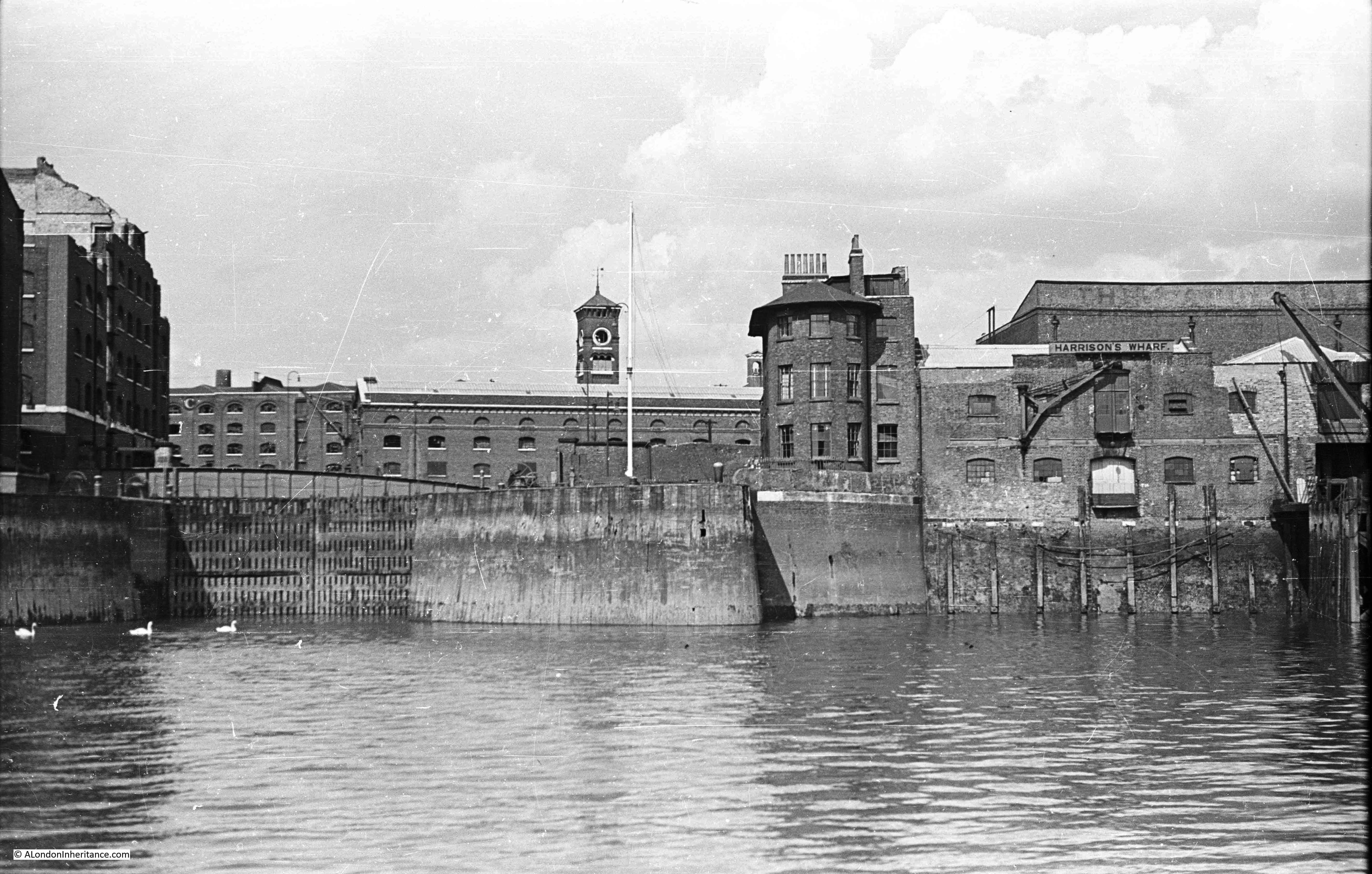
St Katharine Docks opened on the 25th October 1828. In August 1948, my father took the following photo of the dock entrance, whilst on a boat travelling from Westminster to Greenwich.

St Katherine Docks

In September 2019, I took a boat onto the river, and managed to get into roughly the same position to take a photo of the same view of the dock entrance (although the weather was not as sunny as in my father’s original photo).

St Katherine Docks

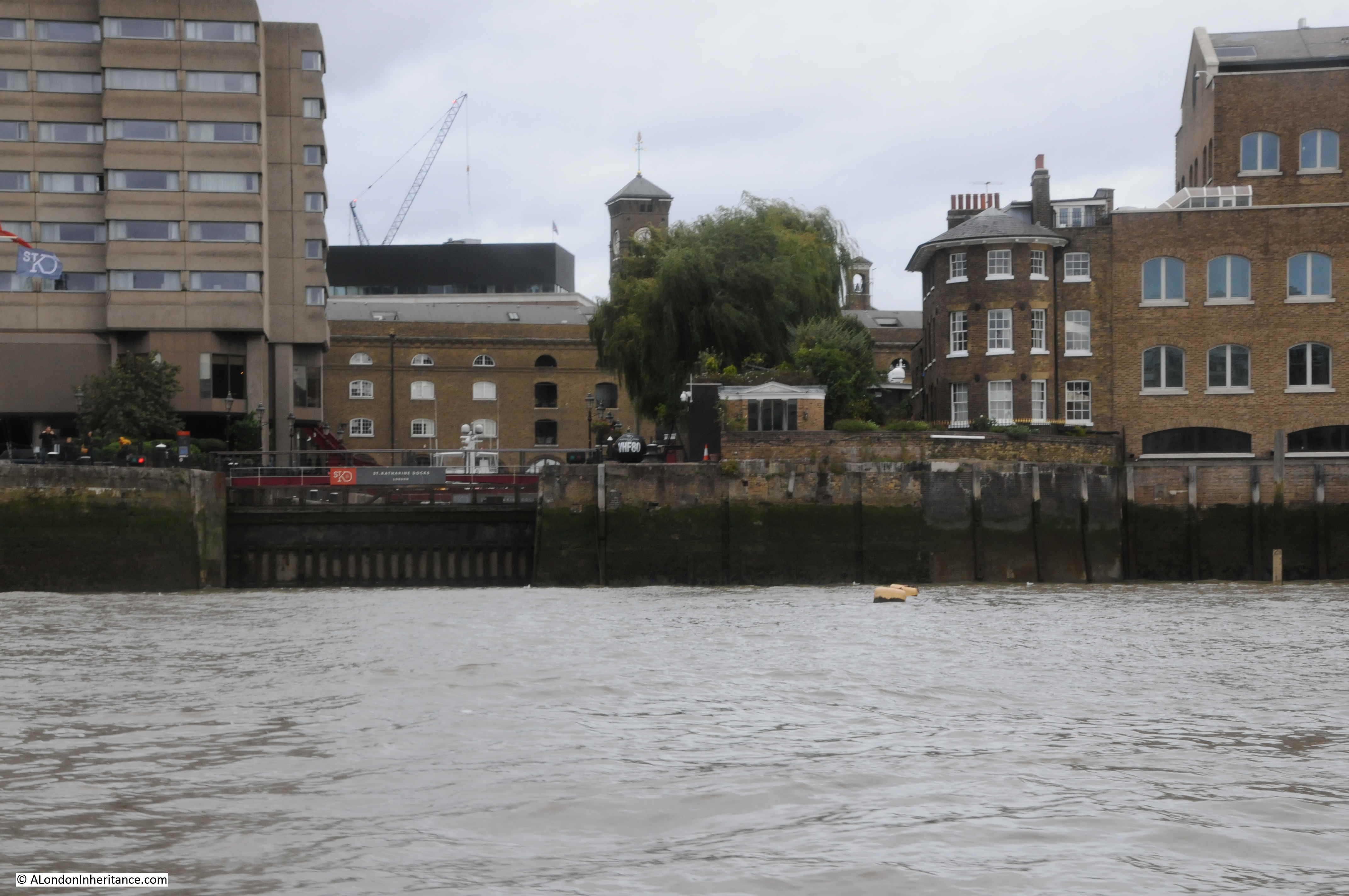
The Grade II listed Dock Master’s Office, with the curved frontage onto the river, still has a prominent position to the right of the dock entrance.

Part of the warehouse infrastructure can be seen in the background in both photos.

In the 1948 photo, you can just about see the original swing bridge over the entrance to St Katharine Dock. This bridge carried St Katherine Way from the east to the west of the dock.

The buildings on either side of the dock entrance have all changed. The large warehouse in the background on the right of the 1948 photo, is the warehouse seen in my father’s photo of St Katharine’s Way

The building on the left of the 2019 photo is the Tower Hotel.

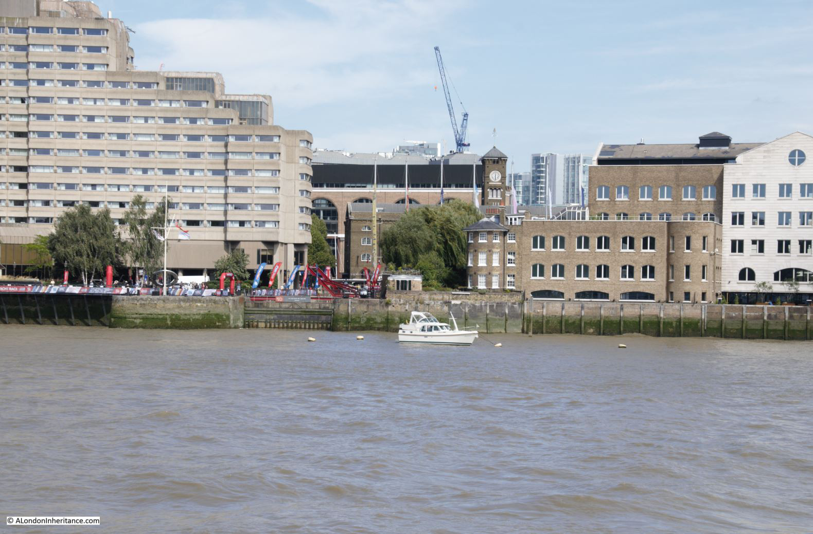
A wider view (and in better weather) taken from the walk way along the south bank of the river is shown below:

St Katherine Docks

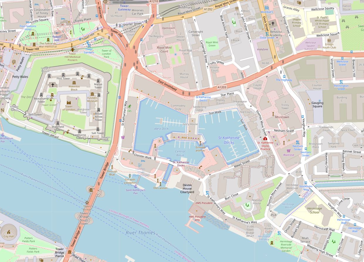
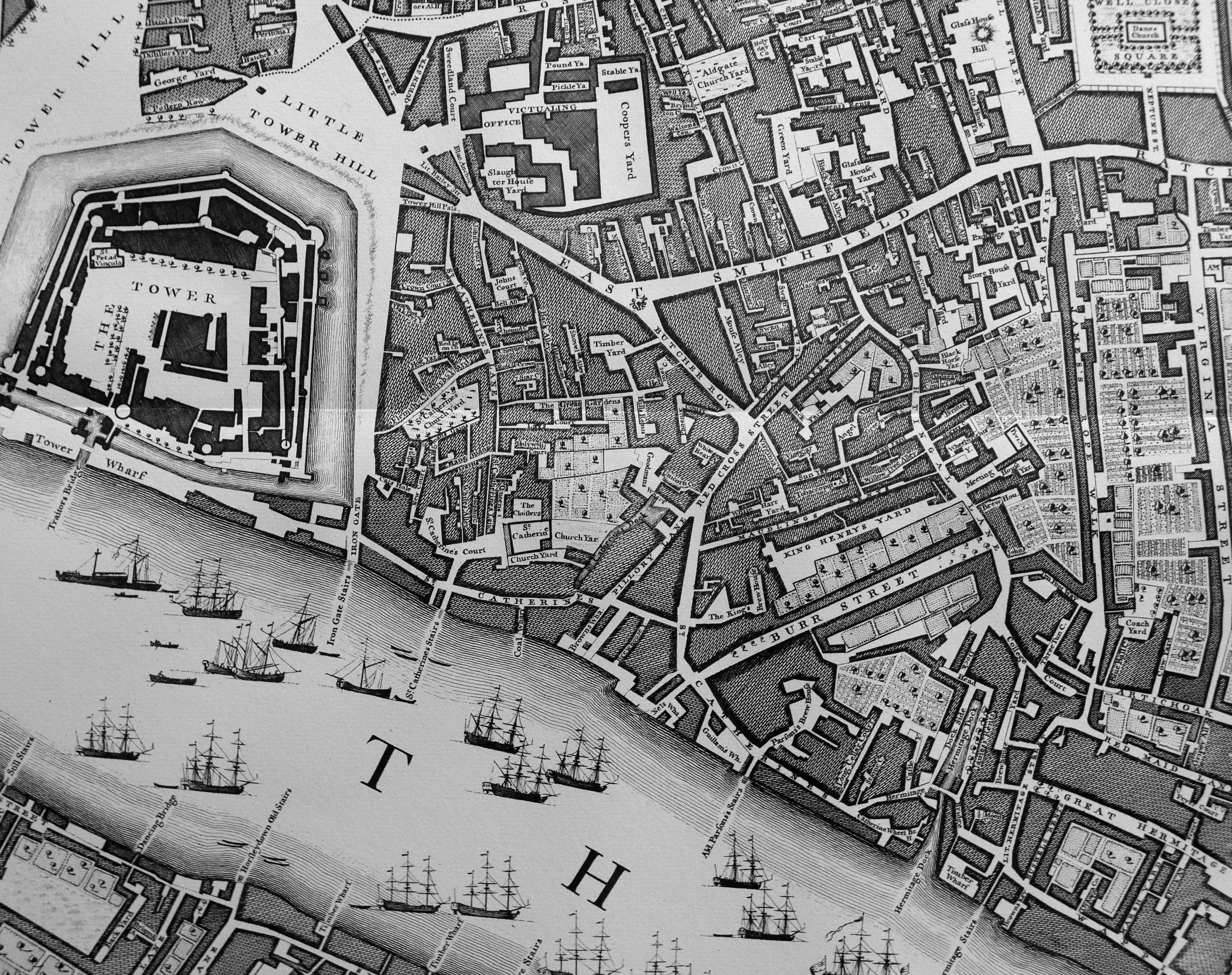
St Katharine Docks are the nearest to the City of London, of the docks constructed along the river starting in the 19th century. Occupying a relatively small area of land, and with a narrow entrance to the river, they were constructed on a historic location, immediately to the west of the Tower of London (Map © OpenStreetMap contributors):

St Katherine Docks

The following extract from John Rocque’s map of 1746 shows the same area as the above map. Tower bridge has yet to be built, and the area that would become St Katharine Docks is to the right of the Tower, and consists of a number of streets, church, cloisters and gardens.

St Katherine Docks

The name Catherine is used for various features across Roque’s map, however I suspect this was the exception as most early maps and books reference the name spelt as Katherine, but it does highlight that the name has a long association with this specific area.

There was also a St Catherine’s Stairs shown on the map.

The area of land to be used for the new docks consisted of the foundations of St Katharine Hospital and Church, a brewery, around 1,100 houses along the streets, mainly to the north of the land.

If you look at Rocque’s map, to the right of the location of the future docks, is a narrow feature called St Catherine’s Dock, however the map strangely shows this feature not connected to the river. This dock provided a private landing place for the hospital, so in Rocque’s map it was either an error that the extension to the river was not shown, or by 1746 it had been filled in, which I doubt.

St Katharine Hospital was founded by Matilda, wife of King Stephen, on land she purchased from Holy Trinity, Aldgate.

Matilda was a fascinating character. The wife of Stephen of Blois, who was pregnant and living in Boulogne when Henry I died. Stephen raced across the channel to claim the crown in 1135, leaving Matilda in France to have her baby.

She joined him after the birth, and supported him throughout his war with another Matilda (Empress Matilda, Stephen’s cousin who also claimed the crown).

As well as raising support for Stephen from her allies in France, Matilda purchased the land, and founded the Hospital. Matilda transferred the custody of the Hospital to Holy Trinity, Aldgate, but reserved the right to choose the Master for herself, and all the Queens who would follow her.

The following map from 1781 shows the Hospital in more detail to Rocque’s map, and shows the church, cloisters, houses for brothers and sisters, burying ground and orchard. The St Katharine Dock, that provided private access to the Hospital is shown on the right of the map. The River Thames is at the bottom of the map as shown by St Katherine’s Stairs on the lower left.

St Katherine Docks

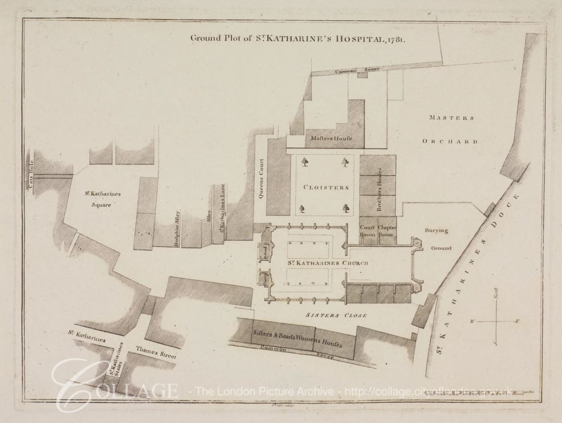
Image credit: London Metropolitan Archives, City of London: catalogue ref: p5412730

The following print from 1810, shows the church of St Katherine’s, Tower:

St Katherine Docks

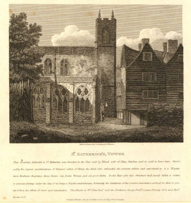
The text provides some background (although I suspect the author has his Matilda’s muddled, as he states Maud, wife of King Stephen, rather than Matilda. Maud was also the name applied to Empress Matilda, the other claimant to the English crown):

“This Hospital dedicated to St Katherine, was founded in the Year 1148 by Maud, wife of King Stephen and is said to have been dissolved by the unjust machinations of Eleanor, widow of Henry the third, who refounded the present edifice and appointed to it a Master, three Bretheren Chaplains, three Sisters, ten Bedes Women and six poor Clerks. In the Year 1780 this Structure had nearly fallen a victim to popular phrensy under the idea of its being a Popish establishment; fortunately the Gentlemen of the London Association arrived in time to protect it from the effects of error and intoxication.”

The problem with secondary (or much more remote) sources such as prints or books is that they often have errors and contradictory information.

Old and New London (Walter Thornbury, 1881) also states that the Hospital was dissolved and refounded by Eleanor, widow of Henry III, whilst London Churches Before The Great Fire (Wilberforce Jenkinson, 1917) states that “The Hospital and Collegiate Church of St Katherine by the Tower, founded by Queen Alienore, widow of Henry II”.

What appears to have happened is that the standards of the Master and Brothers had fallen below what was expected as they were found to be “frequently inebriated”, so in 1273 Queen Eleanor refounded the Hospital and appointed a new Master and Brothers.

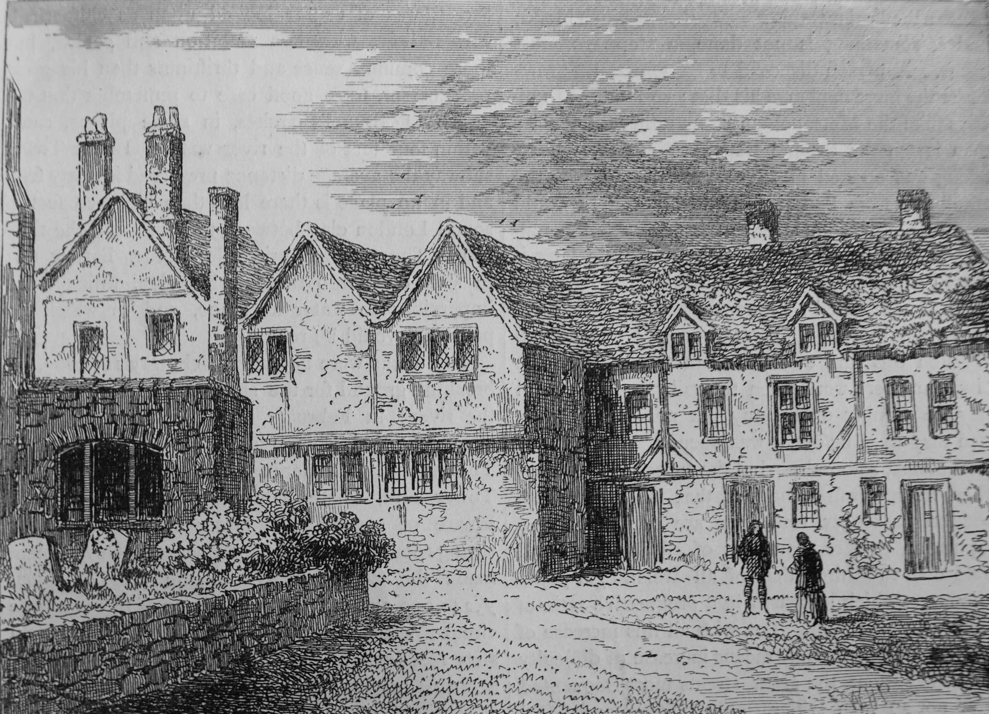
The brothers houses in 1781:

St Katherine Docks

The Hospital survived the Reformation, probably as a result of the influence of Katharine of Aragon, who despite her divorce from Henry VIII, remained the patron of the Hospital, Anne Boleyn did not take up the role, despite this being the traditional role of the Queen.

The early 19th century was a time of considerable expansion of the docks, eastward from the City. The volume of shipping and of goods was high, and the charges levied by the dock owners had limited competition, so there was no incentive to reduce charges. Shipping volumes across the Port of London increased from 13,949 in 1794 to 23,618 in 1824.

The scheme for St Katherine Docks comprised a basin of about 1.5 acres, and two docks of around 4 acres each.

The following plan from 1825 showing the proposed St Katharine Docks is fascinating:

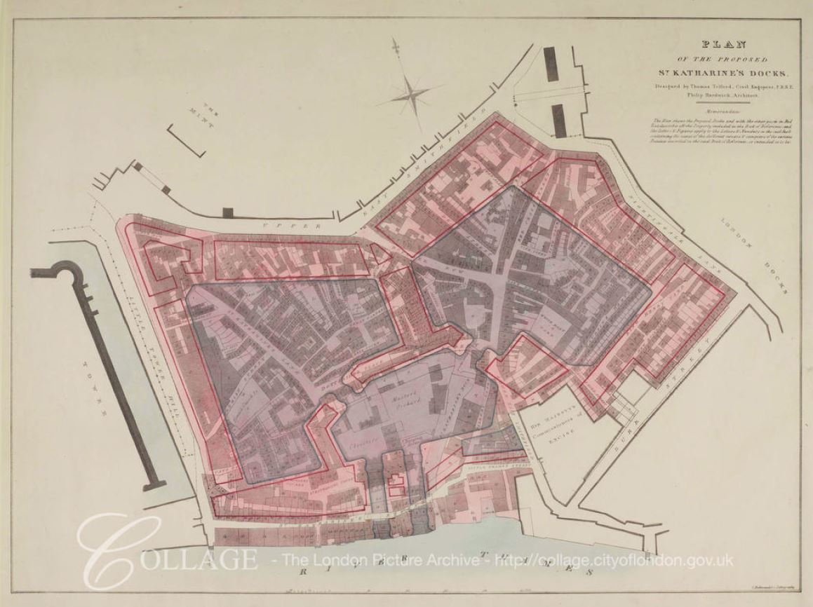
Image credit: London Metropolitan Archives, City of London: catalogue ref: q8051215

The plan shows how the new docks would overlay the existing streets and buildings, and therefore provides a means to locate where these would be across the current site. It also shows the location of the original St Katharine Dock, the narrow channel to the right of the central basin.

The plan shows that originally two entrances to the docks were planned, however only one was built.

St Katharine Docks had a rather unique design, different to the design of the London and West India Docks. in these docks, which had already been constructed, there was an area of land between the edge of the dock and the warehouses. This allowed goods to be offloaded, then sorted before moving to the correct warehouse.

With the design of St Katharine Docks, the warehouses were built almost up against the edge of the dock, with the intention that goods would be unloaded directly from ship into the warehouse, therefore making the whole process considerably more efficient. This would work well if the goods from a ship were all of the same type, but not for a mixed cargo. This design was not used again at any other London dock, which probably gives an indication that the intended efficiencies were not achieved, or that the design lacked flexibility to support mixed cargoes.

The dock entrance from the river was also of a smaller width than the other docks, thereby limiting the size of ship that could enter St Katherine Docks.

The scheme was put before Parliament in 1823, but was opposed by the Commons on the second reading. The scheme returned to parliament in 1825. The owners of the London Docks opposed the building of the new docks and attempted to demonstrate that spare capacity was available at other docks on the river, however incorrect figures put forward by the London Docks Company was shown to be wrong, and that there were indeed problems with warehousing space, and that the London Docks sometimes had 4,000 to 5,000 casks waiting on the dock side for space in the warehouses.

There were also arguments against the use of such historical land, which had been used for religious purposes for seven centuries, however the remaining Brothers were offered new accommodation near Regent’s Park, which was probably a much improved location to that near the river, which Stowe described as “tenements and homely cottages having inhabitants, English and strangers, more in number than on some city in England”, and with street names such as Dark Entry, Cat’s Hole, Shovel Alley and Pillory Lane.

The new buildings by Regents Park for the Brothers were designed by Ambrose Poynter in a Gothic style, much to the frustration of Nash, who saw the buildings as a Gothic intrusion into his Georgian terraces.

The bill, as approved by Parliament, had clauses added to protect and refund the landlords of the properties, however those who were renting the houses in the streets that would soon disappear had to fend for themselves, and find new accommodation in the City (reading the proceedings of the bill, it is remarkable how the process appears to be the same as today, and perhaps also the focus on land owners rights, rather than those only able to rent a property).

The last service in the church took place on the 30th October 1825, with construction starting in 1827, the foundation stone being laid in May of that year.

The soil excavated from the docks was transported west along the river and used to fill in the old reservoirs of the Chelsea water works, and along the southern parts of Pimlico.

Delays to completion of the docks were caused by an exceptionally high tide on the 31st October 1827, which flooded part of the dock workings – newspaper reports tell of Londoners watching the inundation from the edge of the construction site.

The docks were completed and officially opened on the 25th October 1828.

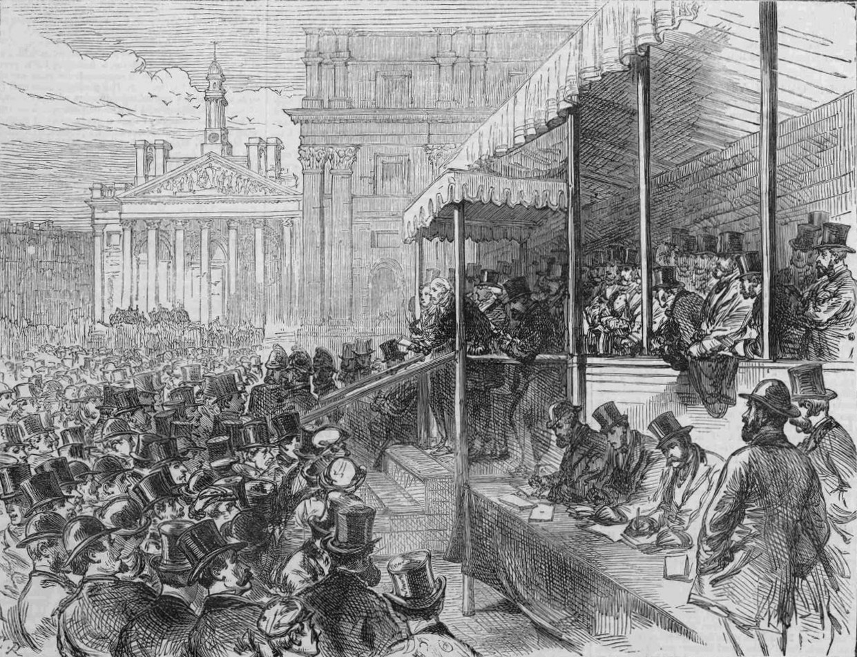
The following painting shows the first ships entering St Katharine Docks during the opening ceremony.

St Katherine Docks

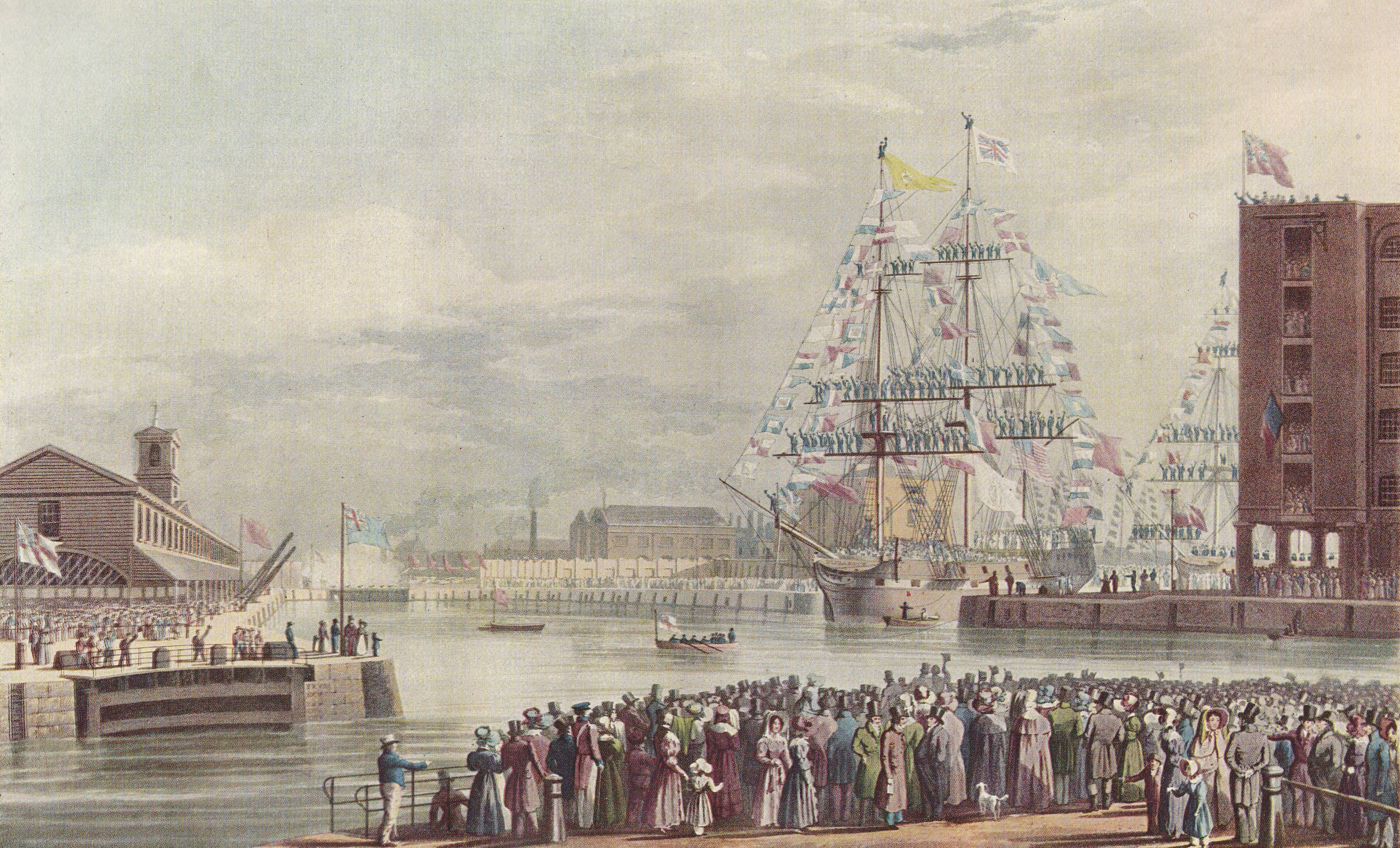
The opening ceremony was reported in the press as a great celebration – from Bell’s Weekly Messenger on the 27th October 1828

“The interesting ceremony of opening the St Katharine Docks took place on Saturday afternoon, and was witnessed by between 18,000 and 20,000 persons. Such was the excellence of the arrangements made, that not a single accident occurred.

By one o’clock in the day, the wharfs and ranges of warehouses presented a most brilliant and animated scene, being filled by highly respectable individuals. Four bands of music were stationed at different positions, and enlivened the scene by playing national and other airs. The ships, nine in number, destined to enter the Docks, were off the entrance dressed out in the colours of all nations, and nearly every vessel in the vicinity of the Docks hoisted her colours, so what with the numerous banners flying in all directions, and the fineness of the day, a more interesting sight has seldom been witnessed. On the eastern dock wharf was stationed a small pack of artillery, which was discharged repeatedly during the entrance of the vessels into the Docks. At about a quarter to two o’clock the tide had risen sufficiently high to permit the commencement of the ceremony.

The Dock gates  were opened, and the Eliza, a fine East India trader, in ballast, entered amid the most deafening applause. The bands struck up ‘God save the King’. The yards were manned, and the deck was crowded by visitors. She entered majestically and was greeted loudly. She is bound for Madras, and waits a cargo at the Docks. Next followed the Mary, laden with goods from the Cape of Good Hope; she also was greeted warmly. The Catherine, Prince Regent and five other vessels followed, all dressed out, and were loudly cheered. the latter are in the Baltic trade. The ceremony having been concluded, the large mass of the visitors departed – those having blue tickets however, passed up into the second floor of the warehouses, marked C, and there partook of a grand collation provided for the occasion.

Success to the St Katharine Docks was drank in bumpers from every mouth, and the day passed off without the occurrence of any untoward event to damp the spirits of the numerous company.”

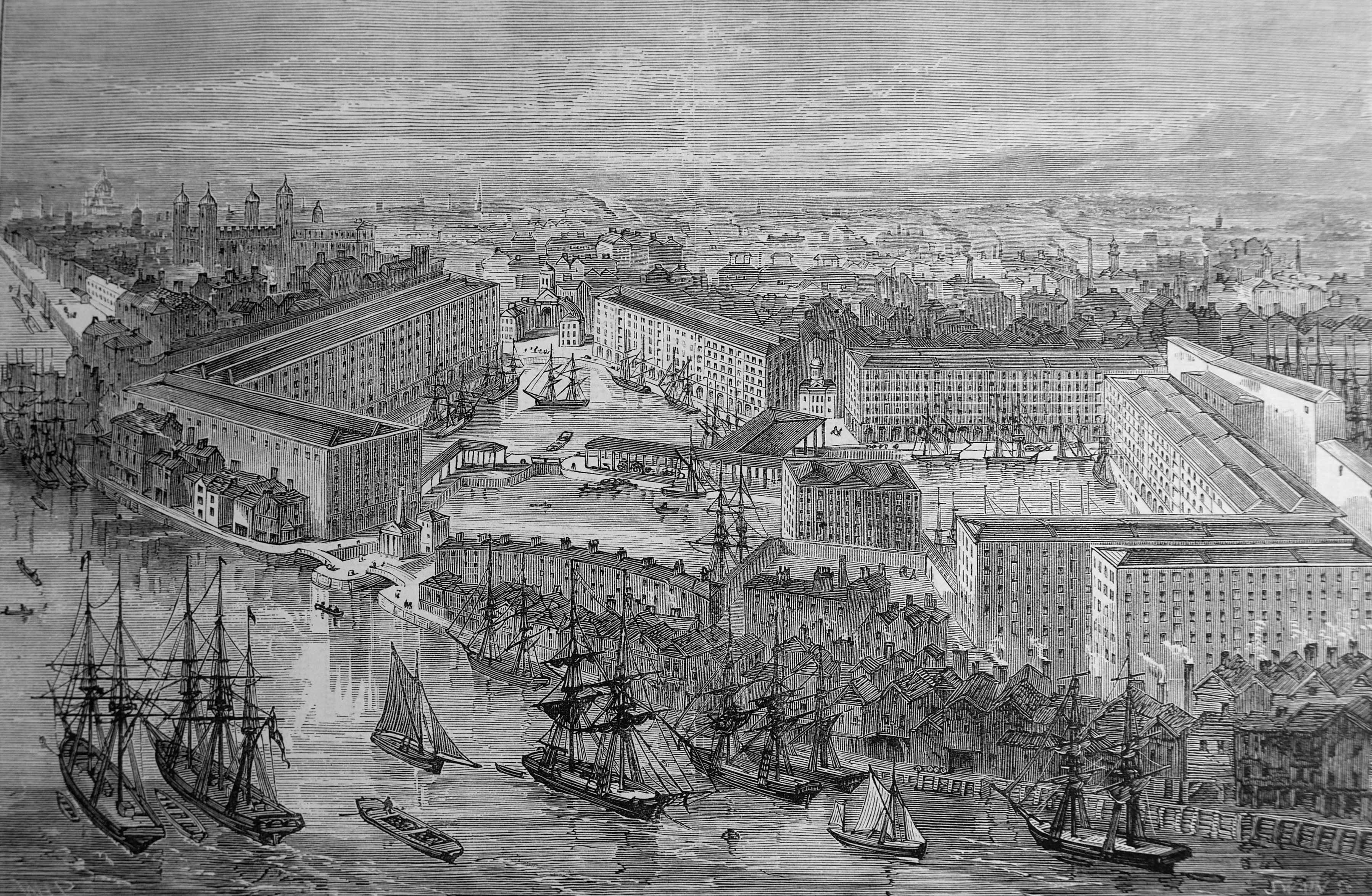
The docks as they appeared in full operation:

St Katherine Docks

The business opportunities offered by the new Docks were quickly recognised by the businesses in the immediate vicinity, as illustrated by the following newspaper advert:

“Lot 2. A substantial brick-built Free Public-house, the Camel, No 107 Minories, in view of the entrance of the St Katharine Docks, capable of doing a good trade in the spirit and tavern department, from its approximation to the Docks. Lease 19 years, at a moderate rent.”

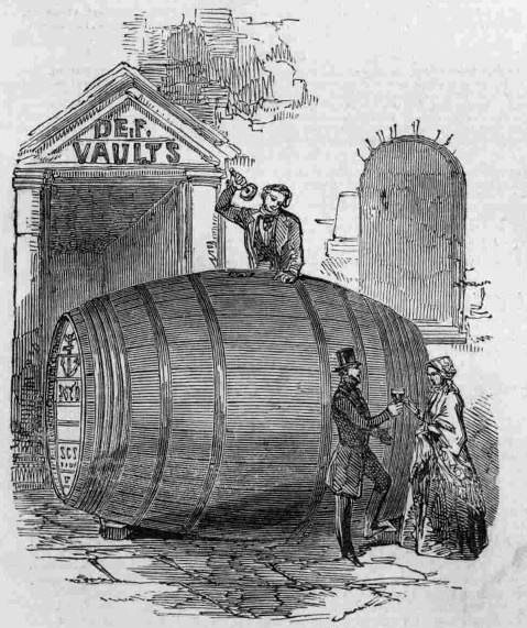
A rather unusual import occurred in December 1848 when an immense cask of Port Wine was delivered from Oporto by the ship Pezo da Regoa. It held around 620 gallons with a value of £650 – a considerable sum in 1848. The justification for the large cask, was that wine develops a “high vinous character more fully in a large bulk, than it is possible to do in the casks (little more than one-sixth in size usually employed for transmission to this country”.

The giant cask:

St Katherine Docks

St Katharine Docks were reasonably successful, although perhaps not as good as expected. Returns to investors averaged between 2.75% and 5% in the years up to 1864, when St Katharine Docks amalgamated with the nearby London Docks.

One of the limitations to the success of St Katherine Docks was the narrow entrance from the Thames which limited the size of ships able to enter.

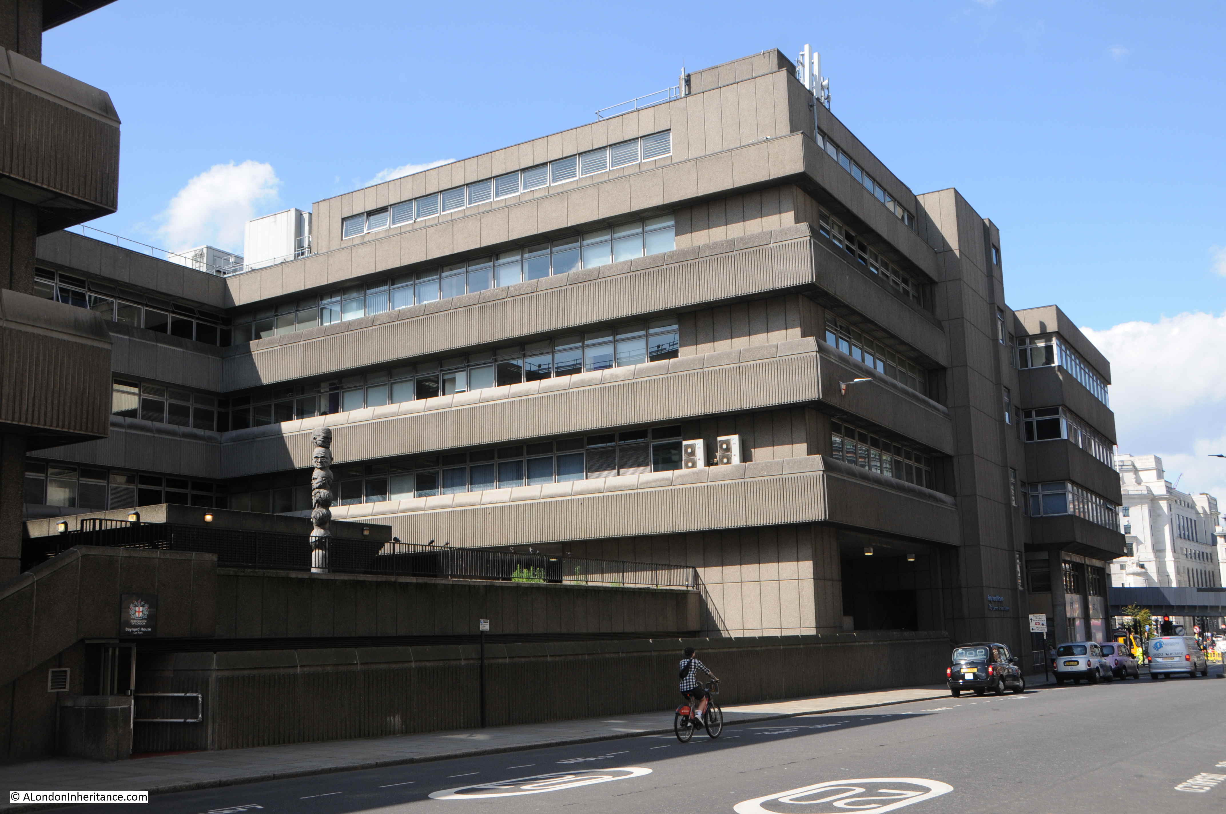
The docks were bombed during the war, and never recovered after the war, becoming the first of the London docks to close, in 1968.

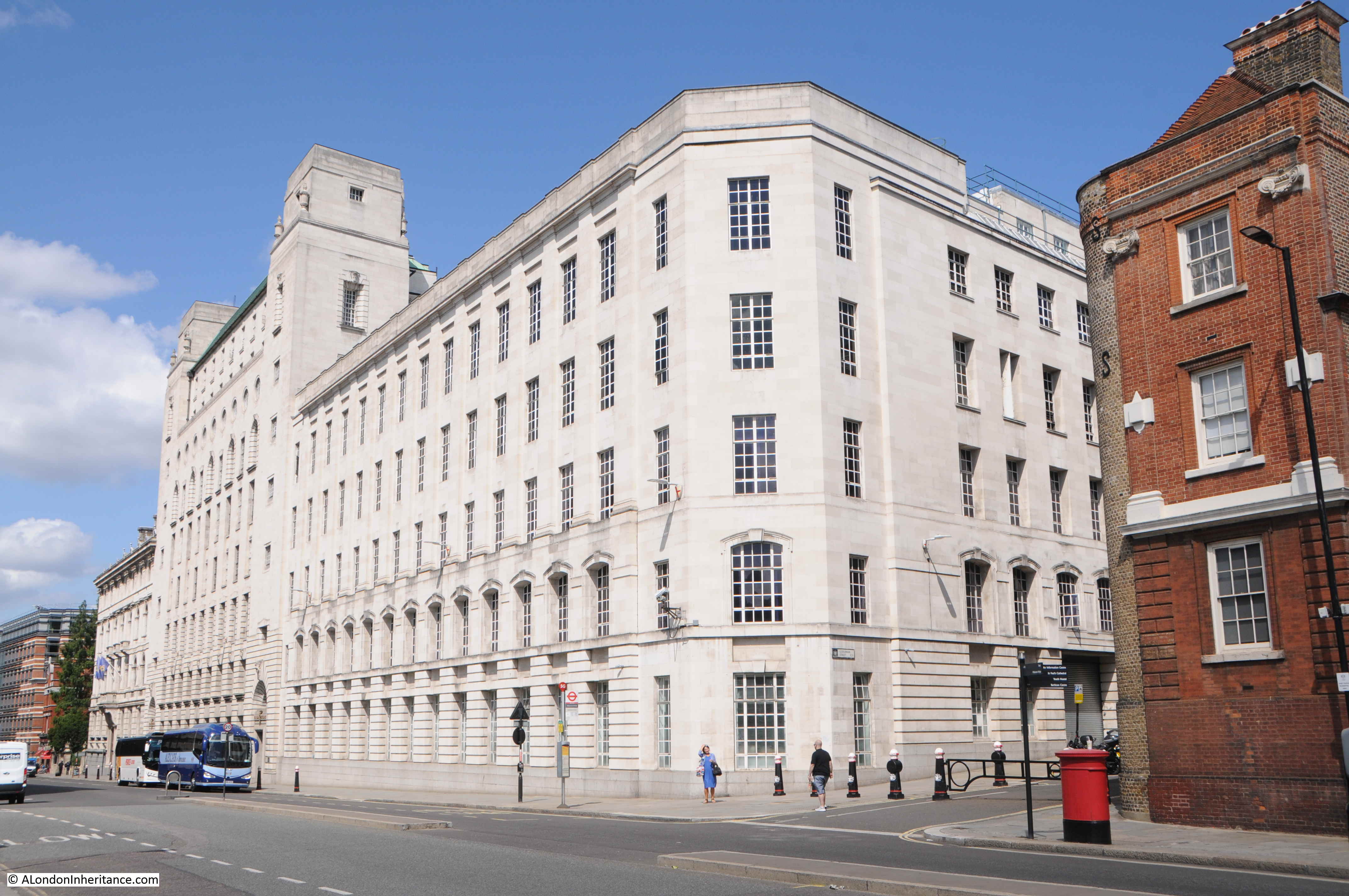
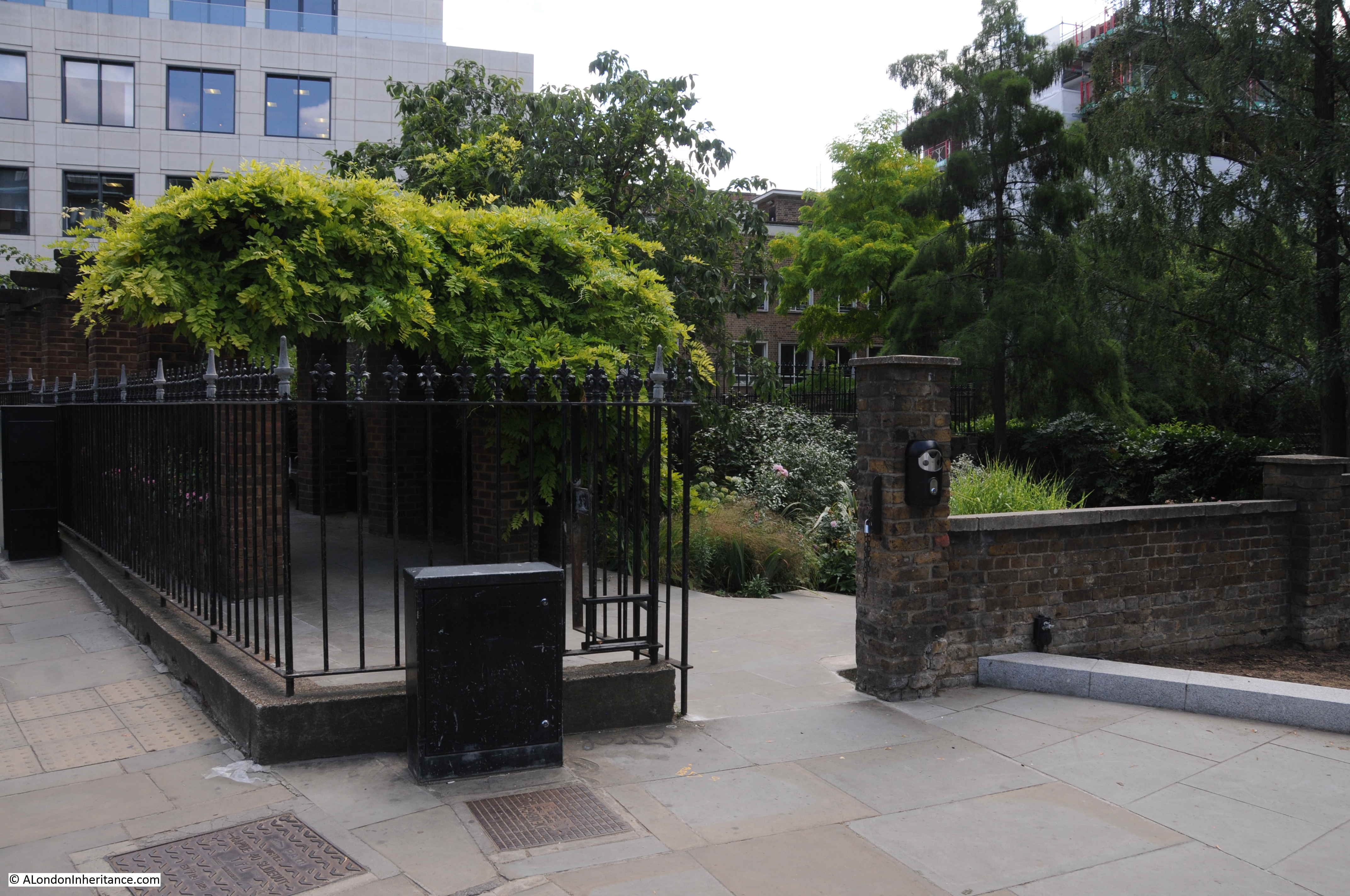
Unlike the docks further east, St Katharine Docks were not left derelict for too long, however many of the original warehouses were demolished to make way for new buildings in the 1970s, and the dock itself became a mariner.

I suspect it was the proximity to the City that resulted in the rapid reuse of the site. The docks further east, and on the Isle of Dogs were too remote from the City, and also St Katharine Docks was a much smaller parcel of land than the other locations.

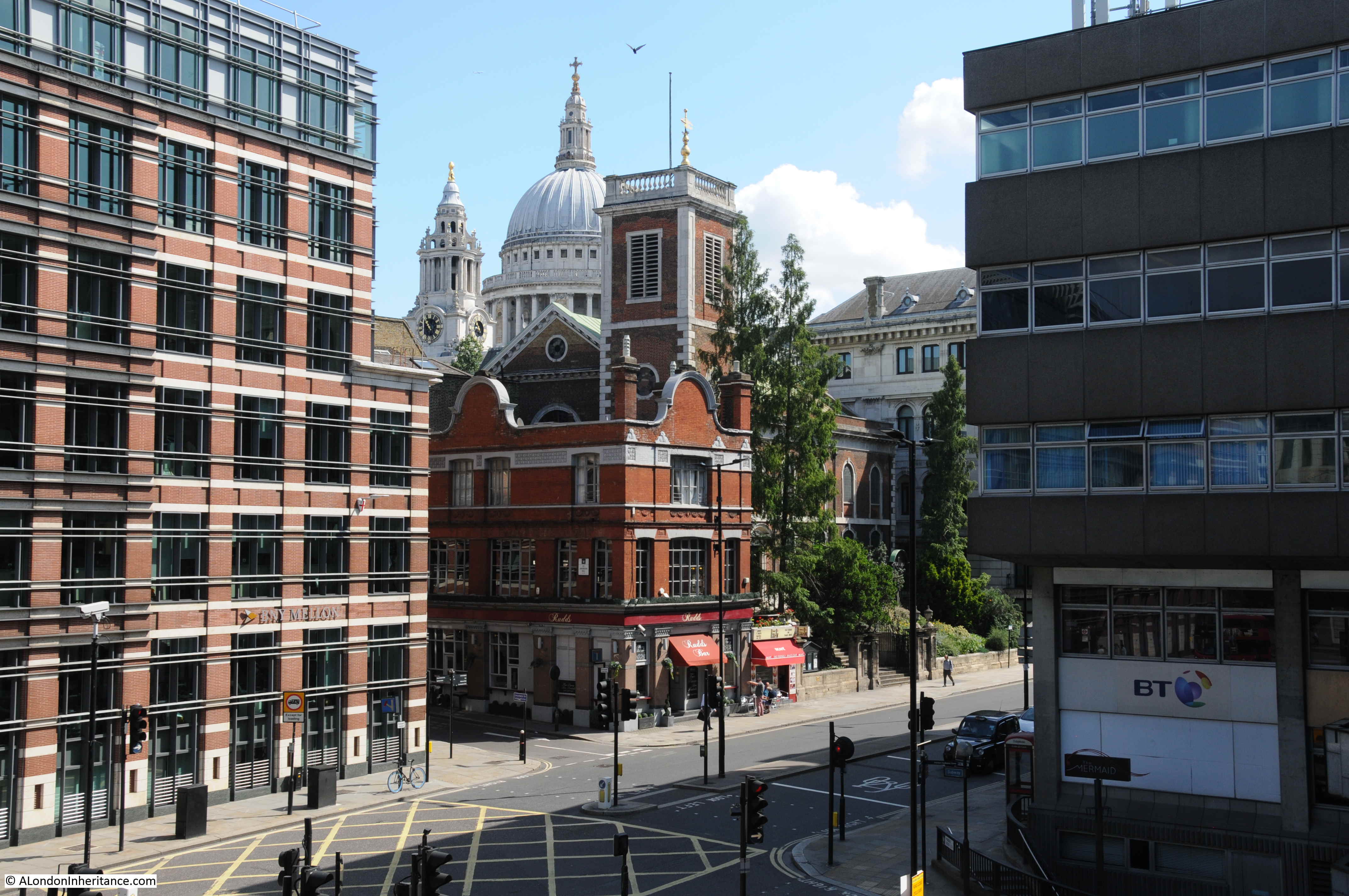
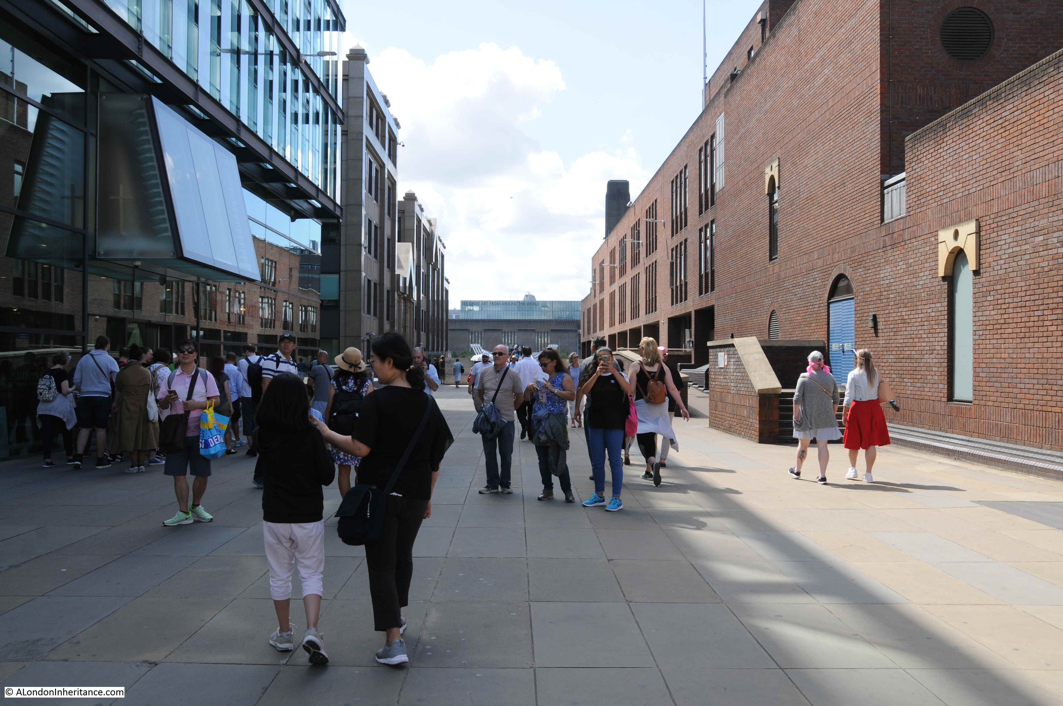
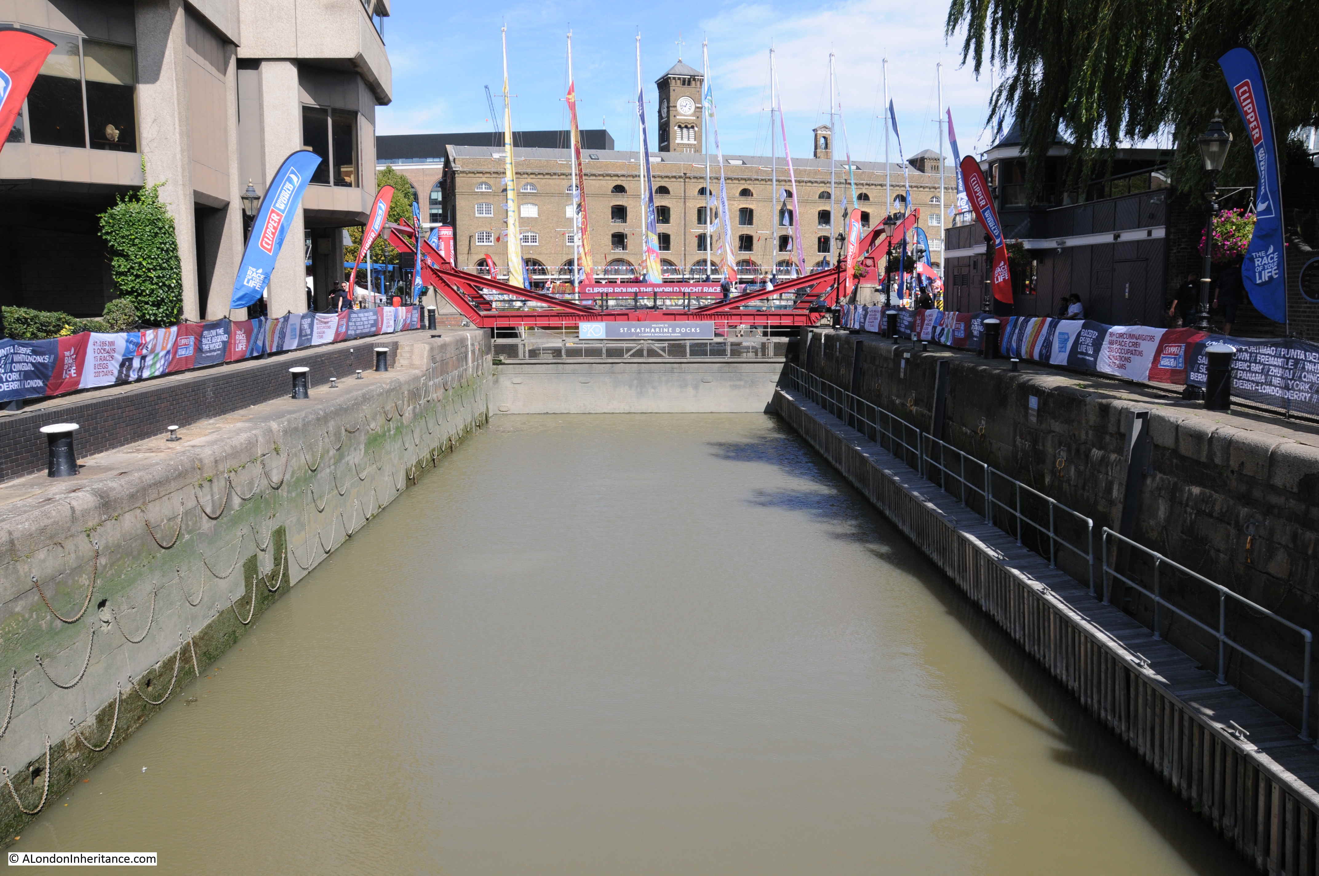
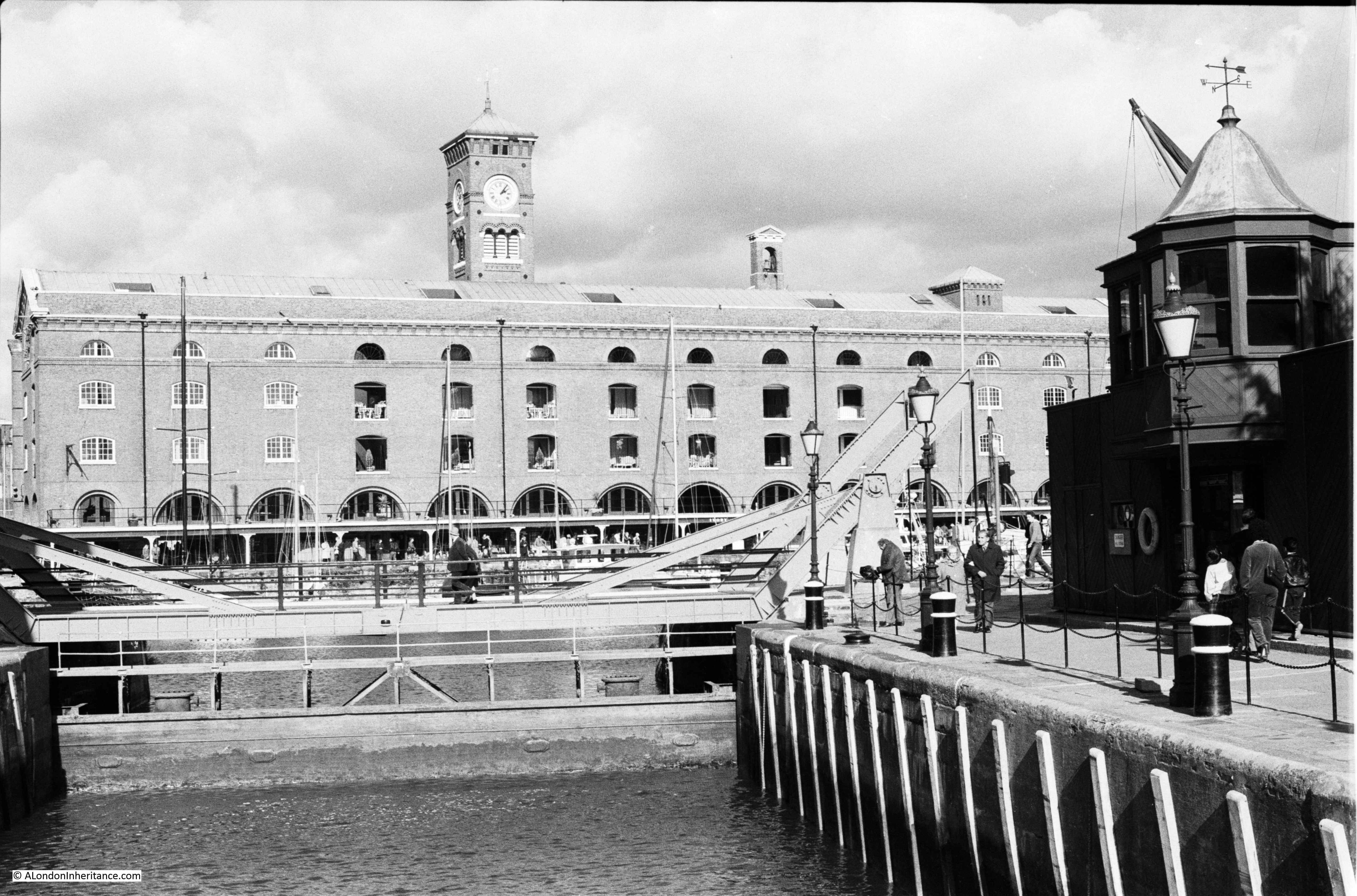
I went for a walk around St Katharine Docks at the end of August, when the weather was far better than on the day i was on the river. There is now a foot bridge over the dock entrance, close to the river. This is the view looking up towards the basin, with one of the few remaining buildings in the background, along with the clock tower seen in my father’s 1948 photo.

St Katherine Docks

I have taken loads of photos around St Katharine Docks over the years. The majority I have yet to find and scan, however this is a photo from 1981 from above the dock entrance showing a similar view.

St Katherine Docks

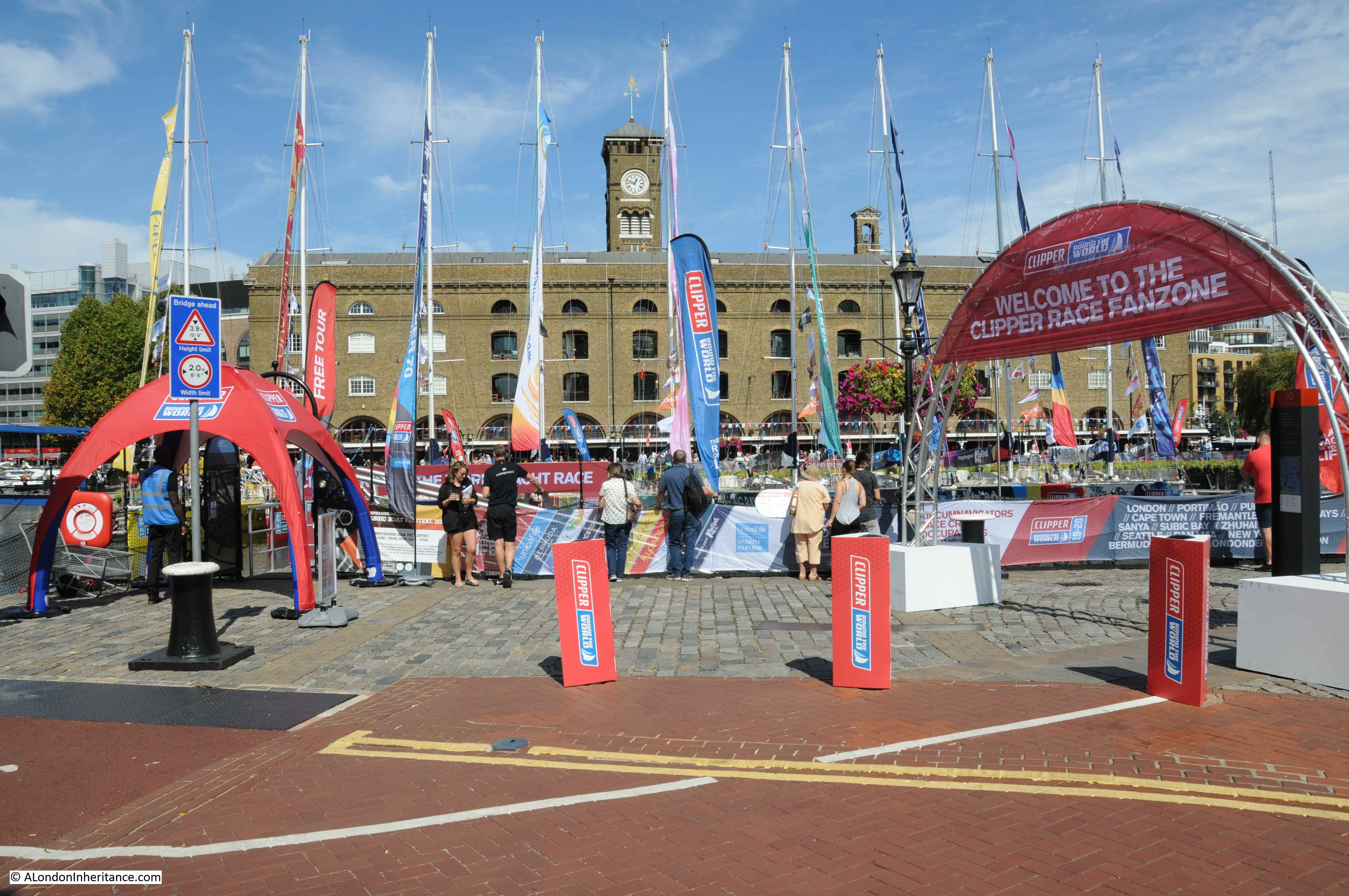
On the day of my visit, it was the start of the Round the World Clipper Race, so the docks were looking more colourful than usual.

St Katherine Docks

This is the view over the eastern dock. All the original warehouse buildings have been demolished, to be replaced with new apartment buildings.

St Katherine Docks

The Clipper yachts adding a splash of colour in the central basin:

St Katherine Docks

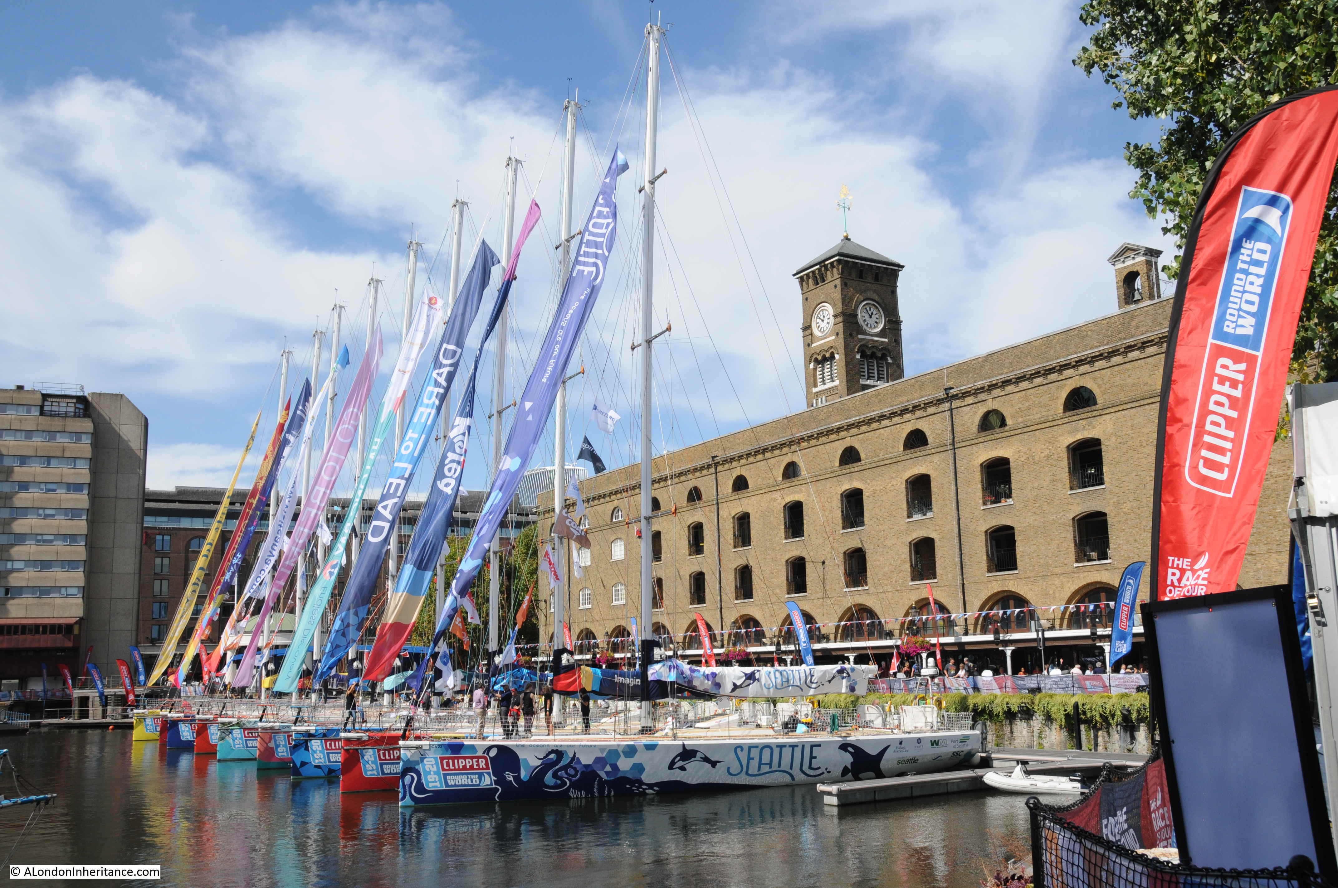
At the time of writing, the Clipper yachts have left Uruguay and are a short distance into their crossing of the South Atlantic Ocean, on their way to Cape Town, South Africa. A nice link with the past, when ships arriving at, or leaving St Katharine Docks would travel to all regions of the world.

The following photo is of the walkway alongside the main remaining warehouse.

St Katherine Docks

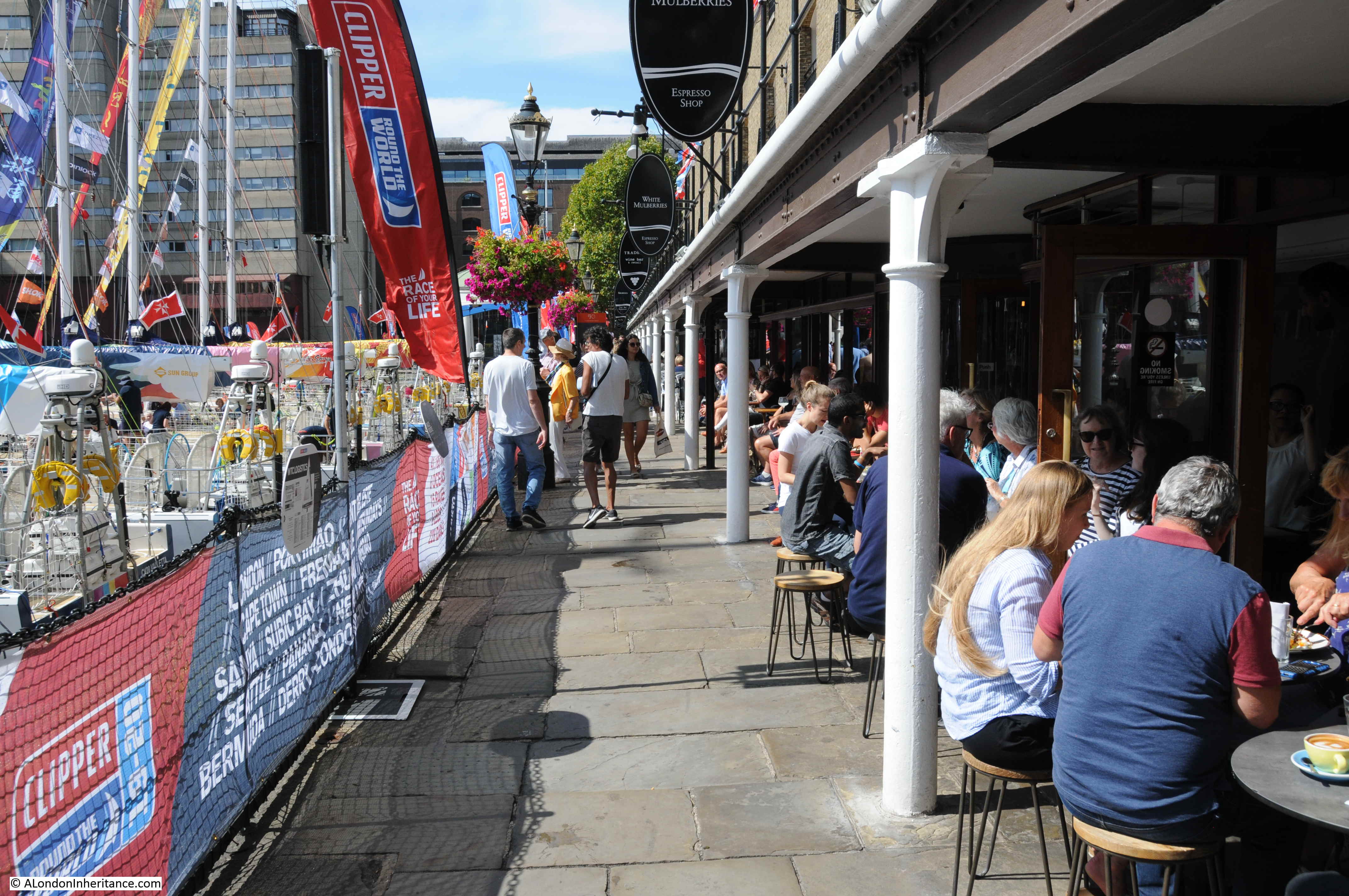
The photo illustrates the design, only used at St Katharine Docks, where the warehouse was built very close to the edge of the dock. There was no space for unloading from the ship and sorting on the quayside, before moving to the correct warehouse. At St Katharine Dock, the intention was to move cargo more efficiently directly from ship to warehouse.

The photo also shows how St Katharine Docks have now been transformed into a popular food and drink destination, with restaurants lining the ground floors of the old warehouse and some of the buildings that have replaced many of the original buildings.

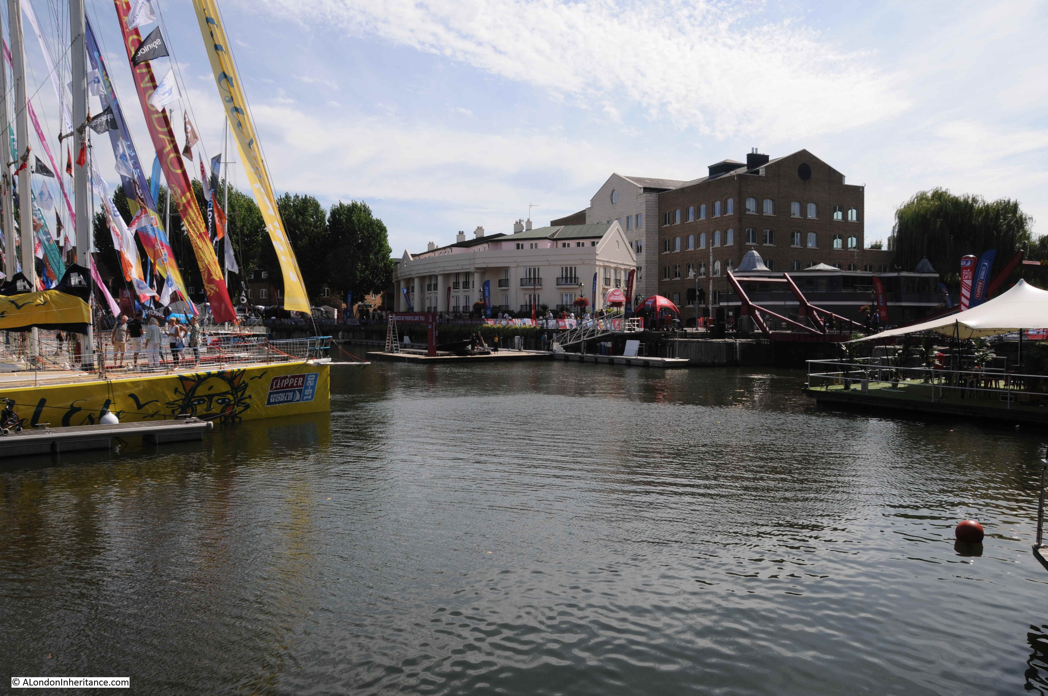
Looking back over the central basin. The entrance to the dock is on the right:

St Katherine Docks

The walkway across from the central basin to the edge of the western dock:St Katherine Docks

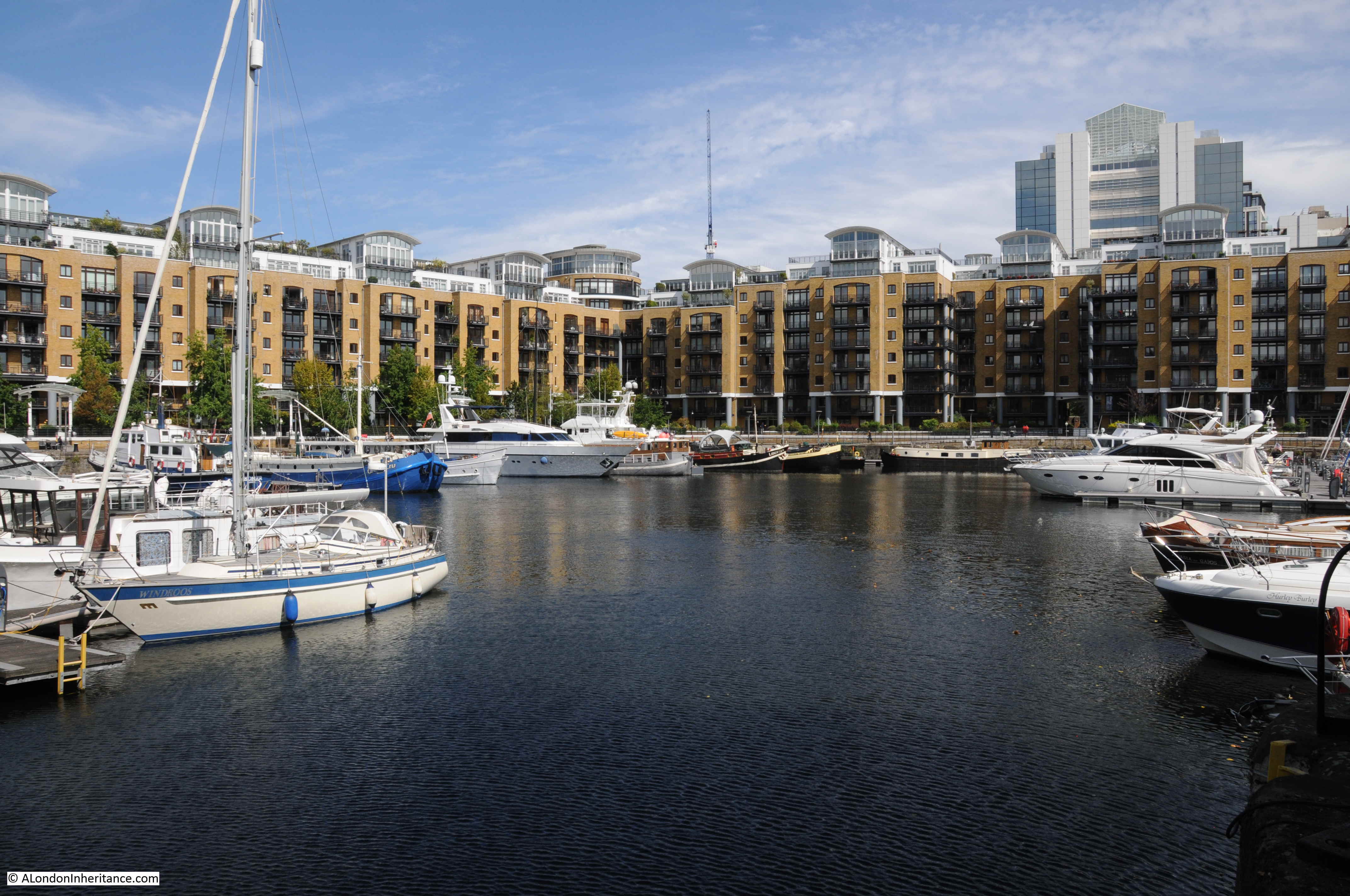
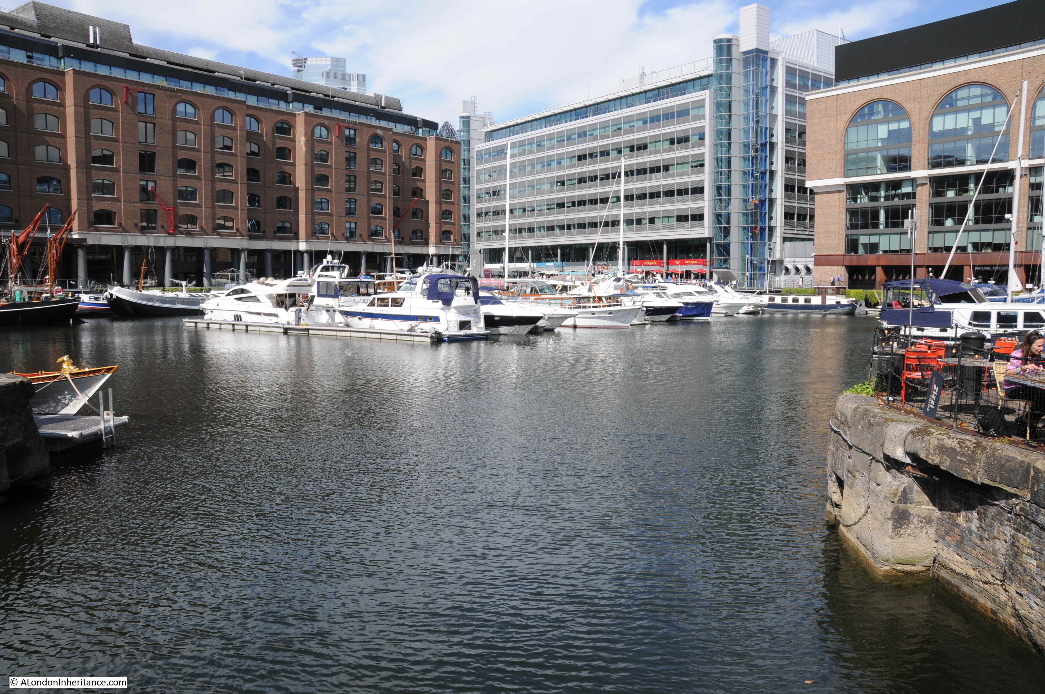
The western dock, showing how St Katharine Docks are now used as a marina.

St Katherine Docks

The photo below is another of my 1981 photos of St Katharine Docks. This is on the north bank of the western dock. In the above photo, it is where the new buildings along the right of the dock are located.

St Katherine Docks

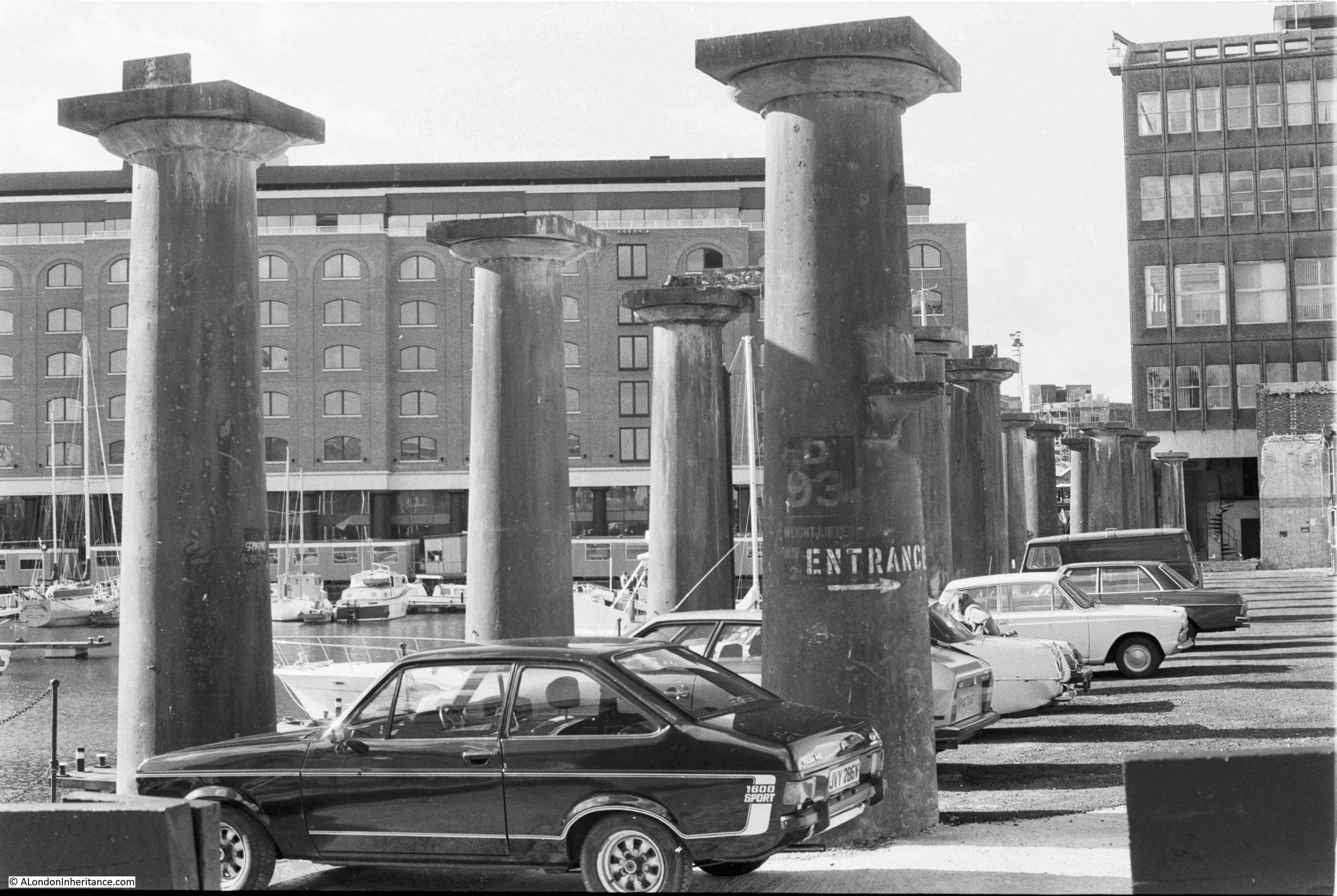
This was at a time when parts of the dock were still yet to be developed, and you could drive into and park directly alongside the docks. The cast iron pillars are all that was left of the warehouse that ran alongside this part of the docks. These all appear to have been lost as part of the redevelopment.

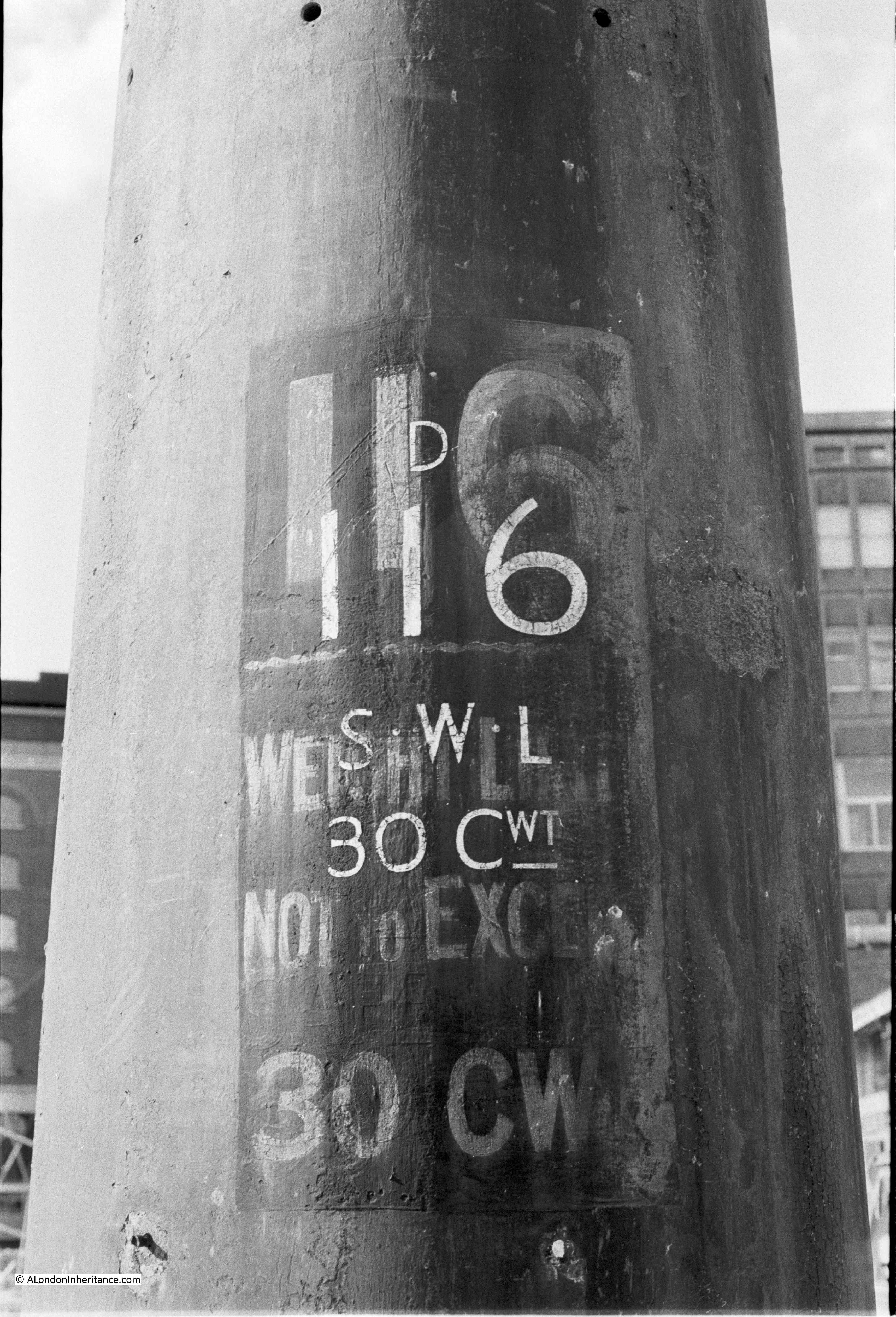
Detail from one of the pillars:

St Katherine Docks

The original stone of the dock side walls survives:

St Katherine Docks

Mayhew, in London Labour and the London Poor provided some interesting statistics which give some insight into employment at St Katharine Docks.

St Katharine Docks employ a ticket system for the employment of workers. The docks would not employ casual workers, only workers who had previously been recommended to the Company and were seen to be of good character. The Company would allocate a ticket to the worker, allowing them to be employed as a preferable ticket labourer.

Despite having a ticket, a worker would not have a guaranteed level of work, as this was dependent on the number of ships, and volume of goods to be moved.

The base level of employment at the docks was 35 officers, 105 clerks and apprentices, 135 markers, samplers and foreman, 250 permanent labourers, 150 preferable ticket labourers, proportionate to the work to be done.

The number of labourers needed could fluctuate dramatically. In 1860, the number of labourers employed at the docks on any one day ranged from 515 to 1,713, so a range of 1,200 a day, in the need for labourers.

Mayhew commented that the ticket system at St Katherine Docks did appear to result in a workforce that “have a more decent look, but seem to be better behaved than any other dock-labourers I have yet seen”.

Despite the ticket system and the workforce “having a more decent look”, the daily fluctuation in the number of workers needed would result in many hundreds not receiving a wage for the day, whilst for those in work, the newspaper advert mentioned earlier told of the pubs that lined up. close to the dock entrance, ready to take the wages of the worker before he reached home.

Again, I have only just scratched the surface of such an interesting and historic London location. History dating back to the 12th century, with a religious function for 700 years until religion was replaced by commerce with the building of the docks in the early 19th century.

A subject to return to, when I have found more of my photos of the site over the last few decades.

alondoninheritance.com

Defending The Thames – Hadleigh Castle

Long term readers of the blog will probably recognise my fascination with the River Thames and how the river has shaped London, and London’s influence on the river.

The river was the main driver in London’s economic growth, providing the route by which ships could reach the City from the sea. This led to the expansion of central London docks, followed by the move of docks from the City out to the Estuary.

The river has also been a weak point, allowing enemies to attack key locations along the Rivers Thames and Medway, and potentially strike at the City.

The River Thames has been lined with various forms of defence over the centuries. I have already written about Tilbury Fort and Coal House Fort, and at Hadleigh in Essex there are the remains of a medieval castle, refurbished and extended to defend the Thames Estuary against the French during the 100 years war, and to provide a royal residence away from London.

A couple of week’s ago I was in Southend (Gary Numan at the Cliffs Pavilion – reliving the late 1970s / early 1980s), so I used the opportunity to visit Hadleigh Castle, just to the west of Southend, on a hill and overlooking the estuary of the River Thames.

The origins of Hadleigh Castle date back to 1215, when King John gave Hubert de Burgh land around the village of Hadleigh. de Burgh constructed the first castle on the site to demonstrate his position in the country and ownership of the Manor of Hadleigh.

As was often the case, relationships became strained as power shifted and de Burgh was forced to return his lands to Henry III in 1239.

Not much happened at the castle until the early 1300s when Edward II started to use the castle as a residence and constructed a number of internal buildings to help make the castle more suitable to providing royal accommodation.

Hadleigh Castle’s potential value as a fortification overlooking the Rover Thames was seen by Edward III during the Hundred Years War – the period straddling the 14th and 15th centuries when the Kings of England fought for the French crown, and the ownership of lands in France.

The Thames was a route whereby the French, and their allies, could attack the towns along the river, potentially all the way to London. This was a very real risk as demonstrated by the attack on Gravesend in the 1380s, and concerns that the French were assembling a large fleet for invasion.

Edward III built on the work of Edward II, strengthening and extending Hadleigh Castle.

Edward III may also have been interested in the castle as a retreat from London, providing views over the river and estuary. The area around the castle also provided extensive hunting grounds for Edward III and his guests.

The river provided easy access to the castle and there are records of the Royal Barge being moored at Hadleigh.

Royal interest in Hadleigh Castle was short-lived as after the death of Edward III the castle was no longer used as a royal residence, instead being leased to a series of tenants, until being sold off in 1551 to Lord Riche, who took no interest in occupying the castle, and started demolition to sell off the castle as building materials.

The version of Hadleigh Castle we see today is therefore a ruin and a shadow of its former self. Just a few towers, walls and foundations that have survived demolition and the castle’s geologically unstable location.

This is the view looking east, with the estuary on the right and the one remaining tower in the centre of the photo.

Hadleigh Castle

Almost the same view was the subject of a painting by John Constable in 1829, titled “The Mouth of the Thames–Morning after a Stormy Night”:

Hadleigh Castle

Image credit: Yale Center for British Art, Paul Mellon Collection

I really do like this painting. It perfectly captures the relationship between the sky and the estuary. Blue sky is starting to appear after the stormy night, and the sun is shining on the ruins of the castle.

In many ways Constable’s view is much the same today, although there was no Southend pier jutting out into the estuary in 1829, and today, cows are not grazing on the slopes adjacent to the castle.

Constable exhibited the painting at the Royal Academy in 1829, where it was described as “Full of nature and spirit, and graceful easy beauty; though freckled and pock-marked after its artist’s usual fashion”.

The painting now appears to be part of the Yale Centre for British Art collection in New Haven, Connecticut in the United States. I am not sure how it was acquired by the Yale Centre. In 1936 newspaper reports were congratulating the National Gallery on the acquisition of the painting and saving the painting for the nation.

The same newspaper reports were also expressing concerns about the planned development of the area around Hadleigh Castle. Factory sites were planned for the land around the castle. The villages of Leigh-on-Sea and West Benfleet were expected to expand towards the castle, and a road was planned to be built to run parallel to the railway.

The site of the castle is still relatively isolated. There are houses about half a mile further in land, and the Salvation Army run Hadleigh Farm is on the approach to the castle. I suspect the war put a hold on the proposed factories.

The following map extract shows the strategic location of Hadleigh Castle, marked by the yellow circle (Map © OpenStreetMap contributors).

Hadleigh Castle

The map shows that the castle’s position provided an ideal view over the estuary, and any attacking force would be clearly seen. The map does not clearly show the height of the castle, which stands 42m above sea level. Not that high, but high enough in this part of southern Essex to provide a commanding view over the river.

The geology of the site is interesting as the castle stands on the edge of high ground, which quickly falls to a level stretch of land between the castle and the river. The following photo is the view looking towards the south-west, with a c2c train running on the route from London Fenchurch Street to Southend and Shoeburyness.

Hadleigh Castle

In the distance are the cranes of the London Gateway port, and in front of them are the oil storage tanks to the west of Canvey Island and in Coryton. Canvey Island is between the oil tanks and the stream of water.

The view below is looking south. The river is at sea level, and the land gradually rises to 6 metres at the rail line.

Hadleigh Castle

During the medieval period when the castle was constructed and in use, the area between the mound on which the castle was built, and the river would have been marshland, and probably subject to flooding at times of very high tide.

The view looking to the east, Southend Pier is visible in the distance.

Hadleigh Castle

The following print from 1772 shows Hadleigh Castle from where the railway line runs today. Although the majority of the castle had been demolished for building materials, some of the southern walls still remained, although the majority of these have since disappeared.

Hadleigh Castle

Although from a strategic perspective, Hadleigh Castle was built in an ideal position, with a commanding view over the approaches to the estuary and River Thames, geologically it was built in a very precarious position.

The castle sits on an unstable spur of London Clay. Over the centuries there have been numerous slippages and damage to the castle building, beginning soon after completion of the castle. The last major landslip was during the winter of 1969 / 1970.

Today, about a third of the southern side of the original castle has been lost due to slippage.

In Constable’s painting, two towers can be seen. Today, only one tower survives. The second tower to the north has slipped and collapsed and the remains can be seen to the right in the photo below:

Hadleigh Castle

The main tower still looks impressive, and gives a good idea of what the whole castle must have looked like in the 14th century:

Hadleigh Castle

Although the tower sits at the edge of the descent down to lower ground towards the river, and cracks inside the tower tell of the possible future for this one substantial remaining part of Hadleigh Castle.

Hadleigh Castle

The exterior of the collapsed tower:

Hadleigh Castle

The interior of the collapsed tower:

Hadleigh CastleThe following photo from Britain from Above shows Hadleigh Castle in 1930.

Hadleigh Castle

The tower on the left of the above photo is the one that has since collapsed.

The photo does provide a good view of the overall size of the castle, and the rather precarious position, situated on top of a high mound of London Clay.

The river is to the right of the photo and the two towers are facing to the east – to the Continent and to the Estuary, so the two large towers would have been the first evidence of the king’s power that anyone arriving from the Continent would have seen.

19th century interest in Gothic landscapes and architecture, and recreating late medieval architecture may have been the source of considerable growth in visitor numbers to Hadleigh Castle. Constable’s painting probably contributed, as did the relatively easy access from London on the Fenchurch Street line.

Visitor numbers were of such a size that in the later part of the 19th century, a large refreshment room was opened in the grounds of the castle, with seating for 400 people.

No such facilities at the castle today, just neatly clipped grass as the castle is now under the care of English Heritage.

Hadleigh Castle

When the Crown sold the castle to Lord Riche in 1551, he seems to have commenced the demolition of the castle for building materials in an organised manner. In the grounds of the castle are the remains of a lead melting hearth from the mid 16th century. The hearth was used to melt down the lead window frames from the castle, thereby making it easier to transport the lead away from the site.

Hadleigh Castle

The hearth is located in the middle of the castle’s hall, with only the foundations remaining today.

Hadleigh Castle

Part of the remaining curtain wall:

Hadleigh Castle

The southern edge of the castle, looking towards the west:

Hadleigh Castle

The above photo marks the boundary to the left, with the land that has fallen away in previous landslides.

To the left, there was the King’s Chamber, continuation of the curtain wall surrounding the castle, and the south tower. All lost as the London Clay fell away.

The one main archaeological excavation of the castle was carried out in 1863 by a Mr H.M. King, working for the Essex Archaeological Society. The work was extensive, however the finds from the excavation have since been lost.

Edward III also constructed a castle on the opposite side of the Thames at Queensborough on the Isle of Sheppy, although nothing now survives of this castle.

So, Hadleigh Castle is the one remaining example of a medieval castle on the Thames Estuary. The last land slip was in 2002, so for how long the castle will remain in its current condition is open to question as the London Clay gradually slips away.

Although the castle is fading away, it is still more substantial than the ghost that a Mr Wilfred Davies of Canvey Island was looking for in the 1960s and early 1970s, when armed with tea and sandwiches, he would keep a nightly vigil at the castle, looking for a female ghost that was reported to slap people’s faces. I bet though, on a dark night at the castle’s isolated position, looking over the Thames Estuary, it would be easy to imagine the ghosts of those who made it their home in the 13th to 15th centuries.

alondoninheritance.com

My Tea Shop – Duke Street Hill

A rare week day post today with a short account of just one of the small changes that take place every day all across London.

I was at London Bridge Station earlier this week, and noticed that a cafe photographed in 1986 had changed to a kebab shop. I think the change was relatively recent, but it is indicative of small changes across the streets of the city that can easily go unnoticed.

Duke Street Hill runs from the junction with Borough High Street down to Tooley Street, alongside the brick railway viaduct that exits London Bridge Station on the route to Cannon Street Station, and with a couple of entrances to London Bridge Underground Station.

The area was very different in 1986 when the following photo was taken, the rebuild of London Bridge Station was still some years in the future and at number 23 Duke Street Hill was My Tea Shop:

My Tea Shop

This was in the years before Starbucks, Costa, Pret and the multiple other chains and individual specialist coffee shops and cafes spread across London and My Tea Shop was representative of the type of small cafe serving Londoners in the mid 1980s.

It was small, served a brilliant breakfast, and also had a rather unusual name.

Their target market was those looking for breakfast and lunch, being open from 7 in the morning till 2:30 in the afternoon. A cup of tea cost 20p, and bacon, egg, and two sausages could be had for £1.05

This is the same location today, with the site of My Tea Shop now occupied by Londoner kebabs.

My Tea Shop

I took a wider view to the 1986 photo to show the exact location. The entrance to London Bridge Underground Station is on the left of the photo.

The fascia has completely changed to align with the new business, however I do hope the original sign was left underneath the new sign which projects forward from the wall.

To prove this is the same location (as there are no location specific indicators in the 1986 photo), brick patterns offer a useful confirmation and the following two photos show the wall to the right of the cafe in 1986 (left) and 2019 (right) and the brick patterns, including those I have circled, confirm this is the same location.

My Tea Shop

The type of cafe that My Tea Shop was a good example of, were once relatively common across London, but changing tastes, populations, high rents, growth of global chains, have all contributed to their decline.

I am not sure when My Tea Shop closed, I have walked past many times and not noticed, it was only because I had 30 minutes of spare time that I had a walk to take a closer look at how the area has changed that I noticed – such is the way of gradual change. It was also then that I realised it was one of the many locations in my collection of 1980s photos.

Google Street View shows the cafe still as My Tea Shop in 2015. By 2017, the cafe had changed to My Tea & Coffee Shop, perhaps trying to respond to the change from tea to coffee drinking and the challenge from the chain coffee shops. In January 2018, the cafe was still My Tea & Coffee Shop, but by 2019 had changed to the Kebab Shop we see today.

I do not know when the cafe first opened, but it seems as if My Tea Shop was open for at least 30 years.

The ever-changing London street scene.

alondoninheritance.com

Baltic Street School and Great Arthur House, Golden Lane Estate

For today’s post, I am back in the area of the Barbican and Golden Lane Estates, exploring the location of one of my father’s photos of the area taken a couple of years after the war, prior to any clearance or construction of the new estates.

This is the view looking across an area that would later become part of the Golden Lane Estate:

Golden Lane Estate

With this photo there is one very obvious landmark, and a couple of other buildings that have helped to confirm the exact location.

The church spire in the photo is that of St Luke’s on Old Street. To the left of the photo there is a building with a rather distinctive bow front. This was the Baltic Street School, and fortunately this building is still there, and is now the London College of Fashion.

To the right of the school, and just below the church spire is a corner building, on the corner of Golden Lane and Garrett Street, and to the right of this building are a couple of other three / four storey buildings – all these have survived, and can still be found.

From some other photos in the same series, I know my father was standing on the edge of Fann Street to take this photo. There are two other street surfaces to be seen in the photo. If I have the alignments right, I suspect the short stub of street on the right edge of the photo was Little Arthur Street, and the street surface in the centre of the photo was Great Arthur Street – a name that can still be found on the estate today, but not as a street.

The following map shows the locations today, with arrows leading back to where I suspect my father was standing. The longest arrow points to St Luke’s and the shorter arrow to the Baltic Street School  / London College of Fashion with the distinctive bow front to the building also shown on the map (Map © OpenStreetMap contributors).

Golden Lane Estate

The view in my father’s photo is the rear of the school building as Baltic Street was on the opposite side of the school, however this view shows the forward thinking design of the school building as this is the south-facing facade, and the large bay of the building has tall, almost floor to ceiling windows, to let in as much light as possible. The rooms either side of the bay also have a considerable number of windows.

This view of the school is still visible today from Golden Lane, and the sun streaming onto the building shows how much natural light must have been let into the school.

Golden Lane Estate

The site immediately in front of Baltic Street School was occupied by the Richard Cloudesley School, built as part of the post war reconstruction of the area. This school has since been demolished as a new school for the City of London Primary Academy Islington is being built on the site, along with a number of residential flats.

The earliest written evidence I can find for the Baltic Street School dates from around 1890, so this would put the construction of the school within the period of time (1870 to 1904) that the London School Board were constructing some magnificent schools across London.

From the early 1890s onward there are numerous reports of prize-givings and events at the school, perhaps one that is most indicative of the poverty of the area was an article in the Hackney Express and Shoreditch Observer describing Christmas morning in 1902:

“Then I took a tram car to Golden-lane and in Baltic-street board school found a vastly different sight. Seven hundred boys and girls were tucking in a dinner of roast beef, bread and baked potatoes, some ravenous as young lions, and others overcome by the liberal helping. Last week Mr John Kirk, secretary of the Ragged School Union, received an offer of this dinner from Messrs. Pearks, Gunston, and Tee, Ltd, if he would find the guests. That was soon settled, and Mr Lewis Burtt went round to the board schools leaving batches of tickets for the poorest scholars.

The ticket cordially invited the bearer to dinner at 12 o’clock, and added ‘Please bring a knife, fork and spoon with you.’ I am afraid some came without these implements, and towards the end, as food was abundant, scores of hungry waiters outside were admitted.”

It is pointless to take a photo of the same view today, as although Fann Street is still there, the view is completely obscured by the buildings of the Golden Lane Estate which was built on the land in the foreground of my father’s photo in the late 1950s and early 1960s.

The following photo is looking back from Golden Lane with the school on the right, towards where the original was taken from, just behind the central tower block.

Golden Lane Estate

I looked through the school gates to see what was probably a small rear playground to the school. The tall windows seen on the central bay are replicated on the side of the building. To the left is a high brick wall.

Golden Lane Estate

This is an original wall and if you look closely at my father’s photo, it was visible in his photo. The brick wall originally separated the school grounds from Hatfield Street – one of the many streets now lost under the post-war development of the area.

The following photo is looking down Baltic Street from Golden Lane. the school is the dark brick building on the left, and the flat facade shows the difference in design between this north facade to the south-facing, with the large bay.

Golden Lane Estate

Going back to the original photo, to the right of Baltic Street School, on the opposite side of Golden Lane, is a lower corner building with a larger warehouse behind. These two buildings can still be seen on Garrett Street, although what was a warehouse building is probably now only a facade:

Golden Lane Estate

Also back in the original photo is another building with rows of closely spaced windows. This building also survives and the rear of the building (the facade seen in my father’s photo), can be seen in the photo below:

Golden Lane Estate

A better view of the building is on Garrett Street, where the building’s unusual design is easier to see. Long rows of relatively small, but closely spaced windows line the three floors of the building:

Golden Lane Estate

Signage on the front identifies the purpose of the building:

Golden Lane Estate

The building dates from a time when horses were still responsible for much of the haulage of goods across London and many thousands of horses needed to be stabled close to the centre of the city.

The building was purpose-built and designed to provide relatively good stabling for the horses of the Whitbread company – not I suspect out of any real concern just for the welfare of the horses, rather these were financial investments, and their ability to lead a reasonably long and productive life was an important concern for the Company.

The last horses left the stables in 1991. Although lorry transport had taken over nearly all of Whitbread’s transport, a limited number of shire horses were retained, mainly for show and a limited number of deliveries across the city.

The building is now occupied by the building materials distributor, Travis Perkins, whose initials are displayed on the main entrance from Garrett Street, on what could possibly be the original doors.

Golden Lane Estate

There was one last landmark from the original photo that I wanted to find, so leaving Garrett Street, I walked back up Golden Lane, along Old Street to find the church of St Luke, which provided one of the main landmarks in my father’s original photo:

Golden Lane Estate

The spire of St Luke’s is one of the most distinctive in London, being a fluted obelisk rising up from the tower.

The church was consecrated in 1733, and owes its existence to the 1711 Act of Parliament which proposed the build of 50 new churches across London to serve the spiritual needs of Londoners as the city rapidly expanded.

Only 12 were built, with St Luke’s being one of the last, and on a much restricted budget to many of the earlier churches, which could have led to the problems which nearly resulted in the loss of the church.

Throughout its existence, the church needed a considerable amount of repair work and underpinning, culminating in major subsidence in 1959 which left a number of the supporting pillars detached from the roof.

The roof of the church was removed and it was effectively left derelict with a very uncertain future.

Despite being Grade I listed, the state of the church gradually deteriorated as it was left roofless from 1959 to the 1990s, when it was taken over by the London Symphony Orchestra and rebuilt as a rehearsal and events space. After a considerable amount of work, the building reopened at the end of 2002.

The following extract from the 1896 Ordnance Survey map shows the area covered by my father’s photo. Fann Street is to the lower left, Golden Lane runs from top to bottom to the right of the map and the outline of the school, with the distinctive bay, can be seen to the left of the upper part of Golden Lane.

Just above Fann Street are Little Arthur Street and Great Arthur Street, the street surfaces of these I suspect were in my father’s photo if I have my alignments correct. Whilst these streets have disappeared, the name can be found in a different context, which I will explain shortly.

Golden Lane Estate

Credit: ‘Reproduced with the permission of the National Library of Scotland’ 

The following 1953 Ordnance Survey extract shows the same area as the above map and highlights the size of the area destroyed, mainly as a result of the fires created by the attack during the night of the 29th / 30th December 1940.

Golden Lane Estate

Credit: ‘Reproduced with the permission of the National Library of Scotland’ 

Whilst Little Arthur Street and Great Arthur Street have disappeared, the name lives on in the form of Great Arthur House, which was built between 1953 and 1957 as part of the Golden Lane development, This is the building that is in the background of my photo from next to the Baltic Street School, looking back to where my father took the original photo. It must have been just to the right of where I was standing to take the photo below of Great Arthur House:

Golden Lane Estate

The architects of Great Arthur House were Chamberlin, Powell and Bon, and at completion, it was the tallest inhabited tower block in England. Built using reinforced concrete, the roof of the block has a rather distinctive, concrete canopy sweeping out from the block that accommodates the equipment rooms on the roof.

The roof of Great Arthur House was open during Open House weekend this year. I booked my visit on the Sunday – a day of cloud and rain following the sunny, blue sky Saturday, however the views from the roof of the building were brilliant, and provided another viewpoint  to compare the area with my father’s photo.

In the following photo the Baltic Street School / London College of Fashion building can be seen. The area once occupied by Richard Cloudesley School has been cleared ready for the construction of the new school. Basterfield House of the Golden Lane Estate runs in the foreground across the photo, and part of Hatfield House (a reminder of Hatfield Street that once ran in front of the school) is just visible, with the blue panels on the left of the photo.

Golden Lane Estate

Fascinating how the names of some of the streets destroyed by the bombing of 1940 and the subsequent construction of the Golden Lane Estate, have been retained in the names of the buildings.

The concrete canopy seen from the rooftop (and with raindrops on the camera lens):

Golden Lane Estate

The arched roof to the equipment room:

Golden Lane Estate

I was dodging showers whilst on the roof, but it was still a spectacular view. The following photo is looking across Golden Lane’s neighbour, the Barbican Estate with two of the estate’s towers. St Paul’s Cathedral can be seen to the left of the central tower. It is only from height that the  white domes that cover the roofs of the lower blocks of the Barbican Estate can really be appreciated.

Golden Lane Estate

Looking to the west and the BT Tower is still a very prominent building on the skyline.

Golden Lane Estate

Looking towards the City.

Golden Lane Estate

To the immediate right of the Barbican tower on the left is the old NatWest building (now Tower 42, but for me the original name is still the natural name). I remember when this tower was built, it was the highest and most prominent building in the City – a gleaming example of the expansion of the financial sector in the City. Today, the tower is overshadowed by the developments of 21st century, and at times seems almost to disappear.

I am pleased to have found the location of another of my father’s photos looking across the space now occupied by the Barbican and Golden Lane Estates.

I am pleased that some of the old street names can still be found in the buildings of the Golden Lane Estate, and that many of the buildings seen in the original photo still remain, including the wonderful Baltic Street School building.

What does worry me is the future of the building. It is currently occupied by the London College of Fashion, one of several sites the college operates across London.

In 2022, the London College of Fashion will consolidate all their London sites to a new campus at the Queen Elizabeth Olympic Park in Stratford. What will this mean for the building at Golden Lane, a building that has served an educational function for well over a hundred years? I just hope it is not converted to yet more expensive apartments.

alondoninheritance.com

Queen Victoria Street – A 19th Century City Improvement

Queen Victoria Street is probably one of those London streets that you only walk along if you are going to one of the buildings that line the street, or using it as a short cut between Blackfriars, Mansion House and Bank.

The majority of people who come into contact with the street, probably cross the street when walking between the Millennium Bridge and St Paul’s Cathedral.

I have written previous posts about some of the sites alongside Queen Victoria Street, however a couple of my photos from 1982 prompted a walk along the full length of the street, and an attempt to get a better understanding of how the street was built, as one of the 19th century’s major attempts to relieve congestion in the City and provide faster east – west travel.

This was the view in 1982, looking up along Queen Victoria Street, with the decorative gates of the College of Arms on the left.

Queen Victoria Street

The same view in 2019 (although with some lighting difficulties due to the bright sun from the south).

Queen Victoria Street

In the 1982 photo, post war office blocks line the right side of the street, including the Salvation Army building closest to the camera. In the 2019 view, these buildings have been replaced with new buildings which show the change in architectural style that has predominated all recent City development, where a stone facade with windows has changed to a facade mainly of glass.

In the distance in 1982 is the office block that would later be replaced by 20 Fenchurch Street, the Walkie Talkie building seen in the 2019 photo.

The pavements on each site of the street have been widened and the letter box moved out further.

Looking down along Queen Victoria Street from roughly the same position, towards Blackfriars in 1982:

Queen Victoria Street

The same view in 2019 – not that much change really.

Queen Victoria Street

Opposite is the church of St Benet’s:

Queen Victoria Street

I explored this church a few years ago in my post on “The Lost Wharfs of Upper Thames Street and St. Benet’s Welsh Church”  and also the excavations of Baynard’s Castle and Roman foundations just south of the church.

The church today:

Queen Victoria Street

Queen Victoria Street was built to provide a wide and direct route from the major junction at the Bank and Mansion House directly down to Blackfriars Bridge and the Embankment.

In the following map extract, Queen Victoria Street is the street running from the junction at upper right, down towards Blackfriars Station and Bridge at lower left (Map © OpenStreetMap contributors).

Queen Victoria Street

The construction of Queen Victoria Street resulted in the demolition of numerous buildings and streets. The book “A Dictionary of London” by Henry Harben (1918) provides a good description of the impact of the street:

“Construction recommended 1861 and provided for in Metropolitan Improvement Act, 1863. Opened 1871. Nearly two-thirds of a mile long.

Numerous courts and alleys, as well as streets of a larger extent, were swept away for its formation. Amongst those which had occupied the site previously were Five Foot Lane, Dove Court, Old Fish Street Hill, Lambeth Hill (part), Bennet’s Hill (part), St Peter’s Hill (part), Earl Street, Bristol Street, White Bear Alley, White Horse Court.

Considerable difficulties were experienced in the formation of the street owing to the steep gradients from Upper Thames Street to Cheapside. In some cases the existing streets had to be diverted in order to give additional length over which to distribute the differences in level. The net cost was over £1,000,000. Subways for gas and water were constructed under the street and house drains and sewers below these.”

There is no doubt that the new street was needed to support the ever-growing volume of traffic across the City, but all those lost names, although the remains of some can still be found. For example, Harben mentions Five Foot Lane. This is a name that in various spellings dates back to at least the fourteenth century with the first record of a Fynamoureslane. Later spellings included Finimore Lane, Fine Foote Lane, Fyve Foote Lane, Fyford Lane and Fye Foot Lane.

It is with this latter spelling that the lane can still be found – a narrow alley between new office blocks that leads from Queen Victoria Street down to Upper Thames Street.

The following extract from the 1847 Reynolds’s Splendid New Map of London shows the area where Queen Victoria Street would later slice through the middle.

Queen Victoria Street

I have tried to show the approximate route of Queen Victoria Street by the red line in the following map:

Queen Victoria Street

The name of the new street, after Queen Victoria, was agreed in December 1869 when a meeting of the Metropolitan Board of Works were presented with a report recommending the name.

The Illustrated London News described the opening of Queen Victoria Street in November 1871:

“The ceremony of formally opening this new street, from Blackfriars Bridge to the Mansion House, was performed at half past three o’clock on Saturday afternoon. There was a procession of the officers and some members of the Metropolitan Board of Works and of the Corporation of the City headed by Colonel Hogg, Chairman of the Metropolitan Board, with the Lord Mayor, walking arm-in-arm, the Sheriffs of London and Middlesex, and several of the Parliamentary representatives of the metropolitan boroughs. These walked from Blackfriars, along the newly made roadway from New Earl-street to Bennet’s-hill, which has not hitherto been passable, and thence along the first-made portion of the new street to the Mansion House.

Having arrived at the hustings erected on the triangular space at the side of the Mansion House, Colonel Hogg and the Lord Mayor briefly addressed the persons there assembled, reminding them of the various City and Metropolitan improvements which had been accomplished during the last ten or fifteen years – the Thames Embankment, the Holborn Viaduct, the rebuilding of Blackfriars Bridge and Westminster Bridge, the opening of Southwark Bridge, the Metropolitan Meat Market, Southwark-street, Garrick-street, Burdett-street, Commercial-road, the removal of Middle-row Holborn, The opening of Hamilton-place, Park-lane, the laying out of Finsbury Park and Southwark Park.”

The above text highlights that Queen Victoria Street had been built and opened in sections, with the lower part down to Blackfriars being the final section (that shown in my photo above looking down towards Blackfriars)

The final paragraph also shows how much change there was in London during the later decades of the 19th century. It was the work during these decades which has shaped so much of the city we see today.

The opening ceremony next to the Mansion House:

Queen Victoria Street

It was a brilliant sunny day when I walked Queen Victoria Street – the type of day when even a Victorian street built as a major through route looks fantastic. There are also some fascinating buildings along the street, although only a few buildings date from before the creation of the street.

This building is the Faraday building, once one of the major hubs for international and national telephone circuits and operator services.

Queen Victoria Street

The Faraday building is interesting as it is the only building (as far as I am aware), that has components of the first, fully automatic, electromagnetic telephone exchange, carved onto the facade of the building. See my post on the Faraday building for views of these.

South of the Faraday building is this lovely building, currently occupied by the Church of Scientology.

Queen Victoria Street

The building at 146 Queen Victoria Street dates from 1866, so was probably built as part of the development of the new street, possibly one of the first new buildings alongside Queen Victoria Street.

The building was by the London architect Edward I’Anson in the classical, Italian style for the British and Foreign Bible Society. The building is grade II listed.  I’Anson’s other London works included the Royal Exchange Buildings.

The next building south is one from well before the construction of the street. This is the church of St Andrew by the Wardrobe:

Queen Victoria Street

The church is at a higher level to the street. The extract from Harben mentioned one of the difficulties with construction of the streets being the steep gradient down to the river, and it is at places such as the church where this is still visible. The surrounding land could be leveled off towards the street, but this was obviously not possible with the church.

This end of Queen Victoria Street has always been a centre for Post Office / British Telecom infrastructure. The Faraday building being one of the first examples, and across the road is Baynard House, the 1970s brutalist offices and equipment building, built for British Telecom.

Queen Victoria Street

Baynard House is built on part of the site of Baynard Castle, hence the name.

Looking up along the facade of Baynard House:

Queen Victoria Street

The design of Baynard House included the post war concept of raised pedestrian walkways, separating pedestrians from streets and traffic. There is a rather underused walkway through Baynard House into Blackfriars Station.

In all the times I have used this route, I have not seen anyone walk to and from the station. It mainly seems to be used by smokers and those taking a break from the surrounding building.

Part of the walkway includes a large open space, with the rather intriguing state of the Seven Ages of Man, by Richard Kindersley from 1980.

Queen Victoria Street

The sculpture is based on the Shakespeare monologue from As You Like It, which begins with “All the world’s a stage” and then goes on to chart the stages of life from an infant to the point at the end of life where a person is “Sans teeth, sans eyes, sans taste, sans everything.”

Along the walkway there are views to Queen Victoria Street and down to the River Thames. The following photo is from the walkway looking along Castle Baynard Street.

Queen Victoria Street

The empty corridor leading up to Blackfriars Station:

Queen Victoria Street

The benefit of a raised walkway is that there are some different views than would be possible at street level. This photo looking across the junction of Queen Victoria Street and Puddle Dock, to St Andrew by the Wardrobe and St Paul’s Cathedral.

Queen Victoria Street

By chance, I found the following photo of the construction of Queen Victoria Street taken from a similar position. I should have been a bit further south, but there were no viewpoints, so the above photo is as close I could get.

Queen Victoria Street

Image credit: London Metropolitan Archives, City of London: catalogue ref: SC_PZ_CT_02_1067

From the photo it looks as if a narrow section of street was open (this may have been the original Earl Street), whilst the main part of Queen Victoria Street was constructed.

In front of the church tower are some of the original buildings at the lower end of St Andrew’s Hill. These would later be replaced by the brick building facing onto the new street shown in my photo from the walkway.

There have been some major changes in the southern end of Queen Victoria Street since the original construction. The following photo is one of my father’s photos which I featured in one of my early posts.

Queen Victoria Street

The photo shows the original southern end of Queen Victoria Street, with Upper Thames Street merging from the rights.

The following photo from the 2014 post shows the same scene.

Queen Victoria Street

The pedestrian walkway ends up in Blackfriars station, but I had lots more to see in Queen Victoria Street, so it was down the stairs and back out onto the street, but not before admiring the destination panels from the original station.

Queen Victoria Street

These stone panels date from 1886, and were replaced in their current position after development work at the station.

The panels show continental destinations that were accessible from the station via a channel ferry. I love how very different destinations are next to each other: Herne Bay and Florence, Sheerness and Vienna, Westgate on Sea and St Petersburg.

Back out of the station and opposite the southern end of Queen Victoria Street.

Queen Victoria Street

Marked by one of my favourite central London pubs – the Black Friar:

Queen Victoria Street

The Black Friar was built around 1875, so not long after Queen Victoria Street opened. The pub was Grade II listed in 1972, which probably explains how the pub has survived the development of the area. The triangular shape of the building is down to an original street and the new street.

To the left of the pub is a short stub of a street leading to a dead-end. On maps this is currently named as Blackfriars Court, but was originally Water Lane. The plot of land originally extended further south to make a more rectangular plot, however Queen Victoria Street sliced through the lower part of this plot and created a triangular plot on which the Black Friar was built.

The Black Friar was not open yet, and I still had the northern part of Queen Victoria Street to walk, so I headed back to the location of my 1982 photos.

The edge of the College of Arms building appeared in my 1982, today much of the building was covered in sheeting to protect some restoration / building work.

Queen Victoria Street

The College of Arms was also impacted by the construction of Queen Victoria Street. Initial proposals for the route of the street called for the demolition of the whole building, however protests by the College Heralds resulted in the route of the new street moving a bit further south.

However even with the new route, parts of the two wings of the College of Arms were demolished, and the building was remodeled as a three-sided building, with shorter wings down to the new Queen Victoria Street.

The College of Arms building dates from after the Great Fire of London when the original building was destroyed.

The following print from 1768 shows the building before the late 19th century changes.

Queen Victoria Street

A short distance to the north is the place where St Peter’s Hill crosses Queen Victoria Street. During the day this is a rather busy crossing being on the direct tourist and walking route from the Millennium footbridge across the Thames up to St Paul’s Cathedral.

The view looking north:

Queen Victoria Street

And the view looking south with the chimney of Tate Modern / Bankside Power Station just visible.

Queen Victoria Street

At the point where the southern approach of St Peter’s Hill reaches Queen Victoria Street, there are a pair of steel gates.

I had not realised this before, but there is a name carved into the lower section of the gates which identify them as the HSBC Gates – presumably after the company that paid for them.

Queen Victoria Street

They were designed by the artist Sir Anthony Caro and installed as part of the development of the walkway at the time of the build of the Millennium Bridge,

A 2012 report by the City of London, Streets and Walkways Sub-Committee identified a number of problems with the walkway between the Millennium Bridge and St Paul’s, and with maintaining the gates:

“Not originally designed and set out to deal with the numbers of people now using it,
this area has suffered a noticeable decline in the local environment since the
Millennium Bridge opened. The HSBC gates are often used for graffiti and urination
and require frequent cleaning and sticker removal.”

The point where St Peter’s Hill crosses Queen Victoria Street is probably the busiest point on the street.

Queen Victoria Street

Further north along the street is the church of St. Nicholas, Cole Abbey.

Queen Victoria Street

A church has been on the site since at least the 12th century. The church was badly damaged during 1940, along with much of the area south of St Paul’s Cathedral.

My father took the following photo in 1947 looking across Queen Victoria Street with the shell of the church (from my post on St Nicholas, Cole Abbey):Queen Victoria Street

Across the road from the church are Cleary Garden’s:

Queen Victoria Street

The gardens are not built on the site of a lost church or churchyard, as so many other City gardens. They are built on the site of houses destroyed during the Blitz. The garden was created by a shoemaker called Joe Brandis who started the garden in the rubble of destroyed buildings.

The name comes from Fred Cleary who was Chairman of The Corporation of the City of London’s Trees, Gardens and Open Spaces Committee for three decades prior to his death in 1984.

Fred Cleary’s involvement with the City of London Corporation resulted in many of the gardens that we see across the City today. He was a firm supporter of the need to create and maintain green spaces across the City, and as with the garden’s that carry his name, made good use of the many bomb sites, some of which had already the foundation of a garden, such as that created by Joe Brandis.

I have now reached the junction of Queen Victoria Street and Cannon Street. The tower is that of the church St Mary Aldermary.

Queen Victoria Street

Street name sign and boundary markers. the one on the left is unusual in that it has the names of the church wardens engraved presumably from the date of the marker in 1886.

Queen Victoria Street

Crossing the road junction and looking back along Queen Victoria Street, and on the right, between the street and Cannon Street is the distinctive form of 30 Cannon Street.

Queen Victoria Street

30 Cannon Street dates from 1977 and was by the architectural partnership of Whinney, Son and Austen Hall.

The building fits into a triangular plot of land – probably that shape after the creation of Queen Victoria Street cut through the lower triangular section of what had been a rectangular plot of land.

The shape of the windows, the rows of windows leading to the curved section facing onto the street junction, and the brilliant white of the material all help make this a stunning post war building.

The panels surrounding the windows are made from glass fibre reinforced cement – the first building to use this material.

If you also look along the sides of the building, it appears to bow out towards the street. which is down to the 5 degree outward lean of each window section.

Floors 1 to 4 have the window arches at the top of each window, but look at the top floor and the arch is upside down with the side legs of the arch around each window facing upwards.

The building is Grade II listed, the justification being the design, usie of innovative materials and the way in which the building integrates with the remaining Victorian buildings around the junction – a justification with which I fully agree.

I have now reached the northern end of Queen Victoria Street, where the street runs up to the major junction by the Mansion House and Bank of England.

The building in the photo below is the City of London Magistrates Court with the address of 1 Queen Victoria Street, so the street starts here.

Queen Victoria Street

This was the location of the opening ceremony shown in the print earlier on in this post. In both photo and print, a corner of the Mansion House can just be seen.

And in the photo below I am at the very end of Queen Victoria Street, looking towards the heart of the City, and the major junction where Lombard Street, Cornhill, Threadneedle Street , Princes Street and Poultry all meet.

Queen Victoria Street

Standing here, the need for the construction of Queen Victoria Street becomes clear. The street provides a direct route from the heart of the City to the station at Blackfriars, and for traffic it also offers a quick route across the river via Blackfriars Bridge, and to the west along that other Victorian engineering marvel, the Embankment.

However it is also a sad loss of all the small streets and alleys that once covered this section of the City, and were swept away by Victorian improvements. Also the archaeological remains that may have been lost as I suspect the Victorians were more interested in getting the street completed, than investigating what lay below the ground.

alondoninheritance.com