Monthly Archives: October 2021

Carter and Goldfinger explain the County of London Plan

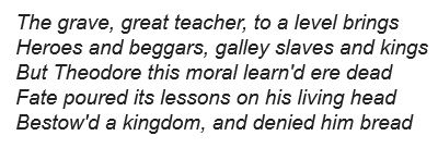
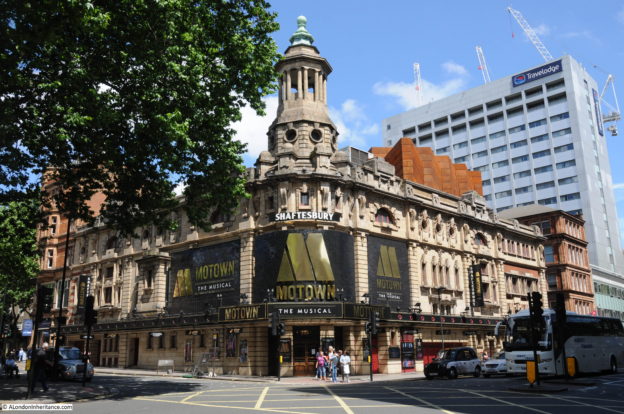
One of the strangest headings I have used for a post, however, this was the title of a wonderful booklet published in 1945, where Edward Julian Carter (Librarian of the Royal Institute of British Architects) and Erno Goldfinger, (the architect of buildings such as the Balfron Tower in Poplar), explained the London County Council, 1943 County of London Plan.

County of London Plan

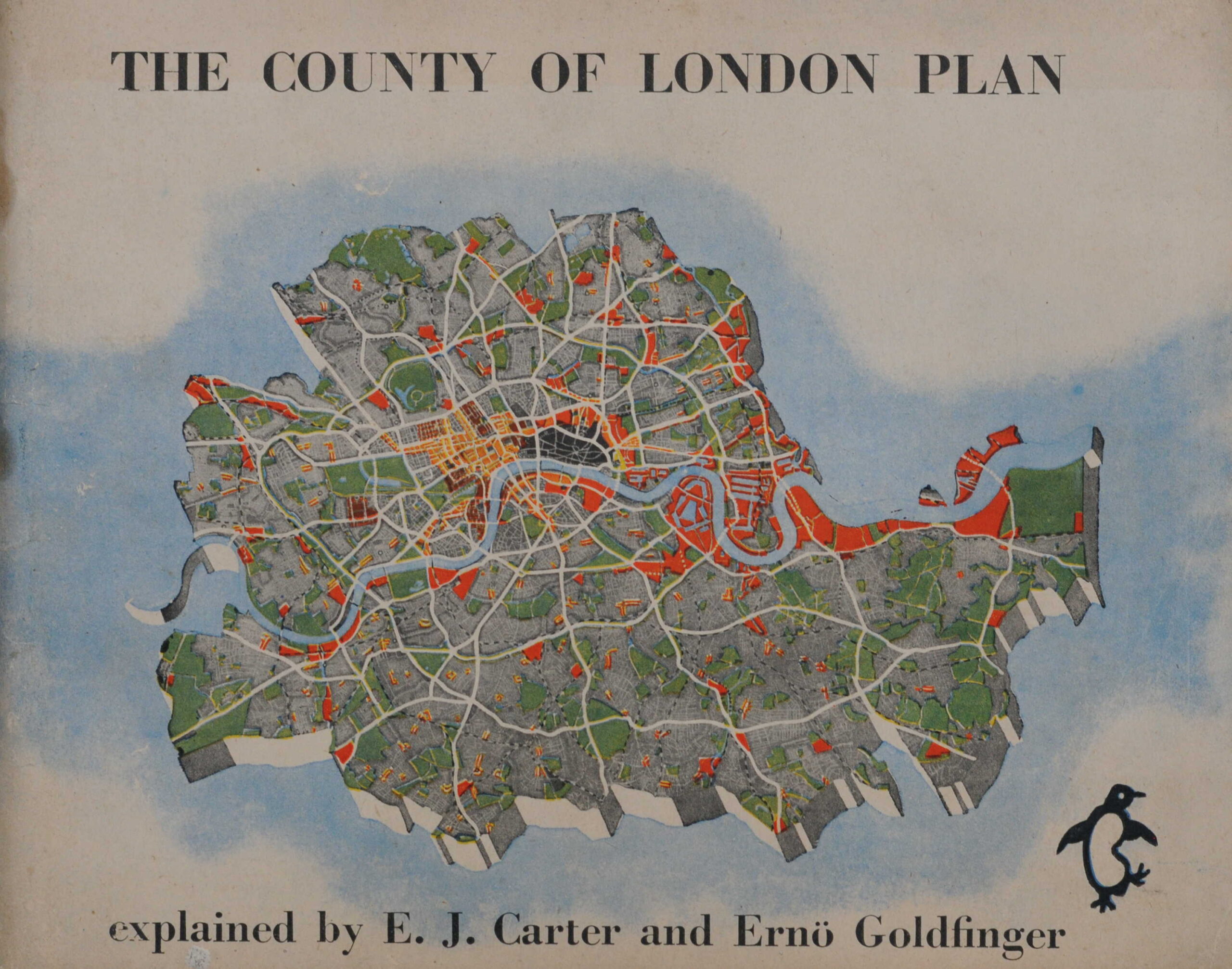
The idea for a County of London Plan came from Lord Reith, the Minister of Works and Planning. In 1941 he asked the London County Council to prepare a plan “without paying overmuch respect to existing town planning law and all the other laws affecting building and industry but with a reasonable belief that if a good scheme was put forward it would provide reasons, the impulse and determination to bring about whatever changes in law are needed to carry the plan into effect”.

The County of London Plan was published in 1943, and provided a view of what the city could become after the devastation of wartime bombing.

As is always the way with long term plans, many of the recommendations were not implemented. Money was a considerable post war problem, many changes were long term, and in the decades following the 1940s, changes not foreseen by the plan, such as the exodus of industry from the city and the closure of the docks, would result in a new approach to city planning.

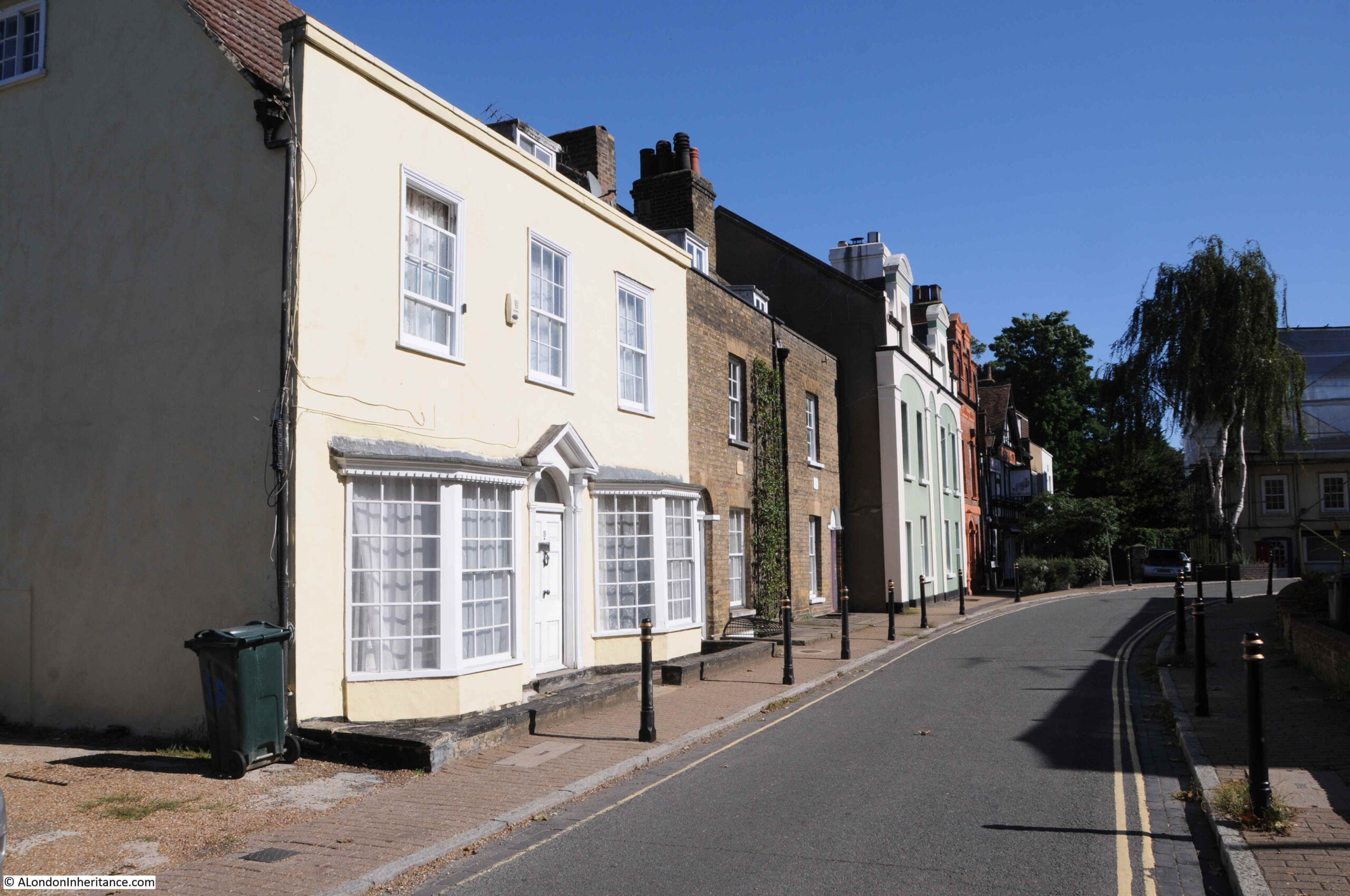
The impact of the County of London plan can though be seen across London today, with, for example, the South Bank being the combination of cultural (Royal Festival Hall, National Theatre etc.), gardens (Jubilee Gardens), office (IBM) and housing recommended by the plan.

The 1945 booklet by Carter and Goldfinger was an attempt to provide a concise view of the plan in a more readable format, and to get the buy in from Londoners to the future of their city as proposed by the plan.

Trying to get the support of Londoners for the plan did though display a bit of “central authority knows best”, as shown by the following two sentences from the introduction to the plan in the booklet:

“So when the L.C.C. plans for London it is not merely planning these things in an abstracted way for Londoners; it is London’s own people through their own democratic government planning themselves”, and;

“The Plan was generated by the people of London and created by architects and planners aware of what the people want. Now it is before the people for them to turn it into reality”.

There is no indication in the booklet how architects and planners were aware of what the people wanted, however the booklet does highlight many of the problems experienced by people living and working in the city.

The booklet was published by Penguin and cost 3 shillings and 6 pence. It would be interesting to know how many Londoners actually purchased and read the booklet.

As with the County of London Plan, the booklet makes some brilliant use of diagrams, what we would today call infographics, use of colour, and plenty of maps, including a wonderful fold out map at the end of the booklet.

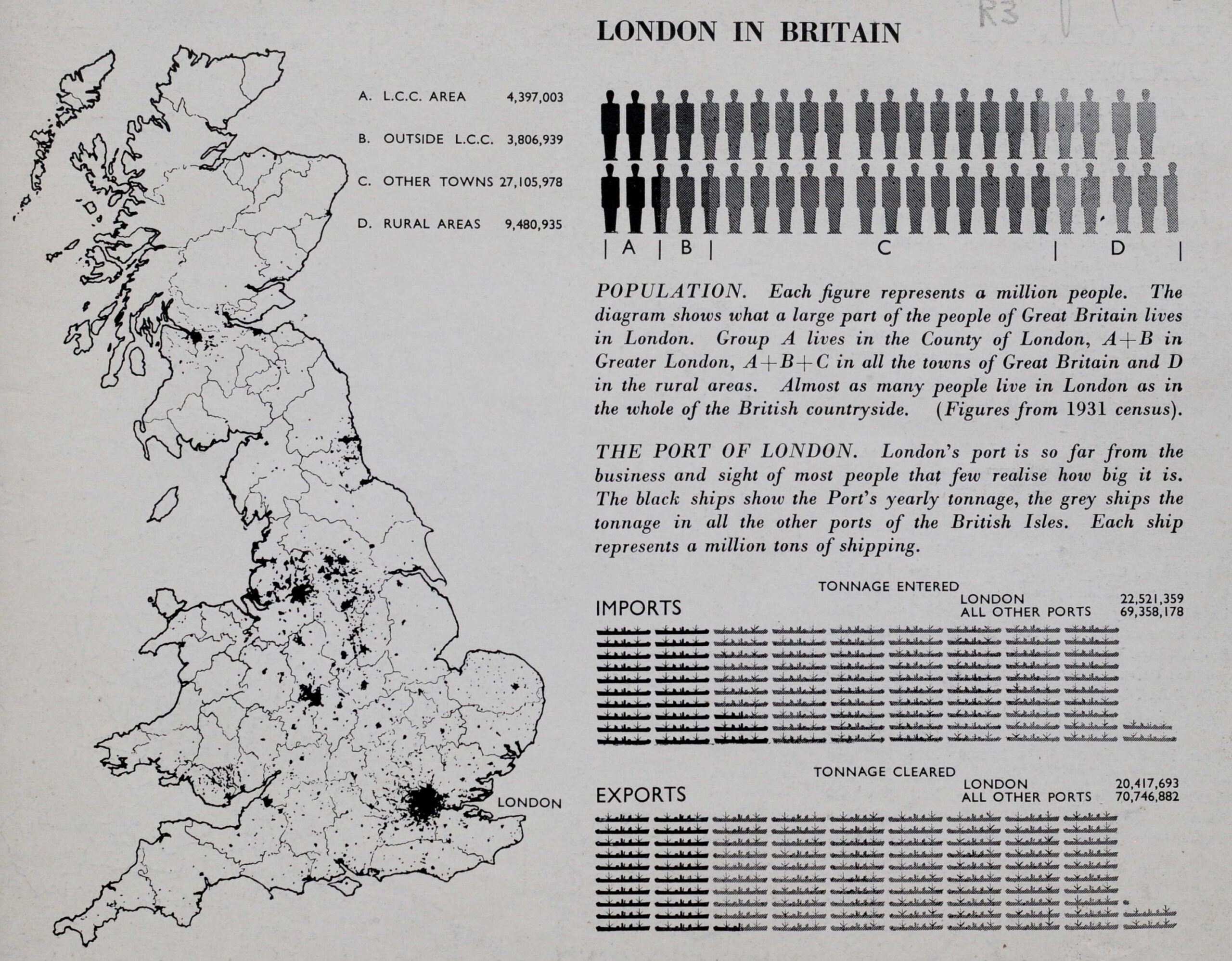
The booklet starts by positioning London in Britain, including that London’s population was almost equal to the number of people living in the whole of the British countryside, as well as the significant percentage of imports and exports that went through the city’s docks.

County of London Plan

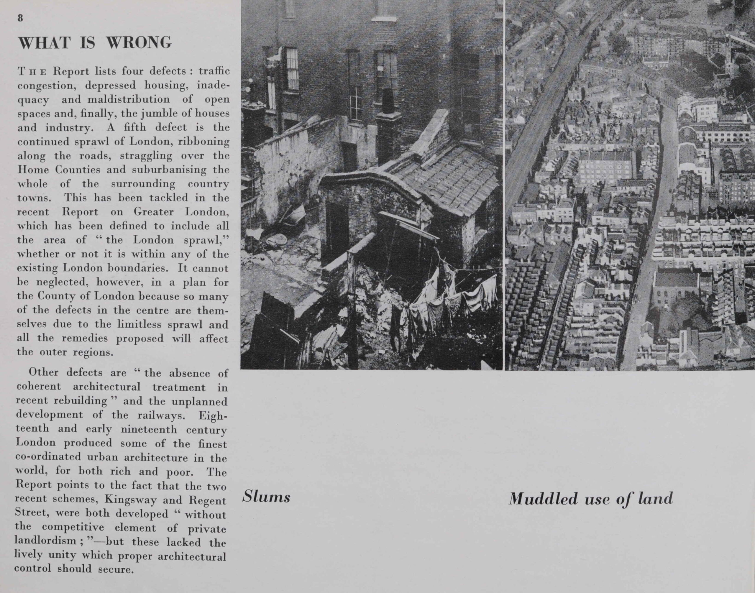
The booklet identifies a number of themes under “What is Wrong”, which includes traffic congestion, depressed housing, inadequacy and maldistribution of open space and a jumble of houses and industry. Another problem is the sprawl of London, with ribbon development along the roads leading to the counties surrounding London, an approach which would gradually leads to urbanising the countryside.

The report illustrates five of these problems. Slums and the Muddled use of land:

What is wrong with London

A lack of open space, traffic problems and architectural squalor:

What is wrong with London

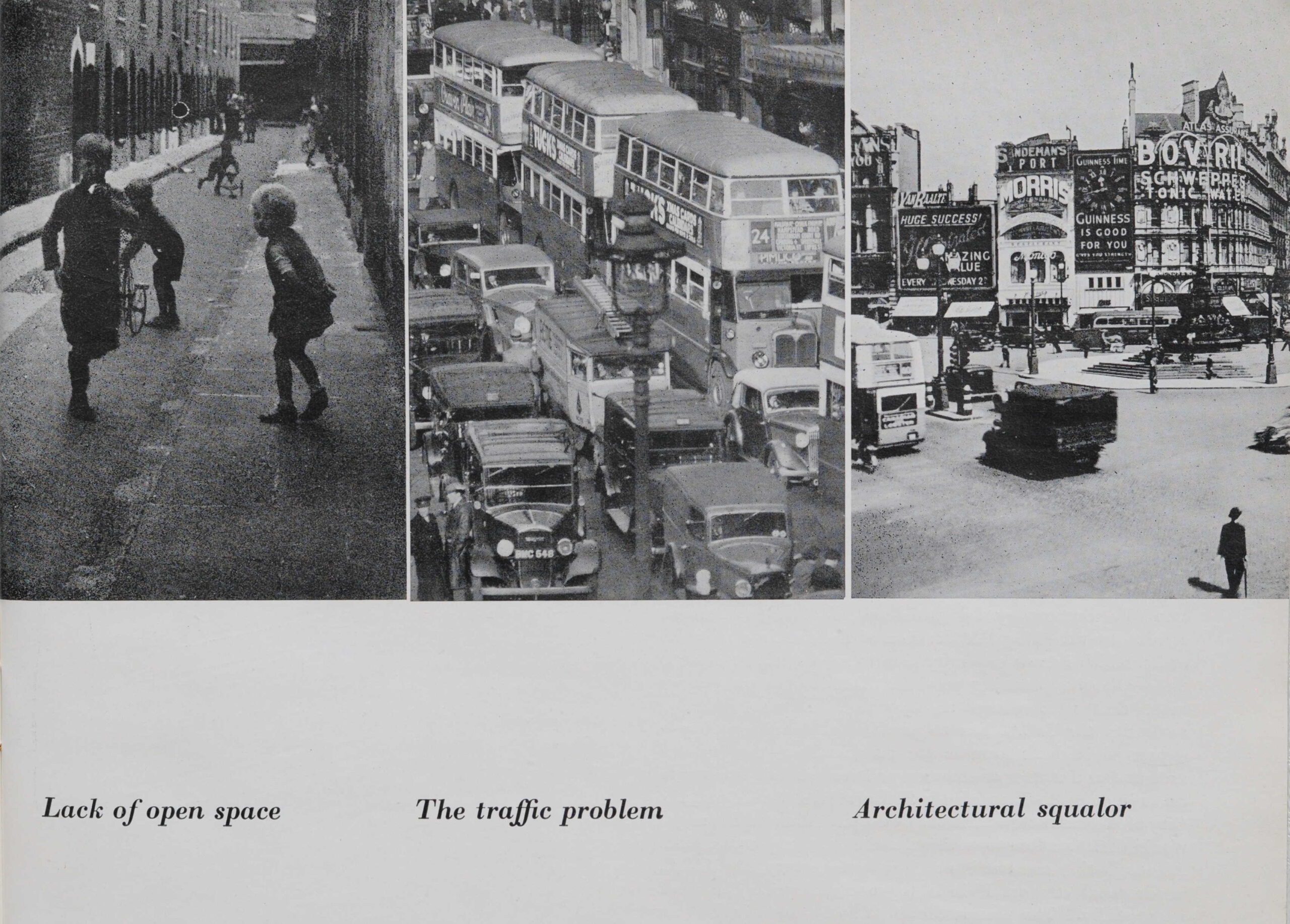
Interesting that the book identifies the “absence of coherent architectural treatment in recent building”. A problem that still exists and demonstrated by the towers that are descending on Vauxhall at the moment.

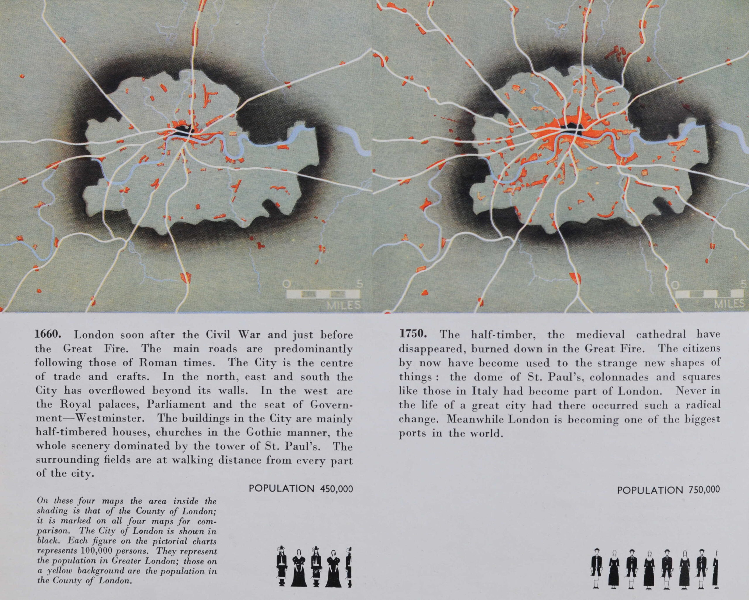
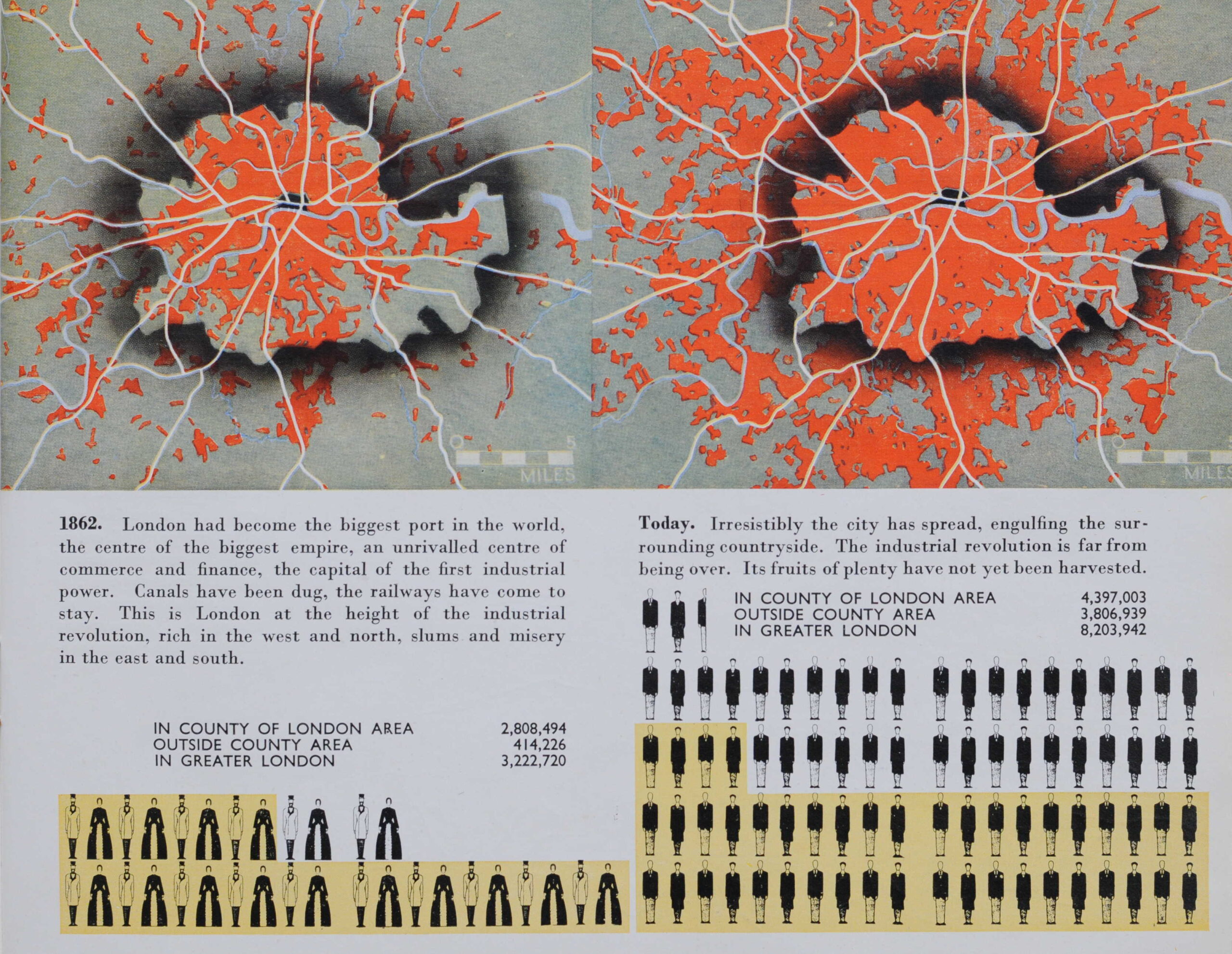
The booklet reviews the growth of London, from 1660 when the city had a population of 450,000:

Growth of London

In 1862, population estimates now include the County of London area, as well as outside the County area to provide a view of the population of Greater London which was 3,222,720 in 1862 rising significantly to 8,203,942 by the time of the report:

Growth of London

The booklet shows some of the data that was used in the County of London Plan to develop the plan’s proposals. The following diagram shows Family Grouping in London, with the number of people in family groups for a sample size of 100 families.

Family size in London

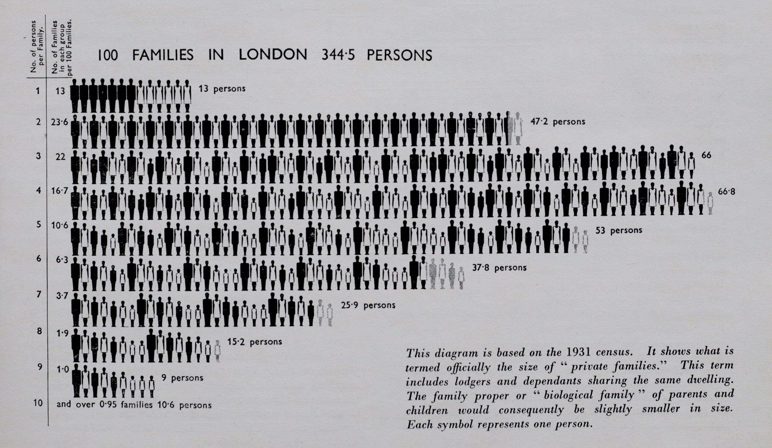
The above diagram was based on the 1931 census, and shows that the highest numbers of families were in the size of three to five persons per family (which also included lodgers and dependents).

This was not so different to the late 19th century. When I looked at the 1881 census data for Bache’s Street (see this post), the average number of members of a family was 3.15, however this figure hid the real problem of houses of multiple occupancy where more than one family would occupy a single house.

Blocks of flats would be a key feature of post war housing development, the booklet goes some way to explaining why this approach was taken.

In the following diagram, the heights of blocks are shown, the height is used to determine the spacing between the blocks.

Housing and flat density

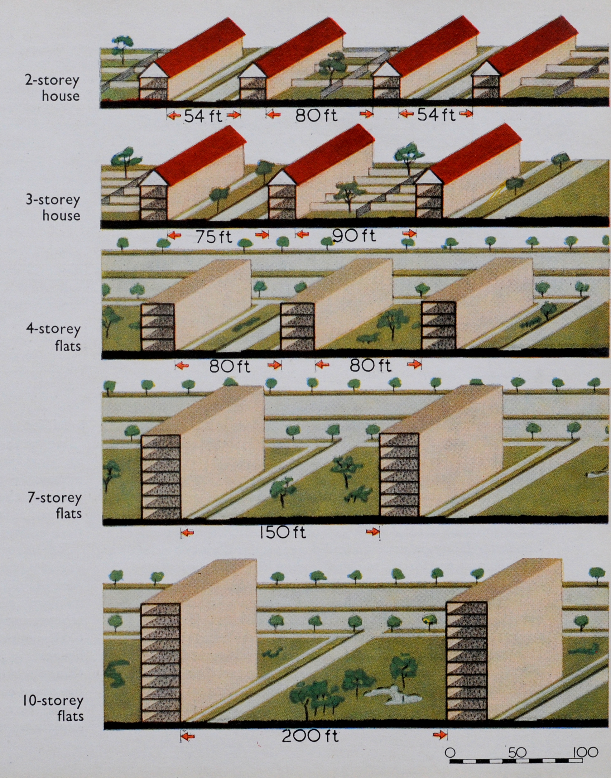
Whilst smaller, 2-storey houses can have their own garden, this arrangement does not give any land over for public gardens, and will require longer roads.

The justification for larger blocks of flats was the large amount of public open space that could be provided, along with uses such as allotments, with very little space wasted for roads.

Whilst the booklet does recognise the lack of private gardens, it does not really appreciate the impact of high rise living, and that large areas of public open space can become a bit of a windswept wasteland if not carefully managed.

The problem with London was the limited amount of space available for everything that could be expected to be included within the city. Homes, schools, factories, shops, public buildings, offices, roads, railways and services for visitors.

The definition of the County of London for the 1943 plan resulted in an area of 74,248 acres available for every use London was expected to support.

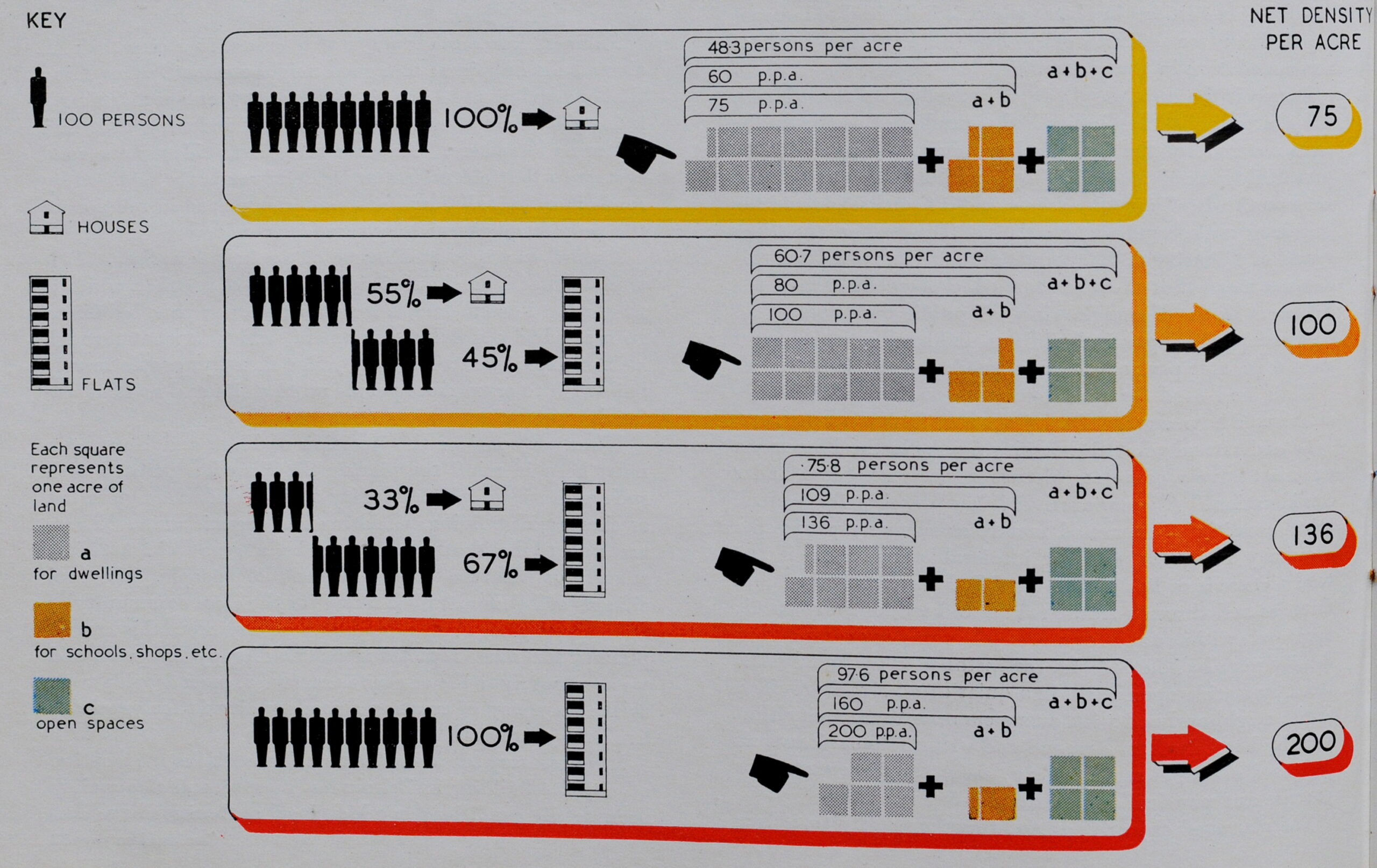
This resulted in some serious decisions on population densities, which again influenced the house / flats discussions.

The following diagram shows the different combinations and their resulting density of people per acre:

County of London Plan

However, even achieving these population densities would cause rehousing problems. Open space was also a consideration as many areas of London had very little public open space. The upper map shows the areas of London where housing is most crowded and there is a negligible amount of open space:

County of London Plan

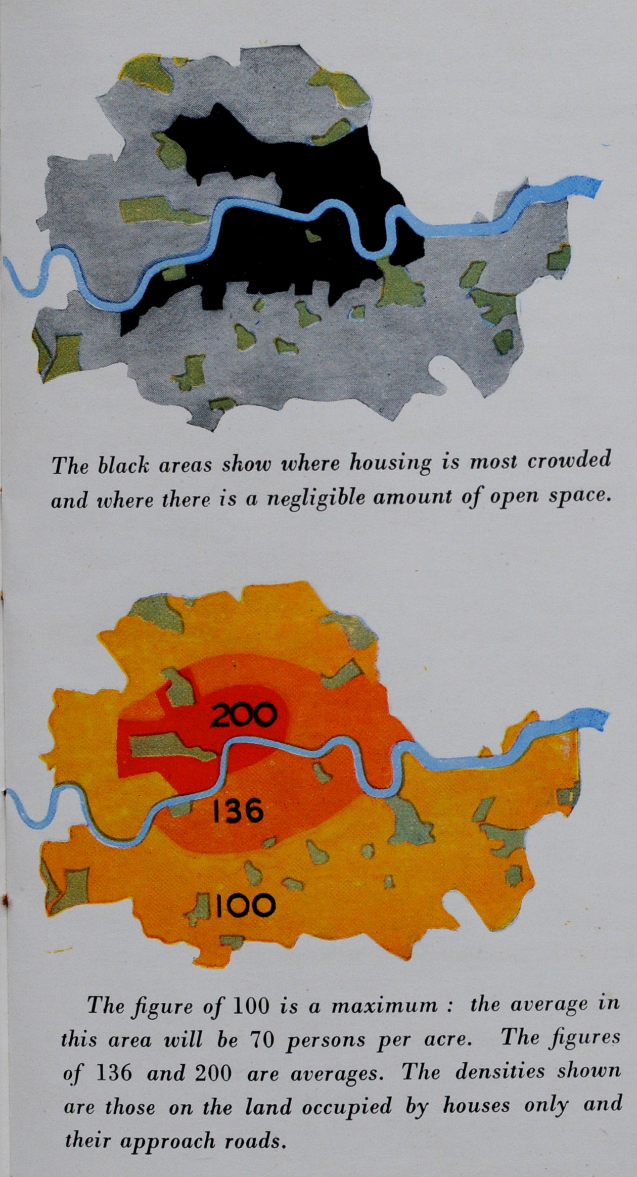
The lower map shows the target population densities defined by the County of London Plan.

The central area would have the highest population density of 200 people per acre, however this figure was much below many areas of London which had densities up to 360 people per acre. This would require the challenge of rehousing and averaging out population densities if a reduction was to be achieved.

As well as housing, London at Work was a key consideration of the plan. At the time of the plan, an estimated 2,990,670 people was employed in Greater London.

The trade with the most people was the Distributive Trades with 563,540, followed by Engineering and Metal Trades at 443,380 and Building and Public Works Contracting at 280,440.

Interesting that the majority of people were involved in some form of manufacturing industry. We tend to think that the city had always been a centre for finance and the professional and service industries, however the report listed 55,360 people in Finance and Commerce, 71,080 in Professional Services and 184,170 in Hotels, Restaurants, Club Services etc. Today, I suspect the numbers for manufacturing and those for the finance, professional and hotel services have swapped.

The booklet includes a map showing the built area of London, with the division of industrial and built areas:

County of London Plan

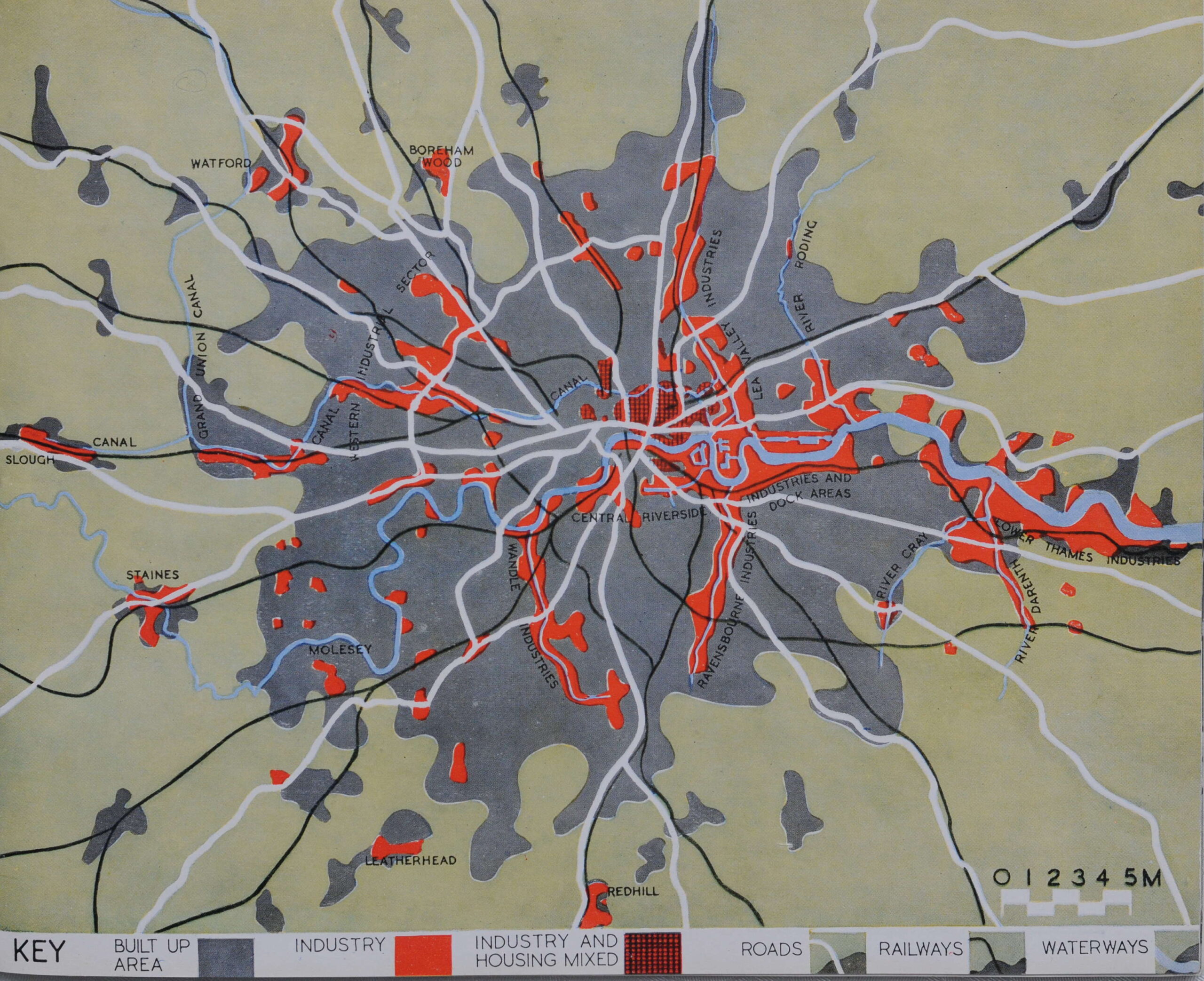
What is interesting is how the growth of industry has followed the rivers of London. Not just the Thames, but the Lea in east London, and if you look in south London, the string of industry along the Ravensbourne and Wandle.

The following map shows the future locations of industry and commerce proposed by the plan. Red being industry and Yellow for Commerce.

County of London Plan

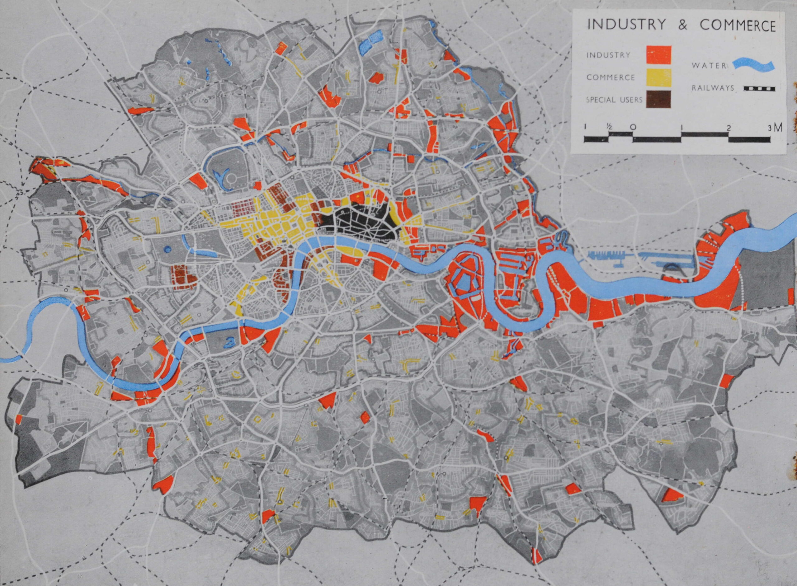
National Government focused on Westminster, Local Government on the South Bank (County Hall), Law to the west of the City, Bloomsbury being the centre for University education and Kensington being the location for museums.

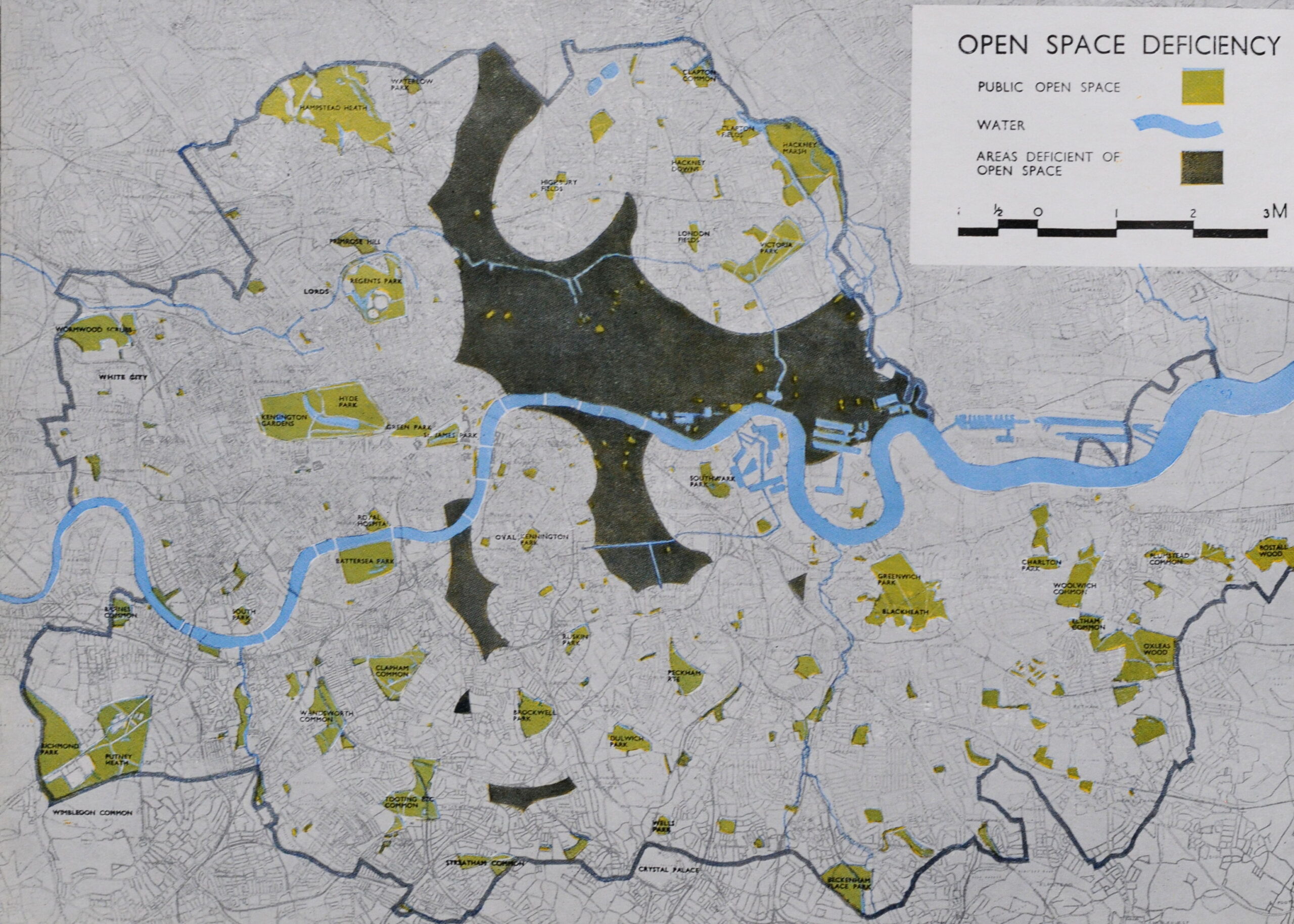
The County of London Plan was concerned with the lack of public open space. During the 19th century London had grown exponentially, with industry surrounded by dense housing estates and very little land available for those living in the city. Whilst to the west there were the Royal Parks, the east of the city was very poorly served as illustrated by the following map, where the dark area indicates areas deficient of open space:

County of London Plan

The County of London Plan proposed a system of new parks, mainly in the east and south of the city as shown in the following map:

Open Space Plan

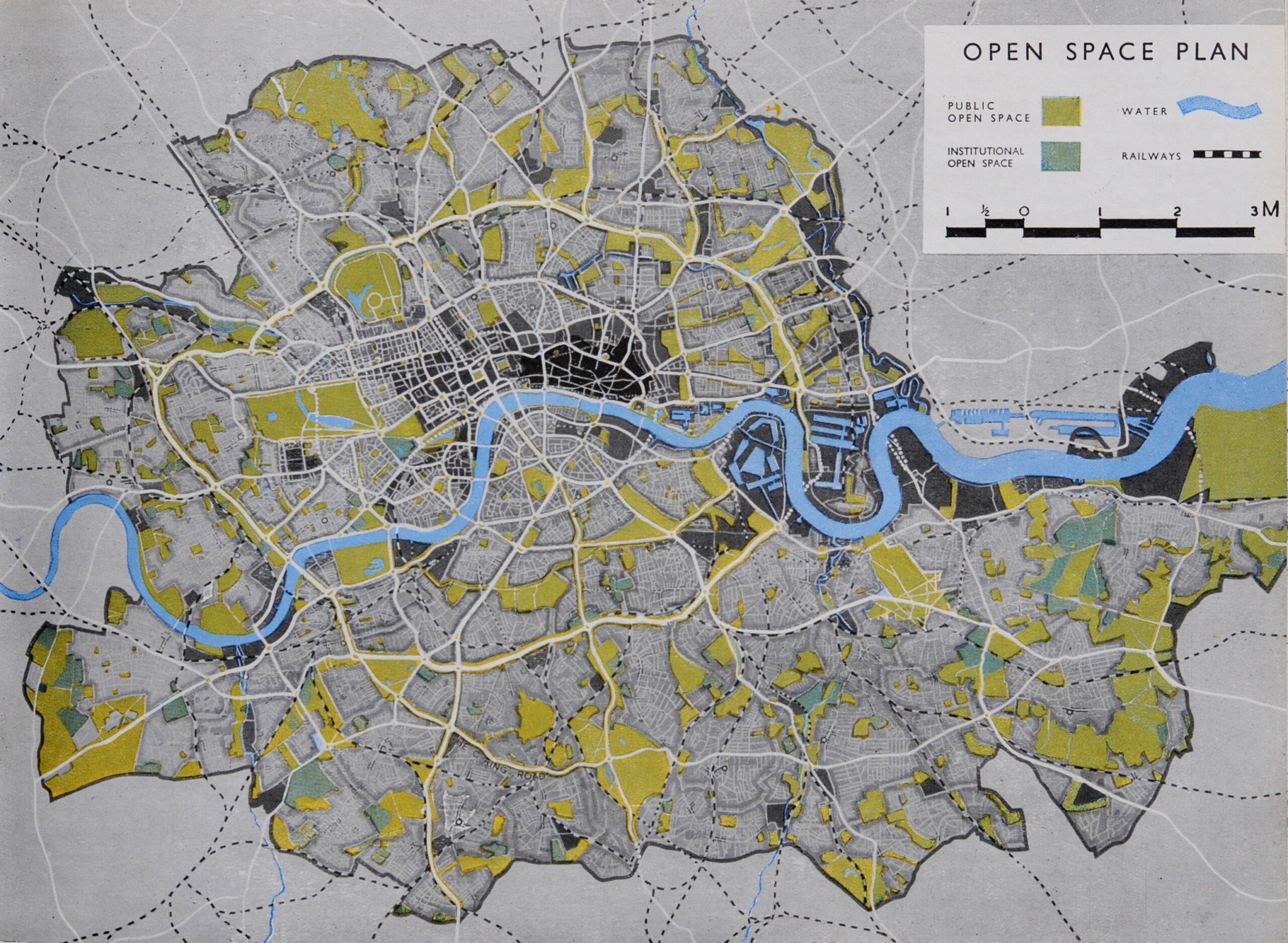
It would be interesting to compare how many of the sites marked in the above map are open space today (adds projects to ever increasing list of things to write about).

The growth in traffic was a key consideration of the County of London Plan. The post war growth in car and lorry traffic was a theme of the majority of post war city development plans. The City of London’s plans proposed dual carriageways through the City (of which the section of London Wall between Aldersgate Street and Moorgate was one of the very few sections to be built, along with underground car parks and raised pedestrian ways.

The County of London Plan offered a desperate view of what could become of the city if measures were not taken:

Traffic

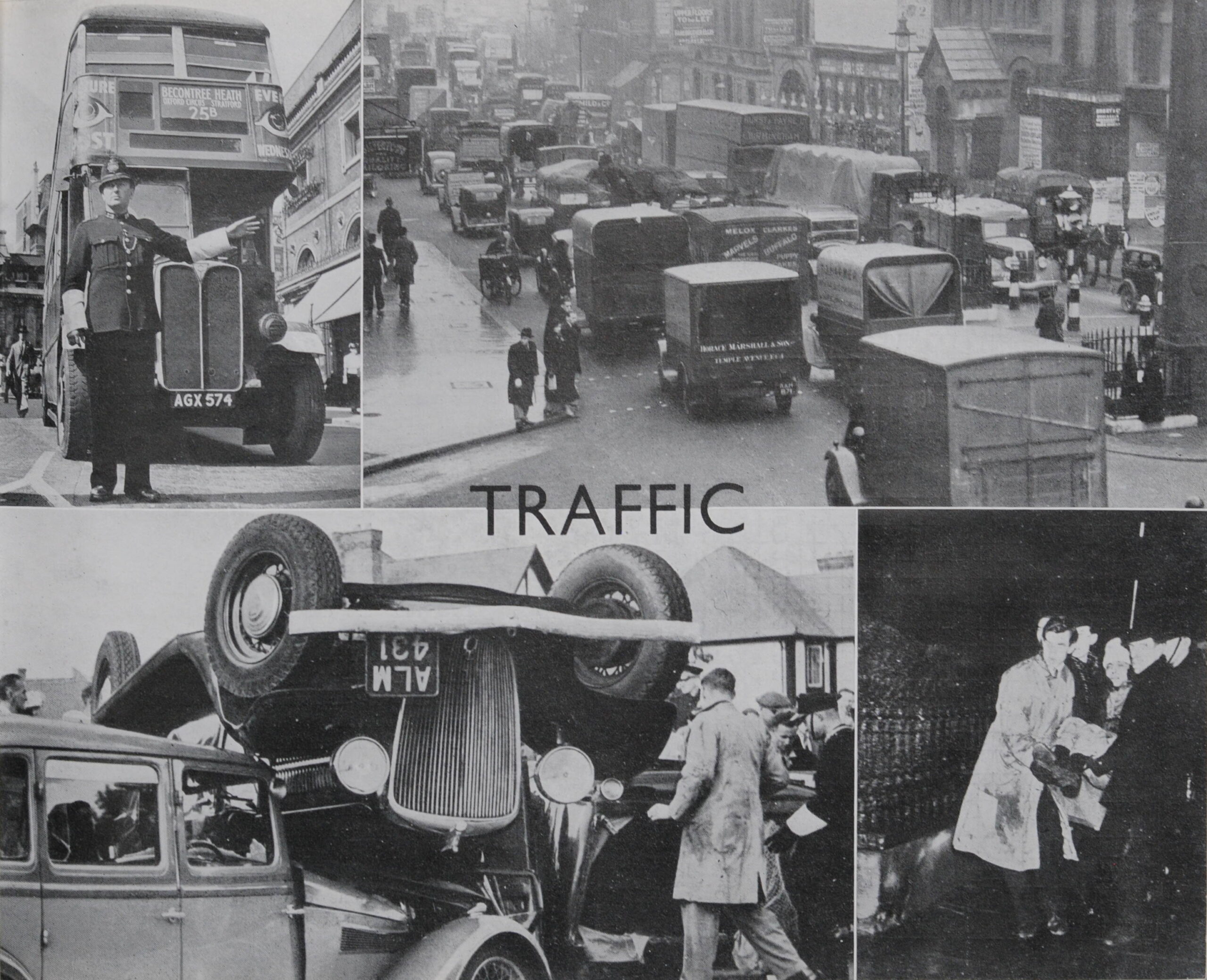
Pre-war, many of the city’s streets were not designed to support the expected volumes of vehicle traffic, or the speed at which these vehicles were expected to travel – much faster than the horse drawn transport of previous centuries.

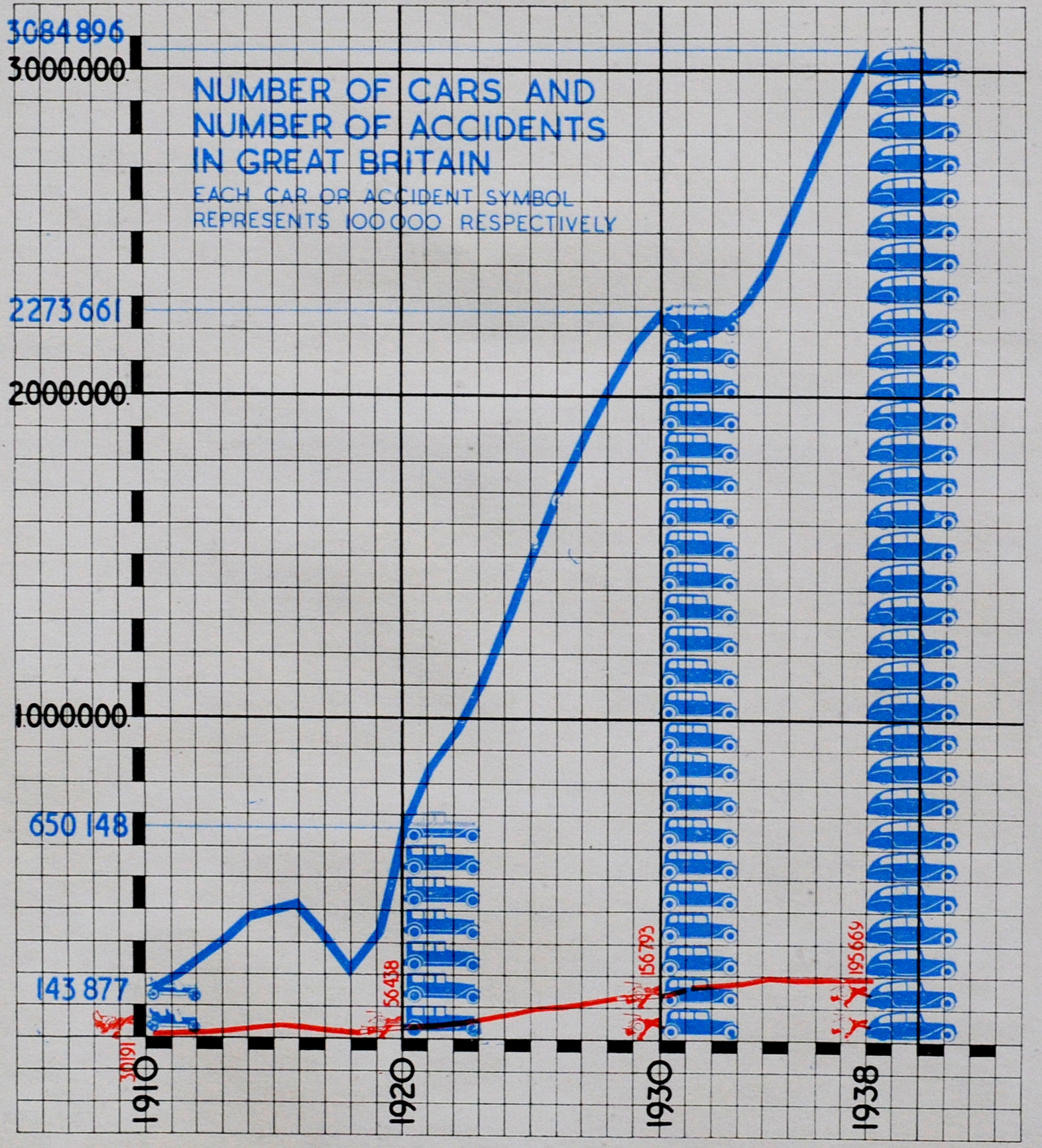
This was illustrated by the increasing numbers of cars in the country up to 1938 (blue) along with the increasing number of road traffic accidents (red):

cars and accidents

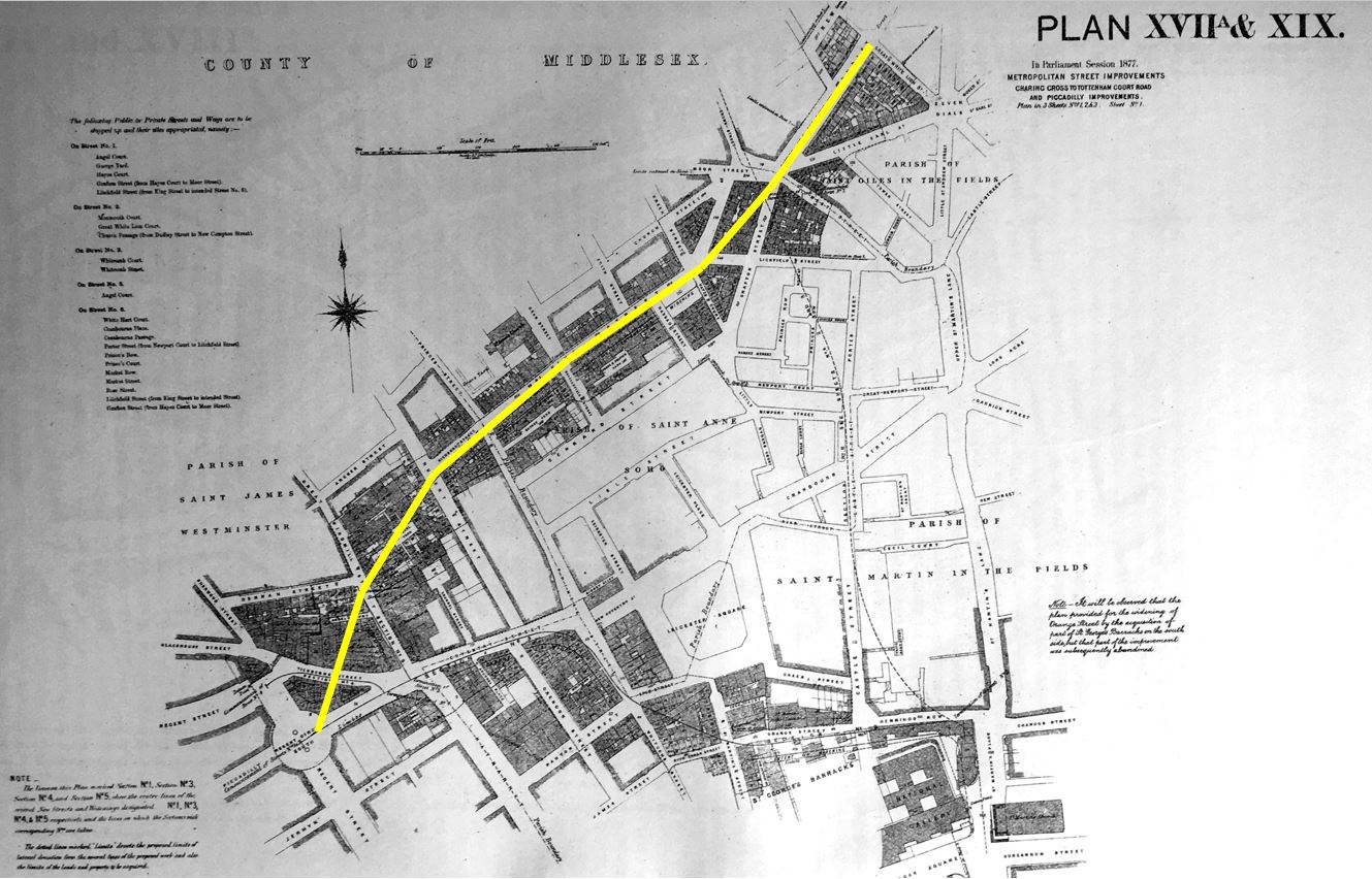
To address the problem, the County of London Plan proposed a series of arterial and ring roads that would help take traffic from the smaller surrounding roads, and speed this traffic to their destinations. The following map shows the proposed new roads on the south-east of London, marked in red:

County of London Plan

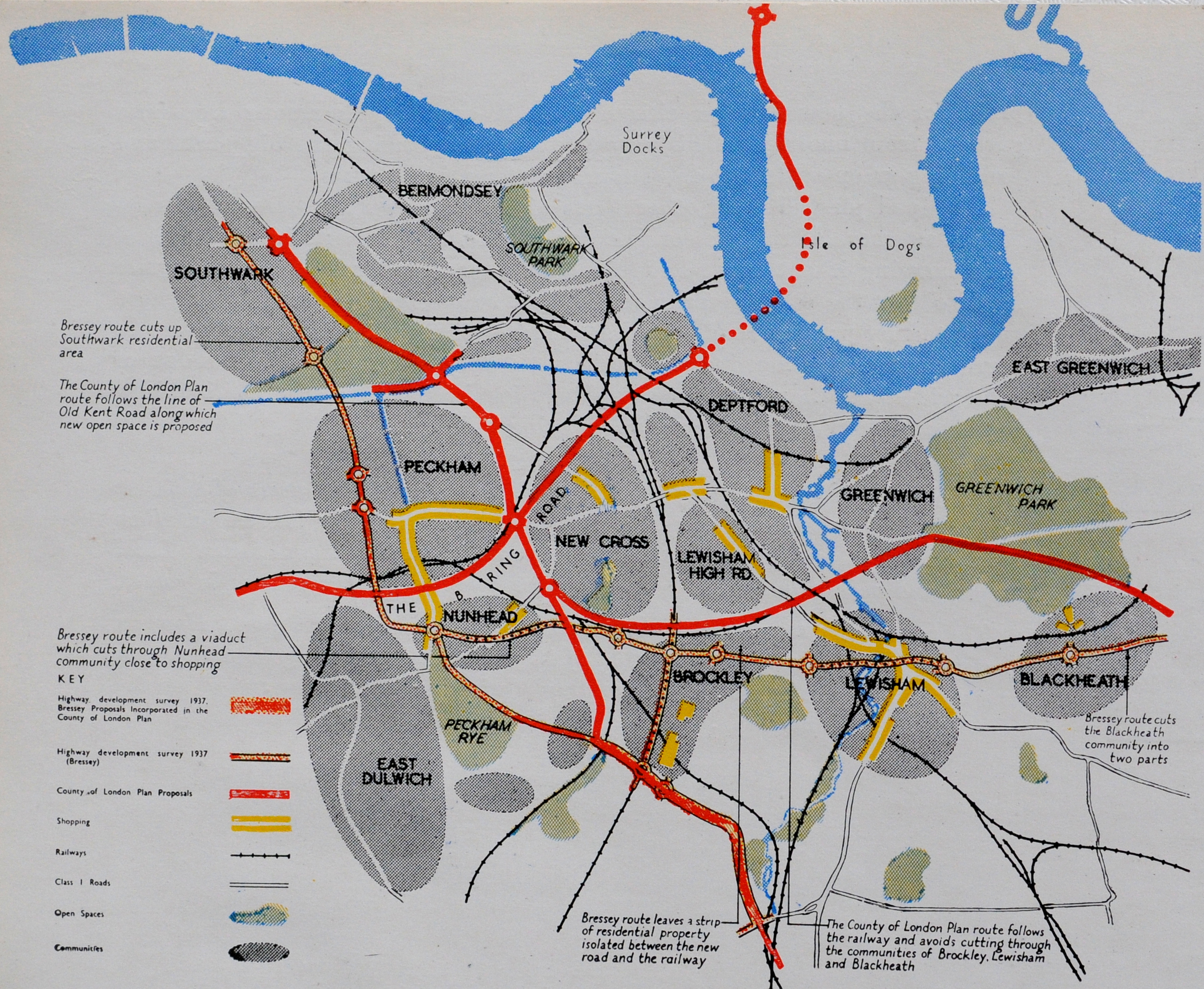
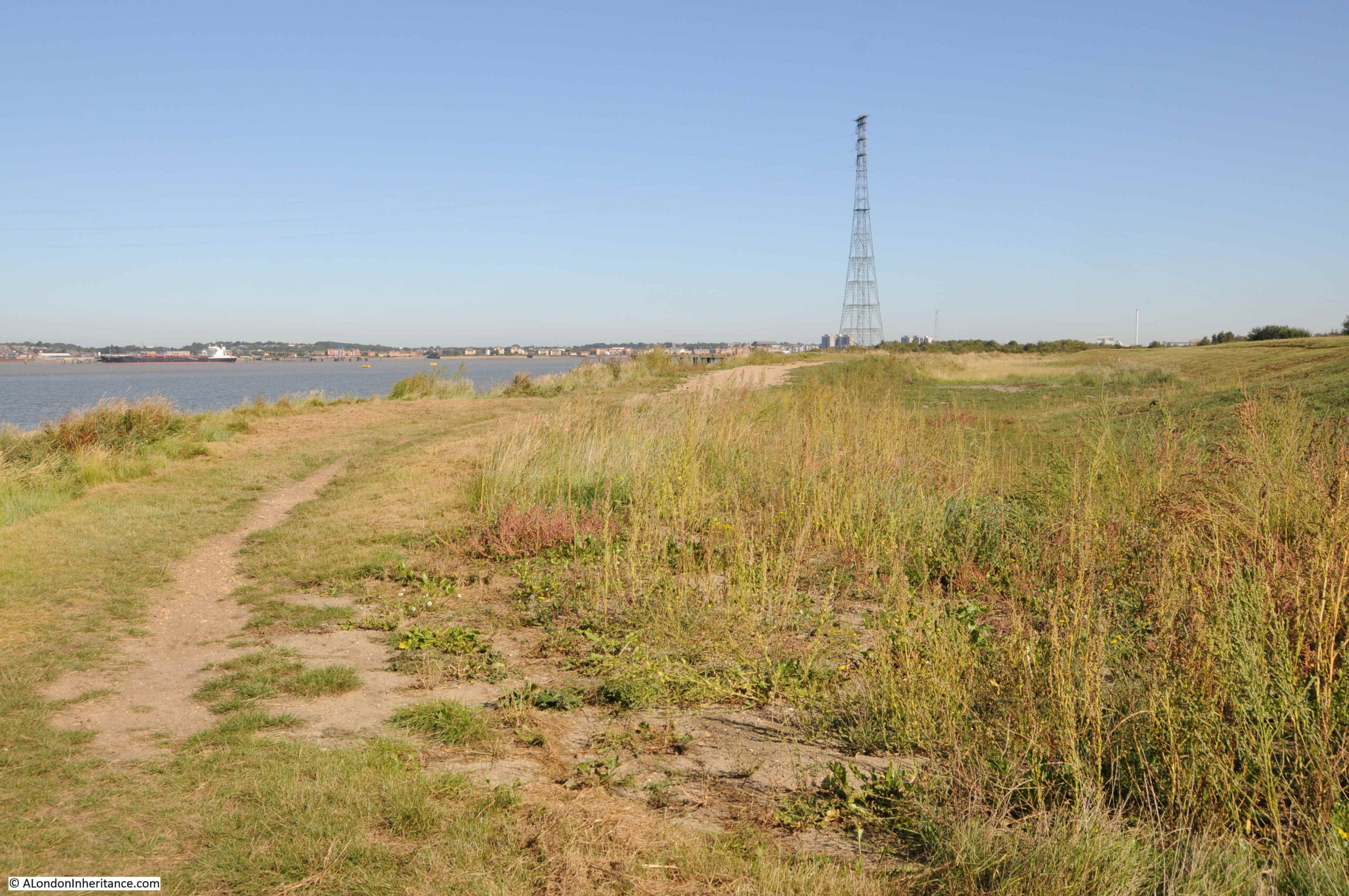
Note the intention for a new road to the west of the Isle of Dogs, that would cross under the river to the south of London. Many of these plans would not be built, or would be built along different routes.

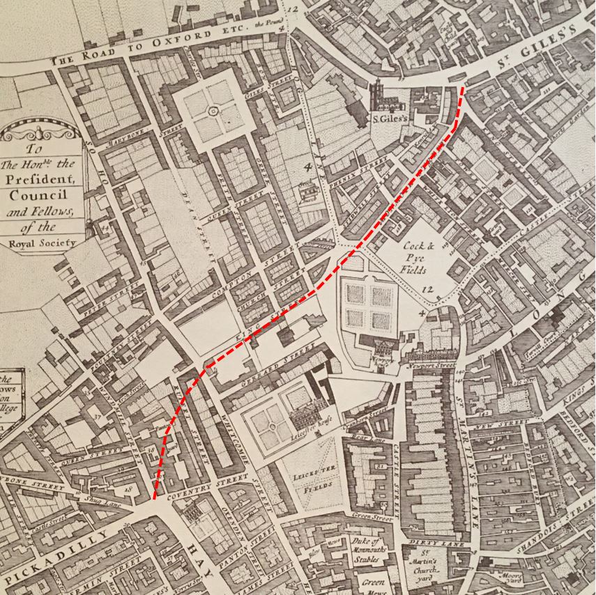
The route through the Isle of Dogs was part of an inner arterial road that would ring the city. The following map shows this road, along with the arterial roads that would connect this ring road out to the rest of the country.

Road Plan

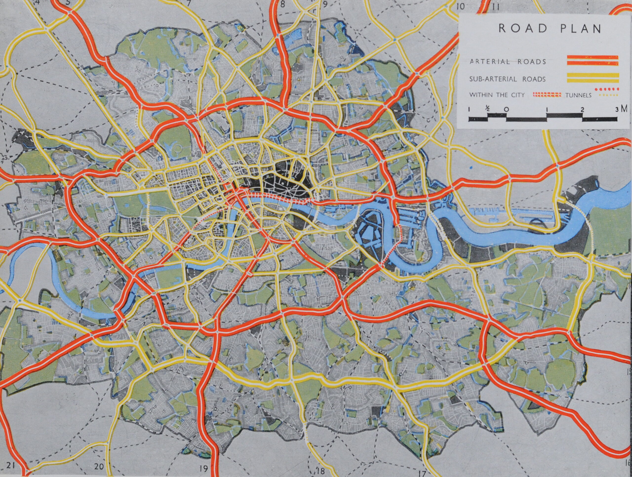
The black area in the centre is the City of London. The red dashed lines between the City and river represent the arterial road that would be created with the construction of the dual carriage ways along what is now Upper and Lower Thames Street. This, as shown in the map, would create a the main east – west route through the City.

The arterial roads stretching out from the city are roads such as the A1, A2, A13, A3, A4 etc. all of which have been rebuilt as major routes into and out of the city to the wider country.

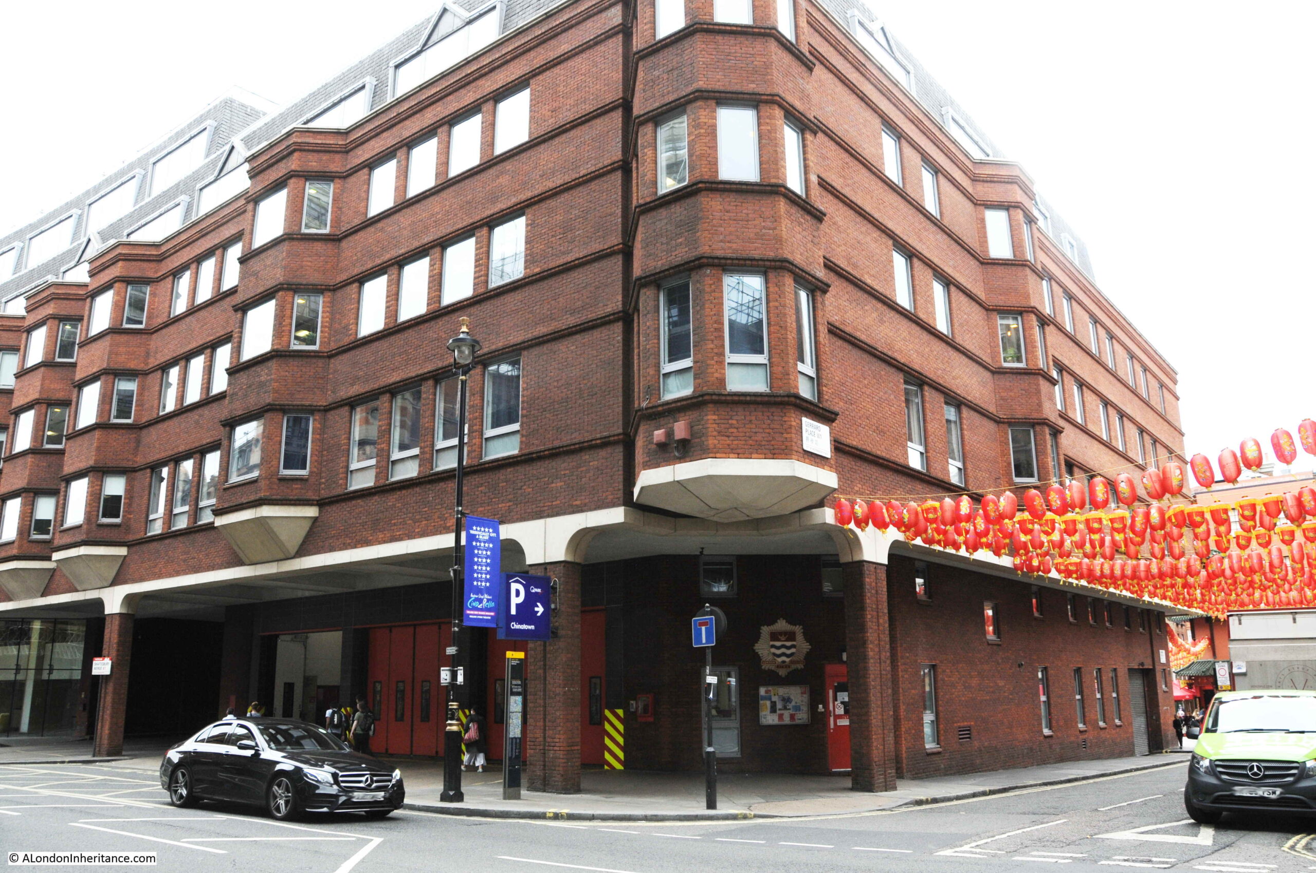
Railways were also considered in the report. A major concern was the impact that railway viaducts had on the city. Viaducts cut through neighbourhoods, dividing areas, and as the booklet described “were signs of incredible squalor, with trains rumbling in front of bedroom windows, day and night”.

The booklet used an aerial photo of Southwark as an example of the impact of viaducts:

Southwark Viaducts

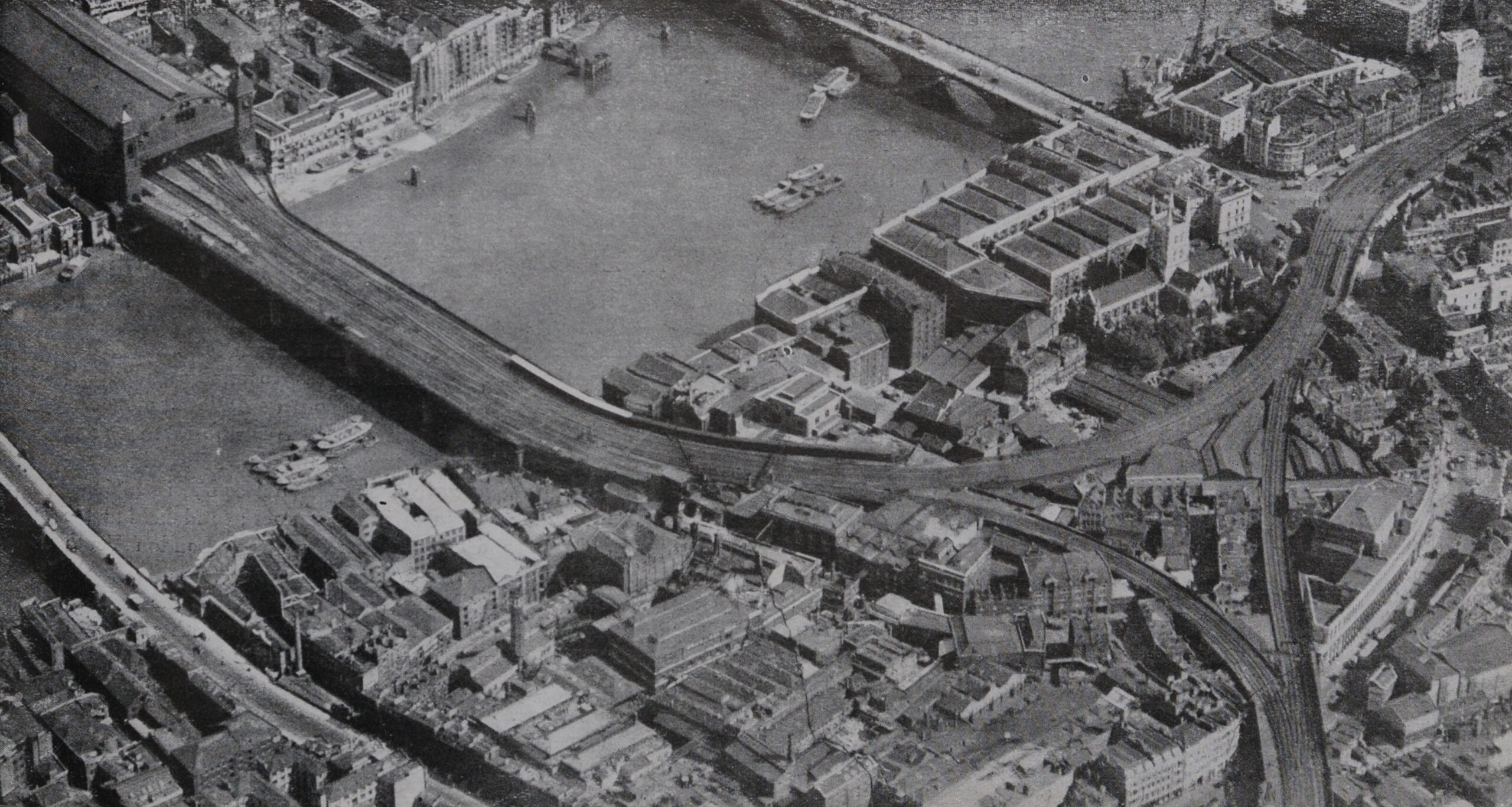
The booklet has a bit of a negative view of rail transport, which probably influenced the following decades of under investment in rail and investment in road transport.

For example, the following paragraph from the booklet covering the London Underground:

“In recent years the Underground Railways have contributed an additional problem for planners. Without thought for the total welfare of London they have pushed their lines out to the open country, encouraging uncontrolled speculative development. It was said at one time that London Transport needed a London of 12,000,000 inhabitants if it was to operate profitably. growth to such dimensions in the districts to the present railway network is the worst possible thing from the point of view of London as a whole.”

The plan makes a number of recommendations for London’s railways, including “increased electrification, better interchange between main lines, underground and suburban services; removal of viaducts; better receiving and distributing services for goods; and possibly the use of air-freight services”.

It is interesting comparing the 1943 plan, with today’s approach, where in 1943 air travel was being suggested as an alternative method for transporting freight, rather than the railways.

The booklet complained that whilst the County of London Plan “tackled the railway problem boldly”, the Central Government or Local Authorities did not have the powers to plan railway companies activities.

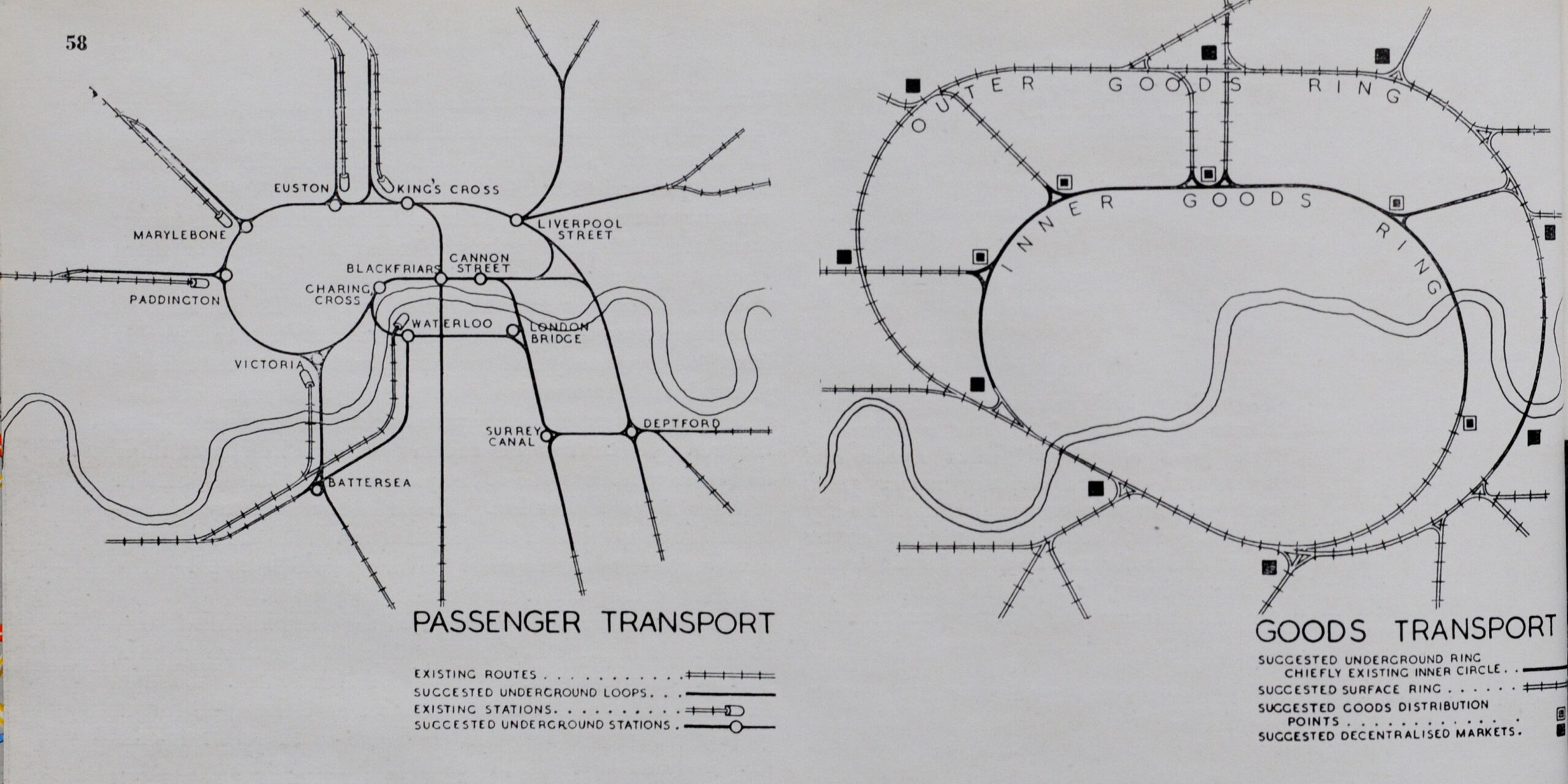
The plan suggested the use of underground loops to link stations, an inner and outer ring for goods traffic and the removal of viaducts. Some of the proposed new routes are shown in the following maps from the booklet:

London Railways

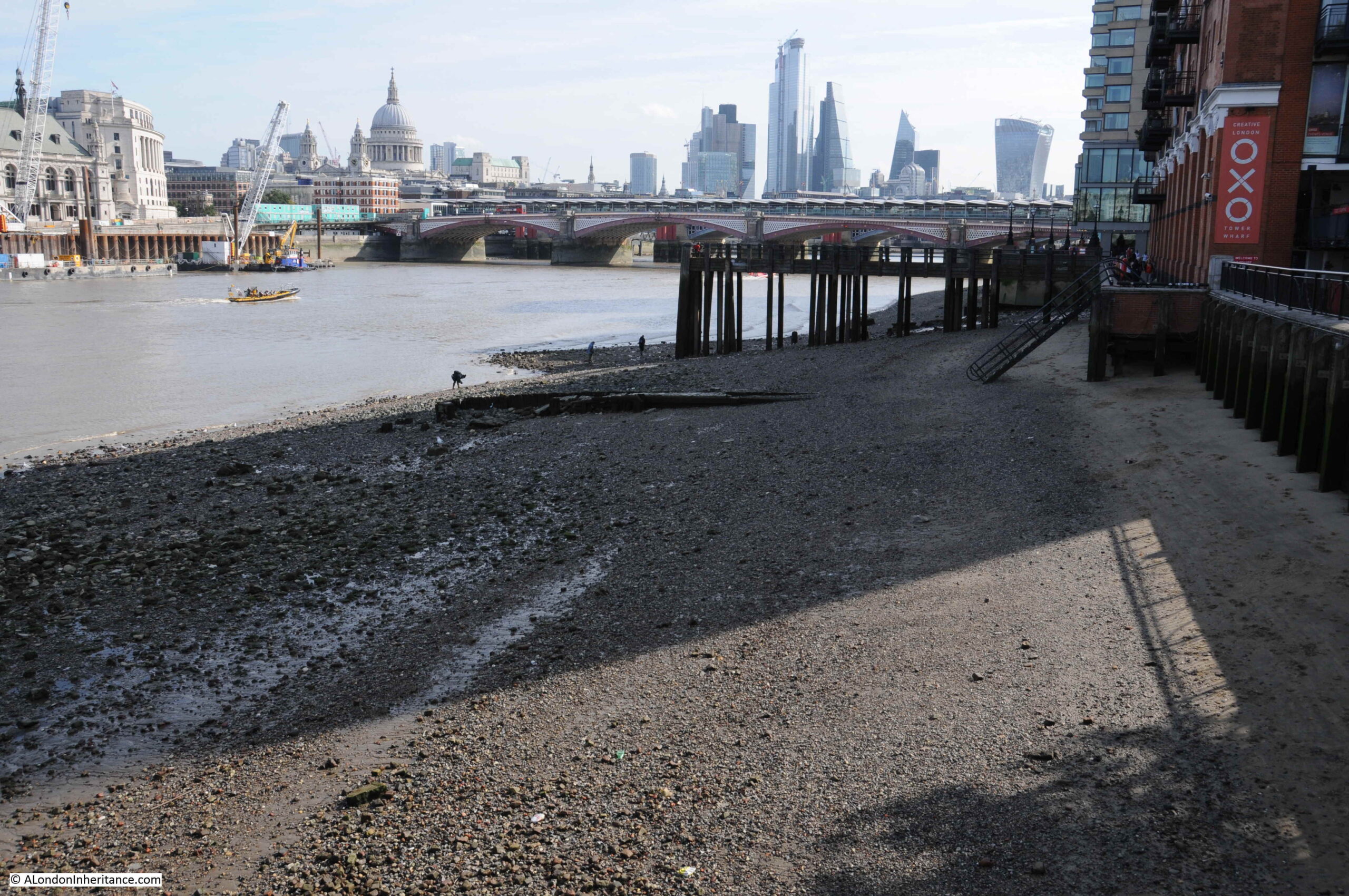
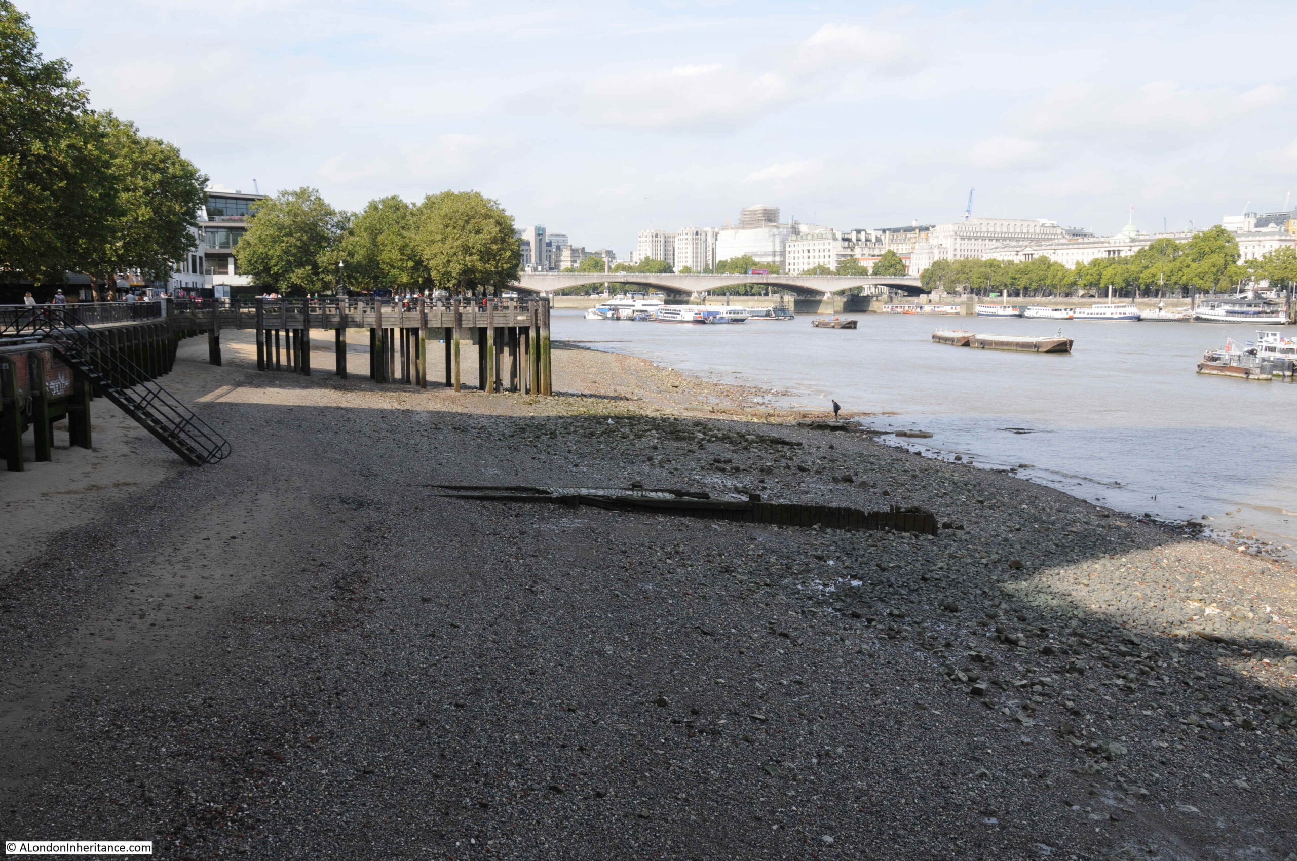
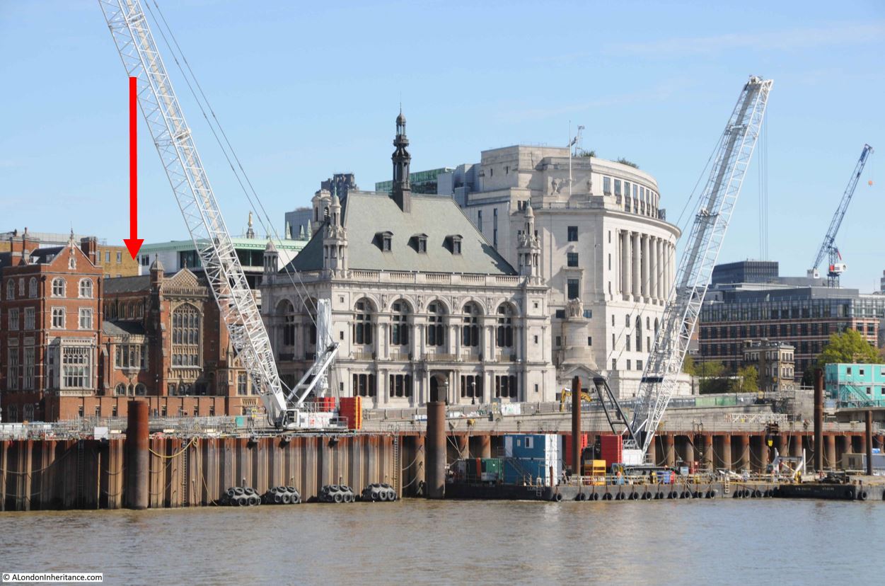
The plan used the South Bank as an example of what could be achieved. The area between Westminster and Blackfriars Bridges had long been the target for improvements. In the late 19th century, newspapers moaned that the area was the first view of London that Americans arriving on the boat train from Southampton would see, and it was an industrialised area with dense, poor terrace housing.

Improvements along the South bank had started in the first couple of decades of the 20th century with the construction of the London County Council’s County Hall, and the plan proposed the South Bank up to Blackfriars Bridge should be transformed as a cultural centre, offices, improved housing, open space and a river walkway.

The plan’s vision for the South Bank was shown using the following model:

South Bank development

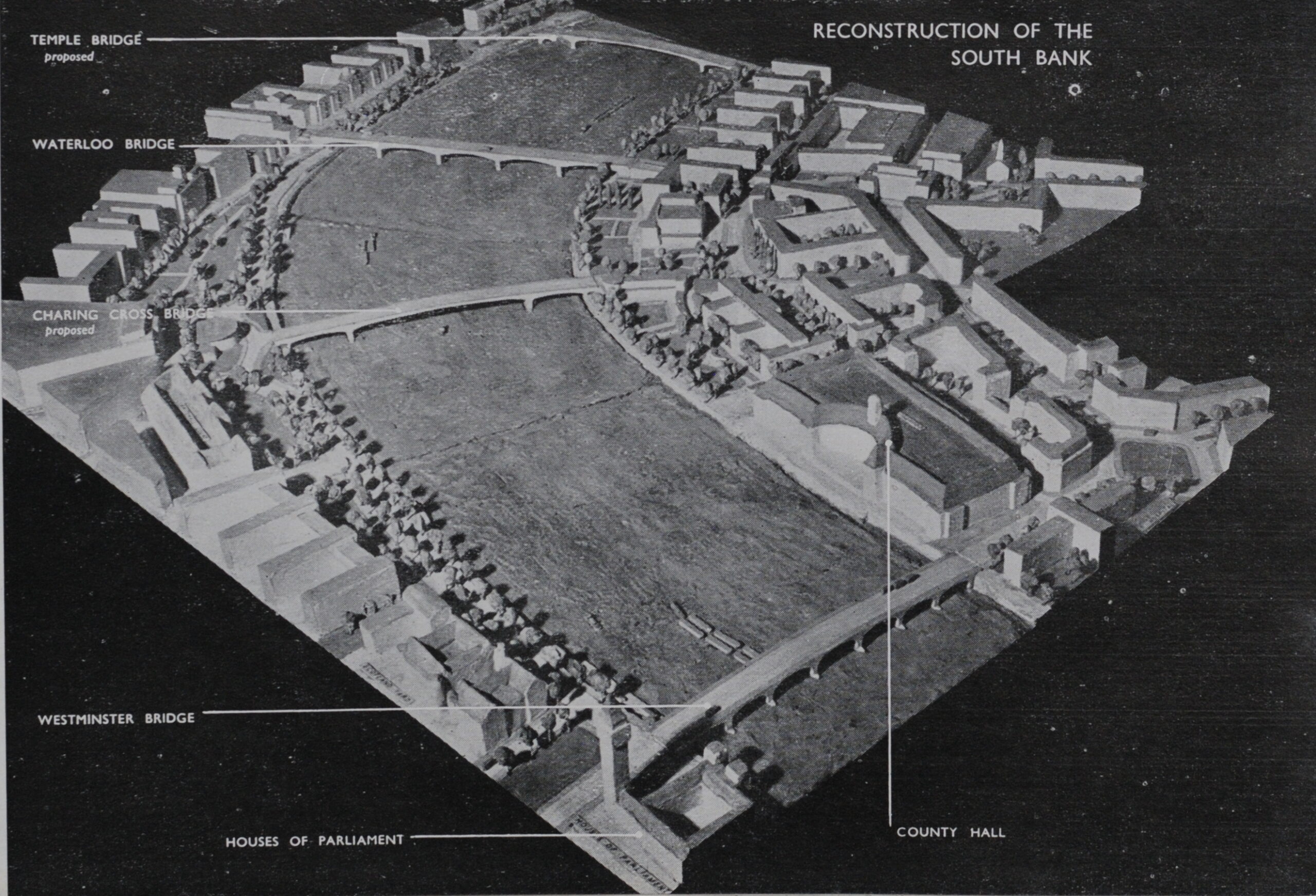
As well as the development of the South Bank, proposals included the removal of Hungerford Railway Bridge, and two new road bridges; a new Charing Cross road bridge and a new Temple Bridge. The car rather than the railway was seen as the post-war future of transport.

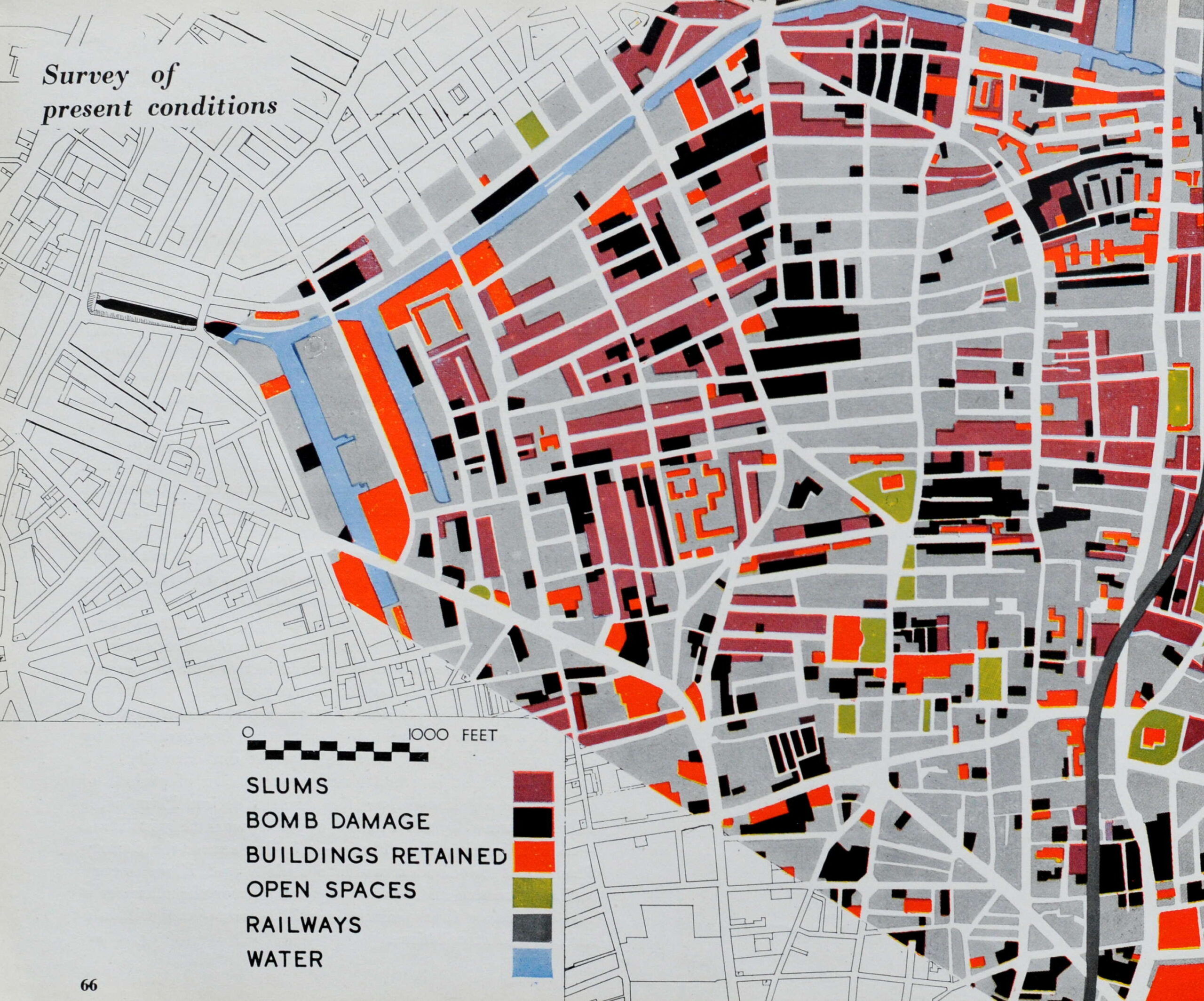
The booklet includes a section titled “Putting Theory Into Practice”, which deals with the challenges of implementing the complex and extensive plans proposed in the County of London Plan.

It makes a comparison with Russia, stating “We all know the great Russian Plans were actually named by the number of years work they involved – the Stalin Five Year Plans – so in due course the County Plan must be divided up into periods and, if we secure sufficient means and powers, we can get the planners a real confidence that each stage will be completed within a limited and stated time.”

To illustrate how this might happen, the booklet includes a series of maps showing how a area could be transformed, starting of with a “Survey of present conditions”:

County of London Plan

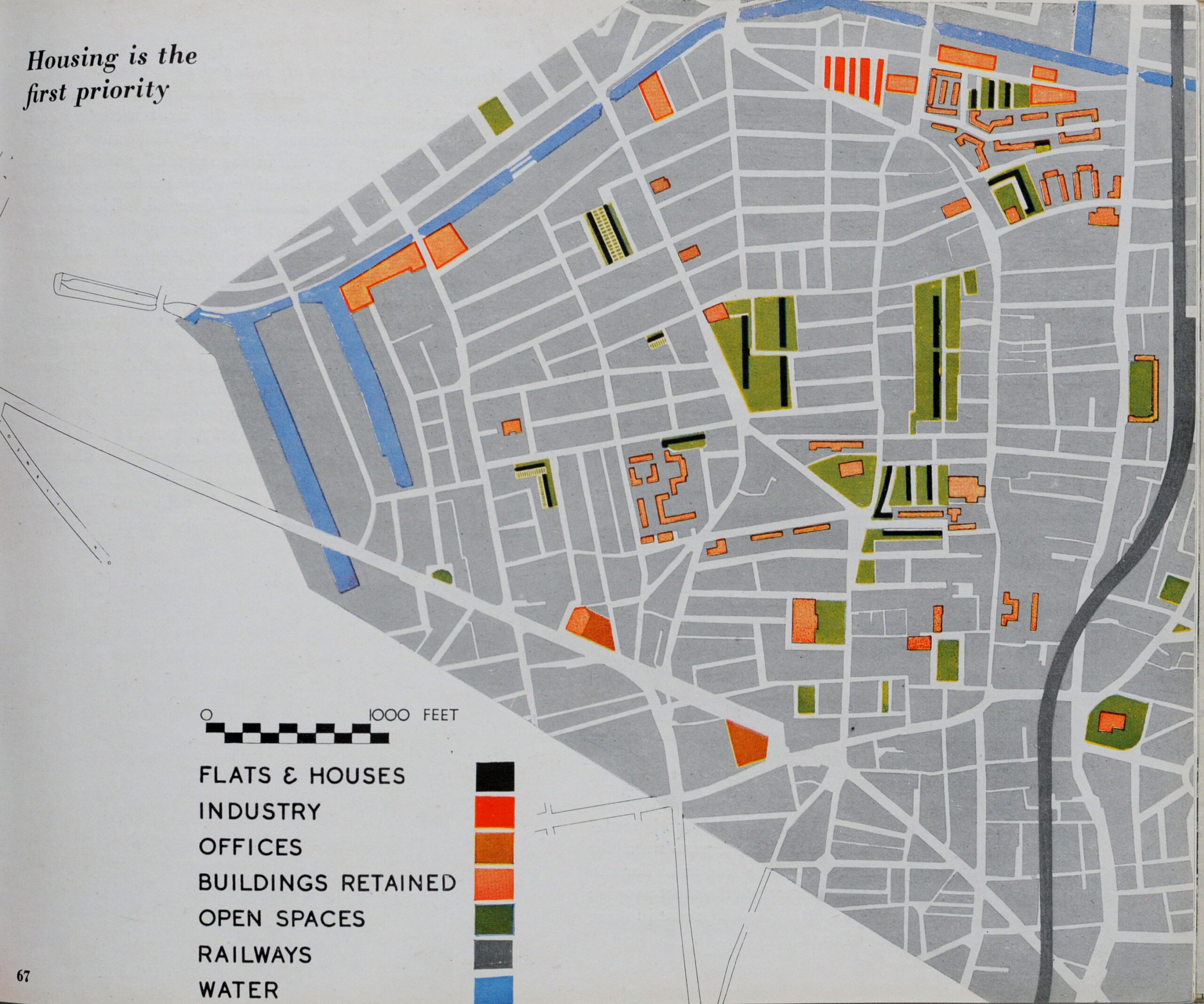
Followed by Housing as the first priority:

County of London Plan

Places of work would be key:

County of London Plan

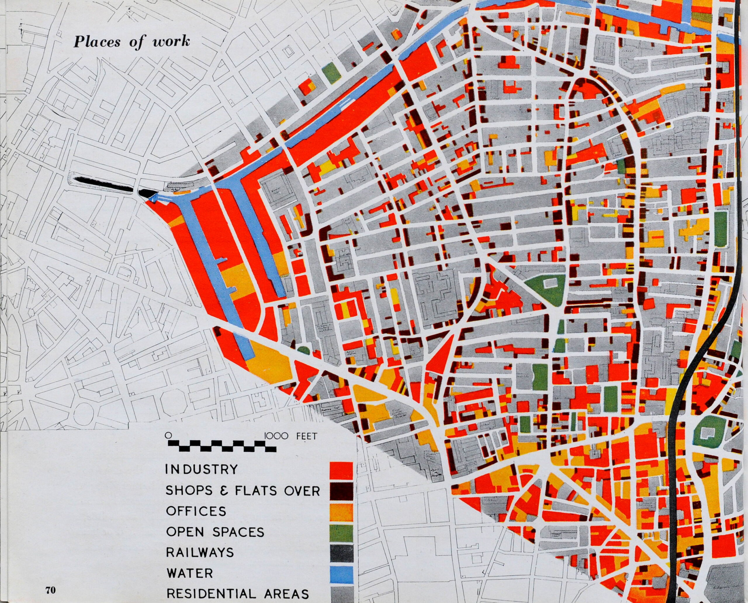
With the need to re-plan the places of work so they move from being packed within areas of housing (above map), to dedicated industrial areas away from residential areas (following map):

County of London Plan

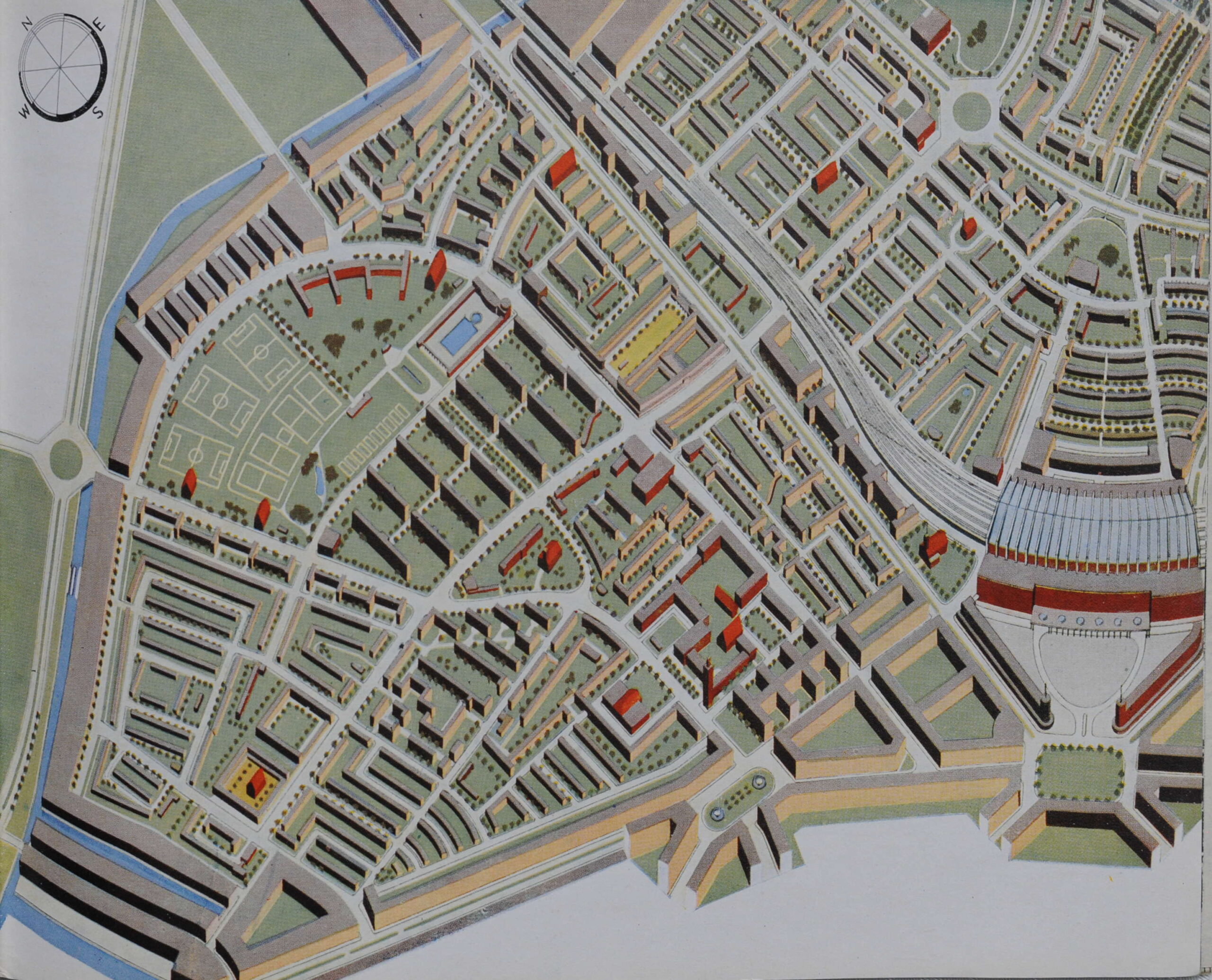
The following diagram shows an aerial view of the completed transformation. A planned and completely rebuilt area of London consisting of ordered residential areas with plenty of public open space. Industrial areas along the edges of the residential to provide local jobs, but not on top of where people lived.

County of London Plan

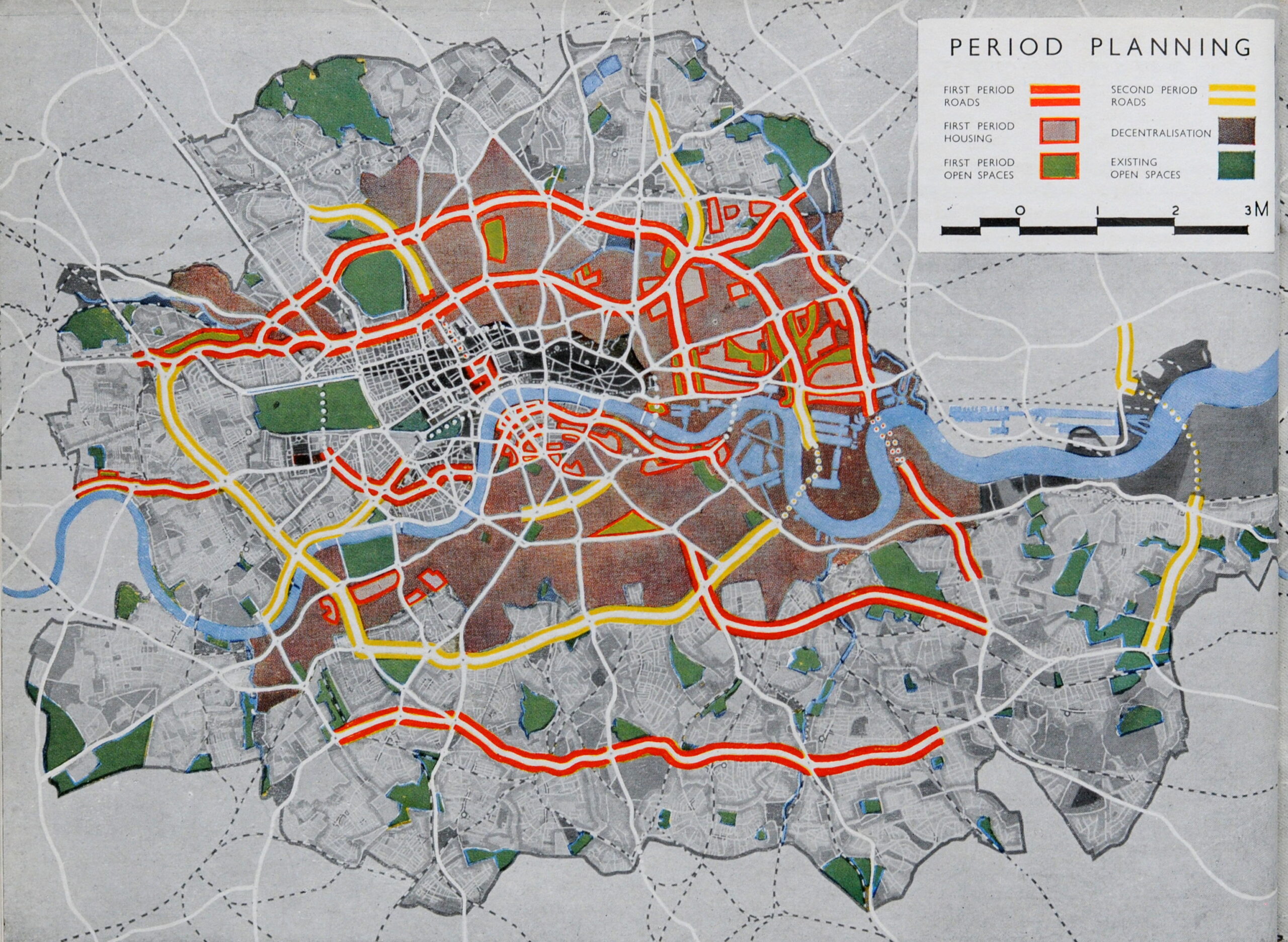
A map titled “Period Planning” identified the priorities for the first period of development, with the key arterial roads and the areas that needed the most attention. The areas outlined in red are those where the plan recommended that work should start immediately.

County of London Plan

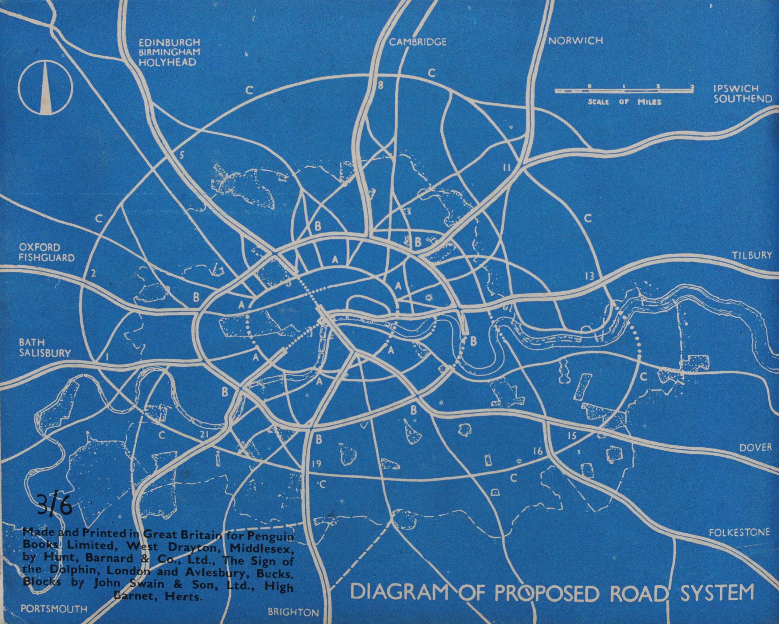
The rear cover of the booklet has a diagram of the proposed road system, with the first indication of an outer ring road, a proposal that many years later would evolve into the M25, although further out from the city than shown in the diagram.

County of London Plan

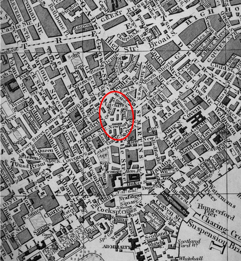
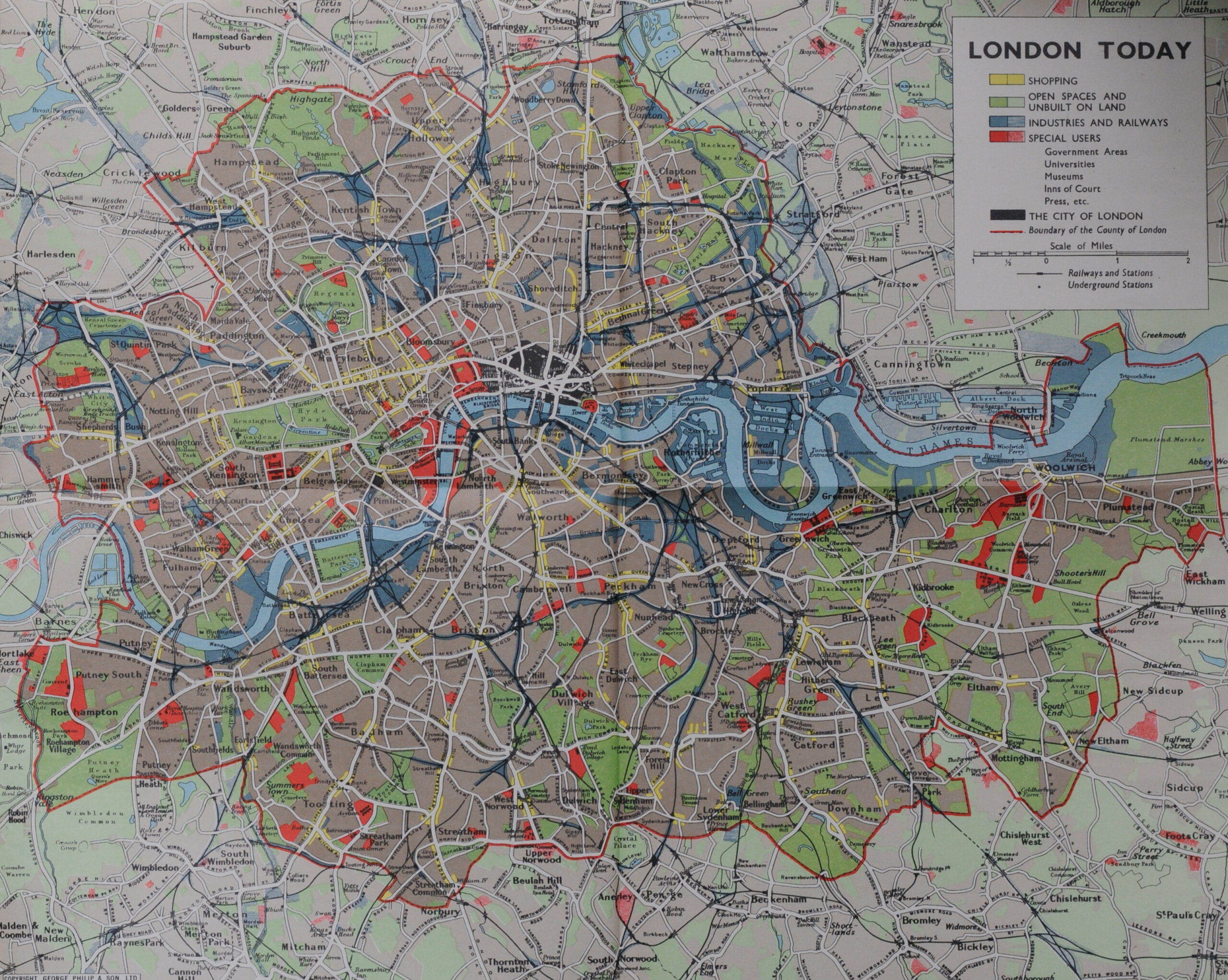
On the inside rear cover of the booklet is a wonderful fold out map titled “London Today”. the map shows a high level view of the use of land within the County of London. What is interesting is that the map shows the boundary of the County of London, with east London places such as Canning Town, Stratford and West Ham being outside the boundary. These were originally within the County of Essex (click on the image to open a larger version).

County of London Plan

The booklet provides a really good summary of the 1943 County of London Plan, and it is interesting that the architect Erno Goldfinger was one of the two authors of the booklet. The planned developments of housing probably aligned with Goldfinger’s view of the possibilities of new residential buildings as can be seen with those he was responsible for, such as the Balfron Tower.

The County of London Plan and the booklet used some really creative graphics to illustrate the key themes of the plan.

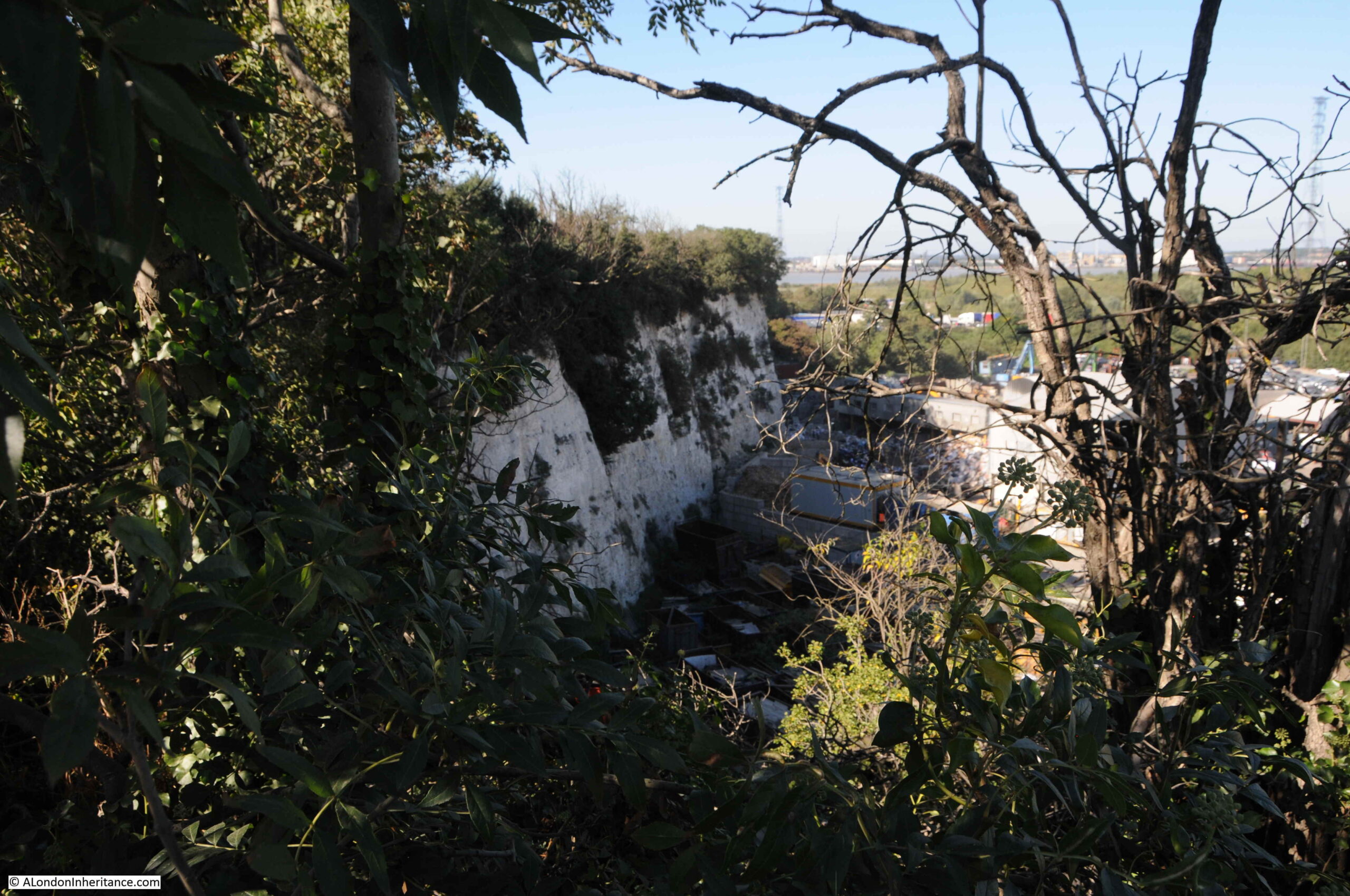
Many of the developments proposed within the County of London Plan would not take place. Some would still be debated decades after the plan. If you go back to the map titled period Planning, you will see at the right edge of the map, there is a road in yellow routing under the Thames. This was the original East London crossing that caused major controversy in the early 1990s when the proposed route would take the road through the ancient Oxleas Wood.

That scheme was cancelled, but it is interesting that over 40 years later, there were still plans to implement some of the recommendations of the 1943 County of London Plan.

Planning for London has always been a challenge. Never enough money, changing politics and changing public attitudes.

The Mayor of London continues to produce a London Plan, the latest March 2021 plan can be found here.

The current strategic plan is a total of 526 pages and after wading through it, it would really help if an equivalent to Carter and Goldfinger could produce a booklet explaining the key points of the plan.

I do wonder how much of the current plan will be implemented. The word “should” is used a total of 1,540 times in the document to describe a recommendation or target, rather than words such as “will” or “must”.

There are some fascinating statements in the 2021 plan, for example at paragraph 10.8.6:

“The Mayor will therefore strongly oppose any expansion of Heathrow Airport that would result in additional environmental harm or negative public health impacts. Air quality gains secured by the Mayor or noise reductions resulting from new technology must be used to improve public health, not to support expansion. The Mayor also believes that expansion at Gatwick could deliver significant benefits to London and the UK more quickly, at less cost, and with significantly fewer adverse environmental impacts.”

I always wonder how much politics is involved in these decisions. Are there fewer voters for the London Mayor under Gatwick’s flight paths than under those of Heathrow?

The 2021 plan includes proposals for major transport projects such as the Bakerloo line extension and Crossrail 2. In the section on funding the plan, there is the statement that:

“There is a significant gap between the public-sector funding required to deliver and support London’s growth, and the amount currently committed to London. In many areas of the city, major development projects are not being progressed because of the uncertainty around funding.”

The Covid pandemic has really hit Transport for London’s finances, and a long term reduction in those working five days a week in London will further reduce fare revenue. The national Government also has a focus on the so called “leveling up” agenda which may focus funding on developments outside of London.

Long term planning for a city with the complexity of London is extremely difficult. Funding, politics, the impact of external and unforeseen events all contribute to the very high risk that plans will need to change, will not be implemented, or will be implemented in different ways.

What these plans do help with though, is an understanding of the city at the time the plan was developed, challenges facing the city, and how these challenges were expected to be addressed.

As such, booklets such as that by Carter and Goldfinger really help with understanding how London has developed.

They also include some wonderful graphics and maps.

alondoninheritance.com

Old Barge House Stairs

For today’s post, I am returning to one of my favourite subjects, the old stairs that lined the river and provided such an important connection between the Thames and the streets of London on both the north and south banks of the river. The stairs for today’s post are Old Barge House Stairs:

Old Barge House Stairs

In the above photo, there are some modern steps descending from the river wall, just to the left of the large OXO sign. The remains of a wood and stone causeway can be seen to the left of the base of the steps towards the river.

The causeway is all that is left of Old Barge House Stairs. The following view shows the stairs from the opposite direction to the above photo:

Old Barge House Stairs

The stairs are located on the north western corner of the Oxo building on the south bank of the river, a short distance to the west of Blackfriars Bridge. I have ringed their location in the following map. The two piers on either side are the piers from where I took the above photos (Map © OpenStreetMap contributors).

Old Barge House Stairs

The name Old Barge House Stairs comes from their proximity to the King’s Barge House, along with accommodation for the Royal Barge Master. It was here in the time of Henry VIII that the King’s Barge was stored.

The stairs appeared on maps as early as 1720, as shown in this extract from “A Plan of the City’s of London, Westminster and Borough of Southwark”, where Old Barge House Stairs are shown in the centre of the map:

Thames Watermen at river stairs

I do like the way that the map shows the boats that were probably used by the watermen associated with the stairs, clustered around the stairs.

If you visit Old Barge House Stairs when the tide is high, you will find just the top of a modern set of metal stairs that run down from the walkway in front of the north western corner of the Oxo building. Visit at low tide, and the causeway that would have once led from the original stairs is visible:

Old Barge House Stairs

I doubt that the causeway we see today dates back to the time of the above 1720 map. These stairs and their causeways were remade several times over the centuries due to continual erosion by the river, as well their changing importance relative to other river stairs.

Old Barge House Stairs

What I find so fascinating about these river stairs is that they provide a fixed point between two very different worlds – the land and the river. They are where people moved between the two, and they provided a fixed point of reference to understand what was happening in these two very different worlds.

On the land around the stairs, they would be used as a reference to events happening near-by. This would help people find a location, or the best way to travel. For example, the following advert from the Morning Chronicle on the 5th September 1806 is the equivalent of today using an underground station as a point of reference:

“Oak Scantlings, Mahogany Plank and Boards, and Two Thousand Deals &c. By Mr Farebrother at Mr Gresham’s Wharf (late Gales) near the Old Barge-house-stairs, Narrow Wall, Lambeth, on Monday next at 12.”

Newspapers mainly report bad news, and the River Thames has been the scene of so many tragic events over the centuries. A quick scan of old newspapers reveals an almost daily report of accidents and deaths on the river. It was a very dangerous place, as well as the scene of tragedies such as that reported in the Morning Chronicle on the 8th April 1831:

“On Tuesday evening, about five o’clock, a middle aged French lady, elegantly attired, hired a waterman, named Oxley, belonging to Waterloo-bridge stairs, to row her to the Old Barge House stairs. On the man being about to land her, she desired to return back and proceed to Westminster-bridge. He instantly pulled round, but previous to his arriving near the bridge, he asked the lady which stairs she would like to be landed at? To which she replied the lower one. When nearing them the lady placed her muff and purse in the boat and taking a portrait out of her bosom, and her bonnet off, she precipitated herself into the river before the waterman could prevent her. By great exertion, however, he succeeded in catching hold of her after she floated through the second arch, and by prompt assistance, she was rescued from the death she meditated. She was conveyed into the Swan tap, where every attention was paid her, but she would neither give any explanation of her rash conduct, nor her name or place of residence. her friends, however, by some means, became acquainted with the circumstance and they sent a coach for her, the coachman being desired to drive to Thornhaugh-street.”

And this very sad report from the Kentish Mercury on the 16th February 1847:

“On Wednesday an inquest was held by Mr. W. Carter at the Mitre, Broadwall, Blackfriars-road, relative to the death of a newly-born male child, found under very remarkable circumstances. Mark Marten, a lighterman, deposed that he was proceeding down the river on Friday morning last, and whilst passing Raymond’s-roads on the upper side of Blackfriars-bridge, he saw a market basket floating down with the tide.

He pulled it into his boat, and rowed ashore at Old Barge House Stairs, where he opened it, and found the body of a child wrapt in a piece of flannel, and covered with meadow hay. On the top of the basket was a label, to the following effect ‘to be opened with care, from an old friend’. Witness gave the body to the police, and inadvertently destroyed the label, which in a moment of excitement, threw into a fire. Mr. E. Doubleday, surgeon, said that he had examined the body, which was that of a male child, fully developed. There was sufficient evidence of the child having breathed, but he was unable to say to what extent. The deceased from the appearance of the body, had clearly received the necessary attention at his birth.

The coroner remarked that the fact of the paper being destroyed by the first witness was an unfortunate occurrence as all chance of tracing the guilty party was lost. He left the case in the hands of the jury, who returned an open verdict of Found Dead in the River Thames.”

The above two reports cover some of the more unusual events where the stairs were involved. There were also very many more tragedies at the river in the vicinity of each of the stairs, for example in August 1880 at old Barge House Stairs, 16 year old John Thomas Glue, who drowned after simply going for a swim during his dinner hour. Ten or eleven yards from the bank, he suddenly had cramp, was swept by the tide under a barge near the steps where he drowned.

What would not have been reported in the newspapers are the thousands of people who have used these stairs, using the services of the watermen who gathered around the stairs like taxis in a taxi rank, waiting to take their fare to their destination of choice.

Old Barge House Stairs

Today, Old Barge House Stairs are found between the Oxo building and Bernie Spain Gardens. The gardens are one of the few places of grassed, open space in the immediate area as this is a very built up area.

The old ITV Studios buildings, IBM Offices and the National Theatre are found to the west. Housing, offices and streets inland. In terms of London’s development, building around Old Barge House Stairs has been relatively recent, with the majority taking place during the 19th century.

For centuries the land around Old Barge House Stairs was part of Lambeth Marsh, an area of land roughly between Lambeth and Blackfriars Bridges and inland to St George’s Circus.

In the following extract from Rocque’s 1746 map of London, Old Barge House Stairs is marked in the centre of the map:

Narrow Wall and Broad Wall

The map shows that by 1746, the land along the river had been built on, however inland it was mainly fields and agriculture. The Tenter Ground was an area used for the drying of newly manufactured cloth. Frames were set up across the field and the cloth was stretched across the frame to dry. If you look on the left side of the map, there is a building marked Dye House, so it is possible that cloth dyed in this building would be dried on the Tenter Ground.

The street running from the left is called Narrow Wall. This street ran from the current location of Westminster Bridge, running along the length of the south bank. The first written mentions of Narrow Wall date back to 1443, and it seems to have been a raised causeway or walkway with the sandy foreshore to the north. The name describes its original appearance as a Narrow Wall which would have helped prevent high tides coming too far inland.

Today, Narrow Wall is better known as Belevdere Road and Upper Ground. This later street name can be seen continuing to the right of the map, with the name again describing the physical characteristics of the street, when so much of the surrounding land was low lying, marshy, and would have been regularly threatened with flooding.

A long street called Broad Wall runs south from Old Barge House Stairs for the length of the map.

The name Broad Wall again defines how this street originally formed. It was also along the line of the western boundary of an area of land known as Paris Garden. The boundary was formed by one of the branches of the River Neckinger, which also seems to have gone by the name of Widefleet.

There was a syndicated article about Paris Garden in a number of newspapers in March 1890, which mention the boundary, and how the stream eventually became a sewer which entered the Thames at Old Barge House Stairs:

“Paris Garden, known as the King’s manor as appertaining to its lord and copyholders, formerly lay in St. Saviour’s Parish, and was famed for its mill, water-courses, pastures and wild plants. In 1670 nearly all of it was taken for the new parish of Christchurch, as constituted under the will of John Marshall, who had died 40 years before. Comprising the ancient hide of Wideflete, and covering nearly 100 acres, it had been given in 1113 by one Robert Marmion to the Cluniac Monastery of Bermondsey, whence, almost fifty years later, it passed to the Knights Templar, who set up a chapelry there, and from them to the Knights Hospitaler of St. John.

In the early years of the fifteenth century it became a sanctuary for offenders. Ultimately passing to Henry VIII, it was granted as dowry for Jane Seymour. Lord Hundens and others, who got the manor from Queen Elizabeth, conveyed the land and manor house to Thomas Cure, a benefactor to the parish. The manor house has been identified with the Holland’s Leaguer, or Nob’s Island, one of the many houses of ill-fame that formerly flourished on Bankside. The moated and castellated ‘Leaguer’ which was kept by one Susan Holland, in 1630, stood south-westwards of the present Falcon drawing dock. Latterly known as Beggars Hall, it was pulled down in making the southern approach to Blackfriars Bridge; yet some authorities question the survival of the original building to that time. The Widefleet was converted into a sewer, having its outlet by Barge House-stairs.”

The outline of streams can be seen in the 1746 map, however these can be more clearly seen in the Agas map which shows London in the mid 16th century. The map does not show Old Barge House Stairs, however the land of Paris Garden is shown as the built and cultivated area in the centre of the map, with Paris Garden stairs to the right of the line of buildings along the river. In the following extract of the Agas map, I have marked the location of Old Barge House Stairs (red circle):

Paris Garden

The map does illustrate the number of streams in this part of the south bank, and running south from the future location of the stairs is a street (Broad Wall), with a stream running along the west side of the street, one of the branches of the Neckinger, or the Widefleet, which drained into the Thames at the location of the stairs.

The Neckinger / Widefleet is not visible today and does not drain into the river next to the stairs. Presumably any running water from the stream is now part of the sewer system.

The river walls here are high, protecting the low lying land from the waters of the Thames:

Old Barge House Stairs

The causeway will gradually erode over the years as the daily tides cover and roll back from the structure. It would be interesting to know if the causeway extends further towards the river wall, under the sand of the foreshore.

Old Barge House Stairs

Thames stairs are so much more than the physical remains we see today. They are a reference point between the land and river, which help tell a story of the area, and the many thousands of people who have in some way come into contact with them.

The problem with researching these posts, is finding a reference to the subject of a post which raises a whole set of new questions, which I frequently do not have time to follow up. One example concerns a potential bridge across the River Thames which would have landed at Old Barge House Stairs.

In 1862 the London Gazette reported on the incorporation of a new compnay, for the making of new bridges over the River Thames. Application was being made by the new company for a new Act that the company was intending to bring before Parliament. The Act proposed a range of new bridges, including:

  • A bridge, to be called the Tower Bridge, for horses, animals, trucks and passengers across the River Thames. Works to commence at Irongate Stairs near the Tower of London, and to terminate at Horseleydown Old Stairs.
  • A bridge, to be called St Paul’s Bridge, for horses, animals, trucks and passengers across the River Thames, commencing from the foot of St Paul’s Steam-boat Pier and terminating at Mason’s Stairs, Bankside.
  • A bridge, to be called the Temple Bridge, for horses, animals, trucks and passengers across the River Thames, commencing on the north side at a point distant 100 yards or thereabouts in a south-easterly direction from the commencement of the Temple Steam-boat Pier near Essex Street, and terminating at certain Stairs called Old Barge-house Stairs at the end of Old Barge-house Alley

As well as the above, the Act also proposed the New Chelsea and Battersea Bridge and the Wandsworth Bridge.

Tower Bridge would be built, however construction was not started for a further 24 years after the above Act.

St Paul’s Bridge continued to be a proposed solution in the early decades of the 20th century, but was never built.

As well as the 1862 Act, a Temple Bridge was proposed in the 1943, Abercrombie County of London Plan, published by the London County Council, but would also not be built.

Today, there is a short stretch of Barge House Street from Upper Ground to behind the Oxo building, and there is a stretch of Broadwall from Upper Ground to Stamford Street, so some of these old street names, and reminders of the history of the area can still be found when walking today.

alondoninheritance.com

National Service, Chepstow, 1947

A bit of a different post this week. Many of my posts have featured my father’s photography, mainly London, but also some of the places he visited whilst cycling across the country in the late 1940s and early 1950s. A number of years ago, one of his friends told me that he always had his camera with him. This included his time on National Service.

The photos in today’s post are from 1947 and were taken at the Military Hospital in Chepstow, South Wales where he was stationed with the Royal Army Medical Corps.

They are the equivalent of the millions of mobile phone photos we take today. Simple photos documenting our everyday lives. I must admit to preferring this type of photo to the more carefully constructed, artistic photo, or even worse, a posed photo.

This type of photo documents what everyday life was like.

I have very few notes to go with these photos. The majority had not been printed, so after scanning, this is the first time they have been seen in 74 years. I have met just one of the people in the photos. I do not know the names of the rest. Who they were, where they came from, and what happened to them in the following 74 years.

If still alive, they would now be in their early nineties, rather than the fresh faced late teenagers in military uniform:

National Service
National Service

There was a note to the following photo which read “troop of 18 and 19 year old National Service recruits leaving for a p*** up” :

Chepstow Military Hospital

As well as the Military Hospital in Chepstow, there was also a local Army Training Centre and Chepstow Racecourse had been used to hold German Prisoners of War.

I have not yet been able to find the location of the Military Hospital. The following photo was taken from the entrance, looking into the site:

Chepstow Military Hospital

Group photo:

National Service

Today, we take millions of photos on mobile phones. These get saved on the phone, stored in Apple or Google’s cloud storage service, or used on Facebook, Instagram or Twitter. I suspect an incredibly small percentage get printed.

I do wonder what will happen to all these photos in the years to come. Will someone in 74 years time be able to access your photos? Will Facebook, Instagram, and even Apple and Google still exist in 74 years time. Will descendants have access to the accounts of today’s users?

The fact that Facebook may not exist may seem fanciful, however, consider the technical, cultural and social changes between 1947 and 2021, as well as how many companies have lasted those 74 years.

All these photos have been scanned from 74 year old negatives. Recovering them is basically shining a light through them using a scanner. If the source material still exists there is nearly always a method of recovering the data, although this can be incredibly difficult given format changes (for example the BBC’s 1984-6 Doomsday project which created laserdiscs of material to produce a new “survey” of the country to mark the 900 year anniversary of the original Doomsday book. A significant amount of work was needed to access the data stored on these discs, following the end of production of laserdisc players, a technology, like Betamax that only lasted for a short time).

Football:

National Service Football

There seems to have been a reasonable amount of free time, as many of the photos show:

Chepstow Military Hospital

Cleaning and maintenance work appears to have been one of the duties at the hospital for National Service recruits:

Chepstow Military Hospital
National Service

Different uniforms for nursing staff:

Chepstow Military Hospital nurse

Many of the photos are just messing around in uniform:

National Service

Including attention to a casualty:

National Service
National Service
National Service
National Service

The Military Hospital appears to have had a division between medical staff and those on National Service who were there in support roles. Guarding the hospital (although I doubt there were many problems at a hospital in south Wales after the war), driving military ambulances, general maintenance of the site and administration, which seems to have been one of the core tasks.

National Service
Chepstow Military Hospital

Thoughtful staring into the distance:

National Service

Ferry in the Bristol Channel:

Bristol Channel

Apparently, cleaning the pond was a penalty for some minor misdemeanor:

Cleaning the pond
National Service

The pipe – adding an element of seriousness to the photo:

National Service

Medical staff:

Nursing Staff
National Service

Group photo with the military ambulances behind:

National Service

Out and about – Chepstow Castle:

National Service
National Service
National Service

Looking to the future:

National Service

I do know that a number of those in the photos were from London, and for the majority, apart from short trips, National Service was their first time away from the city for a substantial period of time.

If still alive, the youngest would be in their early nineties, and they would have had a life time of experience since their time in Chepstow.

The photographer and his camera – how to take a selfie in 1947:

National Service

Whilst serving at Chepstow, there were a number of local trips and so far I have written about:

Chepstow Castle

Chepstow And The River Wye

The Newport Transporter Bridge

Tintern Abbey

As well as the original negatives, these photos are now in digital form.

For all my photos and scans, I keep multiple copies on different devices at home, and use a paid for offsite backup service as the ultimate backup of several terabytes of photos and scans going back 75 years.

I have no idea whether the digital versions will still be available and viewable in 74 years time, however I suspect the negatives, safe in their boxes, will still be able to reveal their everyday view of the mid 20th Century.

alondoninheritance.com

St Anne’s Soho, New River Company and Shaftesbury Avenue

St Anne’s Soho, New River Company and Shaftesbury Avenue is a bit of a mix of very different subjects, however the following photo from one of the Wonderful London books provides the connection.

New River Company Elm Pipes

The caption to the photo reads: “Elm Trunks for Conduit Pipes dug up near St Anne’s, Soho. Wooden pipes like these were used to carry water from New River Head over the Holebourne for the citizens. Trunks used for conveying the fresh water supply were of elm which of all the timbers best withstands the exigencies of heat and cold. The New River Co. had a wharf at the bottom of Dorset Street where the elm trunks were landed and bored. Shaftesbury Avenue was opened February 26, 1887, and the excavations laid these old pipes bare.”

There is much to unpack in that single caption, far more than within the scope of a single post, but I will give it a go, starting with the elm trunk in the photo.

When the New River Company started to distribute water across the city from their pond at New River Head, the only method to carry water within pipes was to use bored tree trunks. Iron pipes would not become available for the New River Company to use for well over a hundred years from when the company started operations in 1613.

The photo shows how a tree trunk was converted into use as a pipe. A hole was bored through the centre of the pipe to carry water, and one end of the trunk was shaved down to a point around the hole so that it could be pushed into the next trunk in the series, trying to form as close a seal as possible to prevent the leakage of water.

The New River Company had their main pond or reservoir at New River Head in north Clerkenwell, and their offices eventually moved to the same location, however as the caption states, they had a wharf at the bottom of Dorset Street, and their original offices were at the same location. It was here that elm trunks were delivered via the River Thames, bored and shaped ready to be used within their network of pipes.

The caption states that the wharf was at the bottom of Dorset Street. The offices, yard and wharf are marked on Horwood’s 1799 map of London, just to the west of Blackfriars Bridge, circled in the following extract:

New River Company

The location of the New River offices, yard and wharf are now separated from the river by the construction of the Victoria Embankment, however I have marked their location with the red arrow in the following photo, now covered by the brick building to the left of the old City of London School.

New River Company

The area served by the New River Company was extensive, for example one of their large industrial customers was the Truman’s Brewery in Brick Lane to the east of the city, and as London expanded to the west, they buried their pipes along the streets to serve the new buildings.

Serving the new west London streets did however bring problems. New River Head was located at a height of 30 metres above sea level. The original customers in the City of London were at a height ranging from 15 metres in the north of the City down to 1 or 2 metres along the river. This worked well when gravity was being used to get the water from New River Head to the City.

The west of the city was a different matter, with the area around Shaftesbury Avenue and Soho being around 22 metres in height, only an 8 metre difference to New River Head and much higher than the City.

This led to supply problems along the new streets of Soho, with a good supply in the City, and poor supply due to low pressure in west London.

The New River Company was also facing competitive pressure from other water companies, and at the end of the 17th century, they brought in Christopher Wren to evaluate their water supply system, and make recommendations for improvements.

Wren’s view was that the system was an unplanned mess, that had grown without any planning or understanding of the areas being served and how water was affected by the length and size of pipes, and the difference in height across London.

Wren could not make any individual recommendations, he compared the system to a diseased body, with the New River Company looking only at one small part of the body to try and work out a cure. Wren recommended a system wide replanning that would take much of the following century to implement.

Wren’s recommendations were also supported by the ex-clergyman John Lowthorpe, also commissioned by the New River Company to examine the system. Lowthorpe also identified that the company had no audit or understanding of their pipe network, and that a single person should be responsible for the system’s design, the role of a Chief Surveyor.

The New River Company did build an upper pond at Claremont Square, and the additional height of this new pond did overcome some of the pressure problems, but it would not be until wooden pipes were replaced with iron pipes, and steam engines were used to pump pressurised water rather than use gravity, that the supply across London would become reliable.

I have written more about New River Head and the New River Company here.

The photo of the elm pipe was taken outside the Wardour Street entrance to the church of St Anne’s, Soho. This is the same view today:

St Anne's Soho

St Anne’s, Soho was built to serve the spiritual needs of those living in the expanding Soho streets. Plans for a new church were first being discussed in the 1670s, along with the search for a suitable location. The land on which the church would be built was owned by two speculators, brewer Joseph Girle and tiler and bricklayer Richard Frith (who would give his name to Frith Street).

There is no firm evidence of the architect of the church, there are references to both Christopher Wren, and one William Talman, but it is impossible at this distance in time, and loss of documentation over the years, to be clear of their individual role.

The new church was ready for use in 1685 and was consecrated by Bishop Henry Compton in either 1685 or 1686.

The church was very badly damaged during the blitz raids of September 1940. The body of the church was completely burnt out, the tower survived, but with considerable damage.

The church was partly restored in the decades after the war, before undergoing a full restoration between 1990 and 1991. The tower survives from the pre-war church, however the rest of the building is a modern rebuild.

The tower and church of St Anne’s, Soho:

St Anne's Soho

The church in 1810 (with the inclusion of Westminster in the name as it was within the parish):

St Anne's Soho

It is always easy to get distracted by the gravestones in the churchyard of an old London church, and St Anne’s is no exception. Although these are now separated from their original graves, they tell the story of some of the characters who were buried here:

St Anne's Soho

In the above photo, the stone on the upper right is to Theodore, King of Corsica:

Theodore king of Corsica

Theodore was born in Cologne, Germany in 1694, with the full name Theodor Stephan Freiherr von Neuhoff. He had a varied career, service with both the French and Swedish armies, negotiating on behalf of the Swedish king with England and Spain, and travelling widely.

It was whilst traveling in Italy that he became involved with rebels trying to free the island of Corsica from the rule of Genoa, one of the republics that made up Italy in the 18th century.

Theodore landed in Corsica in March 1736, and was made king of the island by the inhabitants. His rule did not last long. Disagreements within the rebels, and the Republic of Genoa putting a price on his head resulted in Theodore leaving the island in November of the same year.

He lived in the Netherlands for a while before moving to London, where he tried to get support for Corsica, and his role as king. He was not successful, had many money problems and ended up in the King’s Bench debtors prison.

Released in 1755 after declaring bankrupt, and registering his Kingdom of Corsica for the use of his creditors. He died the following year in 1756, and the gravestone includes the following text:

Another gravestone on the base of the tower is that of William Hazlitt, whose grave in the churchyard is marked by a recent memorial.

William Hazlitt

Hazlitt was one of the greatest English essayist’s of the late 18th and early 19th centuries, however he lived his last years in relative obscurity, partly in a flat in Frith Street which explains why he was buried in St Anne’s.

A report in The Atlas (A General Newspaper and Journal of Literature) on the 26th September 1830 finishes with a sentence that will probably ring true with the majority of authors:

“On Thursday last the body of William Hazlitt was borne beneath our windows; till that moment we were not aware that a man of genius, a popular writer – the author of no less that able a work than the life of Napoleon, which alas closed his literary labours – and an amiable man, had been our next door neighbour for months, enduring sickness and at length dying in indigence. We boast of our national generosity, glory on the flourishing state of our literature, and thunder forth the power of the press, the palladium of our liberties; in the meanwhile ‘the spirit of life’ is allowed to burn itself out in penury and privation. Publishers sport their carriages, or fail for a hundred thousand pounds; and those by whom they become publishers die for want of a dinner.”

So that covers a brief looks at the New River Company and their elm pipes, as well as St Anne’s, Soho. The caption to the photo has the following final sentence:

Shaftesbury Avenue was opened February 26, 1887, and the excavations laid these old pipes bare.”

Which implies that the elm pipes were uncovered during the work to create Shaftesbury Avenue, so the creation of this famous West End street is what I wanted to explore next.

Shaftesbury Avenue

Shaftesbury Avenue is a long street that runs from New Oxford Street in the north down to Piccadilly Circus in the south. The street crosses Charing Cross Road, and it is the lower half that is probably best known as this is where the majority of the street’s theatres are located. As the street sign above confirms, Shaftesbury Avenue is in the heart of London’s theatre land.

In the following map, I have marked the route of Shaftesbury Avenue with a a red dashed line (Map © OpenStreetMap contributors).

Shaftesbury Avenue

Shaftesbury Avenue cut through a series of streets and buildings that had existed from the time of London’s expansion westwards. The following map is from William Morgan’s 1682 map of London, again the red dashed line marks the future route of Shaftesbury Avenue.

Shaftesbury Avenue

During the second half of the 19th century there were a number of building schemes that carved new roads through what been been dense networks of streets and buildings. I have already written about Roseberry Avenue which was built between 1887 and 1892, and Charing Cross Road which was officially opened on the Saturday 26th February 1887.

Shaftesbury Avenue was part of the same scheme that included Charing Cross Road.

Proposals for roads improvements along the lines of Charing Cross Road and Shaftesbury Avenue dated back to the 1830s, when a Select Committee of the House of Commons stated that “several plans for affording greater convenience of intercourse between the southern and northern divisions of the metropolis” were considered due to increasing traffic flow and the need to provide much more direct and convenient links between locations such as the eastern end of Oxford Street, Charing Cross and Piccadilly Circus.

Nothing would come of these early proposals, and by the 1870s the situation was becoming more critical, with traffic added to by the arrival of railway stations to the north of the city and those along the river such as Charing Cross.

The Metropolitan Board of Works applied to parliament for permission to improve the streets between Oxford Street, Charing Cross and Piccadilly, and they were granted the powers to construct these streets through the Metropolitan Street Improvements Act of 1877.

Details of these improvements, along with so many others throughout London were published by the London County Council in a wonderful book published in 1898 called “History of London Street Improvements, 1855 – 1897”.

The book includes some detail on the Shaftesbury Avenue development, including the following two maps which detail the route. I have added a yellow line to highlight the route. The first map covers from Piccadilly Circus at lower left to just to the north west of Seven Dials at top right.

Shaftesbury Avenue

The following map includes a short overlap and covers the north eastern section of the street from Greek Street (top left) to New Oxford Street at lower right.

Shaftesbury Avenue

The route of Shaftesbury Avenue would take over and widen a number of existing streets and would run through a number of housing blocks.

At the southern end of the route, Shaftesbury Avenue opens out onto Piccadilly Circus which is a major junction with Regent Street, Piccadilly, Regent Street St James, and Coventry Street.

Piccadilly Circus

The view along Shaftesbury Avenue from the junction with Piccadilly Circus:

Shaftesbury Avenue

The 1877 Act imposed some difficult conditions on the Metropolitan Board of Works. Previous acts had allowed development to take place with conditions for the rehousing of the “labouring classes” who would be displaced, however the new Act stated that the Metropolitan Board of Works was “forbidden to take, without the consent of the Secretary of State, 15 or more houses occupied wholly or partially by persons of the labouring classes, until the Board had proved to the satisfaction of the Secretary of State that other accommodation in suitable dwellings had been provided”.

The new street would pass through some of the most densely populated parts of London, requiring the rehousing of hundreds of people, so this was a difficult condition for the Board.

The Metropolitan Board of Works tried through the following years to get the condition regarding 15 or more houses either removed or modified, however Parliament refused to change the original Act.

Whilst the Board had been trying to get the Act changed, it had also acquired the land of the old Newport Market and had been building large blocks of working class dwellings ready for those who would be displaced by the development of Charing Cross Road and Shaftesbury Avenue.

Newport Market was an area just to the south of the route of Shaftesbury Avenue. I have ringed the location in the following extract from Reynolds’s 1847 “Splendid New Map of London”:

Newport Market

The projects to build Charing Cross Road and Shaftesbury Avenue would eventually displace a total of 3,044 people, described of being of the “labouring classes”.

Starting to walk north along Shaftesbury Avenue. This stretch of the new road ran through areas of dense housing:

Shaftesbury Avenue

The Metropolitan Board of Works purchased the land for the new street. They tried to keep their purchases to a minimum as the costs were taken from the Rates.

In an example of how the ownership of land always was, and in many ways, continues to be a source of profit, without many of the associated costs, it was complained at the time that whilst the cost of improvements were recovered through the Rates, these were generally paid by the tenants of properties, not by the owner, although in developments such as Shaftesbury Avenue, the owner of land close to the new street would benefit by the increase in the value of his land due to the improvements to the area such a development would bring.

Very similar in the way that Crossrail increases the value of land around new stations.

Land purchased for the new road, often included land running along side. The Board was expected to sell excess land alongside the road to recover part of the construction costs.

Completion of Shaftesbury Avenue would result in an explosion of building along the new route, which included many of the theatres that today line the street.

Shaftesbury Avenue

In the above photo, further from the camera on the right is the Lyric Theatre (1888) and with the “Jamie” advertising is the Apollo Theatre (1901).

At the junction with Wardour Street. The church of St Anne’s, Soho is just up the street to the right.

Shaftesbury Avenue

Remarkable that as the original buildings and streets were being cleared ready for the construction of Shaftesbury Avenue that the 17th century elm pipes were being removed from the ground, and that in the 1880s these were fortunately considered important enough to photograph.

The following photo is looking north from the junction with Wardour Street, and is the stretch of Shaftesbury Avenue which was a much widened earlier King Street:

Shaftesbury Avenue

At the junction of Shaftesbury Avenue and Gerrard Place, there is a modern fire station:

Shaftesbury Avenue

The site has been a fire station from the construction of the street. In 1886, the Metropolitan Board of Works leased the land to a private fire fighting organisation, the London Salvage Corps, with the first fire station being built the following year in 1887. In 1920 the site was acquired by the London County Council as a site for the London Fire Brigade.

Looking south from outside the fire station:

Shaftesbury Avenue

Turning north, and it is here that Shaftesbury Avenue crosses Charing Cross Road, which was also being developed at the same time:

Cambridge Circus

At the junction of Shaftesbury Avenue and Charing Cross Road is the Palace Theatre:

Palace Theatre

The Palace Theatre is a large, red brick building with a capacity for 1,400 theatre goers.

The theatre was opened in 1891 (soon after the completion of the two new streets) for Richard D’Oyly Carte who intended the theatre to be the home of English opera and on opening the theatre was known as the Royal English Opera House. The first production was Arthur Sullivan’s Ivanhoe, however when this closed there was no follow up production and the Royal English Opera House closed.

D’Oyly sold the building and in 1911 it opened as the Palace Theatre of Varieties, commencing a theme of musical productions which have run for most of the theatre’s time. With the emphasis on musicals rather than variety productions, the theatre dropped the last part of the name to become the Palace Theatre.

Today, the Palace Theatre is hosting probably one of the biggest productions in the West End for some years, J.K. Rowling’s “Harry Potter and the Cursed Child”.

Continuing north along Shaftesbury Avenue and on the corner with Mercer Street is the Soho Baptist Chapel:

Soho Baptist Chapel

Built between 1887 and 1888 (the building work along the street in the few years after completion must have been considerable). The building is now the Chinese Church in London.

Further along is the Shaftesbury Avenue Odeon:

Odeon Shaftesbury Avenue

The facade is not what you would typically associate with a cinema and gives away the building’s original function. This building was originally the Saville Theatre.

The Saville Theatre opened in 1931 and according to an introduction to the theatre in one of the early theatre programmes was “built by Messrs Gee, Walker and Slater of 32, St. James’s Street, SW1 from plans of the Architects, Messrs T.P. Bennett and Son, of 41 Bedford Row, WC1 who were also responsible for the whole colour scheme, lighting, furnishing etc.”

The exterior of the building looks much the same today as when it first opened as the Saville Theatre, apart from the canopy over the entrance and the glass blocks that now replace the wrought iron windows in the enclosed area above the canopy.

I have written a post on the Saville Theatre and the freeze that runs along the side of the building here.

Further along Shaftesbury Avenue is what was the “Hospital et Dispensaire Francais”, or the French Hospital:

French Hospital

The French Hospital was originally at 10 Leicester Place where it had been opened in 1867 by Eugene Rimmel, for “the benefit of distressed foreigners of all nations requiring medical relief”.

The hospital quickly outgrew the original site, and the land adjacent to Shaftesbury Avenue was acquired from the Metropolitan Board of Works, with the new hospital building opening in 1890. A hospital would continue on the site until 1992.

Towards the junction with St Giles High Street and High Holborn, Shaftesbury Avenue has left behind the theatres of the southern part of the street, and we find different types of shops, including a decorating / hardware store:

Leyland

Forbidden Planet:

Forbidden Planet

And Ben’s Traditional Fish and Chips:

Fish and Chips

This was also the site of the now closed Arthur Beale, ships chandler.

Looking north across the junction with St Giles High Street on the left and High Holborn on the right with Shaftesbury Avenue continuing north:

St Giles High Street

Although the majority of the street’s theatres are in the section of street between Charing Cross Road and Piccadilly Circus, there is another theatre on the corner of Shaftesbury Avenue and High Holborn – the Shaftesbury Theatre:

Shaftesbury Avenue

The Shaftesbury Theatre occupies a prominent corner location. Opened in 1911 it was originally called The Princes Theatre. For over a century the Shaftesbury Theatre has hosted musicals, plays and comedies and in 1968 the run of the musical Hair commenced in September, made possible by the ending of theatre censorship laws on the 26th September 1968 when after 231 years of theatre censorship, the Lord Chamberlain had his powers to censor plays removed.

Hair ran for almost 2,000 performances before it was forced to close owing to structural problems in the building that required urgent restoration work. During closure, there were attempts to redevelop the building, however it was saved as a theatre and reopened in 1974.

We are now coming into the final part of the street, where it joins New Oxford Street, however, there is a change to the original route.

in the following map, the yellow line indicates the route of Shaftesbury Avenue to New Oxford Street on the right, with the text “Termination of Street” showing where the new street would end.

Shaftesbury Avenue

The above map shows the street cutting across a stretch of street labeled Bloomsbury Street, however today, both this small section of Bloomsbury Street and the new street are called Shaftesbury Avenue as shown on the building in the corner where the two sections of the street run to left and right:

Shaftesbury Avenue

Today, the original section of Shaftesbury Avenue is mainly paved, but with a short stretch of street running along one side:

Shaftesbury Avenue

This view is from New Oxford Street looking down where Shaftesbury Avenue originally joined New Oxford Street:

Shaftesbury Avenue

And this is the view down what was the short section of Bloomsbury Street that now forms the junction of Shaftesbury Avenue with New Oxford Street.

Shaftesbury Avenue

Shaftesbury Avenue was completed in January 1886, and provided a new direct route from New Oxford Street to Piccadilly Circus, as well as driving a considerable explosion of building that has resulted in the street we see today, a street that is at the heart of the West End theatre industry.

The street was 3,350 feet long and 60 feet wide. A subway was constructed along the length of the street for gas, water and other assorted pipes.

The gross cost of constructing Shaftesbury Avenue was £1,136,456. The net cost was £758,887 after the sale of surplus land at £377,569.

The street was named after Anthony Ashley-Cooper, 7th Earl of Shaftesbury, who had died in 1885, the year before the new street was completed. The Shaftesbury name was also given to the Shaftesbury Memorial Fountain (probably better known as Eros), in Piccadilly Circus.

Newspapers at the time of his death were full of the philanthropic work of the Earl of Shaftesbury, and his work in Parliament to try and improve working and living conditions. One of these was the so called “Ten Hours Bill”, which although not strictly living up to its name, did look to reduce the hours of work for children.

Considering that this was considered a great improvement, the changes that the bill looked to implement were still horrendous by today’s standards.

With the exception of silk and lace mills, children under the age of nine were not to be employed in factories, while the labour of those under thirteen was to be limited to 48 hours a week, and the employers of all children were required to provide them with not less than two hours schooling a week.

So, going back to the caption at the top of the post, unpacking everything in the photo from the New River Company’s elm pipe excavated when Shaftesbury Avenue was built, and the church of St Anne’s Soho reveals a fascinating history of a small part of the West End.

It would be brilliant to think that there are still some elm pipes buried below the city’s streets just waiting to be discovered.

If you have managed to get to the end of the post, you may be interested in one of my walks. All the Barbican walks have sold out, and there are just a few tickets remaining for the Southbank walk, which can be booked here.

Swanscombe Peninsula and the London Resort – Part 2

This post continues my walk exploring the Swanscombe Peninsula. The previous post covered the section marked in red in the following map, and this post covers the route in blue, alongside Botany Marsh.

Botany Marsh

The eastern and southern sides of the Swanscombe Peninsula are more industrialised than the western side, and the noise from these sites is starting to be heard above the breeze blowing through the thick fields of grasses and reeds.

The footpath follows the eastern edge of an area known as Botany Marsh, and the wet nature of the land is very obvious, despite September having slightly less rainfall than the average for the month.

Botany Marsh

Electricity pole in the marsh:

Botany Marsh

In the following photo we can see all the infrastructure needed to carry high voltage electricity across the River Thames. On the left is the pylon on the north bank of the Thames in Thurrock, with slightly to the right, the pylon on the peninsula. These two pylons carry the cables across the Thames. In the middle is the tower catching the descending cables and from this tower cables run off across north Kent.

Botany Marsh

View to the south west across Botany Marsh. More water and the chalk cliffs which are the boundary to the south western edge of the peninsula.

Botany Marsh

The Swanscombe Peninsula has long been the site for large industrial companies that needed access to the river for transport of raw materials, and space for large processing plants. One of these companies in operation today is the Cemex Northfleet Wharf and Concrete Plant:

Cemex

The concrete plant has a wharf on the eastern edge of the peninsula where the raw materials for the manufacturer of concrete, aggregates, asphalt and mortar are landed.

Looking in the opposite direction and the peninsula is still wild and wet. Fortunately I did not need to take this footpath.

Botany Marsh

The western side of the peninsula is more open, however walking along the eastern edge of Botany Marsh, and there are some lovely stretches of footpath, with banks and tall bushes on either side. It feels like walking in the depths of the countryside rather than a site with industry, a Greenhithe housing estate and the Thames all a short distance away.

Botany Marsh

However evidence of industry along the edge is not far away, and the noise of lorries running to and from the plant now compete with the breeze through the grasses.

Cemex

This adds to the wonderful contradictions of the peninsula. look one way to see industry, look the other to see the most wonderful landscapes, with Botany Marsh really living up to its name:

Botany Marsh

The road that provides access to the industrial areas also provides access to the peninsula, with some limited parking for cars. At one of these entrances is an information panel which tells how the peninsula is managed, and the wildlife that can be seen on Botany Marsh:

Botany Marsh

Botany Marsh is subject to land management to maintain the biodiversity of the place. Without management, the land would revert to scrub and woodland. Ditches were cleared and the footpath I have been walking along during this part of the walk was created.

The information panel also explains where much of the water comes from. A system to collect water from 20,000 square metres was installed which increased the water flow into the marshes by up to 10,000 cubic metres a year. The water is run through an oil interceptor to ensure the marsh is not polluted

The rear of the panel provides information on the species of animals that can be found across the marsh, many of which have seen a severe decline in numbers over the last couple of decades. Three of the six reptiles native to Britain are found on Botany Marsh (grass snake, slow worm and vivaparous lizard).

Botany Marsh

Campaigning to save the peninsula from development has included the need to designate the area as a Site of Special Scientific Interest. The uniqueness of the place, diversity of animal species, the rarity of such a variety of habitats all support an SSSI designation.

In March 2021, an existing SSSI to the south (Bakers Hole – a back filled quarry that was the site of many finds of Stone Age occupation), was extended to include most of the Swanscombe Peninsula.

Consultation on the recommendation to extend the SSSI took place between March and July and a recommendation to the Board of Natural England will be made based on the results. The Board then have until the 10th of December 2021 to either confirm or withdraw the recommendation.

The London Resort are looking at ways that this recommendation can be withdrawn or accommodated within their plans, so the outcome for both the London Resort and the Swanscombe Peninsula is not yet clear.

Map and details of the proposed SSSI are on display at all the main entrances to the peninsula:

As well as the Cemex site, another industrial company on the eastern side of the peninsula is Britannia Refined Metals, a company owned by the multinational Glencore. The company specialises in lead, zinc and tin production.

Britannia Lead

Given the current shortage of HGV drivers, and the poor facilities provided for them, the above photo provides an example. To the right of the photo was a long layby off the road for lorry parking. The blue box behind the site safety sign appeared to be their only toilet facilities.

Britannia Refined Metals was originally formed around 1930 as the Britannia Lead Co. Ltd, and their original brick building is still onsite with the name above what was probably the original main entrance to the site.

Britannia Lead

After having a looking at the industrial side of the peninsula, I walked back to Botany Marsh to continue south along the footpath.

Botany Marsh

Old building on the northern edge of the southern industrial area gradually being overgrown:

Botany Marsh

Although there are some large industrial sites along the eastern side of the peninsula, they are not that visible, apart from the very tall chimney of the Cemex works. More reeds, grasses and water of Botany Marsh.

Botany Marsh

The path I was following south, then turned towards the west, to loop back inland. I suspect it ended up at the flooded footpath shown earlier in the post, so after a lengthy detour, I turned back to access the road at the site of the Britannia factory.

Following this road south took me through an industrial estate, very similar to those that have traditionally lined the River Thames, but I did not expect to find a number of London buses:

Routemaster

This is the site of London Bus and Truck Ltd – “For All Your Bus, Coach & Commercial Vehicle Requirements” and specialists in Routemaster buses which explains the small fleet of buses in their parking area:

Routemaster

A bit of protection for pedestrians from the many HGV’s passing along the road:

Swanscombe peninsula

At the end of the road running through the industrial estate, it meets the A226, or Galley Hill Road, and I followed this busy road to head for Swanscombe station. The road runs across the bridge seen in the distance in some of the photos in today’s posts. The height of the road provides a good view across the Swanscombe Peninsula, and also shows where HS1 enters the tunnel under the peninsula to cross underneath the River Thames:

HS1

HS1 is the high speed railway running for 108km between Paris and St Pancras Station. Regular services started on the route on the 14th November 2007. The entrance on the Swanscombe Peninsula is the start of a one and a half mile tunnel under the Thames.

There are industrial sites lining the southern end of the peninsula, on either side of HS1. These industrial sites are also included in the land required by the London Resort. As development has extended east along the Thames from central London, many of these industrial estates have been closed and built over with housing. They are though a much needed part of economic infrastructure.

HS1

The view from the bridge shows what appears to be grass and bushes over the northern part of the peninsula. It is not really possible to appreciate the natural diversity of the place from this viewpoint and a walk through the site is needed.

The London Resort describe one of the benefits of their proposals as the regeneration of what is largely a brownfield site. This is true, the peninsula has been the location of both industry, the infrastructure needed to support these industries and connect them to the river, along with the dumping of waste from these industries. However just describing Swanscombe Peninsula as a brownfield site does not fully appreciate the site today. A site which has been considerably reclaimed by nature, is home to many endangered species and also retains that sense of isolation that was so prevalent across much of the land along the river to the east of London.

I also like the industrial sites that are found on the east side of the peninsula. They are there because of the river, the river that has transported so many raw materials and finished products across the centuries.

The road bridge taking Galley Hill Road over HS1. This was the exception when there was no traffic. During my walk along the road there was an almost continuous line of cars and lorries.

HS1

The River Thames is always in the background around the peninsula, with shipping moored at, and travelling past Tilbury visible:

River Thames

From the bridge we can view the chalk cliffs that line part of the south western edge of the peninsula:

Swanscombe Skull

There are a number of chalk pits on the peninsula, and the wider Swanscombe area is one of Europe’s most important Paleolithic sites (500,000 BC to 125,000 BC). Finds in the area include hand axes, and what became known as the Swanscombe Skull, which was excavated in Barnfield Pit, a short distance south of the peninsula (part of the extended SSSI). The area also includes evidence from some of the temperate periods between periods of glaciation, or ice ages.

The skull was discovered in 1935 by Alvan T. Marston, one of the many archaeologists who had been working in Swanscombe. He described the discovery as follows:

“For nearly half a century, archaeologists have known the high terrace gravels at Swanscombe, Kent, and in that time have found hundreds of thousands of the early Stone Age hand axes belonging to the Chelles-Acheulean stage, but the constant hope that skeletal remains of the makers of those implements might be found did not become fact until June 1935, when I discovered a human occipital bone 24ft below the surface in the middle gravels of the Barnfield Pit. Nine months later a second bone of the same skull was found, the left parietal, in the same seam of gravel and at the same depth below the surface. The two bones were 8 yards apart, many tons of sand and gravel having to be excavated and examined to bring the second bone to light, and this work is still going on.

Swanscombe is not homo sapiens. It is, as its geological horizon shows, a pre-Neanderthal hominid.”

The Swanscombe Skull © Natural History Museum:

Swanscombe Skull

And with that diversion, I reached Swanscombe station, ready for the train back to Waterloo East:

Swanscombe Station

This is the first time I have been to Swanscombe Peninsula. No doubt the weather helped with first impressions, however it was a fascinating walk through such an interesting area.

This is a place that is incredibly unique. Fresh water marsh to the south and salt water marsh to the north has created different environments, with a wide variety of animal species populating the peninsula.

The peninsula is also very quite, I walked through on a Friday, so it is possibly busier at the weekend, however I saw five people at most, only one close up – a jogger on the eastern side of the peninsula.

Jobs are really important and are needed in north Kent, and it is always a difficult argument, however the planned resort / theme park does seem to be in the wrong place.

It does not occupy the whole of the peninsula, however it would have a dramatic impact on the remaining land. Construction work, drainage, impact on the water table, noise and light would all have an impact on the surrounding environment and animals. Many of these animals are threatened, with, for example, Swanscombe Peninsula being one of only two known places where the jumping spider Attulus distinguendus can be found.

The development would also disrupt the movement of animals between the peninsula and the wider environment.

The board of Natural England have until the 10th of December 2021 to make a decision on the SSSI extension to the peninsula. It will be interesting to see their decision and the impact this may have on plans for the London Resort and the future of Swanscombe Peninsula.

If you get a chance to visit, a walk through Swanscombe Peninsula is a really good day out.

More information on the London Resort (which includes their planning application), the Swanscombe Marshes, and those campaigning against the development can be found at the following links:

The London Resort site is here.

The Save Swanscombe Marshes site is here

And their map with their recommended walking route is here

The Kent Wildlife Trust page on the London Resort development is here.

The Bug Life page on the Swanscombe Marshes is here.

The RSPB page on the marshes is here.

The Department for Environment, Food and Rural Affairs page with the SSSI documentation is here.

The Natural England page on Swanscombe is here.

A PDF of Natural England’s supporting documentation for the SSSI, including maps, can be found here.

alondoninheritance.com

Swanscombe Peninsula and the London Resort – Part 1

Before heading to the Swanscombe Peninsula, if you would like to explore the Southbank or the Barbican, there are still a few tickets left for my final walks for the year. I have also added a limited number of tickets as many walks have already sold out. Click here for details.

If you have been reading the blog for a while, you will probably be aware of my interest in the River Thames. Not just the part through the city, but the whole of the river, out to the estuary. The Thames is the reason why London is located where it is, and has been the route for the trade that made the city so successful.

Just over a week ago, on probably the last, hot and sunny day of a late summer, I went to the Swanscombe Peninsula. A place that is currently threatened with some significant development.

The Swanscombe Peninsula is a large area of land, pushing out into the river, well to the east of the city. According to the Kent Past website, the name comes from the Old English “camp” meaning a “field, an enclosed piece of land”, along with the Danish name of Swaine, so Swanscombe could have originated as describing “Swaine’s enclosure’’.

The area of the peninsula is 205 Hectares, or 506 Acres. In the following map, I have circled Swanscombe Peninsula in red (Map © OpenStreetMap contributors)..

Swanscombe Peninsula

The western part of the peninsula has long been seen as a development opportunity, and in the Strategic Planning Guidance for the River Thames (1997), the area was identified as a “riverside opportunity for an urban village”. Current plans are for a very different use as a considerable part of the Swanscombe Peninsula is currently planned to be developed as the London Resort, described on the project’s website as a “world-class, sustainable, next generation entertainment resort known as the ‘London Resort’, on the banks of the River Thames”.

The London Resort will also be the “first European development of its kind to be built from scratch since the opening of Disneyland Paris in 1992”.

Development of the London Resort will bring considerable investment into the area and many, much needed jobs.

The London Resort has been planned for many years, in 2008 it was designated as a Nationally Significant Infrastructure Project, however there have been a number of delays, and major supporters of the project have withdrawn and also rejoined over the years.

Plans for development now seem to be making progress, and the London Resort’s website claims a start date of 2022, with the first part of the resort opening in 2024, and the site being complete by 2029.

If I have understood the planning documents correctly, the core of the London Resort is shown outlined in red in the following map:

Swanscombe Peninsula

The red rectangle covers pier developments as numbers of people travelling to the resort are expected to come via the river, and land on the opposite side of the river in Tilbury is being being included in this scheme.

Whilst the map shows the core of the resort, there will be considerable additional surrounding development, bath in support of the resort, and as the large number of visitors and supporting businesses draw in additional development.

The Swanscombe Peninsula is not a pristine, natural environment. It has long been surrounded by the type of dirty industrial complexes that were to be found to the east of London. Paper Milling, Cement Production and Lead Refining were some of the industries that could be found here, and their impact extended over the peninsula, for example rail tracks extending to river piers.

The site has also been used for waste disposal, gas works, a sewage works, and in recent decades provides the infrastructure for a high-voltage electricity crossing of the river, and where the HS1 railway linking St Pancras with the Channel Tunnel dives under the Thames.

The following extract from a mid 1950s Ordnance Survey map shows the peninsula, with industry covering the southern boundary. Note also the split between the Broadness Salt Marsh and Swanscombe Marshes where a drain was constructed to recover the southern parts of the peninsula (‘Reproduced with the permission of the National Library of Scotland’.

Swanscombe Peninsula

To visit the site, I took the train from Waterloo East to Greenhithe. I planned to follow the recommended route on the Save Swanscombe Marshes website, which can be found here.

Starting at Greenhithe Station, an almost circular walk would take me to Swanscombe Station to catch the train back to Waterloo East. I ended up walking almost six miles, by taking some detours and also on the eastern side of the peninsula, I carried on along a footpath rather than turn onto the road, the footpath almost took me back around the peninsula.

There is so much to be found in the area. I got distracted in Greenhithe, found where the Cutty Sark was moored, saw some wonderful electrical infrastructure, and was just stunned by the beauty of the place, and whilst much could be described as a brownfield site, it shows how nature can recover and reestablish.

I have split today’s post about the Swanscombe Peninsula into two separate posts. One at the usual time this morning, and a second post later this evening. I will also include a number of links for further information at the end of the second post.

So, for the first post, I am starting at Greenhithe Station (blue circle to left) and covering the route marked by the blue line.

Swanscombe Peninsula

To reach the western end of the peninsula, I walked through Greenhithe to get close to the river. Greenhithe is a historic, small town, where the streets alongside the river reflect the towns early relationship with the river.

The name has similarities to Queenhithe in the City, with “hithe” meaning a wharf or landing place. It seems that Green just refers to the town as being a green landing place.

There were wharves, ships were built and maintained, goods and people transferred between ships and land.

In Greenhithe High Street is the Sir John Franklin pub, named after the commander of the expedition that sailed from Greenhithe on the 19th of May 1845, in the Erebus and Terror, to try and find a north west passage across the top of Canada, between the Atlantic and Pacific. Greenhithe was the last place that the crew would set foot in England. After a final sighting on the 26th July 1845, the two ships and their crew, including Sir John Franklin, were not seen again.

Sir John Franklin

A newspaper report on the 20th May 1845 describes their departure along the Thames;

“The Erebus, Captain Sir John Franklin, and the Terror, Captain Crozier, left Woolwich on Monday, towed by the African and Myrtle steamers, for Greenhithe. The Terror having previously tried her screw-propeller, on this occasion resolved on trying it again, and made such excellent progress, that she cast off her towing steamer and proceeded down the river without any additional assistance whatever. The crews of the Erebus and Terror were paid in advance today and tomorrow (Saturday) sail for their destination, accompanied by the Monkey and Rattler steam-vessels, ordered to tow them to the Orkney islands. The Baretto Junior transport with live stores and various descriptions of preserved meats and other articles, most liberally supplied for the use of the officers and men of the discovery vessels, will be sent at the same time, and accompany them to the borders of the ice. The compasses of the vessels have been adjusted by Captain Johnson, and the most perfect arrangements made for the peculiar service in which the vessels of the Artic expedition are to be engaged.”

I have written more about the expedition, and the search for the crew in a post on the The Bellot Memorial at Greenwich.

At the back of the Sir John Franklin pub is one of the old wharfs, now a rectangular inlet, with new housing on one side and an old, decaying boat below.

Greenhithe

As well as the name of the pub, Greenhithe High Street retains other links with the previous life of the town (assuming the sign is genuine, and not a modern creation).

Greenhithe

There are some wonderful old houses in the High Street, and it is a lovely place to walk on a sunny, September day, however in the 18th century, this would not be a very safe place to be when the press gangs were roaming as this report from a number of newspapers on the 24th May 1740 indicates: “On Tuesday there was a smart Pres on the River below Bridge, that from the little Town of Greenhithe they have taken no less than 17 Men for the King’s Service”.

Greenhithe

Before the High Street takes a sharp right to turn in-land, there is another pub, this is the Pier Hotel:

Greenhithe

In the first half of the 19th century there was an attempt to turn Greenhithe into a tourist destination, perhaps trying to attract the boats passing on the river that were starting to take Londoners out of the city for a day trip to Southend or Margate.

This included the construction of a short pier, shown in the following drawing by Henry Cole, dated 1836:

Greenhithe Pier

To get back to the river, and continue on to the peninsula, I walked past the Pier Hotel, and took a quick look down to the river, where there is a rather hidden red telephone box, before taking a cut through to the river walk.

Greenhithe

From where there is a superb view of the Queen Elizabeth II Bridge, part of the M25 Dartford crossing:

Queen Elizabeth II bridge

And looking in the opposite direction, I could see my destination, the peninsula curving out into the river, with the electricity pylon a clear landmark of where I was heading.

Swanscombe Peninsula

This stretch of the river has a walkway with superb views across the river. In the following photo I am looking back towards Greenhithe. This stretch of the river has had a considerable amount of building over the last few decades, with a large housing estate on the left, facing onto the river:

Thames Walkway

View in the opposite direction, towards my destination:

Thames Walkway

Part of the land on which the housing in the above two photos was built, originally formed part of the Ingress Estate, an ancient manor that once belonged to the Priory of Dartford.

in 1833, an Elizabethan style house was built on the site and named Ingress Abbey, allegedly using stones from London Bridge which had been demolished in 1831. The house was surrounded by land, including land sloping down to the river. When researching the site, I found the following photo from the Britain from Above archive:

Cutty Sark

The photo is dated 1939. Ingress Abbey can be seen looking down to the river, where two ships are moored. The larger ship is HMS Worcester which at the time operated as the Thames Nautical Training College. The smaller ship is the Cutty Sark which at the time was also part of the training college, operating as an auxiliary cadet training ship. The Cutty Sark would continue in this role, before being moved to Greenwich.

Walking further towards Swanscombe Peninsula, and the walkway changes, now with a high concrete wall protecting the housing from the river.

Thames Walkway

Not sure what these rails in the base of the walkway are, possibly left over from the site’s industrial activity:

Thames Walkway

As well as the land of Ingress Abbey, the housing in the second above photo was built on a large industrial site, the Empire Paper Mills. I have highlighted the paper mills within the red oval in the following extract from the 1966 Ordnance Survey map:

Swanscombe Peninsula

The paper mills included a large jetty projecting into the Thames. This was used to receive raw materials from cargo ships, that were then transported to the mill for processing. Completed products were then sent via the rail network, and a rail line can just be seen leaving the lower left of the mills, heading to the mainline at Greenhithe.

The following photo from Britain from Above shows the scale of the paper mills in 1927. The Swanscombe Peninsula can be seen in the background:

Swanscombe Peninsula

The paper mills continued into the early 1990s, but were struggling to operate and make money. They finally closed in 1992, and in the decades that followed the site was cleared and is now occupied by housing.

The following photo, also from 1927, is looking west, with the paper mills, the grounds of Ingress Abbey and at the top right of the photo, the town of Greenhithe:

Swanscombe Peninsula

In the above photo, part of Swanscombe Peninsula can be seen in the lower left half of the photo. Part of the space is occupied by Cricket and Sports grounds, showing how there has long been a degree of human influence on the peninsula.

Also in the above photo, there is a triangular inlet from the river where the paper mills meets the peninsula. This inlet is still there today, and is where the river walkway ends with steps up to Swanscombe Peninsula.

Swanscombe Peninsula

Walking up the steps, and I was finally on Swanscombe Peninsula:

Swanscombe Peninsula

A raised bank protects this part of the western side of the peninsula from the river. One of the old piers from the area’s industrial past juts out into the river:

Swanscombe Peninsula

Along this stretch there are two raised banks, with a low lying ditch between:

Swanscombe Peninsula

Windswept bushes line the river:

Swanscombe Peninsula

A good view of the Queen Elizabeth II bridge. It is only from viewpoints such as this that you can appreciate the length of the central section and the two slender towers that provide support.

Queen Elizabeth II bridge

Below the bridge, to the lower right can be seen the red and white of the Stoneness Lighthouse, a working lighthouse on a piece of land jutting out into the river. This model of the lighthouse will soon be replaced. The Port of London Authority have issued a Notice to Mariners that from the 29th September, work will begin to replace the lighthouse, and that it will be out of operation until the 9th of October.

Inter-tidal mud and grasses:

River Thames

The above photo highlights how important an area with low lying marsh is along the river, and will be in the future with expected rises in the level of the Thames on the eastern side of the Thames Barrier where water levels will rise, as the barrier protects the city.

Looking inland, and this part of the peninsula is covered with dense, tall grasses and reeds:

Industrial Archeaology

There are two, rusting towers visible in the above photo. To the south of the peninsula was a large cement works, and the towers were part of an aerial cableway that stretched from a wharf and pier on the river to the cement works and was used to transport materials between ships in the Thames and the factory. The cable operated alongside a railway between wharf and factory.

I have highlighted the route of the cableway which is marked on the following extract from the 1966 Ordnance Survey map:

Industrial Archeaology

Closer view of one of the towers, showing one of the cables that once ran along the route carrying materials to and from the cement factory:

Industrial Archeaology

As well as the factory to the south of the peninsula, and the transport system across the peninsula, the production of cement was also responsible for the legal dumping of cement kiln dust, which has raised the height of the land in some western parts of the peninsula.

Looking to the right of the above view, and there is a dense area of grass growth up to a distant tree and bush line:

Swanscombe Peninsula

Along the inland base of the second bank is a road which runs up to the location of the old wharf and pier:

Swanscombe Peninsula

An open barrier still stands as the land around is reclaimed by nature:

Swanscombe Peninsula

Track leading to the location of the old wharf and pier:

River Thames

Which unfortunately appears to have a double row of fencing restricting access:

River Thames

Getting closer to the electricity pylon:

Swanscombe Peninsula

There are a number of tracks which make it clear that parts of the peninsula are private land and that these tracks are not public footpaths:

Swanscombe Peninsula

Exploring tracks on a warm September day:

Swanscombe Peninsula

In the following photo, I am looking inland. There are a number of large areas of water, and in the distance on the left is the bridge that carries the A226, London Road, and on the right, the white chalk cliffs can be seen, highlighting that the site has been subject to extensive chalk quarrying:

Swanscombe Peninsula

Strange to come across some Network Rail infrastructure in a small, fenced compound. The reason for this will be come clear in the second post on Swanscombe Peninsula.

Network Rail

Although much of this part of the peninsula is covered with dense grasses, reeds and low bushes and trees, these can be deceiving as the area is also very wet, with water appearing in clear pools which emerge from the grass:

Swanscombe Peninsula

As well as walking, the peninsula is a place to just stop and enjoy what is a very special place. There is plenty of insect life both within and away from the water. My insect identification skills are almost non-existent, however I hope I am right in claiming the following photo is of a dragonfly, one of many that were around me in the above photo.

Dragonfly

The main landmark on the peninsula is the electricity pylon:

Electricity Pylon

The pylon is one of a pair that support cables spanning the Thames. The other pylon is on the north bank of the river, and they carry several 400,000 Volt (400kV) electricity circuits, transporting power across the country.

They were built in 1965, and are 623 feet (190 metres) in height, apparently the tallest in the country. The height was needed to ensure sufficient clearance for the cables above the River Thames so the river is clear for shipping. Not just the height of the ship, but also to provide enough distance between cable and ship, so the high voltages carried by the cables would not arc between cable and ship.

The cables running over the Thames, connect to the grid network north of the Thames that transports electricity into London. From Swanscombe, the cables run towards east Kent where there were former coal fired power stations, which have been replaced by gas, as well as undersea interconnector cables to the Netherlands and Belgium which land on the Isle of Grain and near Richborough in Kent.

The height of the tower, along with the two platforms on the tower has resulted in the tower being popular with base jumpers – people who jump with a parachute from a high structure. In March 2006, one base jumper died at Swanscombe when it appears his parachute failed to open.

That is a sport I could not imagine ever attempting, however I really do like these structures.

Following photo shows the platform at the very top of the 623 feet tower, along with some of the insulators that carry the cables. These are of some length as they need to separate the 400kV running through the cables from the metal of the tower.

Electricity Pylon

The cables from the top of the tower then run down to a smaller tower that separates and routes them off to more traditional electrical pylons.

Electricity Pylon

A sideways view of the above tower shows a work of industrial art:

Electricity Pylon

I have now reached the end of the blue line in my map of the route through the Swanscombe Peninsula. The post covering part two of my walk through this very special place, the industry on the eastern edge, HS1, the wildlife of the peninsula, the status of a Site of Special Scientific Interest along with links to further sources of information will be sent out this evening.

alondoninheritance.com