Monthly Archives: May 2018

New Deal For East London – Stepney Green

I am still working through the locations featured in the 1973 Architects’ Journal “New Deal for East London” special issue where a range of locations, deemed to be at possible risk from future development were identified.

My first post on this subject with the full background to the 1973 article can be found here.

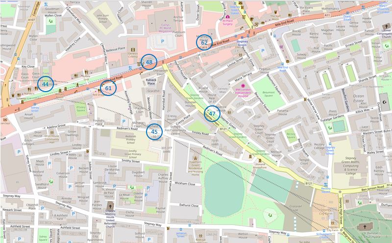
For today’s post I am in Mile End and Stepney Green, tracing the sites numbered 44 to 48, 61 and 62 as shown in the following map extract from the 1973 article (I covered site 46, the church of St. Dunstan’s a couple of weeks ago).

Stepney Green

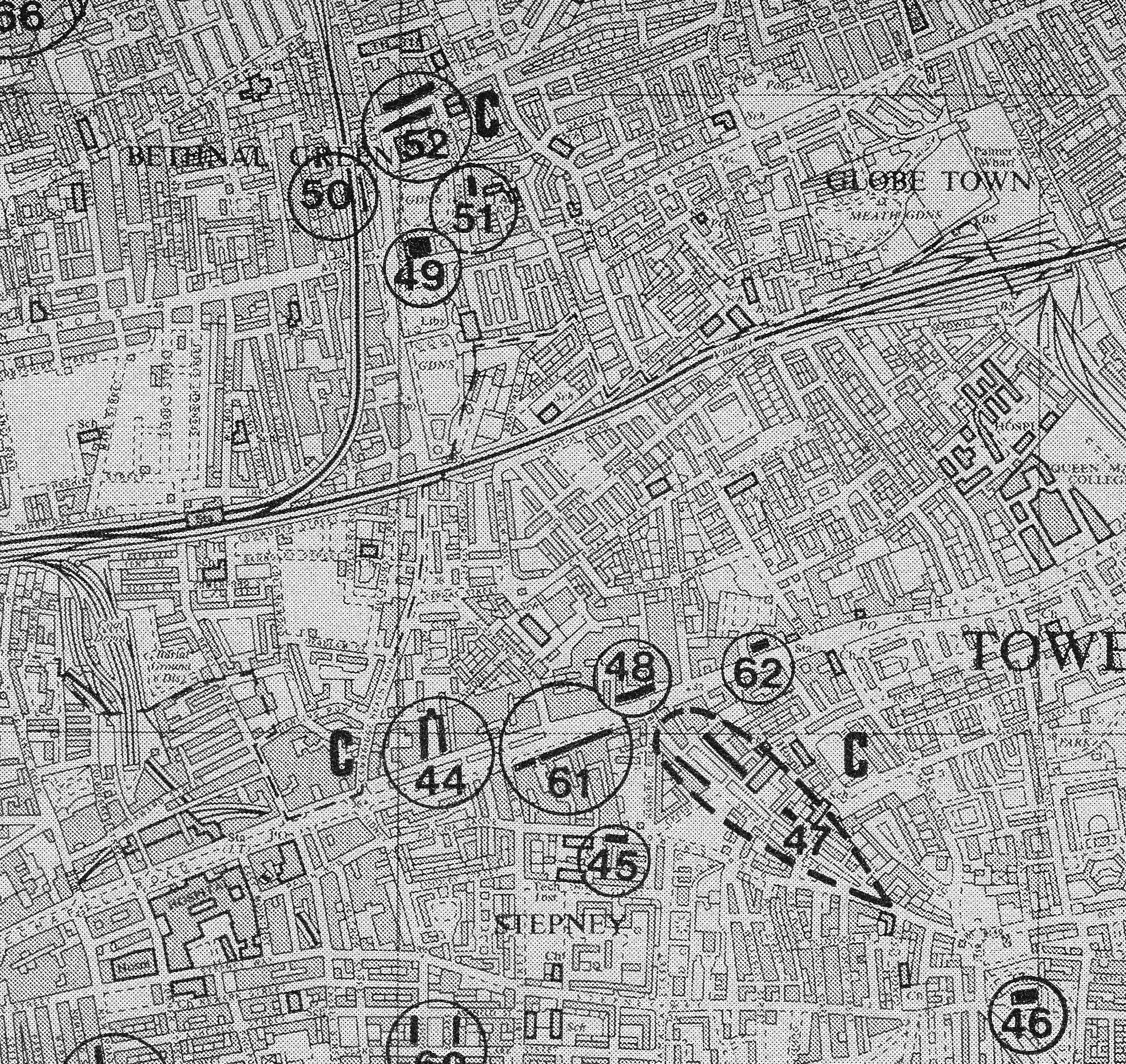
The Architects’ Journal identified Stepney as a Medieval Village Centre, but one that had been absorbed by the growth of east London over the past couple of centuries. I have reproduced the same locations in an up to date map, shown below, from OpenStreetMap.

Stepney Green

There is so much history in this area that a much longer post is needed to cover fully, so my focus for today is seeing how many of the 1973 Architects’ Journal locations remain, and their current condition.

My first location was in Mile End Road:

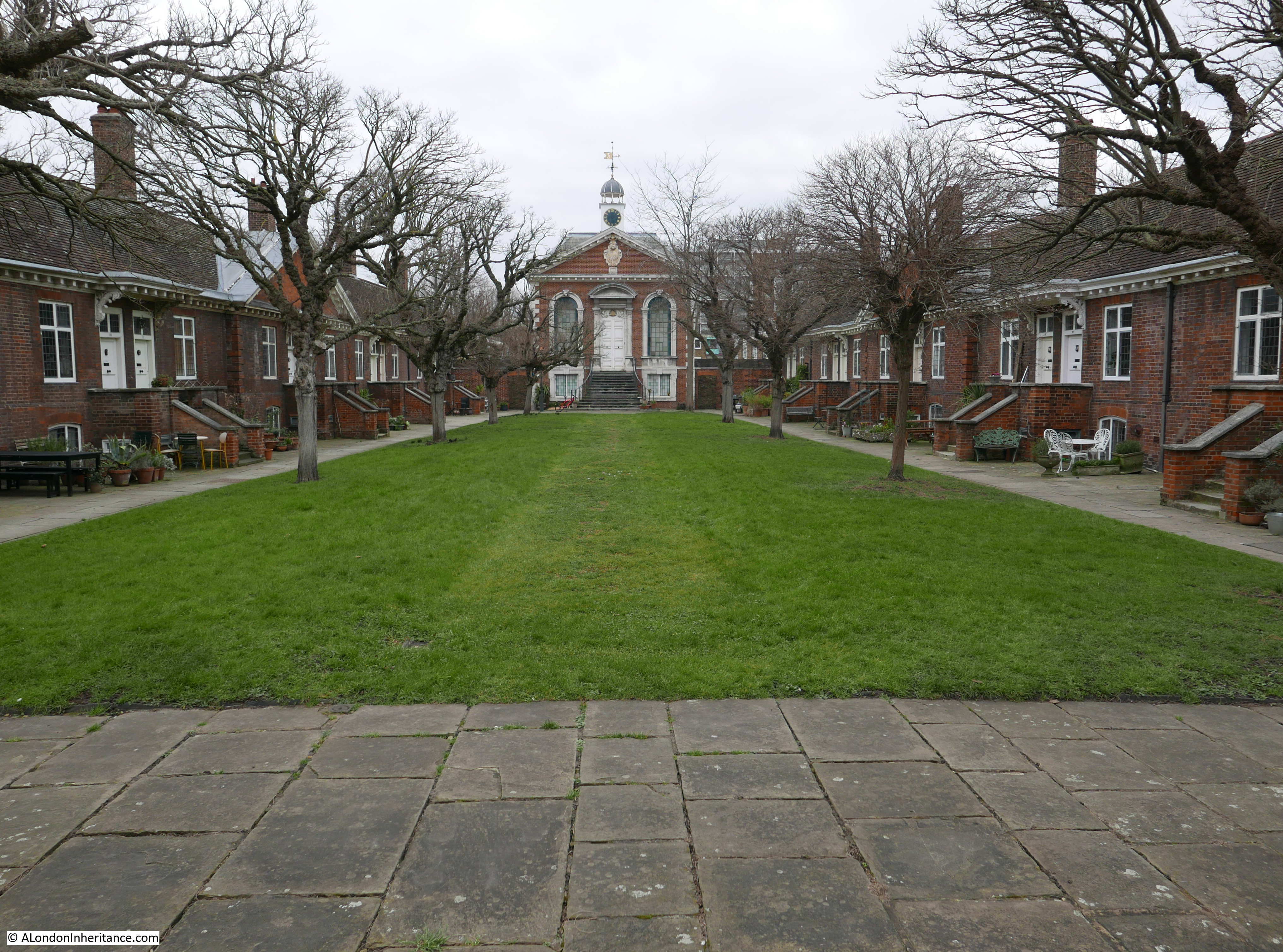
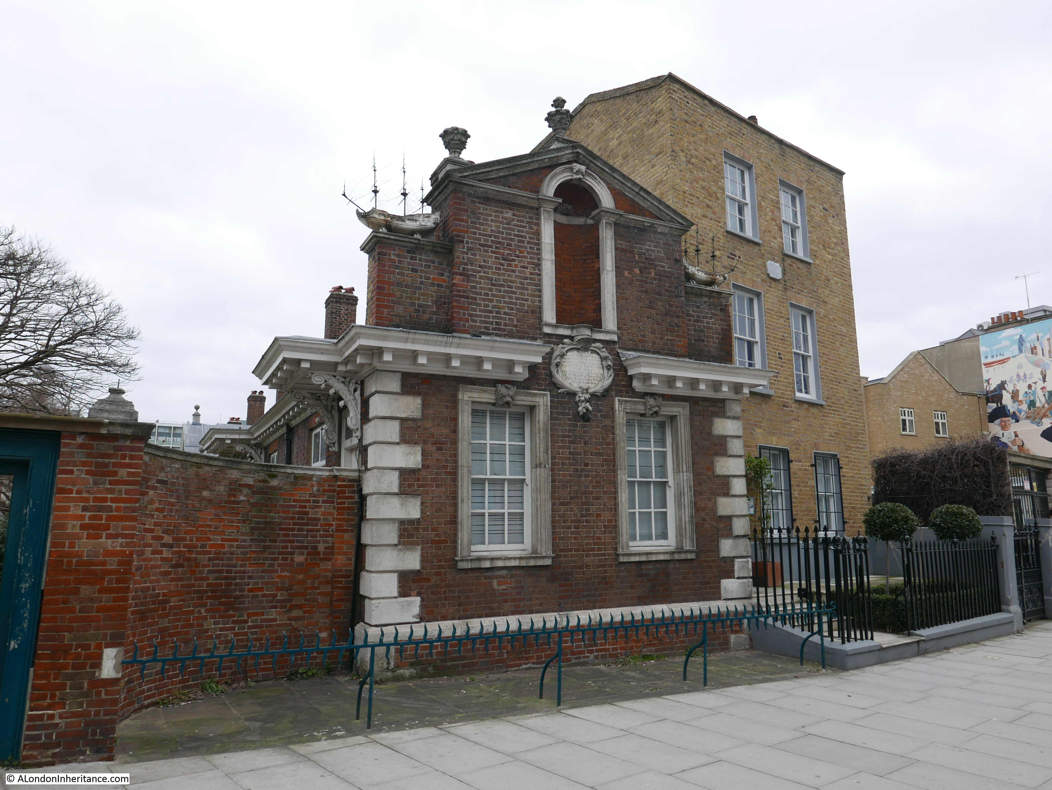
Site 44 – 1695 Trinity Almshouses

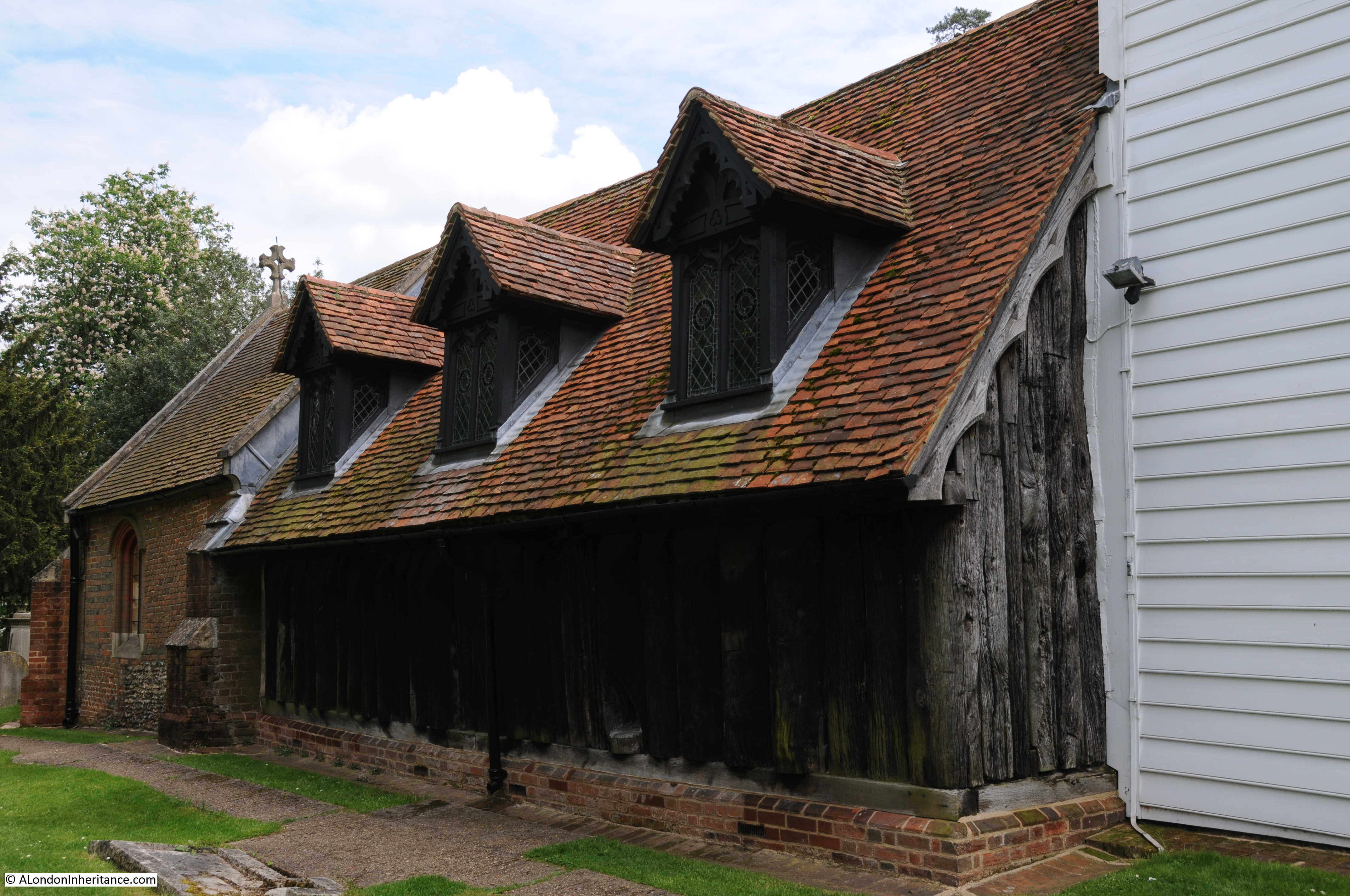
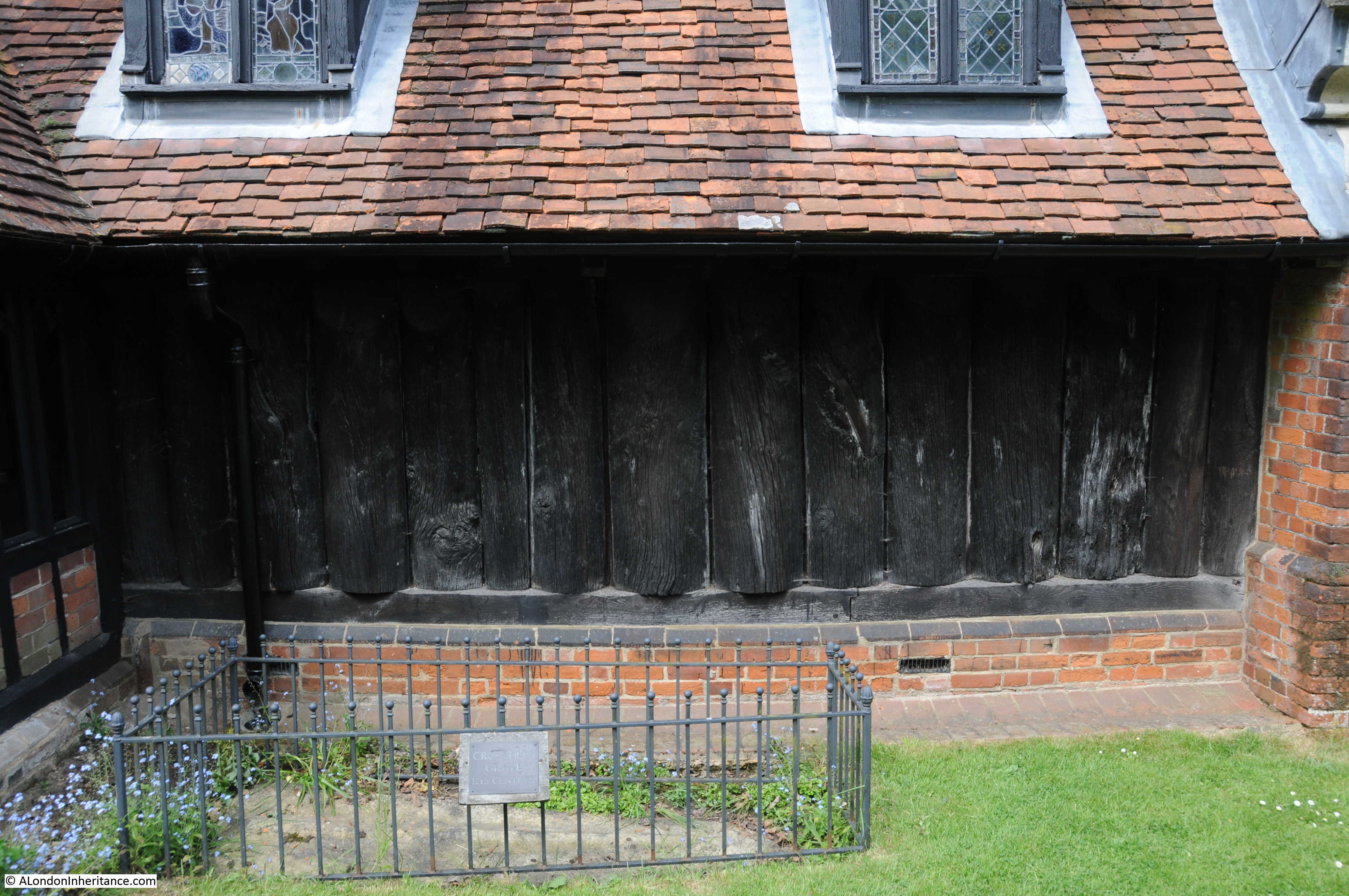
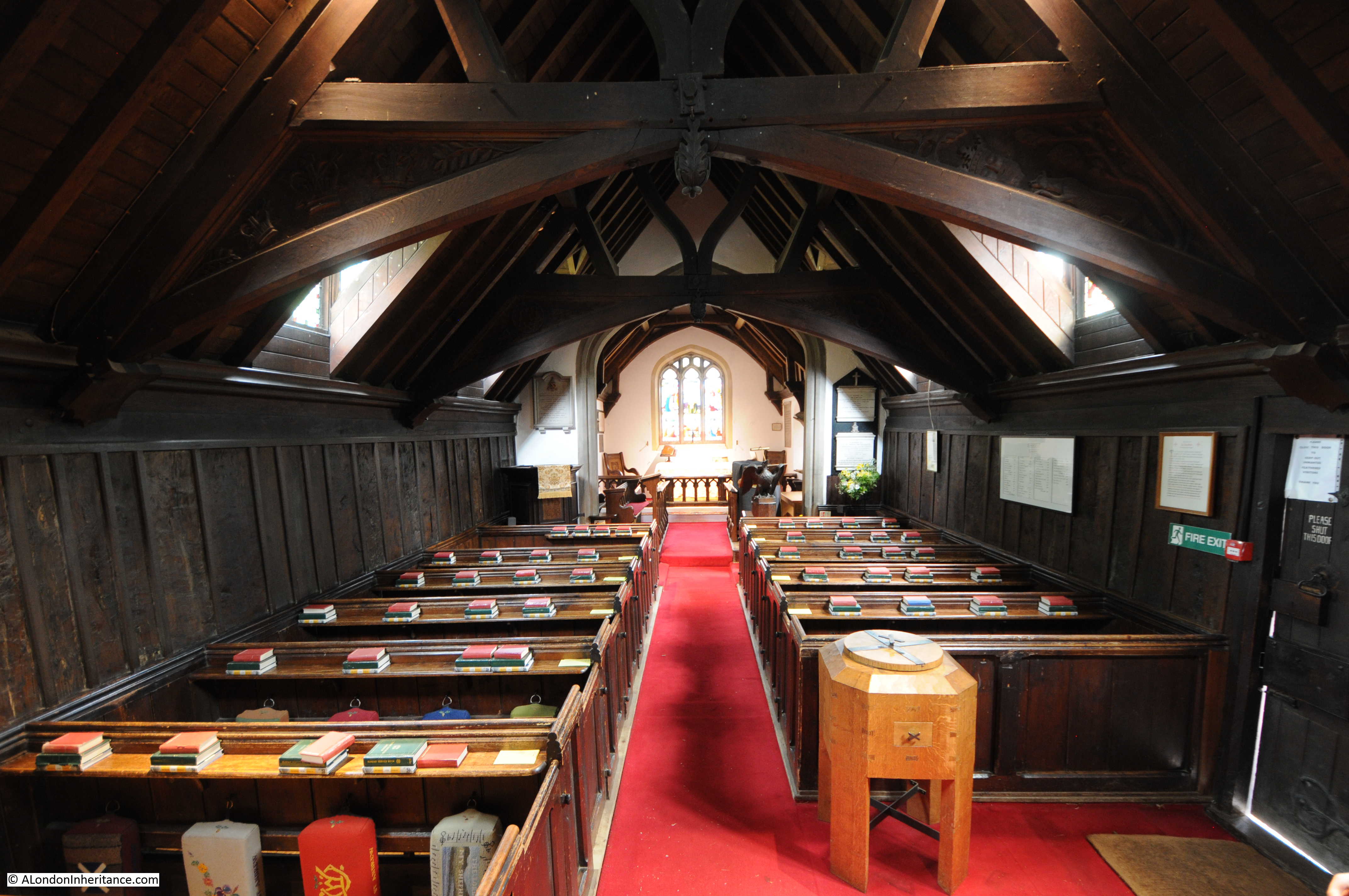
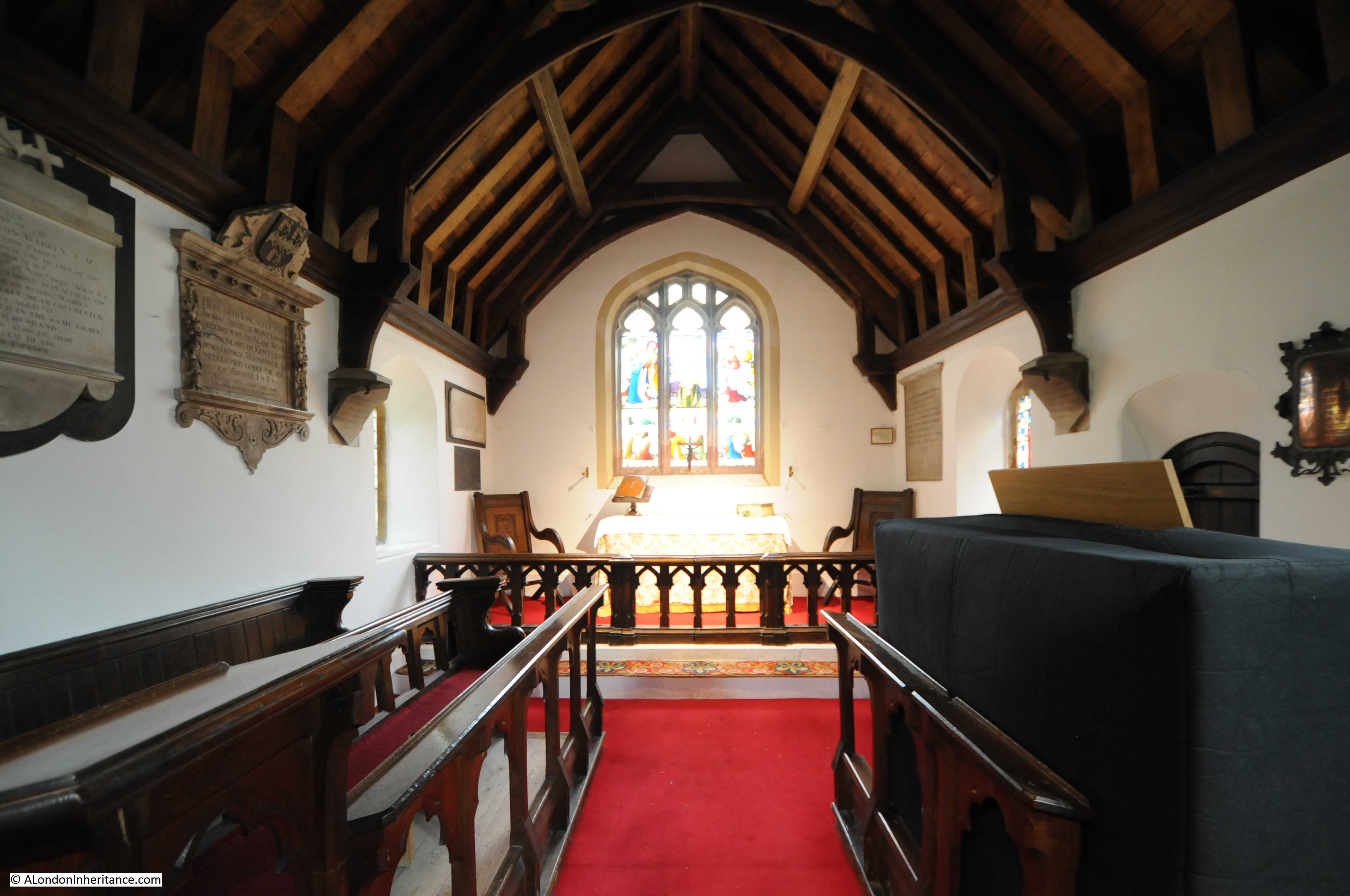
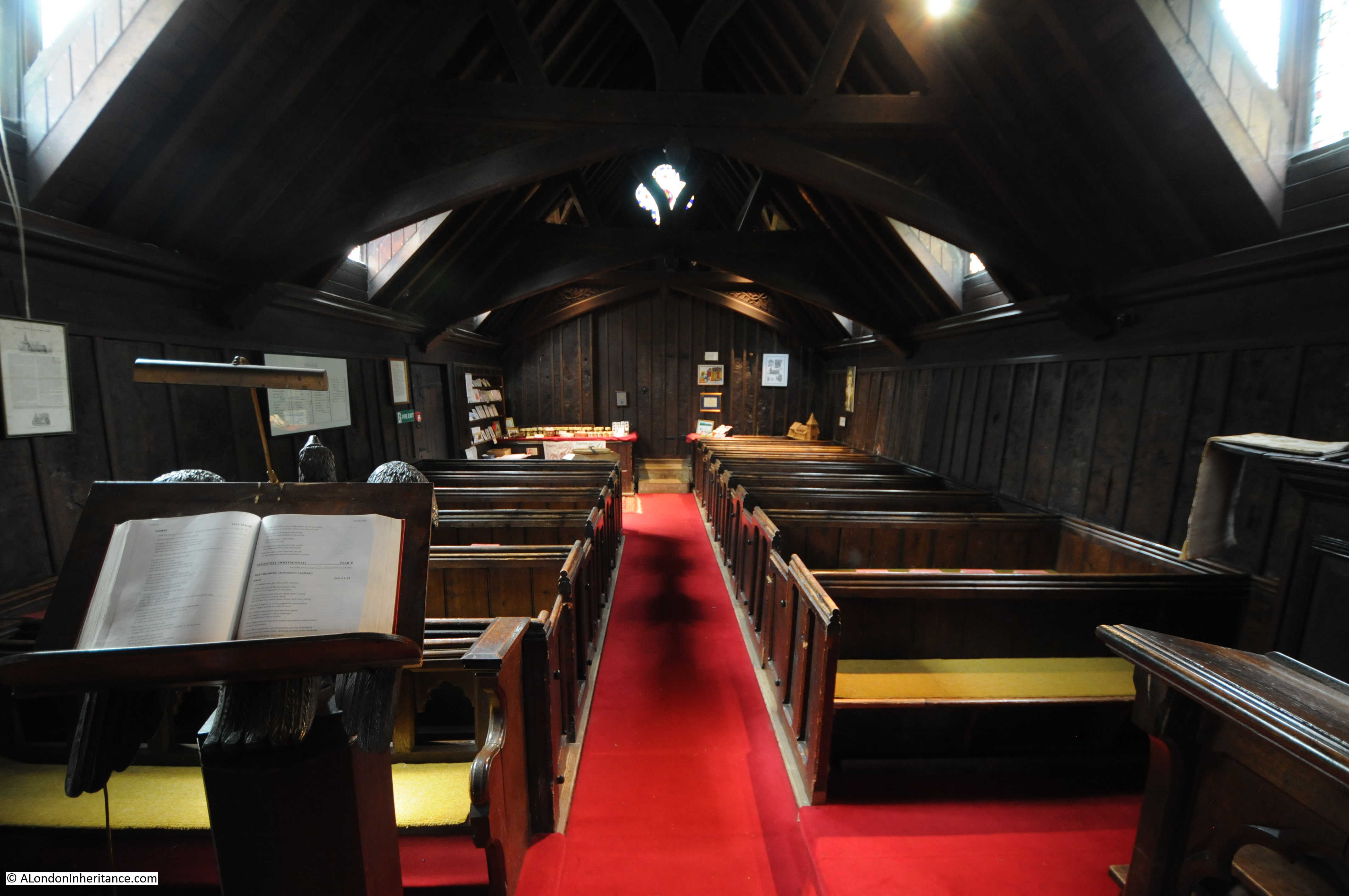
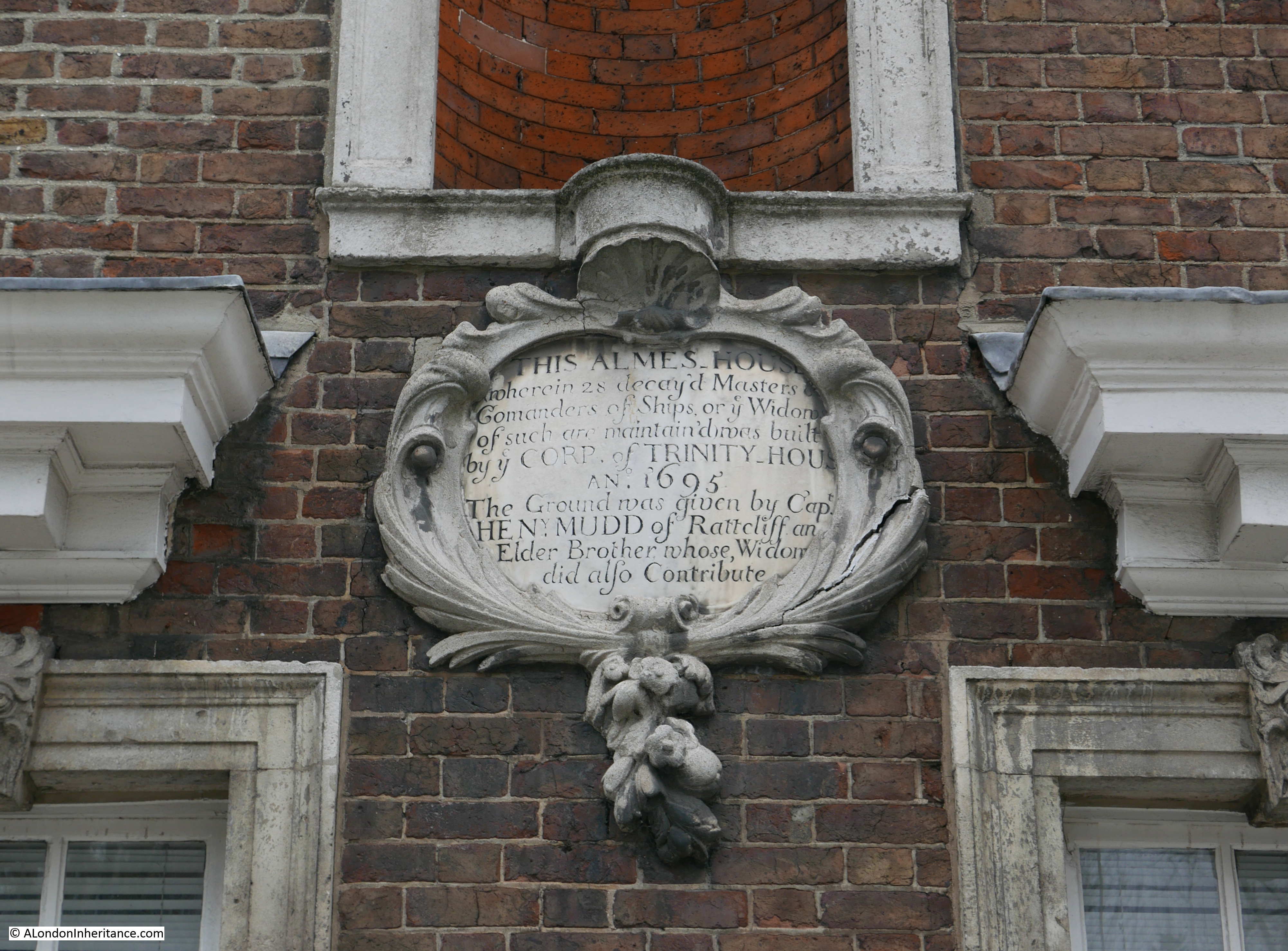
The Trinity Almshouses were built in 1695 by the Corporation of Trinity House for “28 decayed Masters and Commanders of ships or ye widows of such”. The land for the almshouses was donated by a Captain Henry Mudd and they consist of two rows of cottages either side of a green, with a chapel at the far end of the green.

Stepney Green

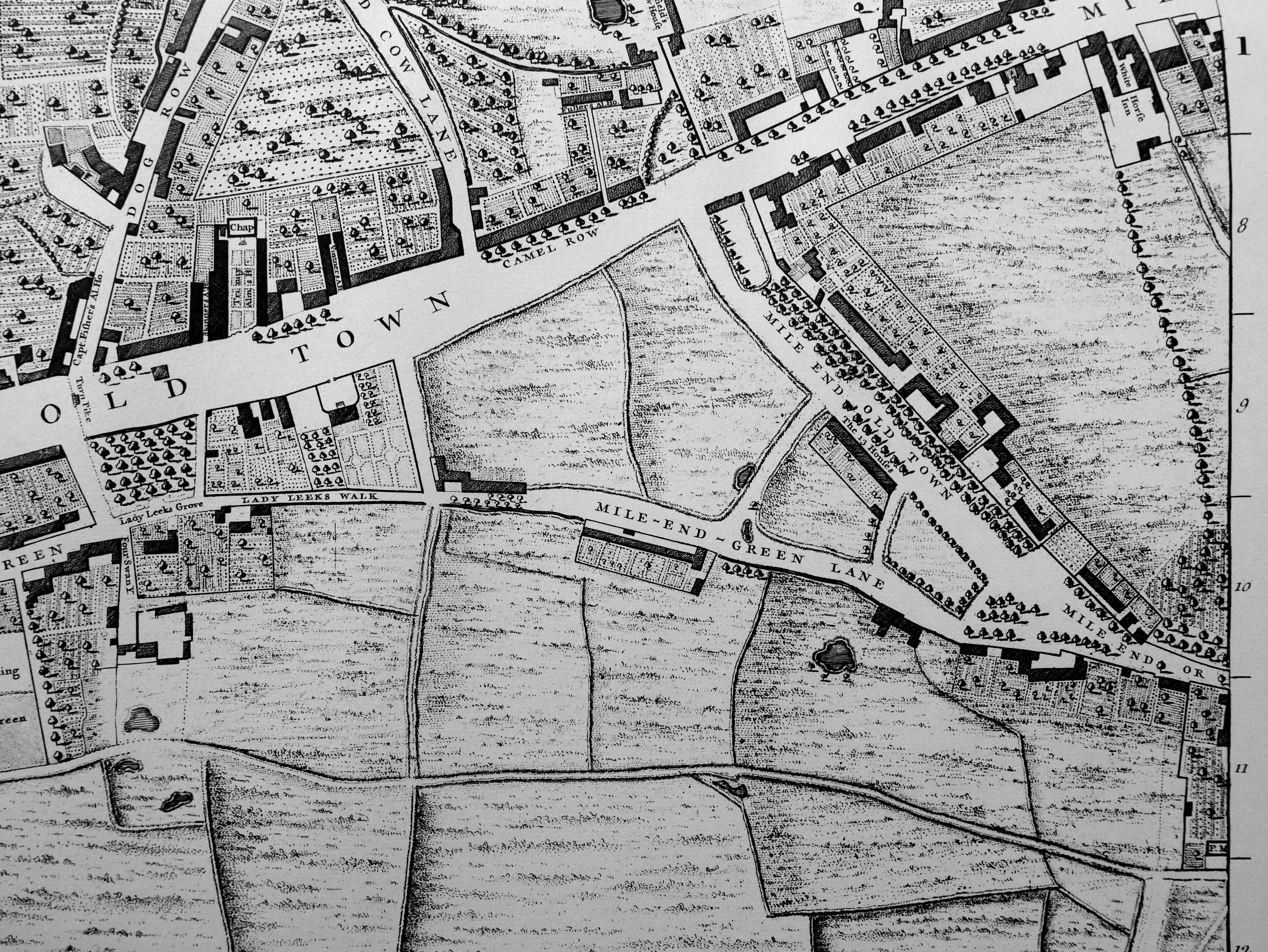
For many years after construction, the almshouses were in a very rural Mile End. The following extract from John Rocque’s map from 1746 shows the almshouses in the centre of the map, surrounded by agricultural land and fields.

Stepney Green

The roads leading north from Mile End Road, either side of the almshouses have some interesting names. Dog Row on the left (now Cambridge Heath Road) and Red Cow Lane on the right (now Cleveland Way). Mile End Road leading through Mile End Old Town was a wide street here in 1746 as it is today.

Captain Fishers Ale House is at the end of Dog Row (I wonder how many of the decayed Masters and Commanders of ships frequented the ale house), and a Turn Pike could be found across Mile End Road opposite Dog Row.

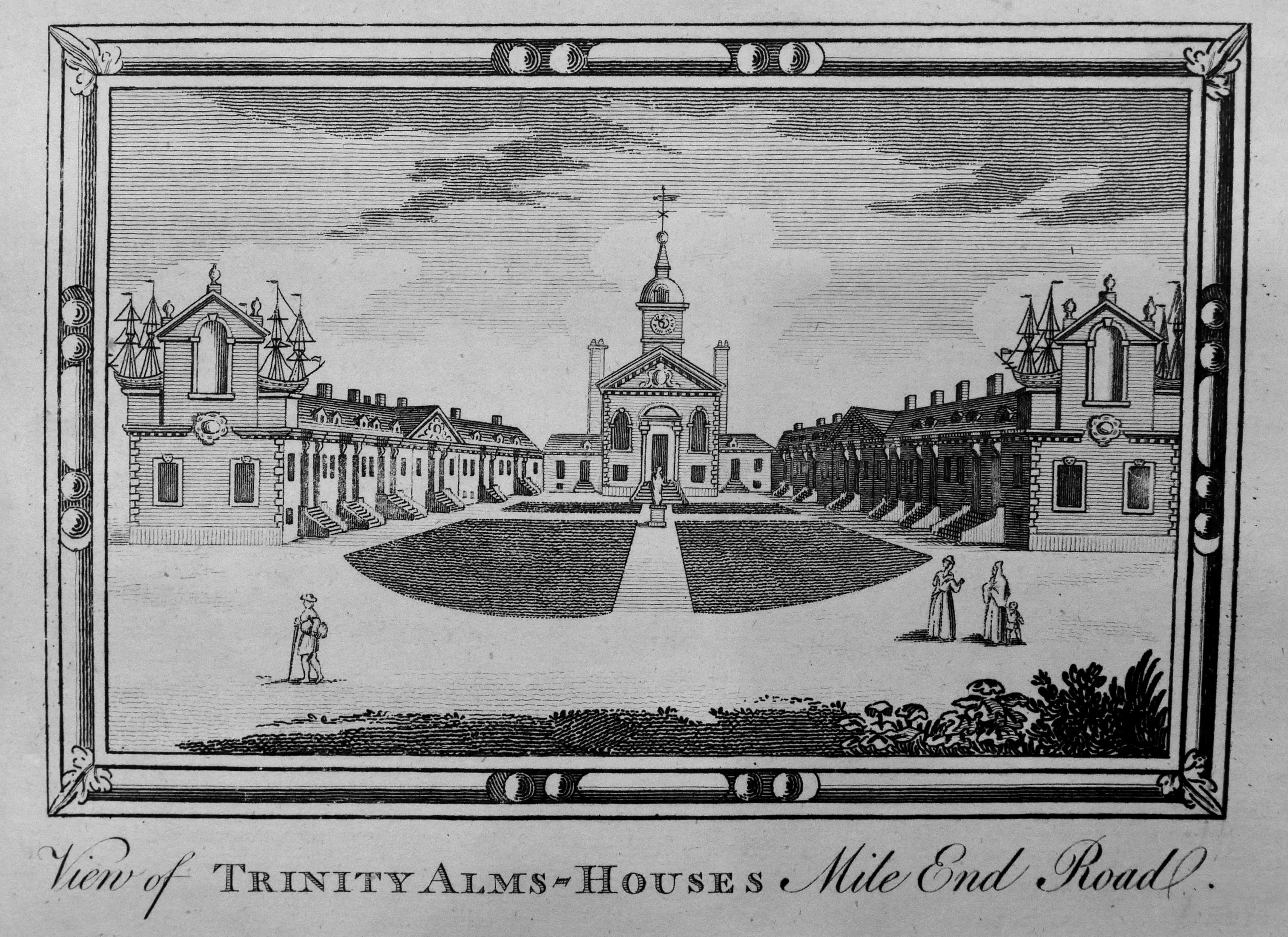
The following engraving from Chamberlain’s History of London published in 1770 shows a rather impressive view of the almshouses as they appeared at the time.

Stepney Green

The almshouses have been under threat many times since 1695. The Corporation of Trinity House petitioned the Charity Commissioners for permission to demolish the almshouses in the 1890s, permission was refused.

They suffered bomb damage during the last war, but were repaired by the GLC, with the chapel being fitted with 18th century paneling from a house in Hammersmith.

Spitalfields Life has documented the recent threats to the almshouses

Where they reach Mile End Road, the two rows of cottages are terminated by rather ornate gable ends:

Stepney Green

A plaque on the gable ends records the origins of the almshouses:

Stepney Green

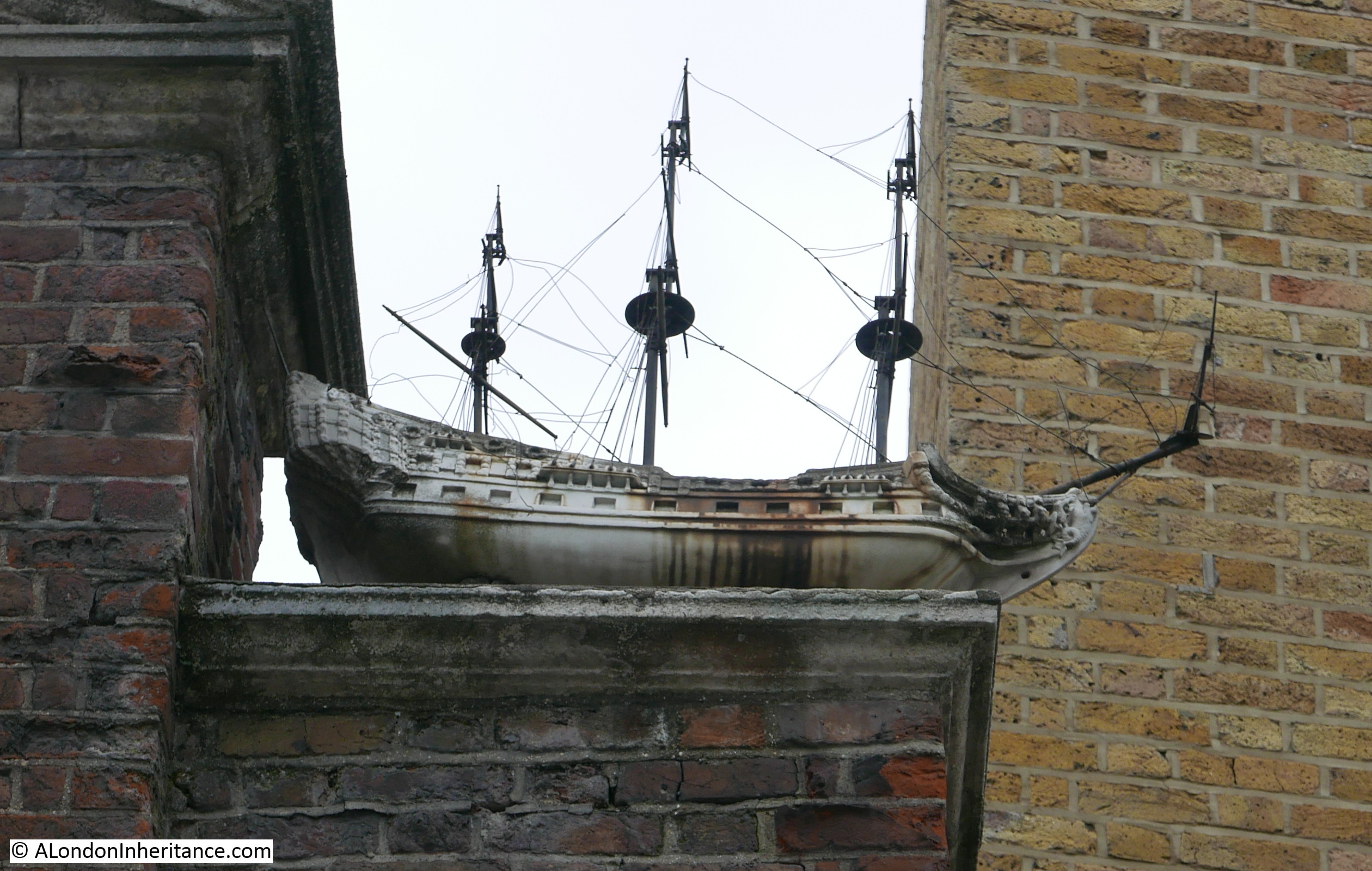
In the 1770 engraving, some rather impressive model ships can be seen on the gable ends. Model ships can still be seen today, however these are now fibreglass replicas with the original marble models being stored in the Museum of London.

Stepney Green

The almshouses feature in the top right of this mural by Mychael Barratt which can be found a short distance from the almshouses:

Stepney Green

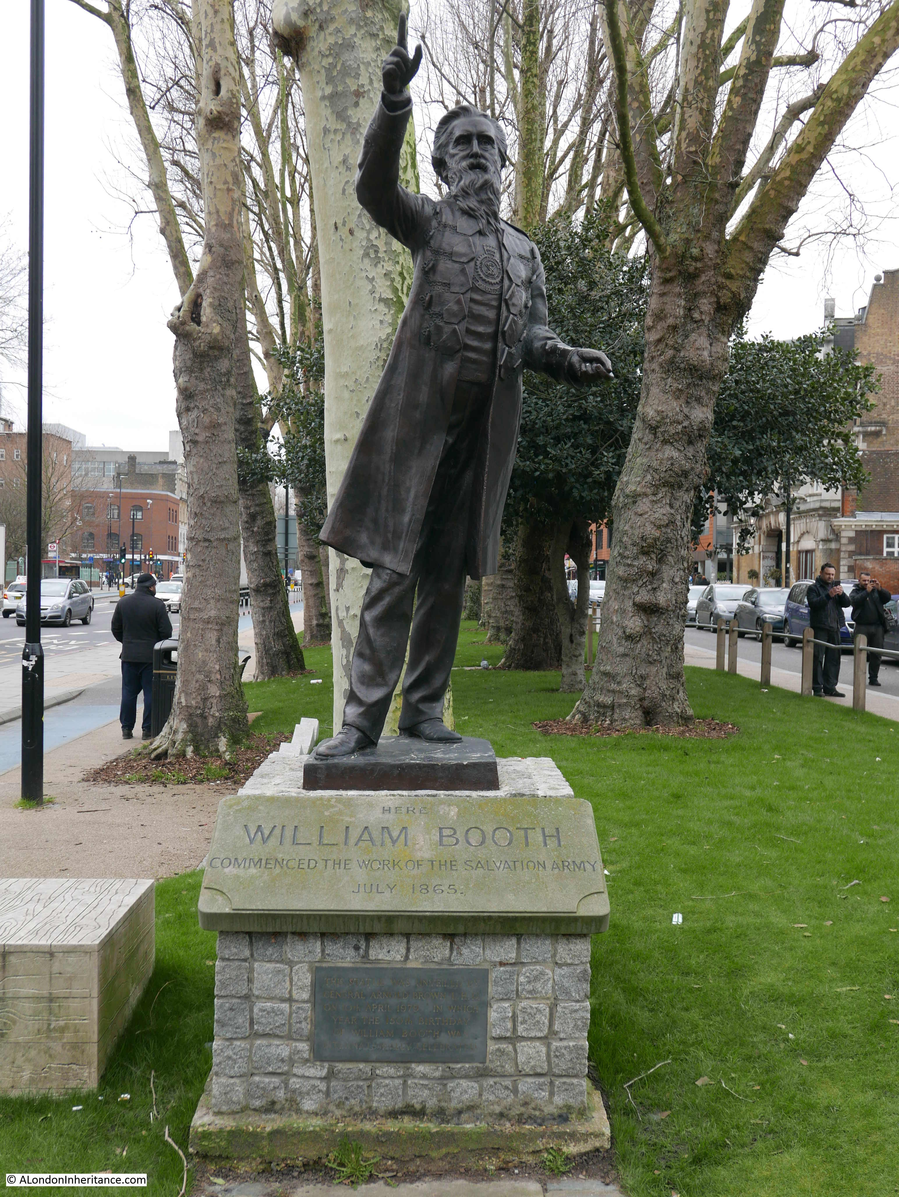
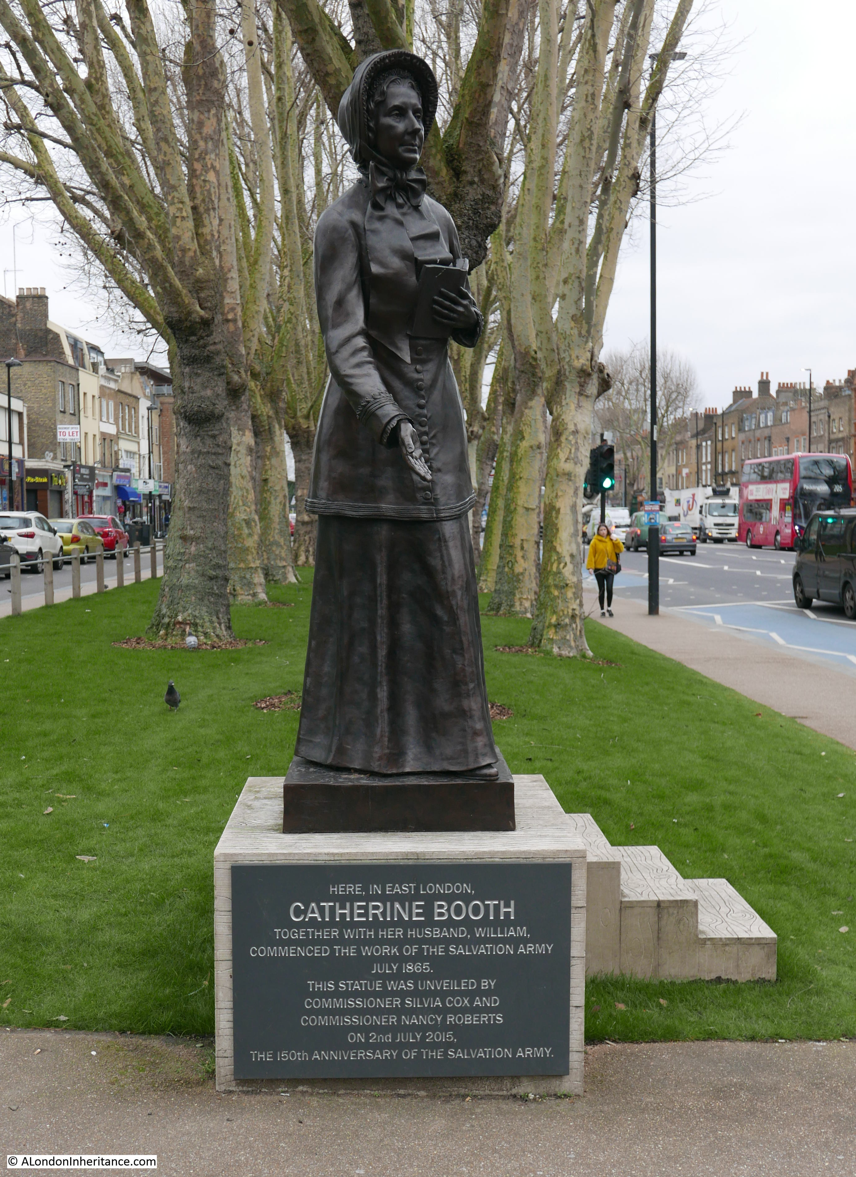
There is also a statue to William Booth, founder of the Salvation Army which was unveiled in 1979:

Stepney Green

And rightly there is also now a 2015 statue to Catherine Booth to acknowledge their joint enterprise to setting up the Salvation Army:

Stepney Green

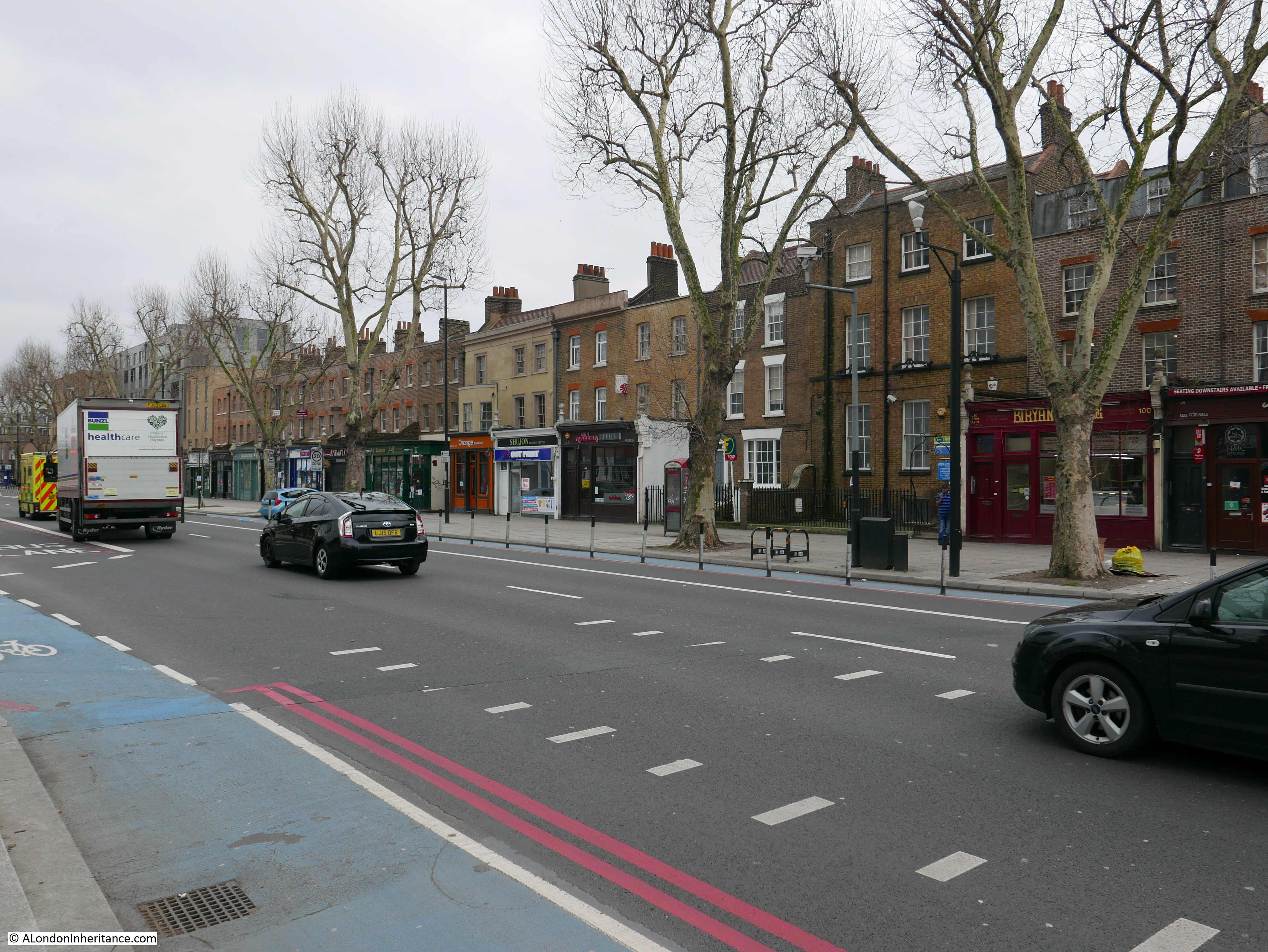
To show just how much can be found in this short distance along Mile End Road, further along can be found this entrance to a car park and a number of businesses, however the wall on the left records an example of the type of destruction that the Architects’ Journal was so concerned about.

In 1958, fifteen years before the article was published, the site of the wall was occupied by the house that Captain James Cook occupied for a number of years in the 18th century.

Stepney Green

The buildings either side of Cook’s house were not demolished, the apparent reason for the demolition was to widen the lane, but there was no reason then, or today, for a wider lane leading off here from Mile End Road.

It is a perfect example of the random demolition that took place in the decades after the 1940s that Cook’s house was destroyed, but the adjacent terrace of buildings was left in place, which is my next location:

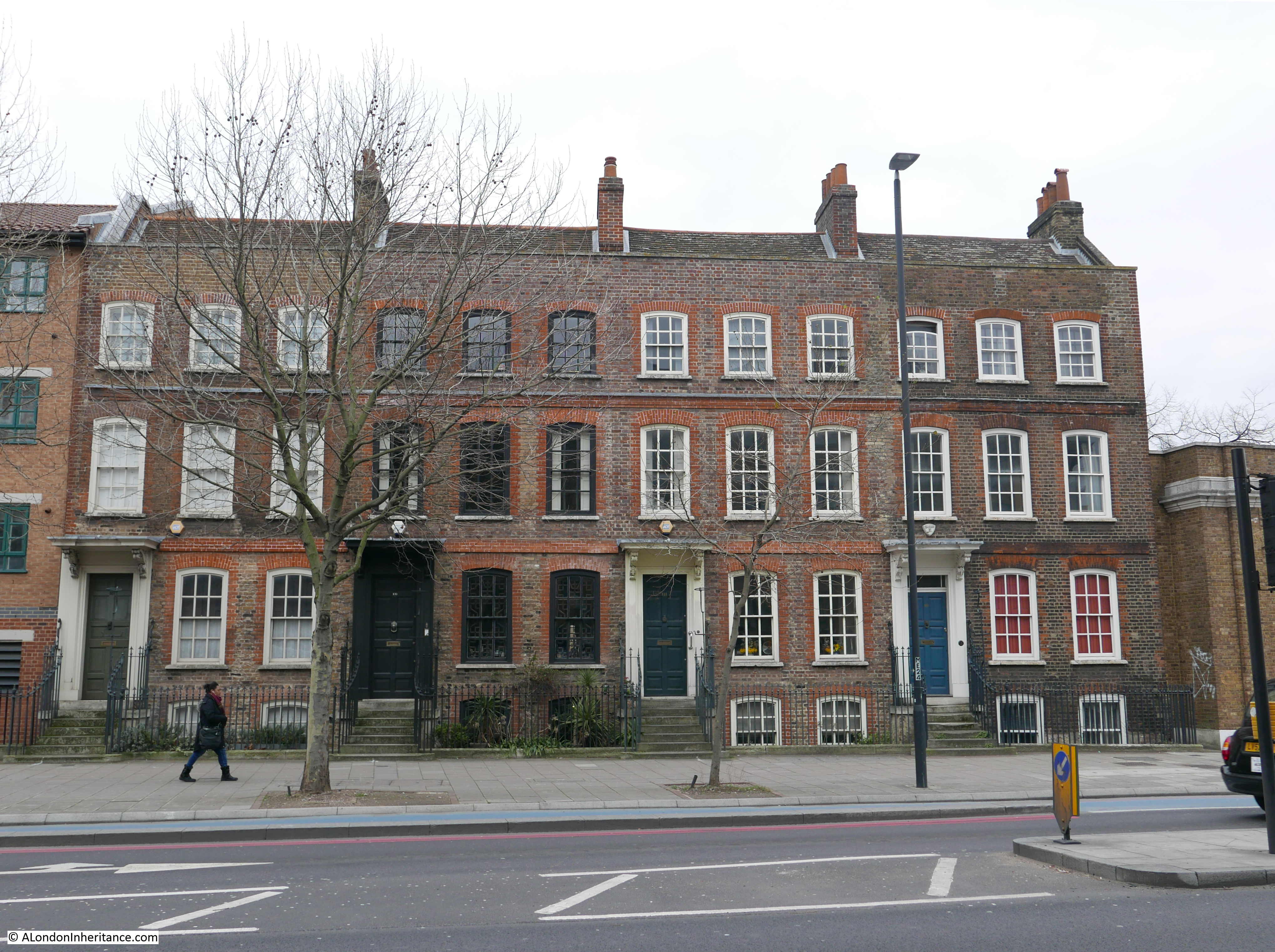
Site 61 – Late 18th Century Terrace

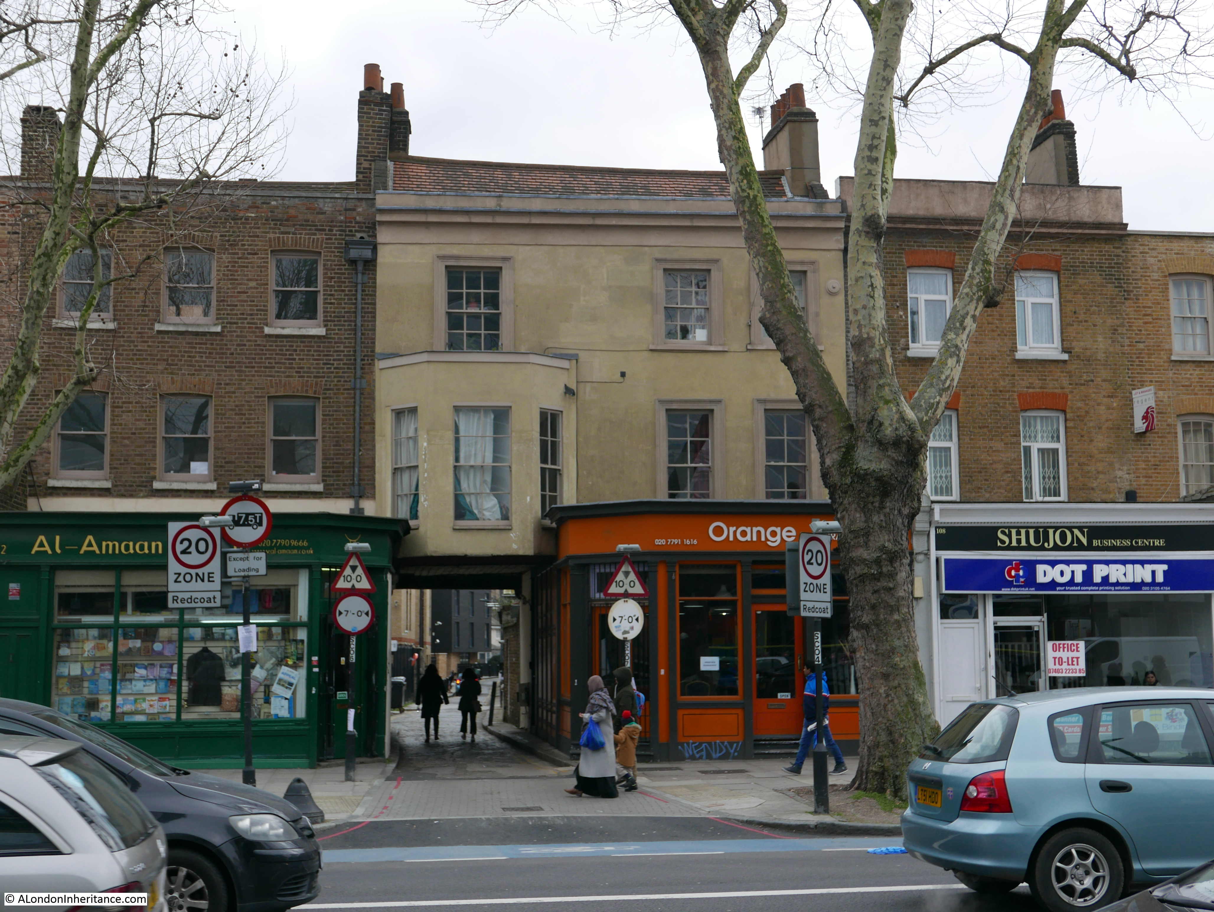
Running to the east along Mile End Road from the location of Cook’s house is this row of late 18th century buildings:

Stepney Green

The terrace consists of a fascinating mix of different architectural styles and modifications to the buildings. In the following example, a bay window on the first floor extends over Assembly Passage – a long, cobbled walkway that leads from Mile End Road to Redmans Road.

Stepney Green

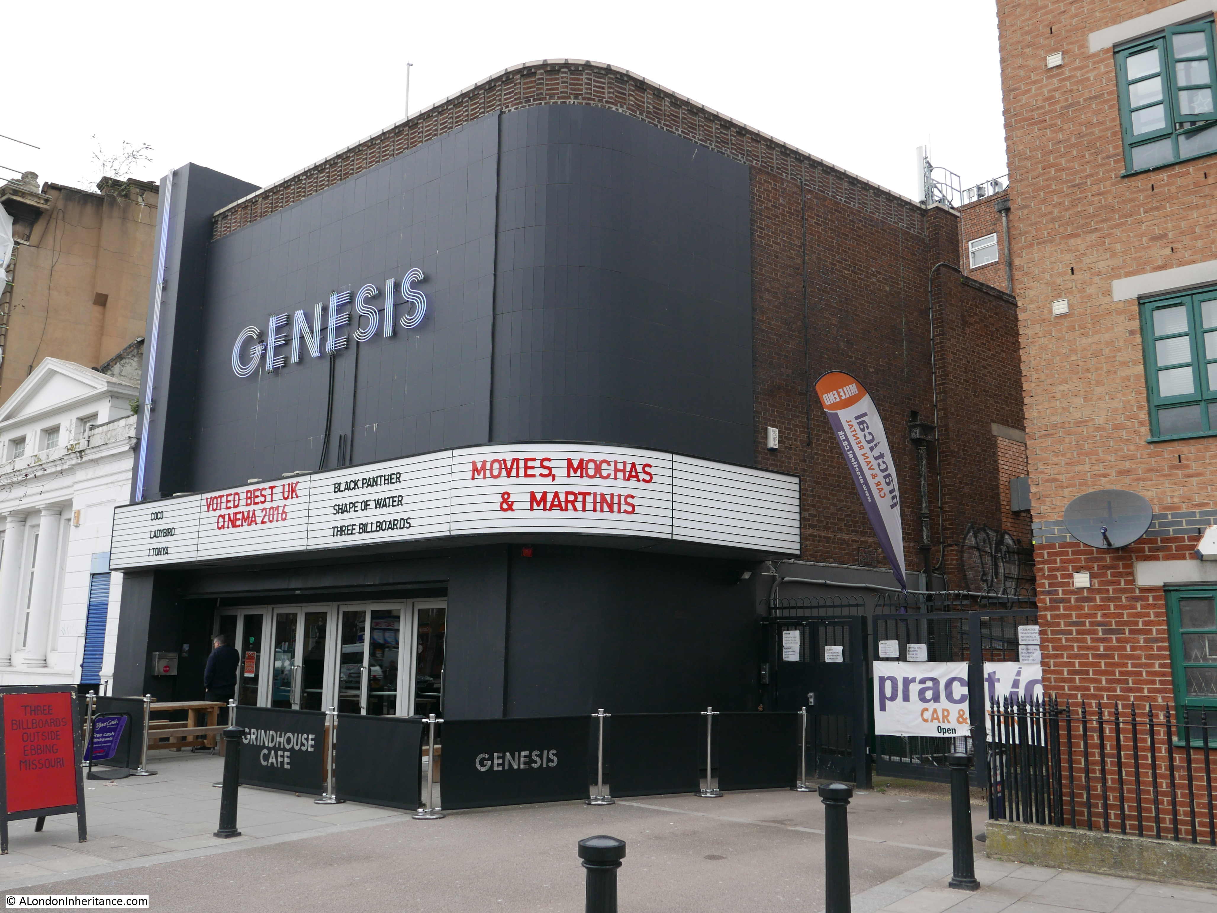
Across the road is the Genesis Cinema – a restored cinema (which originally opened in 1912) in a location that had been occupied by a pub, theatre and palace of varieties.

Stepney Green

A short distance along Mile End Road from the cinema is the next Architects’ Journal location:

Site 48 – Early 18th Century Group

A lovely group of four terrace houses – it took a while to get this photo without any traffic, there is a continuous stream of traffic along Mile End Road.

Stepney Green

Further along Mile End Road is:

Site 62 – Early 18th Century Group

A pair of large 18th century houses, set back from the road with small gardens between house and street.

Stepney Green

To the right of the buildings is a Topps Tiles warehouse and on the left is a small open space, then the new buildings on the site of the old Anchor Brewery.

The Architects’ Journal definition for this site was a ‘Group’ rather than a ‘Pair’ so I do wonder if there were additional houses in 1973 and this pair are all that remain.

The following location was not so lucky:

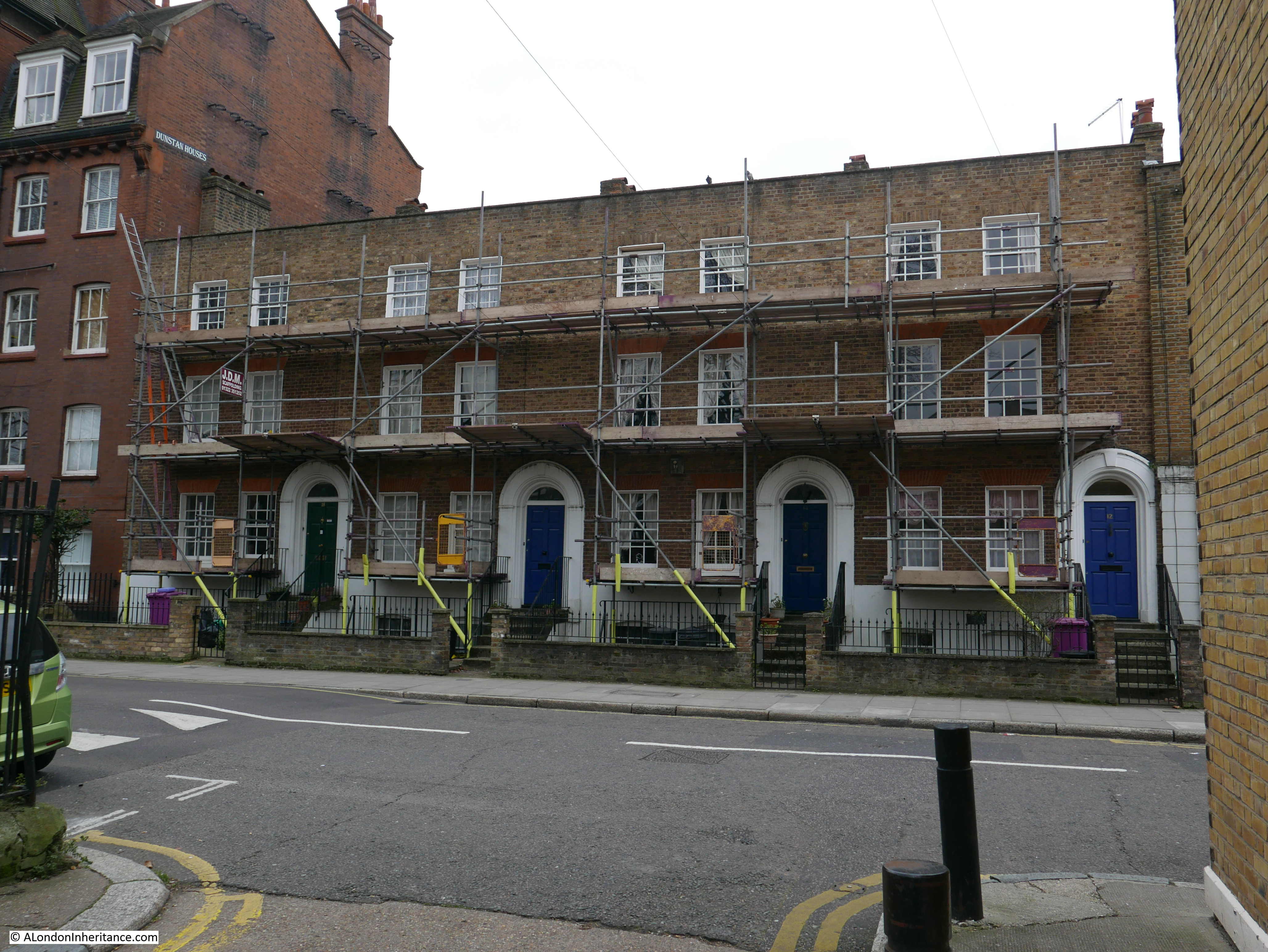
Site 45 – Mutilated Early 18th Century Group

To reach my next destination I turned off Mile End Road, a short distance along Stepney Green, along Hannibal Road to Redmans Road to see if this early 18th century group remained.

If my reading of the Architects’ Journal map was right, then the terrace should have been in this location – space now occupied by the expanded playground of the Redlands School.

Stepney Green

The houses in 1973 must have been in some state as the Architects’ Journal description was the rather strong “mutilated group”. I checked on the excellent London Metropolitan Archives Collage image archive and found this photo from 1971 of a terrace of houses along 42 to 48 Redmans Road – the space now occupied by the playground extension.

Stepney Green

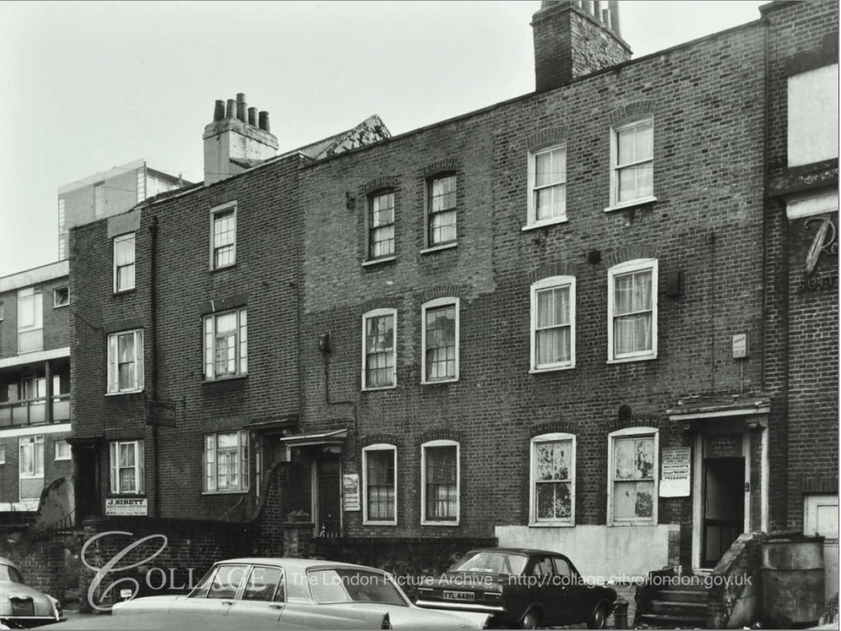
Image credit: London Metropolitan Archives, City of London: catalogue ref: SC_PHL_01_397_71_642

The boards to the side of the doors on the central houses indicate that the houses were used in the clothing trade, with the board on the right advertising machinist vacancies.

I am sure this is the right location as to the left of the above photo, the edge of a post war terrace of flats can be seen, which are still there today as shown in my photo below.

Stepney Green

I assume the description of mutilated indicates that the buildings have been considerably changed from their original 18th century design and structure.

I then turned back along Redmans Road to the next location:

Site 47 – Early 18th Century Remains At Stepney Green

Mile End Road is very busy, with what seems like endless traffic streaming both into and away from the City. Walk the short distance to Stepney Green and the environment changes completely. I walked through Stepney Green on a cold grey day in February and a warmer, but still grey day at the end of April, when the trees were coming into leaf and bird song was louder than the distant traffic.

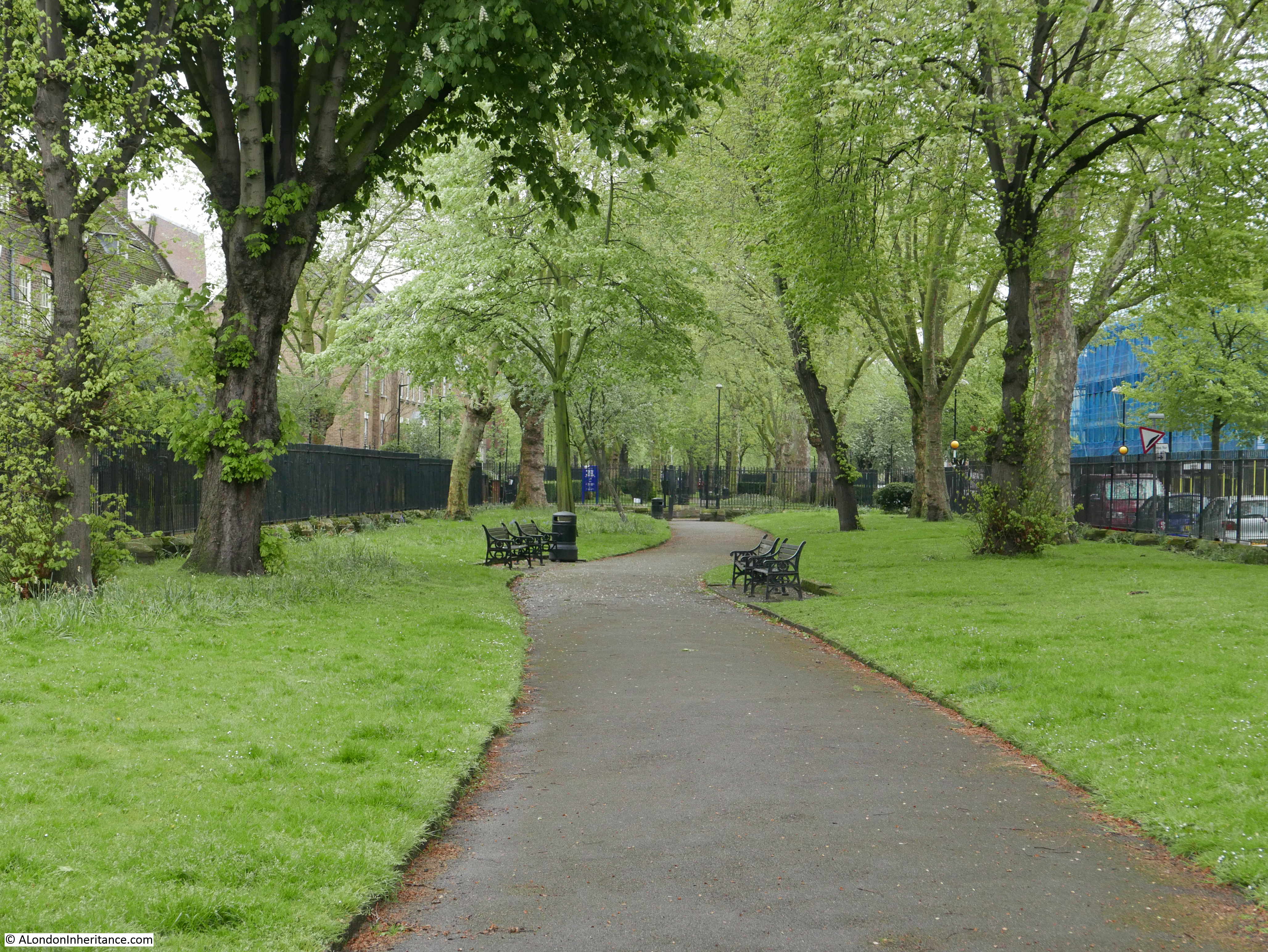
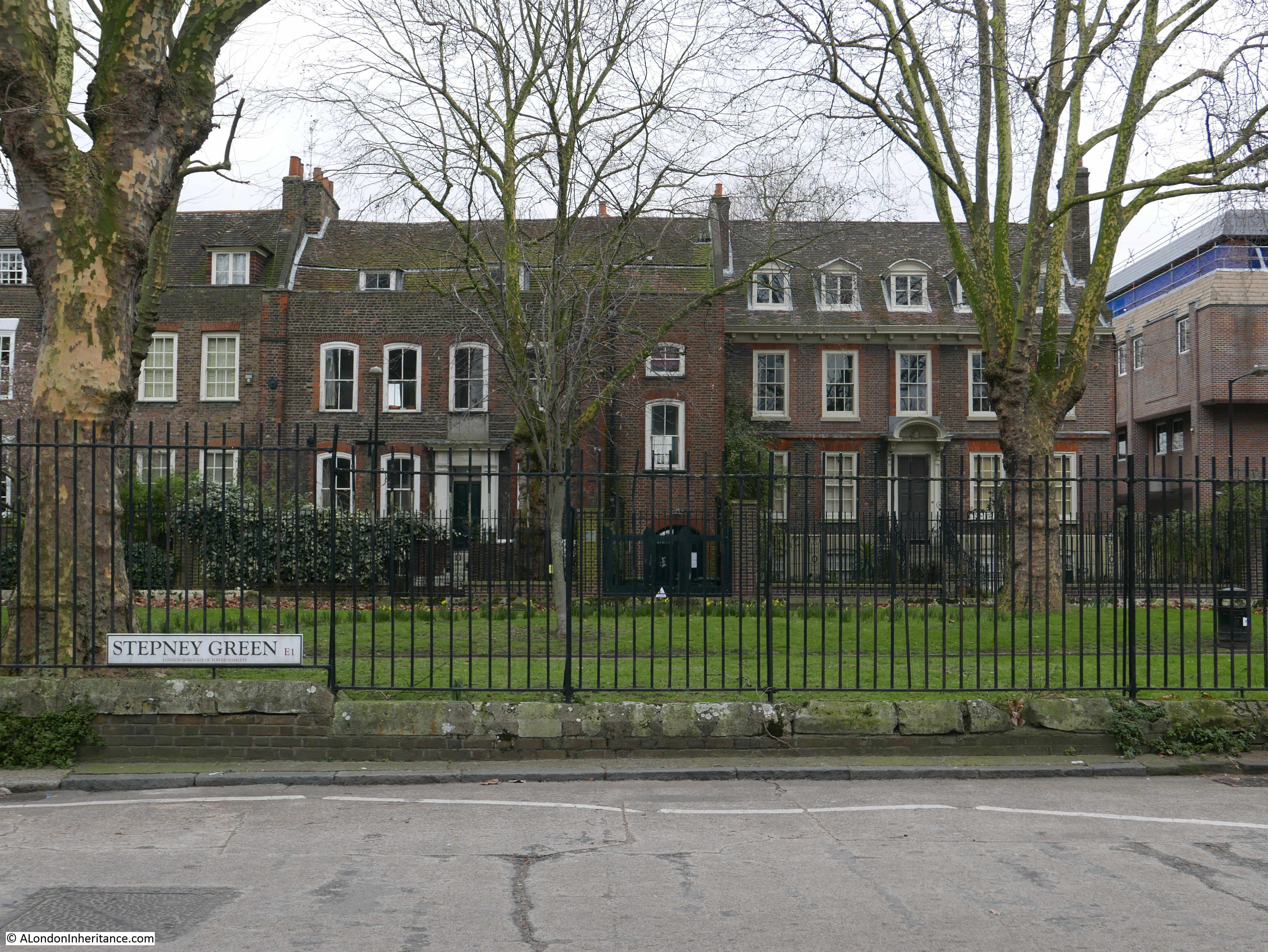
The main part of Stepney Green consists of two parallel streets with central gardens running between them. The eastern street is narrow and it is along this street where the majority of the older buildings are located.

In 1746, John Rocque’s map included what would become Stepney Green as a wide area running south from Mile End Road with houses mainly on the eastern edge. Houses with large back gardens with a large open field behind. In 1746 the area was called Mile End Old Town rather than Stepney Green.

Stepney Green

This is the view down the eastern side of the central green.

Stepney Green

The layout from 1746 can still be seen today as the 1746 map indicates a narrow street in front of the houses to the east, trees along the centre with a wider road on the western side – the same layout can be seen today.

The central gardens are tree-lined on either side with a pathway winding through the middle.

Stepney Green

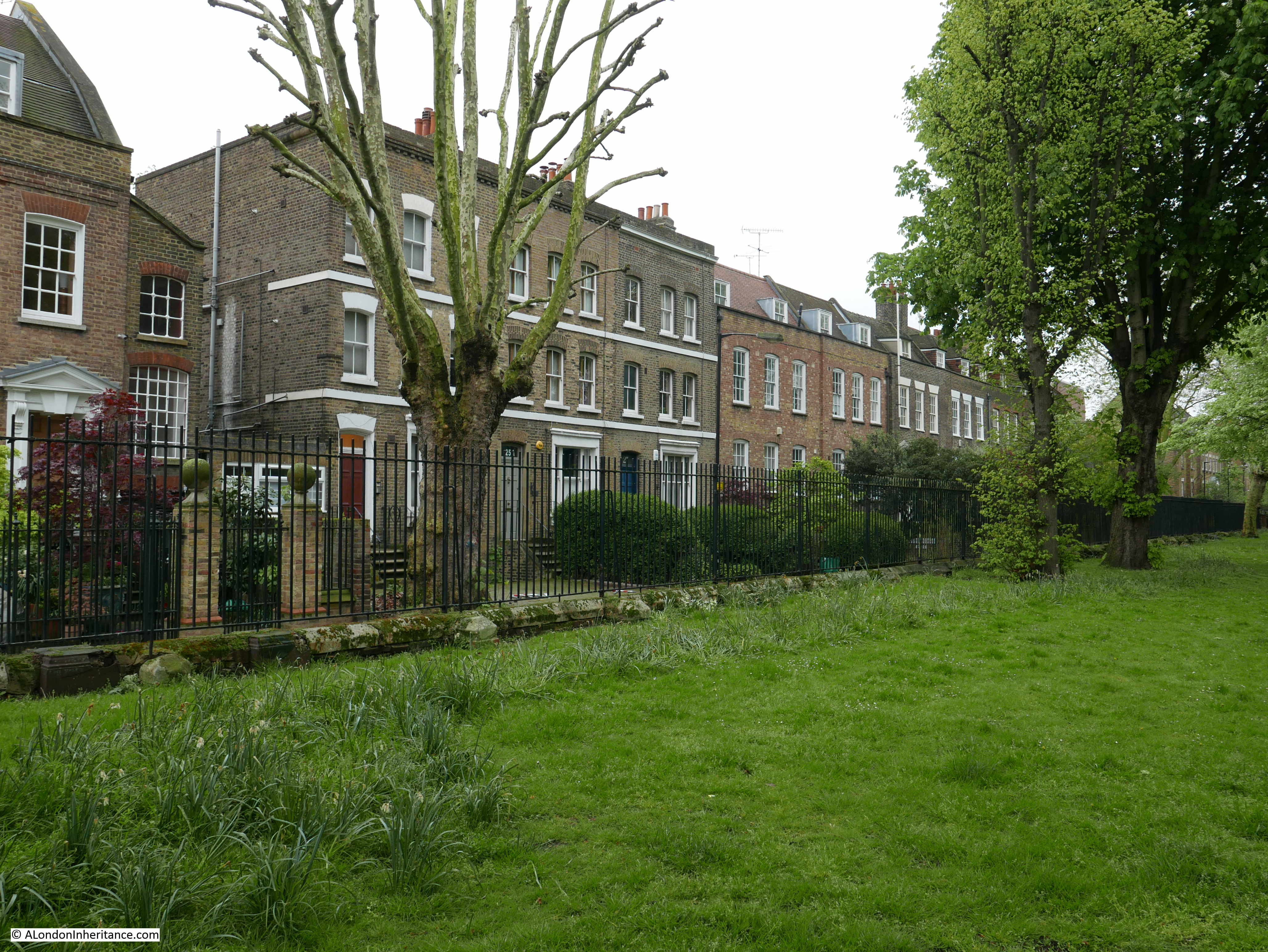
The Architects’ Journal map shows houses on either side at the northern end of Stepney Green with additional houses marked on the eastern side. This distinctive terrace of four houses is along the northwest corner.

Stepney Green

The houses along the eastern edge tend to be larger, more individual buildings.

Stepney Green

One of the most important buildings in Stepney Green is number 37 – a magnificent Queen Anne house that was built in 1694. The  house was purchased by the Spitalfields Trust in 1998 who restored the house from institutional use to a rather magnificent family dwelling.

Number 37 Stepney Green:

Stepney Green

A closed pub on the western side of Stepney Green that has been converted to a private residence. Originally the Ship, then for a few years before closure, the Ship on the Green:

Stepney Green

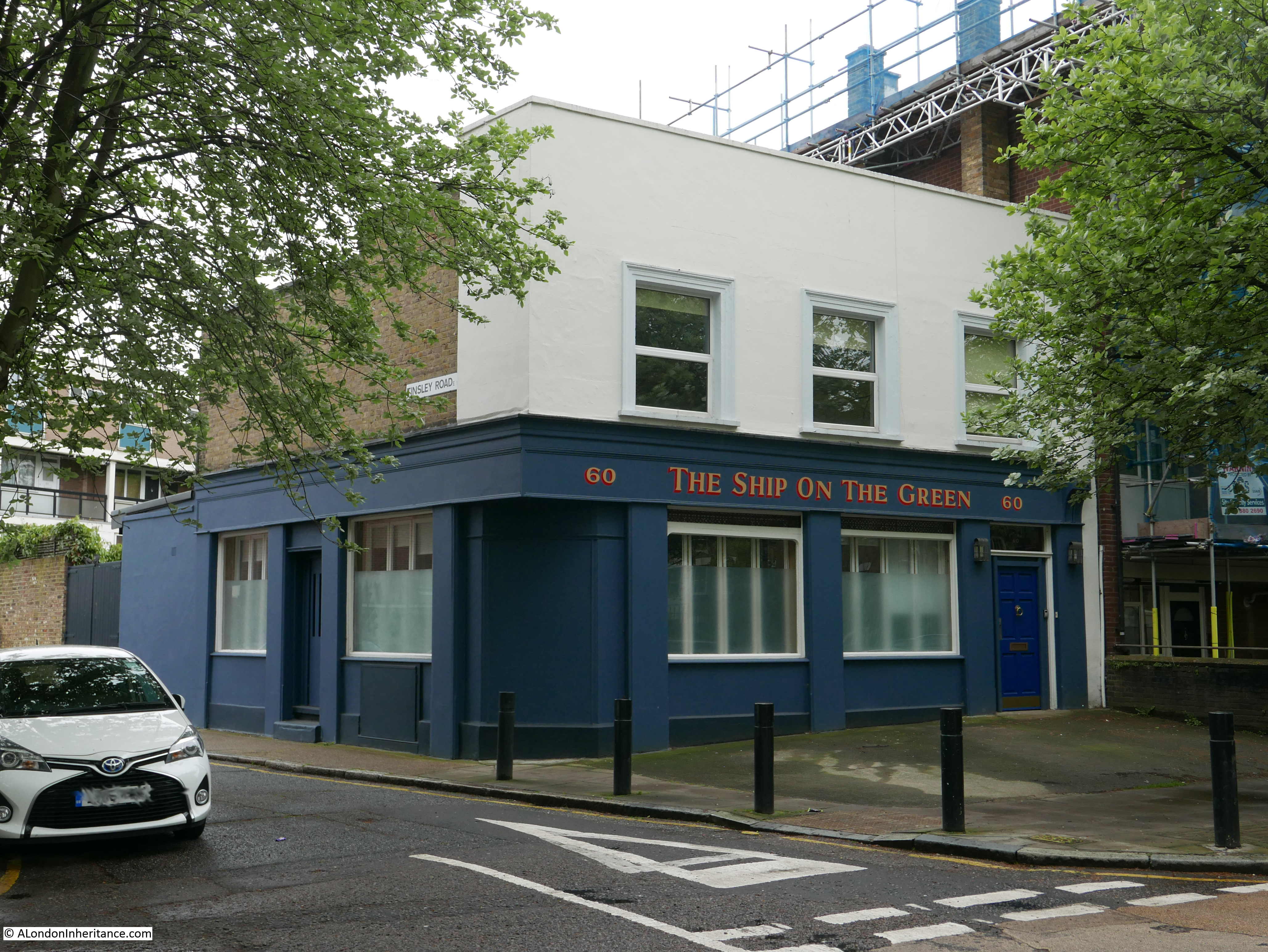
The LMA Collage archive has a photo of the Ship as it was in 1953:

Stepney Green

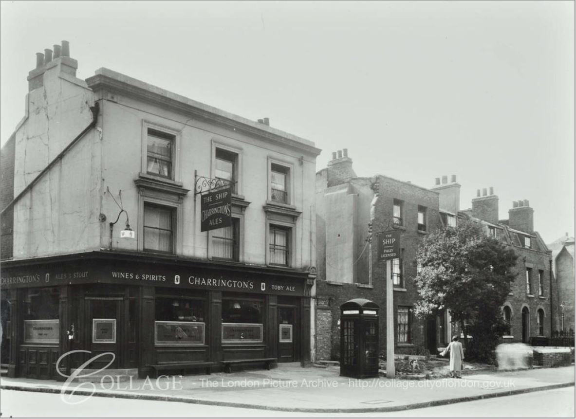
Image credit: London Metropolitan Archives, City of London: catalogue ref: SC_PHL_01_399_F8790

The view across Stepney Green.

Stepney Green

In the above photo, the house to the left of middle has an interesting plaque above the door. The house must have been occupied by a dispensary at some point as the plaque records that the equipment for the dispensary was provided by a fund raised by the Mayor of Stepney in memory of King Edward VII, for the prevention of consumption.

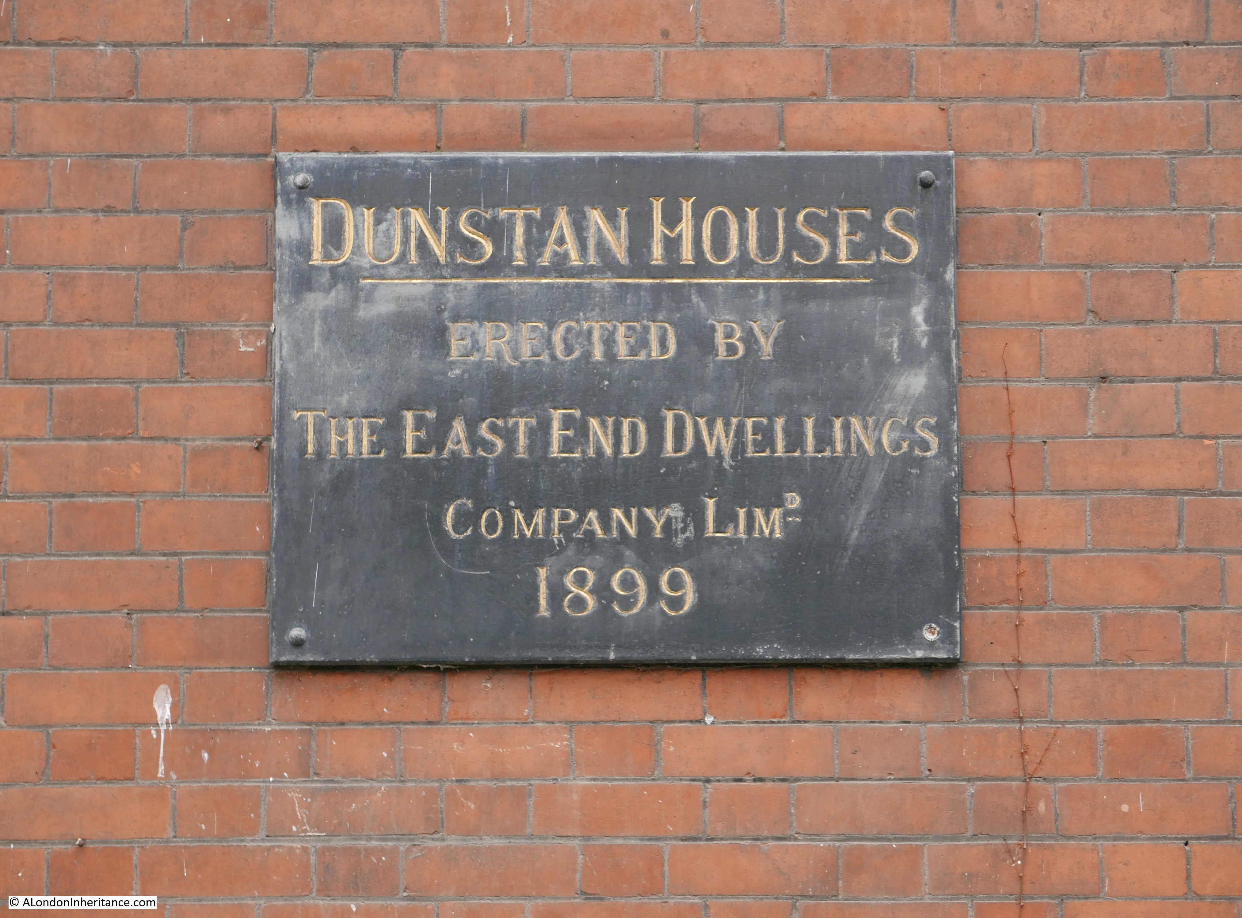
The corner of Stepney Green and Cressy Place is occupied by Dunstan Houses, built by the East End Dwellings Company Ltd in 1899:

Stepney Green

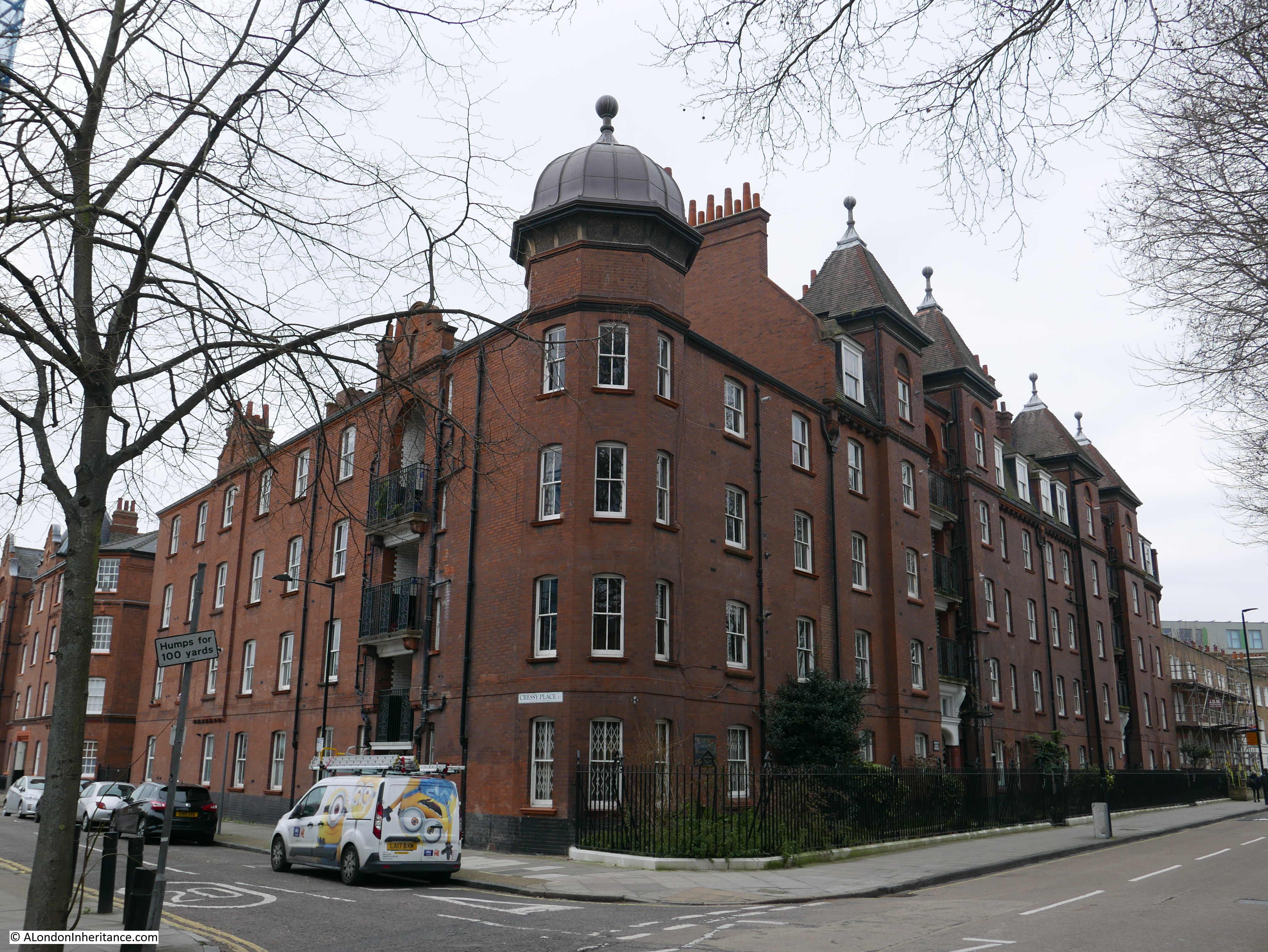
The East End Dwellings Company was formed in the early 1880s by the vicar of St. Jude’s, Whitechapel, the Reverend Samuel Augustus Barnett. The intention of the Company was to provide housing for the poor, including those who other philanthropic housing companies often avoided, such as casual, day labourers.

Stepney Green

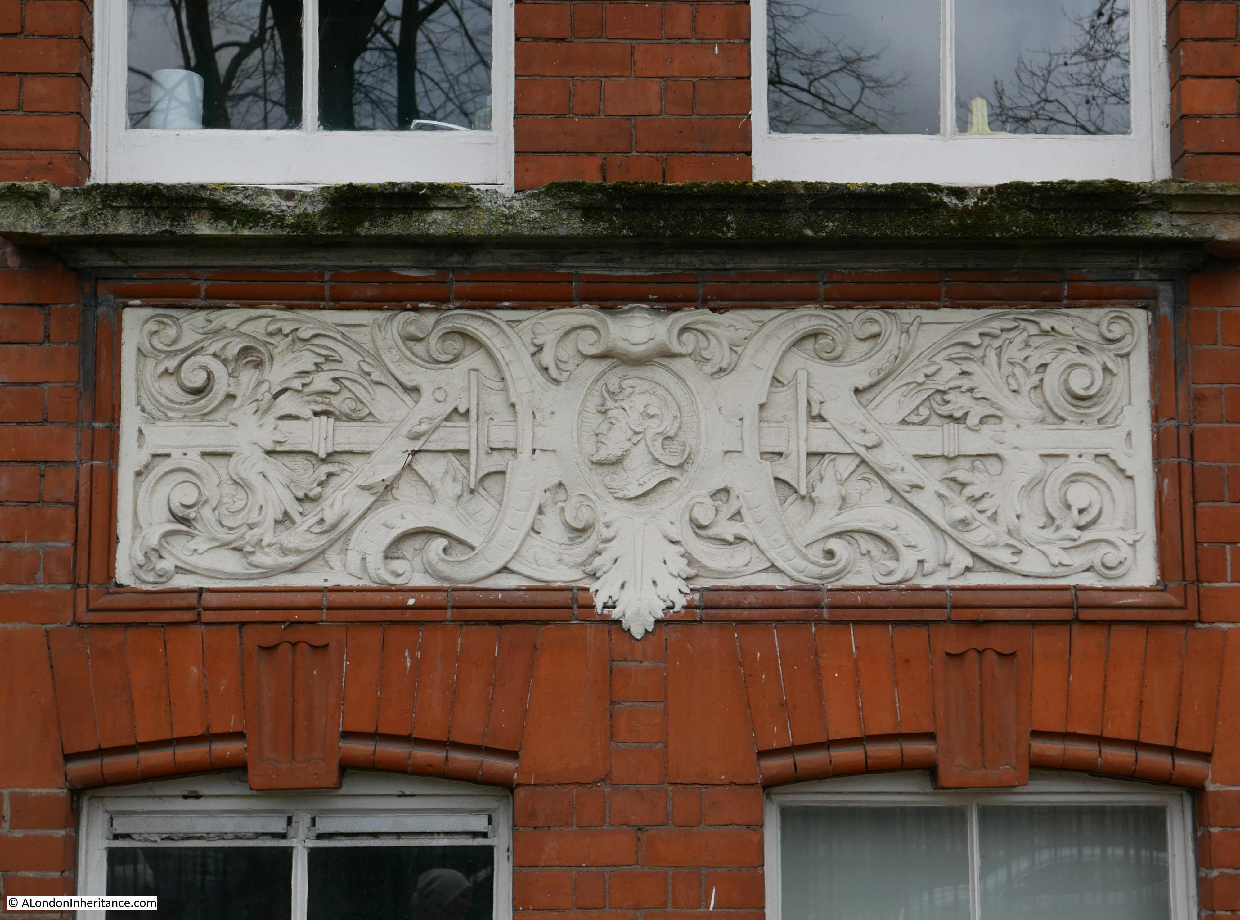
Another of the large housing developments by late Victorian philanthropic companies can be found towards the southern end of Stepney Green.

Stepney Green Court was built by the Four Per Cent Industrial Dwellings Company. The name of the company came from the plan that a four per cent return could be made on the investment needed to construct good housing which could be provided at an affordable rent.

Stepney Green Court was built in 1895.

Stepney Green

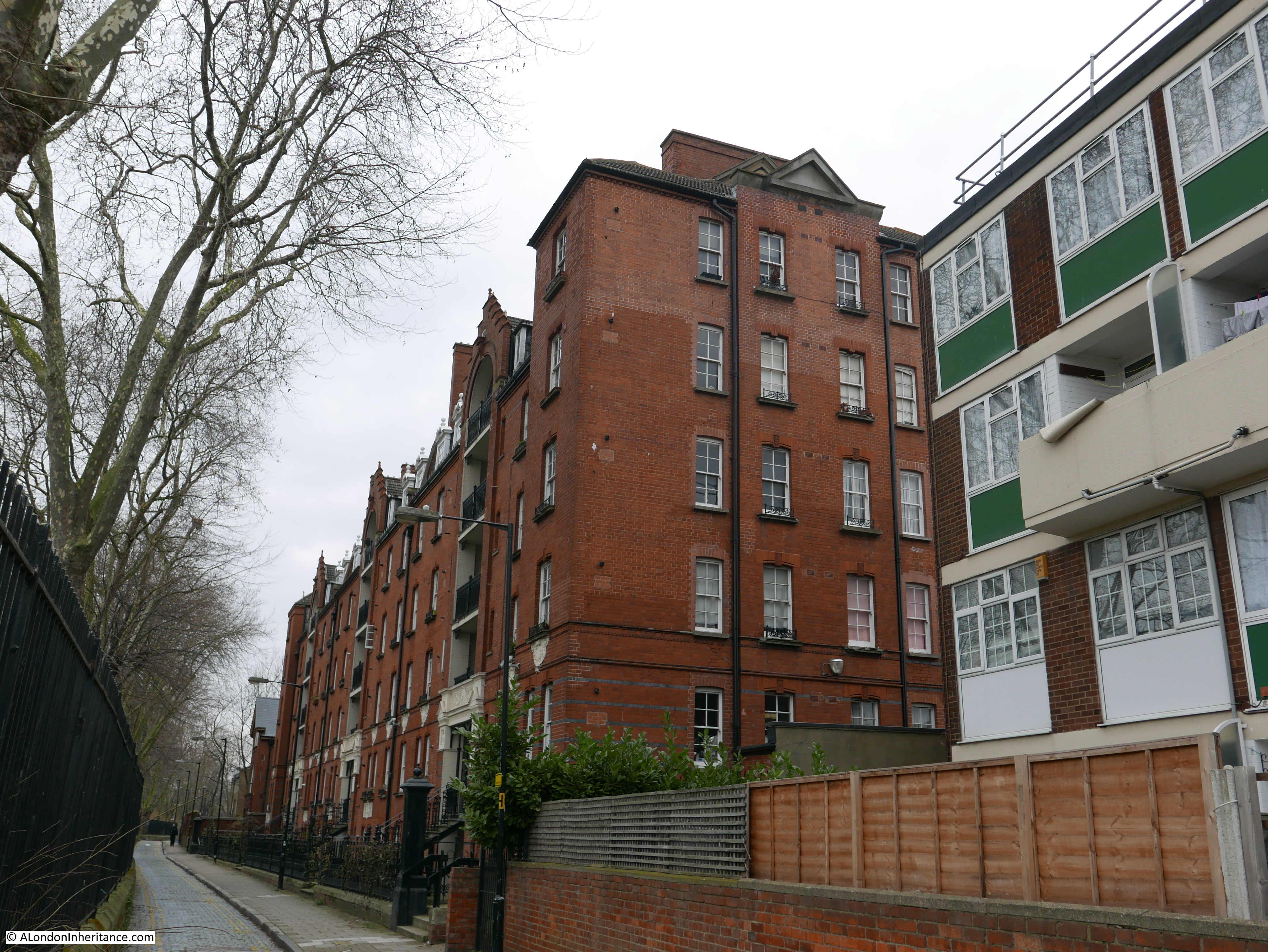
The building features some very ornate decoration:

Stepney Green

Towards the end of Stepney Green, where the central gardens and eastern side road have ended, is the remains of an interesting building.

On a small corner of the main Stepney Crossrail construction site are these brick walls and ornate entrance:

Stepney Green

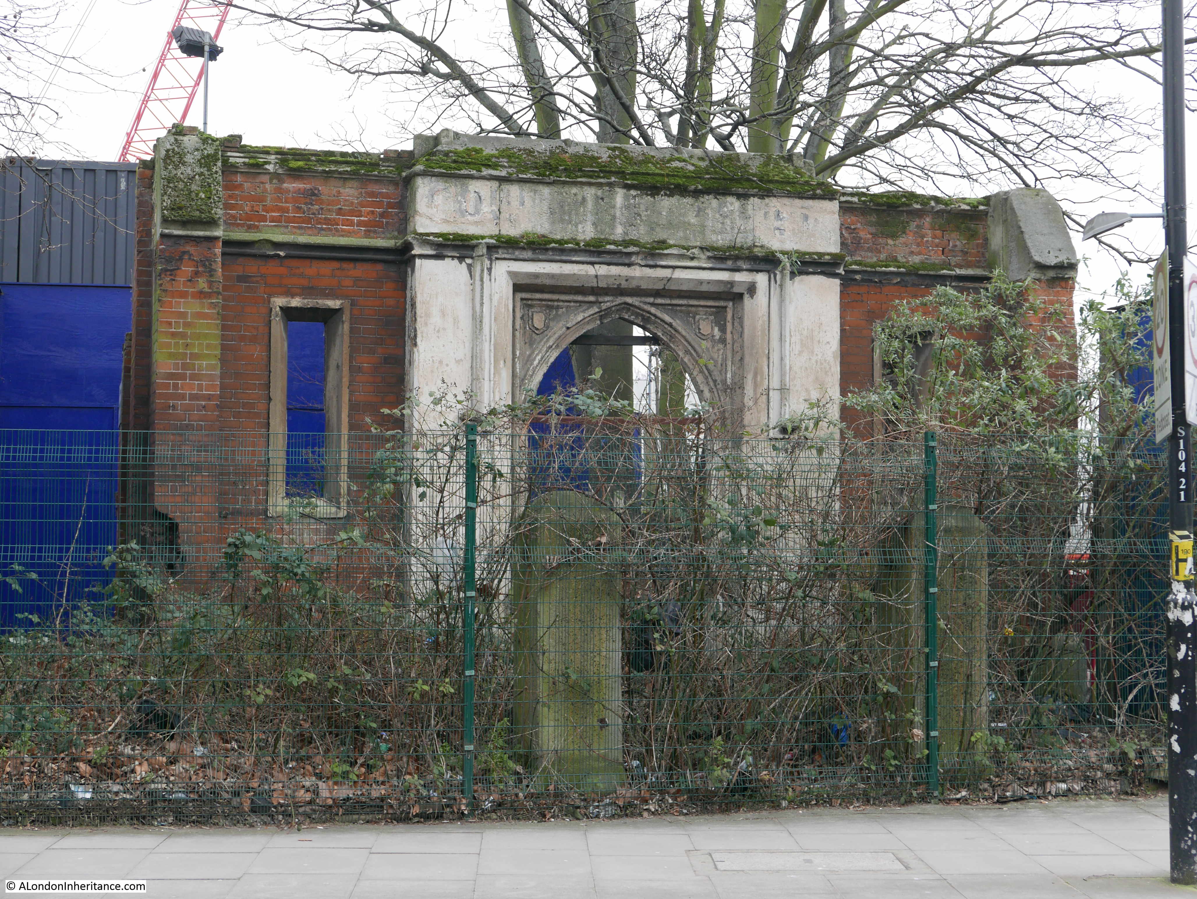
These are the remains of a Baptist Chapel. The Crossrail Architectural and Historical Appraisal identifies the walls and door as the remains of a Baptist Chapel, possibly built around 1811.

The LMA Collage archive has a photo of the area showing that the remains of the Baptist Chapel were in a poor state in 1969.

Stepney Green

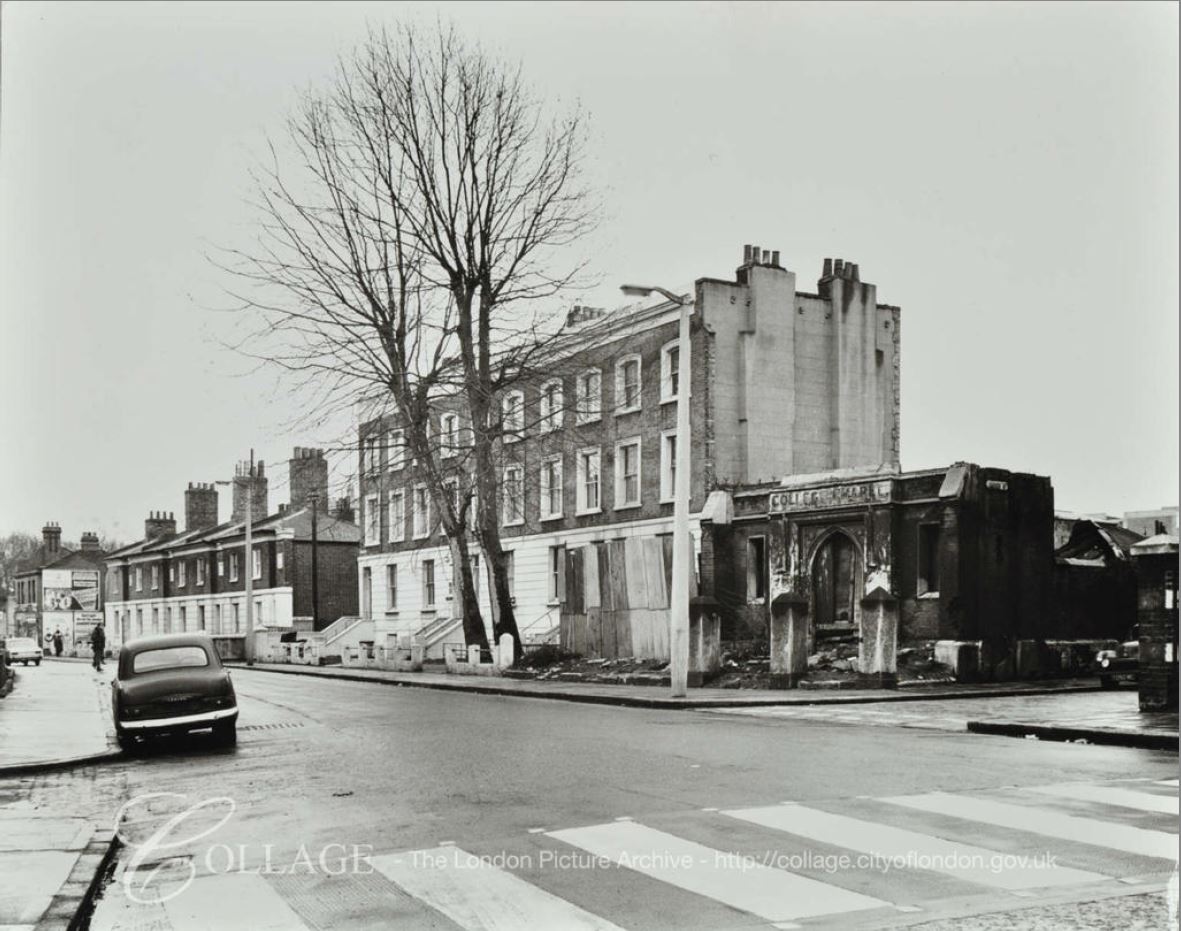
Image credit: London Metropolitan Archives, City of London: catalogue ref: SC_PHL_01_399_69_3379

All the buildings on the left have been demolished and the whole area is now a Crossrail construction site.

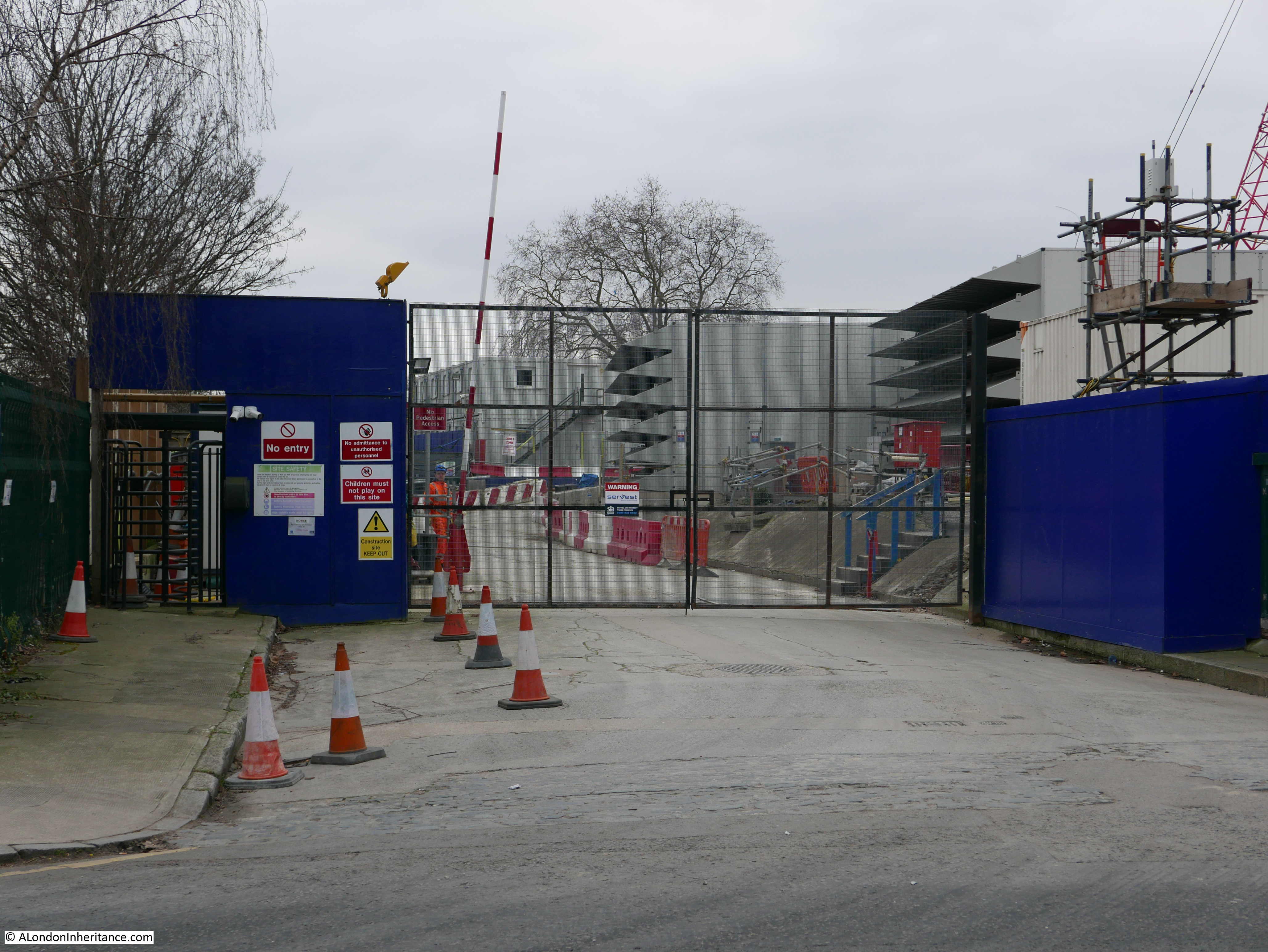
Entrance to the construction site:

Stepney Green

With the exception of the “mutilated early 18th century group” in Redmans Road the buildings listed in 1973 have survived well. The houses along Mile End Road face onto a very busy road  into the City, however turn off Mile End Road into Stepney Green and you can find one of those historic landscapes that London conceals so well.

It will be interesting to see what happens to the remains of the Baptist Chapel and the construction site, once work is completed – hopefully something that blends in with the area rather than bland apartment buildings that can be found anywhere across the city.

A the end of Stepney Green is the large churchyard and church of St. Dunstan and All Saints.

alondoninheritance.com

Blake Hall Central Line Station And Greensted Church

Blake Hall Central Line Station and Greensted Church are a rather strange combination of subjects for a single post, however I hope the reason for combining these locations becomes clear.

Blake Hall Central Line Station

If you look at the following extract from a 1963 London Underground map, you can see the red of the Central Line extending at the top right corner from Epping, through North Weald and Blake Hall to Ongar.

This route out to rural Essex did not start as the Central Line. Built as a single track extension from Loughton to Ongar by the Eastern Counties Railway in 1865. This extension provided a direct route from Ongar, through Epping and Loughton, and then to central London, with fourteen trains a day making the full journey out to Ongar. The name of Blake Hall is after a country house with the same name, and as evidence of the very rural nature of the station’s location, the Blake Hall house is well over a mile away from the station. There appears to have been very little justification for a station at Blake Hall, however it may have been a requirement of the Blake Hall land owner, and a small goods yard for the distribution of coal and the collection of agricultural produce for delivery from the surrounding farms to the centre of London, probably also supported the provision of a station.

The extension of the Central Line, which had been delayed by the war, reached Loughton in 1948, with the original steam trains then continuing from Loughton on to Ongar. The route from Loughton to Epping was electrified in 1949, extending the Central Line further, and rather than leave the short route from Epping to Ongar under separate control, it was transferred to the London Transport Executive, but continuing to run steam trains.

In the 1950s, the line between Epping and Ongar was upgraded with a limited form of electrification allowing electric passenger trains to run, however goods trains continued to be powered by steam.

Due to its rural location, Blake Hall was the least used station on the London Underground network. The goods yard was closed in 1966 as the transport of goods moved from rail to road, and Sunday passenger services also ended in the same year.

Blake Hall continued as a stop on the Ongar extension of the Central Line, but was never going to attract the numbers of passengers which could justify keeping the station open.  Closure of the station was announced in 1981 and at the end of the October 1981 the last Central Line train stopped at Blake Hall and the station was closed on the 31st October 1981.

In August 1981 I took a trip out to Blake Hall to take a few photos of the station before closure, and last weekend I made another visit to see how the station had changed in the intervening 37 years.

At the Ongar end of Blake Hall station, there is a road bridge taking Blake Hall Road over the railway track. The bridge provides an excellent viewing point to see the station building, platform and track. This was my view of Blake Hall station in 1981:

Greensted Church

The same view in May 2018 (although at a slightly different angle as I had to move to a different point on the bridge as tree growth has completely obscured the view from the original position).

Greensted Church

The station buildings are now a private house. The platform is not the original platform. The original platform was demolished soon after closure, however the current platform was built in 2013 by the owner of the old station buildings. The new platform is much shorter in length than the original.

Another of my 1981 photos of Blake Hall station. I could not repeat this view today as trees have grown to completely obscure this view.

Greensted Church

In 1981 I also took some photos of the station entrance:

Greensted Church

Another view of the station entrance showing London Transport posters, advertising season tickets, and transport options to get to the Royal Tournament at Earls Court and Heathrow Airport.

Greensted Church

The old station building has been converted to a private home and the station approach road from Blake Hall Road is blocked by gates, so I could not get any photos of what the original station entrance looks like today.

This was the view in 1981 from the other side of the road bridge showing the track heading towards Ongar:

Greensted Church

The photo below shows the same view today. Note the additional rails in the above 1981 photo which provided the electrical supply to the trains.

Greensted Church

Although Blake Hall Station closed in 1981, the Epping to Ongar extension of the Central Line continued in operation until the 30th September 1994 when the line closed. Continuing losses and the lack of any future development in the area that would boost passenger numbers could not justify keeping the line in operation.

Soon after closure the line was purchased by a private company, with the intention of restarting train operation, however the failure to launch passenger trains led to the formation of the Epping Ongar Railway Volunteer Society who worked with the owner of the track and stations to restore the line between Ongar and North Weald to a point where diesel and steam trains could start running.

The Epping Ongar Railway Volunteer Society now run a weekend service on the line during the spring and summer months, and quite by chance whilst I was taking the photo of the station from the bridge, I could hear the unmistakable sound of a steam train in the distance, and a few minutes later I was treated to the sight of a steam train running again alongside Blake Hall Station.

Greensted Church

Heading towards Ongar:

Greensted Church

I did take photos in the 1980s of all the other stations between Epping and Ongar and the Central Line trains on this short extension, however I have only found the Blake Hall negatives – the challenges with a maximum of 36 photos on a single cassette of film. Hopefully I will find and scan my film of the rest of this small bit of the Central Line in rural Essex.

Full details of the train services now running between Ongar and North Weald can be found on the website of the Epping Ongar Railway.

The following map extract from OpenStreetMap shows the location of Blake Hall station (the orange circle) and how remote the station was from any major settlement. Blake Hall, the source of the name of the station is shown at the location of the red circle – it is some distance away. The route of the railway can be seen as the green line running left to right, to Chipping Ongar.

Greensted Church

The nearest village to the station is Greensted, and this is the location of my next stop, marked by the blue circle:

Greensted Church

Greensted Church is about one mile from Blake Hall station. When scanning my father’s photographs there were a few photos of the church that he took in 1953. There are no other local photos on the same strips of negatives, so I have no idea why he was here, did he travel out by the Central Line or on his bike.

Greensted Church is rather special, it is the only wooden church to have survived from before the Norman conquest, with the wooden walls of the nave dating from around 1060 – the oldest wooden Church in the world.

This is my father’s photo of the church in 1953:

Greensted Church

My photo from May 2018 is shown below. Greensted Church is identical in the two photos, as you would expect as the 65 years between the two photos is nothing compared to the 958 years that the nave of the church has been here in Greensted.

Greensted Church

There may have been a church on the site as early as the 6th or 7th century, however the Greensted Church of today developed in stages over the years.

In the photo above, the original Saxon nave of the church is the section to the right of the tower. The wooden logs forming the main part of the wall have been dated to around 1060. The logs were shortened and a lower brick wall added when decay in the logs was found during restoration of the church in 1848. The porch and windows in the roof are Victorian and the tiled roof is Tudor.

The chancel to the right of the nave, behind the tree has Norman origins, but is now mainly Tudor side wall and Victorian end wall.

In the photo below, the Tudor door, window and brickwork can be seen, with the remains of Norman flint walls on either side of the lower part of the wall. There are also, possibly, a couple of Roman tiles at the top of the flint on the left.

Greensted Church

There is no fixed date for the tower, it may be 17th century, or possibly earlier. One of the bells in the tower has the date 1618.

One of my father’s 1953 photos show the original logs of the side walls rather well:

Greensted Church

To construct the nave of the church, 54 oak logs were split lengthwise with the flat side on the interior of the church. Tongues of wood fixed into grooves running down the side of the logs were used to hold them together and seal gaps between adjacent logs.

The same view today:

Greensted Church

A view of the southern wall of the nave with the wooden logs. originally these would have extended into the ground and met a thatched roof at the top.

Greensted Church

The fenced grave in the above photo is thought to be a 12th century Crusaders grave.

The following photos show the interior of Greensted Church. The interior was much darker than the photos suggest. I was using a handheld camera so to avoid camera shake, I increased the ISO setting which has the effect of brightening the scene.

The following photo is from just inside the entrance porch, looking along the nave to the chancel at the end of the church. The flat side of the log walls can be seen running the length of the nave.

Greensted Church

The chancel:

Greensted Church

The view down the nave from the edge of the chancel gives a good idea of the wooden nave. Prior to the Tudor roof and Victorian windows, the nave would have been much darker,

Greensted Church

On the northern side of the church interior can be seen this strange, small piece of glass covering a hole through one of the logs:

Greensted Church

This is the other side of the hole – looking in from the outside of the church with one of the roof windows on the southern side of the church visible.

Greensted Church

The small window has been called a lepers squint – a small window in the side of a medieval church through which lepers could watch a church service, however this is very unlikely given the size of the hole and the very limited view of the church that it provides. It may well have been just a small window, or possibly a hole through which holy water could have been passed to a small font placed on the shelf cut into the wooden log. The shape of the hole in the log and the flat shelf makes this later use more likely.

The view from the rear of the graveyard of Greensted Church over the Essex countryside:

Greensted Church

The old Blake Hall Central Line Station is only a mile from Greensted Church so the trip out to Essex provided the perfect opportunity to visit the site of one of my earlier photos when the Central Line was still running out to this part of rural Essex, and the location of one of my father’s earlier photos. Two very different locations, but they are in their own way, fascinating landmarks on the Essex landscape.

alondoninheritance.com

Kenwood House, Hampstead Heath

Last Monday, the early May public holiday, I headed to Hampstead Heath to visit Kenwood House.

I probably chose the wrong day to visit as it turned out to be the hottest early May holiday for decades, but the weather was fantastic, there was not a cloud in the sky, and along with what seemed like hundreds of other people, I headed along Hampstead Lane to enter the heath at  the rear of Kenwood House.

The reason for the visit was to take a couple of photos of Kenwood House as my father had done some years before.

Kenwood House sits on flat ground at the top of a long grass slope down to some rather large ‘ponds’. The land in front of the house has a short, steep fall, then a smoother fall down to the water, thereby reducing the height of the land in front of the house compared to the sides.

This has the effect of leaving arms of higher ground branching out from either side of the house and running either side of the central grassy slope. Standing on this higher ground provides a superb view of the house, which was obviously the intention of the landscape design.

It is from the higher ground to the east of the house that my father took the following photo in 1953:

Kenwood House

I could not take a photo from the same position as in the intervening 65 years there has been considerable tree growth, but I did find a gap a short distance further along to take the following photo:

Kenwood House

The first Kenwood House was built in the early 17th century by John Bill, a printer to King James 1st, who purchased the land in 1616. For the rest of the 17th century and early 18th century, the house would be brought and sold, modified and extended.

In tracing the name Kenwood, I have found several sources that give the original name as Caen Wood, including the use of this name during the 19th century. In Old and New London, Edward Walford writes:

“Pursuing our course along the Hampstead road, we reach the principal entrance to the estate of Caen (or Ken) Wood, the seat of the Earl of Mansfield. Though generally regarded as part and parcel of Hampstead, the estate lies just within the boundary of the parish of St. Pancras, and was part of the manor of Cantelows. It is said by antiquaries to form part of the remains of the ancient forest of Middlesex. Lysons is of the opion that the wood and the neighbouring hamlet of Kentish Town (anciently Kentestoune) were both named after some very remote possessor. There was, he says, a Dean of St. Paul’s named Reginald de Kentewode, and the alteration from Kentwode to Kenwood is by no means unlikely to happen. Mr Howitt looks for the origin of the syllable in the work ‘Ken’, a view. As, however, we have stated in previous chapters, the word Caen may, perhaps, be an equivalent to ‘Kaen’ or Ken, which lies at the root of Kentish Town, Kensington etc.”

In 1746 the house appears on John Rocque’s map, with the name being two separate words as Ken Wood House, with the name Ken Wood also being found across the wooded area running parallel to the ponds. Whether Ken or Caen the house takes the name from the woods. The house can be seen just above the centre of the following map extract. In 1746 the area in front of the house down to Hampstead Ponds was covered by formal gardens.

Kenwood House

The transformation of the house and grounds to the view we see commenced in 1754 when William Murray, the 1st Earl of Mansfield purchased Kenwood House.

Robert Adam was commissioned to remodel the interior of the house. This included a new northern entrance to the house at the end of the drive from Hampstead Lane, along with interior works.

Adam’s original designs can still be found in the interior of Kenwood House. His work included the build of a ‘Great Room’ or Library. This is a section through the end of the library:

Kenwood House

Which can still be seen today at the end of the Great Room:

Kenwood House

During the 1st Earl of Mansfield’s time, it seems that the formal gardens disappeared, and the land at the rear of the house was as rural as the rest of the heath. In the following view from 1781, drawn from a very similar viewpoint as my father’s photo, we can see animals being grazed on the land in front of Kenwood House. (Print ©Trustees of the British Museum)

Kenwood House

In 1793 Mansfield’s nephew, David Murray became the 2nd Earl and commissioned the Landscape Gardener Humphrey Repton to advise on changes to the land surrounding the house.  (Humphrey Repton was also responsible for the design of the gardens at the centre of Russell Square).

One of Repton’s recommendations was to move Hampstead Lane further away from the house to provide more privacy and to allow a longer, more impressive drive to be built between the house and road (you could do this sort of thing if you were an Earl).

If you compare the following two maps, the first being detail from Rocque’s 1746 map and the second being the 1940 Bartholomew Atlas, you can see that Hampstead Lane now curves much further away from the house:

Kenwood House

Kenwood House

With reference to the earlier discussion of the source of the name as Caen Wood, in the above 1940 map there is a Caen Wood Towers to the right of the map. This is a large Victorian house, now known as Athlone House.

Repton’s proposals can also be seen in the open area at the rear of the house as the land drops down to the lake. Repton’s proposals included planting strategically placed trees to hide the buildings at Kentish Town and also to create the impression that the valley sweeping down from Kenwood House leads directly towards the City of London.

In 1804, the book “Selected Views in London and its Environs” described the house and gardens using the name Caen:

“Caen Wood, the beautiful seat of the Earl of Mansfield, is situated on a fine eminence between Hampstead and Highgate, and its extensive grounds contain no small degree to enrich the neighbouring scenery. These, with the wood which gives name to them, contain about forty acres, and are laid out with great taste. On the right of the garden front of the house (which is a very noble mansion) is a hanging wood of tall spreading trees, mostly beeches; and on the left the rising hills are planted with trees that produce a pleasing effect. These with a sweet shrubbery immediately before the front, and a serpentine piece of water, render the whole a very enlivening scene. The enclosed fields adjoining to the pleasure-grounds contain about thirty acres more. Hornsey great woods, held by the Earl of Mansfield under the Bishop of London, join the estate on the north, and have lately been added to the enclosure.”

The reference to the ‘pleasure-grounds’ refers to the large, grassed area at the rear of the house which slopes down to the ponds.

The following view from 1792 is titled “The Earl of Mansfield’s at Caen Wood near Hampstead” and is another reference to the name Caen Wood, and is also a view from Hampstead Lane and shows why Mansfield agreed with Repton’s advice to move the lane further north to hide the house from the road.  (Print ©Trustees of the British Museum)

Kenwood House

My father had photographed Kenwood House a few years earlier to the photo at the start of this post. The following photo was taken in 1947 from the western side of the “pleasure-grounds”, looking across to the house.

Kenwood House

I tried to find the same location, however the tree growth on the western side of the house has been considerable and the following photo is my best approximation of the same viewpoint. Although the majority of the house is hidden behind the trees, the fencing that runs along the middle of both photos provides a good reference point.

Kenwood House

My father’s photo taken in 1947 was just after the war, when the house was occupied by military servicemen. The connection with the Mansfield family had ended a couple of decades earlier when the 6th Earl of Mansfield had sold of the contents of the house in 1922 and in 1925 Kenwood House was purchased by Edward Cecil Guinness, the 1st Earl of Iveagh. Edward Guinness had a large art collection and in 1929 the Iveagh Bequest stipulated that access to the house for the public should be free of charge, and the art collection maintained in the house.

These conditions still hold today with the house having passed through the London County Council, then to English Heritage who run the house today, with access free of charge and Iveagh’s art collection (with a number of additions) still being on display.

The view from the rear of Kenwood House looking down towards the ‘ponds’ and Ken Wood:

Kenwood House

Whilst the view from the rear of the house is mainly obscured by trees, a short distance to the east of the house there is a viewpoint where a panorama of the City across to the BT Tower can be seen shimmering in the haze.

The interior o the house has been carefully restored and the Iveagh art collection is on display in many of the rooms.

Kenwood House

There is an English Heritage Volunteer in each of the rooms, who, without exception, had an in-depth knowledge the house.

It was also much cooler inside the house, compared to outside, although talking to the volunteers. the view was that it was a very cold building to work in during the winter.

Kenwood House

We walked back to Hampstead Lane by a different path, and spotted a couple of boundary markers by the side of the path. The stone marker was very faded but I think may have been a St. Pancras boundary marker. The metal marker is for Hornsey Parish, and is numbered and includes the names of a number of parish officials.

Kenwood House

I have seen a number of these Hornsey Parish boundary markers before, but not this one – I should really have been keeping a list of numbers.

Hampstead Lane was busy with parked cars occupying every available space either side of the road and still plenty of people walking to the heath to enjoy the rather unusual weather for a public holiday. We left Caen Wood, or Ken Wood via Mansfield’s rerouted Hampstead Lane to walk back to Highgate for some much-needed refreshment.

alondoninheritance.com

Bethnal Green’s Ordeal

At the end of the last war there were a number of booklets published by different Government Departments – the Metropolitan Police, the Post Office, British Railways and some of the London Boroughs. My father seems to have purchased a number of these as they were published, and this week I want to feature one of the booklets published in 1946 by a London Borough, with the title “Bethnal Green’s Ordeal”.

Bethnal Green's Ordeal

The booklet was published by the Council of the Metropolitan Borough of Bethnal Green and is a very slim, fifteen page account of Bethnal Green during the war. Written by George F. Vale, who had previously written a pre-war book about Bethnal Green, so I assume was a local resident. The booklet covers 1939 to 1945, but starts with preparations in 1938.

The booklet also includes a fold-out map showing the Borough of Bethnal Green with the location of major air raid incidents marked in red. Each dot represents a high explosive bomb, a parachute mine, flying bomb (V1) and long-range rocket (V2), but excludes incendiary bombs. (Click on the map to open a larger version)

Bethnal Green's Ordeal

Note in the bottom right hand corner the impact of the war on the population of Bethnal Green, with a population of 94,560 in 1939 falling almost by half to 50,641 in 1945.

Starting in 1938, we discover that 66,828 gas masks were issued to the residents of Bethnal Green on Wednesday and Thursday the 28th and 29th of September. This was followed by a period of comparative calm, until the war came to Bethnal Green with a vengance in August 1940:

“On Saturday night and in the early hours of Sunday morning, the 24th and 25th August 1940, the storm broke and we in Bethnal Green had some ideas of the dangers that lay ahead. Our baptism of fire consisted of several high explosive bombs each weighing 50 kilograms which were scattered over a fairly large area of the borough, extending almost in a line from The Queen Elizabeth Hospital in Hackney Road to Lessada Street, east of the Regent’s Canal in Roman Road.”

The raids continued through September between Saturday 7th September and the 24th of September 1940,  when 95 high explosive bombs, two parachute mines and literally thousands of incendiary bombs fell on Bethnal Green.

“No part of the district escaped this terrible holocaust. Bethnal Green Hospital, The Queen Elizabeth Hospital, the Central Library, Columbia market, the Power Station in Bethnal Green Road, the Hadrian Estate, the Burnham Estate, the Vaughan Estate and the Bethnal Green Estate were all hit, whilst the parish church of St. Matthew’s and St. Paul’s Church in Gosset Street were totally destroyed. On that night too, Columbia Market, which contained a very large public shelter was the scene of a very distressing calamity when a 50 kilogram bomb, by a million to one chance, entered the shelter by means of a ventilating shaft and caused extensive casualties to those sheltering.”

Thirty eight people were killed by the bomb on the Columbia Market shelter.

The booklet provides details that help understand Bethnal Green at the time. For example, there were still a number of stables across the Borough, and one of these, the Great Eastern Stables in Hare Marsh was hit and several horses were trapped and needed to be put down.

The composition of road surfaces amplified the impact of incendiary bombs as many were still covered by wooden blocks: “On the night of December 11th 1940, more fires were gaining hold on Bethnal Green than ever before. The area at the west end of Bethnal Green Road was a sea of flames, the wooden blocks which surfaced the road themselves catching fire and burning through almost to the concrete underneath.”

The booklet has a page covering the disaster at the Bethnal Green Underground Station. This was being used as a shelter and was one of the largest in London capable of accomodating 10,000 people.

The shelter was opened very rapidly in 1940 at the persistence of Herbert Morrison, the Minister of Home Security. The Sunday Mirror on the 6th October 1940 reported:

“The Man Who Gets Things Done –  Herbert Morrison, new Minister of Home Security, beloved by Londoners, is the man who gets things done.

Standing on the platform of the uncompleted Bethnal Green Underground station, 65ft below ground yesterday, he asked L.P.T.B and local council officials why it was not being used as a shelter.

He was told there were certain technical difficulties. ‘Is there anything to stop the people using it right away?’ he queried brusquely. He was told there were not. 

‘Then open it tonight’ said Herbert Morrison.

That is why several thousand men, women and children of the East End who last night found sanctuary in the station and tunnels – part of the new Tube extension not yet in use – bless the name of Britain’s ‘livest’ Cabinet Minister.

A.A. Shells were bursting in the sky during an alert when Mr Morrison and Admiral Sir Edward Evans arrived to inspect the station. Mr Morrison, after chatting with the experts, reached his decision about the opening of the station as a shelter in five minutes,

Council officials told him that everything was ready to make the shelter comfortable. 

Someone said the pit in the concrete track should be boarded over. ‘Let them sleep on the track’ replied Morrison.

Mr Morrison said in an interview: ‘You can tell the people we are going to utilise every inch of shelter we can find and we’re going to do it quickly’

The booklet describes the Bethnal Green Underground shelter:

“It had a sheltering capacity of 10,000; the highest figure reached was 7,000 in 1940-1 and in the summer of 1944 during the flying bomb raids. The Tube played a great part in the life – at night and in times of danger – of a great number of people in Bethnal Green; particularly the old people and mothers with children. It was provided with a canteen, a sick bay with a trained nurse regularly in attendance, a visiting doctor, a concert hall capable of holding 300 people and a complete branch public library consisting of 4,000 volumes.”

The worst civilian disaster of the war happened at Bethnal Green Underground station on the 3rd March 1943. The booklet records:

“On the night of the 3rd March the warning went at 8:17 p.m. and almost immediately hundreds of people were seen to be making for the shelter from all directions. It is estimated that in the first ten minutes after the sirens had sounded 1,500 people were admitted. Everything was normal and although the people were obviously anxious to get under cover there was no undue haste or panic, when suddenly, without any kind of preliminary warning, at 8.27 p.m. a salvo of rockets was discharged from a battery in Victoria Park. The shattering noise created by this operation undoubtedly caused the already anxious people to redouble their efforts to get into the shelter.

Unfortunately the reports of the guns were thought by many to be the sound of exploding bombs. At this critical moment it is said that a women, with a child, or a bundle, or perhaps both in her arms, fell on the stairs. So great was the pressure of the crowds behind her that in the matter of a few seconds there was a solid mass of bodies, piled up five or six deep, against which the people seeking admission and not knowing of the accident, still endeavoured to force an entrance.

On the instructions of the Home Secretary, Mr Herbert Morrison, a full enquiry into the circumstances of the accident was conducted by Mr. Laurence Rivers Dunne, M.C. one of the Magistrates of the Police courts of the Metropolis. The enquiry lasted from the 11th to the 17th March inclusive and in all eighty witnesses were examined. His final conclusions were:

(a) This disaster was caused by a number of people losing their self control at a particular unfortunate place and time.

(b) No forethought in the matter of structural design or practicable police supervision can be any real safeguard against the effects of a loss of self control by a crowd. The surest protection must always be that self control and practical common sense, the display of which has hitherto prevented the people of this country being the victims of countless similar disasters.”

The report appeared to put the blame on the people attempting to enter the shelter and their loss of control.

In reality, the entrance to the stairs down to the shelter were poorly lit, there was no central handrail and insufficient police or wardens to manage access to the shelter.

The Illustrated London News on the 13th March 1943 published an account of the tragedy and published photos of the entrance showing only side handrails and the general poor condition of the entrance.

Bethnal Green's Ordeal

It is easy to imagine how simple it would be for someone to stumble and fall in a crowd, and the impact that would have in such a confined entrance with no safety features.

Bethnal Green's Ordeal

The Illustrated London News report states that there were no bombs and no panic, and makes no mention of the salvo of rockets. An apparent contradiction to the report by Rivers Dunne, and despite the report stating that “No forethought in the matter of structural design ” could have avoided the tragedy, immediately after the tragedy, steps were taken to improve lighting, add handrails and barriers to shelter enhances, perhaps an acknowledgement of the contribution that the lack of these features had to the Bethnal Green tragedy.

173 people of all ages died on the 3rd March 1943 at the entrance to the Bethnal Green Underground shelter.

The entrance today – the woman fell at the bottom of the first flight of stairs:

Bethnal Green's Ordeal

A plaque recording the tragedy above the stairs:

Bethnal Green's Ordeal

A memorial to the disaster was completed in December 2017:

Bethnal Green's Ordeal

The memorial is located by the entrance involved in the disaster and represents the stairs down from the street, with the names of those killed carved into the side of the memorial:

Bethnal Green's Ordeal

There are 173 small conical light shafts cut into the  top of the memorial, and these are clustered closer together as the end wall is approached – representative of the way the tragedy unfolded:

Bethnal Green's Ordeal

The full names and age of those who perished are recorded on the upright support of the memorial. The repetition of the same surname, and the numbers of children involved shows the terrible impact that the tragedy must have had on individual family’s.

Bethnal Green's Ordeal

The memorial is a very fitting reminder of the tragedy at Bethnal Green Underground station in 1943.

Bethnal Green's Ordeal

One final comment on the tragedy comes again from the booklet and highlights the impact that war had on children:

“Some reference must be made to the work performed by the boys at the tragic Tube Shelter disaster. They helped with the injured and saw sights which probably no boy of such tender years has been called upon to experience. One boy was found by the Controller at the mortuary helping to unload the dead as they were brought from the scene of the disaster. The Controller said to him, ‘Don’t you feel somewhat upset by this?’ and the boy answered, ‘Well, Sir, I was sick when I first started, then I got over it, and anyway the job has got to be done.”

The remainder of 1943 and early 1944 was generally quiet in Bethnal Green, however Bethnal Green’s ordeal continued on the 13th June 1944 when a flying bomb fell in Grove Road. A total of twenty V1 flying bombs would fall on Bethnal Green.

These would be followed by the V2 rocket, with the first falling in Lessada Street in November 1944, the second in Parmiter Street in February 1945 and the final rocket just outside the borough boundary in Vallance Road in March 1945.

The booklet illustrates the effort needed by the Council and volunteers to respond to the bombing of Bethnal Green. The Borough Council had to arrange the clearance of 4,550 homes, providing storage space for the furniture from 1,350 and moving the furniture from 2,200 other homes to alternative accommodation.

Those too young to be conscripted into the armed forces were involved in a number of activities. Boys were used for multiple roles, acting as messengers, filling sand bags, installing blast walls at the London Chest Hospital, and it was the Scouts who erected the 5,000 bunks in the Bethnal Green Underground station shelter. Although evacuation of children from the city had started at the beginning of the war, the booklet records that a large number of children had drifted back to their homes and families in Bethnal Green. (This was also my father’s experience, as he only lasted three weeks after evacuation before returning home to the city).

The task of looking after and identification of so many dead civilians was a challenge for a single Borough. Of the 555 civilians killed during the war in Bethnal Green, there were 23 unidentified or unclaimed. These were buried in the communal grave at the City of London Cemetery, Manor Park.

Bethnal Green’s Ordeal also highlights the impact on the population of day to day precautions. For example, the black out came into full force on Friday 1st September 1939 and is recorded as being one of the war time restrictions that was the most difficult to bear. “It was easy to appreciate its importance during actual raids, but the hours of darkness were so many, especially during the long winter nights – many of which were raidless – that at times the depressing effects of the black-out were almost unbearable.” 

The booklet ends with two pages that provide some key statistics, and details of the organisations that developed within the borough to manage the impact of the war.

Bethnal Green's Ordeal

Bethnal Green's Ordeal

The memorial at the entrance to the Underground station is a reminder of the dreadful tragedy of one single event. The booklet is a reminder of the overall impact to one London Borough as summed up by the final paragraph in the booklet::

“Thus ends the story, perhaps rather fragmentary, of what an ordinary typical East End borough endured during the war years. It is hoped that it will serve as a reminder to the present generation and as a record for posterity of Bethnal Green’s Ordeal, 1939 – 1945.”

alondoninheritance.com