Monthly Archives: October 2014

The Faraday Building of Queen Victoria Street

One of the things that makes walking the streets of London so enjoyable is a discovery that not only informs about a building or location, but also tells a whole new story about a period in time and what was changing and important in the life of Londoners at that time.

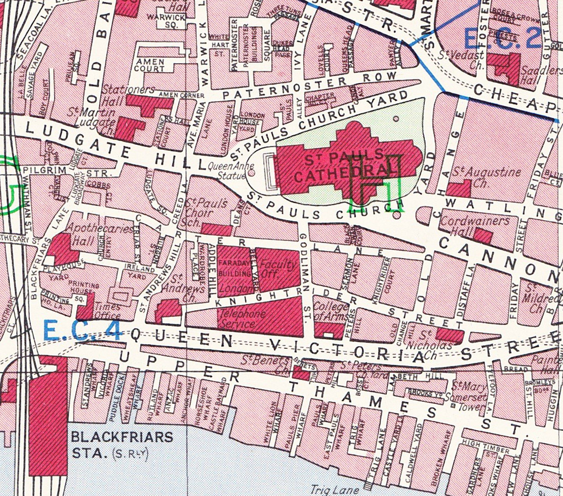
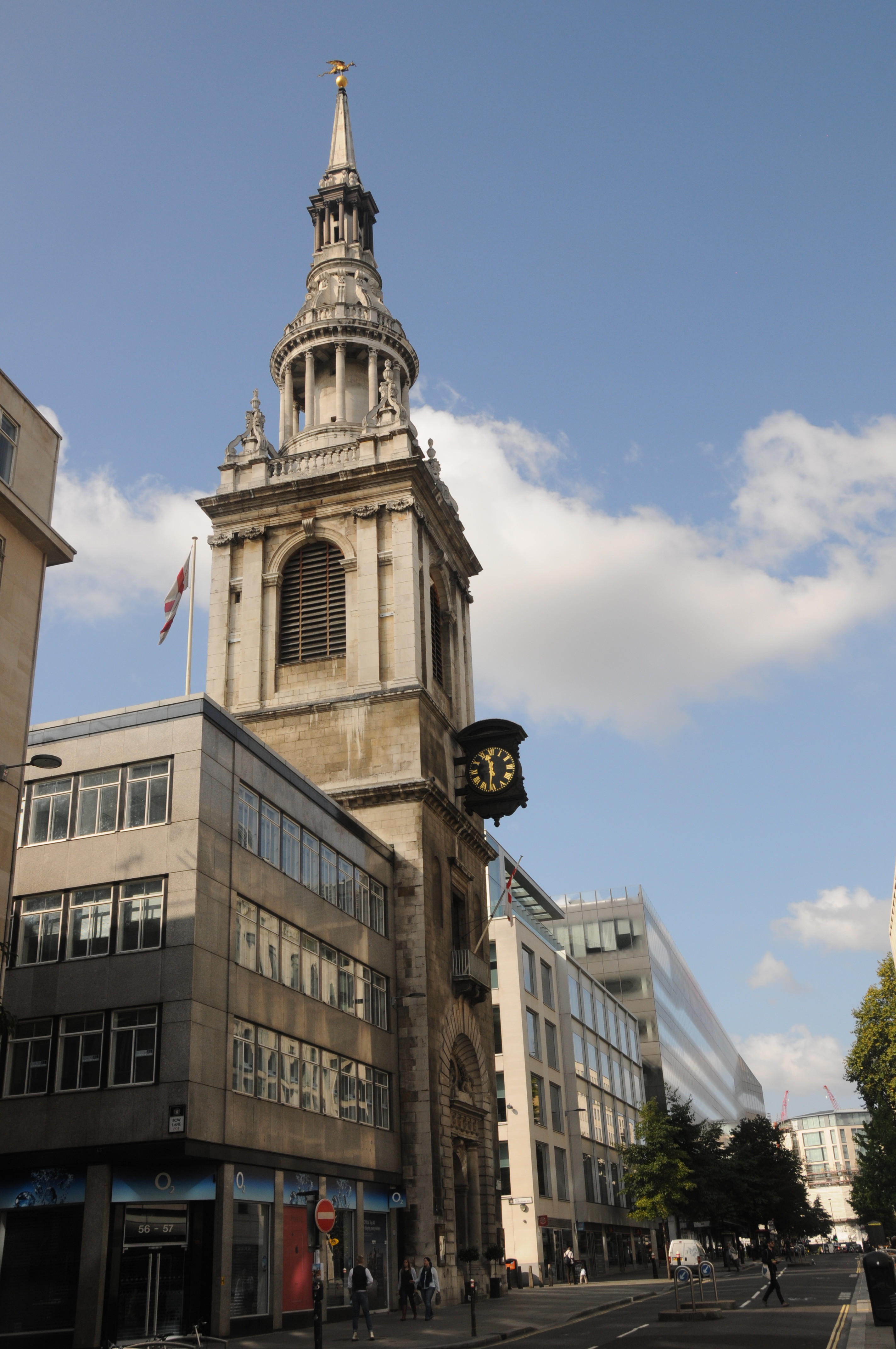
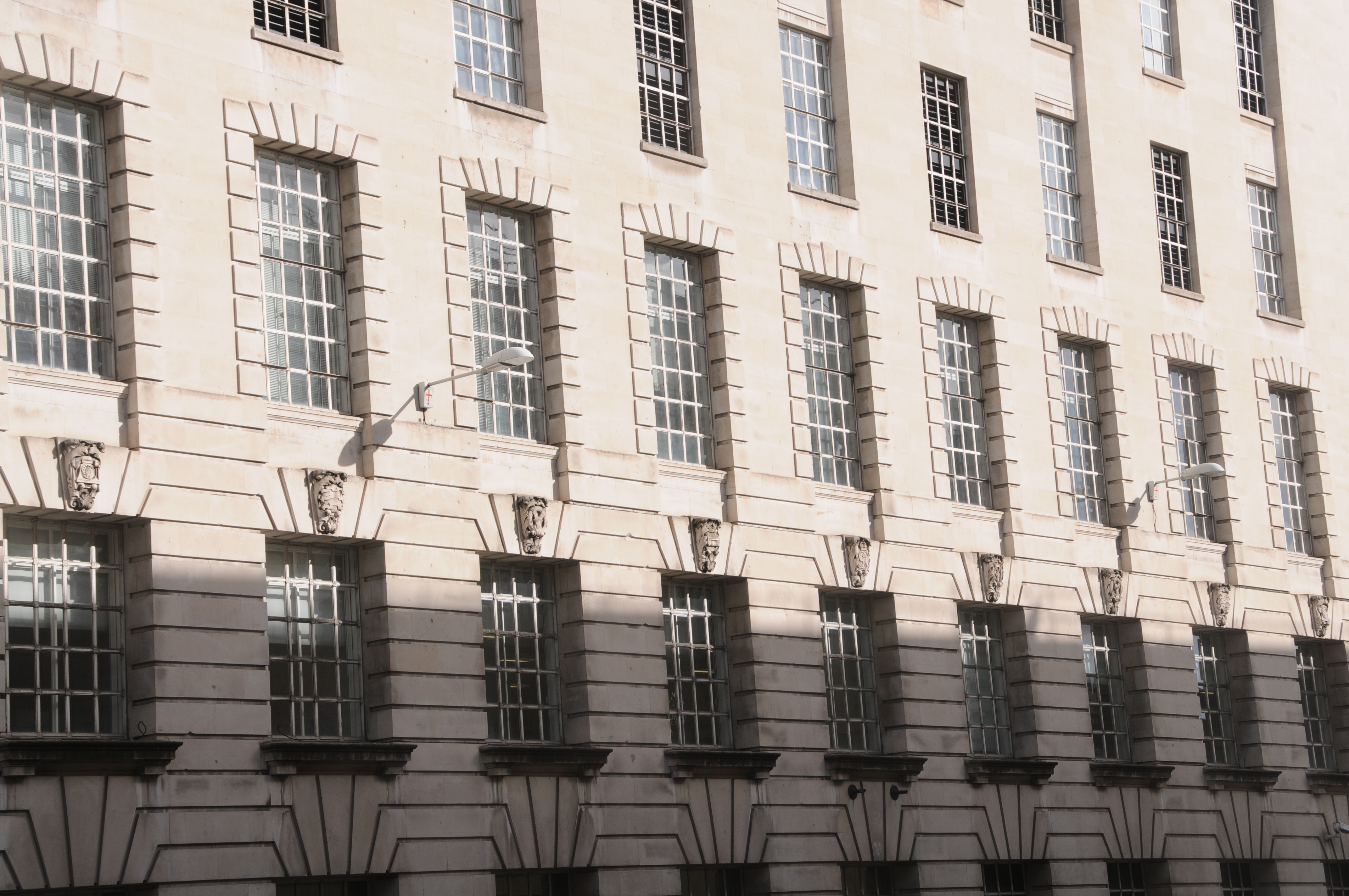
Walk down Queen Victoria Street towards Blackfriars. After passing the church of St. Benet, Paul’s Wharf on your left you will walk past what, at first glance, appears to be a very bland and utilitarian building.

Faraday Building 1

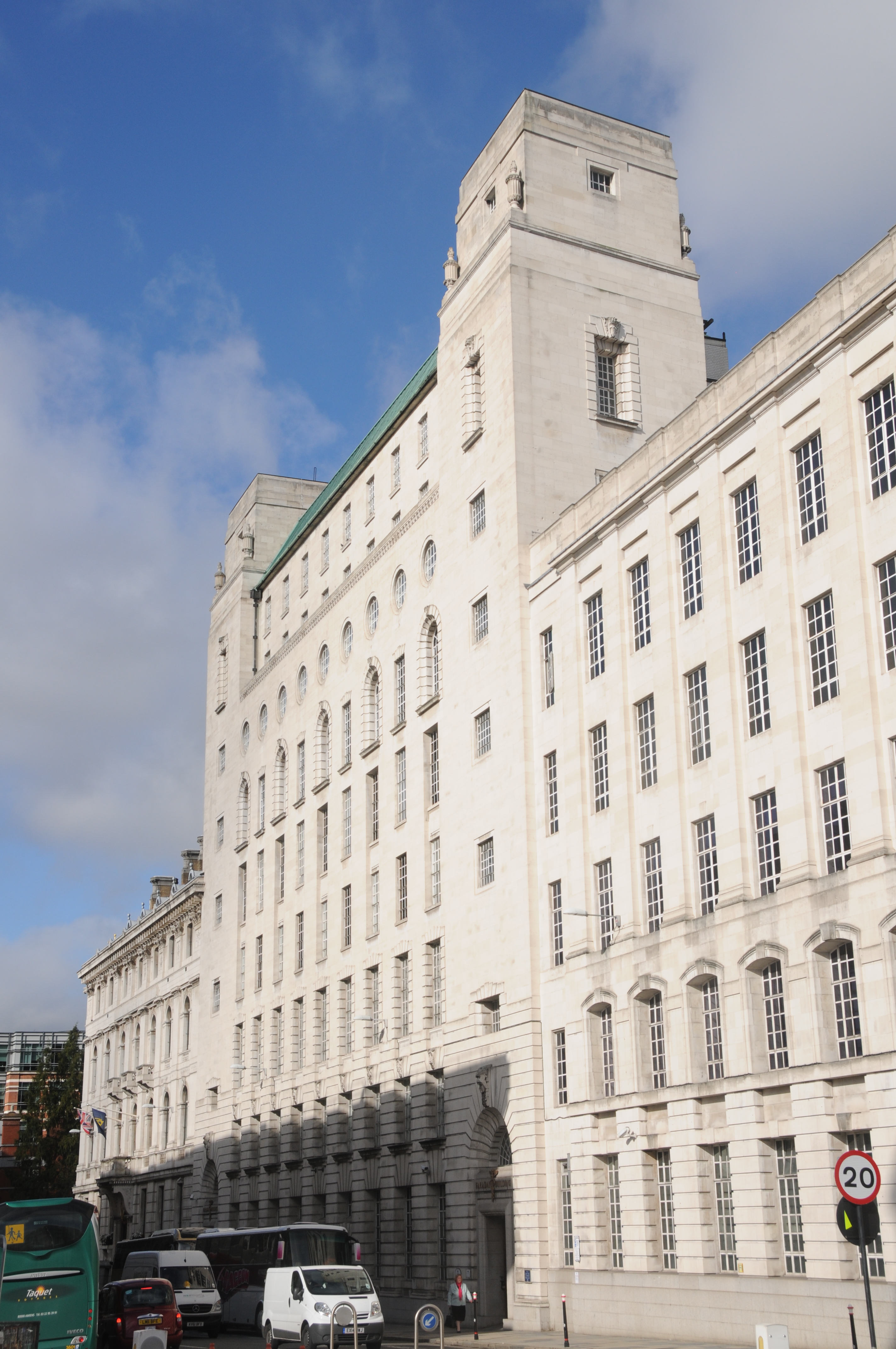
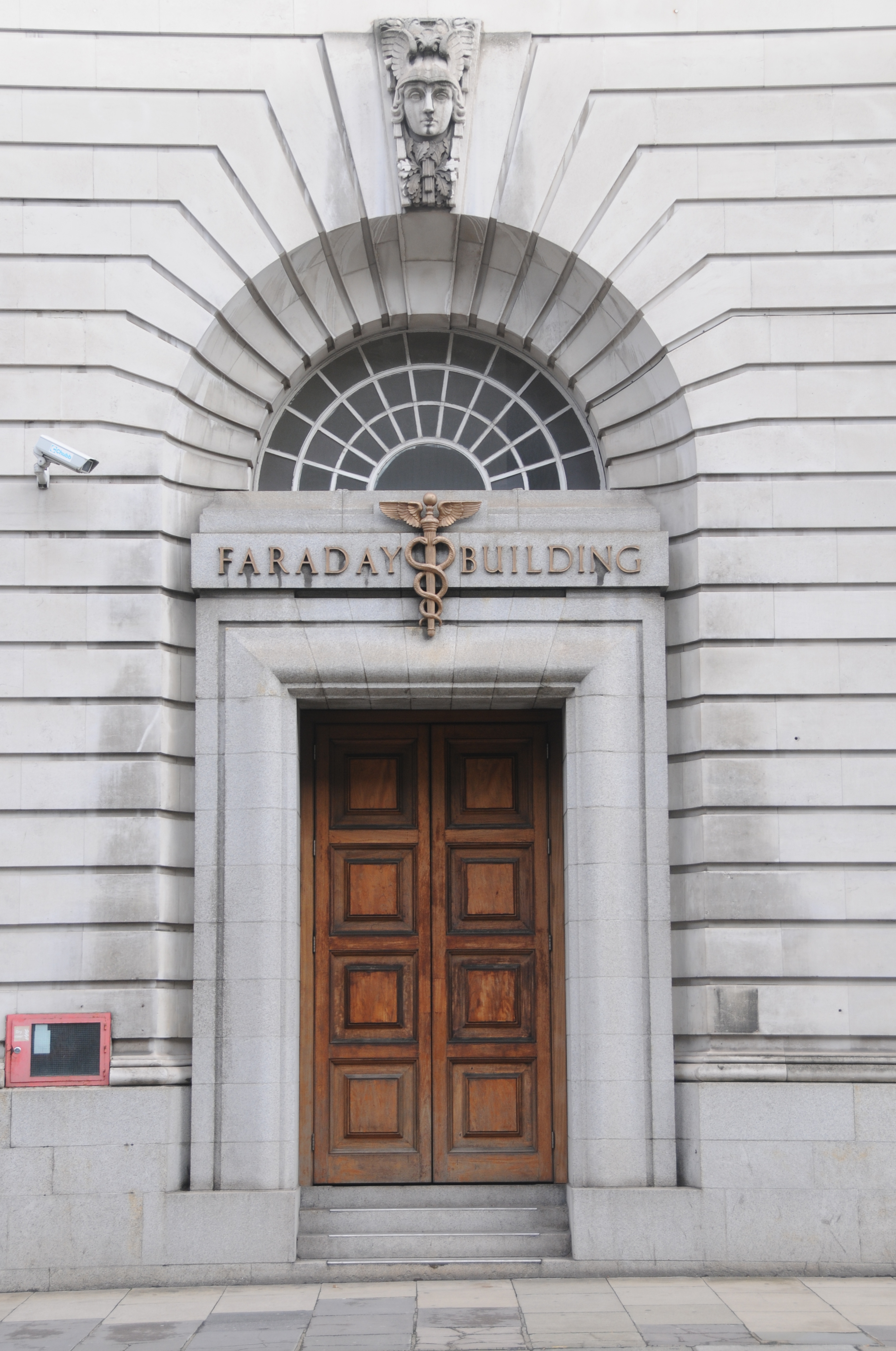
This is the Faraday Building, named after Michael Faraday, an English scientist who experimented with electromagnetism, demonstrated how rotating a coil in a magnetic field could generate electricity and developed the “laws which governs the evolution of electricity by magneto-electric induction”.

The General Post Office (GPO) opened the first London telephone exchange on this site in 1902 with the existing building being completed and officially opened in 1933 to accommodate the very significant growth in telephone services across London. It was designed by A.R. Myers, an architect of the Office of Works who was responsible for the design of a considerable number of Telephone Exchange buildings and Post Offices across the country.

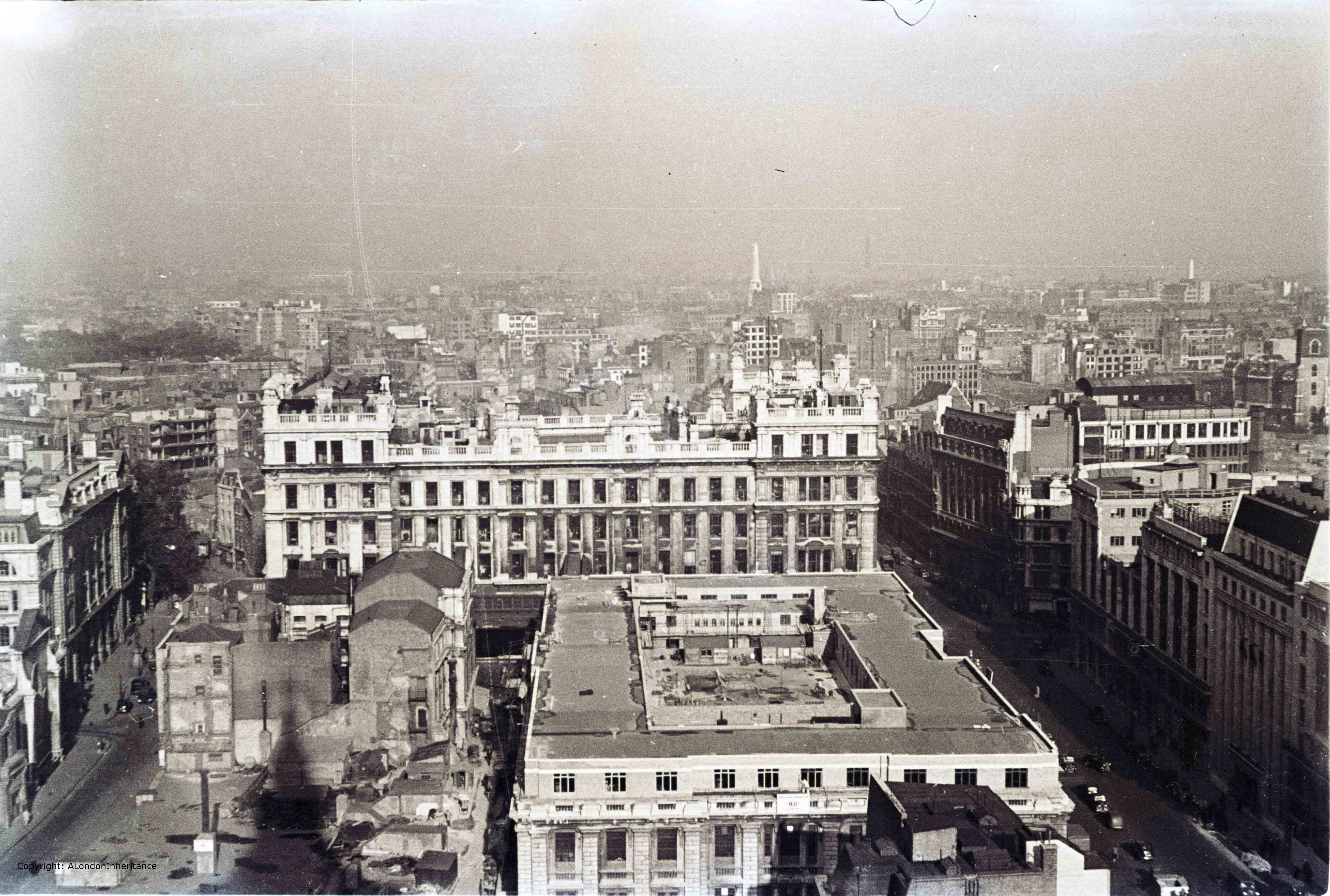
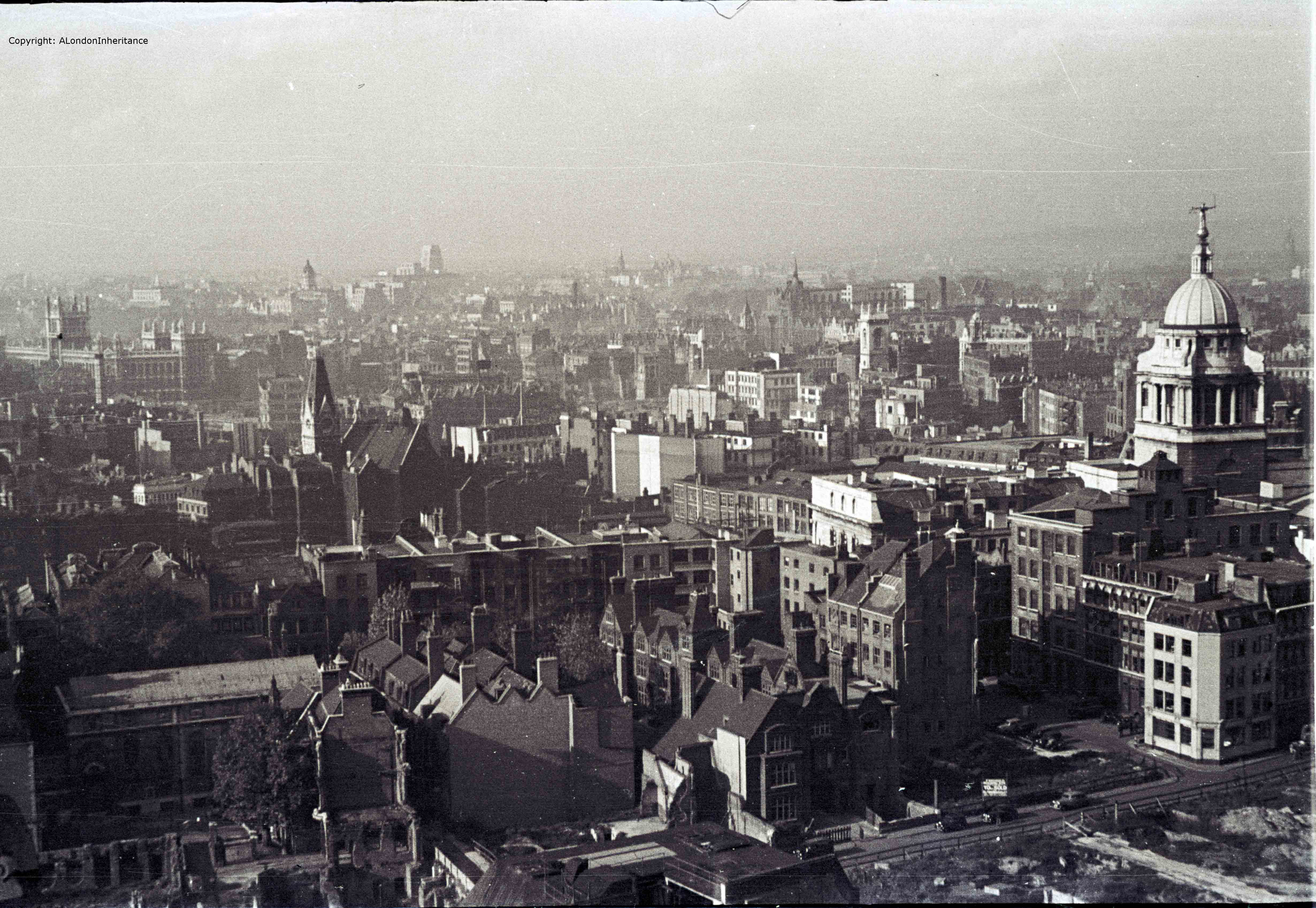
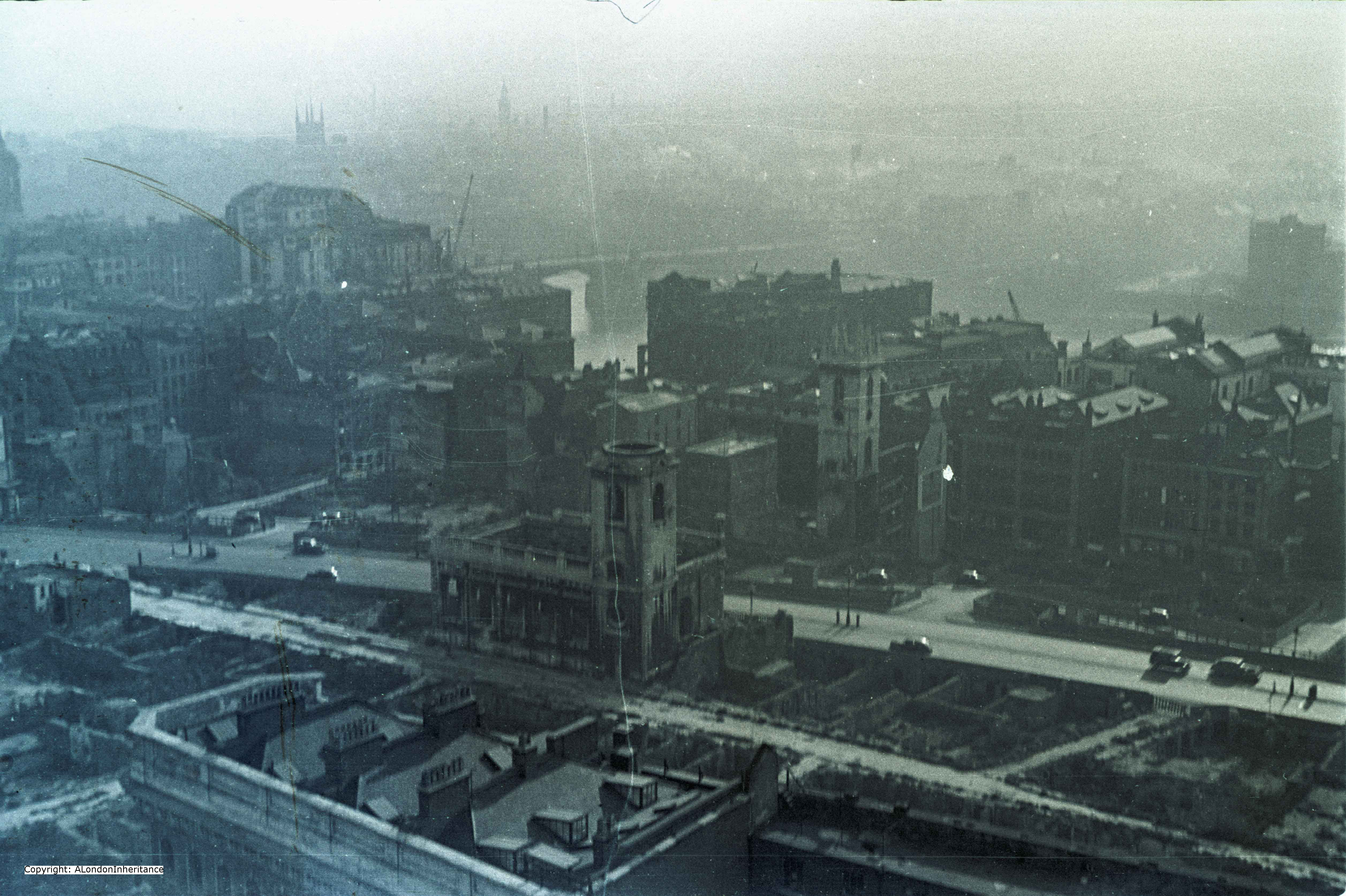
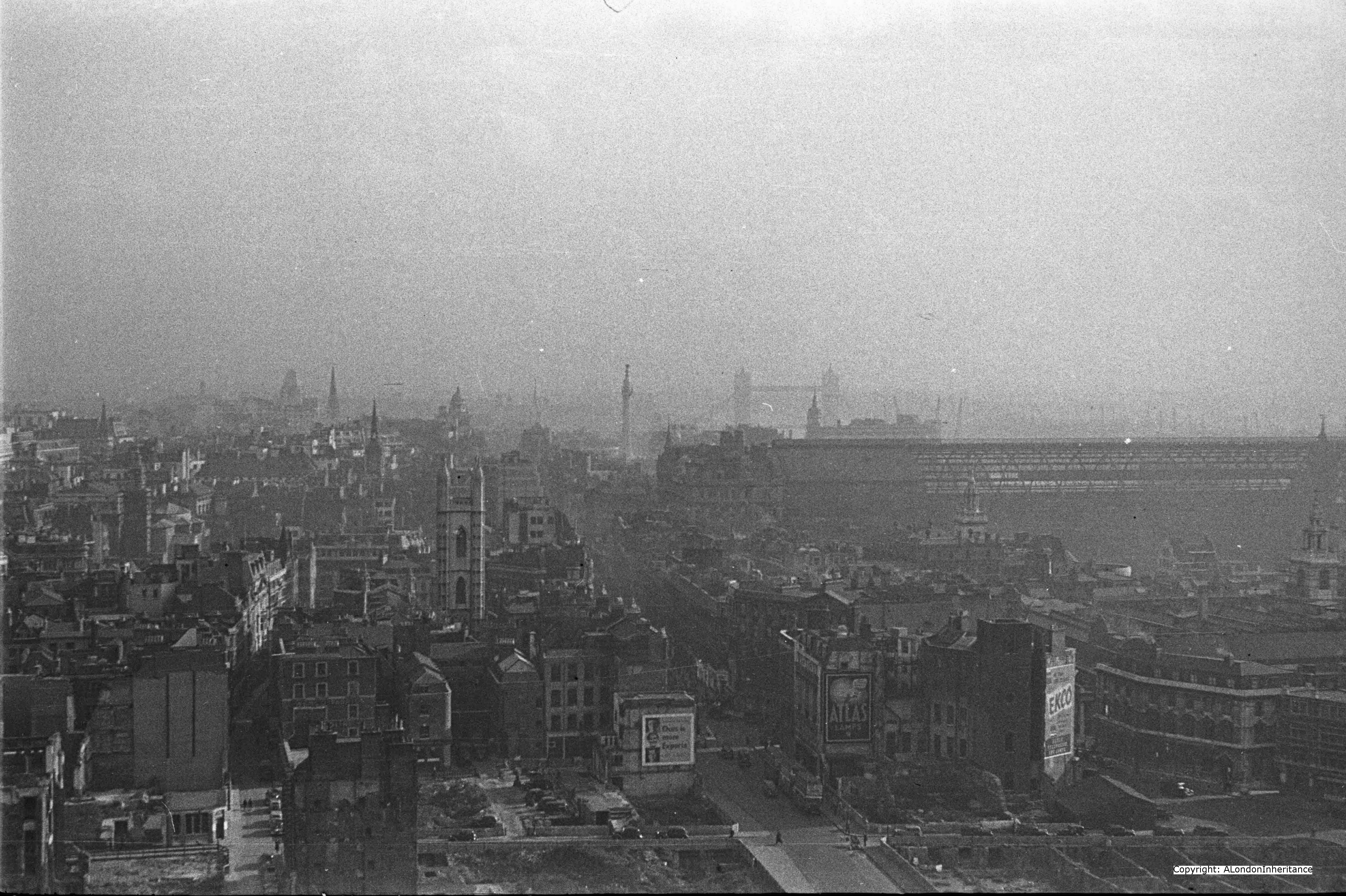
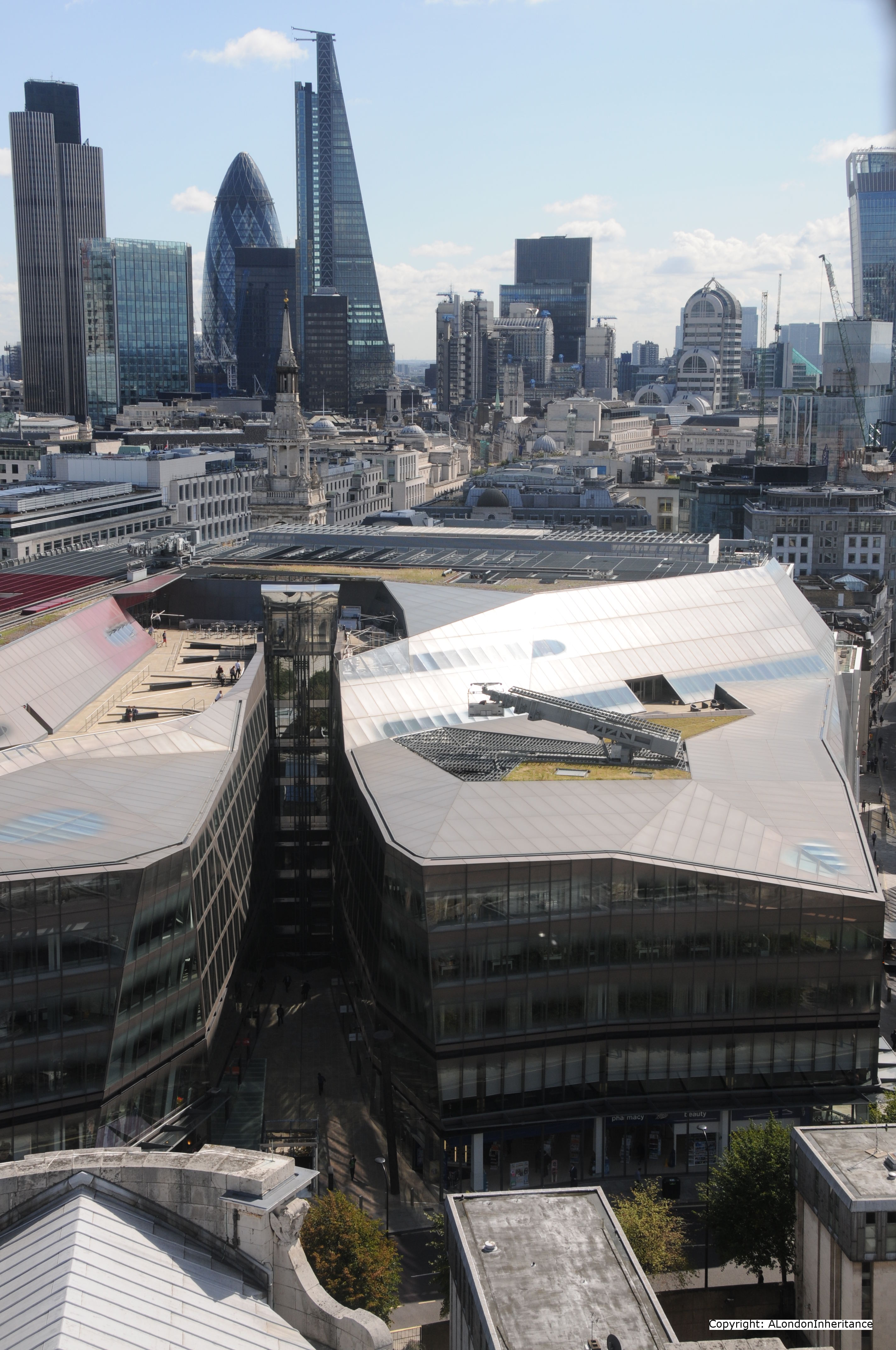
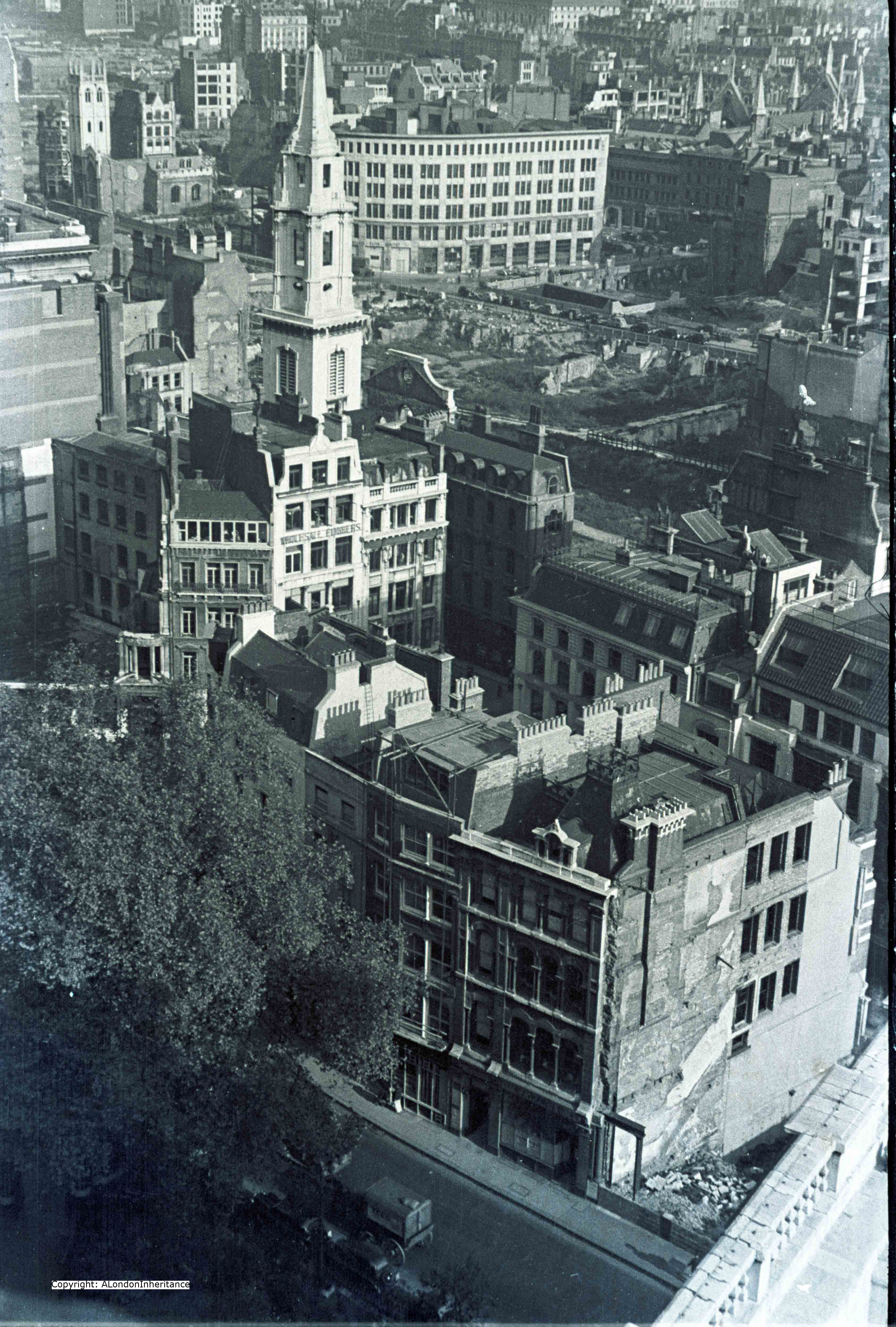
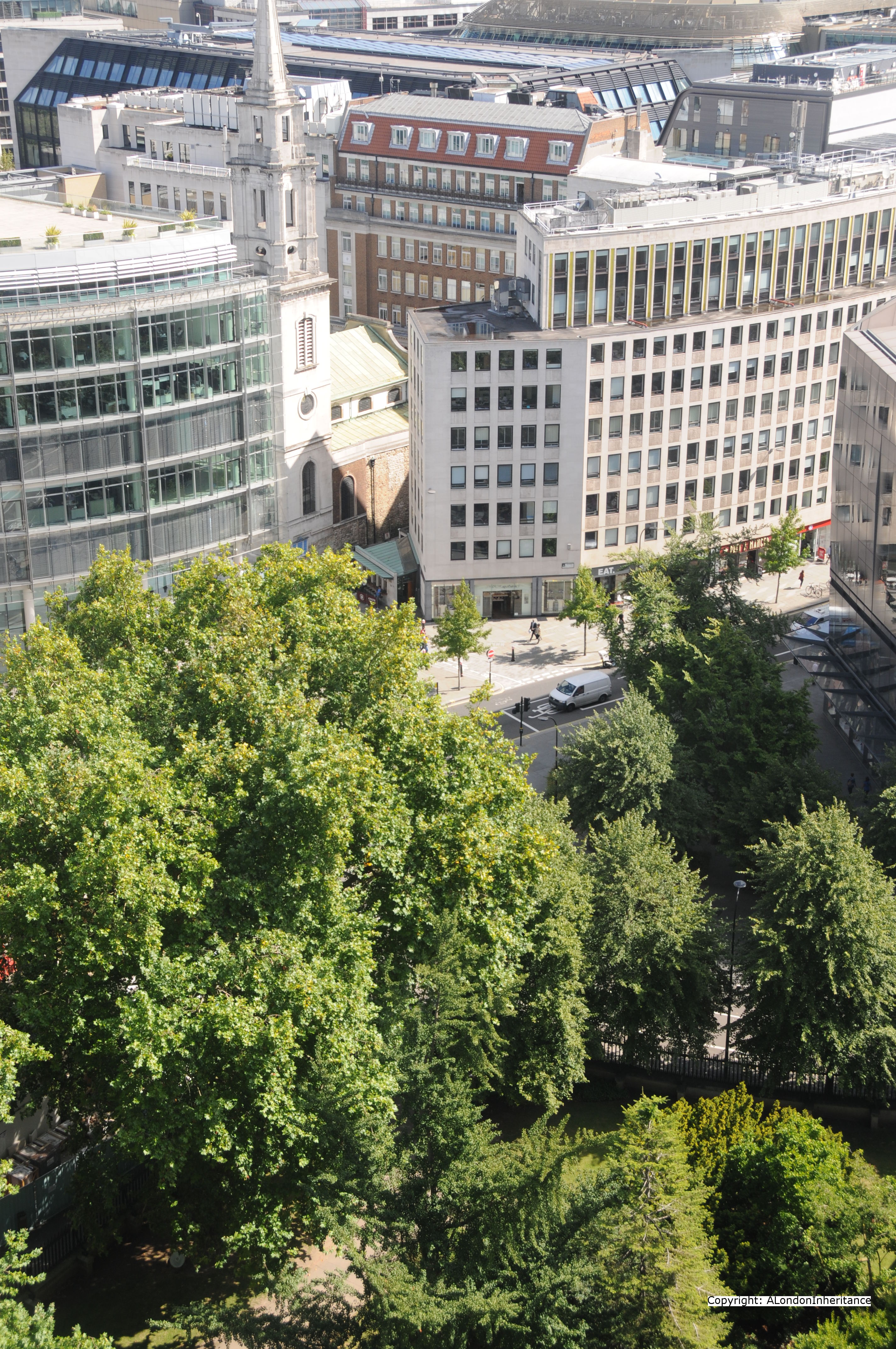
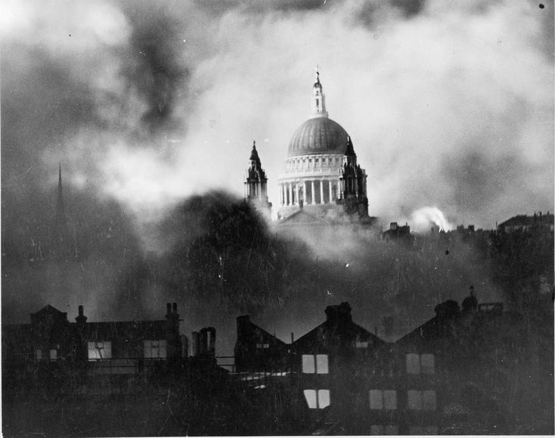
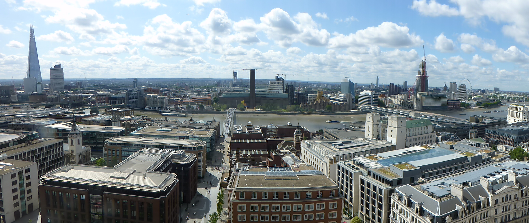
Following completion, the height of the building was very controversial as it blocked the view of St. Paul’s Cathedral from the river. It led to the planning regulations and by-laws that protected sight-lines to the cathedral and restricted the height of buildings. To this day along Queen Victoria Street, the Faraday Building is still the tallest between cathedral and river, as can be clearly seen in the following photo where the Faraday Building is on the right, well above the surrounding buildings.

panaroma with faraday

The Faraday Building was the main telephone exchange for London and also the hub for international circuits with the majority of international calls being routed via the manual switchboards in the building.

Look just above the line of the second set of windows and in the position associated with a key stone, there are a series of carvings, one above each window, that tell the story of what was state of the art telecommunications at the time the building was constructed.

Row of windows

Walking down towards Blackfriars, the first carving is the Telephone.

Telephone
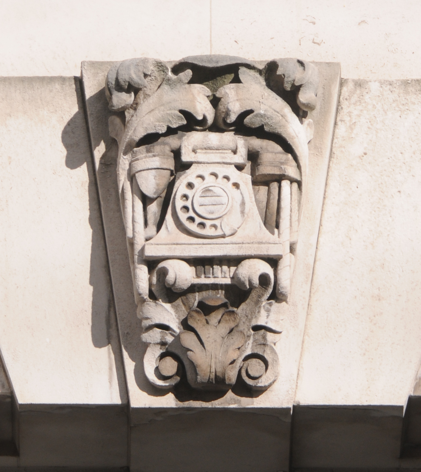
This type of telephone at the time, was cutting edge technology. It utilised a dial that sent pulses to the telephone exchange when the dial was released from the chosen number position, to tell equipment at the exchange what number was being dialled. Prior to the use of a dial, all calls were put through manually, requiring an initial conversation with an operator which would then start a series of manual patching to put you through to your destination. A technique that worked when few people had telephones, but a model that could not cope with the growth of telephones as the 20th Century progressed.

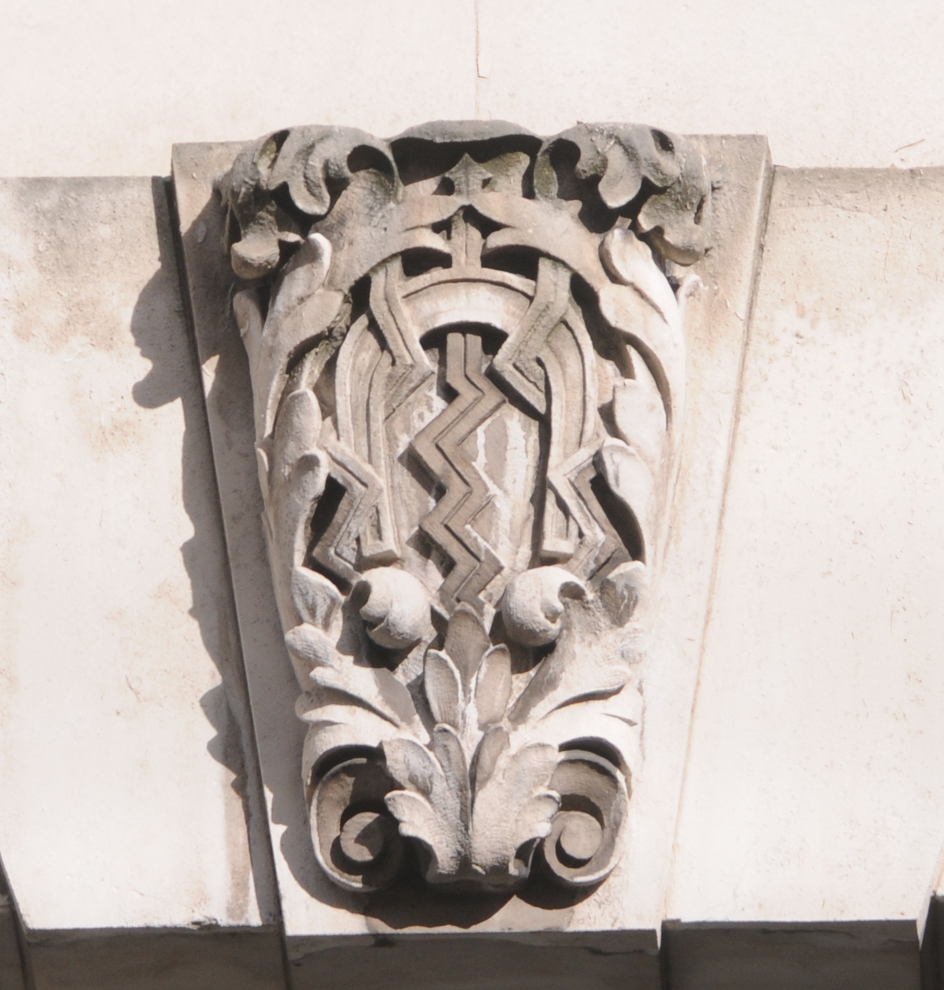
The next carving shows a series of coded pulses crossing a disk, possibly a representation of the world.

Arrows

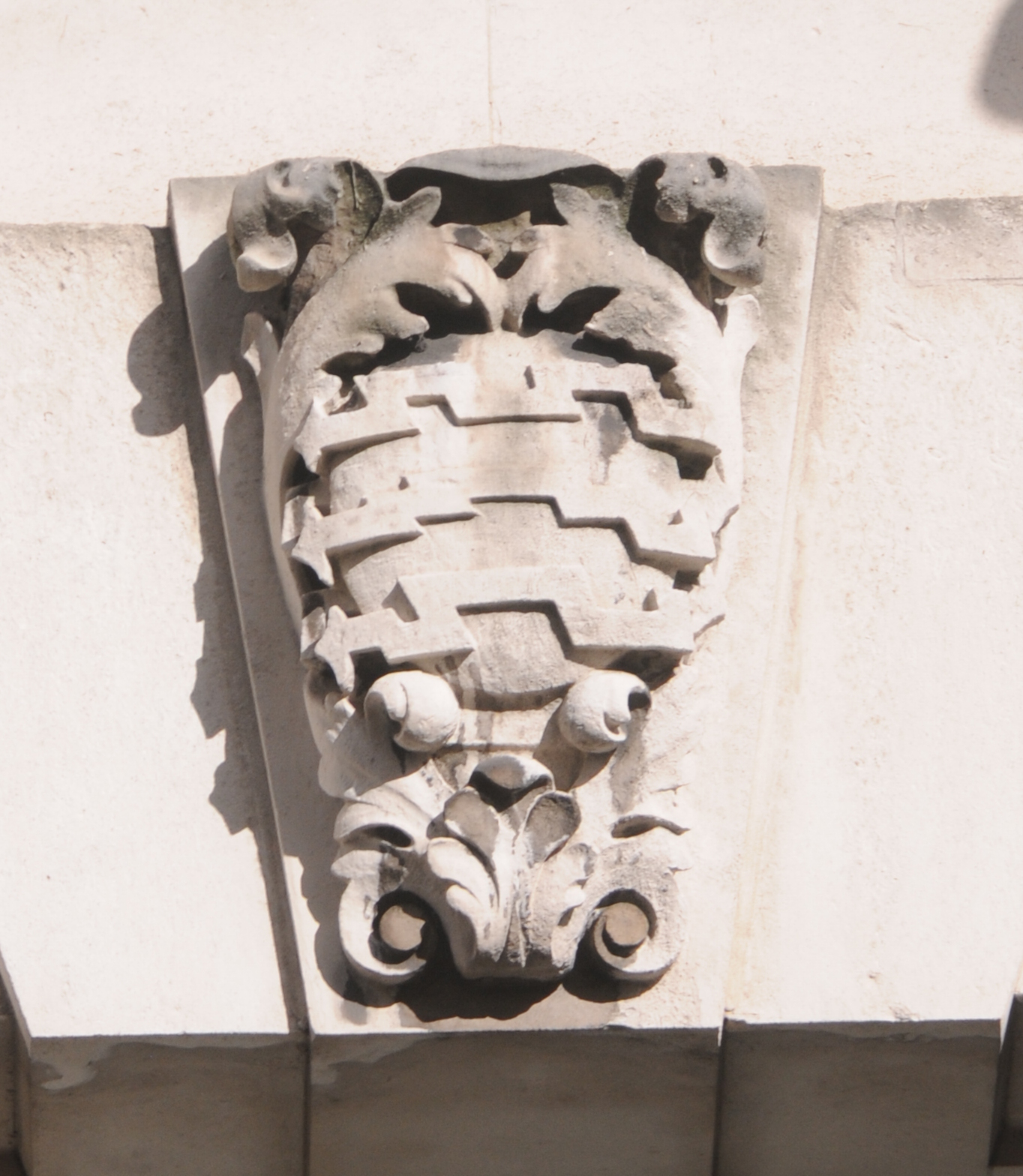
Coded pulses were the means by which information was transmitted about the call to be made. When a dial was turned on a telephone, the release of the dial would cause it to return to its original position and as it returned it would open and close an electrical contact thereby sending pulses to the telephone exchange.

I have seen a number of interpretations for the next carving, but to me these are very clearly the cables that carry telephone signals. There is an outer loop of cable and within the centre, the ends of the cables which have their protective sheath cut back leaving the individual conductors within exposed.

Cables
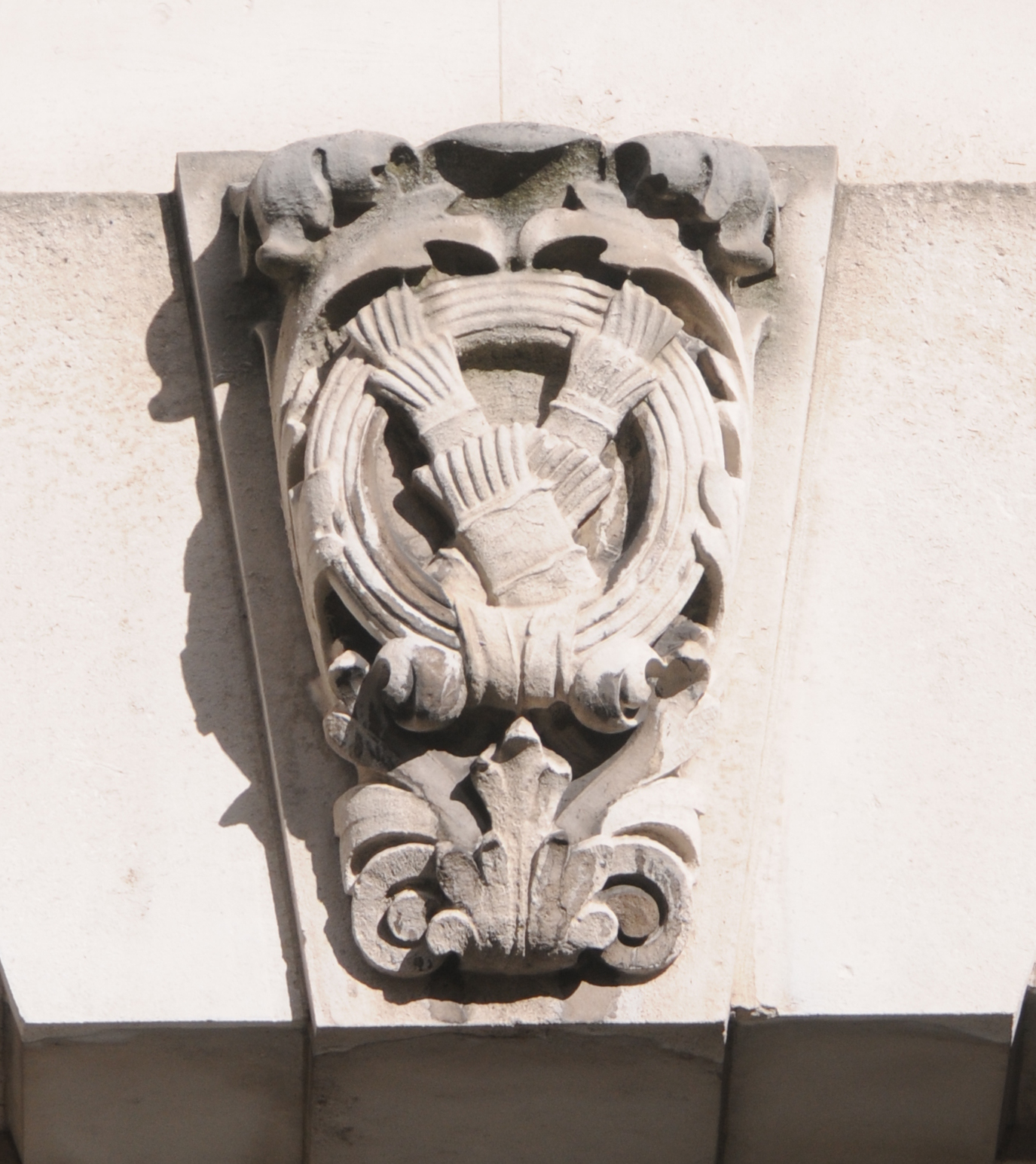
Cables were the key part of the telephone system that carried the pulses and speech from telephones, to the exchanges and then across to their destination, whether in the same street or across the world. (I can see the architects were trying to tell a story in stone of the technology of how a telephone call was made)

The next carving shows a Horse Shoe Magnet. Magnetism was key to the telephone system from the very beginning through to the late 1990s when telephone exchanges driven by magnetic devices were replaced by computer based systems.

Magnet

Michael Faraday’s work with electricity and electromagnetic induction was critical in the understanding of electricity and magnetism, their relationship and laid the foundations for their future practical application. This work was crucial to enable the technology that would go on to provide the telephone systems that spanned the world to be developed and these carvings clearly seem to be celebrating this fact, and the position of the Faraday Building as a hub in this global network.

One of Faraday’s experiments involved rotating a coil of wire between the poles of a horseshoe magnet which resulted in the generation of a continuous electric current in the wires of the coil. This was the first electrical generator and the fundamentals are the same in the generators of modern-day power stations.

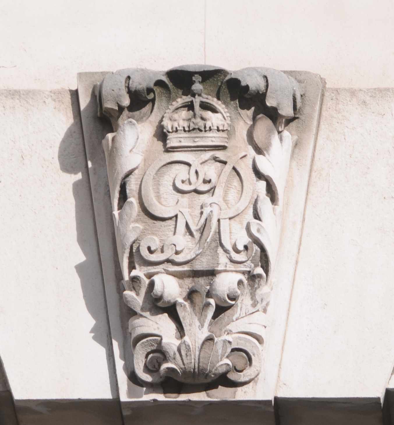
We then come to a carving for King George V, the monarch at the time of the construction and opening of the Faraday Building.

GR

Moving on we come to the carving of an electromagnetic relay which to me is one of the most unique relatively modern-day carvings you will find across London. It is of a core bit of technology, hidden away in the depths of a telephone exchange, but without which automatic telephone exchanges would not have functioned. This type of relay was cutting edge at the time the building was planned, equivalent to the technology that connects the Internet today and switches information from your computer or smart phone through to web-based services across the world.

Relay

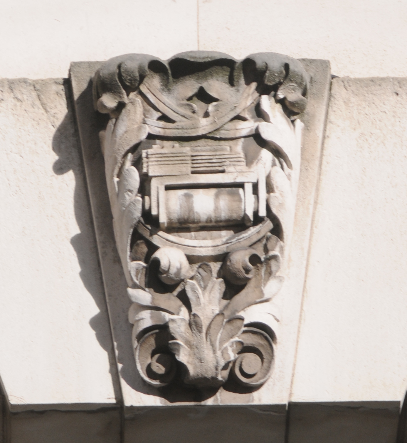
As an apprentice in the late 1970s with Post Office Telephones (as it was prior to changing to British Telecom and being privatised) I have spent many hours cleaning and adjusting these relays to keep them working and driving the equipment that switched telephone calls. The following photo shows a typical item of equipment from a telephone exchange in the late 1970s full of the relays found carved on the Faraday Building. This is looking end on, as if we were looking at the carving in from the right.

new relay set 2
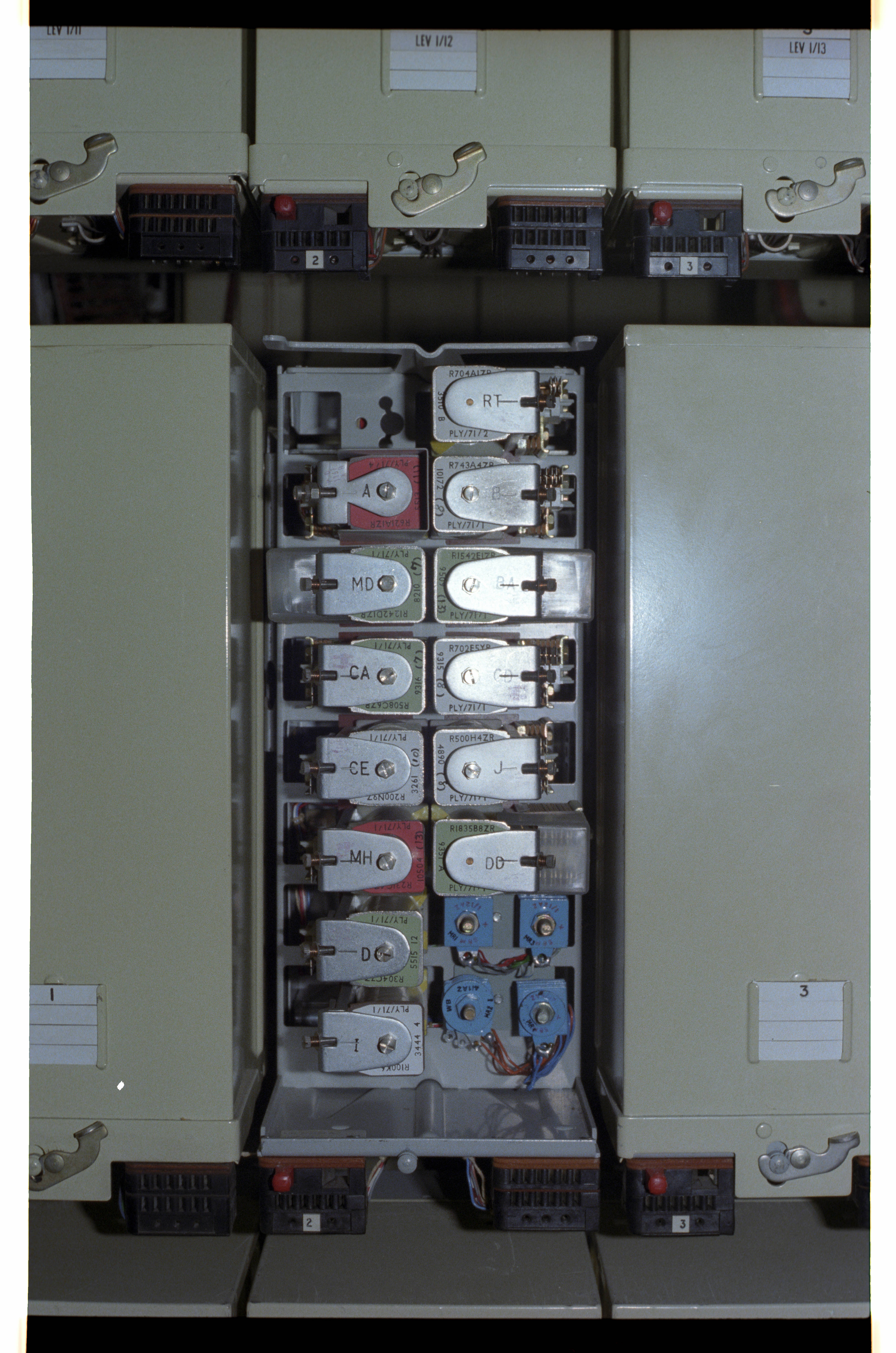
Large telephone exchanges such as that within the Faraday Building would have had many thousands of these relays.

I find these carvings fascinating. They show a pride and celebration in the technology of the time and the function of the building. The majority of buildings constructed during the last few decades, apart from transient corporate logos, tend to have no indication of their function or purpose.

One final set of details can be found just above the main entrances to the building. Just above the door, between the words Faraday and Building is the caduceus (staff with wings above two coiled snakes) of Mercury, the messenger of the Gods, and just above the window there is a carving of  Mercury.
Faraday door

Technology has moved on considerably since the Faraday Building and these carvings were completed and I doubt the architect and builders of the time could have dreamt of the Smart Phone and Internet.

I hope these carvings remain for many decades to come to show future generations the pride that they had in the service that the Faraday Building would provide to London.

alondoninheritance.com


Post War London from the Stone Gallery, St. Paul’s – The North and West

For this week’s post, we continue on our walk around the Stone Gallery of St. Paul’s Cathedral, 376 steps and 53 meters from the cathedral floor. We have covered the south and east views and this week it is the turn of the north and south and the first photo is looking roughly due north:

2014 North 1 old

The street on the left is King Edward Street and the street on the right is St. Martin’s Le-Grand. The large buildings that occupy the space between these were General Post Office buildings  with the larger building in the centre of the photo being the headquarters of the General Post Office.

Whilst the roads are still in the same position, the view again is very different. In the following photo, apart from the streets my only reference points are the building on the extreme left of the photo and the church tower of St. Giles, Cripplegate on the right. These appear to be the only buildings that remains from the immediate post war period.

2014 North 1

Now walk a few feet to the left and look out over to Christchurch Greyfriars.

Newgate Street is running left to right with King Edward Street heading north from Newgate Street.

2014 North 2 old

And the same view today. The body of the church has been left to this day as it was after being destroyed in 1940. Flower beds now occupy the space where the pews once stood. Apart from the church, the building just behind the body of the church also remains.

2014 North 2

The above photos and the ones below are looking down on the area of Paternoster Square and Paternoster Row.

Paternoster Row was mentioned in the thirteenth century when Stow states that it was built around 1282 and that rents from the houses were used for the maintenance of London bridge. Before the war, this area was well-known for book publishing, distribution and warehousing, a fact that contributed to the intensity of the fires that raged in this area. This trade started well before the 20th century. It was in Paternoster Row in 1720 that William Taylor published Robinson Crusoe after Defoe had tried all over London to sell the manuscript. In 1724 Taylor’s publishing business was purchased by Thomas Longman who had founded the publishing firm of Longman, Green and Company also in Paternoster Row. Longman is still an imprint today, owned by the Pearson publishing company.

The following paragraphs are from the book “The Lost Treasures of London” by William Kent and give some idea of the dreadful loss to the long-established businesses that use to thrive in the City.

“On the night of the 29th December 1940 the bombs rained down here and Paternoster Row was more completely destroyed than any other City thoroughfare of importance. All that remained were a few buildings at the east end. The devastation in respect of books has been indicated by Evan Pughe, the Deputy Chairman of Simpkin Marshall and Co. Ltd:

On the night of the 29th December 1940, Simpkin Marshall, Ltd, the greatest distributor of English books in the world, carrying the largest comprehensive stock, lost approximately four million books when their premises in Ave Maria Lane, Stationers’ Hall Court, Stationers’ Hall, Amen Corner, Paternoster Row and Ludgate Hill, were entirely destroyed by the incendiary bombs of the enemy.

This disastrous fire eliminated everything. All the old records of the business going back a hundred and thirty years were destroyed; and most important of all, the great cataloguing system, the only one of its kind in the world, dating back for a hundred and fifty years. These catalogues were handwritten records of books, cross-referenced, so that books on all subjects could easily be traced. These records could immediately give books that had been published on any subject during the hundred and fifty years covered by them, the publisher, date of publication, the price, the size of the books, etc. They were invaluable and their loss will be felt by the reading public for many years to come.”

As a result of the blitz, Simpkin Marshall went out of business. It is hard to imagine the loss that must have been felt when Londoners returned to their place of work after an air raid and realised not just the loss of the buildings, but also what was held within and long established businesses.

Turning a bit more to the left and peering down we can get a glimpse of the Chapter House and the road that was St. Paul’s Church Yard that closely circled the cathedral.

The five circular shapes just behind the Chapter House are the impressions left by water storage tanks. Access to water was always a problem during the blitz. Damage to water distribution pipes, blocked roads and low tides in the Thames all contributed to the lack of the plentiful supplies of water needed to fight the sheer number of fires that would take hold after a raid. After the Paternoster area was destroyed on the 29th December 1940, the area was quickly cleared and these water tanks were built and kept full ready for the next raid.

Further back can be seen the rectangular shape and surrounding streets of Paternoster Square.

2014 North 3 old

I was able to frame the following 2014 photo reasonably well using the statue at the bottom right, to take a photo in exactly the same position as my father 67 years ago. The current incarnation of the Chapter House is currently undergoing re-building / restoration work hence the protective covering.

2014 North 3

Now look up again and walk further to the left and out across to the west. In 1947 the Old Bailey with the “Lady of Justice” holding the sword and scales of justice stand well above the surrounding buildings, with the Senate House of the University of London the next tallest building in the distance.

2014 West 4 old

In 2014, the Old Bailey still stands clear but the rest of the view towards the west is very different. The view of the Senate House is now obscured, and the next tallest building on the horizon is the BT Tower.

2014 West 4

Turning to look further to the left, we can see one of the western towers at the front of St. Paul’s.

2014 West 5 old

And the same view today in 2014:

2014 West 5

Looking at these towers at the front of St. Paul’s, at the Dome, across the different levels of roof across the cathedral, the many small walkways, along with the many stairways leading up to the heights of the cathedral really bring home the complexity of protecting the cathedral during the air raids of the blitz.

The Very Reverend W.R. Matthews, Dean of St. Paul’s wrote an account of St. Paul’s Cathedral in Wartime published in 1946. The following extract covering the 29th December 1940 brings to life the challenges that the Fire Watchers faced whilst protecting the cathedral. We join the account after the external water supplies have dried up:

“The Watch was now forced back on their reserves and had to rely entirely on stirrup pumps and sandbags. How we blessed the prescience of our commander, who had insisted on having our supplies of reserve water augmented in case of an emergency like that which we now confronted. Tanks, baths and pails full of water with their compliment of crowbars, shovels and other fire-fighting equipment were now liberally installed in all the vulnerable parts of the building and were so arranged that men approaching the scene of the fire from any direction would be certain of finding the necessary appliances to hand. But for these precautions there might well have been a different story to tell of the fate of St. Paul’s that night.

The action in the cathedral became for a while a number of separate battles in which small squads fought incipient fires at different places on and beneath the roofs. Some of the bombs were easily dealt with, as for example that one which fell on to the floor of the Library aisle and was extinguished by Mr Allen and myself. I have a special affection for the scar left by that bomb on the floor – it represents, I feel, my one little positive contribution to the defeat of Hitler ! But some of these battles were arduous and protracted. Bombs which lodged in the roof timber were very dangerous and hard to tackle. More than one of these took three-quarters of an hour before they were put out and had to be attacked by two squads, one from below and the other from above. The lower squad had the additional discomfort of being drenched by the pumps of their more elevated colleagues”.

The account also makes clear the need for a “head for heights” when working in the roof spaces and above the cathedral floor. It is the bravery of the Fire Watchers that we have to thank for the survival of the cathedral.

Now for the final view from the Stone Gallery in 1947 and we are looking out over the southerly of the western towers across the River Thames to Westminster. We can see Waterloo Bridge along with the Shot Tower on the south bank of the Thames.

2014 West 6 old

And in 2014, the view of the river and Waterloo Bridge remain but there has been considerable change on both banks of the river. In the 1947 photo, the south bank would soon be cleared for the Festival of Britain, after which the site was part occupied by the Shell Centre building then continuous development leading up to the London Eye.

In the foreground in the extreme lower left of the photos is St. Benets, Paul’s Wharf.

2014 West 6

The following map from Bartholomew’s 1940 Reference Atlas of Greater London covers the area to the north of St. Paul’s and shows the streets between St. Paul’s Church Yard and Newgate Street. This was the area shown in the photos covering Paternoster Row and Square and shows the many small streets that were occupied by numerous businesses including that of Simpkin Marshall Ltd. These were soon to be lost with the rebuilding of the area over the coming decades.

map part 2

Compare this 1940 map with the Google map of today:

View Larger Map
That completes our walk around the Stone Gallery. The air raid of the 29th December 1940 destroyed a significant part of the surroundings of St. Paul’s and the area has since changed dramatically.

The air raids destroyed not only buildings but also business that had been operating for many years, not to mention the thousands of lives that were lost. That St. Paul’s remains is thanks to the bravery of those who protected the building as the area was covered by a deluge of bombs.

For Londoners, it must have seemed that their City was changing forever almost on a nightly basis.

The following photo is from the Imperial War Museum collection © IWM (D 6412) and was taken in January 1942 and perhaps typifies the atmosphere that must have pervaded many parts of the city.

bombed london in the snow

The Stone Gallery (and the higher Golden gallery) provide a perfect location to view the wide sweep of London, from Shooters Hill, to Alexandra Palace, the City, Westminster, North and South Bank. The last stone of the cathedral’s structure was laid in 1708 and since that time it has looked down on a City that has changed beyond all recognition and hopefully will continue to do so for many centuries to come.

The sources I used to research this post are:

  • The Lost Treasures of London by William Kent published 1947
  • St. Paul’s Cathedral In Wartime by the Very Reverend W.R. Matthews, Dean of St. Paul’s published 1946
  • The Blitz by Constantine Fitz Gibbon published 1957
  • The City That Wouldn’t Die by Richard Collier published 1959
  • London by George H. Cunningham published 1927
  • Bartholomew’s Reference Atlas of Greater London published 1940
  • The Streets of London by Gertrude Burford Rawlings published 1926
  • And for a detailed minute by minute account I recommend reading The City Ablaze – The Second Great Fire of London 29th December 1940 by David Johnson published 1980

 alondoninheritance.com

Post War London from the Stone Gallery, St. Paul’s – The South and East

Soon after the end of the war, my father climbed the 376 steps from the cathedral floor up to the Stone Gallery at St. Paul’s Cathedral to get the view that only the Stone Gallery can provide of the sweep of London from the City to Westminster. From here he was able to take in what had become of the city that he had grown up in during the long years of the war.

67 years later I climbed the same 376 steps to take in how London had changed over those intervening years.

In this week’s post, the first of two, I will compare the photos he took then with my photos of 2014, however firstly to get our bearings the following Aerofilms photo from before the war shows how St. Paul’s was surrounded by the dense city streets with buildings much closer to the cathedral than they are now. These were not only offices, but also plenty of warehouses with one of the major publishers / book distributors having their office and warehouse just north of St. Paul’s in Paternoster Square. The spires of the city churches still stood clear of their surroundings, but St. Paul’s dominated the area. In view of what was to come it still amazes me that St. Paul’s survived.

EPW055297


Much of the devastation around St. Paul’s was caused on the 29th December 1940.

Christmas 1940 had been relatively quiet, however on the evening of the 29th December a large bomber force appeared over the City just after 6pm and for just over the next three hours incendiary bombs rained down on the City along with high explosive bombs. This combination caused maximum damage. High explosive bombs would rip buildings apart, exposing their contents to the impact of the incendiaries. During the peak of the raid over 300 incendiary bombs a minute were falling across the City and St. Paul’s quickly became surrounded by a sea of flame, fire crossing over the small streets and debris falling all around.

St. Paul’s was protected by a team of Fire Watchers who had the dangerous job of watching as the bombs fell and getting to an incendiary as quickly as possible to put it out before a fire became established. At one point an incendiary got stuck in the lead dome of the cathedral, where it could not be reached. A moment of danger as a single incendiary could cause a fire that would have engulfed the dome but miraculously it became free as it burned and melted the surrounding lead, and fell away from the dome landing in the Stone Gallery where the Fire Watchers could easily get to it and safely extinguish the danger.

It was not just incendiary bombs that put St. Paul’s at risk. The Fire Watchers also had to deal with a steady stream of flying embers from the surrounding buildings flying across and onto the cathedral. The heat from the concentration of fires stirred up winds that would spread embers quickly to create new fires where bombs had not landed.

The first waves of bombing finished just after 9pm and most of the area around St. Paul’s was ablaze along with many other areas of the City. The Fire Watchers and Fire Fighters worked hard in the dangerous conditions, a low tide not helping with extracting water from the Thames and the constant worry that the next wave of bombers would soon be over. However towards midnight the tide was rising and fog in the channel prevented the next wave of bombers from launching their next series of raids.

Next morning, Londoners awoke to a very different City.

Now join me as we walk around the Stone Gallery. We start looking over towards the south-east of London:

IMG02590-upload

The remains of the church in the centre of the photo is St. Nicholas, Cole Abbey and just behind is St Mary Somerset. The road between the two churches is Queen Victoria Street. The bridge spanning the Thames is Southwark Bridge and in the distance we can just see the tower of Southwark Cathedral.

The view today is shown in the following photo:

DSC_1404-upload

As with much of the City of London, the church towers provide us with reference points to confirm the location. St. Nicholas, Cole Abbey in the centre of the photo still stands along Queen Victoria Street with the steeple restored on the top of the tower.

Interesting that the River Thames is much more visible in 2014. Most noticeable is that we can now see the rail bridge into Cannon Street Station. The height of the buildings between St. Paul’s and the Thames appear lower than the buildings constructed in the pre-war period. A success of the regulations governing the views of St. Paul’s and surprising that in one area of London at least the buildings are not in a race for height.

Turning slightly to the left, we can now see the full length of Cannon Street Station with the original roof running the whole length from the Thames facing towers through to the station buildings facing onto Cannon Street. The Monument stands clear of surrounding buildings and the tops of the cranes running along the Thames between Billingsgate and Cannon Street can be seen.

IMG02591- upload

The same view today is shown below:

DSC_1392-upload

Cannon Street has lost the roof and the dominant position it held on the City skyline. The Monument now bravely maintains its position just above the surrounding buildings, but again is not such a prominent landmark on the skyline and all the cranes have been lost along the Thames.

A slightly different view just further to the left.

IMG02595-upload

And the same view today. the church in the centre of the above photo and just behind the red crane in the following photo is St. Mary Aldermary

DSC_1427-upload

The spire just edging into the bottom of the above photo is the rebuilt spire of St. Augustine, Watling Street and the tower as it was after the war is seen in the following photo from the Stone Gallery.

The building in front of the church in the following photo is the premises of Andersons Rubber Company. One of the buildings that was on the plot to the right of St. Augustine was Cordwainers Hall. In total a succession of 6 livery halls had been on this site from 1440. The one destroyed by bombing was built-in 1909 and was the last on the site as the Worshipful Company of Cordwainers moved to the Law Society in Chancery Lane, then in 2005 moved to the Clothworker’s Hall in the City.

IMG02592-upload

The view today could hardly be more different. the spire has been restored to the church, the Andersons building has been demolished and not rebuilt and the plot of land immediately to the right of the church are now gardens and pedestrian areas.

DSC_1385-upload

The small road that runs past the church and Andersons in the original photo which is now a pedestrian walkway was the end of Watling Street where is ran straight to the St. Paul’s Church Yard road that ran close around the cathedral. Pre-war, although St. Paul’s was the tallest building in London and so dominated the skyline, it was ringed on all sides by a tight network of roads and buildings. Re-building since the war has opened up the immediate cathedral surroundings.

We continue on our walk around the Stone Gallery, this time we have moved a bit further to the left and are now looking across to the centre of the City.

The tower of St. Mary-le-Bow still stands along Cheapside next to the burnt out shell of the church.

The road running across the photo at the back of the car park is Friday Street. So called due to the fishmongers who had their homes here and serving Friday’s market. A survival from the days when fish was eaten on a Friday. This street has now been lost under the One New Change development.

IMG02593-upload

The city skyline in the above photo is as it has been for hundreds of years with only the church towers and steeples rising above the surrounding streets. How different this now looks in 2014:

DSC_1414-upload

As well as One New Change in the foreground, the road in front, New Change is a new routing of the original road Old Change that ran directly behind St. Paul’s, so close that it is obscured in the original photo.

In the City, the march of the new towers continues with Tower 42 on the left followed by the Gherkin, the Cheesegrater and the WalkieTalkie just appearing on the right.

Now for the final photo of this week’s walk around the southerly and easterly aspects of the Stone Gallery and we are looking roughly north-east at St. Verdast alias Foster on Foster Lane.

Note in the top right corner is the shell of the Guildhall. The Guildhall suffered badly on the night of the 29th December when the fire spread from the neighbouring church of St. Lawrence Jewry. The roof was destroyed and the wooden figures of Gog and Magog from 1708 were reduced to ashes, along with about 25,000 volumes from the library.

IMG02594-upload

And today’s photo of the same area, which I admit I did not realise I took a bit too low and cut of the top of the spire on the church. That is what comes with trying to balance an iPad with the original photos and a camera at the same time and not checking afterwards!

DSC_1422-upload

To get a view of the streets around St. Paul’s and how they have changed, the following map is from Bartholomew’s 1940 Reference Atlas of Greater London. The original Old Change was between St. Augustine and St. Paul’s. This has been re-routed to the right and renamed New Change from which the development that is now on top of Friday Street takes its name. Watling Street and Cannon Street ran straight up to St. Paul’s Church Yard. This junction and the building plot where Cordwainer’s Hall was located are now gardens and pedestrian areas.

old map st pauls

Compare this 1940 map with the Google map of today:

View Larger Map

The following photo by the Daily Mail photographer Herbert Mason taken on the 29th December 1940 looking across Ludgate Hill towards St. Paul’s and now in the Imperial War Museum collection gives an impression of the scene with fires raging around the cathedral (photo © IWM (HU 36220A))

IWM St Pauls

Join me next week as I continue the walk around the Stone Gallery to view the North and Westerly views.

The sources I used to research this post are:

  • The Lost Treasures of London by William Kent published 1947
  • The Blitz by Constantine Fitz Gibbon published 1957
  • The City That Wouldn’t Die by Richard Collier published 1959
  • London by George H. Cunningham published 1927
  • Bartholomew’s Reference Atlas of Greater London published 1940
  • The Streets of London by Gertrude Burford Rawlings published 1926
  • And for a detailed minute by minute account I recommend reading The City Ablaze – The Second Great Fire of London 29th December 1940 by David Johnson published 1980

 alondoninheritance.com


A Walk In And Around St Mary-le-Bow

St Mary-le-Bow in Cheapside is one of the more well-known of the City churches being home to Bow Bells. The church also has one of the finest Wren steeples which, unlike the church adjacent to the steeple, survived wartime bombing.

My father took the following photo just after the war from Friday Street looking across the ruins of the city towards St Mary-le-Bow

St Mary-le-Bow

Friday Street is now lost under the One New Change development. Friday Street was on the south side of Cheapside, roughly halfway between Gutter Lane and Wood Street on the northern side, and ran down to Watling Street. The tower and steeple appear relatively unscathed from the outside unlike the church to the lower right which, although external walls remain, has been gutted and is now an empty shell. Within the tower fire did cause much damage and as a result the bells crashed to the ground.

As with many of these photos taken just after the war, it is impossible to take a comparison photo today. The space in between is now full of office blocks with no chance to get any view of the church.

St Mary-le-Bow is now best viewed from Cheapside and the small square adjacent to the church from where the beauty of the spire can be admired.

A Church has stood on the site of St Mary-le-Bow for many centuries. The church to the right rather than the tower is the original site of the church. Apparently when the church was rebuilt after the great fire Wren brought the tower forward onto Cheapside and connected the tower to the church with the vestibule which can be seen in the above photo as the brick wall between tower and church.

As evidence of the age of the church, below is an 11th century crypt constructed when the church was rebuilt by Lanfranc of Canterbury as his London headquarters.

The crypt, although with some changes resulting from reconstruction of the church above following the great fire and wartime bombing is in fine condition and can still be visited with two entrances, either through the vestibule or through a small set of steps at a corner of the church in the square outside.

Part of the crypt of St Mary-le-Bow which also extends to the left of the photo.

St Mary-le-Bow

Following the great fire, Wren planned the reconstruction of the church. The original tower was not badly damaged and much money was spent on attempted restoration, however re-building was eventually found to be inevitable. This is when the decision was taken to emphasise the importance of the church by rebuilding with a magnificent tower and bringing the tower forward to Cheapside. The former church stood about forty feet southwards of Cheapside and in order to bring the new tower forward to the line of the street the site of a house not yet rebuilt after the fire was purchased.

The accounts for the rebuilding of the tower show the expense that was put into the construction:

To Thomas Cartwright and John Thompson, Masons, for building ye whole Stone wall inside and outside of ye New Tower of Bow from ye pavement to ye top of ye first great cornice with ye winding Staires ye Great Neech Portalls Pillasters windows and carvings according to contract by the great bearing date March  3 1676 – £1600

ffor building from ye top of ye first great Cornice to ye top of ye round Cornice according to Contract signed Septr. 22, 1676 – £2550

from ye Top of ye Cornice over ye Ionick Pillars to the top of ye Cornice under ye Pedestall, ffeb. 27, 1679 – £467, 1, 6

from ye Top of ye Cornice under ye first pedestal to ye under side of ye Spire, June 27, 1679 – £295, 16, 6

about finishing ye Piramids Pinicles and other works of ye Tower, June 8, 1680 – £551, 16, 0

The accounts continue to list in detail the various items and costs for the construction of the Tower which finally amounted to £7,388 8s 7d which must have been a considerable sum in 1680, with a further £8,033, 0s, 5d spent on the church resulting in a combined total of £15,421, 9s, 0d which is by far the most spent on the reconstruction of any of the City churches. For comparison, St. Lawrence Jewry was the next most expensive at £11,870 which really highlights the importance of St Mary-le-Bow.

The tower and steeple are best viewed from Cheapside.

St Mary-le-Bow

And from the small square adjacent to the church, we can admire the detail of the steeple. The steeple is 224ft in height and is second only in height to St. Brides.

St Mary-le-Bow

My father also took another photo from roughly the same spot as the first showing the full height of the spire:

St Mary-le-Bow

Rebuilding after the war was carried out between 1956 and 1964. The light inside the church along with the white walls, blue panels, gold decoration and stained glass is magnificent:

St Mary-le-BowUnlike the tower and steeple, the main church building is very difficult to view from a distance. The main church is surrounded by buildings and the best viewing point is from the small square outside the church. The following photo shows the church with the tower to the left. It was possible to get a bit further back, however the tree then obscured much of the church. Even so, you can see from my father’s original photo that although the core of the church was gutted, the walls remain to this day.

St Mary-le-Bow

The statue to the left of the photo is Captain John Smith, a former parishioner of the church. It was Captain John Smith who was leader of the Virginia Colony and was the first English explorer to map the Chesapeake Bay area and New England during the British settlement along the east cost of the United States.

As always, I find it fascinating to walk around a building to see what can be discovered on the external walls. Hiding at the top of the walls are these headers to rain water down pipes continuing a long tradition of dating and decorating these architectural features. A visible reminder of the rebuilding of the church after the war.

St Mary-le-Bow

There is also a plaque removed from the church of All Hallows, Bread Street commemorating that John Milton was baptised in All Hallows.

All Hallows, Bread Street was a victim of the gradual consolidation of parishes over the centuries. It was not just the Great Fire of London and the Blitz that destroyed the City Churches, there was an ongoing process of consolidation. As well as All Hallows, St. Pancras, Soper Lane was also united with St. Mary-le-Bow.

St Mary-le-Bow

On the corner of the tower you will also find the following carving:

St Mary-le-Bow

This is nothing to do with the function of the church, they are found carved on buildings, bridges and walls across the United Kingdom.

They are Ordnance Survey Bench Marks carved into structures that are likely to be long-lasting and stable to provide a height reference. The horizontal line is the height reference above the Ordnance Survey datum.  This was used in the re-levelling of Greater London between 1931 and 1934 and established a height of 56.269ft above mean sea level at Newlyn in Cornwall (the Ordnance Survey datum for measuring heights above sea level). So if you now walk along Cheapside, past St. Mary-le-Bow, at least you know the height above sea level !

St Mary-le-Bow has always been a prominent landmark in Cheapside, a very busy route between Bank and St. Paul’s.  The following view taken from an early postcard shows how the steeple stood well above the surrounding buildings and then as now a clock on the front of the tower kept the busy people of Cheapside well-informed of the time of day.

St Mary-le-Bow

A fascinating church and I have not even covered the story of the Bow Bells, the nursery rhyme , Dick Whittington etc. as these are all well documented elsewhere.

The sources I used to research this post are:

  • The Old Churches Of London by Gerald Cobb published 1942
  • London by George H. Cunningham published 1927
  • Old & New London by Edward Walford published 1878

alondoninheritance.com