Monthly Archives: July 2018

The Regents Canal from Blomfield Road

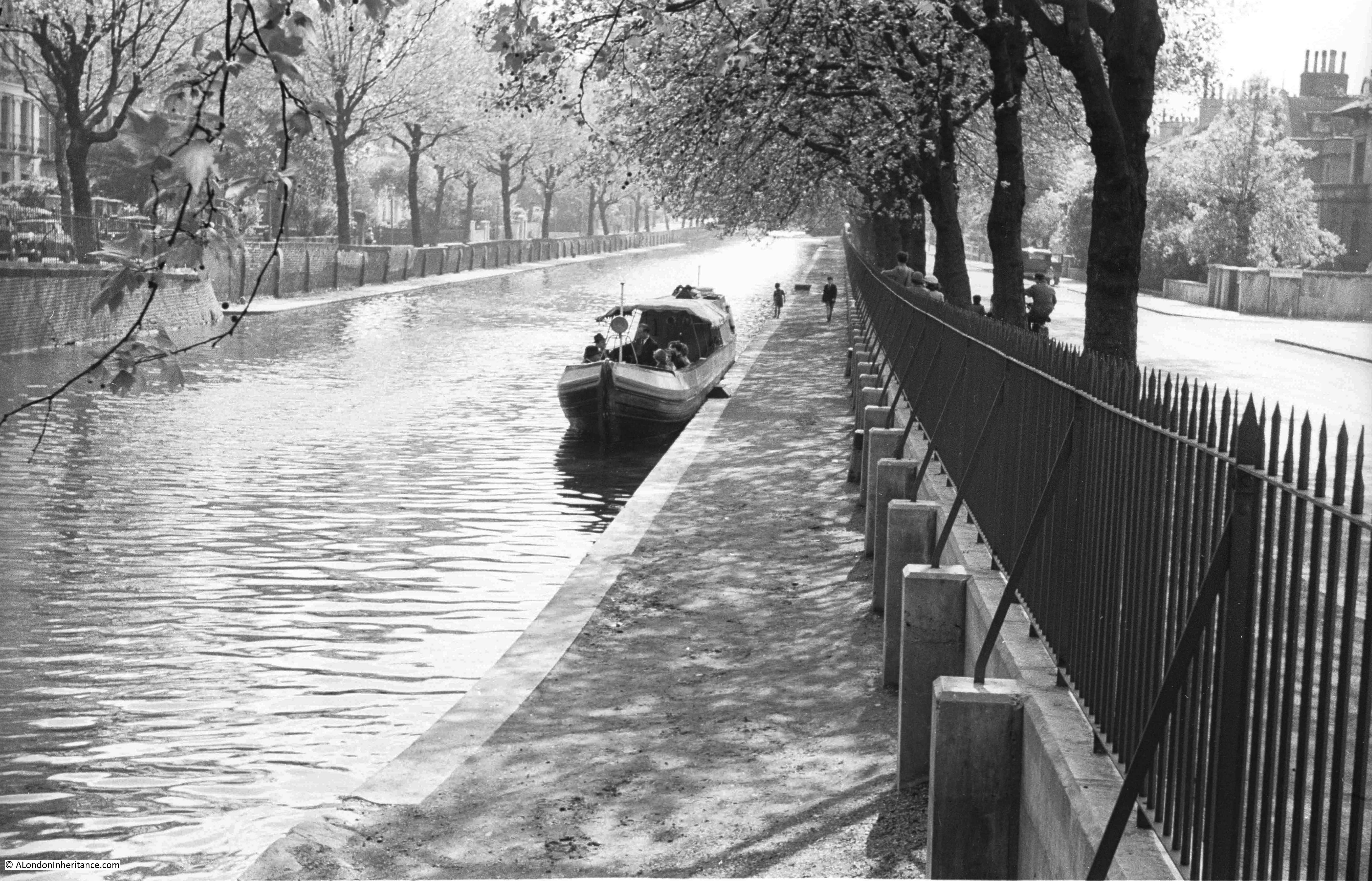
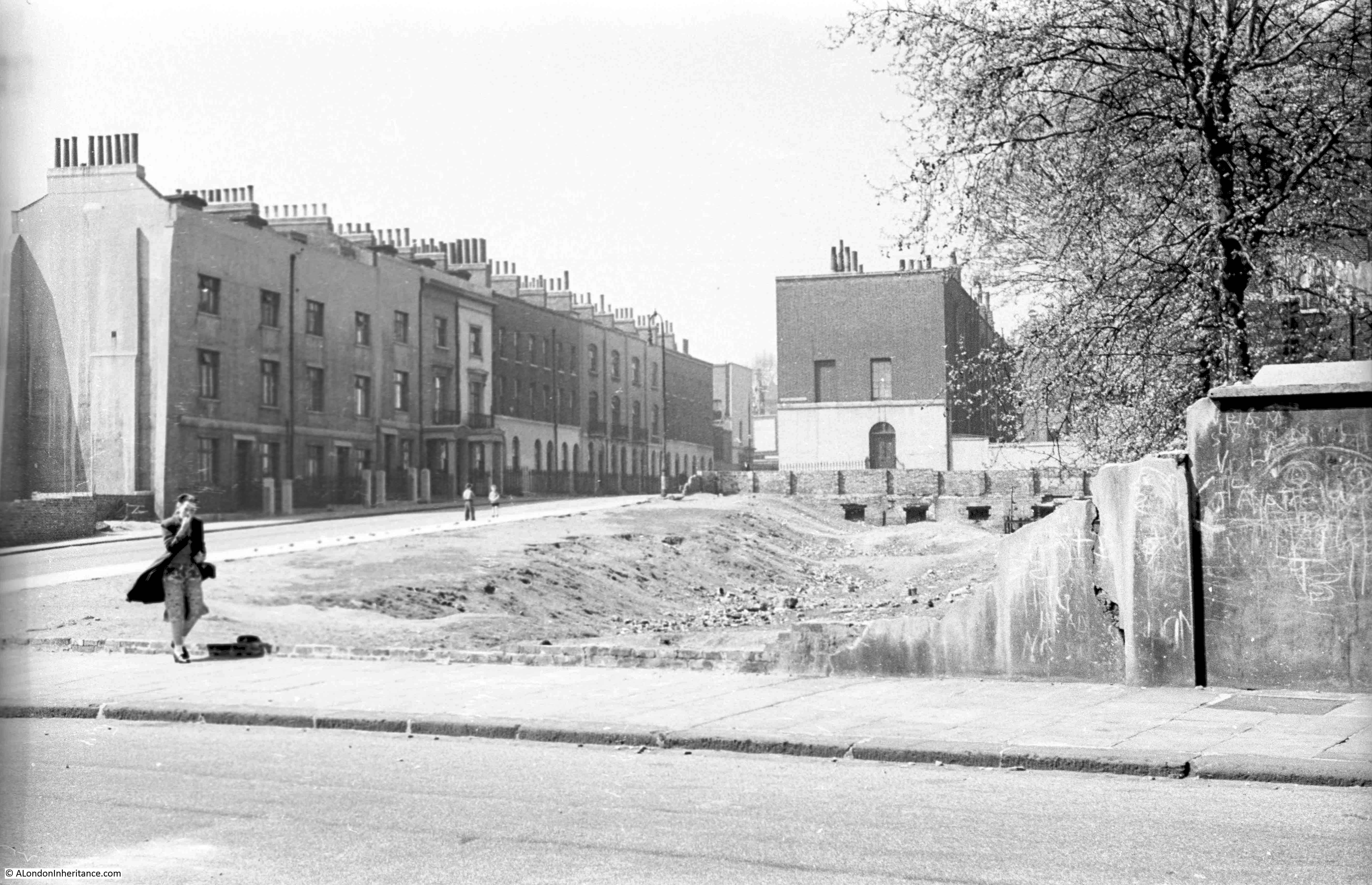
The Regents Canal stretches from the River Thames at Limehouse Basin to meet the Grand Union Canal just north of Paddington Station, at the area known as Little Venice. The stretch of the canal before it joins with the Grand Union runs alongside Blomfield Road, and it was from the Edgware Road end of Blomfield Road that my father took the following photo, looking along the Regents Canal in 1951.

Blomfield Road

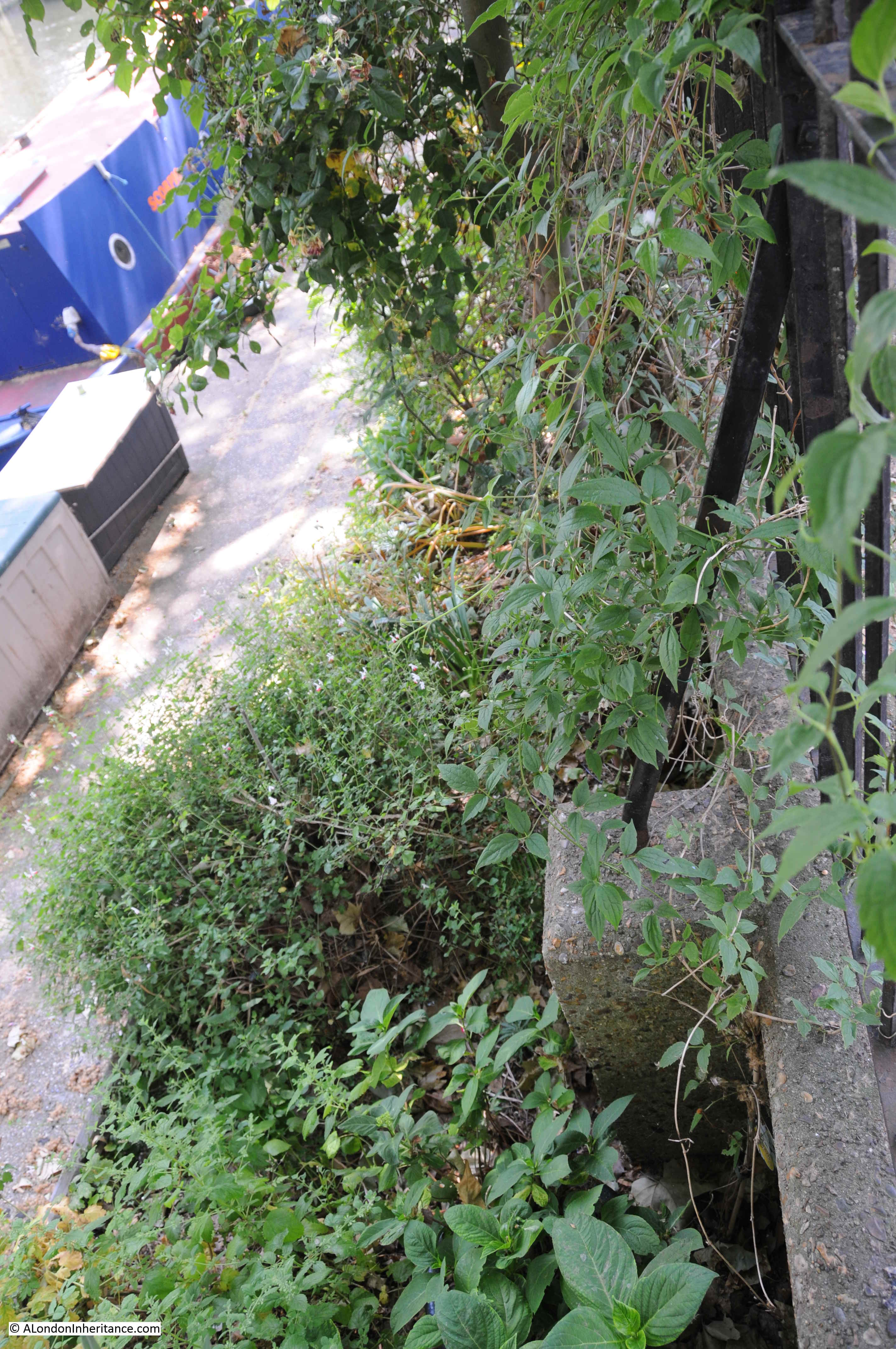
The same view in July 2018:

Blomfield Road

The photos are 67 years apart, and the view, whilst basically the same, has some significant differences. Blomfield Road is to the right of the photo with Maida Avenue running along the opposite side of the canal.

In 1951 the Regents Canal was still a working waterway. My father’s photo shows a clear canal (apart from a single boat), along with an unobstructed tow path. In 1951 Blomfield Road was clear, however today, as with the majority of all London streets, Blomfield Road now has parked cars running the length of the street.

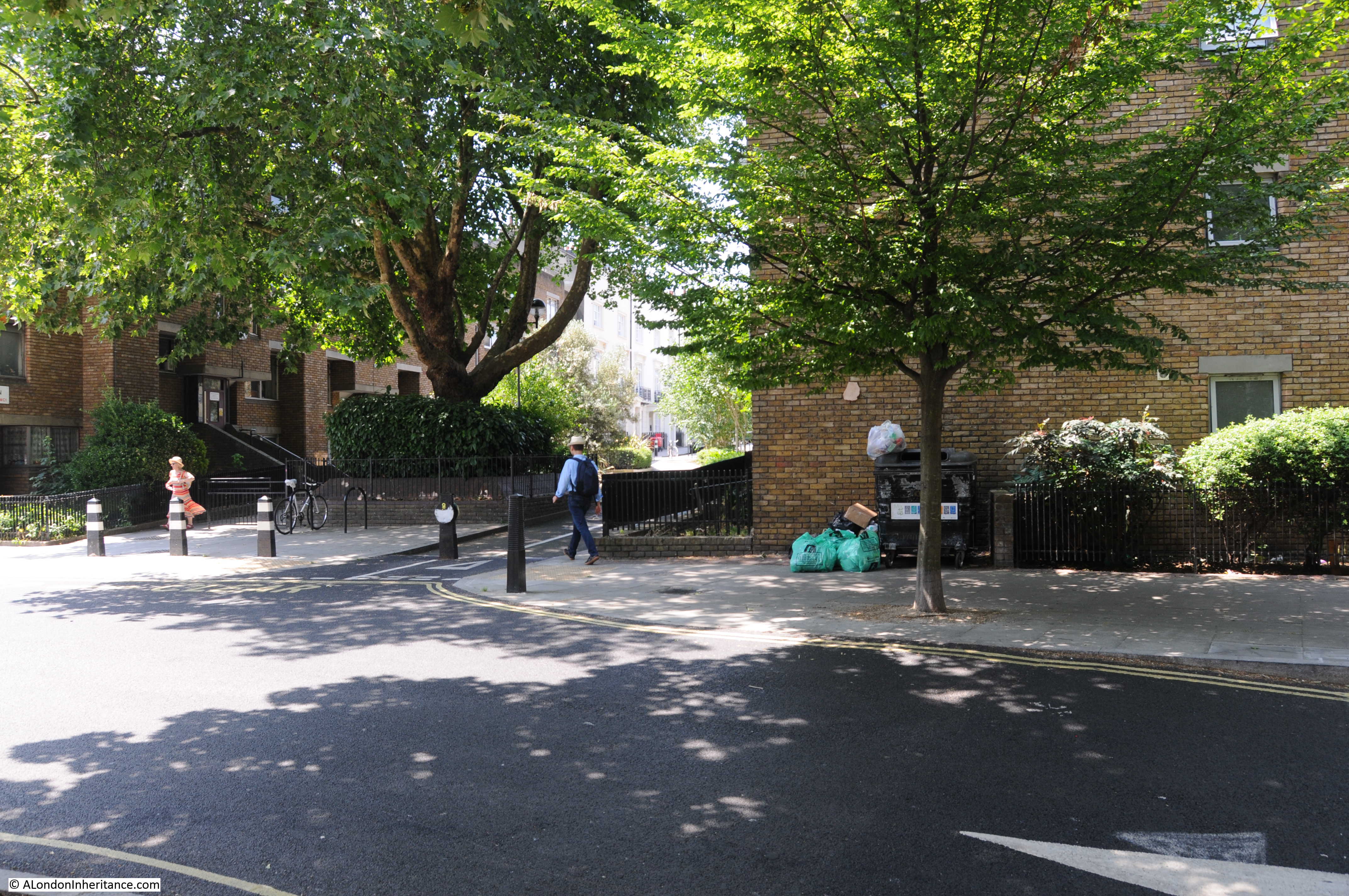
This length of the canal is now occupied by private moorings, so it is not possible to walk the tow path along the Blomfield Road stretch of the canal. Boats line the canal, with domestic paraphernalia alongside the boats with the stretch of the tow path immediately alongside Blomfield Road now occupied by a considerable amount of planting.

In the 1951 photo there are curved metal supports running from the railings down to concrete blocks. These are not immediately visible in my photo above, however walk alongside  the railings and peer over and the same metal supports and concrete blocks can still be seen in the undergrowth.

Blomfield Road

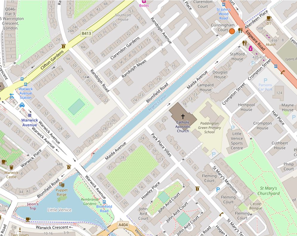
My father took the photo a short distance along Blomfield Road from the junction with Edgware Road. It was at the point where a walkway leads off to the tow path.

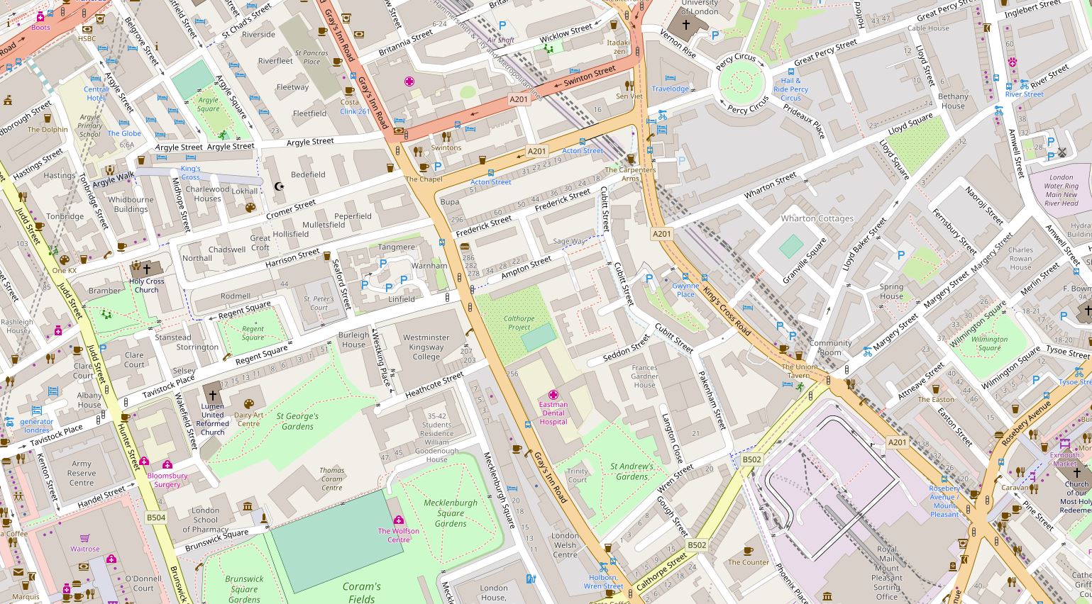
The orange circle at the top right of the following map shows the location. (Map  “© OpenStreetMap contributors”).

Blomfield Road

The photo below shows from where the 1951 and 2018 photos were taken – as best as I can judge, the original photo was taken just to the left of the tree, looking along the canal.

Blomfield Road

The location is close to where the Regents Canal enters the Maida Hill Tunnel:

Blomfield Road

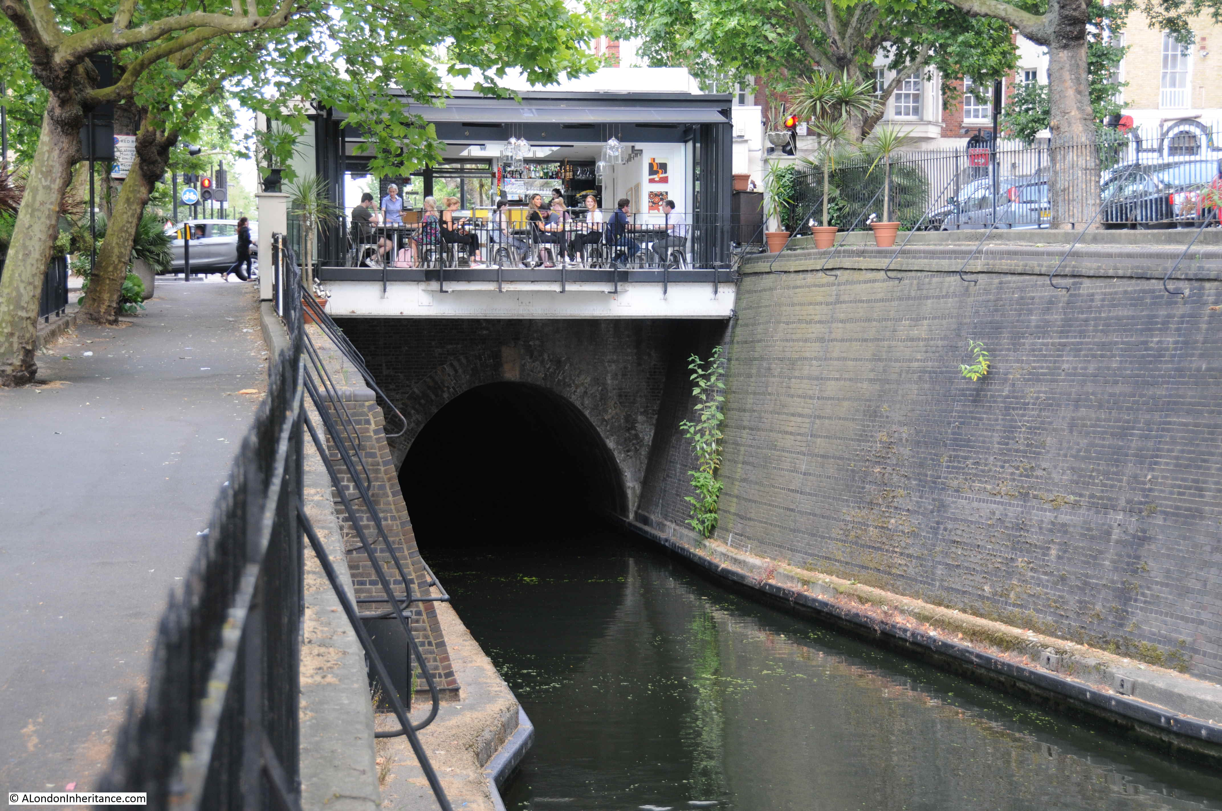
The Maida Hill Tunnel is 248 meters long, running to the east under Aberdeen Place. It is only wide enough for a single boat, so care is needed to check that the tunnel is clear before entering. Fortunately the tunnel is completely straight so checking to see if the tunnel is clear is down to whether you can see light at the far end (or hopefully another boat’s lights at night).

The tunnel does not have a tow path, so horses pulling barges along the Regents Canal would have been walked between tunnel entrances above ground, with those on the barge propelling it through the tunnel by lying on their backs and using their feet on the walls of the tunnel to “walk” the barge through the tunnel.

The cafe built above the tunnel entrance provides a rather spectacular view along the length of the canal, however whilst I was there most people seemed more interested in their phones than the view along the canal.

Construction of the Regents Canal started in 1812 from the Grand Union Canal junction, reaching Camden by 1815. The extension on to the River Thames was completed by 1820 at what was called the Regents Canal Dock, now Limehouse Basin.

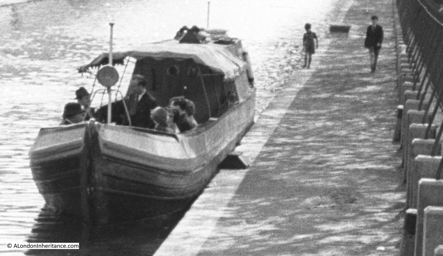
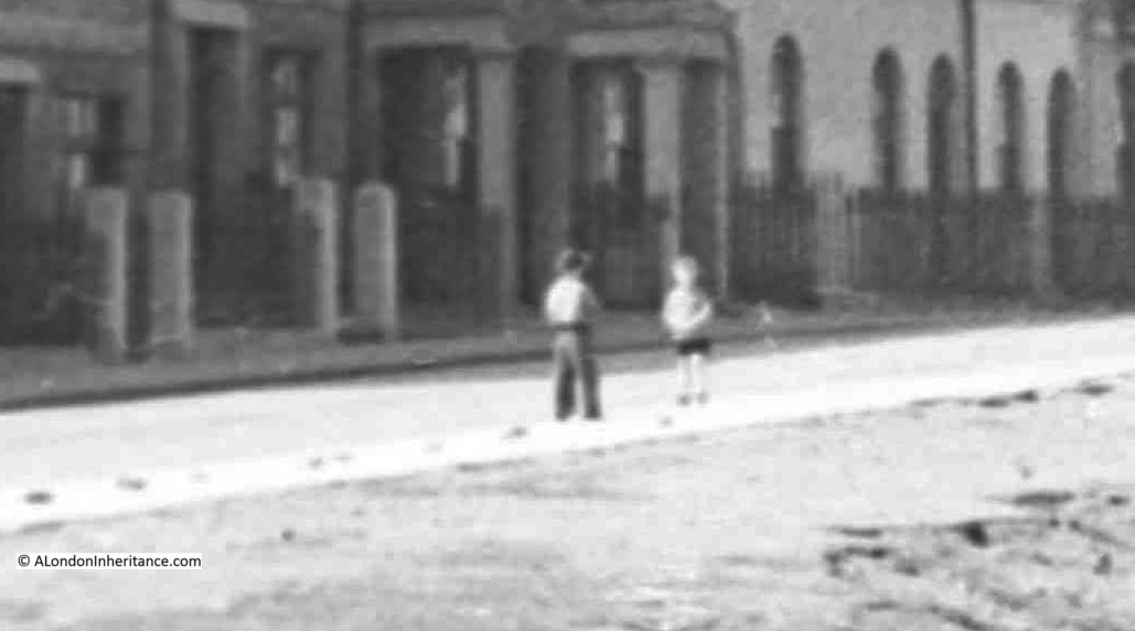
In the 1951 photo there is a single boat moored to the side of the canal. A close up reveals a rather formal group on the boat. This may have been one of the early pleasure trips along the canal. Two boys can also be seen walking along the tow path.

Blomfield Road

When the canal was built, the development of London was spreading north. Building was initially along the Edgware Road, however the development of the Regents Canal was the catalyst for further expansion to the north with Blomfield Road being named by 1841.

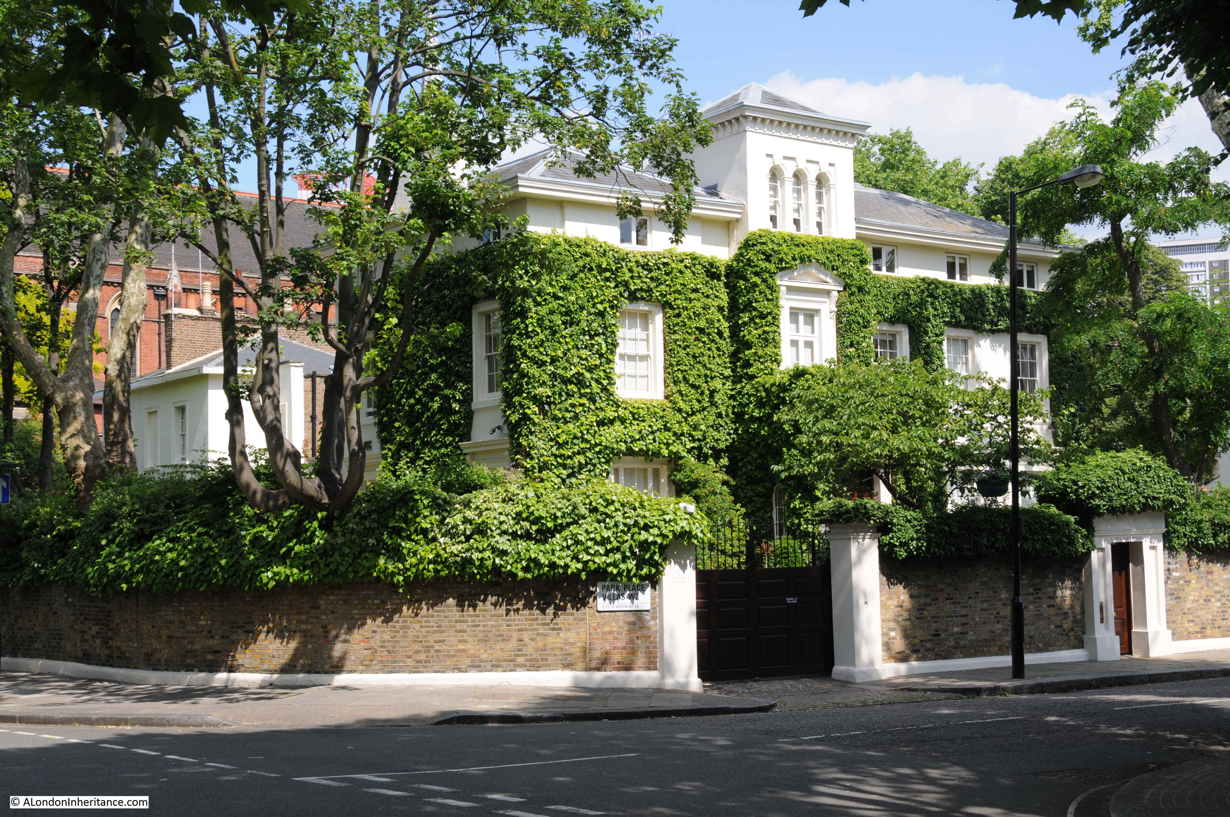
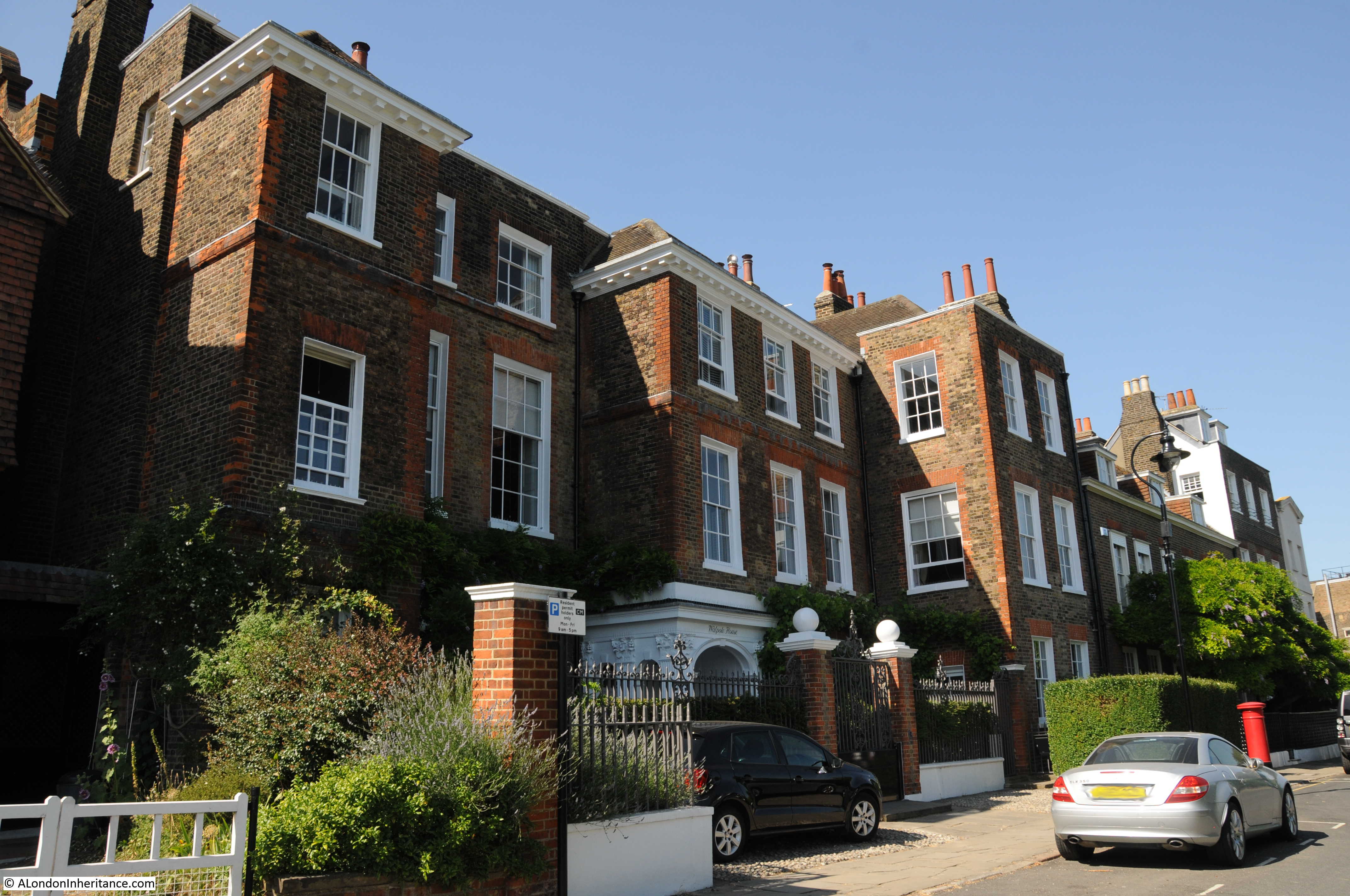
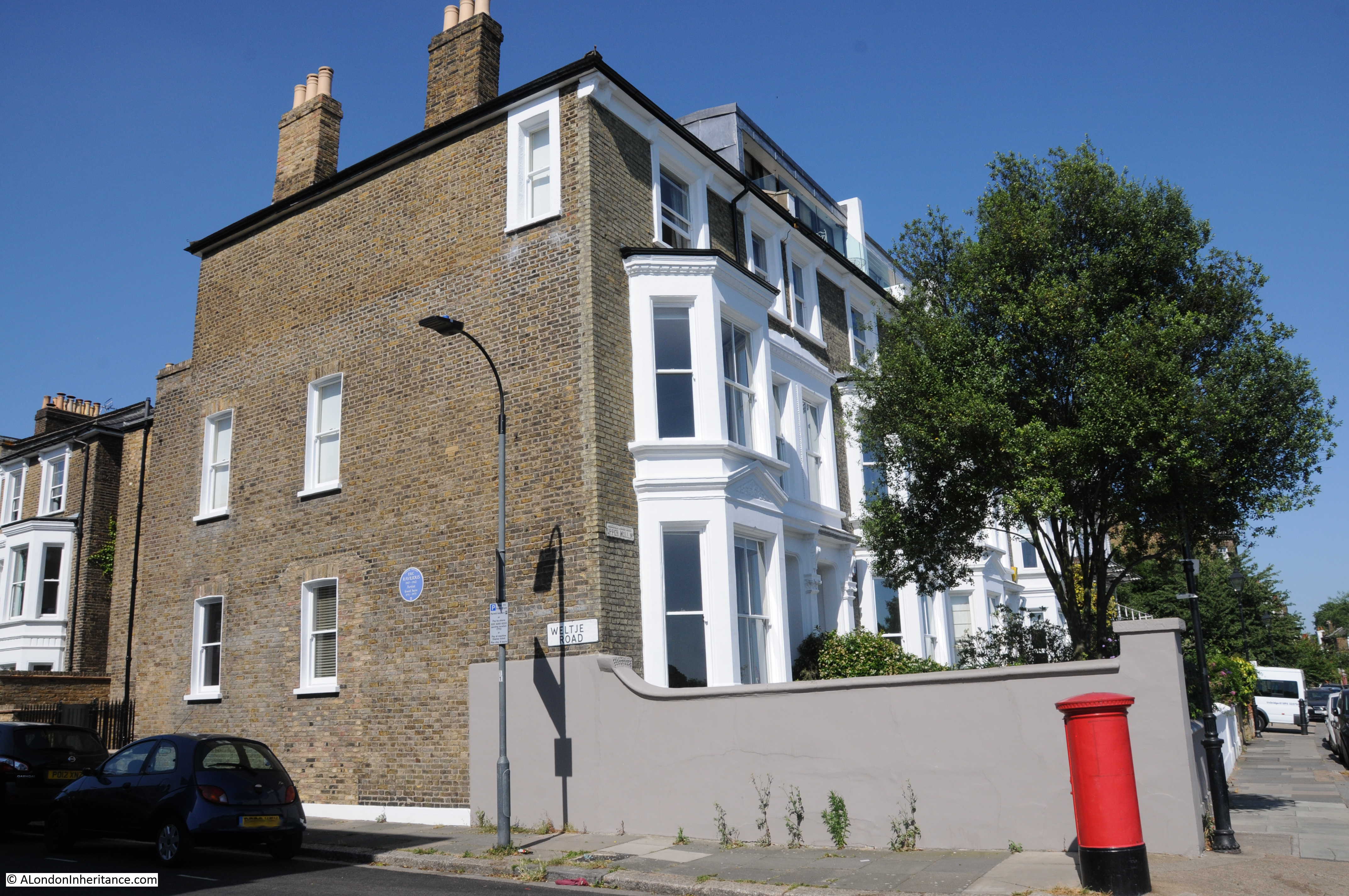
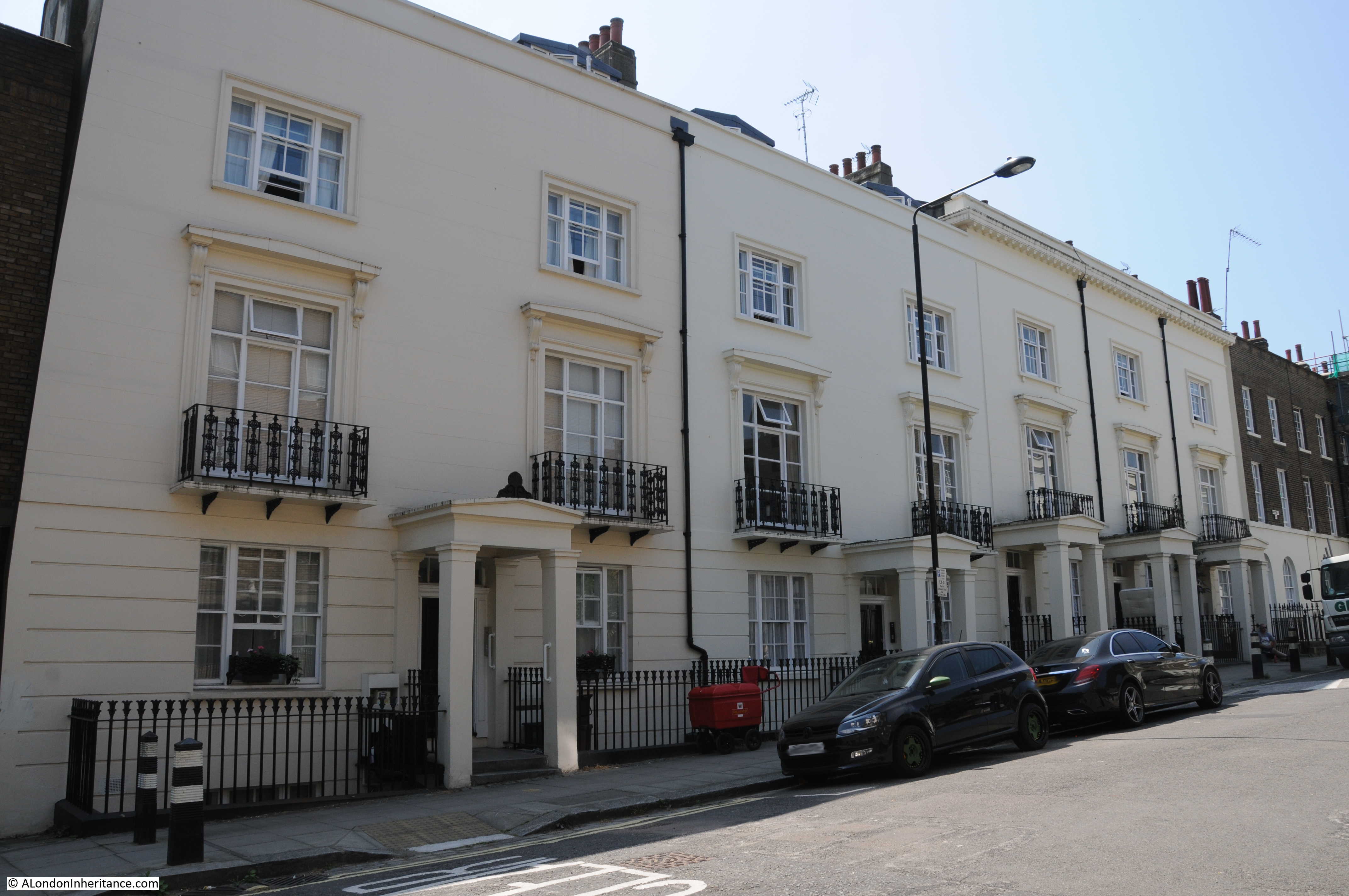
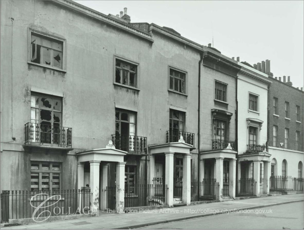
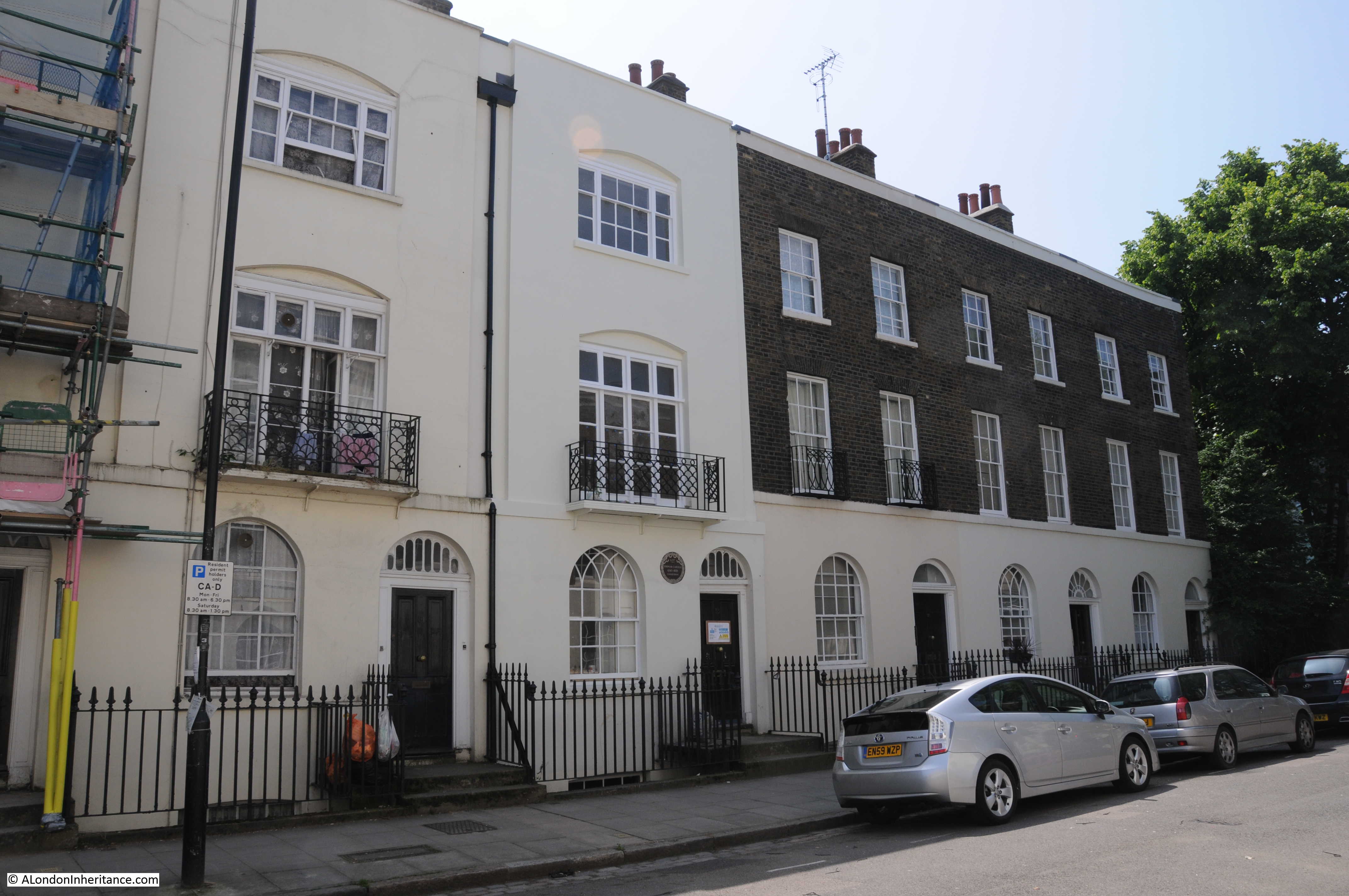
Both Blomfield Road and Maida Avenue have some rather impressive villas lining the street. The large number of chimney pots are the same as can be seen to the right of my father’s photo.

Blomfield Road

An impressive corner plot:

Blomfield Road

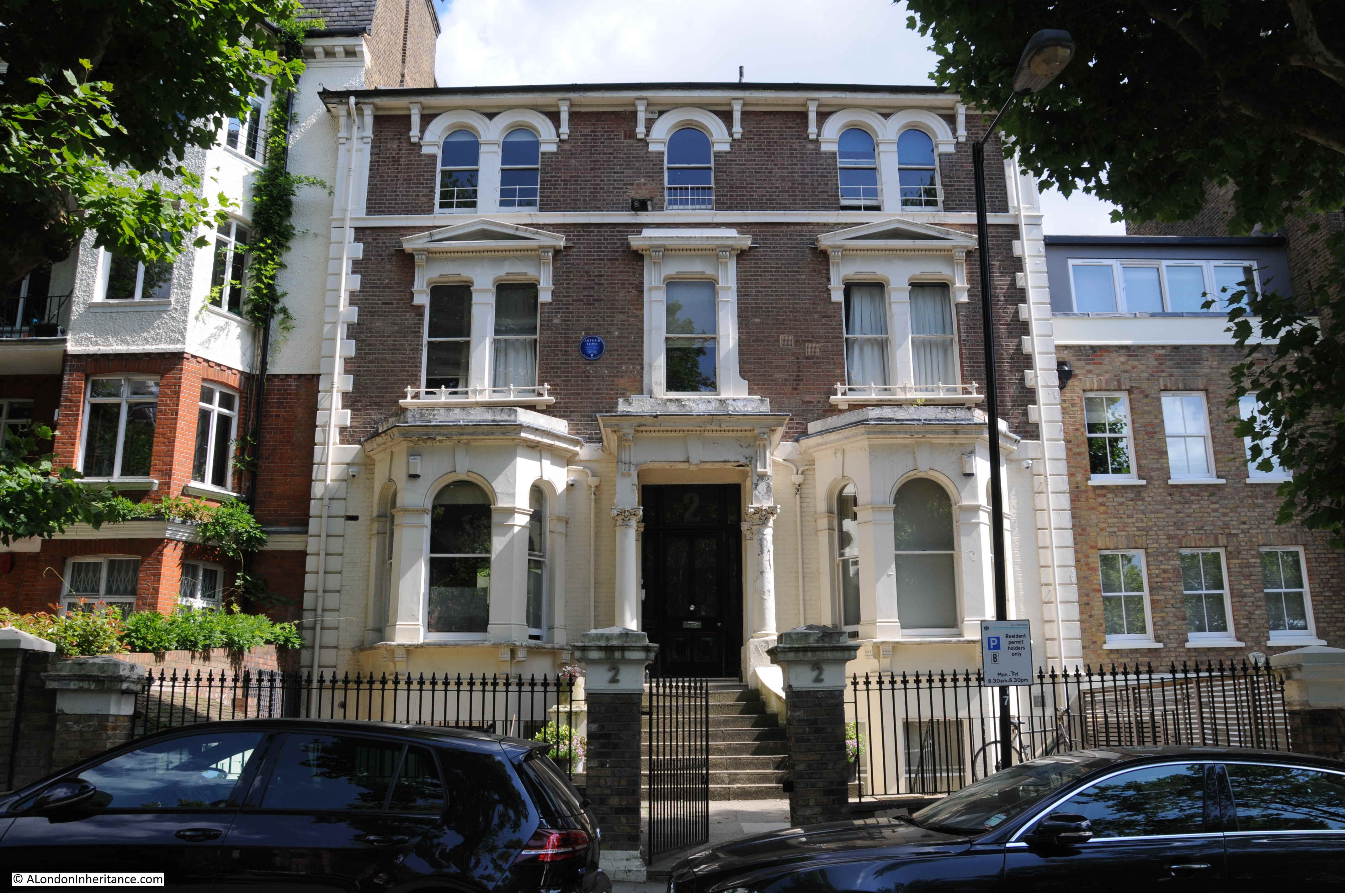
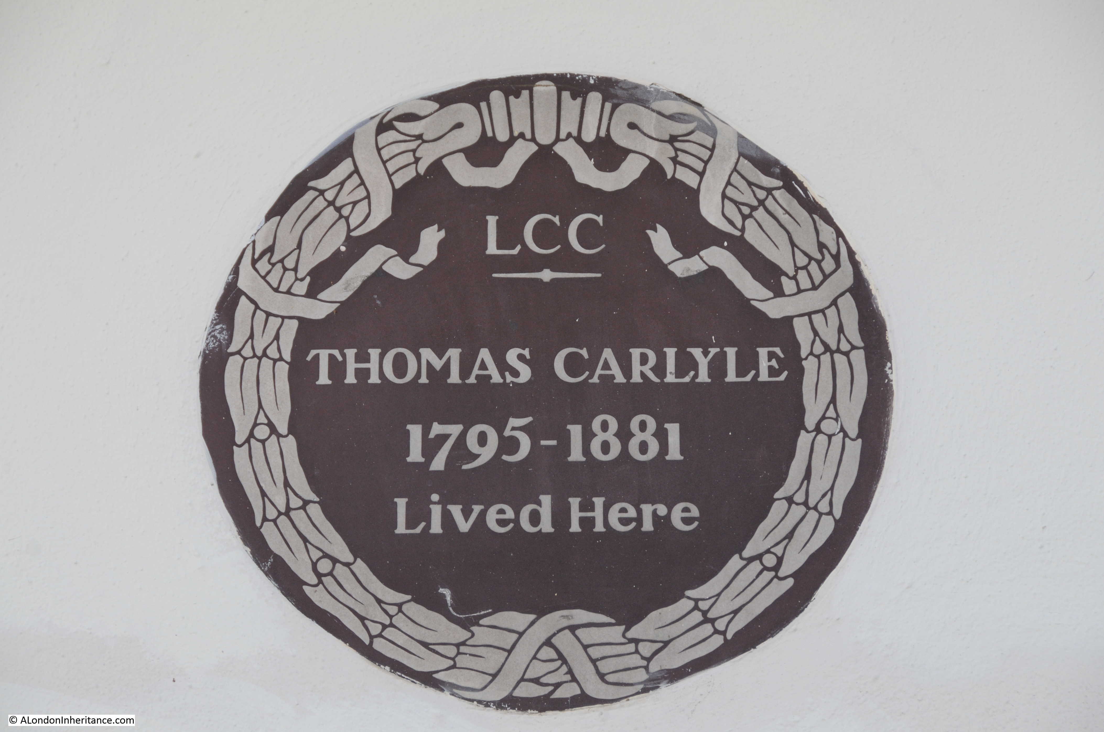
A more traditional, large, three storey town house. The blue plaque informs that Arthur Lowe (Captain Mainwaring of Dad’s Army) lived in the house from 1969 to 1982, the year of his death.

Blomfield Road

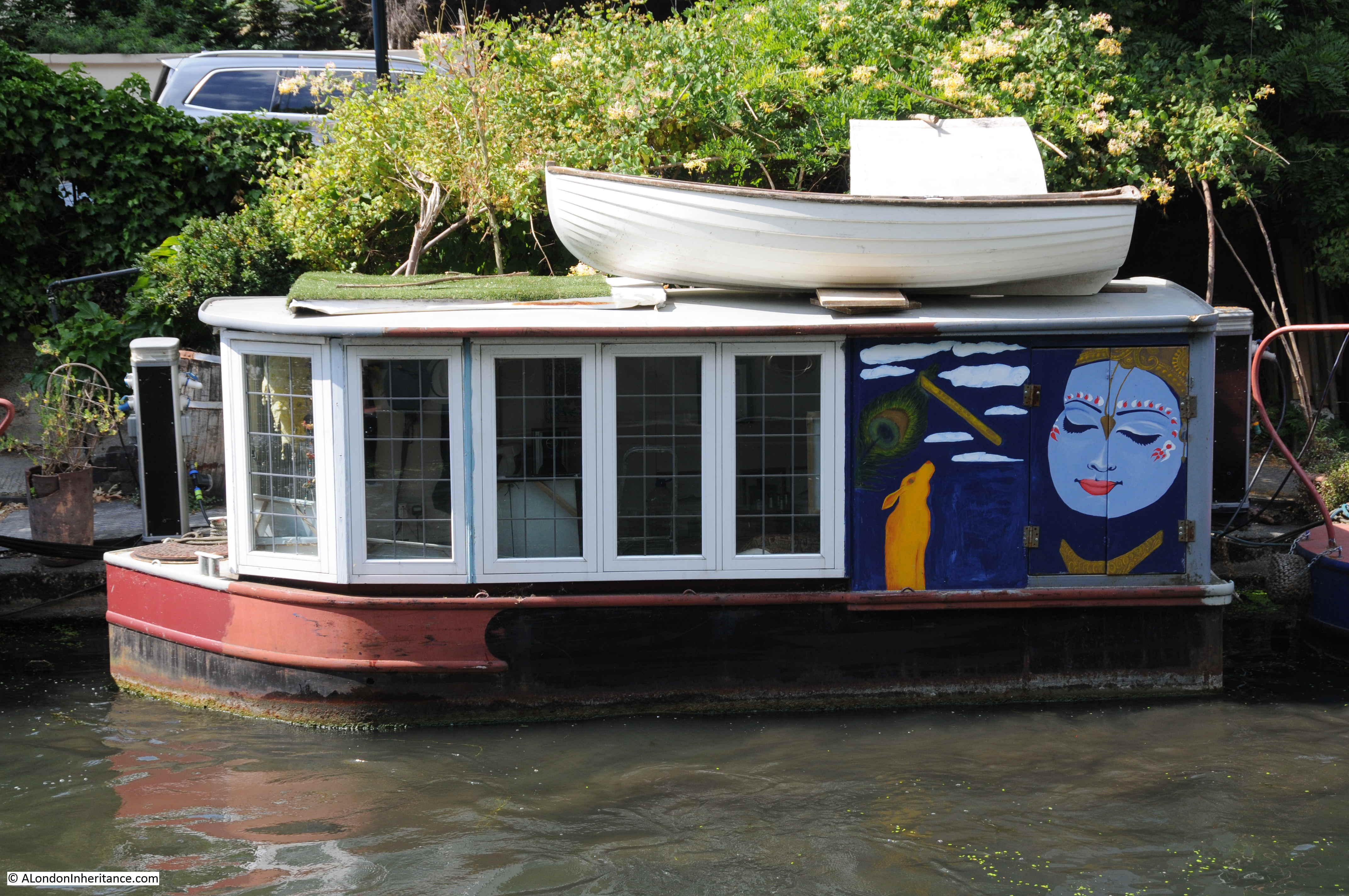
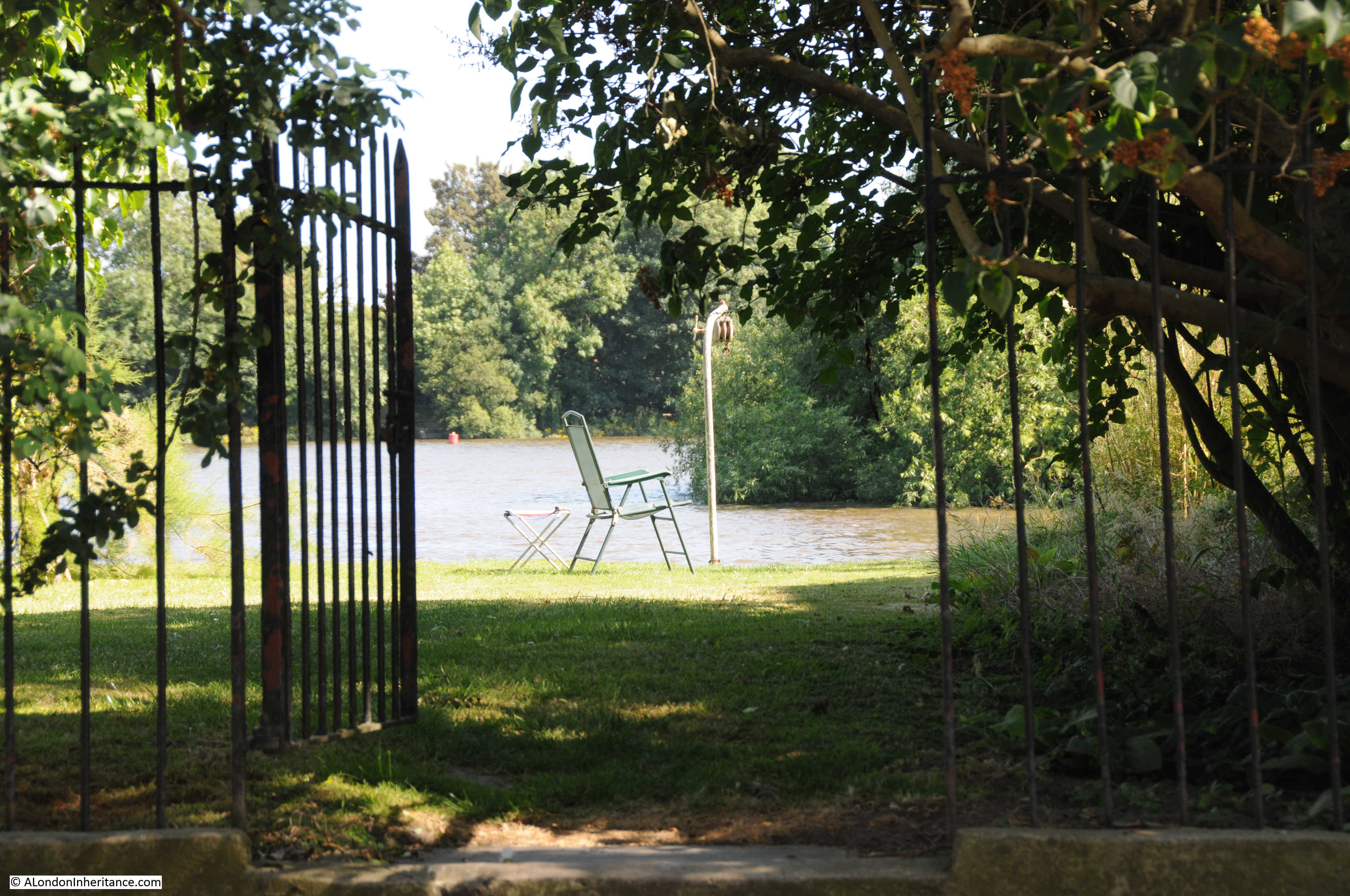
The tow path is now part of the private mooring space with access only for those with a mooring along the canal. Boat owners have set up their own garden space on the tow path alongside their boats.

Blomfield Road

The boats are very individual, with their internal decoration:

Blomfield Road

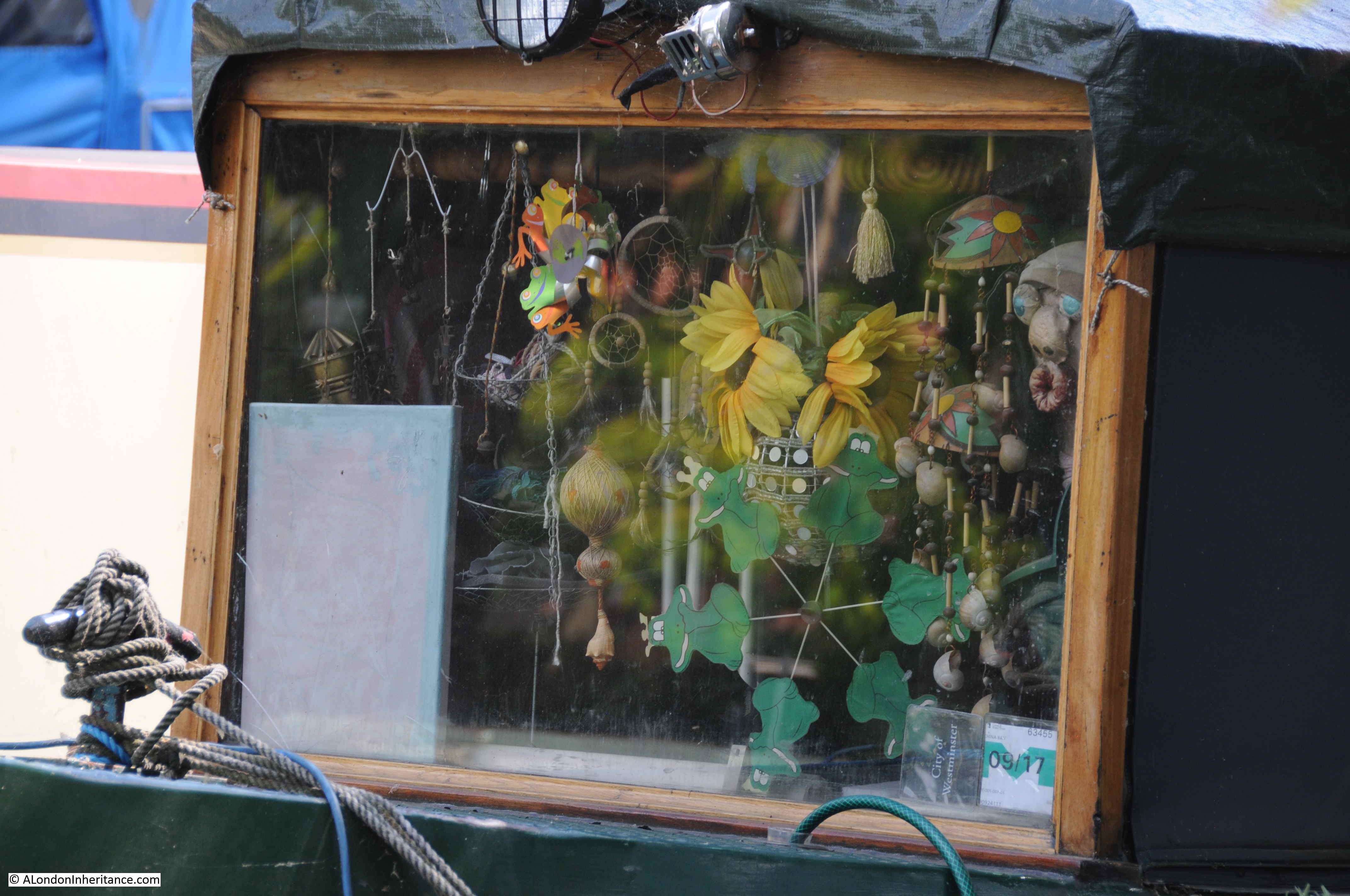
And also their design and external decoration:

Blomfield Road

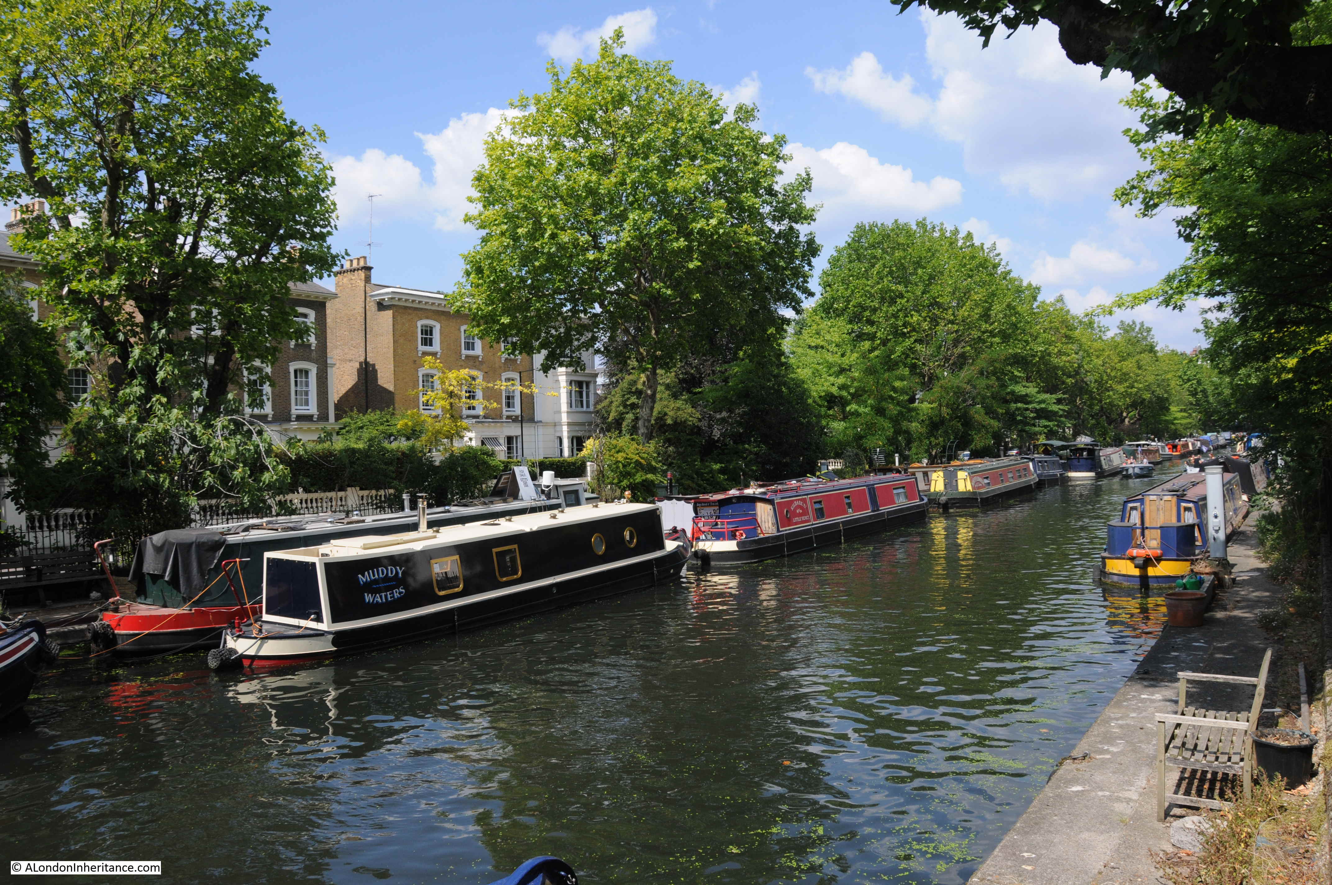
The following view is from the Warwick Avenue end of the canal, just before the Regents Canal enters the junction with the Grand Union Canal. The full length of the canal between Warwick Avenue and Edgware Road is occupied by barges and boats, many with two barges to a single berth alongside the tow path.

Blomfield Road

Where Blomfield Road meets Warwick Avenue there is a bridge that carries Warwick Avenue across the Regents Canal. Through the bridge is the larger expanse of water that makes up the junction with the Grand Union Canal and the branch down to the Paddington Basin.

Blomfield Road

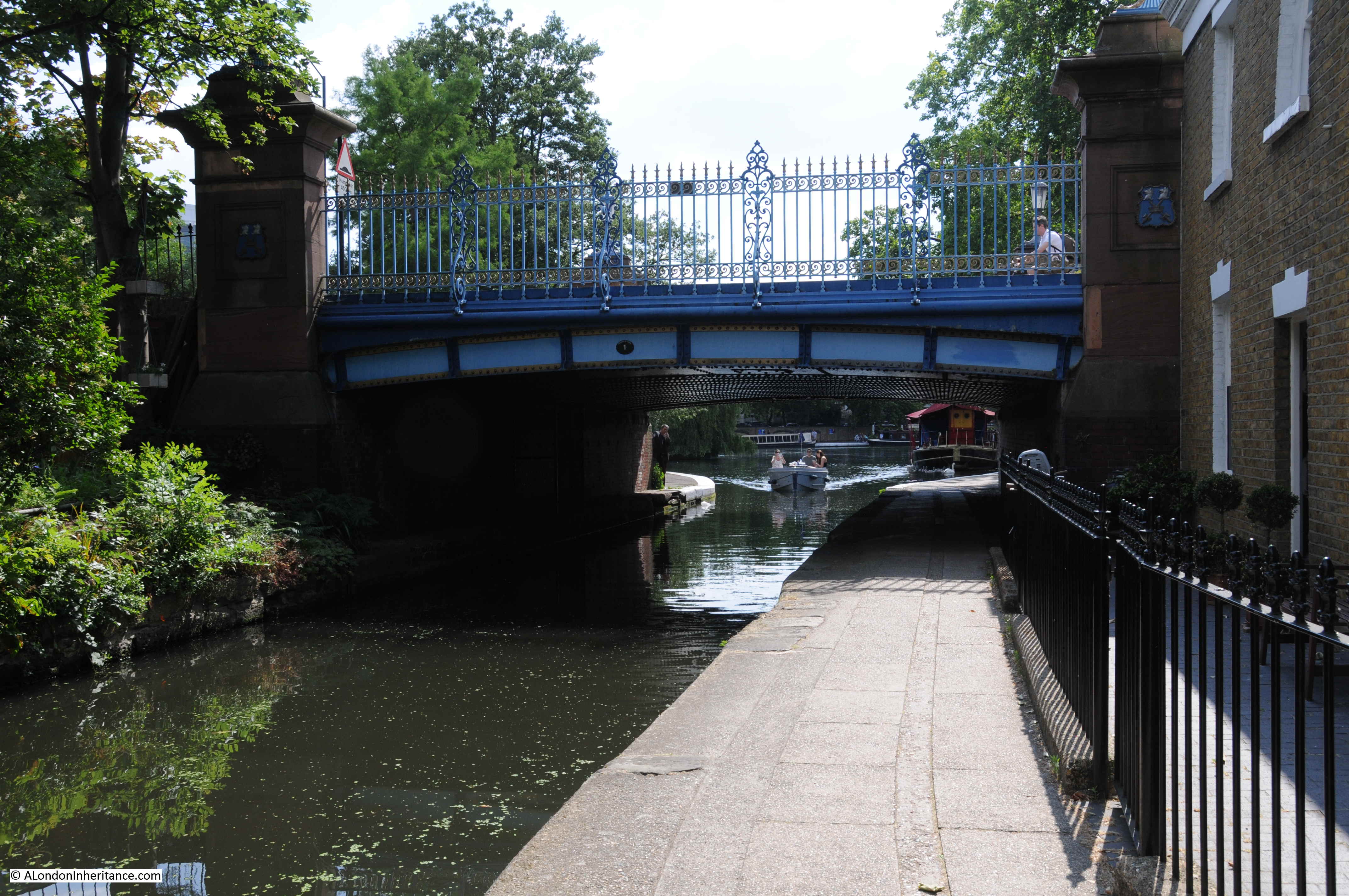
The next photo is the view from the top of the bridge looking back along the canal with Blomfield Road on the left. The empty canal in my father’s photo now looks very different.

Blomfield Road

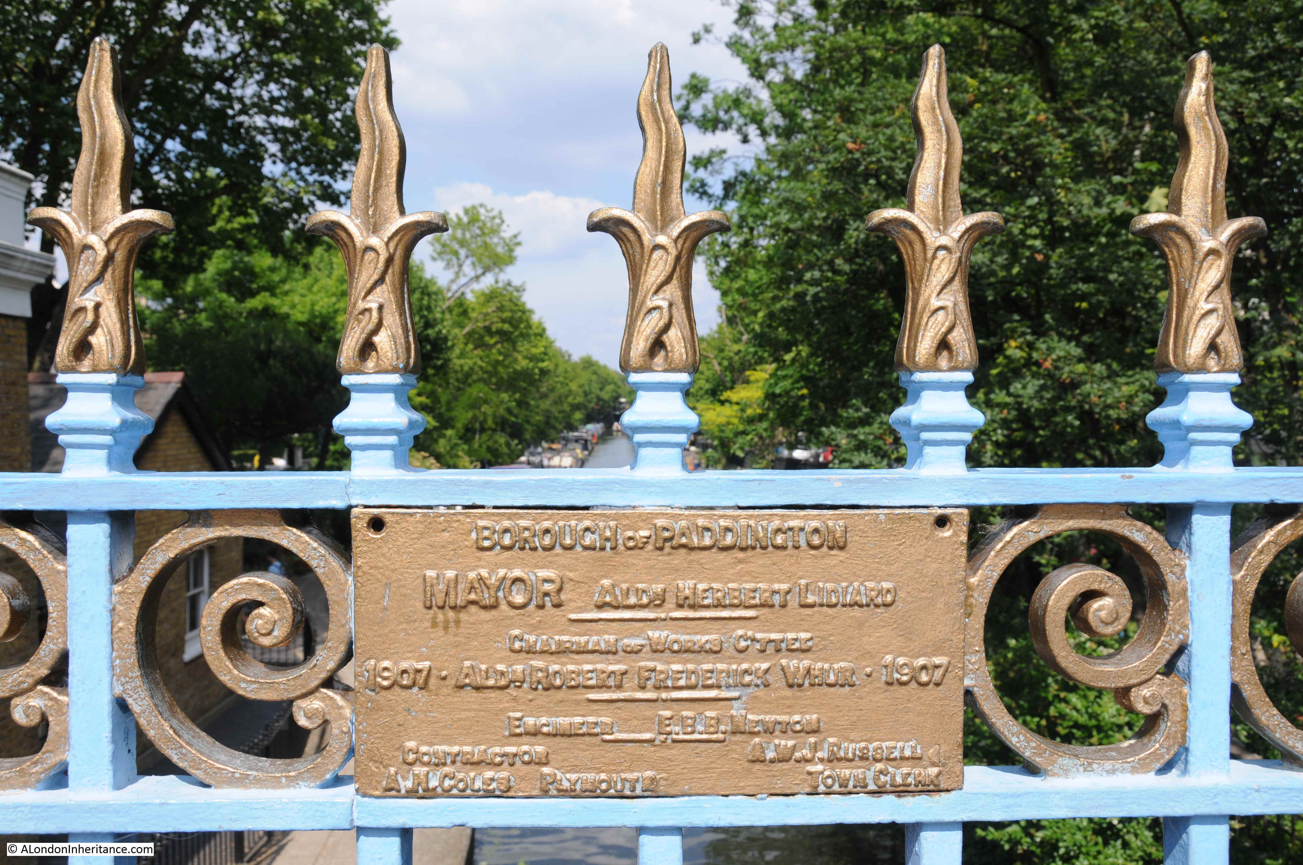
On the railings along the side of the bridge there is a rather nice plaque dating the current bridge to 1907 and constructed by the Borough of Paddington.

Blomfield Road

I always wonder why my father took the photos from the position that he did. I would have thought that the bridge provided a better viewpoint, however given that the majority of the canal as seen from the bridge was empty in 1951, his photo from the Edgware Road end of Blomfield Road included the boat with the group of people, possibly waiting for a trip along the canal, and the two boys walking along the tow path. It was probably these features that added to the overall composition of the photo.

It also makes me very aware of how photography has changed from when my father had the expense of film and developing of the negatives, so individual photos had to be more carefully considered. Compare this to digital photography today when having paid for the camera and memory cards the cost of photo is effectively zero.

The Regents Canal offers some fantastic walking. I have walked several sections, but never the entire length of the canal – another long walk added to the ever growing list.

alondoninheritance.com

Fountain House And St Gabriel Fenchurch

A brief post this week as I have been short of time, however a post that covers two aspects of London that fascinate me. The first is about London’s buildings, the considerable range of different architectural styles over the centuries, how these change, how some buildings survive, the degree of rapid change – Fountain House in Fenchurch Street is a good example.

The second aspect are the traces of London’s history that can still be found in a rapidly changing City, and for this, St Gabriel, Fenchurch is an example.

Fountain House, Fenchurch Street

I came across Fountain House whilst walking along Fenchurch Street. There is nothing special about the building, however the design of Fountain House is from a specific period. It is the type of building that I expect will soon disappear and be replaced by a much taller glass and steel tower, making full use of the space not occupied by the relatively thin tower.

This is the view approaching Fountain House from the east, along Fenchurch Street:

Fountain House

Fountain House was constructed between 1954 and 1958 to a design by W.H.Rogers and Sir Howard Robertson (Consulting). It was the first London building constructed to the tower and podium formula where a large podium occupies the full area of the plot of land, with a much small central space occupied by a tower block.

The lower podium block is occupied by a central entrance foyer and around the street level of the podium there is space for a range of retail units.

The corners of the podium are almost triangular in shape to fit within the surrounding streets. As the central tower only occupies a small percentage of the overall plot of land, today’s developers would no doubt consider this to be wasted space and a modern replacement would see a glass and steel tower occupying the full width and depth of the land available.

This is the view of the corner of the podium, which faces to the east. The clock makes a good central feature to the corner of the building.

Fountain House

A walk down Mincing Lane provides a view of the width of the tower to the street, only three bays wide.

Fountain House

The Pevsner guide describes Fountain House as:

“The first office tower in London to repeat the motif of Gordon Bunshaft’s Lever House, New York (1952), that is a low horizontal block with a tall tower above, here set end-on to the street. With its podium curving to the street and lower return wing along Cullum Street, the composition is tentative compared with later versions of the formula.”

The Lever House in New York, referred to by Pevsner is shown in the photo below. The same concept of podium and tower that would be repeated a couple of years after Lever House was built in 1952 in the City of London with Fountain House.

Fountain House

Source: Wikimedia Commons

In the late 1950s, Fountain House must have appeared to be the latest architectural style transferring from New York – the City of London rising from the destruction of the war.

Fountain House in the final stages of completion in 1957:

Fountain House

Image credit: London Metropolitan Archives, City of London: catalogue ref: SC_PHL_01_010_57_3038

The central entrance to Fountain House:

Fountain House

The two pillars can be seen in the 1957 photo, however I suspect the canopy was a later addition.

A look into the entrance foyer reveals what looks to be a refurbished interior:

Fountain House

The corner of the podium on the western edge of Fountain House:

Fountain House

Always on the look out for plaques attached to buildings, I found the following fixed to Fountain House along the side of the building facing onto Fen Court. The plaque from December 1964 marks the boundary of the site with the implication that the land belongs to the Clothworkers Company (who have their Hall just to the south of Fountain House).

Fountain House

The Clothworkers Company do indeed still own the freehold to Fountain House.

So what is the future for Fountain House?

This first example of podium and tower architecture in the City of London may not be around for too much longer. A development agreement is in place between the Clothworkers Company and the tenant of the building for a major redevelopment of the site. Fountain House will be replaced by a new block which occupies the whole site and makes use of the empty space above the podium, not occupied by the tower. The new building looks to be very much like any other glass and steel tower to be found across the City.

The tenant can commence development from 2017, so I suspect this will happen when the financial case for a new office block makes sense to the tenant.

A shame as I rather like Fountain House.

St Gabriel Fenchurch

The following photo is the view looking east along Fenchurch Street. Fountain House is the building on the left.

Fountain House

Look to the right of the photo and there is a blue plaque.

This records that the church of St Gabriel Fenchurch stood in the roadway opposite, so would have been in the centre of the photo above.

Fountain House

St Gabriel Fenchurch was one of the many City churches destroyed in the Great Fire of 1666 and not rebuilt.

I have not been able to find too much about the church. There are no prints of the church in my books on London churches and history or online (that I could find).

There is a brief description of the church in “London churches before the Great Fire” by Wilberforce Jenkinson published in 1917:

“The church of S. Gabriel, Fenchurch Street, formerly stood in the middle of the street, and was built not later than the fourteenth century. Before 1517 it was known as S. Mary’s and some time ‘All Saints’. Possibly there was a triple dedication. Corruptly it went by the name of Fen Church and gave a name to the street. The district may have been marshy, for the brook, the Langbourne, went through it, and Langbourne Ward is still in evidence. The first rector was John Payne. 1321. The church was a small one, but was enlarged in 1631. In the Return made in 1636 the income of the rectory, including the house, was stated to be £131.

This house, with the garden and graveyard, was the gift of H. Legges. R.Cook, who was rector during the Civil War, was ejected for his loyalty in 1642, but was reinstated at the Restoration.

The church figured in the City decorations on the day of King James I’s coronation entertainment. Ben Jonson described it in 1603:

At Fen-Church the scene presented itself in a square and flat upright, like to the side of a Citie; the top thereof, above the Vent and Crest adorned with houses, towres and steeples in prospective.”

Stowe in his Survey of London has but a single sentence for the church: “In the midst of this streete standeth a small parish Church called S. Gabriel Fenchurch, corruptly Fan church.”

Much the same description is given in the 1771 edition of Chamberlain’s Survey of London, so all the descriptions of St Gabriel’s provide a consistent view of the church.

The Collage archive at the London Metropolitan Archives has a map which shows the location of the church in the centre of Fenchurch Street. The strange thing about this map is that Collage dates the map as c1800 which is 134 years after the church was destroyed in the Great Fire.

Fountain House

Image credit: London Metropolitan Archives, City of London: catalogue ref: k1264238

The map shows the position of the church, and also the burial ground of St Gabriel, part of which can still be found today.

Fen Court is shown on the map leading from Fenchurch Street to the burial ground. I mentioned Fen Court earlier in the post, and it still runs from Fenchurch Street along the eastern edge of Fountain House, to where the remains of the burial ground can be found.

Fountain House

Although St Gabriel Fenchurch was not rebuilt after the fire, the burial ground continued in use. A plaque records what happened:

Fountain House

The text is not that clear so is reproduced below:

“This churchyard was attached to the church of St Gabriel Fenchurch which was destroyed in the Great Fire of 1666. The parish was united with that of St Margaret Pattens in 1670 and was included in that of St Edmund Lombard Street in 1954.  The churchyard was paved and planted by some of the owners and occupiers of the adjoining buildings in 1960.”

The text illustrates how churchyards and burial grounds from churches not rebuilt would be taken up by other local churches. This contributed significantly to the long term survival of these patches of land in a City ever hungry for additional growth space.

The remaining graves appear to be from the 18th and 19th century. Nothing from the time of St Gabriel which is not a surprise, and I suspect burials ended in the 19th century as happened across the majority of City burial grounds and churchyards as after centuries of taking the dead of the City of London, they were over full and a serious health hazard to an expanding City.

Fountain House

A rather ornately carved grave remains:

Fountain House

Which appears to have been built in 1762 by Anne Cotesworth as a burying place for herself as she was born in the parish and her nearest relations were buried in the next vault.

Fountain House

The remains of the burial ground of St Gabriel Fenchurch are immediately behind Fountain House. Hopefully this reminder of a long lost church will not be impacted by any redevelopment.

Fountain House is a reminder of how architectural styles change so quickly across London. Once the first example of a new design imported from New York. Sixty years later, and it may well be disappearing in the next few years – and London continues to evolve.

alondoninheritance.com

St Botolph Without Aldgate

The subject of this week’s blog was easy to find, however I found the specific location from where my father took the following photo through one single building remaining in an otherwise completely changed street scene. The church tower in the centre of the photo is that of St Botolph without Aldgate. The  church tower is distinctive and easy to recognise, although the very top of the spire is missing, probably through bomb damage.

There are no other obvious locations in the photo to identify from where my father took the photo. There looks to be a bomb site between the church and the road.

St Botolph without Aldgate

I walked all the surrounding streets trying to find the location of the photo. The search was not helped by the amount of new building obscuring the view to the church, however when I walked down Dukes Place towards the junction with Creechurch Lane and Bevis Marks I saw one building that looked familiar.

If you look to the left of the above photo, there is a tall building. Look to the left of the photo below and the same building is remarkably still there – a lone survivor from the pre-war buildings in these streets.

St Botolph without Aldgate

Although the ground floor is very different, the floors above have the same architectural features in both photos. The building today is NMB House, however if the building is the same as described in the Pevsner guide to the City of London, it was Creechurch House.

NMB House is at 17 Bevis Marks, and the Pevsner Guide states:

“Nos. 17-18, Creechurch House: smart warehouse facing Creechurch Lane, by Lewis Solomon & Son, 1935, with metal faced floors between stone mullions.”

Pevsner states that the building included number 18. It looks as if the building has been reduced in width, with the space where number 18 once stood, now being occupied by a new building with only number 17 remaining from the original.

The following photo shows the building with Creechurch Lane running to the right,

St Botolph without Aldgate

This is a wider view, and my father took the original photo from just in front of the bus stop. Compared to the original street, post war widening and straightening can be clearly seen in the view today.

St Botolph without Aldgate

Walking down Dukes Place towards St Botolphs without Aldgate, the church becomes visible and at the rear of the church are trees, much as in my father’s original photo.

St Botolph without Aldgate

A much better view of the church can be found by walking a short distance down Minories, the street directly opposite the church.

St Botolph without Aldgate

As with many old City churches, the first written records that mention St Botolph without Aldgate date back to the 12th century, although an earlier Saxon church was probably on the site as evidence of 10th or 11th century burials have been found in the crypt.

The church was originally attached to the Priory of the Holy Trinity. It was rebuilt just before the dissolution of the monasteries during Henry VIII’s reign and restored in 1621. St Botolph without Aldgate was declared unsafe and demolished in 1739, making way for construction of the church we see today.

The church before demolition was recorded in a number of prints, including the following  dated 1739:

St Botolph without Aldgate

The rebuilt St Botolph without Aldgate was designed by George Dance the Elder and built between 1741 and 1744. George Dance was the surveyor for the City of London and the designation ‘Elder’ is to separate this George Dance from his son, also George Dance who was also an architect for the City.

The new church was aligned so that the entrance to the church and the tower above faced directly to the Minories.

The following drawing by George Dance the Elder shows the church looking exactly the same as it does today:

St Botolph without Aldgate

“George Dance the Elder, StBotolph, Aldgate, London, c.1740s: (1-9) Plans, elevations, sections & detail of ceiling © Sir John Soane’s Museum, London”

The dedication of the church, St Botolph without Aldgate is firstly to St Botolph, who established a monastery somewhere in East Anglia in the 7th century. St Botolph died around the year 680. The addition of “without Aldgate” is to reference the location of the church as being outside the City walls.

There are a number of other St Botolph churches on the edges of the City, St Botolph without Bishopsgate, St Botolph without Aldersgate, and there was a St Botolph Billingsgate, destroyed in the Great Fire and not rebuilt.

I have found a couple of possible sources for the association of St Botolph with these churches on the edge of the City. The first is that in the 10th century, King Edgar had the remains of St Botolph divided and sent to locations through London. They passed through the City gates and the churches alongside the gates through which the remains passed were named after the saint.

The other reference associates the City gates with St Botolph being the patron saint of wayfarers, who would use the City gates as their entrance to and from the City.

Both of these sound plausible, and I find it fascinating that the names of churches on the edge of the City refer to both the original Roman wall and possible events from the 10th century.

A traveler arriving at the City gate near St Botolph without Aldgate would find a very different view today with the office towers of the City rising behind the church.

St Botolph without Aldgate

There is an open space on the City side of the church, however buildings run up close to the church to the north and east:

St Botolph without Aldgate

Another of the plans drawn by George Dance showing a section through the church:

St Botolph without Aldgate

“George Dance the Elder, StBotolph, Aldgate, London, c.1740s: (1-9) Plans, elevations, sections & detail of ceiling © Sir John Soane’s Museum, London”

On entering the church there is a record of all the parish priests of the church. The first line almost appears apologetic for the lack of records remaining from before the 12th century “The parish priests of Aldgate are known only from AD 1108”

St Botolph without Aldgate

Also in the entrance to the church is this splendid momument to Robert Dow, who died in May 1612 at the age of 90 – a rather good age for the 17th century.

St Botolph without Aldgate

Robert Dow was a Master of the Merchant Taylors and during his life gave away a substantial sum to various charitable establishments. The value of his donations and those receiving the money are listed on his monument.

I am not sure what the symbolism of the hands covering the skull means – it gives the impression that he had a hold over death (as his 90 years possibly demonstrated), or perhaps representing his own skull in death.

Another monument is to Thomas, Lord Darcy who was beheaded on Tower Hill for treason in 1537 during the reign of Henry VIII.

St Botolph without Aldgate

The view on entering the church:

St Botolph without Aldgate

The interior of St Botolph without Aldgate retains the original galleries and Tuscan columns, however much of the decoration is from a redecoration of the church carried out between 1888 and 1895 by J.F. Bentley who added some remarkable decorative plaster work to the ceiling of the church:

St Botolph without Aldgate

Close up of the ceiling decoration:

St Botolph without Aldgate

I find it fascinating to discover the stories behind the monuments in the City churches. In St Botolph without Aldgate there is a monument to Willian Symington, who died on the 22nd March 1831. The monument records that he constructed the Charlotte Dundas, the first steamboat fitted for practical use, also that he died “in want”.

St Botolph without Aldgate

William Symington was Scottish, having been born in the small village of Leadhills. He studied engineering at Edinburgh University and worked in Wanlockhead where his brother George was building steam engines to James Watt’s design.

William Symington was always interested in whether a steam engine could power a boat. The problem was not just the mechanism to propel the boat, but also how a steam engine could be installed in a wooden boat, without the boat catching fire.

He tried a number of experiments with limited success, problems such as the paddle wheel disintegrating preventing a fully successful trial.

From 1800 Symington continued his work under the patronage of Thomas, Lord Dundas, who had an interest in the Forth and Clyde Canal.

A first trial of a steam boat on the River Carron ended in failure. The second trial was with a new boat named the Charlotte Dundas after Lord Dundas’ daughter. This successful trial included the Charlotte Dundas towing two barges over a distance of 18.5 miles.

Although the trial was a success, there were concerns with the damage that the wash from a steamboat would do to the banks of a river or canal. Symington had also received an order from the Duke of Bridgewater for steam boats on the Bridgewater Canal, however this was cancelled when the Duke died.

As opportunities for Symington’s steamboats collapsed, he moved to the management of a colliery, however this ended in a legal case following which Symington was a rather poor man.

So far, all his time had been spent in Scotland. The London connection starts in 1829, when Symington, in poor health and in debt, moved with his wife to London to live with his daughter and her husband. He would die just two years later and be buried in the churchyard of St Botolph without Aldgate.

William Symingtons steamboat, the Charlotte Dundas:

St Botolph without Aldgate

His reputation was somewhat restored during the later half of the 19th century, and the monument in the church was installed in 1903.

Symington was possibly the subject of some skulduggery. Reading newspaper reports and letters after his death reveal stories such as the following from a Robert Bowie who wrote to the Shipping and Mercantile Gazette on the 5th May 1838:

To the editor of the Shipping and Mercantile Gazette:

Sir, Having observed the paragraph in your journal and in others to the effect that the American Government had granted £24,000 to the heirs of Robert Fulton, the ‘original founder’ of steam navigation. I beg leave to say that, whatever may have been Mr Fulton’s merit in introducing steam navigation to America, he had no right to the title of being its original founder, as he was but a copyist, and obtained, as will be seen by the following documents, the knowledge which enabled him to effect his purpose from William Symington, the first who propelled vessels by the power of steam.

Mr. Symington forms another instance for the page of history, of national ingratitude and neglect; and it is assuredly no great proof of the superiority of this country to America, that instead of rewarding him who conferred an inestimable benefit, his very petition for an investigation of his claims in parliament, was not allowed to be presented.

Fulton’s heirs have not been the only parties who have reaped the rewards of Mr. Symington’s labours. Even at home rewards were bestowed on Henry Bell, who barefacedly used Mr. Symington’s plans, and carried, it is recorded, the model of the first steam boat to Fulton in America. Henry Bell was frequently on board of Mr. Symington’s boats, and was often seen investigating the Charlotte Dundas after she was laid up near Glasgow; and it is a strange and rather suspicious circumstance that the model of a steam boat left by the late Lord Dundas and Mr. Symington in the Royal Institution, disappeared unaccountably from that building; and thus the ‘Fulton Steam Frigate’ as described in the first volume of Blackwood’s Magazine, was, with the exception of her warlike apparatus, a facsimile of Mr. Symington’s Boat.”

No idea if there is any truth in Mr Bowie’s allegations, but an interesting story of possible 19th century industrial espionage.

William Symington’s monument was installed in 1903. There are much older memorials in the church including the following from 1577 recording that “Here lyeth the corps of Robert Tailor”.

St Botolph without Aldgate

The windows of the church have stained glass recording Lord Mayors of the City of London and their Livery Companies:

St Botolph without AldgateSt Botolph without Aldgate

St Botolph without Aldgate

The beautifully carved wooden panel in the following photo dates from the early 18th century (it was restored in 1971). The panel came from the church of St Mary Matfelon, Whitechapel when the church was destroyed by bombing on the 27th December 1940.

St Botolph without Aldgate

An 18th century sword rest:

St Botolph without Aldgate

St Botolph without Aldgate is a fascinating City church with a long history, which I have covered all too briefly in this post.

I was really pleased to find the location in Bevis Marks from where my father took his photo. The one remaining building in the area provided the key landmark to locate the viewpoint – amazing that this one building has survived the considerable redevelopment of the area over the last 60 years.

alondoninheritance.com

Along The Thames From Chiswick To Hammersmith

If you drive west out of London, along the A4, Great West Road from the Hammersmith Flyover to Chiswick and the Hogarth Roundabout, you pass along a very busy highway with three lanes of traffic either side.

This probably is the last place you would expect to find one of the more historic walks along a very scenic part of the River Thames, with some of the views looking more like the depths of the countryside rather than a built up area of west London.

There are some superb walks along the River Thames, and for today’s post, here is a walk from Chiswick to Hammersmith on a very hot Saturday afternoon in June (it is also a lovely walk on a cold, dark winter’s evening). The walk is perfect for a hot day as there are plenty of suitable stopping places along the route for some quick refreshment.

In the following map extract, the A4 is the large road running from the Hammersmith Flyover at top right, down to the Hogarth Roundabout at bottom left.

Chiswick

(Map  “© OpenStreetMap contributors”).

A short distance below the A4 is the river and along the river is a series of streets starting with, on the left, Chiswick Mall.

I started by walking to the river down Church Street, between St. Nicholas’ Church and Fuller’s Griffin Brewery to reach Chiswick Mall.

Chiswick Mall runs along the river, with gardens separating the street from the river, and large houses lining the street opposite the river.

The views here to the river look as if they should be from the upper reaches of the river, rather than a short distance from the six lanes of the A4.

Chiswick

The river here does frequently flood across the road. This was not a particularly high tide, however the damp road shows how far the river had come across the road.

Chiswick

The majority of the houses on the opposite side of the street have flood defences in the form of walls and metal gates that can be closed across the entrances from the street to prevent water from flooding towards the house.

There are also signs warning of the potential impact if you leave your car along the Chiswick Mall.

Chiswick

This is Walpole House, a Grade II listed building dating from the 18th century, possibly with elements from the 17th century.

Chiswick

Barbara Villiers, Duchess of Cleveland, a former mistress of King Charles II was one of the earliest recorded residents, with Thomas Walpole a later owner, who gave his name to the house.

Another view from Chiswick Mall towards the River Thames:

Chiswick

Italy or Chiswick?

Chiswick

At a number of places, the route between Chiswick and Hammersmith turns slightly in land and there are houses between the street and the river. This is where Chiswick Mall ends and becomes Hammersmith Terrace.

Chiswick

There are a number of references to the age of the terrace, dating them from 1755 to 1770. The houses along the terrace are nearly identical, however there are some minor differences, and some which stand out such as very different entrance doorways.

As could be expected there are blue plaques to be found. This one to the typographer and antiquary Emery Walker Chiswick

Emery Walker was a friend of William Morris and it was Walker’s interest in early typefaces that inspired Morris to set up the Kelmscott Press.

A short distance along the terrace is another blue plaque, this time for Edward Johnston, a Master Calligrapher.

Chiswick

Edward Johnston has had a significant impact on 20th century London. It was Johnston who created the sans-serif alphabet (now called Johnston) in 1916 for use across London Underground.

At the end of Hammersmith Terrace, the route returns to run alongside the River Thames, and at this turning is a good stopping point – The Black Lion:

Chiswick

The view at the end of Hammersmith Terrace. Hammersmith Bridge is just starting to appear in the distance:

Chiswick

The view looking back upstream towards Chiswick with Chiswick Eyot in the middle of the river:

Chiswick

The River Thames between Hammersmith and Chiswick is a wide river. In many places the river is bounded by large concrete walls that keep the river within the channel, however in some places, such as where the river floods in Chiswick Mall, the river comes up to the road, with a poorly defined boundary between river and land.

This was the state for the river until recent times, and early prints show a wide, meandering river with marshy edges. The following print from 1750 shows the River Thames from Chiswick:

Chiswick

In 1834, the banks of the river are starting to be developed, but the edge of the river is still a natural boundary between buildings and river:

Chiswick

However much of the river now has a very clear boundary, and time for another stop at the Old Ship:

Chiswick

A short distance along from the Old Ship is the London Corinthian Sailing Club, with a lookout and small pier for launching boats onto the Thames:

Chiswick

Chiswick

The forerunner of the club was the London Sailing Club, who later moved further downstream towards Essex, and those who remained in Hammersmith started the Corinthian’s. They were original housed in a building where Furnivall Gardens are now located, however the area suffered badly in the war, and the council cleared the land to create the gardens.

The council provided Linden House for the club where it remains to this day. The building is a magnificent, 18th century, former Merchants house.

Chiswick

On the corner of Upper Mall and Weltje Road is this house with a blue plaque on the side:

Chiswick

The plaque records that the artist Eric Ravilious lived in the house between 1931 and 1935.

Chiswick

He lived in a flat in the house with his wife Tirzah Garwood. His work had a very distinctive style and his later work covered many wartime scenes. He took the opportunity for a posting to Iceland with the RAF in August 1942 to paint both the Icelandic scenery and the work of the RAF.

On the 2nd September 1942 he was on an air-sea rescue mission flying from Iceland, in search of a plane that had been lost the previous day. The plane with Ravilious on board also disappeared, and he was lost at the young age of 39.

The following is an example of his wartime work. Bombing the Channel Ports. with the description from the IWM image: “a deserted coastal road that leads past an ‘acoustic mirror’ early warning device. In the top right of the composition there are searchlights beaming up into the sky, and a large circular glow of light to one side.”

Chiswick

Bombing the Channel Ports (Art.IWM ART LD 1588) Copyright: © IWM. Original Source: http://www.iwm.org.uk/collections/item/object/22468

On the river wall opposite is this survivor from 1960 warning that you could be fined forty shillings for driving or parking along Upper Mall:

Chiswick

On the wall of Eric Ravilious house, there is another survivor from the time when Hammersmith Borough Council was the authority for the area up to 1965.

Chiswick

A Jasmine covered lamp post:

Chiswick

Carved decoration on houses:

Chiswick

On Upper Mall is the small museum of the William Morris Society:

Chiswick

The displays are worth a visit, and above the entrance is an interesting plaque recording a unique event that took place here in Hammersmith.

Chiswick

The plaque is to record the construction and testing of the first electric telegraph here in Hammersmith in 1816.

This was the work of Sir Francis Ronalds who lived here and used his garden for experimentation. He was awarded a knighthood in 1870 and the following Illustrated London News report provides a good insight into an interesting character:

“The Queen has lately conferred the honour of knighthood upon a gentleman in the eighty-second year of his age, who showed the use of the electric telegraph so long ago as 1816. Sir Francis Ronalds, F.R.S. formerly director of the Kew Observatory, has devoted his life to the advancement of electrical science and its practical applications. in 1814, having made the acquaintance of M. de Lue, then engaged in a series of interesting experiments, Mr. Ronalds was induced to turn his attention to this subject.

The researches he then began, with a view to ascertain the degrees of quantity and intensity in the electric pile, and his invention of a clock to be kept in motion by electro-galvanic power, were described in the Philosophical Magazine.

In the summer of 1816 he undertook to prove the practicability of telegraphic communication at great distances, by transmitting a certain number of electric shocks, for an arranged signal, through insulated wires of a considerable length. He laid his wire in glass tubes surrounded by wooden troughs lined with pitch, which were placed in a covered ditch, 525 feet long and 4 feet deep in his garden at Hammersmith. He also suspended eight miles of wire, by silk cords, from two wooden frames erected on the lawn, so that the wire passed to and from many hundred times, well insulated at each point of attachment, and forming one continuous line, kept separate from contact with other parts.

Both these kinds of apparatus served equally to show the instantaneous transmission of the electric shock. in order to provide the means of conveying intelligence along the underground line, he placed at each end of it a clock, with a dial bearing twenty letters inscribed. It is only needful to explain that the two clocks were made to go isochronously, the one always presenting the same letter as the other at any particular second of time; and the moment chosen was indicated at the other end by the sudden collapse of a pair of pith ball electrometers, suspended at each station close to the clock dial and connected with the telegraph wire.”

The following illustration shows the apparatus used by Francis Ronalds in his Hammersmith garden:

Chiswick

I wonder what he would have thought of the people walking by his house using mobile phones with instant communication anywhere in the world?

The route now turns slightly in land as there are a row of houses between the Mall and the river, and here we find the next stop:

Chiswick

The Dove is an old pub, originally an early 18th century coffee house, not that big, but with some brilliant views over the river and the perfect place for a stop on a hot summer’s afternoon.

A short distance further along, the route returns to the river’s edge, alongside Furnivall Gardens, named after Dr. Frederick Furnivall who was one of the original creators of the Oxford English Dictionary. The relevance to the location alongside the river is his enthusiasm for rowing and his own Furnivall Sculling Club.

Alongside Furnivall Gardens we can get a view of the full length of Hammersmith Bridge:

Chiswick

Unfortunately, as the tide comes in, the river washes up the rubbish that has probably been up and down the Thames many times with the tides.

Chiswick

My next stop was at the Rutland Arms, probably the busiest pub along the river between Chiswick and Hammersmith.

Chiswick

Almost next door to the Rutland Arms is an older pub (the white building with the awning projecting from the front), the Blue Anchor which was first licensed in 1722. Another good stop on a hot summer afternoon:

Chiswick

A final blue plaque for George Devine, the Artistic Director of the Royal Court Theatre, who lived in this house overlooking the river and Hammersmith Bridge.

Chiswick

I then reached the end of the walk from Chiswick to Hammersmith, at Hammersmith Bridge, which deserves a dedicated post, however I took a quick walk across as this is always a fascinating bridge to pick out design and construction details.

Chiswick

The year of construction, 1887, replacing a previous bridge across the river:

Chiswick

Detail of the decoration on the rods leading up from the deck of the bridge to the main suspension cable:

Chiswick

Lights, which all appeared to be on during a bright summer afternoon:

Chiswick

The view from the bridge to the north bank at Hammersmith:

Chiswick

Wooden seating between the walkway across the bridge and the road.

Chiswick

As traffic passes over the bridge it makes a very distinctive rumbling noise. The cause of which is easily seen, as it the reason why Hammersmith Bridge is London’s weakest bridge.

The deck of the bridge appears to consist of wooden decking, overlaid with metal plates, then a layer of tarmac, which in many places has disintegrated. The rumbling noise as traffic passes over the bridge is caused by tyres passing over the many exposed bolt heads, which presumably are holding the metal plates and wooden decking together.

Chiswick

Chiswick to Hammersmith along the river is a fascinating walk, not just for the architecture and scenery, but also to discover early experiments with the electric telegraphic and the creator of the typeface that is still used across the London Underground.

There are also plenty of refreshing stops along the way, which on a very hot June day were very welcome.

alondoninheritance.com

A Bomb Site In Ampton Street, Gray’s Inn Road

I was intending to write about Ampton Street a couple of weeks ago, It is the location of one of my father’s photos, taken in 1947, of a street with a cleared bomb site along one side of the street.

This was one of the photos my father had printed, and on the reverse was written Ampton Street, Gray’s Inn Road. I had assumed the photo was taken from Gray’s Inn Road (I will explain why later), but when I got home and checked the photos side by side on the computer, it was obvious that I had taken the photo at the wrong end of the street. I had a day off from work last week, so on a rather lengthy walk, I included Ampton Street on the route and finally photographed the scene from the correct end of the street.

Ampton Street is shown in the following map extract. In the very centre of the map, a relatively short street running right from Gray’s Inn Road towards Cubitt Street.  (Map  “© OpenStreetMap contributors”).

Ampton Street

This is my father’s photo taken in 1947. The  view is looking from Cubitt Street, along Ampton Street, in the direction of Gray’s Inn Road. A length of Ampton Street has been cleared of houses following considerable bomb damage.

Ampton Street

The first house still standing on the right hand side of the street is on the junction with Ampton Place, so the entire terrace of houses from Ampton Place to Cubitt Street has been destroyed.

This area on both sides of Gray’s Inn Road suffered considerable bomb damage during the war.

The LCC Bomb Damage Maps showing the houses on the cleared space as “total destruction”.  The houses on the left of the street are colour coded purple “damaged beyond repair” and red “seriously damaged”. This also applied to many of the buildings in the street directly opposite Ampton Street on Gray’s Inn Road and there are new buildings now covering these areas.

A V1 flying bomb also landed just south of Ampton Street on the area just behind what is now  the Eastman Dental Hospital (the old Royal Free Hospital).

I love the detail in these photos, in this one there are a couple of children playing in the street:

Ampton Street

This is the same view today:

Ampton Street

I took the photo a bit to the left of where my father was standing in order to get a slight view up Amton Street.

The bomb site is now covered by the brick buildings on the right of the photo and the open space on the left is also covered by new buildings.

Ampton Street is now closed off to through traffic with only a pedestrian walkway and cycle lane running through into Cubitt Street. Looking through the gap between trees and buildings it is just possible to see the porticos on the houses on the left, far more clearly shown in my father’s photo as in 1947 there was a clear view along the street.

These are the buildings on the cleared bomb site:

Ampton Street

In my father’s photo, a couple of the buildings have a portico over the entrance. These are still visible today and a couple of buildings have also had porticos added since 1947.

Ampton Street

The LMA Collage archive includes a 1972 photo of the same terrace of houses as shown in my photo above.  A number of the houses look to be in a rather derelict state, with broken windows and boarded up ground floor windows. Rather amazing considering the prices these houses would sell for today.

Ampton Street

Image credit: London Metropolitan Archives, City of London: catalogue ref: SC_PHL_01_333_72_716

This is the view leading into Ampton Place. The house on the left is the one seen at the end of the cleared bomb site in the 1947 photo.

Ampton Street

This is the view looking down Ampton Street towards Cubitt Street. The housing on the left occupies the 1947 bomb site:

Ampton Street

This is the photo I took a couple of weeks ago, looking across Gray’s Inn Road towards Ampton Street, thinking at the time it was the right place.

Ampton Street

In my defence it was a hot day, I had already walked for miles, and I was looking at the original photo as a small printout. I had assumed that the park area on the right of Ampton Street was the old bomb site, however it should have been very obvious that the houses on the left are different to the original photo and the house just visible on the right is too close to Gray’s Inn Road to be the house in the original photo.

Ampton Street was built between 1821 and 1827 by Thomas Cubitt. The land between Gray’s Inn Road and the Fleet River was owned by Lord Calthorpe and in 1814 he applied for an Act of Parliament to approve the paving of streets on his land.

Some of this land was leased to Thomas Cubitt who built Ampton Street, Frederick Street, and the street now named after the builder, Cubitt Street (however at the time it was called Arthur Street.)

The houses that remain in Ampton Street are perfect examples of Cubitt’s early 19th century designs. This is the terrace running from the Gray’s Inn Road to Ampton Place along the northern side of Ampton Street. On the far right of the photo can be seen the new builds on the old bomb site. This original terrace probably shows what the destroyed terrace looked like.

Ampton Street

A rather nice street name plaque:

Ampton Street

It is unusual to walk these early 19th century streets and not find a street without a plaque recording a previous resident and Ampton Street continues this rule with an LCC plaque recording that Thomas Carlyle, the Scottish writer, historian, and key founder of the London Library lived here from 1831 to 1834. It was his first London residence after moving from Craigenputtock, a very rural location in south west Scotland where Carlyle lived with his wife.

Ampton Street

Carlyle wrote about his stay in Ampton Street that they spent “an interesting, cheery, and in spite of poor arrangements, really pleasant winter. We lodged in Ampton Street, Gray’s Inn Lane, clean and decent pair of rooms, and quiet decent people. Visitors in plenty, John Mill one of the most frequent, Jeffrey, Lord Advocate, often came on an afternoon.”

Thomas Carlyle’s house in the centre of the photo:

Ampton Street

The area around Ampton Street, covering Lord Calthorpe’s original land still has many of the original early 19th century buildings and shows the development of the city as formal streets and housing spread north. There is a Calthorpe Street, named after the original owner of the estate, running from Gray’s Inn Road to King’s Cross Road to the south of Ampton Street.

It was a pleasure to make a return visit, however also a lesson that I need to more carefully check the original scene.

When my father’s photos include children, I always wonder if they are still alive. The two playing in the middle of the street in 1947 would I suspect now be in their late 70s – and if they came back to Ampton Street, I suspect they would be very surprised by how good the street looks today.

alondoninheritance.com