Monthly Archives: May 2016

It Can Now Be Revealed

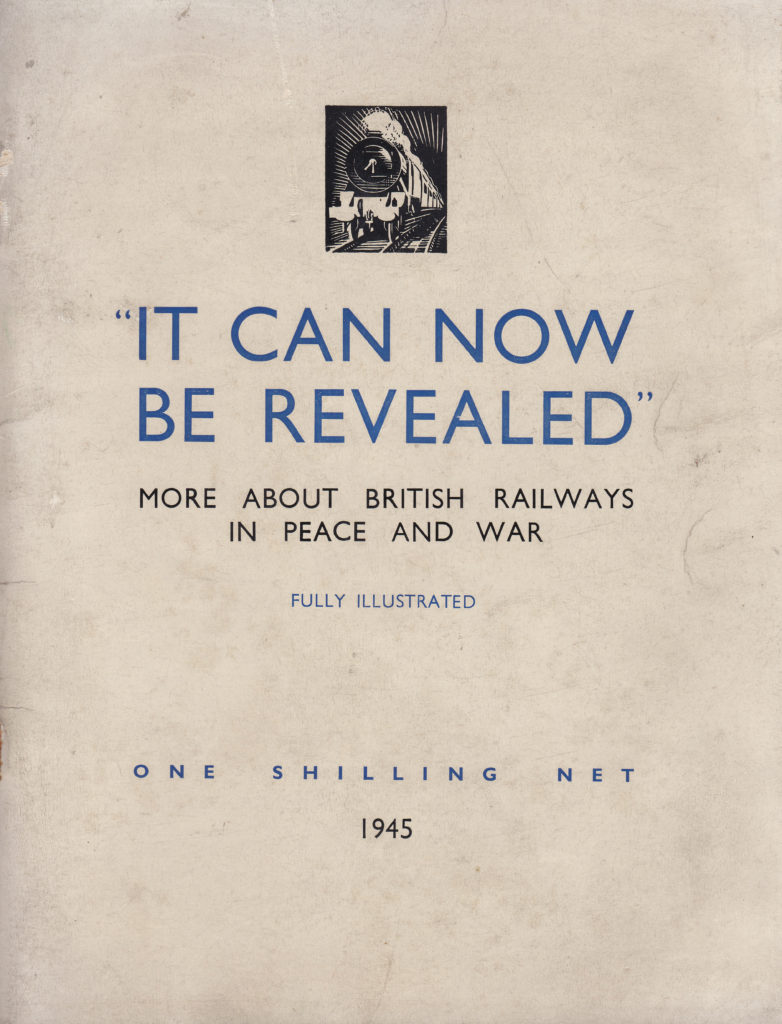
It Can Now Be Revealed – not a tabloid headline but the title of a booklet printed in 1945 by the British Railways Press Office telling the story of the railways during the war and ending with hopes for a brighter transport future. This booklet was one of many that were issued in the immediate years after the 2nd World War by organisations such as the Railways, the Post Office, the Police, all the various branches of the armed forces, individual London boroughs along with towns and cities across the country.

My father bought a number of these as they were published and they make fascinating reading and give the impression of an urgent need to record what happened between 1939 and 1945 before the country quickly moved on to reconstruction and the hoped for brighter future.

For this week’s post, I would like to introduce two of these booklets: The Post Office Went To War, and to start with, the title of the post – It Can Now Be Revealed, More About The British Railways In Peace And War:

It can now be revealed 9

It Can Now Be Revealed has three main themes: how the railways contributed to the war effort, how the railways responded to the damage inflicted by bombing and a look to the future. In covering the railways, the booklet fully covers the London Transport Passenger Board where workshops and staff quickly moved from supporting London’s transport network to the manufacture of components and equipment for the war effort.

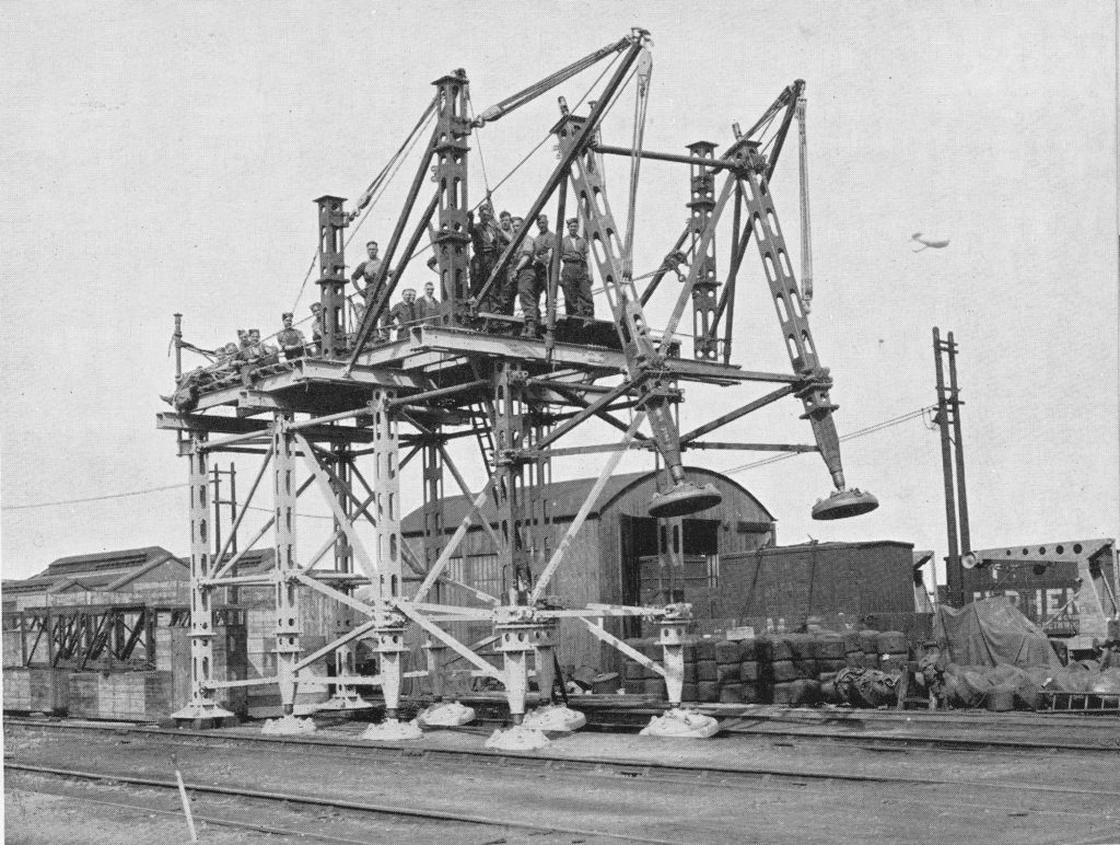
Pre-war, the rail network and the London Passenger Transport Board all had considerable engineering and manufacturing resources and these were immediately converted into wartime production. During the almost six years of war, these resources produced vast amounts of equipment of all types covering bombs, guns, boats, tanks, gliders and some very specialised equipment. The following photo shows one such item of specialised equipment produced by the Railway and London Transport workshops – a machine to help with the repair and installation of bridges.

It can now be revealed 2

London Transport, along with a number of road transport concerns, was part of the London Aircraft Production Group. The Group rapidly set up manufacturing resources and within fourteen months the first aircraft manufactured by the Group took flight and by the middle of 1944, the London Aircraft Production Group had built 503 Halifax bombers.

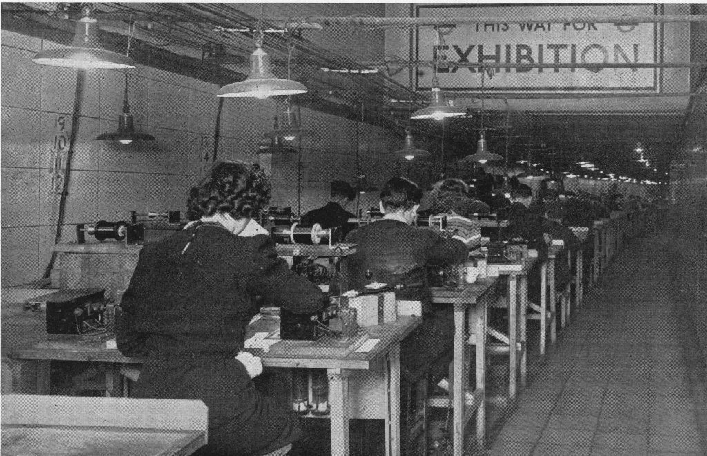
London Transport were able to make use of underground facilities for the secure manufacturing of aircraft components. The following photo shows once such production facility:

It can now be revealed 1

To give some idea of the breadth of equipment manufactured by London Transport, from the outbreak of war to 1944, London Transport had manufactured: 8,000 forgings for guns, 20,000 gun components, 80,000 sea mine components, 102,000 road vehicle parts and 158,000 2 inch shells as well as aircraft, bridges, tanks etc.

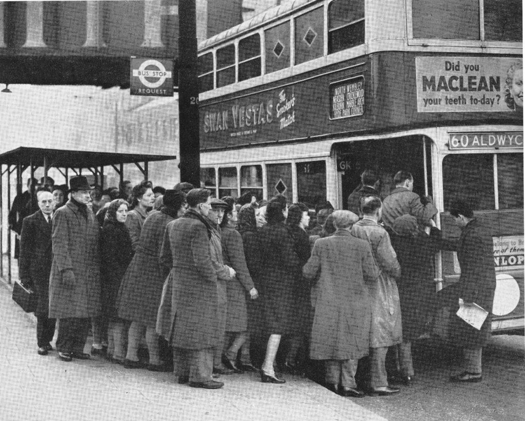
Transporting staff to the Railway and London Transport factories was a major effort as well as maintaining a degree of normal services. London’s buses were used for factory transport as well as continuing to provide services across the city and during the periods when bombing was at its peak there was considerable disruption with crowding on many of the routes across the city.

It can now be revealed 3

In the build up to war there was a considerable amount of planning and preparation to provide the staff of the rail networks with the equipment needed to protect the system and to install equipment to prevent damage. A serious concern with the London Underground system was the risk of flooding. This was a very real risk if the Thames embankment was breached or if bombing damaged water mains or sewers.

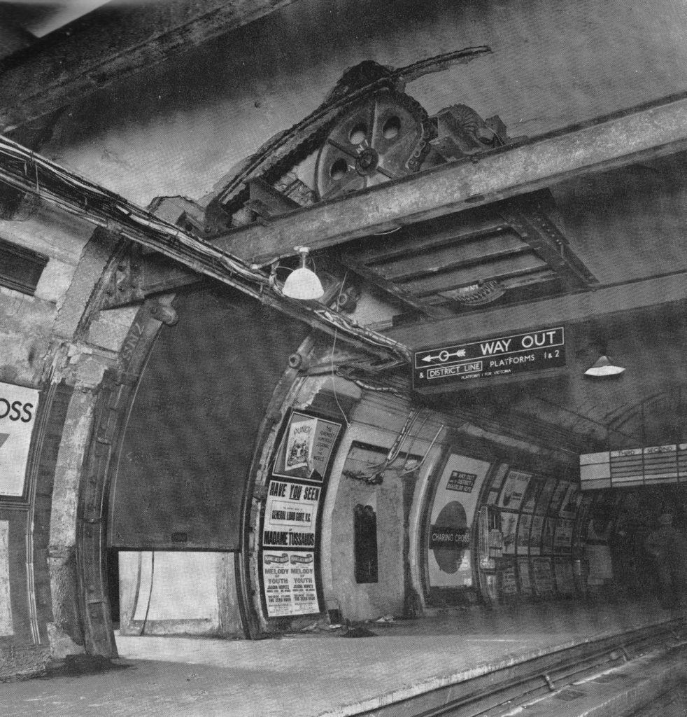
Floodgates were installed at a number of underground stations, including Waterloo, Charing Cross and the Strand stations. These were electrically operated floodgates installed across tunnels and connecting passages. The following photo shows one of the gates being tested at Charing Cross station.

It can now be revealed 4

The booklet recorded many of the incidents of damage across the rail network and the efforts that went in to restore the rail network as quickly as possible. Damage across the network was considerable, from the earliest days of the war through to the V1 and V2 weapons with both the above ground and underground networks suffering.

The booklet records an example of what happened when a V1 fell on the rail network:

“One of the worst incidents happened in the Southern. One night in August an express from Victoria bound for the Kent coast was travelling at 60 miles an hour when the girders of a bridge over a country lane less than 200 yards ahead of the train were damaged by a flying bomb falling nearby. The driver saw the explosion and at once threw on the brakes, but before he could bring the train to a stand it had reached the bridge, which collapsed when the engine, tender and leading coach had passed over. As a result the engine and tender were derailed about 100 feet from the bridge and the two first coaches were flung at right angles to the track. the third vehicle in the train got across, together with the leading end of the fourth, which came to a rest spanning the gap and supported on the damaged abutment. In the road beneath were poised four bogies torn from coaches. Eight persons, including a permanent way man who was on the bridge at the time, were killed and sixteen seriously injured, but strenuous efforts on the part of the railway engineers prevented serious dislocation to traffic. The damaged rolling stock was removed and a temporary bridge of two spans of 50 feet girders speedily erected, the outer ends of the girders being supported by bearing pads on the approach embankments and the centre by a steel trestle built in the middle of the roadway with the aid of a mobile crane. The relaying of the tracks was then quickly completed and within 66 hours of the incident both lines were again open for traffic.”

Which certainly brings the challenges of today’s commute into context.

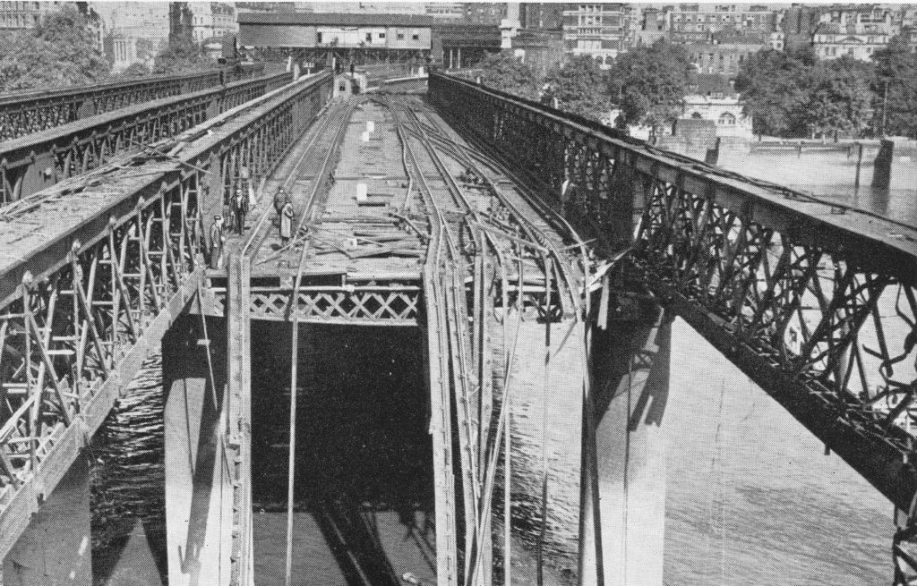
Photos within the booklet show the considerable damage across the rail network including the following photo showing damage to the Hungerford railway bridge, taken from the southern end of the bridge looking north towards Charing Cross station.

It can now be revealed 5

The booklet concludes with a positive view of the future with the final chapter opening with the sentence “The British Railways and London Transport are determined to regain and surpass their peacetime standards of public service”.

This included plans for new stations and rolling stock. This was urgently needed as there had been hardly any new building during the war years and the rail and underground networks were suffering from pre-war infrastructure, wartime damage and temporary repair and minimum maintenance.

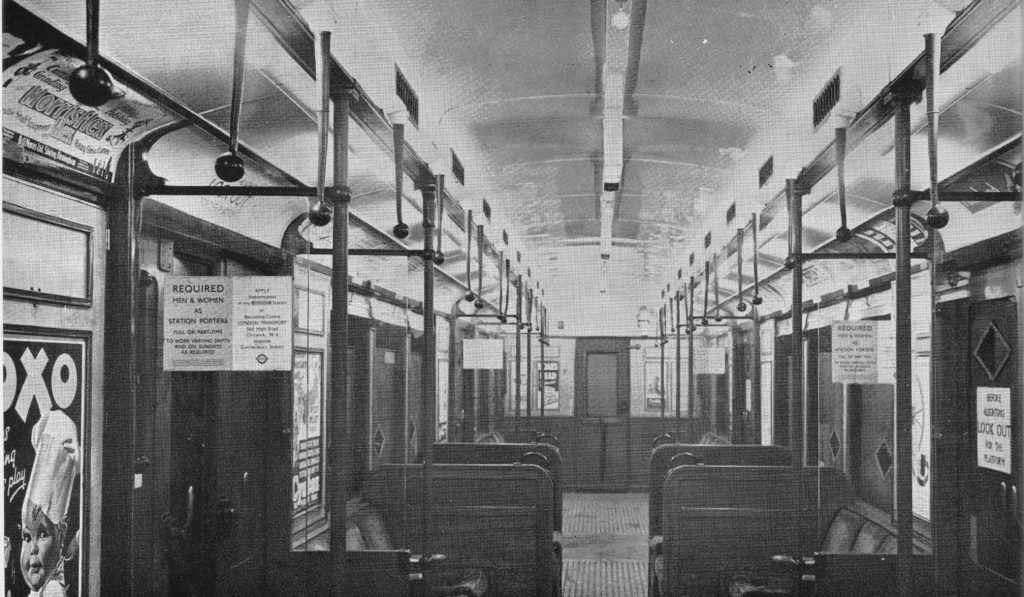
The following photo shows an example of new carriage construction and the title to the photo highlights one of the benefits being “improved lighting”.

It can now be revealed 6

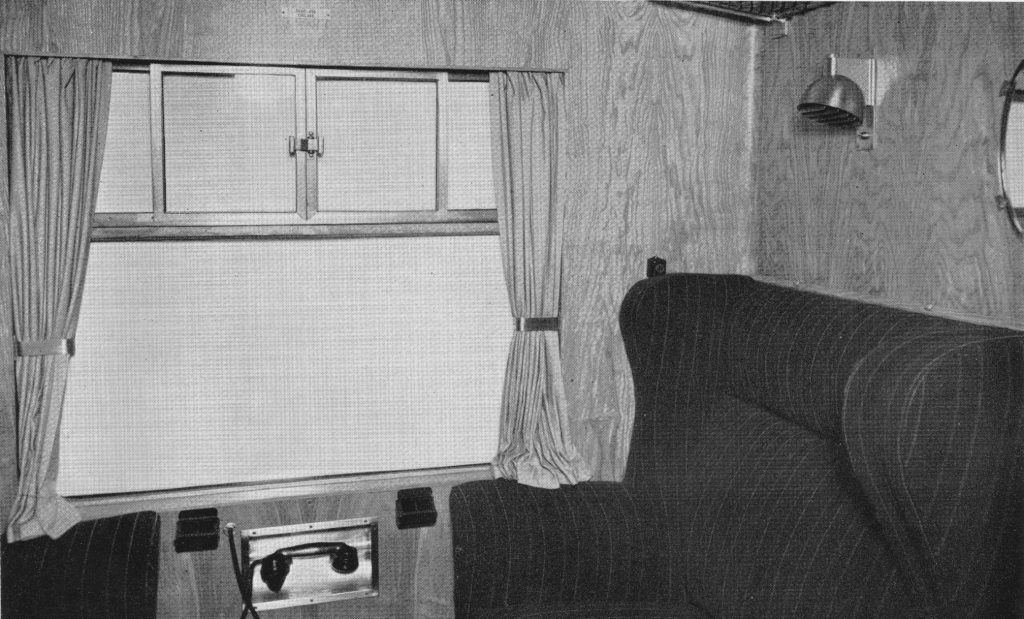
Along with a presumably a new design of first class compartment judging by the telephone handset below the window, presumably so that a first class passenger could call for service.

It can now be revealed 7

As well as new rolling stock, the booklet looked forward to new stations that would be built in the post war period. The station was described as the “shop” in which railway transport is sold. The booklet describes the facilities that will be provided at these new stations:

“The future British railway station will incorporate as spacious a concourse as possible, equipped with all the facilities that passengers need, conveniently situated and easily identifiable. Both concourse and public rooms will be light, cheerful and attractively decorated. News theatres (no idea what these were), newsagents, fruiterers, chemists, confectioners shops and Post Office facilities will be included whenever needed. Special attention will be given to the standard of food, drink and service provided in the refreshment rooms. Finally the platforms will be kept as free as possible of obstructions and passengers given the clearest indication and guidance about their trains, and how to get to them, by means of carefully designed train indicators and signs, supplemented by loudspeakers.”

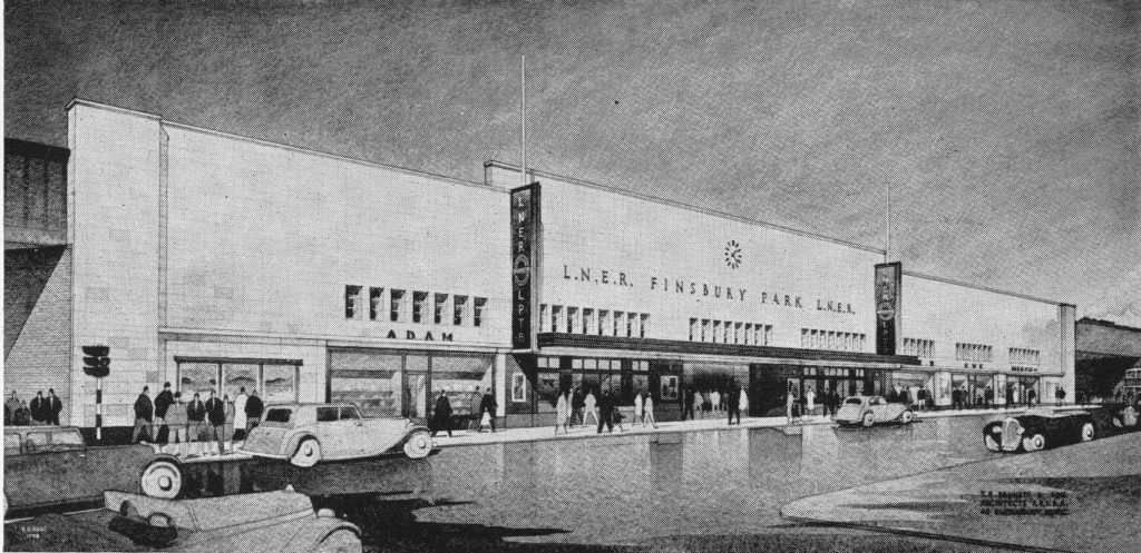
The booklet includes a drawing of one of the future stations, Finsbury Park which will be rebuilt “on the most modern lines”.

It can now be revealed 8

It Can Now Be Revealed provides a fascinating insight into the impact of the last war on the rail networks of London and the wider country and how every aspect of the railway network and those who worked on the network were involved in one way or another in the war effort. As with many publications of the later years of the war, the booklet is also looking forward to a much brighter future with reconstruction offering the chance to significantly improve all aspects of the rail network.

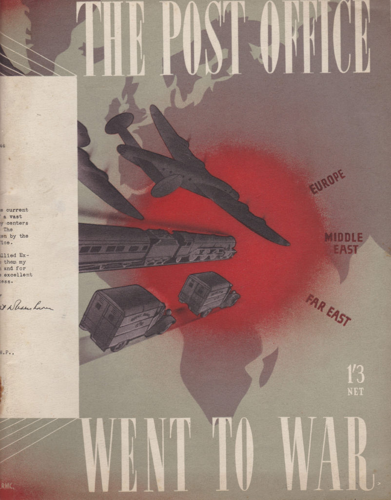
The second booklet was published a year later in 1946 and titled “The Post Office Went To War”. This was in the days when the Post Office ran a wide range of services, not just letter and parcel delivery, but also the telephone and telegraph networks, radio stations for long distance calls, sub-sea cables etc.

It can now be revealed 10

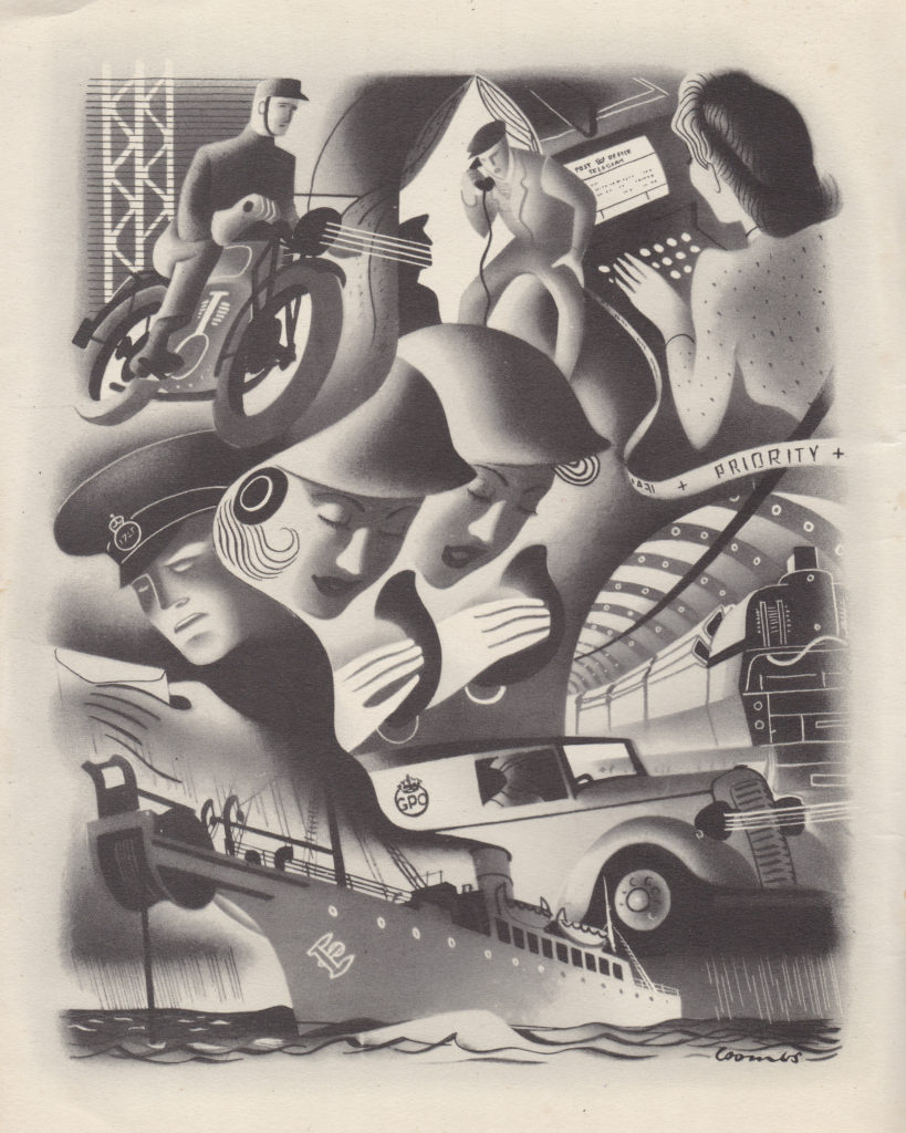
The extra year before publication may have allowed time for some additional graphic design as the Post Office booklet has a more interesting layout and artwork then the earlier Railways booklet published in 1945.

It can now be revealed 11

The opening paragraph to Chapter One states “Throughout our history as a nation it has been our cheerful habit to declare war first and then to prepare for it”, a statement that could also apply to events over the last few decades.

The challenges that faced the Post Office started long before there was any enemy action. Within the first week after war was declared, the Post Office lost fifteen percent of staff to the Forces, immediately having an impact on the ability to continue to provide services.

The first few months of war were spent putting in new telephone circuits to coordinate the services that would defend the country, and implementing alternative circuit routing so damage to one site would not cut out a large number of critical services.

When the bombing of London started, the impact was considerable. In one night alone in September 1940, twenty-three London Post Offices were hit and damage to the road and railway networks caused many problems with the transport of mail.

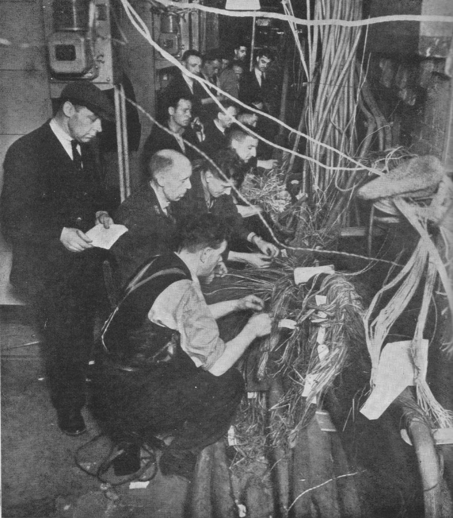
London was also a hub for much of the country’s telephone network with most of the international circuits terminating in a key number of London Telephone Exchanges. Bombing could damage cable at multiple points across the city, not just in the Exchanges, but also where they ran along the streets. After bombing it was an ongoing battle to quickly reconnect damaged cables to get telephone and telegraph services back up and running. Cables would be cut and fire would cause the lead cover and insulation to melt and burn away

The following photo from the booklet shows a team of engineers working on reconnecting damaged cables, and is titled “Joining up after a raid”.

It can now be revealed 12

The Post Office services hosted in London could not easily be moved out of the city. For telephone and telegraph services, the country network was design so that the majority of long distance and international calls were routed through a small set of London buildings. it was not just relocating staff from these buildings but also reconfiguring the whole network and implementing a new cabling system that would have been required to move out of London. The majority of these key services remained in central London buildings.

One of these was the Wood Street building, just north of Cheapside. This building housed three large automatic telephone exchanges, London Wall, Metropolitan and National along with Exchange services for City and Central areas. Wood Street also housed a large operator service.

On the night of the 29th December 1940, this area was very badly damaged by bombing. The building continued to operate throughout the night with operating staff working at an emergency manual switchboard in the basement of the building.

At 7pm a high explosive bomb fell close to the building blowing in all the doors and windows and the fires from the numerous incendiary bombs reached parts of the building overnight.

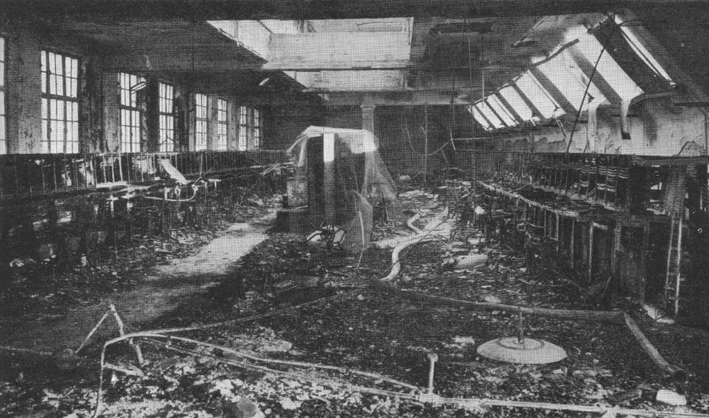
15,000 telephone lines terminated in Wood Street and the following morning 10,000 of these needed repair. The building itself was also badly damaged with the following photo showing one of the burnt out operator halls with the remains of operator positions lining the walls on either side.

It can now be revealed 13

In the days that followed, as well as work to repair the building, equipment and cabling, one hundred telephone boxes were installed along Cheapside and Moorgate to provide temporary services.

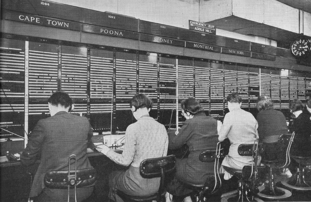
What the operator hall should have looked like is shown in the photo below taken in the Faraday Building in Queen Victoria Street which was a hub for Trunk and International telephone services and thankfully did not suffer the same level of damage as other telephone exchanges in the city.

It can now be revealed 18

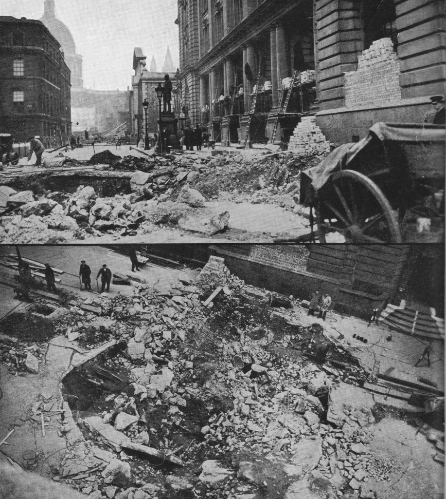
The following two photos show the impact of a high explosive bomb falling in the road outside the Central Telegraph Office in King Edward Street.

It can now be revealed 14

The Central Telegraph Office was the heart of the whole British telegraph system (used to transmit telegrams) and had a staff of 3,000. A telegram was how you would send a fast written short message to someone, the early 20th century version of text messaging or Whatsapp. Written messages would be delivered or phoned in to the Central Telegraph Office, typed onto a teleprinter that would send the message to a similar machine at a location closest to the recipient where it would be printed out and hand delivered.

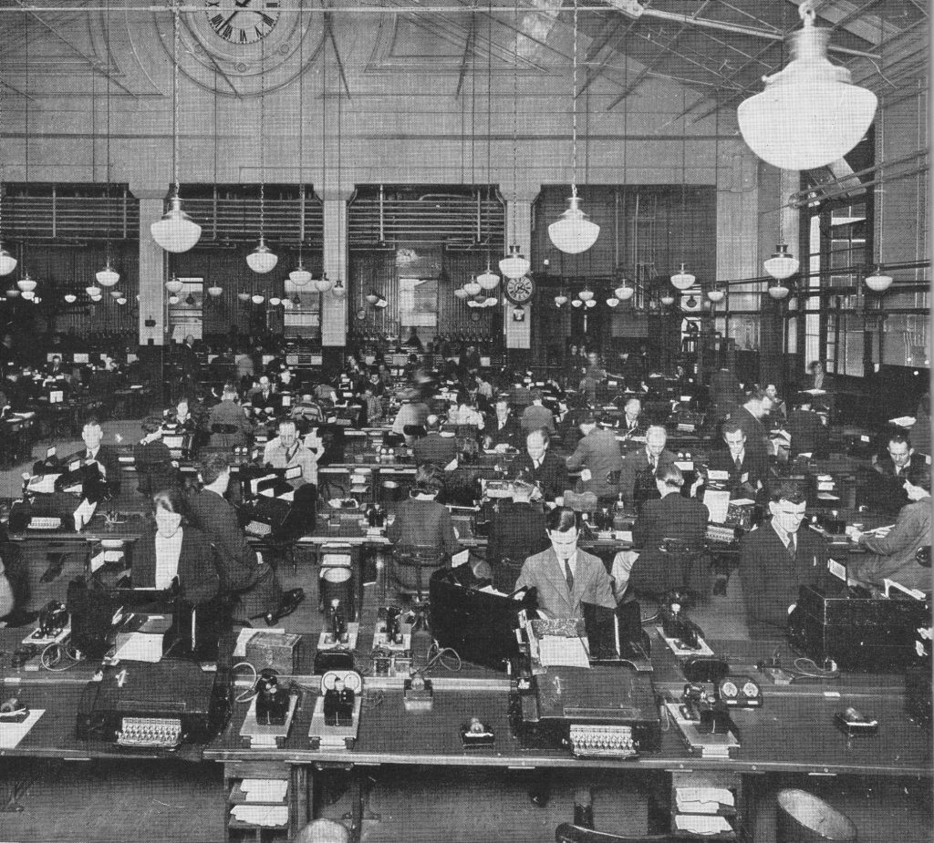
The Central Telegraph Office had galleries dedicated to Inland and Foreign telegrams. The Inland Gallery was equipped with 500 teleprinter machines dealing with 200,000 telegrams a day.

The Central Telegraph Office was completely gutted over the night of the 29th December 1940, but was rebuilt and continued to provide service during the later years of the war. The following photo shows one of the galleries in operation.

It can now be revealed 19

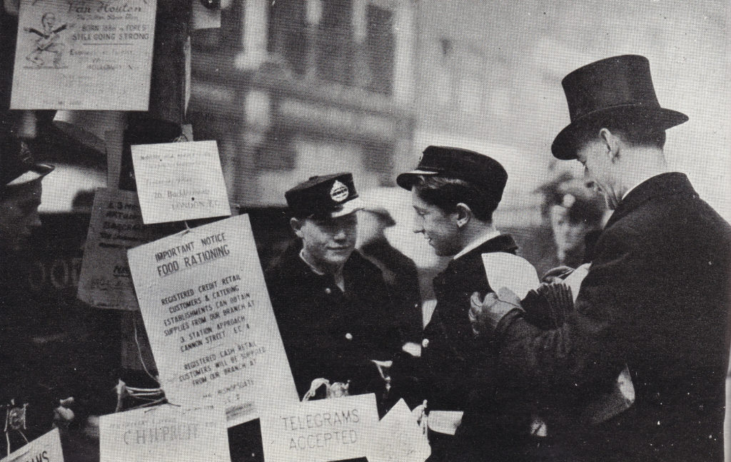
One of the methods to send a telegram for the businesses in the City was to phone the Central Telegraph Office and dictate the message, however with the damage to telephone cables, this was not always possible, so the Post Office stationed Telegraph Messengers at key points across the City to pick up messages and take them to the Central Telegraph Office.

It can now be revealed 15

As well as telephones and telegrams, the Post Office was also responsible for the collection and delivery of letters and parcels and in London this centered on Mount Pleasant which at the time was described as the largest Post Office in the World and just prior to the start of the war employed up to 7,000 Post Office workers.

The size of Mount Pleasant was such that it was bound to be hit by bombs but did get off relatively lightly being hit nine times throughout the war years, although some of these did cause considerable damage including a single bomb that on the 18th June 1943 completely gutted the three storey parcels building.

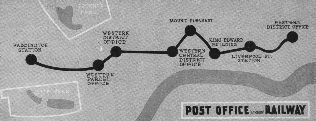
The Post Office Railway passes through Mount Pleasant and the booklet describes the railway during the war:

“During the war the Post Office Railway , in addition to its normal duties, made its own contribution to the Post Office war effort. It furnished an admirable air-raid shelter and dormitory; a series of cots, hinged to the wall by one end, being pulled down and set right across the track when the long day’s work was done and the conductor rail had gone dead for the night.

It was also a minor casualty when in December, 1944, a V2 rocket bomb fell in Bird Street, between Selfridges and the Western District Parcels Office. Besides putting this important parcels office out of action just before Christmas, it damaged a water-main which flooded the station of the Western District Parcels Office, nearly 80 feet below to a depth of 18 inches. But the Post Office Railway is prepared for such emergencies, and the station was soon pumped clear.”

Map from the Post Office booklet showing the stations of the Post Office railway:

It can now be revealed 16

An interesting couple of paragraphs in the booklet show that even in wartime, the collection of customs duties was fully in force:

“In war-time one class of parcel presents a particular problem – namely the packets of tobacco and cigarettes which may be dispatched duty-free to our Forces overseas. These are convenient to send, for all you have to do is hand an address and the requisite sum across a tobacconists counter, and a standard packet will be dispatched to your own particular sailor, solider or airman.

But if, as frequently happens, the packet cannot be delivered – possibly because the addressee has become a casualty or been transferred to another quarter of the globe – and the local authority sends it back, the nice question now arises ‘Who is to have the packet?’ Not the tobacconist for he has already been paid; nor the sender, for he has paid no duty. The Post Office solves the problem by handing over the packet to the customs authorities.”

The booklet also contains some fascinating detail of wartime mail distribution. It was possible to send letter to members of the British forces who were held as prisoners of war. An agreement was reached with Germany in 1941 allowing letters to be flown out to Lisbon where they would be handed over to the German airforce who would also hand over letters for German nationals held prisoner of war in the UK. Over 200,000 letters were sent each week from London to Lisbon for onward routing to British prisoners of war.

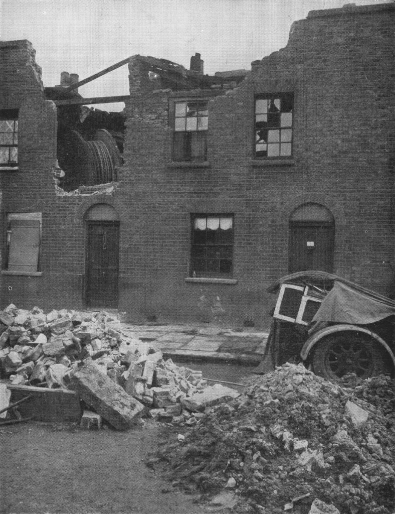
The booklet highlights the difficulties in maintaining the overall delivery of Post Office services, whether it was due to bombed Post Offices, damaged cabling or disruption to transport networks. Even when trying to repair the network, the impact of bombing can continue to cause problems. The following photo shows a cable drum blown from the street to the top floor of a house as a result of a bomb.

It can now be revealed 17

Unlike the Railway booklet, the Post Office Went To War does not have a chapter looking forward to post war reconstruction, however it does have a section on research and features the Post Office Research Station at Dollis Hill in north-west London.

Dollis Hill was the main Post Office Research Station and carried out research into all the technologies used by the Post Office including Telephone Systems, Radio, Cables, Sub-Sea systems etc. A significant number of engineers and scientists were employed at Dollis Hill with, for example, a staff of 300 in just the Radio Section.

It was still classified information at the time the booklet was written so it was not included, however the Collossus computers used at Bletchley Park during the war to decode German signals were built at Dollis Hill. Tommy Flowers (originally from Poplar in east London) who worked at Dollis Hill proposed using electronic valves rather than mechanical relays to build the computers needed by Alan Turing at Bletchley and despite considerable resistance that a machine with such a large number of valves (1,500 upwards) would be reliable, Tommy Flowers and his team constructed the Collossus computers which more than confirmed Flowers’ view that they would be much faster and more reliable than the existing mechanical relay based systems.

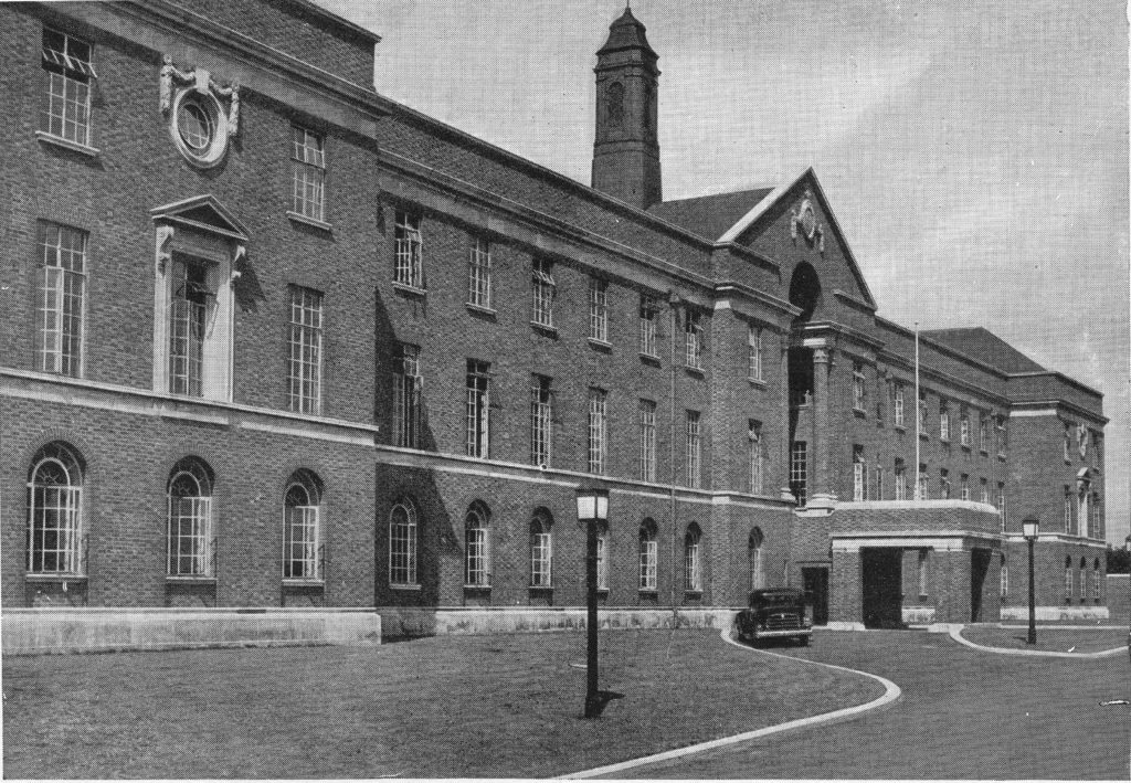
The Dollis Hill Research Station:

It can now be revealed 20

The Research Station moved out of London to Martlesham Heath in Suffolk during the 1970s after which Dollis Hill closed. The main building was preserved and converted into flats.The approach road to the flats has been named Flowers Close in honour of Tommy Flowers.

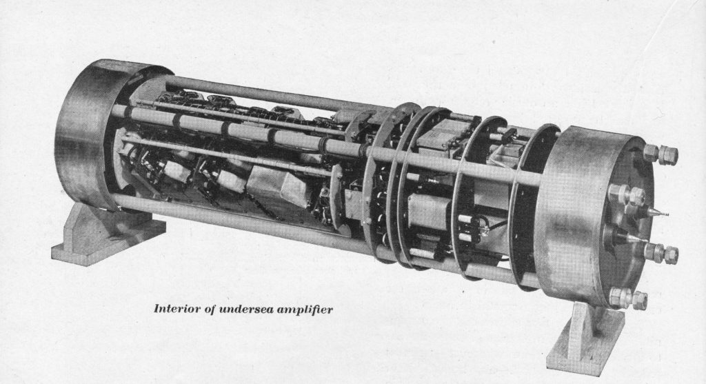
From the booklet, a photo of the interior of an undersea amplifier developed at Dollis Hill and used on sub-sea cable systems to amplify signals enabling telephone calls and telegrams to be sent over very long distances.

It can now be revealed 21

These two booklets, along with the many others published in the same period have a common theme. Recording with pride how their respective organisations, London boroughs or towns contributed to achieving victory at the end of the war, but also a recognition that times would very soon change and these events needed to be recorded quickly before the country focused on reconstruction and the possibilities that the future would bring.

alondoninheritance.com

Church Row – Hampstead

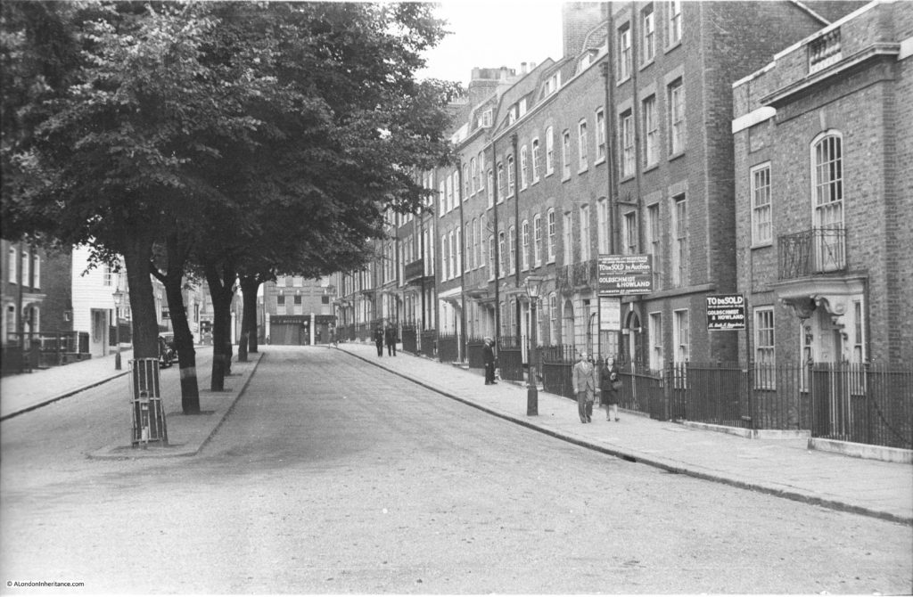
I have featured Hampstead in a number of posts and for this week I am back in Hampstead looking at a street which, architecturally, has hardly changed in the past 67 years. The street is Church Row which turns off from Heath Street as you walk up towards Hampstead Underground Station.

Church Row leads up to the parish church of St. John-at-Hampstead with a central, narrow avenue of trees that separates two rows of terrace houses in the section of road closest to the church. These houses were mainly built during the 1720s.

The following photo was taken by my father in 1949, standing outside the church and looking back up towards Heath Street.

Church Row 1

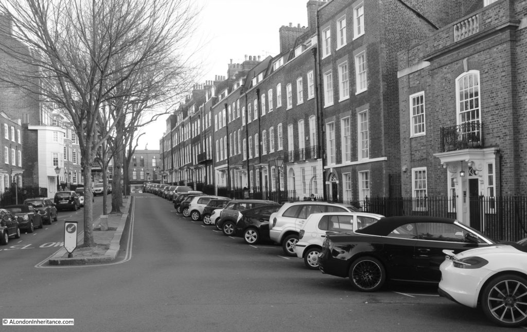
And the same view in 2016 (although I should really have waited a couple of months for the trees to be in full leaf).

Church Row 4

I thought that using black and white for the 2016 photo would emphasis how little Church Row has changed over the past 67 years, with one exception – the car and on-street parking.

A common challenge with taking photos of the locations today that my father photographed many years ago is trying to capture the same scene without traffic obscuring the view. With locations such as Church Row it is impossible to photograph without the on-street parking.

Car ownership and use across London has grown considerably over the last 70 years. Central London has always been busy, however the ongoing growth in traffic and need for parking has spread out from the centre to cover all parts of the city.

It is interesting to compare car ownership statistics to understand the growth of car use across London. The County of London Plan published in 1943 stated “In England, the ratio of cars to population is about one to twenty-two; in America it is one to six or seven. It is perhaps doubtful whether this country will equal America in this respect, but it is generally agreed that there is every likelihood of a rapid approach to the American figure and that the increase in the number of vehicles will far outstrip the 500 cars per day increase which was taking place in the days preceding the present war.”

This statement from the 1943 plan just shows the difficulties in trying to predict the future. The plan suspects it is doubtful that this country will get to a car ownership level or one car per six or seven of population, however for London in 2012, from the Transport for London report “Roads Task Force – Technical Note 12. How many cars are there in London and who owns them?” there are currently:

  • 2.6 million cars registered in London and 54% of households have at least one car
  • this gives a ratio of approximately 0.3 cars per adult
  • car ownership varies widely across London with the lowest percentage (13%) in the City of London and the highest (75%) in Richmond upon Thames
  • for Hampstead, the Borough of Camden has an ownership percentage of 38%, however I suspect this varies widely across the Borough

The above 2.6 million excludes the cars that travel into London during the day. I have been unable to find any reliable figures for the total number of cars across the whole of London.

This volume of cars all need to be parked somewhere so we see the streets of London changing as Church Row has done between 1949 and 2016.

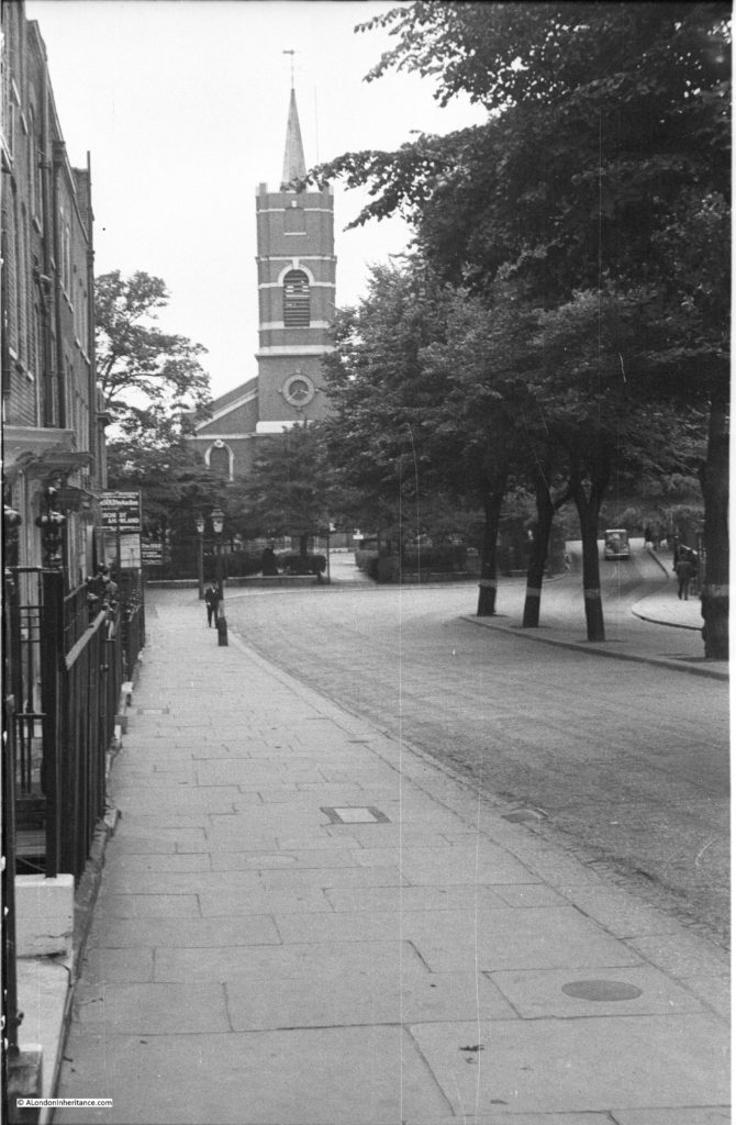
The following photo from 1949 is looking back down Church Row towards the church. The above photo was taken from just outside the entrance to the churchyard.

Church Row 3

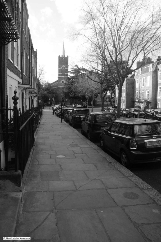
And the same scene in 2016:

Church Row 7

These two photos are interesting as they show the challenges with taking exactly the same photo and how using different cameras and lenses impact the perspective of the photo.  The 1949 photos were taken by my father using his Leica IIIc and a 50mm lens. I am using a Nikon D300 digital camera with an 18 to 200mm zoom lens – two very different camera systems and this is very noticeable in the perspective differences.

My 2016 photo looks further away from the church than my father’s however I walked up and down the street a number of times to find the same combination of manholes. In the 1949 photo there are two round nearer the camera and a rectangular manhole furthest away. I found the same combination, and although the paving slabs look to have been changed, there are the same number of rows of paving slabs between the various manholes so I am confident I found the same location although the perspective looks slightly different (and perhaps by counting paving slabs and manholes I am starting to take this project a bit too seriously !!)

My father sold the original camera to purchase a Leica IIIg which I still have along with the original 50mm lens which was transferable between different Leica camera bodies. On my to-do list is to learn how to use this entirely manual camera and start taking photos using the Leica and the original lens that may father used.

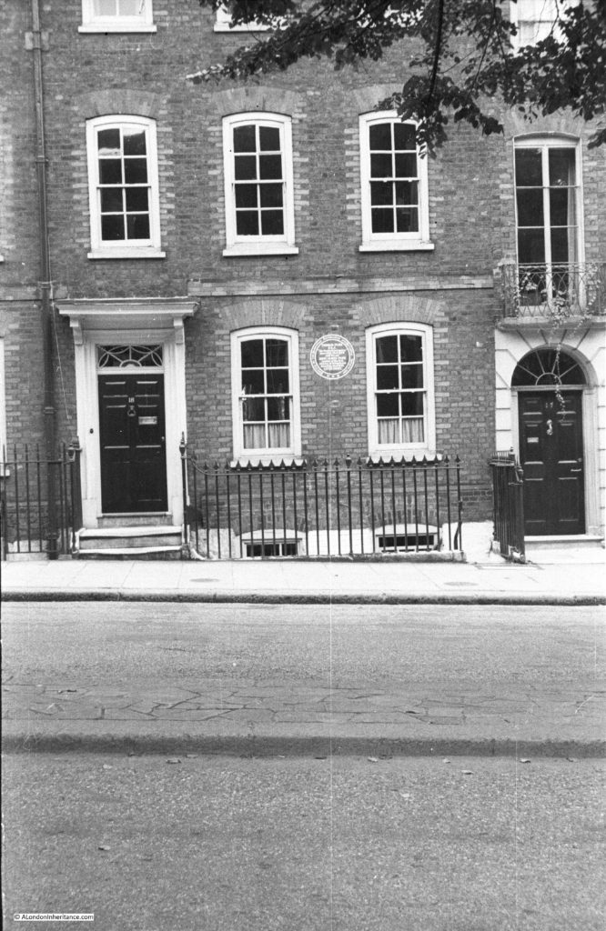
As you walk down Church Row, towards the church, on the left is a house with a plaque. The house in 1949:

Church Row 2

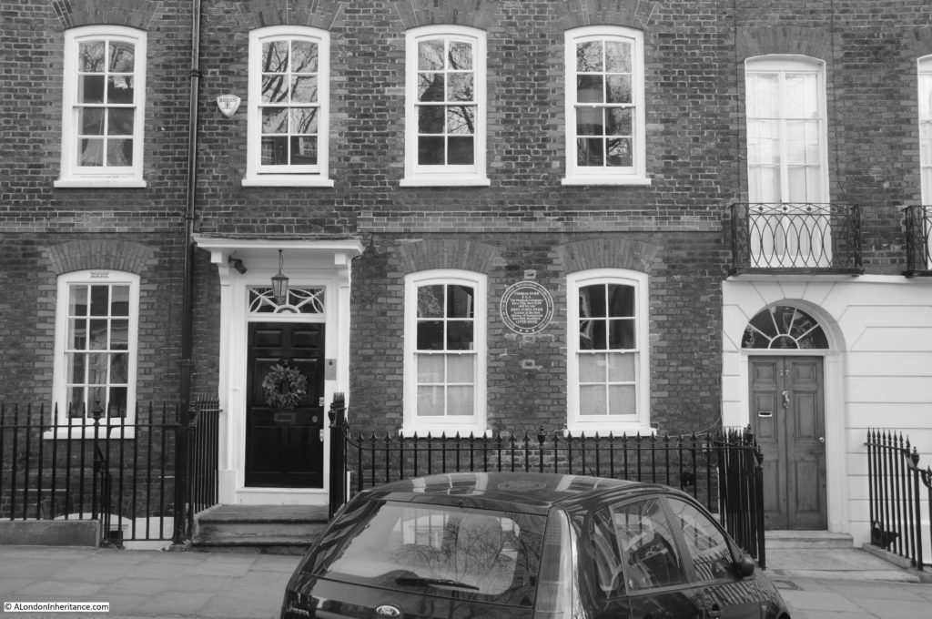
And the same house in 2016 (although I forgot when taking the photo that the original was portrait rather than landscape).

Church Row 5

Only very minor cosmetic changes, for example the change in rainwater down-pipe, apart from the burglar alarm and the car parked in front.

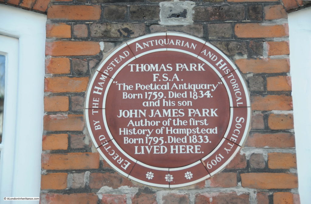
The plaque was installed in 1909 by the Hampstead Antiquarian and Historical Society. Formed in 1897, the “objects of the society are the study, and as far as possible, the recording of antiquarian and historical matters, especially in regard to the Borough of Hampstead, and also, should necessity arise, the protection of any historic landmark from needless violation.”

I cannot find exactly when the Society closed, however the Camden local history archive has the minutes, cashbooks, annual reports and papers of the society up to 1940 and I can find no record post 1940.

Thomas Park was an engraver, poet and antiquary who lived in Church Row for 30 years until his death. His son, John James Park published “The Topography and Natural History of Hampstead in the County of Middlesex with Appendix of original Records” in 1818. It was the first book dedicated to the history of Hampstead.

According to “London” by George Cunningham, H.G. Wells lived in number 17, the house to the right of that of Thomas Park, in 1912. His stay was obviously too short to justify a plaque.

The Hampstead Antiquarian and Historical Society plaque to Thomas Park and John James Park:

Church Row 6

As with the buildings along Church Row, there are some other aspects of London that change very little. Whilst reading the section on Road Transport in the 1943 County of London Plan I found the following paragraph:

“In 1927 the late Mr Frank Pick stated that the London General Omnibus Company lost, through delay and congestion on the roads, one million pounds a year in actual out-of-pocket expenses. This figure does not take into account the cost of time lost to passengers. Other estimates include those of a large catering firm, which estimated the cost of calls in congested periods at 6s 8d compared with 3s 4d outside those periods, and of Mr. Shrapnel Smith, who estimated the cost of delays in central London, within a three mile radius of Charing Cross, at over eleven million pounds a year. Uncomfortable and slow traffic, resulting from congestion and lack of system, is inefficient and bad for business.”

Multiply the financial values several times and those exact words could be written today. Some thing never change !

alondoninheritance.com

Manchester Square, The Marchioness Of Hertford And A Very Old Lane

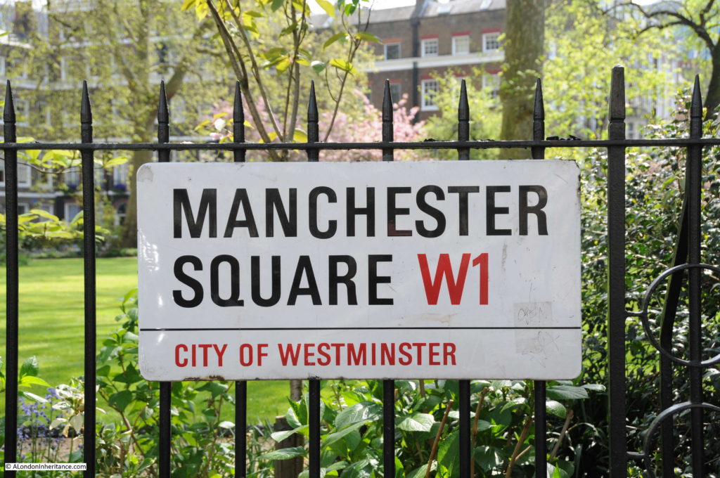
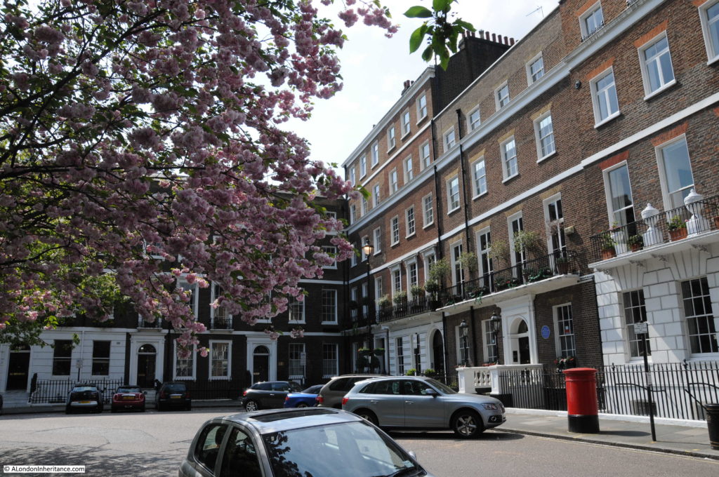
Manchester Square is the subject of this week’s post. Georgian architecture, a Marchioness who had intimate meetings with the Prince Regent and an original lane that once ran through fields and now runs through the streets of Georgian London.

Manchester Square is a short distance north of Oxford Street and a perfect example of how in London you can walk in a matter of minutes from streets crowded with people and traffic to a peaceful place that is full of history and wonderful architecture.

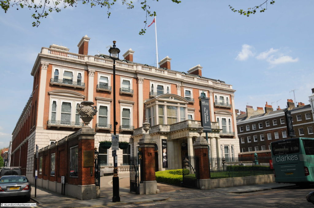
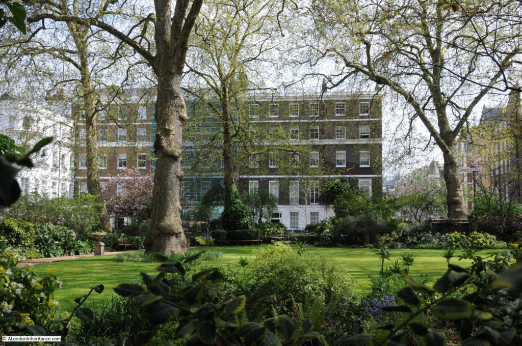
Manchester Square still has the much of the original Georgian and Regency period houses from when the square was built, along with an original London town house that occupies one full side of the square. In the centre of the square is a garden which looked fantastic when I visited on a sunny spring day.

Manchester Square 15

Construction of Manchester Square was part of the Georgian expansion of London. The land formed part of the Portman Estate (as it still does) and a lease on a plot of land was granted to George Montagu, fourth Duke of Manchester who commenced construction in 1776 of a house on the north side of the square.

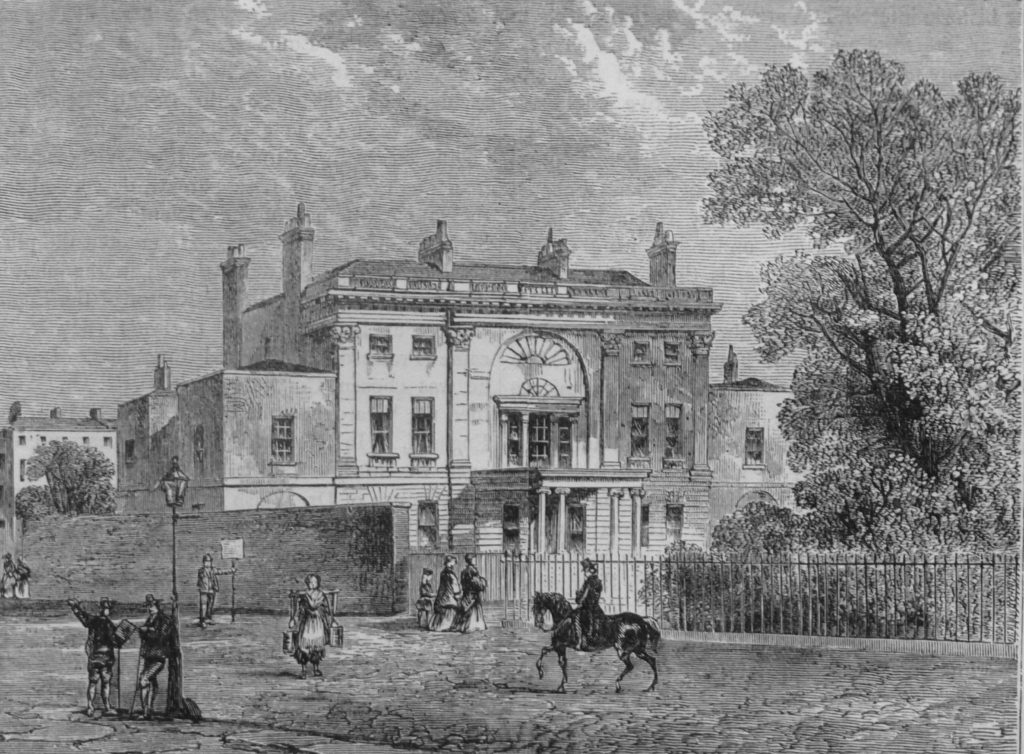
Other builders purchased leases on the other three sides of the square, the central gardens were laid out, and Manchester Square came into existence, named after the Duke, as was his house, which on completion in 1788 became Manchester House.

Soon after the completion of his house, the Duke died. The house was then purchased by the Spanish Government as their London embassy, a role it occupied until 1797 when the second Marquis of Hertford purchased the lease and renamed the house as Hertford House (and this is where the Marchioness of Hertford became a rather scandalous London figure – more later in this post).

The second Marquis died on 1822 and the house passed to the third Marquis, then in 1842 to the fourth Marquis of Hertford who was a collector of art, furniture, china etc. scouring the auction rooms of Europe to put together a very large collection that was stored in his houses in London and Paris. The fourth Marquis of Hertford died in 1870. He was unmarried and with no children, left his entire collection to his friend Sir Richard Wallace (who was also a collector). Wallace made a number of changes and extensions to the house to form the building that we see today.

The combined collection became known as the Wallace Collection, and on the death of Sir Richard Wallace, the collection was bequeathed to the nation, and it is this collection which is now housed in Hertford House

Hertford House, home of the Wallace Collection in Manchester Square:

Manchester Square 14

Manchester House soon after completion and before it became Hertford House:

Manchester Square 22

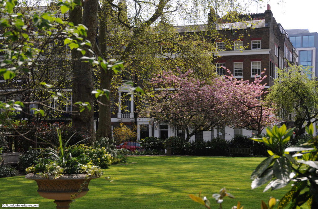
Standing in Manchester Square it is hard to believe that you are only a couple of minutes from Oxford Street. The central gardens are an oasis of green, spring blossom is blowing across the street and the few people around are either heading to the Wallace Collection, or using the street as a local parking place for Oxford Street.

Manchester Square 16

The original plan for Manchester Square was for a church to be built in the central square, however this did not get built and the gardens were laid out between 1776 and 1788.

Manchester Square 2

The second Marquis of Hertford who purchased Manchester House and renamed it Hertford House was a good friend of the Prince of Wales (who would later become George IV) and the Prince of Wales was a regular visitor to Hertford House, however it was his interest in the Marchioness, Lady Hertford that appears to have been his main reason for making the journey to Manchester Sqaure. It was written at the time that “The Prince does not pass a day without visiting Lady Hertford, indeed so notorious did these calls on ‘the lovely Marchesa’ become that a scurrilous print inserted in its columns the following advertisement: Lost, between Pall Mall and Manchester Square, his Royal Highness the Prince Regent”.

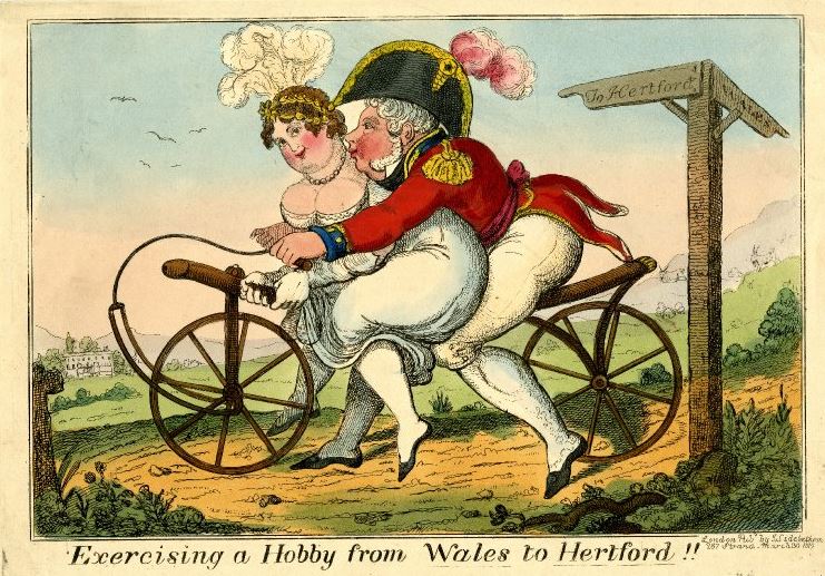
The relationship between the Prince of Wales and Lady Hertford was also the subject of a number of satirical cartoons. The following cartoon from 1819 shows Lady Hertford and the Prince Regent, the Prince of Wales on one of the new velocipedes. The signpost on the left is pointing to Wales and Hertford.

Manchester Square 24

©Trustees of the British Museum

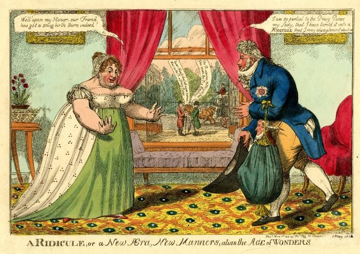
The following carton shows a room in Hertford House with Manchester Square seen through the windows. The Prince Regent on the right is walking towards Lady Hertford. The Prince is holding the Privy Purse and the small character inside the purse is John McMahon who at the time was the keeper of the Privy Purse and the official private secretary to the Prince.

The Prince is saying to Lady Hertford: “I am so partial to the Privy Purse my Lady; that I have turn’d it into a Ridicule that I may have it always about me.” and she replies: “Well! upon my Honor, our Friend has got a snug birth there indeed.”

The two men talking in the square seen through the window are talking about the bad news of the day being that McMahon is now the keeper of the Privy Purse (and will do exactly what the Prince requires) and the Prince is therefore holding the Privy Purse up to ridicule.

Manchester Square 25

©Trustees of the British Museum

The Marchioness, Lady Hertford was considered one of the reigning beauties of the day. The Irish poet, Thomas Moore, initially a good friend of the Prince wrote of Lady Hertford:

“Or who will repair unto Manchester Square,

And see if the lovely Marchesa be there?

And bid her to come, with her hair darkly flowing,

All gentle and juvenile, crispy and gay,

In the manner of Ackerman’s dresses for May.”

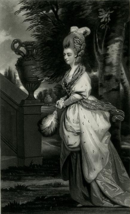
Portrait of Isabella Anne Ingram Shepherd, 2nd Marchioness of Hertford by Sir Joshua Reynolds:

Manchester Square 26

©Trustees of the British Museum

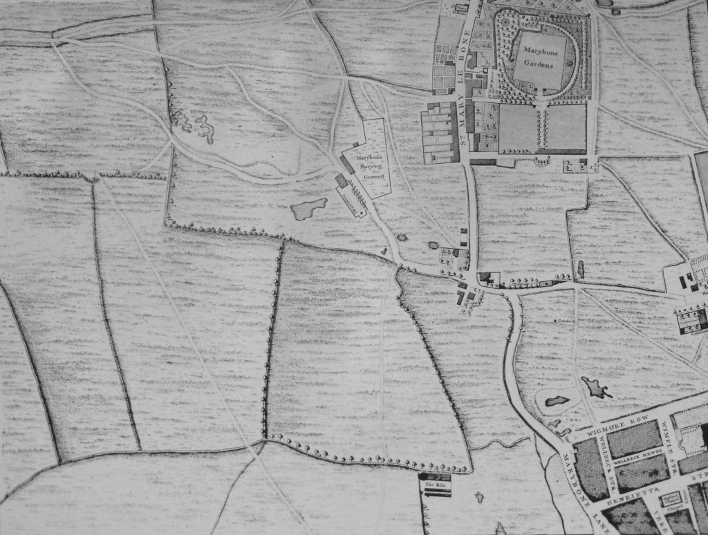
When Manchester Square was built, London was expanding rapidly to the west and north. The area to the north of Oxford Street was being turned from fields to wide, formal streets and squares. To see what the area was like immediately before Manchester Square was built, I turned to John Rocque’s map of 1746, just 30 years before construction started on Manchester Square.

The following map shows the area on which Manchester Square would be built.

Manchester Square 21

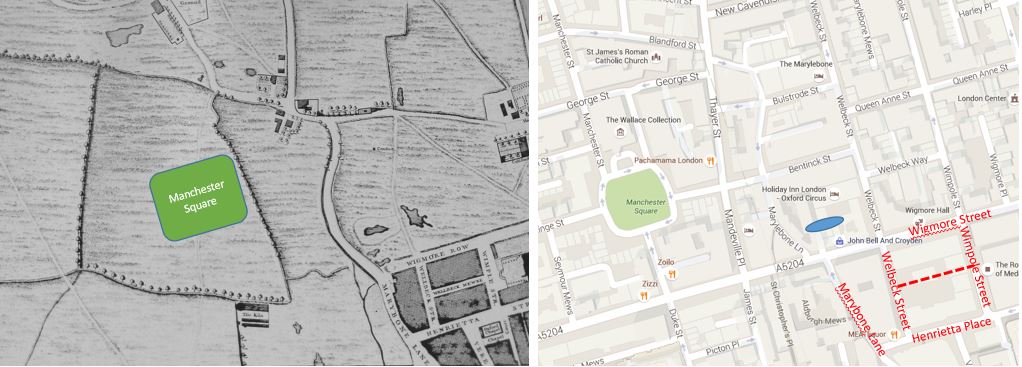
I wanted to see if I could place Manchester Square in Rocque’s map and whilst doing so, found what I believe to be an original street remaining from when the area was all fields.

See the two maps below. On the left is Roqcue’s map of the area and on the right a Google map of the same area. If you look to the lower right of both maps, the 1746 extent of building can be seen.

I have shown the modern street names in red on the Google map. In the 270 years since Roqcue’s map there have been some subtle changes in street names:

Wigmore Row in 1746 is now Wigmore Street

Wellbeck Street is now Welbeck Street (it has lost an ‘l’)

Wimple Street is now Wimpole Street

Henrietta Street is now Henrietta Place

The dotted line in the Google map is the location of Wimple Mewse which has disappeared since the Rocque map.

Manchester Square 23

The extent of the building in 1746 is along Marybone Lane, this is now Marylebone Lane. I have marked the name in red in the Google map, however where it gets really interesting is if you follow Marylebone Lane north across Wigmore Street you will see that it curves to the left, following roughly the same curved path as Marybone Lane in 1746.

Marylebone Lane today is different to the majority of other streets in the area. It is a much narrower street and is not a formal straight street as are nearly all the others in the area. Also, look just above Wigmore Row in the 1746 map and Marybone Lane curves to the left to avoid a pond in the field, I have marked the rough position of this pond on the Google map by the blue oval.

I suspect that Marylebone Lane today follows the same alignment as Marybone Lane when it originally ran through open fields and the curved route of today avoids a long lost pond that is now under the Holiday Inn Hotel between Welbeck Street and Marylebone Lane.

I have marked my estimate of where Manchester Square would later be built on the 1746 Roque map, in the middle of a rather large field.

If I am right, it is remarkable that with the considerable 18th and 19th century development of this area, and the laying out of wide streets in straight lines, it is still possible to walk down a street that once ran through open fields and is probably many hundreds of years old.

After that diversion, let’s return to Manchester Square to admire the architecture.

Manchester Square 4

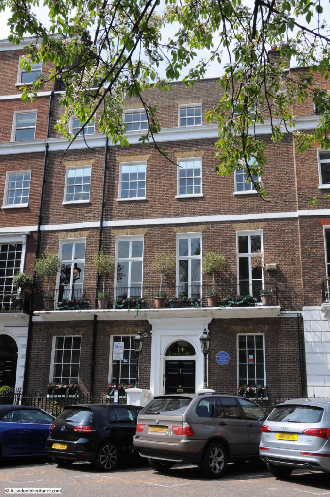
Many of the buildings surrounding the square have the wrought iron balconies of the late Georgian / Regency period.

Manchester Square 5

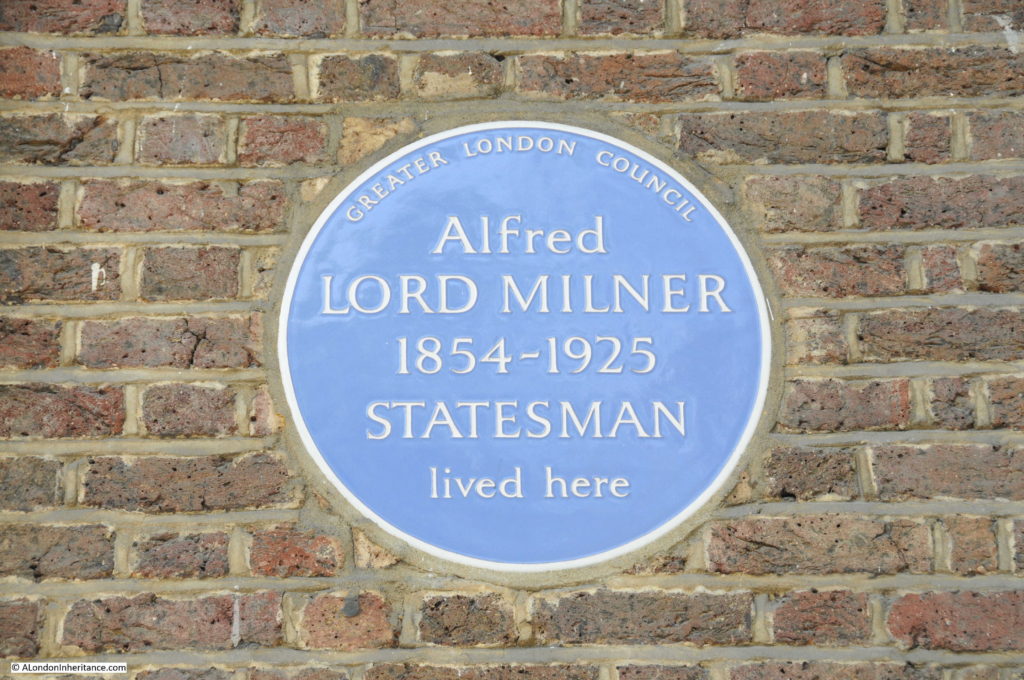
And as you might expect, there are plenty of Blue Plaques to be found. This one for Alfred Lord Milner, who started as a journalist, then was a civil servant before becoming High Commissioner for South Africa and Governor of the Cape Colony during times of considerable tension which led to the 2nd Boer War. On return to London he was chairman of the Rio Tinto mining company, a Director of the Joint Stock Bank and continued to have a number of roles in the Government, continuing to travel widely.

Manchester Square 6

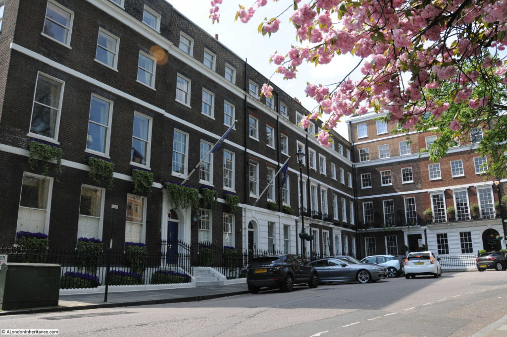
The south west corner of Manchester Square.

Manchester Square 7

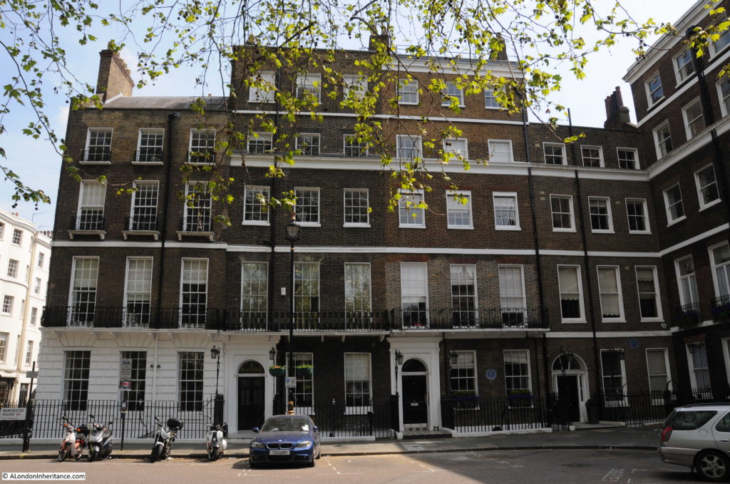
Below is the south east corner of Manchester Square. The windows in these buildings clearly show the impact of the 1774 Buildings Act which took the 1709 requirement for the windows to be recessed by 4 inches and added the requirement for the sash box to be hidden behind the brickwork. The main reasons for these changes were to prevent the spread of fires and the risk of the sash window falling out, but was also driven by the fashion of an austere and simple window design.

Manchester Square 8

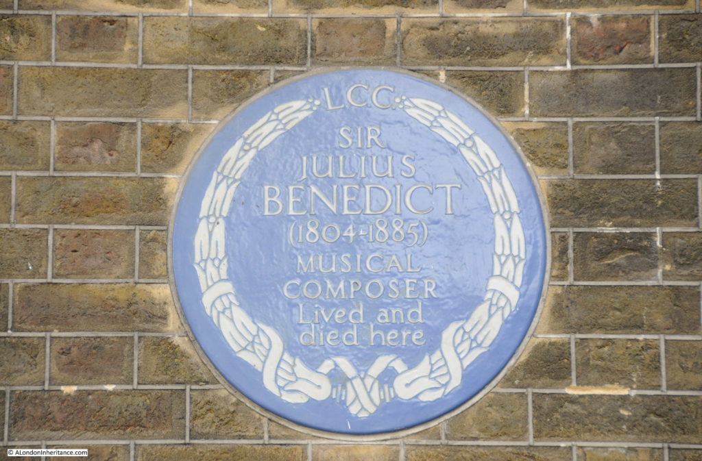
Blue plaque to Sir Julius Benedict, a German composer and conductor who spent the majority of his life in London.

Manchester Square 9

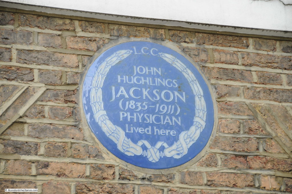
And in the same corner of the square a blue plaque to John Hughlings Jackson, a prominent neurologist, whose work on epilepsy resulted in an improved ability to diagnose and understand the condition.

Manchester Square 10

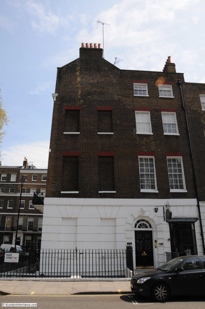
Blocked up windows on the side of one of the buildings in Manchester Square, possibly to reduce the amount of Window Tax paid by the occupiers. The windows are blocked on the side street from the square so the main frontage of the building onto Manchester Square has the full complement of windows. The owner would not want the view of his house facing to the square to be any different from his neighbours and savings would be made where parts of the house were less visible.

Manchester Square 17

A different architectural style on the north east corner of Manchester Square:

Manchester Square 19

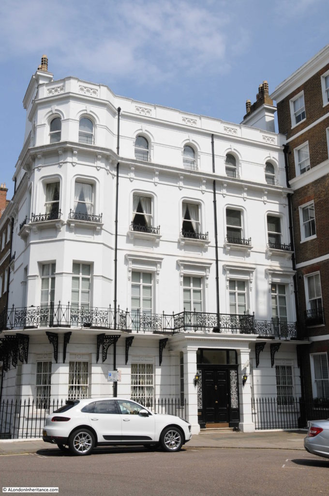
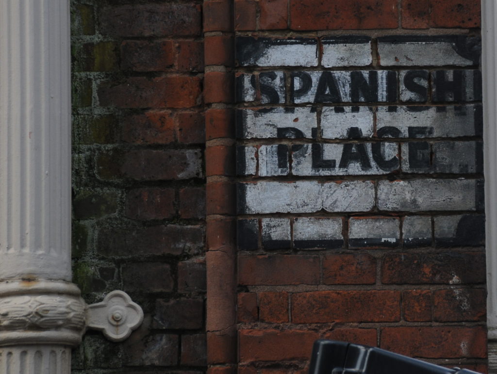
One of the streets leading off Manchester Square (to the right of Hertford House) is Spanish Place – the name recalling the Spanish connection of Hertford House when it was home to the Spanish Embassy.

Manchester Square 27

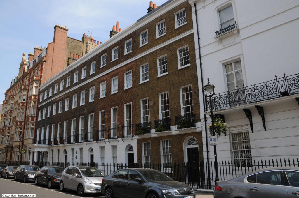
Some of the original houses in Spanish Place. As with many of the houses in the main square, they have the Georgian form of windows as well as the fanlight, arched window above the door:

Manchester Square 11

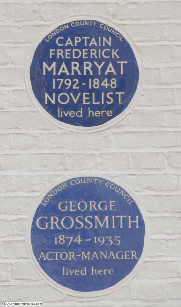
With yet more blue plaques. This time to Captain Frederick Marryat, a Royal Naval officer and author and also to George Grossmith, who was a theatre director, actor and playwright.

Manchester Square 12

Manchester Square and the surrounding area is fascinating. This area grew considerably during the Georgian period as London expanded rapidly to the west and north of Oxford Street and there are many fine streets and squares to be found, and Marylebone Lane looks to be a survivor from the time when this area was all fields.

The legacy of the 4th Marquis of Hertford and Sir Richard Wallace with the Wallace Collection housed in Hertford House is well worth a visit and whilst walking the rooms of Hertford House you are also walking the site of the Prince Regent, the Prince of Wales many visits to meet with the Marchioness, Lady Hertford.

alondoninheritance.com

Wonderful London

I have been collecting books about London for many years, my first purchase was in the mid 1970s in a second-hand bookshop in one of the alleys leading into Greenwich Market. It was H.V. Morton’s London, first published in 1940, a collection of three individual books published in the 1920s. H.V. Morton was a journalist and his writing about London was probably embellished somewhat, but at the time it seemed to bring alive the history and romance of London.

I recently bought a remarkable 3 volume set – Wonderful London, published in the late 1920s. It was edited by St. John Adcock (a prolific author and poet who lived in Hampstead and died in 1930) and described as “The World’s Greatest City Described by its Best Writers and Pictured by its Finest Photographers”.

Wonderful London has chapters on all aspects of the city, each written by a different author, for example “How London Strikes A Provincial” by J.B. Priestley, “The Case For Old London” by G.K. Chesterton and “Sunday In Town” by H.V. Morton.

The three volumes run to over 1100 pages and 1200 photos and provides a fantastic snapshot of London in the 1920s with the text highlighting the social attitudes of the time.

As I scanned through the book, many of the photos are of the same scenes that my father took in the late 1940s and early 1950s and which I have been photographing over the years. There are also some remarkable photos showing London in the first decades of the 20th century and for this week’s post, let me bring you a sample of photos from Wonderful London.

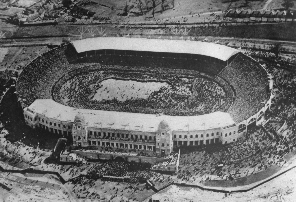
To start, the first photo is a fantastic aerial view of Wembley Stadium. the title to the photo is “Ants Nest Carelessly Broken Open Or Wembley Stadium Seen From The Cockpit Of An Aeroplane”. The caption to the photo reads:

“When at the end of 1925, after two years of stucco splendour, the pavilions and palaces of the British Empire Exhibition melted beneath the workmen’s hands, one building, as though in irony remained, the Wembley Stadium, solid-built as the shrine of professional football. It is symptomatic boast that the Stadium exceeds the Colosseum in size by one-half. During the period of the Exhibition the arena was used for various pageants and military displays, but it is not on record that they ever drew a crowd nearly as dense as the one on which we are gazing.”

Wonderful London 1

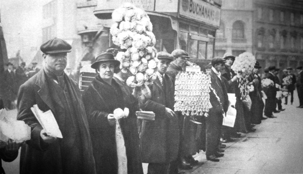
Continuing on the football theme, the following photo is titled “Street Hawkers Sell Football Favours At Walham Green” and has the caption:

“At Walham Green coloured favours and match programmes are for sale near Stamford Bridge, the ground of the Chelsea Football Club.”

Wonderful London 9

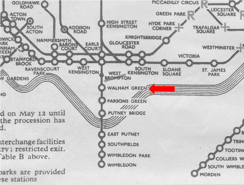
Walham Green is a name that is rarely heard today. Originally the name of a village in west London, dating back to at least 1383 when it was known as Wandongrene. As the above reference to Chelsea Football Club suggests, it was integrated into Chelsea and Fulham. The underground station on the District Line that is now called Fulham Broadway was originally called Walham Green. See the following scan from a 1937 underground map. The name changed to Fulham Broadway in 1952.

Wonderful London 40

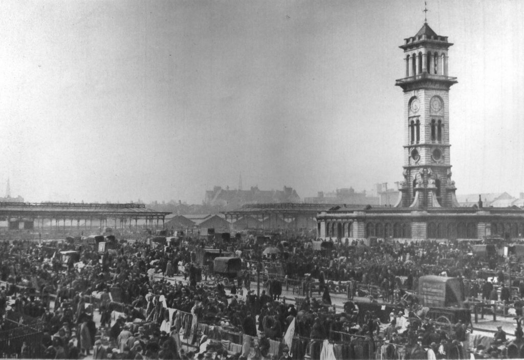
Last year I published a couple of posts on the Caledonian Market, including climbing the Clock Tower which can be found here and here. Wonderful London includes a few photos of the market, including the following photo showing an overview of the market in action. The clock tower is still there, but the surroundings are now completely different.

Wonderful London 2

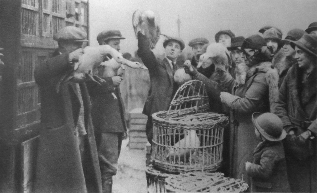
As well as the main cattle market, the Caledonian Market area was also the site of a Friday “pedlars’ market”  where is was possible to buy almost anything. The following photo shows the sale of poultry at the pedlars market.

Wonderful London 3

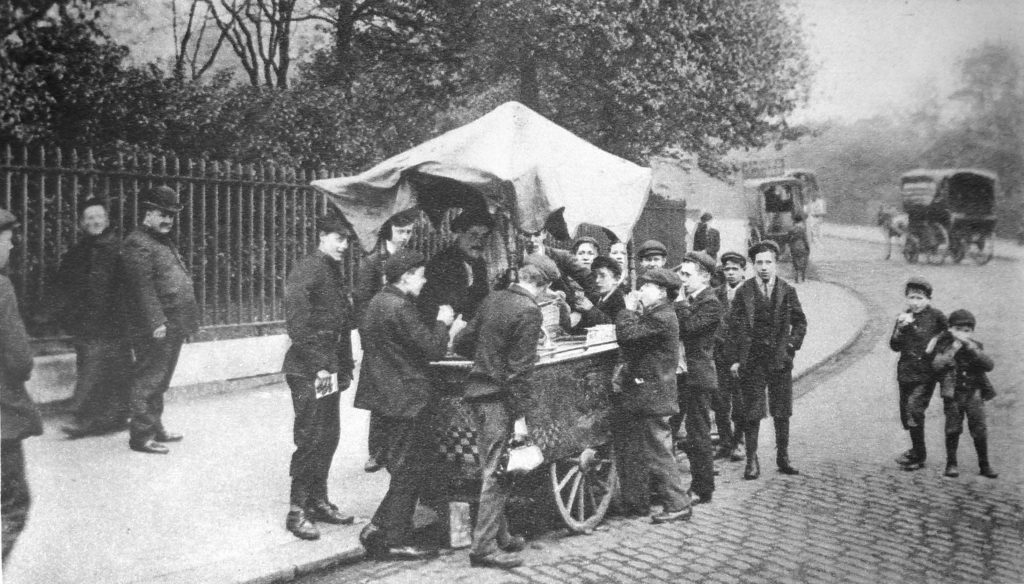
A couple of months ago, I published a photo my father took after the war of the ruins of Chelsea Old Church. In frount of this photo there is a cart with a few children. The cart appears to be an ice cream cart. In Wonderful London there is the photo below of a similar scene with the title “A Son Of Italy Does A Brisk Trade In Frozen Something-Or-Other.”

Wonderful London 4

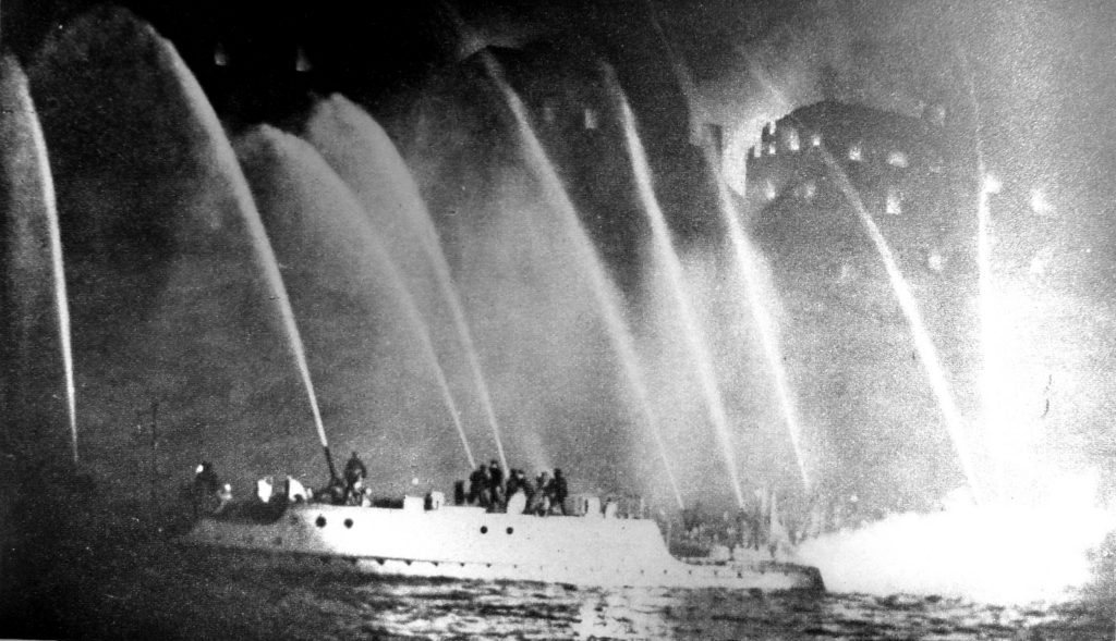
At the end of last year, I went on the Massey Shaw Fireboat as it traveled along the Thames to demonstrate how river based firefighting was carried out. Wonderful London includes the following photo of a huge warehouse fire at Millwall with “thousands of tons of rubber are burning here besides large quantities of tallow and carpets”, being fought by fireboats on the river.

Wonderful London 5

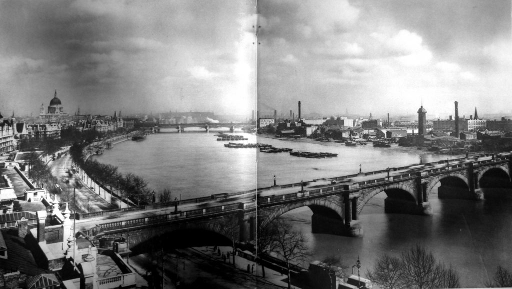
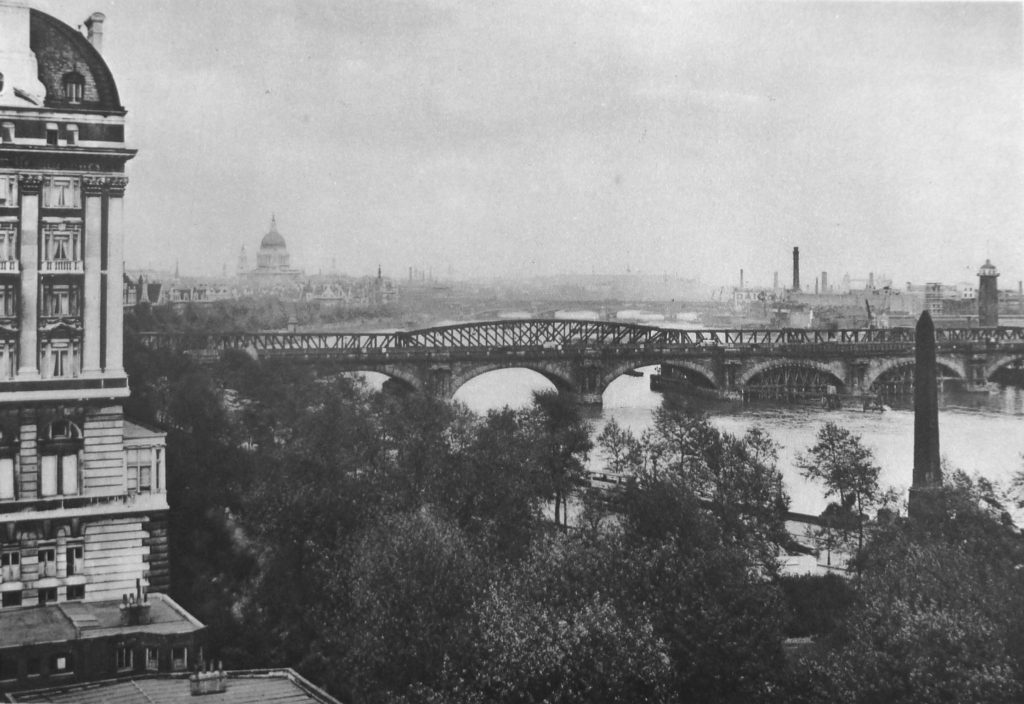
Wonderful London includes a couple of full-page spreads showing views along the Thames. The following photo shows the original Waterloo Bridge from the top of the Savoy Hotel and is titled “Before Evil Days Fell Upon Waterloo Bridge After A Century Of London Traffic.” The caption reads:

“This is a last look at the old bridge as it was before two of its arches failed and began to take up that bent and disquieting appearance which caused the steel auxiliary to be built, the old bridge shored up and so much ink spilt about it.”

Wonderful London 6

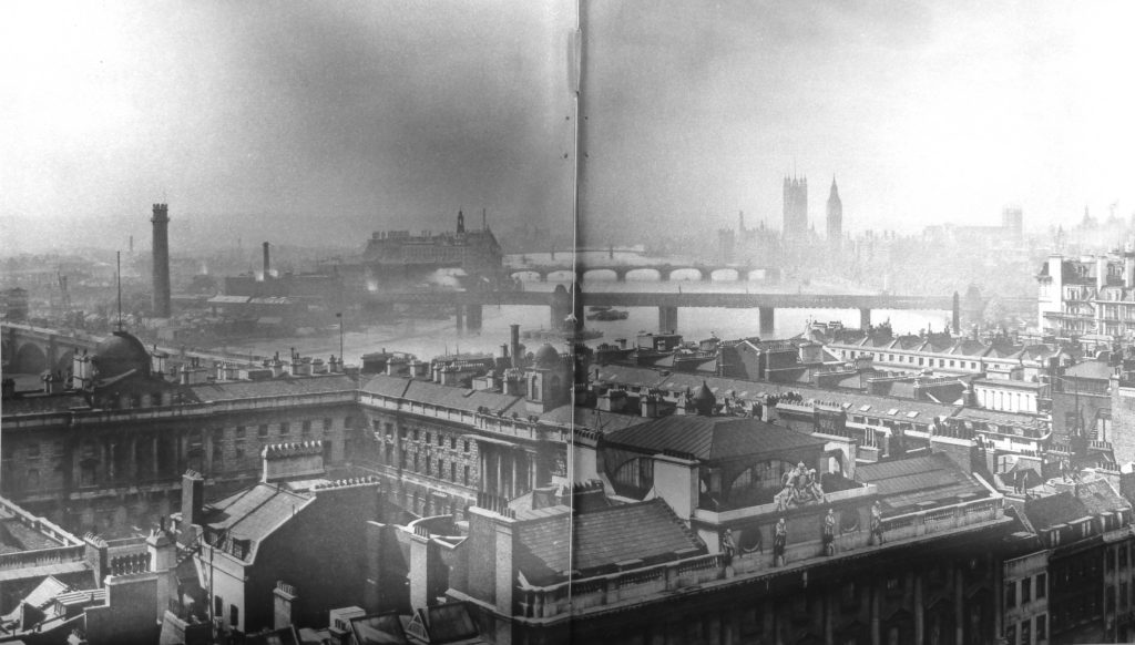
Another of the panorama photos is the following photo taken from the roof of Bush House. The photo is looking towards the South Bank and shows the Shot Tower and the industrial area on the South Bank prior to the post war redevelopment leading to the Festival of Britain.

Wonderful London 7

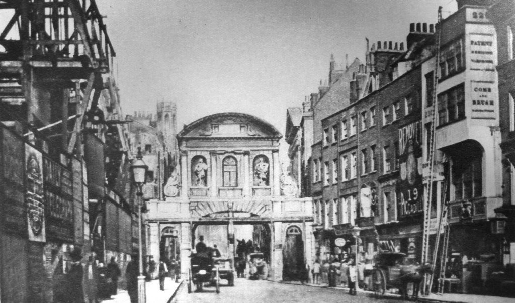
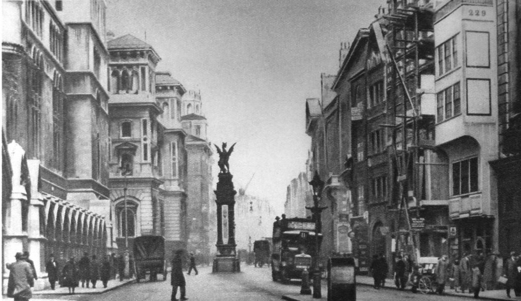
It is interesting that London has always been the subject of “before and after photos”, which is also one of my aims for this blog, to take photos today of the locations my father photographed in the 1940s/50s. Wonderful London includes a number of examples, including the following two photos taken from the same position in the Strand. The first photo shows the original Temple Bar city boundary in 1878. The second photo shows exactly the same scene in the 1920s following removal of Temple Bar, widening of the street and new buildings on either side of the Strand. The location can be confirmed by building number 229 which is on the right of both photos.

Wonderful London 10

Wonderful London 11

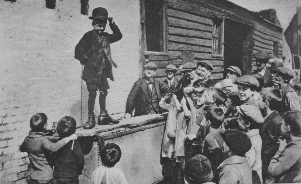
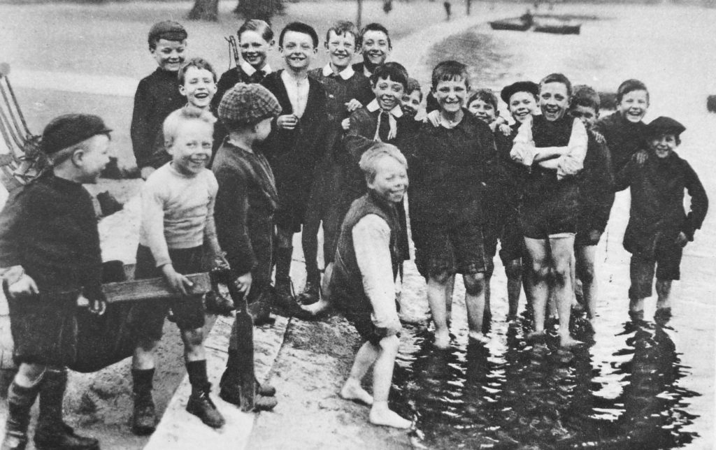
Wonderful London features a range of photos of London children, including the two photos below which are titled “A Budding Humorist Of The East-End And The Serpentine Smile”. the caption for both photos reads:

“A water-tank covered by a plank in a back-yard among the slums is an unlikely place for a stage, but an undaunted admirer of that great Cockney humorist, Charlie Chaplin, is holding his audience with an imitation of the well-known gestures  with which the comic actor indicates the care-free-though-down-and-out view of life which he has immortalised on the screen. Below is a group of summer paddlers in the Serpentine. On the extreme left is a boy holding the shafts of the inevitable sugar-box cart fixed on perambulator wheels.”

Wonderful London 13

Wonderful London 12

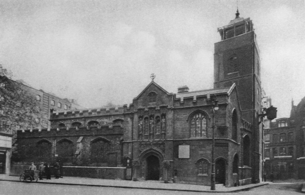
In last week’s post I featured photos my father had taken from the river looking at the north bank of the river. One of these photos had the shell of the church of Allhallows by the Tower which had suffered severe bomb damage during the war. Wonderful London includes the following photo of the church in the 1920s, looking south. The buildings behind the church to the right are between the church and the river. The majority of the surrounding buildings would also be destroyed by bombing in just over 10 years following the decade when this photo was taken.

Wonderful London 14

Photos of views along the river with many of the earlier bridges are included. The following photo shows the view from the Adelphi Terrace looking eastward along the river. The bridge is the original Waterloo Bridge that crossed the river before the version of the bridge in place today, and was photographed after the failures mentioned in the earlier photo. The bridge has the “steel auxiliary” also mentioned above.

Wonderful London 15

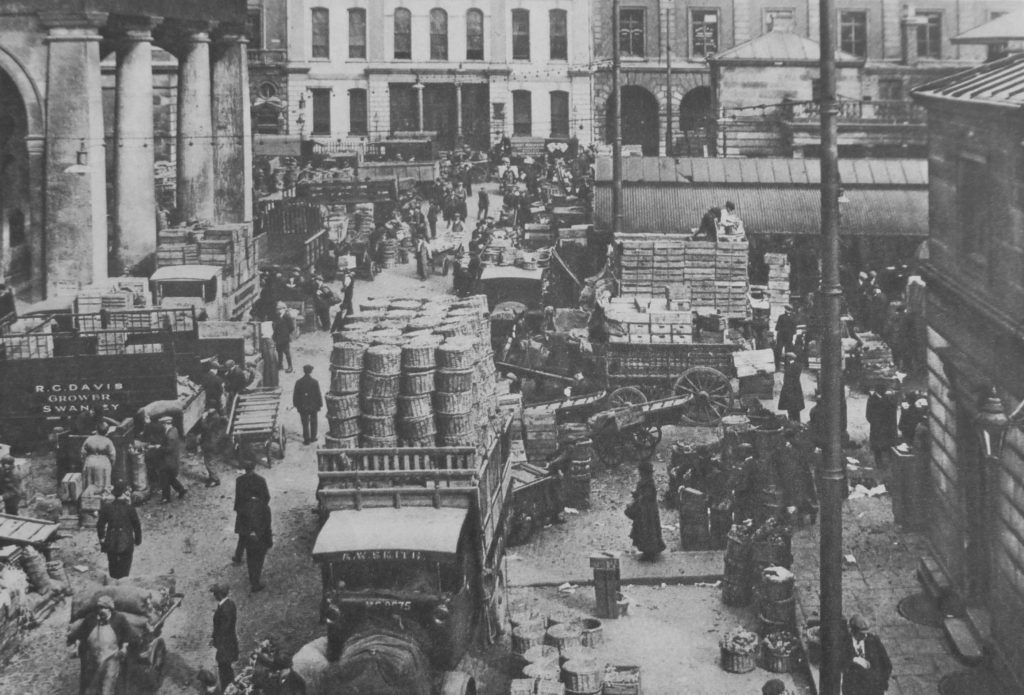
The markets of London feature in Wonderful London. Here is Covent Garden, with the title “Early Morning In The Convent Garden Which Has become Covent Garden” and the caption reads:

“It seems that the Convent Garden of Westminster stretched along the north side of the Strand between Drury Lane and St. Martin-in-the-Fields. When Henry VIII made his pounce upon the monasteries and flung the pieces to his followers, the Russell family got the garden and built themselves Bedford House on the south side. They caused Inigo Jones to lay out a piazza on the north and east and a church on the west. Stalls for selling fruit and vegetables were already established. In 1704 the Russells (or Bedfords) moved to Bloomsbury, and in 1830 most of the current buildings were put up. Soon after midnight the carts start their journeys from the market gardens beyond outer London to reach Covent Garden in time.”

Wonderful London 16

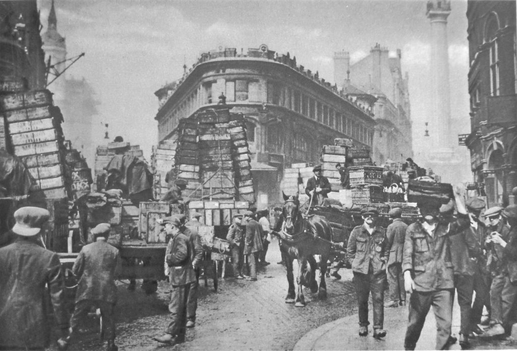
Another London market is Billingsgate Market and the photo in Wonderful London below of the streets outside the market is taken from roughly the same location as one my father had taken (see here). The photo is titled “Fish-Porters Of Billingsgate Gathered About Consignments Lately Arrived From The Coast” and the caption reads:

“At Billingsgate is the chief fish market of London. and to it are brought all kinds of fish from aristocratic salmon and oysters to democratic shrimps and dog-fish of rock salmon. At one time smacks brought all the fish sold in the market, and were unloaded at Billingsgate Wharf, which is said to be the oldest in London. Today however, most comes by train, and little by boat.  The daily market is always crowded, and business is conducted at a speed extremely confusing to the casual spectator. Here we may see the fish porters, who have an almost legendary reputation for bad language, handling the slippery loads with the precision of experts. In the background of this view, to the right, is seen the monument.”

Wonderful London 17

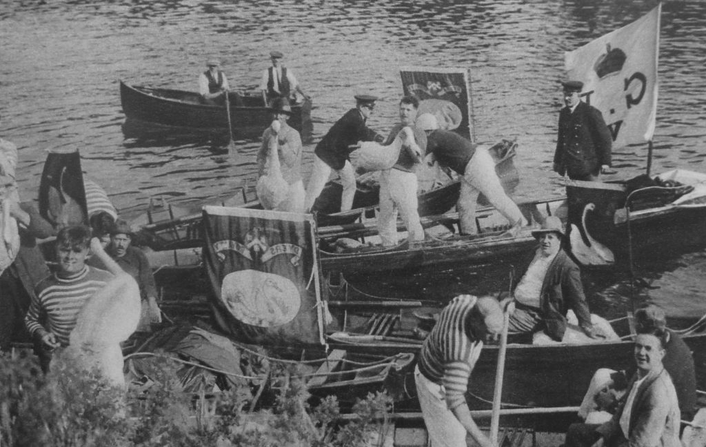
One of the ancient customs covered by Wonderful London is Swan Upping. A custom which my father photographed, as did I during the 2015 event. My post can be found here. Photos of the event in the 1920s look almost identical to the event of today.

Wonderful London 18

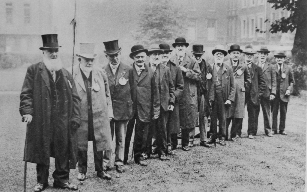
Among photos of Londoners and their trades is the following of “old cabbies headed by an ancient who claims that he once drove King Edward when Prince of Wales, from Waterloo to Marlborough House, in 1868.” You probably would not want to question the route taken by these cabbies!

Wonderful London 19

A chapter in Wonderful London covers Social Work, but a very different form of Social Work to that we understand today. Provided to Londoners through a range of organisations such as the Salvation Army, Police Court Missionaries, Dr. Barnardo’s, the Watercress and Flower Girls’ Christian Mission, St. Dunstan’s, the Morning Post Home for Destitute Men, a Medical Mission for ailing working women and children and the YMCA.

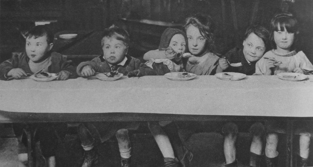
The following photo has the title: “Little Citizens Of London Who Ask For A Change In Life” and is captioned:

“There is no more important branch of social work in great cities than amelioration of the slum child’s lot. The public conscience is difficult to stir, but much is nevertheless being done by philanthropical societies and by individual effort to brighten the drab lives of these little unfortunates, to rescue them from surroundings of cruelty or crime and to start them upon happy and useful careers. Many east-end children have never been beyond their own disease-ridden courts and the dingy streets that form their playground.”

Wonderful London 20

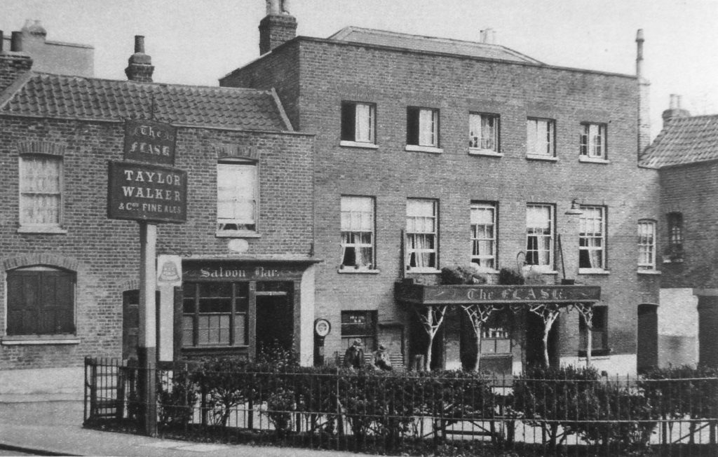
There are many photos in the books which show exactly the same scenes that my father would later photograph. One of these is The Flask in Highgate (see my post on The Flask which can be found here). The caption to the photo reads:

“At The Flask, labourers from the few surviving farms still drink the good ale, as their forerunners did a century ago. This tavern was much frequented by revellers’ clubs of late Georgian times.”

Wonderful London 21

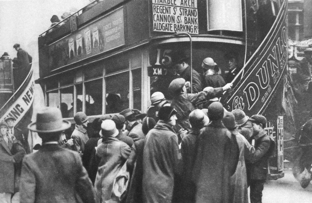
It is interesting that in almost 100 years, aspects of London’s transport system have not really changed.  The following photo has the title “Herding Passengers On To A Bus On Ludgate Hill” and the caption starts “Londoners endure a state of perpetual and acute discomfort in the daily travelling to and from their work which is really astonishing.” A sentence that could equally apply today.

Wonderful London 22

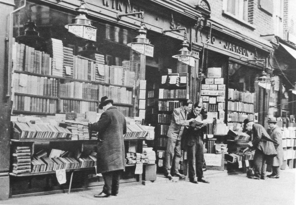
One of the chapters in Wonderful London covers second-hand bookshops and includes the following photo of a second-hand bookshop in Charing Cross Road, which as well as being the home to Foyles (which originally had a second-hand department) also had many other book shops.

Just looking at this photo makes me wonder what treasures could be found in this shop. Had I been around at the time I would probably have spent far too much time and money in shops like this one.

Wonderful London 23

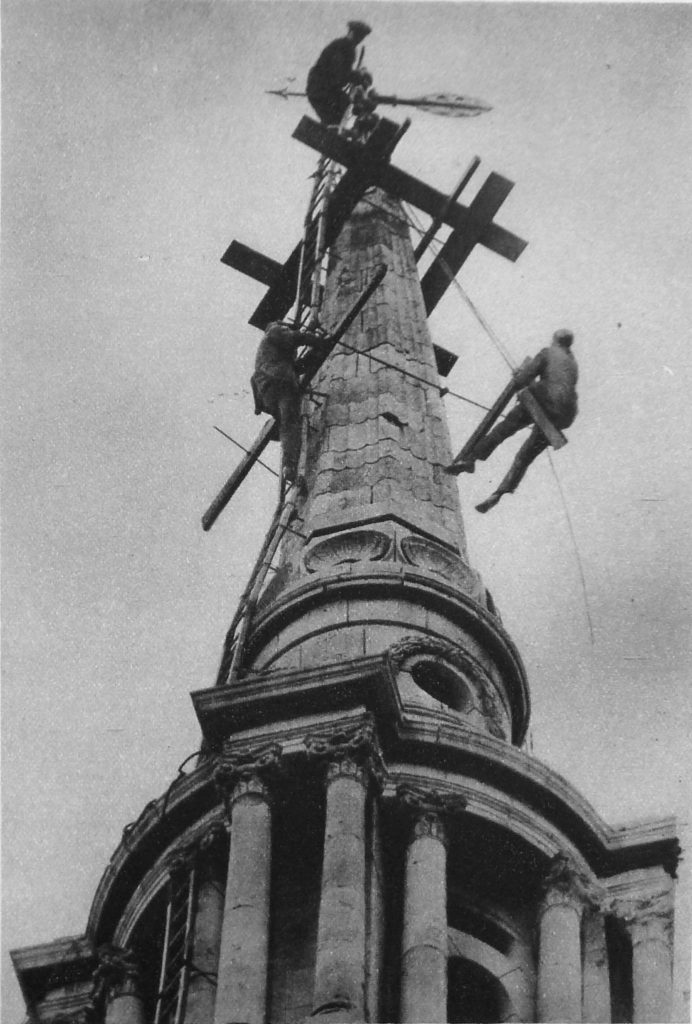
A range of occupations are covered in the three volumes, including the following photo of steeplejacks defying vertigo on the spire of All Saints, Poplar.

Wonderful London 24

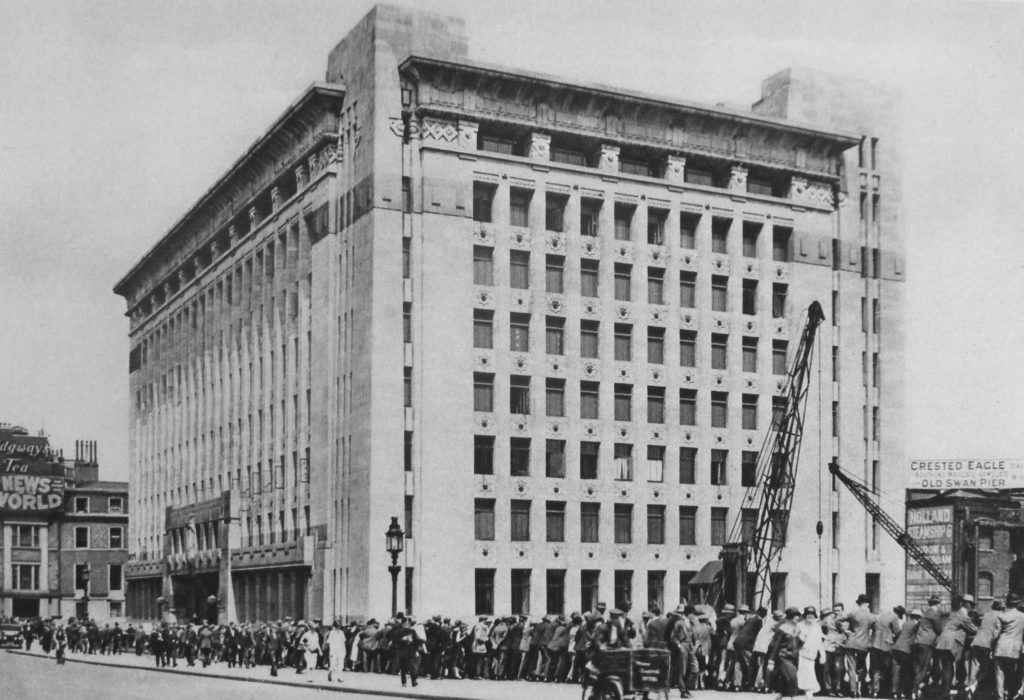
In last weeks post I included a photo taken from the river showing Adelaide House adjacent to London Bridge. Wonderful London includes the following photo of the building soon after completion. The title reads “Adelaide House, A Monument of Modern Architecture On The Site Of Old London Bridge”. The caption to the photo reads:

“In observing this new expression of the architect’s attempt to meet the problems of rebuilding in London it must be remembered that, according to design, a superstructure has yet to be added, and that the bridge level is not the ground level of the building. To get the full height effect, Adelaide House must be viewed from the river or else its south bank. Another place from which to be impressed or perhaps oppressed by the height of the thing is Lower Thames Street. Sir John Burnet and his partners were responsible for the huge study in concrete, and several designs for it were submitted and revised. There is a curious effect about the main entrance as though doorways had shrunk under the tremendous weight above.”

Interesting that the height of buildings has always been an issue in London.

Wonderful London 27

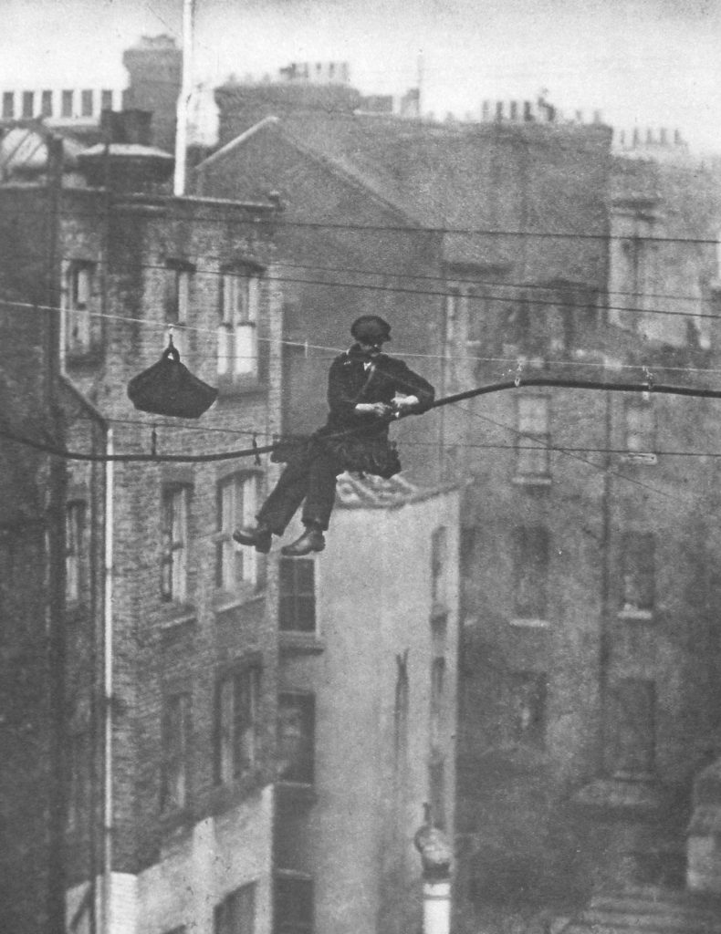
When the telephone was introduced across London, the majority of wiring was above ground. Old photos often show telegraph poles on top of office buildings with wiring strung across the rooftops and streets. These required a good head for heights to maintain. The title for the following photo reads: “Suspending a telephone cable between Conduit and Maddox Streets.”

And has the caption:

Twice a year the steel wires which support London’s telephone cables – each cable may hold the lines of thirty subscribers – are inspected. The cables are fastened to the wires by rawhide suspenders and this man is detaching the thick dark cable from the old wire and fastening it to the new wire, which shows fresh and bright above. The new wire also supports the worker. He sits in a bo’sn’s chair, consisting of a board slung by a loop at either end, which is fastened to the wire. Overhead wires are gradually being superseded by underground systems.”

Wonderful London 28

Some jobs are almost the same now as they were then, for example overnight maintenance work on the city’s railways. The following photo has the caption:

“A gang is at work on the permanent way on Charing Cross Bridge. The lights of the station can be seen in the distance.”

Wonderful London 30

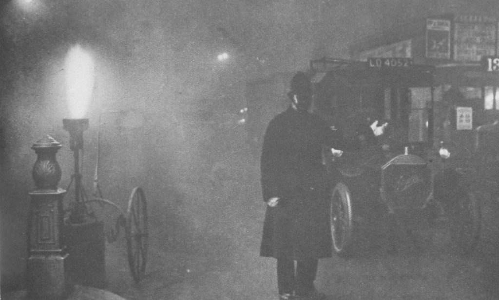
Fog was very much a problem for London in the 1920s. The following photo is titled “Fogbound, Flares For Traffic In A London Particular” and is captioned:

“When the minute particles of dust which are always overhanging London become coated with moisture and the temperature falls below what is called dew point, that is when the temperature at which the moisture in the atmosphere condenses, fog blankets the streets. It is one of the scourges of the city, and much time and money are lost annually by its delaying the traffic. In a real pea-souper acetylene flares are placed at traffic control points. In the photo a constable is directing traffic where Charing Cross meets Trafalgar Square.”

Wonderful London 31

Interesting that the caption refers to the time and money lost due to London fogs rather than the impact on the health of Londoners. Business, trade and making money has always been the main driver of London life.

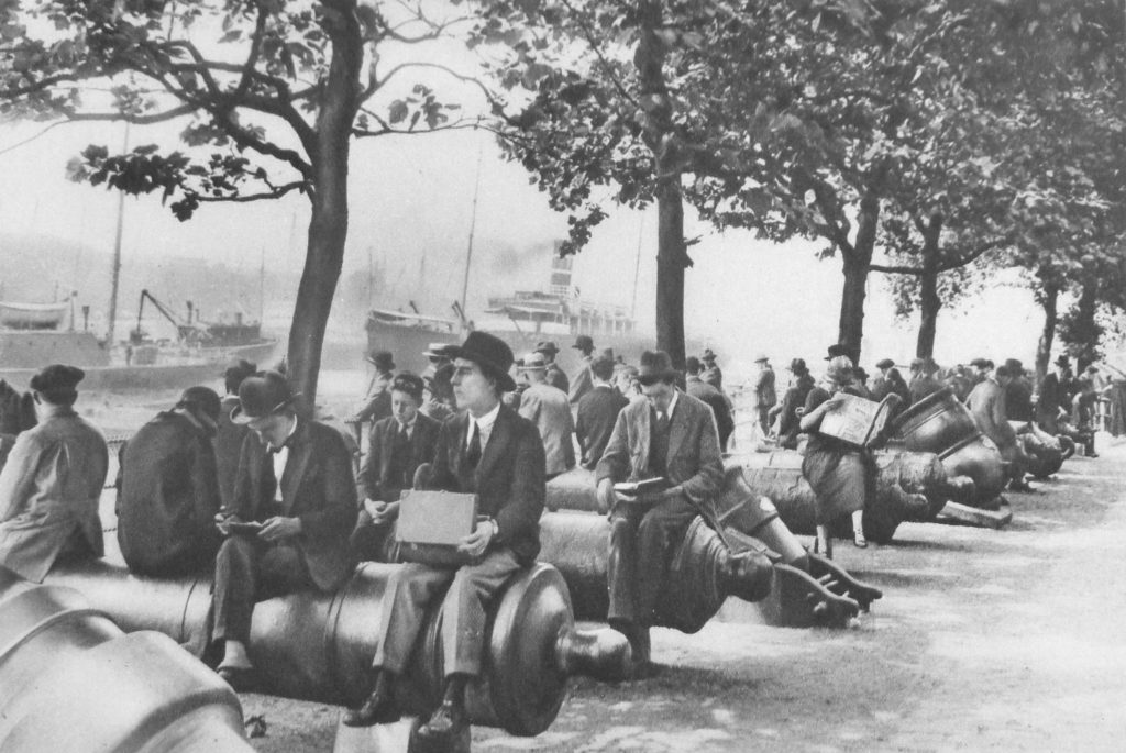
I covered the cannon in frount of the Tower of London in a post showing my father’s 1947 photo of the area.  Wonderful London includes a photo of the same area from the 1920s with the title “Tower Wharf: One Of London’s Lunch-Time Gathering Grounds” and the caption:

“Despite the tremendous number and variety of eating places, many hundreds of those who work in the City and its surroundings prefer, in fine weather, to eat their lunch on a park seat or as here, seated on the slippery surface of an old cannon. Tower Wharf, whatever its merits as a restaurant, is a fine place to view the Tower, and also the shipping in the Upper Pool and the opening of Tower Bridge. The wharf was built by Henry III who also made Traitors Gate. The wharf gave the fortress one more line of protection. On the very ground where this crowd is sitting another crowd assembled day after day to scream for the trembling Judge Jeffryes to be thrown to them, in quittance for the Bloody Assize.”

Wonderful London 32

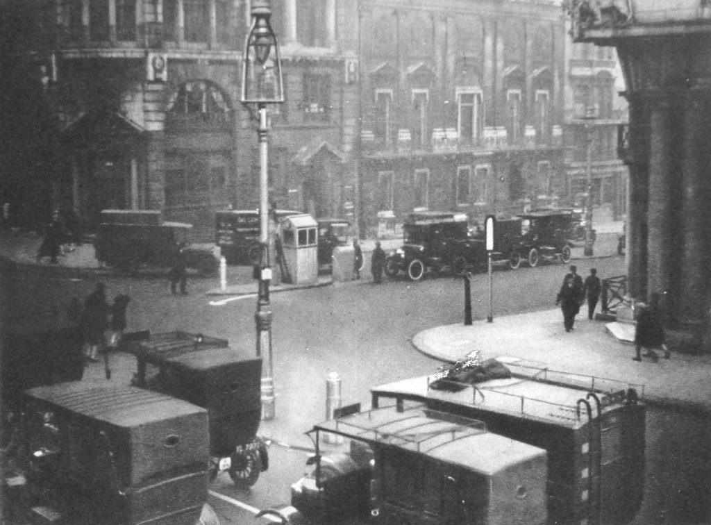
A theme during the 1920s was the growth in motorised traffic across London and the need to manage traffic. This required new systems of control and in 1925 manually operated traffic lights were installed at the junction of St. Jame’s Street and Piccadilly.

The photo below shows the junction. Look in the middle of the photo and there is a small hut.

Wonderful London 33

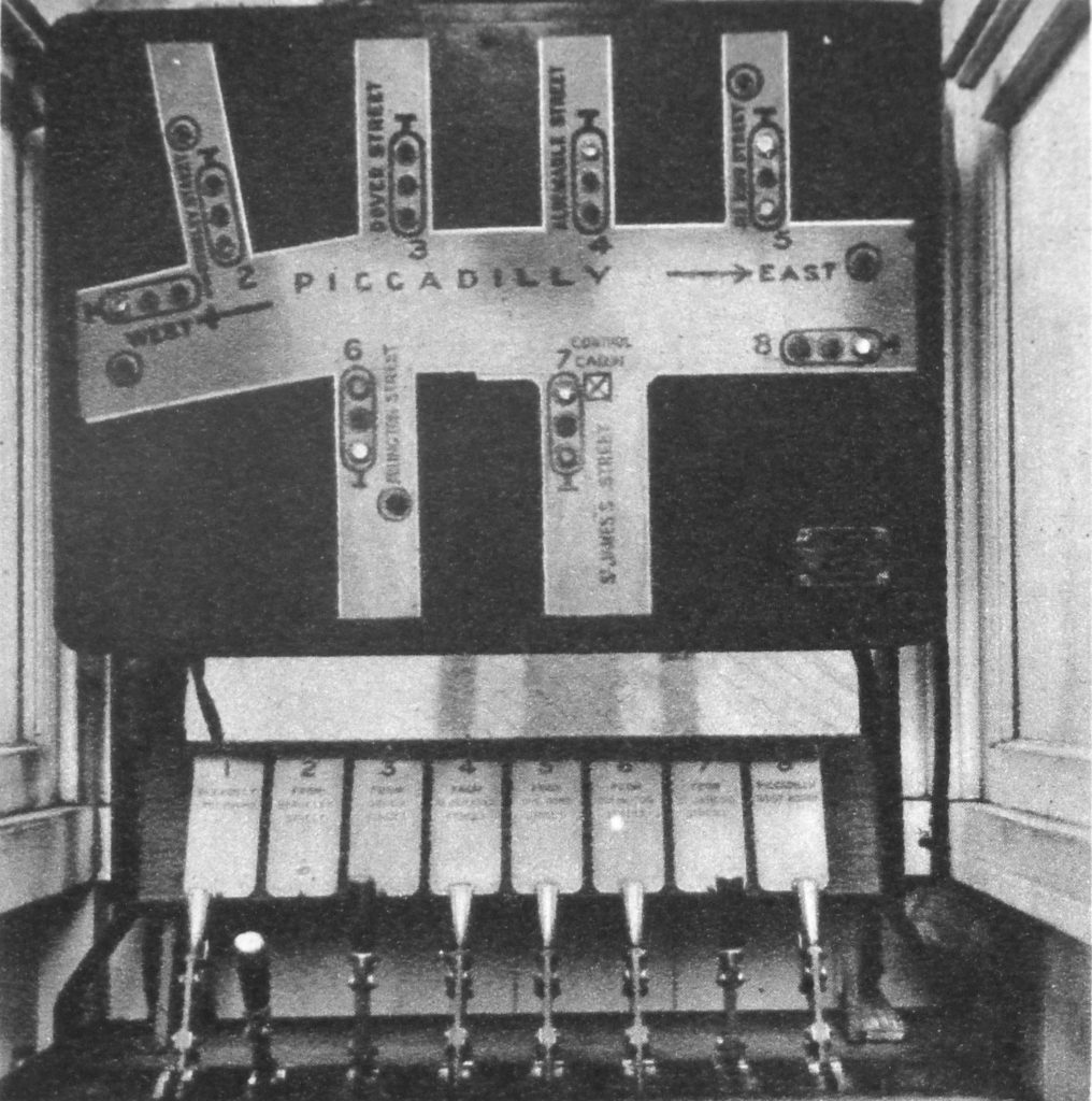
Within this hut is the control equipment for the traffic lights. Operated manually by the levers at the bottom of the photo with the street layout and indicators showing the status of the traffic lights above. Requiring an operator for each set of traffic lights, it is no wonder that they only really started to proliferate across London when automated lights were developed a few years later.

Wonderful London 34

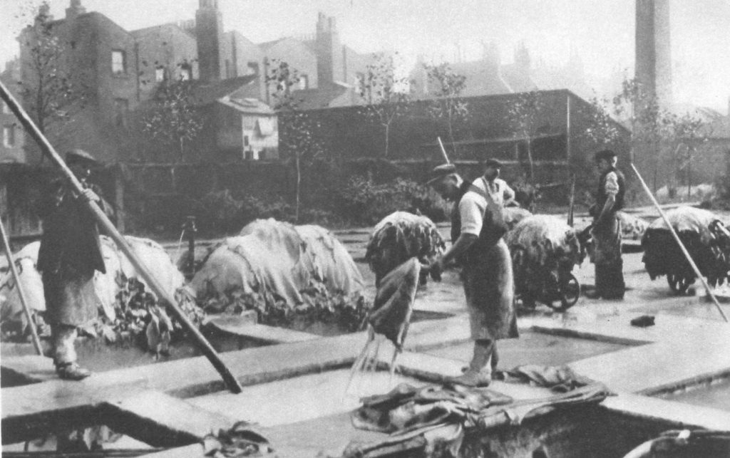
The book also features trades that have long since disappeared. Tanneries were a major industry in 19th century London but in the first decades of the 20th century they were gradually disappearing. The following photo shows one of the remaining tanneries and is captioned:
“At Bermondsey tanning is, so to speak, in the air as one traverses the dingy streets towards the Neckinger Mills, where the photograph was taken. We are looking at the lime yard full of pits about seven feet deep, and built some 60 or 70 years ago. Fifteen to thirty dozen skins go to a ‘pack’ and each pack is soaked in fresh water, then in a solution of limewater, for 3 – 6 weeks to remove the hair. Goat skins are being dealt with here.”

Wonderful London 35

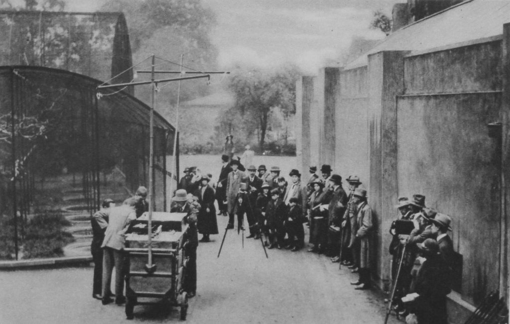
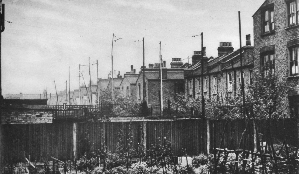
Radio broadcasting, or wireless was a new technology in the 1920s with the BBC having started daily broadcasts in 1922. Wonderful London shows how this technology is starting to impact the lives of Londoners with two photos under the title: “Broadcasting Noises From The Zoo To The Aerials Of Suburbia”

The photos are captioned:

“Howling is only approved of by ‘listeners-in’ when it comes from the Zoo, and several experiments have been made in bringing the wild animal into the home by wireless. We see the officials of the British Broadcasting Co. preparing to receive a few screeches from the aviary.”

Wonderful London 36

“These will be wafted over the forest of wireless poles that has sprung up all over London since the broadcasting craze took its hold on the inhabitants. The poorer neighbourhoods seem particularly to bristle with aerial poles, and this is very noticeable from a train traversing such districts.”

Wonderful London 37

As well as radio providing a new means of communication and entertainment another new technology that started to be widely available and continues to have a huge impact on London is flight.

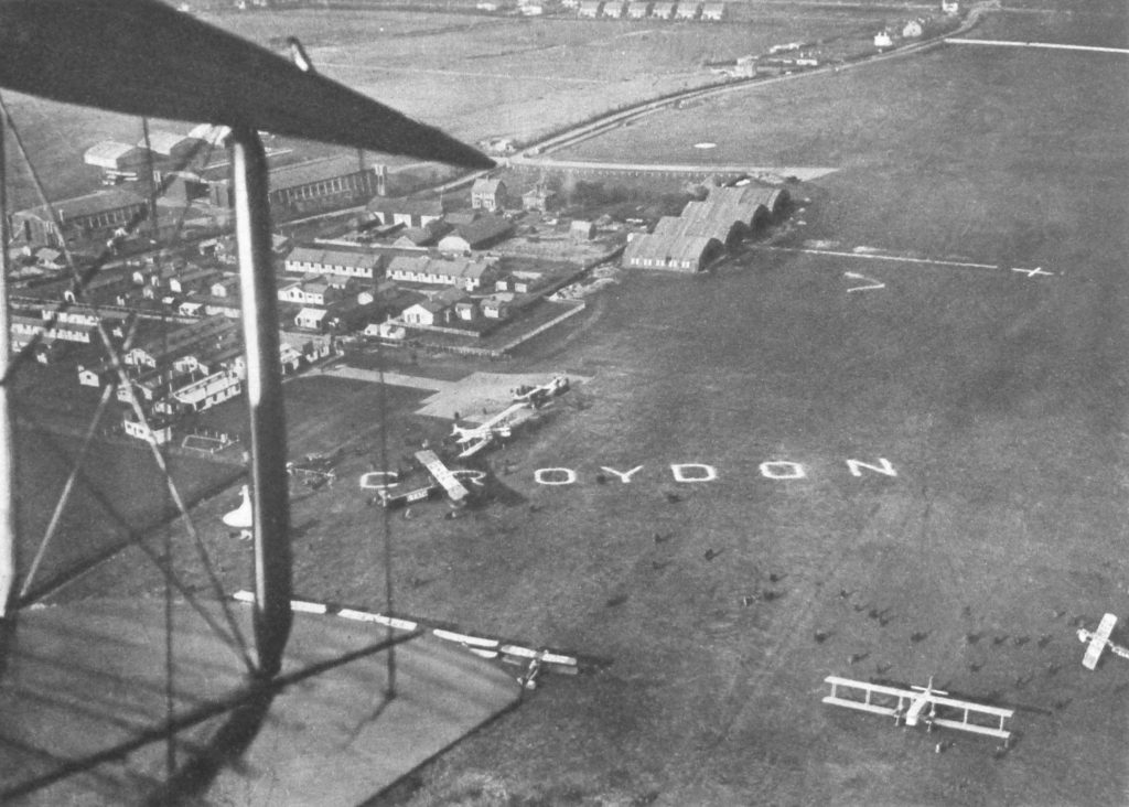
Long before Heathrow or Gatwick, Croydon was London’s airport, and the following photos show the first steps in London’s aviation journey. The first photo is titled “The Air Port of London As It Was In 1925” and is captioned:

“The official designation of the great aerodrome is “The Air Port Of London” though it is popularly known as the Croydon, or Waddon aerodrome for it is included in the latter parish”

Wonderful London 38

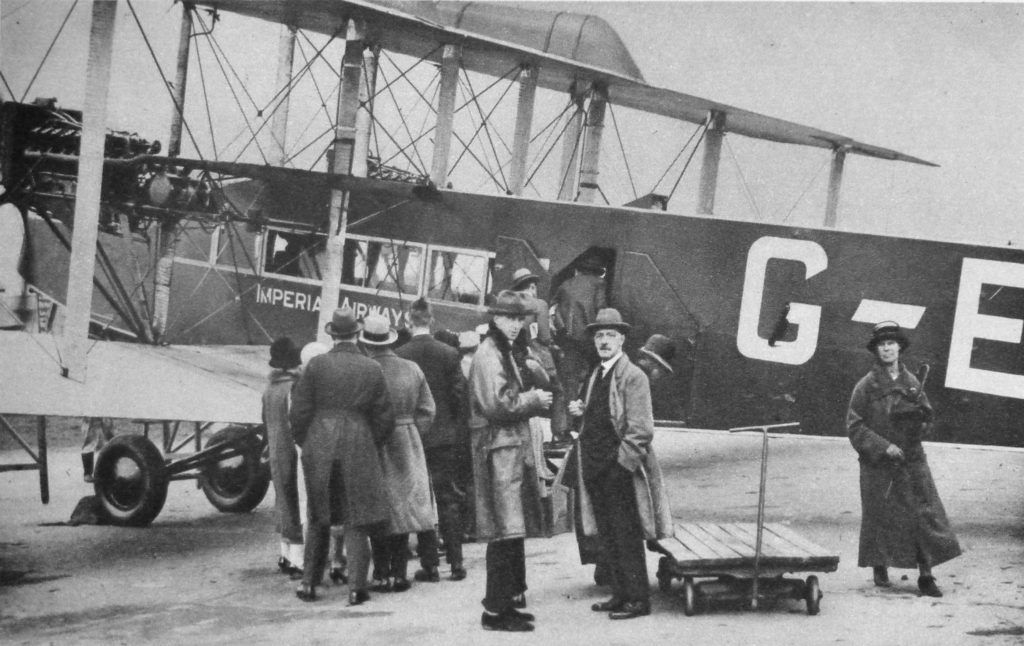
And the following photo “Loading Cargo and Passengers”

“Passengers are embarking for Paris by an Imperials Airways machine.”

Wonderful London 39

When you consider how quickly these first tentative steps in commercial aviation transformed into the scale and complexity that we now see at Heathrow, it does make you wonder what the next 90 years will hold for London.

Wonderful London does live up to its name and with the written chapters that cover almost any topic you could think off, and with so many photos the books really do justice to describing the world’s greatest city.

alondoninheritance,com

Along The Thames In 1947 And 2016 – Tower Bridge To Westminster Bridge

During the afternoon of Saturday 23rd August 1947, my father took a boat trip along the Thames from Westminster to Greenwich. I am able to date this accurately as the date was written on a number of the photos taken along the route that he printed afterwards.

I will be on the river later this year to photograph the same views on the stretch between Tower Bridge and Greenwich, however for the photos covering the route between Westminster and Tower Bridges, I cheated by taking a walk along the south bank of the river to photograph the north bank views.

My father’s photos were taken from a boat at low tide, so I was not able to get the view exactly right, however they do show roughly the same view and the changes that have occurred along the north bank of the river.

I have not processed these photos, they are straight from the scanner and some show some imperfections. I prefer the unprocessed look as a more genuine presentation of photos that are now 69 years old. Film was hard to get just two years after the war had finished and these photos were taken on 35mm movie film which was cut up to fit the film holder in the camera. I have no idea why movie film was available, or where it came from.

After taking the photos for last week’s post about Tower Bridge, I continued along the south bank of the river towards Westminster, so these photos are in reverse order.

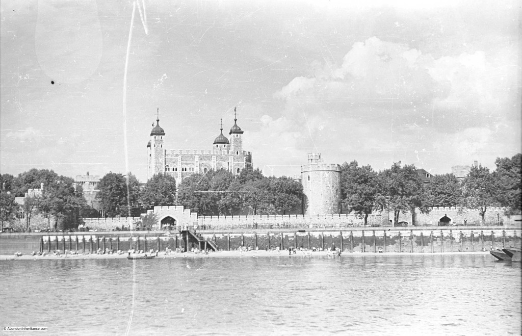
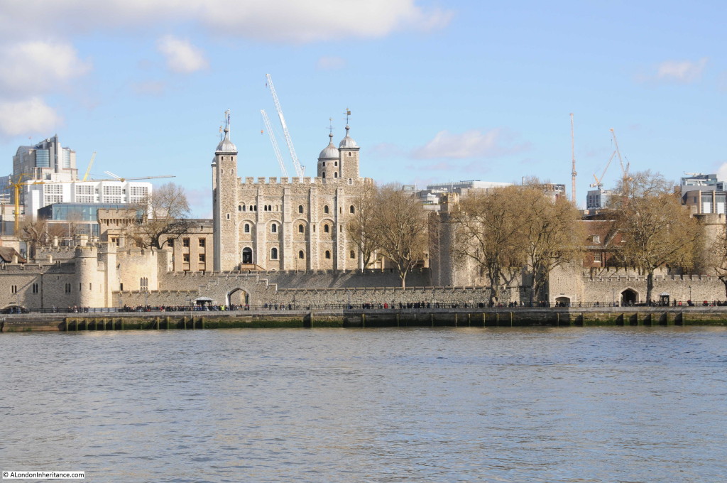
Starting the journey in 1947 with the Tower of London. As with last week’s photos the beach in front of the Tower looks to be busy on an August summer afternoon.

Southbank Walk 1

The view today from the opposite bank of the river. There are few high buildings immediately behind the Tower to detract from the view, however I doubt that this will remain the same for long, the number of cranes in the background are rather threatening.
Southbank Walk 13

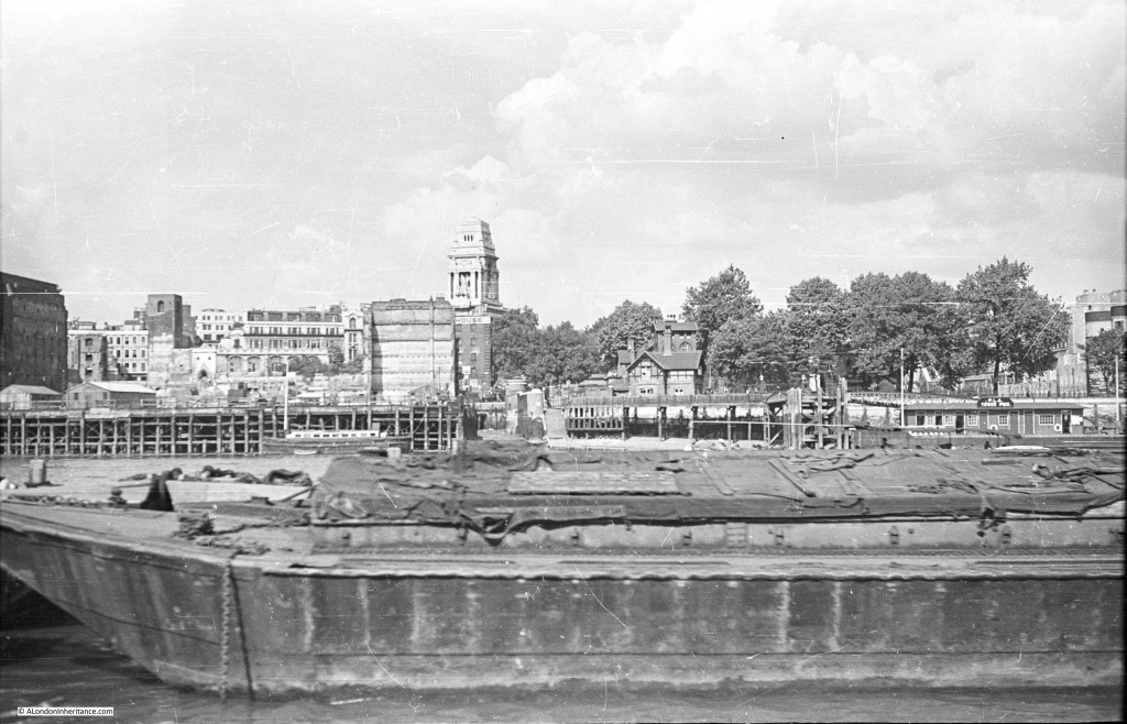
Just past the Tower is this view. The Tower of London is at the right of the photo (just behind the trees) and the large building in the centre is the former Port of London Authority building.
The area on the left of the photo, down to the river was bombed heavily during the war. To the left of the photo is the shell of a church tower. This is the church of All Hallows by the Tower. Below the PLA building and facing the river is the side of a building. This is the Ye Old Tiger Tavern on Tower Hill which survived bombing but was later pulled down in the reconstruction of the area. More on these buildings and the area in later posts.
Southbank Walk 2

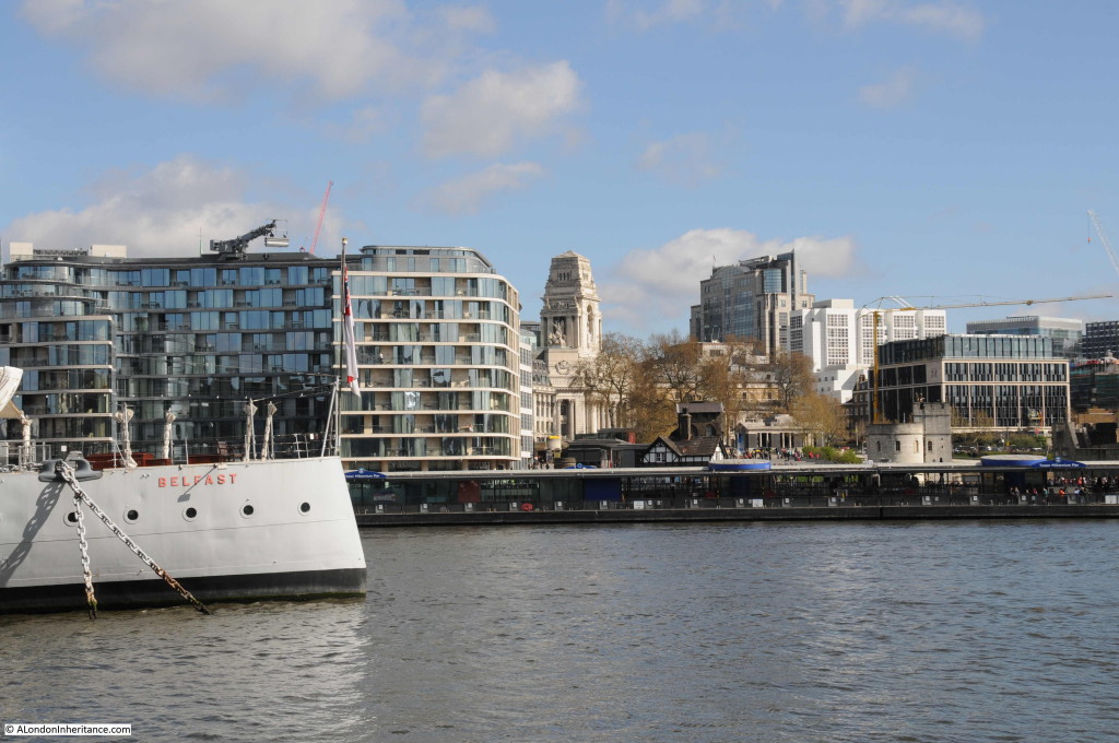
The view today. I should have been a bit further to the left, however the Belfast would have obstructed much of the view. The tower of the PLA building is still visible, however the new buildings on the left have obscured the view of All Hallows by the Tower which was rebuilt after the war.

Southbank Walk 14

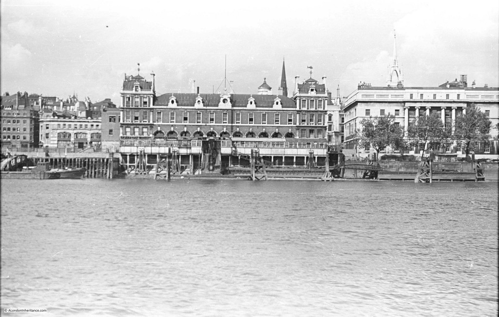
Further along we come to Billingsgate Market, with the Customs House on the right and the tower of the church of St. Dunstan in the East just behind the Custom House.

Southbank Walk 4

And the view today (although partially obscured by one of the new piers along the Thames). Billingsgate, the Custom House and the tower of St. Dunstan’s are the only buildings that remain from 1947 with the towers of the City rising up behind.

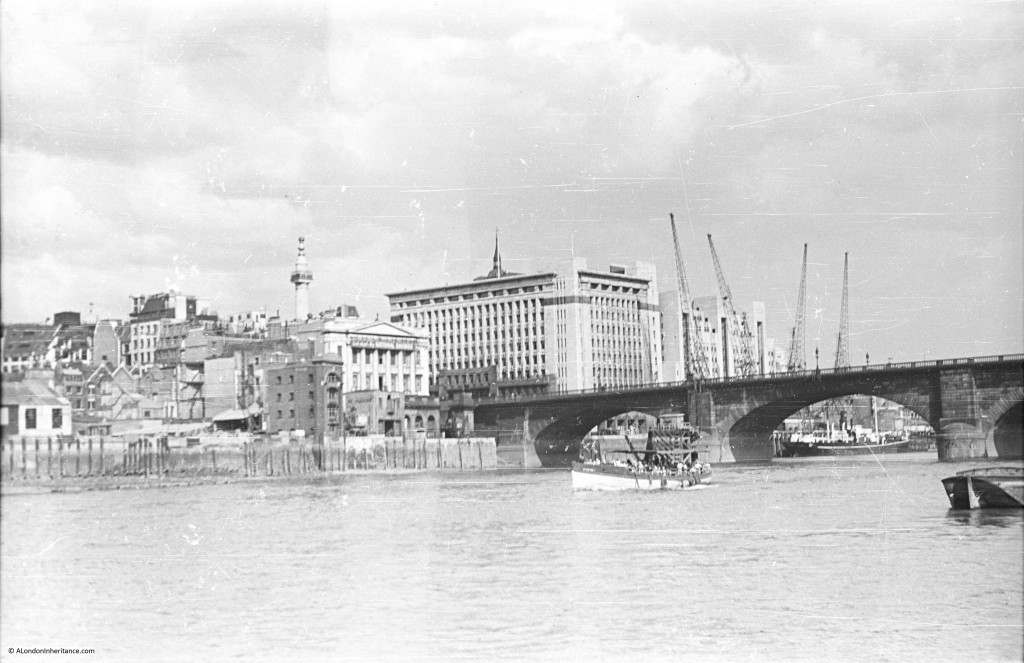
Southbank Walk 16The following photo shows the edge of the Billingsgate Market building on the extreme right of the photo. There is then a gap which before the war was occupied by Nicholson’s Wharf, destroyed by bombing along with a direct hit by a V1 flying bomb. To the left of the gap is New Fresh Wharf. This was a busy wharf that handled very large volumes of goods, general goods, fruit and canned goods as well as operating as a terminal for passenger ferries.

New Fresh Wharf was demolished in 1973. The building on the extreme left of the photo is Adelaide House. Construction of Adelaide House was completed in 1925. It is now a Grade II listed building. The dock facilities of New Fresh Wharf extended along the river frontage of Adelaide House.
Southbank Walk 5

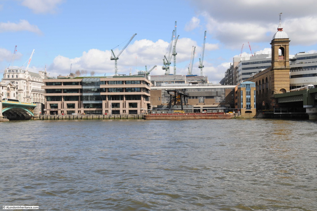
The same view today with Billingsgate on the right of the photo and Adelaide House of the left. The scene in-between these two buildings is now completely different.

Southbank Walk 17

We have now moved further along the river, past London Bridge, the version of the bridge prior to the current one can be seen in the following photo with Adelaide House and New Fresh Wharf behind the bridge. We can now see the Monument and to the left of the bridge is Fishmongers Hall, the home of the Fishmongers’ Company. Damaged caused by bombing can be seen to the left.

Southbank Walk 6

Almost the same view today, although I should have been on a boat, mid river as my father was to get the same perspective. Adelaide House, the Monument and Fishmongers Hall are still there. My father’s photo included the 19th Century version of London Bridge and my photo shows the 1974 incarnation of the bridge that has crossed the river in roughly the same location for many hundreds of years.

Southbank Walk 18

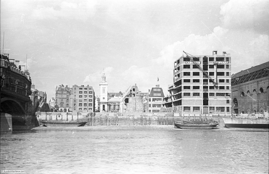
If we now pass under the bridge taking the rail tracks across the river into Cannon Street Station, and view the small space between Cannon Street Station and Southwark Bridge. Cannon Street Station is on the right with the structure on top that held the glass canopy to the station. The church is St. Michael Paternoster Royal.

Southbank Walk 7

The view today. Cannon Street Station still on the right, although without the original roof, offices have now been built above the station platforms. The old Cameron Wharf area is now the City of London Corporation Waste Transfer Station with barges mooring along side to take rubbish from the City to processing locations further down river.

Southbank Walk 19

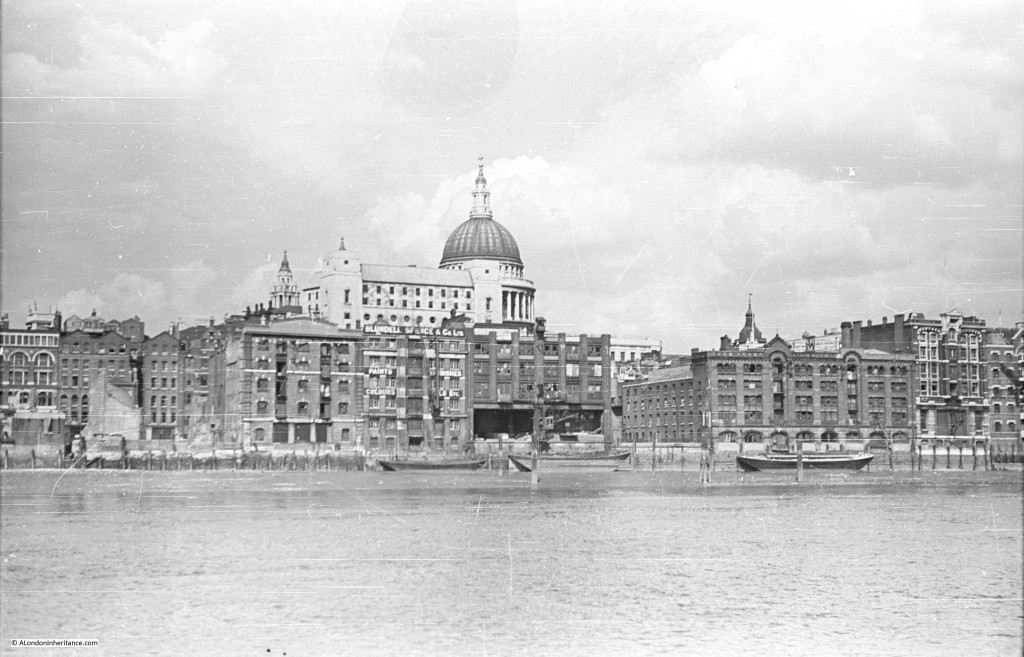
Now walk under the new Millennium Bridge and slightly further up river you would have had this view in 1947. Puddle Dock is on the extreme left. St. Paul’s Cathedral is in the centre, partially obscured by the Faraday Building in Queen Victoria Street, one of the main London telephone exchanges. The height of the Faraday Building and the impact on views of St. Paul’s was one of the reasons for the planning regulations that now protect specific sight-lines and views of the cathedral.

The building and wharf of Blundell Spence & Co Ltd (manufacturers of Paints, Varnishes and Colours) is just below the Faraday Building, with the Cannon Warehouse and Showrooms to the right.

Southbank Walk 8

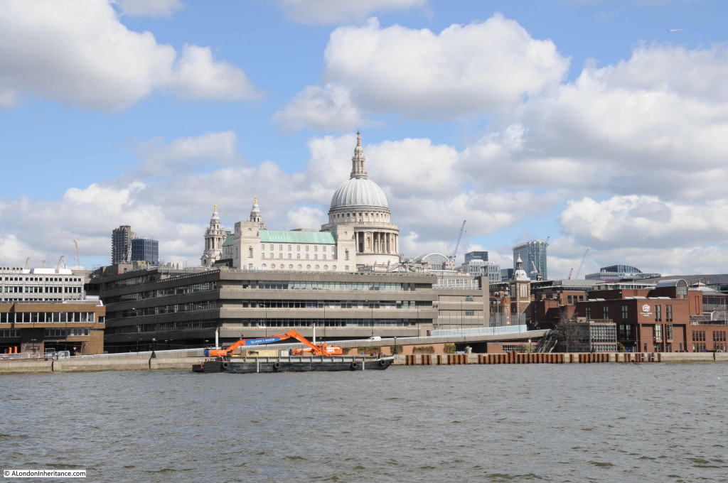
The view today. The Faraday Building is still the highest building between the cathedral and the river. The church on the right of centre in the 2016 photo is St. Benets Welsh Metropolitan Church. If you look in exactly the same position in the 1947 photo the spire above the tower of the church can be seen. The building on the right hand edge of the photo is the new site of the City of London School.Southbank Walk 20

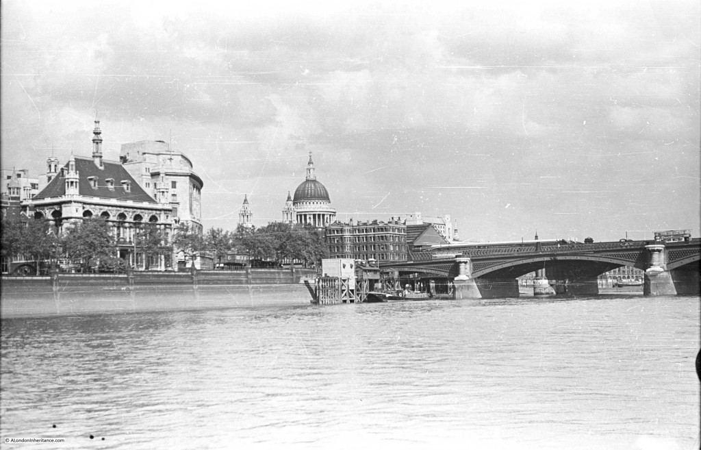
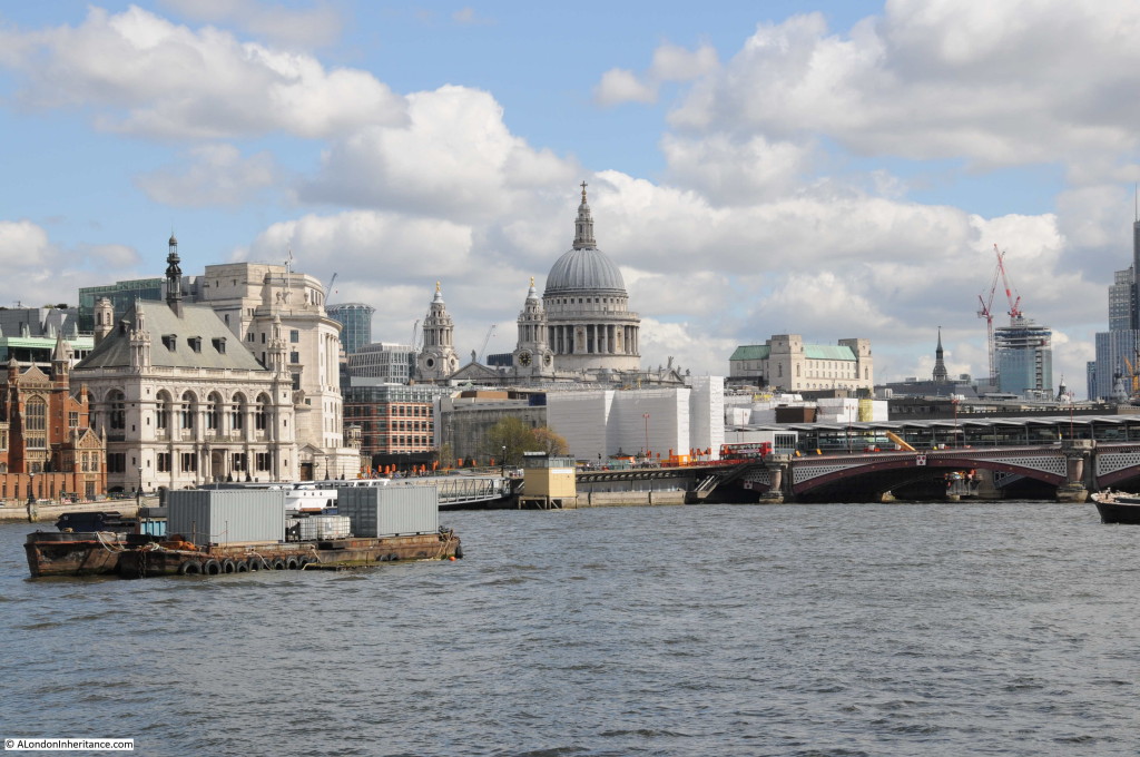
Now passing under Blackfriars Bridge, walk along a bit further and look back at St. Paul’s Cathedral. In this 1947 view, on the left is the City of London School with the Unilever Building just behind.

Southbank Walk 9

The same view today. The original building of the City of London School is still there, although the school moved out in 1987 to new buildings along Queen Victoria Street.

Southbank Walk 21

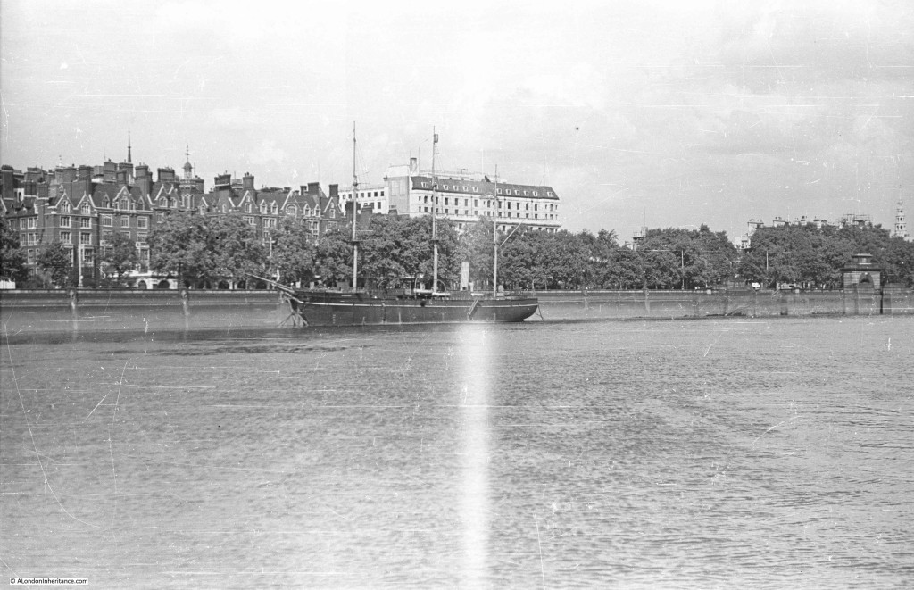
Walk further along the south bank, almost to Waterloo Bridge and look back along the north bank of the river and this is the 1947 scene. The steeple of St. Brides church is on the extreme right. Also on the right of the photo on the embankment wall is the memorial commemorating the naming of this stretch of the river as King’s Reach after King George V.

The ship in the middle of the photo is the Discovery, Robert Falcon Scott’s original ship. She was moored here from 1931 to 1979. Having been fully restored, the Discovery is now moored in Dundee. During the war she was used by the Sea Scouts, of which my father was a member. His written account of life in London during this time includes accounts of staying on the Discovery and sailing up and down the Thames between Pimlico and Tower Bridge on an old whaler doing things that would be a nightmare for current health and safety.

Southbank Walk 10

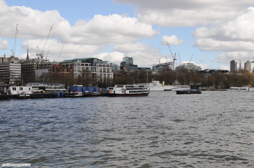
Roughly the current view, although not exactly the same viewpoint. The steeple of St. Brides church is still on the right, although as I could not get to exactly the same position, the Kings Reach memorial is now to the right of center.

The location of the Discovery is roughly at the position of the blue containers.

Southbank Walk 22

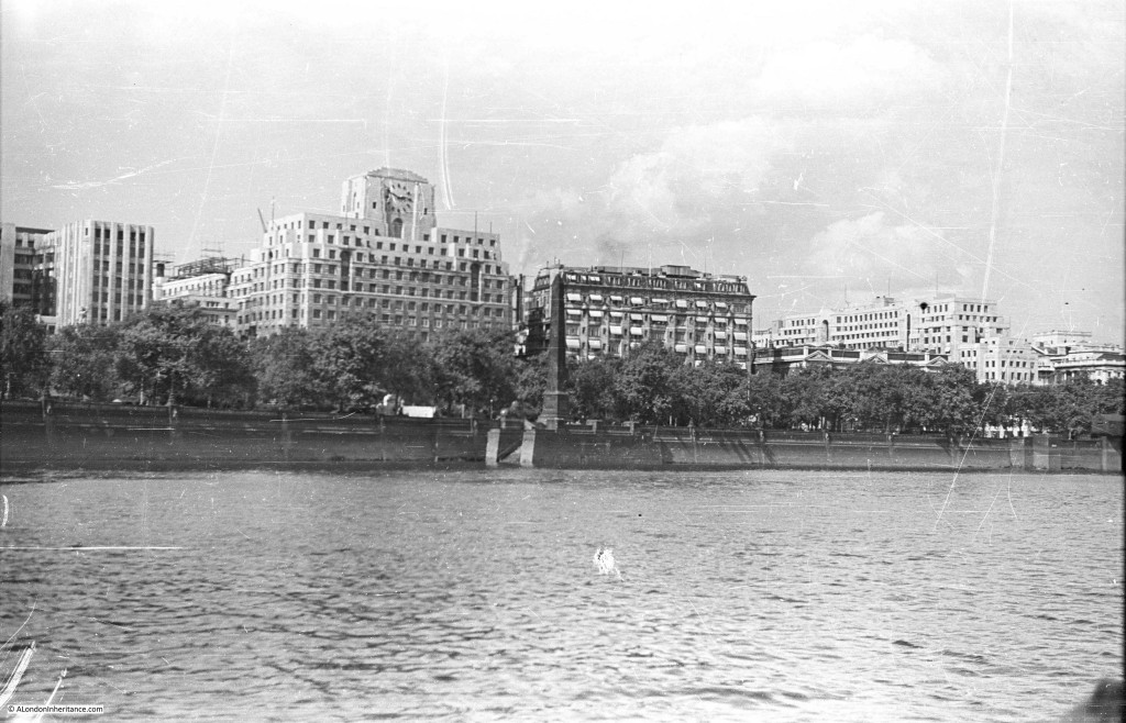
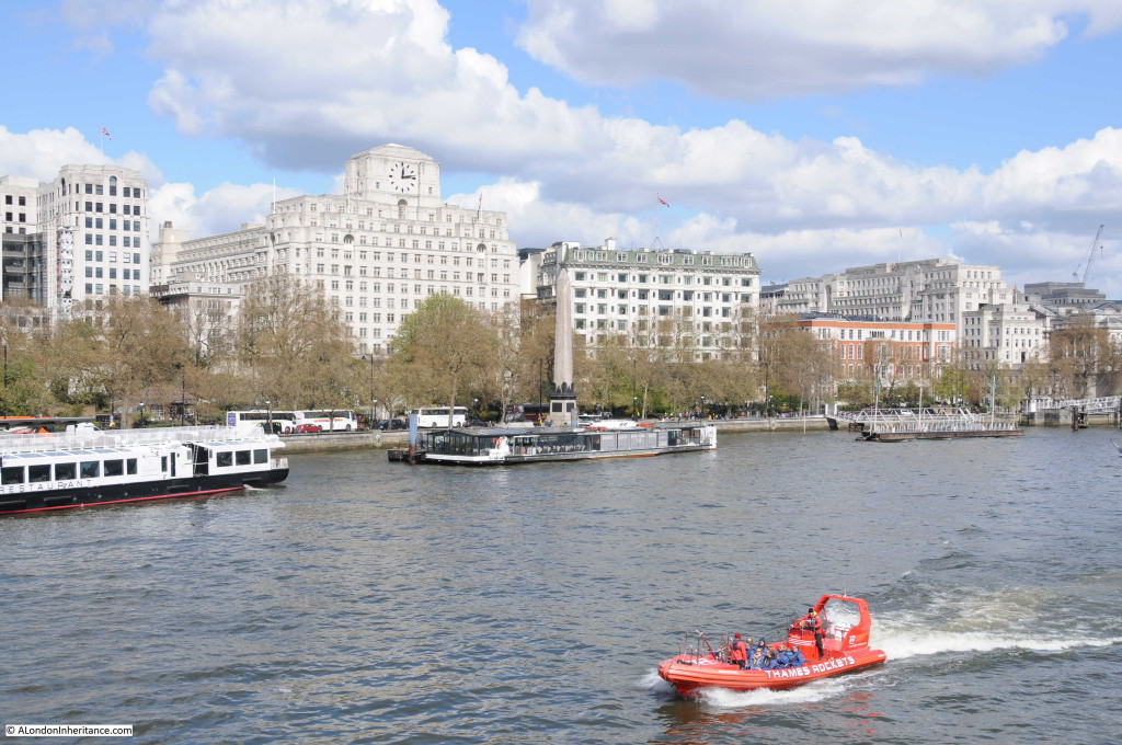
Much has changed along the Thames in the 69 years since my father took these photos, although some views are almost exactly the same. The following photo was taken close to Hungerford Railway Bridge. Cleopatra’s Needle is in the centre with the Shell-Mex building behind (the building with the clock). the Shell-Mex building was completed in 1931 and occupied by Shell Mex and BP Ltd. Although Shell have long since moved out, the building is Grade II listed so should be preserved as a major Thames landmark and an example of 1920s / 1930s architecture long into the future.

Southbank Walk 11

The same view today is almost unchanged, with the Adelphi on the left, then Shell-Mex House, the Savoy, then lower down, behind the trees the Institute of Electrical Engineers building, then Brettenham House and finally Somerset House on the extreme right of the photo.

I had intended to take this photo at the same time (2:50pm) as my father although due to taking too many photos along the walk I arrived slightly later at 3pm.

Southbank Walk 23

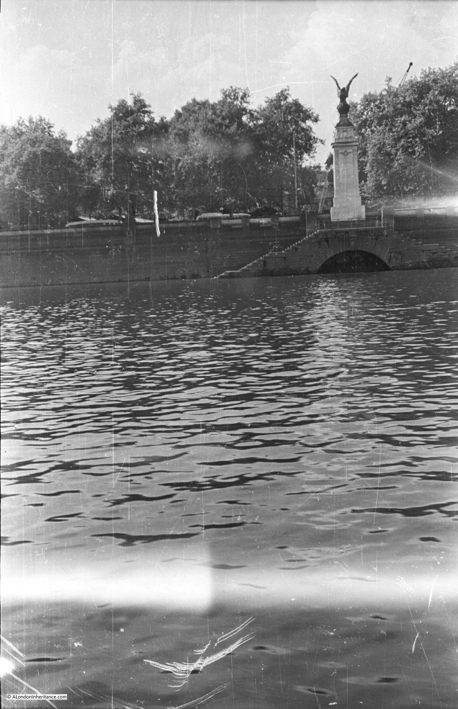
The final stop as we approach Westminster Bridge is the view across to the RAF memorial. The stone column was designed by Reginald Blomfield and the eagle on top of the memorial by William Reid Dick. The memorial was unveiled in 1923.

Southbank Walk 12

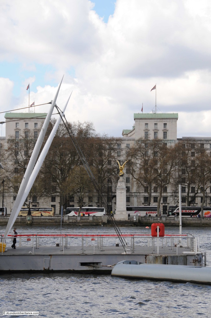
The view to the memorial today. I should have been a bit further to the left, however the infrastructure around the base of the London Eye obscures the view. The significant change is the building behind the memorial. These are the main Ministry of Defence buildings. Construction of these started in 1939, although the war then caused significant delays with construction being completed in 1951.

Southbank Walk 24

A boat trip or walk along the river is a fantastic way to view the city. Although there has been much development along the north bank over the years, it is surprising that whilst many of the buildings are different, the overall views are much the same. The most significant difference being the towers that now occupy much of the City.

Change along the south bank of the river and in the stretch between Tower Bridge and Greenwich has been much more dramatic and I will be covering these in future posts.

alondoninheritance.com