Monthly Archives: March 2015

Trinity Square Gardens – Memorials To Execution And Wartime Sacrifice

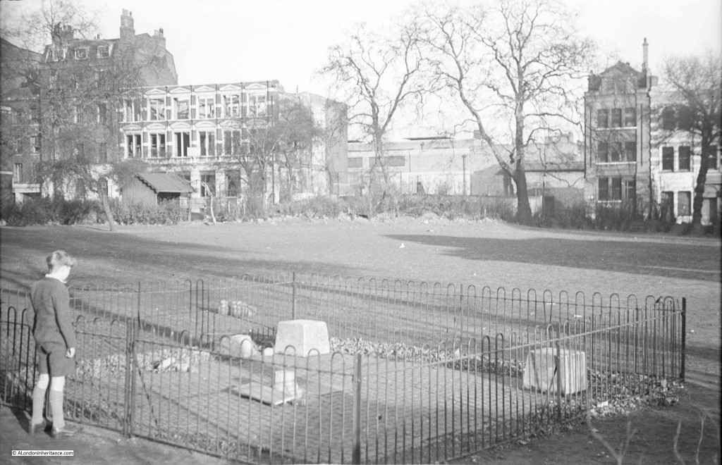
This week’s photo is from early 1947 and is one of the photos for which I did not have any location information and I was not sure whether I would ever find the location. There are no obvious landmarks or features that would help identify where the photo was taken.

We are in a park in London and a boy is looking at some form of memorial. I should have realised where it was, but such are the changes looking in this direction across the park, it was not immediately obvious.

There is only one part of this photo that remains the same in 2015 and that is the building on the left of the photo. When walking in London, I carry my father’s photos with me on an iPad which makes checking locations so much easier and chance finds I can compare with the original photo I believe I have found.

After taking last week’s photos under the southern approach to Tower Bridge, I walked across the bridge and cut through into Trinity Square Gardens at the top of Tower Hill, just past the Underground Station. Behind the war memorial I found the location of the 1947 photo.

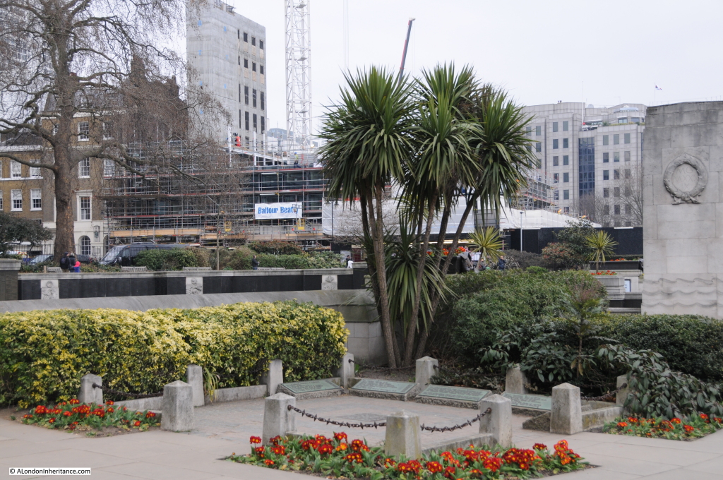
This is Trinity Square Gardens and the boy is looking at the memorial to the executions carried out on here, and the buildings across the gardens are in Coopers Row.
Tower 1

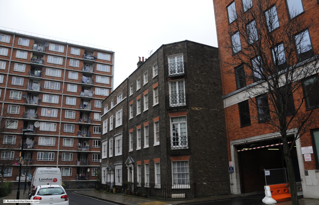
This is the same scene in 2015. The layout of the execution memorial has been changed and looks slightly smaller but still appears to be in the same position. Much of the grass in the 1947 photo is now covered by the World War 2 memorial to merchant seamen. Nearly all the buildings in Coopers Row have changed with the exception of the building on the left, behind the tree. This was the building that confirmed this as the correct location.

Tower 2

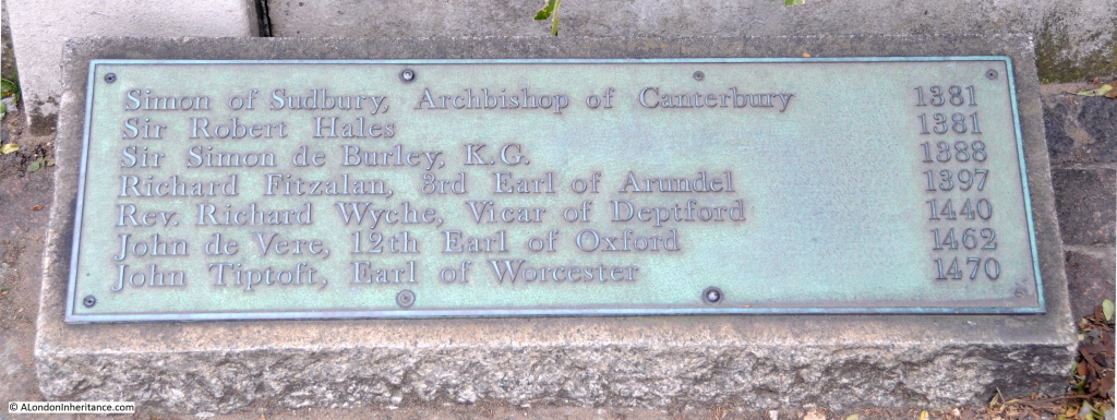
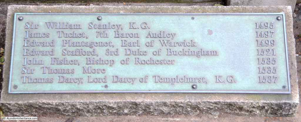
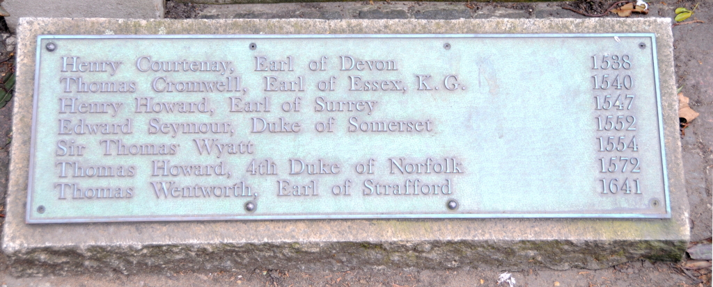
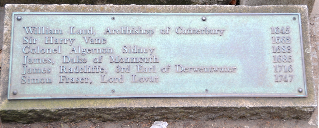
The Execution Memorial is on the approximate spot of the scaffold and has a number of plaques listing the names and year of execution of many of the more well-known victims. The central plaque states that the memorial is:

“To commemorate the tragic history and in many cases the martyrdom of those who for the sake of their faith, country or ideals staked their lives and lost.

On this site more than 125 were put to death. The names of some of whom are recorded here.”

Around the edge of the memorial are four plaques listing the names of those executed.

plaque 1a

plaque 2a plaque 3a plaque 4a

Whilst the names of some of Henry VIII’s victims such as Sir Thomas More and Thomas Cromwell are recorded, the names of his wives who were executed are not as they were executed more privately inside the Tower of London rather than suffer the public spectacle of an execution on Tower Hill.

As well as the Execution Memorial, Trinity Square Gardens is also home to two other memorials.

The World War 1 memorial to those lost on the Merchant Navy and Fishing Fleets is not visible in the 1947 or 2015 photos, but is just to the right. This was finished in 1928 and design by Sir Edwin Luytens who was also responsible for the design of the Cenotaph in Whitehall.

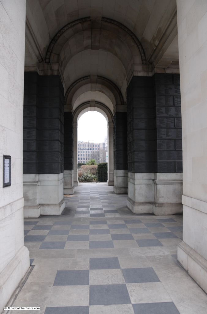
This memorial consists of a number of vaults with plaques recording the names of those lost at sea.

Looking through the 1st World War memorial:

Tower 7

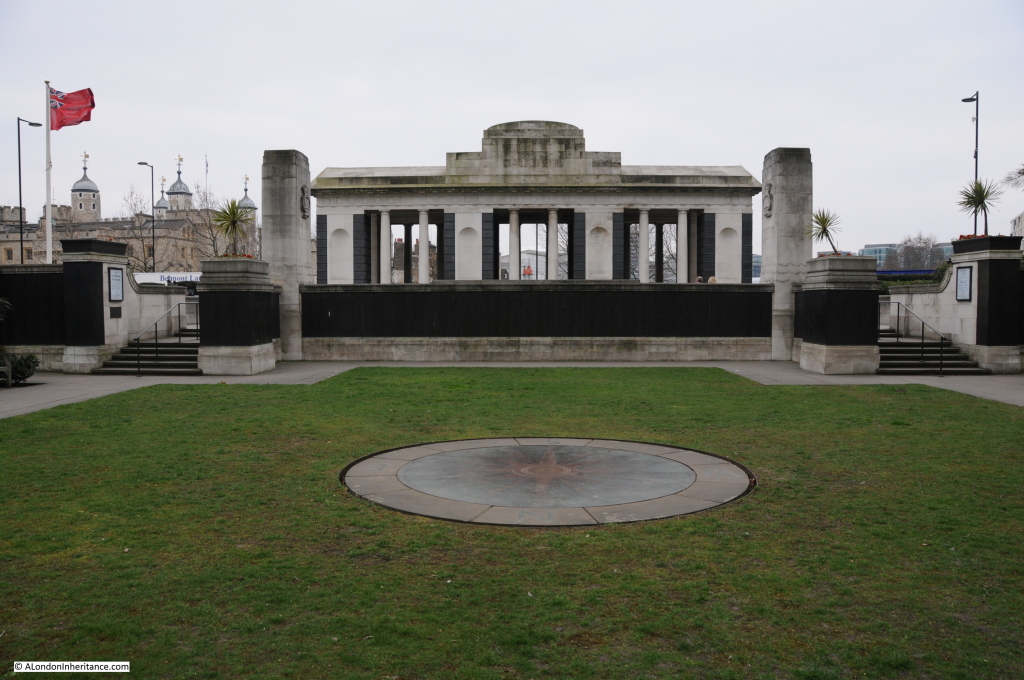
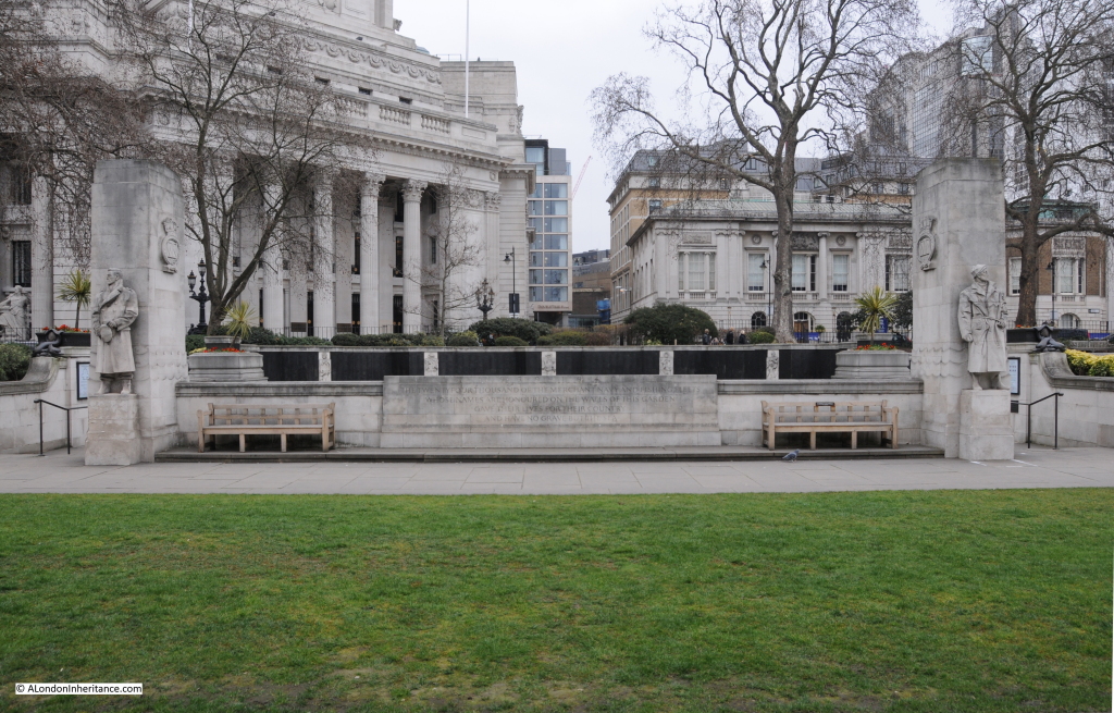
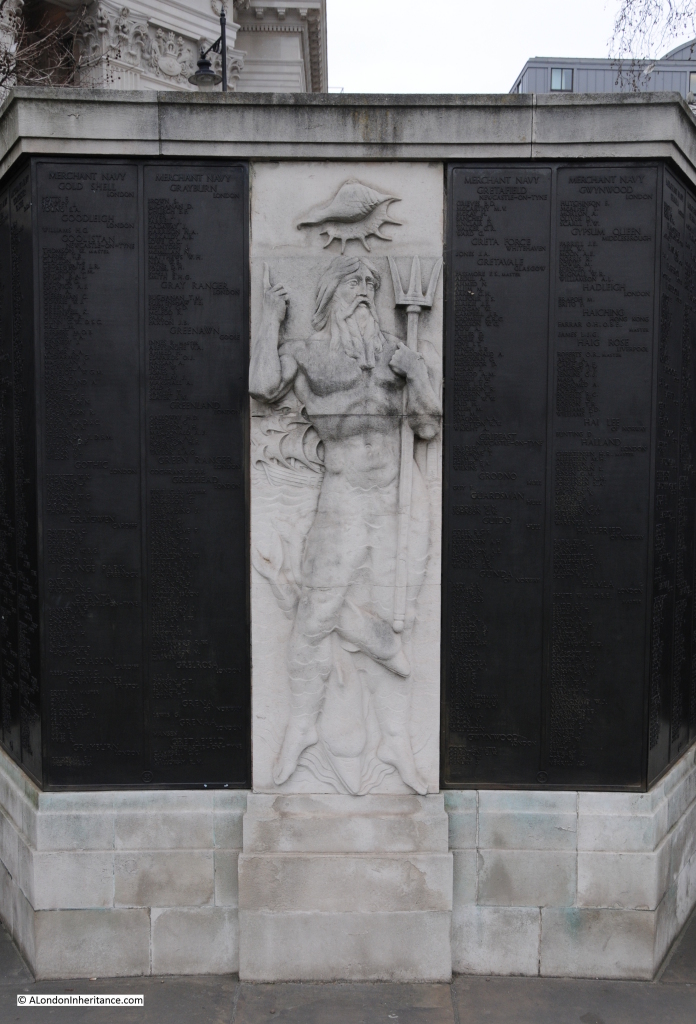
Below the 1st World War memorial is the much larger memorial to those lost in the Merchant Navy and Fishing Fleets during the 2nd World War. This occupies the grassed area in my father’s 1947 photo and can be seen in my 2015 photo.

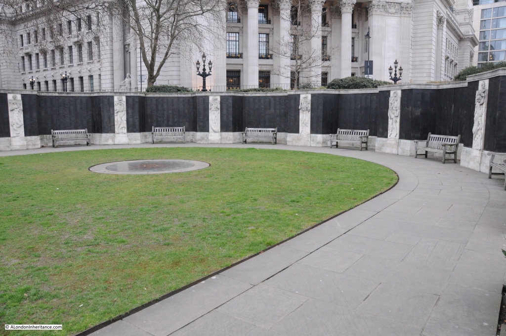
The following photo is looking across to the 2nd World War memorial from that of the 1st World War. The inscription on the large stone block between the two seats reads:

“The twenty-four thousand of the merchant navy and fishing fleets whose names are honoured on the walls of this garden gave their life for their country and have no grave but the sea”

This memorial was opened by the Queen on the 5th November 1955. It was designed by Sir Edward Maufe who was also responsible for Guildford Cathedral and the Runneymede Air Forces memorial.

Tower 4

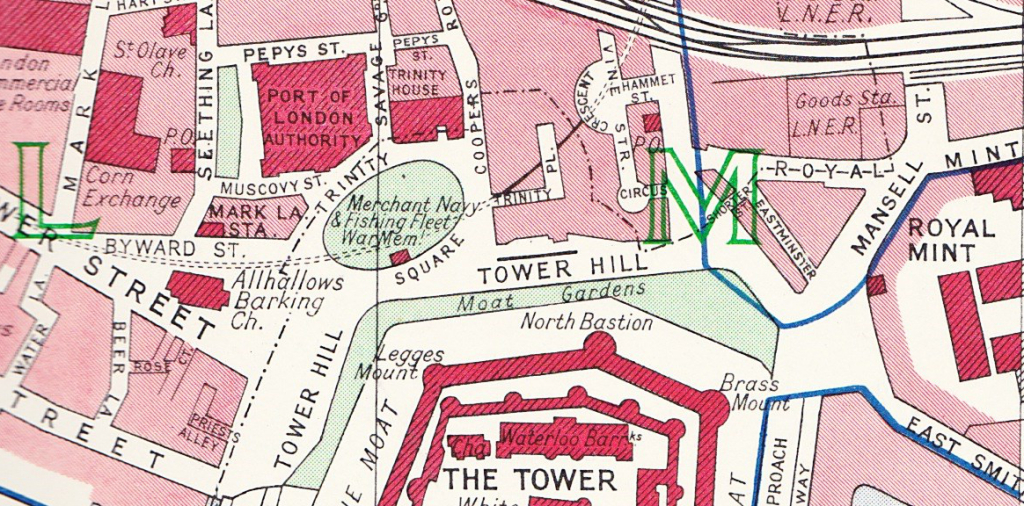
This map extract from 1940 shows the location of Trinity Square Gardens. I find these old Bartholomew maps interesting as they also show the routes of underground lines. The dashed lines routing through Trinity Square just above the red block of the war memorial is the Circle Line. This was built using the cut and cover technique where the tunnel was dug from the surface then covered over. In the above photo, the tunnel is below the grass section between the 1st and 2nd World War memorials.

trinity map 1

Steps either side provide access to the main area of the memorial. The following photo is looking back towards the 1st World War memorial. The Tower of London can be seen to the left. Tower 3

Arranged around the edge of the memorial are a number of alcoves, each with panels listing the names of those lost during the war.

It is all too easy to get desensitized to large numbers, but walking around this memorial and reading the names, each an individual with their own unique story, really brings home the sacrifices made by so many.
Tower 5

Between each of the alcoves is a sculpture by Sir Charles Wheeler representing the sea. Here, directly opposite the entrance is Neptune:

Tower 8

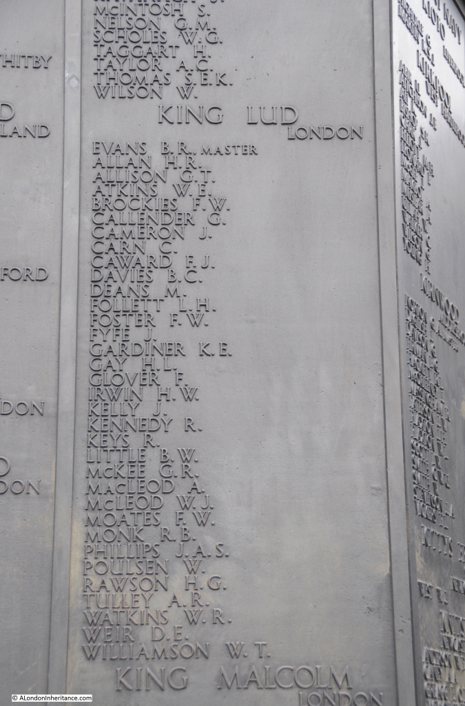
Looking through the names In the 1st World War memorial, which are organised by the name of the ship, I found the King Lud, which seemed an appropriate connection with London. The memorial lists the names of those lost with the ship.

Tower 6

Although in the 1st World War memorial, this ship was lost in the 2nd World War. There was a King Lud in the 1st World War, however the crew survived. It was captured by the German cruiser, the Emden on Friday 25th September 1914 off Point de Galle, Sri Lanka. The crew were taken off and the ship sunk.

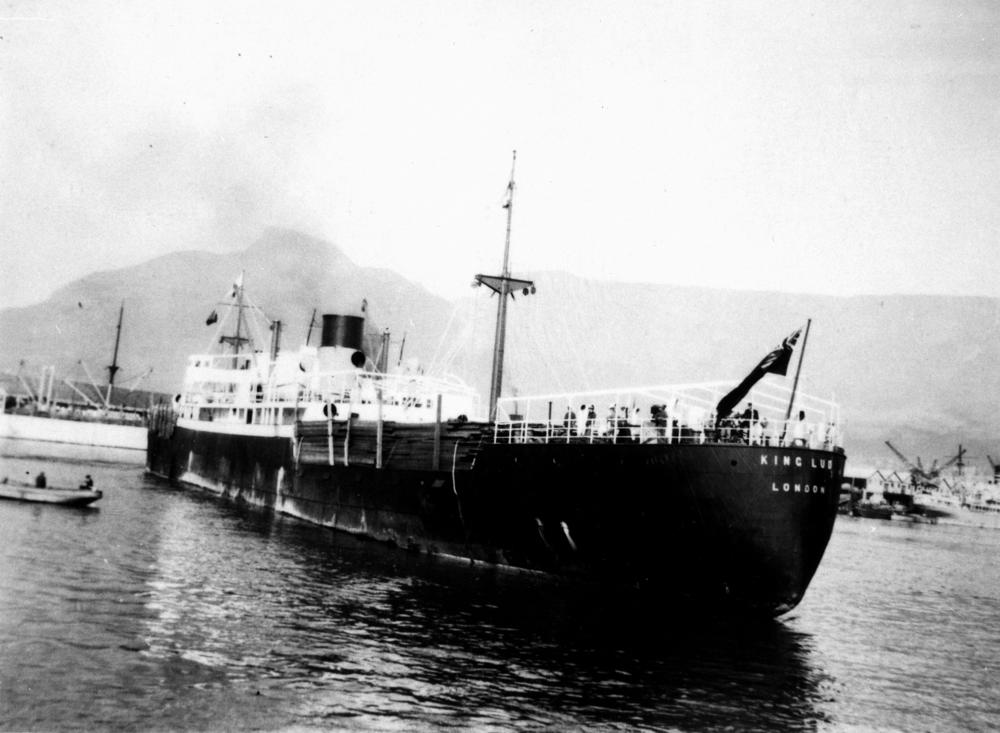
The King Lud that this memorial refers to was sunk on the 8th June 1942 by a Japanese submarine, the I-10. The King Lud was sailing from New York to India when it was attacked in the Mozambique Channel (the area of sea between mainland Africa and Madagascar).  The ship was carry military personnel and government supplies. There were no survivors.

The Master of the King Lud was Benjamin Roderick Evans who was 52.  Among the crew there were also three, 17-year-old cadets and apprentices on board.

Built in 1928, the ship was owned by King Line, an operator of merchant ships based in London. Off the 20 ships owned by King Line at the start of the war, 14 were lost during the war.

To be lost off Mozambique must seem so remote from London. The King Lud:

StateLibQld_1_148727_King_Lud_(ship)

Just one ship and crew out of so many recorded across the two memorials.

Trinity Square Gardens is an interesting juxtaposition of two memorials. One to those executed on the site over the centuries, the other to those who died in war, far from London.

alondoninheritance.com

The Lost Warehouses of Pickle Herring Street

Many of the photos I have used to illustrate how London has changed are of the more well known views of London, from the Stone Gallery of St. Paul’s Cathedral, from Greenwich, from Waterloo Bridge, the Royal Festival Hall etc. however sometimes to get a real understanding of how London has changed since the last war in terms of the streets, buildings, employment and people, you need only look in some of the more ordinary, mundane places.

I was unsure of where my father took the subject of this week’s post. There are two photos, taken from within the same tunnel, looking out to streets with closely packed warehouses on either side.

The warehouses with their trademark walkways over the streets were clearly along the Thames. The tunnel in which the photo was taken would be adjacent to one of the stations or bridges across the Thames.

I vaguely recognised the tunnel from many walks along the south bank of the river, and a morning exploring all the tunnels finally found the location, however the changes were such that I was still slightly unsure (I will explain how I confirmed the location later).

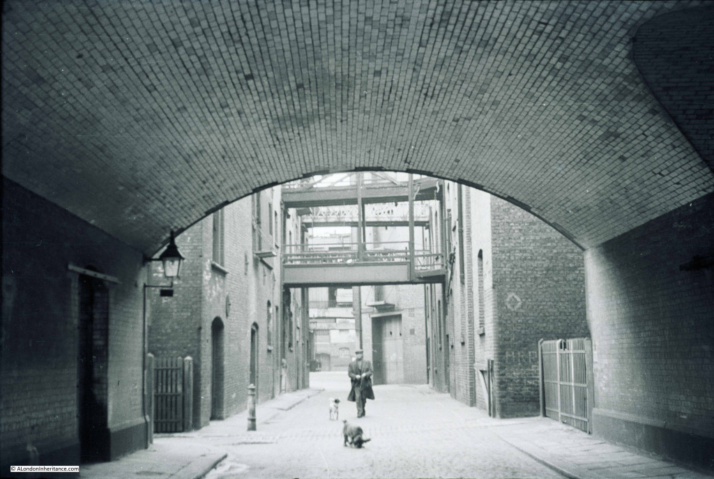
The first photo, and it is a Sunday, early in 1947 and a solitary man walks with his two dogs towards my father taking the photo from the middle of the tunnel.

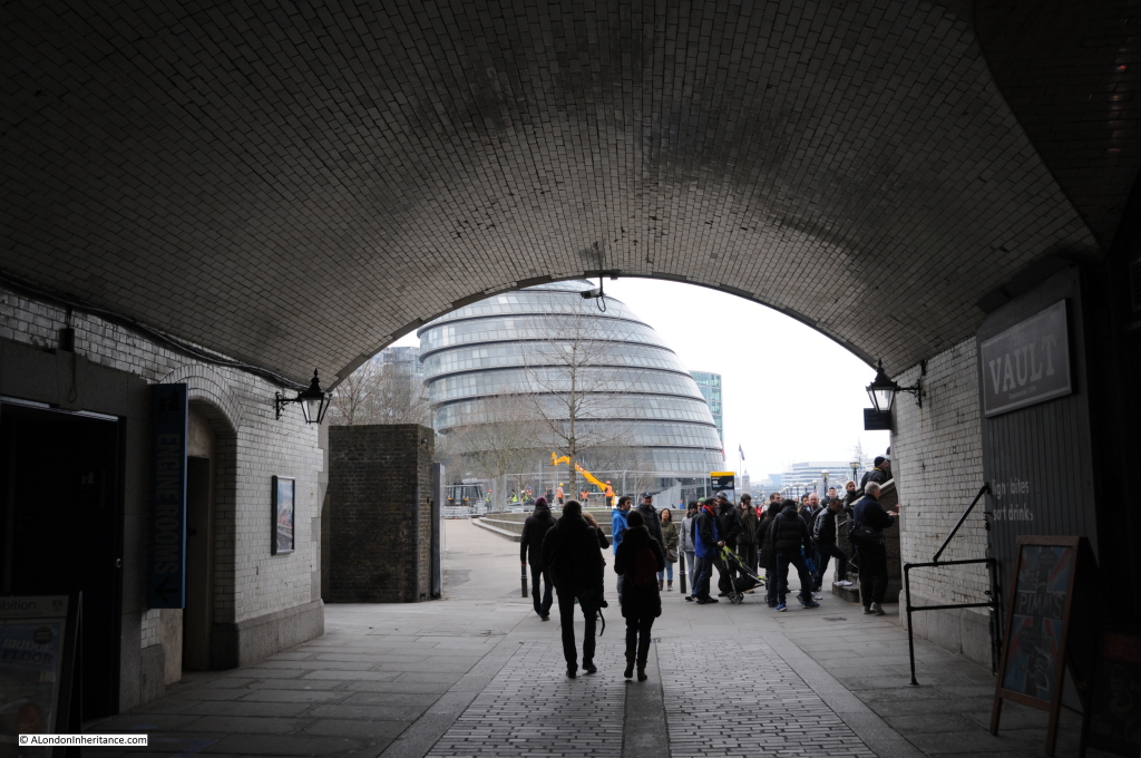
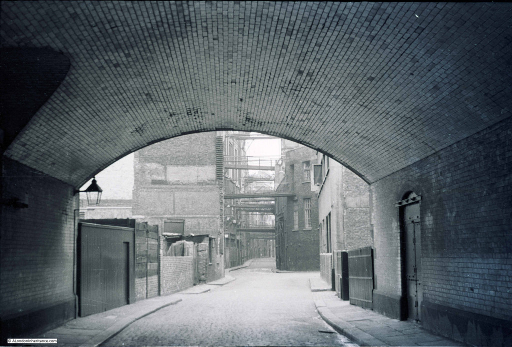
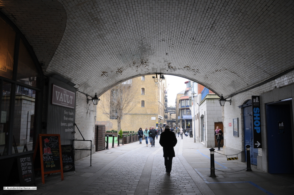
Welcome to Pickle Herring Street, taken from the tunnel under the southern approach to Tower Bridge in 1947 and then in 2015:

Pickle 1

Pickle 2

These two photos really show how London has changed in the intervening 68 years.

In 1947, shipping was still coming this far up river to be loaded and unloaded at the warehouses that ran the length of the river. The warehouses on the right were facing onto the river, walkways over the street lead to further warehouses.

Pickle Herring Street in the 1947 photo is the street winding through the warehouses, it had been here for many years but has now disappeared along with all the warehouses lining this stretch of the Thames in the redevelopment of this area of the south bank for City Hall (the building that appears to lean backwards in the 2015 photo), the home of the Mayor of London and the Greater London Authority, along with the public open space created up to Tower Bridge.

Instead of the solitary Londoner walking his dogs we now find the thousands of tourists who follow the walkway along the river and cross to and from the north bank and the Tower of London via Tower Bridge.

It took a while to take the 2015 photos, I was waiting until there were not too many people in the tunnel, such is the popularity of this area even on a chilly March morning. Not long after I took the photo, an ice cream van arrived and parked to the left of the tunnel entrance. I wonder what the man in the 1947 photo would have thought about how London would be changing over the coming decades.

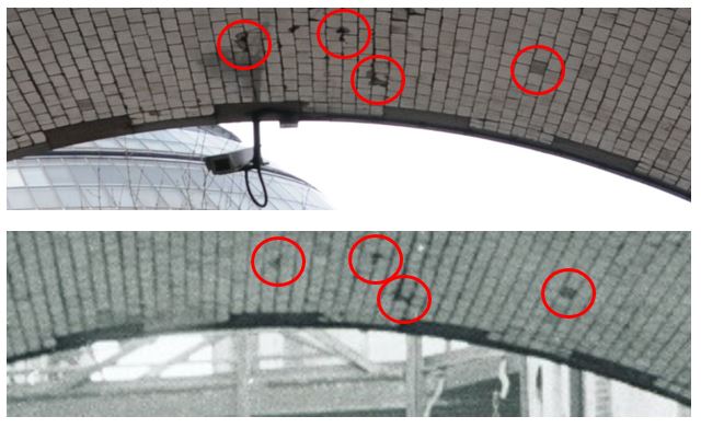
The change was such that I was still slightly unsure that this is the correct location of the 1947 photo, so I checked the tiling on the roof of the tunnel. The following photos show that even across 68 years the same defects and damage to the tiling can be found.

roof compare 1

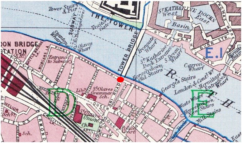
In the following map from the 1940 edition of Bartholomew’s Reference Atlas of Greater London I have marked the location from where the photograph was taken with a red dot.

The tunnel is directly underneath the approach road to Tower Bridge and Pickle Herring Street is seen running to the left:

Pickle map 2

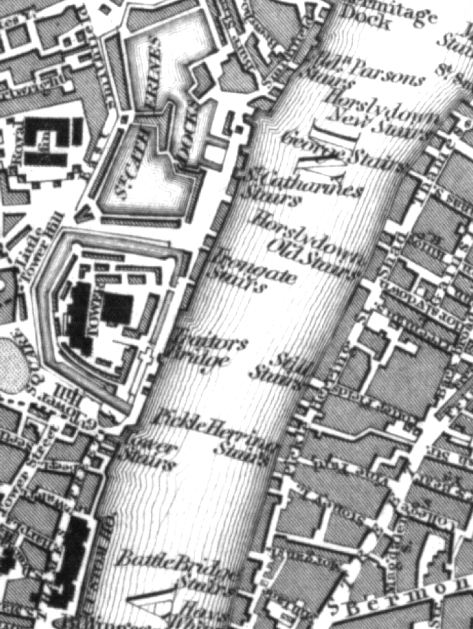
The following early 19th century map extract shows the area prior to the construction of Tower Bridge. There was also a Pickle Herring Stairs roughly where St. Olaves Wharf is shown in the 1940 map. Note also Horslydown Old Stairs. This is where Tower Bridge would be built later in the 19th century.

Pickle map 6

Despite having such an interesting name, I have not found that many references to Pickle Herring Street. The name must refer to the landing and storage of pickle herrings here at some point in the past.

Old and New London, published in 1878 describes the area:

“Indeed from Morgan’s Lane – a turning about the middle of Tooley Street, on the north side, to St. Saviour’s Dock, the whole line of street – called in one part Pickle Herring Street, and in another Shad Thames – exhibits an uninterrupted series of wharves, warehouses, mills and factories, on both sides of the narrow and crowded roadway. The buildings on the northern side are contiguous to the river, and in the gateways and openings in these we witness the busy scenes and the mazes of the shipping which pertain to such a spot. “

The buildings would be exactly the same in 1947.

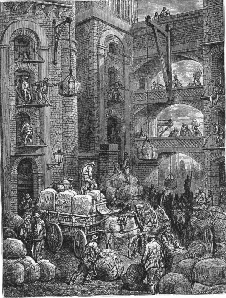
Gustave Doré visited the area in 1872. The following is his illustration of Pickle Herring Street for the publication, “London – A Pilgrimage”:

gustav dore

Doré probably used some artistic license in this drawing, the buildings look rather too finely built for riverside warehouses, however it probably does give a good impression of the atmosphere in Pickle Herring Street at the time.

Return to the dot in the above map, turn to the right and you will be looking down Shad Thames. This was the scene in 1947 looking down to the next stretch of warehousing running the length of the river. This was Butlers Wharf.

Pickle 3

In 2015 Shad Thames remains as does Butlers Wharf, although converted into luxury flats, restaurants and shops, again indicative of the changes across much of central London.

Pickle 4

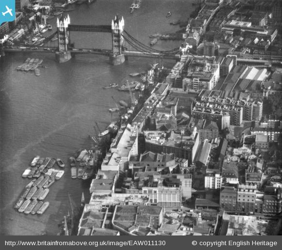
The excellent Britain from Above website has the following photo of the area, also take in 1947.

The warehouses on either side of the approach road to Tower Bridge can clearly be seen along with the cluster of shipping and barges up against the warehouses along Pickle Herring Street.
EAW011130

I stood for a while in the tunnel waiting to take the photos, in exactly the same place as my 18 year old father back in 1947, under the same tiled roof, but looking out on a very different world.

alondoninheritance.com

A Wartime Temporary Bridge And County Hall

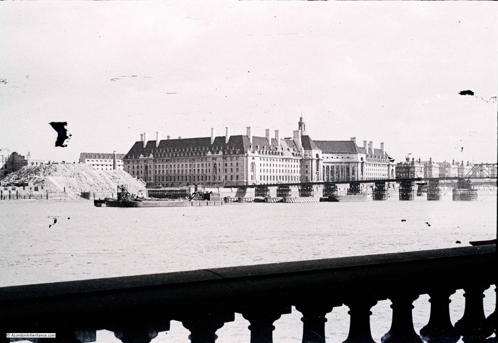
My father took the following photo in early 1947 from the Embankment, just by the base of the Hungerford railway bridge looking over towards the County Hall, the offices of the London County Council. The photo is from the end of a strip of negatives that has suffered some damage. I will process and repair, but for this blog my intention is to present my father’s photos as I first see them after scanning. The photo is interesting for two features, the temporary bridge over the Thames that can be seen running across the river in front of County Hall,  and the large heap of rubble to the left of County Hall. The very start of demolition of the site that would a few years later be the location of the Dome of Discovery for the Festival of Britain. County Hall 1 The location where my father took the photo was easy to find. As well as County Hall being the main feature in the photo, the balustrade in the foreground is still there. Just beyond County Hall to the right are the original buildings of St. Thomas’ Hospital.

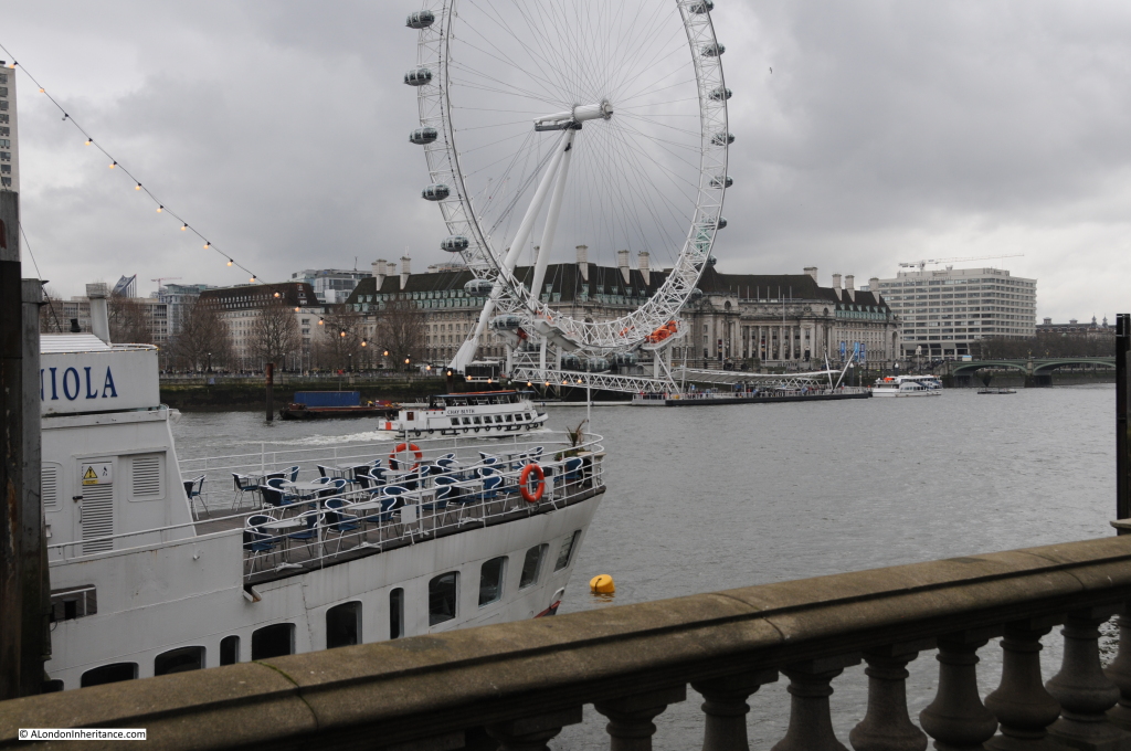
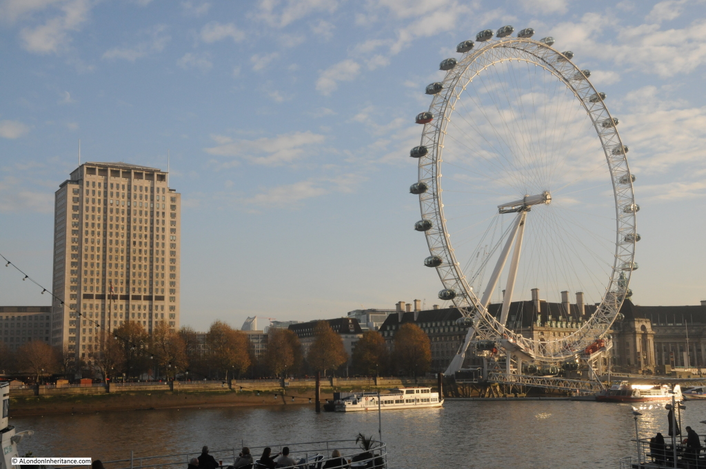
Unfortunately the weather was not as sunny as when my father took the photo 68 years earlier, however my 2015 photo from the same location: County Hall 3 The ship in the foreground was not there in 1947. She is the Hispaniola, launched in 1953 as the Maid of Ashton and entered service in Scotland. She was converted into a restaurant ship and renamed the Hispaniola in 1973, finally reaching her current place on the Thames in 1974.

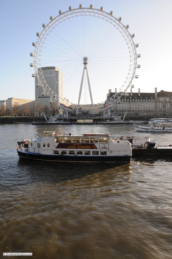
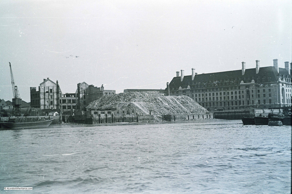
The temporary bridge over the Thames was one of a number constructed during the war. The aim was to provide an alternative route over the river if the main bridges were bombed. This bridge would have provided an alternative route if the nearby Westminster Bridge was hit. The temporary bridges were removed between 1947 and 1948 so my father’s photo was taken a couple of months before it was dismantled. The route of the temporary bridge was from the north bank to the south, to land adjacent to the County Hall. The following photo is from the landing point on the north bank looking along the line of the bridge to the south bank. These bridges were temporary and there is no evidence of the bridge to be found today, just the London Eye which now dominates this area of the south bank. County Hall 4 There was a second photo on the same strip of negatives, in better condition, and taken looking slightly to the left of the first photo so we get a full view of the location that would host the Festival of Britain and which is now the Jubilee Gardens. As with so much of the land along the banks of the river, the stretch between Hungerford and Westminster bridges was a continuous stretch of warehousing and industrial activity with many wharfs and inlets to the river. County Hall 2 Looking across to the same area now: County Hall 5 To give some idea of the activities which took place along this stretch of the river, the plans for County Hall detail the occupiers of the site prior to the start of the construction. Adjacent to Westminster Bridge was the Westminster Flour Mills, then came the Lambeth Borough Council Works department with Acre Wharf and Vestry Wharf on either side followed by the Cross and Blackwell factory at Soho Wharf, then extending past the County Hall site was the London County Council Works Department. The whole stretch providing a very irregular frontage onto the Thames, as shown in the 1947 photos.

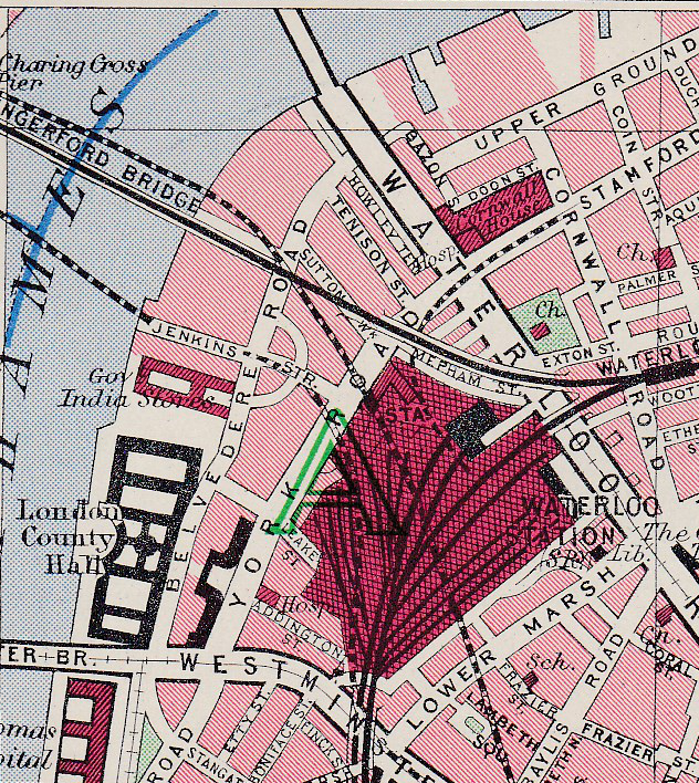
The following map is from Bartholomew’s Reference Atlas of Greater London from 1940. Whilst not showing the wharfs, it does show the area adjacent to County Hall, covered by my father’s original photos, part occupied by the Government India Stores and that a road, Jenkins Street, now long since disappeared extended down to the river’s edge from Belvedere Road.

County Hall Map 1

Construction of County Hall commenced in 1909 with a “coffer dam” being built between January and September 1909 to separate the construction area from the Thames so this could be emptied of water. Work was then started on the embankment wall in September 1909 to build the substantial wall that we see today.

Once the area was separated from the Thames, construction of the foundations and the raft on which the building would sit started. It was during this work that evidence of London’s Roman history was found with the discovery of a Roman boat deep in the sub soil, 19 feet below the river’s high water level. 38 feet in length and 18 feet wide the boat was considered to be a “round-bottomed ocean-going” boat. After seeing the light of day and a very different Thames than the boat must have last sailed down, it was stored by the London County Council before being transferred to the Museum of London.

Work continued on County Hall during the First World War, initial impact of the war was on the slowing of supplies of Cornish granite due to the military demand for rail transport. Reduction of supplies resulted in manpower being moved onto other activities with work slowing considerably after 1915. After the war, work picked up again, with 349 men working on the site in July 1919 rising to over one thousand in 1921. County Hall was finally finished and officially opened in July 1922.

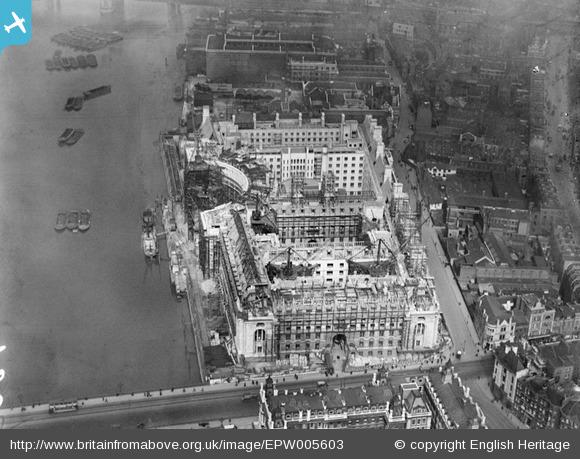
Aerofilms took the following photo when much of the construction up to roof level was nearing completion. The area beyond County Hall is still industrial and warehousing typical of this whole stretch up to Westminster Bridge prior to the construction of County Hall. EPW005603It is fascinating to read how the authority for London was viewed in the first half of the last century. From the 1951 edition of The Face of London by Harold P. Clunn:

“The London County Council is generally admitted to be the largest and most efficiently managed municipal governing authority in the world. It superseded the old Metropolitan Board of Works created in 1855 to watch over the requirements of London, and its 118 councillors were first elected on Thursday, 17 January 1889. On 21 March 1949 it celebrated its Diamond Jubilee. It had often been said that if Parliament ceased to talk for twelve months the country would suffer no inconvenience, and many people would probably be glad. On the other hand, if the London County Council ceased work for a few days indescribable chaos would result, and the health of Londoners would be seriously jeopardized. its housing estates house 500,000 people who pay £5,000,000 a year in rents. In its 1,400 schools 300,000 children are educated by 14,000 teachers.” 

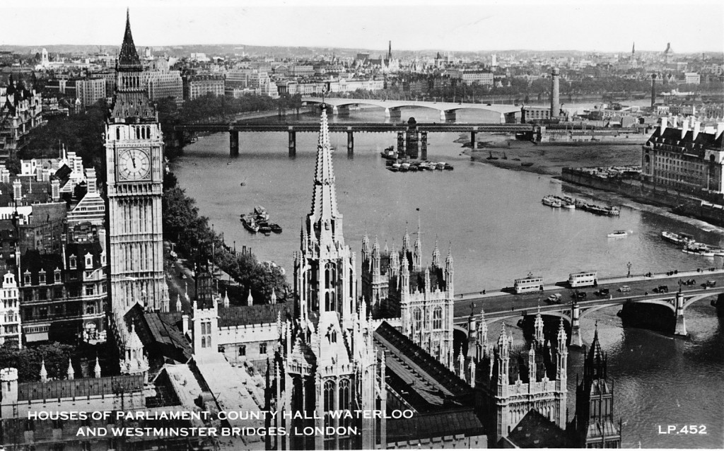
The following postcard with a view taken from the Victoria Tower of the Houses of Parliament shows the area of my father’s photo following clearance and before construction of the Festival of Britain. This must have been around 1949. the temporary bridge has been removed along with all the buildings and rubble from the south bank site, with the land flattened all the way down to the river. It must have been a sight at high tide with the river probably able to extend a fair distance inland at this point. County Hall 6 The view from the Victoria Tower also shows how few tall buildings there were across London. An aspect of the city that would change very dramatically over the following 60 years.

The sources I used to research this post are:

  • The Face of London by Harold P. Clunn published in 1951
  • County Hall, Survey of London Monograph 17, Royal Commission on the Historical Monuments of England
  • Bartholomew’s Reference Atlas of Greater London published in 1940

alondoninheritance.com

Imperial Chemicals House – Millbank

If you take a walk around London, you cannot miss the numbers of building sites and cranes that seem to be transforming the city on a daily basis.

The majority of new buildings are typically carbon copies of buildings that could be in any world city. Built of the same materials and providing occupation space for a transient work force or absentee owners.

I love buildings that have a reason to be where they are, they have a history to tell. They are not competing for height or shape and they could not be anywhere else apart from London.

A few months ago I featured one such building, the Faraday Building in Queen Victoria Street and this week I want to highlight a second building that can be so easily missed, and dismissed as another office block of pre-war construction, but look a bit closer and it has a fascinating history to tell.

I was walking along Millbank, alongside a building I have walked past many times and which I have never really stood back and studied, but this time I happened to look up at the roof line. It probably helped being winter as the trees were bare.

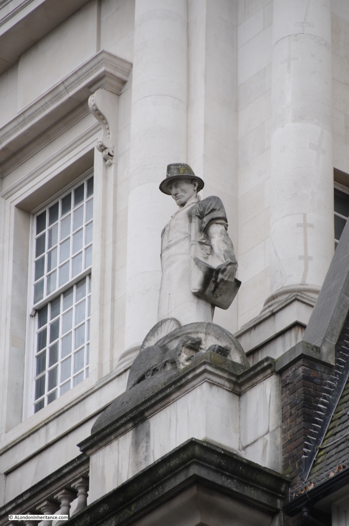
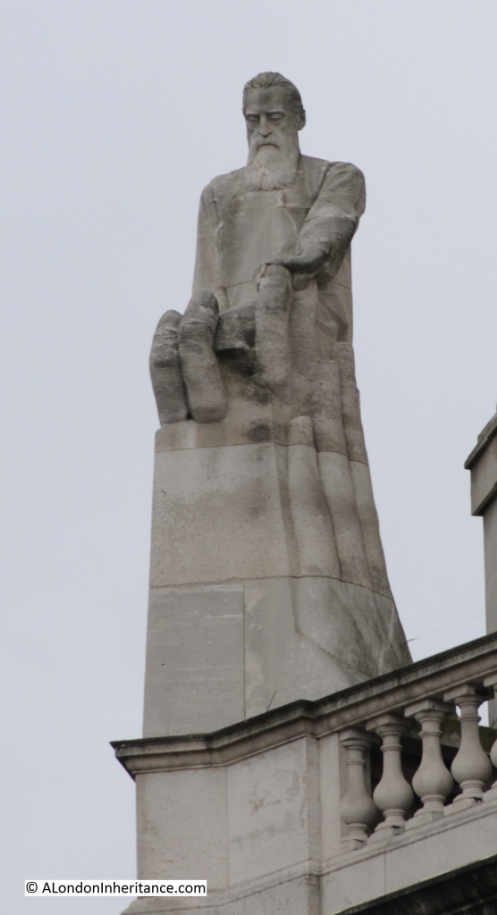
I found myself staring at another man who spends his time looking down at Millbank:

ICI 11

He is such an unusual figure. Not the usual candidate for a London statue who usually tend to be royalty, military leaders, those who played a key role in the history of the country or development of London. This character is anonymous, but is clearly a working man, shirt sleeves rolled up, strong and very industrial.

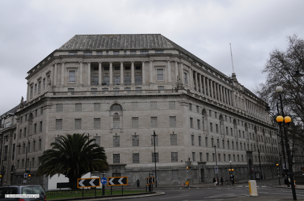
This is the old Imperial Chemical Industries head office building, Imperial Chemicals House at 9 Millbank, as seen below from the end of Lambeth Bridge. If you glanced at the build it would be very easy to miss the detail, however the building provides a lesson in industrial history and the history of chemistry.

The building was designed by Sir Frank Baines FRIBA and was constructed between 1929 and 1931. He was also employed by the Office of Works at the same time as his work on Imperial Chemicals House. This caused a stir in parliament as this was significant private work and there was concern that this would impact his work for the Office of Works. Sir Frank could not end his obligations to the construction on Millbank so he retired from service in the Office of Works.

ICI 1

The man in my first photo is one of a series of statues along the building at the base of the doric columns. He is the first statue coming from the direction of Parliament Square, at the far right of the above photo.

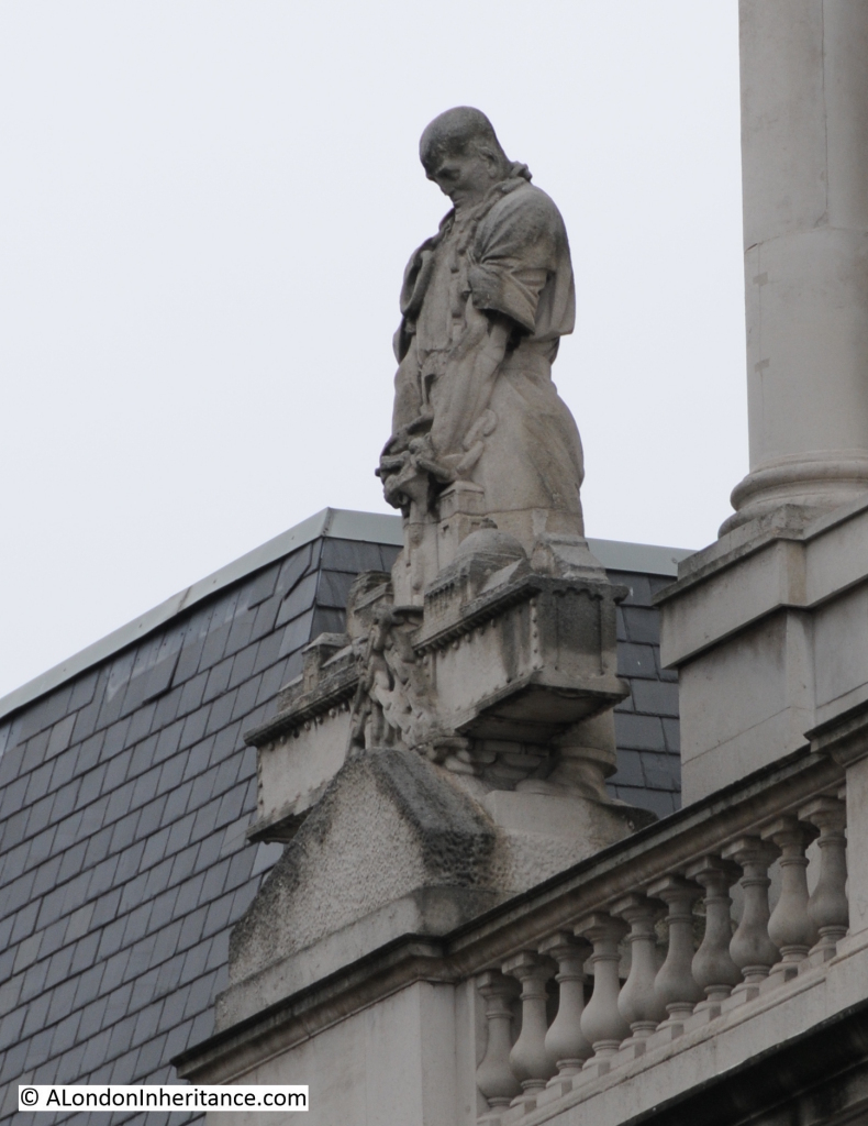
Further along we find the following statue. Note the incredible detail on these statues.

ICI 12

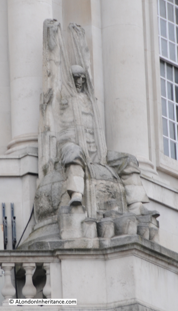
These statues are by Charles Sargeant Jagger, a British sculptor and they represent the industries of Chemistry, Agriculture, Marine Transport and Construction.

ICI 13

Charles Sargeant Jagger lived between 1885 and 1934 and after active service in the First World War was responsible for a number of well-known war memorials. His war memorial work in London includes the Great Western Railways war memorial at Paddington Station and the Royal Artillery memorial at Hyde Park Corner.

ICI 14

He was well-known for the rugged and realistic style of his work, which clearly comes across in the statues on the ICI building.

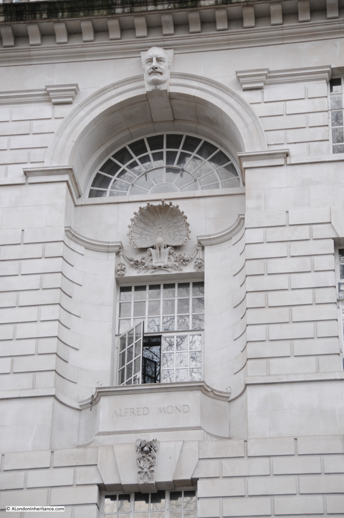
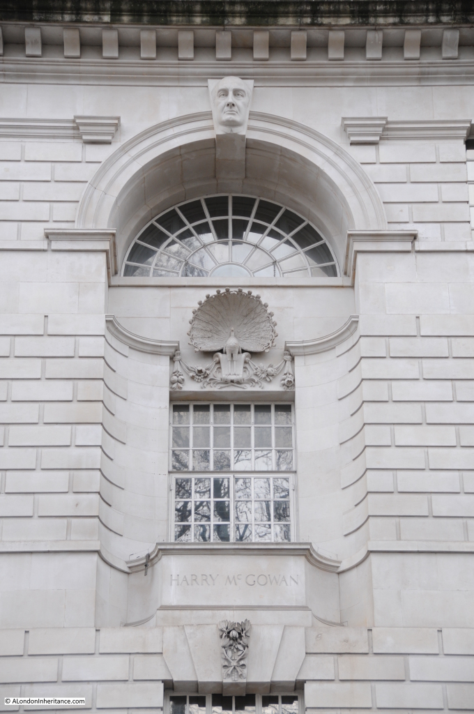
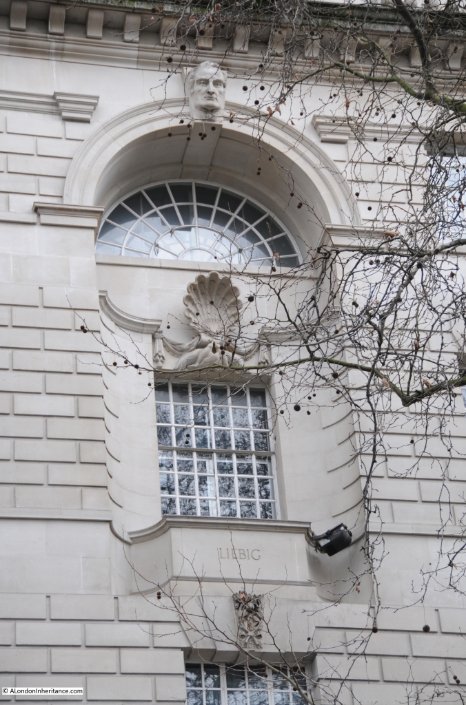
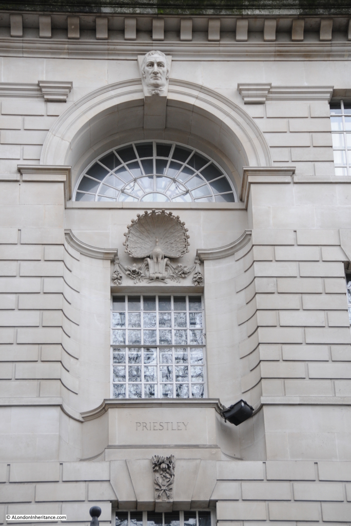
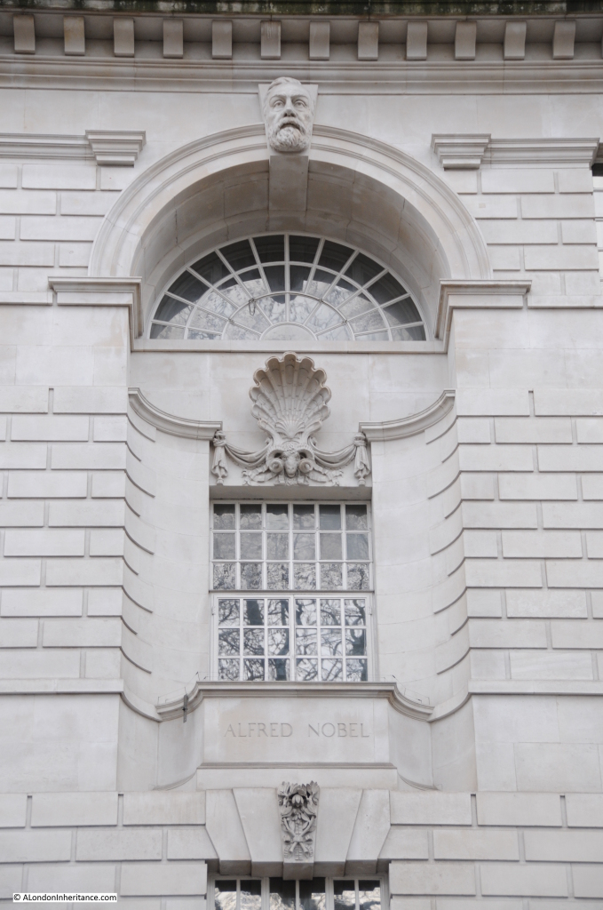
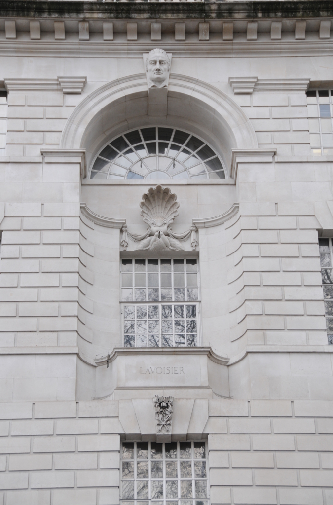
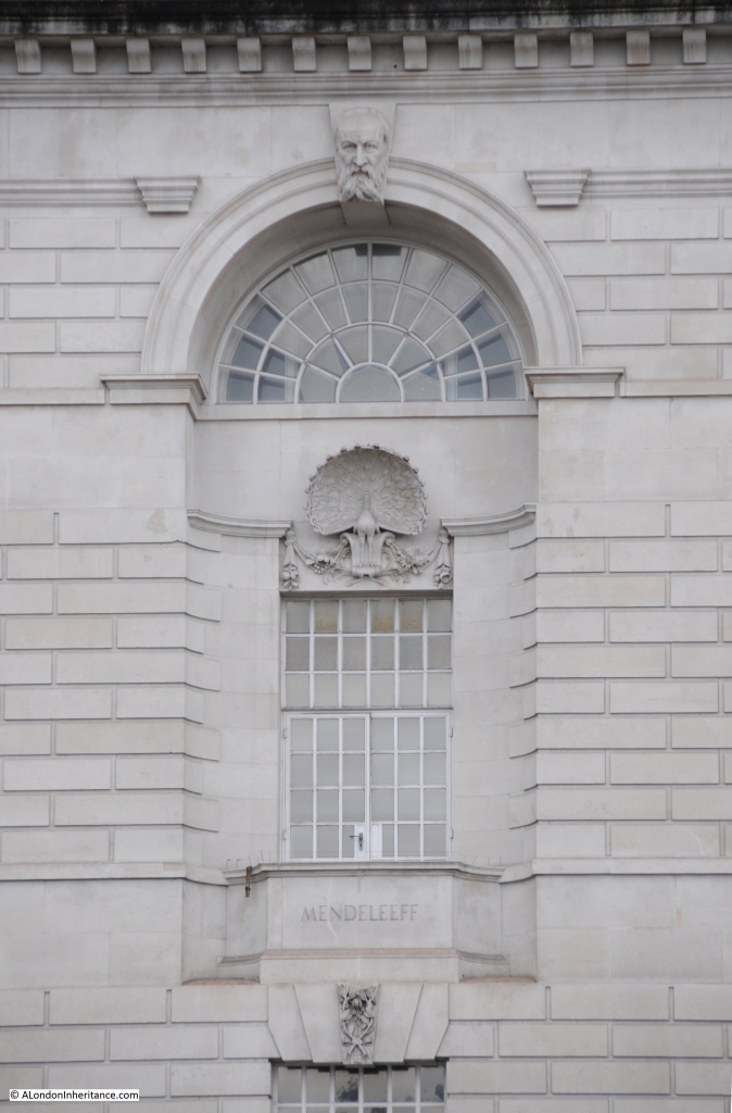
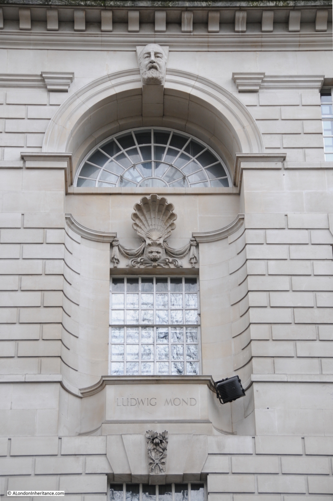
Now look below the 5th floor balustrade and there are a series of large windows, each with a carving of a head on the key stone at the top of the window with a name on the balcony below. This provides us with a lesson in both industrial history and chemistry.

Imperial Chemical Industries, or ICI was once one of Britain’s largest industrial companies. ICI employed tens of thousands of people, had a global reach and was active across all the major areas of chemical manufacturing along with an extensive pharmaceutical business, however like so much of British industry, ICI lost its way towards the end of the 20th century, sold off the pharmaceutical business (now AstraZeneca) and ended up being purchased in 2008 by the Dutch chemicals manufacturing business AkzoNobel.

ICI was founded in 1926 by the merger of four chemical companies, Nobel Explosives, United Alkali Company, British Dyestuffs Corporation and Brunner, Mond and Company, and it is to this last company that we find our first name:

ICI 8

Ludwig Mond  was born in Germany in 1839 and was active in a range of chemicals businesses, forming his own company, Brunner Mond, along with the industrialist John Brunner to manufacture soda at a factory at Northwich. He also developed a process for the production of pure nickel, building a factory in south Wales to develop this side of the business.

His son was Alfred Mond, the subject of the next window:

ICI 7

Alfred became the managing director of Brunner Mond and it was Alfred who was instrumental in the formation of ICI and became the first chairman of the new company.

The sculptor for the heads along the top of these windows was William Bateman Fagan, a Londoner born in Bermondsey in 1881.

The next key figure in the formation of ICI was Harry McGowan:

ICI 5

Harry McGowan started work as an office boy at the age of 15 at the Nobel Explosives Company (founded in 1870 by the chemist Alfred Nobel, who was to use part of his estate to establish the Nobel Prize).

McGowan worked he way to the top of Nobel Explosives to become Chairman and Managing Director when Nobel was one of the four companies to merge to form ICI.

He became the second Chairman and Managing Director of ICI after Alfred Mond.

Now we come to the scientists who discovered the processes and the key elements that were the foundations of ICI’s business.

The first is Liebig, or Justus von Liebig to give him his full name, a German chemist who lived from 1803 to 1873. Liebig’s work in the field of organic chemistry and the application of chemistry to agriculture were significant. It was Liebig who discovered that the element Nitrogen was a critical nutrient for plants, and therefore a key component in the production of agricultural fertilisers.

Apart from the ICI building, Liebig has another prominent connection with London. His work in agriculture and foods resulted in his development of a process for the manufacture of beef extracts. To  commercialise this process he founded the Liebig Extract of Meat Company which went on to produce Oxo, and in London built a factory where the Oxo Tower stands to this day on the southbank of the Thames.

ICI 10

Next we come to Joseph Priestley, an English theologian and scientist (or more correctly for the time a natural philosopher) who lived from 1733 to 1804.  It was Priestley who discovered Oxygen, however his insistence in continuing to support an earlier theory that attempted to explain how fires burnt in air by the release of material called phlogiston and that fires stopped burning when the air around them could not absorb any more phlogiston, left him somewhat isolated.

Priestly also had controversial religious views for the time, being a religious Dissenter and along with Theophilus Lindsey founded Unitarianism with the first Unitarian service being held in the Essex Street Chapel, located just off the Strand. A fascinating man at a key moment in history at the early stages of the industrial revolution.

ICI 9

Next is the Swedish chemist Alfred Nobel, the inventor of dynamite and the founder of Nobel Industries Limited, one of the four companies that merged to form ICI.

Nobel’s lasting legacy is the Nobel prize for which he donated the majority of his estate having been concerned how history would remember him as the inventor of explosives.

ICI 6

Lavoisier was a French chemist born in 1743 and was executed in 1794 by guillotine during the French revolution, a victim of the anti-intellectual atmosphere of the revolution and of anyone connected with authority prior to the revolution.

Fortunately his work survived and he was key in understanding the processes of combustion and proving that water was not an element, but made from Oxygen and Hydrogen. His work help to disprove the  phlogiston theory which Priestly was desperately trying to support.

ICI 4

Finally we come to Mendeleeff or Dmitri Mendeleev, the Russian chemist who lived from 1834 to 1907. His work on the composition of petroleum was key in understanding how oil and petroleum could be used as a feedstock for the chemicals industry, processes on which so much of ICI’s business would depend.

He was also the inventor of the Periodic Table of Elements, the table that classified the ordering of elements according to their key properties. The table not only helped understand elements but also provided a structure to classify future discoveries and to identify where unknown elements must exist to populate the gaps in the table.

ICI 3

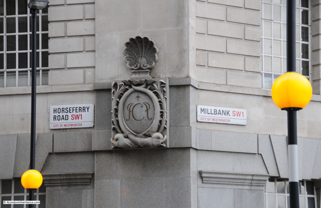
ICI’s initials are ornately carved on many plaques across the building:

ICI 2

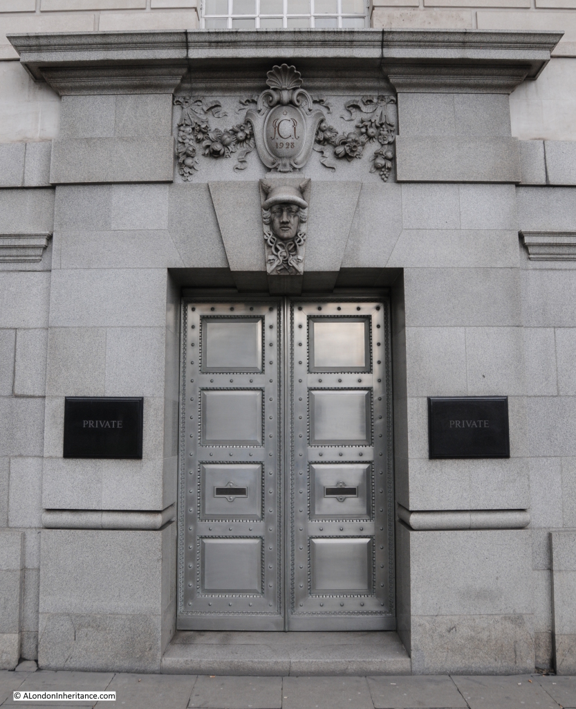
One of the side doors to the building, again with the ICI initials and the start of construction date of 1928:

ICI 15

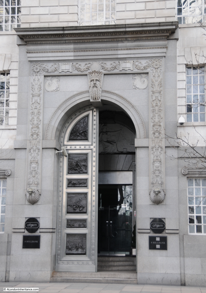
The main entrance on Millbank. Whilst the carved heads may not be very obvious, the main entrance provides a very dramatic entry to he building. It is again the work of William Bateman Fagan. On the door, the carved panels show the development of science and technology. The panels on the left show stone age technologies and show the construction of a basic tented home starting with building the frame onwards to completion. The final panel includes the completed tent with Stonehenge being seen in the background. The panels on the right hand door show contrasting modern industrial scenes.  Just inside the door can be seen Britannia along with a busy shipping scene.

ICI 18Although the name ICI is gradually fading into history, Imperial Chemicals House, or 9 Millbank as it is now more simply known demonstrates a 1920s confidence in science, technology and industry, not so evident in the country 90 years later, and I doubt we will see again this type of building that so proudly displays the heritage of the buildings creation.

So if you walk along Millbank, take some time to discover the work of Charles Sargeant Jagger and  William Bateman Fagan.

There are many good books that explore the scientists, chemists and industries highlighted on Imperial Chemicals House.

The Lunar Men by Jenny Uglow documents the chemists, inventors and natural philosophers associated with the Lunar Society between 1730 and 1810 and includes Priestley and Lavoisier.

The Slow Death of British Industry by Nicholas Comfort is an excellent account (although very depressing) of the death of much of British industry between 1952 and 2012 including ICI.

alondoninheritance.com

A Water Pump, Bedford Row And Tracing Harpur’s Bedford Charity Estate

There are some locations in London that have changed remarkably little over the last seventy plus years. There are also locations where decisions made 500 years ago are still in evidence. Not the usual candidates such as the Tower of London or St. Paul’s but amongst the ordinary streets of London.

One of my father’s photo’s from 1947 was the water pump in Bedford Row.

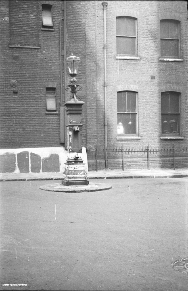
From Chancery Lane underground station, walk along Holborn to the west until you come to Brownlow Street. Head up this street and at the end you will be in part of Bedford Row, facing the water pump shown in the following 1947 photo:
Bedford Row 18

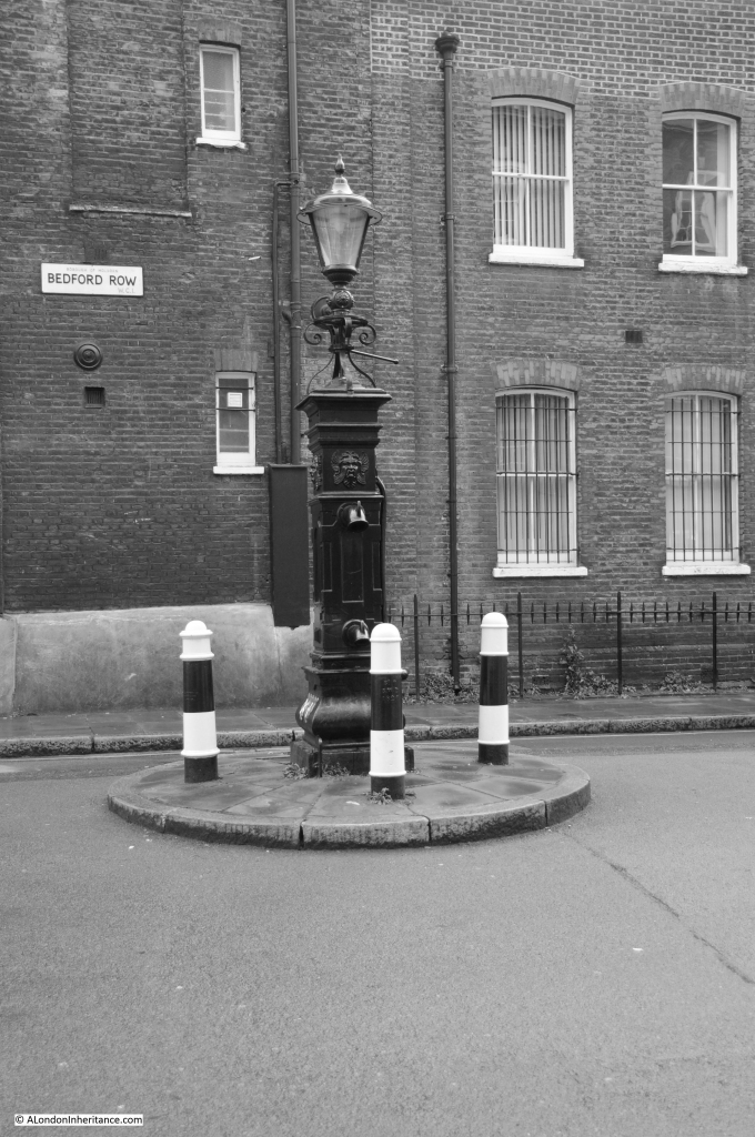
And in 2015 the scene is remarkably much the same. The pump has been painted, a sign with the street name has been put on the building behind and there are now bollards around the pump.

The buildings behind are almost unchanged, even the metal fencing along the building to the right is the same.
Bedford Row 17

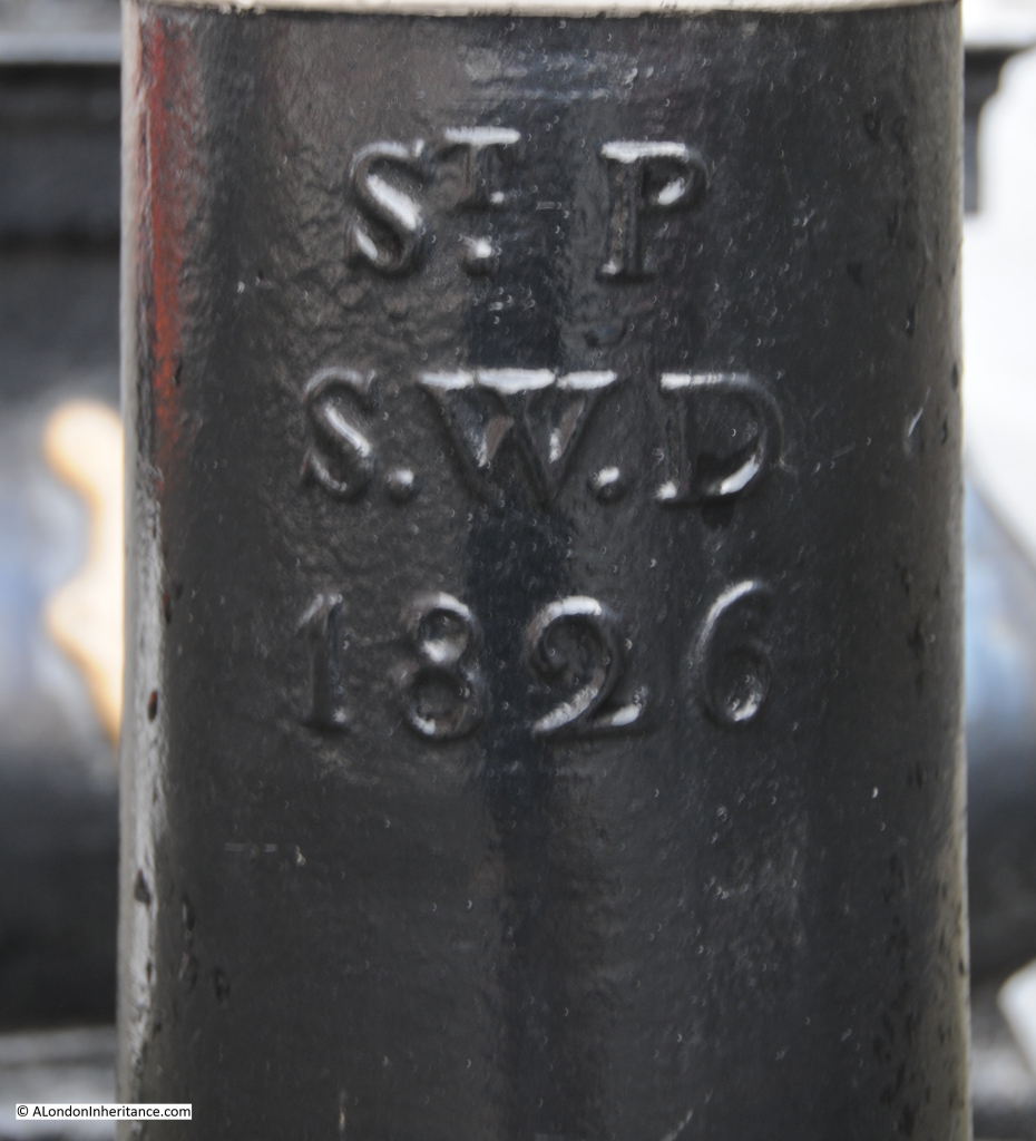
The pump is also a perfect example of not always believing what you see in London. Take a look at the bollards and they are marked St. Pancras Street Works Department, 1826, so it would be a reasonable assumption that they have been in place since 1826, however the 1947 photo clearly shows a much smaller surround to the base of the pump and no bollards.

I assume that with the size of cars and lorries that are now in use on London roads, it was decided prudent to enlarge the base and provide some protection to the pump using bollards from some other location in St. Pancras.
Bedford Row 16 small

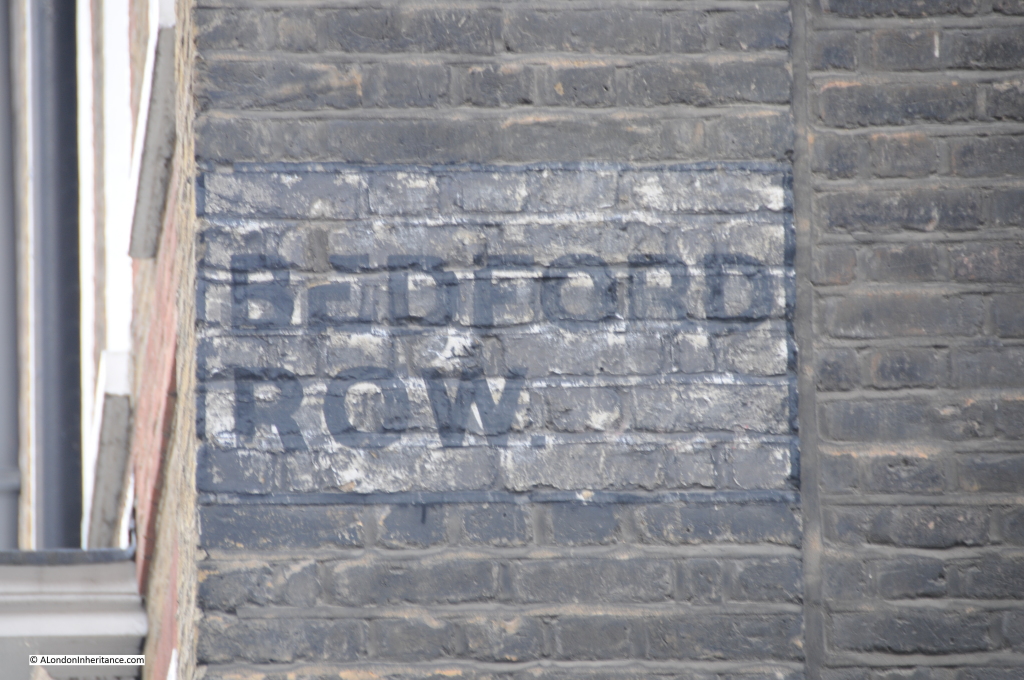
I always find it fascinating to look at the buildings around any location I am photographing. On the building just to the left of the pump is the remains of the original street signage for Bedford Row:
Bedford row 1

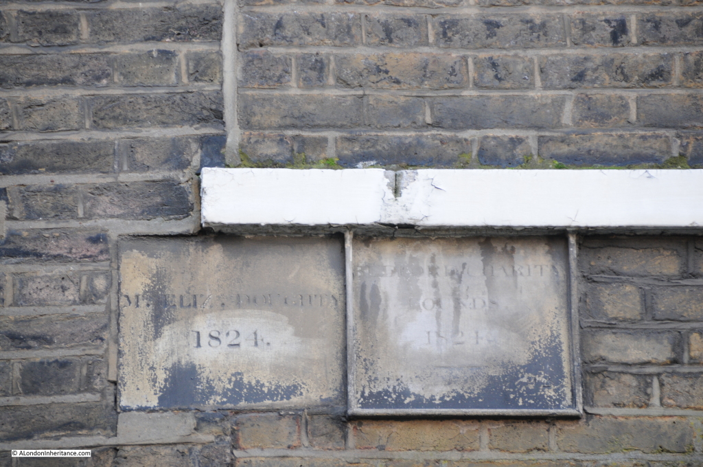
And just further along I found the following plaques:
Bedford Row 19

Not so easy to read. The one on the left reads “Ms. Eliz Doughty 1824” and the one on the right “Bedford Charity Bounds 1824”

These are boundary markers and were essential to identify ownership of blocks of land prior to the availability of accurate street mapping. In the days before clearly defined ownership boundaries, when parcels of land were let and sublet, when it could be decades between the times when ownership of land needed to be checked and when owners could easily extend their boundaries in the hope of expanding their ownership before anyone realised, boundary markers played a key role in defining ownership.

Much of the land across London was originally held by the Crown or Church in large blocks, and over the centuries this has gradually been sold off to leave much smaller parcels of land, however some large estates still remain.

The Bedford Charity seemed an ideal candidate for some further research, to find the original boundaries of the estate, how the estate came into being, and if anything remained.

The origin of the Bedford Charity is a gift of land made by Sir William Harpur in 1566 to the corporation of Bedford.

Sir William Harpur was very much a self-made man of the times. The Harper family (the spelling of the name appears to have changed to Harpur around 1764) had lived in the area around Bedford for many years prior to the 16th century.

A school had been operating in Bedford since before 1166 and as with most schools of this period it was part of the church and Bedford school maintained this connection through to the dissolution during Henry VIII’s reign.

William Harpur attended the original Bedford School before leaving for London. His early days in London do not appear well documented, however from the book “The Harpur Trust” by Joyce Godber;

“It my be that he was apprenticed to a tailor, but there is no certainty about this; nor is there evidence of his connection with any other trade.”

The assumption of his original apprenticeship seems likely to be correct due to his later career, as William Harpur was admitted to the Merchant Taylors company in 1533.

Harpur’s progression through the Mechant Taylors resulted in him becoming Master in 1553, the same year he became an alderman for the ward of Bridge Without.  When a vacancy appeared for an alderman within the much older and prestigious ward of Dowgate, Harpur was elected to this ward in 1556. He also served a year as treasurer of St. Bartholomew’s Hospital and was a sheriff between 1556 and 1557.

His rise continued and in 1561 he reached the peak of his career becoming Lord Mayor of London.

Through his contacts, Harpur would have been very aware of the work of others within the City of London in support of schools throughout the country.

Whilst Harpur was Lord Mayor the Merchant Taylors school was founded by Richard Hilles, the master at the time and a contemporary of Harpur. He would have known of the founding of St. Paul’s school by Dean Colet in 1509 and the work being done by schools such as Winchester where the earliest printed school text books were compiled in 1559.

He had already been assisting the school in Bedford. Newnham Priory, originally attached to the school had been closed and the property confiscated. Again from “The Harpur Trust” by Joyce Godber;

“These were unsettled times in religious matters. In 1533 when he was approaching the age of 40, Harpur would have heard that, like monasteries elsewhere, Newnham Priory had been closed, the canons pensioned off, and the property confiscated. When he visited Bedford again he would find the priory site desolate, with much of the stone carried away and what was left was being converted to a house. At Bedford it would seem he found the school still existing, probably under an aged master, but it was clearly at risk, like similar schools elsewhere; for the building was up for sale with a number of other ex-monastic properties.

And now Harpur seems to have got in touch with John Williams, perhaps once his schoolfellow. Williams in 1545 obtained a large grant of former monastic property, and with it the school-house in School Lane.

In 1548 Edmund Green came from New College, Oxford to teach at Bedford. Probably Harpur arranged this and paid his stipend. But at this stage he did not commit himself further.”

Given his position in the City, he was probably a wealthy man.

Joyce Godber’s book also provides an insight into Harpur’s life as the Lord Mayor of London;

“On the 12th January, when Harpur and the alderman went to St. Paul’s and all the crafts in London in their livery, and then came into Cheapside a lord of misrule from Whitechapel with a great company”

and in September 1562 after an inspection of the conduit heads of London’s water supply:

“after dinner they hunted the fox, and there was a goodly cry for a mile, and after the hounds killed the fox at the end of St. Giles, and there was a great cry at the death, and so rode through London my Lord Mayor Harpur with all his company home to his place in Lombard Street.”

It would not be until 1564 that Harpur commenced the work that would provide a lasting endowment for Bedford.

On the 30th September 1564 for £180, 13 shillings he purchased 12 acres and 3 roods of meadow outside the City at Holborn, old monastic land that had formerly belonged to Charterhouse.

On the 22nd April 1566 he and his wife, Dame Alice, conveyed the land to Bedford Corporation.

The following map (kindly provided by the Harpur Trust) shows the approximate boundaries of the original deed of gift by Sir William Harpur in 1566:
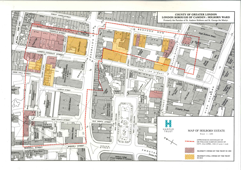
The Harpur Trust estates map Sep 2013 FINALWhilst this map shows the majority of the original estate, it was not until 1654 when it took this final shape. There were some small blocks of land in Harpur’s deed separate from the main block and in a Chancery decree of the 16th February 1654 an exchange of smaller, detached parcels of land took place leaving the estate in its final form.

The following map from the Joyce Godber’s Harpur Trust book shows the original blocks of land identified by the red crosses to the left of the main block of land, which were part of the exchange to consolidate the estate into a single block.
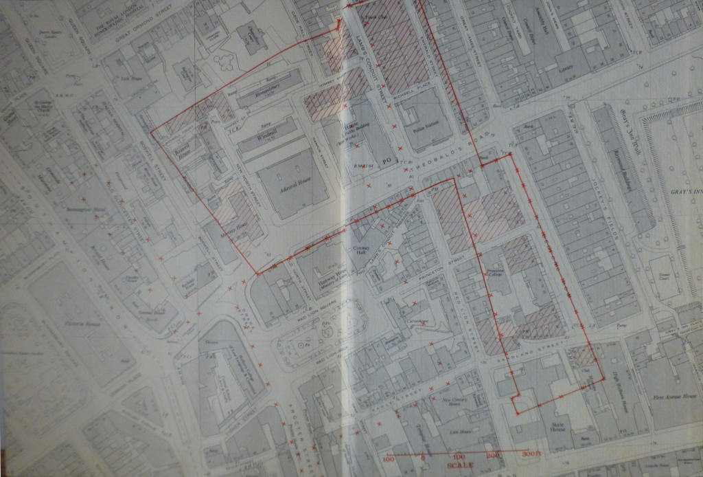
book map 1

Just prior to the transfer of the land to Bedford Corporation, in 1565 the land was let on a 40 year lease to Richard Bacon. On transfer, this brought in a sum of £12 per annum.

Having found the first boundary markers for the Bedford Charity, I wondered if any further remained and if it was possible to trace the outlines of a 1566 transfer of land, on the streets of 2015 London.

I started at the Holborn end of Bedford Row, with the water pump to my right. Bedford Row is a superb wide street of broadly similar architectural styles (despite the rather aggressively pollarded trees). Bomb damage during the war has been repaired rather than rebuilt.

From this point of view, the boundary runs down the centre of the street and the original Harpur land is to the left.
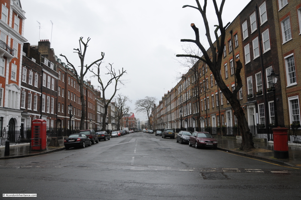
Bedford Row 7

I made two visits to the area, one on a cloudy, wet day, the other with clear blue sky and a February sun which really highlighted the brickwork:

Bedford Row 3

Due to the proximity of Grays Inn, many of the buildings now house activities associated with the legal profession.
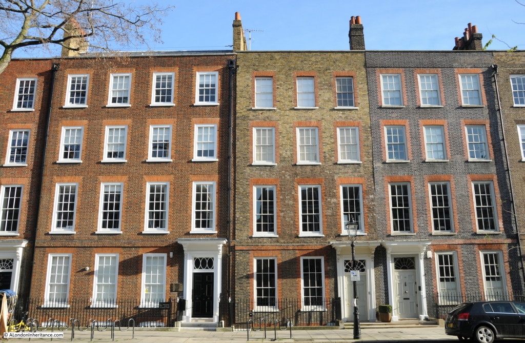
Bedford Row 5

Although some buildings retain reminders of earlier occupation:
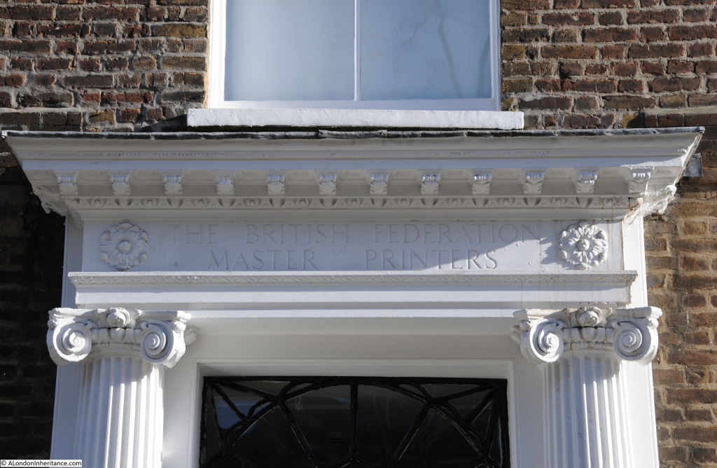
Bedford Row 4

So how many indications of the original Harpur land could I find? I have annotated the Harpur Trust map with the locations of the boundary markers that I was able to find.

Marker 1 is the first, at the end of Bedford Row, adjacent to the water pump shown in the earlier photo:
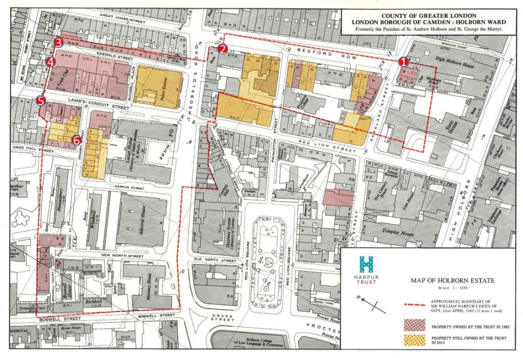
Harpur map with locations

At the end of Bedford Row, at marker 2 in the map where I found the following from 1803 to show where the boundary came from the centre of the street onto the edge of the building.

This one is dated 1803. The different dates are down to the building work that was being carried out on the land, and when the commissioners of the charity would periodically come down from Bedford and “perambulate” the boundaries of the land.
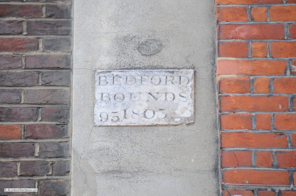
Bedford Row 6

Now cross over Theobalds Road and walk down Emerald Street. At the very end at marker 3 in the map is this boundary marker.
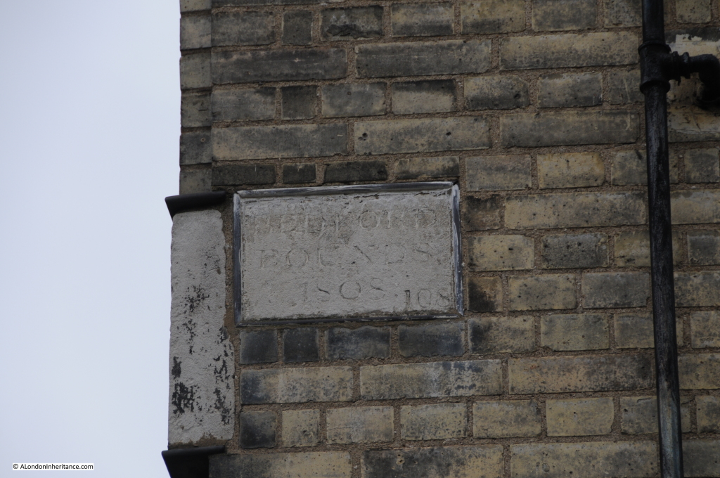
Bedford Row 8

Now head down the small alley from Emerald Street, leading up to Lamb’s Conduit Street and half way along on the right are two of the Bedford boundary markers, one from 1776 and the other from 1838. These are shown in marker 4 in the map.
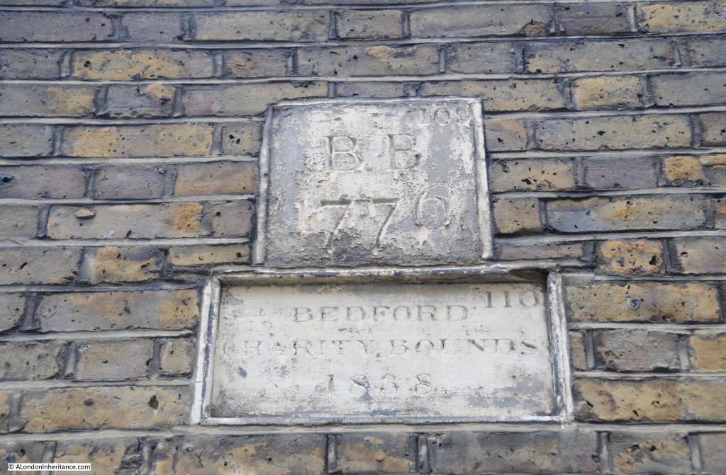
Bedford Row 9

From Lamb’s Conduit Street we can look back down the alley (part of Emerald Street). Boundary marker 3 can be seen half way up the wall of the building at the far end of the alley. Marker 4 is half way along on the left.
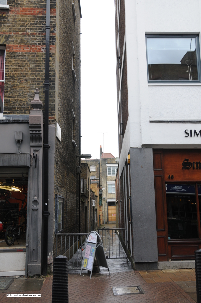
Bedford Row 12

Lamb’s Conduit Street derives its name from William Lamb who erected a water conduit n the site in 1577 by restoring an earlier dam in one of the tributaries of the River Fleet.

The next set of boundary markers are on a building in Lamb’s Conduit Street, directly across from the alley. These were from 1803 and 1838. Marker 5 on the map.

It is here that there is a marked boundary with another estate. Just below the Bedford markers on the building on the right is a boundary marker for the Rugby Estate, dated 1824. The Rugby estate was an 8 acre parcel of land that was part of a bequest to Rugby School in 1567. As with the Harpur estate, the Rugby estate was mainly meadow / pastureland at the time of the bequest, however rapid development over the coming years would add considerably to the estates income.
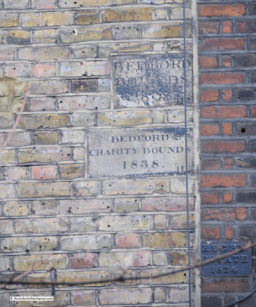
Bedford Row 10

Photo taken from the end of the alley looking towards the building with the Bedford boundary markers and the Rugby marker on the building on the right. Not easily seen, but are just behind the tree branches.
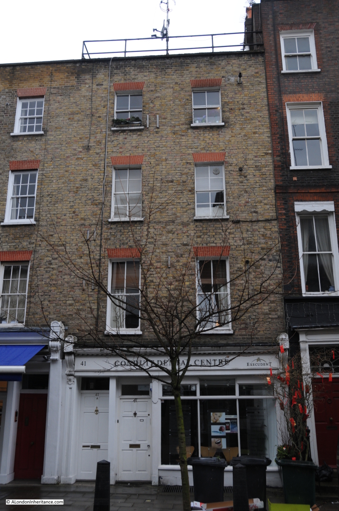
Bedford Row 11

The next pair of markers are strange. I cannot explain their location. Following the map, to get from Lamb’s Conduit Street to Orde Hall Street where I expected the next set of markers to be found, I found the pair shown in the following photo at marker 6 in the map. This area should be clearly within the Bedford / Harpur estate, however the marker on the right is Bedford 1883 and on the left is Rugby 1884. I can only assume that this was a later sale of land between the two estates in the later part of the 19th century, although strangely the Harpur map shows these buildings as being still owned by the Harpur Trust in 1985 and 2013.
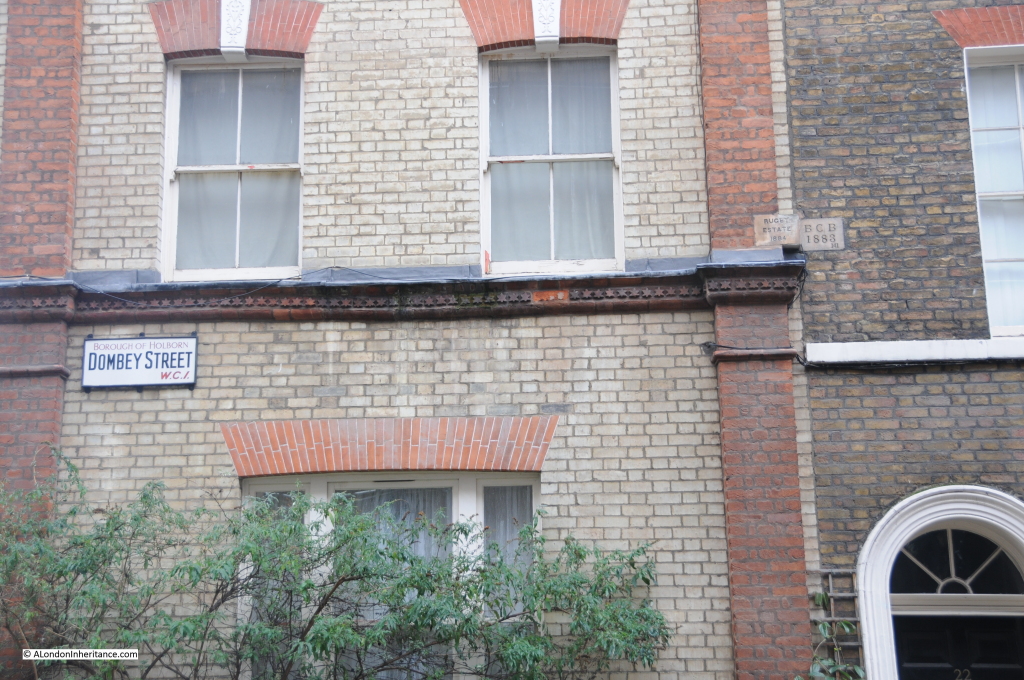
Bedford Row 14

Despite walking the rest of the route of the boundary I was not able to find any more boundary markers, although there are still a number of reminders of the Harpur legacy.

A small alley off Dombey Street leads to Harpur Mews:
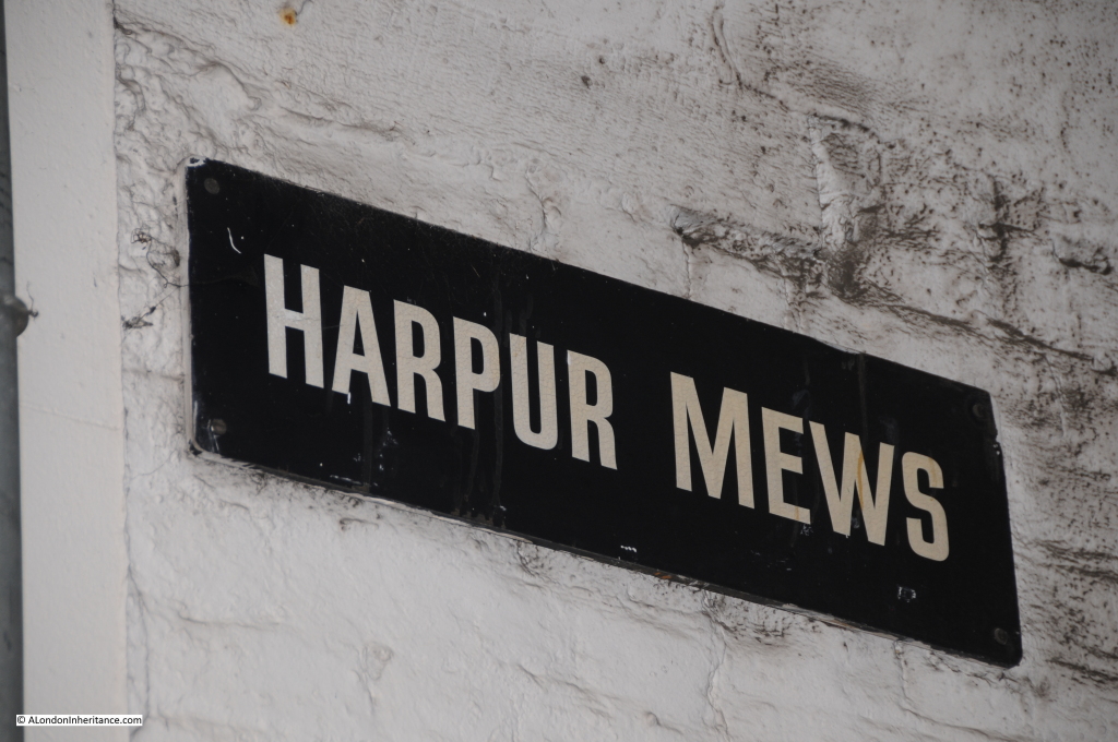
Bedford Row 13

And this is Harpur Street:

Bedford Row 15

The far house is original and the house nearest the camera is a post war development.

An example of how boundaries between estates were often challenged can again be found in the book “The Harpur Trust” by Joyce Godber;

“There were soon to be more complications over the London lease. The Great Fire of 1666 set in motion a tide of building in London. One of the most active developers was Nicholas Bourbon, who had qualified as a physician, but who had speculative interests  which included setting up in 1681 an office for fire insurance. A contemporary says that the trade of medicine failing, he fell into that of building, and the fire of London gave him means of doing and knowing much of that kind….All his aim was profit. By 1683 he had contributed to the development in the Strand, Soho and elsewhere. Another contemporary notes in his diary in 1684 on 11 June “Dr. Barebone, the great builder, having some time since bought the Red Lyon fields nears Gray’s Inn to build on….the gentlemen of Gray’s Inn, thinking it an injury to them, went with a considerable body of 100 persons, upon which the workmen assaulted the gentlemen and flung bricks at them. Red Lyon Field, now Red Lyon Square, adjoined the revised Harpur land on the southwest; between it and Gray’s Inn were trees and open space, now Bedford Row. the case came before the Privy Council, where it was said that Barbon marched about the fields at the head of his workmen, shouting and halloing.”

William Harpur died on the 27th February 1574 at the age of 77. He was buried in St. Paul’s church, Bedford.

The Bedford Charity is still going, renamed the Harpur Trust, and still using income from the properties owned within the original Harpur estate to support education in the town of Bedford.
Remarkable that 450 years later, Harpur’s original bequest continues to benefit education and can still be traced on the streets of London, and that going in search of a water pump can lead you off in a totally different direction of London’s history.

The sources I used to research this post are:

  • The Harpur Trust 1552 – 1973 by Joyce Godber published in 1973
  • My thanks to the Surveyor of the Harpur Trust for the provision of the map

alondoninheritance.com