Monthly Archives: March 2019

Jack Straw’s Castle, Hampstead

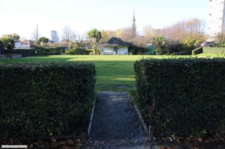
For today’s post, I am at the highest point in the metropolitan London area, standing opposite Jack Straw’s Castle.

Jack Straw’s Castle was one of the most well known pubs around Hampstead Heath. A coaching inn as well as a place for those walking across the heath to visit, along with weekend and Bank Holiday crowds.

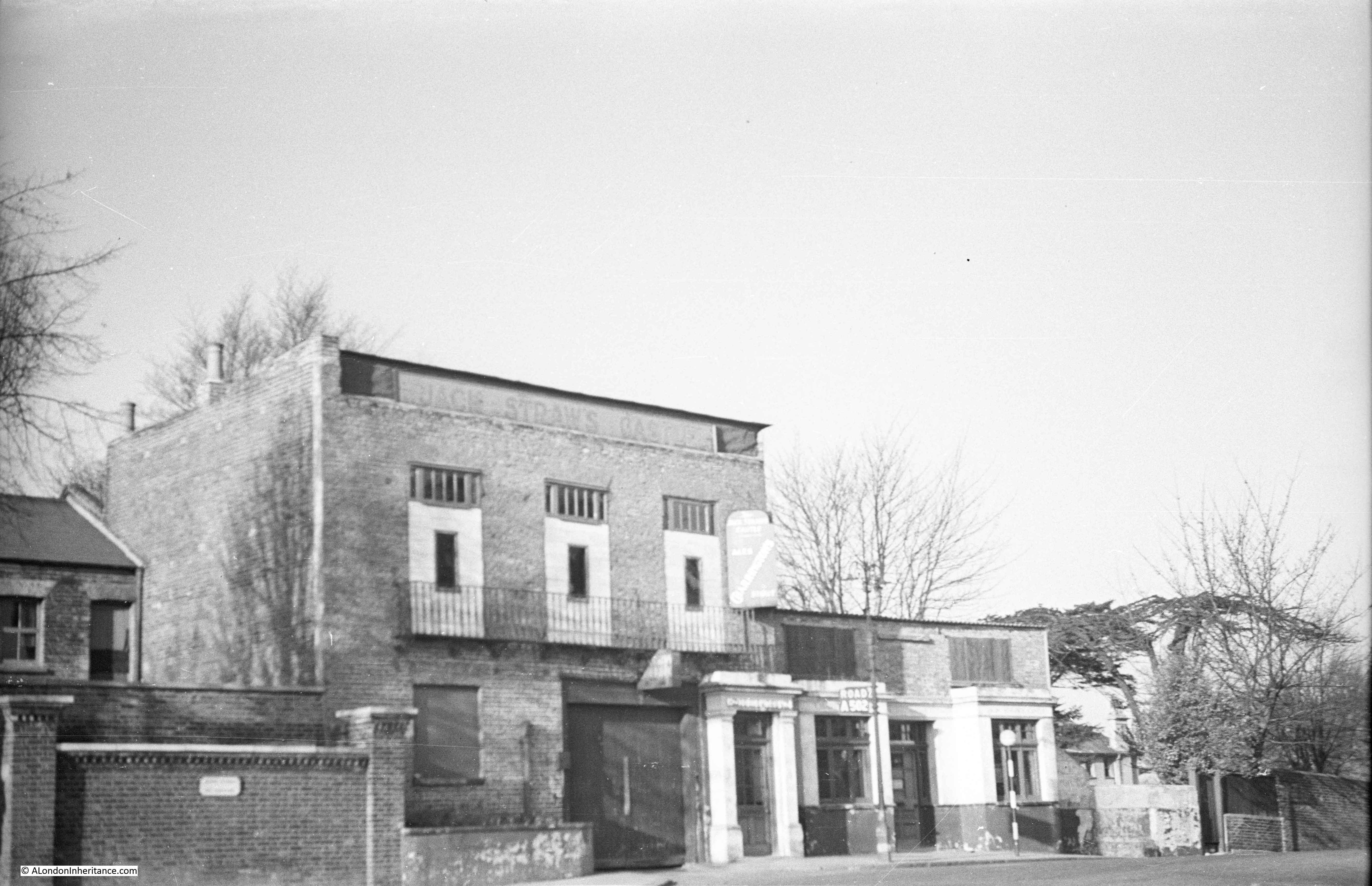
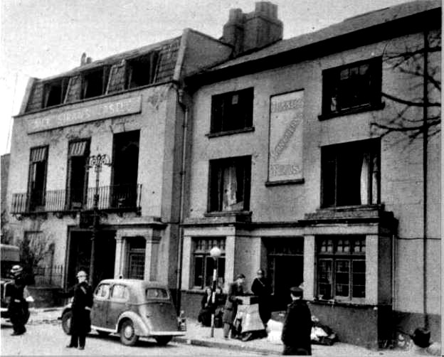
My father photographed the building just after the last war and the photo below is his view of Jack Straw’s Castle in 1949.

Jack Straw's Castle

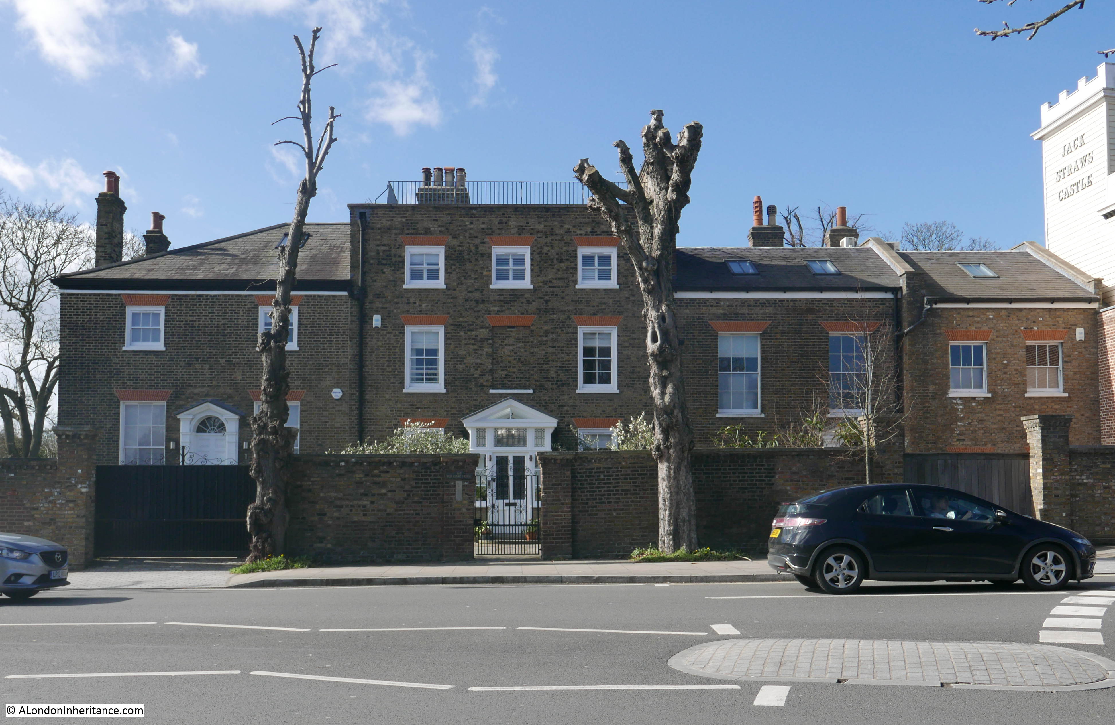
This was my view in March 2019:

Jack Straw's Castle

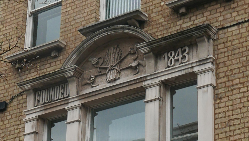
You may well be wondering how I know that my father’s photo is of Jack Straw’s Castle, given the changes between 1949 and 2019, however if you look at the very top of the tallest building, the faded words Jack Straw’s Castle can just be seen. Also, the building on the far left of both photos, along with the brick wall with two pillars, are the same in both photos.

My father’s photo shows the pub as it was following bomb damage in 1941 and subsequent demolition of some of the walls to make the building safe. The Daily Herald on the 29th March 1941 carried a report titled “Jack Straw’s Castle Bombed – the old Hampstead hostelry, was among places recently damaged during air-raids. Its neighbour, Heath House, the home of Lord Moyne, leader of the House of Lords, was also damaged.”

The building was demolished and rebuilt in 1964 to a rather striking design by Raymond Erith, however it is no longer a pub, having been converted into apartments and a gym. The building is Grade II listed which has helped to preserve key features of Erith’s design, despite developers trying to push the boundaries of how much they could change.

Jack Straw, after who the pub was named, is a rather enigmatic figure. General consensus appears to be that he was one of the leaders of the Peasants Revolt in 1381, however dependent on which book or Internet source is used, he could either have led the rebels from Essex, or been part of the Kent rebellion. Jack Straw may have been another name for Wat Tyler and some sources even question his existence. Any connection with Hampstead Heath and the site of Jack Straw’s Castle seem equally tenuous – he may have assembled his rebels here, made a speech to the rebels before they marched on London, or escaped here afterwards.

Jack Straw is mentioned by Geoffrey Chaucer in the The Nun’s Priest’s Tale of The Canterbury Tales:

Out of the hyve cam the swarm of bees.
So hydous was the noyse — a, benedicitee! 
Certes, he Jakke Straw and his meynee
Ne made nevere shoutes half so shrille
Whan that they wolden any Flemyng kille

Given The Canterbury Tales were written not long after the Peasants Revolt, this reference by Geoffrey Chaucer does probably confirm his existence. The reference to “Flemyng kille” is to the targeting of the houses of Flemish immigrants in London by the rebels.

I cannot though find any firm evidence of Jack Straw’s association with Hampstead or the site of the pub.

My father’s photo was of a rather sad looking building, however before the bombing of 1941, Jack Straw;s Castle was a rather lovely coaching inn. The following photo is from a postcard from around or just before the First World War showing Jack Straw’s Castle, and demonstrating that part of the series of buildings was the Castle Hotel.

Jack Straw's Castle

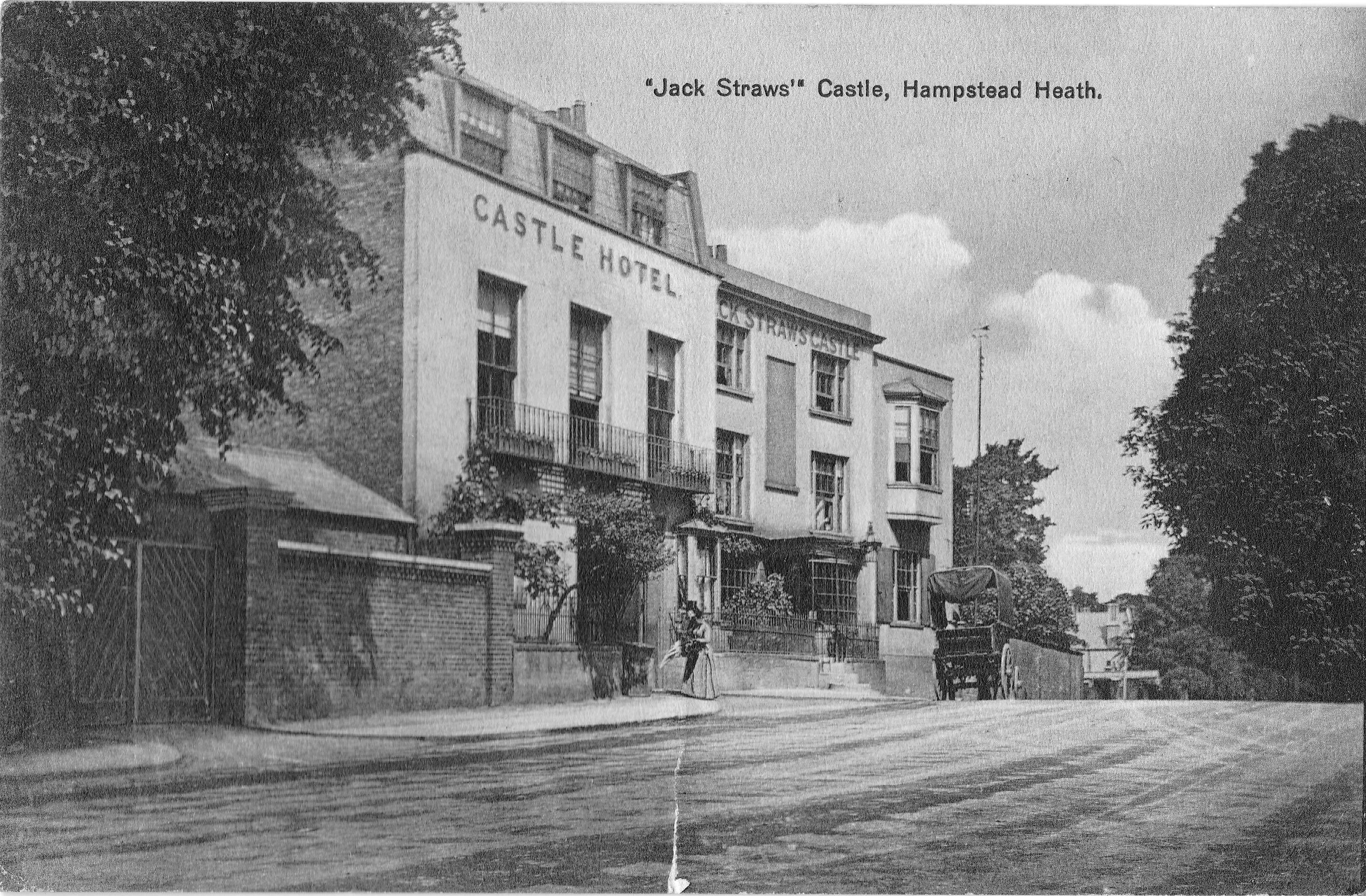
It all looks rather idyllic. A cart is parked outside, a well dressed couple are entering the Castle Hotel, and there are small trees and plants growing in frount of the buildings. The road to Golders Green disappears off past the buildings.

The rear of the postcard reveals that London was not so idyllic when it was posted. The card is dated 10th September 1915 and the author has written “The Zeppo did a lot of damage here”, probably referring to the raid on the 8th September 1915 when a Zeppelin attacked London, dropping the largest bomb to land on the city during the first war, with the raid killing 22 people in total.

Jack Straw's Castle

A later photo than the above postcard as the pub has now lost the bay windows on the ground floor and has the windows that would remain in my father’s photo.

Jack Straw's Castle

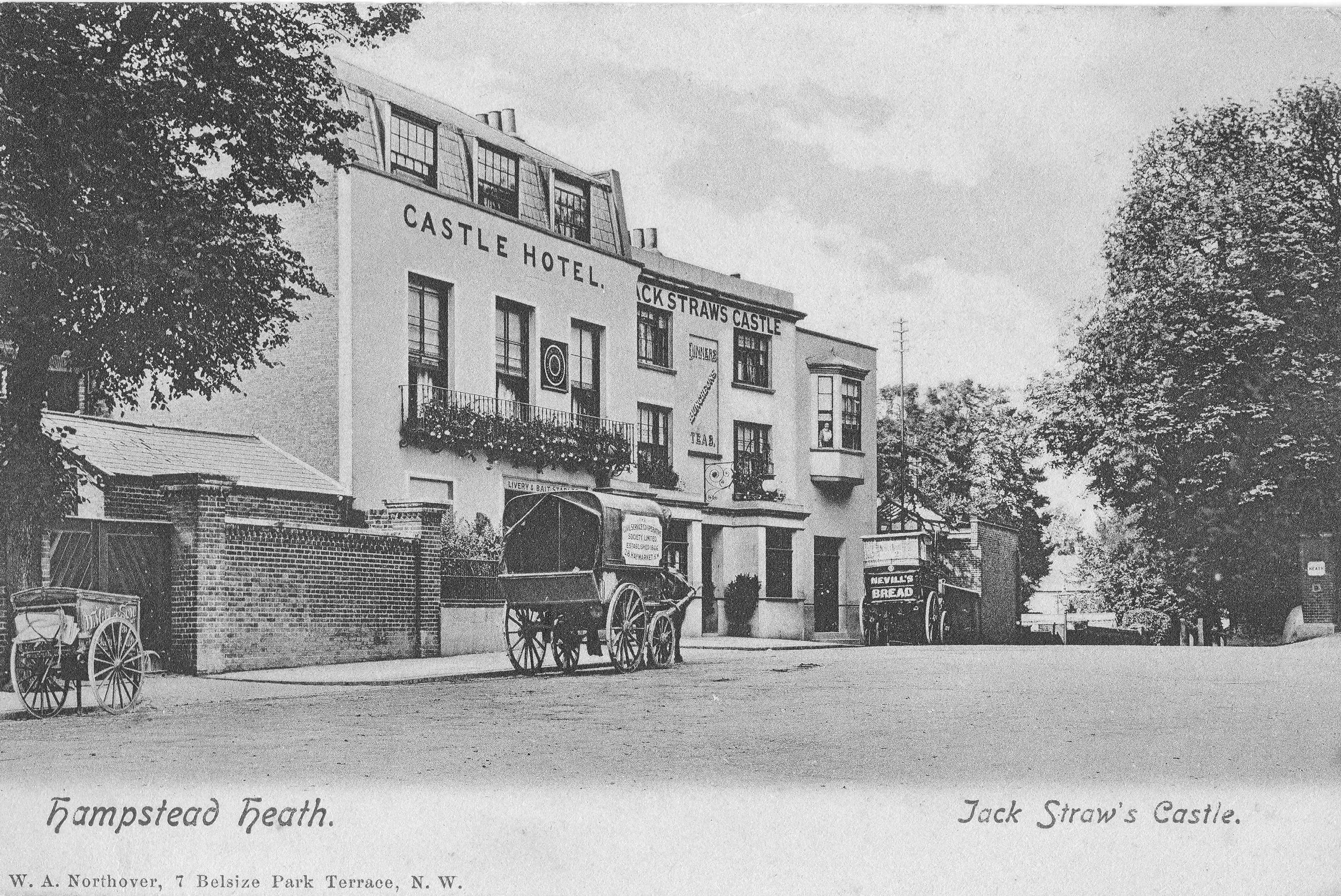
The two carts in the above photo possibly delivering Nevill’s Bread to Jack Straw’s Castle and Hotel, along with a delivery from the Civil Service Cooperative Society.

In the following photo, the cart is delivering High Class Table Waters.

Jack Straw's Castle

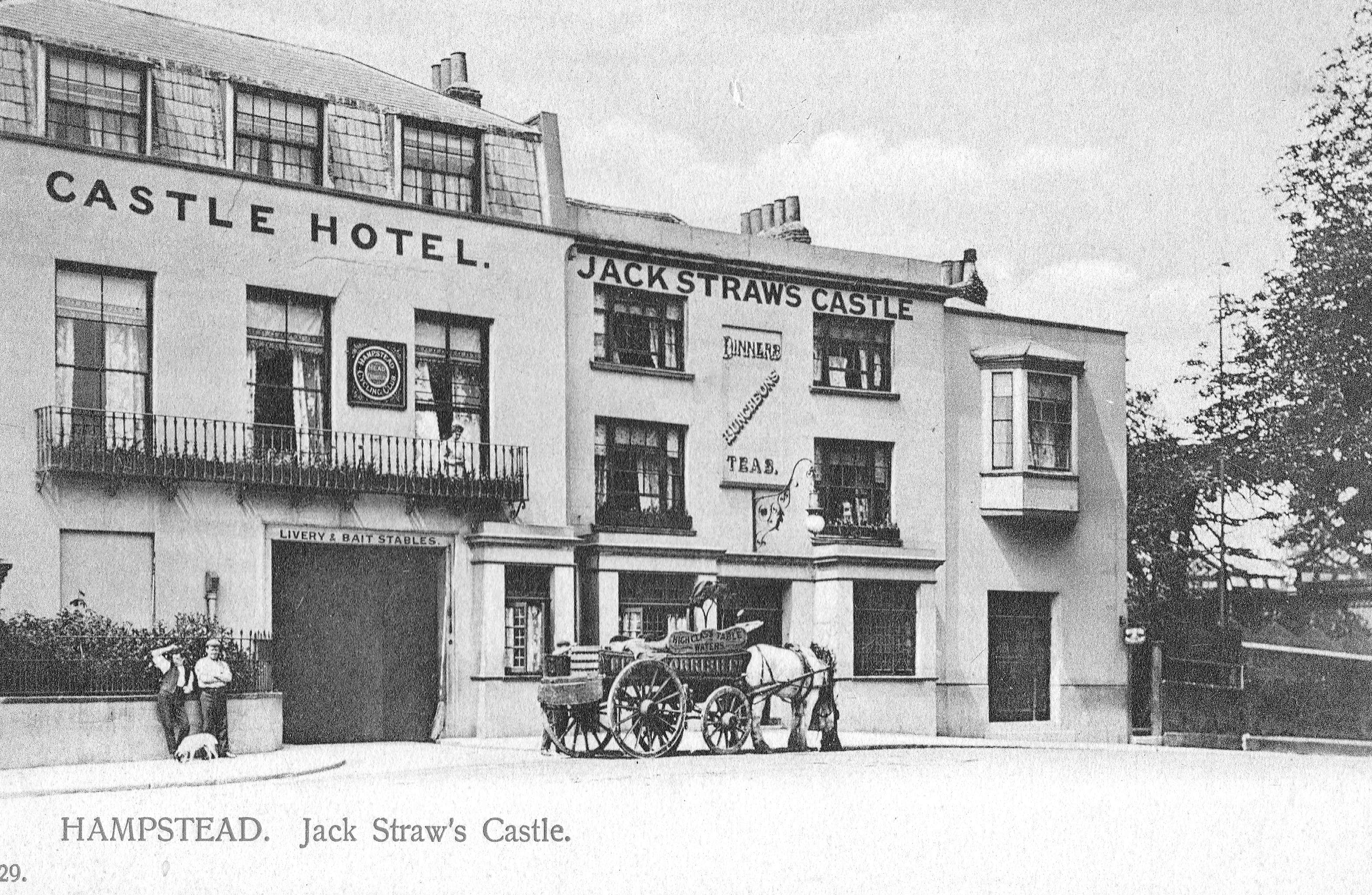
The above photo shows how there are frequently traces of previous buildings in the buildings we see today. Jack Straw’s Castle was a Coaching Inn, and the large doors on the left have “Livery & Bait Stables”, but compare the position of these large doors with my 2019 photo above and you will also see a large set of doors in roughly the same position, although the 1964 version of Jack Straw’s Castle had no need to provide a stables.

A view of Jack Straw’s Castle, the origin of the name and some of the visitors to the inn is provided by Edward Walford in Old and New London (published in 1878);

“To Hampstead Heath, as every reader of his ‘Life’ is aware, Charles Dickens was extremely partial, and he constantly turned his suburban walks in this direction. He writes to Mr. John Forster: ‘You don’t feel disposed, do you, to muffle yourself up and start off with me for a good brisk walk over Hampstead Heath? I know of a good house where we can have a red-hot chop for dinner and a glass of good wine.’ ‘This note’ adds Forster, ‘led to our first experience of Jack Straw’s Castle, memorable for many happy meetings in coming years.’

Passing into Jack Straw’s Castle, we find the usual number of visitors who have come up in Hansoms to enjoy the view, to dine off its modern fare, and to lounge about its gardens. The inn, or hotel, is not by any means an ancient one, and it would be difficult to find out any connection between the present hostelry and the rebellion which may, or may not, have given it a name. The following is all that we could glean from an old magazine which lay upon the table at which we sat and dined when we last visited it, and it is to be feared that the statement is not to be taken wholly ‘ for gospel’ – Jack Straw, who was second in command to Wat Tyler was probably entrusted with the insurgent division which immortalised itself by burning the Priory of St. John of Jerusalem, thence striking off to Highbury, where they destroyed the house of Sir Robert Hales, and afterwards encamping on Hampstead heights. Jack Straw, whose castle consisted of a mere hovel, or a hole in the hill-side, was to have been king of one of the English counties – probably of Middlesex; and his name alone of all the rioters associated itself with a local habitation, as his celebrated confession showed the rude but still not unorganised intentions of the insurgents to seize the king, and, having him amongst them, to raise the entire country.

This noted hostelry has long been a famous place for public and private dinner-parties and suppers, and its gardens and grounds for alfresco entertainments.”

Gardens at the back of pubs and inns have probably been a popular attraction for as long as these establishments have existed, and today a pub with a garden is a perfect place to spend a summer’s evening or weekend afternoon. The garden at the back of Jack Straw’s Castle looks perfect in this drawing from 1830 by George Scharf (©Trustees of the British Museum).

Jack Straw's Castle

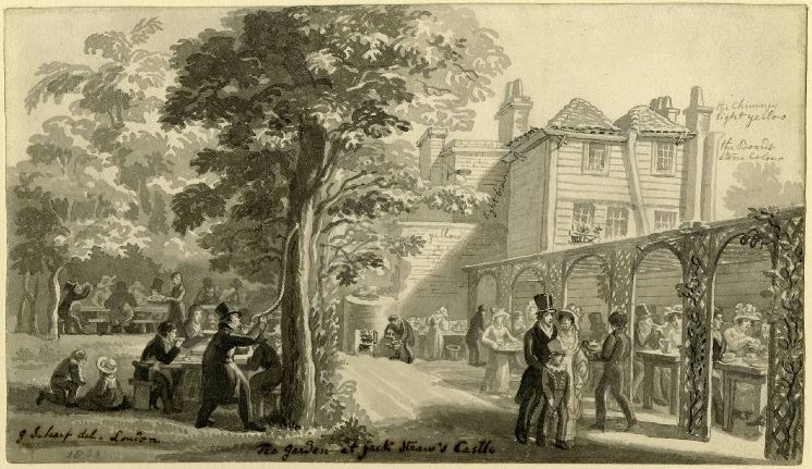
The drawing is interesting as it appears to contain notes for a later coloured version. Scribbled text alongside the building record that the chimney is light yellow, the boards are stone colour and the brick wall is yellow.

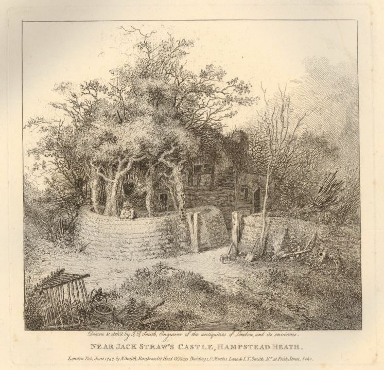
Jack Straw’s Castle was obviously a local landmark in what was a very rural area. The following print from 1797 showing an old cottage surrounded by trees and bracken and is labelled “Near Jack Straw’s Castle, Hampstead Heath” as the inn was probably the only local reference point (©Trustees of the British Museum).

Jack Straw's Castle

My father’s photo was of the building just after the war showing a shadow of the former inn. The following photo from 1941 shows Jack Straw’s Castle in 1941 in the days following the bombing.

Jack Straw's Castle

The windows have been blown out, but difficult to see what other damage has been caused to the structure of the building. From this photo I would have expected that Jack Straw’s Castle could have been repaired, however shortage of materials and people during the war probably prevented any repair work, and over the years any structural damage and the building being left in this state resulted in the building being unsafe, and walls demolished to result in the building that my father photographed.

Although Jack Straw’s Castle is very different, the buildings to the left look as if they are much the same as their original construction.

Jack Straw's Castle

There appear to be four individual houses in the above photo. The name adjacent to the entrance is “Old Court House”. The Victoria County History volume for Hampstead refers to these buildings as having been built by Thomas Pool who purchased Jack Straw’s Castle in 1744 and built two houses in 1788. The Victoria County History states that in 1820 they were converted into a single house, with name changes over the years of Heath View, Earlsmead, and finally Old Court House.

Underneath the name plate is an intercom system with four buttons so I assume they are four individual homes, but how and when they converted from the original two houses to the current buildings, I am unsure.

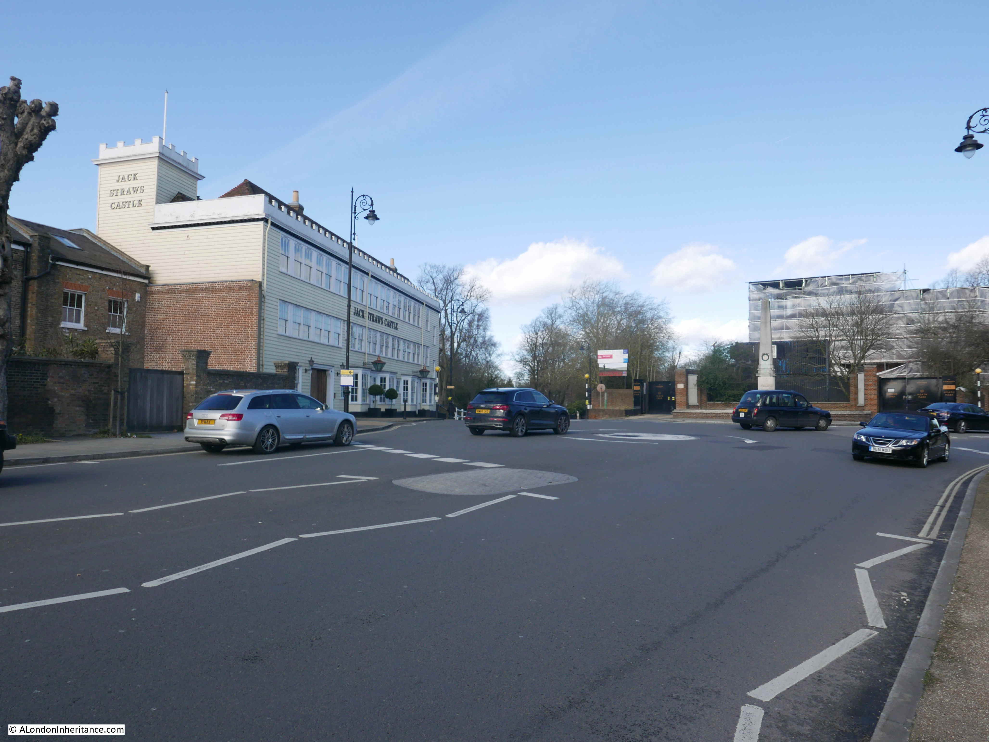
Jack Straw’s Castle sits on a very busy road junction, where roads from Hampstead, Highgate and Golders Green converge. Whilst I was trying to take photos there was a continuous stream of traffic.

In the following photo, the road on the left leads to Golders Green, the road on the right leads to Highgate (passing a building which is still a pub – the Spaniards), and I am standing by the road that leads up from Hampstead.

Jack Straw's Castle

After visiting Jack Straw’s Castle, I walked down into Hampstead. This took me alongside Whitestone Pond.

Jack Straw's Castle

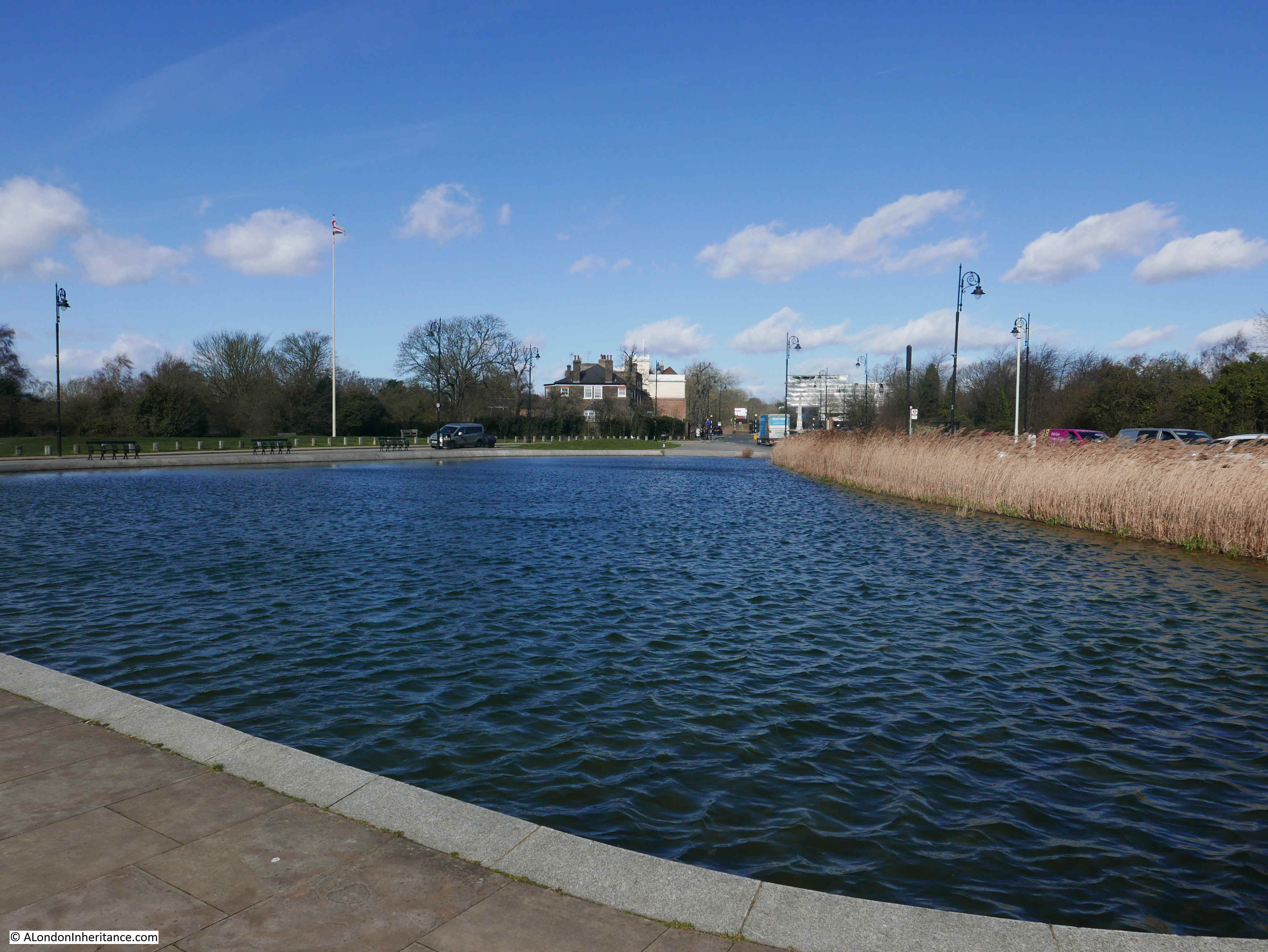
The pond was originally named Horse Pond as it was a drinking point for horses on the passing road, I will find the origin of the new name in a moment.

This area is the highest point in London, with according to the Ordnance Survey map, the pond being at 133m above sea level and Jack Straw’s Castle being at 135m.

It was originally fed by rain water and dew, however I believe it now also has an artificial supply as the height of the pond means there was no natural underground or stream sources of water.

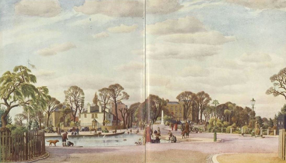
This view dates from 1936 and shows Whitestone Pond, with the side of the Old Court House and Jack Straw’s Castle in the distance.

Jack Straw's Castle

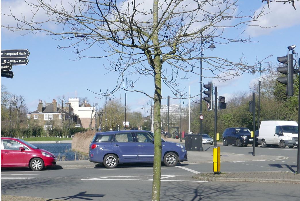
I took the following photo of the same view, but I have no idea why I stupidly did not move to get the tree in a different position as it is obscuring the war memorial which can be seen in the distance in the 1936 view.

Jack Straw's Castle

Just to the left of where I was standing for the above photo, is the source of the name Whitestone Pond. Jack Straw's Castle

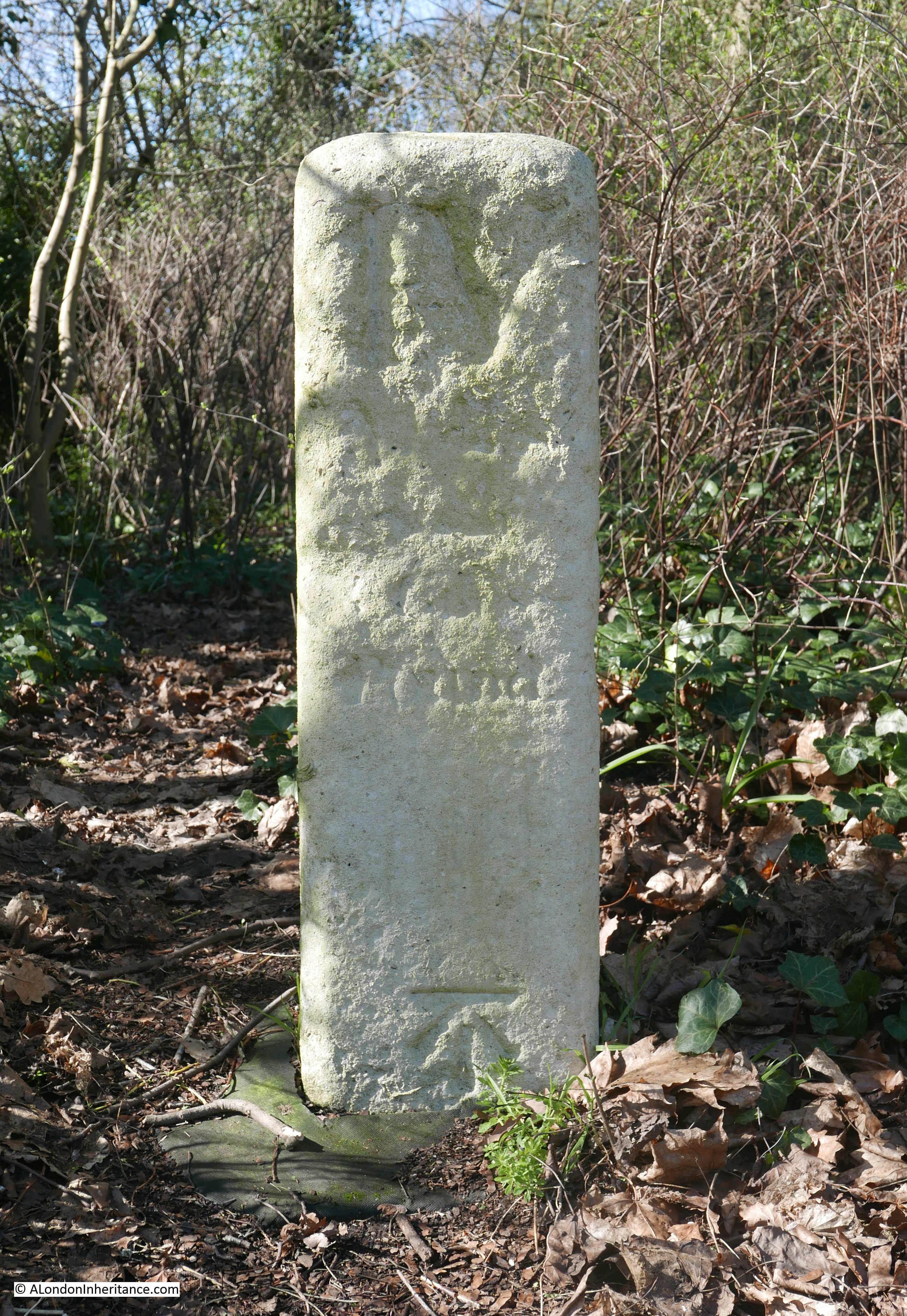
This is a milestone and states “IV miles from St Giles, 4 1/2 miles 29 yards from Holborn Bars”. There is a similar milestone near the Flask pub in Highgate (see my post here) which gives a distance of 5 miles from St Giles Pound. These two milestones show that there were two main routes, either side of Hampstead Heath, leading down to St. Giles and then via Holborn, into the City.

There is one final unexpected find before heading off down into the centre of Hampstead, close to the milestone is a covered reservoir with an unusual looking dome on top.

Jack Straw's Castle

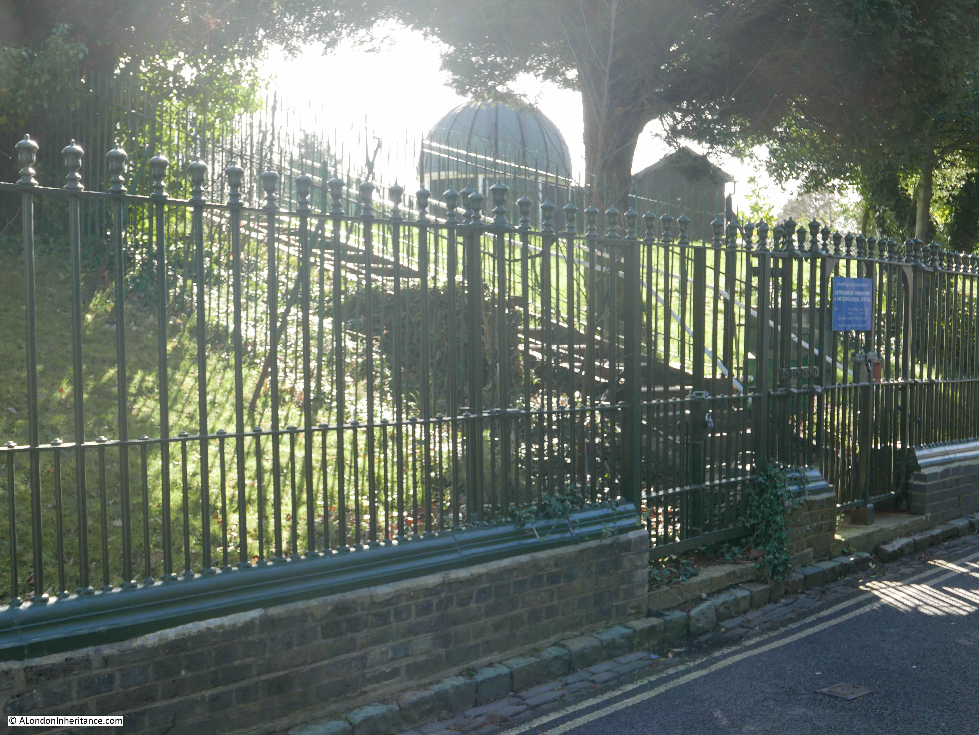
This is the astronomical observatory of the Hampstead Scientific Society – a rather unique place to observe the night sky, high above the rest of London. One of the very few locations across London that provides public viewing. Unfortunately, the observatory is currently closed whilst restoration work is carried out.

It is a shame that Jack Straw’s Castle is no long a pub. It is an impressive building in an equally impressive location – although I must admit that i prefer the pre-war building. I have read so many different interpretations of the origin of the name Jack Straw and possible associations with Hampstead so i suspect we will never know the truth behind Jack Straw, but it is good that there is still a very visible reminder of the Peasants Revolt at the highest spot in Hampstead, 638 years after the event.

alondoninheritance.com

The Perseverance or Sun Pub, Lamb’s Conduit Street

Today’s post is not the one I intended, it has been a busy week so not enough time to complete research for the planned subject, however I was in the area of Lamb’s Conduit Street last Tuesday so made a visit to the pub on the corner of Lamb’s Conduit Street and Great Ormond Street. Today, the pub is named The Perseverance, but back in 1985 it was the Sun and had the most brilliant decoration on the rounded corner, so typical of the architecture of 19th century London pubs.

The Perseverance

This is the same view in March 2019, a change in name and rather more subdued signage on the corner of The Perseverance.

The Perseverance

Lamb’s Conduit Street has two main, historical, landowners. The Bedford Charity (which I wrote about here) owned and developed the southern part of the street, whilst the Rugby Charity owned and developed the northern section of Lamb’s Conduit Street.

The Rugby Charity still owns much of the original land, including The Perseverance with the income from the street being used to fund bursaries and scholarships to Rugby School. (There are still a number of Rugby boundary markers in place, so a future project is to walk the boundaries and look for all the remaining plaques that identified the estate).

The pub retained the name of the Sun from the early 19th century, to the 1990s when the name changed a couple of times, including being called Finnegans Wake prior to the final name change around 2005 / 2006 to The Perseverance.

I have always wondered why pubs change from names that have lasted well over 100 years. I can understand if the pub wants to completely separate from a previous existence, but when the pub continues to serve the same function to the same target market, I would have thought the marketing benefits of retaining a historical name far outweigh the benefits of a new name.

There are many other examples of name changes across London. I wrote about the Horn Tavern in Sermon Lane which only relatively recently changed name to The Centre Page.

The full view of The Perseverance on the corner of Lamb’s Conduit Street and Great Ormond Street.

The Perseverance

I did not take a similar view in 1985 – the photo at the top of the post was the last on the strip of negatives so this must have been the end of a roll of film. One of the benefits of digital photography is the almost endless capacity for taking photos.

The photo above shows a different style to the buildings immediately joined on to the pub. These buildings, along with the original corner building date from the early 18th century, however the pub was refronted in the early 19th century to the style we see today.

The building is Grade II listed.

The Perseverance retains the feel of a “local” and has a bar area on the ground floor and a dining area on the first floor. It was still rather empty when I stopped for a quick drink as shown in the photo below.

The Perseverance

The Grade II listing states that the pub retains an original cast-iron column, which I assume is the column on the left of the bar.

Back outside, I had a couple of minutes for a quick look around.

One side of the eastern branch of Great Ormond Street has a fantastic array of potted plants lining the pavement.

The Perseverance

Whilst the opposite side of the street has a terrace of brick built houses from the original development of the land, looking good in the sunshine.

The Perseverance

Along the western branch of Great Ormond Street, a short distance along from The Perseverance is this building with a Blue Plaque.

The Perseverance

The plaque records that “John Howard, 1726 to 1790, Prison Reformer Lived Here”.

John Howard was the prison reformer after who the Howard League for Penal Reform was named. Howard was born in Hackney, but spent much of his life in Bedford. He became the High Sheriff of Bedfordshire which came with the responsibility for the county gaol.

He was horrified by the conditions of the gaol and the way in which it was administered, with control basically being down to the way in which the appointed gaolers wished to manage the prison and make money out of those with the misfortune to be held.

His experience in Bedford resulted in many journeys throughout the country exploring and reporting on the conditions of numerous gaols – all of which suffered from the same problems.

His journeys between 1775 and 1790 were described in a book “The State of the Prisons In England and Wales” which provides a comprehensive review of conditions in 18th century goals. The first paragraph of Section 1 – General View of Distress in Prisons introduces the state of the country’s gaols:

“There are prisons, into which whoever looks will, at first sight of the people confined there, be convinced, that there is some great error in the management of them; the fallow meager countenances declare, without words, that they are very miserable; many who went in healthy, are in a few months changed to emaciated dejected objects. Some are seen pining under diseases, ‘sick and in prison’ expiring on the floors, in loathsome cells, of pestilential fevers, and the confluent small-pox; victims, I must not say to the cruelty, but I will say to the inattention of the sheriffs, and gentlemen in the commission of the peace.”

The book records the state of each prison that he visited and Howard’s records of Marshalsea Prison in Southwark are as follows:

The Perseverance

The Perseverance

The Perseverance

Howard’s book The State of the Prisons In England and Wales is available online at archive.org and provides a fascinating insight into 18th century prisons.

I did not have time to explore much further along Great Ormond Street, so I backtracked to The Perseverance to head back down along Lamb’s Conduit Street, which deserves a dedicated blog post, however one building just a short distance from the pub has some interesting decoration above the first floor windows.

The Perseverance

I could not photograph from directly opposite as the branches of a tree partially obscured the view. Detail of the first floor decoration is shown in the photo below which consists of a date along with a sheaf of wheat, tied with rope, with four hands pulling on the rope.

The Perseverance

The symbol is of the United Patriots National Benefit Society which was founded in 1843 with offices here in Lamb’s Conduit Street, as well as other offices and branches across London and the rest of the country.

The society was one of a number of benefit societies to which members contributed a regular subscription and were then able to call on financial support in times of hardship. The sheaf symbol was used extensively by the society on their buildings, certificates of membership, documentation and badges.

Like many 19th century societies, the United Patriots National Benefit Society appear to have enjoyed members meetings in pubs which seemed to have consisted of entertainment and toasts (and probably lots of beer). An account from the Islington Gazette on the 4th November 1884 reads:

“The members of the Caledonian-road branch of this society celebrated their fortieth anniversary by a supper, at the ‘Prince of Brunswick’ Tavern, Barnsbury-road on Thursday evening last. Subsequently, the members having disposed themselves for the evenings entertainment.

The Chairman (Mr. W.E. Beer), in a few prefatory remarks condemning the recent disquieting rumours in the press concerning the Navy, proposed the ‘loyal and patriotic toasts’ which were drunk enthusiastically.

Mr G. Coel (the branch secretary), in responding to the toast of the evening, said that, up to the end of last year, the members on the books numbered 95. the receipts for 1883 amounted to £116 14s 11d, and the disbursements £114 17s 7d leaving a balance of £1 17s 4d in their favour, he regretted not being able to lay before them a better statement of affairs, but owing to the unfortunate prevalence of sickness during that time, there has been an extra call upon the funds; but it was, at the same time, gratifying to know they have been more than able to meet the demands made, without applying for aid from the mother society. He concluded by thanking them all for their courtesy and kindness accorded to him during his connection with them, extending over seven years (Cheers).

The proceedings throughout were enlivened with songs by the company, which separated after cordially approving votes of thanks to the Chairman and the host (Mr. Wilson).

I suspect those who had been able to call upon the society during times of sickness were the fortunate ones, with those not able to be members having very little to fall back on.

I should not be surprised as I have been walking London for decades, however it is always brilliant how much history can be found within a very short distance from a specific point. I went to find the pub which had a very colourful decoration in the 1980s and also found one of the key early founders of prison reform and the home of one of London’s benefit’s societies. Digging deeper there is the history of the Rugby Charity which received the original donation of land and has owned, developed and managed much of the local area since, and before that one of the early water supplies to London and the land owner that gave the street its name.

Hopefully subjects for future posts.

alondoninheritance.com

St John at Hampstead and George du Maurier

Last Saturday was a windy, sunny spring day in London, so what better than to spend an hour exploring the cemetery of St John at Hampstead.

The reason for this specific cemetery was to find a rather unusual grave that my father had photographed in 1949. This is the grave of George du Maurier.

St John at Hampstead

The same view 70 years later in 2019:

St John at Hampstead

The grave today does not appear as well looked after as in 1949. There was some space surrounding the grave in 1949, however today there are many more graves alongside. The tree on the left has been cut down and today only the stump survives. One of the significant differences which I find in many of my father’s photos is the number of cars in the street. In 1949 streets were generally free of parked cars, in 2019 there are very few streets without parked cars, or lots of passing traffic.

George du Maurier, or to give him his full name, George Louis Palmella Busson du Maurier, was born in Paris on the 6th March 1834 and died on the 8th October 1896.

His grandparents on his father’s side were French and according to an 1886 newspaper account, emigrated to England during the “Reign of Terror” during the French Revolution. Later accounts state that his grandfather was a glassblower and left France to avoid fraud charges, adding the du Maurier name to give the impression of a French aristocratic background.

His father returned to Paris and it was there that George was born. He spent much of his childhood in France until the family returned to London and George started as a student at the Birkbeck Laboratory of Chemistry.

The Hampstead and Highgate Express on the 24th July 1886, in their series on well known residents features George du Maurier and explains that whilst his father wanted him to become a chemist, including going to the expense of setting up his own private laboratory, George was more interested in the arts and “humorous draughtsmanship“.

After the death of his father, he gave up chemistry and went to Paris to study art. He later returned to London, after spending an additional three years in Germany and Belgium and started in his career as a draughtsman, producing drawings for publications. Punch was the publication that became most associated with his work, and he produced drawings for Punch for twenty five years.

George du Maurier photographed in 1889 (© National Portrait Gallery, London)

St John at Hampstead

The article in the Hampstead and Highgate Express described his work: “Over a period of nearly twenty five years he has contributed to ‘Punch’ an almost endless series of drawings illustrative of the manners and customs of English society. Some of its phenomena, the shams, affectations, meannesses and frivolities peculiar to its salons and garden parties, and some other scenes of fashionable life, are treated by the artist with the most biting satire. But a great deal belonging to English life and society, especially its venial weaknesses, is treated by the artist from the humorists’ standpoint, namely that of light satire and good humour. In an appreciation of beauty and grace as seen in his numerous presentments of women and children, and in his general design of his pictures, Mr du Maurier excels all preceding English pictorial humourists. In the ‘Punch’ contributions he has not only shown power as a graceful and refined artist, but in his drawings for that amusing periodical there are touches of wit, humour, satire, subtle observation, and poetic suggestiveness which are indisputably the work of a man of genius.”

A couple of examples of George du Maurier’s work for Punch are shown below (both ©Trustees of the British Museum).

The following drawing is an illustration for Punch, dated the 18 October 1880. It is described as “What our Artist has to put up with, a man talking and touching the shoulder of another, both standing before a group of three pictures, other figures examining other pictures on the surrounding walls”.

St John at Hampstead

The following drawing is dated the 12th January 1878 and is a study of two female figures sitting in a carriage on the Metropolitan Railway.

St John at Hampstead

He also produced numerous sketches for his own amusement, including many self portraits. This one on paper, stamped with his home address in Hampstead shows George du Maurier exclaiming ‘Hooray!’ at the arrival of the post with his dog dancing nearby.

St John at Hampstead

George du Maurier married Emma Wightwick, who he had met whilst in Germany. They had five children. One of his children was the actor Sir Gerald du Maurier, who was the father of the authors Daphne du Maurier and Angela du Maurier.

In his later years, George du Maurier turned to writing and produced three novels between 1889 and 1897- Peter IbbetsonTrilby, and The Martian.  Trilby was a significant best seller with the Victorian story of a fallen woman with a good heart.

George du Maurier was 62 when he died of heart failure. He had lived at two locations in Hampstead during his life, but had moved around a number of times and at the time of his death was living at Oxford Square, near Hyde Park.

His funeral at St John at Hampstead was a significant event, attended by many dignitaries of the day, authors and the staff of Punch magazine.

The memorial at his grave is unusual, and I cannot find any references as to why the design was chosen.

I am also unsure why my father chose to photograph du Maurier’s grave given the number of famous names buried at St John at Hampstead. My father was also a draughtsman, professionally for the St. Pancras Borough Council Electricity and Public Lighting Department, then the London Electricity Board, but also was interested in drawing many other subjects and it may have been this interest in an earlier draughtsman that prompted the choice of grave to visit and photograph.

George du Maurier’s grave is in the “Additional Burial Ground” just across the road from the church of St John at Hampstead and the original graveyard. The extension opened in 1812. This is the view of the additional burial ground from Church Row. The church is on the left, just behind the car. George du Maurier’s grave is up against the railings, just behind the poster.

St John at Hampstead

Another view of George du Maurier’s grave. Underneath the name and dates of birth and death is written “A little trust that when we die, we reap our sowing and so – good bye“.

St John at Hampstead

The monument above the grave is to Geoirge du Maurier, however there are panels inset to the front and sides that record the children of George and Emma du Maurier.

Here, their eldest son, Lieutenant Colonel Guy Louis Busson du Maurier is recorded as being killed in action on March 10th 1915 at Alston House, near Kemmel in Flanders.

St John at Hampstead

Marie Louise Busson du Maurier, their youngest daughter.

St John at Hampstead

Gerald Hubert Edward Busson du Maurier, their youngest son.

St John at Hampstead

There are numerous fascinating graves in the cemetery of St John at Hampstead. Walking around is a history lesson of the past couple of centuries.

The following grave and monument was not there when my father took the photo at the top of this post. It is immediately to the left (when looking from the road) of George du Maurier’s grave and is the grave of Hugh Gaitskell, the  leader of the Labour Party from 1955 to 1963, along with his wife, Dora.

St John at Hampstead

Adjacent to the grave of Hugh Gaitskell are plaques to the Hampstead resident, comedian and satirist Peter Cook and his wife Lin.

St John at Hampstead

Strangely Wikipedia states that Peter Cook’s ashes were buried in an unmarked grave so either the plaques are in the wrong place, or Wikipedia is wrong. – I suspect the later.

There was one specific grave that I was interested to find, and after some searching I found the grave of Sir Walter Besant.

St John at Hampstead

Sir Walter Besant was born in Portsmouth in 1836 and died in Hampstead in 1901. His life almost matching the reign of Queen Victoria.

He was a prolific author of both novels and factual books. Two of his more famous novels, “Children of Gibeon” and “All Sorts and Conditions of Men” dealt with the living and social conditions of east London and the relationship between east and west London. The later book helped with the establishment of the People’s Palace in east London by John Beaumont. The book included the planning and build of a Palace of Delight to provide education, concerts, picture galleries, reading rooms etc. free to the people of east London. The name used in the book was part taken by the People’s Palace, and the book brought funding and support to the People’s Palace.

For many of his books, he worked with the author James Rice and the two men went walking across London to gather background for their books. James Rice died in 1882 and in the preface to “All Sorts and Conditions of Men”, Besant wrote: “The many wanderings, therefore, which I undertook last summer in Stepney, Whitechapel, Poplar, St. George’s-in-the-East, Limehouse, Bow, Stratford, Shadwell and all that great and marvelous unknown country we call East London, were undertaken, for the first time for ten years, alone. They would have been undertaken in great sadness had one foreseen the end. In one of these wanderings I had the happiness to discover Rotherhithe, which I afterwards explored with carefulness; in another, I lit upon a certain Haven of Rest for aged sea captains, among whom I found Captain Sorensen; in others I found many wonderful things, and conversed with many wonderful people”.

I suspect that during the 19th century there were quite a few authors wandering the streets of east London.

In a review of one of Besant’s book, the London Evening Standard wrote in 1901 a paragraph that is just as true today:

“It is commonly said that half the world is ignorant of how the other half lives. That is more than true of London, for its vastness limits the social outlook of its inhabitants to the narrow groove of their daily work. How little do most people know of the occupations, or even names, of their immediate neighbours. Sir Walter Besant however is well acquainted with the region he is describing and his details are always equally graphic and correct.”

Sir Walter Besant spent six years abroad when he was a Senior Professor of Mathematics at the Royal College in Mauritius. He was Secretary of the Palestine Exploration Fund. Besant was also instrumental in the founding of the Society of Authors and became the first Chair of the society. During his time with the society he was active in furthering the cause of copyright for an author’s work.

Sir Walter Besant, looking very Victorian in 1896 (photo © National Portrait Gallery, London)

St John at Hampstead

The reason why I wanted to find Besant’s grave was that I have many of his historical and topographical books on London. They are comprehensive studies of a specific period in time and of a region of the city. Full of early photos, drawings and maps. This is my copy of Besant’s London books published by A&C Black.

St John at Hampstead

The London Evening Standard on the 11th June 1901 carried a comprehensive obituary of Besant.

It records that “When the People’s Palace was opened by Queen Victoria, the obligation which London and the nation owed to Mr. Besant was publicly recognised, and in 1895 the honour of Knighthood was bestowed upon him, amid universal approval.”

He was married to Mary Foster-Barham, and the obituary illustrates how male and female children were treated differently. The obituary records that when he died, his two sons, Philip and Geoffrey were both at the Front (South Africa). The former being a Captain in the 4th Battalion Royal Warwickshire Regiment, the latter a trooper in the Imperial Yeomanry. Of his daughters, the only mention is that one unnamed daughter was with Walter Besant at the time of his death.

It was fascinating to find the grave of an author that has provided me with a Victorian view of the history of London.

It was a pleasure to walk round and explore the “Additional Burial Ground” of St John at Hampstead on a sunny spring day.

St John at Hampstead

The cemetery is at the exactly right place between being wild and too manicured. Last autumn’s leaves still cover the ground, moss covers many of the graves and narrow paths provide walkways across the cemetery. The houses of Hampstead close in on the cemetery boundaries.

St John at Hampstead

This stunning Magnolia tree will look magnificent in a couple of weeks (providing the flowers have not been blown away with the recent gales).

St John at Hampstead

There are so many graves that tell an interesting and often tragic story of 19th and early 20th century life. This is the grave of Arthur Llewelyn Davies who died in 1907 and his wife Sylvia Jocelyn who both died at the same age of 44 (although in different years).

St John at Hampstead

Perhaps the only good thing about their relatively young deaths is that they would not have to suffer the deaths of their eldest son George who was killed in action at the age of 22 on the 15th March 1915, and the death of their fourth son Michael who drowned whilst bathing at Oxford where he was an undergraduate at the age of 20.

Inscriptions also record how individuals (or their families) wanted to be remembered. This is the grave of George Atherton Aitken – The Very Mirror Of A Pubic Servant.

St John at Hampstead

After visiting the additional cemetery, I walked across the road to visit the church of St John at Hampstead and the original cemetery.

St John at Hampstead

References to a chapel on the site date back to the 14th century. The core of the current church was consecrated in 1747 with the spire being added in the 1780s. The church was expanded during the middle of the 19th century to support the growing population of Hampstead. During the rest of the 19th century there would be improvements (such as gas lighting), decoration and minor changes. The church was given a lighter colour decoration in 1958 to replace the dark Victorian interior.

The interior of St John at Hampstead today:

St John at Hampstead

The original cemetery around the church has a number of fascinating graves of those who have made their mark over the centuries.

Close to the church is the grave of John Harrison.

St John at Hampstead

The inscription provides a summary of Harrison’s work;

“In memory of Mr John Harrison , late of Red Lion Square, London. Inventor of the Time-Keeper for ascertaining the Longitude at Sea.

He was born at Foulby, in the County of York, and was the Son of a Builder at that Place, who brought him up to the same profession.

Before he attained the Age of 21, he without any Instruction employed himself in cleaning and repairing Clocks and Watches and made a few of the former chiefly of Wood. At the age of 25 he employed he Whole Time in Chronological Improvements. He was the Inventor of the Gridiron Pendulum and the Method of preventing the Effect of Heat and Cold upon Time keepers by Two Bars of different Metals fixed together. He introduced the Secondary Spring to keep them going while winding up and was the Inventor of most (or all) of the Improvements in Clocks and Watches during his Time.

In the year 1735 his first Time keeper was sent to Lisbon, and in 1764 his then much Improved fourth Time keeper, having been sent to Barbados the Commissioners of Longitude certified that it had determined the Longitude within one Third of Half a Degree of a Great Circle having erred not more than 40 Seconds in Time.

After near Sixty years close Application to the above Pursuits, he departed this Life on the 24th Day of March 1776, Aged 83.

Mrs Elizabeth Harrison Wife of the above Mr John Harrison departed this life March 5th 1777, Aged 72.”

Despite the success of the trial with the fourth time keeper (model H4), Harrison had problems with the Board of Longitude which had been set up to oversee the trials and a financial award for the accurate measurement of Longitude under the Longitude Act. The Commissioners on the Board of Longitude did not feel that sufficient trials had been carried out, and they initially offered part of the award (£10,000) with a further £10,000 if Harrison’s time keeper could be replicated by other manufacturers. This would have required the design details of Harrison’s time keeper to be published freely for other manufacturers to use.

Harrison did eventually get a substantial financial award from Parliament, with the support of the King.

The grave of an artistic Hampstead resident can be found up against the boundary wall of the cemetery. This is the grave of the artist John Constable.

St John at Hampstead

Constable was a frequent visitor to Hampstead and lived for many years in the area, including in a house in Well Walk between the years 1827 until 1834. It was from the drawing room of the house in Well Walk that he painted a number of views across to the centre of the City.

An example being the following view with St. Paul’s Cathedral in the centre distance. An inscription on the rear of the painting reads: “Hampstead. Drawing Room 12 o’clock noon Sept.1830” (Image ©Trustees of the British Museum)

St John at Hampstead

The hilly nature of Hampstead is visible in the graveyard, as the land descends from the high point of 135m at Whitestone Pond down towards the River Thames.

St John at Hampstead

The graveyard is also managed in such a way that whilst it is not too wild, it is not manicured and a plaque at the entrance provides information on the range of wildlife that can be found.

St John at Hampstead

Towards the south east corner of the graveyard, just across Frognal Way, there is a rather large construction site.

St John at Hampstead

I believe this was 22 Frognal Way, which was occupied by a modernist house built to the design of Kentish Town architect Philip Pank. The house was commissioned by Harold Cooper and built in 1978. Cooper was the founder of the Lee Cooper jeans brand. After his death in 2008, the house became derelict and although there were attempts to get the house listed and restored, planning permission appears to have been given for demolition and construction of a new house.

The new building will be low profile consisting of a single story as viewed from street level, however as can be seen by the size of the excavation in the above photo, the new building will have considerable basement space.

Some of these building sites where basements are constructed for residential homes appear more like a Crossrail construction site. I suspect I know what the neighbours think about having such a large excavation on their doorstep.

The church of St John at Hampstead, the original and additional graveyards, are a fascinating place to explore, and if you have a couple of hours spare on a sunny day, there is no better place to learn about the residents of this area of north London.

alondoninheritance.com

Simmonds Stores, Godfrey Street, Chelsea

Before getting into this week’s post, can I thank everyone who commented and e-mailed following last Sunday’s post on the 5th anniversary of the blog. Your feedback is really appreciated.

There are a number of then and now photos that I find sum up the changes to an area. A few years ago I wrote a post about the location of the Gun Tavern in Wapping. My father photographed the post war ruins of the old pub. Today, the same location is occupied by a Foxton’s estate agent.

For today’s post I have another pair of photos that sum up how an area has changed. This time I am in Chelsea, and this is Simmonds Stores, on the corner of Godfrey Street and Cale Street. The photograph was taken in 1986.

Godfrey Street, Chelsea

The same view in February 2019:

Godfrey Street, Chelsea

The two photos typify how the area has changed. A corner shop that once sold household wares, piled high outside the shop to tempt passers-by, is now the Chelsea Green Valet. It is not just the shop that has changed, the building has been “restored”, although some of the changes attempt to replicate original features which were not part of the building’s design. An example being the new door on the left of the building which replaces an original window. The use of a door surround that attempts to give the door an original appearance was part of the work to bring the building to its current appearance.

The building of Godfrey Street dates from the 19th century. The first newspaper reference I have found to the street was from 1830 which implies the street was developed in the first decades of the 19th century. The name probably comes from Walter Godfrey who was a landowner in Chelsea during the 18th century. The corner store probably dates to the original construction of the street.

The 1891 Kelly’s Directory records that Albert Simmonds, Oilman was in residence, and it is this reference that provides a clue to the early function of the store and the large jars that are still mounted on the side of the building.

These represented Tuscan oil jars and indicated that oil was sold in the store. There is another example to be found in my post on Lower Marsh in Lambeth.

The 1891 census provides some additional information on Albert Simmonds. He was aged 30 and was born in Shipton, Oxfordshire. He lived in the building with his wife Mary (31) and children Mary Ann (7), Albert (6) and Frederick (1). Also in the house there was a servant Florence Hele, aged 17 and listed as a General Servant.

I do not know when the stores closed, or whether it was still in the Simmonds family when my father photographed the building in 1986, however it retained the Simmonds name for around 100 years.

The London Metropolitan Collage archives has a photo of the stores dated from 1971.

Godfrey Street, Chelsea

Image credit: London Metropolitan Archives, City of London: catalogue ref: SC_PHL_01_067_71_2348.

In 1971 the shop had a rather nice lantern over the door which had disappeared by 1986, All the windows on both the ground and first floors looked stuffed with goods for sale.

A wider view of the location of Simmonds Stores.

Godfrey Street, Chelsea

I have marked the location of the building in the following map extract to show Simmonds Stores on the north-west corner of Godfrey Street.

Godfrey Street, Chelsea

Map  © OpenStreetMap contributors. 

As usual, I always use the opportunity of finding these locations to take a walk around the immediate area. The shop sits between Godfrey Street on the left and Danube Street on the right. Danube Street’s main function is to provide access to the rear of the buildings on the adjacent streets.

Godfrey Street, Chelsea

Godfrey Street is interesting. A considerable mix of architecture with houses much altered since their original build. Many of the buildings have been painted in bright colours.

Godfrey Street, Chelsea

The council’s conservation reports have concerns about this approach in a conservation area – “The buildings within the area were not intended to have painted masonry finishes. Today many houses have been painted. In some cases where the whole terrace was painted many years ago in a consistent scheme, this paint has become part of the street’s character. However, in other places, where individual houses have been painted in a brick terrace, they have harmed the uniformity of the terrace and the appearance of the conservation area”.

View from the southern end of Godfrey Street looking up towards Cale Street.

Godfrey Street, Chelsea

It is fascinating to look up newspaper references to the locations I visit. They frequently provide an insight into the lives of those who have lived in these streets. One tragic report from one of the earliest mentions of Godfrey Street, documenting an example of domestic abuse was reported in the London Courier and Evening Gazette on the 20th November 1832:

“LOVE AND SUICIDE – It may be recollected, that a few weeks ago Mr. Hilde, a Hanoverian by birth, was charged at Queen-square Police Office by a Mrs. Arthur, a young widow of 19 Godfrey Street, Chelsea-common, with frequently assaulting her, and treating her in such a manner that she considered her life in danger from his violence. He was then ordered to enter into sureties to keep the peace towards her, but he would still continue to come to the house and annoy her, although he had moved her lodgings  to No 22, Pulteney-street, Golden-square. Mr Hilde, had been a lodger of Mrs. Arthur’s and during the time he was there she was arrested and confined in Whitecross-street prison. he paid the debt for her, and she was released, and they then cohabited together as man and wife, until they had frequent quarrels, and he was in the habit of beating her continually. The last time he was brought to Queen-square was about a month ago for attempting to get into her house, and he had then great trouble to procure bail, as his friends found it difficult to keep him from going to the house where Mrs. Arthur resided, so devotedly did he appear to be attached to her, not withstanding his ill-usage of her.

On Sunday afternoon he called upon Police Sergeant King, of the V division, No. 10 at Battersea, who had him in custody at the Police-office, and he dined and drank tea with him. They afterwards went out and took a walk, and he returned and had supper with him. During the whole of the day he appeared very much depressed in spirits, and frequently exclaimed, with tears in his eyes, in broken English ‘My God ! how I love that woman ! – nobody knows how I love her !’

About a quarter to ten o’clock in the evening, he left King’s house to go home, and in less than half an hour afterwards King was informed that a man was in the Thames. An alarm was instantly given, boats put off, and in about twenty minutes the body of the unhappy man was picked up by Abraham Graves, a waterman, quite dead. The body was taken to the Adam and Eve public-house, in Duke-street, Chelsea, and Mr. Fletcher, the surgeon, promptly attended, but every effort to restore life was ineffectual. the body now awaits the Coroner’s inquest”.

The article highlights what Mrs. Arthur had to suffer, however the sympathy of the article appears to be with Mr. Hilde despite the fact that he was the one inflicting violence on the young widow. Sadly what happened in Godfrey Street was suffered by woman all across the City with minimal impact on the male perpetrators.

At first glance, Godfrey Street ends in a dead-end with a house appearing to close the street, however the street does a 90 degree bend to the right, where it meets the narrow Danube Street (the southern section of which is also called Godfrey Street).

Godfrey Street, Chelsea

On the corner is a rather nice bollard.

Godfrey Street, Chelsea

Turning the corner at the end of Godfrey Street and the house between the main street and the small side street is painted bright blue.

Godfrey Street, Chelsea

Looking down Godfrey / Danube Street that runs at the rear of the houses. A narrow service alley that provides access to the rear of the buildings.

Godfrey Street, Chelsea

Godfrey Street ends at the junction with Burnsall Street. I turned right into Burnsall Street to look at the buildings that are on the opposite side of the alley that runs at the back of Godfrey Street. These houses are very different. This is Astell Street which runs parallel to Godfrey Street, up to Cale Street.

Godfrey Street, Chelsea

These buildings are very different to those in Godfrey Street. A look at the 1895 Ordnance Survey map shows that this street was named Blenheim Street and was comprised of workman’s houses, very similar to those in Godfrey Street, however early 20th century redevelopment demolished the original terraces of two storey houses and replaced them with much larger, and more expensive houses.

These changes were happening across Chelsea, causing the Chelsea Society in 1937 to express concern about the social mix of the area changing as working class homes were being demolished and replaced with the type of building we can see in Astell Street.

At the junction of Astell Street and Britten Street is another rather nice original bollard, dating from 1844.

Godfrey Street, Chelsea

Walking down Britten Street and by a lucky coincidence there is the type of place where I like to end a walk. This is the Builders Arms.

Godfrey Street, Chelsea

The pub has the date c. 1820 at the very top of the building, however the written references I have found for the pub appear to date the building to around 1841. The reference to 1820 is a recent addition as this was not on the building in the 1970s.

The Builders Arms was located adjacent to the Anchor Brewery. The site of the Brewery has been considerably redeveloped, however an entrance gate can still be seen.

Godfrey Street, Chelsea

I am not sure if I remember correctly, however I believe the arch is a rebuild of the original arch, although I may be wrong.

Simmonds Stores typifies how Chelsea has changed over the last few decades, however as with the references to Astell Street, the gradual change from original working class housing to the multi-million pound housing we find today has been going on for very many years.

I have covered a number of these 1980s corner shops, and have very many more to find, however for the next series of posts, I will be returning to 1940s and 1950s London, and also discovering some other aspects of London.

alondoninheritance.com

5 Years Of A London Inheritance

I started the blog “A London Inheritance” five years ago, at the end of February 2014. I really did not think I would get this far, or be able to keep up the rate of a post a week (which I know is a very low rate compared to some bloggers).

The original aim of the blog was to track down all the locations of my father’s photos, and also to provide a kick for me to get out and explore more of this wonderful city. I hope I am still true to that original aim, and I feel that I have explored and learnt so much during the last 5 years. Getting out and walking really is the best way to discover London.

I still have very many photos where I need to track down the location, new places to visit, themes for walks – I just need to find the time.

Can I also offer my thanks to everyone who reads my posts, subscribes, comments and e-mails. I apologise for being so dreadfully bad at responding to these. When I finish one blog post it is a panic to get the next completed in time. Work and other activities take time, and I am very aware that many of my posts are too wordy and need a bit of a rewrite, so I apologise for inflicting these on you.

I was not sure what to write about to mark five years, so what follows is a bit of a brain dump on the past year, what fascinates me about the process, photography, and some thoughts for the future.

The Most Read Post

My most read post of the year is one that I wrote the previous year.

In August 2017 I wrote about St. James Gardens. I had photographed the area shortly before the site was closed ready for the archaeological excavation in preparation for the extension of Euston Station for HS2.

This post was popular at the time and consistently ranks high for viewers. Occasionally there is a very high peak of viewers which usually happens when there is news of a discovery at the excavation.

In January it was announced that the grave of Captain Matthew Flinders had been discovered in St. James Gardens.  Flinders was the first European to circumnavigate Australia in HMS Investigator, demonstrating that Australia was a single continent.

The following graph shows my site states for the days around the announcement of Flinders discovery. The peak day of the announcement was Friday, January 25th and the blog received several thousand views, the majority all going to the page on St. James Gardens that I had written about in August 2017.

London Inheritance

The excavations at St. James Gardens and the changes around Euston are, rightly, of considerable interest. I have e-mailed questions to HS2, but get the same response that, judging from comments on the blog, everyone else gets – a very standard response with answers only to very basic questions.

I can understand why, the scale of the work is considerable and must be handled in a sensitive and considerate manner, but I do suspect it would help with the public perception of the work around Euston if more regular detail on the excavations was made available.

The preparation for HS2 also highlights the rate and scale of change. Just within the last couple of years a whole area of streets have been cordoned off and will soon become part of a much enlarged Euston station. I returned to the site earlier this year, and plan to make an annual visit to photograph the changes as HS2 and the new Euston station gradually complete.

London Ghosts

By ghosts, I do not mean the traditional definition, rather the traces that are left behind by the millions of people who have lived, worked, or just passed through London. Not necessarily those who are famous and have blue plaques or other memorials, rather finding a trace of someone who had a very personal connection with the city.

I love London books and these often provide a link. One of my favourites I found in a copy of the “Geographia” Greater London Atlas. I am not sure of the exact date, but this version was published towards the end of the 1950s or very early 1960s.

On the title page is the name of the owner – Leading Fireman Barlow, No. 3019 of the London Fire Brigade.

London Inheritance

The atlas itself is fascinating enough, lots of lovely pages of colourful maps, but the street index tells the story of how a London Fireman must have kept up to date with street changes across London – long before the days of Satnavs, Google Maps and the IT that is now deployed to a fire engine.

In every single page of the street index, streets have been neatly crossed out, and new names and references have been written at the bottom of each page.

London Inheritance

What it appears that Leading Fireman Barlow was doing was keeping his atlas up to date as streets disappeared and new streets were built across the city. This was a time of considerable change with post war rebuilding gathering pace.

A couple of examples. In the above pages, at lower left, Dixon Street E14 has been crossed out. Looking in the atlas, Dixon Street is one of a cluster of streets in Limehouse, just to the north east of the Regent’s Canal Dock.

London Inheritance

This area was considerably rebuilt in the late 1950s and 1960s with the loss of many of the streets that once covered Limehouse. The following map shows the area today with the original position of Dixon Street marked.

London Inheritance

Map  © OpenStreetMap contributors. 

As well as the loss of streets, Leading Fireman Barlow had to keep up with new streets. At the bottom of the same index page is a reference to Dilton Gardens, SW15, HE47, 103. The last number is the page number and the preceding number is the grid reference within the page.

Turning to page 103 and we are now in south west London, just to the east of Richmond Park. I have marked the location of the new street with a red oval.

London Inheritance

The map of the area today with Dilton Gardens ringed. The map today shows the large area of infill between the boundaries of the park and Roehampton Lane which has been built since the publication of the atlas.

London Inheritance

Map  © OpenStreetMap contributors. 

What surprised me was the range of updates, covering the entire area of the atlas. Leading Fireman Barlow was interested in the whole of Greater London, not just his local fire station. I also wonder from where he got the information? Was this official London Fire Brigade policy to provide updates to staff and did they keep their own atlases up to date? This was at a time when a fireman would have needed to navigate the streets of London using their local knowledge or with paper maps.

Leading Fireman Barlow was very conscientious in updating the atlas and I would love to know why and how.

I found a very different trace of a Londoner in a book I purchased a couple of years ago in a second hand bookshop in Lichfield.

This book, “Achievement – A Short History of the LCC” was published in 1965.

London Inheritance

The book itself is a fascinating read on the London County Council, mainly focused on the years 1939 to 1964, however what turned the book from a printed copy of information, into something with a specific history was the presentation slip on the inside of the book.

London Inheritance

Desmond Plummer was the Conservative Councillor for St. Marylebone to the London County Council from 1960 until 1965. The date is relevant as March 1965 was the last month of the London County Council as the Greater London Council (GLC) took over from the 1st April 1965.

After the formation of the GLC, Plummer was elected leader of the Conservative opposition and became leader in 1967 when the Conservatives won a majority on the GLC. He would continue as leader of the GLC until 1973.

Plummer was a firm believer in the need to upgrade London streets to support the growing levels of traffic, and during his time as Leader, the Westway was built between Marylebone and Acton. He was also in favour of the London Motorway Box scheme, which would have seen the construction of a 30-mile-long, eight-lanes-wide elevated inner ring road (very similar to the schemes published in the “The City of London – A Record Of Destruction And Survival” in 1951). Thankfully, this did not get built.

He died in October 2009 at the age of 95. I do wonder how the book presented to him in the last month of the London County Council came to be in a bookshop in Lichfield?

London Photography

My blog is based on photographs. Tracking down the location of my father’s photos from the late 1940s onward has been a constant theme for the blog.

I started taking photos when as children we were taken on walks through London. My very first camera was a Kodak Instamatic. It used a 126 film cartridge which made it very easy to use as the cartridge slotted directly into the back of the camera. The format of the negatives and the printed photos was square rather than the rectangular output of traditional 35mm film.

The camera only had two light settings, bright and shady, so getting perfect photos back from being developed at Boots was a bit hit and miss. This simplicity did ensure the camera was ideal for a very young beginner.

I recently found some of my early London photos taken with the Kodak Instamatic in an old shoe box, so here is a sample of my first London photos taken in either 1971 or 1972.

This photo was taken in Broadway, looking down Tothill Street towards Westminster Abbey, which can just be seen at the end of the street.

London Inheritance

The large building on the right is the London Underground head office at 55 Broadway.

The following photo was taken on the bridge over the lake in St. James Park looking east towards the Government offices along Horse Guards Road.

London Inheritance

The following photo is the hat shop of Lock & Co at 6 St. James’s Street. London Inheritance

It is some 48 years since I took the photo of Lock’s, however this is a trivial amount of time since the shop was first established at 6 St. James’s Street in 1765. The shop looks almost identical today.

The following photo was taken in Cheapside, at the junction with New Change. The church is Christchurch Greyfriars.

London Inheritance

The view from within Cardinal Cap Alley, Bankside, looking across to St. Paul’s Cathedral.

London Inheritance

The alley is gated now, but in the early 1970s, Bankside was an area to explore and had not seen any of the development that would so change this stretch of the river.

I took these photos around 48 years ago. I still have them as they were developed and printed out and these photos have been in a shoe box of photos for the last four decades. Digital photography has opened a whole new world in capability and volume of photos, however I do wonder how many of the amateur photos taken today will still be around in 50 years time.

I last used film for photography about 18 years ago, however one of my planned projects for the coming year is to get back into the use of film. This is my father’s Leica IIIG camera.

London Inheritance

He purchased the camera body in 1957 so it is not the camera used for the majority of the early black & white photos I have published, however the lens is much earlier and was fitted to the Leica IIIc that my father used for his early photos.

I have had the camera serviced as the shutter was sticking, and I have brought some Ilford black & white film so I am ready for some film photography of London. I just need to learn how to use the camera and a separate hand held light meter to set up the correct exposure settings on the camera.

Hopefully later this year you will see some 2019 black & white film photos of London on the blog.

A Year Of Posts

I have been to some really interesting places during the year and discovered how much London has changed, but also in many places, they look much the same.

In December I wrote about the Angel. A brilliant pub on the south bank of the river in Rotherhithe. My father had photographed the pub from the foreshore of the river in 1951.

London Inheritance

Sixty seven years later I was standing in the same position taking a photo of the same pub. The surroundings have changed dramatically, however the pub is much the same.

London Inheritance

Like all London pubs, the Angel has had to adapt to survive and now serves a very different set of customers to when my father took the photo. By chance, from the same year there is a Daily Mirror article written in October 1951 by a journalist who was taken to various locations along the working river by a “merchant skipper”. One of these locations was the Angel, Rotherhithe. He writes of the experience:

“The Angel, Rotherhithe, where the skipper has to meet this mate of his is full of watermen when we arrive. One stocky waterman called Jim – a tough looking character with a grey stubble of a beard – is telling a story indignantly: “So I’m in my boat having a clean-up he is saying, w’en along comes this toff in a boat wearin’ a pair of flippin knickers and a flippen cap. ‘E is trainin some girls ‘ow to sail. Trainin’ em, Jim repeats darkly.

So ‘e comes smack-bang into my boat. O’ course, I could’t even talk to ‘im proper since there were ladies present. ‘get away from my boat, you unsophisticated chucker’ I shouts, ‘E looks up and says: ‘My man’ ‘e says, ‘do you know ‘oo I am?’

‘You might be flippen Joe Louis I says gettin’ really aggravated. But you don’t look like ‘im. An’ unless you push off from my boat this instant, I shall flippin’ well come down and knock your flippin’ ‘ead off – fancy cap an’ all.”

I am sure there was some journalistic embellishment, but an interesting tale from when the customers of the Angel were those who worked on the river and the surrounding warehouses and industries.

Last August we went to the Netherlands. We had lived there for 5 years from 1989 and wanted to revisit places and friends. My father had also cycled round the country in 1952 with some friends he had made during National Service, and as usual took his camera with him. I had not scanned these negatives when we lived in the country, so this was also an opportunity to visit the places he had photographed.

I am fascinated by how places can be connected. Cities do not stand in isolation. London has a road and rail network radiating out across the country and a river flows through the city. There are also networks of power, religion, monarchy and finance which have shaped the City and Country. Trading routes, flows of people from within the country and to and from the world have also established networks of connections.

There are also very unique points of connection. A single event that happened at a specific point in time, and I found one in a wooded suburb of the Hague, when I went to Wassenaar to find the launch location of the first V2 rocket to hit London.

London Inheritance

And a week later on the anniversary of the launch, I went to the site in Chiswick where the rocket landed. At each location there is a small memorial pillar that records the date and the event.

London Inheritance

Two places, 205 miles apart which will forever have a tragic connection.

The Oosterbeek War Cemetery was one of the many locations that my father visited in the Netherlands. He went to many of the locations associated with Operation Market Garden, the battle made famous in the book and film ‘A Bridge Too Far’. Not a surprising set of locations to visit given he had grown up during the war, had just finished National Service and these events were only 8 years previous.

The Oosterbeek War Cemetery really brings home the huge loss of life and the very young age of so many who died. The majority of those killed on the Allied side of the battle were British and Polish forces and I found a number of the graves that my father photographed in 1952 and for the blog post was able to find some of the stories behind those buried here.

London Inheritance

The photos above and below show the temporary marker in 1952 and the permanent stone marker in 2018 on the grave of Mieczyslaw Blazejewicz. A rank of Starszy Strzelec (this seems to translate to a Senior Private or Lance Corporal) in the 3rd Parachute Battalion of the 1st Polish Independent Parachute Brigade. He was born on the 24th November 1920 at Lancut, a town in south eastern Poland.

He was killed whilst trying to cross the River Rhine to get to Oosterbeek on the 26th September 1944. As with many of those killed whilst trying the cross the river, his body would drift downstream and be later recovered from the river at Rhenen on the 9th October. He was 23, just two months short of his 24th birthday.

London Inheritance

One of the posts I found personally most interesting was about the King Edward VII Memorial Park in Shadwell. I have walked along the river at the side of the park many times and occasionally through the park, but decided to explore the park in more detail.

I found a partially derelict pavilion and the flat grass of a bowling green, both of which had once been for the Shadwell Bowls Club.

London Inheritance

I was initially going to write about the park as I found it, but the more I researched, the more I found. A fascinating history of an area once crowded with streets, houses, pubs, industry, and a fish market that was a potential rival to Billingsgate.

I also found a collection of photos on the London Metropolitan Archives, Collage site and was able to trace the locations of where the photos were taken.

This photo is looking up towards the High Street (the Highway) along Broad Bridge. The building on the left is the Oil Works and residential houses are on the right. Note the steps leading up to the High Street, confirming that the height difference between the Highway and the main body of the park has always been a feature of the area, and is visible today with the terrace and steps leading down to the main body of the park.

London Inheritance

Image credit: London Metropolitan Archives, City of London: catalogue ref: SC_PHL_01_381_A361.

Again, another way in which the ghosts of those who have lived and worked in London return, hidden within books, maps, photographs and the physical traces we can find when out walking.

To finish, can I again thank you for reading the blog, subscribing, following, commenting and e-mailing and putting up with my random travels around London and further afield.

I am now off to try to learn how to use a sixty year old film camera.

alondoninheritance.com