Monthly Archives: January 2022

The South Bank Shot Tower and Riverside Buildings

I have written a number of posts about the South Bank, and the transformation of the area from industrial and terrace housing, via the Festival of Britain, to the place we see today with the Jubilee Gardens and Royal Festival Hall. The majority of my father’s photos of the area were taken in the streets of the South Bank, however there is one that was taken from across the river featuring the Shot Tower, and part of the Thames foreshore between Waterloo Bridge and the site of the Festival Hall.
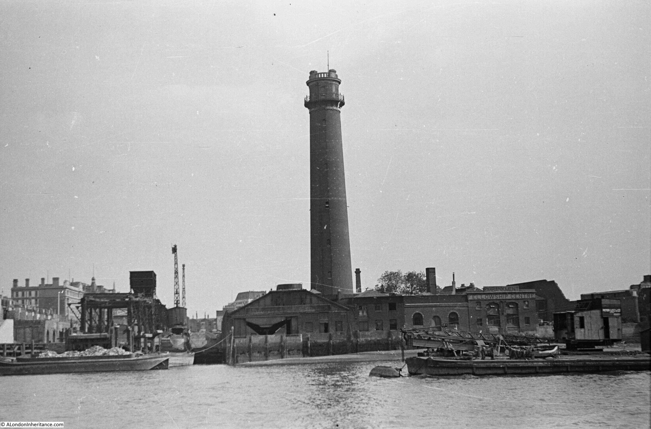
1947 view of the Shot Tower and South Bank

The above photo was taken on Saturday 23rd August 1947, and shows the Shot Tower, and the buildings along the river. The approach to Waterloo Bridge can just be seen on the left of the photo, and on the right would today be part of the Royal Festival Hall.

The same view in 2022 (although a bit too much of the Royal Festival Hall):
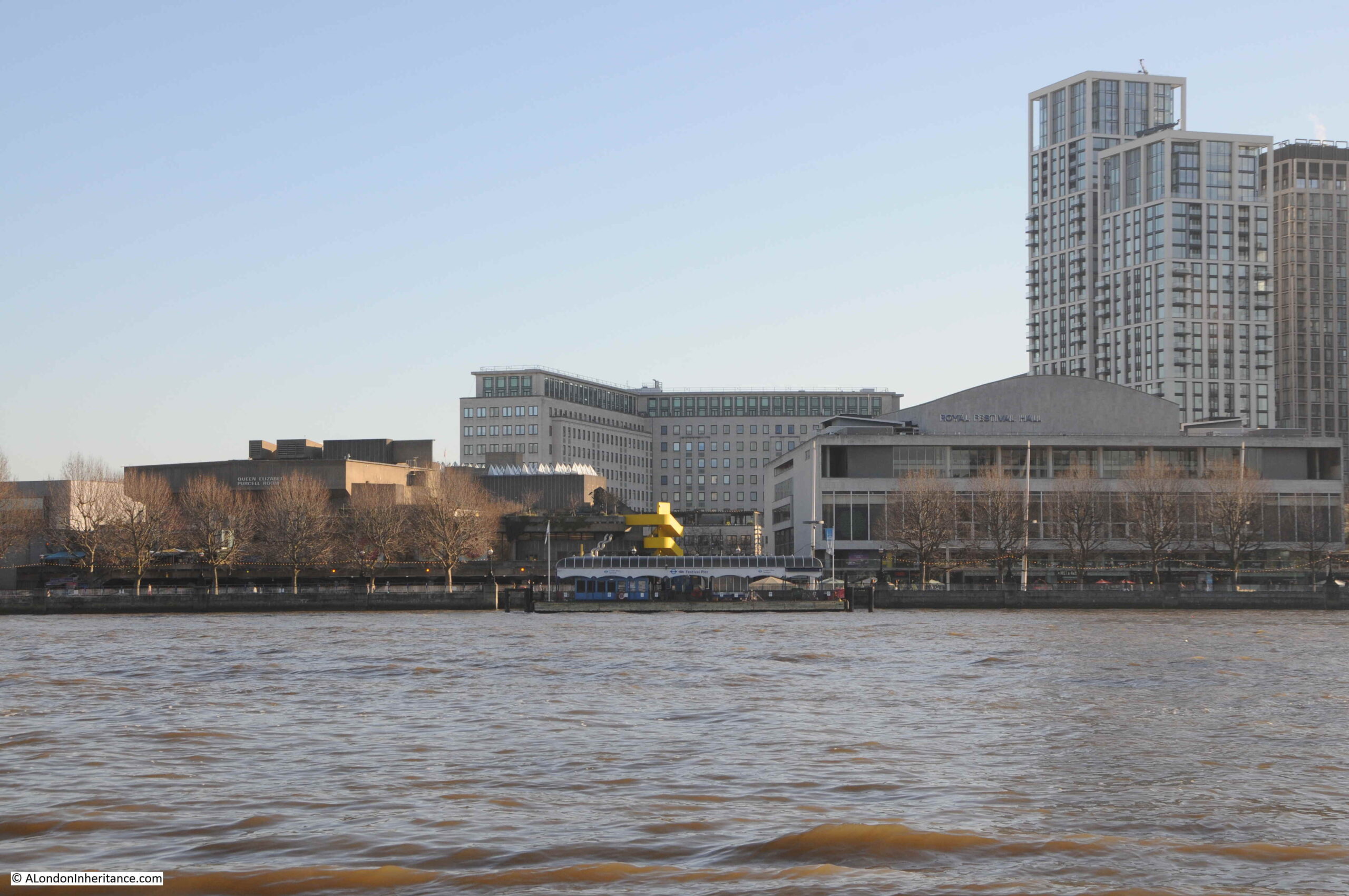
View of the South Bank

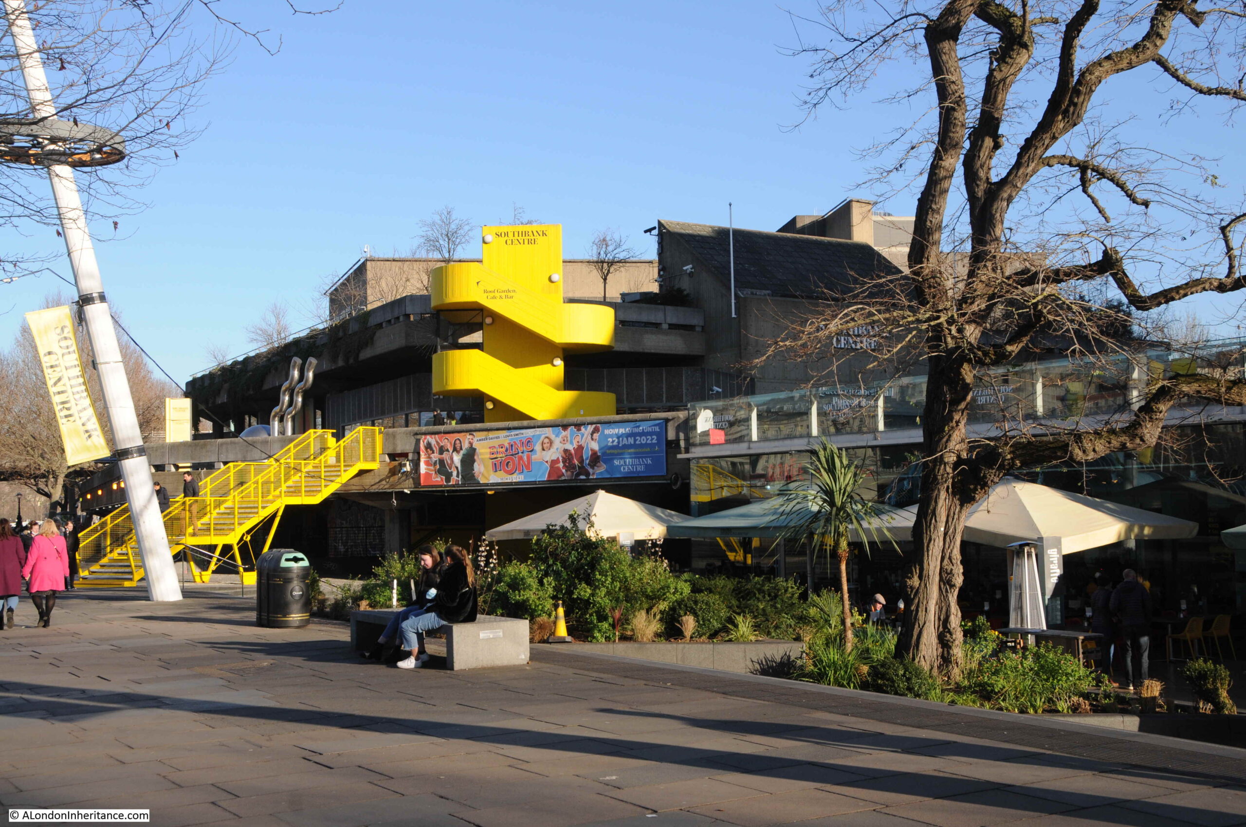
The Shot Tower was just behind and to the left of the yellow stairs seen in the centre of the above photo.

The South Bank today, and the Shot Tower would have been just to the right and further back from the yellow concrete stairs, and the edge of the Queen Elizabeth Hall:
Location of the Shot Tower

The purpose of the Shot Tower, and the process which gave its name to the tower, was the manufacture of lead shot for shotguns.

The Shot Tower was built in 1826 for Thomas Maltby & Company, and in 1839 was taken over by Walker, Parker & Company, who would continue to operate at the site until closure in 1949.

The Shot Tower was designed by David Riddal Roper and stands 163 feet from ground level to the top gallery. A spiral staircase within the tower provided access to two galleries, one half way up from where molten lead was dropped to produce small lead shot, and a gallery at the top of the tower which was used for large lead shot.

It was a considerable brick construction, with 3 foot thick walls at the base of the tower, tapering to 18 inches at the top.

There were a number of shot towers across London, including one on the other side of Waterloo Bridge which I will show later in the post. There was also one in Edmonton and a film was made using the Edmonton tower to show how lead shot was made within the tower.

The film can be found here on the British Pathe site, and shows the process which would have taken place within the South Bank Shot Tower.

The Shot Tower survived the demolition of all the other buildings on the South Bank as part of the clearance for the Festival of Britain, and was included as part of the festival.

It was finally demolished in 1962, clearing the site for the construction of the Queen Elizabeth Hall. A real shame that it was not preserved and space made for it in the design of the new hall. It would have been a fitting reminder of the industrial history of the South Bank.

The Shot Tower survived and was included in the Festival of Britain as it was considered a well known landmark, and as with the lion on the top of the Lion Brewery, there was public concern that such a landmark would be demolished.

The festival organising committee wanted vertical features on the South Bank to draw attention to the site (the Skylon was the primary feature, designed specifically for the festival) and they also wanted the festival to demonstrate Britain’s scientific and technical achievements and advanced British manufacturing, as the country faced the economically difficult post war years and was in desperate need of foreign trade and currency.

The answer was to save the tower, and include it as part of the displays. The very top of the tower was removed and a new structure installed that consisted of a large lamp, emulating a light house, and a large radio dish antenna mounted on an anti-aircraft gun carriage.

The following photo shows the Shot Tower with the additions to the top of the tower for the Festival of Britain:
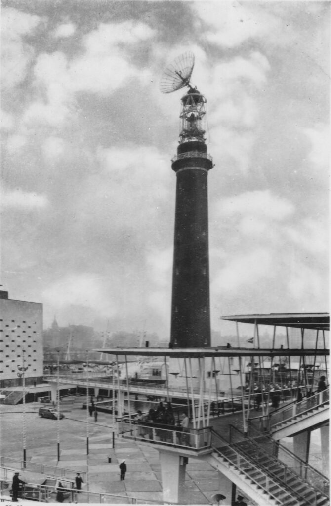
Shot Tower with radio dish and lighthouse

The intention with the radio dish at the top of the tower was described in the Festival of Britain Guide Book, as: “The radio beacon is above the lighthouse optic. The most obvious part of it is a large reflector which beams a signal to the moon. This is part of the radio telescope and is connected with the display in the Dome of Discovery by underground cable. In the Dome visitors can transmit signals to the moon and actually see them reflected back to the earth after about two and a half seconds”.

The display was in the Outer Space section of the Dome of Discovery, and the use of an anti-aircraft gun carriage at the top of the tower on which the radio dish was mounted, was to enable the dish to move to follow the moon in the sky.

The above description of the intended use of the radio dish is from the official festival guide, and the majority of books on the Festival of Britain repeat this planned use, however it seems that a different use for the dish had to be found after the technically advanced parts for such as radio transmitter / receiver were not available in time.

The Illustrated London News on the 21st April 1951 (not long before the opening of the festival on the 3rd of May 1951) records the new use of the radio dish: “There is to be no moon radar telescope on the top of the 200-ft shot tower on the South Bank: instead , visitors will see radio ‘noises’ or atmospherics from outer space on a television screen.” I assume the guide book had already been printed when the change was made.

The display on a TV of radio noise from sources such as the sun was probably far less visibly dramatic than the radio dish on the top of the old Shot Tower, but it did follow one of the Festival’s aims of showing scientific and technical advancements, just not in such a dramatic way as bouncing a radio signal off the moon.

Mounting an anti-aircraft gun carriage at the top of the tower was not without its dangers as this report from the Evening Telegraph on the 26th of October 1950 describes: “GUN CRASHES INSIDE SHOT TOWER – The gun mounting of a 3.7 A.A. gun being hoisted to the top of the Shot Tower at the Festival of Britain site fell 120 feet inside the tower to-day.

A 20-year-old soldier, Edward Bradley, was taken to St Thomas’s Hospital with slight bruises.

The mounting which weighs about five tons was being placed at the top of the Shot Tower. The gun is to carry a radar set which will send pulsations to the moon during the Festival.

Mr. Morrison told the Commons yesterday the equipment would cost £25,000 and would help in the development of radar astronomy.

Gunner Bradley was half-way up the staircase inside the tower, guiding the load, when he was struck by a falling plank. The gun mounting landed squarely in the centre of the tower and broke through the concrete floor to a depth of a foot.

Also inside the tower at the time were Captain Elliott, in charge of the operation, and a sergeant. The sergeant said ‘We heard a noise as if there was something amiss and we baled out of the tower as quickly as possible'”.

Underneath the radio dish was the “lighthouse” which was in operation from dusk until the evening closure of the festival. It was an electrically operated light (described as “of the most modern all-electric design”) with a lamp of three thousand watts, with a second lamp available should the main fail. The glass of the lighthouse optics which focused the light was made by Chance Brothers, the company that had made the glass for the original Crystal Palace in 1851.

The beam from the lighthouse could be seen up to 45 miles away from the South Bank site.

The following postcard showed the Shot Tower at Night. The lighthouse is the lit section at the very top of the tower, not the beam of light shining down from the tower.
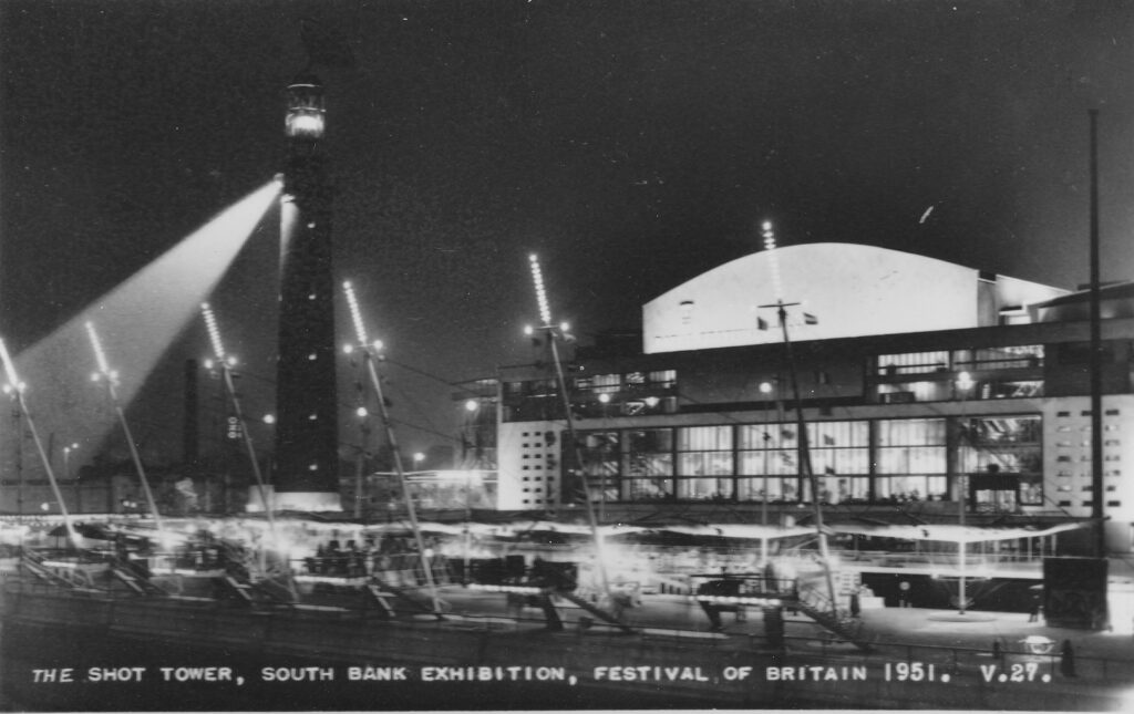
Shot Tower at night

There were discussions on how to decorate the brick tower. Aluminum was suggested (the material was used for the Dome of Discovery and the Skylon), but was deemed too expensive. Cellophane was also suggested but considered a very poor choice. In the end, it was left as the original brick

The two vertical features of the South Bank, Festival of Britain – the Shot Tower, and much taller (300 feet from ground to tip) Skylon:
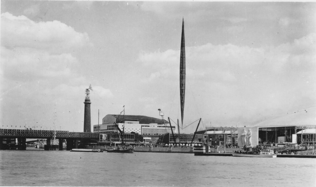
Skylon

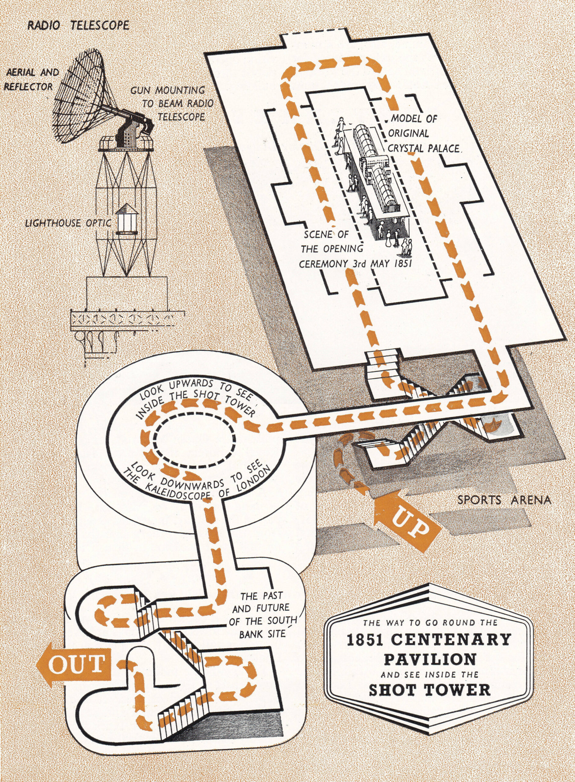
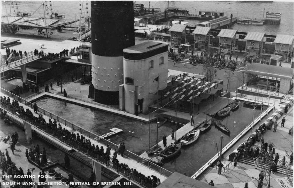
As well as the Shot Tower, a brick building at the base of the tower was retained and used for a small exhibit showing the development of the South Bank site, as well as some control equipment for the radio system at the top of the tower.

A walkway from this building led into the Shot Tower where visitors could look up and see the top of tower, and below a kaleidoscope of changing London scenes was shown.

The following page from the Festival of Britain, South Bank Guide Book shows the Shot Tower and the recommended route:
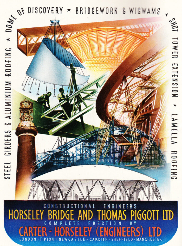
The Guide Book also included a rather good colour advert from the construction engineers who had completed the work to extend the steelwork at the top of the Shot Tower for the lantern and for supporting the anti-aircraft gun and radio dish:
The following postcard shows the base of the Shot Tower and the adjacent brick building which provided the access route to the tower during the festival:
Shot Tower

My father took the following photo at the base of the Shot Tower:
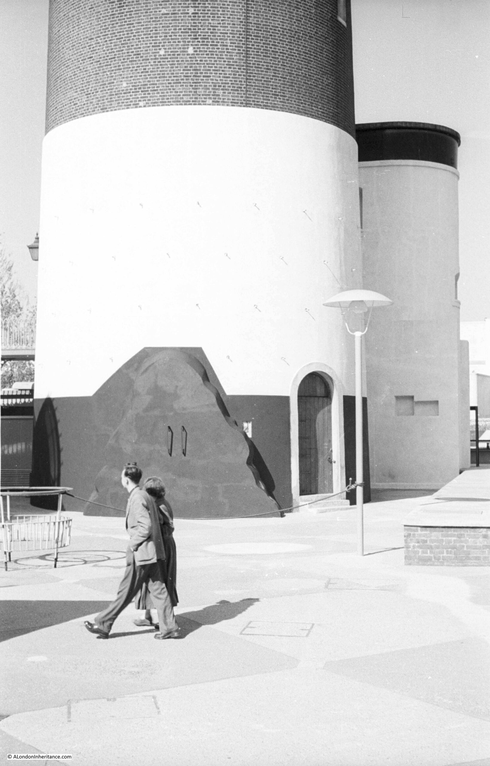
Base of the Shot Tower

Time to return to my father’s original photo and look at the other buildings facing onto the river:
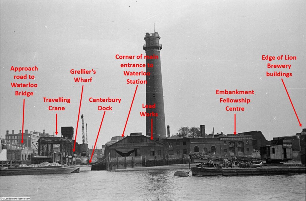
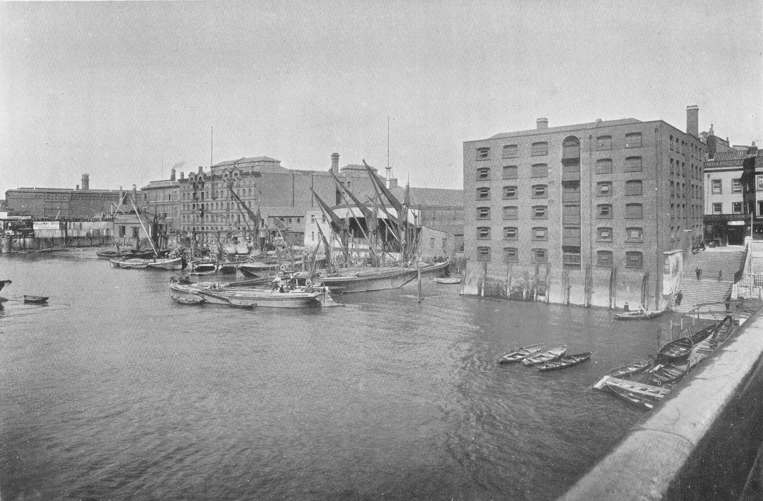
View of the South Bank in 1947

From left to right:

On the far left edge of the photo is the approach road to Waterloo Bridge. Behind the red arrow pointing to the approach road is one of only two buildings that have survived from the photo, the building is now part of King’s College, London.

To the right is a travelling crane and Canterbury Dock that were part of Grellier’s Wharf.

The name Grellier’s Wharf came from Peter Paul Grellier, who opened a stone and marble business at the site between Belvedere Road and the Thames. Auctions were held at the site of imported stone and marble, for example, on the 20th July 1843, there was an auction of “a very large importation of very fine marble, consisting of statuary, black, black and gold, vein, dove and bardilla. This importation is recommended to the attention of the trade, as being of a very superior description”.

Canterbury Dock was a small inlet of the river into the site. The name Canterbury came from the Archbishop of Canterbury who was a major landowner in the area (and is also why many of the streets with housing developed in the area between Belvedere Road and Waterloo Station in the 19th century were named after Archbishops of Canterbury).

Slightly to the right, in the background can be seen a small part of the main entrance to Waterloo Station, the second building that remains from the 1947 photo.

The buildings of the lead works are next with the Shot Tower behind.

To the right of the Shot Tower, along the buildings facing the river, there is one with the name “Embankment Fellowship Centre” along the top of the building. An enlargement from the original photo is below:
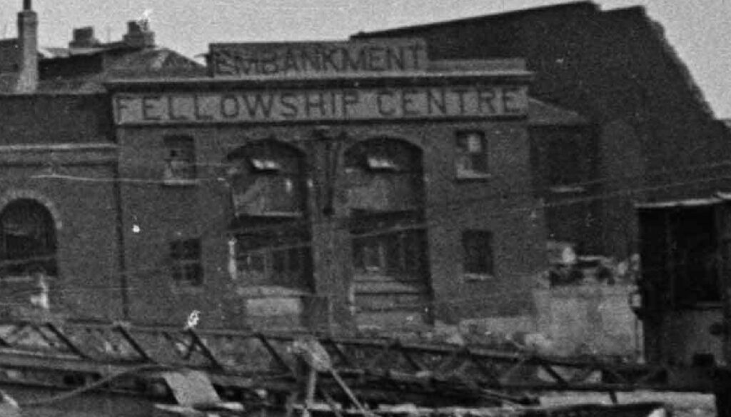
Embankment Fellowship Centre

The Embankment Fellowship Centre was a charitable organisation with an aim of helping unemployed ex-servicemen who had fallen into poverty. Established in 1932 by Mrs. Gwen Huggins the wife of the Adjutant of Chelsea Hospital. She decided to do something to help the ex-servicemen she saw sleeping rough in London, and along the Thames Embankment.

Originally known as H10, and changing name to Embankment Fellowship Centre in 1933, the following article from The Sketch on the 30th of August, 1939 provides a good summary of the organisation’s approach and what took place on the south bank:

“The EMBANKMENT FELLOWSHIP CENTRE provides a constructive solution to the unemployment problem where it affects its most difficult victim, the middle-aged ex-Service man from the Navy, Army, R.A.F., or Mercantile Marine. The Centre does not cater for the vagrant, the work-shy, or the waster, but can claim that every man helped has been reduced by sheer misfortune and no fault of his own to the lowest ebb of poverty.

Painters, doctors, miners, schoolmasters, chauffer’s, stockbrokers, plasterers, mechanics and clerks are all among those who have been assisted. The credentials of all applicants who must be over forty-five, are carefully examined before admission to the Centre, where they are housed, fed and re-clothed and maintained for a period averaging 47 days per case. When a man reaches the Centre he has usually been through a bad period of stress, so the first task is to ‘recondition’ him. To that end he is surrounded by an atmousphere of cheerfulness, comfort and companionship. In the daytime he has occupational work, and every evening he has something to look forward to – a lecture, a show by an amateur dramatic society, a game of darts or billiards, or a film.

Meanwhile officials endeavour to find suitable employment for him; and since many applicants belong to overcrowded or depressed trades, the Fellowship Centre undertakes free training in its own workshops for employment in which middle-age is only a slight handicap, such as valeting, housework, cookery, carpentry, boot and shoe repairs, and so on.

Last year employment was found for 549 men, at an average age of 53 years. The total could have been larger had the premises been capable of accommodating more men. During the past four years some 2000 men have been found employment at an average age exceeding 50 years. Included in the Centre is the Ward of Hope, where a period of free convalescence is provided, following discharge from hospital for homeless and friendless men.

The Council are trying to solve the problem of expansion. They are also trying to raise capital for maintaining a country home, to be modelled on Chelsea Hospital, where veterans of good record with no pension and past the working age can be housed.

Subscriptions to this excellent cause to be sent to Major R.M. Lloyd, Appeal Director, the Embankment Fellowship Centre, 59 Belvedere Road, S.E.1.”

The Embankment Fellowship Centre made a film in 1939 telling the story of a middle aged man named Smith, who lost his job, and could not get another because of his age. Things went downhill quickly with the family possessions being repossessed until he was recommended to the centre. With the centre’s help, he found a new job, and the last scene of the film is Smith and his wife agreeing to donate his recent pay rise to the Embankment Fellowship Centre.

The film “Smith” can be watched here.

The centre on the South Bank was closed not long after my father took the photo, and Hansard records a question in Parliament about the closure, when on the 23rd September 1948, Commander Noble “asked the Minister of Health why the Embankment Fellowship Centre, Lambeth, which provides accommodation for ex-Service men, has just been given notice to quit by 1st December”

Mr. Bevan answered “I understand that this and other notices are occasioned by a London County Council scheme for the redevelopment of the area of the South Bank in which this centre lies.”

The redevelopment of the South Bank would lead to the Royal Festival Hall and the Festival of Britain.

The Embankment Fellowship Centre relocated, and in 2007 changed name to  ‘Veterans Aid’, and is still in operation.

Veterans Aid have their main London centre at ” New Belvedere House”, which is rather nice as hopefully the intention was to name the building after the original location at 59 Belvedere Road on the South Bank.

On the right edge of the 1947 photo is part of the Lion brewery. It would be demolished to make way for the Royal Festival Hall which would be built on the land to the right of the Shot Tower.

The South Bank Shot Tower was not the only shot tower along the south bank of the river. The following postcard is a view from the top of the Shot Tower, looking towards the City of London:
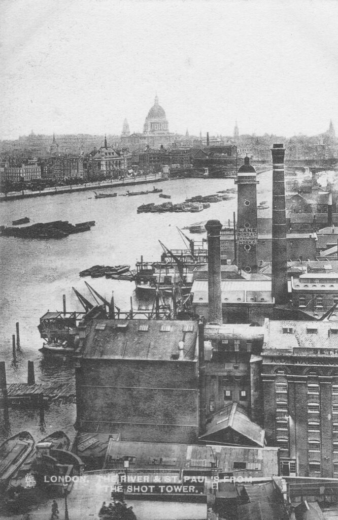
View from the Shot Tower

Between the two chimneys is a much wider tower, with a dome shaped top. This was also a shot tower, and was older than the one on the South Bank.

Built around 1789, it was described as “a new structure, which cost near six thousand pounds, but cannot be considered as an object ornamental to the River Thames”. It was 150 feet high, and in 1826 the top part was destroyed by fire, which was not surprising given the activity carried out within the tower.

The lead works which included this second shot tower were also owned for a period by Walker, Parker & Company, the same company that owned the South Bank Shot Tower. They left the works in 1845 to concentrate on their South Bank site. The site was advertised in the Morning Chronicle on the 9th October 1845 as: “EXTENSIVE LEAD WORKS, Shot Tower, Wharf, Dwelling-house, and Buildings, Commercial-road, Waterloo-bridge. To be LET on LEASE for twenty one years, from Michaelmas next, when possession will be given in one or two lettings, all those capital and spacious PREMISES, with Wharf, extending about 120 feet next the river Thames, with the lead works, shot tower, and buildings lately occupied by Messrs.’ Walker and Co. Also a counting house, extensive stabling and premises, lately occupied by Mr. Sherwood”.

By the time of the above photo, the large advertising sign on the side of the shot tower was advertising that the works were “Lane, Sons & Co Limited. Lead and Shot Works”.

The street name in the advert is given as Commercial Road. This was a short lived name for the street which is now Upper Ground.

The shot tower was demolished in 1937 after having been out of use for several years. Today, the IBM offices (in the photo below) occupy the site of this second shot tower and lead works:

It is such a shame that the South Bank Shot Tower could not have been included in revised plans for the Queen Elizabeth Hall, and could today be seen between the Queen Elizabeth and Royal Festival Halls.

A reminder of the industrial history of the area, and adding some historical complexity to the buildings we see today, lining the side of the river.

alondoninheritance.com

East London 1980s Shops – Fordham Street

Thanks for the feedback to last week’s post. The pub at the top of the stairs leading down to the Thames, next to Westminster Bridge Road was identified as the Coronet, and there is a good drawing of the pub and the stairs on the Closed Pubs site. It was good that I did not get any comments or e-mails that the bronze box beneath the foundation stone of County Hall has been removed, so hopefully it is still there for archaeologists in the distant future to dig up.

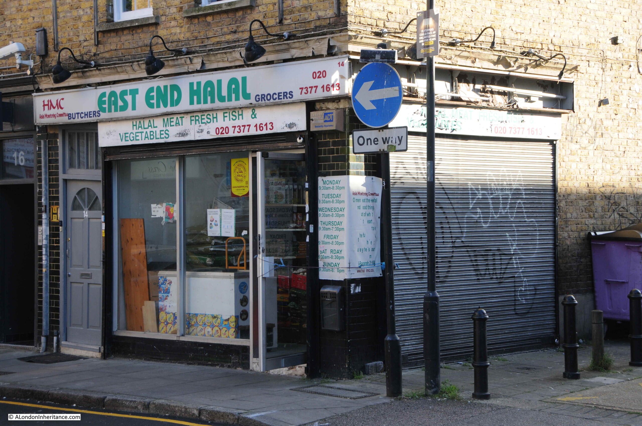
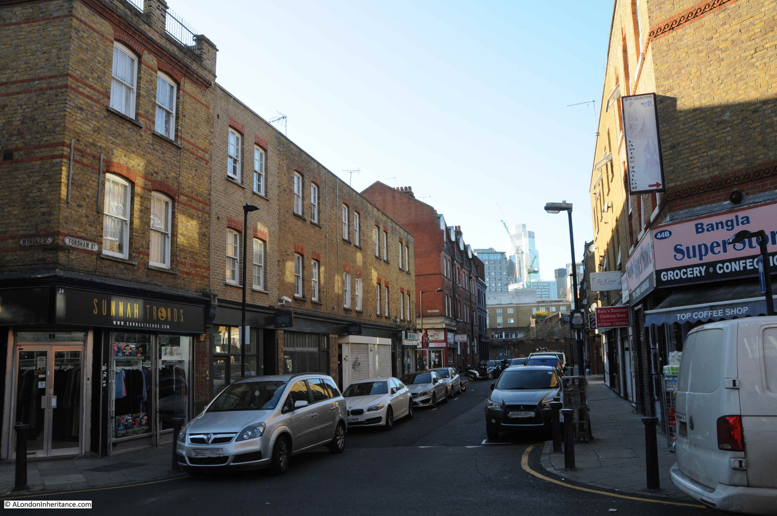
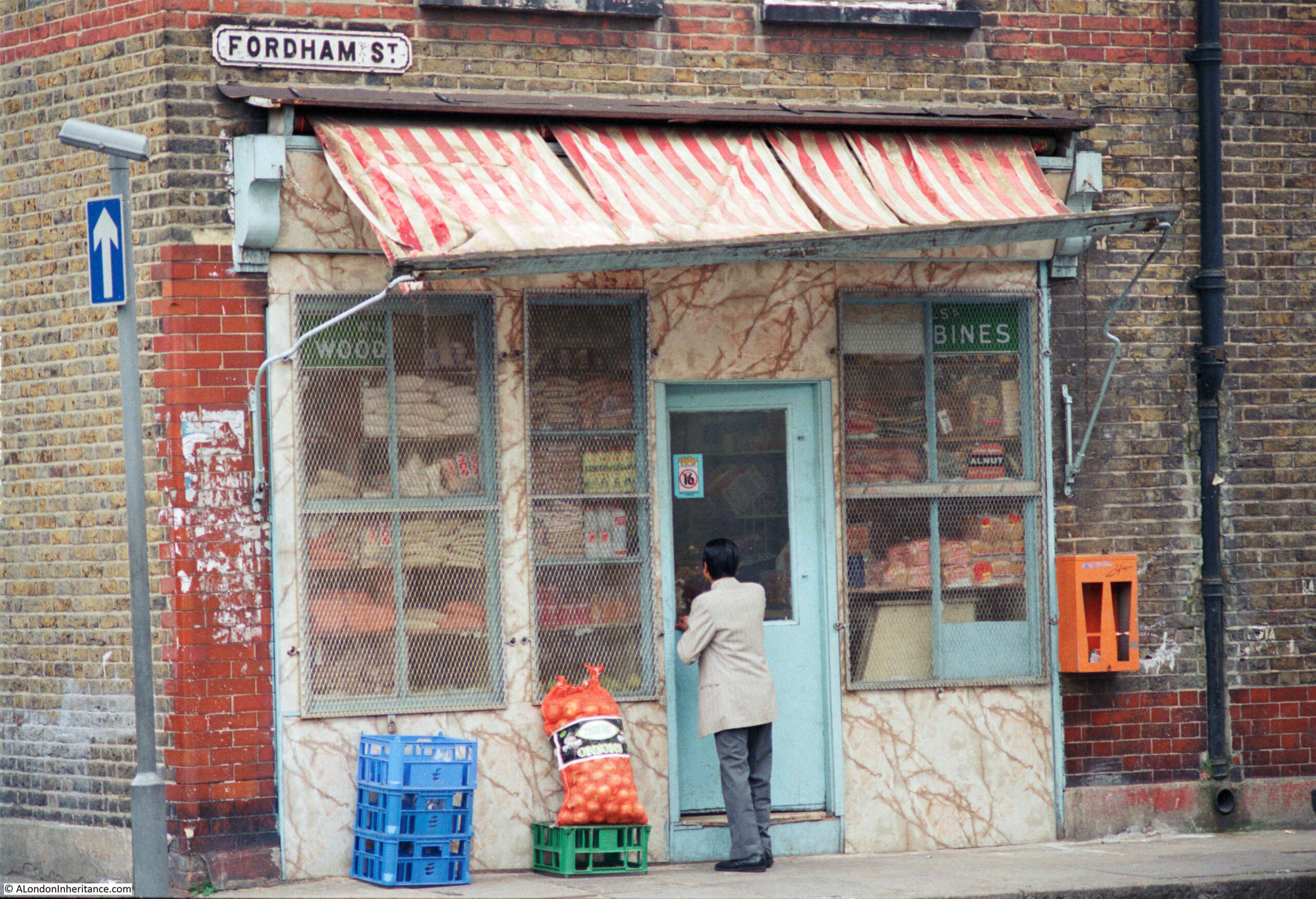
For this week’s post, I am in East London, looking for the location of a shop in Fordham Street, photographed here in 1986:

Fordham Street

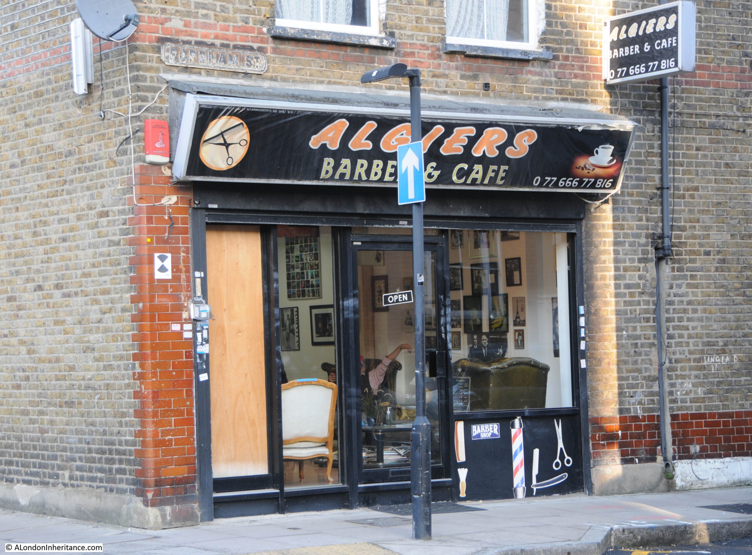
The same location today. The old general stores type of shop has been replaced by the Algiers Barber and Café:

Fordham Street

The 1986 photo is typical of the type of shop. Goods piled high in the window, bread, bottles of Fairy Liquid and Woodbines advertising running along the top of the window.

No idea whether that is a customer entering the shop, or the owner locking or unlocking.

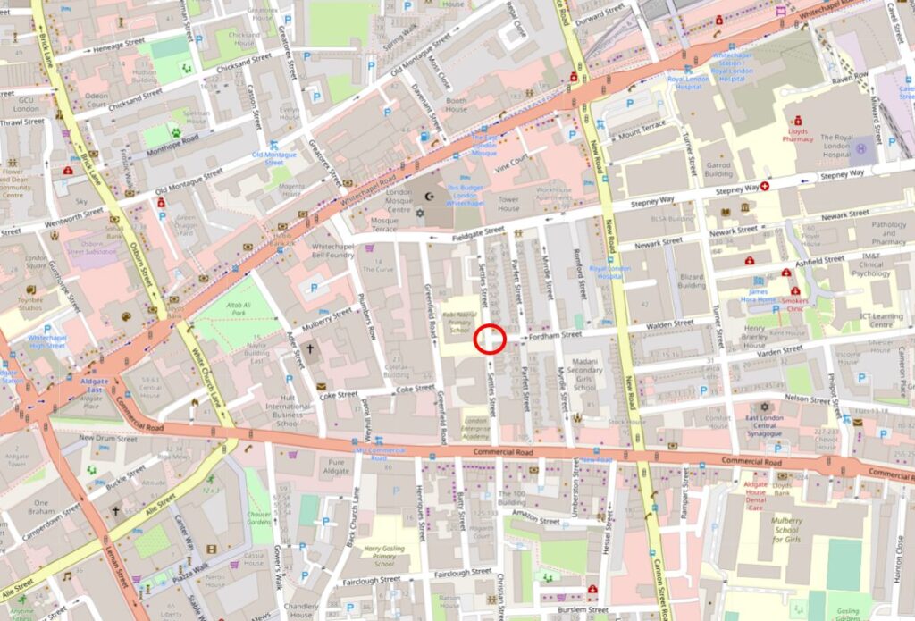
Fordham Street is in the heart of east London, roughly half way between Whitechapel and Commercial Roads. The street leads from New Road which is a main street leading between Whitechapel Road and Commercial Road, and is part of a residential area that has long housed the changing populations of east London.

In the following map I have circled the location of the shop photographed at the top of the post:

Fordham Street

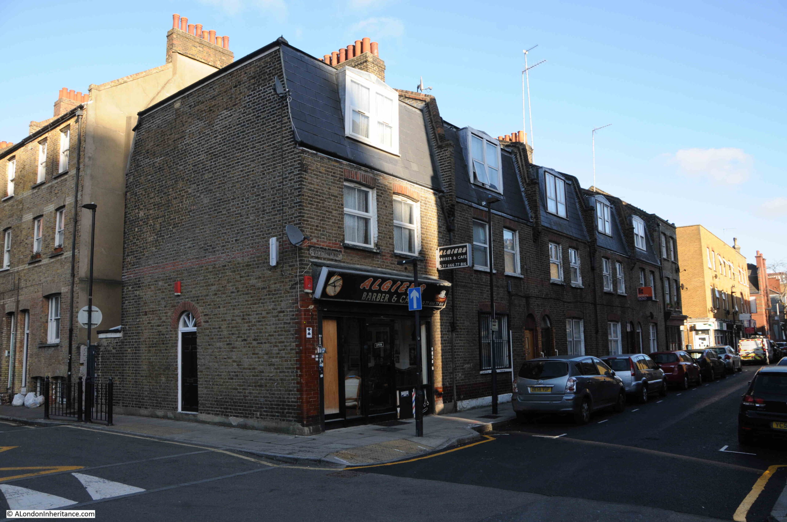
A view of the corner location of the shop, at the end of a short terrace of houses:

Fordham Street

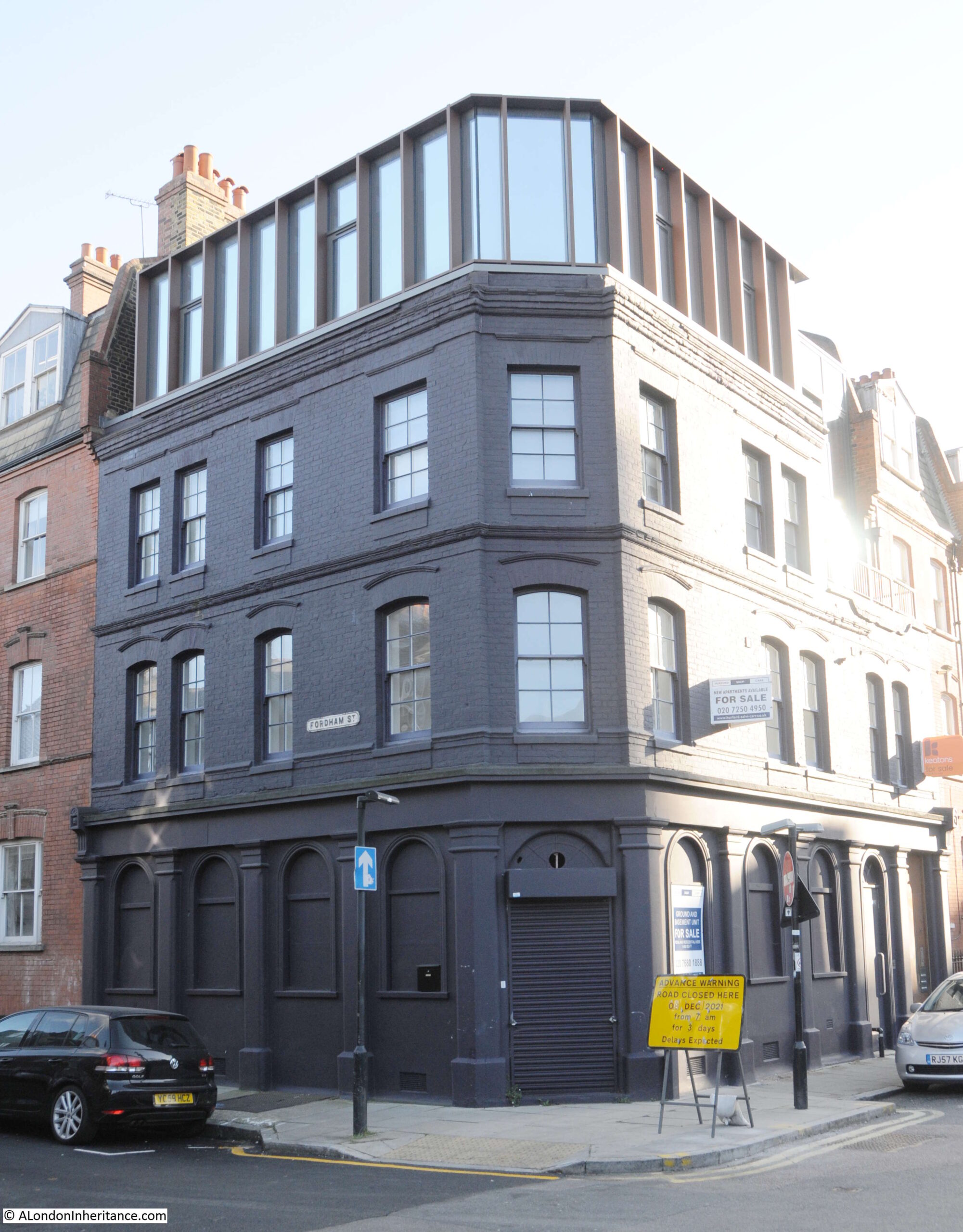
Although a relatively short street, as was typical in east London of old, the street had two pubs, both now long closed. On the corner opposite the shop is the building that housed one of the pubs:

Bricklayers Arms pub

The pub was the Bricklayers Arms. I can find very little information about the pub, and there are only a couple of newspaper reports that mention the Bricklayers Arms. The first is when a 19 year old labourer, Frederick Perrie was sentenced to six months hard labour after trying to use a counterfeit florin in the pub in 1893.

Throughout the first decade of the 20th century, Friday evenings seem to have been the time when the East London (Jewish) branch of the London Central Council met in the pub. Regular adverts about the event featured in newspapers. The licensee at this time appears to have been Isaac Ernest Marks.

The last reference to the pub is in 1911 when Isaac Ernest Marks had his license renewed. It does not appear to have stayed open long after 1911 as Closed Pubs suspects the pub was closed by the 1920s, and there are no newspaper reports mentioning the pub after 1911.

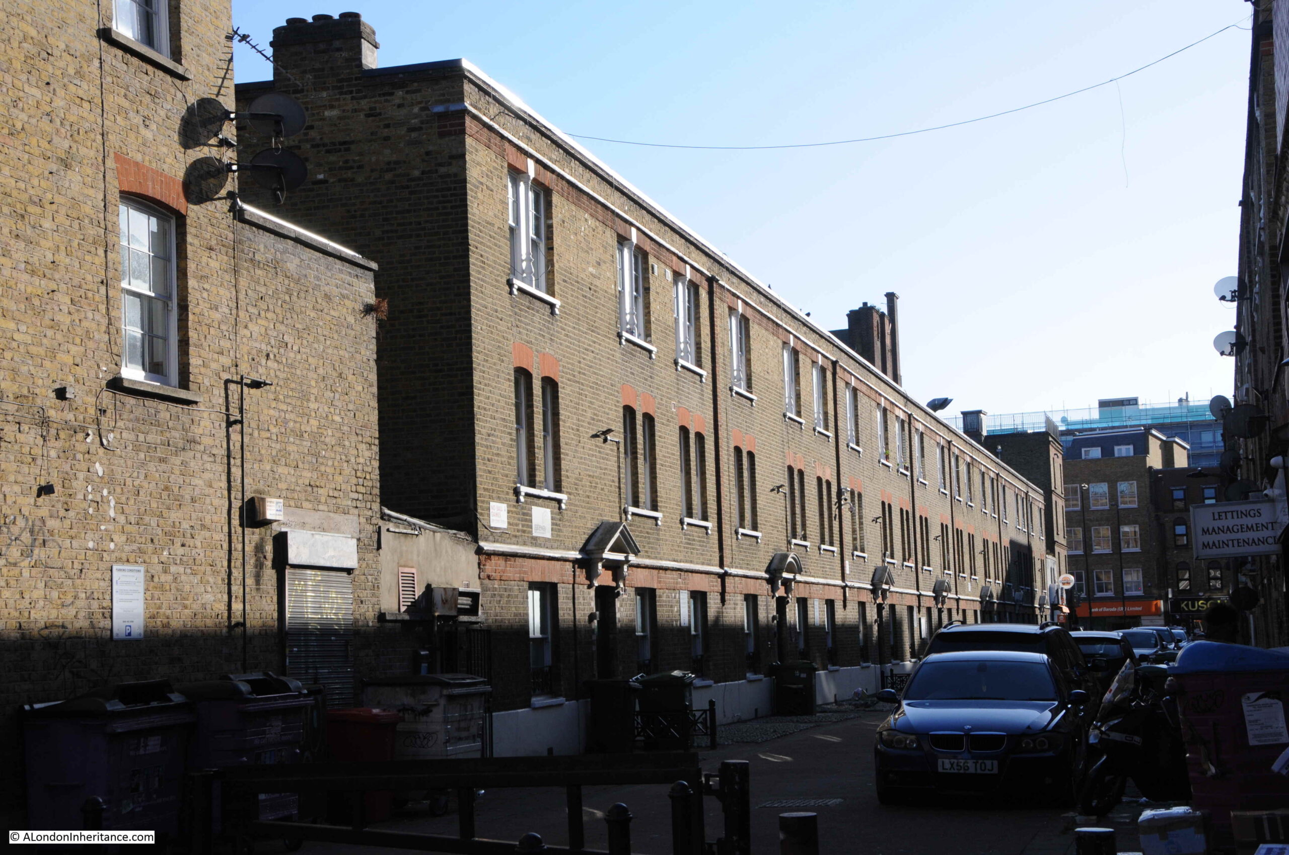
Pubs such as the Bricklayers Arms would have served those living in the densely populated terrace housing that lined the streets around Fordham Street. Whilst many of these have been demolished, some remain, although the following photo shows the challenges of taking photos with a low winter sun on a bright day:

Fordham Street

Many of the corner shops in Fordham Street have survived, and have changed over the 20th century to serve the changing population of east London:

Fordham Street

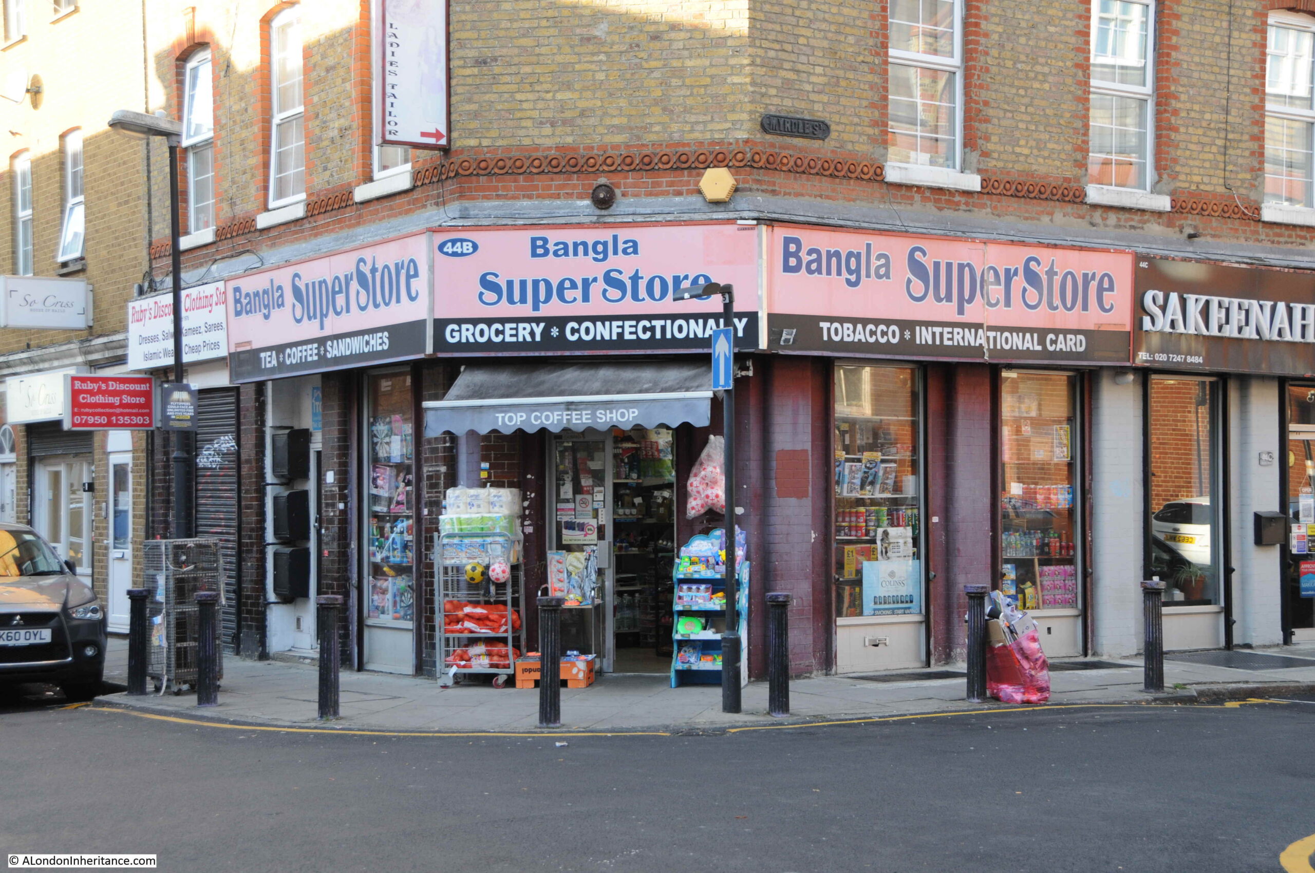
The second pub in the street was the Duke of York. The Bangla Super Store on the corner of Fordham Street and Myrdle Street now occupies the building that was once the pub:

Duke of York pub

The Bangla Super Store maintains the tradition of a corner shop stacked high with a wide range of goods for the local community.

Rather strangely, I cannot find any newspaper report mentioning the Duke of York, and cannot find any record as to when the pub opened or closed. It is marked as a Public House on the 1894 Ordnance Survey map of the area, and the building has the large, flat corner on the upper floors, so typical of 19th century pubs where their large pub name / advertising signs were located.

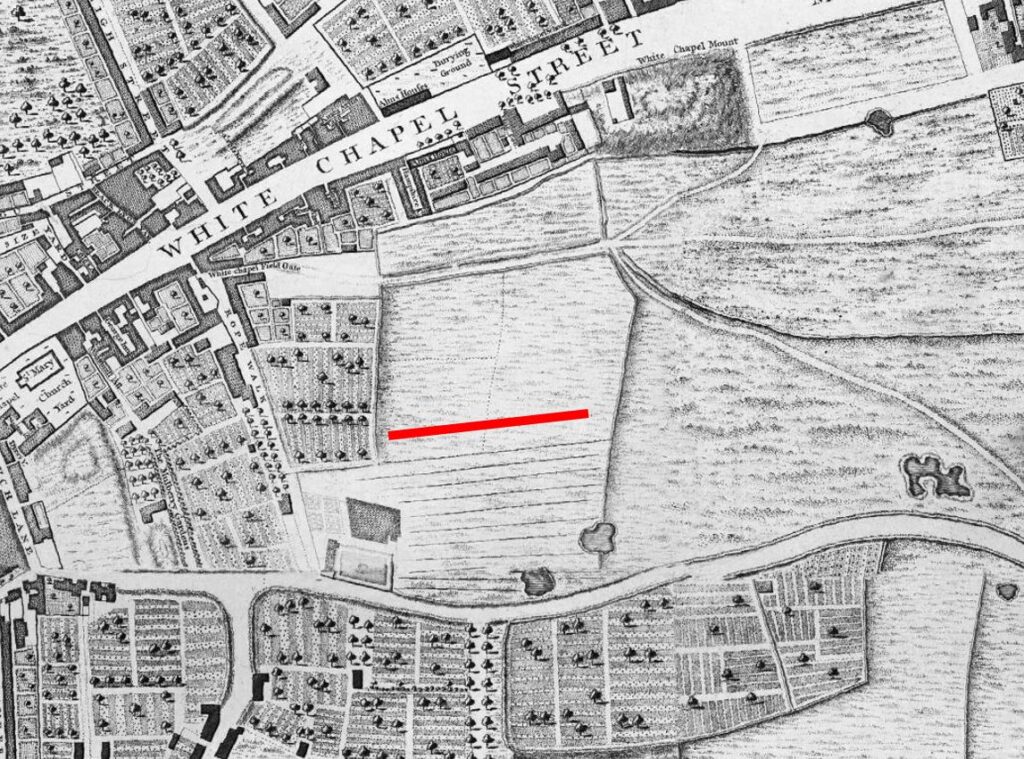
Myrdle Street runs across Fordham Street, and the straight lines of this network of streets indicate that they were laid out as part of a significant development of the area, however the street plan that we see today appears to be the second since the fields that once covered the area were built on.

In 1746, John Rocque’s map was showing the area now occupied by Fordham Street as a field, surrounded by other fields, ponds and cultivated land (the red line indicates the future location of Fordham Street):

Fordham Street

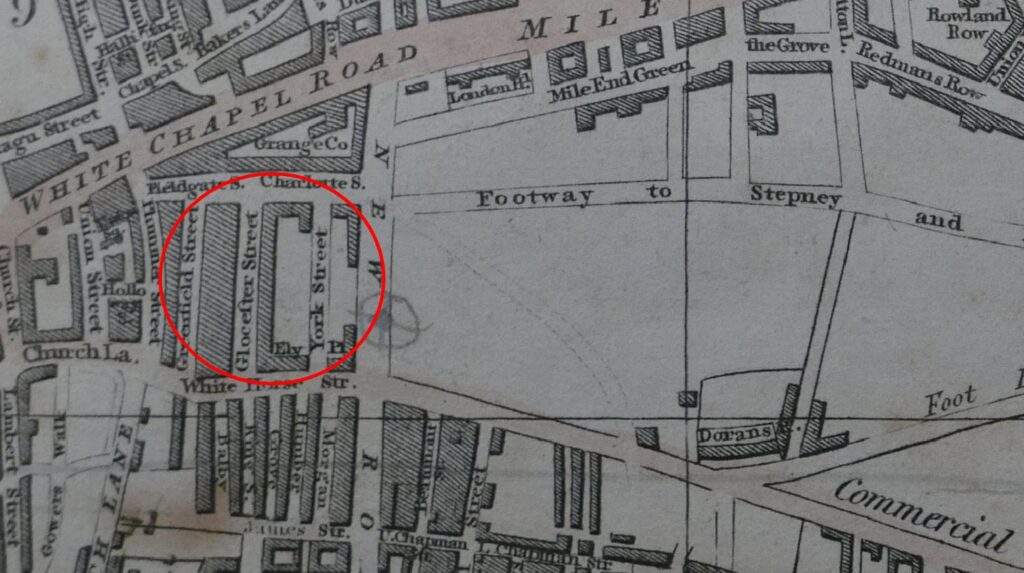
The following is an extract from the 1816 edition of Smith’s New Plan of London. I have ringed the area now occupied by Fordham Street and surrounding streets:

Fordham Street

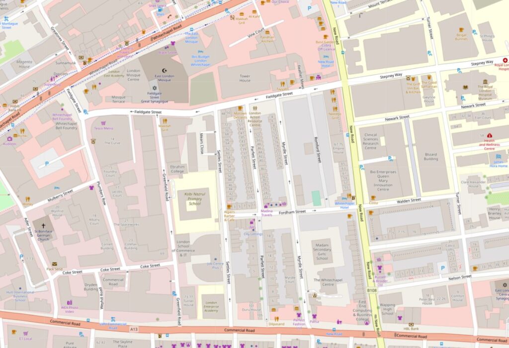
Comparing with the map of the area today (see below), and the streets, along with their street names are very different. To confirm the location, Whitechapel Road runs along the top of both maps, the start of the Commercial Road development runs along the lower part of the 1816 map, and one of the few consistent street names is Fieldgate Street which runs just south of Whitechapel Road in both maps.

New Road can be seen in both maps, new as this was a major new road built as part of the development of the area.

I cannot find exactly when Fordham Street was initially developed. It is shown in the 1894 OS map. The first newspaper reports which mention the street date to the 1880s, including one from 1886 which advertises a building plot available to be leased in Fordham Street.

Charles Booth’s poverty maps include Fordham Street, with the occupants of the street falling within the classification “Mixed. Some comfortable, some poor”. There was one area described as “Very poor, casual. Chronic want” on part of the land now occupied by Fieldgate Mansions (see further in the post). The street may then date to the early 1880s, however this does seem rather late.

I like that the Footpath to Stepney in the 1816 map is now the Stepney Way, to the upper right of the following map.

Fordham Street

So the streets we see today are not those from the original development of the area, and were built in the decades following the 1816 map. Interestingly, in 1816 there was a York Street roughly where Myrdle Street is today, where the Duke of York pub was located on the corner with Fordham Street, so this lost pub may have been named after the name of the original street.

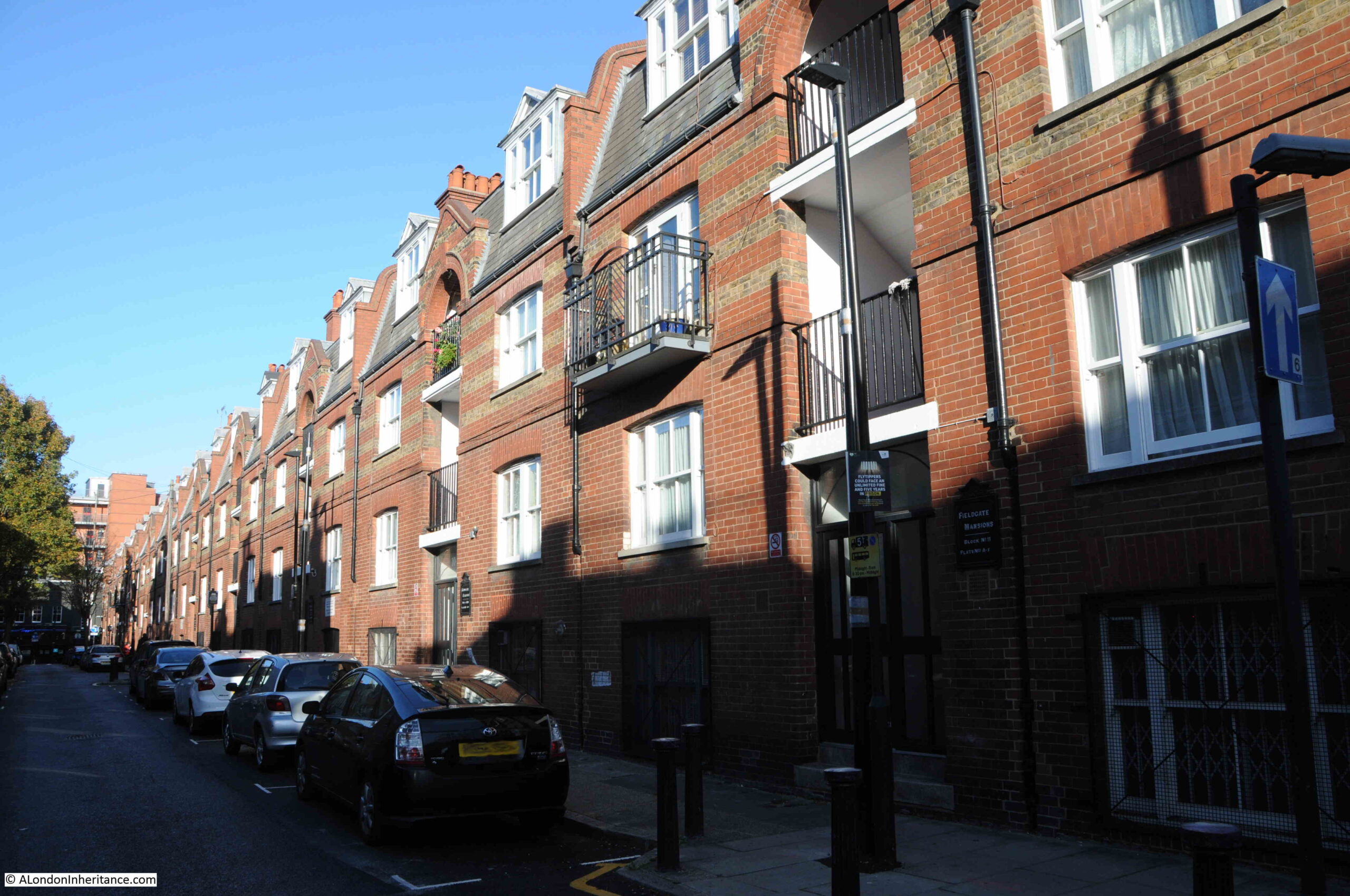
Myrdle Street was a long run of terrace houses, but one side of the street has been replaced by Fieldgate Mansions:

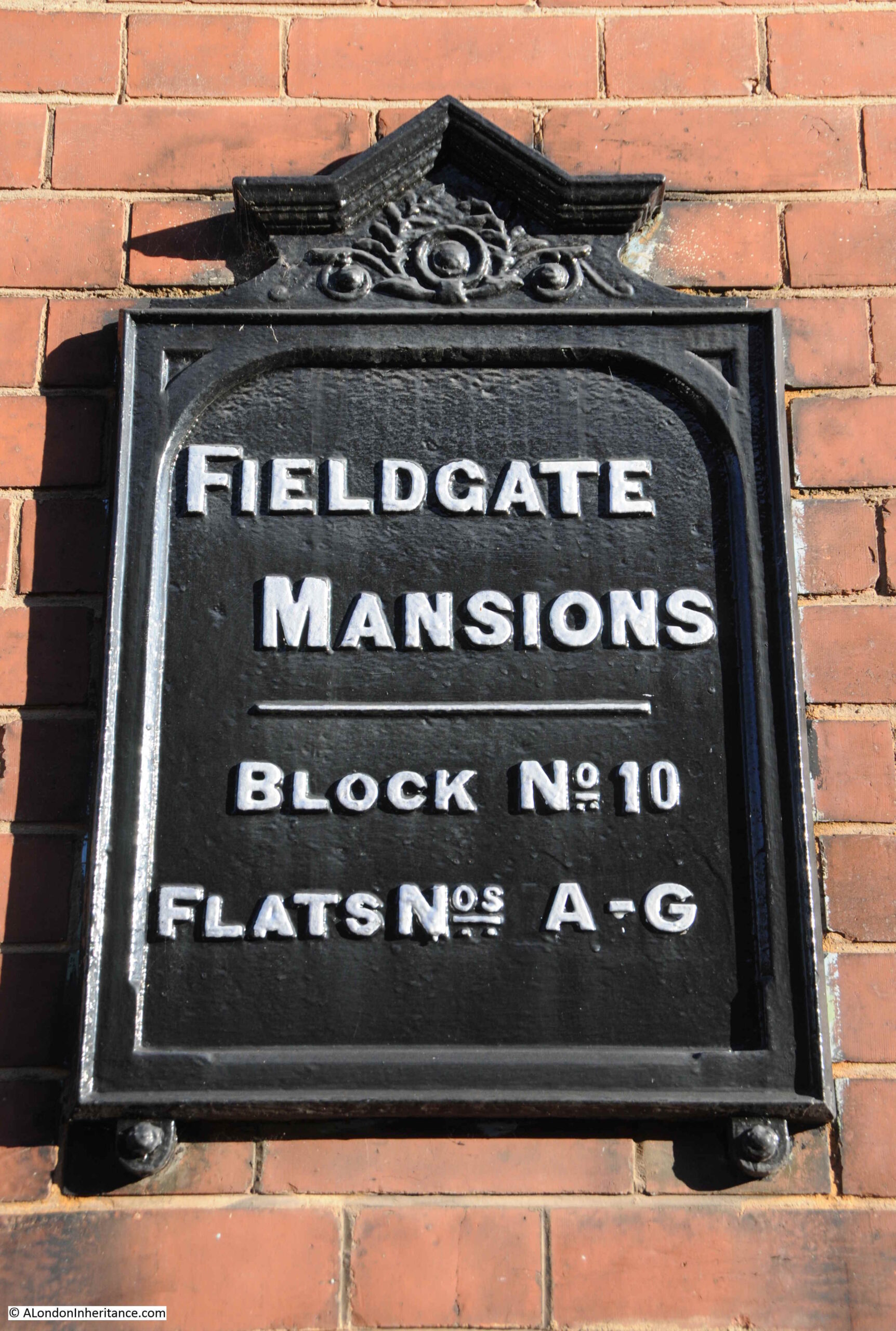
Fieldgate Mansions

Fieldgate Mansions is a large complex of tenement dwellings that extend along Myrdle Street and further back towards New Road. They were built between 1903 and 1907 to replace the much smaller terrace houses that ran the length of the street. They take their name from Fieldgate Street which runs at the northern end of Myrdle Street.

The original tenants were mainly Jewish immigrants, which probably explains why meetings of the East London (Jewish) branch of the London Central Council were held in the pub at the end of Fordham Street.

Post war, the blocks were neglected by their landlords, some had suffered bomb damage, and by the early 1960s prostitution was a considerable problem in the area.

Many of the apartments in the blocks were empty by the late 1960s and 1970s, and were occupied by squatters campaigning for the restoration and use of derelict property.

They were redeveloped during the 1980s and it is the restored Fieldgate Mansions that we see today:

Fieldgate Mansions

Unlike the Duke of York pub, there are plenty of references to Fieldgate Mansions in the press, that tell of everyday life, and the challenges of those who lived here.

On the 4th of December 1942, the East London Observer has a Naturalization Notice, where “Notice is hereby given that H. LEVY of 48, Fieldgate Mansions, Myrdle Street, E.1. is applying to the Home Secretary for naturalization, and that any person who knows any reason why naturalization should not be granted should send a written and signed statement of the facts to the Under-Secretary of State, Home Office, S.W.1.”

On the 5th December 1941, Fieldgate Mansions were advertising for “two fire watchers, good references essential”. An important role where fire watchers would look out for fires started by incendiary bombs and then do their best to extinguish fires before they took hold. This was a role my grandfather had in his flats.

A strange case reported on the 31st March 1944 was when Morris Lakin, 32, a traveler of Fieldgate Mansions was in court accused of receiving stolen goods, described as property of the Canadian Army. A strange combination of “five revolvers, 83 rounds of ammunition and 63 pairs of woollen socks”. He was also charged, along with two others of receiving a “quantity of cosmetics, a wireless set and an Eastman cutting machine”.

The tenants of so many east London apartment blocks were subject to rent rises, and there were frequent strikes where tenants refused to pay their rent. On the 4th of July 1939, one rent strike ended and another began “Sixty-four tenants of Fieldgate Mansions, who have withheld their rents for 20 weeks, have reached agreement with their landlord. Rent reductions are to be made from May 1st, some amounting to 3s a week. At Linden Buildings, Brick-lane, Bethnal Green, 68 tenants started a rent strike yesterday”.

Just five years where within Fieldgate Mansions we have rent strikes, protecting the community by fire-watching, stolen goods, and H. Levy’s application for naturalization.

Myrdle Street crosses Fordham Street and on the south-western corner of the junction is another business housed in what was an original corner shop. The wooden decoration just visible around the top and to the right of the current shop signs demonstrates that this has long been a corner shop.

Fordham Street

The following photo shows the view west, along Fordham Street at the junction with Myrdle Street. The towers of the City can be seen in the distance.

Fordham Street

Fordham Street is a very ordinary east London street, but it can tell so much about how the area has developed from the field of the 18th century to the network of streets we see today.

The demise of east London pubs, changing populations, and snapshots of the lives of people who have made this part of the city home for a brief few years.

alondoninheritance.com

County Hall and a Roman Boat

Today, the River Thames runs between embankments on the north and south sides of the river, embankments built over the last 160 years, and were still being completed in the 1980s. For centuries the river had an extended foreshore which would shift with the tides, and particularly on the south bank, large areas of wet, marshy land.

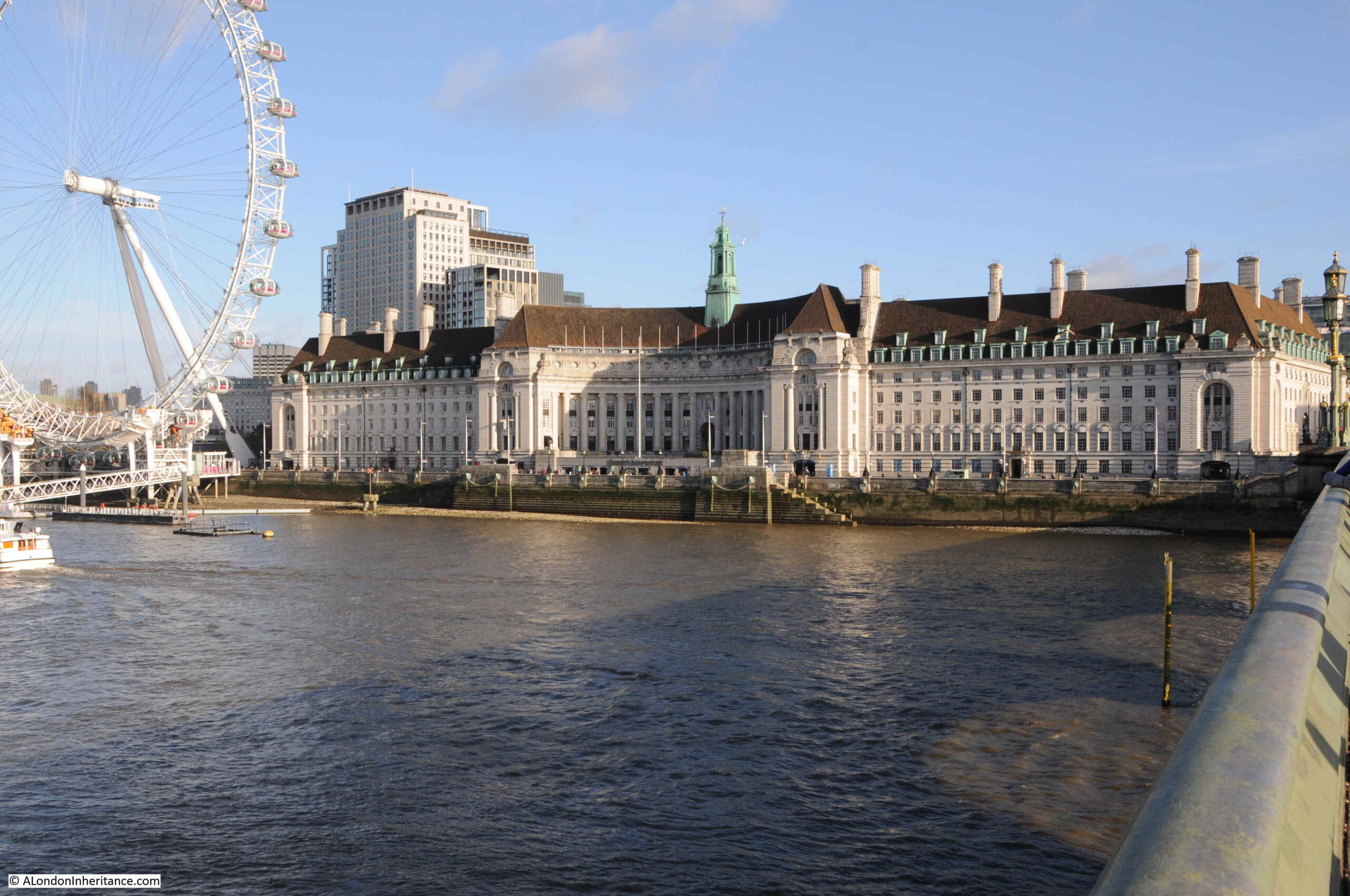
One stretch of the embankment, built during the first decades of the 20th century, is the stretch in front of County Hall, the purpose built home of the London County Council, then the Greater London Council, and now home to hotels and tourist attractions.

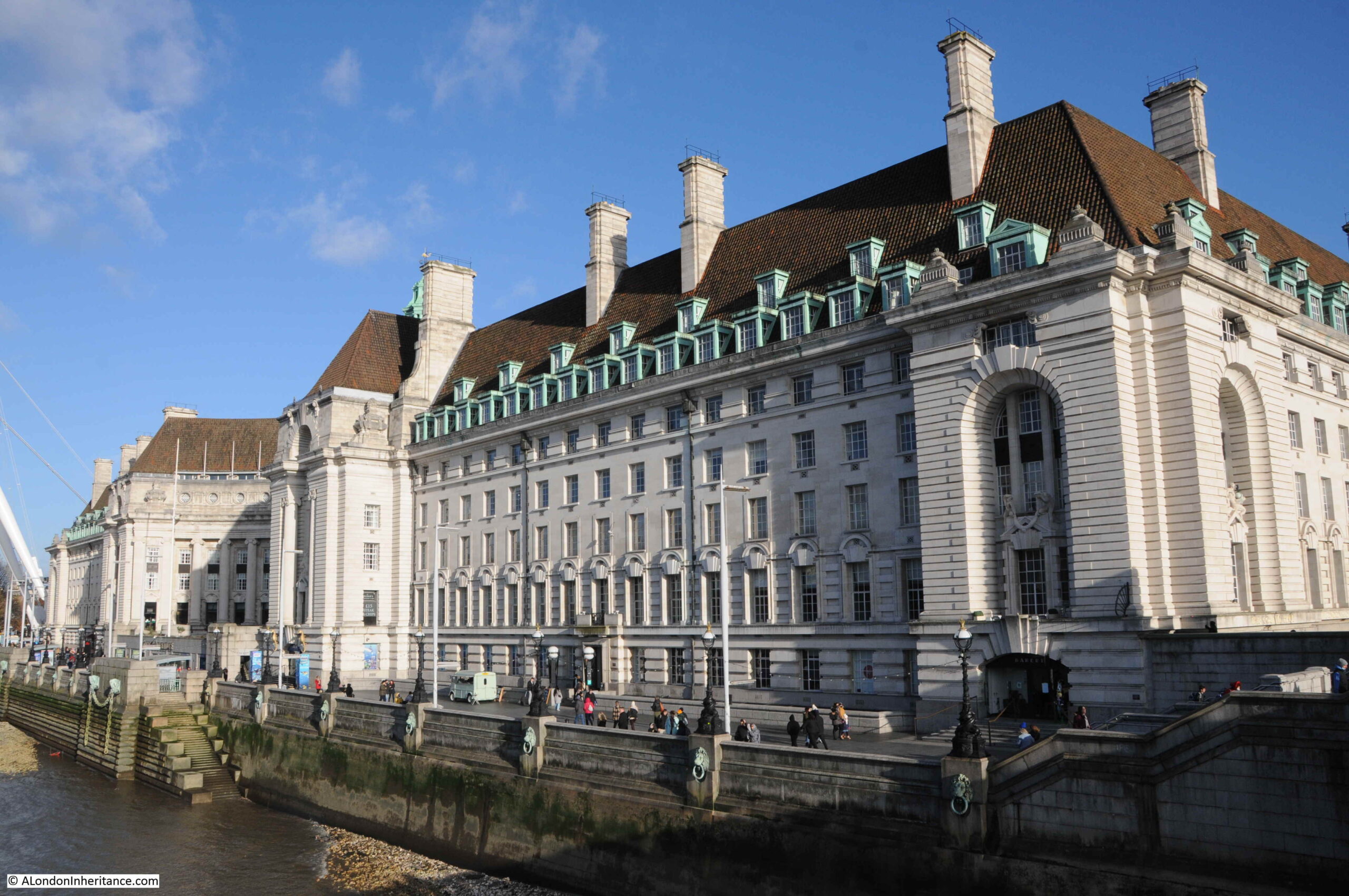
County Hall photographed from Westminster Bridge:

County Hall from Westminster Bridge

The London County Council was formed in 1889 to replace the Metropolitan Board of Works and to gradually take on powers covering Education, Health Services, Drainage and Sanitation, Regulation and Licensing of a whole range of activities, dangerous materials, weights and measures, street Improvements – there was hardly an aspect of living in London that would not be touched by the LCC.

The problem with having all this responsibility was that the LCC also needed the space for all the elected officials and the hundreds of staff who would deliver the services.

The LCC initially had an office at Spring Gardens, near Trafalgar Square, the old home of the Metropolitan Board of Works, but quickly started looking for a new location as staff began to be scattered across the city.

A wide range of locations were suggested, but they were either too small, too expensive or too close to the Palace of Westminster – the London County Council wanted to be seen as a completely separate authority to the national government, but still wanted a prominent location, suitable for the governance of London.

The LCC already had a Works Department which occupied a small part of a site on the South Bank, to the side of Westminster Bridge.

The new St Thomas’ Hospital on the other side of Westminster Bridge had already started the improvement of the Lambeth side of the river, which included the creation of a large formal embankment.

The land across Westminster Bridge Road from the hospital provided a sufficient area for the LCC with space to grow. It was in a prominent position, directly facing onto the river, and importantly was on the opposite side of the river to the Palace of Westminster so was close to, but separate from the national government.

As the site was being acquired, attention turned to the design of the new building, and a competition was organised to invite designs for the new home of the LCC.

There were some incredibly fancy and ornate designs submitted, however the winning design was one of relative simplicity by the 29 year old architect Ralph Knott.

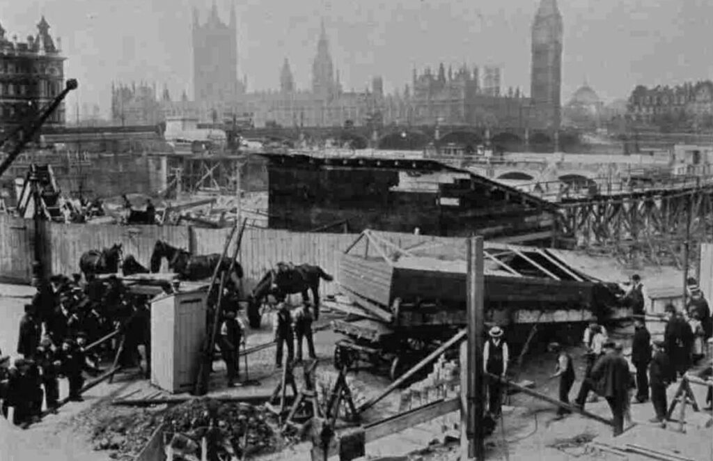
Construction of County Hall began in January 1909 with the construction of a coffer dam in the river, which allowed the new river wall to be built, reclaiming an area of land from the river. Work then began on excavation of the ground, ready for laying a concrete raft on which County Hall would be built.

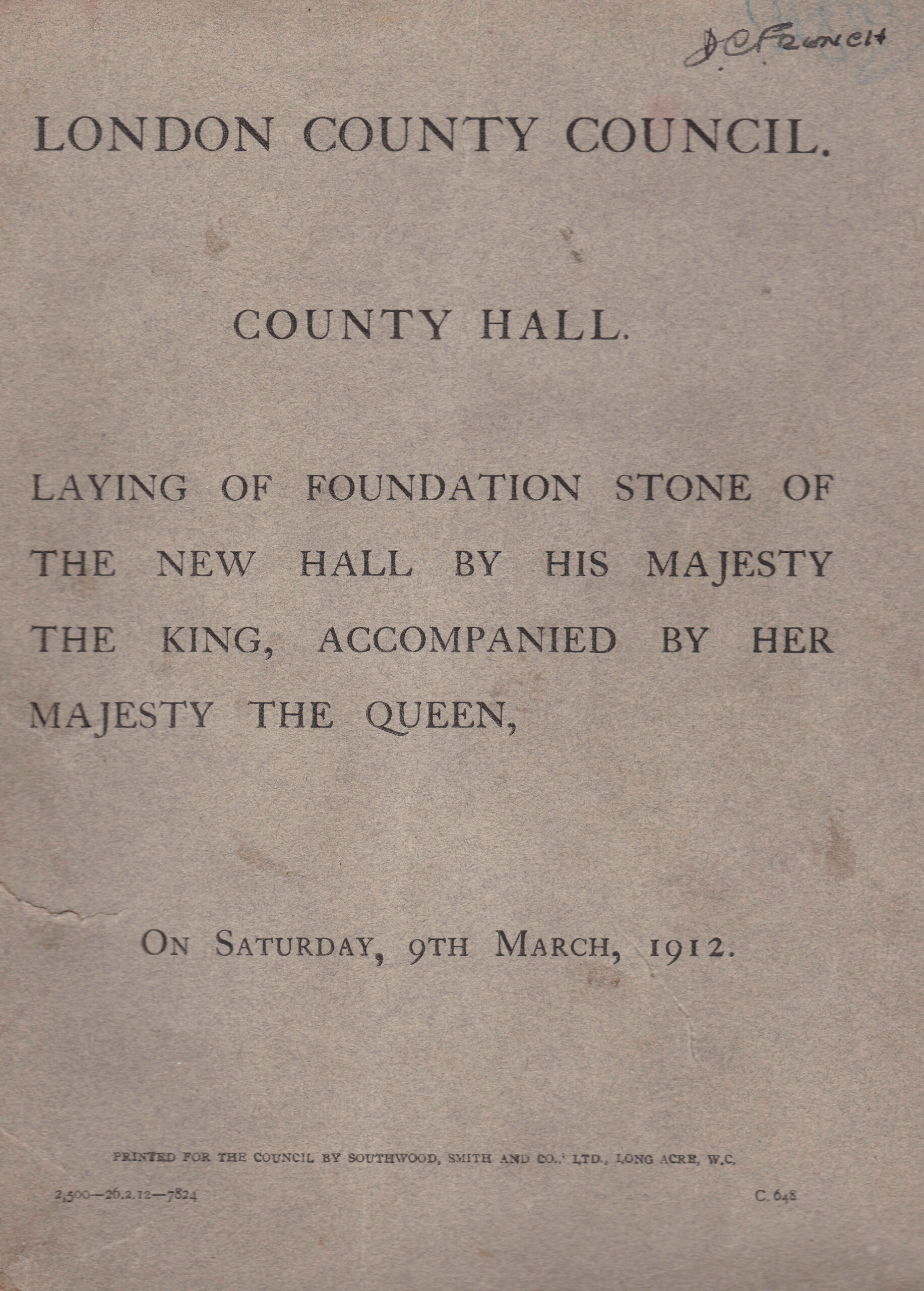
Work was sufficiently advanced, that by 1912 the laying of the foundation stone could take place, and to commemorate the event, a booklet was published, providing some history of the construction of County Hall up to 1912, along with some plans and photographs of the original river frontage, and an important find during digging ready for the construction of the concrete raft.

County Hall foundation stone

County Hall would be built on a 6.5 acre site, and to achieve this area, a significant part of the foreshore and river needed to be reclaimed. In total two and a half acres of the river were reclaimed and a new river wall constructed to hold back the Thames.

A new river wall had been part of the construction of St Thomas’ Hospital, and the alignment of this wall would be continued with the construction of County Hall.

588 feet of new river wall was constructed. the most difficult part being where the wall would come up against Westminster Bridge. The piers of Westminster Bridge had been built on timber piles, and the foundations of the river wall would go a further 6 feet deeper than those of the bridge, so careful construction was needed to avoid damage to the bridge. This included steel piles driven around the foundations of the bridge to provide some protection from the excavations of the river wall.

Construction of the wall started in January 1909 and was completed in September 1910 at a total cost of £58,000.

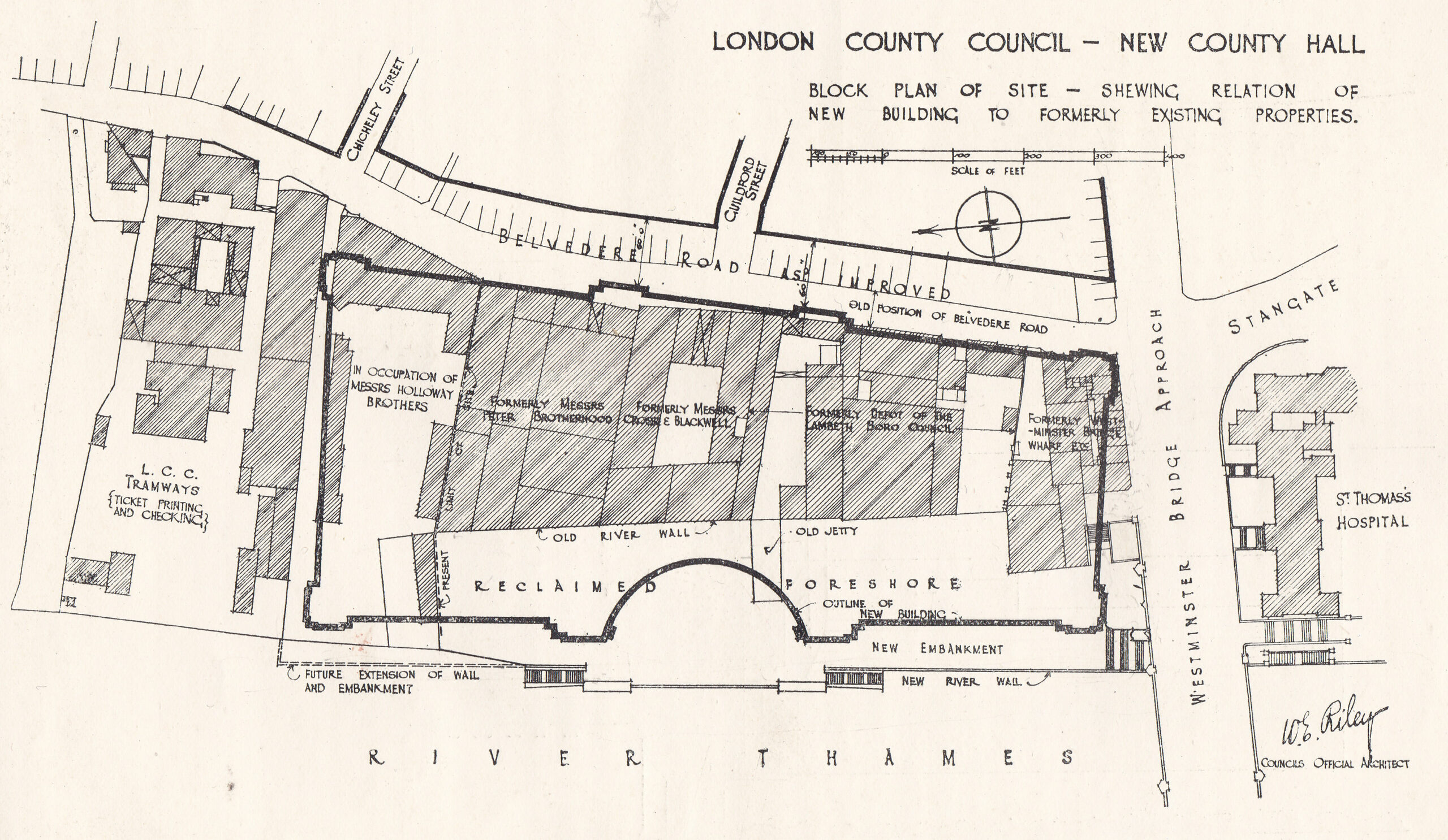
The booklet includes the following diagram which shows the outline of County Hall, the alignment of the new river wall, and within the outline of County Hall, the original buildings on the site and the alignment of the old river wall, showing just how much was reclaimed from the river.

County Hall

The site was occupied by businesses such as Cross and Blackwell with a jam and pickle factory, and the engineering firm of Peter Brotherhood who had their radial engine factory on the site. Their radial engine was an innovative machine used to power the Royal Navy’s torpedoes, as well as being a source of power for other machines including fans, and dynamos for the generation of electricity.

The booklet also includes the following photo of the site from Westminster Bridge. I suspect the embankment wall now runs roughly where the photographer was standing.

County Hall original river frontage

If you look at the edge of the photo on the right, there are a large flight of stairs leading down to the river, and at the top of the stairs can just be seen part of a pub. The pub had one side facing onto Westminster Bridge Road, and the other facing a small square and the river stairs. With limited research time, I have been unable to find the name of the pub, and it is not mentioned in the County Hall booklet.

This is the view of County Hall today, the photographer for the above photo was probably standing a bit closer to the river wall than I am, but everything in the following photo was built on reclaimed land.

County Hall

The new river wall and embankment was a significant construction, and before work on this could start, a timber dam had to be built to hold back the Thames from the construction site. The dam consisted of a wall of tongue and groove timber piles, which had to be driven through four feet of mud, then eleven feet of ballast (sand, gravel etc.) before reaching London Clay, then driven further into the clay to provide a firm fixing.

This was needed as the dam would have to hold back a significant wall of water, as the tidal range could be over 20 feet, so the dam had to hold back sometimes no water (at very low tides) and at very high tides, a wall of over 20 feet of water pressing on the dam.

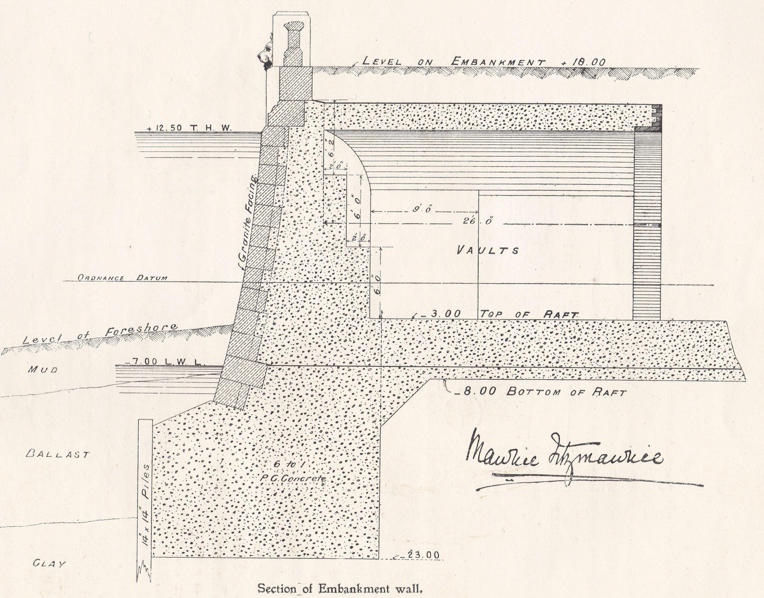
The embankment wall was a very substantial construction, reaching down over 35 feet below the original Trinity high water mark. Between the river wall and County Hall, a new public walkway was constructed, and under the walkway there were large vaults within the open space between the walkway and the concrete raft at the base.

The following drawing shows the construction of the wall and embankment:

County Hall Embankment Wall

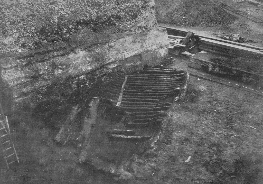
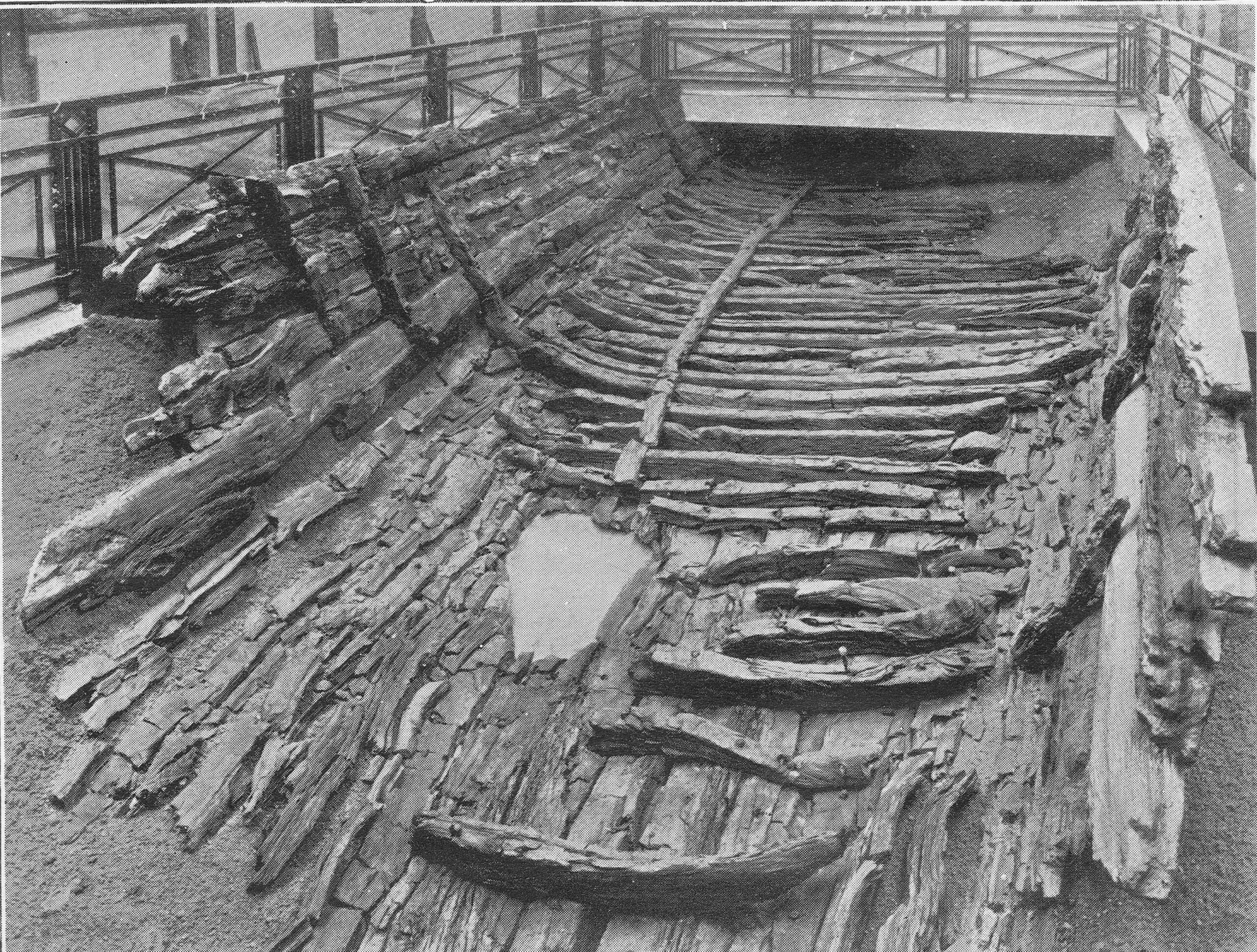
Behind the wall, a large area was excavated. Due to the marshy, damp nature of the ground a concrete raft was needed across the whole area on which County Hall would be built. It was during the excavation to build that raft that a significant discovery was made of the remains of a Roman boat, seen in the following photo as discovered:

County Hall Roman Boat

The booklet provides a description of how the boat was found:

“The discovery was primarily due to Mr. F.L. Dove, the present chairman of the Establishment Committee. While inspecting in January 1910, with Mr. R.C. Norman, the then Chairman of the Committee, the excavation for the concrete raft, he noticed a dark curved line in the face of the excavation immediately above the virgin soil, and some distance beneath the silt and the Thames mud. The workmen engaged suggested that it was a sunken barge, but Mr. Dove realised from its position that it must be of considerable antiquity, and accordingly requested the Council’s official architect to have the soil carefully removed from above.”

Mr. Dove was right about the considerable antiquity of the find. When excavated, it was found to be a Roman boat, constructed out of carved oak. It was lying 19 feet, 6 inches below high water, and 21 feet 6 inches below the nearby Belvedere Road.

The size of the boat was about 38 feet in length, and 18 feet across.

Within the boat were found four bronze coins, in date ranging from A.D. 268 to 296, portions of leather footwear studded with iron nails, and a quantity of pottery. There were signs that the boat had been damaged as several rounded stones were found, one of which was embedded in the wood, and there was indication that some of the upper parts of the boat had been burnt.

After excavation, the boat was offered to the Trustees of the London Museum, who accepted, and the boat was removed from site, with the following photo showing the transport of the boat from the excavation site. It is within a wooden frame to provide some protection.

Roman Boat

The boat was put on display in Stafford House, then the home of the London Museum. (Stafford House is now Lancaster House, in St. James, a short walk from Green Park station).

The following photo shows the boat on display:

Roman Boat

I contacted the Museum of London to see if parts of the boat were available to view, and was told a sorry story of the limitations of preservation techniques for much of the 20th century.

The boat was found beneath the silt and Thames mud in an area of damp ground. This created an oxygen free environment which preserved the boat’s timber.

As soon as the boat was exposed, it started to dry out, and over the year the timbers cracked and disintegrated. Museum of London staff tried to patch up with fillers, but this was long before the chemical means of conservation that we have today were available.

When the Museum of London moved to its current site on London Wall, only a small section was displayed, and this was removed from display when the gallery was refurbished in the mid-1990s.

Some key features of the boat such as joints and main timbers have been preserved as well as they can be after so many years, and are stored in the Museum of London’s remote storage facility, so not available for public display.

The Museum of London did donate some of the fragments to the Shipwreck Museum in Hasting, so I got in contact with them to find out what remained.

I had a reply from the former City of London archaeologist, Peter Marsden, who advised that much of what was preserved at Lancaster House was modern plaster of paris painted black. He also confirmed that only some ribs and a few bits of the planks survive, and are no longer on display.

Peter Marsden has written some fascinating books on Ships of the Port of London. They are very hard to find, however the English Heritage Archaeology Data Service has the book “Ships of the Port of London, First to eleventh centuries AD” available to download as a PDF from here. It is a fascinating read which includes many more discoveries in the Port of London as well as the County Hall Roman boat.

The age of the boat seems to be around 300 AD which is confirmed by the coins discovered in the boat all being earlier, and Peter Marsden managed to get a tree ring date of around 300 AD from one of the planks.

It is difficult to confirm exactly why the boat was lost on the future site of County Hall. There was much speculation at the time, including in the County Hall booklet, that the boat had been lost during battles in AD 297. The burning on parts of the wood written about in the booklet has not been confirmed, and the stones could have been ballast.

It seems more likely that the boat may have been damaged, or simply lost on what was the marshy Thames foreshore and land of the south bank. Away from the City of London, the boat was left to rot, gradually being covered by the preserving mud and silt of the river until discovery in 1910.

There is another feature on the plan of the new County Hall that suggests the boat could have been on the edge of the Thames foreshore.

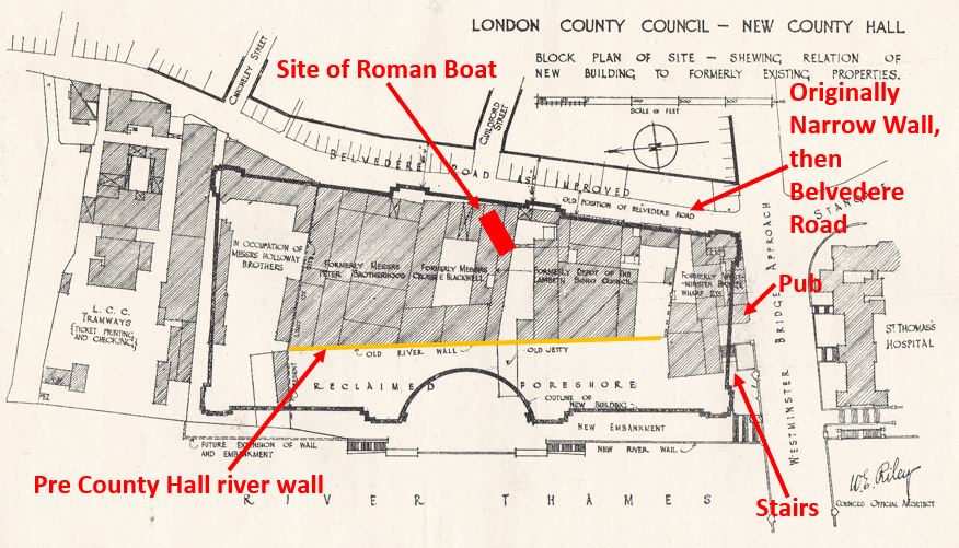
On the opposite side of County Hall to the river is a street called Belvedere Road. This was originally called Narrow Wall. The first written references to the name Narrow Wall date back to the fifteenth century, and it could be much older. The name refers to a form of earthen wall or walkway, possibly built to prevent the river coming too far in land, and as a means of walking along the edge of the river.

In the following extract from John Rocque’s 1746 map of London, Westminster Bridge is at the lower left corner, and slightly further to the right, Narrow Wall can be seen running north.

Narrow Wall

Although straightened out and widened, Belvedere Road follows the approximate route of Narrow Wall.

If Narrow Wall was built along a line that formed a boundary between river and the land, then the Roman boat was close to this and would have been in the shallow part of the reed beds that probably formed the foreshore.

I have annotated the original plan from the booklet with some of the key features, including the location of the Roman boat:

County Hall

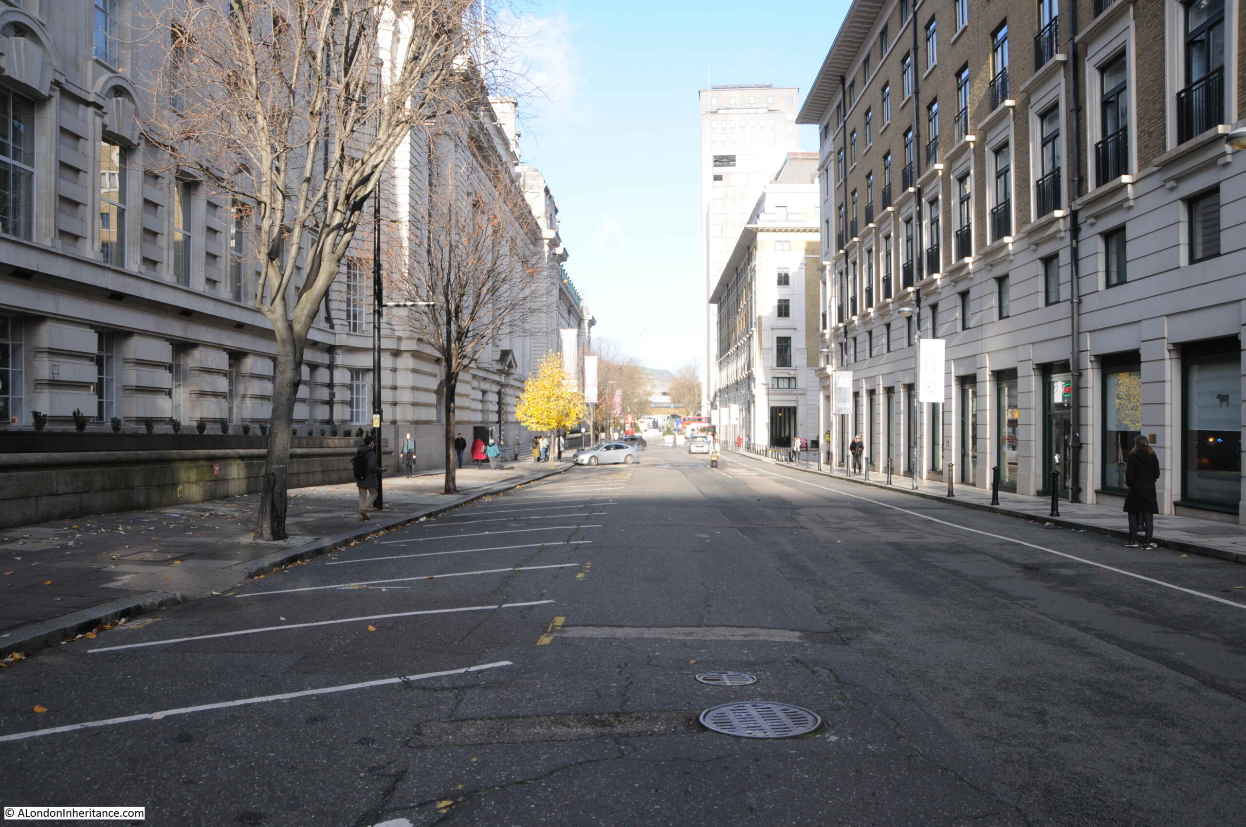
The following view is looking along Belvedere Road / Narrow Wall, with County Hall to the left:

Belvedere Road

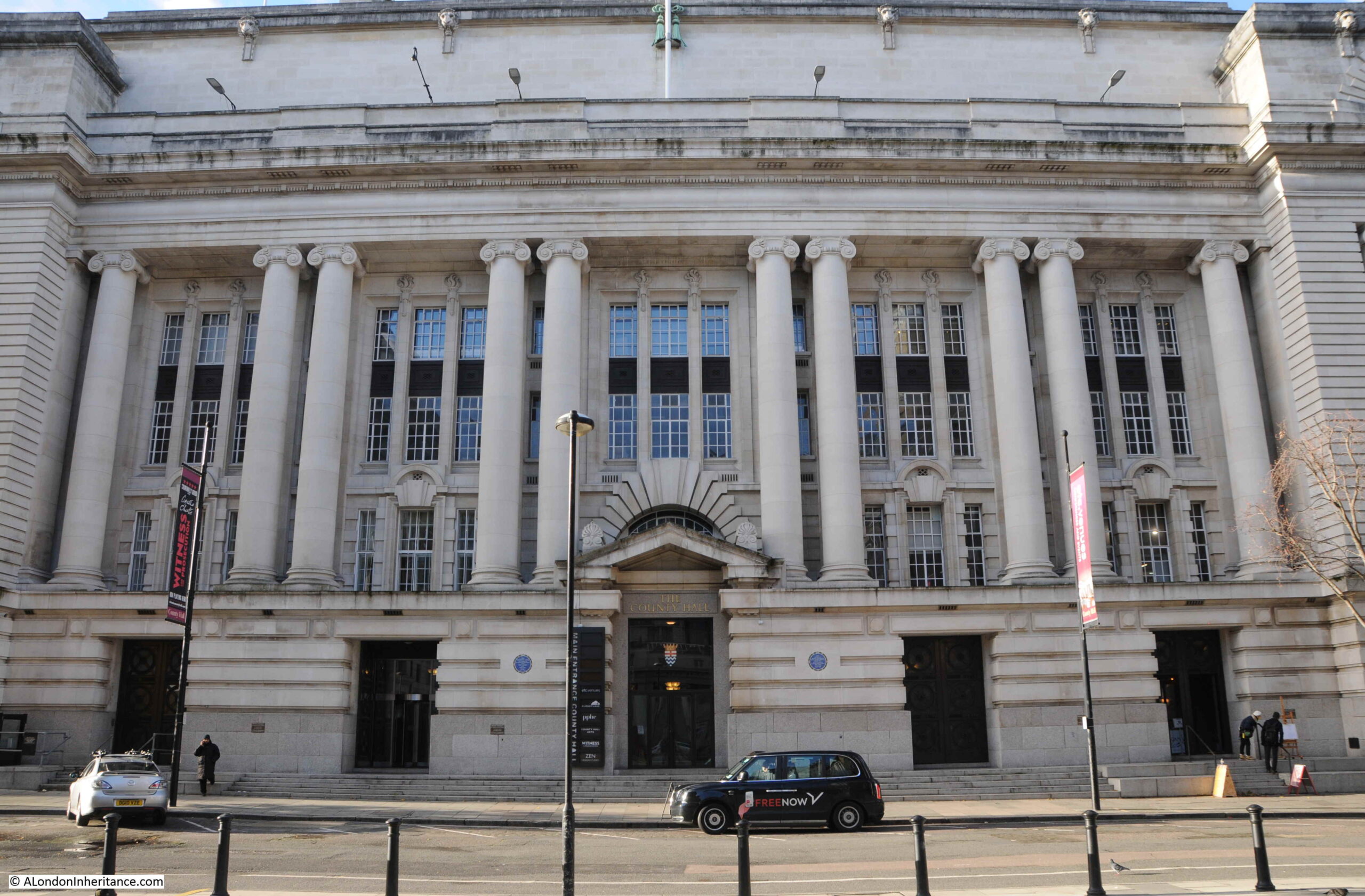
The following photo is a view of the entrance to County Hall from Belvedere Road. The Roman boat was found just behind the doors to the left:

County Hall

There is a curious link between the finding of the Roman boat and the laying of the foundation stone commemorated by the booklet.

The foundation stone was laid on Saturday the 9th of March 1912 by King George V. Underneath the foundation station was a bronze box, the purpose of which was described in newspaper reports of the ceremony:

“Depositing a ‘find’ for some archaeologist of the future, the King and Queen watching the foundation stone of the new London County Hall being lowered into position. Before the stone was lowered into position and declared by the King to be well and truly laid, his Majesty closed a bronze box containing certain current coins and documents recording the proceeding, and caused it to be placed in a receptacle in the stone. Perhaps at some dim future day, when London ‘is one with Nineveh and Tyre’ this box and its contents will come to light beneath the spade of an excavator, burrowing amid the ruins of a forgotten civilisation.”

So having been the site of excavation of a Roman boat, the hope was that the bronze box would form an archeological discovery in some distant future.

I assume the bronze box is still there, below the foundation stone, in the north-east lobby adjacent to the old Council Chamber.

Construction of County Hall continued slowly. It was a large building requiring large numbers of workmen and materials.

The coal and dock strikes of 1912 and building workers strike of 1914 delayed construction. Work continued during the First World War, however war demands such as on the rail network caused problems with the transport of granite from Cornwall to London.

As parts of the building became useable, they were taken over by rapidly growing Government departments such as the Ministry of Munitions and Ministry of Food, who were able to prioritorise their needs over the LCC due to the demands of war.

By the end of September 1919, the LCC were able to retake possession of the building, and work on completion continued quickly, with over one thousand men working on the site by March 1921.

The building was soon substantially complete, was gradually being taken over by an ever expanding LCC staff, and was officially opened in July 1922.

The London County Council continued until the 1st April 1965. The London Government Act of 1963 restructured how London was governed, and this led to the Greater London Council (GLC) which took over from the LCC.

The GLC lasted to the 31st of March, 1986 when it was abolished by the 1985 Local Government Act, primarily down to conflict between the Labour held GLC and the Conservative government of Margaret Thatcher across the river.

The building was sold to the Shirayama Shokusan Corporation, a private Japanese company, for £60 million. and in the following years it would be converted to a hotel and the ground floor facing the embankment walkway hosts tourist destinations such as Shrek’s World of Adventure, a Sealife Centre and the ticket offices for the London Eye.

County Hall is Grade II listed, and the original Council Chamber of the LCC has been preserved, and is now available to hire and is used as a theatre.

The architect Ralph Knott worked on County Hall for most of his career. He had been called up into the Royal Air Force during the First World War where he was responsible for the design of airfield buildings, but he still kept in touch with County Hall construction. He returned to the County Hall project after the war to see the main building through to completion.

He was still working on plans for extension of the building late in his career, which were not finished at the time of his death at the young age of 50 on the 25th of January 1929.

County Hall is a fitting tribute to Ralph Knott. A relatively simple, but grand and imposing building facing onto the river, suitable for an institution that was to have so much impact on the 20th century development of London. A building of contrasting design to the Palace of Westminster on the opposite bank of the river.

Sad that the Roman boat has been substantially lost. Preservation of organic remains that have been in waterlogged soil for centuries is difficult, but thankfully now much better, as seen for example, with the preservation of the Mary Rose in Portsmouth.

I hope that no readers comment that the bronze box beneath the foundation stone has been removed. It would be great that it is still there for archaeologists in the distant future to dig up.

alondoninheritance.com

Pickle Herring Street Revisited

It is remarkable how some places in London have changed beyond all recognition within living memory, and this week’s photo is a prime example. It was taken by my father in 1947 in Pickle Herring Street, a lost street that ran behind the warehouses on the south bank of the Thames, west from Tower Bridge.

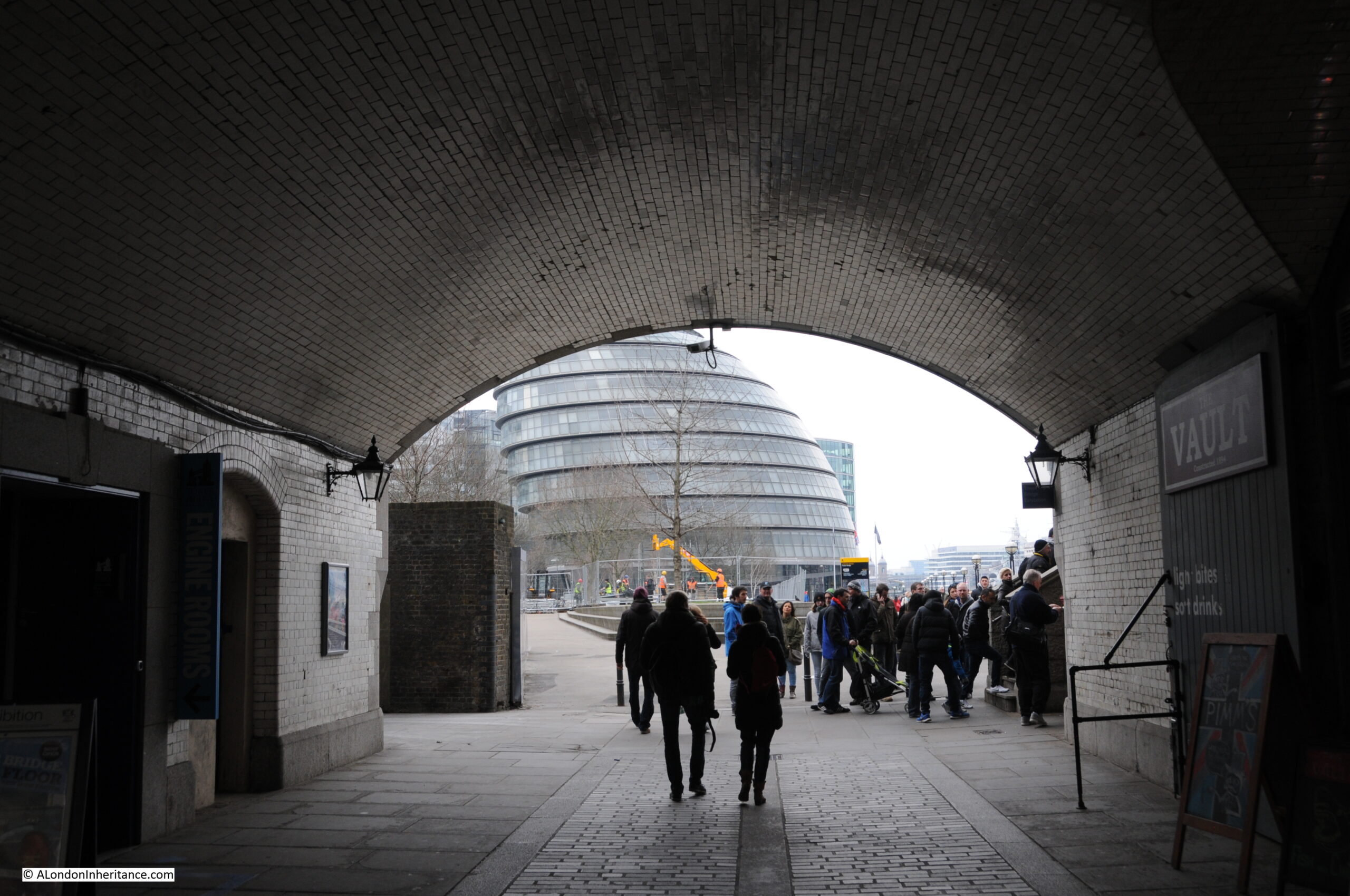
I last wrote about Pickle Herring Street six years ago, when I featured a photo taken from underneath the arch on the approach road to Tower Bridge. This photo was on the same strip of negatives, but I was not sure of the location, whether west of Tower Bridge, or east along Shad Thames, so I put the photo aside to look at later.

I recently spent some time checking maps, and aligning some of the features between map and photo and can now confirm that the following 1947 photo shows an additional section of Pickle Herring Street, not seen in my original 2015 post.

Pickle Herring Street

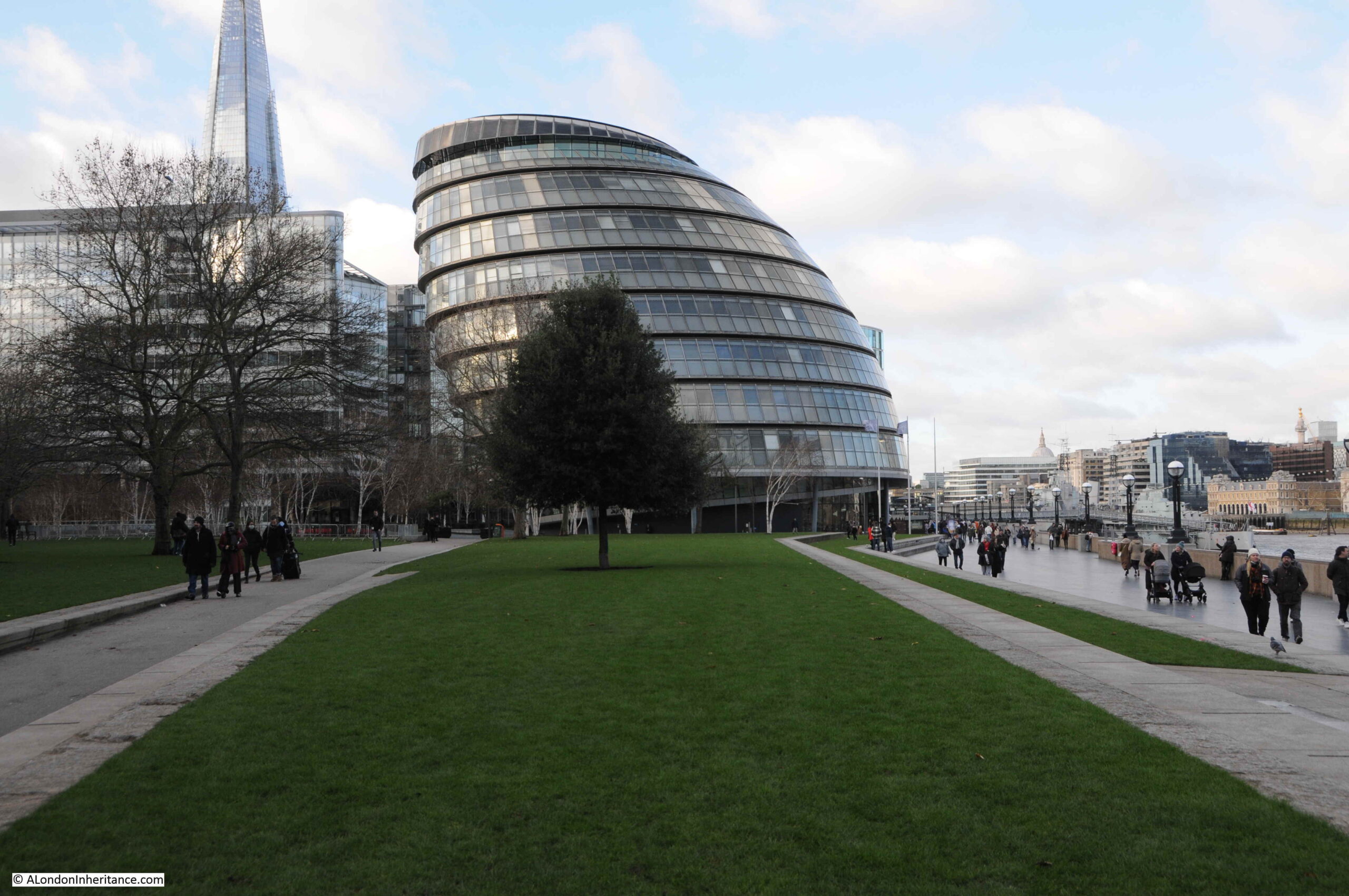
It is difficult to be precise with the exact location of the photo given the total redevelopment of the area, however as best as I can estimate, my father was standing somewhere on the grass between where I am standing to take the photo, and the tree, looking towards City Hall:

Pickle Herring Street

The building behind the tree is City Hall, the current home of the Mayor of London, which will soon be moving to an existing building called the “Crystal” at the Royal Docks in Newham. (Strangely on the Mayor of London website, the pages describing City Hall have text that refer to the existing building, but with a photo of the new building at the Royal Docks).

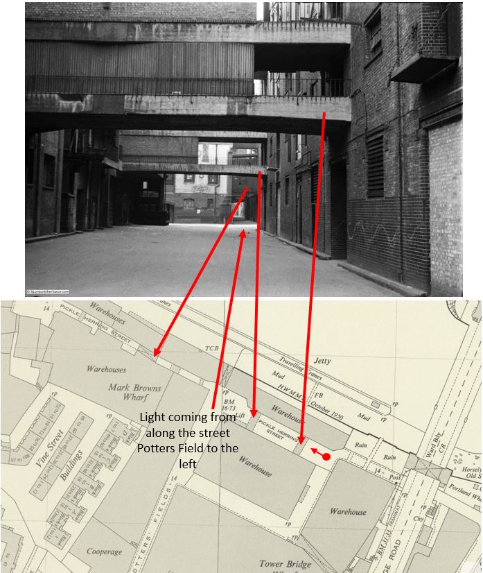
To find the location of the photo, I checked the features in the scene against the 1950 revision of the Ordnance Survey map, published three years after the photo had been taken.

In the following graphic, I have aligned features in the photo with those on the map  (‘Reproduced with the permission of the National Library of Scotland“):

Pickle Herring Street

The red dot and arrow show where my father was standing to take the photo and the arrow is the direction of view.

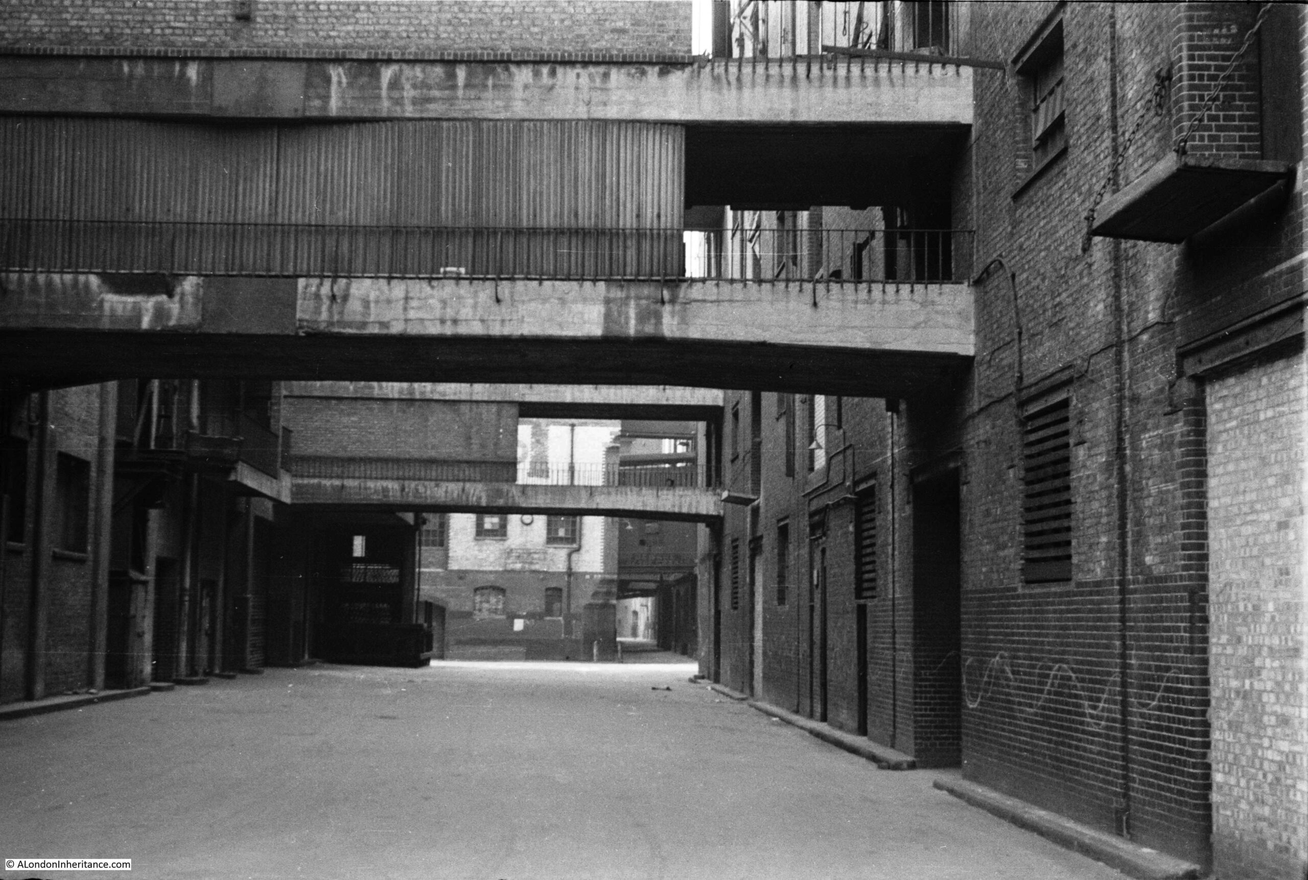
The first two arrows point to the overhead walkways connecting warehouses on either side of Pickle Herring Street.

A patch of light can then be seen on the street, this is coming from the street Potters Fields which runs to the left of the photo.

The street than narrows with a building seen blocking part of the street, and a narrow section to the right, where in the distance, a larger overhead structure can be seen spanning the street. This is the greyed in block in the map with an X which shows this is an upper floor which runs over a street.

The southern approach to Tower Bridge can be seen on the right of the map.

So having located this 1947 photo, I can add to the photo from my 2015 post to give a fuller view of Pickle Herring Street. This was the view from under the approach to Tower Bridge:

Pickle Herring Street

If you refer to the 1950 map, you can see the point in the street where the building on the right juts out into Pickle Herring Street, and it was there that my father was standing to take the photo at the top of today’s post.

The following photo is my 2015 version of the above, from underneath the approach to Tower Bridge:

Pickle Herring Street

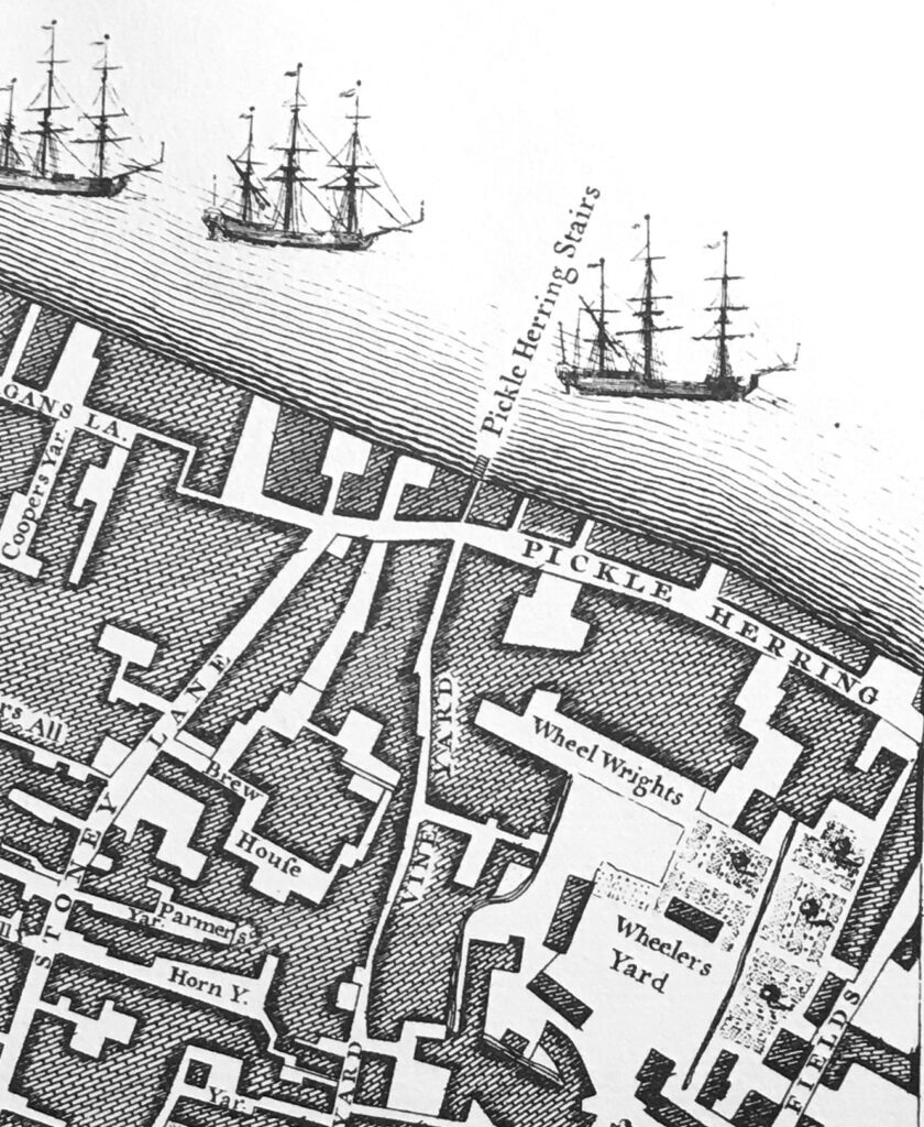
Pickle Herring Street is an old street, and is shown in Rocque’s 1746 map of London. The following extract shows the western extent of the street, the part in my father’s photo was in the join on my printed copy of the map so did not photograph well.

John Rocque map of Southwark

The map does show that there was also a Pickle Herring Stairs to the western end of the street. I do not know what came first, the stairs or the street, but I suspect the stairs as the river stairs are some of the oldest features along the river’s edge.

There are also multiple theories as to the source of the name of the street and stairs. I cannot find any confirmed written reference to the source, but it is probably safe to assume it has some reference to the fish herring that may have been landed at the stairs, but it is impossible to be sure.

The first written references to activities within the street date to the start of the 19th century, and a newspaper advert from the Public Ledger and Daily Advertiser on the 14th of February, 1805 refers to the street, and also an interesting way of buying access to a property at the time:

“WHARF, DWELLING-HOUSE and WAREHOUSE, PICKLE HERRING STREET, Southwark, at Garraway’s Coffee-House, Cornhill. The Life Interest of Two Persons, aged 45 and 44, in the above estate, is now to be sold, and the purchaser will be entitled to the property for the life of the longest liver; both are insurable at a very trifling premium, but as there are now two lives, no insurance is necessary”.

Interesting way of buying access to a set of buildings, where the length of time you have access is entirely dependent on the remaining length of life of two people. Presumably they still held the freehold, which at the death of the last, would then pass to whoever was named in their will, and the person who had purchased the property would either have to leave, or negotiate with the new owner.

There is an earlier written reference to Pickle Herring Stairs, which dates from the 16th October 1727, when a newspaper reported that a Waterman’s Boy had fallen in the Thames at the stairs and drowned.

It is safe to assume that Pickle Herring Street has been in existence for centuries, and served the warehouses and wharves that lined the river.

That would all end not long after my father took the above photos. The 1953 edition of London Wharves and Docks, published by Commercial Motor lists the two wharves that were still in operation.

Mark Brown’s Wharf and Cold Stores are the buildings in the first photo at the top of the post. These were owned by the Hay’s Wharf Company and dealt with “provisions, dried fruit, spices, canned goods and refrigerated produce”.

As seen in the 1950 map, there was a long jetty in the river to serve the wharf, with travelling cranes. The jetty could accommodate and fully unload ships up to 420 feet in length.

The buildings seen from underneath the approach to Tower Bridge in the second photo were part of Tower Bridge Wharf, which dealt with “hides, skins, wool and leather”.

The buildings were empty and derelict for much of the 1960s and 70s, were demolished, and for some years the space became a temporary car and lorry park before the building of the area as we see it today.

The grass in the photo is part of Potters Fields green space, an area that runs from close to Tower Bridge, round the back of City Hall and up to Tooley Street.

The space where City Hall is located occupies the western end of Pickle Herring Street, at the far end of the photo at the start of the post.

It is interesting how streets dissapear, and the space occupied by these streets become part of private developments.

Large parts of London have long been owned by individuals. In the past these tended to be members of the aristocracy, who owned the land, then built and developed as the city expanded, and ended up owning large areas of streets and buildings. Many of these are still in existence, however they have reduced from their peak.

Property companies have built significant collections of buildings, and a change over the last few decades has been the rise of the foreigh property owner.

The area from City Hall, almost to Hays Galleria and up to Tooley Street now goes under the name of More London.

The area is owned by St Martins Property, which is the UK investment vehicle of the sovereign wealth fund of Kuwait.

So the space occupied by Pickle Herring Street is now under private ownership, and in common with many of these spaces, is patrolled by private security.

The name Potters Fields referred to the street that ran from Tooley Street to Pickle Herring Street and was the street that allowed light to fall on the street in the distance in my father’s photo. It can still be found as a small stub of the street remains off Tooley Street, and in the name of the green space.

Originally, Potters Fields was the name given to the space to the west of the approach to Tower Bridge, and today occupied by City hall. Part of this space was occupied by a pottery, set up by the Dutchman Christian Wilhelm in around 1618, and which went by the name of Pickle Herring Pottery.

I suspect the name of the pottery came from the street or stairs as it is a rather strange name to give to a pottery.

The pottery operated on the site for around 100 years, before moving to Horsley Down to the east of Tower Bridge, early in the 18th century.

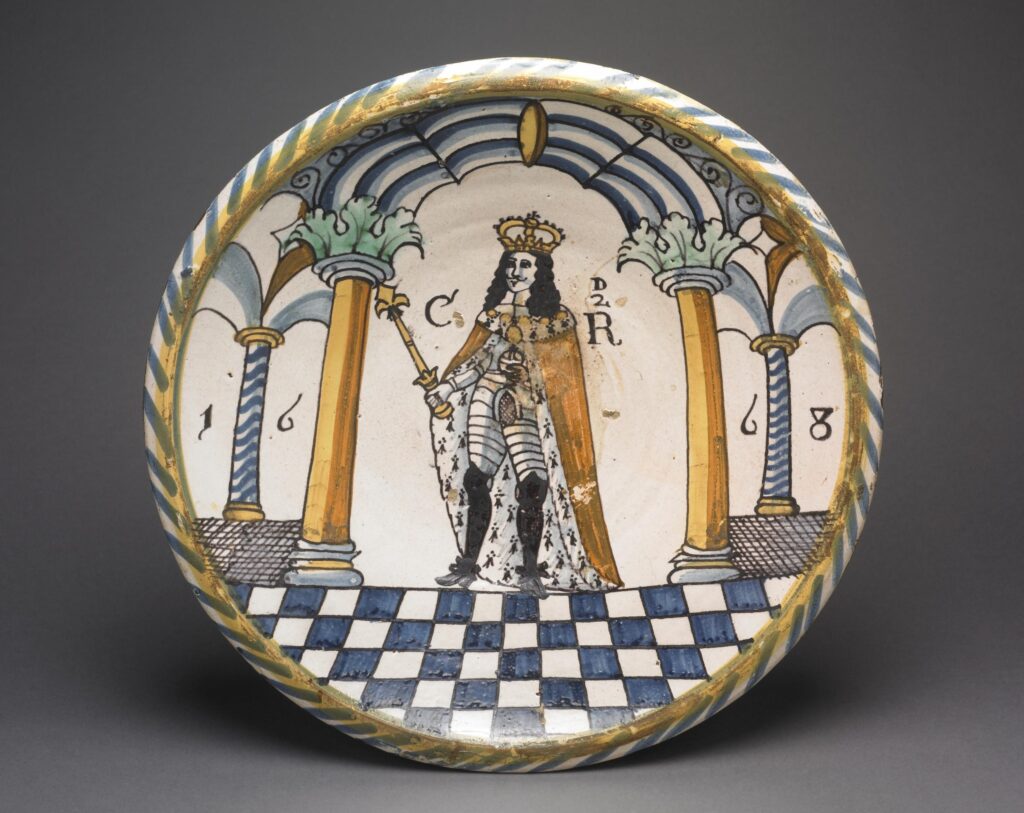
The British Museum has a collection of what is attributed as Pickle Herring Pottery, including the following dish dating from 1668 and showing Charles II crowned and in armour (© The Trustees of the British Museum):

Potters Field pottery

Much of the early output of the Pickle Herring Pottery appears to have had a delftware influence, which was probably down to the Dutch founder of the pottery.

Sad that the centuries old name Pickle Herring which referred to both the street and river stairs can no longer be found in the area, however I am pleased to have confirmed the location of another of my father’s photos and at least these two photos help to remember this lost London street.

My original 2015 post on the street can be found here.

alondoninheritance.com

Tunnelling the Baker Street and Waterloo Railway

A couple of week’s ago, I wrote about the construction of the Greenwich foot tunnel, based on a pamphlet published in 1902 by the Institution of Civil Engineers. The pamphlet included details of another recent tunnelling project, constructing the tunnels of the Baker Street and Waterloo Railway (known from the start as the Bakerloo line), under the Thames between Embankment and Waterloo Stations.

Parliamentary Acts of 1893 and 1896 had approved construction of the Baker Street and Waterloo Electric Railway, initially running from Dorset Square near Marylebone Station, to Waterloo Station. Further requests for extensions were approved and by 1904 the line ran from Paddington to Elephant and Castle.

The route of the Baker Street and Waterloo railway ran beneath the Baker Street Station of the Metropolitan District Railway, by Regent’s Park and Crescent Gardens into Portland Place, through Langham Place to Oxford Circus (where the tunnels pass over those of the Central Line with a clearance of only 6 inches at one point), down Regent Street to Piccadilly Circus, along Haymarket and Cockspur Street to Charing Cross, along Northumberland Avenue, then under the Thames to College Street, Vine Street and Waterloo Station.

The majority of the tunnel went through London Clay and was a relatively easy construction project, however there was a challenge where the tunnel went underneath the Thames.

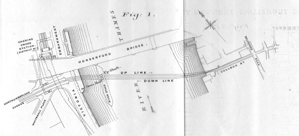
The following diagram from the pamphlet shows the route under the river, from Northumberland Avenue to College Street on the opposite side of the river. The station shown above Hungerford Bridge, labelled Charing Cross Station, is now Embankment Station.
Baker Street and Waterloo Railway

The diagram shows a “River Stage” extending south from Hungerford Bridge. This was a large platform, 50 feet wide and 370 feet long on which were built workshops, stores, steam cranes, boilers and air-compressors, staff buildings along with two shafts down to where the tunnels would be built.

The construction platform and shafts on the Thames were needed due to a strange anomaly found in the bed of the river when test boreholes were made along the route of the tunnels.

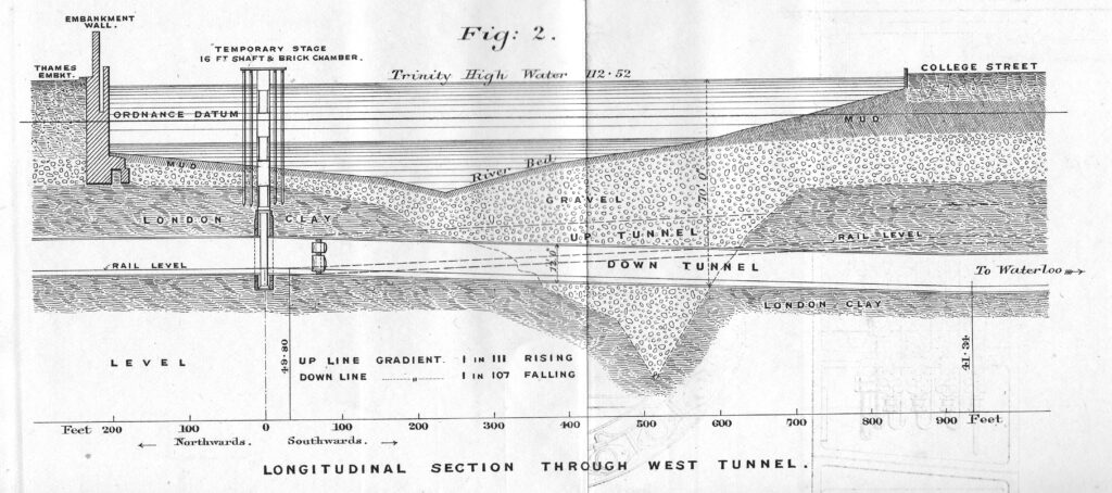
In the middle of the river there was a sudden depression in the London Clay through which the rest of the tunnel had been bored. This had filled with gravel, which was porous to water and required a different tunnelling method to the rest of the route, which would use compressed air to help keep out water as the tunnel went through the gravel.

The following diagram shows the route under the Thames of the Baker Street and Waterloo railway, the depression in the London Clay and short distance of gravel through which the tunnel would need to run.

Baker Street and Waterloo Railway

The diagram also shows the shafts sunk down to the level of the tunnels for their construction, along with the temporary work platform created on the river.

College Street on the right is now under the Jubilee Gardens.

Note also in the diagram how the depth of the two tunnels diverge as they route under the Thames, with the “up” line having a rising gradient towards Waterloo (shown as dotted lines) and the “down” tunnel having a descending gradient towards Waterloo.

The ground beneath the streets and buildings of London is generally invisible, but is just as interesting as the surface. I have written about some of the areas where the geology beneath the city has influenced the development of an area, for example, how water shaped north Clerkenwell, Bagnigge Wells, St. Chad’s Place and a Lost Well, and also when oil was found beneath the streets of Willesden.

There are many features below the surface, some as a result of ice and freezing, some as a result of water, for example when the Thames was a much wider river, and the multiple smaller rivers that ran into the Thames, and some the result of human activity.

I wondered whether the feature shown in the 1902 pamphlet was still there. I suspect we look at the Thames at low tide, and assume a uniform bed to the river as it descends from one side of the river, to rise on the opposite side.

The Port of London Authority (PLA) have a complete set of survey and navigation charts on their website, detailing the river from Teddington to Southend. They show a very different view of the Thames, a view that is essential to those on the river. The depth of water, obstructions, navigation lights, moorings etc.

A view where bridges almost disappear, with only the piers supporting the bridge shown on the chart, as these are the key features for those on the river.

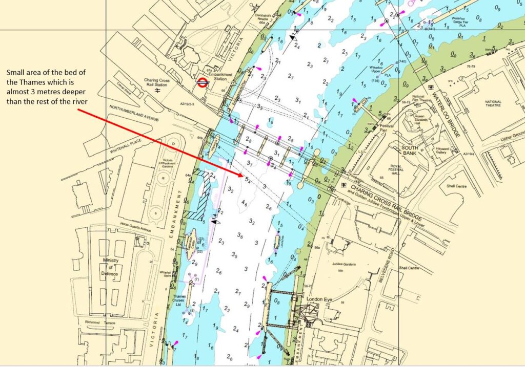
The PLA kindly gave permission for me to include an extract from the chart for Lambeth Reach in today’s post, an extract which covers the area where the tunnel for the Baker Street and Waterloo Railway was constructed.

Port of London Authority chart for Lambeth Reach

Hungerford Bridge can be seen in the centre of map, although only shown by black lines, with the piers supporting the bridge as the key feature.

The depth of the water is shown in metres (the depth is the average depth at the lower of each day’s two tides, which should show the minimum depth of water for those travelling along the river). The green areas along each side of the river are where the land is exposed at each low tide, with the height being shown (numbers underlined).

The depth of the Thames is typically between 2 and 3 metres at low tide in the central part of the river, however as can be seen just south of Hungerford Bridge (arrowed) there is a small area where the depth increases to a maximum of 5.4 metres, which is the same area as the depression in the London Clay shown in the 1902 diagram. Today’s Bakerloo line runs a short distance below the deepest area of this depression.

The PLA charts show how the depth of water gradually increases as the Thames heads towards the estuary, which is to be expected. They are some other similar features to the depression by Hungerford Bridge. For example, just off Limehouse Marina, there is a small area where the bed of the river suddenly descends from an average depth of between 6 and 7 metres, down to 11.7 metres, which is quite a depth at low tide.

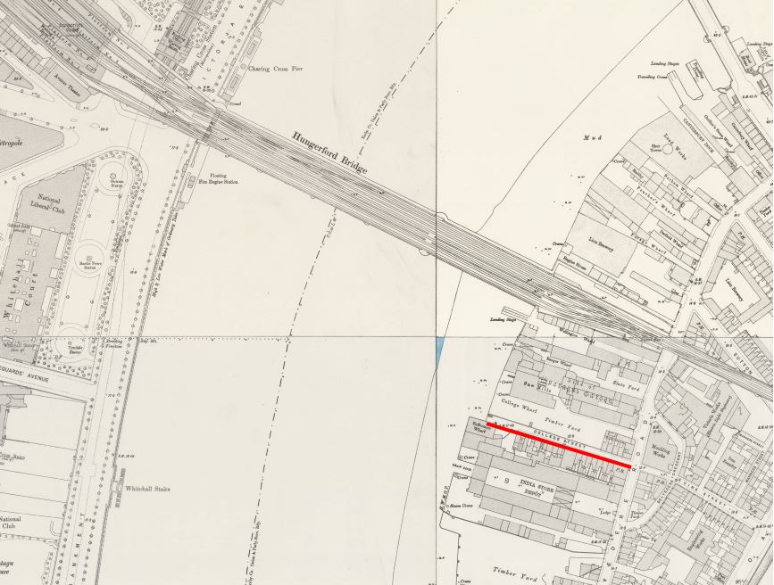
Returning to the 1902 diagram of the route of the tunnels, it shows the tunnels running under College Street on the south bank of the river. This is one of the many streets that were lost following clearance of the area for the Festival of Britain.
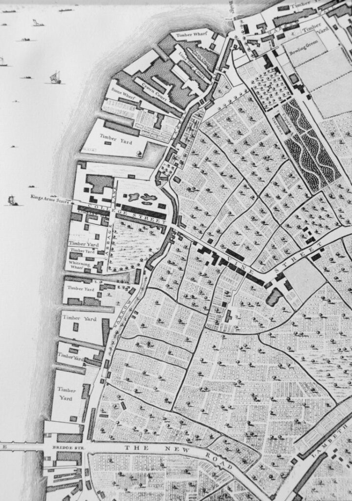
The 1894 Ordnance Survey map shows the location of College Street (underlined in red) in the following extract  (‘Reproduced with the permission of the National Library of Scotland“):

College Street

Interesting to compare the above map with the PLA chart. In the OS map, the priority is the land, so the river is shown as a blank stretch of water, with no defining features.

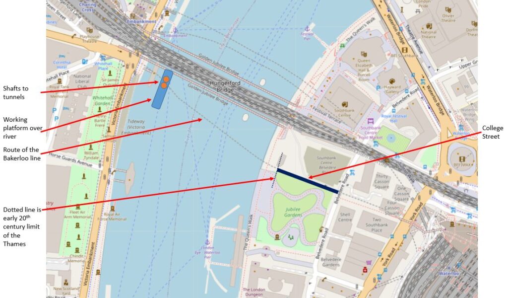
The location of College Street today, is under the northern edge of the Jubilee Gardens. The Thames has also been pushed back, with the construction of the embankment and walkway along the river for the Festival of Britain. In the following map, I have marked the location of College Street, pre-1950 edge of the river, where the shafts to the tunnels and the working platform were located, along with the route of the tunnels which today form the Bakerloo line ( © OpenStreetMap contributors).

Baker Street and Waterloo Railway

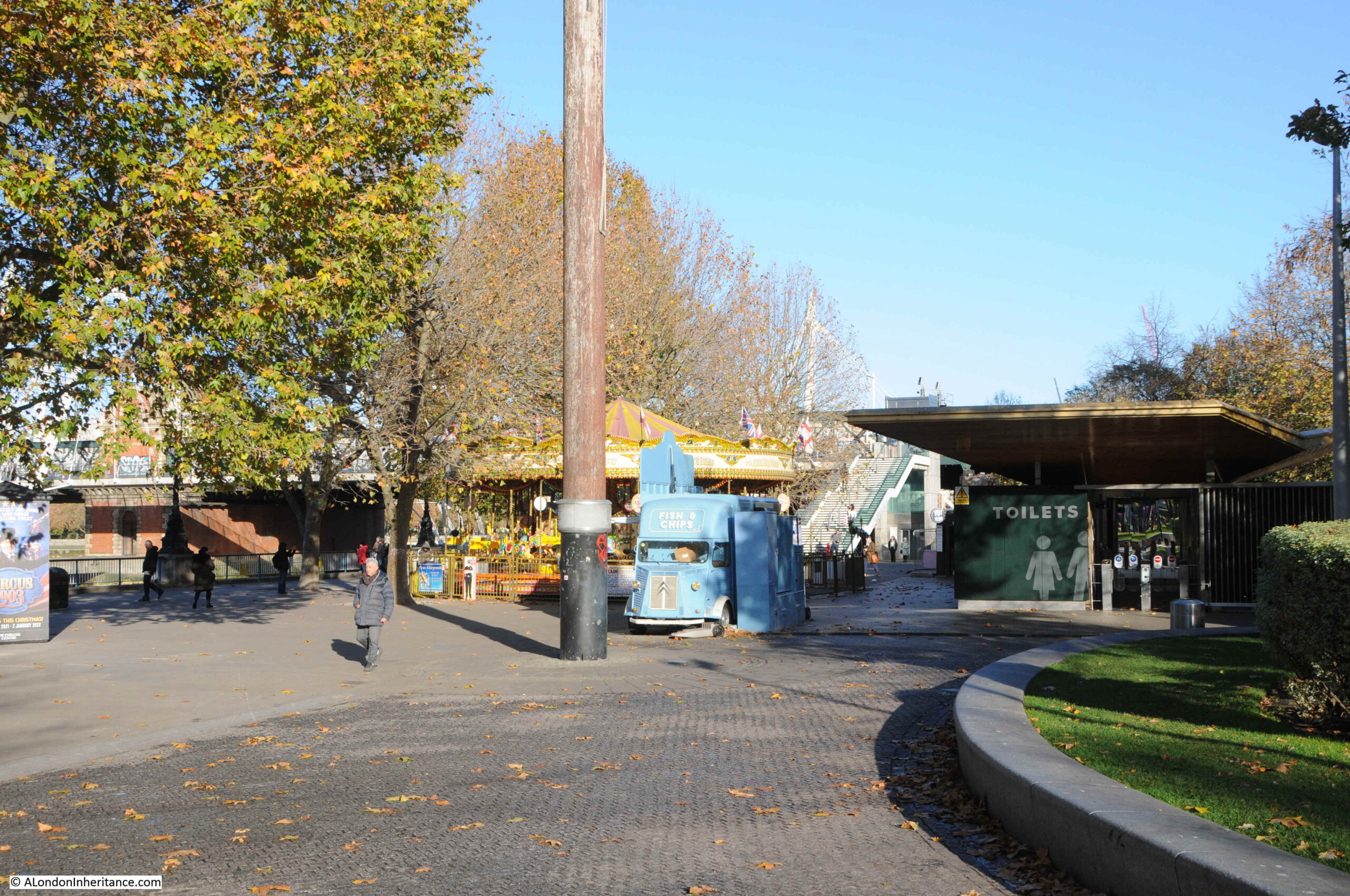
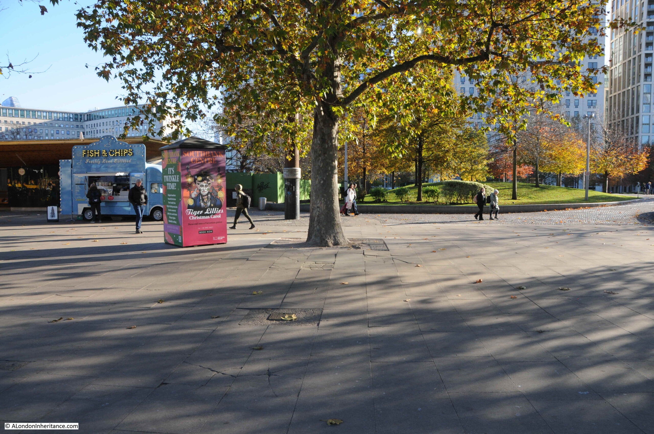
Looking at the area today, the tunnels of the Bakerloo line, run roughly under the blue van in the photo below. The edge of the grass to the right is the approximate pre-1950 boundary with the Thames.

Baker Street and Waterloo Railway

This view is looking back towards Waterloo Station from the walkway along the south bank, following the route of the Bakerloo line tunnels and College Street:

College Street

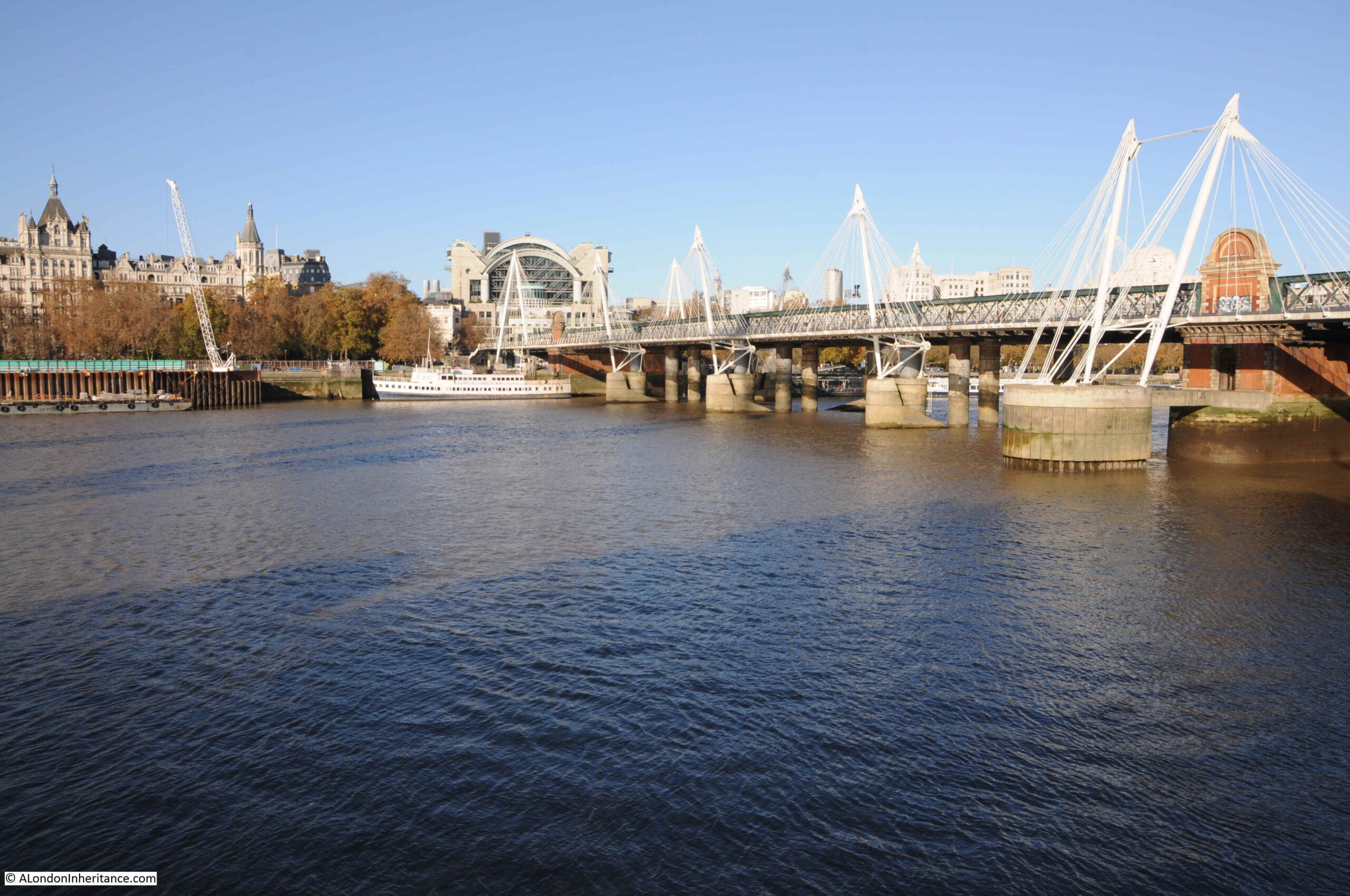
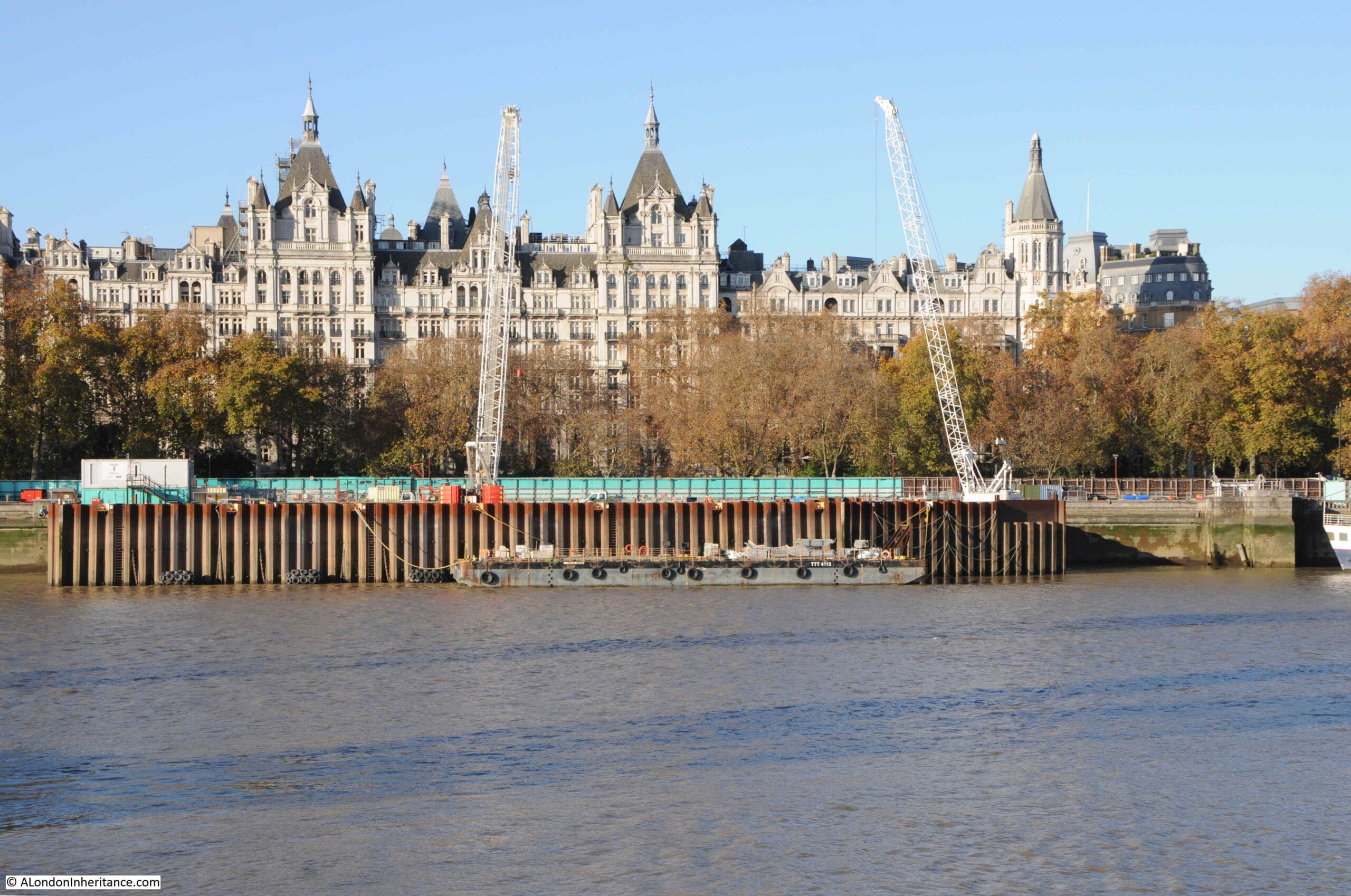
in the following view, the work platform extended from the first bridge pillars on the opposite side of the river (in front of the white boat) and extended 370 feet to the left. The depression in the London Clay is in the centre of the photo, and the Bakerloo line tunnels are running from the white ship to where I am standing to take the photo.

River Thames

One of the benefits stated in the 1902 pamphlet of the work platform in the river was that material excavated during the construction of the tunnels could be taken away by barge, saving the transport of large amounts of material through the city’s streets.

The river continues to be used for a similar purpose, with close to the route of the Bakerloo tunnels, a new construction site on the edge of the river for the Thames Tideway Tunnel or the Super Sewer, being dug at a much greater depth to the Bakerloo line tunnels, but with the same need to understand the geology through which the tunnel will be bored beneath London, and to transport materials via the river.
Thames Tideway Tunnel

There is a superb aerial view on Google Maps of the above Tideway Tunnel construction site showing the shaft down to the tunnel, which can be found on this link.

The two tunnels of the Bakerloo are each 12 feet in internal diameter, and were located in the gravel bed at a distance of 23 feet apart from the centre of each tunnel. As the tunnels approach the south bank, they move closer and the east bound tunnel will be running vertically over the west tunnel along the old route of College Street. This was done to keep the tunnels within the limits of the street.

Presumably this was done to avoid any damage to the buildings on either side of the street, or to create problems with later construction on the street, where deep cellars may have been built.

To get from College Street to Waterloo underground station, the tunnel crossed Belvedere Road and then routed along Vine Street. This street was also lost during clearance for the Festival of Britain, and in the late 1950s, the Shell Centre complex was built over the site of the street (only the tower block still remains).

I worked in the building during the 1980s, and fortunately working in what would today be called IT (lots of network, radio and telephone cabling), was able to access many of the tunnels built as part of the complex. There were two tunnels between the upstream (with the tower block) and downstream buildings of Shell Centre (on the opposite side of the railway viaduct to Hungerford Bridge). One of these tunnels was for pedestrians, and the other was a service tunnel.

The service tunnel had a raised section which went over the upper tunnel of the Bakerloo line, and it was possible to hear trains rumbling through the tunnels below.

To start construction of the Baker Street and Waterloo railway tunnels, two shafts of cast iron, 16 feet in internal diameter, were sunk from the work platform on the Thames. They reached down 50 feet. I like to assume these cast iron shafts are still below the surface, filled in, as probably too difficult and expensive to remove.

From a chamber at the bottom of the shaft, tunnels were started heading in both directions, with special attention paid to the tunnels under the Thames due to the gravel. The gravel was waterlogged, and at high tide, the combination of river and waterlogged gravel gave a head of 70 feet which created a considerable pressure of water through which the tunnel had to be driven.

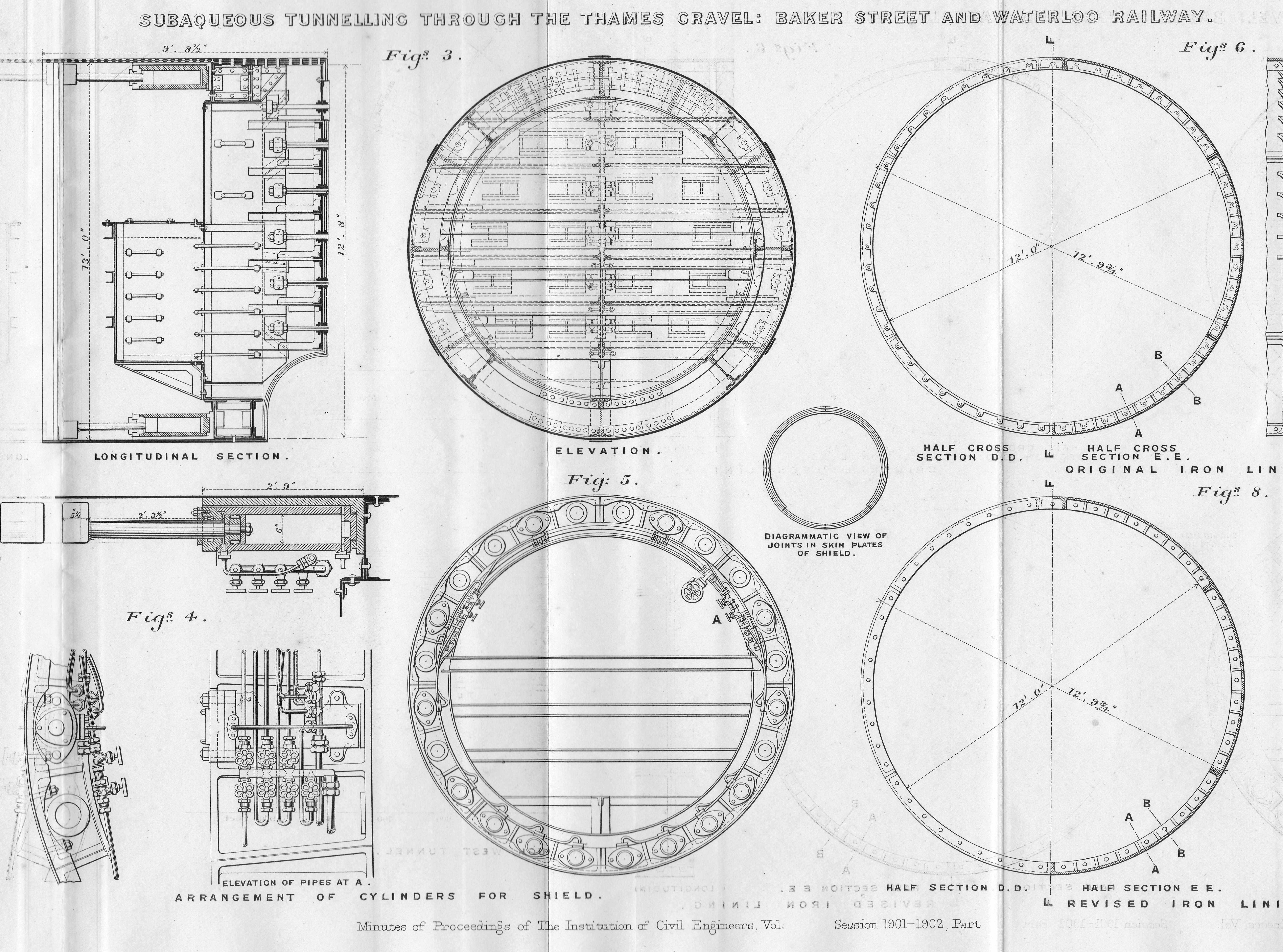
A special shield was constructed, weighing 29.5 tons and with an outer steel cylinder of 13 feet in diameter. The shield included 14 hydraulic rams, each 6 inches in diameter, to push the shield forward as the gravel in front of the shield was excavated.

The following diagrams show some of the detail of the shield’s construction, including the hydraulic rams, their controls and the pipes feeding the rams, along with elevations of sections of the shield. Each hydraulic ram could be operated independently

Baker Street and Waterloo Railway

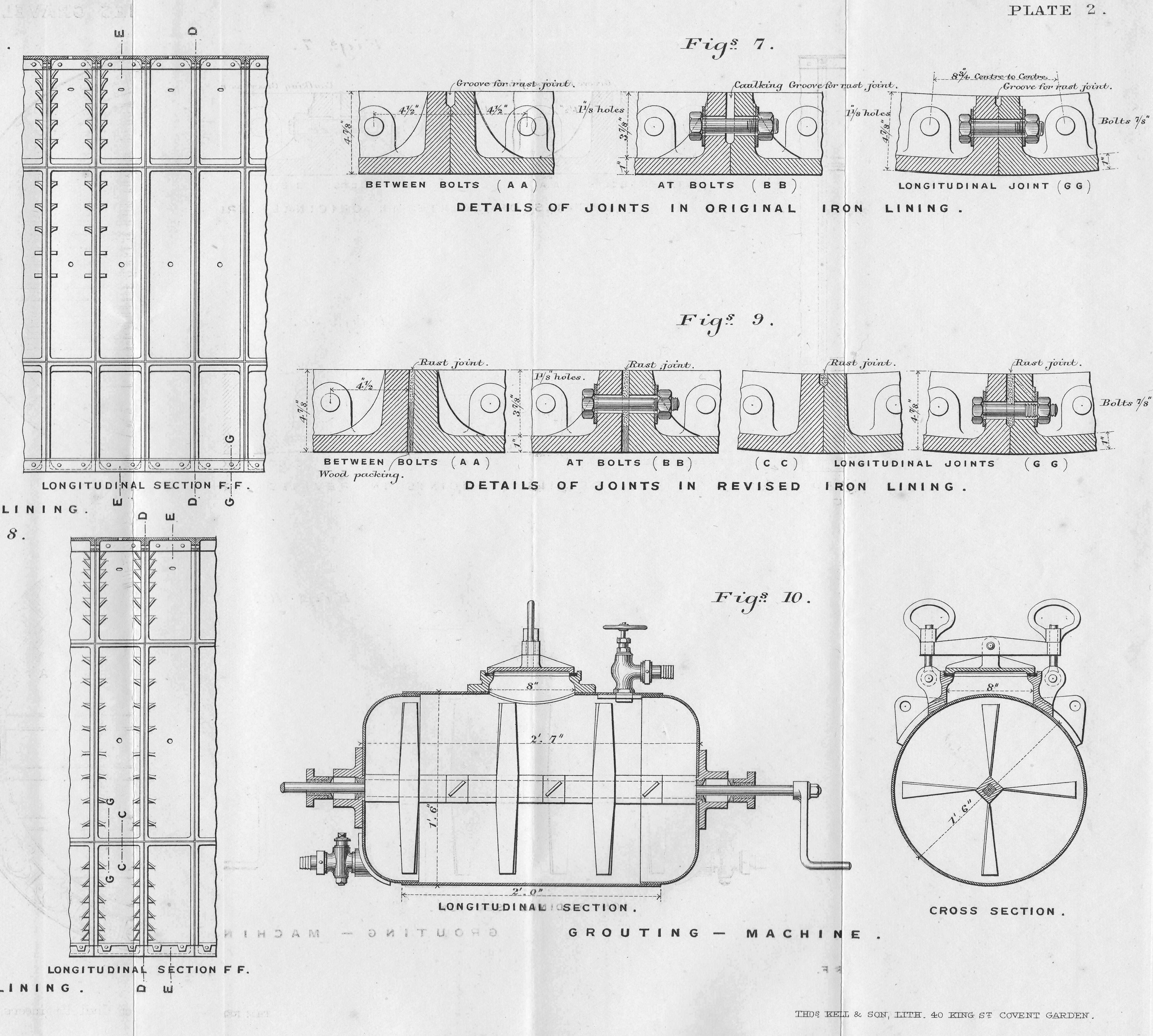
Specially constructed iron rings were designed for the tunnel wall under the river. Each ring was 18 inches wide, and constructed of seven segments. Initially, the joints between the rings were machined to give a smooth fit between rings where bolts were inserted to join the two, however this design was soon revised with rough surfaces on the joints, which were then packed with creosoted pine wood (figures 7 and 9 below).
Baker Street and Waterloo Railway

Gaps were grouted using a specially designed grouting machine (figure 10 above), which applied the grout at pressure, through special grouting holes, to help make the rings water tight.

The first part of the tunnel was through London Clay, however as the tunnel approached the centre of the Thames, it hit the water bearing gravel shown in the diagram earlier in the post. This required a change in tunneling method.

Compressed air was now used to keep the tunnel pressure at a level slightly higher than the pressure of the water through which the tunnel was being bored. This prevented water entering the tunnel, but required adjusted working conditions for the workers, with shifts reducing from 12 to 8 hour shifts.

Air pressure was also adjusted as the tide above rose and fell as the pressure of the column of water above the tunnel through the gravel and the river changed.

As the air pressure in the tunnel was higher than the water column, air would escape from the tunnel, up through the gravel, and could be seen by those on the side of the river as water spouts, with the position of the spouts changing as the tunnel progressed across the river.
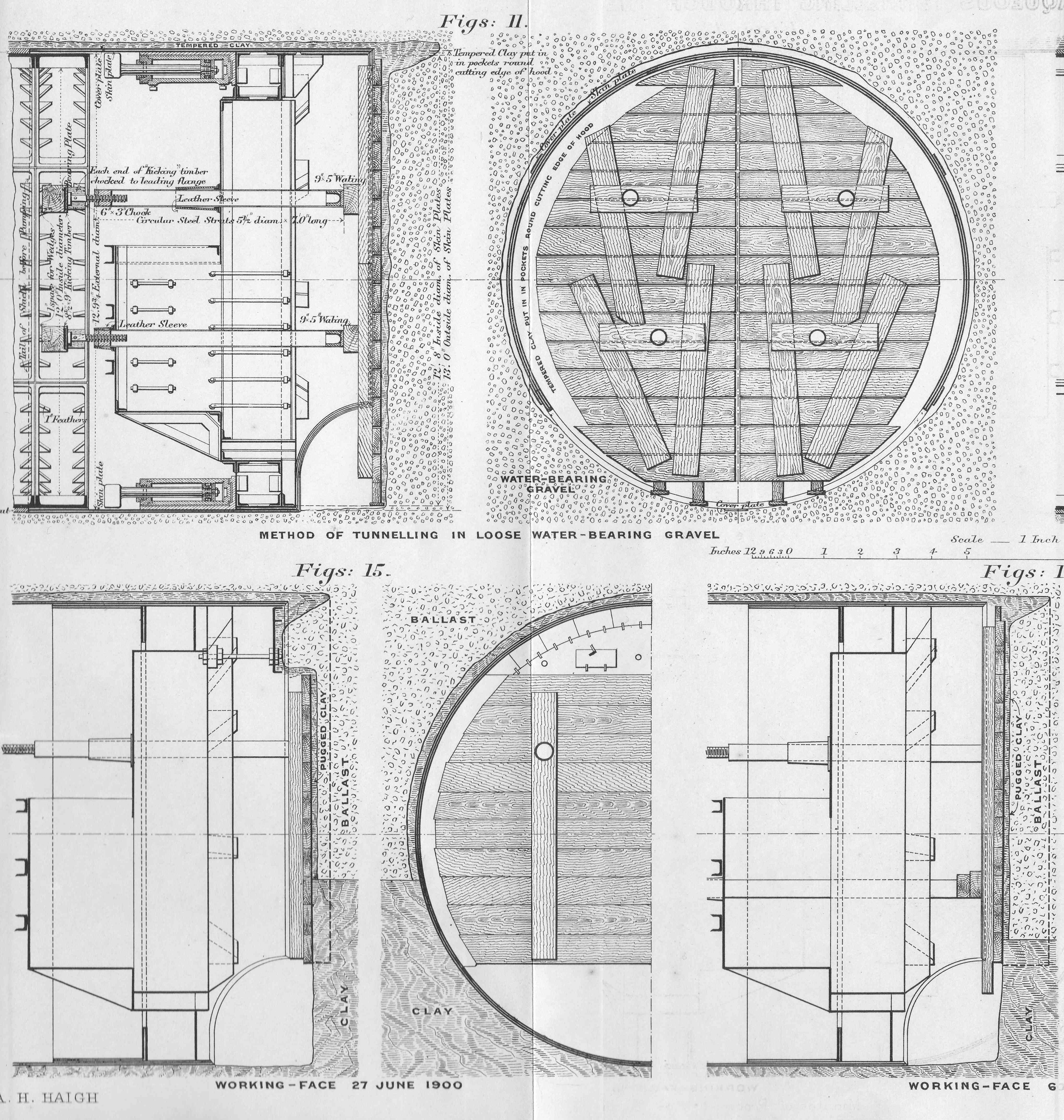
The configuration of the shield needed to change as the shield approached and entered the gravel. The following drawings show the shield as it approached and then went through the gravel (called ballast in the diagrams).

Baker Street and Waterloo Railway

Work on the first tunnel commenced on the 19th March 1900. it had taken the previous January and February to construct the shield at the bottom of the shaft. On the 2nd of April, work was stopped to allow the construction of an 8 foot thick bulkhead brick wall in the tunnel. This would form the airlock to the section of the tunnel through the gravel where compressed air would be used.

Tunneling restarted on the 2nd of May and on the 6th of June the shield entered the gravel, and on the 15th July, the tunnel was fully within the gravel.

During the period of tunneling through the gravel, there were a few “blowouts” where water entered the space behind the shield. The design of the shield allowed time for the men working to escape, and provided a means of re-entering sections, and continuing work.

On the 27th September, the tunnel re-entered London Clay, with the last of the gravel seen on the 6th October 1900.

Tests were then carried out by removing the pumped air pressure to check for leaks, repairs carried out and compressed air was ended on the 27th October, with the airlock being demolished in November 1900.

The second tunnel was constructed in 1901, with the majority of the same workers, and using many of the lessons learnt on the first tunnel. This second tunnel was completed separately as the shield from the first tunnel was reused.

There were no deaths during construction, two “illnesses” due to working in compressed air, neither of which appear to have been serious. Workers were provided with hot coffee, clean work clothes, and a place to change before and after work. A doctor was assigned to the project to monitor those working in the part of the tunnels with compressed air.

Figure 11 at the top of the following diagrams highlights the method of tunneling in loose, water-bearing gravel:

Baker Street and Waterloo Railway

The Baker Street and Waterloo Railway commenced services in 1906, from Baker Street to Elephant and Castle. The Middlesex & Surrey Express on March the 9th, 1906 provided a description of the new railway:

“The Bakerloo, London’s new tube railway, running from Baker-street to Kennington-road, will be opened tomorrow. There are intermediate stations at Waterloo, Embankment, Trafalgar-square, Piccadilly Circus, Oxford Circus and Regent’s Park, and a novelty about the new stations is that they are each treated in a separate colour scheme.

A uniform fare of twopence for the whole or any distance is to be charged, and trains will run at frequent intervals from half-past five in the morning until twelve thirty at night. The cars are of the usual type, well lighted, and with good, if not excessive provision made for ‘strap-hangers’ and one can imagine a scramble for straps taking place during the busiest hours. Collisions are rendered practically impossible for a most ingenious system, of automatic signaling has been adopted. Should, however, there be a prolonged breakdown, passengers will be able to leave the trains as a lighted footway has been provided between each stopping place along the whole length of the line.

The booking halls at the various stations are almost palatial in their design, and a feature of the lift accommodation is the use of compressed air in the rapid opening and shutting of the gates. All the wood used in construction has been rendered fire resisting”.

What is not mentioned in any of the news reports covering the opening of the Bakerloo is the tunnel under the river, and the challenges that were overcome in building two rail tunnels through water logged gravel under the Thames.

There was speculation at the time that the depression in the clay was caused by dredging for an earlier tunneling project for the Whitehall and Waterloo Railway.

This was a scheme to build a pneumatic railway in an iron tube under the river, the tube being sunk into the river bed rather than bored. The Railway News on the 20th of May, 1865, provided a description of project;

“THE WHITEHALL AND WATERLOO RAILWAY. Arrangements have now been completed which will admit of the commencement of works of this proposed railway immediately on the necessary Parliamentary powers being obtained. The bill has passed the Commons, it is now unopposed in the Lords and in a few days it may be expected to receive the Royal assent.

The railway is to be worked on the pneumatic principle, and is to be carried under the River Thames from Scotland-yard to the Waterloo Station of the London and South Western. The work must, of course, be finished before the wall of the Thames Embankment on the north side is built up, hence the necessity of pushing forward the preliminary arrangements as quickly as possible.

The railway will be formed by an iron tube, twelve feet in diameter, sunk into the bed of the river and supported in piers – a bridge, in fact, built in, not over the waters. the iron tubes will be made by Messrs. Samuda, and the laying of the tube and the other works will be undertaken by Messrs. Brassey and Co. The principle upon which the line will be worked will be much the same as that adopted on the experimental railway in the grounds of the Crystal Palace. The machinery will be on the Surrey side at the York-road Station.

The whole of the works will be completed in twelve months from the date of commencement. The cost of the undertaking will be about £130,000. The total weight of iron in the tube will be about 5,000 tons, and it will be sunk in four separate sections.”

The project soon ran into financial difficulties, the proposed timescale and costs for the project were hopelessly optimistic. In February 1868, papers were reporting that “The Whitehall and Waterloo Railway is at a complete standstill, and the directors advise the abandonment of the concern, unless, as they say, something turns up between this and the spring. They, of course, hope the South Western will help them in their difficulty, but one would think nothing could be farther from the thoughts of the directors of this company.”

In 1871, the company formed to build the Whitehall and Waterloo Railway was wound up.

The route of this earlier railway did follow much the same route as the later Baker Street and Waterloo Railway, and some parts of the iron tube were found during excavation for the construction of the Shell Centre complex, however I am not sure whether the depression in the London Clay was caused by dredging for this abandoned project.

The shape looks natural, the plan was to dig in the tunnel across the river to bury the iron tube, however the PLA chart shows the change in depth running along the river.
Whether natural or man-made, it was a considerable achievement to bore two tunnels that would become the Bakerloo line, through water bearing gravel, under a considerable head of water, at the start of the 20th century.
If you travel from Embankment Station to Waterloo on the Bakerloo, you will pass through this area of gravel soon after leaving the station.

alondoninheritance.com