Monthly Archives: March 2021

William Maitland’s History and Survey of London

“To the Right Honourable Slingsby Bethell, Lord-Mayor. The Right Worshipful the Court of Aldermen and Sheriffs, and the Worshipful the Court of Common-Council of the City of London.

The Proprietors of this voluminous and useful work, undertaken with a pure intention to preserve those monuments of antiquity, which convey a just idea of the wisdom, good governance, loyalty, religion, industry, hospitality and charity of your predecessors in the Magistracy of this City, and to perpetuate down to the latest posterity the present flourishing and prosperous State of this Metropolis, to which is arrived by your Zeal for the Public Good, steady attachment to the true Interest of your fellow Citizens, and unwearied Application in the Support of Trade, National Credit, and Works of Charity; and by Duty and Gratitude, as well as Affection, induced to make this Public Acknowledgment of the many Obligations they owe for your kind Assistance which has enabled them to finish so extensive and chargeable a Plan, and to seek your Patronage and future Recommendation”.

So reads the dedication at the start of William Maitland’s “History and Survey of London From Its Foundation to the Present Time”.

The History and Survey was first published in 1739, with an expanded version in two volumes in 1756. Maitland was a Scottish merchant and antiquary, born around 1693 and died in 1757. He was a Fellow of the Royal Society, but not too much appears to be known about his life.

An obituary after his death in 1757 reads “At Montrose, in an advanced age, William Maitland Esq. F.R.S. author of the histories of London and Edinburgh, and one of the history and antiquities of Scotland, lately published. He was born at Brechin, and had lately returned home to spend the remainder of his days with his relations; who, it is said, have got by his death above £10,000”.

As well as Scotland, he appears to have lived in London for some years, including when he was working on the History and Survey of London.

I cannot find any reference as to how he created the work, however he references previous historians of London, and if his work on Scotland offers a comparison, he would send out letters to vicars, societies, organizations, etc. asking for their respective history and details, which he would compile.

The History and Survey of London provides a very readable history of the city, and a wealth of information about so many aspects of the city in the first half of the 18th century.

I was able to get hold of a copy of Maitland’s History and Survey of London some years ago. Two large volumes comprising 1392 pages of text and tables and numerous drawings and maps, so for today’s post, let me take you through one of the volumes of the History and Survey of London and explore London in the early 18th century through a fraction of the information Maitland offers.
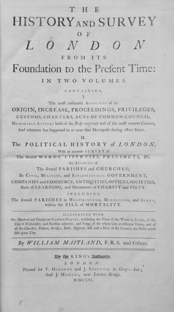
The page photos are directly from the book. Due to the age of the book, the tight binding and condition of the pages, I have not straightened or flattened them out, so some of the photos may look a bit distorted.

Click on any of the pages for a larger view.

The first Ward map is of Aldersgate Ward, which “takes its name from that north gate of the City, and consists of Diverse Streets and Lanes, lying as well within the Gate and Wall, as without”.
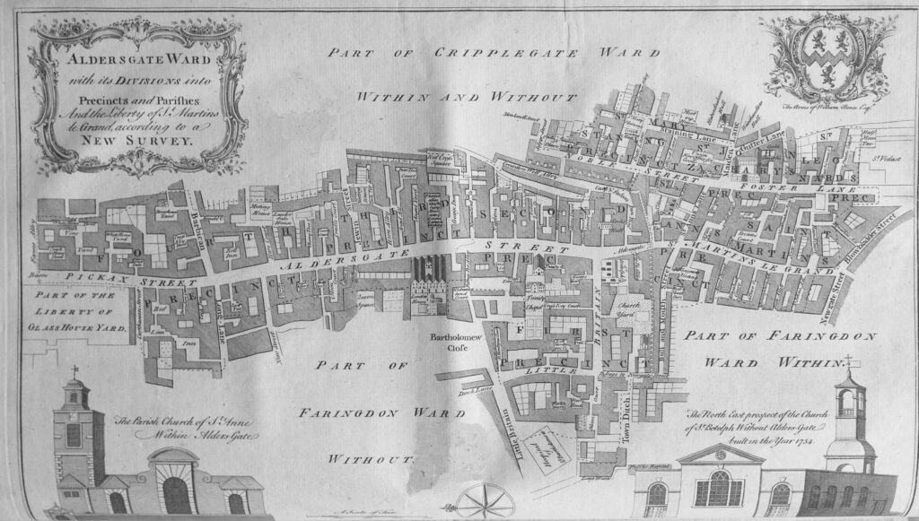
The map shows Aldersgate Street as the central street with the “diverse streets and lanes” of the ward radiating out either side.

Interesting that north of the junction with Long Lane and Barbican (now Beech Street), Aldersgate Street was called Pickax Street.

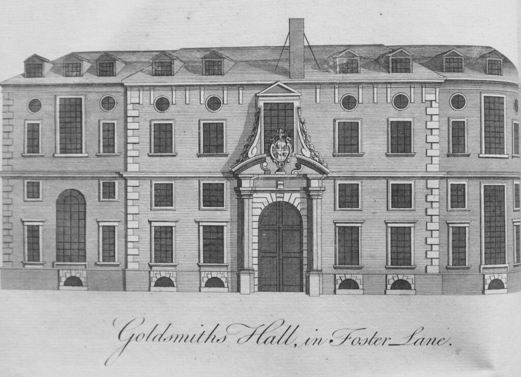
To the right of the map is the wonderfully named Blowbladder Street, and just above is Foster Lane, the home of the Goldsmiths Hall:
Also in Aldersgate Street was the City of London, Lying-In Hospital for Married Women, which had been “instituted on March 30th 1750”.
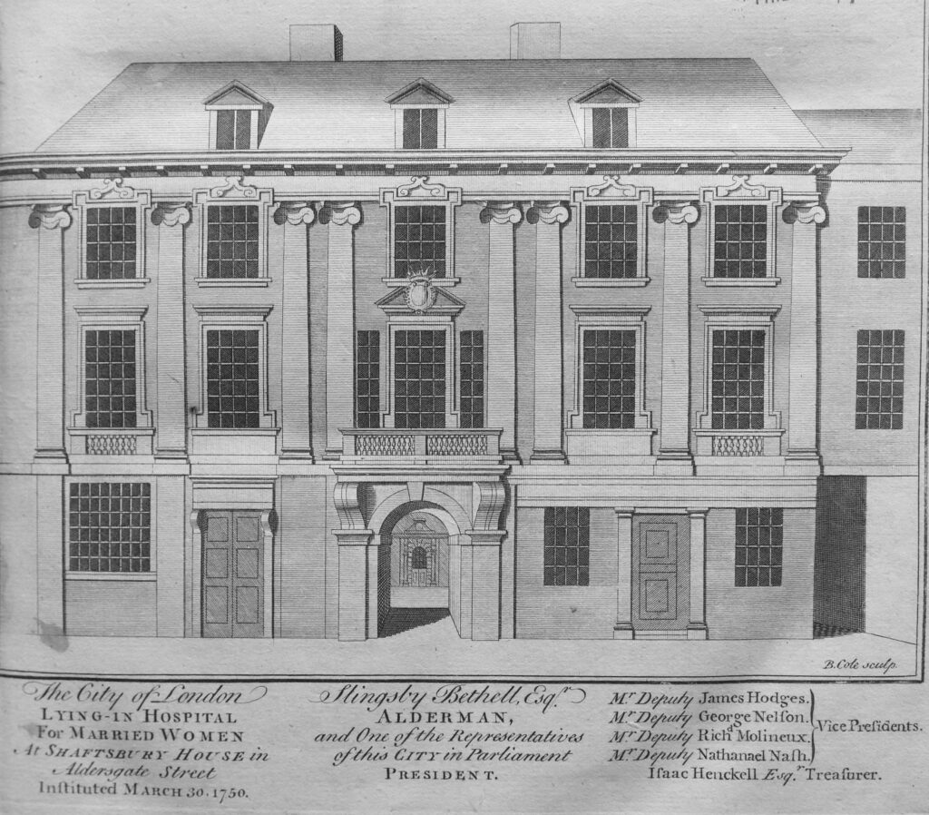
The description of the hospital provides a clear view of the attitudes of the time, and who was deserving of charity. The name of the hospital indicates that it was only for Married Women, and the text further includes terms such as “the industrious poor” and that it had been set-up for the “Wives of Poor Tradesmen or others labouring under the Terrors, Pains and Hazards of Childbirth”.

We next come to Aldgate Ward, which “takes its name from the East gate of the City, called Aldgate, or anciently Ealdgate”.
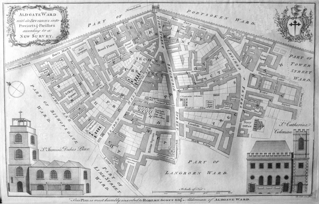
The map includes the Ironmongers Hall, the Bricklayers Hall, the synagogues off Beavis Marks and in Magpye Alley, and to the south centre of the map, the East India Warehouse.

Within the dense text of the books, there are numerous tables providing statistics of life in London in the first half of the 18th century. The table below shows the number of people buried between 1704 and 1733, including where they were buried, split by male / female and those who had been christened.
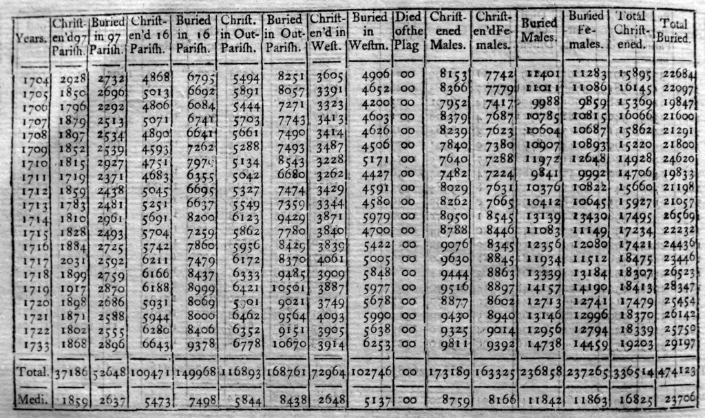
As would be expected, the number of deaths changes year to year, however there is a gradually increasing trend in the total number of deaths per year which probably reflects the growing population of the city, rather than an increased rate of deaths for a given population count.

There are a wealth of statistics in the book, all begging to be entered into an Excel spreadsheet followed by a bit of graphing – perhaps one day.

Next up is Baynards Castle Ward and Farringdon Ward Within.
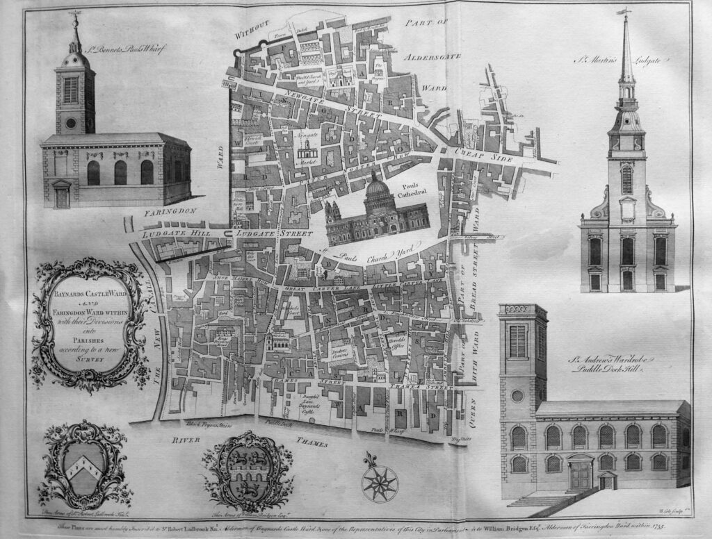
The map shows the location of Barnards Castle on the river to the south of the map. Farringdon Ward is Within, as it is within the old City walls as shown by the thick line to the left of the streets, along with the Fleet River, or the New Canal.

At the centre of the map is St Paul’s Cathedral, at the end of Ludgate Street (note that the present day street was divided into Ludgate Hill and Street at the location of the city gate). The book includes a print showing the west end of St Paul’s, facing onto Ludgate Street:
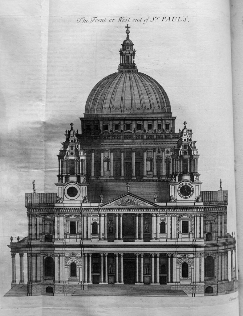
Very few drawings seem to get the dome of the cathedral right, and the above drawing seems to have a slightly flattened dome.

The book includes the dimensions of the cathedral, which was still relatively new at the time the book was published:
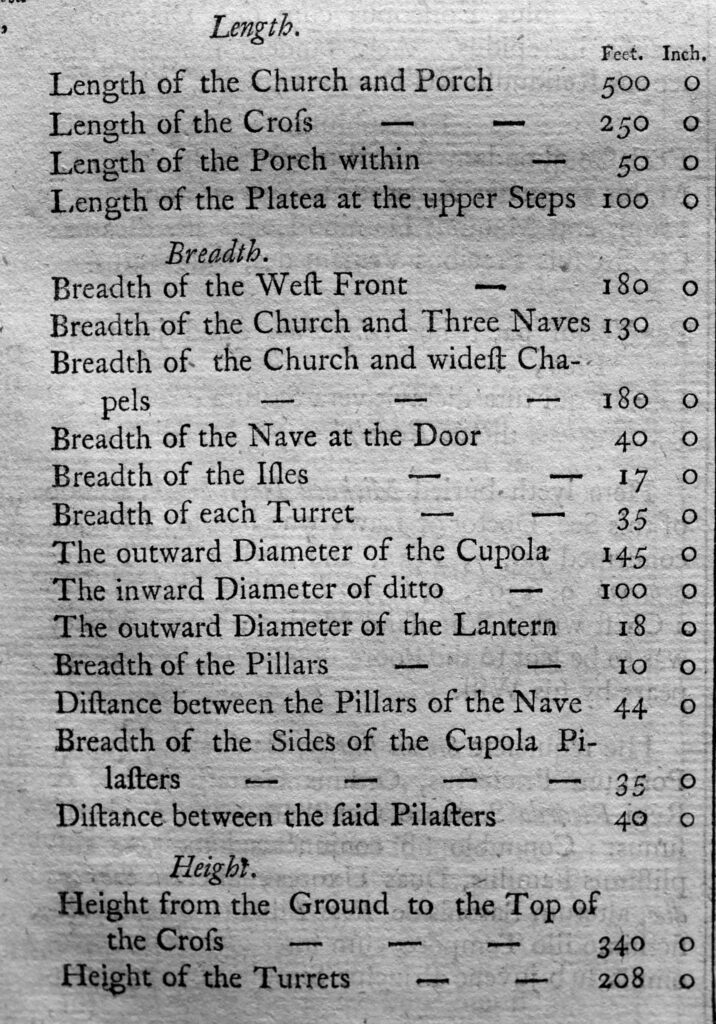
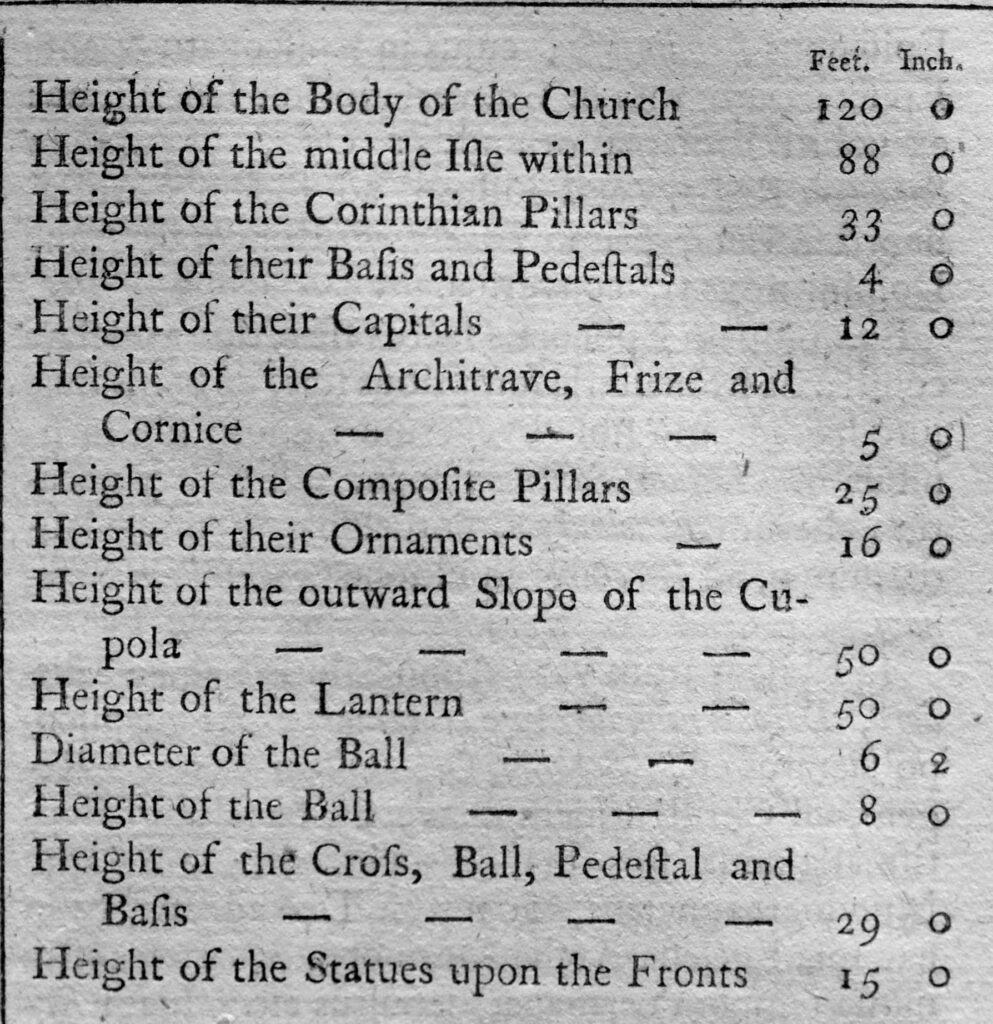
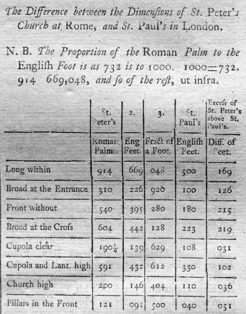
As well as the dimensions of the cathedral, there is a comparison with St Peter’s Church in Rome, where St Peter’s was apparently still measured in Roman Palm, so the table includes a conversion from Roman Palm to English Feet. The table shows that in all measurements, St Peter’s is larger than St Paul’s.
We next come to Billingsgate Ward and Bridge Ward Within.
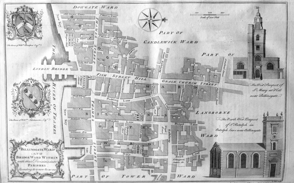
The map shows Thames Street running the length of the ward, with the street being described as “a place of very considerable trade on account of its convenient situation near the water, the Custom House, Billingsgate and several Wharfs and Keys for the lading and unlading of Merchants Goods, and is very well built for that purpose”.

The map shows the original location of London Bridge, when Fish Street Hill and Grace Church Street were the main streets leading down from the centre of the City to the river crossing.

The text lists twenty one Keys, Wharfs and Docks that line the river between Dowgate and Tower Wards showing just how busy was this short stretch of the river.

Next up is Bishops Gate Ward Within and Without, showing that the ward covered the area both within and without the old city walls.
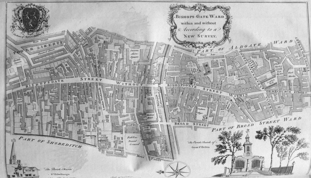
Bishops Gate Ward was another ward that took its name from one of the City gates.

The text for each ward describes the streets and buildings of the ward, as well as administrative details covering how the ward was run. For example, for Bishops Gate Ward “There are to watch at Bishopsgate, and the several stands in the Ward, every Night, a Constable, the Beadle, and eighty watchmen, both within and without”.

The ward also had “An Alderman, two deputies, one without the Gate, another within, six Common-Council men, seven Constables, seven Scavengers, thirteen for the Wardmote Inquest, and a Beadle. it is taxed at thirteen Pounds”.

Many of these adminstrative arrangements had not changed for many centuries.

Bread Street Ward and Cordwainers Ward were two relatively small wards in the centre of the City:
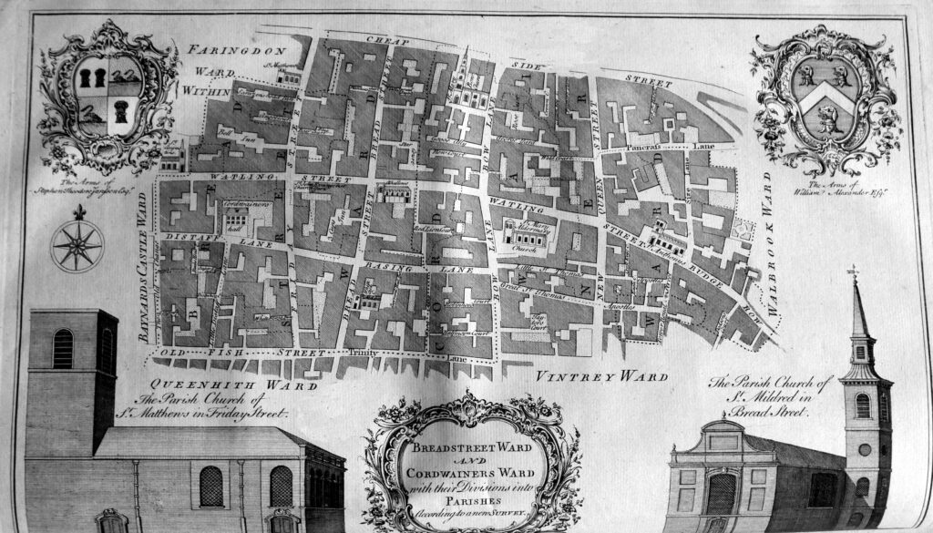
Bread Street Ward “takes its name from the principal street therein, called Bread Street, which, in old Time, was the Bread-market”,

Cordwainers Ward takes its name from “the occupation of the principal inhabitants, who were Cordwainers, or Shoemakers, Curriers and other Workers of Leather”.

A large fold out map covers Broad Street and Cornhill Wards:
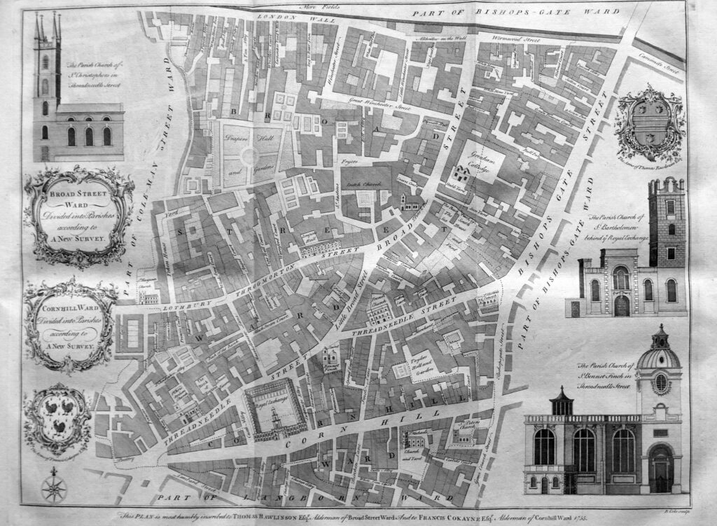
The text gives the source of the Broad Street name as being a reference to the street before the Great Fire as “there being few before the Fire of London of such a Breadth within the Walls” Cornhill Ward derives its name from Cornhill Street which took its name from the corn market which was “kept there in ancient times”.

In the lower part of the map, above Corn Hill we can see the Royal Exchange, and to the upper left of the Royal Exchange is the Bank of England, then a relatively small building. To the left of the Bank is St Christopher’s Church. This old church would be demolished in 1781 to make way for the extension of the Bank of England along Threadneedle Street as the bank expands to take up the large site it occupies today.

The map of Cheap Ward, includes in the corners, four of the important buildings within the ward – the Guildhall Chapel, the Grocers Hall, the Blackwell Hall and the church of St Mildred in the Poultry.
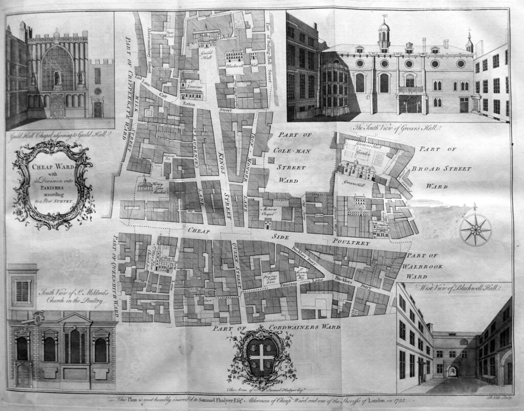
The text explains that the name Cheap comes from the Saxon word Chepe, meaning a market which was held in this area of the City. Markets and shops selling provisions have long occupied this area of the City, and on the left boundary of the ward, just above Cheap is shown Honey Lane Market. This market is described “as well served every Week, on Mondays, Wednesdays, Fridays and Saturdays, with provisions. The Place being taken up by this Market is spacious, being in length, from East to West 193 feet, and from North to South, 97 feet. In the middle is a large and square Market-house standing on pillars with rooms over it, and a Bell Tower in the middle. There are in the Market 135 standing stalls for Butchers, with Racks to shelter them from the injury of the weather, and also several stalls for Fruiterers”.

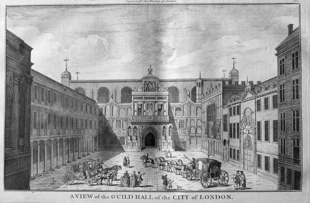
Running vertically along the map is Queen Street, then King’s Street, which run up to the Guild Hall. The book includes a print of the Guild Hall as it appeared in the middle of the 18th century:
The next map covers Coleman Street and Bassishaw Wards:
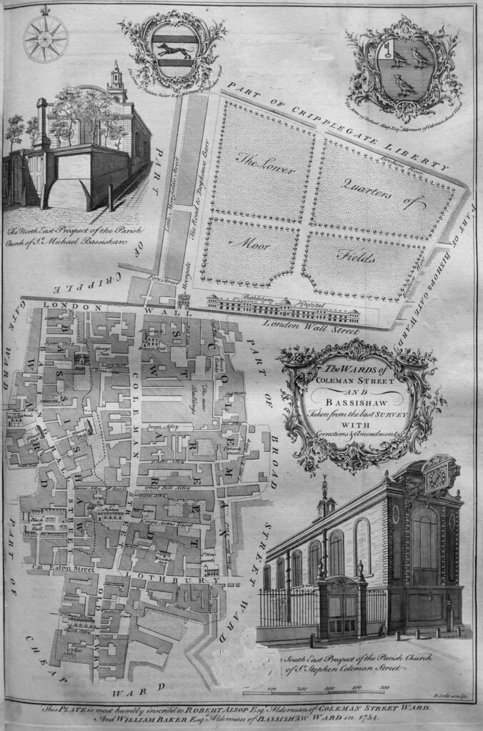
The map shows the streets of Coleman Street Ward to the south of London Wall, and on the other side of the wall we see “The lower quarters of Moor Fields” and the Bethlehem Hospital.

The Moor gate leads into Fore Street and also to the intriguingly named “Road to Doghouse Barr”.

To the left of the above map is Cripplegate Ward, and it is to Cripplegate Ward and Cripplegate Parish without the Freedom that we come to next:
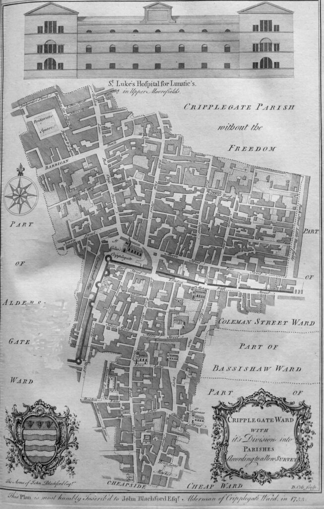
The map shows the ward within the well defined old City wall, with the street London Wall following its original alignment before post war reconstruction diverted the street south and removed the relationship between street and wall.

The bastions we can still see today are along the west of the ward, and outside the ward to the north is the church of St Giles Cripplegate and with further north, the streets that today are buried under the Barbican and Golden Lane estates.

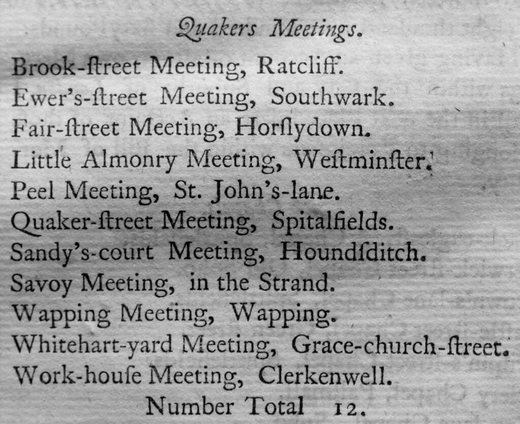
Churches are a feature of all the ward maps, and the book include long lists of all the religious establishments in London in the middle of the 18th century. The shortest list is that covering the location of Quaker meeting places, there being a total number of 12 within London at the time.
The maps also show the main Halls of the most important Guilds and Company’s of the City, the Barbers Hall is shown up against the wall to the left of the Cripplegate map. The text of the book provides details of all the Guilds, Company’s and Fellowships of the City and their order of precedence. There are a number of interesting institutions lower down in the order of precedence.

In last week’s post on St John’s Lane, the role of Carman was listed as the profession of a number of those living in the street. In the book, and at number 89, is the Fellowship of Carmen, constituted as a Fellowship of the City in the reign of Henry VIII.
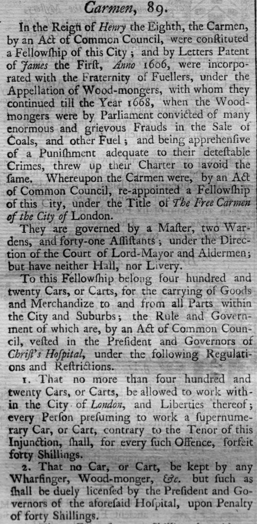
The text includes all the rules and regulations for each company, and one of the key roles was in regulating how many could practice the trade for which the company was responsible. This effectively established a monopoly for each trade and restricted competition by limiting the number within each trade.

For the Carmen, no more than four hundred and twenty Cars or Carts would “be allowed to work within the City of London, and the Liberties thereof”, with a forty shilling fine for exceeding this limit.

There were some very small Companies, including at number 82, the Longbow String Makers:
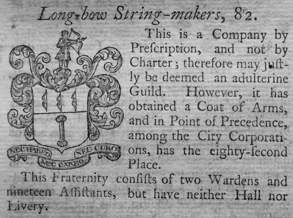
The Longbow String Makers were a “Company by prescription, and not by Charter; therefore may be deemed an adulterine Guild”.

An adulterine Guild was a set of traders or a profession that acted as a Guild, but without a Charter, and had to pay an annual fine for the privilege of acting as a Guild.

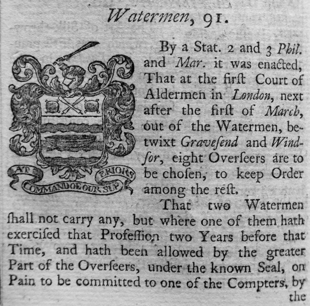
And in at number 91 were the Watermen (sounds more like a music chart). This profession has featured many times in my posts on the Thames and the River Stairs.

The Watermen were charged with overseeing the watermen’s trade between Gravesend and Windsor, and that those who worked as watermen followed a strict set of rules.
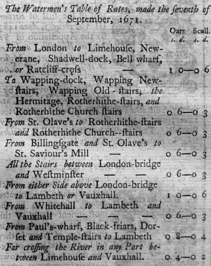
One of the rules was a Table of Rates, listing what a Waterman could charge between specific places on the river. This was important for customers as when you wanted a Waterman to transport you along the river, you would have wanted the assurance of knowing the cost, and that any of the Watermen trading at a specific boarding point should be charging the same rate.
Next comes Farringdon Ward Without:
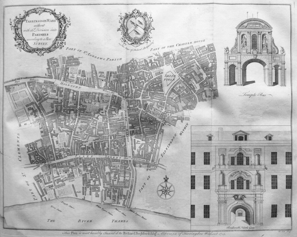
This is a large ward, and runs up to Temple Bar to the west (an image of which is in the top right corner). We have also moved into legal London with Lincoln’s Inn to upper left. In the centre of the map is the River Fleet, although now the Fleet Ditch below Fleet Street and covered by the Fleet Market between Fleet Street and Holbourn Bridge.
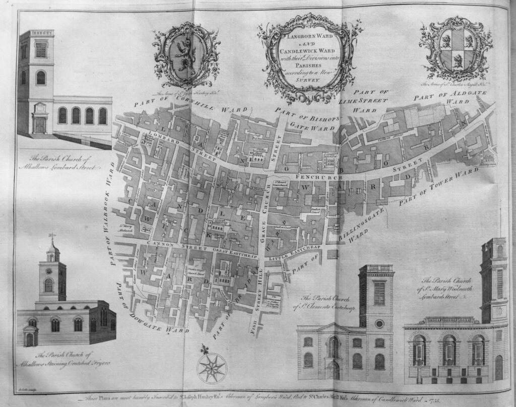
To the upper right of the map is Smithfield, and just to the right of Smithfield are “The Sheep Penns”.

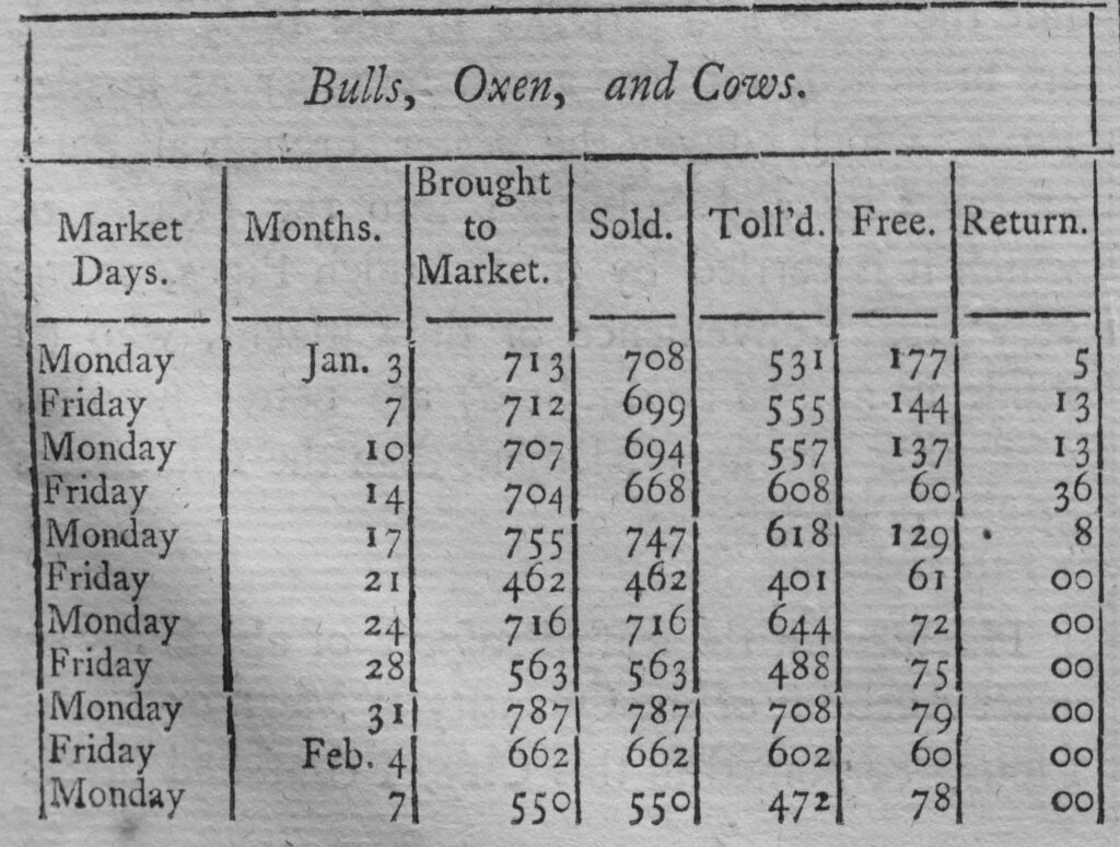
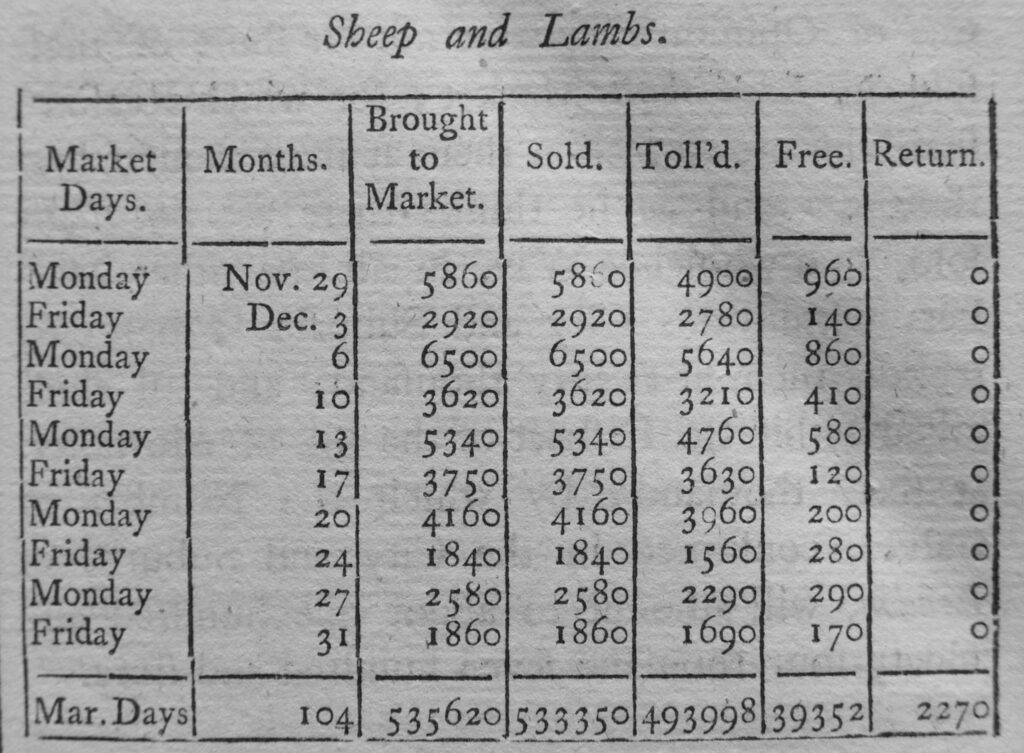
The book includes details from the Smithfield Clerk of the Market’s Account for the Year 1725 which shows the high numbers of animals sold at the market each day.

The tables are too large to include in this post, however a couple of extracts provide a sense of the numbers passing through the market in 1725:
History and Survey of London

The numbers in the bottom row of the above table show the total number of Sheep and Lambs sold during 104 market days at Smithfield Market in 1725. A considerable number, when you also consider that these animals had been driven from their farm or fields, and had come through the streets north of Smithfield to arrive at the market, which, as the upper table illustrates was also selling Bulls, Oxen and Cows.

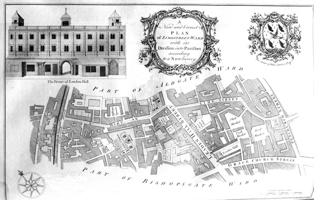
Limestreet Ward was a small ward, taking its name from Lime Street, which referred to “a Place in ancient Times where Lime was either made or sold in Public Market”.
History and Survey of London

Limestreet Ward is the location of the area now known as Leadenhall Market. The early 18th century version of the market can be seen by the references to Flesh, Fish and Herb Markets to the right of Leaden Hall Street, with the original Leaden Hall being seen to the south of the street.

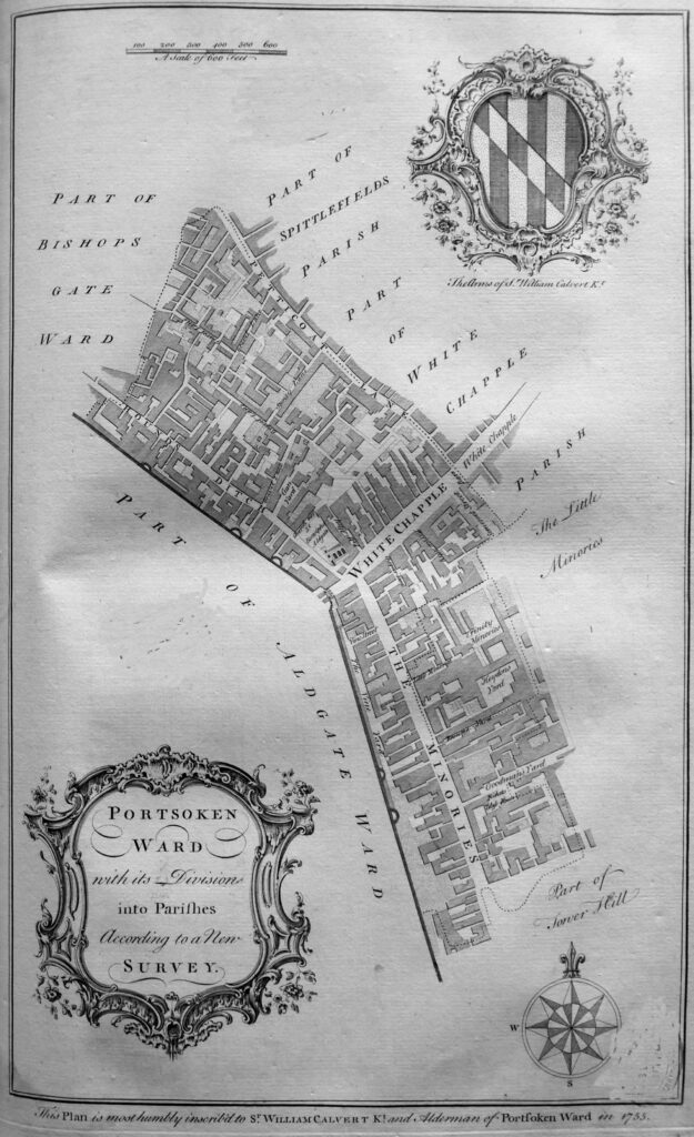
Portsoken Ward was outside the City walls.
History and Survey of London

A feature of all the ward maps is that at the bottom of the map is a dedication to an alderman of the ward. For Portsoken “this plan is most humbly inscribed to Sr. William Calvert Kt. an Alderman of Portsoken Ward in 1755”.

The description of the ward also mentions Whitechapel as the principle street to the City from the east, which was “a spacious street for entrance into the City Eastward. It is a great thorough-fare, being the Essex Road, and well resorted to, which occasions it to be well inhabited, and accommodated with good inns for the Reception of Travelers, Horses, Coaches and Wagons. Here on the south side of the street is a Hay Market three times a week”.

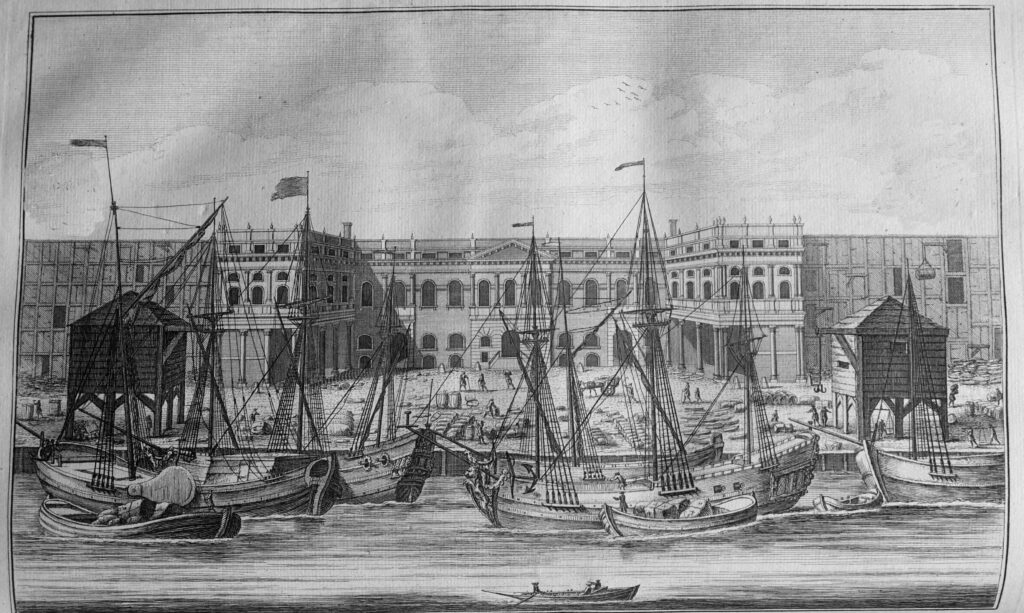
In the mid 18th century, the affluence of the City was growing based on the trade that was brought to the City along the River Thames. The river today is quiet and it is hard to imagine that the river was the hub of London business for so many centuries, and was extremely busy. The following print shows the Customs House on the river:
History and Survey of London

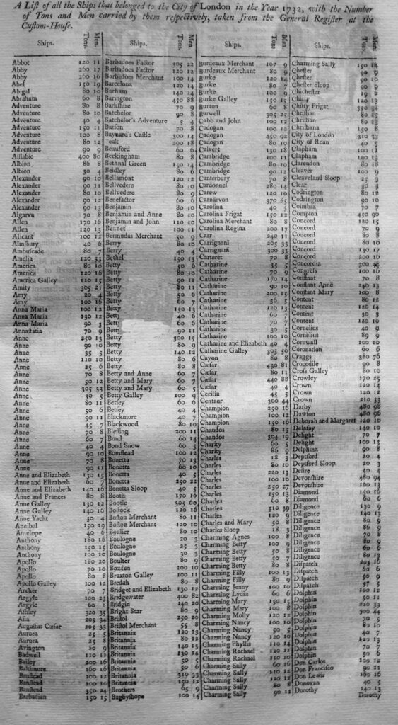
To get an idea of the scale of trade on the river, the book includes several pages of a list of “the ships that belonged to the City of London in the Year 1732”. The following is the first page of the table:
History and Survey of London

In total, in 1732, there were 1,417 ships, with a total of 178,557 tons, crewed by 21,797 men recorded as belonging to the City of London. It was these ships that transported the trade on which the City grew rich.

Many of those ships could have unloaded their cargo at one of the wharfs that line the river in the second of the wards in the following map of Walbrook and Dowgate Wards.
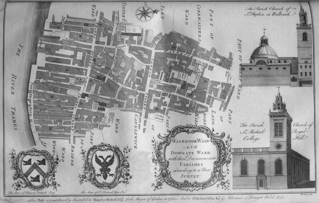
History and Survey of London

In the description of Dowgate Ward, Thames Street is described as “a great thoroughfare for carts to several wharfs, which renders it a place of considerable trade, and to be well inhabited”.

Much of that trade was run by various trading companies headquartered in the City of London. The book details all these companies, one of which was the Russia Company:
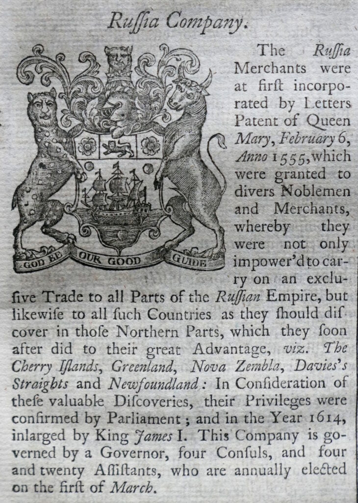
History and Survey of London

And perhaps the most well known of the trading companies – the East India Company:
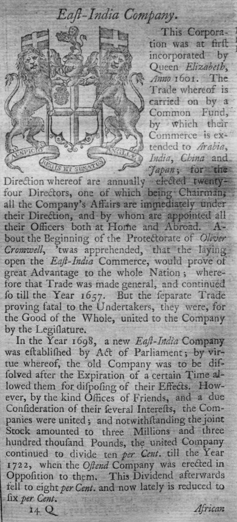
History and Survey of London

The description of the East india Company provides an indication of the value of these trading companies and the wealth they created.

In 1698 the East India Company was worth Three Million, Three Hundred Thousand Pounds – a considerable sum of money at the end of the 17th century, and in the early years of the 18th century, was generating a dividend of 10%, falling to 8% for investors.

Another source of funds, part of which contributed to the City, including the costs of rebuilding St Paul’s Cathedral after the Great Fire was the Coal Duty.

A Coal-meters Office was based in Church Alley, St Dunstan’s Hill, and in the office the records of all ships entering the Port of London with coals were recorded:
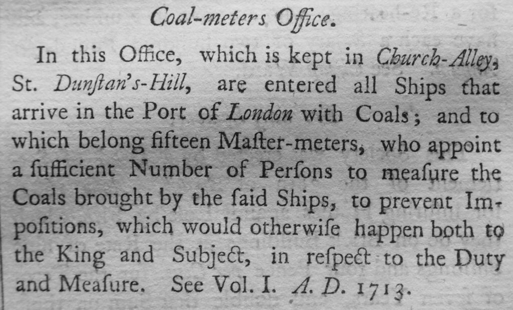
History and Survey of London

Maitland’s Survey of London included areas on the edge of, or were part of the wider London. the following print is of the Charter House Hospital as it appeared in the early 18th century:
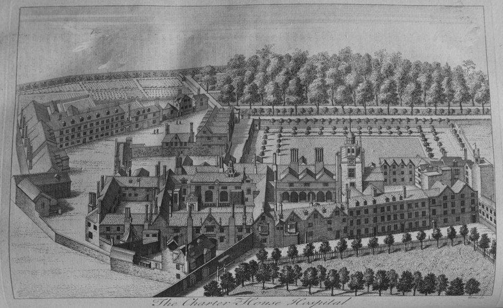
History and Survey of London

Map showing the City of Westminster and Duchy of Lancaster:
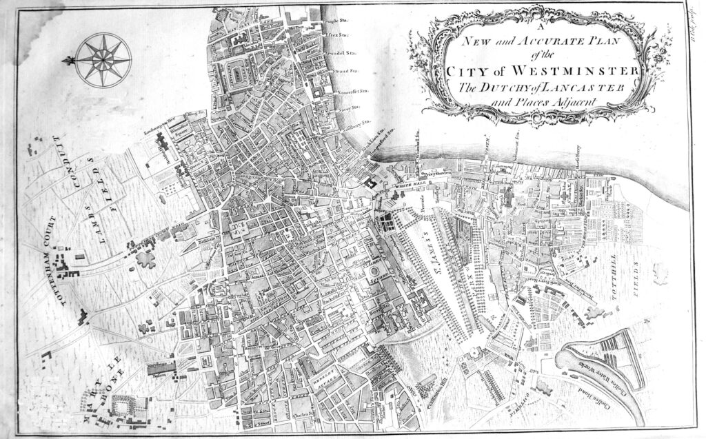
History and Survey of London

To the left of the map, Tottenham Court Road still ran through fields, Chelsea Water Works are to the right of the map, and along the river are the names of many of the Thames Stairs, all now lost under the 19th century Embankment.

The view of the first Westminster Bridge, with the two towers of Westminster Abbey on the right edge of the print:
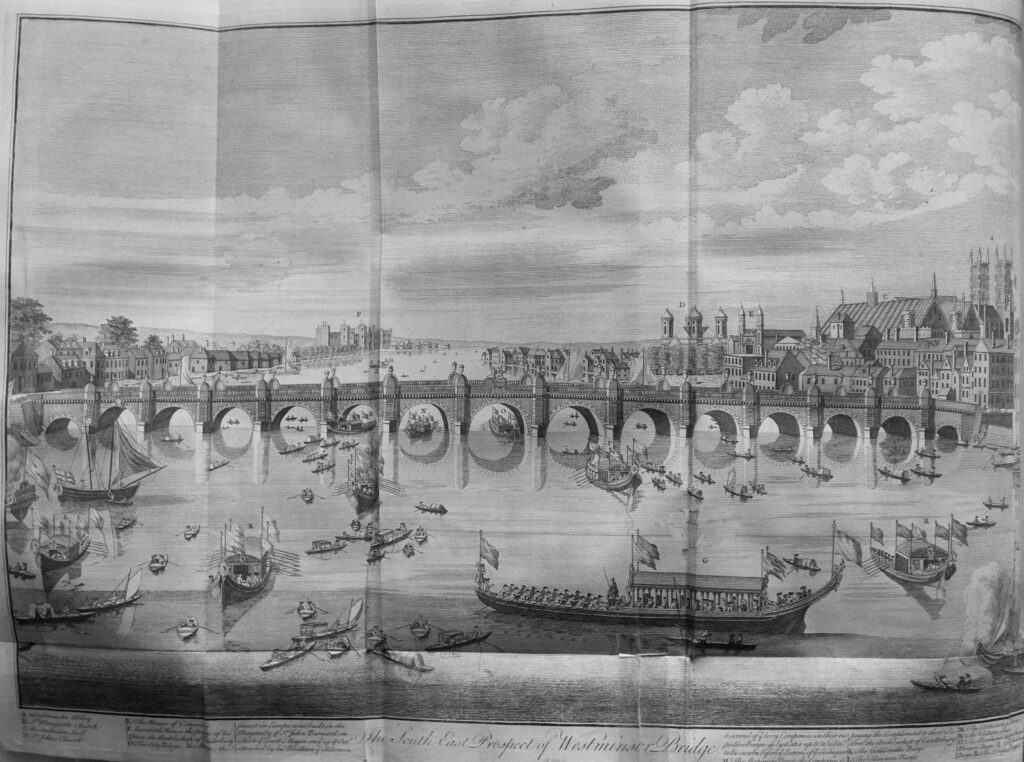
History and Survey of London

And to the east of the city, the Parish Church of St John’s at Wapping:
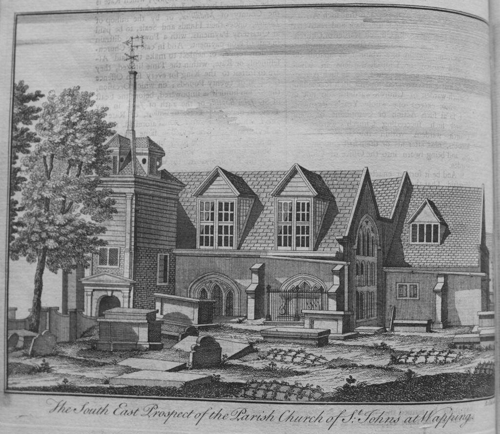
History and Survey of London

The Parish church of St Paul’s at Shadwell:
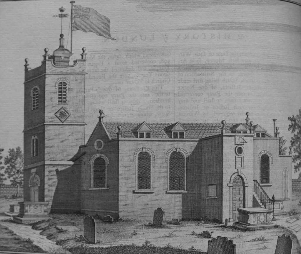
History and Survey of London

William Maitland provides a very readable history and survey of London. The book really brings to life how the city was administered and operated. The wealth of the city and the trade that generated this wealth. All manner of statistics and lists cover those living in the city, key buildings and organisations.

As written in the dedication at the start of the book, it really does describe “to the latest posterity the present flourishing and prosperous State of this Metropolis

The History and Survey of London is also available online and can be found at here.

alondoninheritance.com

St John’s Lane – First World War Bombing, Passing Alley and the Census

For this week’s post, I am back in Clerkenwell, an area I have explored in a number of recent posts, and today I will take a walk along St John’s Lane, a street that runs from St John’s Street, up to St John’s Gate.

Although St John’s Lane is relatively short, there is so much that the street can tell us about the history of the area, events across London, and the people who have passed through London.

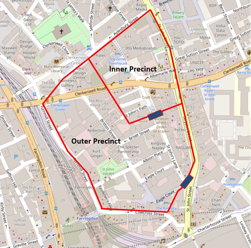
St John’s Lane is a very old street, dating back to the 12th century. The street originally ran through the outer precinct of the Priory of the Order of St John of Jerusalem, leading from a gate at the southern end, to St John’s Gate at the northern end, which formed the gateway to the inner precinct. The following map is repeated from my earlier post on the Order of St John, and shows St John’s Lane between the two blue rectangles, which represent the gatehouses into the outer and inner precincts (Map © OpenStreetMap contributors).

St John's Lane

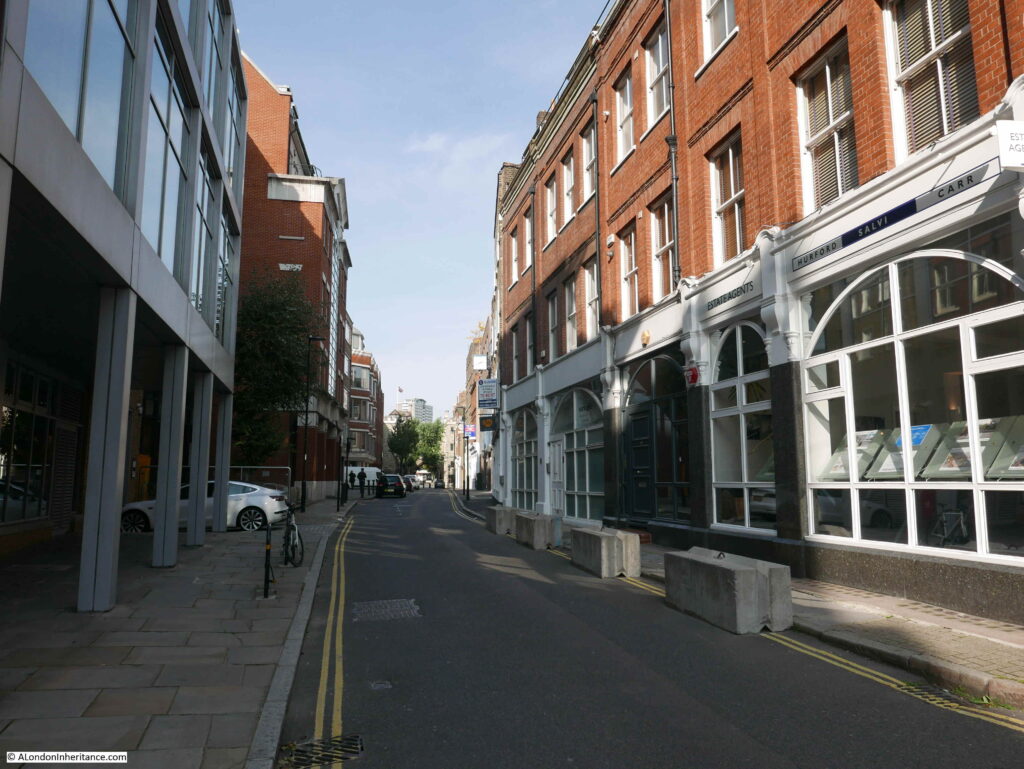
St John’s Lane today, photographed from the south, looking up towards St John’s Gate just beyond the trees at the end of the street.

St John's Lane

St John’s Lane today is mainly lined by late 19th and early 20th century buildings, along with a number of post war buildings, mainly on the western side of the street which suffered a higher degree of bomb damage during the last war.

During the time that St John’s Lane was part of the outer precinct of the priory, the street was lined by buildings associated with the priory, including a number of large houses with gardens to the rear, owned by important members of the Order of St John.

The Clerkenwell News of the 16th December 1863 included a very imaginative and colourful description of St John’s Lane in an article on the history of the street “What a glorious picture does imagination, aided by the indubitable facts of history, present of the splendid pageants which, in the days of chivalry, passed along this highway, their pomp and splendor offtimes swelled by the gorgeous retinue of some kingly potentate or prince of royal blood. What an array have we of glittering lances, blazoned shields, and fluttering pennons – heralds in their gaudy tabards – knights, the flower of England’s nobility, mounted on stately charges, richly caparisoned. Obsequious esquires, and the fair dames and daughters of nobles, grace by their presence the magnificent cortege, pleased to follow their lords and loves to the tournament in the neighbouring Smithfield”.

After the priory was taken by Henry VIII during the dissolution in the 1540s, many of the buildings and much of the land was sold off, however evidence of the large houses that once lined the street could still be seen in the 17th century.

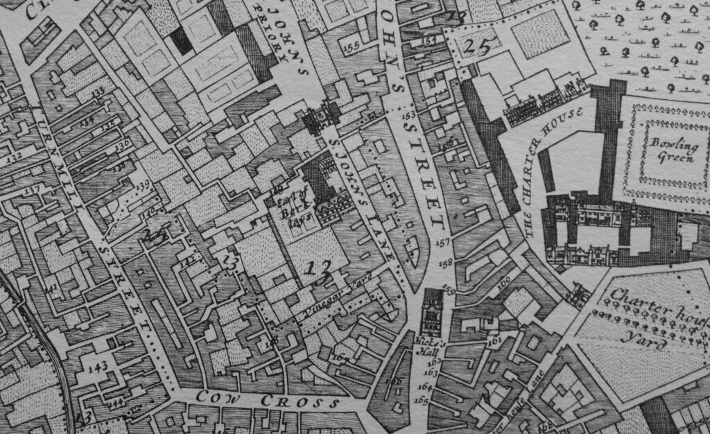
The following extract from William Morgan’s Survey of London from 1682 shows St John’s Lane in the centre of the map, and to the left of the upper part of the street is the house and grounds of the “Earl of Berkleys”.

St John's Lane

By the end of the 19th century, the street was a mix of different type and use of buildings. There were terrace houses, a pub, a Friends Meeting House, a Smithy, along with a mix of industrial buildings and workshops supporting the trades that had moved into Clerkenwell.

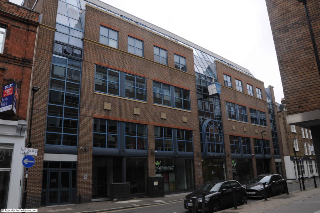
Only a few of these buildings can be seen today. The Friends Meeting House was destroyed during the war, and in 1992 the following building was completed on the site.

St John's Lane

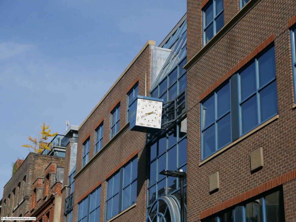
This is Watchmaker Court, an office building with a name that recalls one of the crafts / industries that was based in Clerkenwell from the late 17th to the early 20th centuries.

A clock stands out from the front of the building, telling the time in Roman numerals.

St John's Lane

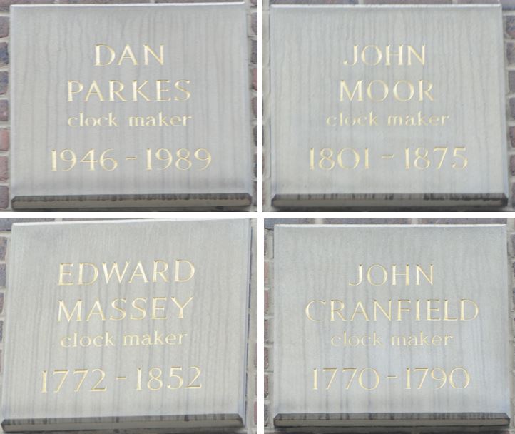
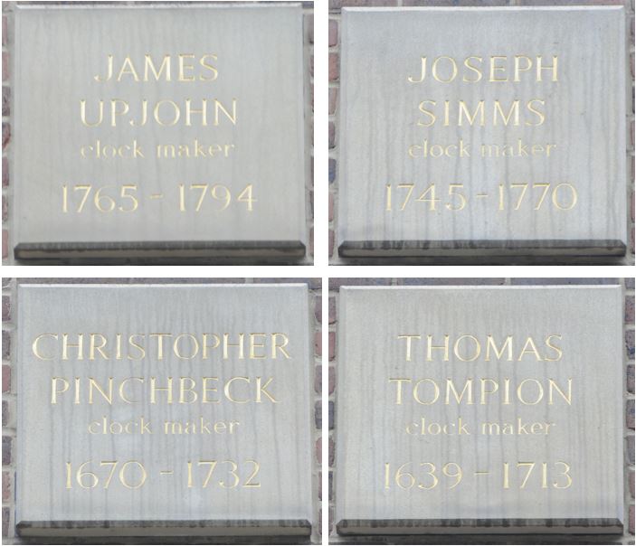
There are eight plaques along the front of the building, each naming a significant clock maker in chronological order, starting with Dan Parkes:

St John's Lane

One of those named is Christopher Pinchbeck, who lived in Albion Place, one of the streets that runs off St John’s Lane to the west. Pinchbeck invented an alloy of copper and zinc which very nearly resembled gold.

St John's Lane

On the northern side of Watchmaker Court is the building that was once the pub, the Old Baptist’s Head:

St John's Lane

The building that we see today is a rebuild of the pub dating from the 1890s, however the pub had been on the site for many years, originally being part of the house of Sir Thomas Forster, who died here in 1612.

There seem to be various post war dates for when the pub closed, however by 1961 the building had been converted to a warehouse.

There is nothing really remarkable about the old pub building, in what is now a relatively quiet street. The pub has played a part in the life of so many who have passed through London over the centuries.

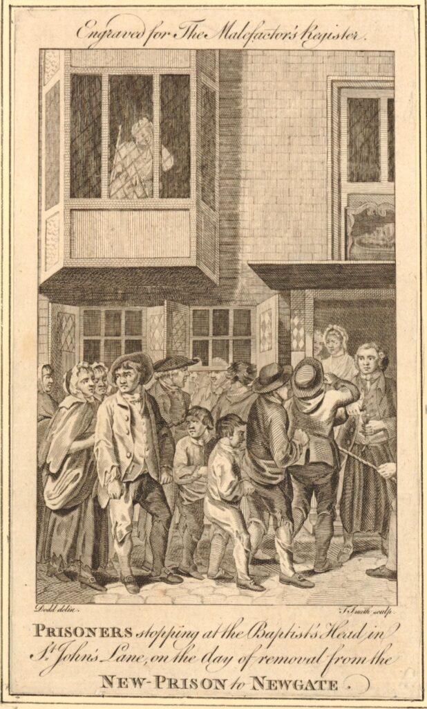
From the same article of the Clerkenwell News that I quoted above, is a comment that the Old Baptist’s Head was a halt for prisoners on their way to Newgate. The British Museum archive includes a 1780 print of prisoners stopping at the pub  (the two following prints are ©Trustees of the British Museum, Creative Commons Attribution-NonCommercial-ShareAlike 4.0 International (CC BY-NC-SA 4.0) license):

St John's Lane

The New Prison was the Clerkenwell Prison, or the Middlesex House of Detention that I wrote about in a previous post on Sans Walk, a Fenian Outrage and the Edge of London. The Old Baptist’s Head, or just the Baptist’s Head as it was in 1780 was about half way between the prison and Newgate, so I assume the prisoners were allowed a stop for refreshments.

A very different stop at the Old Baptist’s Head was recorded in the District News on Friday the 29th June, 1900. There is an article by a St John Ambulance volunteer who was on his way from Hebden Bridge in West Yorkshire to the Transvaal in South Africa.

He arrived in London at King’s Cross and then made his way to the Old Baptist’s Head where accommodation had been arranged by the St John Ambulance (who had their headquarters at the nearby St John’s Gate). The article tells of an early morning, 5 a.m. exploration of London, before heading to Aldershot via Waterloo for training, then to Tilbury to catch a boat to South Africa.

Whilst buildings such as the old pub now serve a different purpose, it is fascinating how many have passed by the Old Baptist’s Head; from prisoners to volunteers heading from Yorkshire to South Africa. There must be millions of such individual stories across London.

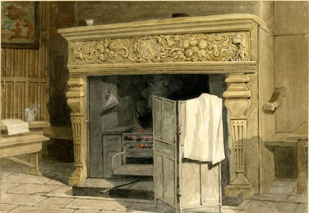
A relic of the time when the Old Baptist’s Head was a pub can today be seen in St John’s Gate. A fire place originally belonging to the pub is now in the Old Chancery room of St John’s Gate. The fireplace includes the coat of arms of Sir Thomas Forster, so is presumably from his house prior to part being converted to the pub.

The following print shows the fireplace in the Old Baptist’s Head:

St John's Lane

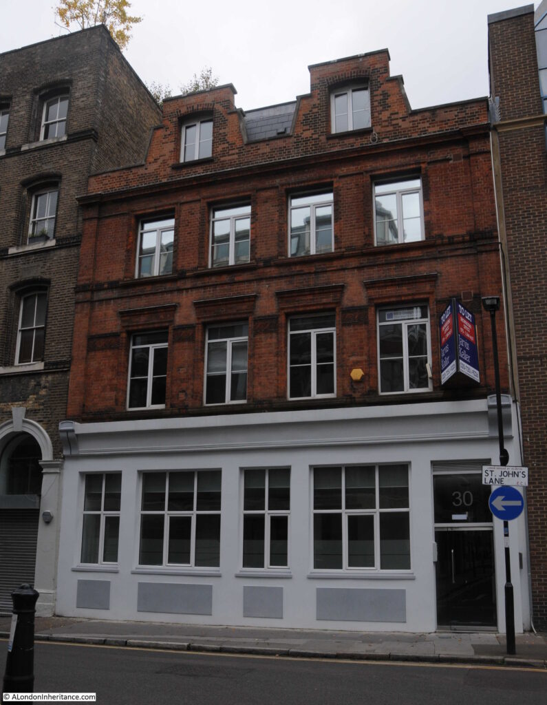
The following photo is of number 29 St John’s Lane. An early 1880s warehouse built for the wholesale stationers Fenner Appleton & Co.

St John's Lane

Although now converted to offices and flats, the building retains the large doors on floors one to three that would have been used to move goods between the street and the warehouse floors.

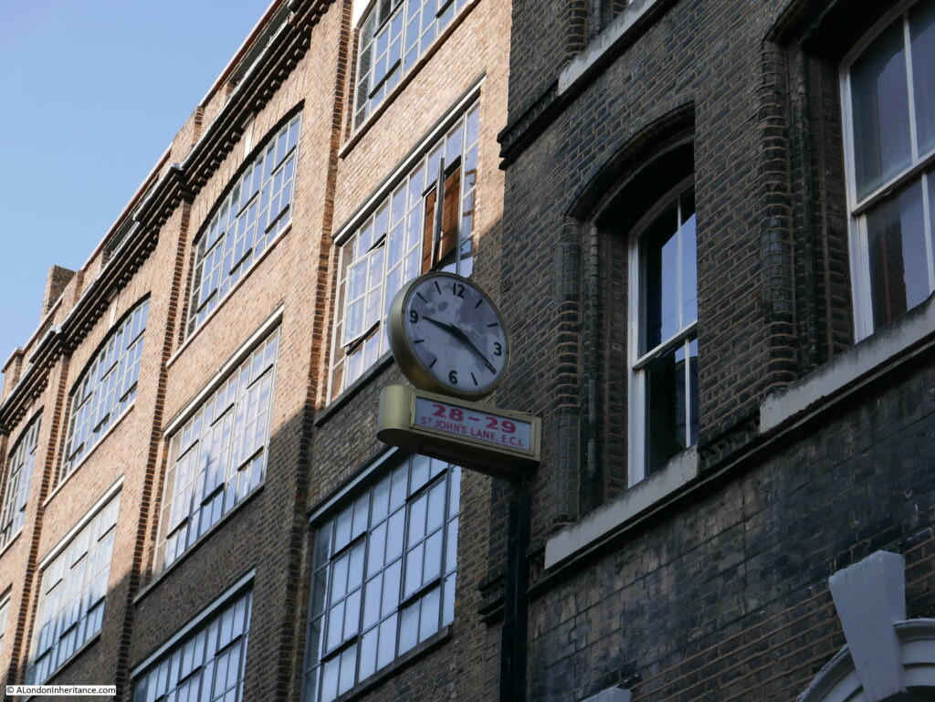
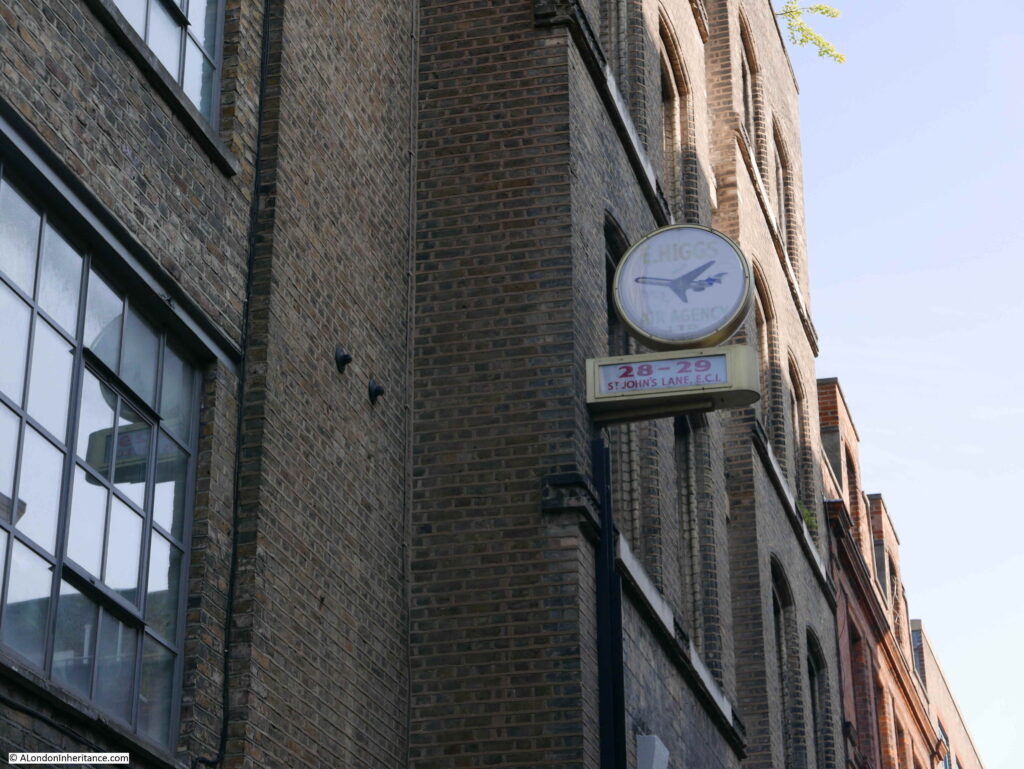
On the front of the building is a superb clock:

St John's Lane

On one face of the clock is an outline of the world, and on the other side is the name E. Higgs Air Agency Ltd.

St John's Lane

I am always rather cautious with relics such as this clock as to whether they are actually genuine.

There does not seem to be much information available on the company. They were on the delegate list to a World Air Transport Conference held at the Royal Lancaster Hotel on the 8th and 9th of May 1974, but despite leaving a rather good clock, they do not seem to have left much else in Clerkenwell.

There is today a company called Higgs International Logistics that provides logistics for the publishing industry, and given Clerkenwell’s history with the printing industry, perhaps the company now in Purfleet, Essex is the latest incarnation of the business in St John’s Lane.

If it is, I am pleased that they left their clock.

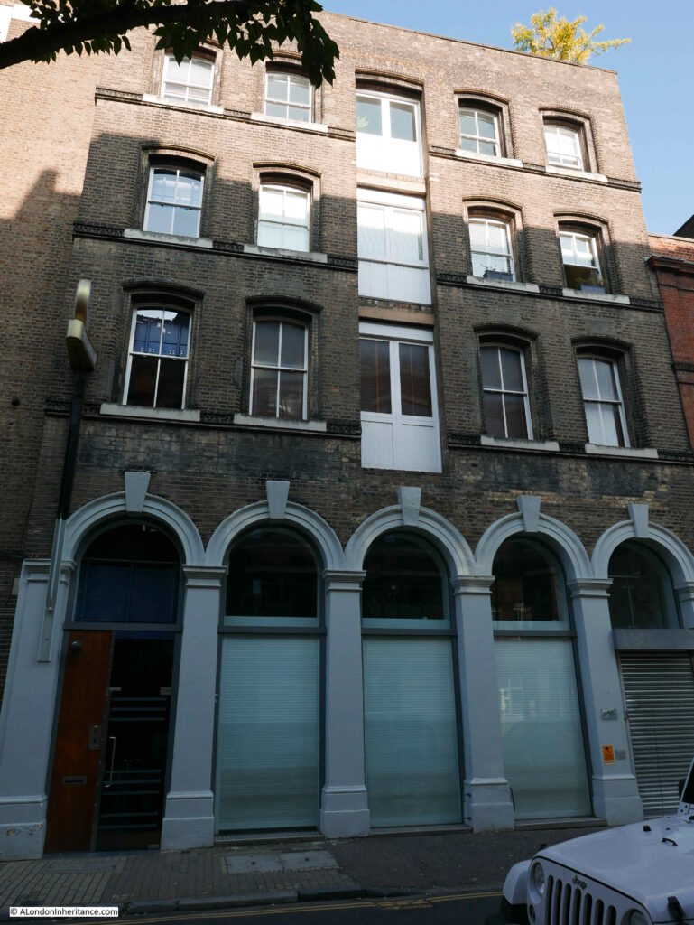
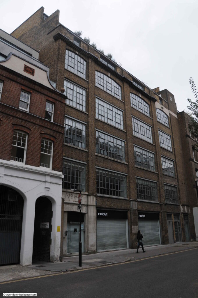
At number 28 is a large warehouse and offices dating from 1901:

St John's Lane

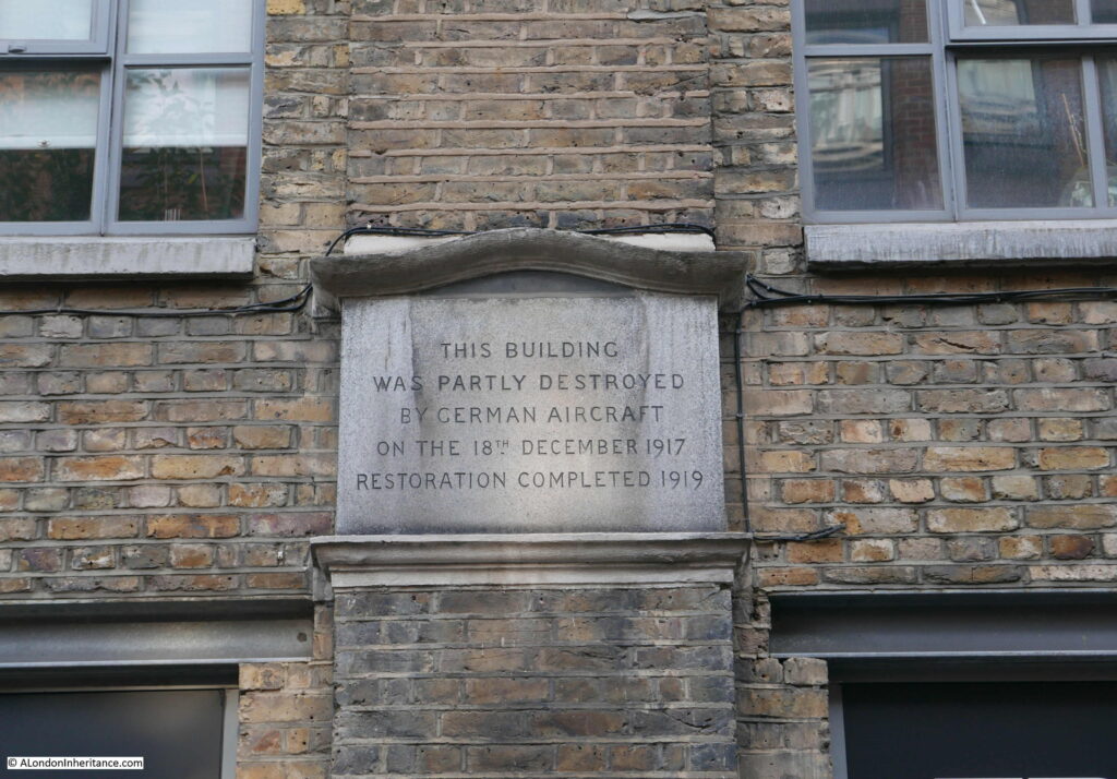
This building is part of a tragic period of London’s history, as hinted at by the plaque on the front of the building.

St John's Lane

Although minimal compared with the Second World War, London was bombed during the First World War.

Early attacks during the war were by Zeppelin airships (see my post on Queen Square), and during the later years of the war, the Germans switched to the use of aircraft to bomb London.

The first fleet of German aircraft attacked London on Wednesday, the 13th of June 1917. Sporadic raids continued during the following months, and night raids commenced in September.

On the night of the 18th December 1917, a fleet of sixteen aircraft set of from Belgium, and thirteen “Gotha” bombers and a single “R-plane or Giant” bomber reached London, where they dropped their bombs across the wider city causing considerable damage, including in St John’s Lane.

On the route from Belgium and return via London, the planes dropped 2475kg of high explosive on London, 800kg on Ramsgate, 450kg on Margate and 400kg on Harwich. One of the Gotha bombers was shot down by a Sopwith Camel flying from an airfield at Hainault in Essex. The bomber crashed in the sea off Folkestone.

It is remarkable that aircraft of 1917 had the range and lifting capabilities to carry heavy loads of high explosive bombs from Belgium to London and across Essex and Kent.

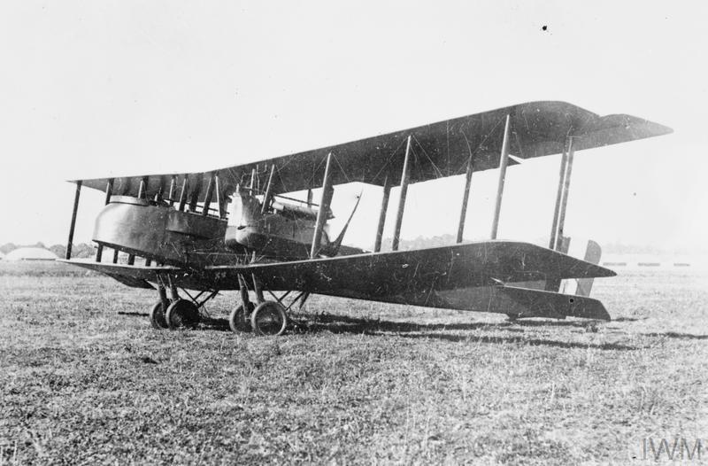
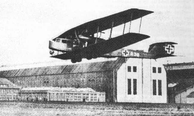
The Gotha was a twin engined heavy bomber that entered service in August 1917. It had a range of about 520 miles and a maximum speed of 87 mph. The Gotha was capable of carrying up to 14, 25kg high explosive bombs. For the crew, it was unpressurised and there was no heating, so it must have been incredibly uncomfortable for the crew on long night flights from Belgium to London and back.

The Gotha Heavy Bomber of the type that attacked London on the night of the 18th December 1917:

St John's Lane
GERMAN AIRCRAFT OF THE FIRST WORLD WAR (Q 67219) Gotha G.V heavy bomber. Copyright: © IWM. Original Source: http://www.iwm.org.uk/collections/item/object/205234223

A single R plane was also involved in the raid on the night of the 18th December 1917. The R plane, also known as the Giant, was a four engined heavy bomber, with a maximum bomb load of 4,400 lbs of high explosive bombs and a range of 500 miles.

The R plane had two engines on each wing, one in front of the other. The front engine had a forward facing propeller that pulled the aircraft, the rear engine had a rear facing propeller and pushed the aircraft. Remarkably, the engines were capable of being serviced in flight and a mechanic was stationed in each of the engine pods during the flight.

The R Plane, or Giant bomber of the type that attacked London:

St John's Lane

(image source https://commons.wikimedia.org/wiki/File:Zeppelin-Staaken_R.VI_photo1.jpg):

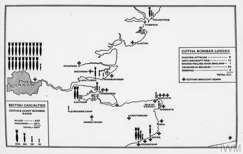
A map in the Imperial War Museum archive provides an overview of the Gotha bomber attacks on London, Kent and Essex during the later years of the First World War and illustrates the considerable numbers of bombs dropped on London, casualty numbers and the number of Gotha bombers lost.

St John's Lane
THE GERMAN AIR FORCE IN THE FIRST WORLD WAR (Q 73542A) Map of the locations of German Gotha raids on Britain and casualties on both sides. Copyright: © IWM. Original Source: http://www.iwm.org.uk/collections/item/object/205360173

The attacks on London during the First World War, though relatively small in number, were an indication of what was to come in just over 20 years time.

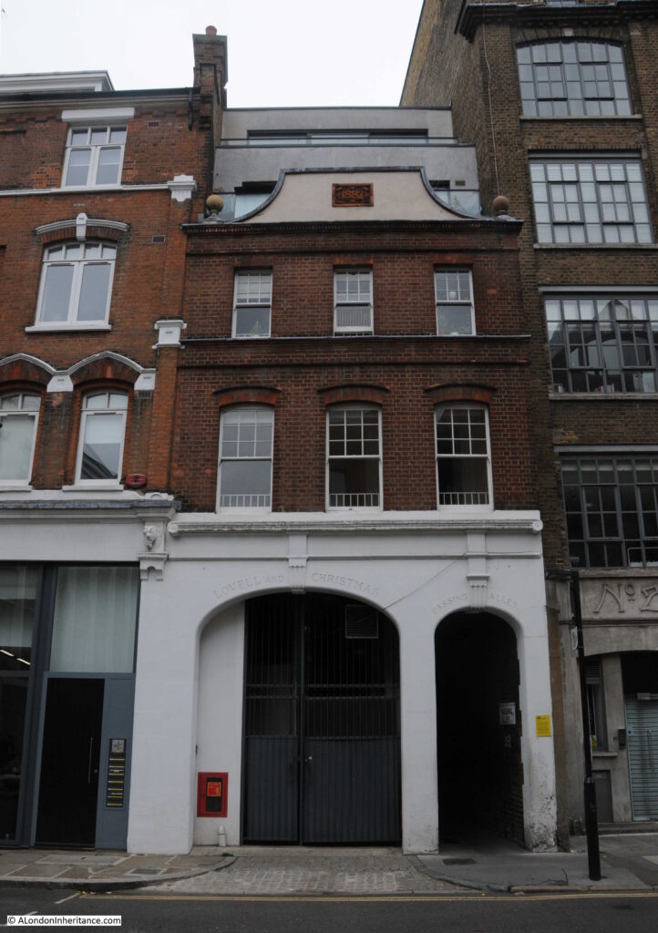
The building next to number 28 has an interesting ground floor frontage to the street, part of which provides access to an alley.

St John's Lane

Behind this building, in space between St John’s Lane and St John’s Street was a large area for the stabling of horses. The large arch on the left of the building was originally an access tunnel to the stabling area.

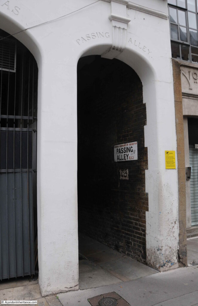
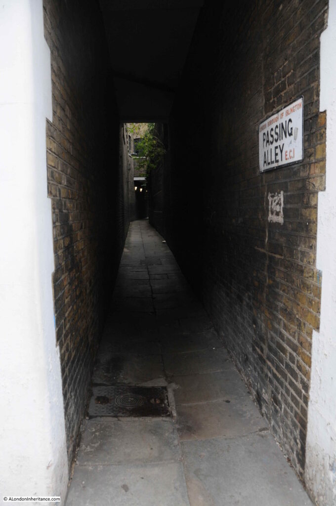
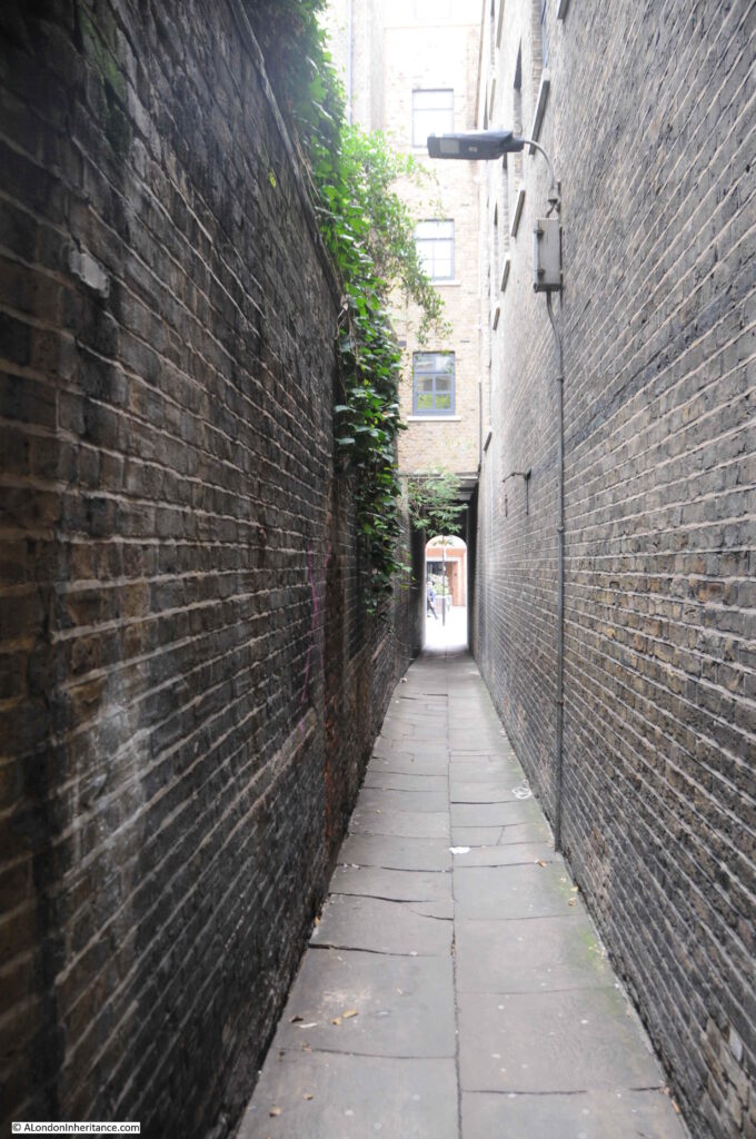
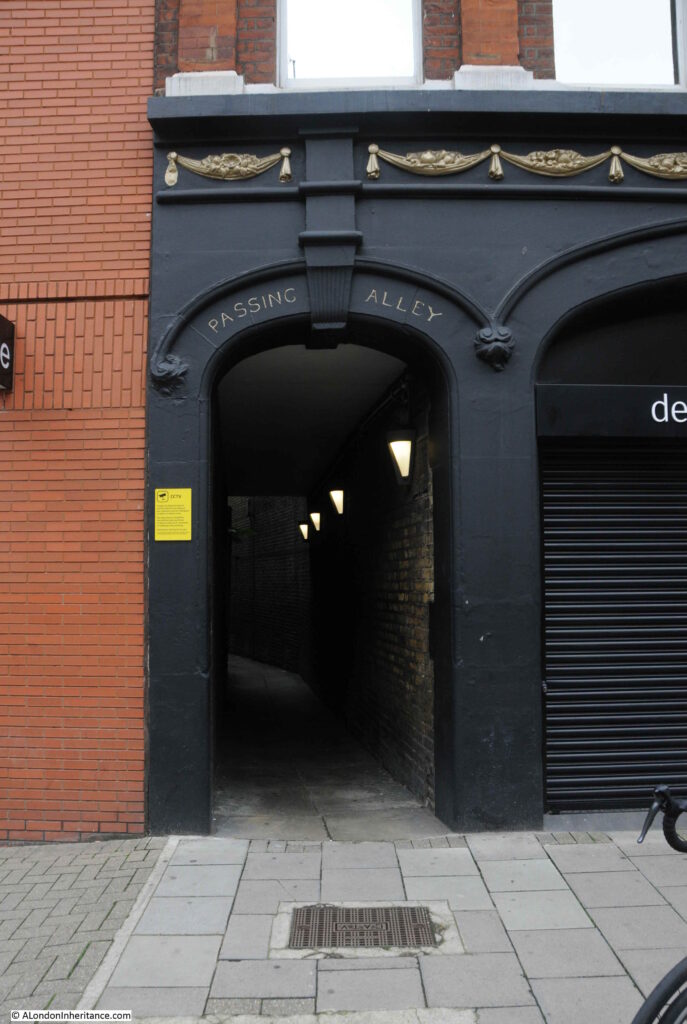
The smaller arch to the right provides access to Passing Alley, an alley that allows pedestrian access through to St John’s Street.

St John's Lane

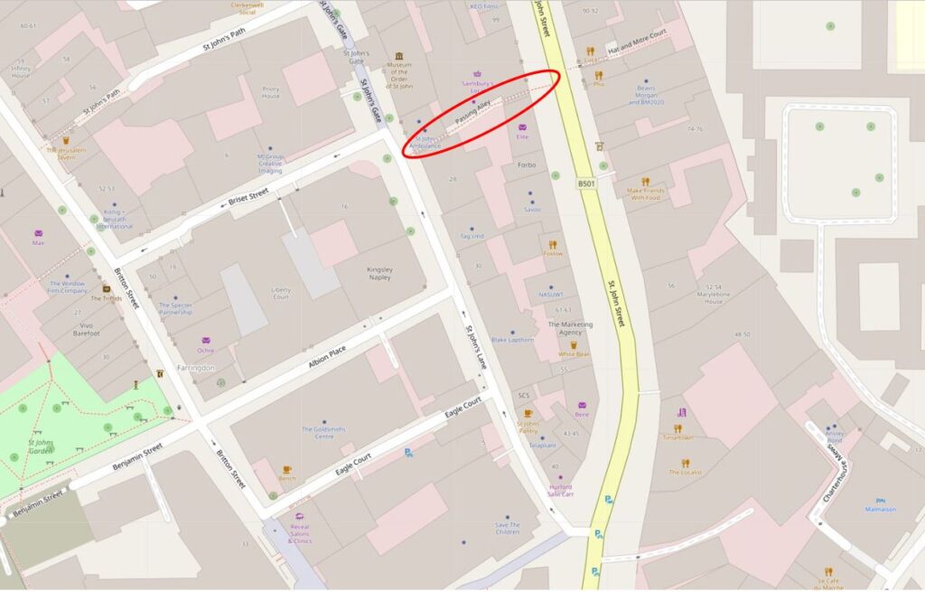
Passing Alley gives the impression of being one of London’s ancient alleys, however in London terms, it is relatively recent. The alley was originally around 40 feet to the north of its current location, however late 19th century development, which included the building that now provides access to the alley, required the shift of the alley to the south.

In the following map, I have outlined Passing Alley with a red oval. Look to the left of the alley, across St John’s Lane, and Passing Alley is to the south of Briset Street.

St John's Lane

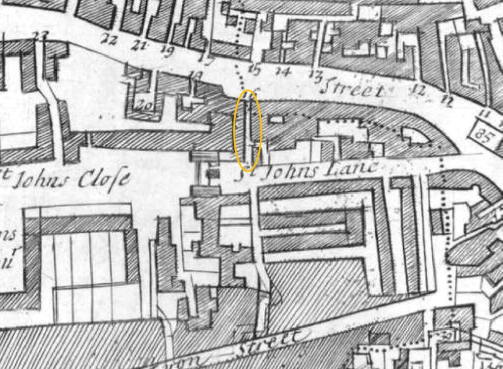
In the following extract from a 1755 parish map, I have circled Passing Alley with an orange oval. In this extract, the alley is in its original medieval position and was a continuation of Briset Street. The map also seems to imply that it was a slightly wider street than the narrow alley we see today.

St John's Lane

The name of the alley seems to have changed in the late 18th century. In the key for the above parish map the alley was called Pising Alley, and in Rocque’s 1746 map it had the name Pissing Alley.

I cannot find any firm evidence for the source of this earlier name, however it may be down to the location of cesspits in the area.

St John's Lane

Alan Stapleton’s 1924 book “London’s Alley, Byways and Courts” records that the alley was blocked for many months during the Great War due to the bomb dropped on the adjacent building on the night of the 18th December 1917, and that some hundredweights of bricks fell into the alley, killing an unfortunate man who happened to be passing through.

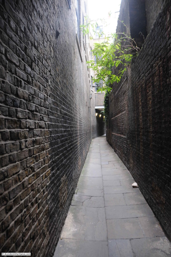
Walking through the alley today, and it is still lined by high brick buildings and walls, and one can imagine the impact of so many bricks falling into such a narrow alley.

St John's Lane

The way the alley curves means that as you enter from either entrance, you do not get a view of the full length of the alley and what is around the corner.

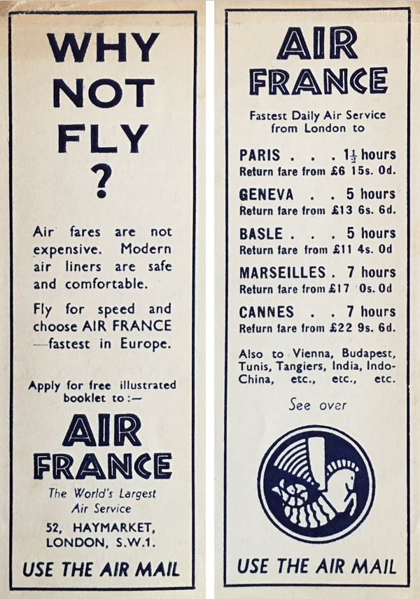
As a complete diversion, I have mentioned a number of times the pleasure of finding things that previous owners have left in second hand books. My copy of Alan Stapleton’s book on London’s alleys contains a bookmark that was issued by Air France, detailing their flights from London. There is no date on the bookmark, but at the time, a flight from London to Paris would have cost £6, 15 shillings.

St John's Lane

The following photo shows the St John’s Street end of the alley:

St John's Lane

And the entrance to Passing Alley in St John’s Street:

St John's Lane

If you are reading this post on the day of publication (Sunday 21st March 2021), then it is census day, the day every ten years when every household is expected to complete a census return providing details of those living at each address on the day.

A census has been carried out every ten years since 1801. The amount of information collected changes each census and 1841 was the first census when the names of all the individuals at an address were collected.

The census has been conducted every ten years apart from 1941, when the impact of the war meant that there other priorities. The 1931 census data for England and Wales was destroyed by fire – an early example of why backing up data is so important, although using the technology of the time with thousands of paper returns, this would have been difficult.

There was a register taken in 1939, not a full census, the data was needed to create ID cards and ration cards as part of the measures brought in during the war.

Availability of census data is goverened by the Census Act 1920, and the later 1991 Census (Confidentiality) Act. These acts restrict the disclosure of personal information from census returns until 100 years have elapsed, meaning that the 1911 census is the latest to be fully available. The 1921 census will be published online in 2022.

Given that the day of post publication is census day, I thought I would take a look at who was living in St John’s Lane in 1911, when the census was taken on the 2nd of April.

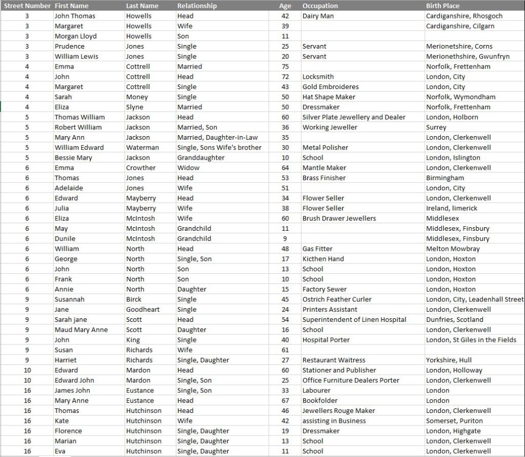
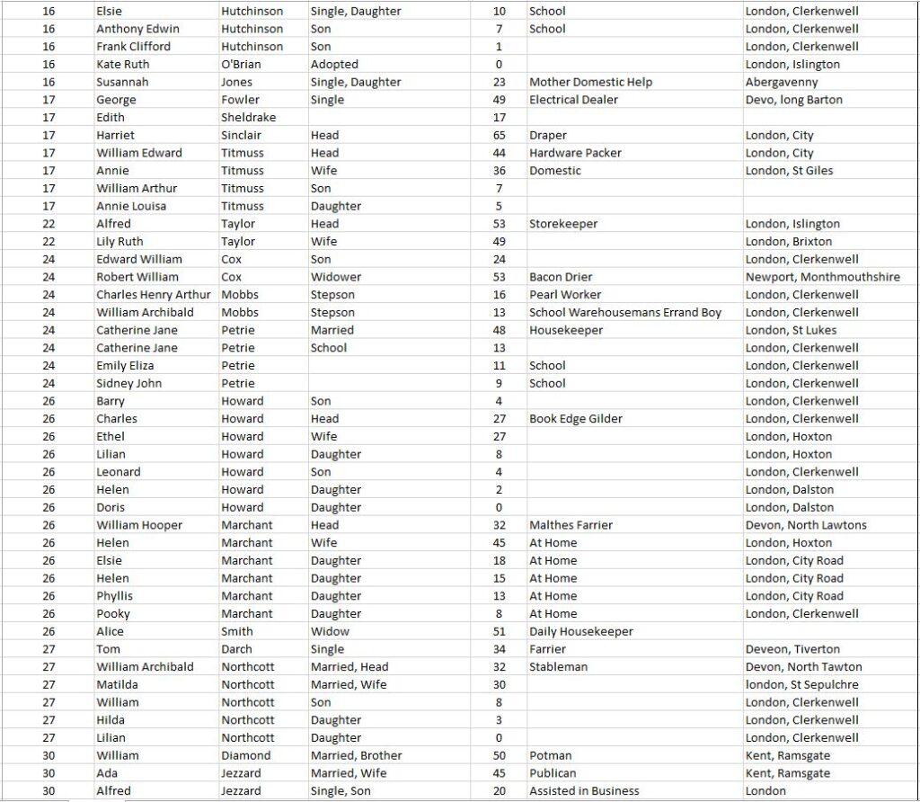
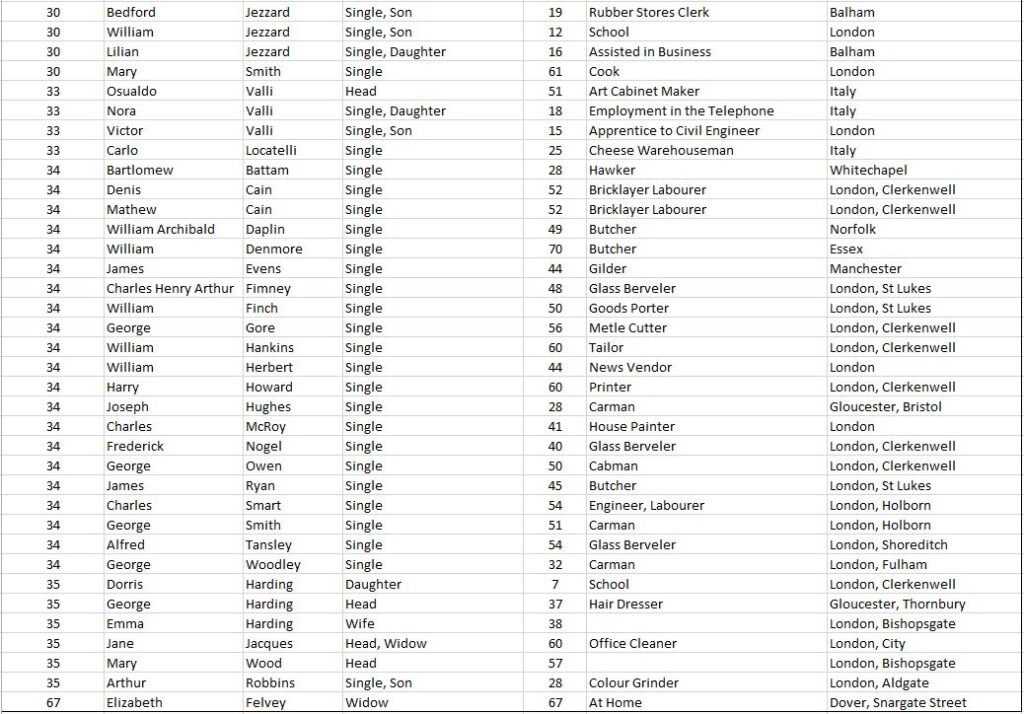
By 1911, St John’s Lane was home to a number of warehouses and business premises (as can be seen by gaps in the street numbering), however there were still 125 people living in the street, as detailed in the following extract from the 1911 census covering all the entries for St John’s Lane:

St John's Lane
St John's Lane
St John's Lane

If you have seen the Government’s current advertising for the 2021 census, the emphasis is on the importance of the census to planning services such as transport, education and healthcare, however they also have an incredible historical importance as they provide a snap shot of the population at a point in time.

The 1911 census tells us the names of those living in St John’s Lane, their age, profession and their place of birth. We can therefore see the type of occupancy for the houses in the street (for example, in number 34, all the residents are single and recorded as Boarders).

We can get an idea of mobility by looking at their birth place. Many of those living in St John’s Street seem to have stayed relatively local. Out of the 125 residents, 82 are recorded as being born in London, of which 34 were born in Clerkenwell.

Only one family came from outside the United Kingdom. The Valli family at number 33 came from Italy, and we can get an idea of when they moved as their 18 year old daughter was born in Italy, but their 15 year old son had been born in London. The children also had some modern sounding jobs. The son was an apprentice to a Civil Engineer, and the daughter’s job shows the jobs that new technologies were bring to London as she had “Employment in the Telephone”.

The census also shows the tradition of people from Wales being associated with London’s dairy industry. At number three lived John Thomas Howells with his wife Margaret, both from Wales, with John being listed as a Dairy Man. They also had living with them two others from Wales listed as Servants.

A surprisingly high number were single, with 78 out of 125 being recorded as single, either as an adult, or because they were a son of daughter, widow or widower.

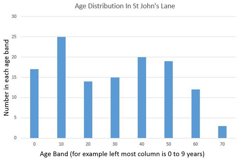
Displaying census data graphically helps with understanding what St John’s Lane was like in 1911. The following graph shows the age distribution, and highlights that the largest age group in the street was aged between 10 and 19.

St John's Lane

The graph also shows the rapid decline in ages after the age of 59, with only three residents in their seventies. Of these three, two were married, Emma and John Cottrell at number four. Emma was 75 and had come from the small village of Frettenham in Norfolk. John was born in the City of London and at age 72 was still recorded as working as a locksmith.

So, as you complete the 2021 census, you may well be helping those who want to understand the history, demographics, mobility and professions of your street when the data is made public in 2122. Will your current job sound as strange to those in 2122 as an Ostrich Feather Curler sounds today?

alondoninheritance.com

Winchester Palace and the Great Hall, Clink Street

Clink Street in Southwark is close to Southwark Cathedral and Borough Market, and the street is part of the busy walk along the south of the river. Converted warehouses line the river side of Clink Street, but on one part of the southern side of the street, a remarkable survivor, the Great Hall of Winchester Palace can be seen; the Southwark residence of the Bishops of Winchester.

Winchester Palace

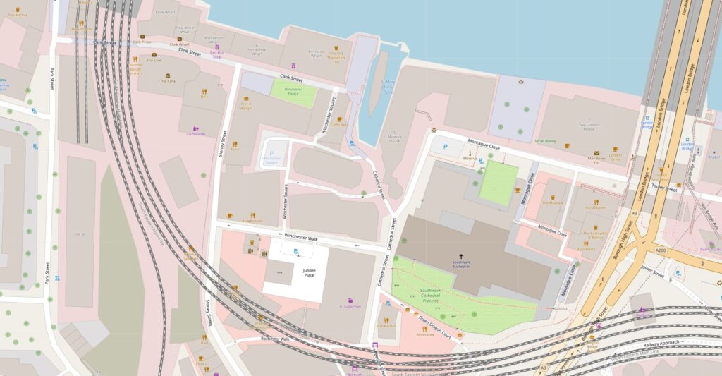
The following map extract shows the location – the green rectangle towards the middle, top of the map is the part of the palace that can be seen alongside Clink Street (Map © OpenStreetMap contributors).

Winchester Palace

The first evidence of a palace for the Bishops of Winchester dates back to the 12th century, with an eastern boundary wall, and some building of stone construction.

The 13th century saw the expansion of the palace estate with some major construction work. This work included a number of two storey blocks, a hall, chapel and courtyard. Work also included improvements to the wharf along the River Thames.

The 13th century also included the surfaced road that would become Clink Street, with the name Clink Street being in use by the start of the 17th century.

One of the earliest references to Winchester House (as it was also known) comes from the life of St. Thomas à Becket by William FitzStephen, who wrote that Archbishop Thomas received hospitality at the house of the Bishops of Winchester before making his final journey to Canterbury where he would meet his death.

The Bishops needed a London residence, not just for their religious duties. At the time there was not that much separation between religion and government, and the Bishops of Winchester also frequently held some of the great Offices of State.

The Palace was also frequently used for entertaining, and hosted events for the rich and powerful of the land. For example, in 1424 the wedding feast of James, King of Scotland, and Joan, daughter of the Earl of Somerset was held at the palace.

The palace appears to have been in possesion of the Bishops of Winchester through to the mid 17th century, when it was turned into a prison for Royalists during the Civil War. In 1649 it was sold for £4,380 to a Thomas Walker of Camberwell, but after the restoration of the monarchy, the palace estate was returned to the Bishops of Winchester.

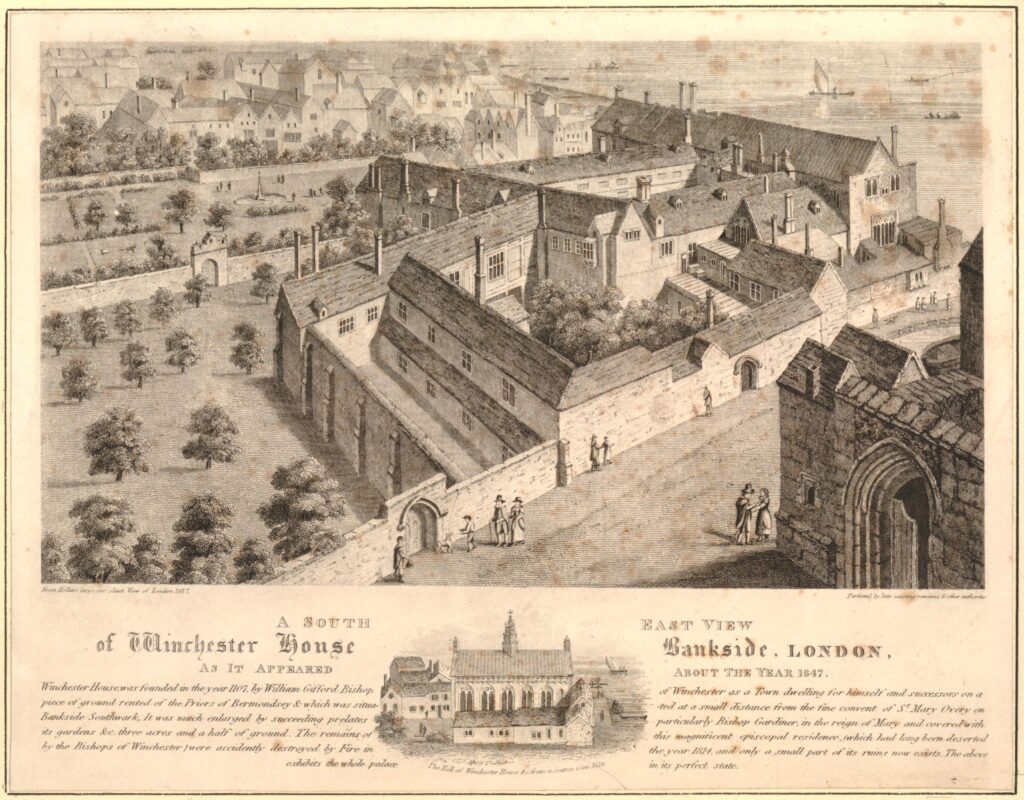
It was during the 1640s that a parliamentary survey of the palace was carried out, and around 1647 the artist Wenceslaus Hollar completed a drawing of the Palace, or Winchester House, the words Palace and House are frequently used in reference to the Bishops of Winchester residence  (Prints in this post are ©Trustees of the British Museum):

Winchester Palace

Hollar’s drawing shows an extensive range of buildings alongside the river. The Great Hall is to the right, with the rest of the buildings housing accommodation blocks, storage, kitchens, a chapel and stables. There were also extensive grounds to the palace.

The text below the above print provides some detail about Winchester House: “Winchester House founded in the year 1107 by William Gifford Bishop of Winchester as a Town dwelling for himself and successors on a piece of ground rented of the Priors of Bermondsey and which was situated at a small distance from the fine convent of St Mary Overy on Bankside Southwark. It was much enlarged by Succeeding prelates particularly Bishop Gardiner, in the reign of Mary and covered with its gardens &c. three acres and a half of ground”.

The small drawing at the bottom of the print shows the Great Hall, and it is the remains of this building that we can see alongside Clink Street today.

Although the palace was restored to the Bishops of Winchester on the restoration of Charles II, it was not really used again as their London residence. They now also had a property in Chelsea, provided to them by a 1661 Act of Parliament. Perhaps the location of their palace was not as pleasant for the bishops due to the growing population, the location of industry, entertainments and markets that were not allowed in the City of London, displaced to the south side of the river, and around the bishops palace.

The buildings of the palace were now let out to a large number of tenants and sub-tenants.

The bishops cannot have been too morally fussy in previous centuries, as the local area of Southwark and Bankside had a history of prostitution long before the Bishops left their palace in the 17th century, and they had a role in the governance, and profited from the brothels or “stews” that were found in the area. These had been banned in the City of London, so their south bank location, close to London Bridge was an ideal place to relocate.

The bishops let out buildings to be used as brothels and were also responsible for managing the “Ordinances Touching the Government of the Stewholders in Southwark under the Direction of the Bishop of Winchester” set out in the 15th century.

These ordinances dictate 36 specific rules and the fines associated with breaking these rules, for example:

  • Number 6: Owners of a stew (stewholder) could not lend a sex worker more then 6s 8d (this was done to prevent a stewholder from having too much control over a sex worker)
  • Number 9: a sex worker who paid the rent of 14d must be allowed to come and go at will. The owner of the stew must not interfere
  • Number 15: a fine of 40s if a stewholder’s wife solicited at a stew

Perhaps the most serious was for any sex worker who established a relationship with their procurer or what we would now call a pimp. For this they would be fined, they would also suffer a dunking on the cucking stool, possible imprisonment, and would also be banished from the borough.

Stewholders were also banned from selling food, drink and fuel from their premises.

The Bishops of Winchester profited from the rents from the buildings occupied by the stews and from the fines generated by any transgression of the rules. They were also expected to ensure the rules were adhered to, and manage law and order in the area.

The association of the Southwark stews with the Bishops of Winchester was such that the sex-workers in the stews became known as Winchester Birds or Winchester Geese.

The Bishops of Winchester probably made a considerable sum from the rents and fines, and it would be interesting to know if as supposedly religious men, they had a moral conflict with making money from women involved in sex work.

If they did feel any moral responsibility, it did not extend to the treatment of these women after death who were buried in unhallowed burial grounds, many at the nearby Cross Bones burial ground, today on the corner of Redcross Way and Union Street.

The Southwark stews were closed in 1546 when Henry VIII banned them.

During the late 17th and 18th centuries, the land occupied by Winchester Palace was further broken up and sold. Warehouses and docks now occupied the area as trade along the river expanded, and walls that remained from some of the old palace buildings were included in the new structures that grew up along the river and Clink Street.

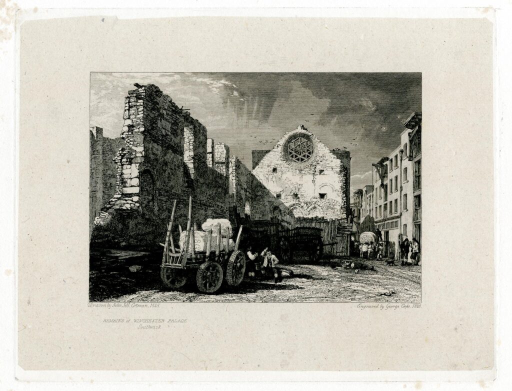
As was common in the 19th century, in 1814 a large fire destroyed a number of buildings in Clink Street, but whilst the fire appears to have destroyed later building, it did reveal part of the old Great Hall of Winchester Palace, and the following print from 1828 shows the remains of the Great Hall exposed after the fire, looking very much the same as they appear today.

Winchester Palace

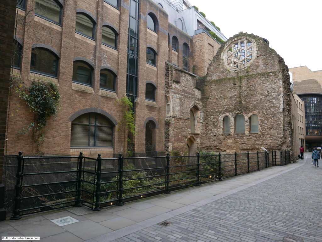
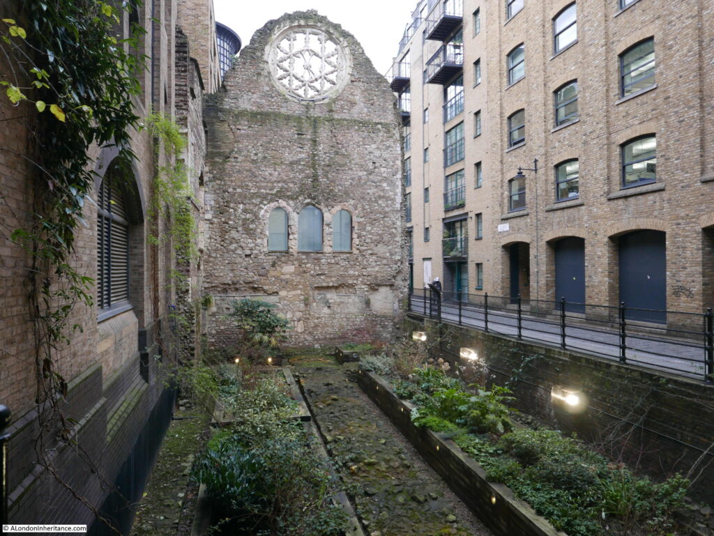
The following photo shows again the west wall of the Great Hall and Clink Street alongside. The three openings that look to be windows were doors from the first floor of the Great Hall to the kitchens on the other side. The space below was occupied by an undercroft or cellar.

Winchester Palace

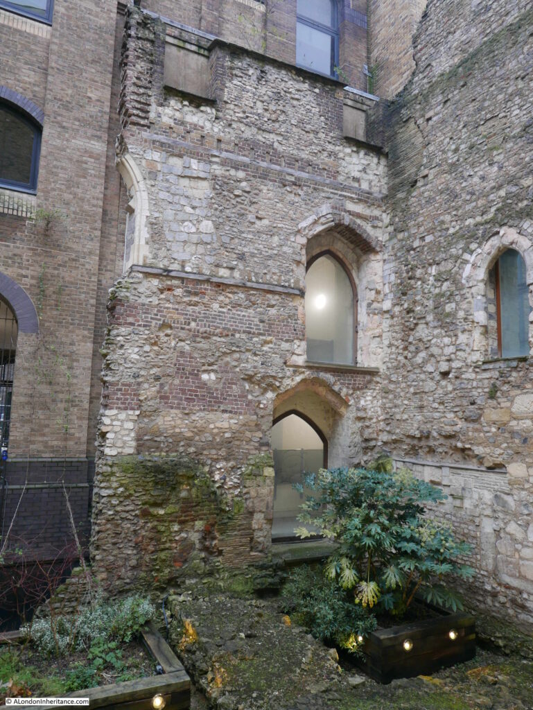
A small part of the southern wall of the Great Hall remains, up against the west wall. A ground floor door below with a first floor doorway above:

Winchester Palace

In the years after the 1814 fire, warehouse space along this part of river was in short supply, so it would not be long until a new warehouse was constructed over the site of the Great Hall, however, the approach of minimising costs by including any existing stone or brick structures into a new build continued, and the west wall and rose window of the Great Hall were included in the new warehouses.

There was some damage to warehouses in the area during the last war, however this does not appear to include the two warehouses that had been built either side of the west wall. In 1943 a Mr. Sidney Toy, of the Surrey Archaeological Society removed the brickwork on the seperating wall on the 3rd and 4th floor of the warehouses, and found the rose window, still showing blackened markings from the 1814 fire and with parts missing, and used in other parts of the structure.

There have been a number of early excavations of the palace, such as a 1962 excavation on the site where a new warehouse was planned. The major excavation of the site of Winchester Palace took place during 1983 and 1984. These excavations revealed a considerable amount of evidence of the original palace, including parts of the eastern range of the early 13th century building which were found under the current location of the Cafe Nero, on the corner of Palace House.

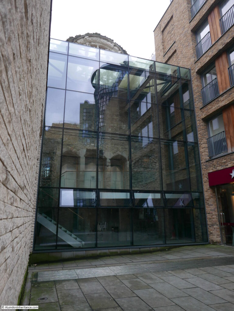
The following photo shows the other side of the west wall. The majority of the wall has been covered over by a glass frame that appears to be part of the new building to the right. The edge of a Pret coffee shop can be seen to the right.

Winchester Palace

In the above view we can again see the three doors that led through to the kitchens that would have occupied this space.

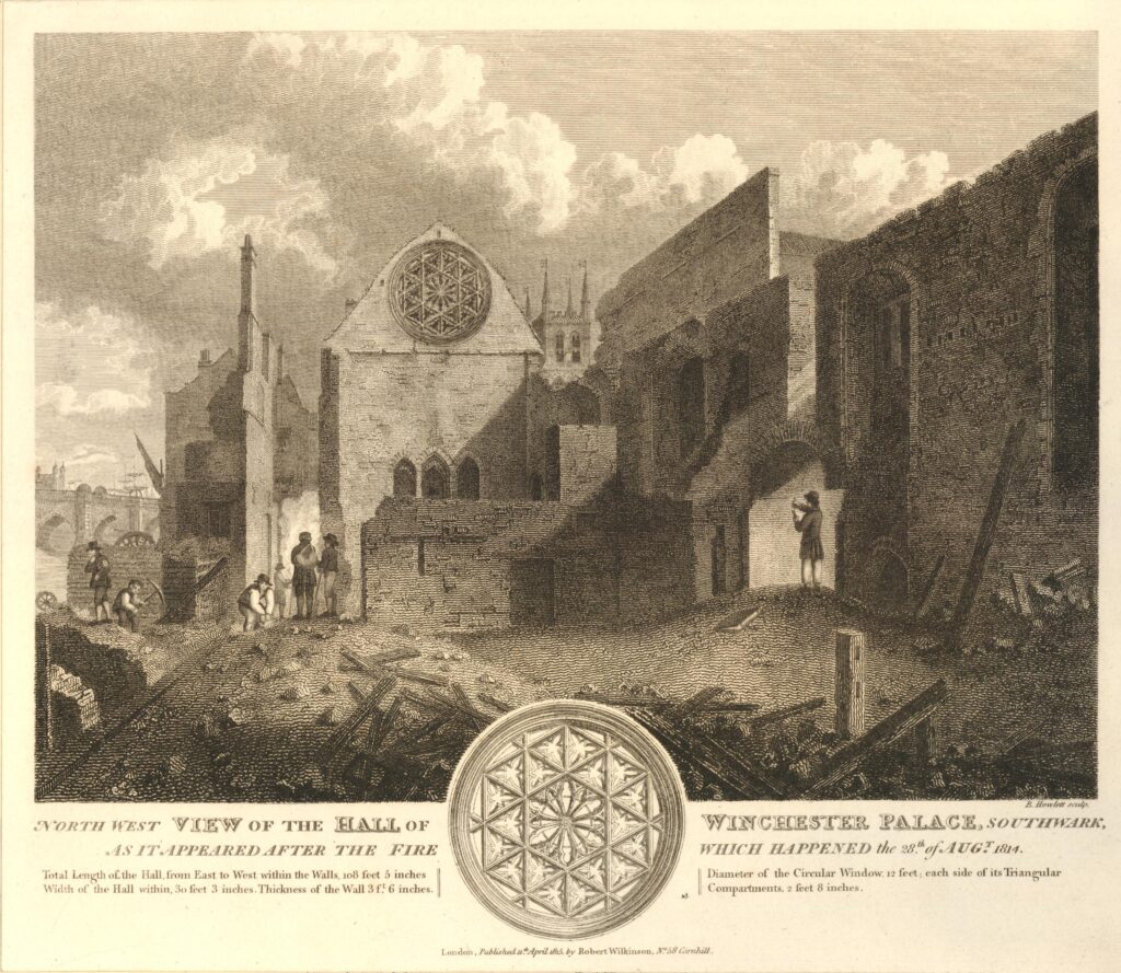
The following print from 1815 shows the same side of the wall as in the above photo. The print was a year after the 1814 fire.

Winchester Palace

Behind the wall we can see the tower of St Mary Overy (today Southwark Cathedral), and on the left is London Bridge. The text at the bottom of the print provides some details as to the size of the Great Hall:

  • Total length of the Hall from East to West within the Walls, 108 feet, 5 inches
  • Width of the Hall within, 30 feet 3 inches
  • Thickness of the Wall, 3 ft, 6 inches
  • Diameter of the Circular Window, 12 feet
  • Each side of the Triangular Compartments (of the window) 2 feet 8 inches

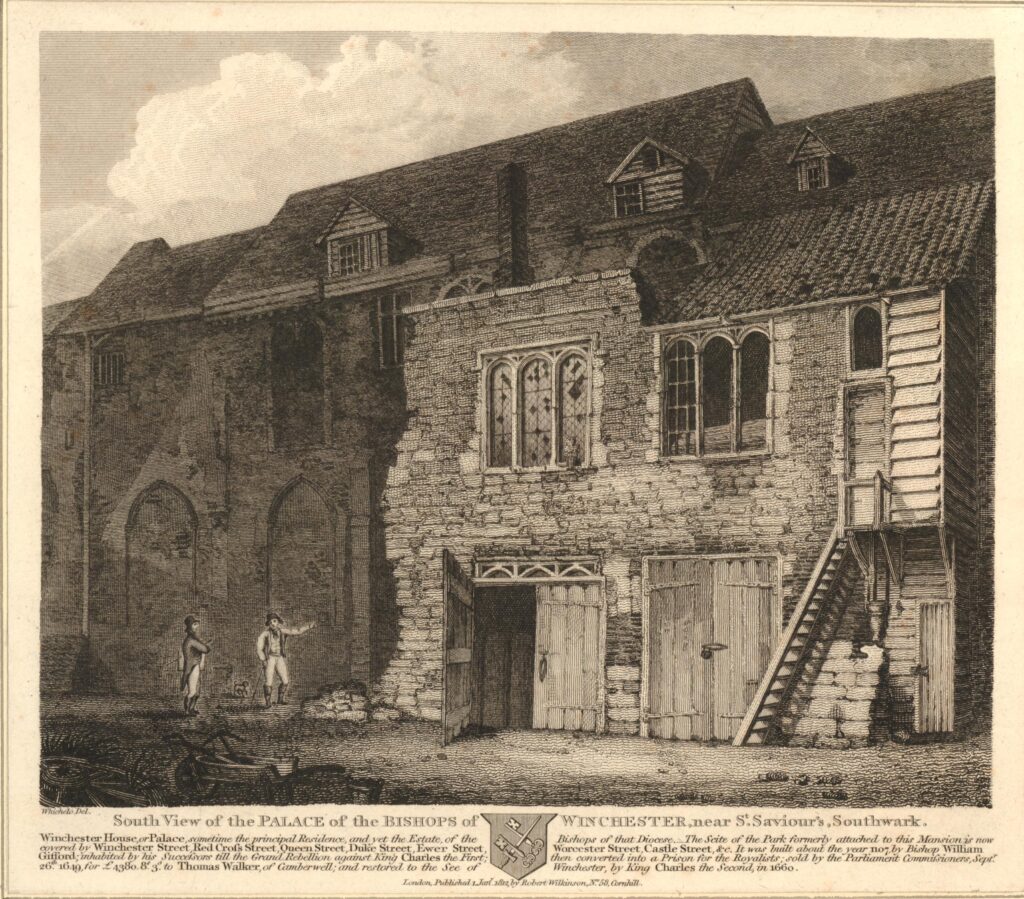
The following print is dated 1812, so before the fire of 1814.

Winchester Palace

The print shows the south view of the Palace of the Bishops of Winchester. It is not clear whether it is a view of the Great Hall, however it does show the state of the buildings just over 150 years after the Bishops of Winchester had left their palace, and the buildings had been sold and let to multiple new owners and tenants.

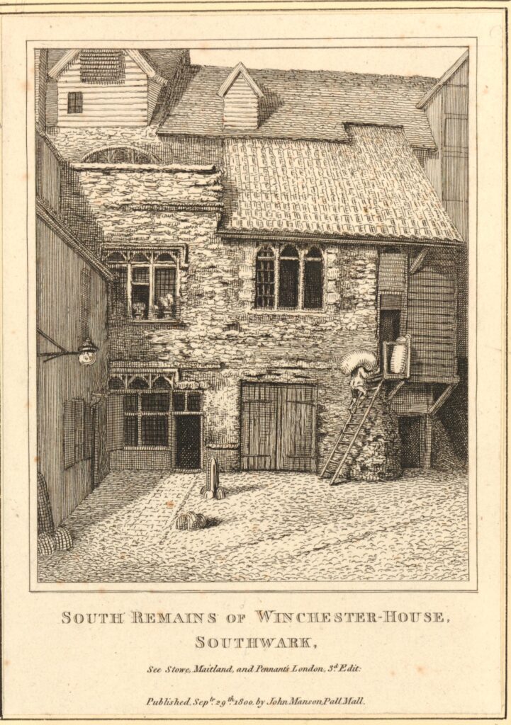
It is interesting to compare the above view, with the following view of the same building on the right of the above print. This print is dated 1800, so just 12 years before the above print.

Winchester Palace

Given the age of the west wall of the Great Hall, and the amount of rebuilding over the centuries, it is a remarkable survivor from the original Winchester Palace.

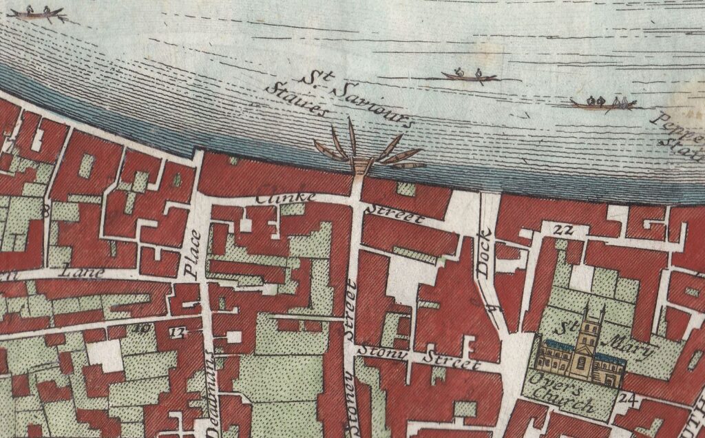
The following map extract is from a map of the Parish of St. Saviours Southwark by Richard Blome (late 17th century but published by John Stow in 1720). Clink Street is in the centre of the map, and the location of the Great Hall is under the word Street.

Winchester Palace

There is no mention of the palace that was once of considerable importance, so perhaps by the time of the above map, it was just another part of the buildings that lined the streets of the area. The white space in the centre of the block bordered by Clink Street and Stony Street is probably one of the old courtyards of the palace, possibly the space in front of the buildings in the above two prints from 1800 and 1812.

The palace occupied a far larger area than the remains of the Great Hall we see today. The Museum of London Archaeology Service published a richly detailed report in 2006 (Monograph 31) covering the history of the palace and focusing on the excavations of 1984 and 1985 and the finds discovered under the new and redeveloped buildings that occupy so much of this area.

The wall of the Great Hall has survived for so long because it was included in the structure of later buildings. This is how a number of other very old structures have survived in London, for example the Roman and Medieval bastions at Cripplegate and much of the Roman wall.

When we rebuild today, the approach seems to be a complete demolition of the previous building, including all the foundations and basements. It is interesting to consider how much 20th and early 21st century architecture will remain to be discovered in whatever form London takes in the future.

When the weather improves, and we can go out walking, sit outside the Pret with a tea and sandwich, in what was the kitchen of the Great Hall, and imagine the feasts that were prepared here and taken through the doors into the hall.

alondoninheritance.com

The Willesden Oil Well

For just over a week, the blog has had a fault connecting with the subscriptions package, so although I wrote a new post last Sunday, it appeared on the blog, but did not get e-mailed out. The connection has been rather unstable for the last few days, but now looks better, so I hope the problem is fixed. To test, here is a post with the strange story of when Willesden was the centre of oil exploration in London.

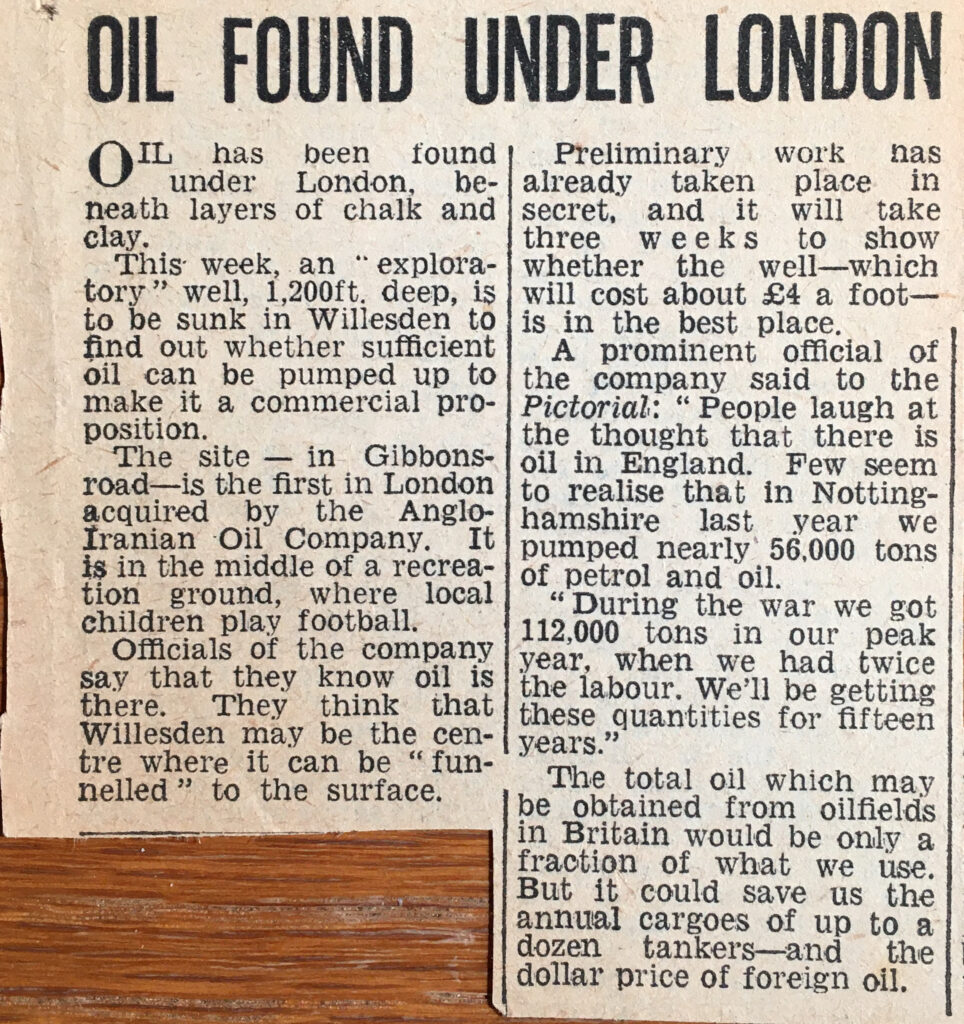
I have mentioned before one of my fascinations with old books is that you never know what previous owners may have added between the pages. I was looking through a copy of Haunted England by Christina Hole (1941 – A Survey of English Ghost-Lore), and between the pages were a couple of clippings from newspapers about an oil well that was drilled in Willesden in 1947:

After the war, the country was desperate for foreign currency, and was trying to export as much as possible, as well as to limit any imports that would have to be paid for in a foreign currency, such as dollars.

One of the major dollar imports was oil and as the article mentions, any source of oil that would enable a reduction in imports would have been highly important to the economy.

The fact that there were traces of oil deep below the streets of Willesden had been known for a number of years. In 1911 a laundry business in Willesden had been drilling a borehole as a water source, but instead found traces of oil. This resulted in a search for oil by drilling the borehole much deeper to see if there might be commercial quantities available, as reported in the Pall Mall Gazette:

“Is oil present in paying quantities in Great Britain? Is this country to be to some slight extent independent of its coal measures?

That is an interesting question which, often mooted before, is prompted again by the recent announcements that oil had been discovered in a well-boring at the White Heather Laundry, Willesden. In the days when ‘booms’ are only too readily created, the owners of the Willesden property showed commendable reticence in refraining from making public their discovery until the news leaked out through a channel which has not yet been discovered.

It must be remembered that the oil obtained at Willesden so far only amounts to a very small quantity, and the question whether it is there in commercial quantity is not likely to be settled for some time; the boring was started in January, 1911, and the first indication of oil was obtained at a depth of 1,200ft on September 6th. The depth of the boring is now 1,735ft. The people concerned are now definitely ‘going for oil’ and the success or failure of their experiment will be watched with absorbing interest”.

There were further positive news reports including:

“One of the directors of the laundry (which was founded about ten years ago by four young men from Cambridge) said: ‘We have had several members of City companies up here already, including representatives of the Standard Oil Company. We had found a splendid quality of water at a depth of 1,000ft, but the quantity is short of our requirements, and that is the chief reason why we are going deeper. We prefer to test the real value of the oil discovery before making any sort of deal”.

The borehole found very salty water at a depth of 1600ft, which was assumed to be water from an old sea formation.

Water was rising to the top of the borehole, and variable amounts of gas would also bubble up through the water.

The 1911 borehole did find traces of oil deep below Willesden, but not sufficient quantities to be economically viable, so the “four young men from Cambridge” did not make their fortune from oil.

Another attempt at finding oil was the 1947 borehole in the article at the start of the post. It may well be that the need to restrict imports encouraged another attempt at finding oil after the failure of the 1911 borehole.

The 1947 borehole was drilled by the D’Arcy Exploration Co. Ltd, a subsidiary of the Anglo-Iranian Oil Company. This was the oil company that was formerly known as the Anglo-Persian Oil Company, which was the first oil company to extract oil in Iran. The company would later become British Petroleum (BP), so this new exploration in Willesden was being undertaken by a company with some serious oil exploration heritage.

The cost for drilling the borehole and examining the results came to a total budget of £10,000, a considerable sum for such a speculative undertaking.

Expectations were high, and the planned borehole made the national press with the Daily Mirror reporting that there was a strong possibility of oil being found, and that “One of the officials on the site yesterday said ‘I think the prospects are good’ “.

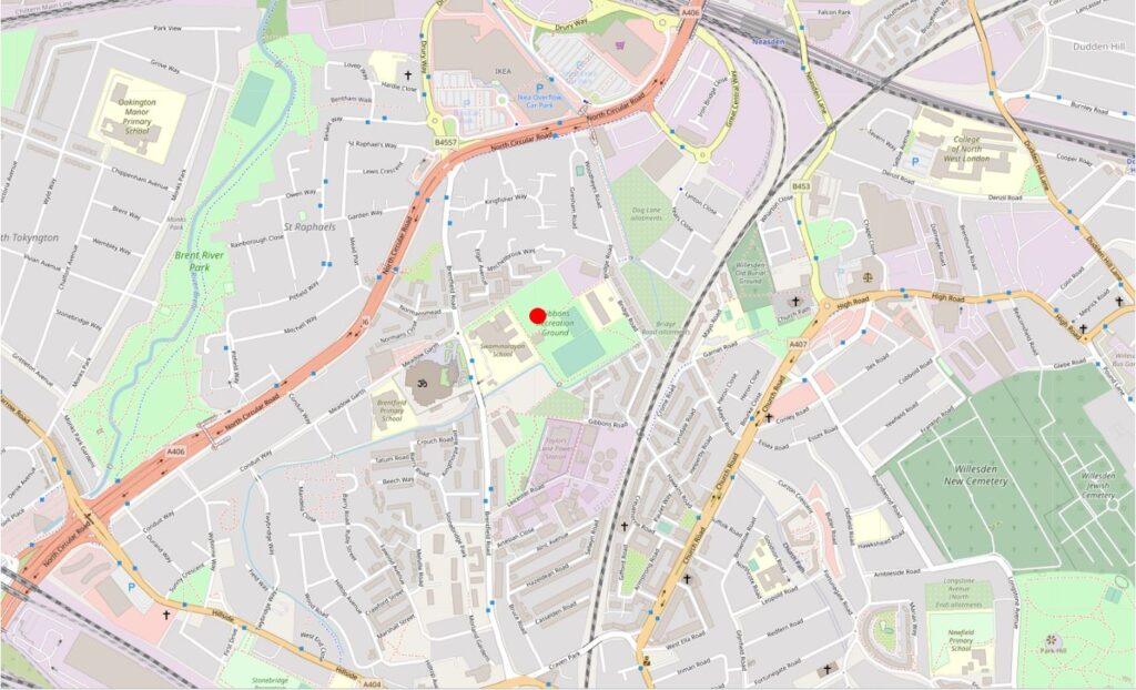
Work on the borehole commenced in November 1947, with even the serious Illustrated London News stating that “North London could become another Kirkuk” (the city in Iraq that was producing 4 million tons of oil a year before the war). The borehole was being drilled in the Gibbons Road Recreation Ground, an area of open space we can still find today. In the following map extract, a red circle marks the approximate location of the borehole (Map © OpenStreetMap contributors):

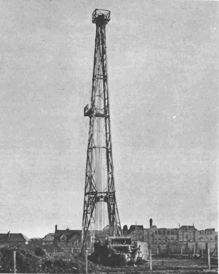
An 87 foot high “jack-knife” derrick was used, powered by a Caterpillar diesel engine. The following photo gives an impression of the derrick in operation:

The borehole went down to the remarkable depth of 2,680ft, and the original bore hole logs by the D’Arcy Exploration Company can still be found online. The British Geological Survey has an online portal which maps all the boreholes that have been notified to them, and clicking on each borehole location will identify if the logs are online with a link for access (see link at the end of the post).

It is remarkable how many boreholes there are across London, and it is fascinating to look for patterns in their locations on the British Geological Survey site.

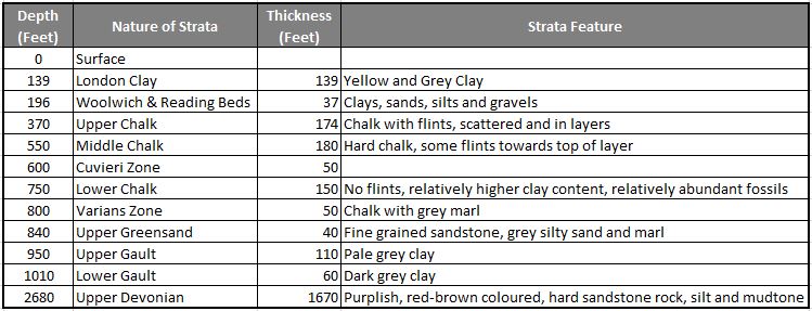
The borehole log for Willesden reveals the following rock strata as the drill headed 2,680ft below the surface of London.

The log pages reveal interesting details of what was found at different levels.

Pyrolised wood was found at about 60 feet (pyrolised refers to the decay of wood in the prescence of heat).

The Cuvieri Zone seems to refer to a zone where a specific type of plankton fossil called Orbulina was found.

A fractured zone with fish remains was found at a depth of 1085 feet.

Although trace amounts of oil were found, it was clear that Willesden would never be an oil producing area, and drilling of the borehole ended in January 1948. The borehole record contains the single word “Abandoned” at the end of the list of strata.

The borehole was capped, and concrete was used to fill the hole from a depth of 1000 feet to the surface – strange to think that this long concrete column now sits below Gibbons Road Recreation Ground – for comparison, roughly the same height as the Shard, and the overall borehole drilled down two and half times the height of the Shard.

Drilling had been met with an air of excitement in newspaper reports at the start of work, however by January 1948, the only reports were a small paragraph stating “Experts have abandoned hope of striking oil at Willesden, but work will continue to obtain general geological information”.

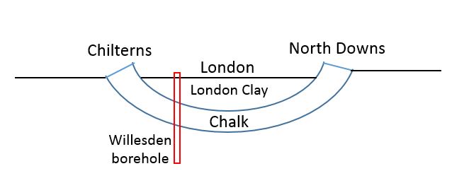
The geology of London is fascinating. In the Willesden borehole, thick layers of chalk were found. These form a sort of bowl underneath the city, curving below the city, rising up to form the Chilterns to the north of the city, and North Downs to the south.

The following graphic shows how the chalk layer dives under the city. The Willesden borehole drilled through London Clay and Chalk layers to the much older rocks below.

London Clay formed as a sediment at the bottom of a sea, formed around 56 to 34 million years ago. The chalk layers are much older and also built up on the bottom of a warm sea in the Cretaceous period over 65 million years ago.

The geology of London goes some way to explaining why there are far more Underground train routes north of the river than to the south. London Clay is a relatively easy substance to tunnel through, and although I have shown it equally spaced in the above graphic, in reality there is far more London Clay to the north of the river than the south.

London Clay is impermeable – water does not easily pass through the clay, chalk is permeable and explains why boreholes such as the 1911 borehole for the Willesden Laundry, were sunk to access water. Rain from outside the area of London Clay would flow through the chalk and water would collect in the layers of chalk under the city.

The British Geological Survey map of boreholes provides so much information on the geology below London. The chalk layer has provided London with water for centuries. The record for a borehole at 1 Bankside, performed in the late 19th century for the Belfast and London Aerated Water Company identified a minumum water flow of 3,000 gallons an hour. Water was found at a depth of 114.5 feet. The purity of the water was measured at 27.1 parts per 100,000 of total solids, or which 12.7 were Chlorine.

A note at the bottom of the borehole record states that the site was visited on the 11th July 1946 and that the borehole had not been filled in, but was boarded over and had not been used for some 30 to 40 years. The note remarked that the borehole probably could not be used anymore due to dirt and rubbish.

St Paul’s Catherdral sits on a hill, however in the distant past water has washed over this area. A 2008 borehole at One New Change identified a 6m thickness of River Deposits below the built layer near the surface. this layer consisted of dry sand and gravel for the first 4.5m, followed by a 1.5m layer of wet sandy gravel.

This may all seem rather remote as we walk the streets of London, however the strata below the surface impacts the location and design of so much of the infrastructure we take for granted.

For example, with the extension of the DLR from the Isle of Dogs to Greenwich and Lewisham a detailed geophysical investigation was undertaken along the route of the tunnel under the Thames. There was concern that a geological fault, (a fracture between two different blocks of rock) could have caused problems for the tunnel. The fault line was found slightly to the east of the tunnel’s proposed route.

The Thames Barrier sits astride the Greenwich Fault, and there are horizontal and vertical shifts of up to 50 meters and 5 metres respectively between the rock strata in the area around the barrier.

Seventy three boreholes were drilled during the planning of the Thames Barrier to check the ground beneath. There was concern that the chalk under the southern half of the site had been damaged during the ice age when frozen conditions could have resulted in the top layers of chalk crumbling into rubble, which would not have created a stable base for construction. Fascinating that we still have to consider the impact of the Ice Age on present day construction.

If you have exhausted the TV schedule, and Netflix, run out of alcohol, and the pubs are still not open, why not spend an evening browsing the British Geological Survey borehole portal. There are hundreds across the city. (The link brings up the UK map, click on the borehole scans at top left, geology transparency at top right to 100%, then zoom in to parts of London where the coloured dots of boreholes appear. Click on one of the dots to bring up information as to whether there is a scan available).

Boreholes for the Jubilee Line Extension, the new Thames Tideway Tunnel, historic boreholes drilled for water, such as the 600ft borehole beneath BBC’s Broadcasting House that was yielding 1,272 gallons of water an hour. Confidential or Restricted boreholes are spread across London. There are no online records for these, and it is intriguing to guess at the reason.

There was a potential attempt at drilling again at the original Willesden site, when London Local Energy applied for a licence to drill and search for oil and gas in 2014. The company believed that whilst small quantities had been found in the earlier boreholes, new fracking technology would allow an economic quantity to be recovered. The application did not make any progress.

Despite the considerable number of boreholes, no commercial oil has ever been found in London, so Willesden, or anywhere else in London will never see an oil bonanza.

alondoninheritance.com

Limehouse Cut and Angel Underground Station

Before starting on this week’s post on the Limehouse Cut and Angel Underground Station, can I thank you for all the feedback following last Sunday’s post. It is really appreciated.

I also hope that if you receive my posts as a subscriber, this one does reach you. For the last few days there has been a rather obscure error message in the component that links the blog with the WordPress tool that manages e-mail subscriptions. The hosting company is investigating, so my apologies if it does not reach you automatically.

You may well be wondering what on earth brings the Limehouse Cut and Angel Underground Station together in one post. I can assure you there is a common theme linking these two locations, which I hope will become clear as you read through the post.

Limehouse Cut

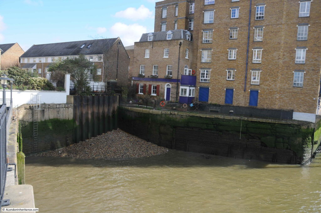
If you walk east along Narrow Street in Limehouse, over the bridge that crosses the channel from Limehouse Basin to the Thames, then turn towards the river along the Thames Path, and at the end of the new apartment buildings that go by the name of Victoria Wharf, you will find a short channel in from the river:

This was the original river entrance where the Limehouse Cut connected to the River Thames.

The Limehouse Cut was opened in 1770 to provide a direct route between the River Thames and the River Lea at Bromley-by-Bow.

The River Lea entered the Thames to the east of the Isle of Dogs, so the Limehouse Cut provided a much shorter route for barges heading to the City and east London by avoiding the need to travel around the full loop of the Isle of Dogs.

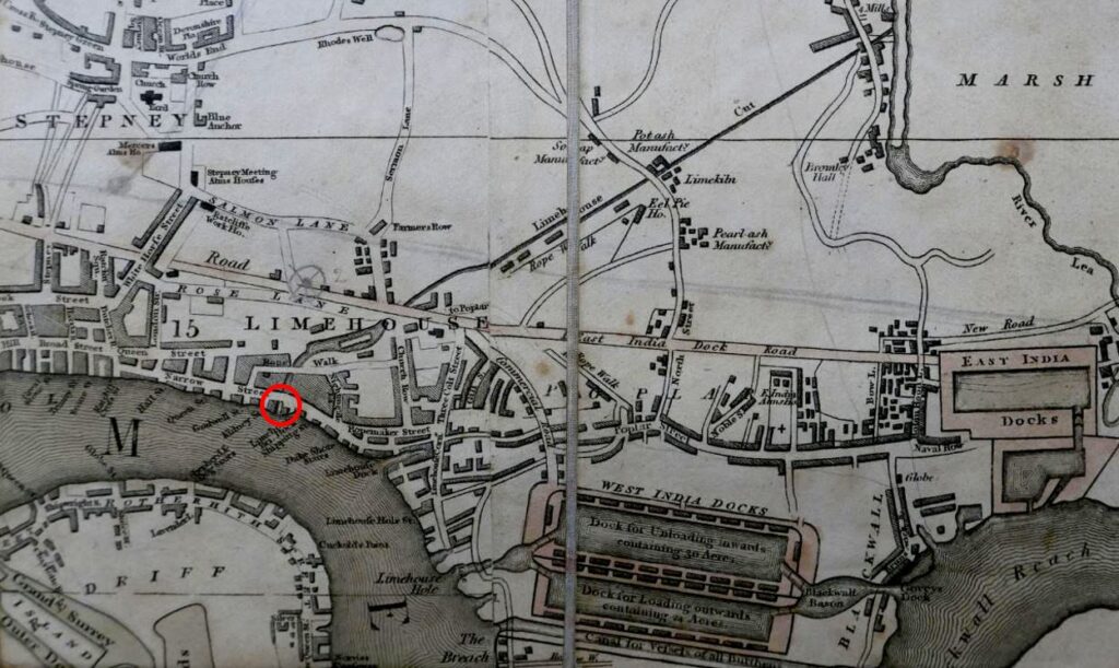
The following extract from the 1816 edition of Smith’s New Plan of London shows the Limehouse Cut running as an almost straight line from the River Lea at top right to the Thames, where I have marked the point where the Limehouse Cut connects to the river with a red circle – this is the short channel in my photo above.

The area to the lower left of the Limehouse Cut was mainly open space, with a limited number of buildings and streets, however this would be changing very soon.

Soon after the 1816 map was published, another canal was built to help with transport across the city. The Regent’s Canal ran from Limehouse and headed north to loop around north London, allowing goods to be transported from the river to the north of the city, thereby avoiding the congested road system.

Part of the Regent’s Canal included a large basin, an expanse of open water just before the point where the Regent’s Canal entered the river. There were warehouses around the basin, and barges would gather, waiting to transit to the river when tides allowed the locks to be open.

The Regent’s Canal Basin, and the entrance to the river was built immediately to the west of the Limehouse Cut.

For eleven years between 1853 and 1864, the Limehouse Cut was diverted into the Regent’s Canal Basin, however after 1864 the original entrance was back in use, with a new bridge carrying Narrow Street over the canal. This would last for another 100 years.

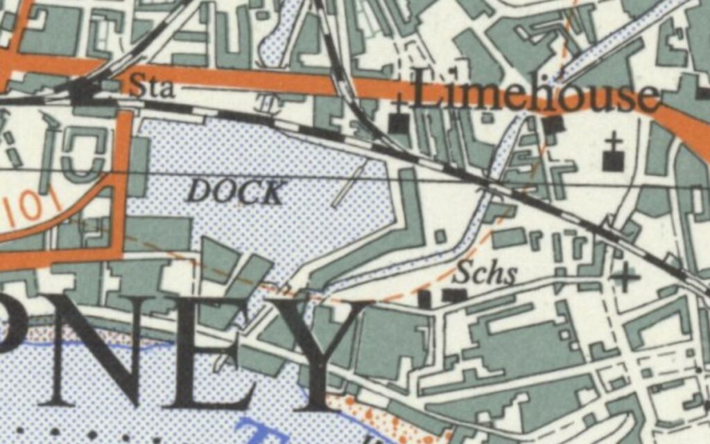
The following extract from the 1955 revision of the Ordnance Survey map shows the Limehouse Cut running from top right down to the River Thames, with the Regent’s Canal Basin immediately to the left, labelled as “Dock” (‘Reproduced with the permission of the National Library of Scotland’).

By 1968 industrial activity in the area had been in long decline as was trade on the Regent’s Canal and Limehouse Cut. The entrance to the river was again closed, and the Limehouse Cut diverted into the Regent’s Canal Basin that was renamed as the Limehouse Basin.

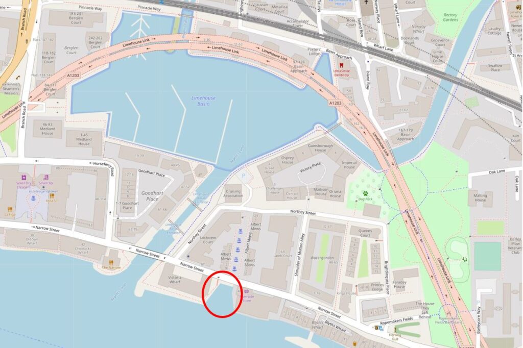
The following extract is from a map of the area today. Limehouse Cut is coming in from top right and diverting straight into Limehouse Basin, I have again circled the original entrance with a red circle (Map © OpenStreetMap contributors).

The pink road that appears to loop across the north of the Limehouse Basin is in reality underground as this is the Limehouse Link Tunnel.

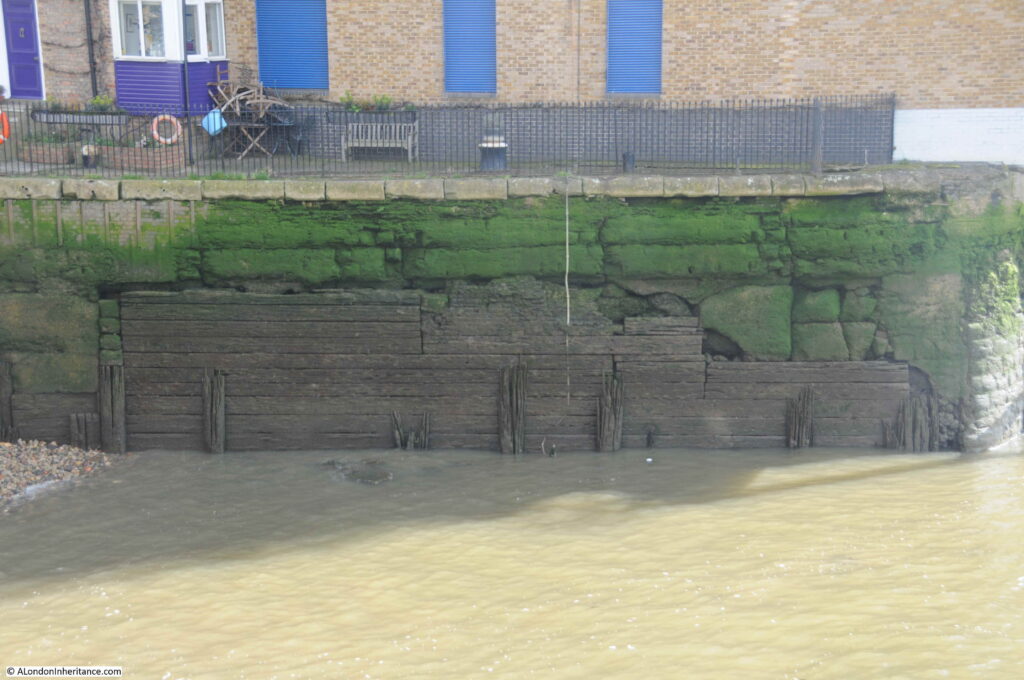
The following view is looking across the old entrance to Limehouse Cut. The wooden boards may well be the original planks that lined the entrance to the canal.

A couple of high explosive bombs landed in the immediate vicinity so the area surrounding the wooden planks may well be repaired bomb damage.

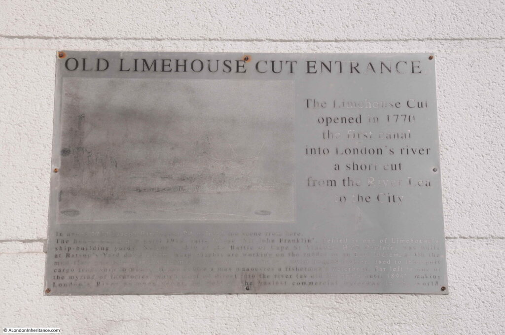
A very faded information board at the old entrance to the Limehouse Cut:

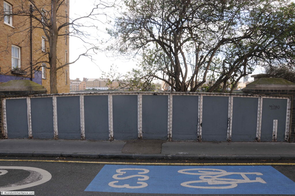
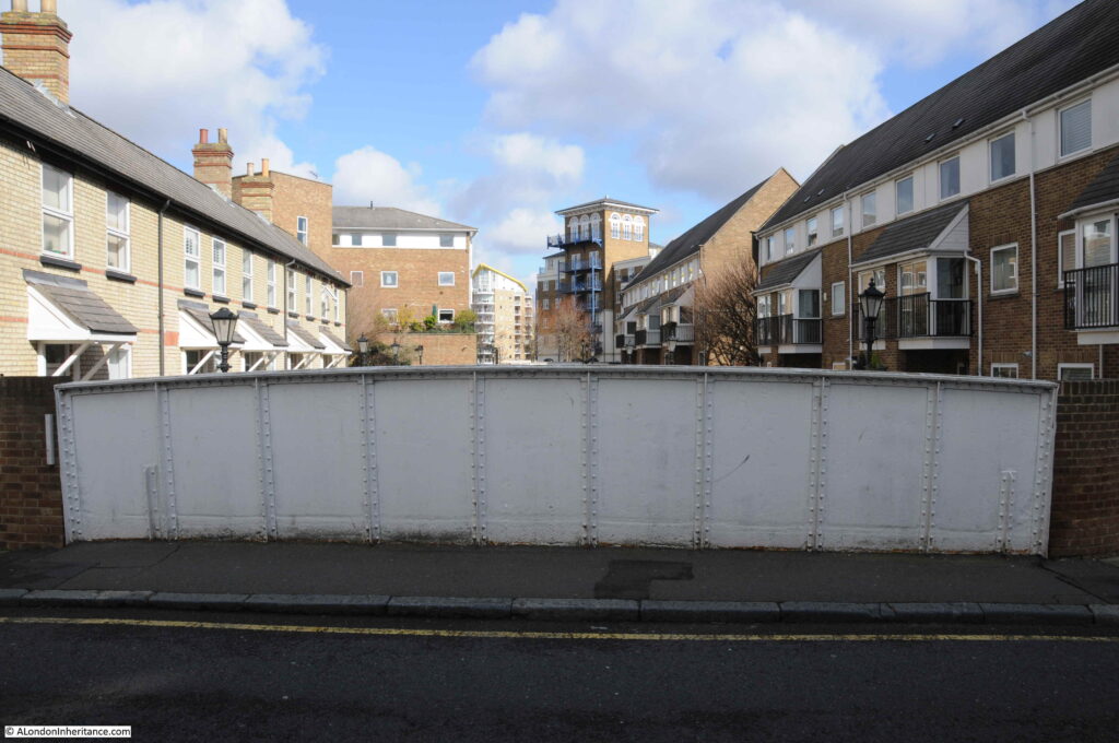
Between 1853 and 1864, the Limehouse Cut had been diverted to the Thames via the Regent’s Canal Basin. In 1864, the original entrance was restored, and a new wrought iron girder bridge was installed to carry Narrow Street over the Limehouse Cut. This 1864 bridge remains in place, although because of the filled in entrance, the bridge is not that obvious apart from the iron side walls as the street is carried over the Limehouse Cut. This is the view from Narrow Street looking south towards the Thames:

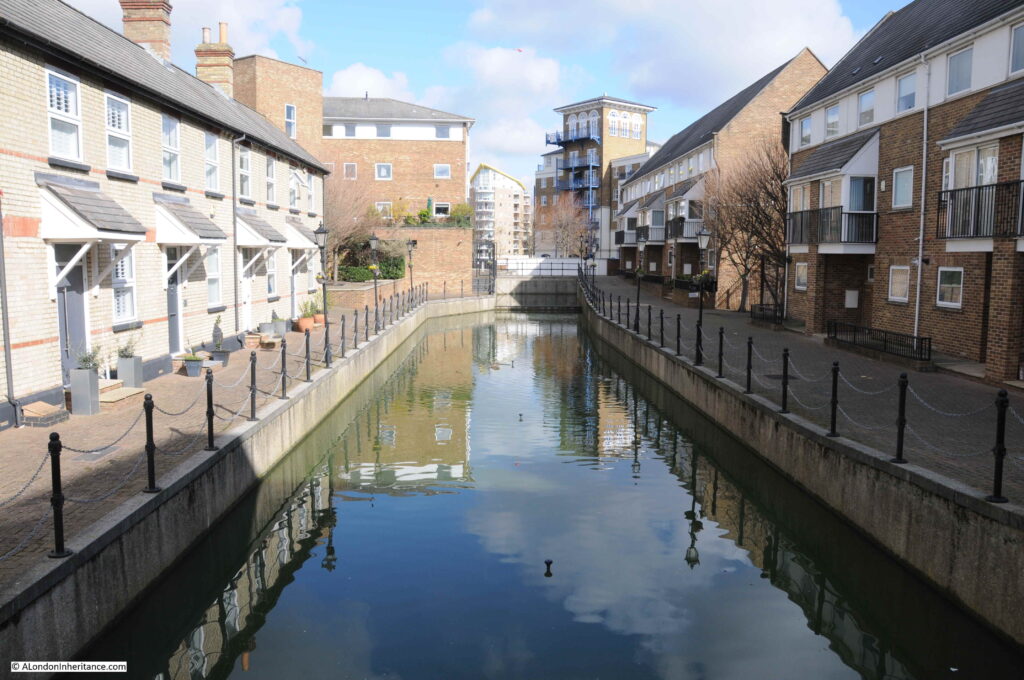
The view looking north:

Looking over the northern edge of the bridge, we can see the section of the Limehouse Cut that was originally the lock that controlled access between the non-tidal canal and the tidal river. Much restored late 19th century lock keepers cottages line the western side of the old lock (to the left in the photo below):

The old Regent’s Canal Basin, now the smaller Limehouse Basin, today hosts a marina, and provides links with the River Thames, Regent’s Canal and via the Limehouse Cut, the River Lea, and are all really interesting walks.

The old Limehouse Cut entrance is evidence of the canal’s original 1770 route into the River Thames for one of London’s early transport systems.

Angel Underground Station

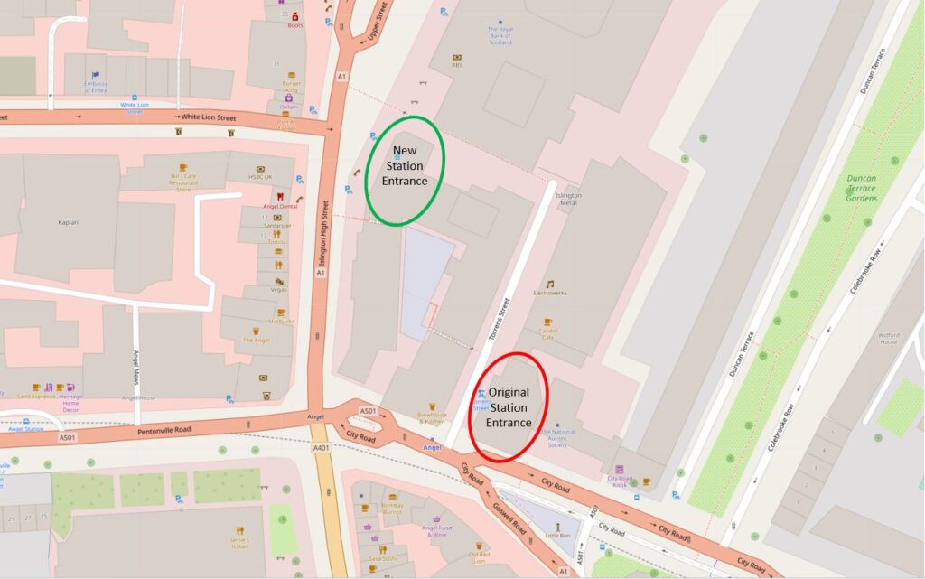
Today, the entrance to Angel Underground Station is on the corner of a modern brick office block, facing onto Islington High Street. It has not always been in this position.

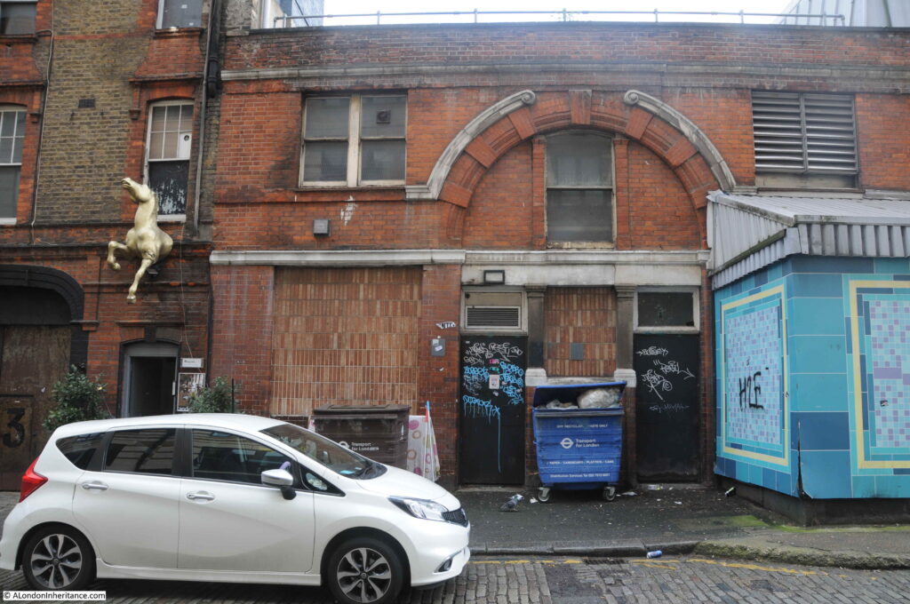
To find the original station, you need to walk south to the junction of Islington High Street with Pentonville Road, and walk a short distance along City Road and on the left is a rather strange looking building:

This is the original Angel Underground Station.

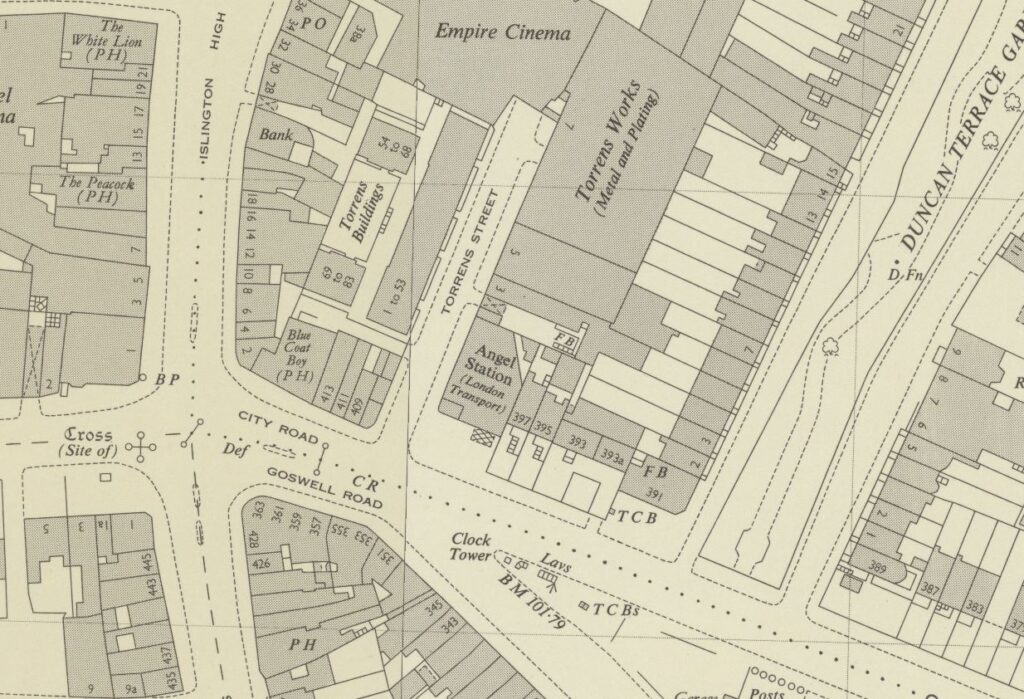
The Angel Station opened in 1901 as part of the City and South London extension from Moorgate. Six years later in 1907, the line was extended on towards Euston station. Today, Angel Station is on the Bank branch of the Northern Line. The following extract from the 1954 Ordnance Survey Map shows the original station in the centre of the map, on the corner of City Road and Torrens Street. This is the station building photographed above (‘Reproduced with the permission of the National Library of Scotland’).

The location of the old and new stations can be seen in the following map (Map © OpenStreetMap contributors):

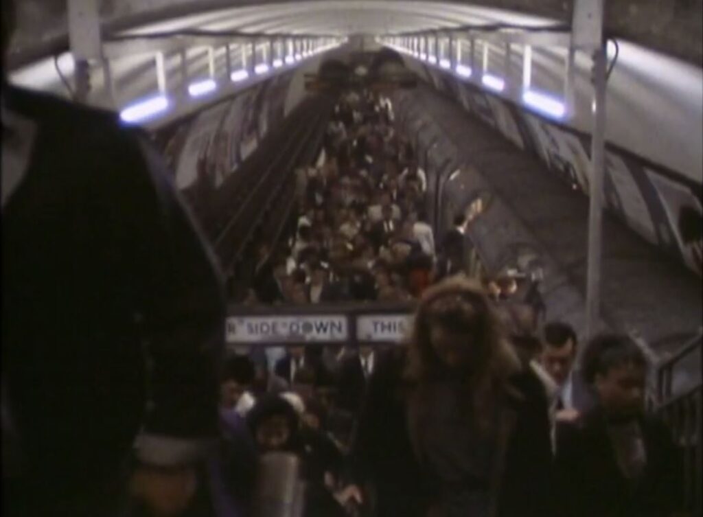
When Angel Station was built, it had a narrow central platform, with both tracks running either side of the platform. Whilst this was probably fine for the short period of time before the line was extended, it was a rather dangerous place when the platform was crowded, and busy trains ran in both directions.

The following clip is from the 1989 BBC film Heart of the Angel (link at the end of the post), showing the crowded platform.

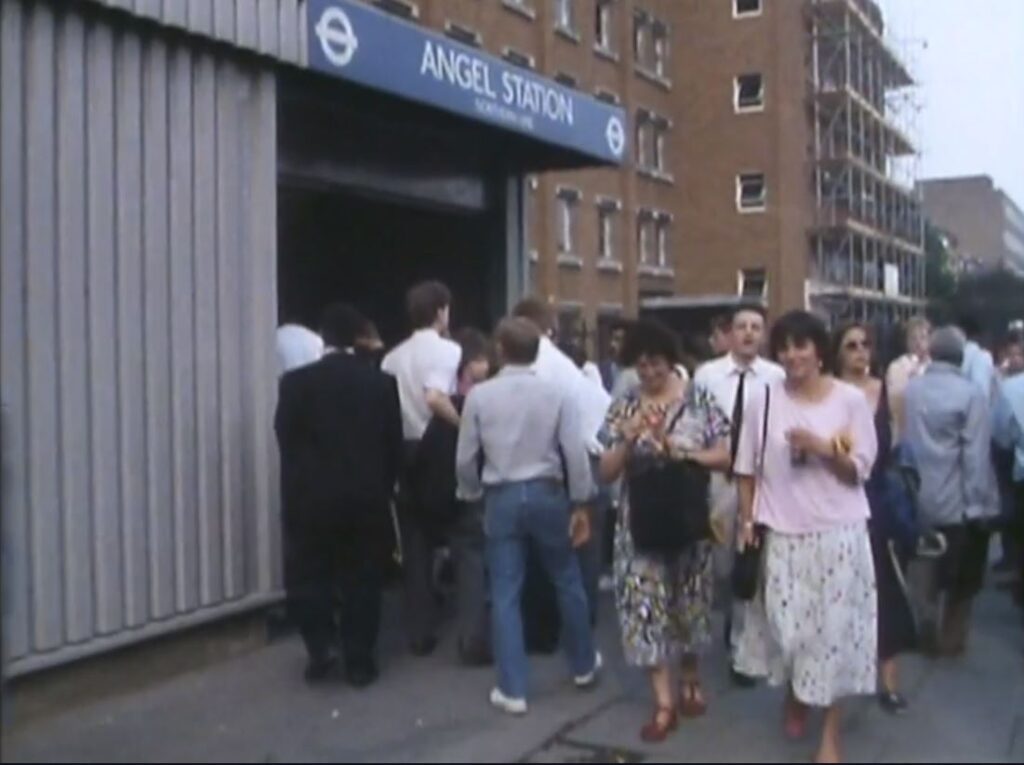
From the same film is a clip of the 1989 entrance to the station, looking down City Road and is on the right of my photo of the station at the top of this section of the post.

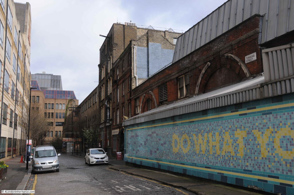
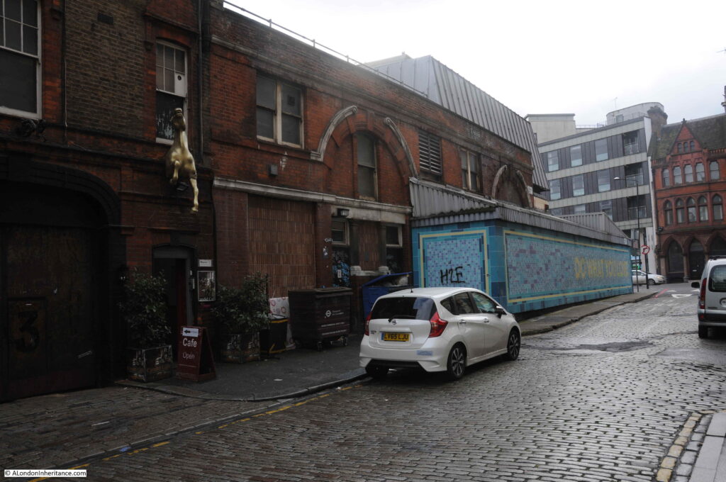
The platforms were also served by lifts from the ground level building. The exterior cladding around the original brick building was a later addition to provide extra space. The view down Torrens Street with the station on the right:

By the late 1980s, the station had a long history of overcrowding along the narrow single platform. It would frequently be rather chaotic when two trains pulled in, with passengers leaving both trains onto a narrow platform full of passengers waiting to get on the trains.

The lifts were also relatively small for the number of passengers at busy times and would also frequently break down. At the end of the 1980s a major rebuild of the station began.

A new tunnel was excavated to take the northern branch, thereby separating the northern and southern tracks so each could have their own platform. The southern branch today occupies the space of the original tunnel so has a rather wide platform compared to a normal station, as the platform occupies the space of the original platform and the northern tracks.

Escalators were installed to avoid the use of lifts, and these took passengers between the platforms and the new station entrance on Islington High Street.

The new station opened in 1992, leaving the original station building to sit on the corner of City Road and Torrens Street.

Crossrail 2 includes a station at Angel, and the complete eastern side of Torrens Street, including the original station building, was designated in the safeguarding map of sites for Crossrail 2 construction and operation.

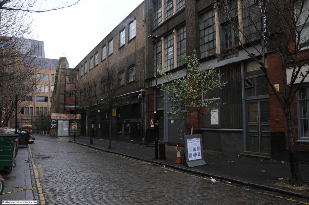
The following view looks along Torrens Street at the buildings included in the safeguarding map.

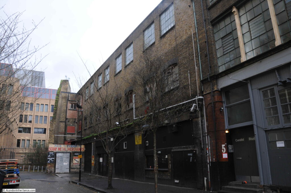
The buildings along this side of the street are an interesting mix of old warehouses.

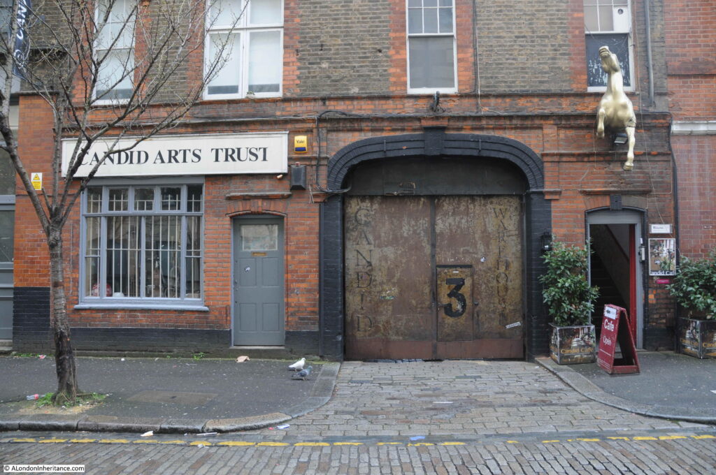
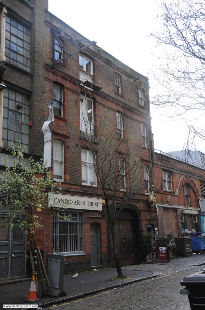
Candid Arts Trust occupies a 19th century warehouse:

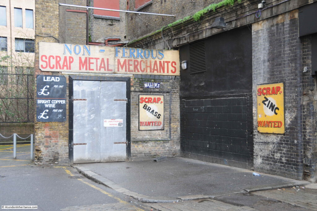
And at the end of the street is an early 20th century building that was constructed on the site of a smithy and may have been used to stable horses, however it would be occupied by a metal working and plating company.

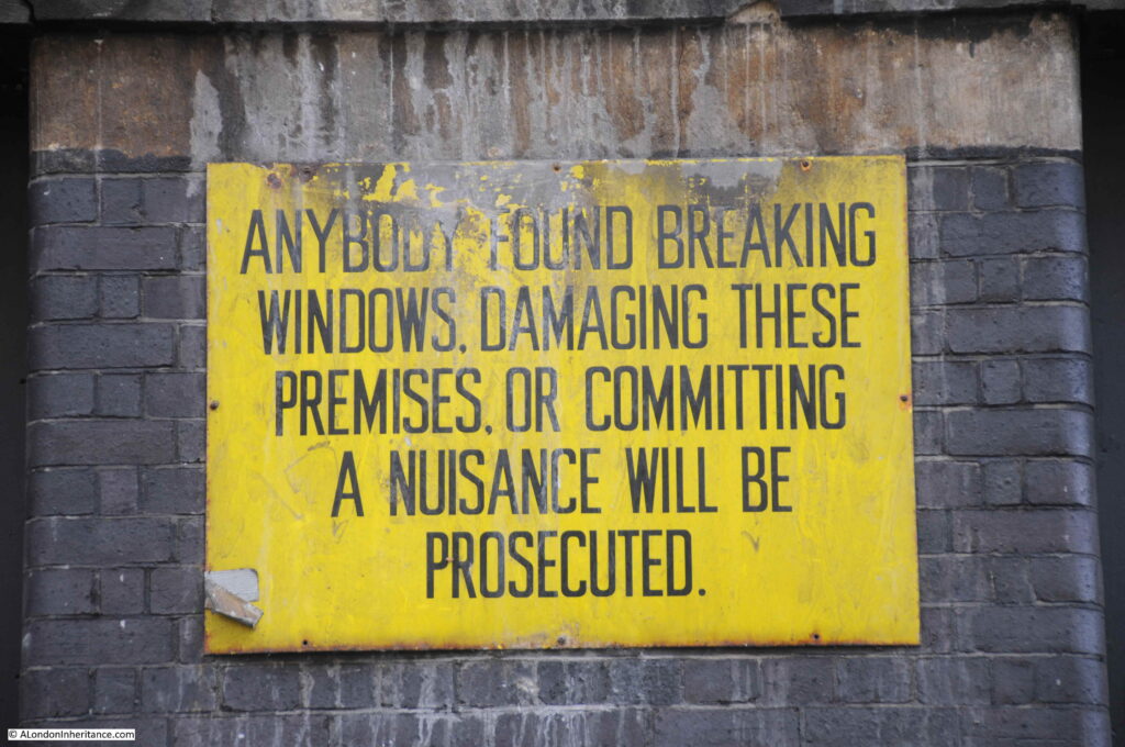
And there is still evidence of this activity:

The building is now occupied by the “Islington Metal Works” – run by a hospitality company and the site is used for Wedding Receptions, Corporate and Christmas events.

The link between these two very different sites, in different parts of London is hopefully now clear; that they are the redundant entrances to once busy transport links that have now been diverted.

The entrance to the Limehouse Cut was once a busy route for barges moving between the Lee River and the River Thames, with the Limehouse Cut now diverted into Limehouse Basin.

The original entrance to the Angel underground station has now been closed for some thirty years, with passengers now diverted along escalators rather than lifts to the new station entrance on Islington High Street, with a considerably improved and safer platform layout at the station.

There are many examples of these across London where the ever changing transport system adapts to changing technology, different patterns of use and improvements.

A film was made for the BBC 40 Minutes series in 1989 documenting 48 hours in the life of the Angel station.

Heart of the Angel was made by the BAFTA award winning director Molly Dineen, and it is a very honest portrayal of a station struggling to cope with the numbers of passengers using the station and the creaking infrastructure supporting the station.

if you have a spare 40 minutes, it is well worth a watch and can be found here.
alondoninheritance.com