Category Archives: Uncategorized

Cripplegate Ward: Lady Eleanor Holles School and Cripplegate

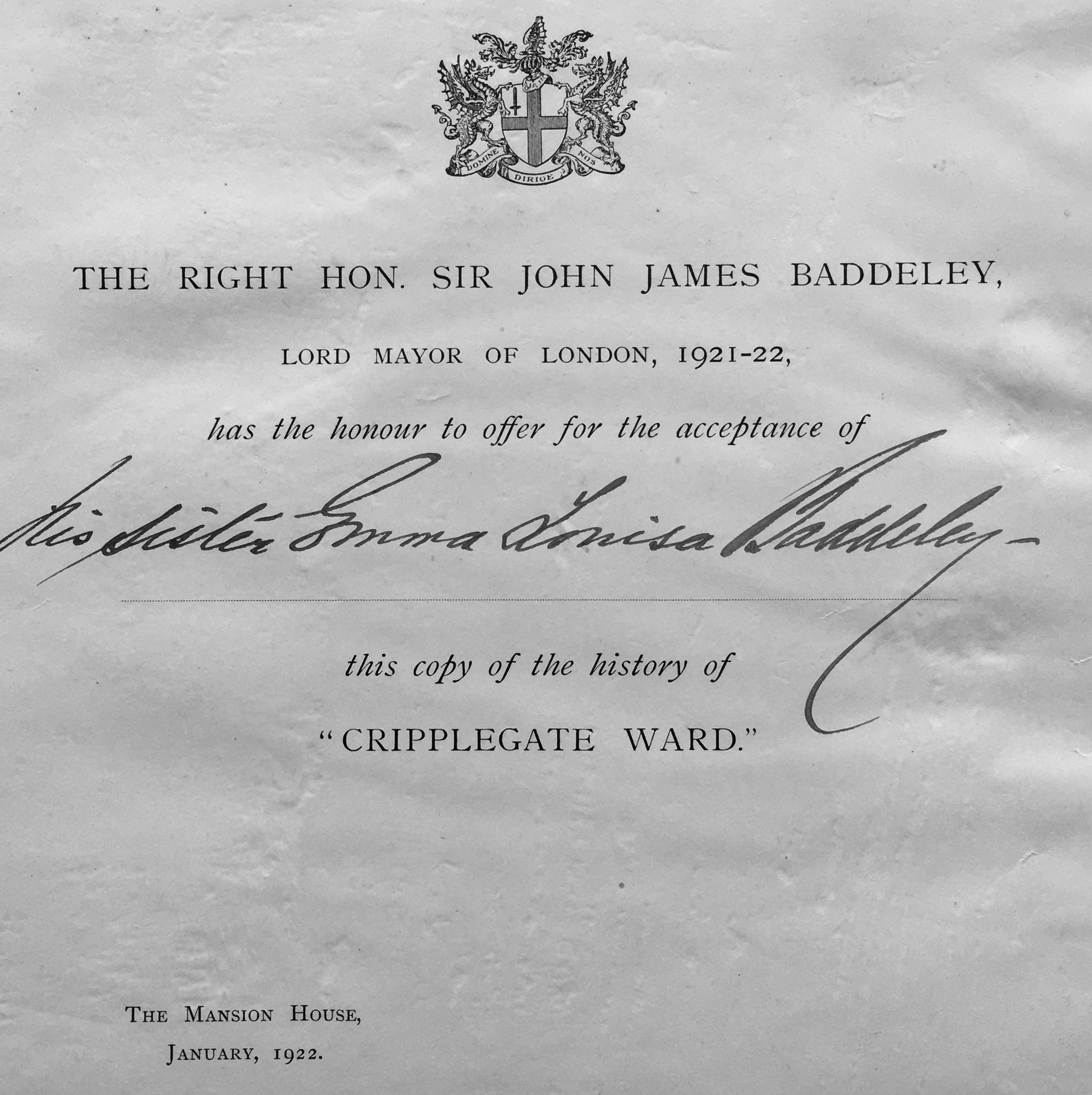
I am fascinated by the journey that books take over the years. I have a copy of a book titled “Cripplegate Ward” by Sir John James Baddeley, published in 1921.

Baddeley was the Lord Mayor of London between 1921 and 1922, and on the inside cover of the book is pasted a square of paper detailing Baddeley’s presentation of this copy of the book to his sister Emma Louisa Baddeley:

Cripplegate Ward

As it is roughly 100 years since Baddeley gave the book to his sister, I thought it would be a good time to revisit Cripplegate Ward, using the book as a guide.

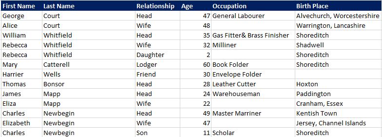
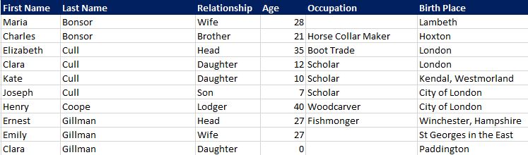
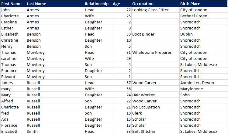
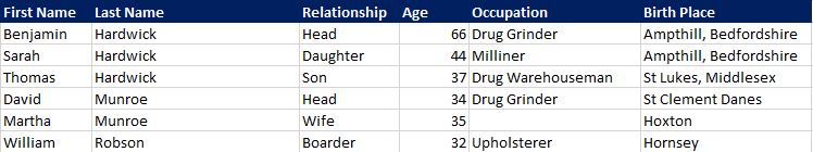
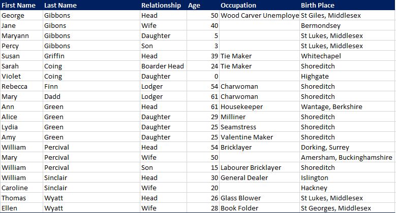
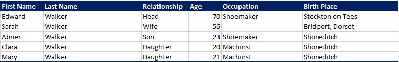
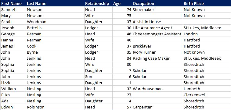
Baddeley describes Cripplegate as the second largest ward in the City (Farringdon Without being the larger), covering an area of 63 acres, nearly a tenth of the whole City. In the last census (1911) before Badderley’s book was printed, the ward had a population of 36,793, the majority of whom were employed in the various warehouses and factories that could be found across the ward.

Cripplegate was / is divided into Cripplegate Within and Without to describe those parts of the ward that were in the City side of the old Roman wall, and the area on the outside of the wall. That demarcation makes very little difference today, but would have been important when the wall was still a feature of the landscape.

Whilst I have written about Cripplegate in a number of previous posts, what I also find fascinating is gradually peeling back the layers of the history of a place, and finding more detail than I have already covered, so for today’s post I want to explore two places within Cripplegate ward that I have not written about before. The first is:

Lady Eleanor Holles School

There is an elevated walkway underneath Gilbert House within the Barbican estate. The walkway is lined by a number of round, concrete pillars that support the building above, and on one of these pillars is the following plaque:

Lady Eleanor Holles' School

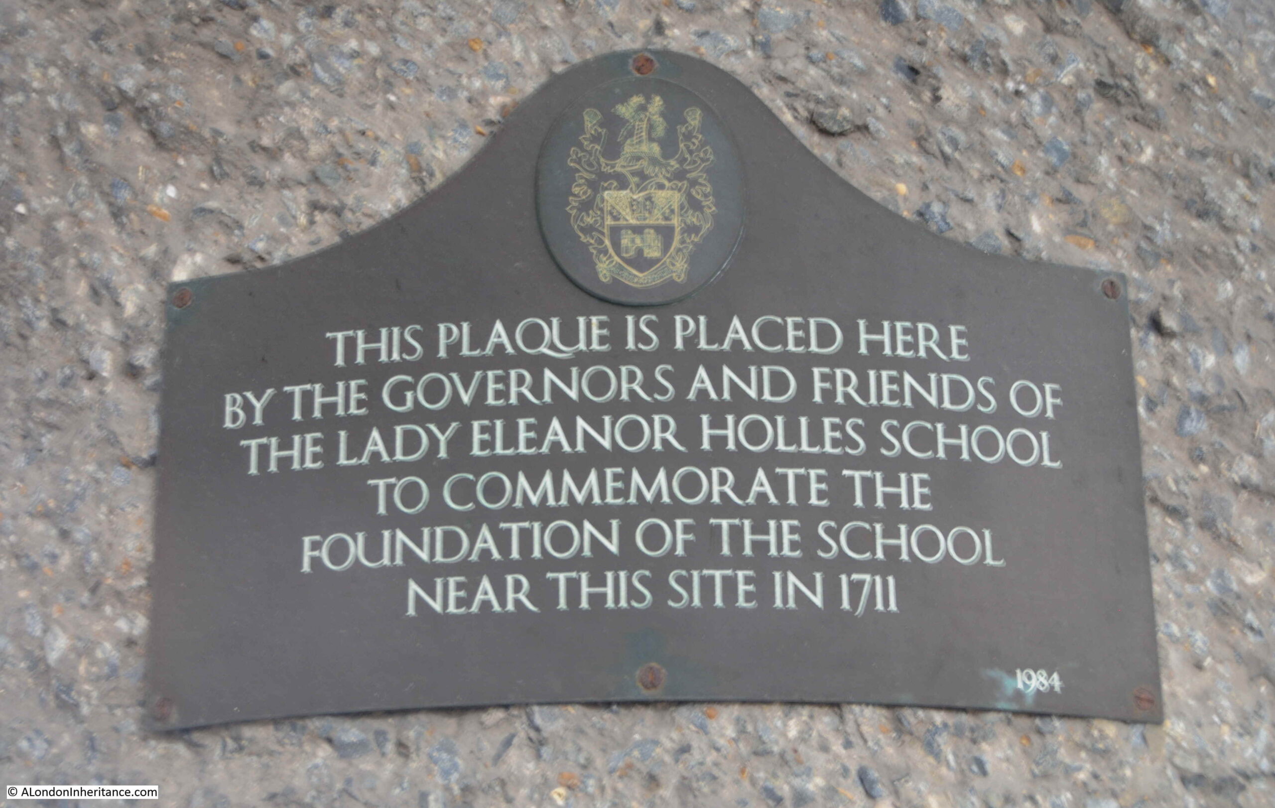
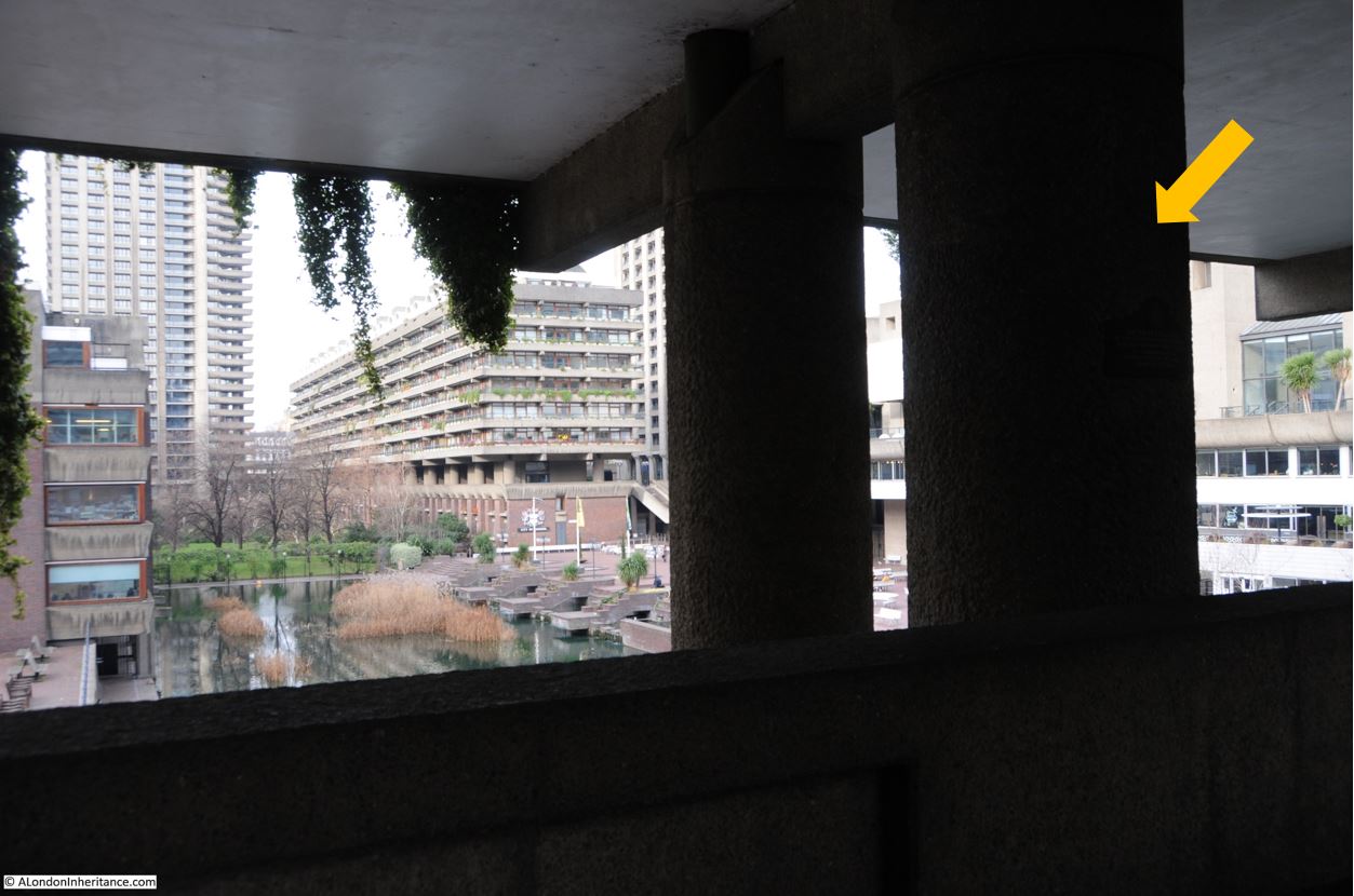
The plaque records the foundation in 1711 of the Lady Eleanor Holles School near the site of the plaque. The plaque is on the pillar arrowed in the following photo, which shows the location and view out to the central area of water in the Barbican:

Lady Eleanor Holles' School

Cripplegate Ward by Baddeley, along with an article on the history of the school in the City Press on the 24th of July 1869 both provide some background into the Lady Eleanor Holles School.

Lady Eleanor Holles died in 1708, and in her will asked that her executor, a Mrs Anne Watson, dispose of her estate “to such pious purposes as her executor might think best”. Her estate consisted of land and a number of properties which produced an income of £62 and 3 shillings a year.

There was already a boys school in Redcross Street, Cripplegate, and Mrs Anne Watson arranged that the properties from Eleanor Holles will were committed to a body of trustees, and the funds used for the creation of a girls school, consisting of “a schoolmistress and the education of fifty poor girls”, and to be known as “the Lady Holles’ Charity School”.

There is no record as to why Anne Watson chose the poor of Cripplegate to be the beneficiary of the Eleanor Hollis will, however Anne Watson appears to have been deeply interested in promoting education for the poor as in her own will she left £500 for a charity school.

Around the start of the 18th century, there were concerns regarding the lack of education for children of the poor, and what this meant for the promotion of “Christian principles”.

According to the City Press, the school “undoubtedly owes its origin to that general movement in favour of the religious education of the poor in the principles of Protestantism which took place in the latter stages of the seventeenth century”. Baddeley also adds that a document in possession of the treasurer of the school and written in 1709 states that “It is evident to common observation that the growth of vice and debauchery is greatly owing to the gross ignorance of the principles of the Christian religion, and Christian virtues can grow from no other root than Christian principles”.

The original school used rooms leased from the boys school, which was located towards the northern end of Redcross Street. In 1831 the enlargement of the school was proposed, and a new school for the girls was built at the southern end of Redcross Street.

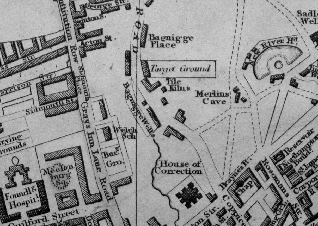
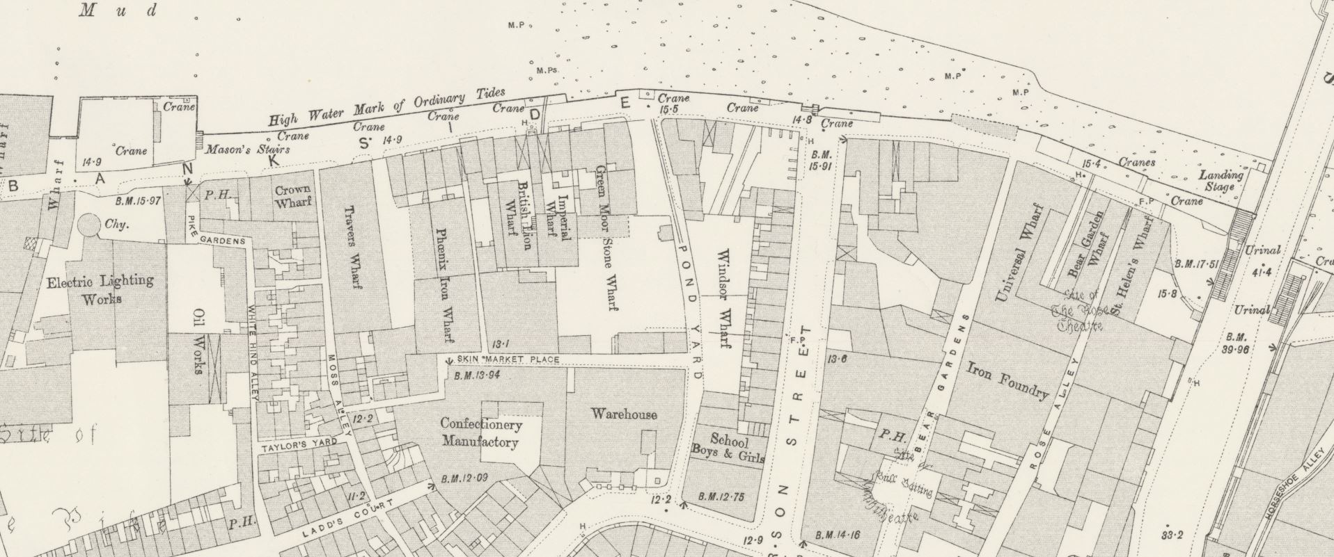
I have circled the location of this school (marked as School Girls) on the 1894 Ordnance Survey map below (‘Reproduced with the permission of the National Library of Scotland“):

Lady Eleanor Holles' School

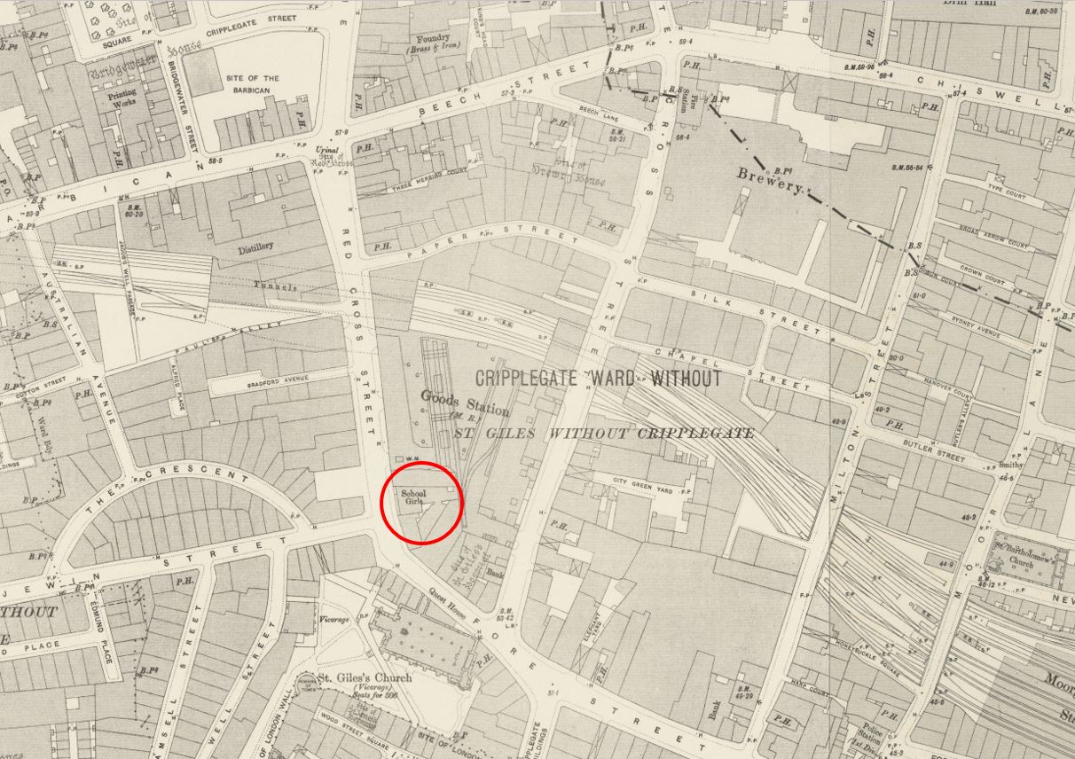
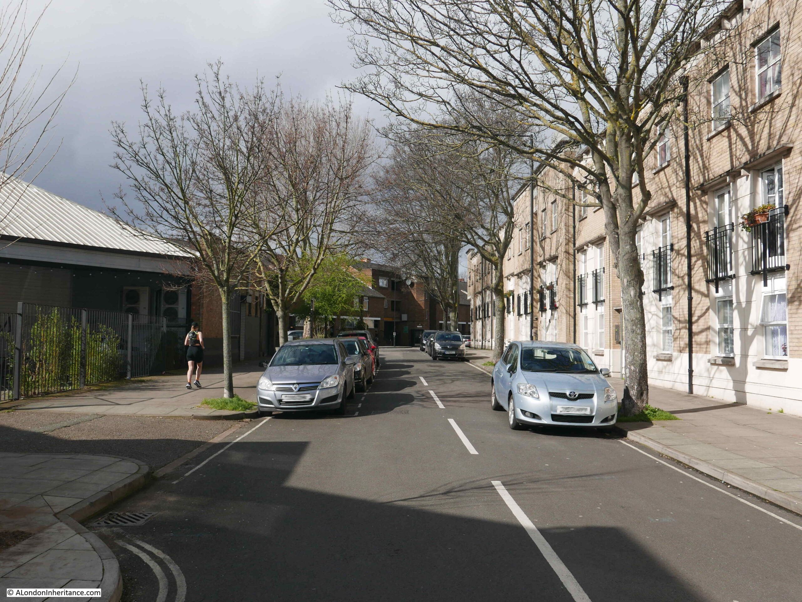
The school was located where Fore Street turned into Redcross Street. I have marked the location on a map of the area today (© OpenStreetMap contributors):

Lady Eleanor Holles' School

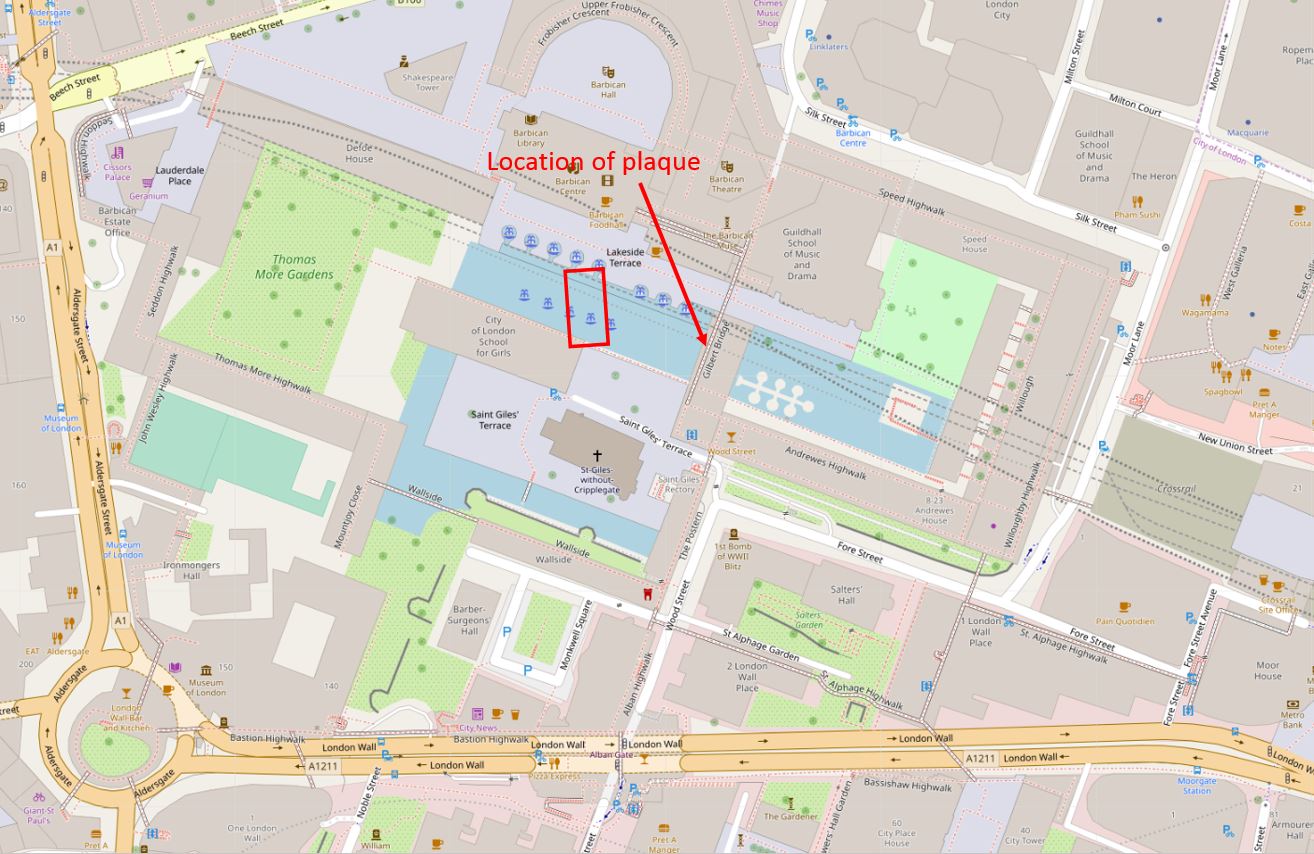
The plaque photographed earlier in the post is on the walkway under Gilbert House (arrowed in the map above), and the red rectangle shows the location of the school which would have been facing onto Redcross Street, which ran from just above the left of the church, past the school and into what are now the buildings of the Barbican.

The school went through a number of enlargements during the 19th century, and the final build of the early 1860s created a school with a capacity for 300 girls and 100 infants, residence for the school mistresses and a board room for the governors.

In the mid 19th century, the school seems to have been doing financially rather well, as in an 1868 survey of the “Thirty Three City of London Endowed Schools for Primary Instruction for Boys and Girls”, Lady Eleanor Holles school was identified as having the largest endowment, with an annual income of £1,377.

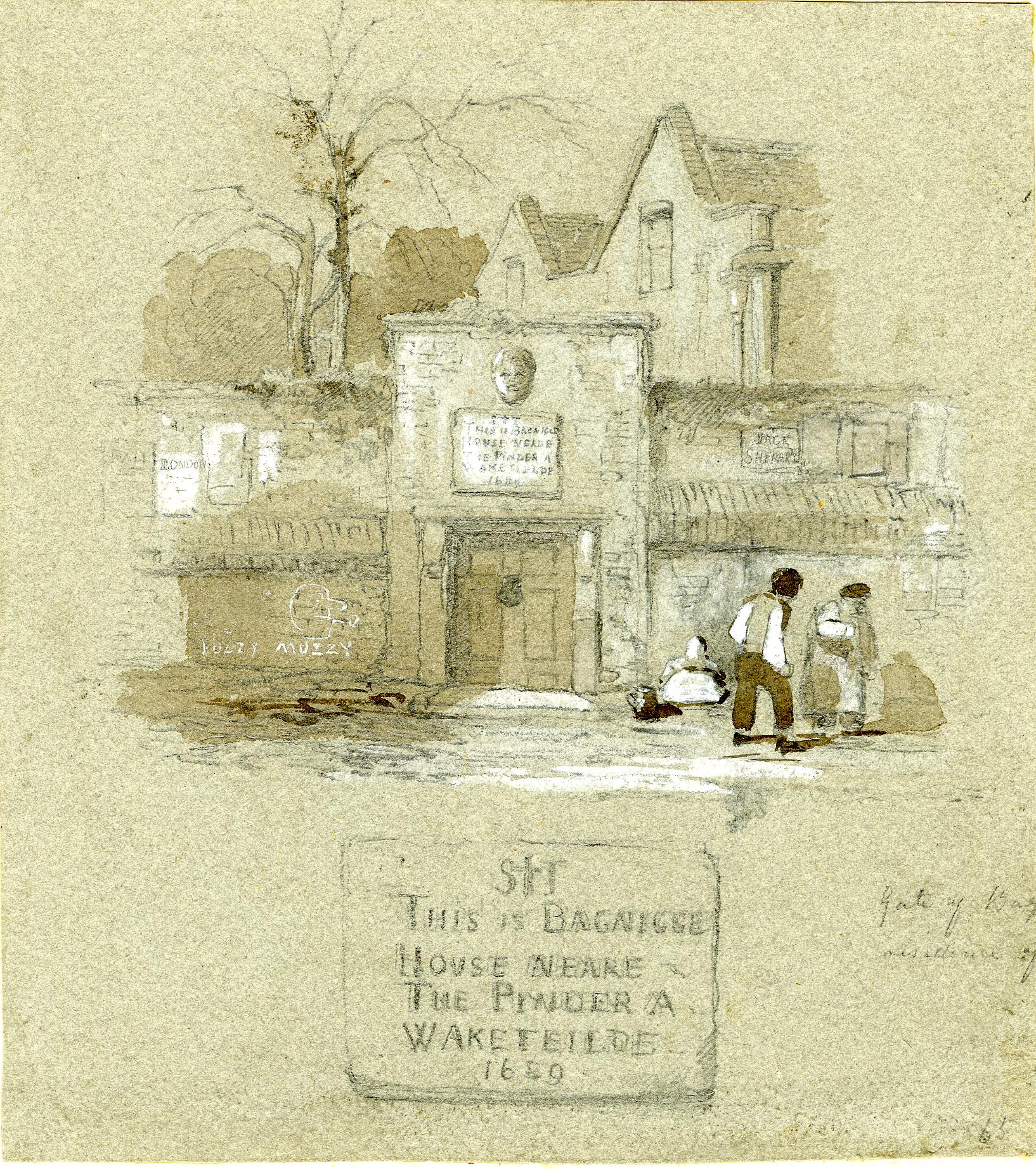
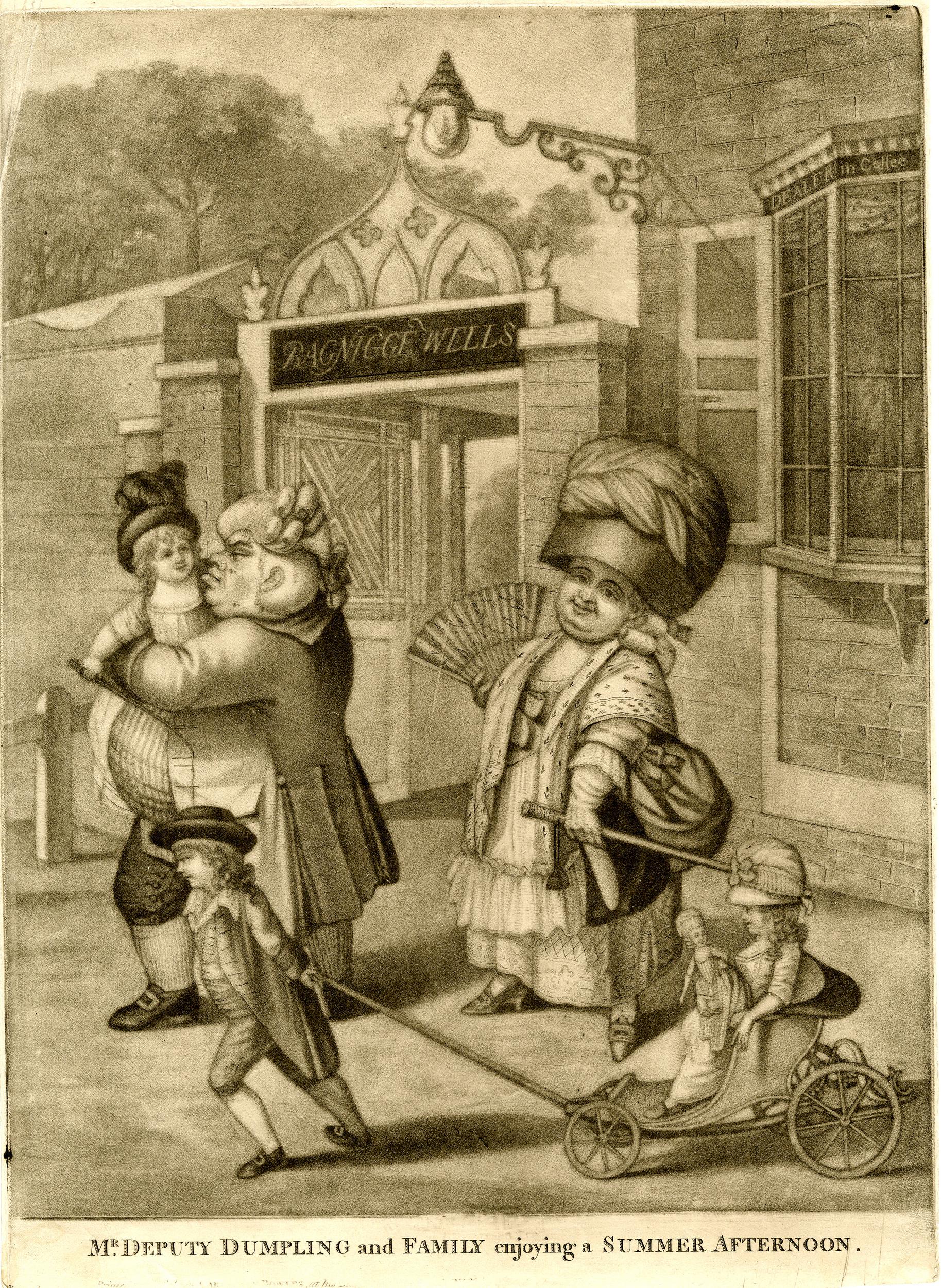
As with many charity schools throughout London, the Lady Eleanor Holles School had the sculptured figure of one of the scholars mounted on the front of the building. The following image of the figure, showing the collar, cap and clothes that would have been worn by the girls comes from Baddeley’s book on Cripplegate Ward:

Lady Eleanor Holles' School

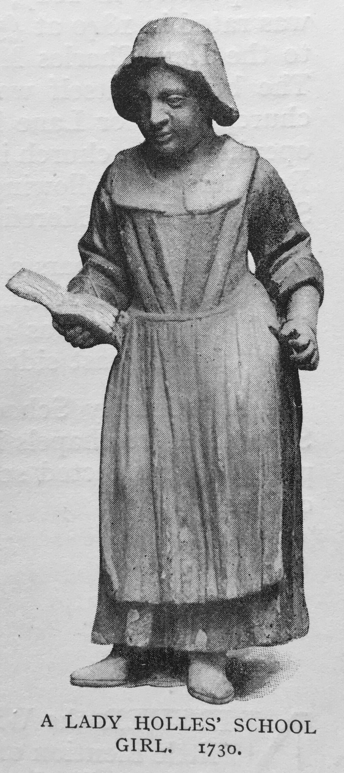
The girls were instructed in the practice of the Christian religion. They were taught to spell, read and sew.

Although the school could support a large number of girls and infants, towards the end of the 19th century the majority of pupils were coming from outside the parish of St Giles, Cripplegate. This was down to the reduction in the number of dwelling houses in the area as more factories and warehouses were constructed.

The school was also in competition with the new schools created by the London Schools Board, which were being funded through the rates and parliamentary grants, rather than through charity donations and fees.

The future of the school was decided by the London County County who were looking for a site to construct a large, new fire station.

The LCC offered the trustees of the Lady Eleanor Holles School a sum of £30,000 for the land and buildings. The school trustees accepted, and moved to a new location in Mare Street, Hackney.

The reason for a new fire station in Redcross Street can be seen in this article from Lloyds Weekly Newspaper on the 4th of December 1898:

“Hitherto Watling-street has been the chief City fire station, and the proposed change would be of great advantage, as the warehouses in the vicinity of Wood-street are filled, as a rule, with the most combustible materials. On the northern side the station would be of very great utility to the over-crowded districts of St. Luke’s and Shoreditch, where most houses are old and the danger of fire considerable.”

I have written about the Redcross Street fire station in a previous post, as it was a central feature in one of my father’s post war photos of the area now occupied by the Barbican and Golden Lane estates. The post can be found here, and covers the story of the fire station during the blitz, Redcross Street, and the surrounding area.

What I did not have time to cover in the earlier post was the history of the school, so in the following photo, St Giles is the church which is still a central feature in the Barbican. Redcross Street fire station is the large building on the left, and the rest of the area shows the devastation of bombing, mainly on the night of the 29th December, 1940.

Lady Eleanor Holles' School

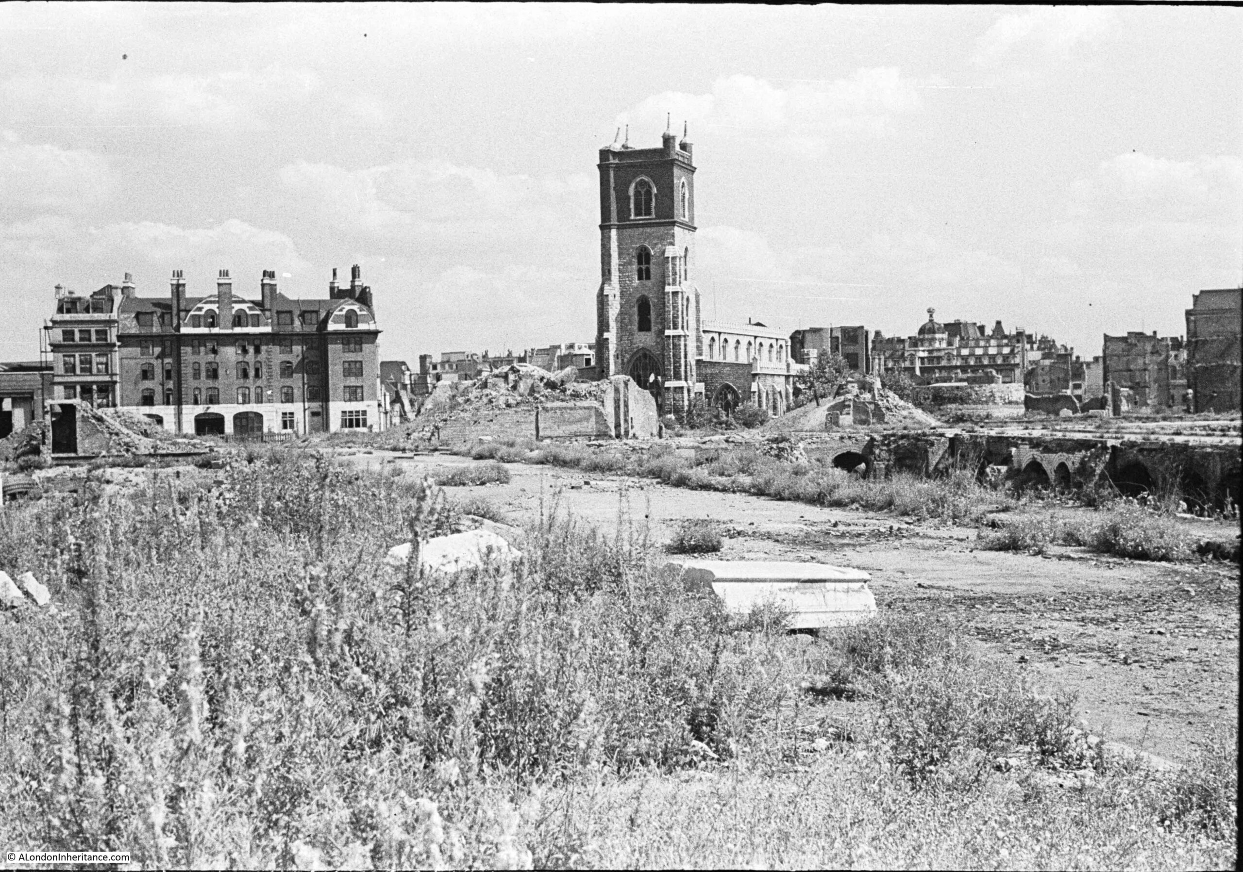
So, part of the area now occupied by the central water feature in the Barbican was once the site of the Redcross Street fire station, and before that, was the site of the Lady Eleanor Holles School for Girls.

The school, and fire station were once located in the centre of the lake in the following photo, just behind the tall grasses on the left. The walkway with the pillar and the plaque is in the background, underneath Gilbert House:

Lady Eleanor Holles' School

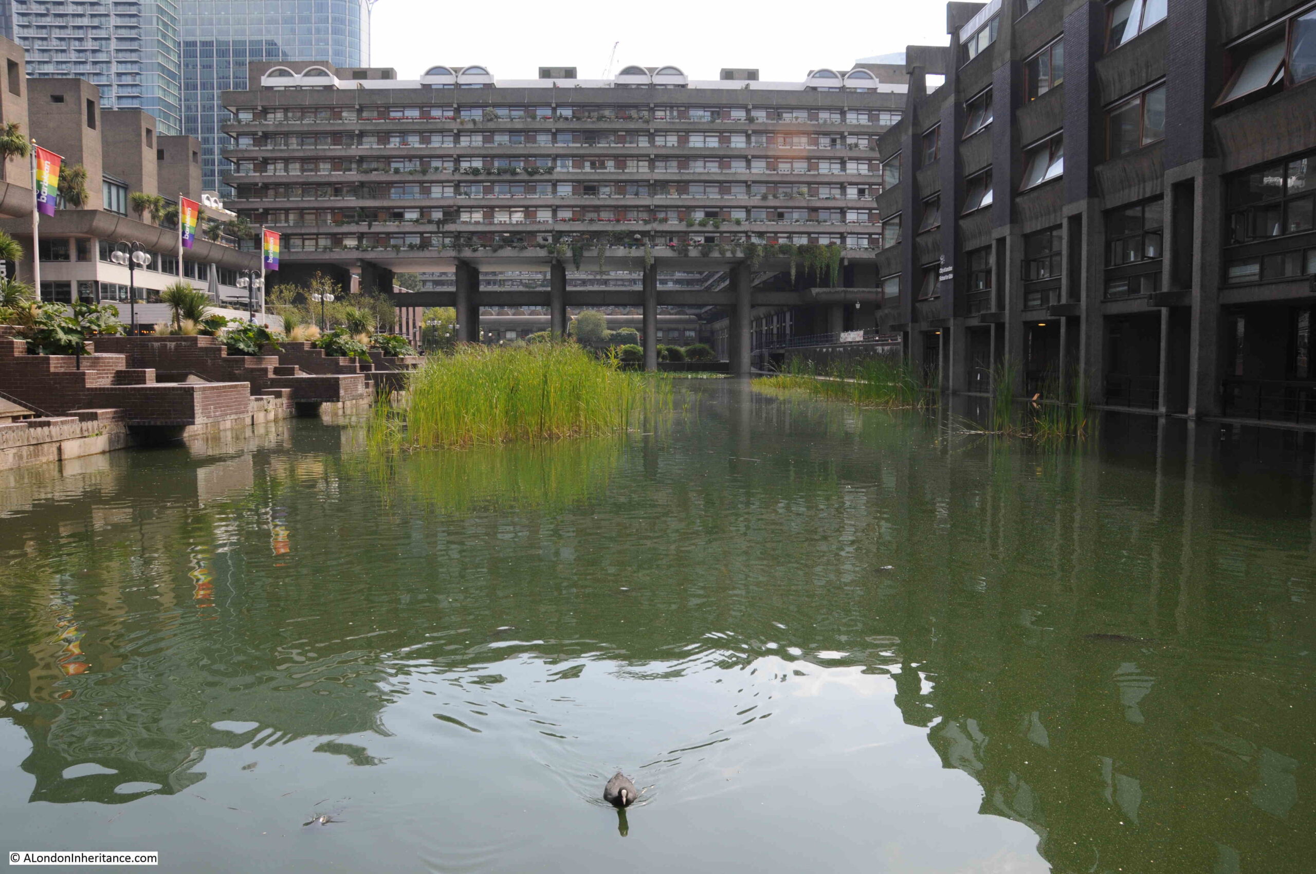
The above photo also shows how Gilbert House is supported by a relatively few number of slender pillars.

The Lady Eleanor Holles school remained at Mare Street, Hackney until the mid 1930s, when for similar reasons to the challenges of the late 19th century (industrialisation of the area, competition with many other local schools), the school decided to relocate out of central London and moved to a temporary location in Teddington, whilst a new school building was constructed at Hanworth Road, Hampton.

The Lady Eleanor Holles school continues to be based in Hampton and is rated as one of the leading independent girls schools in the country.

A very different location, but maintains the name of Lady Eleanor Holles, who left sufficient money through her property, to establish the original girls school in Redcross Street in 1711.

My second location for this week’s post on Cripplegate Ward is the feature that would give the ward its name:

Cripplegate

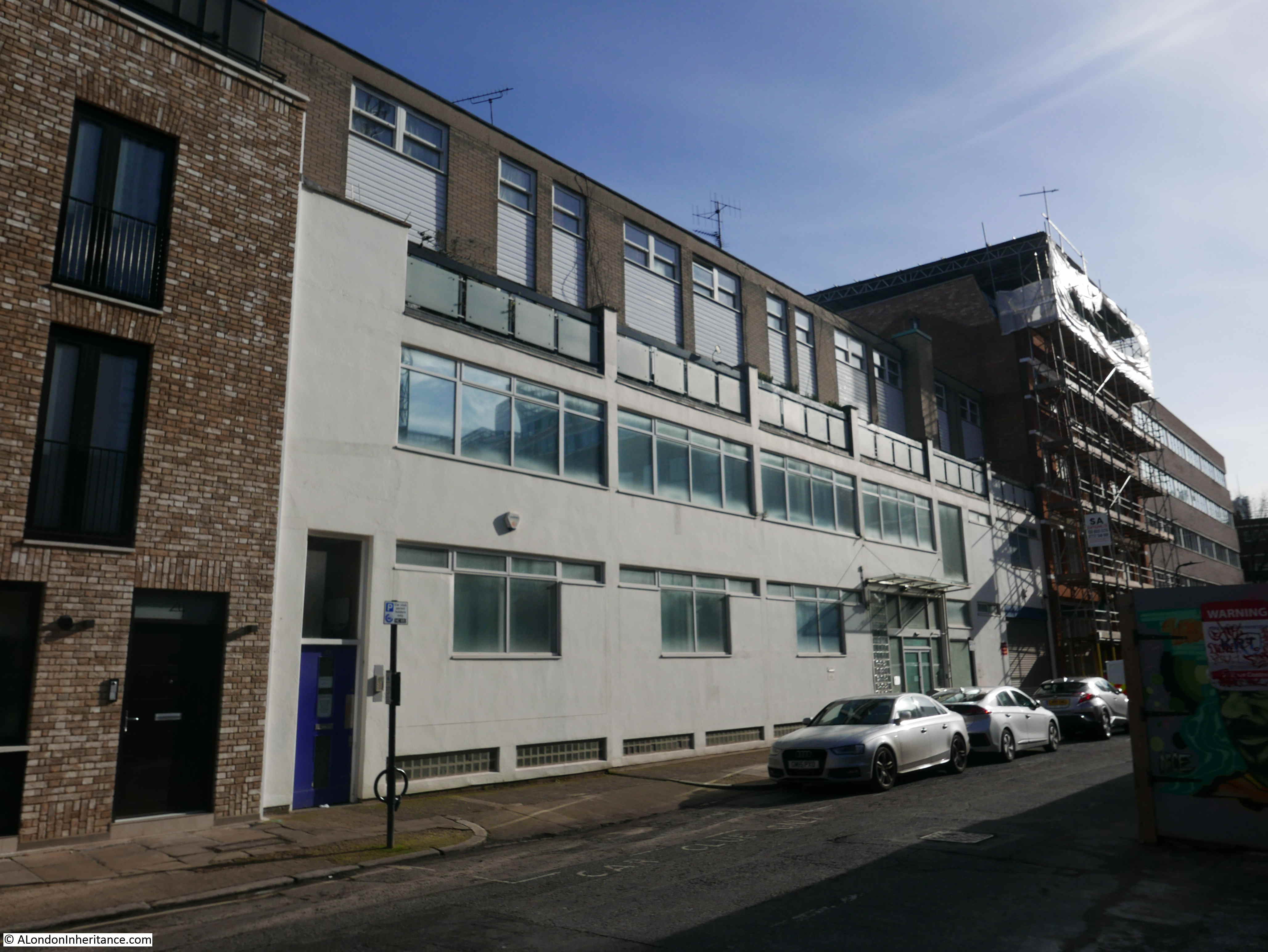
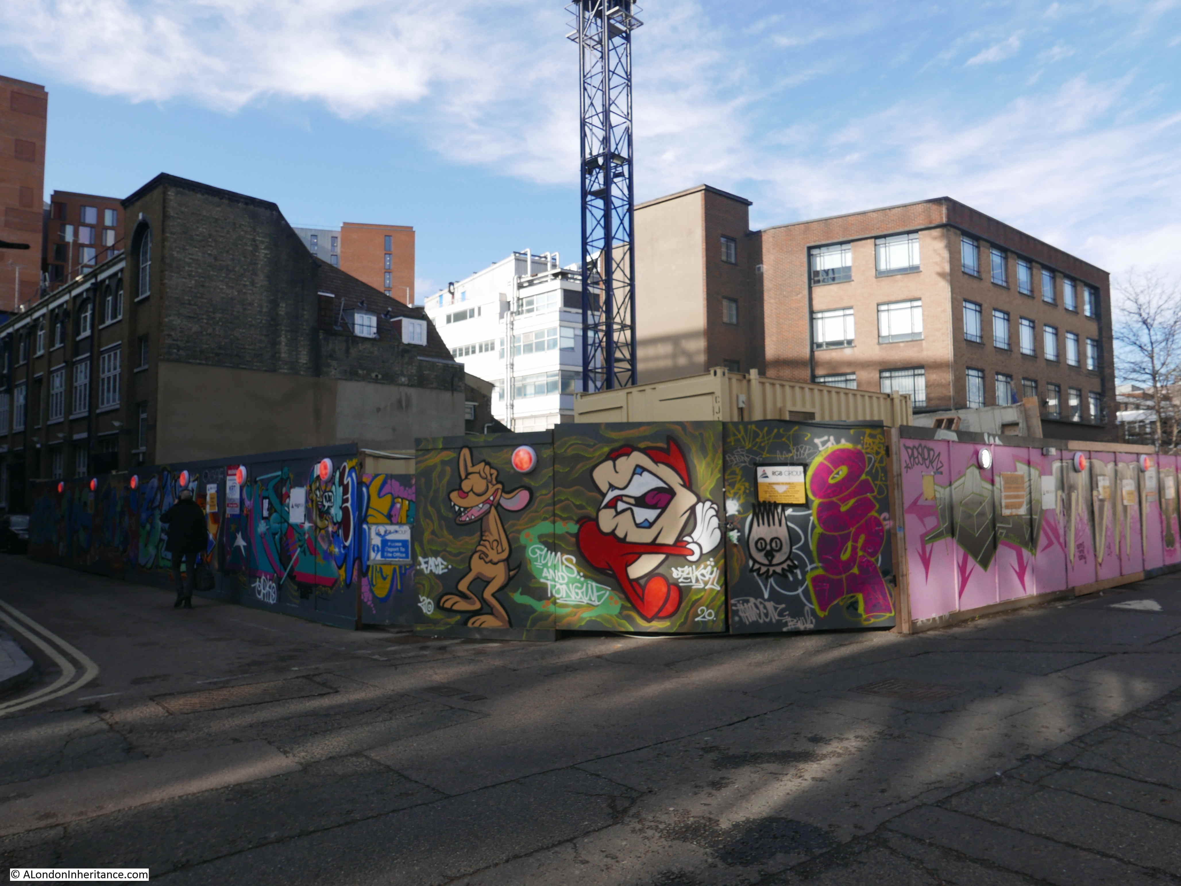
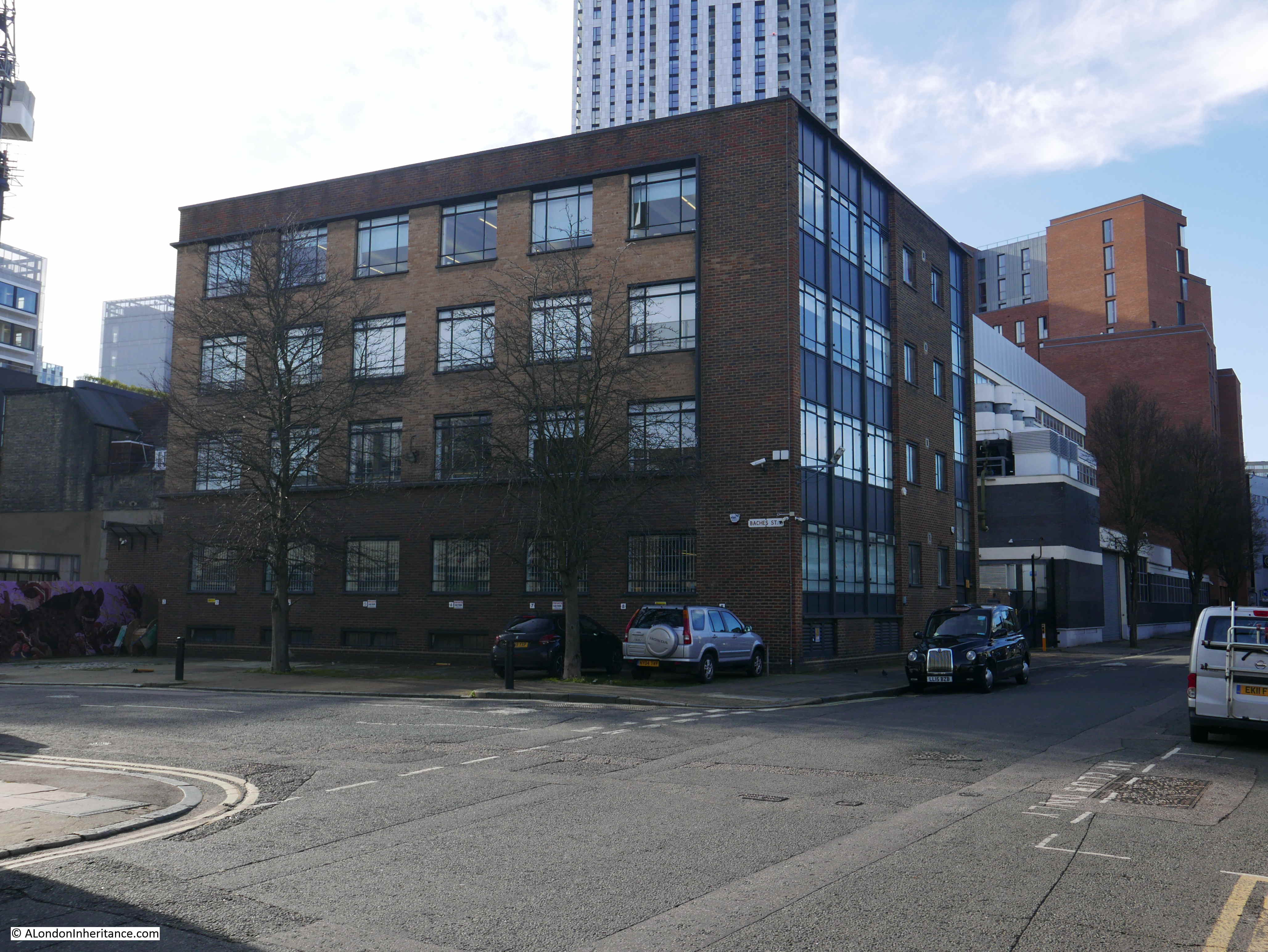
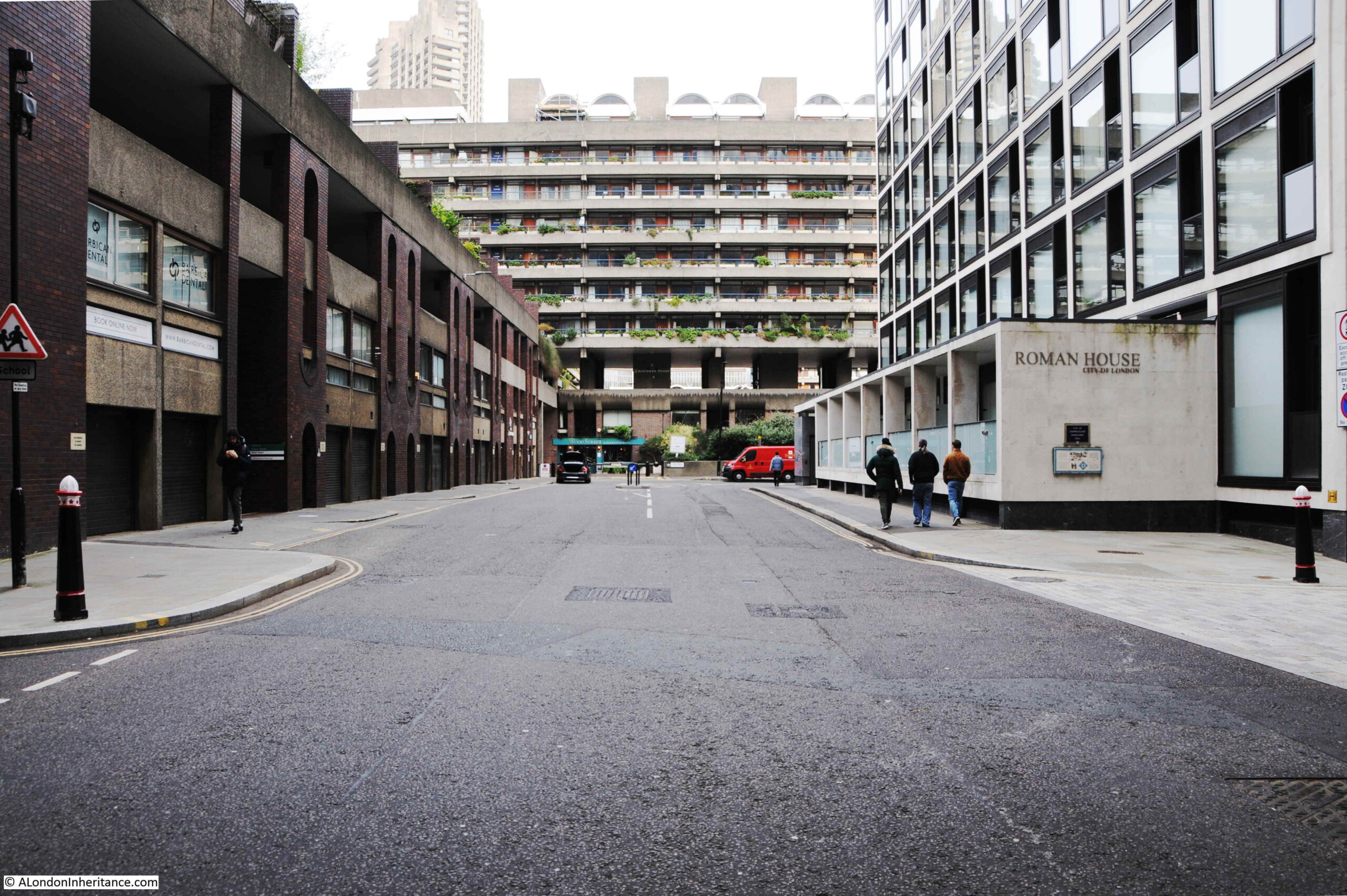
Wood Street runs from Gresham Street, across London Wall, finishing with a short stretch where it turns into Fore Street. Just before the junction with Fore Street, Roman House can be found on the right, and on the side of this building is the following plaque:

Cripplegate Ward

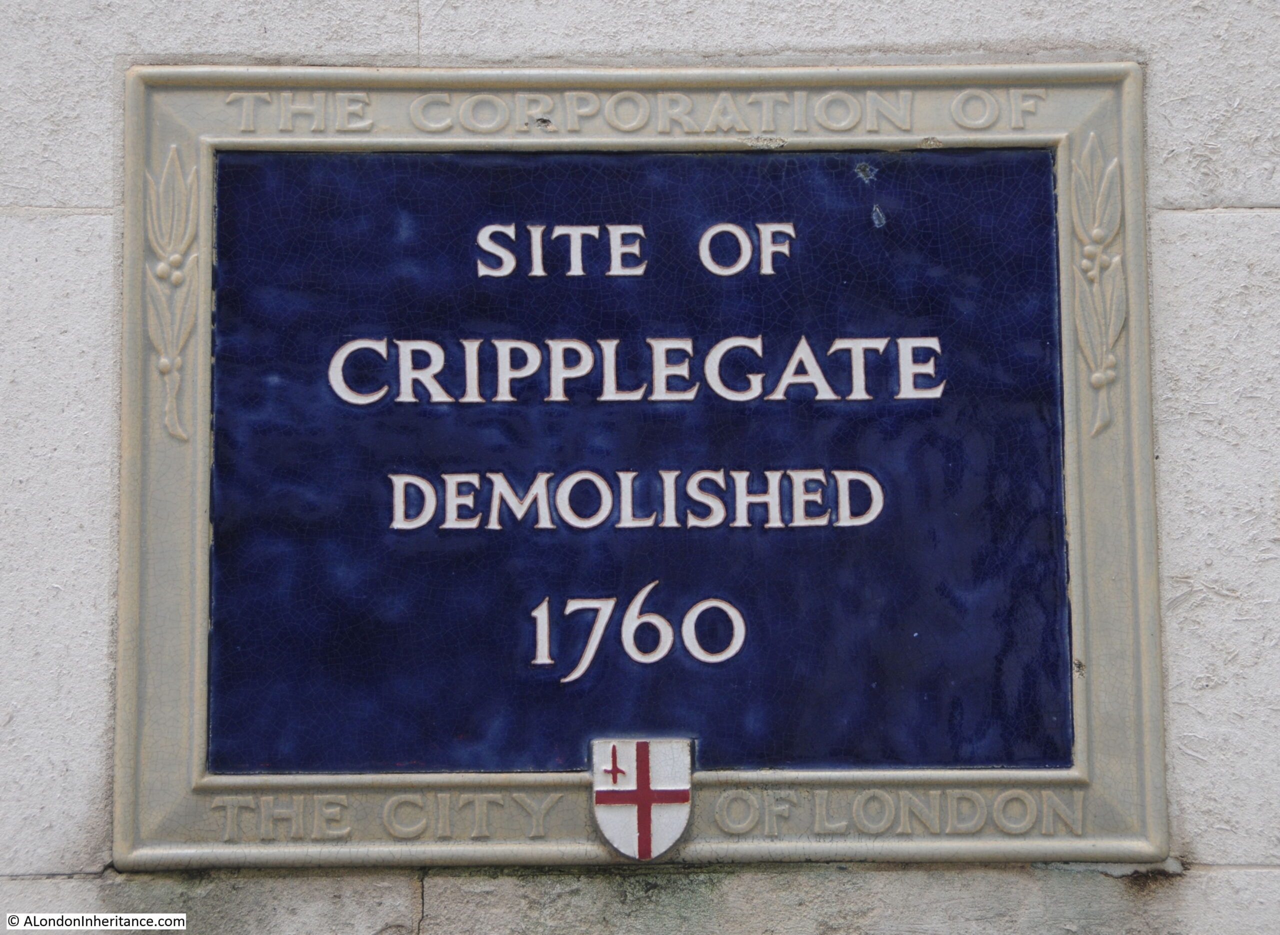
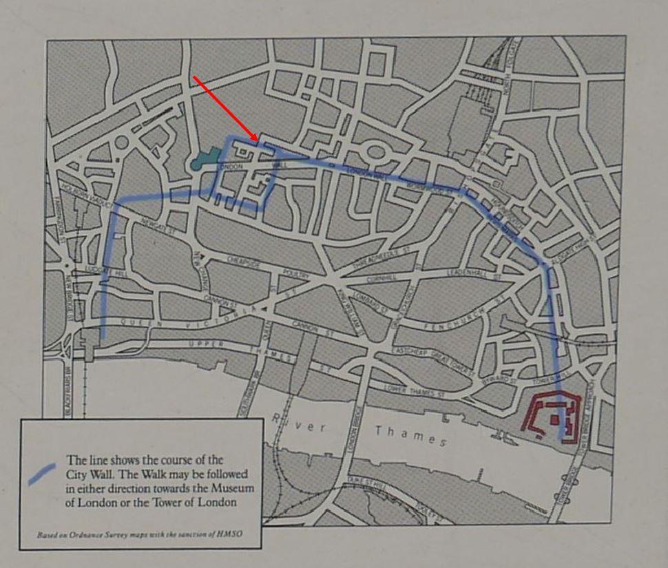
Cripplegate was the original northern gate to the Roman fort which occupied the north west corner of the old Roman City. The fort was discovered during post war excavations by Professor W.F. Grimes, and the location and size of the fort is shown by the blue rectangle in the following map of the wall from one of the plaques showing the route of the wall. The location of the gate is shown by the red arrow.

Cripplegate Ward

The plaque is on the right of the following photo of the northern section of Wood Street, the gate would have been across the street, to the left of the plaque.

Cripplegate Ward

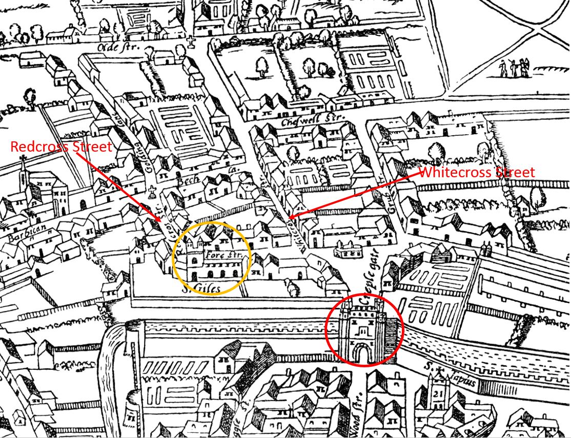
The gate is shown in the modified 1633 version of the early Agas map of London, the red circle in the following map surrounds the gate. The orange circle surrounds St Giles, Cripplegate, and Redcross Street, the site of the school and fire station is on the left and Whitecross Street on the right:

Cripplegate Ward

The name of the gate has long been the subject of speculation. A news article from 1904 reads:

“The origin of the name of Cripplegate, in which stands the church of St Giles, has long puzzled the minds of antiquaries. Ben Johnson averred that the street took its name from a crippled philanthropist, but Stow says the name was derived from the thronging of cripples which frequented it for begging purposes. It seems however, now to be decided that the name comes from ‘Crepel-gate’ a covered way in the fortifications. There is still a strong belief prevailing, however, that when the body of St. Edmund was brought from Bury to save it from the Danes, crippled persons by the wayside were cured of their afflictions as the body passed, and that the church of St Giles, the patron saint of cripples, was erected in commemoration of the miracle.”

Baddeley, in his book on Cripplegate Ward provides more:

“The etymology must be sought elsewhere. Cripple-gate was a postern gate leading to the Barbican, while this watch-tower in advance of the City walls was fortified. The road between the postern and the burghkenning (Barbican) ran necessarily between two low walls – most likely of earth – which formed what in fortification would be described as a covered way. The name in Anglo-Saxon would be ‘Crepel’, ‘Cryfele’ or ‘Crypele’, a den or passage under ground, a barrow, and geat, a gate, street or way.”

The book “The Ward of Cripplegate in the City of London”, (1985) by Caroline Gordon and Wilfred Dewhirst also refers to the Anglo-Saxon Crepel, or covered way as the source of the name taken on by the gate, and that Crepel was still used in written references to the gate in the late 20th century. The authors do though dismiss the story of St Edmund as a story that can “hardly be taken seriously”.

Baddeley provides some excerpts from City records to illustrate the history of the gate. In 1297 is was ordered that “Crepelgate should be kept by the Wards of Crepelgate, Chepe and Bassieshawe”, and “At the Gate of Crepelgate, there were to be found at night, from the same Ward Within eight men, well armed; and from the Ward of Bassieshaw six men, well armed; and from the Ward of Colmannestrete, six men, well armed and Robert Cook and John le Little were chosen to keep the keys of the gate aforesaid.”

The gate required regular repair, and in “1490, Sir Edward Shaa, who had been Alderman of the Ward from 1473 to 1485 bequeathed five hundred marks for the purpose of repairing the Gate”.

The gate was well kept and guarded during the Wars of the Roses during the second half of the 15th century. This was the last time that the City wall was strengthened, and the brick work that was added to the City Wall can be still be seen in the stretch of wall by St Alphage, a very short distance to the east of the old location of the Cripplegate.

As with other City gates, it was used as a processional route, with Elizabeth I apparently using the gate as her access to the City on her journey from Hatfield to London after the death of her sister, Mary I on the 17th November 1558.

The gate was also used to display the bodies of those who had been executed as a warning to those passing through the gate.

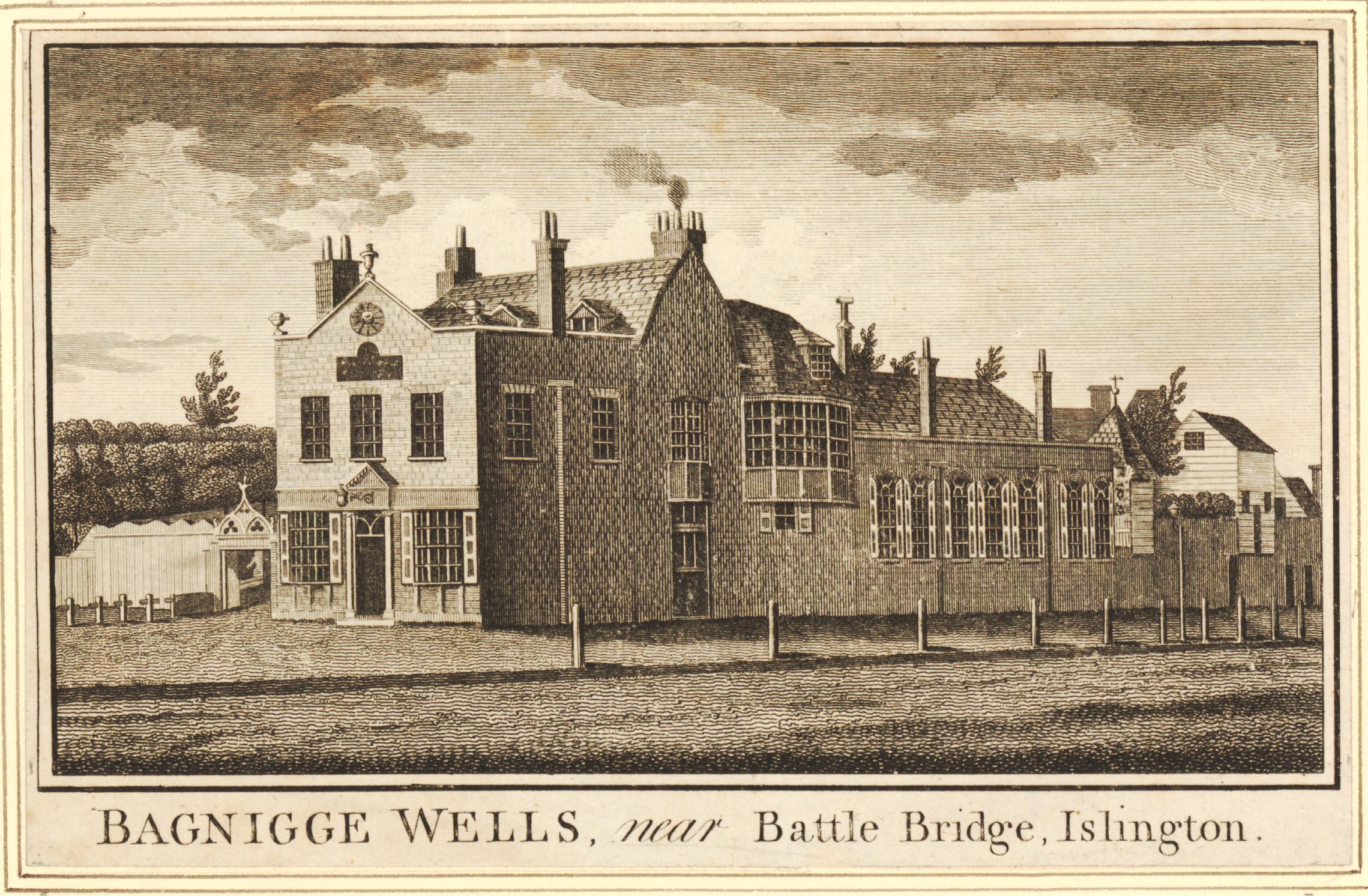
Cripplegate as it appeared in 1760 looking north from the City side of the gate, within Wood Street:

Cripplegate Ward

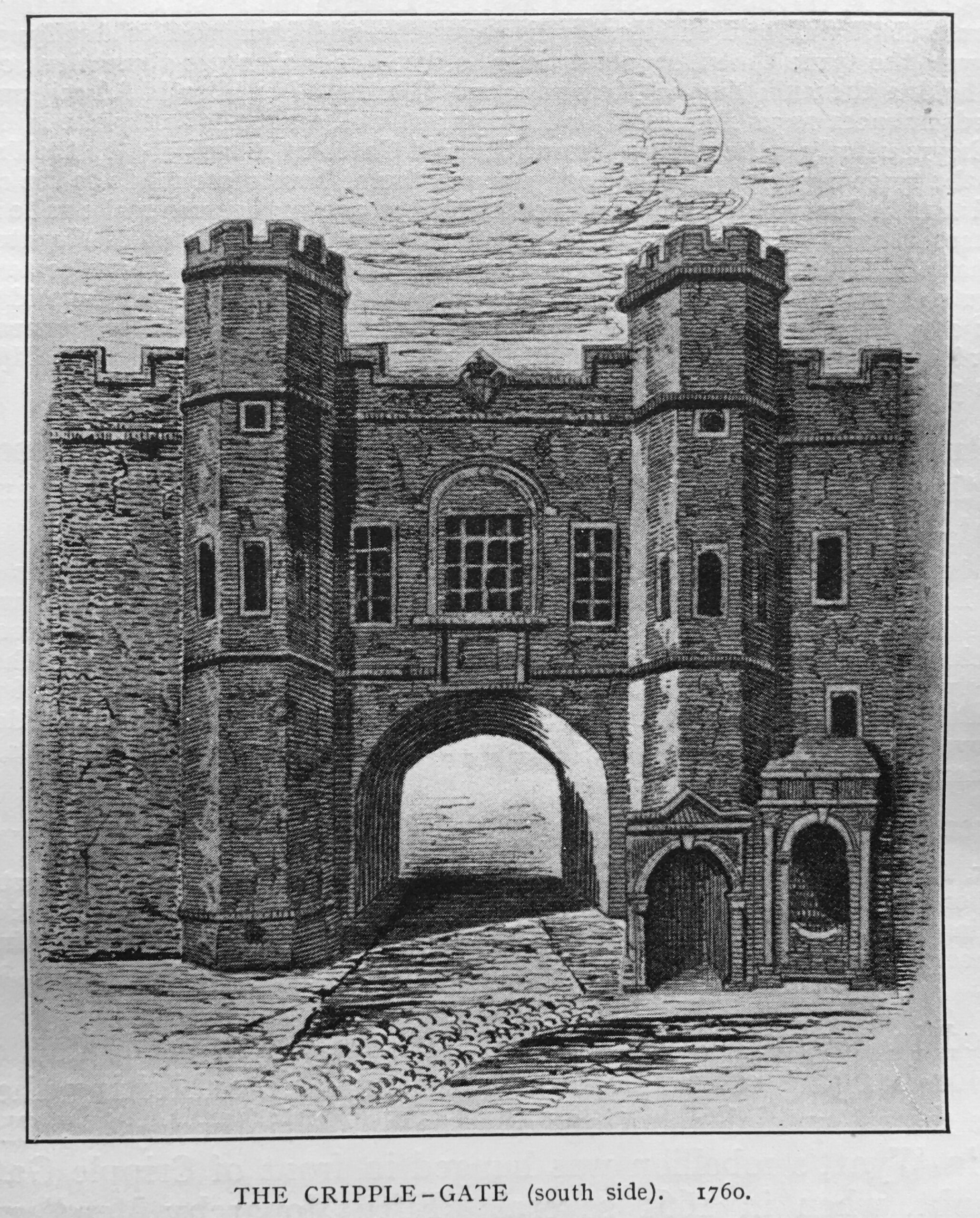
The above print from Baddeley’s book is dated 1760, although it may have been a view of the gate some years earlier, as by 1760 the gate was being described as in a poor condition. The carriageway through the gate was relatively narrow, and London had been expanding considerably to the north of the old gates and Roman wall which by the mid 18th century were no longer effective or needed as a defensive structure to protect the City of London.

Tolls were taken at the gate, but these were insufficient to keep up with the costs of repair, so in early 1760, the decision was taken to demolish the gate.

The City Lands Committee advertised for tenders to demolish and remove a number of the old gates, including Cripplegate, Aldersgate and Moorgate.

A Mr. Benjamin Blackden bought Cripplegate for £91 – buying the gate ensured demolition, and allowed the person buying the gate to keep a considerable quantity of building material.

The same Benjamin Blackden also paid £91 for Aldersgate and £166 for Moorgate.

On the 2nd of September 1760 newspapers were reporting that “Tuesday, the workmen began to erect scaffold at Cripplegate for pulling down that Gate.”

By the 31st of December, 1760, the Kentish Weekly Post was reporting that “Aldgate is quite pulled down, and Cripplegate is about two thirds down; and Moorgate, Aldersgate and Bishopsgate are to be pulled down forthwith.”

Demolition of the gate was completed in early 1761, and Wood Street then provided open access from the City to the northward expansion of London.

Lady Eleanor Holles School and Cripplegate are two lost features of Cripplegate Ward. Both very different, and in different periods of the Ward’s long history.

They have both left their mark in that the school is still functioning today, although in west London rather than the centre of the city, and Cripplegate, one of the City’s gates within the Roman Walls, that appears to have been named after an Anglo-Saxon word for a defensive, covered way, has left its name to one of the City’s most interesting wards.

alondoninheritance.com

Bagnigge Wells, House and Gardens

Although today there is very little of it to see, water has shaped much of London. The alignment of streets, property boundaries, rise and fall of the land have all been shaped by water. Whilst these are all subtle indicators of the historic presence of water there are still a number of more visible signs that hint at an areas history, and one of these is on a building on the western side of King’s Cross Road.

Bagnigge Wells

The sign reads “This is Bagnigge House Neare the Pinder A Wakefeilde 1680”.

The Pinder of Wakefield was a pub that dated back to the early 16th century in Gray’s Inn Road. A pub with the same name was on the same site until 1986, when the building was purchased by the “The Grand Order of Water Rats” charity, renamed the Water Rats, and is now a performance venue.

Bagnigge House and the Wells that were found in the gardens of the house are the subject of today’s post.

The house in King’s Cross Road with the Bagnigge House sign:

Bagnigge Wells

The location of the Bagnigge House stone, along King’s Cross Road is shown by the red circle in the following map  (Map © OpenStreetMap contributors):

Bagnigge Wells

The red rectangle highlights the area covered in the post.

If you look to the left side of the red box, you will see Cubitt Street, a street which unlike the rest of the streets in the area, does not follow a straight line and is curved around an area of land between Cubitt Street and King’s Cross Road.

To the left of Cubitt Street, the map shows the light blue line of the old River Fleet. I have double checked with my go to reference for London’s old rivers; “The Lost Rivers of London” by Nicholas Barton and Stephen Myers, and the routing of the Fleet shown in the above map is roughly right.

Before the streets and buildings of London had extended this far north, this was an area of fields and agriculture. The River Fleet ran through the fields, the area was low lying and rather wet, especially after heavy rains when the Fleet would have flooded.

Rocque’s map of 1746 provides a view of the area in the middle of the 18th century. Fields cover the majority of the area, but in the upper centre of the map there are buildings and formal gardens bounded by the River Fleet and a street named Black Mary’s Hole.

Bagnigge Wells

The street to the left labelled “Road to Hampstead and Highgate” is today, Grays Inn Road.

Black Mary’s Hole is now King’s Cross Road. There are various interpretations of the name, but the majority of sources refer to a black woman called Mary, who sold water in the vicinity from a well or fountain.

As well as the Fleet, the Rocque map extract also shows the irregular shape of a number of ponds, confirming that this was an area where there was plenty of water.

By 1816, streets and buildings had started to reach the area, and the following extract from the 1816 edition of Smith’s New Plan of London shows the area between the Fleet and King’s Cross Road (in the centre of the map) now labelled Bagnigge Wells.

Bagnigge Wells

To the right of the map is New River Head and on the edge of the map, Sadler’s Wells, further illustrating how water has shaped the area.

Turning off King’s Cross Road into the side streets, and we can get a view of the drop in height down to King’s Cross Road and the rise in height on the opposite side. An indication of the river valley of the Fleet.

The following view is looking down Great Percy Street from Percy Circus, with the rise of Acton Street across the junction. The River Fleet would have run from right to left along the lowest part of the view.

River Fleet

The area of land shown in the Roque map between the Fleet and Black Mary’s Hole appears to have been enclosed at some point in the second half of the 17th century. The land was to the east of a field called Action Field that occupied the area west to what is now Gray’s Inn Road. The name of the field is preserved in the present day Acton Street.

When a Thomas Hughes purchased the land in 1757, he had the waters from a well that was already in use, tested by a Doctor John Bevis, who reported that the water from the well had chalybeate properties (in the context of water, the name chalybeate means that the water contains iron, see also my post on the Chalybeate Well in Hampstead).

To capitalise on these findings, Thomas Hughes opened the gardens and the well to the public in 1759. This was the period when there were many pleasure gardens opening up around the City. Outside the jurisdiction of the City of London, in places such as along the south bank of the Thames, in Islington, and in Bagnigge Wells.

They provided a pleasant place to visit, away from the smoke, dirt and noise of the City. St. Chad’s Well was another well a short distance away from Bagnigge Wells that had gardens and a pump house where customers could drink the water. I have written about St. Chad’s Well here.

The gardens around the well were attractively laid out, entertainment, food and drink was also provided to customers, both to attract customers to the gardens as well as for profit.

Bagnigge Wells seems to have been a success as some of the land on the opposite side of the River Fleet was purchased to expand the gardens.

A print from 1843 appears to show the stone that is now in King’s Cross Road above the garden entrance (© The Trustees of the British Museum):

Bagnigge Wells

The inscription on the stone in my photo at the top of the post has the date 1680. In the print above it could be 1689, so either an error, or a later updating of the inscription over the years has changed the original date on the stone.

The date does pre-date the time when the gardens and well were part of the pleasure gardens so the house referred to must have been one of the earliest houses on the land.

Although the caption to the following print does state “The Original Garden Entrance To Bagnigge Wells, Established in 1680”, the gardens and wells were not a public gardens at that time (© The Trustees of the British Museum).

River Fleet

Presumably, the view is looking north with the garden entrance on the left and Bagnigge House behind the trees on the right.

The river running along the middle of the print must therefore be the River Fleet, which looks rather serene and calm, however it was not always so, and heavy rains around the source of the river in Hampstead could quickly result in the river flooding as the following article from the Derby Mercury on the 9th September 1768 reports:

“And about One o’clock yesterday morning the water came down in such torrents from Hampstead that the road and flat fields about Bagnigge Wells were overflown; the water rose eight feet perpendicular above the usual height of the drain, and was nearly four feet above the foot bridge at that house; the Pleasure-garden, cellars, and Out-houses belonging thereto were overflown, and several of the Pales broke down by the Violence of the stream. Great damage was done to Mr Harrison’s Tile-kiln near the said Wells, where three young men were sleeping in an Out house and were surprised by the Flood, and two of them drowned. The house of Dr. Sharpe, near Bagnigge Wells, was four feet deep in water, and a man and woman behind the House narrowly escaped being drowned.”

The article mentions Mr. Harrison’s Tile-kiln and if you refer back to the extract from Smith’s New Plan of London, you can see the tile-kilns just to the north east of Bagnigge Wells.

The rain was probably caused by the brief, very heavy showers we have also seen in London recently which cause a flash flood. Today, this volume of water falling in north London would now be carried by the same sewer in which the old River Fleet in now buried.

The following print is from 1777, eleven years after the floods in the above article and shows the buildings at Bagnigge Wells, with the entrance to the gardens on the left (© The Trustees of the British Museum).

Bagnigge Wells

Today, roughly where the River Fleet once ran, is Cubitt Street (originally Arthur Street). This is the street that curves slightly to the west of King’s Cross Road and is where the River Fleet formed the original western boundary to Bagnigge Wells as shown in Rocque’s map of 1746,

The view south along Cubitt Street:

Cubitt Street

And the view north along Cubitt Street:

Cubitt Street

In the above view, the River Fleet would have run roughly along the line of the street. Bagngge Wells was originally to the right, and following the commercial success of the gardens, expanded to include the left of the photo, with wooden bridges providing access between the two sections of the gardens.

Seats were arranged along the River Fleet for those who wanted to smoke or drink ale or cider. Tea, cake and hot buttered rolls were served, and concerts were held in the main room of the house. A small temple shaped building was created to house the wells from which water was taken and sold.

London’s pleasure gardens and their visitors were often the subject of satirical prints. The following print from 1781 shows “Mr. Deputy Dumpling and Family enjoying a Summer Afternoon” at the entrance to the gardens at Bagnigge Wells (© The Trustees of the British Museum).

Bagnigge Wells

18th century pleasure gardens were intended to be peaceful places in London’s countryside, away from the noise and dirt of the City. Where people could spend an afternoon or evening, being entertained, or just drinking and eating and seeing and being seen by others at the gardens, however they were not always places of peace.

in May, 1784, Bagnigge Wells was the scene of some violence between two opposing political groupings, as documented in the following newspaper report:

“Yesterday evening the gardens at Bagnigge Wells exhibited a strange scene of riot and confusion. How the affair began is not easy to be determined, but, at the same moment, several hundreds of Stentorian lungs vociferated the cry of ‘Hood and Wray’ and these were answered by the exclamation of ‘Fox for ever’. Intoxicated with liquor and politics those who were for Hood and Wray boxed with the friends of the Coalition and Fox, and many on both sides were knocked down with the canes and sticks of their adversaries. So sudden a disarrangement of the tea-table apparatus was perhaps never before seen and innumerable fragments of china shone on every walk, and served to give issues to the inflamed blood of the fallen and sprawling heroes. Those peace officers were sent for, the tumult was not appeased for near two hours and a half. Three men, who had been active in fomenting the disturbance, were taken into custody and were soon rescued”.

The same newspaper also reported on a “violent fracas” between the same two opposing groups in the Piazzas, Covent Garden.

Wray was Sir Cecil Wray who was a member of Parliament but was highly critical of proposals to raise taxes by a “receipts tax” which he claimed would fall “on the middling ranks of people and very partially and unequally laid”. Wray preferred a land tax, which in his view had always been too low in the country, but was opposed by the land owning classes (some things do not change).

He also presented a petition that had been drawn up by the Quakers calling for the abolition of slavery, which he called “an infamous traffic that disgraced humanity”.

The MP Charles James Fox put forward the East India bill which proposed nationalising the troubled East India Company, and Wray was strongly opposed to such an action.

At the general election Wray and Lord Hood stood against Fox with Wray standing as an Administrative candidate in Fox’s Westminster constituency. It was a violent election period as indicated by the trouble at Bagnigge Wells, however Fox won and Wray then appears to have abandoned any plans to try and get back into Parliament. He was described as being “one of the most upright, one of the most virtuous, one of the most honourable and independent men” in Parliament.

Up until the end of the 18th century, Bagnigge Wells continued to be a fashionable place to visit, however its days were numbered as the buildings and streets of London started to surround the gardens.

Less desirable and the “lower class of tradesmen” were now to be found in the gardens, and there was petty crime and prostitution, as illustrated by the following print from 1799 titled “The Road To Ruin”, where a young man, possibly an apprentice, in poor fitting clothes, stands between two prostitutes who appear to be berating him (© The Trustees of the British Museum).

Bagnigge Wells

In 1813, the manager of the gardens went bankrupt, they reopened somewhat reduced the following year and attempts to rejuvenate the place by building a concert hall in 1831 led to nothing as the customers of the concert hall were described as being of the “disreputable sorts”. The concert hall closed in 1841 and what was left of Bagnigge Wells was built on.

With the River Fleet now buried in a sewer, there are today no signs above the surface of the waters that once made this area an attractive place to visit, away from the noise and dirt of central London.

I have photographed the plaque before, however there was a bus stop directly in front which made the plaque rather difficult to photograph. The following photo is from about 18 months ago and shows the bus stop in its original position.

Bagnigge Wells

If you refer back to the second photo from the top of this post you can see that the bus stop has now been moved to the right. No idea why this has been done, but it does make the plaque easier to see, which is to the good, as it is the only reminder of Bagnigge House, the Well and Gardens now to be found in the area.

alondoninheritance.com

Lost Bankside Alleys

I have no idea of the exact location of the following photo. It is one of my father’s and dates from 1949. Judging by the photos on the strips of negatives that included this photo, it is probably one of a number of Bankside alleys, although there is a chance it is a bit further east.

The photo shows a police officer walking through an alley, probably between warehouses. At the end of the alley, there is one of the typical walkways that were built to connect warehouses on opposite sides of a street.

I love the photo as it captures what must have been a relatively common event – a lone police officer patrolling his beat.

Policing has changed considerably in the 72 years since the photo. Budget cuts have reduced police numbers, streets now have CCTV and there is the ongoing threat of terrorism.

Along Bankside, there are no warehouses full of goods that would tempt a thieve. The river is quiet and is no longer teeming with barges and lighters, although as the tragic events on London Bridge just a week ago demonstrate, the Thames is still a very dangerous place for anyone who enters the water.

The police officer in the photo was probably on his “beat” – a set route around a district that an officer would patrol. They would get to know the streets, the people, activity that was normal, and what was not normal.

Being assigned to a beat was the first step in a police officer’s career after training and being posted to a station as a Police Constable.

In the book “Fabian of the Yard” (1950) by Superintendent Robert Fabian, he provides an introduction to the activity of “being on a beat”:

“On the beat, an officer should normally walk the regulation 2.5 m.p.h. – if he is hurrying he is probably after someone or more likely going home to his supper. Properly carried out, patrol duty is not half so dull as you might imagine. The most ordinary looking street can to the practiced eye be of absorbing interest. Each doorway, shadow at a window, hurried footstep or meaningful glance may have a tale to tell”.

(Fabian of the Yard is a fascinating account of London policing and crime between the 1920s and 1940s)

Crime was frequently reported after the event, however the benefit of being on the beat, was that anything unusual, and a possible crime, could be investigated as it happened. Detailed newspaper reporting of such events tended to reduce in the 20th century, however in the 19th century, papers were full of long accounts of crimes, often including the conversations that had taken place during an inquest, or the words of the police officers involved.

The following three extracts are examples of the type of action that a police officer on the beat would frequently get involved with, when patrolling along the river’s edge.

From the Shipping and Mercantile Gazzete on Thursday the 8th February, 1877:

“THEFT FROM A BARGE – At the Southwark Police-court, Joseph Sadler, 22, a returned convict, was charged with being concerned with two others in stealing three pieces of oak timber from a barge on the River Thames, the property of Messrs. Shuter and Co., coopers and stave merchants, Shad Thames.

George Barnett, police-sergeant 56M, said that between 10 and 11 on the previous night he was on duty in Bermondsey-wall when he saw the prisoner and two others coming from Eaton’s Wharf. They were each carrying a piece of timber and as soon as they saw him they dropped the timber and ran away. He, however, captured the prisoner, but his companions escaped. He made inquiries, and found that the timber had been stolen from a barge lying off Bermondsey-wall. Mr. William Joseph Littell, of the firm Shuter and Co., identified the three pieces of oak timber as the property of the firm. Mr. Partridge committed the prisoner for trial”.

From the St. James Chronicle, August 1855:

“SOUTHWARK. CHARGE OF BURGLARY – John Richard South, a tall young man, partially dressed in military attire, and who stated himself to belong to the Royal Artillery, was charged with being concerned with another, not in custody, with breaking in to the Watermen’s Arms public-house, Bankside.

Joseph Alley, police-constable, 30M, said he was on duty shortly before three o’clock that morning in Bankside, and when passing the Waterman’s Arms he heard something breaking inside, which induced him to stop.

Another constable then came up, when they again heard the breaking noise, and saw the reflection of a light inside. Witness immediately directed the other constable to go to the rear of the house, while he knocked on the door for admittance and rang the bell. While doing so he heard a rushing noise inside, and a minute or two afterwards, the landlord came down and opened the street door. Witness entered and passed through, when he saw two men climbing up a shed. He got up after them, and saw the prisoner concealed behind a chimney, and as he came near him he exclaimed ‘It’s all right, I’ll give myself up’. He took the prisoner into custody, but his companion made his escape”.

From the Morning Post, 2nd July 1833:

“Yesterday two men, named Morrett and Yates, were brought before Mr. Murray, charged on suspicion of drowning a young woman (name unknown), whose body was taken out of the water at Bankside.

A police sergeant of the M division on proceeding over Blackfriars Bridge on Sunday morning, about four o’clock, saw some persons looking through the balustrades, and heard them exclaim ‘That a woman was in the water’. He looked in the direction of Southwark bridge, and perceiving a splashing in the water at some distance off, he ran round to Bankside, and by the time he arrived saw the body of a young female just brought on shore by a waterman.

He observed two men standing upon a barge moored at some distance out in the river, and he had been informed that these two men were with this female at the time she was drowned. Acting upon this intelligence he procured a wherry, and immediately went on board the barge, and took them both into custody.

The accused were examined separately, and Yates made the following statement voluntarily;- he said that he and the other prisoner were brass founders, and worked at a large factory in St Martin’s-lane. On Saturday night after work, they went to the Cart and Horses in Upper St Martin’s-lane which they left at half past eleven o’clock, and then went home together, but did not retire to rest.

At three o’clock in the morning they left home together with the determination of taking an excursion on the water. On their way to Westminster bridge they met a young female near the Horse Guards, and they spoke to her, and told her they were going to have a pull down the river. She expressed her desire to accompany them; they endeavoured to dissuade her, but when they hired the boat, which was at Mr Lyons, near the bridge, she said she was determined to go with them, and accordingly jumped into the boat along with them.

They then proceeded down the rive, the tide running that way, and in the course of their progress, run against a chain or warp to which a barge was made fast. This was about midway between the two bridges, and in an attempt to extricate it the wherry heeled over and the female rolled into the river. One of them (Yates) got hold of the barge and saved himself, and rescued Morrett, who was on the point of being drowned, and would inevitably have shared the fate of the female had not Yates grasped him by the collar and pulled him on board the barge.

in reply to the Magistrate the accused said he never saw the deceased before; that she appeared to be 18 years of age, and that they were unacquainted with who or what she was. She was dressed in a dark half-mourning dress, and wore a straw bonnet with ribands. The other prisoner gave a similar account of the transaction, and they were ordered to be detained in custody, as there were some mysterious circumstances attending the case”.

The following day an inquest was held and a verdict of accidental death was returned. Much of the critiscm at the inquest seems to have fallen on two other parties, not the two men found on the barge.

When the young woman’s body was first found, “two medical men” had been called, but had refused to attend. One of their assistants only arrived an hour later.

The proprietor of the boat was criticised for “letting out a wherry at that hour in the morning without some experienced person to attend to it; and that it was in consequence of this neglect that many casualties occurred in the river”. A deodand of £5 was levied on the boat. A deodand was a forfeit on an object where it has caused, or been involved with, a person’s death.

A scene that a police officer on the beat may have been interested in is shown in the following photo from the same strip of negatives, so around the same bankside area.

A quiet alley and some activity around a car in the distance.

Again, I cannot identify the location of the alley, there are no features that enable identification, and the area has changed so much in the last 72 years that as far as I can tell, the alley has long disappeared.

A glance at the 1896 edition of the Ordnance Survey map shows the number of alleys that were once along Bankside (‘Reproduced with the permission of the National Library of Scotland’).

In the above extract, Tate Modern now occupies the area on the left, and Southwark Bridge is on the right.

From left to right there is: Pike Gardens, leading to White Hind Alley, Moss Alley and Rose Alley, along with narrow streets leading up to the Thames such as Pond Yard and Bear Gardens.

These alleys have now dissapeard when you walk along the Thames, however there are traces further in land, such as Rose Alley, which is now a short stretch of narrow street acting as a service road to the building that now blocks the end of the old alley to the Thames.

There is one alley part remaining, although this is not named on the above map.

Underneath the letter I of the word Bankside (running along the street on the Thames embankment), there is a narrow alley with no name. This is Cardinal Cap Alley, with the entrance being found between two buildings just to the west of the Globe Theatre.

I wrote a post about Cardinal Cap Alley and No. 49 Bankside back in 2015 as the alley and number 49 have a fascinating history.

The alley has been controversially gated off for some years, however looking through the bars of the gate we can see the remains of an old Bankside alley.

Cardinal Cap Alley was open in the 1970s, and the view across to St Paul’s was one of my early photographic attempts, with my first camera, a Kodak Instamatic 126 (although the camera did not handle contrast that well, so St Paul’s is only just visible across the river).

I have no idea whether the police officer in my father’s 1949 photo was walking the regulation 2.5 mph, or as Fabian of the Yard also suggested that he may be hurrying home for his supper.

The policing of the river and the land along the river’s edge has changed considerably in the 72 years since the photo was taken, and the majority of Bankside alleys have been replaced with new buildings facing onto the Thames. Both Bankside and the river are today a very different place.

alondoninheritance.com

Bache’s Street – An Ordinary London Street?

The inspiration for this week’s post came when a couple of months ago, a reader e-mailed regarding Bache’s Street, a street a short distance to the north-east of Old Street roundabout.

Bache's Street

There was not much initially to find about Bache’s Street. I found some details about the origins of the street, and a tragic murder, but that was about it.

Bache’s Street is a short street of about 106 metres / 348 feet. Nearly every building dates from the later half of the 20th century, and there is nothing of any real architectural merit. It is the sort of street you would only visit if you had business there, or it was on the route to somewhere else.

The view along Bache’s Street, looking north from Brunswick Place.

Bache's Street

I believe that if you dig deep enough, there is always a story to tell about any street in London, and my approach to Bache’s Street is based on a visit to Chepstow in South Wales last year.

Chepstow have implemented a brilliant scheme to highlight who has lived in buildings, along with the business carried out, along the high street of the town. Plaques in the pavement, in front of each building list the previous residents and trades that occupied the building.

Bache's Street

Close-up of the plaque for numbers 17 and 18 Chepstow High Street.

Bache's Street

I think this is a brilliant idea. It makes the history of a place very tangible at the individual level, and standing in front of a building, you can imagine all those who have lived and worked there before.

How could I apply this approach to Bache’s Street? Using census data, could I develop a similar virtual approach, and what else could this data tell us about a typical street in north London?

Using census data from 1881, I built a spreadsheet so the data could be manipulated and sorted. I only had time to work on the 1881 census, but following through on other census years provides a view of how streets and people change over time – I hope to cover this in a future post.

Later in this post, I will take you on a virtual walk through Bache’s Street to meet all 329 people resident in the street for the 1881 census. The data also provides us with a view of how people lived at the time and where they were from, so I will explore this as well, but before getting into this level of detail, some background to the street.

The following map extract shows the location of Bache’s Street, a short distance north-east of the Old Street roundabout  (Map © OpenStreetMap contributors).

Bache's Street

The street did not exist in 1746. The area consisted of fields, formal gardens and orchards. The Haberdashers Hospital was to the east, and the newly built Charles Square was to the south-east. The following extract from John Rocque’s 1746 map of London shows the area, with the future location of Bache’s Street marked with a red line.

Bache's Street

By 1828, the fields had been built over as London’s northward expansion gathered pace. Greenwood’s map of 1828 shows a street in the position of Bache’s Street, but with the name Charles Street. Buildings are shown on either side of the street, and the length of buildings on the eastern side of the street are named Bache’s Row.

I suspect that Bache’s Row may provide a source for the name. The form of the name implies it could have been named after the landowner, builder or owner of the row of houses along the eastern side of the street.

Reynolds’s New Map of London dated 1847 still has the street labelled as Charles Street. The street is circled in the following map extract which also shows how the area had changed in the 100 years since Rocque’s map.

Bache's Street

By the 1881 census, the street name had changed from Charles Street to Bache’s Street – for some reason, the name of the row of houses on the east side had been used for the whole street.

The 1894 revision of the Ordnance Survey map shows a street with houses lining the majority of both sides, but with a Glass Manufactory on the south-east corner of the street, replacing some of the houses.

The Charles Booth poverty map for the area is shown below:

Bache's Street

Bache’s Street is in the centre of the map, and the colour code used for the households along the street is defined as “Mixed, some comfortable, others poor”.

Bache’s Street was explored by George H. Duckworth for Booth’s survey and he walked the area on the 17th May 1898 with Police Constable W.R. Ryland, and he wrote “Only a few dwelling houses at the north east and south east end left. The rest have been replaced by large factories.” This was the start of the change of the street from residential to commercial.

There are also newspaper reports that report on the poor conditions of some of the houses along the street with Aristocratic landlords (Lord Arlington) charging rents for a well maintained property, but which the Medical Officer of Health had found to be unfit for human occupation.

The 1945 maps used for the LCC Bomb Damage maps still show the street much as it was in 1894. Most of the street survived the war, however there was damage to two building half way along the eastern side of the street.

The remaining houses that originally lined Bache’s Street would disappear in the decades following the war, with the land being used for offices and business purposes – a process which has reversed slightly with some of the buildings being converted to flats.

So what can we learn about Bache’s Street from the 1881 census, and more generally about what life was like in the area north of Old Street in the late 19th century?

I transferred the census data for the 329 people living in Bache’s Street at the time of the 1881 census into a spreadsheet, and this is what I found.

The occupants of Bache’s Street were young. The following graph shows the age distribution of the residents.

Bache's Street

The majority of residents were under the age of 40, and the highest number of residents were in the age range 0 to 9.

From the age of 40 onward, there was a rapid decrease in the number of people, with only one resident older than 80.

This could be explained by the type of people attracted to the street – younger families, or it could illustrate the life expectancy of those living in the area in the late 19th century.

The residents of Bache’s Street were generally poor manual workers. There were only 23 houses in the street, but 329 residents. The following graph shows the number of residents at each house in the street. showing how densely packed they were into this short street.

Bache's Street

These houses were occupied by multiple families, and families were not that large. The following bar chart shows the number of members of each family living in Bache’s Street in 1881 (every other name has been omitted to make the vertical axis readable, all families are included. I have only included family members and have excluded lodgers and visitors).

Bache's Street

The largest families in the street consisted of 8 people. The average number of family members across the street was 3.15, so in many ways not that different to today. The families with a single member are typically widows or widowers.

The majority of people living in Bache’s Street in 1881 were born in London, but a significant percentage had moved to London from the rest of the country, and from abroad.

This included 9 people from Germany, 1 from Australia, 1 from Ireland, 1 from Jersey, 1 from Switzerland and 1 from Australia.

I have plotted the birth towns of Bache’s Street residents from the rest of the country in the following map:

Bache's Street

People moved from major industrial towns such as Manchester and Birmingham as well as market town’s such as Bridport in Dorset.

Not a single resident was listed in the census as being born in Scotland or Wales.

What is interesting is the north / south of the river split. There has always been a very distinctive split across London just by travelling across the River Thames. For those living in Bache’s Street, and being born in London, the vast majority were from north of the river. Of the 329 people in the street in 1881, only 11 people were identified as being born south of the river (Bermondsey 2, Lambeth 4, Lewisham 1, Greenwich 1, Southwark 1, Kennington 1, Newington 1).

There were more people in Bache’s Street from outside the UK in 1881, than from South London. It would be an interesting study to see if this was typical and whether there was very little migration or marriage between south and north London, and how far that has changed.

An extract from the 1894 Ordnance Survey map is shown below with Bache’s Street in the centre of the map.

Bache's Street

Credit: ‘Reproduced with the permission of the National Library of Scotland’ 

There were 23 individual house numbers in the 1881 census and I have tried to align these accurately on the 1894 Ordnance Survey map, so when we take a virtual walk through the street, we can see where the families lived.

The Public House (P.H.) at the top right of the street was the Globe and had an address on Great Chart Street.

The building on the top left also I suspect had an address on Great Chart Street, and the building below this may have had an address on Styman Street as the longer edge was on this street.

The Glass Manufactory at lower right had been built between the 1881 census and the 1894 map, so working down from the top of the street, I assume that house numbers 2, 4 and 6 occupied this space,

So, lets take a virtual walk along Bache’s Street to meet the residents of the street in 1881.

Today, all the houses have disappeared. The “wework” office block shown in the following photo occupies the space of the odd numbered houses from 1 to 15.

Bache's Street

Number 1 Bache’s Street

Bache's Street

Number 1 Bache’s Street had the most people of any individual house on the street, and also included one of the largest families (the Whiting’s).

Lizzie Bacon is listed as being born in the United States, it would be interesting to know why she moved to London, and how she met her husband Frederick.

The children of many of the residents often had a job related to their parent, for example John Whiting was a Printers Compositor as was his 17 year old son.

Directly across the street from number 1, was the Glass Manufactory in the 1894 OS map. Today, the same space is occupied by an office block. In 1881, this was houses 2,4 and 6.

Bache's Street

Number 2 and 3 Bache’s Street

i have combined these two houses, opposite each other on the southern end of the street, as they had a smaller number of people. The Pike family were the only residents of number 2, with the Winter and Kohlsfer families in number 3.

Bache's Street

Number 3 had a German family, the Kohlsfer. They were obviously recent immigrants to London as their youngest daughter aged 4 had been born in Germany.

There were a number of lodgers throughout the street and lodgers often would come from the same home village or town as the main family, demonstrating the contacts between immigrants to London and their place of birth persisted. The Kohlsfer’s had a German born lodger or boarder, Henrich Hamer who was a 26 year old Furrier from Germany.

Number 4 Bache’s Street

Bache's Street

Number 4 has a possibly interesting tale. Charles Newbegin is listed as a Master Mariner. His wife Elizabeth was born in Jersey in the Channel Islands. Did they meet after he had sailed to Jersey, and he brought her back to London?

The list of occupations also shows how specific jobs were at the time. Many tasks which would be automated in the future were still manual, so for example in number 4 you will find an Envelope Folder.

Number 5 Bache’s Street

Bache's Street

It is interesting to speculate on how people moved around at the time.

Take the Cull family at number 5. Elizabeth Cull, the head of the family (she is not listed as a widow, but is living with her children as a single parent) was born in London, as was her oldest daughter and her son. The middle child, aged 10 was listed as being born in Kendal, Westmoreland.

In the 1871 census, Elizabeth Cull is recorded as living in Kendal with her husband Joseph Cull who was originally from Ireland. So had they moved to London where Clara was born, then moved back to Kendal when Kate was born, and back to London for Joseph’s birth (named after his father). There is no record of what happened to the husband / father Joseph Cull – did he return to Ireland?

Number 6 Bache’s Street

Bache's Street

Many of the families in Bache’s Street continued to have older children at home. For example in number 6, the Russel family still had children aged 24, 22, 21 and 19 at home. If children were not married, this was probably an economical way for the family to live with the Russell family having a total of 4 members working. It must though have contributed to very crowded conditions and as there were 4 families and the single Elizabeth Smith living in number 6, the Russell family could not have had more than a couple of rooms.

Number 7 Bache’s Street

Bache's Street

There are so many interesting job descriptions in the census and in number 7 there were two “Drug Grinders”.

Number 8 Bache’s Street

Bache's Street

Lydia Green who is listed in the census as living at number 8 would suffer a tragic fate in the house six years after the census. The following is a report from the London Daily News on the 11th February 1887:

“The victim Lydia Green, an unmarried woman, thirty-one years of age, was found dead in her bedroom last Saturday morning. She was nearly dressed, she lay on her back in a pool of blood, and she bore a terrible wound on the head, as well as other wounds on the hand and jaw. She lived with her mother and a widowed sister at Baches-street, Hoxton, and she and the sister slept in a back room on the ground floor.

Both sisters went out to work, but Alice, the widowed one, usually rose first, and left the house at ten minutes to seven. The deceased woman rose a little later, and at about half-past seven she usually knocked on the ceiling, as a signal to her mother, who slept in the room above.

On Friday last she went to bed in perfectly good health, her mother previously having heard her talking at the street door with Thomas Currell, a young man with whom she had ‘kept company’ for some years. On Saturday morning, just after the widowed sister had left for her work, the mother in her bedroom, heard noises, as of a person falling, in the room below. She heard these noises three separate time, and after them the step of someone walking sharply along the passage and, the slamming of the street-door. The noises do not appear to have alarmed her, and she lay in bed until half-past seven, when she expected to hear her daughter’s signal on the ceiling.

No signal came, and then the mother went downstairs, and found the poor woman dead as described. There were two wounds on the right hand, which seemed to have been inflicted by bullets, though no bullets were found in them, two other wounds on the right jaw, in which were found some piece of metal that might have been parts of bullets, and a wound above the right eye which extended to the brain.”

The article goes on to explain that Thomas Currell had been out of work since the previous August and may have been jealous of Lydia. Currell was known to Scotland Yard and had been twice in trouble before. They were engaged, however a couple of weeks prior to her death, Lydia had wanted to break off the engagement

At the time of the report Thomas Currell had disappeared, however he would hand himself in to the police a few days later, having no money and suffering from cold and starvation. Newspaper reports at the time complained about the failure of the police to find Currell and it was only because he handed himself in that he was caught. If he had more money, he would have escaped London.

He appeared at the Old Bailey during the first week of April 1887, found guilty and sentenced to death. He was hung at Newgate on the 18th April 1887 at the age of 31.

Number 9 Bache’s Street

Bache's Street

Number 9 Bache’s Street only had a single family. If I have my mapping of house numbers to houses on the Ordnance Survey map correct, then number 6 was the same size house as the rest along this side of the street, so no idea why there was only a single family.

Perhaps they were affluent enough to cover the costs of the whole house, or perhaps this was a temporary position, as people in other rooms had moved on, and no one else had yet moved into the house. The census provides a snapshot of a specific point in time.

Moving back to the even side of the street, and the building in the following photo occupies the space where numbers 8, 10 and 12 were in the 1894 Ordnance Survey map.

Bache's Street

Number 10 Bache’s Street

Bache's Street

Number 10 again shows a range of professions, and also how families must have retained contact with their home towns.

Hanna Perman is listed as being born in Hertford, and the family have a lodger, James Cook, a bricklayer who also came from Hertford. Perman was Hanna’s married name, so John Cook could have been a relative.

Number 11 Bache’s Street

Bache's Street

Residents of number 11 show how families worked together, probably working at home. James Edmonds was a Fancy Box Cutter and his wide Susan was a Fancy Box Maker.

Caroline Denney is listed as being from Australia. She is 25, has a newborn son, and there is no other member of her household. It does make you wonder how she came to be living as a single parent in a Hoxton Street, a long way from her birth place in Australia.

Many of the Occupation entries are blank, implying that the person was not employed. Occasionally there is a reference to being unemployed, or out of work, along with their profession. An  example in number 11 is Edward Wood, an unemployed pie maker.

Number 12 Bache’s Street

Bache's Street

An average number of residents, but still with 4 families living together.

Number 13 Bache’s Street

Bache's Street

By far the majority of occupations are manual work, but occasionally there is something different, such as William Potts being listed as a Musician, but no indication of what instrument or where he played.

The building in the following photo occupies the space where 14 to 22 were located in the 1894 map:

Bache's Street

Number 14 Bache’s Street

Bache's Street

By the age of 15, most children were expected to be working, very few are listed as still being a Scholar from 15 onward.

In number 14, 15 year old Charles Cross was an Errand Boy, Edward Wild was an Engraver and Arthur Wild, a year younger at 14, was a Carman.

Number 15 Bache’s Street

Bache's Street

Louisa Baum was a German born Stick Manufacturer and appears to have been a single parent of a 9 year old son, although I will caveat that with the census being a snapshot in time, so her husband may have been away working or travelling. Census data can only can only tell us so much.

Number 16 Bache’s Street

Bache's Street

Whilst the majority of residents were born in the London area, a significant number were from the rest of the country, and from abroad. In number 16, Thomas Bobbing from Shoreditch had married Lizzie from Switzerland. Did they meet in London or Switzerland?

The following photo shows the space once occupied by numbers 17, 19, 21 and 23:

Bache's Street

Number 17 Bache’s Street

Bache's Street

Number 17 had one of the larger family’s with the Nealon’s having 6 children. John Nealon would have been supporting them all through his job as a Cab Driver, and although their eldest son was an Apprentice Bookbinder at age 14, I doubt he was earning very much.

Number 18 Bache’s Street

Bache's Street

In number 18, Henry Bisband’s occupation is listed as “Japanner”. This was a specialist way of applying a varnish or lacquer, and was intended to imitate Asian furniture and small metalwork.

Number 19 Bache’s Street

Bache's Street

Number 19 was one of the most populated houses on the street with five families and 20 people. The house was also one of the few with someone from south of the river as Charles Selling was born in Lambeth. Apart from Joseph Thorn from Essex, everyone else in number 19 was local.

Number 20 Bache’s Street

Bache's Street

Number 20 had more people than number 19 with 24 people across 7 families, although one family had a single member. The census still listed Phoebe Hodges as the “Head” although she appears to be the only family member.

Phoebe’s occupation is listed as Annuitant, someone who receives an annuity. There is no clue as to her previous circumstances, or profession so no indication as to why she was the only person on the street listed as receiving an annuity. I suspect that this was somewhat unusual on streets such as Bache’s Street, but at 79, and apparently on her own, she would have needed such an income to survive.

Most houses on the street had a single parent, probably indicative of the mortality rate at the time. In number 20 as well as Phoebe, James Wilding is listed as a widower.

Number 21 Bache’s Street

Bache's Street

James Edwards in number 21 is listed as an Unemployed Labourer. He was 58, and therefore one of the older residents on the street. Late 19th century diet, healthcare and a life of manual work probably meant that by today’s standards he would have appeared much older than 58, and he could have been unemployed due to health conditions. I would not really have wanted to have been a labourer at the age of 58 in Victorian London. James and his wife Elizabeth would have had to support themselves on Elizabeth’s money as a Charwoman.

Number 21 also had another German family, with the Seyer’s who again must have moved to London relatively recently as their daughter Clara aged 6 was also born in Germany.

Number 21 also illustrates how frequently older, or only children were named after their parents. George Simpson had the same name as his father, Fanny Simpson had the same name as her mother, and Clara Seyer also had the same name as her mother.

Number 22 Bache’s Street

Bache's Street

Number 22 had the oldest resident on the street with David Benjamin at the impressive age of 86. He was one of the few who were born in the 18th century. He is listed as “Head” so must have been on his own (if he lived with his children, then he would have been head and his children, whatever their age, would have been listed as children).

He does not have an occupation, so one wonders how he supported himself.

Number 23 Bache’s Street

Bache's Street

And finally to the last house on the street, number 23. Again, a large number of people in the house with a wide range of occupations.

James and Martha Daley must have worked together as an Umbrella Frame Maker and Umbrella Coverer – again very specific job roles. The four members of the Farmer family consisted of a Wood Turner, Dressmaker, Coachman and a Wood Carver.

Spencer Dodds at the age of 67 still had to work as a Boot Maker.

Number 23 was the last numbered house on the street. At the northern end of Bache’s Street were two large buildings on the 1894 map, but both of these had Chart Street addresses as they do today.

On the north-east corner of the street was a pub in 1894. This was the Globe. The pub closed in 2013 (although a later version of the building than the one on the 1894 map), and the old pub was finally demolished in 2018 to be replaced with the typical London early 21st century brick clad apartment building shown in the following photo.

Bache's Street

Directly opposite, on the north-west corner of Bache’s Street is this building, again with an address in Chart Street.

Bache's Street

So that was Bache’s Street in 1881. If you accidentally walked through the street (unless you live or work there), I suspect you would not give the street a second glance, and hurry on to your destination, however scratch the surface and we can really understand what life was like on the street, 140 years ago.

Was this an ordinary London street? Probably, a typical working class street where families would cluster together in a limited number of rooms with other families in the same house, all working manual jobs, and struggling to make enough money to survive in any degree of comfort.

Bache’s Street also had a significant number of residents from outside of London and abroad. London has always been a city of inward migration.

Bache’s Street would become more industrial in the decades to come. The Glass Manufactory built over houses 2, 4 and 6 was the first sign of this change.

I may try to return to Bache’s Street in the future and follow-up on later census data to track how the street changed, and what happened to those resident in 1881.

Now I wonder if I can get the above carved into paving stones and placed along the street?

alondoninheritance.com