Monthly Archives: April 2021

Portsmouth from Portsdown Hill – 1949 and 2021

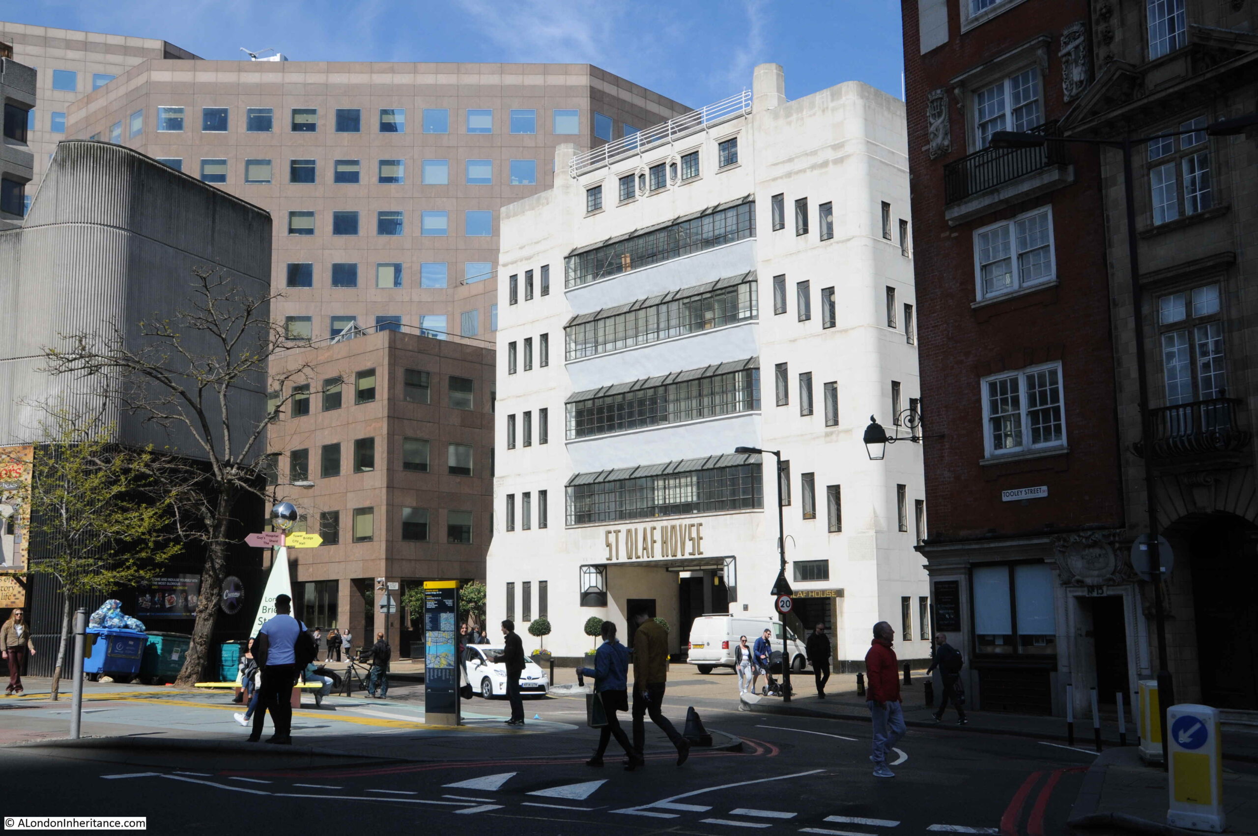
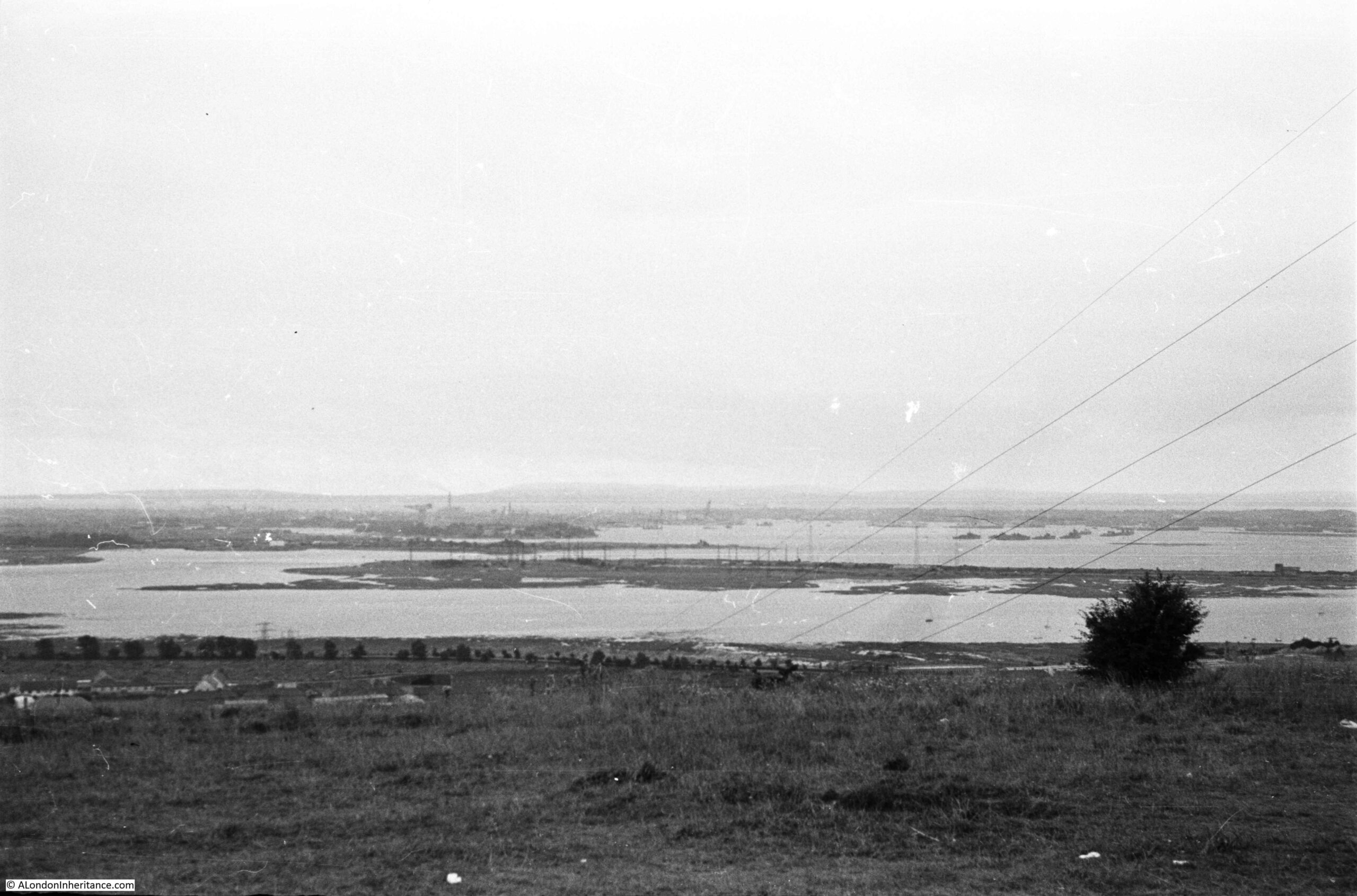
Regular readers will know that as well as London, my father also took very many photos whilst cycling around the country during the late 1940s and early 1950s. For a mid-week post, I am visiting the location of one of those photos, which tells an interesting story of how land has been reclaimed, and the uses to which we have put that land. This is the view of Portsmouth from Portsdown Hill in 1949:

Portsdown Hill

The same view in 2021:

Portsdown Hill

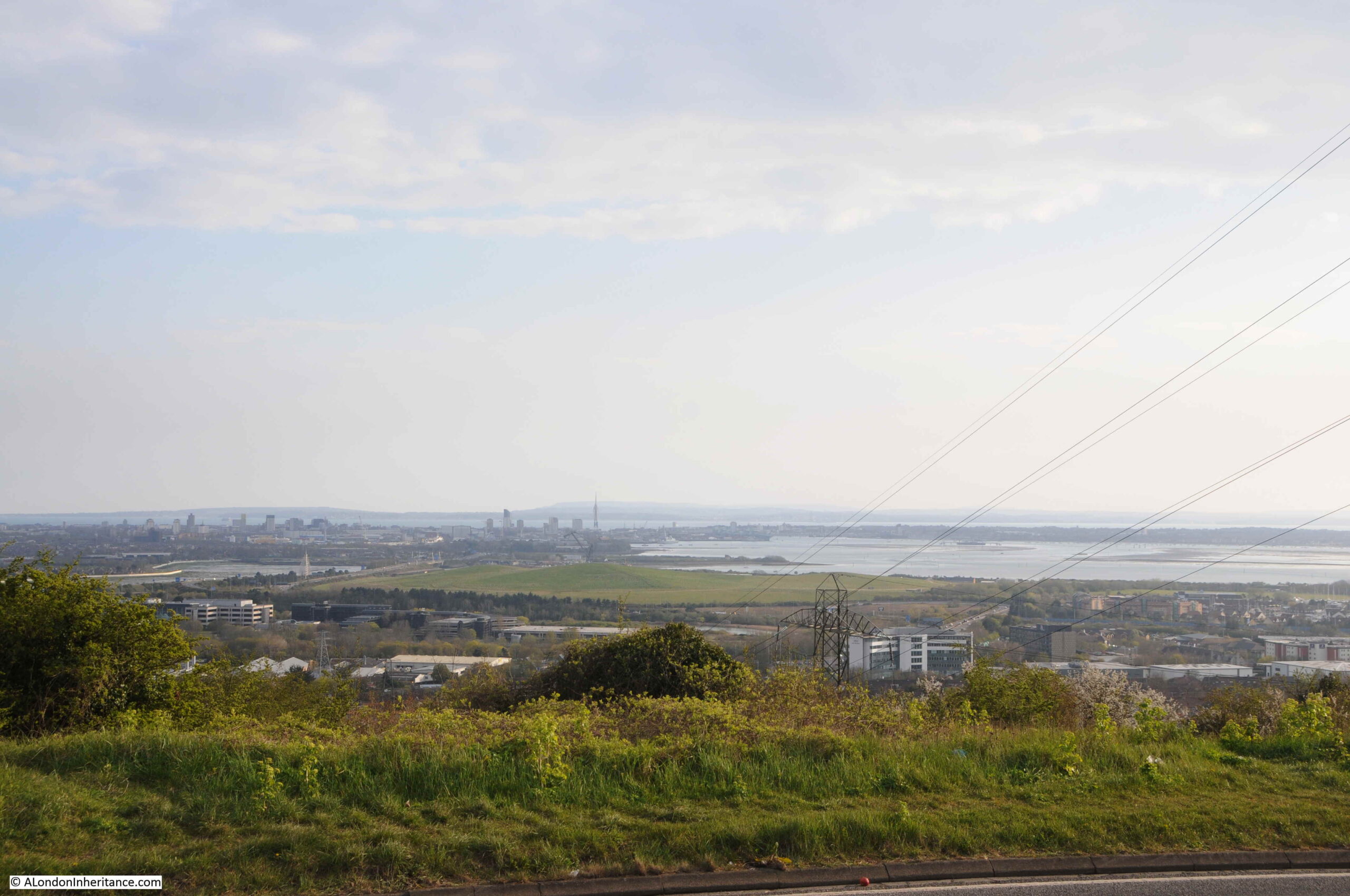
There are a couple of details that confirm that this is the same view. Both photos have the electricity cables on the right disappearing over the edge of the hill, and in the distance the profile of the Isle of Wight is the same.

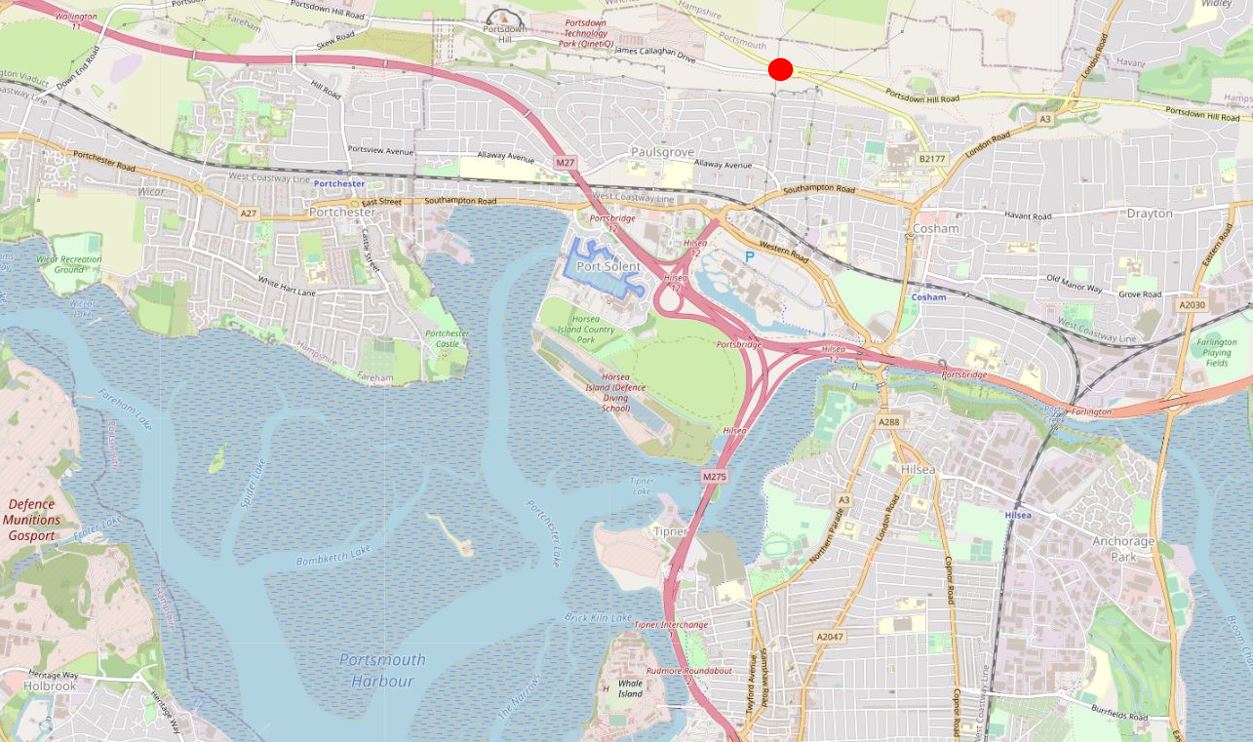
The location is important for the rest of the post. The following map is a wider view of the area. The Isle of Wight is lower left, the water is the Solent, the channel leading up to the top left corner is Southampton Water. Portsmouth is the block of land with water on both sides, in the centre of the map  (Map © OpenStreetMap contributors).

Portsdown Hill

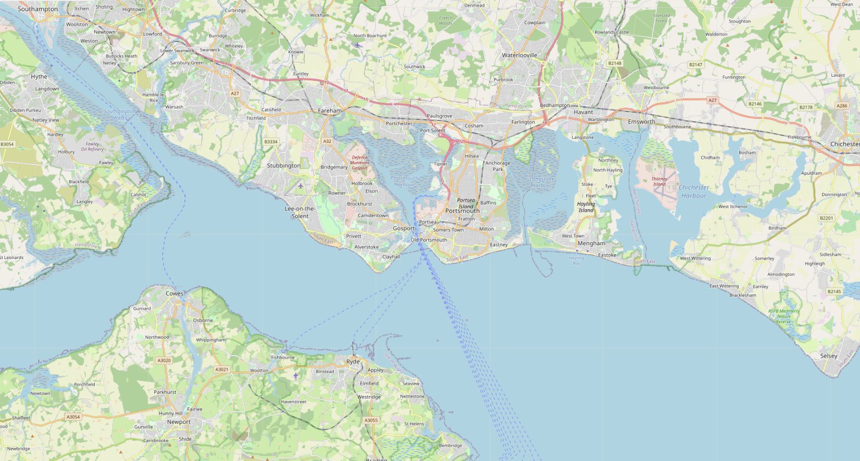
The following map is an extract from the above map, with the red circle marking the location from where both photos were taken  (Map © OpenStreetMap contributors).

Portsdown Hill

Portsmouth can be considered as an island as it is surrounded by water on all sides. Portsmouth Harbour to the west, Langstone Harbour to the east, the Solent to the south, and around the north of the island there is a narrow channel of water.

It is not very clear from the above map, but the place from where both photos where taken is on a hill. Portsmouth is generally flat and low lying with a maximum height of 6 metres. Directly behind Portsmouth is a chalk hill, known as Portsdown Hill, running east to west. The height at the location of the photo is 101 metres, so considerably higher than Portsmouth as illustrated in the photos.

Portsdown Hill is part of the geologic feature called the Portsdown Anticline.

An anticline forms when the ground has been compressed from two sides, and the compression causes the land to rise and fall. An anticline is the part where the land has risen and a syncline is where the land falls. The following diagram illustrates the concept of an anticline and syncline.

Portsdown Hill

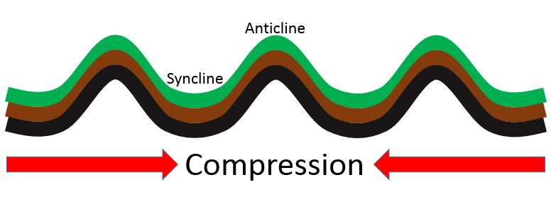
The sides of an anticline sometimes erode over time, and also become exposed due to human activities, which has happened to the chalk of the Portsdown anticline, which I will show later in the post.

The anticline / syncline model explains much about the landscape of this part of southern England, with the hills on the Isle of Wight in the photo being part of the Sandown anticline, the ripples of anticlines and synclines forming the landscape up to Petersfield and Winchester, and further north, the Hog’s Back in Surrey, before flattening out to form the London Basin.

Human activity is often very visible with the construction of roads, housing, factories and warehouses, and in the two photos from Portsdown Hill we can see the impact of another form of human activity which has had a considerable impact on the waters of Portsmouth Habour since my father’s 1949 photo.

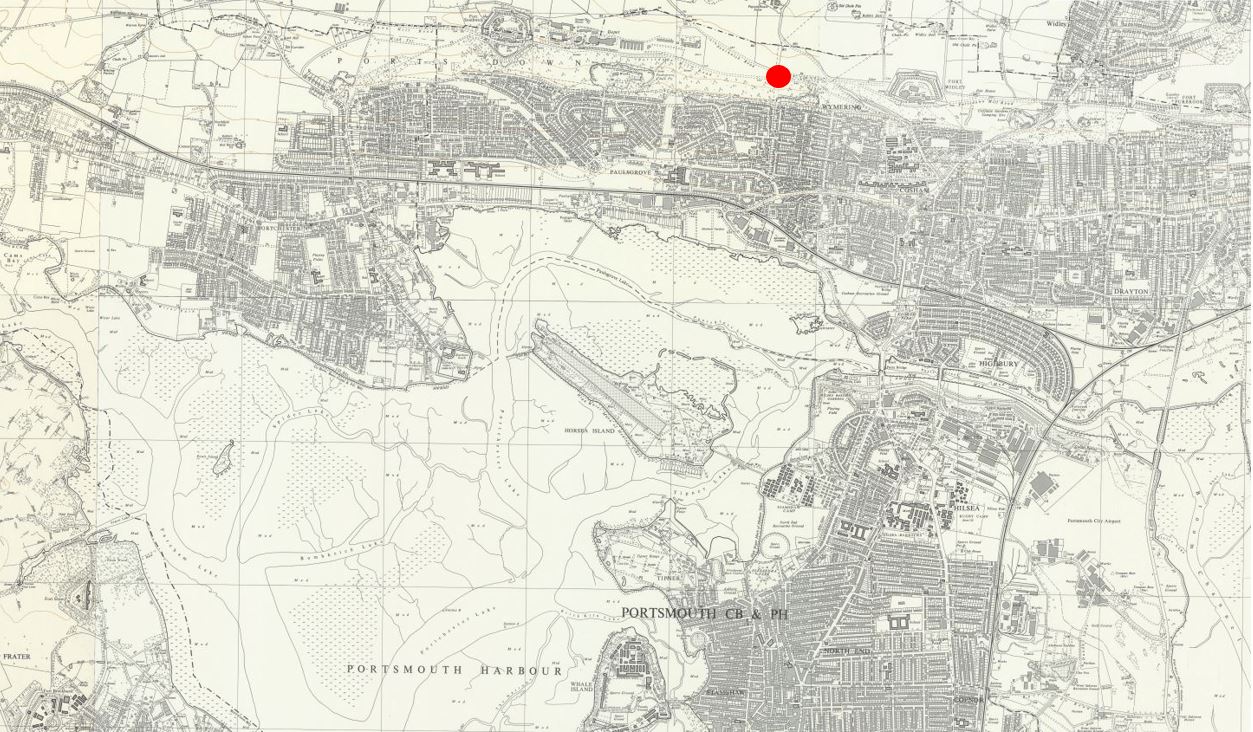
In the 1949 there is a large area of water in the foreground. In the 2021 photo this has disappeared. The following map extract shows the area in 1962. Again, the red circle indicates where the photos were taken from.

There is a large island (Horsea Island) in the north east part of Portsmouth Harbour (‘Reproduced with the permission of the National Library of Scotland’).

Portsdown Hill

In the 1970s the area of land between Horsea Island and the mainland was reclaimed. The following map shows the reclaimed area.

Portsdown Hill

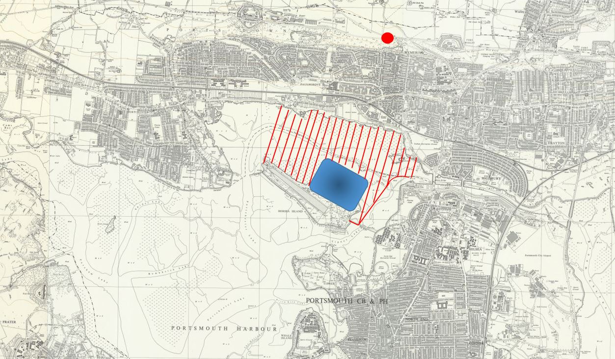
Comparing the above map, with the map of the area in 2021 earlier in the post will show that the reclaimed area has been used for the M27 motorway, the M275 into Portsmouth, construction of Port Solent marina, along with housing, shopping, entertainment and buildings for marine businesses.

One large part of the reclaimed land was used as a landfill area for household waste. The area destined for landfill is shown in the above map highlighted in blue.

Even though the decision was made in the 1970s, it is still surprising that such a marine environment would be used for landfill. A number of old landfill sites on the coast are already, or at risk of erosion. This is already happening at an old landfill site on the Thames at East Tilbury.

The Portsmouth landfill site closed in 2006, and the site has now been grassed over, although vents can be seen protruding from the ground to vent the gasses from the decaying materials below.

I have marked up my father’s 1949 photo with some of the key features, including the area that would become landfill.

Portsdown Hill

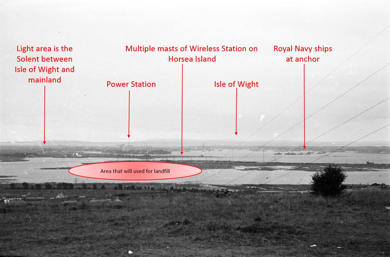
The masts are part of a navy wireless station that occupied much of Horsea island. The island also had a torpedo testing range, which can still be seen as the long channel of water in the 2021 map earlier in the post.

The torpedo testing range was the result of earlier human intervention. Horsea Island was originally two islands – Great and Little Horsea. The admiralty purchased the islands in 1885, and they were merged into a single island using chalk excavated from Portsdown Hill. The enlarged island provided the space for the torpedo testing range which was eventually extended to a length of 1,000 yards.

The following photo from the same location shows the old landfill site as the large grass mound in the centre of the photo.

Portsdown Hill

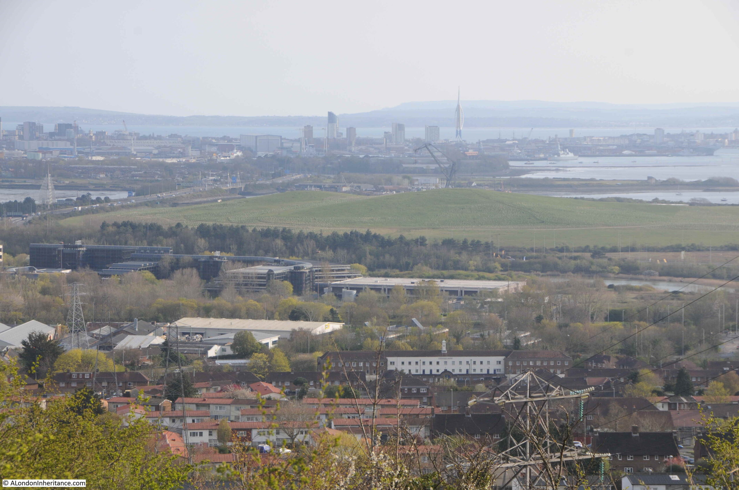
The Isle of Wight can be seen across the Solent and there is a tower rising to the right of the taller buildings of central Portsmouth.

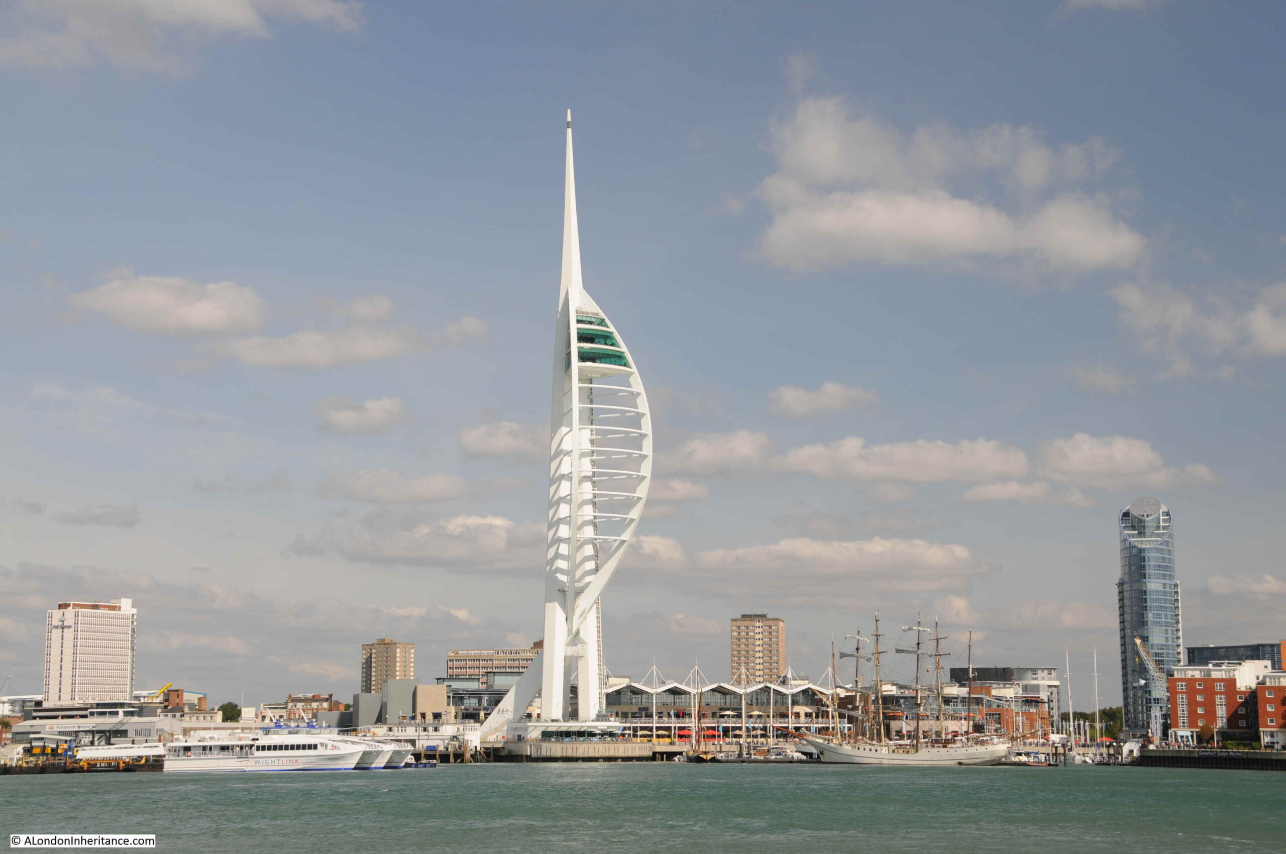
This tower is the Spinnaker Tower located on the Portsmouth Harbour waterfront at Gunwharf Quays.

Spinnaker Tower Gunwharf Quays

Gunwharf Quays is now a retail and entertainment complex, built on the site of HMS Vernon, an old part of Portsmouth’s naval base, and an area focusing on mine warfare and the development of torpedoes which provides a link with Horsea Island. HMS Vernon was decommissioned in 1986.

Construction of Gunwharf Quays started in 1998. It was a complex engineering and construction process as much of the new site would be built over tidal mudflats and one of the largest marine decks in Europe was built to support much of the new building.

Construction of the Spinnaker Tower started in late 2001, based on a design chosen from three designs put to a vote by the residents of Portsmouth. The design is intended to emulate the billowing out of a spinnaker sail to reflect Portsmouth’s marine heritage.

At the top of the Spinnaker Tower is a viewing gallery, which I visited a number of years ago. The height of the tower provides a spectacular view over the surrounding area. In the following photo, the view is back towards Portsdown Hill and I have marked the site of the 1949 photo with a red arrow.

Portsmouth Harbour

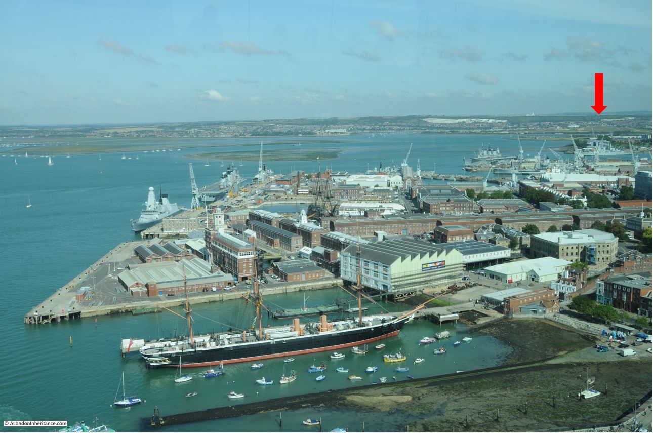
The white of the exposed chalk can be seen just to the right of the arrow, with a much larger area to the left. This is the underlying chalk of Portsdown Hill which has been exposed by both weathering and erosion over time, as well as human quarrying.

The Portsmouth naval base as well as the historic dockyard occupy much of the foreground of the photo.

The large ship nearest to the camera is HMS Warrior. Built in 1860, HMS Warrior was powered by both steam and sail, and was Britain’s first iron hulled, armoured naval warship. The most technologically advanced ship of her time.

Follow up from the funnels of HMS Warrior and HMS Victory can also be seen. The Historic Dockyard is also home to the Mary Rose, the flagship of King Henry VIII, which sank in the Solent in 1545, and raised from the seabed in 1982.

Looking in the opposite direction, the Spinnaker Tower provideds a superb view over the Solent and the entrance to Portsmouth Harbour.

Portsmouth Harbour

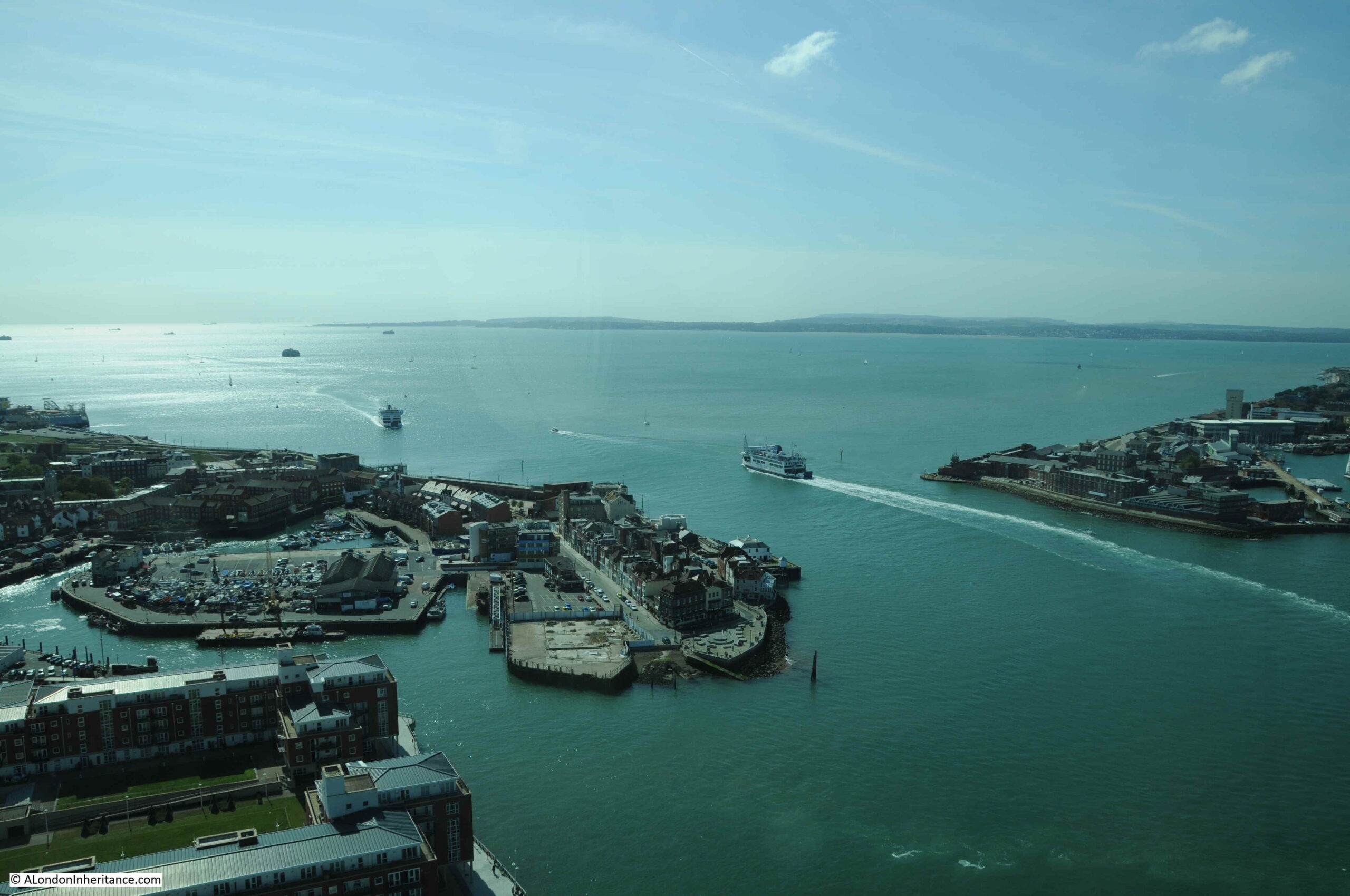
In the above photo, the area to the left of the harbour entrance is called Portsmouth Point, also known as Spice Island.

Today, there are a couple of brilliant pubs facing onto the harbour entrance, however in the past, Portsmouth Point / Spice Island had a reputation for drunkness, prostitution and crime, with press gangs roaming the streets.

Thomas Rowlandson produced the following satirical print of Portsmouth Point in 1814.

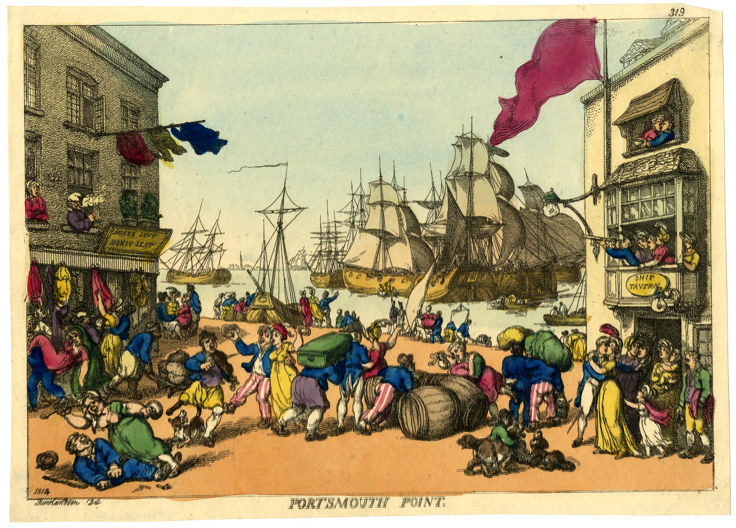
The view is looking out towards Portsmouth Harbour where numerous ships are moored or with their sails up. General confusion and chaos reigns on the Point with sailors just returned or about to leave (a sailor is saying goodbye to his family in the doorway on the right, whilst in the window above an officer is looking towards the harbour with his telescope).

The power station chimney seen in the 1949 photo was just to the left of the above photo, the area is now covered with housing.

Portsmouth harbour opens out into the Solent, the water that runs around the north of the Isle of Wight.

Although the Isle of Wight is now an island, this was not always the case. The Solent was once part of a large river system that drained part of southern England, including Portsmouth, Langstone and Chichester Harbours, along with Southampton Water.

The west of the Isle of Wight was connected to Dorset during the time of the Solent river system, however the land was breached around 7,000 years ago as sea levels rose following the end of the last glacial period and melting of large sheets of ice.

There is so much history to be discovered around Portsmouth. In the above photo, there are some round objects visible in the sea to the left of the photo. These are what have become known as Palmerston Forts, or Palmerston Follies:

Palmerston Forts

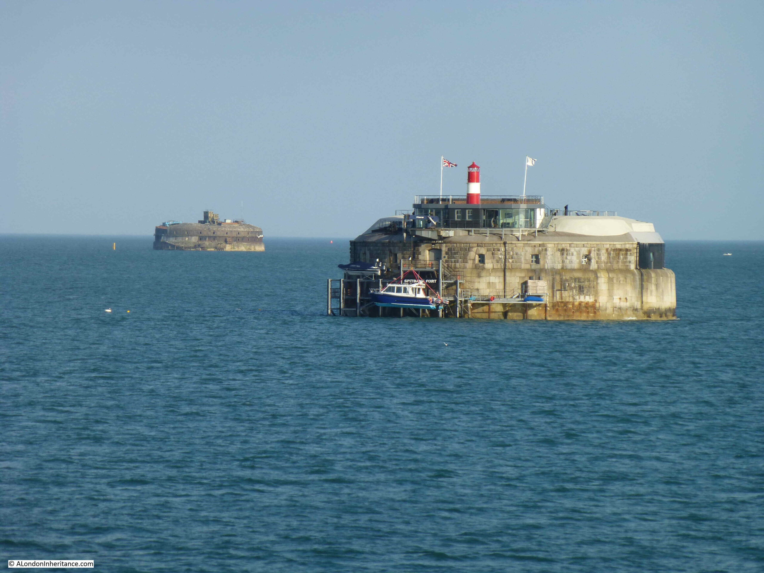
These were built between 1865 and 1880 following a Royal Commision that raised concerns regarding the risk of a French invasion. They were intended to defend Portsmouth from an attack from the east.

They were named after Lord Palmerston who was Prime Minister at the time, and who championed the idea of the forts. They became known as Palmerston Follies as they were never used as a French invasion never materialised, and they quickly became outdated following advances in weapons technology.

Three additional land based forts were also built along Portsdown Hill which can still be seen when travelling along the road that runs along the top of the hill.

The following print from 1823 shows a view from Portsdown Hill, further to the west of my father’s 1949 photo (© The Trustees of the British Museum).

Portsdown Hill

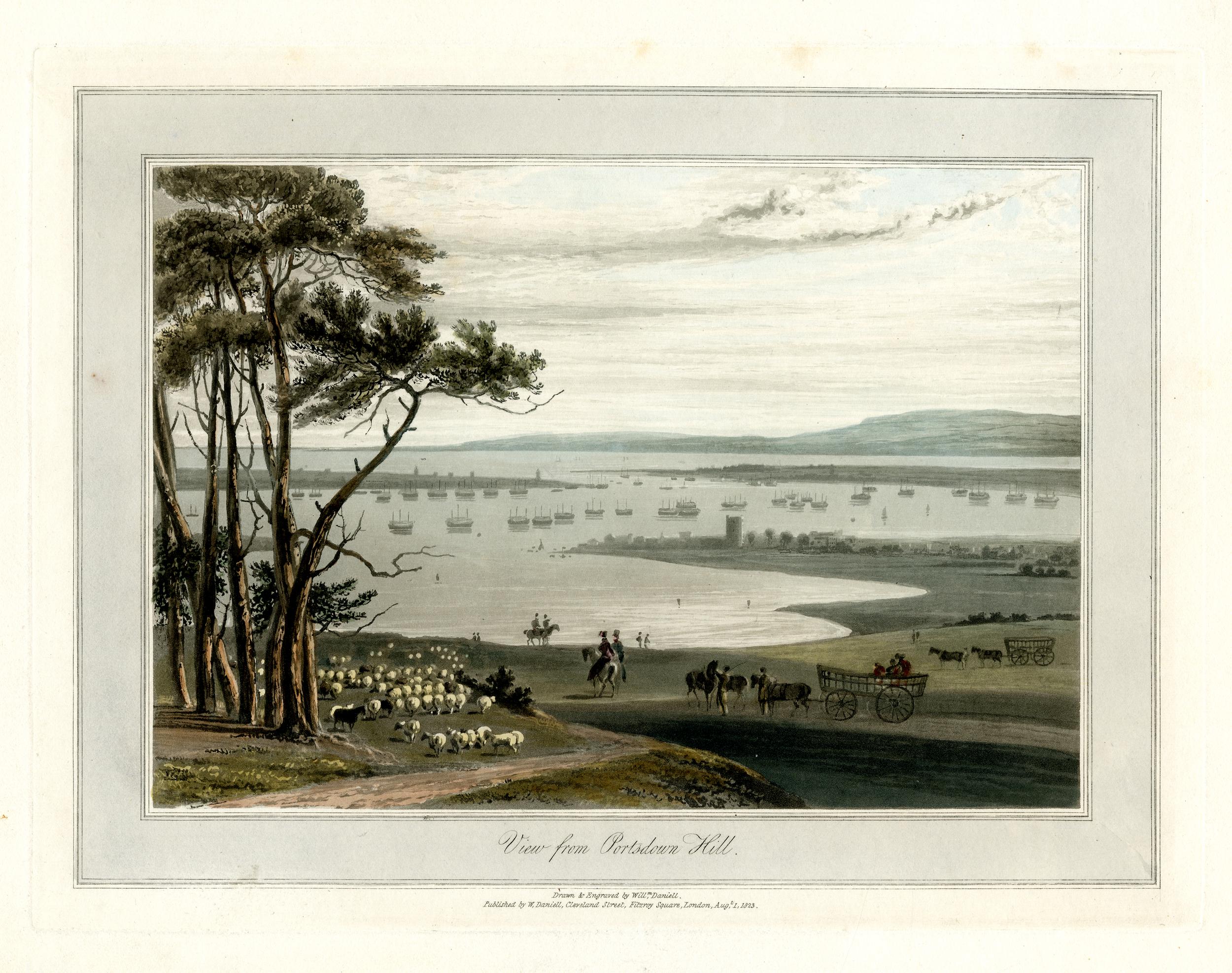
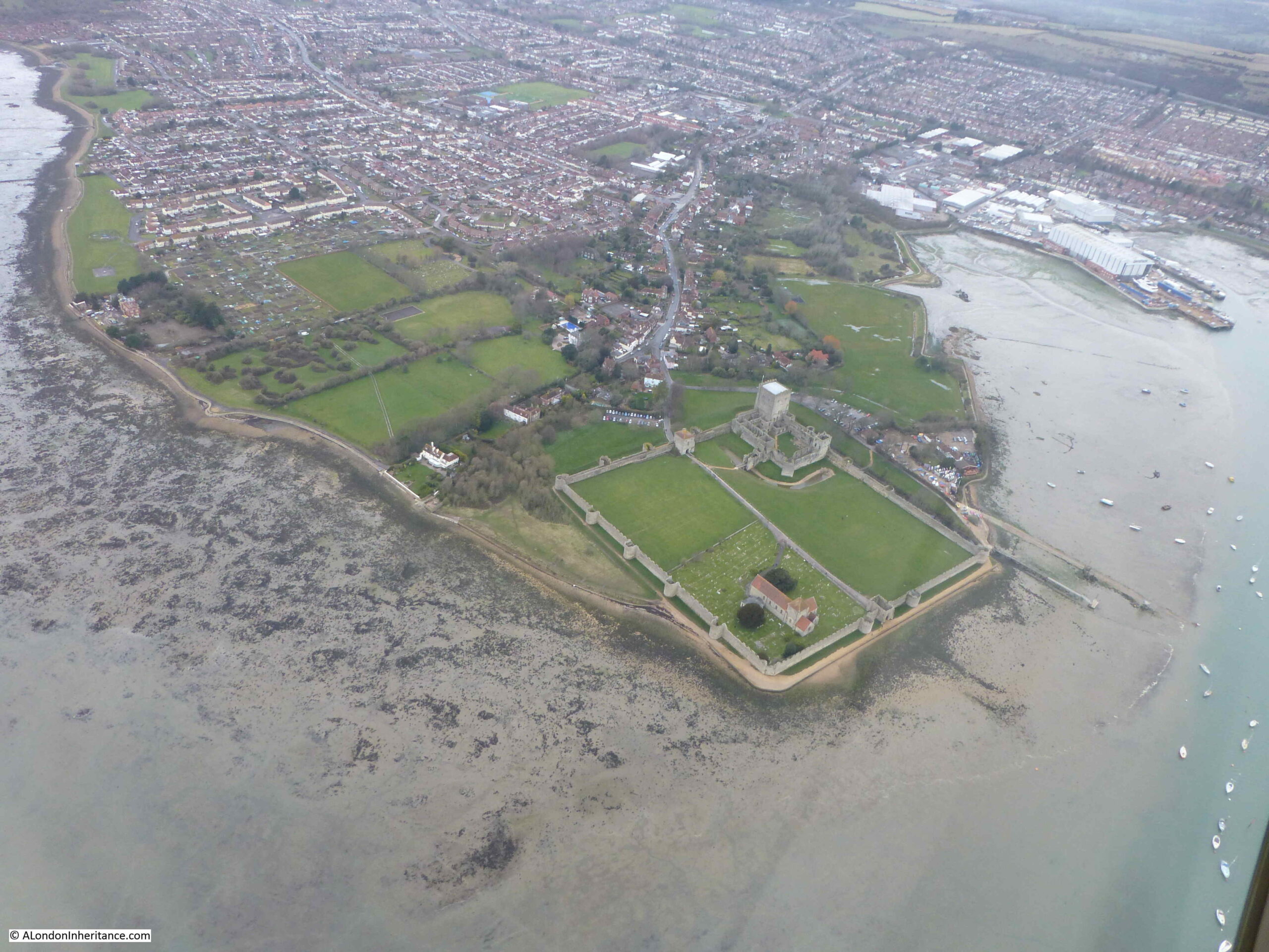
There is a tower like structure in the centre of the print, which can also be seen to the right of the 1949 photo. The tower is the Norman keep of Portchester Castle at the northern end of Portsmouth Harbour.

Portchester Castle was originally a Roman fort, built in the 3rd century as one of a number of shore forts to defend the area against Saxon raids.

The old Roman fort seems to have been occupied from the ending of the Roman period to the Norman conquest, when the site became a Norman castle, with a 12th century keep. The castle continued to be in use and further fortified due to its strategic position, and what seems to have been an almost continuous threat of invasion by the French.

Charles I sold the castle to a local landowner in 1632, and for periods during the next two centuries, the castle was rented to the Government as a prison to hold prisoners of war, including during the Napoleonic wars of 1793 to 1815, when the castle was home to thousands of prisoners.

Portchester Castle is still owned by descendants of the landowner who purchased the castle from Charles I, and is now managed by English Heritage.

Portchester Castle from the air, facing onto Portsmouth Harbour:

Portchester Castle

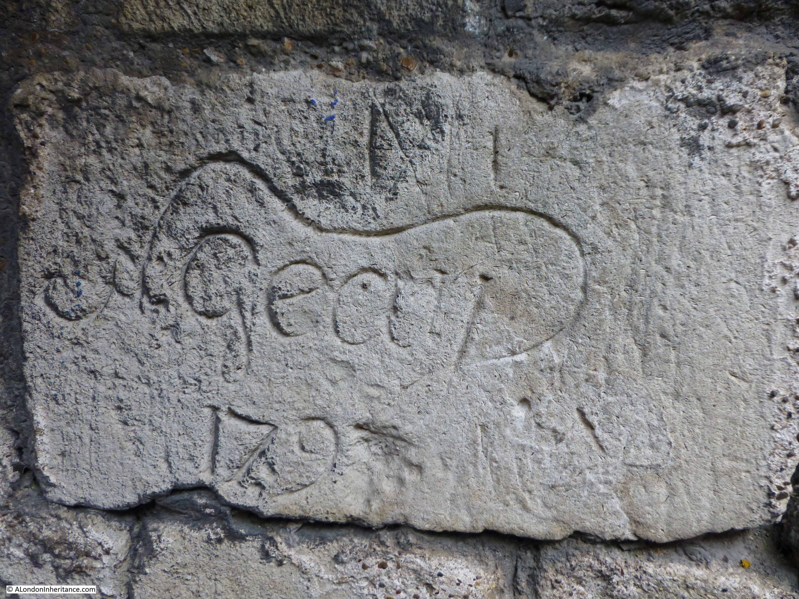
Some of the prisoners left their mark with graffiti on the castle stone:

Portchester Castle

The view from Portsdown Hill has changed considerably since 1949, however the view still includes a fascinating sweep of historical and geological time, and there is far more to be discovered than I have been able to cover in a single post. The view tells the story of how the land developed, and what we have done with that land.

The 1949 photo was taken by my father on one of his cycling trips out of London, Youth Hostelling with friends from National Service. Other locations I have so far covered on this route along the south of England include:

Chichester Market Cross And The First Fatal Railway Accident

Salisbury – Poultry Cross, High Street Gate And Cathedral and,

Winchester and Stonehenge

alondoninheritance.com

Three Hundred Years of Hay’s Wharf

Seventy years ago, this coming Friday, at 5.30 p.m. on the 30th April 1951, Mr. L. Elliott Esq. arrived at No. 1, London Bridge to celebrate three hundred years of Hay’s Wharf. The Lord Mayor would also be attending and there were cocktails and music.

Hay's Wharf

The invitation card pictured above opened out to reveal pictures from 1651 and 1951. The following picture shows Hay’s Wharf (with London Bridge on the right) in 1651:

Hay's Wharf

The second photo shows the wharfs occupied by the Hay’s Wharf company in 1951, running from London Bridge at top right, along the left side of the river down to Tower Bridge.

Hay's Wharf

The edge of the river in 1951 appears to be a hive of activity with numerous barges, lighters and ships moored alongside the wharfs, and working in the river.

This was the Hay’s Wharf that the event on the 20th April 1951 was intended to celebrate.

Hay’s Wharf has a rather complicated history, with different owners of land, building and rebuilding of wharfs and warehouses, the Hay’s family, partners in the business and how Hay’s took over most of the river frontage between London and Tower Bridges.

Today’s post is an attempt to provide an overview of the 300 years of Hay’s Wharf and the Hay’s Wharf company.

The year 1651 as the founding of Hay’s Wharf seems to be year when Alexander Hay took over the lease of a brew-house from Robert Houghton, on the site of the current Hay’s Wharf buildings, alongside a small inlet from the river.

Running a brew-house may have meant that Hay realised the importance of clean water supplies. Water was being delivered to London by companies such as the New River Company, and by the London Bridge Waterworks, and these companies needed pipes through which to distribute their water.

Before a method of joining iron pipes was developed in 1785, water pipes were made from hollowed out tree trunks, and Hay set up a business to bore tree trunks and supply wooden pipes to companies such as the New River Company.

This was carried out at the small inlet at Hay’s Wharf, with buildings alongside constructed for the operation of the business.

Pipe boring must have been of such a scale that the Bridge House records, record Pipe Borers Wharf as the official name for Hay’s Wharf

There is one curious story of Hay’s Wharf during the early years of the 18th century. In 1709, the overall lease for the wharfs and properties close to London Bridge were taken over by Charles Cox who had been the MP for Southwark since 1695. It was from Charles Cox that Hay had an individual lease of the properties that formed Hay’s Wharf.

In 1697 the Treaty of Ryswick resulted in the persecution of Lutheran Protestants in parts of what is now Germany. Many of these fled to England as refugees and were granted an allowance of one shilling a day. Following early arrivals from Germany, numbers soon increased as news of the welcome they received in England spread. Numbers became such that there was a public outcry against the number arriving and the grant of a shilling a day. As a result, this grant was soon stopped.

Charles Cox announced that he would give asylum to all who arrived and would cover the cost. His approach to housing new arrivals was to crowd them into buildings at Hay’s Wharf and nearby Bridge House. Conditions grew very insanitary, and the local population were angered by the number of arrivals, and their living conditions so close to the existing residents.

Despite Charles Cox stating that he would fund the costs, the local Poor Rate had to be increased to £700.

Hundreds continued to arrive from Germany, and in desperation Charles Cox sent many to Southern Ireland, where they were not welcomed, and had to return to London.

Eventually, arrangements were made to ship the refugees to America, where they were settled in Carolina. It is interesting to wonder how many of those living in America today are descendants of those who travelled to America via the buildings at Hay’s Wharf and Bridge House.

Warehousing as a major business started from 1714 when the Customs Authorities allowed goods such as tobacco to be stored in warehouses on payment of a small percentage of the import duty.

If the product was then exported, the import duty would be repaid, allowing imported goods meant for export to be stored in warehouses tax free. Previous warehouses had been for the temporary storage of goods and the convenience of merchants, however tax free import followed by export significantly grew warehousing as a business.

By 1789, Hay’s Wharf was just one of a number of sufferance wharfs along the south bank of the river. A sufferance wharf is one where goods can be stored until any tax or duty is paid.

The following map shows the sufferance wharfs lining the south bank of the river in 1789.

Hay's Wharf

Hay’s Wharf was just one of a number that lined the river. From lower left are Chamberlain’s Wharf, Cotton’s Wharf, Hay’s Wharf, Beal’s Wharf, Griffin’s Wharf, Symon’s Wharf, Stanton’s Wharf, Davis Butt & Co Wharf, Hartley’s Wharf, Pearson’s Wharf and Holland’s Wharf.

Hay’s Wharf was used as a place where ships would dock and receive goods and passengers for transport across the country, and abroad. A Hay’s Wharf sailing bill from 1798 provides an indication of how this trade was carried out.

Hay's Wharf

The “Sally” would be sailing from Hay’s Wharf to Plymouth and Plymouth Dock, and the ship would be available for twelve working days at Hay’s Wharf to take goods for transport to Plymouth, from where they could then be forwarded to a range of locations in the West Country. As well as taking goods, the Sally would also carry passengers for Plymouth.

Throughout the 18th century, the Hay’s Wharf business had passed through the Hay’s family. Francis Theodore Hay would be the last of the family connected with the business.

Francis had been apprenticed as a Waterman before taking over the business. He would become Master of the Waterman’s Company and King’s Waterman to George III and George IV.

In the early 19th century, Hay’s business was seeing considerable competition. In earlier years the Customs Authority had granted sufferance, or the right to store goods without paying tax, to a limited number of wharf owners, however they now granted sufferance to any owner of land with a frontage on the river. Competition was also coming from the new docks which were being built east of the Tower of London.

Possibly because of this competition, Francis set up his son in a lighter building business, with a property on the river in Rotherhithe. Lighters were smaller, flat bottomed barges which allowed goods to be transferred from a ship, right up to the wharfs lining the river.

Francis Theodore Hay died in 1838, and was the last of the Hay’s connected with the wharf business. His son carried on running the lighter building business.

Francis Theodore Hay:

Hay's Wharf

Francis Hay’s interest in the business seems to have been mainly financial, and Alderman John Humphrey (who already had a long association with Hay’s), now became the owner of the business. He would bring in two partners who were influential in the future success of Hay’s Wharf.

Hugh Colin Smith was a member of a family long connected with the City’s banking and commercial world. Arthur Magniac’s family was part of the Jardine, Matheson Company, one of the oldest Merchant Adventurers in China, and it was through Magniac that the tea trade was brought to Hay’s Wharf, with tea clippers from China bringing a high percentage of the tea consumed in London to Hay’s.

The trade with China was so successful that Jardine, Matheson referred to Hay’s Wharf as “our wharf in London”.

Humphrey, Smith and Magniac entered a fomal partnership in 1861 known as the “Proprietors of Hay’s Wharf”, although Humphrey would only live for another 18 months, however his sons took over their father’s interest in the partnership and Hay’s Wharf entered a period of considerable expansion and progress.

For the rest of the 19th century, and the early 20th century, Hay’s Wharf introduced mechanisation, purchased land and wharfs along the river between London and Tower Bridges, invested in new buildings and technologies such as a Cold Store. They also purchased the Pickford’s transport business.

It was during the early part of the 20th century that the Hay’s Wharf business was at the peak of its expansion and success.

The following painting by Gordon Ellis shows the tea clipper Flying Spur about to enter the dock at Hay’s Wharf on the 29th of September 1862. The ship is bringing the new season’s tea back from Foochow, China.

Hay's Wharf

The site of the original Hay’s Wharf is now the Hay’s Galleria. Seen from across the Thames, two old warehouse buildings surround an open space covered by a glass and metal frame.

Hay's Wharf

The central open space was once fully occupied by water, the remains of an old inlet from the river that had been turned into a dock so that ships could moor adjacent to the buildings that would store their cargo.

I cannot confirm the exact date of the current buildings. There are references to construction in 1856, however the 1861 fire, named in the press as the “Great Fire in Tooley Street” caused considerable damage to these buildings. The Morning Post of the 24th June 1861 describes the fire catching in the roof of Hay’s Wharf, tall columns of flame, the top floor blazing and the fire descending to the floor below, with the rest of the floors following.

The article described that this was supposed to be a fire proof building, and although it appears to have been considerably damaged by the fire, the fire did take longer to move from floor to floor than in the other warehouses.

Hay’s Wharf was repaired / rebuilt soon after, suffered bomb damage in the last war, and considerable restoration and modification at the end of the 20th century, which included the infill of the old central dock.

The following photo is looking along the interior of Hay’s Wharf, out towards the River Thames.

Hay's Wharf

The following photo shows the interior when it was in use as a dock, with water running up to a narrow walkway alongside the building on either side (the walkway was a later addition to the warehouse buildings. When first built the dock ran directly up to the side of the building and to get between the different arches you would have had to walk through the interior).

Hay's Wharf

The photo dates from 1921 and the ship in the photo is the Quest, the ship that the explorer Earnest Shackleton used for his final expedition to the Antarctic. Shackleton would suffer a fatal heart attack on the 5th of January 1922 whilst at South Georgia, where he would be buried.

The view back along the old dock from the river end of Hay’s Wharf:

Hay's Wharf

The old entrance to the river can still be seen with the indent on the river wall and walkway:

Hay's Wharf

In the late 1920s, the Hay’s Wharf Company decided to build a new head office. This would occupy the site of St Olave’s Church, between Tooley Street and the Thames.

To continue a link with the 11th century saint after who the church was dedicated, the new head office would be called St Olaf House. The photo below shows the view of the building from Tooley Street:

St Olaf House

St Olave’s church just survived the disastrous fire at Tooley Street in 1843. It was rebuilt the following year, however over the coming decades the size of the congregation declined, and in 1908 is was recorded that at one of the rare services at the church there were only five in the congregation.

The body of the church was eventually demolished with only the tower and graveyard remaining. In 1928, Bermondsey Borough Council proposed selling the church to the Hay’s Wharf Company in order to save public money. A bill was presented in Parliament to enable the sale, which requested permission:

“to sell to Hay’s Wharf the site of the Church of St Olave’s and the churchyard, comprising St Olave’s Garden between Tooley Street and the River, together with the right of demolition of the tower and the right to use the ground as a waiting place for vehicles, with loading bays, and to erect buildings upon it.

The sale of the churchyard and the tower (a local landmark) was a contentious issue, but finally went ahead. The flagstaff from the tower was given to St George’s Church, Borough High Street and three bells from the tower were given to the Church of St Olave which was then being built in Mitcham.

The octagonal Portland stone turret, formerly capping the tower of the church was moved to the Tanner Street, Bermondsey park and children’s playground to form a drinking fountain. The playground was funded with some of the proceeds from the sale of the land.

The new head office was designed by H.S. Goodhart-Rendel and opened in 1931.

The Tooley Street entrance to the building is recessed under the building, with parking space and vehicle access between the entrance and Tooley Street.

The main entrance has the arms of the Smith, Humphrey and Magniac families above the door, along with the opening date of 1931. These three families were the partners in the company, and responsible for the considerable development and expansion of the company after 1862.

St Olaf House

A black and gold mosaic of St Olave on the corner of the building:

St Olaf House

On another corner of the building is recorded that it occupies the site of the church and the legend of St Olave:

St Olaf House

Along with an award for the offices from the British Council:

St Olaf House

View of the new Head Office from London Bridge:

St Olaf house

The same view from London Bridge in 1951:

St Olaf house

The focal point of the river facing side of the building is a large set of reliefs framing six of the windows:

St Olaf House

The reliefs were the work of the sculptor Frank Dobson and completed using gilded faience (second time in the last few weeks I have come across this material. Faience is glazed pottery, see also post on Ibex House in the Minories).

The three large panels at the top represent Capital, Labour and Commerce, and the 36 vertical panels represent “The Chain of Distribution”.

Another example of Frank Dobson’s work can be found on the south bank of the river with “London Pride”, designed for the Festival of Britain, now outside the National Theatre.

Another 1951 view from London Bridge showing the head office, and the adjacent wharf (now the London Bridge Hospital). Note the cranes built on a pontoon in the river:

Hay's Wharf

As well as the name of the building, the name of the saint and church continues with the name of the alley from Tooley Street to the river to the west of the building – St Olaf Stairs:

St Olaf Stairs

There are two interesting buildings just to the east of St Olaf House on Tooley Street. The photo below shows Emblem House, now part of London Bridge Hospital.

Bennet Steamship Company

Emblem House was built in 1903 to a design by Charles Stanley Peach. Originally called Colonial House, the building was part of the change from wharfs and warehouses to commercial buildings along this stretch of Tooley Street.

In the photo above, there is a thin, brick built building to the left of Emblem House. This is Denmark House.

Built in 1908 to a design by S.D. Adshead, for the Bennet Steamship Company.

On the side of the building facing St Olaf House, at the very top of the building, there is a stone model of a steamship, with what looks like a funnel, two lifeboats and cranes at front and rear – possibly one of Bennet’s steamships.

Bennet Steamship Company

After the war, some of the wharfs and warehouses lining the Thames between London and Tower Bridges were empty. Wartime damage and the transfer of trade to the docks east of the river had an impact, however there were still ships being loaded and unloaded at the wharfs owned by Hay’s Wharf. My father took the following photo in 1947 from in front of the Tower of London, looking across to the warehouses on the south bank of the river:

Hay's Wharf

A ship is heading towards Tower Bridge, and a second ship is moored up against one of the warehouses, and cranes line the southern bank of the river.

This would not last for too much longer, and from the 1950s the business continued to decline.

By 1970, the Hay’s Wharf company was seen more as an owner of valuable property than a business running wharfs and warehouses. Following the release of the financial results for the company in 1970, newspaper reports commented that the results were “the London group owning 25 acres of prime Thames dockland, is almost as interesting as the takeover rumours surrounding the company”.

The Hay’s Wharf Company had announced a profit of £1.2 million, which “do not take into account the terminal costs on the closure of the Tooley Street wharves and expenditure on properties awaiting development”. The wharf and warehouse business had effectively closed by 1970.

There were various schemes proposed for redevelopment of the area between Tooley Street and the river during the 1970s and early 1980s. A 1981 scheme for a massive office development was the subject of a public enquiry, and in 1983 the Government gave approval for a scheme proposed by the London Docklands Development Corporation, which included a number of new office blocks, along with retention of a couple of the old warehouses, including Hay’s Wharf.

Hay’s Wharf reopened as Hay’s Galleria in 1987, with the old dock filled in.

View from the north bank of the Thames with Hay’s Wharf on the left, running up to London Bridge on the right.

Hay's Wharf

The following photo shows Hay’s Wharf to the right, and the buildings running up to Tower Bridge on the left.

Hay's Wharf

The majority of the above two photos was once part of the Hay’s Wharf Company. Today, the area is known as London Bridge City and is ultimately owned by the Kuwaiti Sovereign Wealth Fund.

I wonder what Mr. L. Elliott would have thought of what the area would become in the next seventy years, as he clutched his invitation and joined the celebrations of three hundred years of Hay’s Wharf.

To research this post, one of the key books I read is a book published to go with the 300 year celebration: “Three Hundred Years on London River – the Hay’s Wharf Story” by Aytoun Ellis. The book is a fascinating account of Hay’s Wharf, the development of this part of the south bank of the river, the families involved, and the commercial and political environment of London during those 300 years.

alondoninheritance.com

Narrow Boat Pub, Ladbroke Grove

Last week, I featured a pub in Belgravia that is still there. For today’s post, I am in Ladbroke Grove to visit the site of a lost pub. This is the Narrow Boat on Ladbroke Grove, adjacent to the bridge over the Paddington Arm of the Grand Union Canal.

This was the Narrow Boat pub in 1986:

Narrow Boat Pub

The pub has disappeared, bridge rebuilt, and the Narrow Boat has been replaced by a block of flats:

Narrow Boat Pub

My father took the 1986 photo, and I have no idea whether including the passing cars in the frame was intentional or accidental. Chauffeur driven cars, and I do not recognise the man sitting in the rear of the car on the right.

If the passing cars were accidently included in the frame, this was the days of film, so taking another when there was a risk of more traffic in the view was often an inefficient use of film. Very different to today when you can take as many digital photos as needed to get the right view.

The Narrow Boat was located on the north east corner of the bridge taking Ladbroke Grove over the Paddington arm of the Grand Union Canal. I have highlighted the location with the red circle in the following map (Map © OpenStreetMap contributors):

Ladbroke Grove

An area I have not written about before (there are so many still to do). The large area of green space to the left of the pub is Kensal Green Cemetary, which is well worth a visit.

The Narrow Boat was a relatively recent name for the pub. It had originally been called the Victoria. The name changed in 1977 when the Chiswick brewer’s Fuller, Smith and Turner took over the pub. A news report of the change in ownership records that the name change was in keeping with the pub’s proximity to the Portobello Docks, and the narrow boats that carried goods along the canal. The new landlords of the pub were also new to the pub trade. Wally Sharpe had been a London cab-driver for eleven years and Irene Sharpe had been a civil servant.

They had plans to completly refurbish the pub, and for a beer garden and the build of a landing stage on the canal for passing canal traffic.

Judging from the exterior of the pub just nine years later, I am not sure how many of these plans came through to completion. I suspect that Wally and Irene were just ahead of their time, and a pub with gardens facing onto the Grand Union Canal could now be rather profitable, especially as the area is not particularly well served with pubs.

I cannot find the exact date when the pub opened. There are newspaper references to the Victoria pub in the 1890s. In the late 19th century this was on the edges of built London with still many fields to the north and west. Kensal Green Cemetary had opened in 1833, making use of the amount of open space available in the area.

The Paddington arm of the Grand Union Canal opened in 1801 to provide a link between Paddington Basin and the main Grand Union Canal which connected with Birmingham and much of the rest of the country’s canal network.

The Victoria may not therefore have been opened much earlier than the 1890s, unless it was built to serve those passing on the canal.

In the late 1970s, the Marylebone Mercury had a regular beer column and on the 14th September 1979, one of the improvements to London pubs was the fitting of hand pumps in Fullers pubs, with fifty so far being upgraded to return to more traditional ways of serving beer. The Narrow Boat was included in the list of pubs in which the author of the column would enjoy a pint.

in the same year, the beer column commented that the Narrow Boat pub had been included in the Campaign for Real Ale’s 1979 edition of the Good Beer Guide.

Earlier mentions of the pub include a report in 1912 into the drowning of an eight year old boy who had been fishing in the canal. Joseph Church, the landlord at the time was one of those trying to rescue the boy and was called as a witness at the inquest.

In 1902, the Kilburn Times reported on the trial of a drinker in the Victoria who was charged with disorderly conduct and assaulting a Police Constable. In a strange turn of events, the drinker was found innocent after evidence presented, including from the pub’s landlord, proved that the Police Constable had intimidated and assaulted the drinker. The Police Constable was reported.

Apart from that, the Victoria / Narrow Boat appears to have passed a reasonably quite life servicing the locals, workers on the canal, and those from the gas works opposite.

The following photo is looking to the west, from the bridge that carries Ladbroke Grove over the canal.

Grand Union Canal

Parts of Kensal Green cemetary can just be seen on the right, and the large building in the distance on the left is a Sainsbury’s store. The area on the left was once occupied by a large gas works.

The view over the opposite side of the Ladbroke Grove bridge, looking towards the east.

Grand Union Canal

There has been, and still is much development in the area. This is St John’s Terrace which originally ran from Harrow Road to the rear of the Narrow Boat. The building that has replaced the pub can be seen at the end of the street.

Ladbroke Grove

On the corner of St John’s Terrace and Harrow Road is the closed premises of the Tyre and Wheel Company, which has been closed for some time, and I assume is waiting for demolition and probably the build of new flats.

Ladbroke Grove

Walking back south along Ladbroke Grove, over the bridge and turning into Kensal Road is the boarded up remains of another pub. This was the late 19th century Western Arms.

Ladbroke Grove

The Western Arms originally had a large single storey ground floor bar running to the right of the three storey block, however this looks to have been recently demolished,

The pub was called the Playhouse during its last years as a pub, finally becoming a cocktail bar / performance venue. The old pub occupies a reasonably large corner plot so could easily suffer the same fate at the Narrow Boat, however as the three storey block has so far been left standing there is some hope that this will be retained, and the building retains a similar function to that performed during its time as a pub.

Ladbroke Grove

A short walk along Kensal Road offers other buildings of interest. This is “The Gramophone Works”:

Ladbroke Grove

The name comes from the building being the home of Saga Records Ltd during the 1960s and 70s.

The site was purchased in 1960 by Marcel Rodd, who purchased Saga Records the following year.

Saga Records was one of the first companies to reduce the cost of records, to try and break up control of the market by the major music companies. The majority of their music publishing appears to have been classical records, however they also included jazz and West End shows in their catalogue. In 1966 on their Saga EROS label they released the soundtrack to West Side Story by the original English cast.

A short distance further along Kensal Road is another closed pub. Again, from the 19th century and with the wonderful original name of “Lads of the Village”.

Ladbroke Grove

The pub features in a number of interesting news reports. The earliest I can find dates from 1864, so I suspect the pub dates from the 1850s, or very early 1860s. The headline in the 1864 article gives an indication of trouble, and the fact that this area was then a very new development:

“Riot at Kensal New Town – Mr Alfred Price, the landlord of the ‘Lads of the Village’ beershop, Kensal New Town, said: Yesterday morning I left my house a little after six o’clock. I closed the house, barricaded and locked the tap-room door which opens into the street. I bolted the bar door, and went out by the front door, which closed with a spring lock.

I returned between six and seven o’clock the same morning, after taking a walk. I found the tap-room door broken open, and all these men there. Shay was behind the bar acting as landlord. I had porter and ale on the engine, and he was drawing from it. I saw eight pots of beer filled and a half-gallon can, also full, on the counter. The others were partaking of the beer, and giving it away as well to parties outside and others inside.

I said ‘How dare you force into my premises and give away my beer’ Shay merely laughed. They continued drawing the beer and drinking it, in spite of me. I saw Foley and Gadstone shortly afterwards, and they partook of the beer. I went for the police at eight o’clock, and returned with a constable. There were about 40 gallons of beer and ale on draught at the time. I find the barrels are drained and the bung of another barrel had been taken out and the contents were wasted”.

Foley was jailed for three months for assaulting a policeman, and the judge ordered a police inspector to investigate further.

The name of the pub was frequently abbreviated to just The Village, however not that long ago changed name to Frames, although it did not last long with the new name, closing in 2016, and no indication of when current work will complete, and what the old pub will eventually become.

Returning back up Kensal Road to the location of the Narrow Boat pub and looking across the bridge is a rather unusual structure:

Ladbroke Grove

This is an old water tower that was originally built in the 1930s to hold 5,000 gallons of water ready to use if parts of the adjacent gas works caught fire.

The water tower was converted for designer Tom Dixon by the architectural practice SUSD Architects. Building work was completed in 2012, with additional floors added to the water tower to provide a kitchen, two reception rooms, two bathrooms and two bedrooms.

There were originally plans to extend accommodation down to ground level, hiding the four concrete legs, however these plans do not seem to have made any further progress since the initial conversion.

Ladbroke Grove

The building is in a strange location. There must be good views over the surrounding area as there is nothing of similiar or greater height to block the view.

Access is via the temporary looking scaffold stairs to the side of the tower.

A walk round to the side of the Sainsbury’s car park provides another view of the tower:

Ladbroke Grove

No idea if anyone is living in the converted water tower at the moment, but it would be a rather interesting place to stay, and look out over the canal, and the streets of Ladbroke Grove, Kensal Green and Kilburn.

All the locations covered in this post are within a five minute walk of the Ladbroke Grove bridge over the Grand Union Canal. In that short distance, there were once three pubs. One, the Narrow Boat has completely disappeared, and the future does not look good for the remaining two empty buildings.

I have many more 1980s London pubs to visit, some remaining, some lost, however I will break these up after two weeks of pubs and return to these again in the coming months – and hopefully when we can go inside.

alondoninheritance.com

Horse and Groom Pub, Groom Place, Belgravia

For this week’s post I am in Belgravia, an area of London I have not covered before, however this is a return visit to check on a pub last photographed in 1985. This is the Horse and Groom in Groom Place, Belgravia.

Horse and Groom

The same pub today, unfortunately closed whilst we are still under Covid restrictions.

Horse and Groom

The Horse and Groom in Groom Place is one of London’s ‘mews’ pubs. Not on a main street, rather tucked away in one of the small side streets that were designed for servicing the large houses on the main streets, for stabling the horses of their residents, providing (when originally built) lower cost housing and for some small industrial purposes.

Chester Street and Chapel Street run from Grosvenor Place to Upper Belgrave Street and Belgrave Square. Groom Place runs between Chester and Chapel Streets. I have highlighted the location in the following map, with a red circle marking the location of the Horse and Groom on the corner of Groom Place (Map © OpenStreetMap contributors):

Belgravia map

The green and blue to the right of the above map are the gardens and lake of Buckingham Palace Gardens.

This area of London is relatively new, having been built during the early decades of the 19th century.

Horwood’s map of 1799 shows some early building along Grosvenor Place, and the first houses in Chapel Street, however the rest is still field (unfortunately this area was on the edge of the page of my copy of Horwood’s map, so only part of the fields are shown).

Horwood's map of Belgravia

Smith’s New Plan of London dating from 1816 provides a better view of the area (but without the level of detail of Horwood’s map), and shows the Queen’s Gardens (what are now Buckingham Palace Gardens), with Grosvenor Place to the left of the garden with building now along the street and starting to reach into the fields behind.

Smith's new plan of London

There are some differences with Horwood’s earlier map. The above map shows a pond just below the word “Chapel” which does not appear on the more detailed Horwood map. There were several ponds in the area as Rocque’s map of 1746 show these, and the area was known to have been poorly drained.

There is an interesting detail in the above map. look to the left of the open space with the word “Chapel”, and you will see a wavy line running down from Knightsbridge. This was the River Westbourne when it still ran through what remained of the fields of west London, running down from the Serpentine in Hyde Park, which originally used the Westbourne as a water source, before the river became too polluted.

The ponds and the River Westbourne provide some clues as to the state of the area that would become Belgravia. In Old and New London (1878), Edward Walford writes:

“There was a time, and not so very distant in the lapse of ages, when much of Belgravia, and other parts of the valley bordering upon London was a ‘lagoon of the Thames’; indeed, the clayey swamp in this particular region retained so much water that no one would build there. At length, Mr Thomas Cubitt found the strata to consist of gravel and clay, of inconsiderable depth.

The clay he removed and burned into bricks, and by building upon the substratum of gravel, he converted this spot from the most unhealthy to one of the most healthy in the metropolis, in spite of the fact that the surface is but a few feet above the level of the River Thames at high water, during spring-tides”.

Thomas Cubitt started developing Belgravia in 1824 on behalf of the owner of the land, Richard Grosvenor, the 2nd Marquess of Westminster. As well as removing the clay, Harold Clunn in the Face of London (1932) states that the ground level was also made up by the use of the soil excavated to form the St Katherine Docks, however I suspect this was more towards the south of the estate around Pimlico rather than in the area of Groom Place.

The land consisted of what had been known as the Five Fields, an area of around 430 acres that stretched from roughly Hyde Park Corner down to Pimlico and Chelsea. The area was once part of the ancient Manor of Ebury, and in 1677 it came into the possession of the Grosvenor family through the marriage of Sir Thomas Grosvenor to Mary Davies who owned Ebury Farm with the associated land.

The name Ebury can still be found today with Ebury Street to the south of Belgravia, near Victoria Station, along with the nearby Ebury Square. Ebury Street follows the rough alignment of an old street called the Five Fields, and the original location of Ebury Farm (also called Avery Farm on early maps) was close to Ebury Square and Victoria Coach Station.

The name Belgravia comes from the village of Belgrave in Cheshire, which is part of one of the estates owned by the Duke of Westminster.

Returning to Groom Place, and where there is a branch leading up to Chapel Street, was, in 1985, L. Binelli, General Store:

Binelli General Stores, Groom Place

The General Stores have gone, the crooked corner door has been straightened, a window added to the first floor, and the building is now home to Muse – a restaurant run by the chef Tom Aikens:

Muse Restaurant Groom Place

A bit of detail from the 1985 photo – 1980s corner shops always seemed to have their windows stuffed with the products you could buy in the shop, and frequently a Lyons Maid ice cream sign.

Binelli store window

Walking up to Chapel Street, and we can see the original name of Groom Place:

Groom Place

Chapel Place was the name from the time the area was built up until the early 20th century (I cannot find the exact date of the name change).

Perhaps the name change was to mirror part of the name of the Horse and Groom pub, or to recall one of the jobs that would have been based here. It may have been changed to avoid confusion with another Chapel Place, between Oxford Street and Henrietta Place, which still exists today. The need to avoid confusion with other streets of the same name was a frequent justification for name changes.

Given the history of the area, there is one thing I am confused about with the Horse and Groom. Just above the door, the pub advertises “established 1698”.

Horse and Groom

This date was not on the original 1985 photo, and given that the area was built during the first decades of the 19th century, 1698 seems a considerable time before this development and was a time when the area was mainly fields.

The first reference I can find to the Horse and Groom dates from the 15th March 1852, when a rather cryptic paragraph in the Morning Advertiser states “Horse and Groom, Chapel-place, Belgrave-square. Joseph Prior applied for this licence and Mr Wire appeared in opposition – Licence refused”.

Why Joseph Prior was unsuitable for the licence to run the Horse and Groom and what caused Mr Wire to object is not recorded, but it does confirm that the Horse and Groom was a working pub in 1852, and therefore probably dates to when Chapel Place was constructed. The name of the pub refers to the main activity that took place in Chapel Place.

We can get an idea of how the area was developing from an advert for the Horse and Groom in the Morning Advertiser on the 18th June 1868:

“HORSE AND GROOM, 3 CHAPEL-PLACE, BELGRAVE-SQUARE, together with the GOODWILL AND BENEFICIAL POSSESSION. The premises are of recent elevation, combining all the requisites for carrying on the excellent full-priced trade this house is noted for. Protected, unopposed, and with the certainty of additional trade, arising from the countless mansions that are now being erected in Grosvenor-place and the vicinity, render this property comparatively speaking matchless”.

Looking down Groom Place from Chester Street:

Horse and Groom

The large building on the left in the above photo was Bryant’s Second-hand Saddlery, Harness and Horse Clothing Depot, established in the early 1830s.

The following photo shows the full building of the Horse and Groom and answers the question regarding the age of the pub.

Horse and Groom

If you look to the left of the windows on the first floor is writing stating that Shepherd Neame are Britain’s oldest brwery, and that they were established in 1698, so the sign above the door relates to the brewery, not the pub.

I can reasonably confidently date the pub to when Chapel Place was built, around the late 1820s / early 1830s.

The buildings housing the depot for all things horse related:

Groom Place

The following photo is from outside the Horse and Groom, looking back up Groom Place towards Chester Street.

Groom Place

I love looking for evidence in the built streets of London remaining from the time before they were built.

I have no evidence to confim this, but as shown in the above photo, the central part of Groom Place is in a dip, with the parts of the street going to Chapel and Chester Street rising in height.

The early maps show a pond roughly in the area of Groom Place, and perhaps when laying out the streets, the site of an old pond would not be where you want to build the expensive houses, so the smaller houses, and those occupied by stables were built on the site of the old pond.

The price of properties in Groom Place reflect the price of Belgravia in general. There is currently a two floor flat in Groom Place for sale for £2.795 Million. The covered Bentley in the following photo highlights the money you need to live in the area.

Groom Place

A final look back along Groom Place from just outside the old Binelli General Store:

Groom Place

Belgravia may not appear too interesting at first glance. Rows of similar terrace houses, foreign embassies, buildings owned offshore as investments and empty for much of the time, however look a bit closer and there are so many interesting little side streets and interesting buildings. The old Five Fields is just below the surface and it is still possible to trace some of the old roads and locations of the Five Fields and Ebury Farm which have transformed into the Belgravia we see today. There is plenty more to explore, including more mews pubs.

Thankfully the Horse and Groom is still there, although redecorated since 1985. It is a really good pub, and although great at any time of year, a visit in the winter and leaving after dark, into Groom Place can, just for a moment, recall what this part of Belgravia may have been like in the 19th century.

alondoninheritance.com

The Minories – History and Architecture

I have been to the Minories in a previous post when I explored the lost Church of Saint Trinity, or Holy Trinity in the Minories, and when I went to find the pulpit from the church which is now at All Saints’ Church, East Meon in Hampshire.

I wanted to return to explore the street, the abbey after which the street is named, and one of the most architecturally interesting buildings in the city.

The following photo is from Aldgate High Street at the northern end of the Minories, looking down the street.

The above photo shows what looks like an ordinary London street. Lined by commercial buildings, fast food stores, and the obligatory towers rising in the distance; the Minories has a far more interesting history than the above view suggests.

The following ward map from 1755 shows the Minories running down from Whitechapel, just outside the City wall.

In the above map, the area of land between the city wall and the Minories was once part of the ditch that ran alongside part of the walls. Look across the map at the top of the Minories, and running to the top left is another reminder of the ditch, the street Houndsditch, the last part of the name can be seen.

Being outside the City walls, the area may have been the site of a Roman cemetery, and in 1853 a large Roman Sarcophagus with a lead coffin was found near Trinity Church, just to the right of the street.

In the map the street is called The Minories, however today “The” has been dropped and the street name signs now name the street just Minories (I am continuing to use “the” in the post as I suspect it helps the text to flow”.

The name derives from the sisterhood of the “Sorores Minores” of the Order of St. Clare. The sisters of the order were known as Minoresses and the book “A History of the Minories, London”, published in 1922 and written by Edward Murray Tomlinson, once Vicar of Holy Trinity Minories, provides some background as to the origins of the order:

“The Order of the Sorores Minores, to which the abbey of the Minores in London belonged, was founded by St Clara of Assisi in Italy, and claimed Palm Sunday, March 18th 1212, as the date of its origin”.

The Order’s arrival in London, and establishing an abbey outside of the City walls dates back to 1293. It appears that the first members of the Order in the Minories came from another of the Order’s establishments just outside Paris.

The land occupied by the 13th century Order can be seen in the following map, enclosed by the red lines to the right of the street (Map © OpenStreetMap contributors).

The land supported a Church, Refectory, Guest House, Friars Hall, and along the right hand wall, a Cemetary and Gardens.

The Order received a number of endowments, and rents on properties that had come into their possession, and by 1524 they were receiving £171 per annum.

The lists of rents received in 1524 provide an interesting view of the costs of renting in different parts of the city. The following table lists the rents received from Hosyer Lane (now Hosier Lane in West Smithfield).

The majority of documentation that survives from the Order are mainly those relating to endowments, rents received, legal and religious documents. There is very little that provides any information on day to day life in the Minories. The only time we have a view of the number of sisters who were part of the Order, is at the very end of the Order, when on November 30th 1538, the Abbey buildings and land in the Minories were surrendered to Henry VIII.

The Abbess of the Order probably realised what was happening to the religious establishments in the country, and that by surrendering to the King, the members of the Order would be able to receive a pension, and it is the pension list that provides the only view of the numbers within the Order.

In 1538 there was an Abbess (Elizabeth Salvage) who would receive a pension of £40, along with 24 sisters, ranging in age from 24 to 76, and each receiving a pension of between £1 6s 8d and £3 6s 8d.

There were six lay sisters who do not appear to have received a pension – the name of one of the lay sisters was Julyan Heron the Ideote, indicative of how even religious establishments treated people who probably had learning difficulties.

It appears that the King granted the land and buildings to the Bishop of Bath and Wells, and many of the original Abbey buildings were still standing in 1797, when a large fire destroyed many of the remaining buildings of the Abbey. The last religious building on the site was the church of Holy Trinity, which closed as a church at the end of the 19th century, but the church survived as a parish hall until the Second World War when the building suffered severe bomb damage. A wall did remain until final clearance of the area in the late 1950s.

The remaining abbey buildings of the Minories in 1796:

As well as the name of the street, Minories, a side street also recalls the order. The street in the following photo is St Clare Street, after the Order of St. Clare. It runs through the land of the old abbey, and at the end of the street was the church of Holy Trinity.

The pub on the corner of the Minories and St Clare Street is The Three Lords. The current pub building dates from around 1890, however a pub with the same name has been on the site for much longer. The earliest newspaper reference I could find to The Three Lords dates to the 11th January 1819 when the Evening Mail reported on the arrest of a man for robbery. He was formerly a respectable man with carriage and servants, one of whom in 1819 kept the Three Lords and a pot from the pub was found in the room of the alleged thief.

Walk along the Minories today, and apart from the street name, there is nothing to suggest that this was once the site of the Abbey. The street is mainly lined with buildings from the first half of the 20th century.

With a mix of different architectural styles and construction materials.

Towards the southern end of the Minories is one of the most architectually fascinating buildings in the city. This is Ibex House:

Ibex House was built between 1933 and 1937 and was designed as a “Modernistic” style office block by the architects Fuller, Hall and Foulsham.

it is Grade II listed and the Historic England listing provides the following description: “Continuous horizontal window bands, with metal glazing bars. Vertical emphasis in centre of each facade in form of curved glazing (in main block) and black faience strips”

“faience” was not a word I had heard before, and the best definition I could find seems to be as a glazed ceramic. Black faience is used for the ground floor and vertical bands, with buff faience used for the horizontal bands on the floors above ground.

The ground floor, facing onto the Minories consists of the main entrance, sandwich bar and a pub, the Peacock:

The Peacock is a good example of the way developers have integrated a business that was demolished to make way for a new building, in that new building.

A pub with the same name had been at the same location since at least the mid 18th century. It was demolished to make way for the Ibex building, and a new version was built as part of the development.

An 1823 sale advert for the Peacock provides a good view of the internal facilities of the original pub, from the Morning Advertiser on the 19th May 1823:

“That old-established Free Public House and Liquor Shop, the PEACOCK, the corner of Haydon-street, Minories, in the City of London, comprising five good sleeping rooms, club room, bar, tap, kitchen, and parlour, and good cellar, held on lease for 18 1/4 years, at the low rent of £45 per annum.”

Newspaper reports that mention the Peacock include the full range of incidents that would be found at any city pub over the last couple of hundred years – thefts, the landlord being fined for allowing drunkenness, betting, sports (boxing seems to have been popular at the Peacock, etc.) however one advert shows how pubs were used as contact points, and tells the story of one individual travelling through London in 1820. From the Public Ledger and Daily Advertiser on the 29th May 1820:

“WANTED, by a PERSON who is 30 years of age, and who has been upwards of three years in the West Indies, a SITUATION to go to any part Abroad, as CLERK in a Store or Warehouse, or in any way he may be able to make himself useful. Address (post paid) for A.B. to be left at the Peacock, in the Minories”.

It would be fascinating to know “A.B’s” story, did he get another job, and where he went to next.

On the southern corner of Ibex House is a rather splendid sandwich bar, all glass and chrome:

The main entrance to the building looks almost as if you are entering a cinema, rather than an office building:

During the first couple of decades, occupants of Ibex House illustrate the wide variety of different businesses that were based in a single London office block, including:

  • Shell Tankers Ltd – 1957
  • Johnston Brothers (agricultural contractors) – 1952
  • Associated Lead Manufacturers Ltd – 1950
  • Vermoutiers Ltd (producers of “Vamour”, sweet or dry Vermouth) – 1948
  • The Royal Alfred Aged Seamen’s Institution – 1948
  • Ashwood Timber Industries – 1947
  • The Air Ministry department which dealt with family allowances and RAF pay – 1940
  • Cookson’s – the Lead Paint People – 1939
  • Temple Publicity Services – 1938

The Associated Lead Manufacturers advertised “Uncle Toby’s Regiment of Lead” as their special lead alloy was used widely in the manufacture of toy soldiers. It would not be till 1966 that lead was banned as a material for the production of toys due to the damage that lead could cause to the health of a person.

The front of Ibex House is impressive, but we need to walk down the two side streets to see many of the impressive details of the building. Ibex House is designed in the shape of an H, with wide blocks facing to the Minories, and at the very rear of the building, with a slightly thinner block joining the two wider.

Walking along Haydon Street we can see the northern aspect of the building (Haydon Street was also the southern boundary of the Abbey of the Order of St Clare / the Minories).

The central glazed column contains small rooms on each floor level. There are few sharp corners on the building, mainly on the very upper floors, with curves being the predominant feature.

Looking back up towards the Minories:

The stepped and curved floors and railing on the upper floors give the impression of being on an ocean liner, rather than a city office block:

Curved walls feature across the building, including the corners of the ground floor which are tucked away at the end of the street:

Portsoken Street provides the southern boundary of the building:

Detail of the projecting canopy roof at the very top of the central, glazed column:

With a small room at each floor level:

The design detail includes curved windows in the glazed column that open on a central hinge:

Larger room at the top of the glazed column – a perfect location for an office with a view:

As well as the main entrance on the Minories, each side street also has an equally impressive central door into the building:

Ibex House is a very special building.

The view back up the Minories from near the southern end of the street:

The sisterhood of the “Sorores Minores” of the Order of St. Clare have left very little to tell us about life in their Abbey, and there are no physical remains of their buildings to be found, just the street names Minories and St Clare Street. Just one of the many religious establishments that were a major part of life in the city from the 12th century onwards.

So although we cannot see anything of the abbey, the Minories does give us the architectural splendor of Ibex House to admire as a brilliant example of 1930s design.

alondoninheritance.com