Monthly Archives: April 2020

Ely Cathedral and Oliver Cromwell

As well as London, my father took lots of photos around the country during the late 1940s / early 1950s whilst youth hosteling with friends from National Service. Long term readers of the blog will know that I am also visiting the locations of these photos with occasional trips out of London, and for this week’s post I am returning to the City of Ely in Cambridgeshire, to visit Ely Cathedral, and a historic house.

This was last August, but it seems a very long time ago now.

My father’s photos were taken on the 23rd July 1952, my photos 67 years later on the 12th August 2019.

Ely is a fascinating city, both from a historical aspect, but also the location of the city. Built on the highest point (around 20 metres) where an area of Kimmeridge Clay provides elevation above the surrounding Fens, which through their marshy and waterlogged landscape, turned Ely almost into an island.

The marsh has been drained, however the magnificent Ely Cathedral still rises over the surrounding landscape, giving the building the name of the Ship of the Fens.

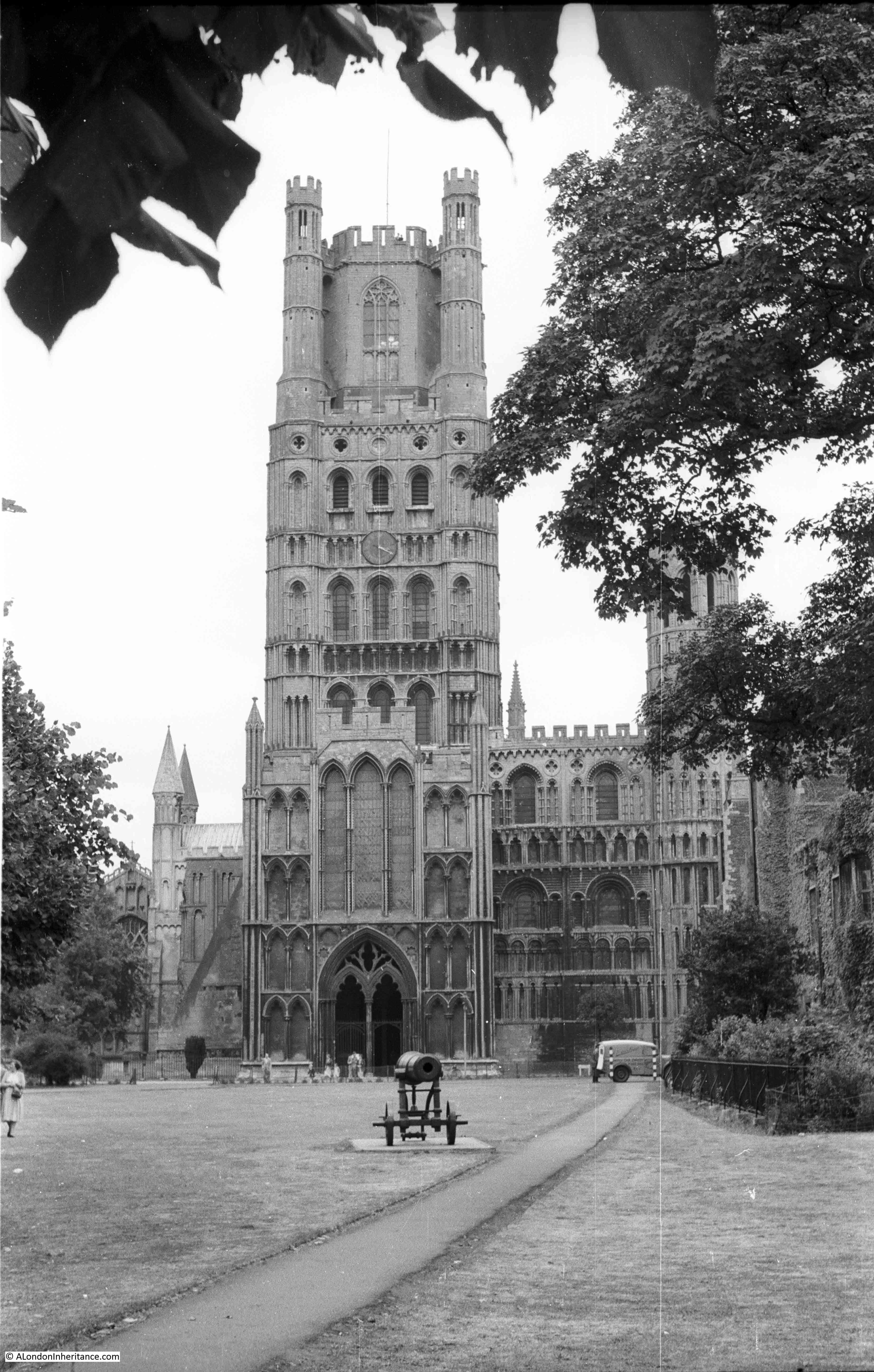
Approaching the cathedral from the west provides a view of the magnificent west tower, standing 215 feet tall. The lower two thirds of the tower date from the 12th century, with the upper section being added in the 14th century. The view in 1952:

Ely Cathedral

The same view today:

Ely Cathedral

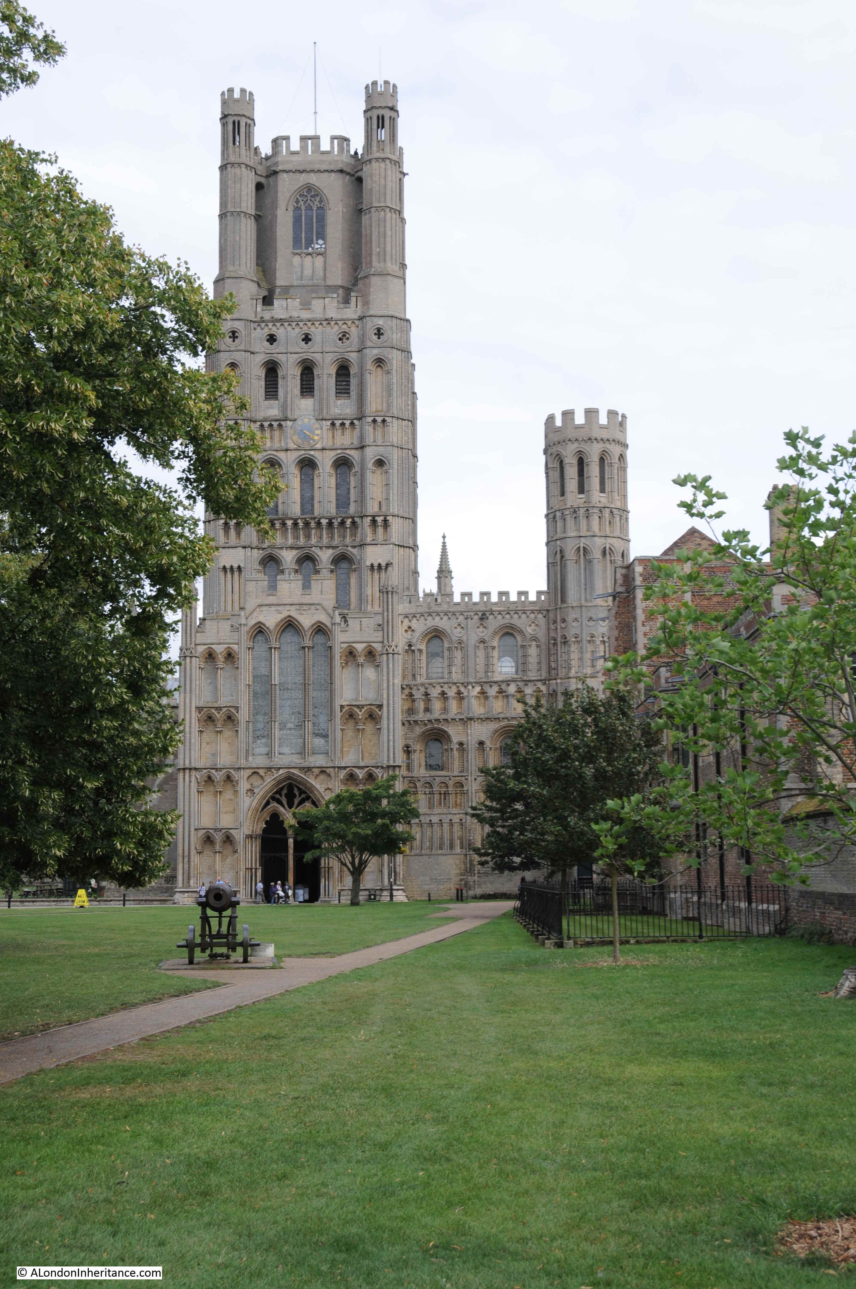
In the foreground in both photos is a cannon. This is a Russian cannon captured during the Crimean war and was presented to Ely in 1860 by Queen Victoria to mark the creation of the Ely Volunteer Rifles.

The walls of an old building can just be seen to the right of the above photos. This is the Old Bishop’s Palace building:

Ely Cathedral

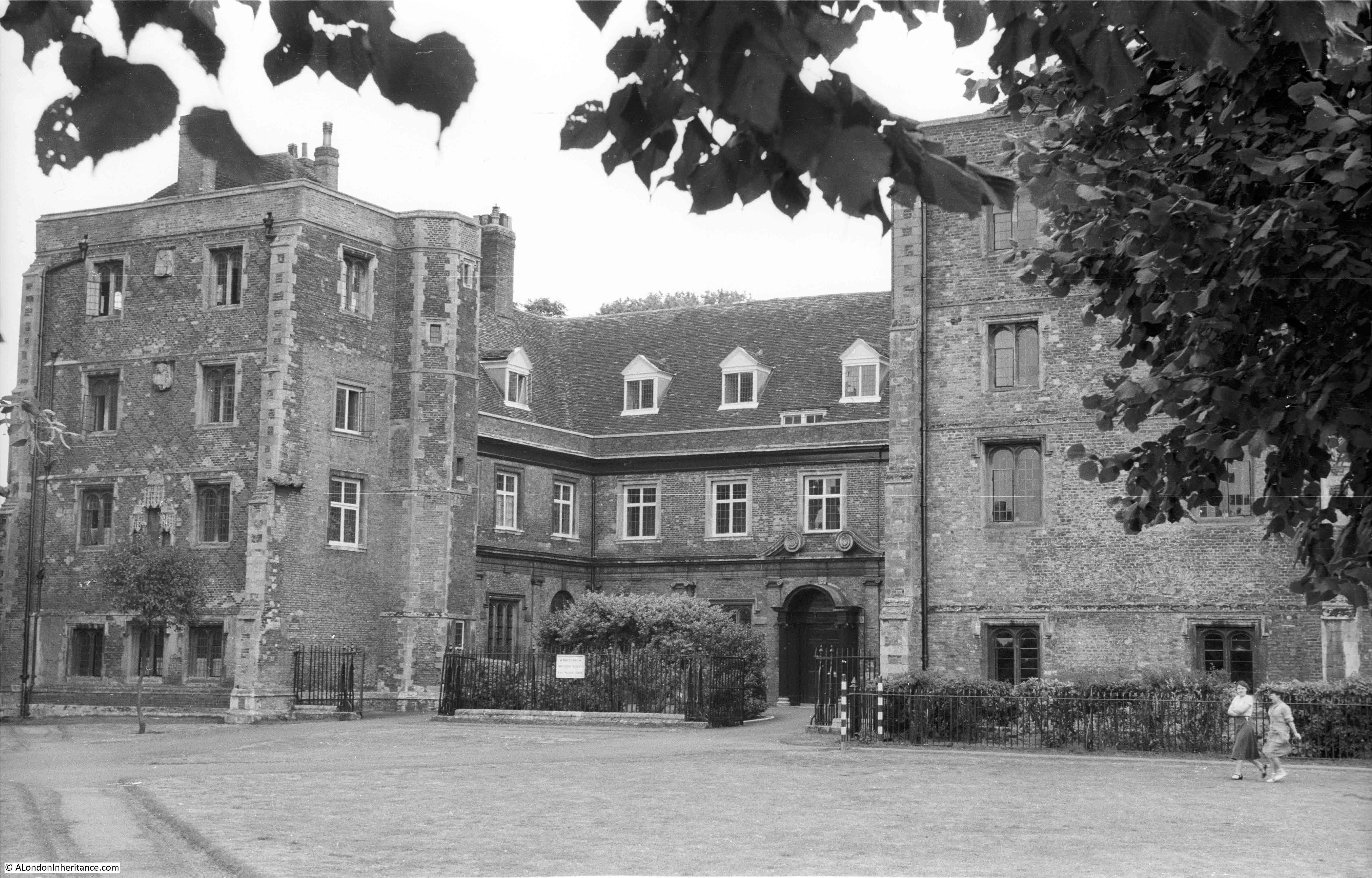
1952 above and 2019 below. I suspect that is the same tree to the left of the photo showing 67 years growth.

Ely Cathedral

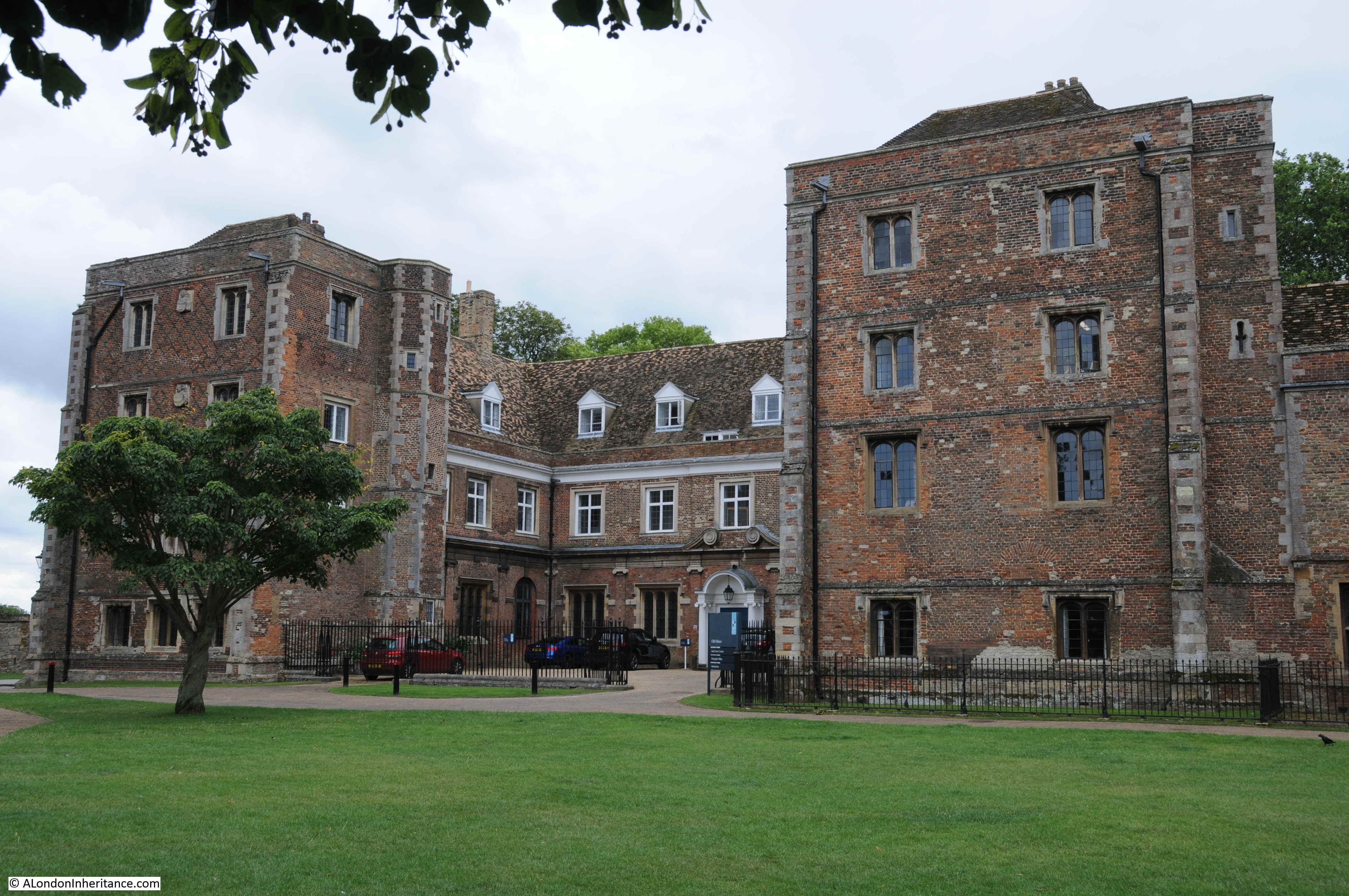
The Old Bishop’s Palace dates from 1486 when it was built by John Alcock. It was the home of the Bishop’s of Ely from 1486 to 1941, when it was taken over by the British Red Cross. The building is now part of King’s Ely public school.

Ely has seen its fair share or religious persecution over the centuries. During the reign of the Catholic Queen Mary I, her attempts to reverse the English reformation and restore the Catholic church resulted in two Protestant martyrs being burnt to death on the green outside the cathedral and Old Bishops Palace.

William Wolsey and Robert Pygot were both from the local town of Wisbech. Wolsey was accused of not attending Mass and also of possessing and reading a smuggled New Testament in English. Pygot was accused of not attending church. They were both burnt at the stake on the 16th October 1555.

Wolsey was almost looking forward to his fate. Foxe’s Book of Martyrs records that in the days preceding his execution “that being wonderful sore tormented in the prison with the toothache, he feared nothing more than that he should depart before the day of execution (which he called his glad day) were come.”

During their execution, copies of the English New Testament were also burnt, and Foxe records that “With that cometh one to the fire with a great sheet knit full of books to burn, like as they had been New Testaments. ‘Oh,’ said Wolsey, ‘give me one of them;’ and Pygot desired another; both of them clapping them close to their breasts, saying Psalm cvi., desiring all the people to say Amen; and so received the fire most thankfully.”

Elizabeth I followed Queen Mary and the country returned on the reformation path of Protestantism. It was now the turn of Catholics to be prosecuted and between 1577 and 1597 the Old Bishops Palace was used as a prison for “Catholic Recusants”  – those who remained loyal to the Pope and the Roman Catholic Church. Thirty two recusants were held in the Palace buildings between the years 1588 and 1597 during the reign of Elizabeth I.

Fortunately Ely is a far more peaceful place today.

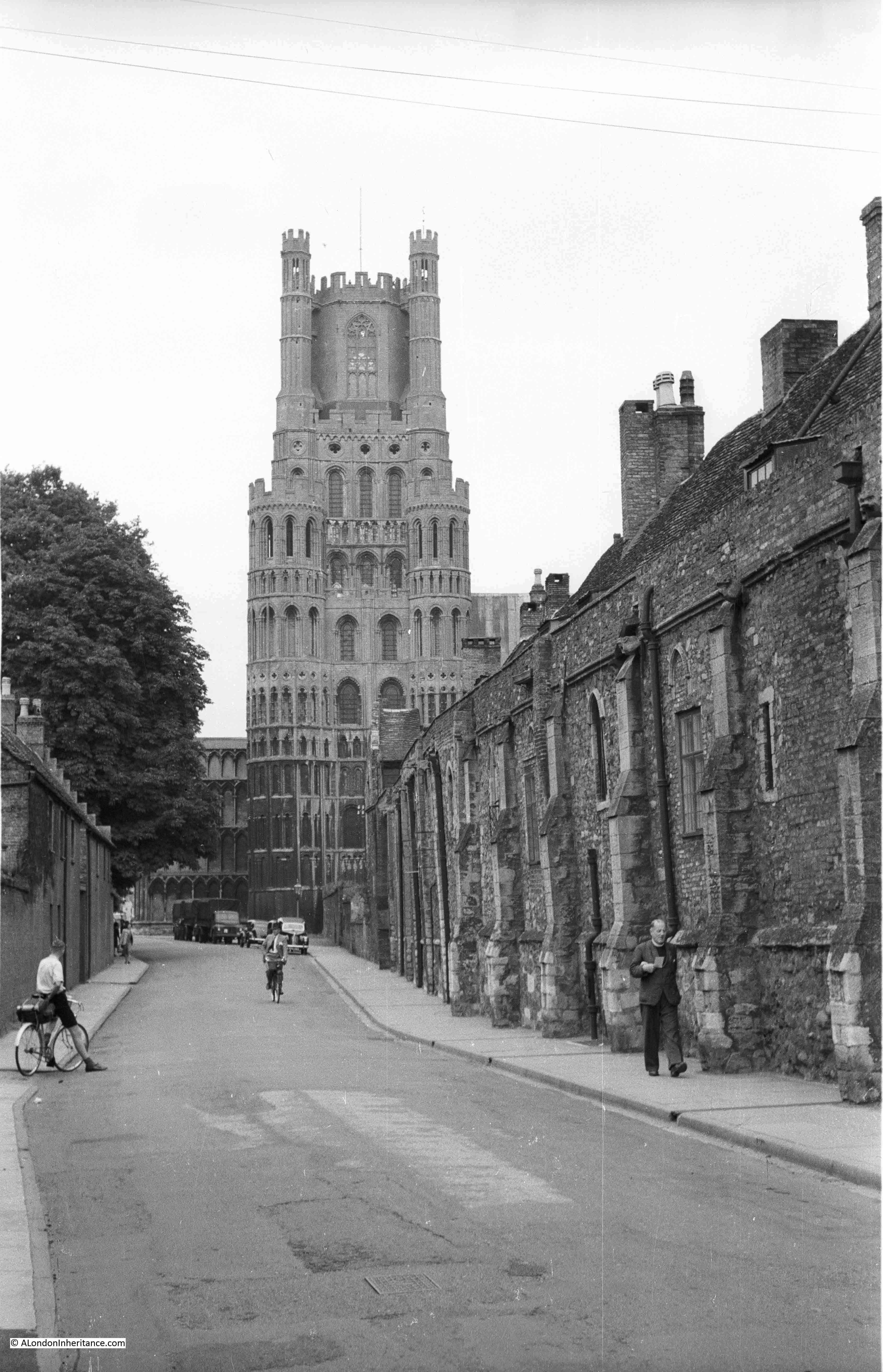
The street that runs in front of the main entrance to the cathedral has the unusual name of “The Gallery”. I will visit the cathedral later, but to find the location of more of my father’s photos, I turned right along The Gallery, and walked alongside the buildings that are currently the home of the Bishop of Ely.

This was the view looking back towards the cathedral in 1952:

Ely Cathedral

The same view in 2019:

Ely Cathedral

Further back along The Gallery, and here to the right we can see the external structure of the Octagon, one of the magnificent internal features of Ely Cathedral.

Ely Cathedral

The same view in 2019:

Ely Cathedral

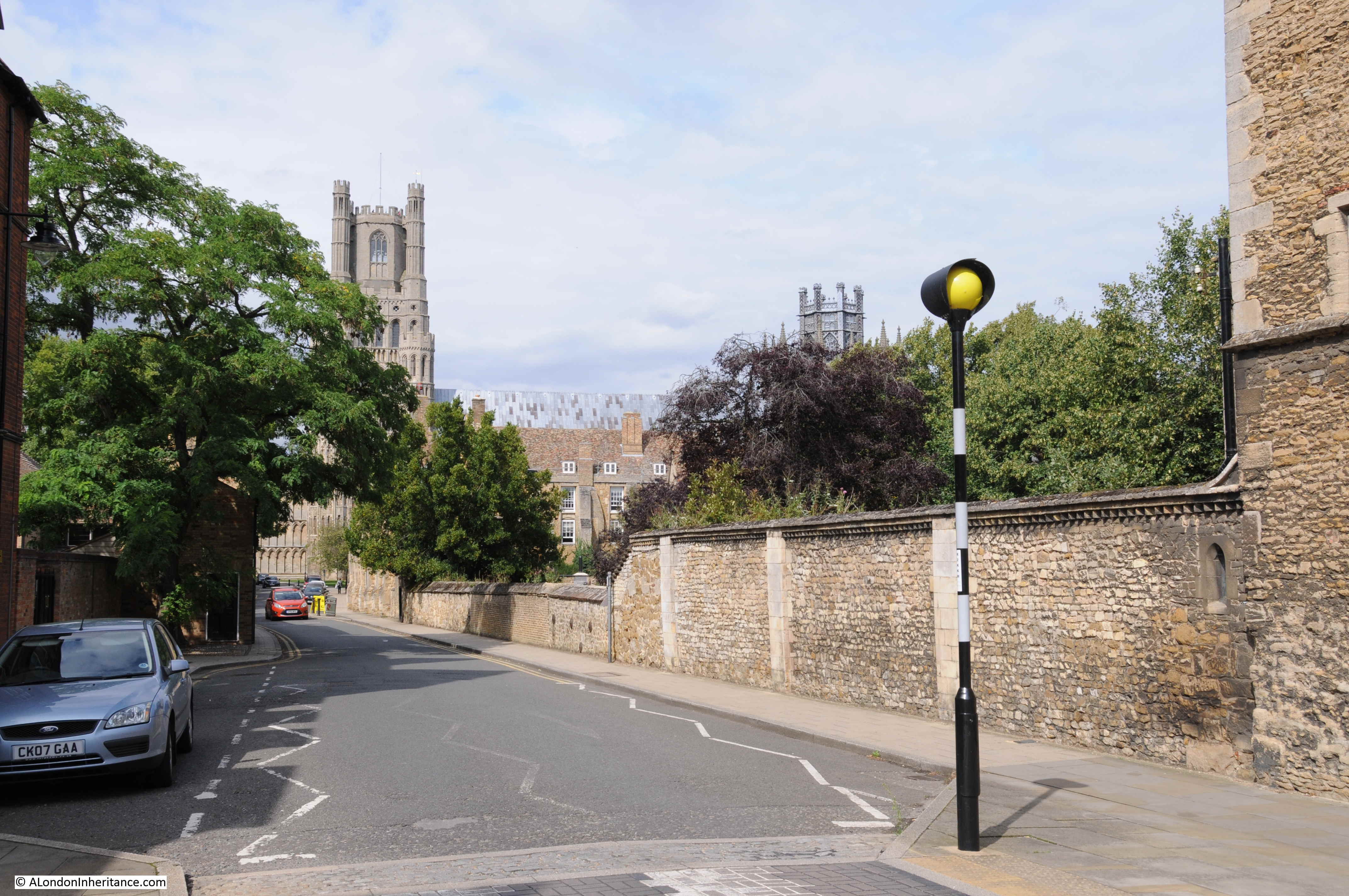
Along the cathedral side of the street, The Gallery has the Bishop’s residence, the external wall of a walled garden, and at the end of The Gallery is the gatehouse shown in the photo below. At the end of The Gallery, the street joins Back Hill which then descends to the River Great Ouse. The downwards slope of the street away from the cathedral down towards the river helps demonstrate that the cathedral was built on higher ground in a low lying region.

Ely Cathedral

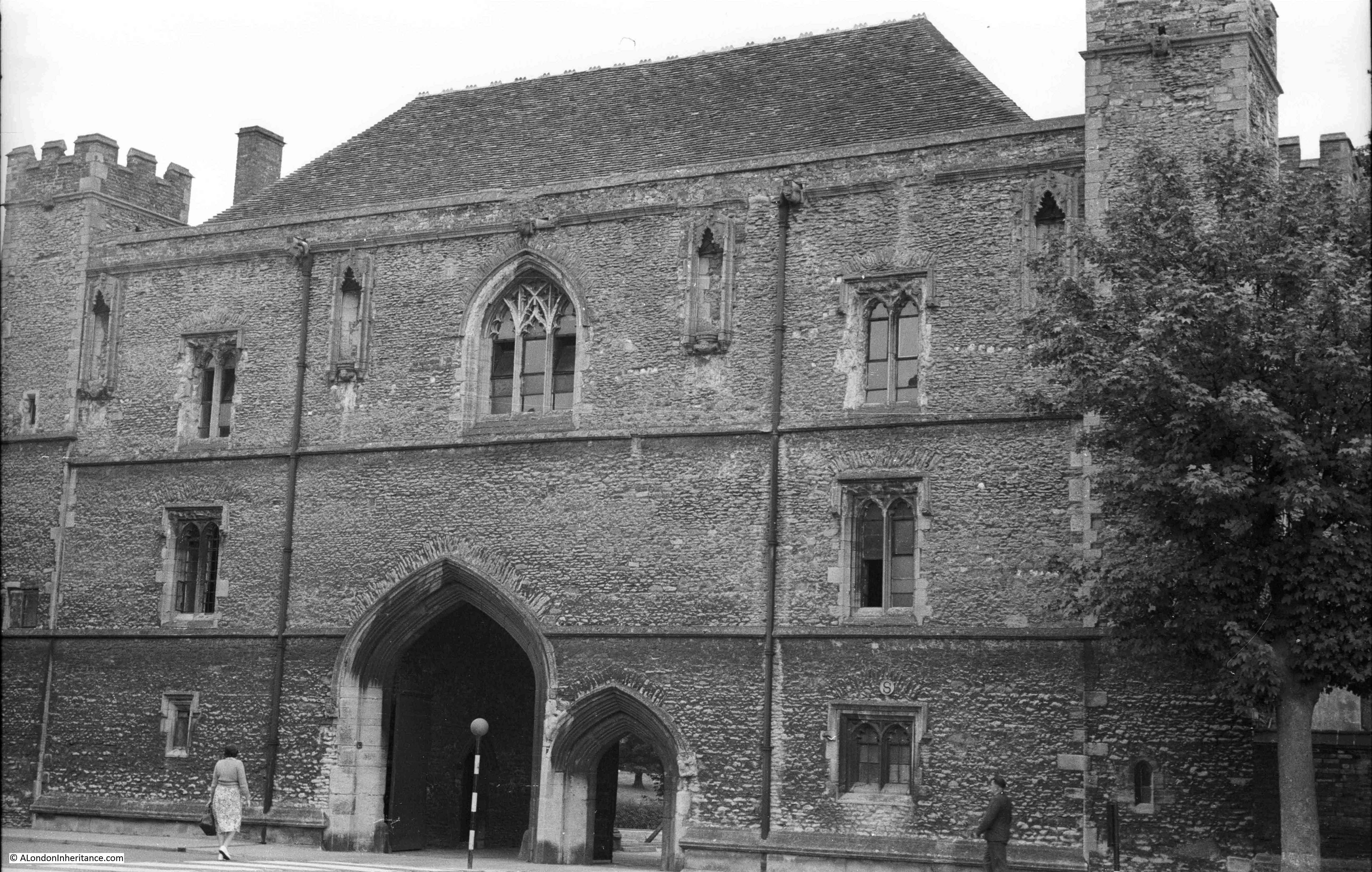
The Gatehouse today:

Ely Cathedral

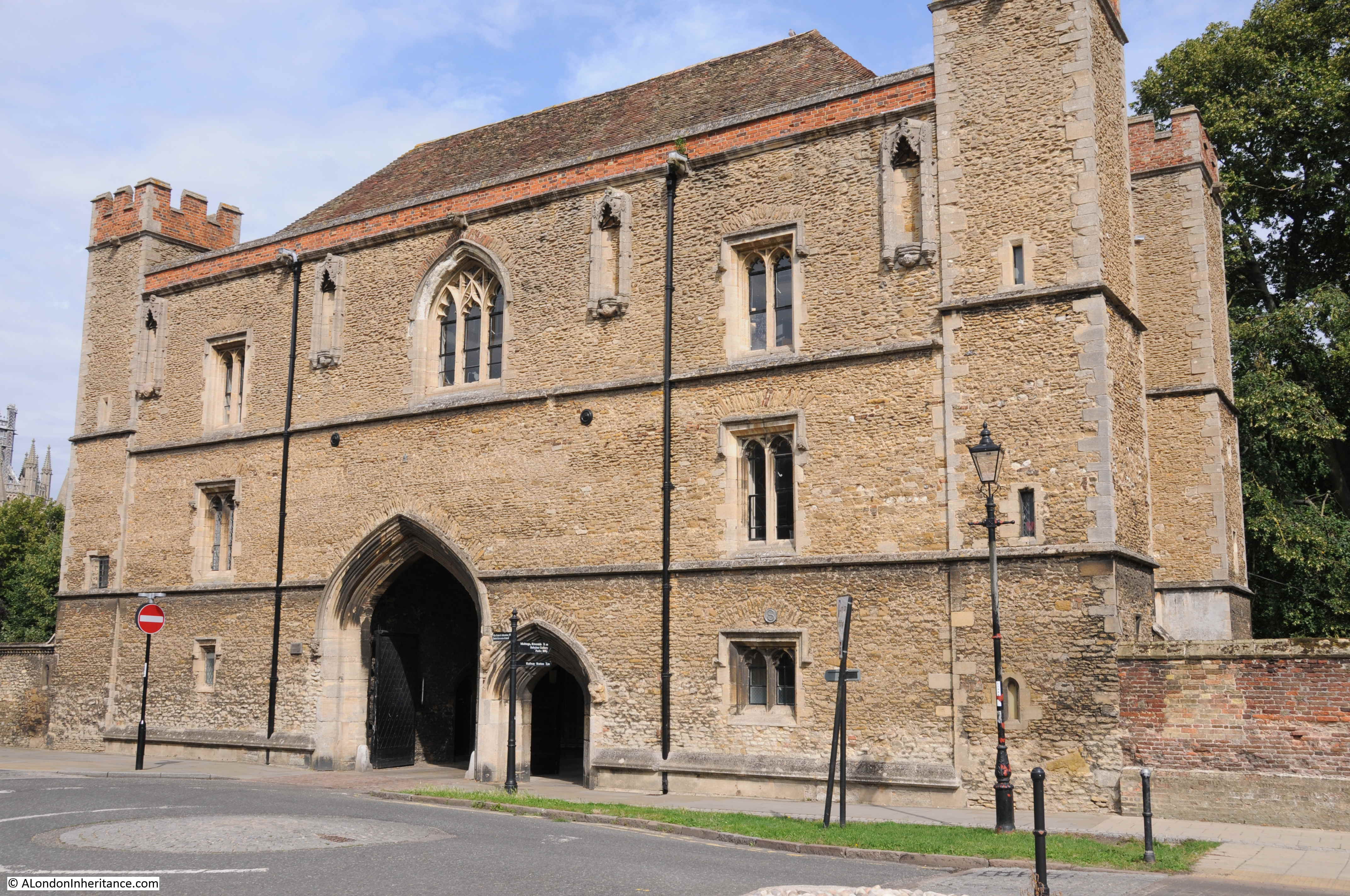
The Gatehouse leads into Cherry Hill Park, an open space which includes Ely Castle Mound, the site of a long demolished castle. The park also provides a walkway down to the river, with superb views of the southern facing side of the cathedral.

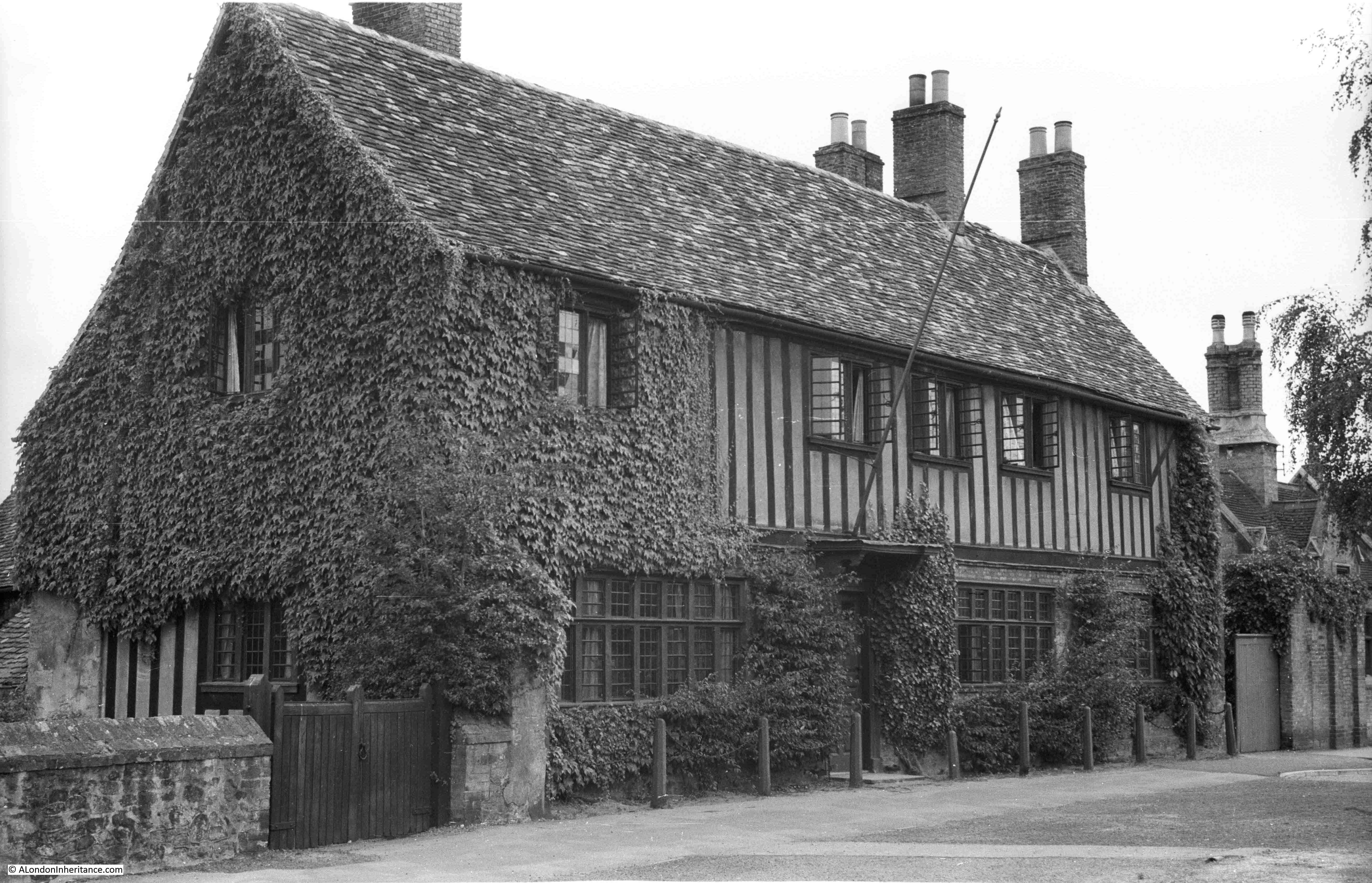
There is another historic building in Ely which my father photographed in 1952. Oliver Cromwell, who led Parliament’s forces to victory during the Civil War and led the country as Lord Protector during the period of the Commonwealth, lived in Ely between 1636 and 1646.

This was Oliver Cromwell’s house in 1952:

Ely Cathedral

The same house in 2019:

Ely Cathedral

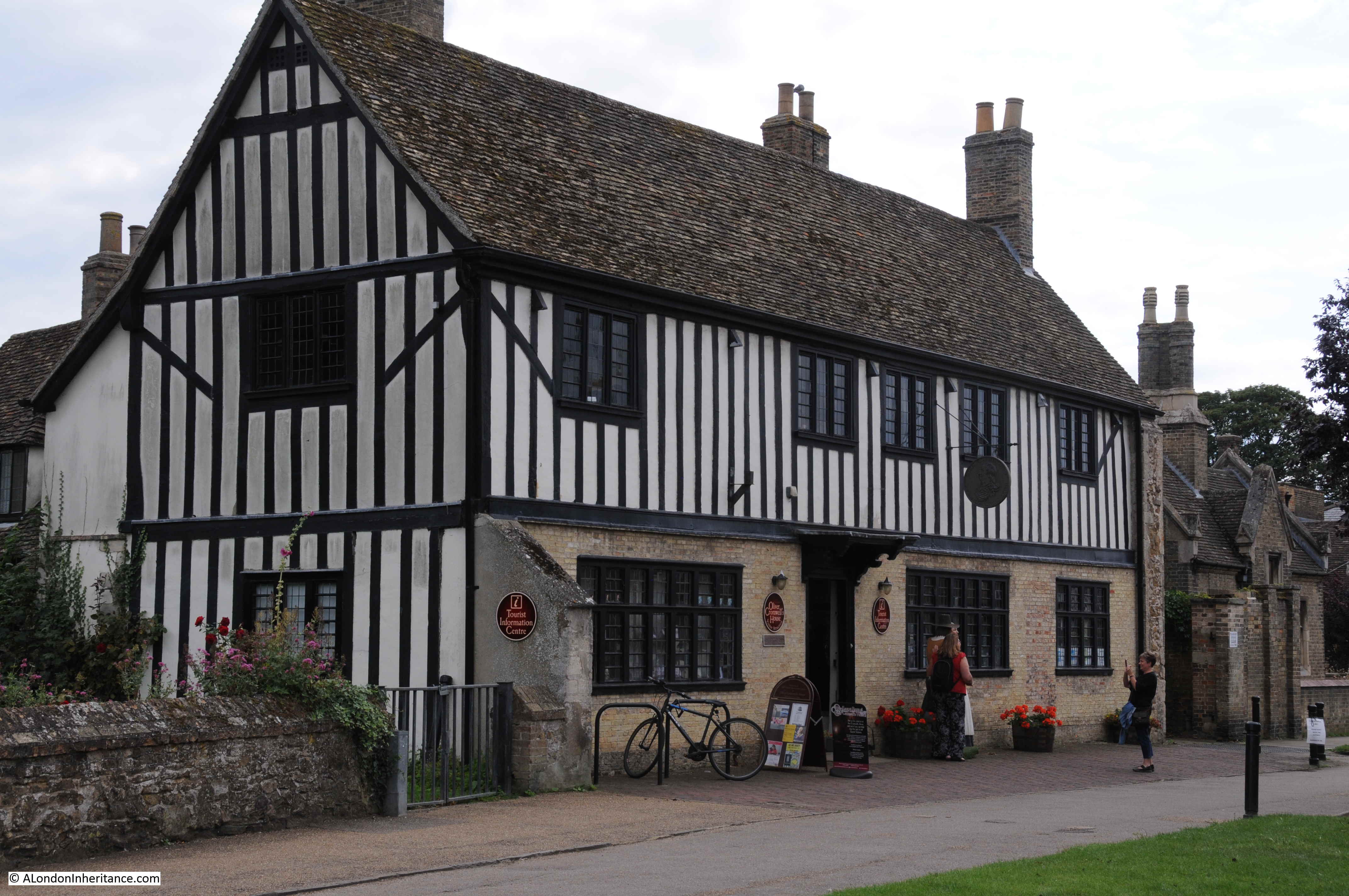
Cromwell inherited the house along with a number of other properties in Ely from his uncle. He was firstly the MP for Huntingdon, then from 1640 the MP for Cambridge, and raising troops to defend Cambridge was one of his first actions at the start of the civil War, including a number of soldiers from Ely.

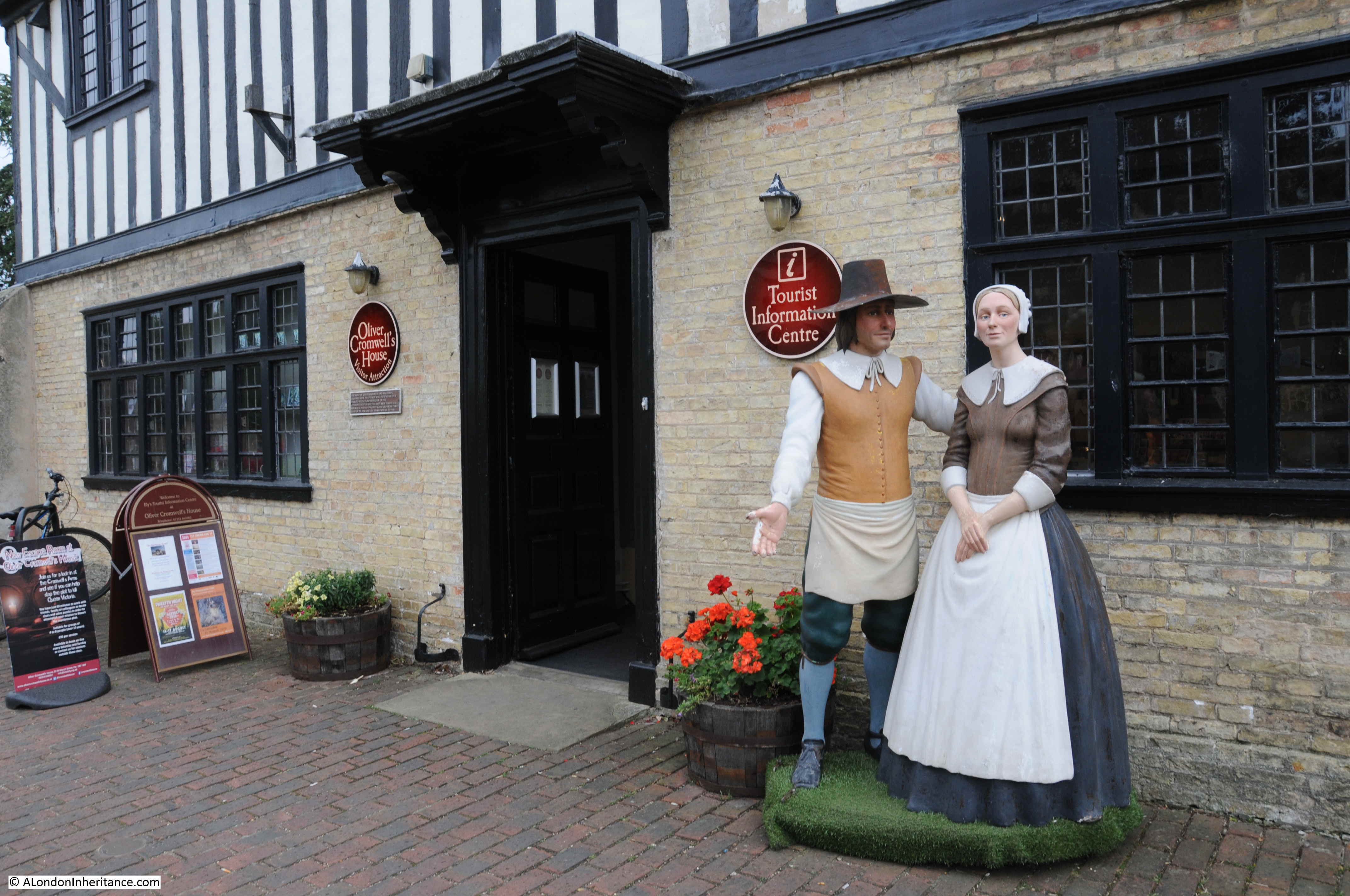
The building today has a Tourist Information Office and also has a Civil War Exhibition. The building also hosts Murder Mystery evenings and an Escape Room – all the commercial things that historic buildings without large numbers of visitors need to do to survive.

Ely Cathedral

I could not find the location of the following photo:Ely Cathedral

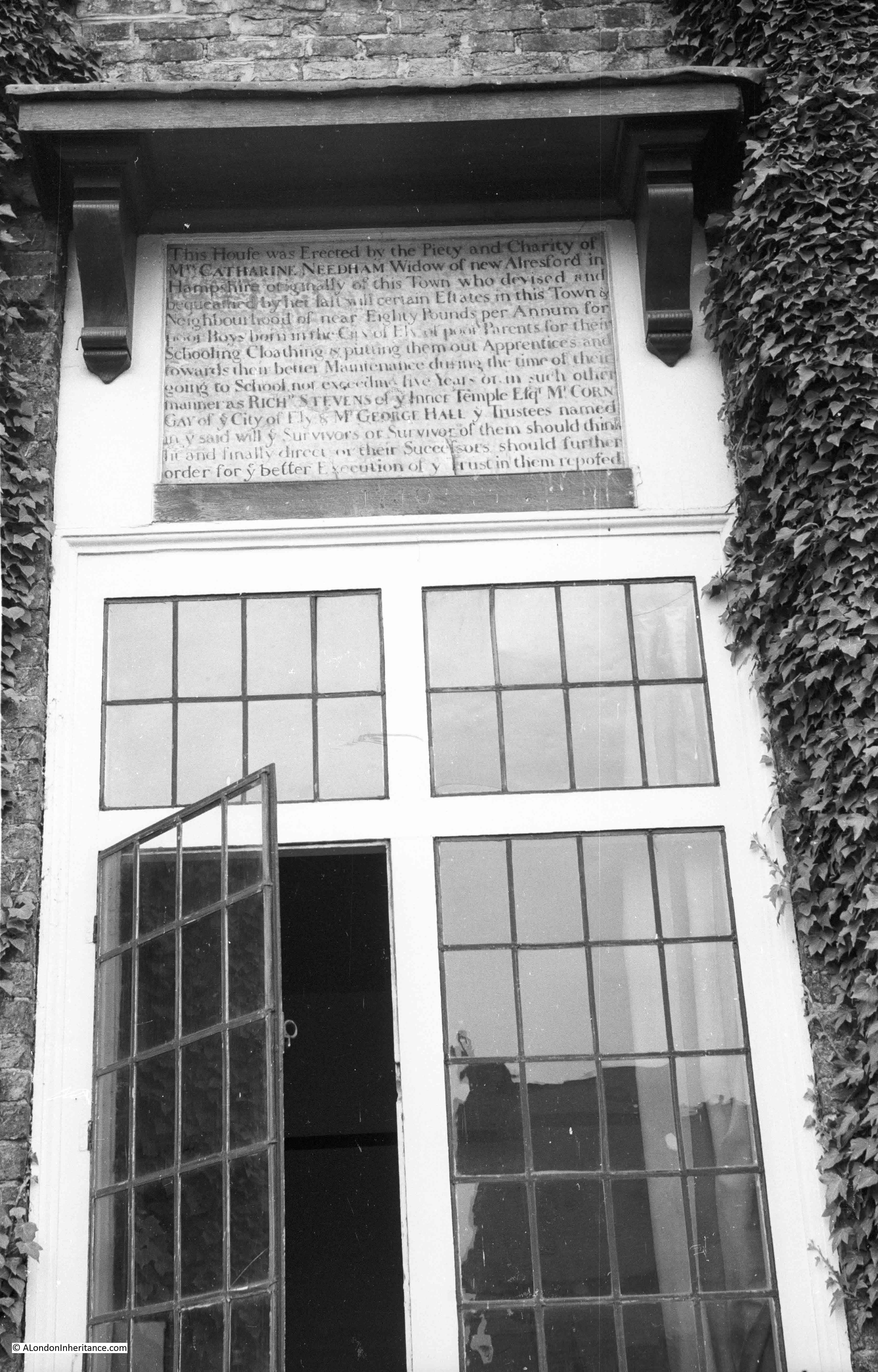
We walked around all the buildings that look as if they would have such a window, but could not find the location. I suspect it is within the King’s Ely school.

The inscription tells that the house was erected by the piety and charity of Mrs Catherine Needham, Widow of New Alresford in Hampshire, but originally of Ely. She left certain estates in the town and neighbourhood of nearly eighty pounds per annum, to be used for poor boys born in the City of Ely of poor parents. For their school clothing and putting them out as apprentices.

Having had a walk around the town, the next stop was to visit the inside of Ely cathedral.

Ely Cathedral occupies a site with a long religious history – from a time when the area occupied by the town was surrounded by marsh and water.

Originally, a monastery founded by Etheldreda, an Anglo-Saxon queen in 673, was built on the site of Ely Cathedral. The site was probably the location of an earlier religious building.

Etheldreda reached Ely after fleeing from her husband, the King of Northumberland. The Isle of Ely was part of her wedding dowry.

The monastery was a mixed community of both monks and nuns.

Etheldreda would be viewed as one of the more important English saints, compared with St Cuthbert, and Thomas Becket. Bede portrayed her as an English version of the Virgin Mary.

After her death, she was buried in the monastery, and her body was believed to be incorruptible.

In the 10th century, Ethelwold, the Bishop of Winchester converted Ely into a Benedictine Monastery, and the Isle of Ely was defined by King Edgar as a Liberty and therefore free of royal interference.

The next name from history to pass through Ely was Hereward the Wake, an Anglo Saxon noblemen and one of the rebels against the Norman Conquest who assembled in Ely in 1071. William the Conqueror sent a force which surrounded Ely. There are various legends as to how Ely was taken, that the Norman’s built a causeway over the marshy land, that they bribed a monk to show them a safe route into the town or that the majority of the would be rebels negotiated. However Ely was taken, Hereward the Wake apparently disappeared into the marshes, and again become a figure of legend, possibly being pardoned by William, hiding in Scotland or being ambushed and killed by Norman knights.

Building of a new Norman cathedral that would replace the Anglo-Saxon monastery could now commence, and this was started in 1082 by Simeon who was the brother of the Bishop of Winchester. Work on the new cathedral was slow and gradual, with the style changing over the years as new Bishop’s took over and new design approaches were tried.

Bishop Ridel was appointed in 1169 and completed work on the Gothic west front.  The church had a Norman central tower, however in the early 14th century this would collapse leading to one of the most beautiful features of the cathedral we see today, being constructed in its place.

This was the central Octagon which required far more substantial foundations than those that supported the Norman tower, so parts of the central church were demolished to create a large space for the Octagon supporting structure to be built, and foundations were dug down to a depth of 3m. At the very top of the Octagon is a magnificent lantern.

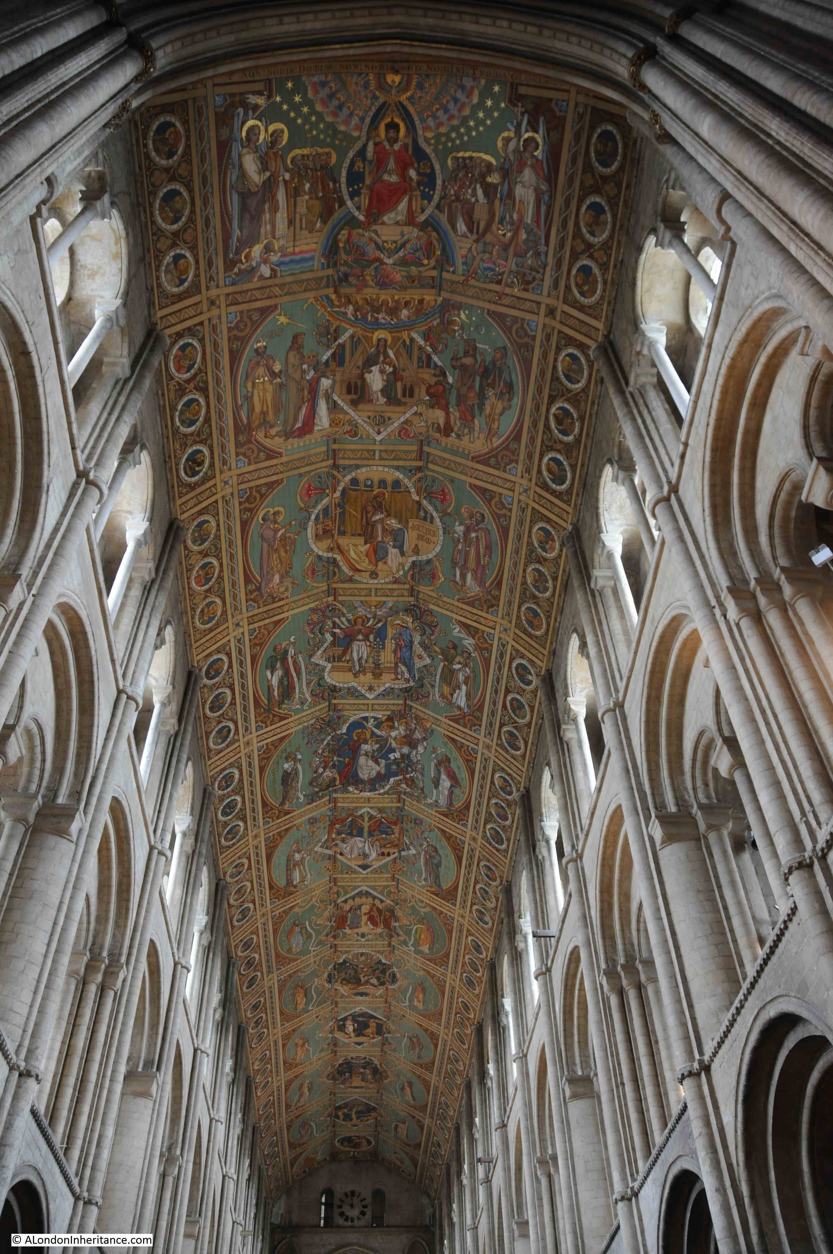
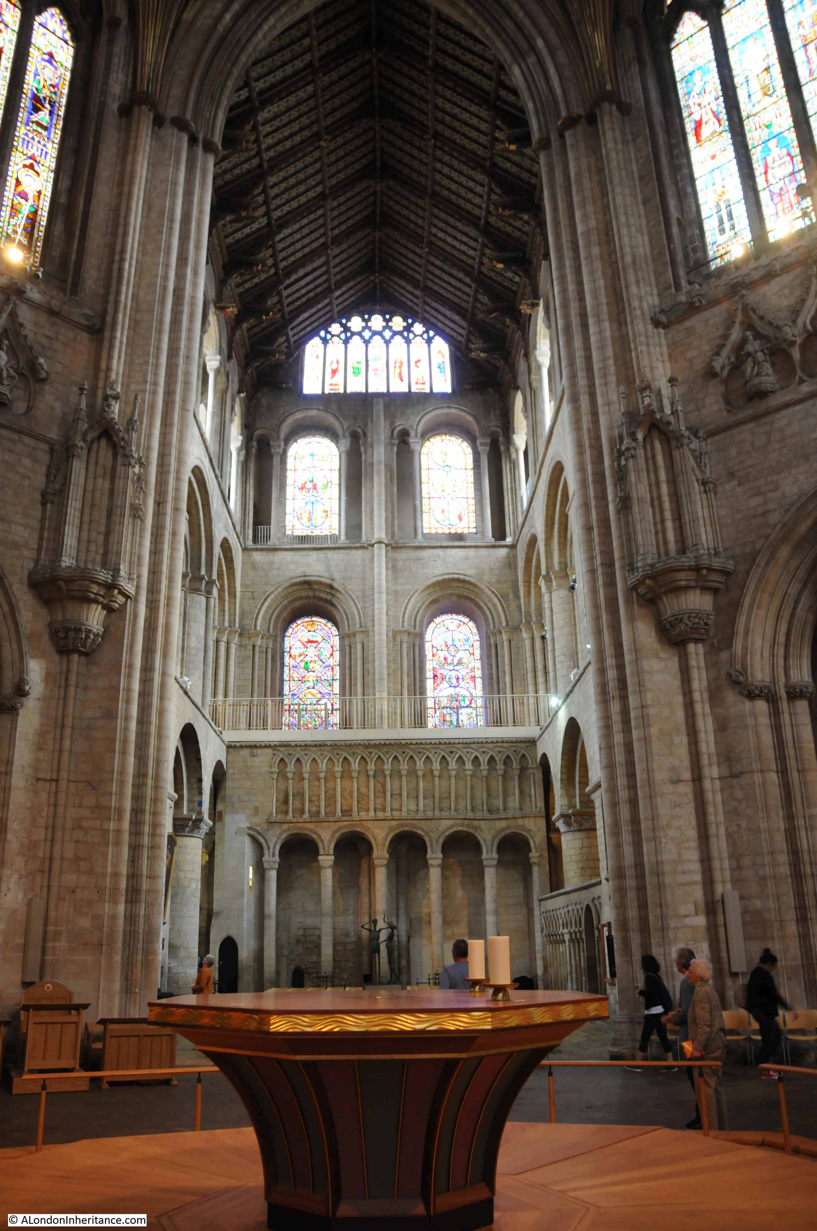
The view of the nave after entering Ely Cathedral:

Ely Cathedral

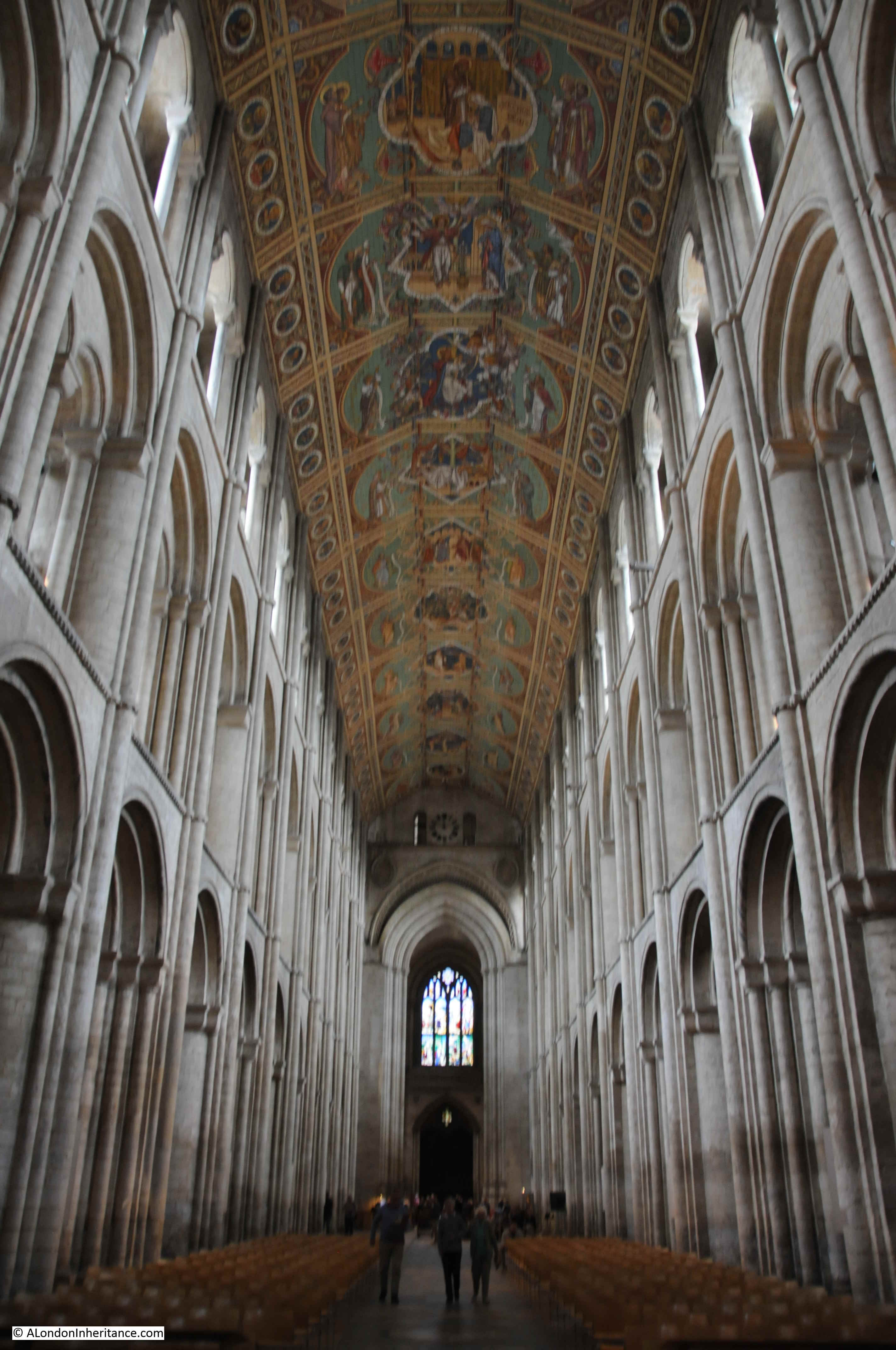
The painted roof was part of the Victorian restorations of the cathedral, and is the work of two artists, Henry Styleman Le Strange and Thomas Gambier Parry, who painted the final six of the panels – you can see the change of style halfway along the roof.

Ely Cathedral

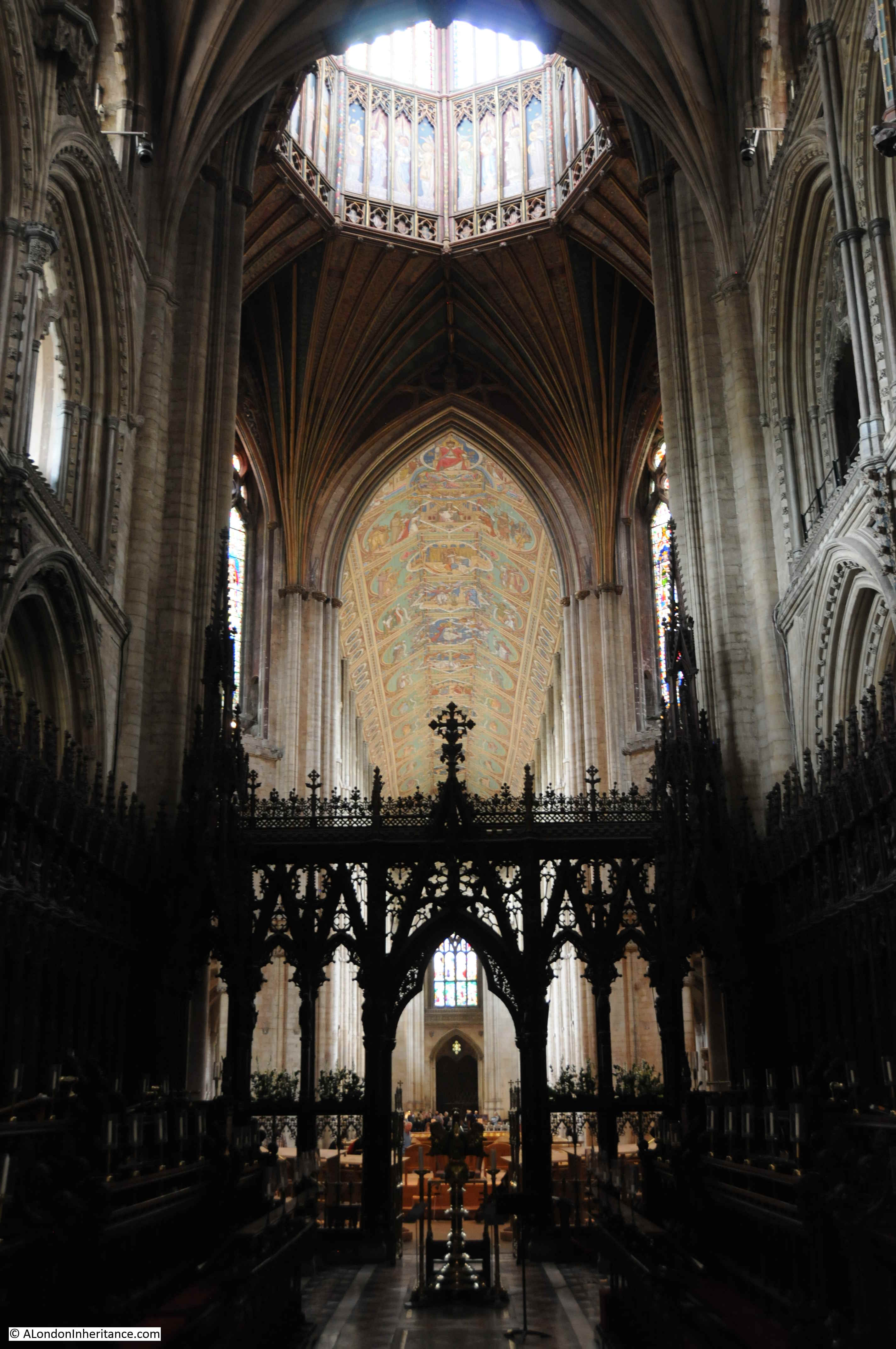
Underneath the Octagon – a magnificent example of medieval architecture and construction.

Ely Cathedral

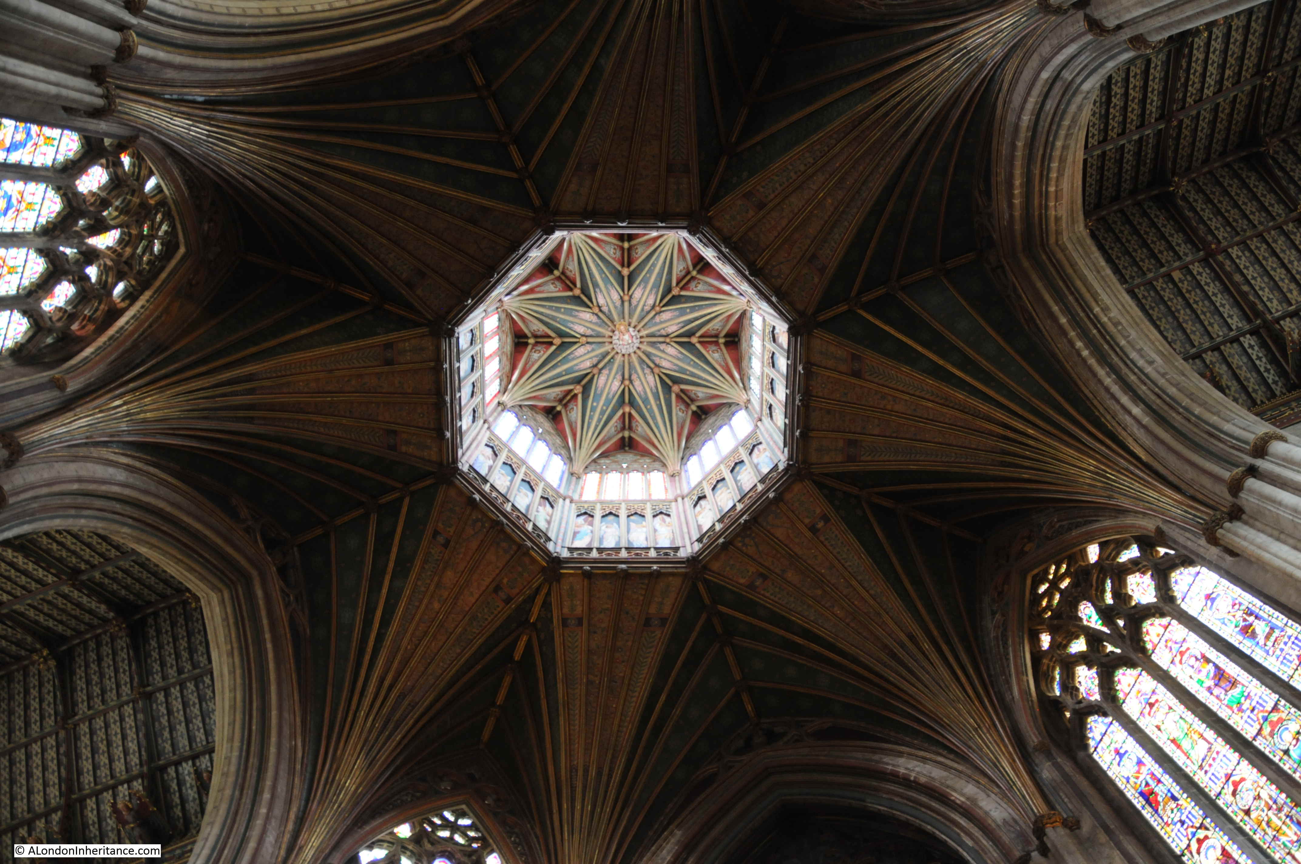
Occupying the space of the collapsed central Norman Tower, the pillars were moved further out to enlarge the central space, and were built on much firmer foundations.

The Octagon is topped by a central Lantern and is built of wood covered in lead to reduce weight, as a stone lantern would have been too heavy for the pillars to support.

The height of the Octagon is 142 feet, and was the work of Alan of Walsingham. John of Burwell carved the central image of Christ and in total, the Octagon took 18 years to complete.

Close-up view of the lantern:

Ely Cathedral

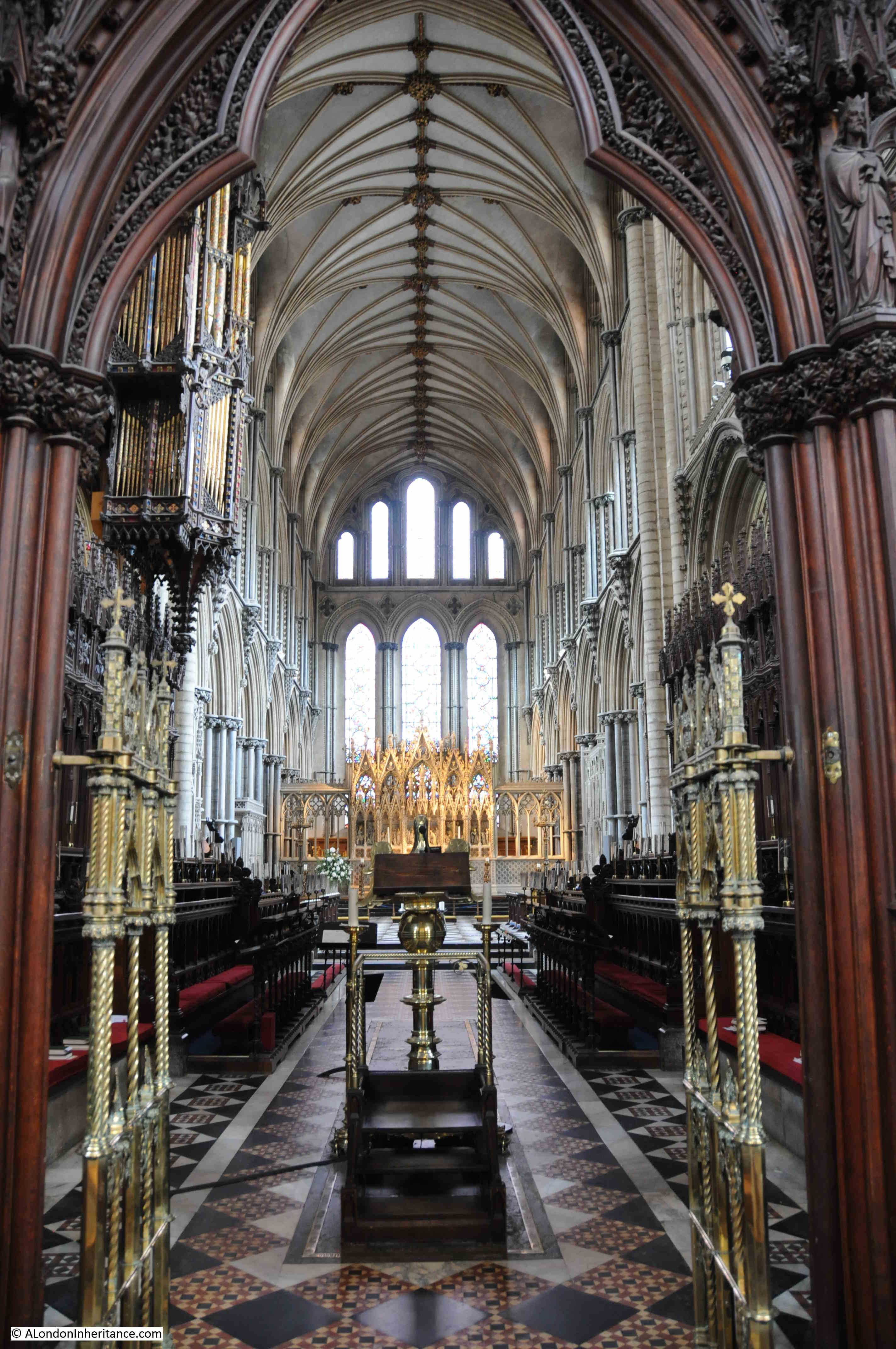
The space directly underneath the Octagon is occupied by an octagonal altar:

Ely Cathedral

The Octagon and Nave viewed from the Choir:

View towards the north transept and the choir:

Ely Cathedral

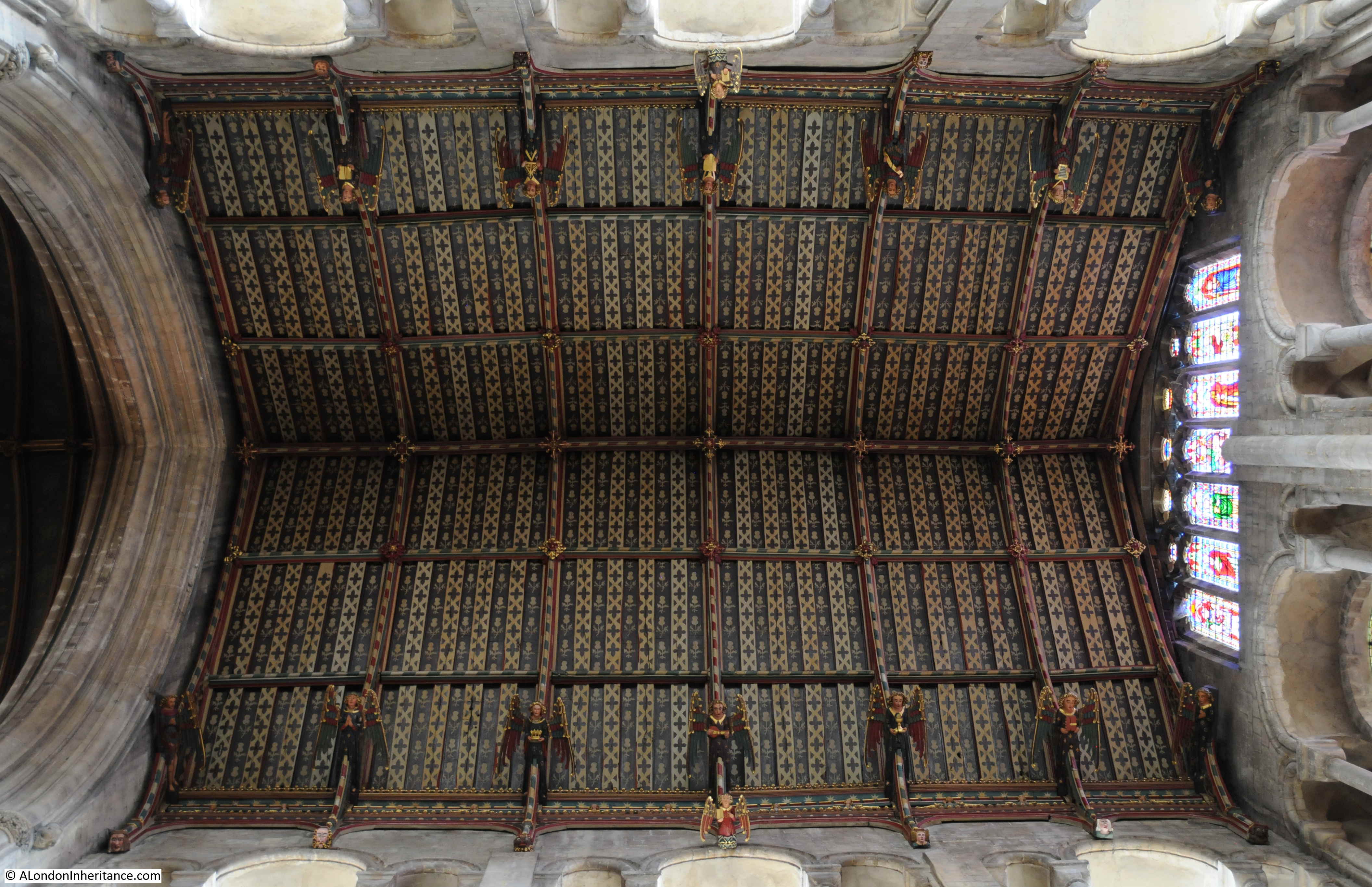
Mid fifteenth century hammer beam roof with flying angels of the south transept:

Ely Cathedral

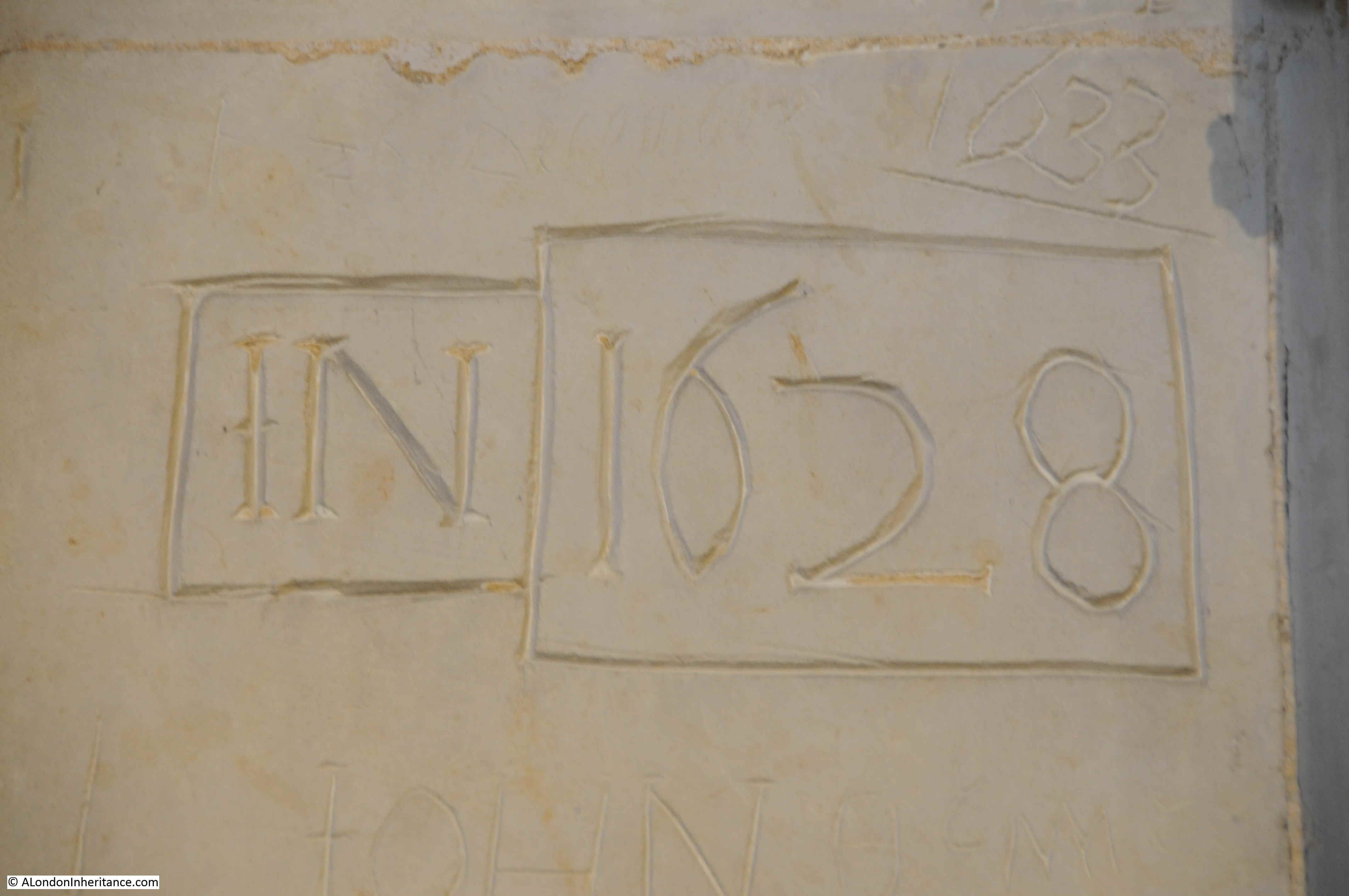
There is a remarkable amount of graffiti across the cathedral. If this happened today we would condemn such an activity, but graffiti from the past is often preserved and studied. Does make you wonder who IN was and what he was doing in Ely Cathedral in 1628 (assuming they are the initials of a person).

Ely Cathedral

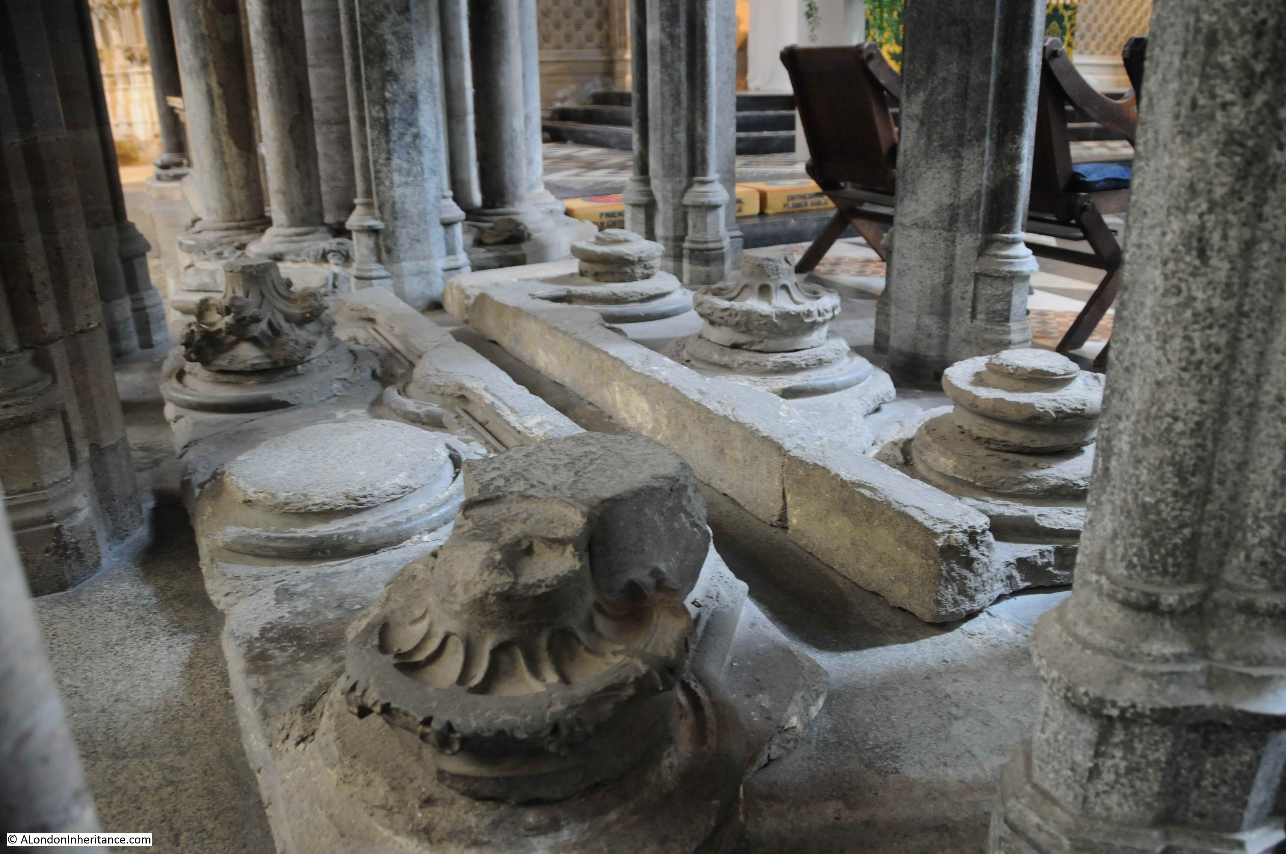
The remains of the canopy of a stone tomb. An information panel states that these have been mistaken as part of the Shrine of St Etheldreda. The Shrine was destroyed during the Dissolution of the Monasteries during the reign of King Henry VIII.

Ely Cathedral

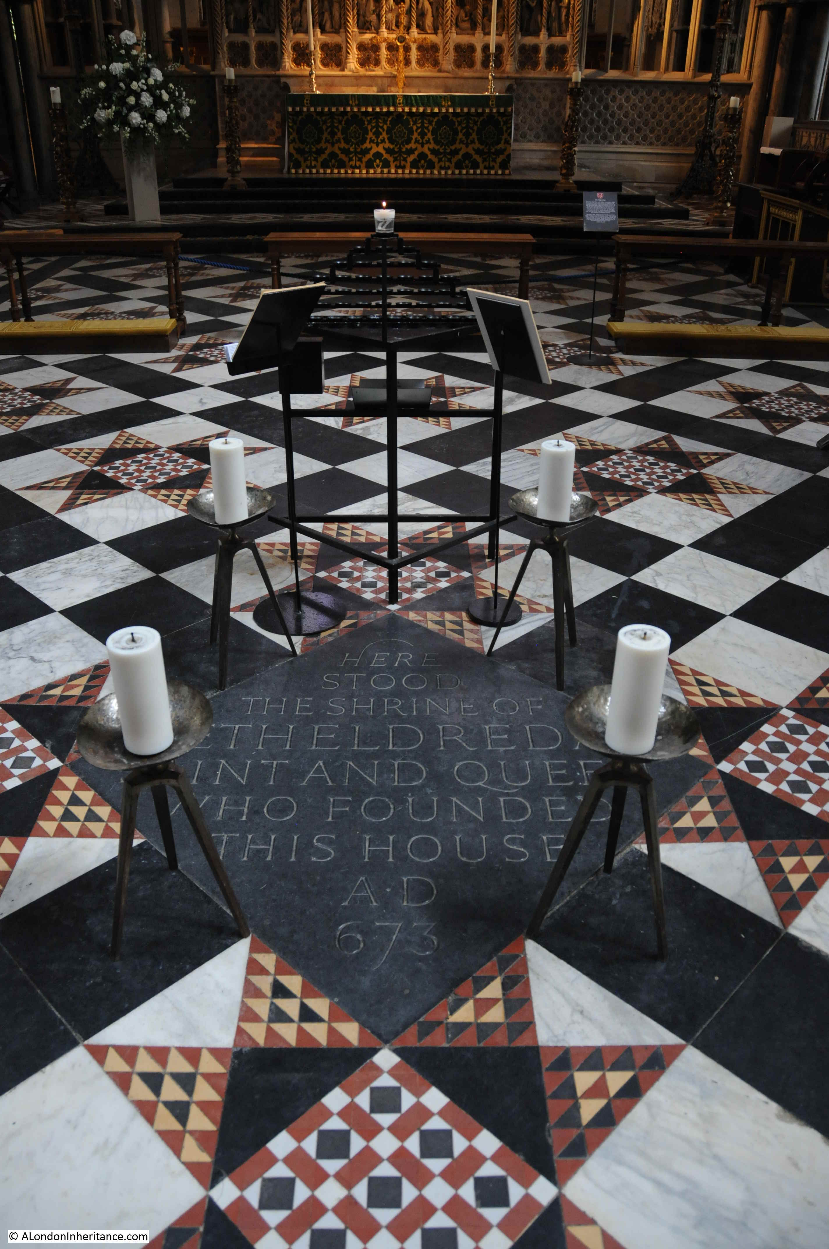
A plaque set into the floor marks the spot where the Shrine of St Etherdreda was located:

Ely Cathedral

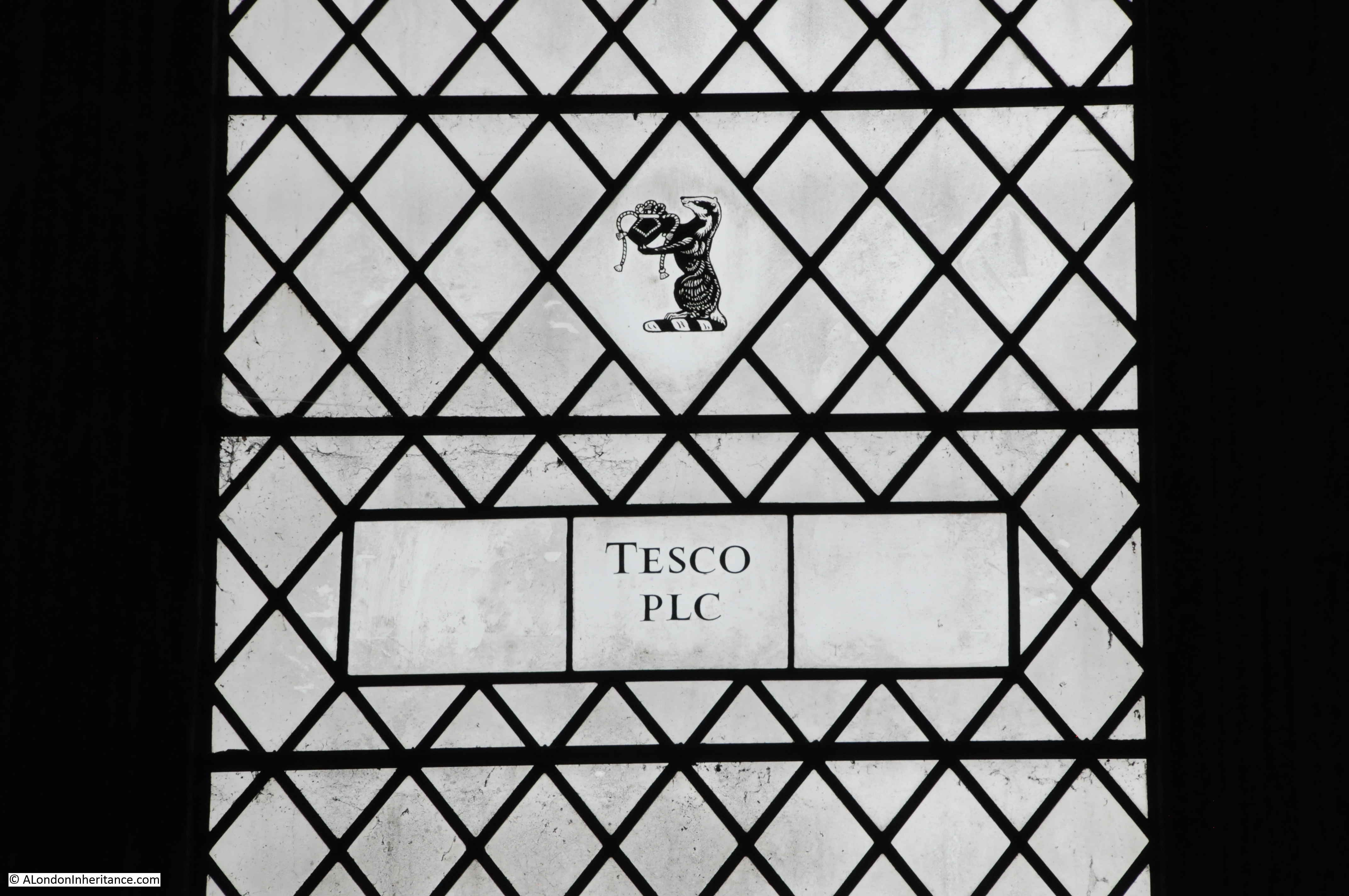
The Lady Chapel includes unusual additions to the windows. The names of companies that have contributed to the cathedral.

Ely Cathedral

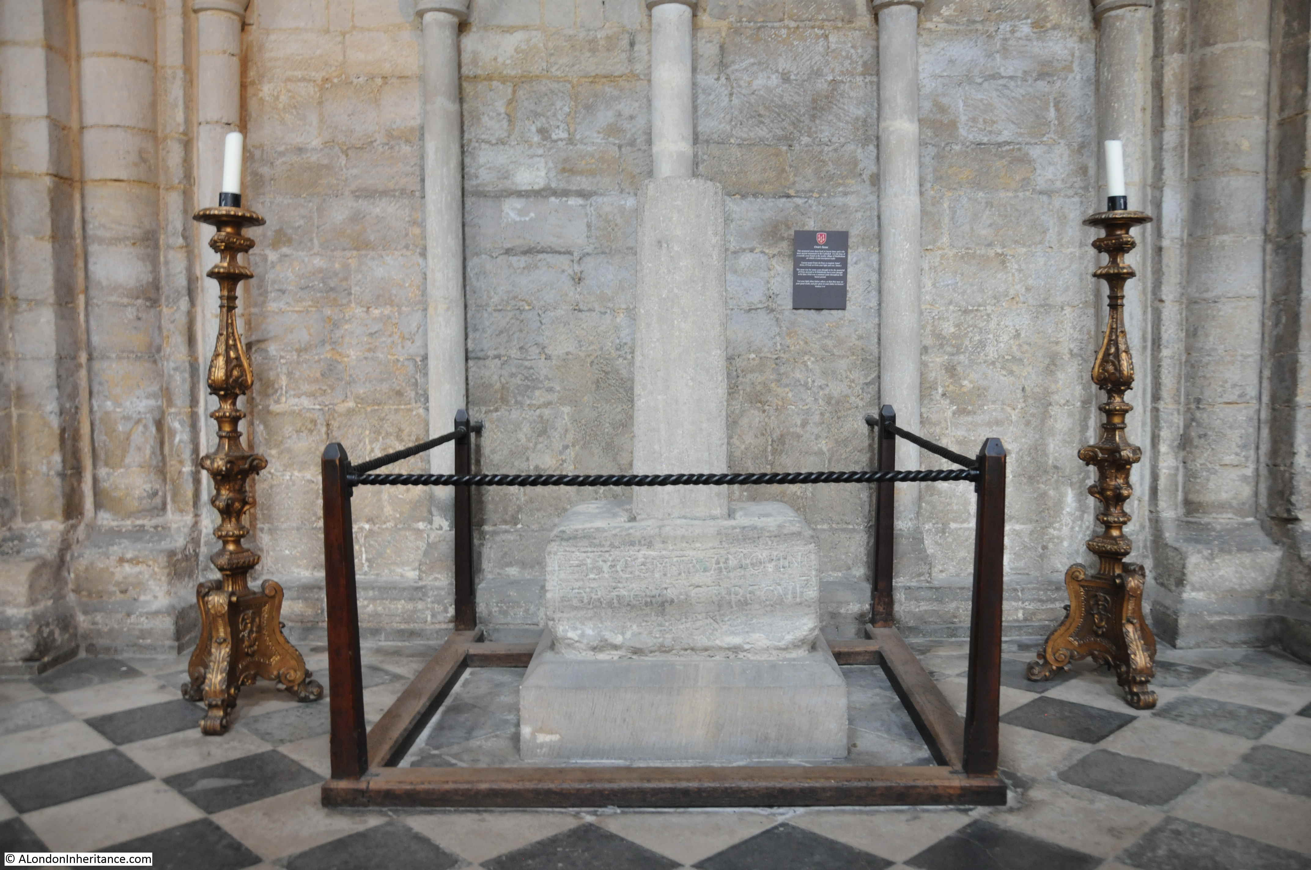
There is the base of a wayside Saxon cross in the Cathedral, oldest of all the monuments. It was found in the nearby village of Haddenham and the Latin inscription on the base reads “Give, O God, to Ovin your light and rest”. Ovin was apparently a common Saxon name.

Ely Cathedral

I have only just scratched the surface of the history, architecture and story of this wonderful city. The Cathedral is stunning. As you approach Ely, the cathedral rises up above the surrounding landscape, and must have been even more dominant during the medieval period.

Walking the side streets reveals many more historic buildings. The River Great Ouse has played a part in Ely’s history and the drainage of the surrounding marshland which has transformed Ely from the Isle of Ely, to the city we see today. I doubt Hereward the Wake would recongise the landscape if he could return.

After a long walk around the city, we returned home. After his visit in July 1952, my father headed to Ely Youth Hostel, which I suspect by today’s Youth Hostel standards, was rather basic. A long bike ride from London.

Ely Cathedral

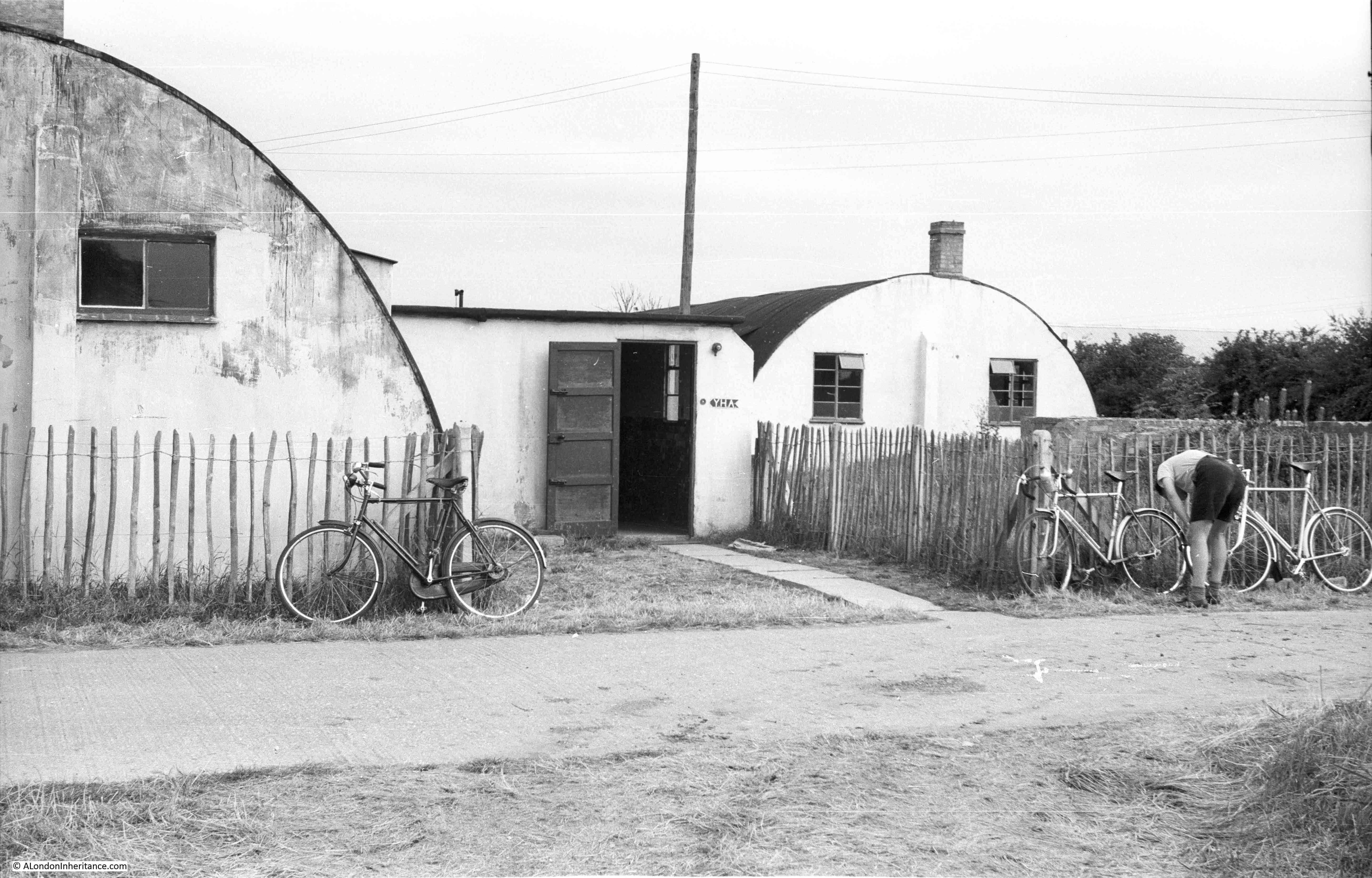
Ely Youth Hostel Dining Room.

Ely Cathedral

Ely is on my list of places to return – which at the moment is getting longer every day.

alondoninheritance.com

Shadwell Dock Stairs

Six week’s ago, I walked along the north bank of the Thames from Tower Bridge to the Isle of Dogs, hunting some of the stairs down to the river. I am trying to trace all those that have been lost, and visit all those that remain. I have already covered a number of these fascinating places, and for this post I am at one of the probably lesser known stairs, Shadwell Dock Stairs.

The red circle in the following map extract shows the location of the stairs, between King Edward Memorial Park and the entrance to Shadwell Basin  (Map © OpenStreetMap contributors).

Shadwell Dock Stairs

Shadwell Dock Stairs are shown on the 1894 Ordnance Survey map, but in a rather unusual location as they are almost hard up against the entrance to the Shadwell New Basin. This was the eastern entrance to the London Docks, so must have been a busy place with ships entering and departing from the London Dock complex.

Shadwell Dock Stairs

Credit: ‘Reproduced with the permission of the National Library of Scotland’ 

The reason they are there is explained by looking at an earlier map, the 1746 Rocque map of London which shows the stairs in place, long before the build of the Shadwell Basin. They are highlighted by the red oval in the following map.

Shadwell Dock Stairs

The above map also explains the source of the name. If you look to the left of the stairs, there is a narrow channel leading a short distance inland to the street Lower Shadwell. This channel of water is named Shadwell Dock. There is a Timber Yard across the street, so perhaps Shadwell Dock was the route by which timber was landed to be moved to and from the Timber Yard.

So, I suspect it is safe to assume that Shadwell Dock Stairs are earlier than 1746, and were named after the nearby dock.

The Faithorne and Newcourt map of 1658 shows a continuous line of buildings along the river at this point, without the stairs or Shadwell Dock, so they must have been built in the years between 1658 and 1746.

UPDATE: Reader David Crowther highlighted in the comments a key point regarding the location of the stairs which I completely missed. In the 1746 map, Shadwell Dock Stairs are to the west of Labour In Vain Street, however in the 1894 map the stairs are just to the east of the same street. To check that this was not a mapping error in the 1746 map, I checked Horwood’s map of 1799 and that also shows the stairs to the west of Labour In Vain Street, the same position as the 1746 map. 

The Shadwell Basin entrance was constructed in the 19th century, and aligning Horwood’s map with the position of the basin entrance shows that the original position of the stairs was where the new entrance would be constructed, so the stairs were re-built just to the east of the basin entrance, to the new position shown in the 1894 map.

This perhaps demonstrates the importance of the stairs, in that they were not simply lost when the Shadwell Basin was constructed, but were rebuilt just to the east of the new basin entrance.

The following maps (1746 on left and 1894 on right) clearly show the change in location between Labour in Vain Street (red oval) and Shadwell Dock Stairs (yellow circle).

My thanks to David for finding this.

Shadwell Dock Stairs today are fenced off and show evidence of an alternative use of providing access to the river. They are located on the pathway that leads from Glamis Road to the southern end of the King Edward Memorial Park, where the northern ventilation  / old pedestrian access building for the Rotherhithe Tunnel is located.

This is the view looking towards the top of the stairs. The walkway is behind the fence at the top of the photo.

Shadwell Dock Stairs

The LMA Collage archive has a similar view of the stairs from 1978, when much of the land behind was still derelict.

Shadwell Dock Stairs

Image credit: London Metropolitan Archives, City of London: catalogue ref: SC_PHL_02_0639_78_120_100_2

The clue as to the most recent use of the Shadwell Dock Stairs is found in the space between the stairs and the entrance to Shadwell Basin. This space is now occupied by Shadwell Basin Outdoor Activity Centre which provides water sport activities, and the Tower Hamlets Canoe Club.

The steps provided a launching route into the river for the adjacent organisations, however there now appears to be a much larger slipway built directly into the entrance to Shadwell Basin so I assume the stairs are now redundant, hence the current condition.

Boats would have been run down and up the metals runners which have been installed over the steps.

Shadwell Dock Stairs

Shadwell Dock Stairs feature in numerous newspaper reports over the years. All the usual accidents, drowned bodies being found, crime, ships for sale etc. There are three reports that I want to cover, as they reveal some of the more unusual aspects of life on the river, centred around these river stairs.

From the Morning Chronicle on the 16th January 1841, a report which shows that it was not just the Thames around the area of the City that froze in winter:

“NARROW ESCAPE OF THREE WATERMEN ON THE RIVER – On Thursday night, at about six o’clock, three Greenwich watermen, who had been into the London Dock with a vessel they had brought up the river, were returning from the upper entrance at Wapping, when their progress was stopped by a large field of ice, which nearly broke their boat in two, and drove them towards Shadwell Dock-stairs. Here they were completely hemmed in among the ice, which extended from one side of the river to the other, and completely blocked up the navigation.

The boatmen endeavoured in vain to extricate themselves, and were at length driven nearly into the middle of the river. Here they remained stationary for some time, exposed to the sleet and snow.

Soon afterwards the ebb tide drove the ice a little further down the river, and again the poor watermen tried to get out, but with no better success than before, and the field of ice was again stopped by the barges and shipping.

The watermen continually hailed the people ashore to render them some assistance, but none could be afforded, and the masses of ice were not sufficiently consolidated together for any one to venture in safety.

The men at last began to complain of the wet and cold, and said they could not hold out much longer. They had been four hours among the ice and their situation became very critical.

Some watermen and lightermen ashore threw lines towards them, but they fell very far short of the boat.  At ten o’clock, when they appeared quite exhausted, Judge, an Inspector of Thames police, and three river constables came to the spot at Shadwell and determined to make some effort to save them.

They borrowed two hurdles and some ropes. Constable Jones ventured as far upon the ice as was consistent with safety, and threw a line towards the boat, but the men were unable to catch it. The Thames Police, finding no time to be lost, and that the men were benumbed with cold, and incapable of any exertion, resolved upon a bolder attempt to save them.

A rope was fastened around Jones, the youngest and most expert of the party, and he placed one of the hurdles across the blocks of ice in advance of the one he was standing on. 

After much difficulty, Jones got back with a second line he had made fast to the boat. On reaching the shore, the Thames police, with the assistance of five other men, pulled the boat right over the ice, with the three men in it, and brought it close alongside one of Mr Charrington’s coal barges.

The watermen were taken out and were conveyed to the nearest public house.

Their exposure to the snow storm had affected them so much that it was some time before they recovered; and had not the greatest attention been paid them one or more would have perished.”

Very descriptive, and looking across the river at this point, it is hard to imagine that it could have frozen, being much wider than in the City, but in reality the sheer number of moored ships and barges would have provided plenty of spaces where ice could aggregate, and tides would have broken free large sheets of ice which would have drifted around the river as described in the report.

There are a number or reports which mention a ferry running from Shadwell Dock Stairs, but so far I have not been able to find any detail of the type of ferry, the destination and for how long it operated. There was consideration of starting a large steam powered ferry service from Shadwell, similar to the Woolwich ferry, and in Lloyd’s List on the 15th February 1893, there is a report that the London County Council is proposing a ferry between Rotherhithe and Shadwell.

The article reports on the considerable differences in opinion of the effect on navigation of a two ferry-boat service running across the river at intervals of every 15 minutes throughout the day. The proximity to the entrance to the London Docks was identified as a risk, with a ferry being a serious danger to ships entering or leaving the docks.

The Rotherhithe to Shadwell ferry was part of a bill put before Parliamentary Committee, but the ferry proposals did not make any progress, the proposal for a road tunnel underneath the Thames was a much better option, able to move far greater volumes of traffic and with no impact on river traffic. The Rotherhithe Tunnel opened in 1908, and now runs underneath the river, very close to Shadwell Dock Stairs.

I have often wondered whether these Thames stairs were administered or overseen in any way, or whether they provided open access to the river. In the days when there was so much traffic on the river, with people and goods of all types being stored on ships and barges. Given the right tide, the river was probably the fastest method of moving across London. The Thames stairs were important gateways between the river and land.

An article in the London Sun on the 10th March 1868 mentions a Watchbox at Shadwell Dock Stairs.

The article reports on the trial of Thomas Deacon, a 19 year old lighterman who was charged with violently assaulting Edward Dove, a Waterman at Shadwell Dock Stairs. The report states that:

“The complainant said that the prisoner was a perfect nuisance at the place and was in the watchbox at Shadwell Dock-stairs last night with another man. They had no right there, and were requested to turn out, which they refused to do, and the prisoner, who is a strong and powerful fellow, struck the complainant a tremondous blow on the mouth with his clenched fist, and completely wounding the upper lip.”

Thomas Deacon was sentenced to two months of hard labour for the assault.

Watermen were higher in the river hierarchy than lightermen, and watermen had a range of rights covering their work on the river, and perhaps were involved in some form of policing, or watching over the river and stairs.

The Watchbox at Shadwell Dock Stairs possibly being part of this approach – a problem with writing this blog, researching any topic always opens up lots of additional subjects to investigate.

Looking down Shadwell Dock Stairs and the following photo provides a better view of the stones forming the causeway leading out into the river.

Shadwell Dock Stairs

The LMA Collage archive has a better photo of this part of the stairs at low tide in 1971. Interesting in comparing the above and below photos, the 1971 photo did not have what looks to be some form of concrete / stone platform either side of the causeway. This must have helped with preserving the state of the causeway. The concrete appears to have replaced the wooden posts that once held the side of the causeway in place.

Shadwell Dock Stairs

Image credit: London Metropolitan Archives, City of London: catalogue ref: SC_PHL_02_0639_71_35_513_23

Looking west along the river with Shadwell Dock Stairs in the lower left corner. To the right, between the marker post and the opposite river wall is the entrance to the Shadwell Basin, showing how close the entrance is to the stairs.

Shadwell Dock Stairs

Shadwell Dock Stairs are Grade II listed, and they were included in the impact assessments for the construction of the Thames Tideway Tunnel and close by is one of the construction sites for the tunnel, where part of the river facing walkway has been closed off. The following view is from the location of the Shadwell Dock Stairs, looking east, with the old Rotherhithe Tunnel pedestrian entrance, now ventilation point on the left, and the construction site on the right.

Shadwell Dock Stairs

A small part of King Edward Memorial Park is now part of the construction site, but the major part of this park is unaffected. It is a park with a fascinating story, including competition for Billingsgate Fish Market. I wrote about the history of the park here.

Large, black, storage tanks form an interesting view along the southern edge of the park:

Shadwell Dock Stairs

A longer view of the Tideway Tunnel construction site. Shadwell Dock Stairs can just been on the left edge of the photo.

Shadwell Dock Stairs

Shadwell Dock Stairs were in existence before the London Docks, and the construction of the entrance to Shadwell Basin must have demolished the Shadwell Dock seen in the 1746 map, that the stairs must have been named after.

Shadwell Basin is the only remaining expanse of water from the London Docks, with the entrance to the basin being adjacent to the stairs.

A large lifting bridge remains over the entrance to the basin, carrying Glamis Road from Wapping Wall up to The Highway.

Shadwell Dock Stairs

The section of the basin entrance between bridge and river is now occupied by the Outdoor Activity Centre.

Shadwell Dock Stairs

Looking from the bridge in the opposite direction with the basin entrance leading into the larger Shadwell Basin. The towers of the City in the distance.

Shadwell Dock Stairs

At the risk of sounding repetitive as I have mentioned this in my previous posts on Thames Stairs, I do find them fascinating. Shadwell Dock Stairs today is fenced off, but as with all the stairs I have looked at, they are a focal point for discovering the human history of the river and shore.

Standing by the stairs, we can imagine the thousands of people who have used the stairs to get to and from the river. The coming of the Shadwell Basin must have had a huge impact on the stairs. The times when ice from the frozen river broke up against the stairs, and the watchbox that must have been a scary place to sit on a dark winter’s night – all part of London’s centuries old relationship with the River Thames.

alondoninheritance.com

The Royal Aquarium, Cock Inn and Westminster Hospital

Many of London’s buildings seem so substantial that they almost appear permanent, however looking back there have been so many buildings of all types that at the time must have seemed destined for a long future, but in reality would only grace the city streets for a limited number of years.

There are so many trends that influence the buildings that spring up across the city. Changing work and living patterns, the economy, financial incentives, industrial changes, government policy, transport etc. and it is interesting to speculate how this might continue as the city we see today is only ever a snapshot of a point in time.

In 30 years time will there be campaigns to preserve the Walkie Talkie building, threatened with demolition as with technology changes there is a significantly reduced need for office space in the City and the City of London is now approving hotel and apartment building? Demand for office space across London may be reduced in the next few years as more companies recognise the economic benefits of staff working from home?

What got me thinking about this was looking at a map, and seeing a large building that was only in existence for a few decades.

Last summer, a reader generously gave me a number of maps, including large-scale Ordnance Survey maps from the end of the 19th and start of the 20th century. One of these covered Westminster, and just opposite Westminster Abbey, there was a large building with bold lettering naming the building as the Royal Aquarium.

Royal Aquarium

The Royal Aquarium was a rather magnificent building, as illustrated by this view of the building from the book The Queen’s London. the view is from the yard outside Westminster Abbey. Tothill Street is running to the left of the Royal Aquarium.

Royal Aquarium

The Royal Aquarium had a relatively short life. Opened in April 1876, it was demolished in 1903, to make way for the building that we find on part of the site today – the part facing Westminster Abbey – the Methodist Central Hall.

Royal Aquarium

The Royal Aquarium was built by the Royal Aquarium and Summer and Winter Garden Society, a limited company which had been set-up with an initial £200,000 of capital through the sale of shares of £5 each.

An aquarium had recently been built in Brighton and was financially very successful with the shares at a 30% premium to their original sale price, and the Society argued that the same success could be achieved in London, although I would have thought that a sea-side town like Brighton was a much more suitable location for an aquarium than central London.

Despite the name, the Royal Aquarium would cover far more than the display of marine life, and it was intended to deliver, in the Victorian approach of such institutions, cultural and educational entertainments. These would include “vocal and instrumental performance of the most brilliant manner, supported by a splendid orchestra and best known artists of the day”. The Royal Aquarium would also feature Reading Rooms, a Library and Picture Gallery.

The Royal Aquarium and Summer and Winter Garden Society was soon renamed the Royal Westminster Aquarium Company. Opening commenced in January 1876 with a formal opening of the main building by the Duke of Edinburgh. The rest of the building’s facilities opened during the following months with the theatre opening in April.

The Royal Aquarium was a really big building, and some idea of the scale can be had from the following description from The Era on the 3rd of October 1875:

“The Royal Aquarium promises soon to be an accomplished fact, for already the building is so far advanced that on Tuesday, in response to the invitation of the Managing Director, a number of gentlemen inspected the works. 

There is still, of course, a great deal of scaffolding to interrupt the view of the building. Still enough can be seen to form some idea of the size, grace and elegance of design of this new addition to the pleasure resorts of the Metropolis.

The large tanks for fish on each side of the great central avenue have sills of polished granite, and are lighted both from above and at the back; the plate glass in front being one inch in thickness. the whole of the flooring of encaustic tiles on concrete cement is now being laid down. The promenade, or winter and summer garden, is about 400 feet long by 160 feet wide, and is approached by two bold entrances from the Tothill-street frontage, surmounted by pediments; with representations of Neptune and the sea-horse, above which rises a figure of Britannia, twelve feet in height. 

The height of the gallery from the floor of the promenade is sixteen feet and from this level to the springing of the vaulted roof is about sixteen feet. The whole height from the floor level to the top of the roof is seventy-two feet. The galleries round the building are forty feet in width, a large portion being set apart for refreshments. On the north side in the centre is the large orchestra, sixty feet by forty feet. The concert room at the west end is a noble and lofty apartment, and is capable of being converted into a large and handsome Theatre. It is 106 feet long by sixty-six feet in width. the stage is thirty feet in width to the sides of the proscenium, and forty-three feet in depth.

There are also two galleries, which, together with the ground-floor space, will accommodate an audience of 2,500 persons. About 800 tons of iron have been used in the construction of the building.”

The name Royal Aquarium does not really cover the multiple functions that the building could serve, as from the description, with the galleries, large promenade, concert room / theatre, this really was a multipurpose space, capable of being converted to host a range of different functions.

The Royal Aquarium photographed in 1902 from Victoria Street:

Royal Aquarium

Image credit: London Metropolitan Archives, City of London: catalogue ref: SC_PHL_01_536_78_7349

There was some criticism soon after opening regarding the lack of marine life, for example: “It was said that the Aquarium does not deserve its title because there were no fish, but great efforts have been made of late to stock the tanks, and some drawback in their construction and arrangement having been removed, the public will have the opportunity of judging the Institution fairly.”

The Royal Aquarium was eventually well stocked with a variety of marine live, however the methods used to transport animals to the Aquarium were very basic and often resulted in a tragic outcome.

In 1877 a whale was being delivered to the Royal Aquarium from Labrador, Canada, however on arrival it was found to be suffering from what appeared to be a bad cold, with mucus coming from the whale’s blow hole. It arrived on a Wednesday but died the following Saturday. The lungs of the dead whale were found to be very badly congested and the cause was identified as the method used to transport the whale.

It had been on an exposed open deck during the trip across the Atlantic, and had been covered in sea water every five minutes, however water evaporated quickly between the regular soaking, which resulted in extreme cold, and the subsequent impact on the whale’s lungs.

A very barbaric treatment of the whale for the sole purpose of entertainment.

Some idea of the scale, the volume of iron used, and the way an iron framework was used to construct the building can be seen from the following photo that was taken during demolition of the Royal Aquarium (note the twin towers of Westminster Abbey in the background):

Royal Aquarium

The following drawing shows the interior of the Royal Aquarium:

Royal Aquarium

Picture credit: © Victoria and Albert Museum, London

From the above view it can be seen that the design was very similar to that of the Great Exhibition, with a long central space covered by a glass arched roof. Side galleries also ran the length of the building.

Entertainment at the Royal Aquarium was what would be expected of late Victorian mass entertainment, consisting of Music Hall style acts along with people who were considered very different to the norm. One being Chang the Great Chinese Giant:

Royal Aquarium

Credit: Poster: Royal Aquarium : Chang, the great Chinese giant : admission one shilling. Credit: Wellcome CollectionAttribution 4.0 International (CC BY 4.0)

Chang, according to his obituary, was born in China in 1842. He came to England in 1868 and toured extensively across the UK and Europe, including displays at the Royal Aquarium. It was claimed he was 8 foot tall.

He settled in England and married a woman from Liverpool, but settled on the south coast at Bournemouth, where he was listed as a resident under the name of Mr Chang Woo Gow. He was known for his readiness to help and get involved in local matters, he sold Chinese objects at charitable bazaars and exhibited at local art exhibitions.

He died in 1893 at the age of 51 and was buried in a local Bournemouth cemetery in the same grave as his wife. His coffin was reported as being 8ft 6in long. Chang and his wife had two sons who were still alive at the funeral of their father.

Other entertainments were similar to those put on at a Music Hall, but on a much larger scale. The following is the Autumn Season in 1886, where you could see the Mysterious Disappearance of a Lady, in full view of the audience, or Professor Beckwith and Family’s New Swimming Entertainment.

Royal Aquarium

Image credit: London Metropolitan Archives, City of London: catalogue ref: SC_GL_ENT_125b

One of the events hosted in the Royal Aquarium was when the management “scored a great success with their first ping-pong or table tennis tournament”.

The drawing below shows the final in the ladies section between Mrs Thomas and Miss V. Eames, when “each lady scored one game and twenty-five points, upon which it was decided to play for five consecutive points, Miss Eames ultimately scoring, and winning the ladies championship.”

Royal Aquarium

A very different appearance at the Royal Aquarium, was that by James Gordon, a street-porter from Dundee, in December 1886.

He was 47 years old, and originally apprenticed as an engineer, however he had his right hand smashed at work and lost his thumb and three fingers. He then tried work as a baker, as a painter, before finally working as a light porter in Dundee. He had twelve children. four had died and one had emigrated to New Zealand. Finding work was difficult and some weeks he would only earn four shillings.

With his disability, there was very little hope of finding any better work, so he decided to push a wheel barrow from Dundee to London and back – a distance of roughly 1,000 miles.

On reaching London, he rested for three days and appeared at the Royal Aquarium, where many visitors came to see him. He had a collecting box in his wheel barrow and people put in money during his journey, and at each town he stopped at, he would pay in the money at the Post Office, to be sent back to his wife at Dundee.

Mr James Gordon pulling his wheel barrow and setting of at the start of his return journey from London to Dundee.

Royal Aquarium

By the early years of the 20th century, the Royal Aquarium was in decline. It had grown a slightly dubious reputation as the newspapers of the time reported on the “single women” who would walk the galleries of the building.

So after a short 27 years in existence, the main building closed in January 1903. At the closing performance, the president and managing director of the aquarium company referred to some of the successful entertainments put on at the Aquarium, including Ladies’ Cycle Races, a Boxing Kangaroo, and that the public had paid one shilling a seat to watch a man in a trance awake (an experience that was compared to simply watching a sleeping man wake up !!). The theatre would continue on until 1907 when it too would be closed and demolished.

The site would soon be handed over to the Wesleyan Methodists, who would build their new Central Hall which would be open by 1912. The Central Hall today, from along side the Queen Elizabeth II Centre:

Royal Aquarium

Although the Methodist Central Hall has a very different purpose to the Royal Aquarium, the building is now the location for the BBC’s New Years Eve concert before and after the fireworks, so there is a small entertainment link remaining with the popular culture of the Royal Aquarium.

The Ordnance Survey large-scale maps are fascinating, there is so much detail to discover. In addition to the Royal Aquarium, I have circled three other sites:

Royal Aquarium

The red circle is around some text stating The Cock Inn (site off).

The Cock Inn was one of London’s very old inns:

Royal Aquarium

Image dated 1845 © The Trustees of the British Museum

According to Stow, the original Cock, or Cock and Tabard existed as far back as the reign of Edward III (1327 to 1377), and workmen were paid at the Inn during the building of Westminster Abbey. This original Inn may at some point have been demolished, and a new Inn, the Cock, was built on the opposite, north side of the street, which would be the location marked on the map.

Timber was reused from the original Inn to build the new, and there is a story in Old and New London which was also reported in the London Evening Standard on the 9th January 1854:

“DISCOVERY OF ANCIENT GOLD AND SILVER COINS – On Saturday morning, while some workmen were taking down some outhouses belonging to the well-known Old Cock and Tabard Inn, Tothill-street, Westminster, in the occupation of Mr Flixton, they came in contact with a large oak beam, which was hollow in the centre, when to their great surprise, they discovered a very large quantity of gold and silver coins, besides other antiquities of the reign of Henry V and Henry VII. The men, not knowing the real value of these coins, which are in a state of very good preservation, sold several to parties in the neighbourhood for a few pots of beer. Fortunately Messrs. J.C. Wood and Co., the eminent brewers, of Victoria-street, Westminster, hearing of the discovery, got possession of the remainder; and it is supposed by antiquaries and others competent of judging that they must have remained in the place where they were found for 500 or 600 years.”

The newspaper report uses the old name for the Inn, and there does seem some confusion regarding whether the inn on the northern side of Tothill-street was the original inn, or whether it was a rebuild of an inn that had existed on the opposite of the street, Old and New London states that the large oak beams were from the original inn, and it was common to reuse building materials.

The Cock Inn was demolished in 1873 to make way for the development of the Royal Aquarium – a sad fate of an inn that was probably around 500 years old.

The yellow oval is around another building that had a longer life than the Royal Aquarium, but has since been demolished and replaced by a very different building.

This is the Westminster Hospital:

Royal Aquarium

Image credit: London Metropolitan Archives, City of London: catalogue ref: SC_PHL_02_0579_5846C

The above photo is dated 1913 and shows the Westminster Hospital facing onto the yard at the entrance to Westminster Abbey. The front of the Methodist Central Hall can just been seen on the left of the photo.

The site of the Westminster Hospital is today occupied by the Queen Elizabeth II Centre, and the grass space in frount.

Royal Aquarium

The origins of the Westminster Hospital date back to 1716. The founders (Henry Hoare from the Hoare banking family, William Wogan, a religious author, a wine merchant, Robert Witham and the Reverand Patrick Coburn) were concerned about the very unhealthy conditions along the north bank of the Thames in Westminster. The area was subject to frequent flooding and the land was marshy.

In 1719, the Westminster Infirmary opened in a small house in Petty France, as a voluntary hospital, dependent on donations for all running costs.

The Westminster Hospital opposite the Royal Aquarium was the fourth version of the hospital, as it expanded and moved around Westminster as property became available.

Built in 1834 with an initial capacity of 106 in-patients, the hospital expanded over the years, with the additional of nurses accommodation and a medical school.

The first operation under general anesthetic was performed at the Westminster Hospital in 1847. One of the Doctors at Westminster Hospital was Dr. John Snow, who was responsible for tracking down the source of a cholera outbreak in Soho in 1854.

Within 10 days there were a large number of fatal cases of cholera within a small radius of the junction of Broad Street (now Broadwick Street) and Cambridge Street (now Lexington Street).

John Snow worked meticulously on tracking down all those who became infected to discover any common link between infections, and he gradually came to the conclusion that the common source was a water pump close to the junction of Broad and Cambridge Street’s. To confirm that this was the source, he also tracked locals who were not infected to find out where they sourced their water and in all cases it was a different source to the water pump.

He had some trouble trying to convince officials that the pump was the source, but after the pump handle was removed, cases stopped appearing.  In his report to the Medical Times and Gazette, he wrote:

“I had an interview with the Board of Guardians of St. James’s parish, on the evening of the 7th, and represented the circumstances to them. In consequence of what I said, the handle of the pump was removed on the following day. The number of attacks of cholera had been diminished before this measure was adopted, but whether they had diminished in a greater proportion than might be accounted for by the flight of the great bulk of the population I am unable to say. In two or three days after the use of the water was discontinued the number of fresh attacks became very few.

The pump-well in Broad-street is from 28 to 30 feet in depth and the sewer which passes a few yards away from it is 22 feet below the surface. the sewer proceeds from Marshall-street, where some cases of cholera had occurred before the great outbreak. 

I am of the opinion that the contamination of the water of the pump-wells of large towns is a matter of vital importance. Most of the pumps in this neighbourhood yield water that is very impure; and I believe that it is merely to the accident of cholera evacuations not having passed along the sewers nearest to the wells that many localities in London near a favourite pump have escaped a catastrophe similar to that which occurred in this parish. ” 

An early example of the importance of track and trace, and of listening to experts.

A pub called John Snow is now on the corner of Broadwick and Lexington Street, close to the original location of the contaminated pump.

Back to the Westminster Hospital, and the buildings opposite Westminster Abbey remained open until 1939, when a new and enlarged hospital building was completed at St. Johns Gardens.

Westminster Hospital remained at St Johns Gardens until 1993, when the buildings of the 5th version of the hospital closed, and reopened as the Chelsea and Westminster Hospital on Fulham Road.

The hospital buildings opposite Westminster Abbey remained for a number of years, and there were plans to build a new Colonial Office on the site. The following is an illustration of what the Colonial Building could have looked like.

Royal Aquarium

There were plans for the site to become an open space, or alternative government offices, however it was not until 1975 that the plan for a conference centre was approved, and construction of the current building that occupies the site started in 1981 with the Queen Elizabeth II Conference Centre opening in 1986.

There is one final site marked on the map by the blue circle. This is the location of Cockpit Steps, which I wrote about here.

I started this post with the theme of how London’s buildings change continuously, and the Royal Aquarium, Westminster Hospital building and a 500 year old pub are now just historical footnotes. But they all hold a wealth of history, whether the story of James Gordon pulling his wheelbarrow from Dundee to feed his family, hidden treasure in centuries old beams, or a pioneering doctor who found the source of a cholera outbreak in Soho.

The same will apply to nearly every building across London today, at some point they will also become a historical footnote as the city responds to continuous change, and reinvention.

alondoninheritance.com

Battersea Easter Parade 1979

Forty one years ago (where did the time go) in 1979, I went to photograph the Battersea Easter Parade. I was using my new Canon AE-1 camera, recently bought on Hire Purchase which was the only way I could afford the camera, being on an apprentice wage.

The weather was somewhat like this weekend, warm and sunny. We got to Battersea Park a bit late as we had been out the night before, and walked around where the parade was assembling, but by the time we got to the route of the parade, I could only find a place to the back of the crowds lining the route.

For this Sunday’s post, whilst we are on lock down, and the thought of standing in large crowds of people now seems surreal, let’s take a trip back to the London of 1979, and the Battersea Easter Parade.

Battersea Easter Parade

Disney characters get everywhere:

Battersea Easter Parade

I have tried to adjust the colour of the photos, but they do have a heavy blue tinge. I had not scanned the negatives until earlier this year, so it may be down to a degree of deterioration.

Battersea Easter Parade

1979 marked the 150th anniversary of the first horse-drawn bus in London, and there were a number of buses on the parade, starting with horse-drawn, through to the latest bus on London’s streets. A couple can be seen in the background of the following photo.

Battersea Easter Parade

Battersea Easter Parade

Fire Engines:

Battersea Easter Parade

The Battersea Easter Parade was the latest incarnation of the Van and Cart Horse Parades traditionally held at Easter. My father photographed the parade at Regent’s Park in 1949. Although the Battersea Easter Parade by the 1970s featured many other different types of floats, horse and carts continued to participate.

Battersea Easter Parade

More Disney:

Battersea Easter Parade

Young & Co, when they still had a brewery in Wandsworth:

Battersea Easter Parade

Battersea Easter Parade

When the parade started, we could only find places towards the back of the crowd, so some poor photos of the parade in progress.

Battersea Easter Parade

Battersea Easter Parade

The Capital Radio bus:

Battersea Easter Parade

This was when Capital Radio was a local London station, with creative broadcasters such as Kenny Everett rather than the national station it is today.

The 194 reference is to the Medium Wave frequency, which at the time served the majority of listeners with VHF FM gradually growing in use.

The 194 signal was broadcast from Saffron Green, next to the A1 and just south of the South Mimms junction with the M25. Capital’s original Medium Wave transmitter used a wire strung between the chimneys of Lotts Road power station in Chelsea.

What would Capital Radio have been playing that week? I checked the music charts for the Easter week, and this was the top 30:

Battersea Easter Parade

Squeeze, Sex Pistols, Dire Straits, Kate Bush, Jam, Sham 69, Siouxsie, Generation X and Elvis Costello – those were the days when brilliant, creative music occupied the charts (or perhaps it is just that I am getting old).

A rather more traditional form of music:

Battersea Easter Parade

Steam haulage:

Battersea Easter Parade

I suspect the theme of the following float was 101 Dalmatians:

Battersea Easter Parade

Battersea Easter Parade

Post Office Telecommunications – my employer at the time. “London Telephones link the world”

Battersea Easter Parade

There were a number of Carnival Clubs who participated in the Battersea Easter Parade. The following float was by the Wick Carnival Club from Glastonbury – probably not a theme you would expect to see today.

Battersea Easter Parade

Fire engines:

Battersea Easter Parade

Battersea Easter Parade

Well it is in London:Battersea Easter Parade

Battersea Easter Parade

Continuing the theme of the old Van and Cart Horse Parade:

Battersea Easter Parade

There was one photo left on the film, I took this as we walked away from Battersea Park, on the north bank of the Thames looking towards Chelsea Bridge and Battersea Power Station. A view that has changed considerably today with the development of the old power station, and east along the river.

Battersea Easter Parade

Forty one years is not that long ago, but in many ways it feels like a different time.

As well as differences in fashion and haircuts, whenever I look back at my earlier photos the big difference is not a single mobile phone.

Associated Press have a newsreel style film of the event which can be accessed here.

The weather will be much the same this weekend as it was in 1979, but Battersea Park will be very different.

alondoninheritance.com

Dr Barton’s Airship

Staying at home has provided the opportunity for more research into a number of London related subjects, and in this post I would like to introduce you to one of the early pioneers of flight, who built his machine at Alexandra Palace, and flew from Alexandra Palace to just outside of Romford, Essex. This is the story of Dr Barton’s Airship.

At the end of the 19th century and during the first years of the 20th century there was considerable competition to demonstrate powered flight. The concepts were clear, but the design and build of a machine were challenging with the technology and materials available at the time.

The Wright brothers in the US were working on a machine that led to the first powered, heavier than air and manned flight in 1903. The Wright brothers machine was very rudimentary, but was something that today we would recognise as an aeroplane. Other inventors were taking a different approach.

One was Francis Alexander Barton, a medical doctor from Beckenham in Kent. Born in 1861, Barton had always been interested in mechanical invention and was an early user of the motor car. He had also been experimenting with balloons and by the end of the 19th century was President of the Aeronautical Institute.

Dr Barton looking suitably late Victorian / Edwardian:

Dr Barton's Airship

He had been working on a design for a powered airship that used some of the principles that would be adopted into the design of aircraft – the use of aeroplanes, or small wing-shaped structures, that would allow the airship to be navigated without the use of ballast or the release of gas, constraints that limited the time an airship could spend in the air.

Barton saw his airship as a stepping stone to a future aircraft design where the balloon of an airship could be removed and the craft would be held aloft and navigated by the use of aeroplanes, or wings as we would call them today.

Dr Barton proposed an airship design to the War Office, who in 1901 gave him an order for a machine.  He hired Frederick Rawson as a consulting engineer for the project and in 1902 they started work on the machine in space that had been provided to him at Alexandra Palace in north London.

A model of the proposed airship used to support the proposal to the War Office is shown below:

Dr Barton's Airship

A hydrogen filled balloon provided the lift for the machine. Below this was a bamboo structure with a platform for those who would operate the airship. At the rear was a large rudder to steer the craft left and right, and along the platform are the “aeroplanes” which would help provide up and down navigational control to remove the need to release gas, or use ballast.

Diesel motors also supported on the platform were connected to propellers which would push the airship through the air.

The crew of the airship would also sit on the platform, surrounded by the bamboo structure and a hydrogen filled balloon just above.

Dr Barton had some competition and the Brazilian Santos-Dumont was also using a similar design. The following view of his machine shows how exposed crew were below the balloon:

Dr Barton's Airship

Dr Barton’s airship was gradually taking shape at Alexandra Palace. Building the machine was relatively standard engineering, however the real risk was with the generation of sufficient hydrogen gas to fill the airship balloon. Hydrogen is an exceedingly flammable gas and early 20th century, amateur airship builders were perhaps limited in their approach to safety when dealing with hydrogen.

A report in the Daily News on the 5th July 1904 covered an explosion at Alexandra Palace where Dr Barton was very lucky to survive:

“DR BARTON’S AIRSHIP – EXPLOSION OF GAS – INVENTOR BADLY INJURED. The work of constructing Dr. Barton’s airship at Alexandra Palace has been attended by numerous incidents, none of which, however, have occasioned personal injuries to those engaged in the undertaking. Yesterday, what might have been a much more serious affair, attended by the gravest results to the balloon and its inventor, occurred in the early hours of the morning.

The airship itself is rapidly approaching completion. The gas necessary for the inflation of the balloon is manufactured in a miniature works just outside the shed which contains the airship. Here iron shavings are thrown into a very strong solution of sulphuric acid, which is contained in specially constructed lead-lined generators.

About two o’clock yesterday morning, Dr. Barton fancied the generator was not working as quickly as it should; so, standing on the platform which is fixed about halfway up the generators, he removed the plate and threw in another pailful of iron shavings.

A tremendous explosion ensued, the force of which may be gathered from the fact that it woke the manager of the works, who was asleep in his house a mile and a quarter away, and blew the pail which Dr Barton had been using to the boundary of Alexandra Park.

The labourers engaged immediately ran to the assistance of Dr. Barton, who was found lying on the platform, the railing of which had prevented his being blown to the ground. He was at once carried into the airship shed, and medical aid was sent for.

In the meantime the injured man became unconscious. Two doctors arrived about three o’clock, and he was carried to his home some distance away on the ambulance stretcher attached to the Palace. There it was found that the patient had received serious burns about the face, and his hair and moustache were partially burnt away.

The worst injury, however was to the eyes, a number of fine particles of iron having been blown rather deeply into both. By the aid of a powerful magnet these were all removed, and Dr. Bremner, who with Dr. Maler performed the operation, believe that in the absence of complications Dr. Barton will be quite restored within a week.”

Despite this set back, Dr. Barton was made of strong stuff and was soon back at work.

Dr. Barton standing in the bamboo frame of his airship:

Dr Barton's Airship

Dr. Barton, and the Alexandra Park Trustees were also in trouble with the council in 1904 as the borough surveyor had found out that waste from the gas-producing plant was being dumped in the Council’s sewers. The surveyor was told to monitor the situation.

The first trial of the airship was in July 1905, when:

“A preliminary trial of Dr Barton’s airship took place at the Alexandra Palace, and it claimed that at a height of 40ft, she obeyed her helm well and readily forged ahead against the wind, which was blowing at an estimated rate of between 15 and 20 miles an hour. The airship was not allowed to make an unfettered trip. The balloon, which it will be remembered, was originally designed for the War Office, is 180ft long, 60ft high, and 40ft wide. The aeroplanes and motors, the propellers and rudders, all worked smoothly, and the balloon had a lifting capacity of several tons.”

By 1905, construction and flight of the airship had taken so long that the War Office had cancelled the contract, and Dr. Barton was now funding the airship from his own funds.

Soon after the trial, also in July 1905, the airship would make its first, and only flight. The Essex Newsman reported on the 29th July 1905:

“Immense interest was taken in the ascent of Dr. Barton’s airship at the Alexandra Palace on Saturday afternoon. The airship rose gracefully at 4.45, and it was universally agreed that the ascent was a magnificent one. Dr. Barton was in charge, and he was accompanied by Mr. E. Rawson, Mr. Spencer, and Mr. Gauderon. 

In the upper air the ship was cleverly maneuvered, but a wind was blowing, in the teeth of which it was found impossible to steer the ship. After some clever tacking, therefore, Dr. Barton gave up the idea of steering the airship back to the Palace grounds. After over an hour’s sail he descended at Havering. The airship was well seen from various parts of Essex, and the ease with which the tacking operations seemed to be done evoked great admiration.

After the descent, alas the ship was wrecked. At Heaton Grange, Havering, at the house of Sir Montagu Turner, a garden party was in progress, and the descent of an airship close by was not the least interesting item of the day’s proceedings. Two farm labourers ran after the trail rope and hung onto it. 

At that moment the keel touched the turf and she bounded about 50ft in the air, throwing the men head over heels. In the rebound, the ship cleared a hedge which divides the field from a few acres of potatoes on the other side, and the anchor catching in the obstruction, the ship pulled up and sank gracefully to the earth, which she touched without a tremor.

Then came an exciting time. As the ship lay there, on a perfectly even keel, Mr Gaudron and Mr Rawson, in a moment of forgetfulness, joined Dr. Barton in the bow, where the latter was receiving the congratulations of the garden party. This sudden shifting of the weight upset the equilibrium and the stern of the airship rapidly rose in the air. 

With presence of mind, Mr. Harry Spencer, who had remained in the stern, grasped the ‘ripping gear’ with which the ship was fitted and tore open the balloon from end to end. Once the rip started, the imprisoned gas did the rest, and with a noise comparable to that of a dozen rockets being fired at once, what remained of 200,000 feet of pure hydrogen was liberated and the vessel sank back to earth.”

The flight had been a success, flying a straight line distance of over 14 miles, and landing perfectly. The airship was destroyed through the excitement of those who had made the flight, rushing to meet those who had come to see them.

It must have been quite a sight – the following view is of Dr Barton’s airship before take off at Alexandra Palace.

Dr Barton's Airship

The route of the airship (Maps © OpenStreetMap contributors):

Dr Barton's Airship

The landing-place on today’s map, just north-west of the Gallows Corner roundabout on the A12:

Dr Barton's Airship

Dr. Barton had put a considerable part of his life and money into the project. The final paragraph of the Essex Newsman article provides a rather poignant summary of the day’s flight:

“In the potato patch as the aeronauts passed home there stood a solitary policeman, engaged in a nocturnal vigil over all that remained of the labours of twenty years and the expenditure of more than £4,000.”

Dr. Barton would not construct another airship. The future was flight without hydrogen balloons, and Dr. Barton did have an attempt at a float plane which he built at the Isle of Wight. This was also constructed of bamboo as it was a strong and importantly cheap material. There was no engine of sufficient light weight for the plane, so Dr Barton conducted some tow tests, but the float plane was wrecked on one of these tests.

He did briefly look at another airship design just before the first world war, however he was unable to get enough support for the project, and he returned to medicine.

Dr. Francis Alexander Barton died in April 1939 – a turn of the century amateur inventor and pioneer of flight, and probably one of the few people to have flown from Alexandra Palace to Havering, near Romford in Essex.

alondoninheritance.com

New Crane Stairs and the Anchor and Hope Pub

In the week before the lock down was implemented, I walked from London Bridge to the isle of Dogs. One of my favourite walks as the views of the river are wonderful in the gaps between old warehouse buildings. I am gradually working through as many Thames Stairs as I can find, and for this week’s post, let me take you to New Crane Stairs and a lost pub.

New Crane Stairs can be found at the corner where Wapping High Street turns away from the river towards Garnet Street. the entrance is tucked away between the old New Crane Wharf building and a recent new apartment building, with the entrance to the River View Chinese restaurant at the entrance to the stairs.

New Crane Stairs

The view along the passageway leading to the stairs:

New Crane Stairs

At the end of the passageway, New Crane Stairs lead down to the river foreshore:

New Crane Stairs

Despite the name, New Crane Stairs are an old set of stairs down to the river. They appear in Morgan’s 1682 map of the whole of London. The word “New” at the start of the name is interesting as it implies there may have been an earlier set of stairs with the Crane name. There are other examples of this, for example Horselydown Old and New Stairs on the south bank of the river, east of Tower Bridge.

The London Borough of Tower Hamlets Wapping Wall Conservation Area document states that: “Great Jubilee Wharf and New Crane Wharf (following the post medieval river wall line) form a continuous ‘wall’ of buildings between the street and the Thames.” Intriguing to wonder if New Crane Stairs could possibly date back to a route over the medieval river wall to the river.

The following photo shows the view of New Crane Wharf from the river, with the stairs to the left:

New Crane Stairs

I cannot find a source for the name, whether there was an earlier set of stairs with the Crane name, or whether the name was in reference to the nearby installation of a “new crane” which perhaps in the 17th century or even earlier would have been worthy of note.

Rocque’s 1746 map clearly shows New Crane Stairs at the point where the road turns north, in the centre of the following map:

New Crane Stairs

The first written reference I can find to the stairs, in addition to the above maps is a rather touching newspaper report from the 4th August 1758:

“Thursday, the Wife of John Newcomb, a Waterman, belonging to New Crane Stairs, Wapping, was delivered of three fine boys, and all are like to do well.”

That this was newsworthy probably indicates how rare it was in the mid 18th century for three babies to be born, presumably without any complication – although typical for the time, the wife’s name is not given, or her health following the birth.

Five years later, in July 1763 there was one of the disastrous events that were relatively common in the wooden, close built houses and warehouses crammed with combustible materials:

“Sunday morning, about One o’Clock, a most dreadful Fire broke out at the New Crane Stairs, Wapping, which burnt with great Fury for 4 Hours before it could be stopped, and consumed all the Houses from New Crane Stairs to King James’s Stairs, and from the River-side back to the Garden Ground which includes both sides of the Street called Wapping Wall, and Part of Gravel Lane; it ended in consuming Mr Wilson’s large and fine Cooperage: The Number of Houses burnt are computed around 170, besides Shops, Warehouses and Docks, &c. and it is reckoned 1500 Persons, Housekeepers, Lodgers, &c. are burnt out. The loss is immensely great.

In the Dock by New Crane Stairs was the Mary Gally, captain Clarke, a fine Ship in the West-India Trade, almost ready to come out, which was entirely consumed to the keel, with all materials about the Dock. 

It is said the Fire broke out in a Small-Beer Brewery, which immediately communicated itself to the Ship Alehouse; and the Wind blowing strong from the South carried the Flames to the Dock-Yard and other Houses adjoining; and the street being narrow, greatly impeded the working of the Engines. Two men are said to be buried in the Ruins and a Fireman had his skull fractured by the falling of a Wall.”

The damage caused by the fire can be judged by Sun Fire Office alone paying out £40,000 to those who had suffered losses in the fire.

It was a sunny and peaceful day when I walked down New Crane Stairs. The following photo is looking back up the stairs, the green algae demonstrating the height of high water on the stairs and surrounding buildings.

New Crane Stairs

Part of the foreshore at the base of the stairs is covered in large concrete blocks, possibly the remains bombed buildings, river wall of structures that once ran into the river.

The foreshore at the base of many of the Thames stairs are remarkable places. I very rarely see anyone else, they are very peaceful, but have the full view of the river and adjoining buildings.

New Crane Stairs

To the east (the above photo), the foreshore is almost beach like with a fine silt covering much of the surface. To the west as shown in the photo below there are more of the large concrete blocks:

New Crane Stairs

The foreshore is covered with the tide worn remains of bricks and the chalk blocks that were used to provide flat and firm bases on the foreshore for barges and lighters.

New Crane Stairs

When the tide is low it is possible walk some distance along the foreshore, but not today – and always with care to watch the tide and access to and from the river.

New Crane Stairs

A rather tragic event at New Crane Stairs in 1911 demonstrated the lack of care for people really struggling and probably with mental health problems. The following article was titled “A Lucky Escape”:

“James Rick, 48, a meat porter of Angle-street, Walworth, was charged with attempting to commit suicide by jumping into the River Thames at New Crane Stairs, Wapping.

Police-Sargent Anderson, stated that early on Saturday morning he saw the accused struggling in the water. He rowed to his assistance, and succeeded in getting him into the boat. When questioned at the station, the accused replied ‘I have lost my wife, and everything has gone wrong. Everything seems to have gone wrong with me’.

Prisoner was remanded for a week.”

That someone who had attempted suicide, and had been driven to that fate by who knows what tragedy had been treated as a criminal seems incredible, but was a standard approach at the time.

A different example, but which also shows how people were treated comes from 1832 when Hugh Elliot of the coal ship Flora from Sunderland was charged with assaulting John Morrison, a boy belonging to another collier.

The boy had been assaulted at midnight at New Crane Stairs where he was waiting for his master, when the prisoner and several other ‘north country seamen’ came down and asked the boy to row them to their ships. He refused as he was waiting for his Captain, and Hugh Elliot assaulted him with several blows about the face and body.

This was bad enough, but the boy had been waiting since 10 pm and was “almost perished with cold”. It was apparently common practice for the masters of colliers to get their apprentices to row them to shore, then wait in the cold whilst they got drunk in the pubs. The report adds that a few winters ago, two lads were found by their officers frozen to death while waiting for their captains.

New Crane Wharf, to the east of the stairs is one of the pre-war warehouses, however the building to the west of the stairs is a new apartment building replacing a smaller building seen on the left of the following photo of New Crane Stairs in 1971:

New Crane Stairs

Image credit: London Metropolitan Archives, City of London: catalogue ref: SC_PHL_02_0639_71_35_518_11

We can get an idea of the industry in the immediate vicinity of New Crane Stairs by looking at maps of the area. The following extract from the 1894 Ordinance Survey Map shows New Crane Stairs in the centre of the map, with a causeway extending out into the river.

New Crane Stairs

Credit: ‘Reproduced with the permission of the National Library of Scotland’ 

There is a jetty extending into the river, and to the upper left of New Crane Stairs are a “Commercial Gas Company’s Works”. More detail can be seen in the 1948 Ordnance Survey Map below, where New Crane Stairs is shown with a “Hard” extending into the river, the pier is still there with a conveyor which I suspect was used for taking coal to the Gas Works, which by 1948 are now shown as disused.

New Crane Stairs

Credit: ‘Reproduced with the permission of the National Library of Scotland’ 

There is a 1929 Britain from Above photo which shows the area covered by the above two maps. Ignore the large white ship, rather look to the right and there is a smaller ship with two square holds which I suspect carried coal which would then be transported via conveyor to the Gas Works, the area to the right of the gas holders.

New Crane Stairs

New Crane Stairs are to the upper right of the smaller ship, between the large warehouse (New Crane Wharf) and the smaller building.

Coal for the Gas Works was at continual risk of theft. An article in the East London Observer on the 29th May 1920 reported on two boys, John Vincent and John Bullman, both of Whitehorn-place, Wapping who were charged with the theft of 84lbs of coal, the property of the Commercial Gas Company. They had been seen by Constable 393 H who was on duty at New Crane Stairs coming from the barge Spaniard with a large sack.

They were up before the magistrate at Old Street Police Court and were given some “good advice” and bound over to be of good behaviour for twelve months.

I suspect the large amount of broken concrete blocks on the foreshore to the west of New Crane Stairs could be the remains of the jetty, or other infrastructure which was part of transporting coal from moored ships to the gas works.

The two maps also show a causeway or hard extending from the stairs into the river. There was no sign of that on the day of my visit, however on a visit a couple of years ago when the tide was lower, remains of this feature were visible existing out from the silt of the foreshore into the river, as shown in the following photo:

New Crane Stairs

The following drawing from the LMA Collage archive, dated c1870, shows the New Crane Stairs on the far right, along with the smaller warehouse building shown in the maps, Britain from Above photo and the 1971 photo.

New Crane Stairs

Image credit: London Metropolitan Archives, City of London: catalogue ref: p540958x

In the centre of the drawing is a pub. This is the Anchor and Hope public house, the building labeled P.H. just to the west of the stairs in the 1894 Ordnance Survey map.

I cannot find any photos of the pub, or much written about the pub, although there are plenty of newspaper references to the pub, either as a reference point for some event, or to activities using the pub. These references are always useful in understanding more about life in London as they record the day to day events that were important at time.

The unhealthy state of the River Thames is clear from an article in The Sportsman on the 14th January 1889 when the capture of a fish justifies an article:

” Perhaps the most startling incident in the world of sport during the last few days is the catch of a large carp in the Thames at Wapping. On Tuesday afternoon, opposite Mr Bat Murphy’s well-known hostelry, the Anchor and Hope, Wapping, a lighterman caught a very fine specimen of an English carp in the river, weighing more than 7lb. Mr Murphy has given instructions that this ‘below-bridge novelty’ should be stuffed and placed in a glass case.”

So perhaps the carp in its glass case was on display in the Anchor and Hope. The article goes on to mention a previous capture of a carp in the Thames, which was cooked for a special dinner to commemorate the capture of such a fish in the river, however after one bite, the taste was so bad that the diners had to reach for the brandy – a possible indicator of how bad the pollution of the river was in the 19th century.

Pigeon racing was a popular sport in East London and in August 1883, Mr Murphy, representing the Anchor and Hope came 3rd and won £3 in a race that started from the Derby Arms, Charlton.

In August 1880, the City of London, Tower Hamlets, Middlesex, Shadwell, Wapping and Ratcliffe Annual Regatta took place and all watermen and lightermen’s apprentices of the River Thames from Teddington to Gravesend were invited to enter their names at the Anchor and Hope, New Crane, Wapping for their annual coat and silver badge, and freedoms of the Watermen’s and Lightermen’s Company.

Pubs were used as a meeting point, both for activities at the pub and also as a reference point for unrelated activities. An event in 1806 is a reminder of how General Elections were very restricted and the appointment of MPs controlled by the MPs, who often held seats for very long periods of time.

In the November 1806 General Election, George Byng was returned to Parliament for Middlesex. He had already been an MP since 1790 and would remain an MP for Middlesex until his death in 1847.

Voting was limited to Freeholders, and one way to get Freeholders to vote was to arrange their transport, and George Byng was advertising in newspapers that on election day:

“the Friends of Mr Byng are respectively informed that Carriages are provided for the conveyance of Freeholders in that Gentleman’s interest, and stationed at the following places, viz. Near the Anchor and Hope, New Crane, Wapping.”

As well as the Anchor and Hope, the advert then lists an additional 8 locations across East London and the City where coaches would be provided to transport his supporters to the election at Brentford.

I can identify exactly how and when the Anchor and Hope pub closed. The following is from an article titled “Exciting Scenes At Wapping” in the Daily News on the 5th July 1904:

“The East-end was the scene of an exciting fire in the early hours of yesterday morning, at which two persons were injured and three had very narrow escapes.

Shortly before two o’clock a fierce fire burst out in the spirit stores on the first floor of the Anchor and Hope public-house, Wapping High-street. In a short time the entire floor was blazing.

When the Shadwell firemen arrived they were informed that there were people in the burning building. Dashing up the staircase, and beating back the flames with a hydrant as they went, the crew of the escape brought down a man and a woman – the latter, Mrs Margaret Allen, 68, being in a condition of semi-unconsciousness. Meanwhile a third person had leaped out of the second floor window to the foreshore of the Thames. Her name is Ann Donovan, 43, and when she was picked up and removed to hospital it was found that she had broken her leg in two places, and was otherwise injured.

The fire was not extinguished until the public-house and it contents had been practically destroyed.”

It may be that fires were at the start and end of the Anchor and Hope, probably built after the destruction of the 1763 fire, and destroyed in the 1904 fire. After the 1904 fire, the area once occupied by the pub seems to have been included in the space occupied between river and gas works, probably used for the movement of coal from river to gas works.

I continue to be fascinated by Thames Stairs. They are some of the oldest features to be found along the river and almost certainly date back many hundreds of years.

Most times when I walk down stairs and on to the foreshore, even on a glorious sunny day, they are quiet. It is not often I find someone else on the foreshore.

A perfect place to watch the river and consider the considerable human history centred around these places that form the boundary between land and river.

alondoninheritance.com