Monthly Archives: January 2020

St Martin Ludgate and a Hidden Name

City churches are interesting, not just the history of the church, but also for the artifacts that London’s churches seem to accumulate. St Martin Ludgate, or to give the full name St Martin Within Ludgate is a church I have not visited for a while, so on a rather grey day I went for another look inside the church.

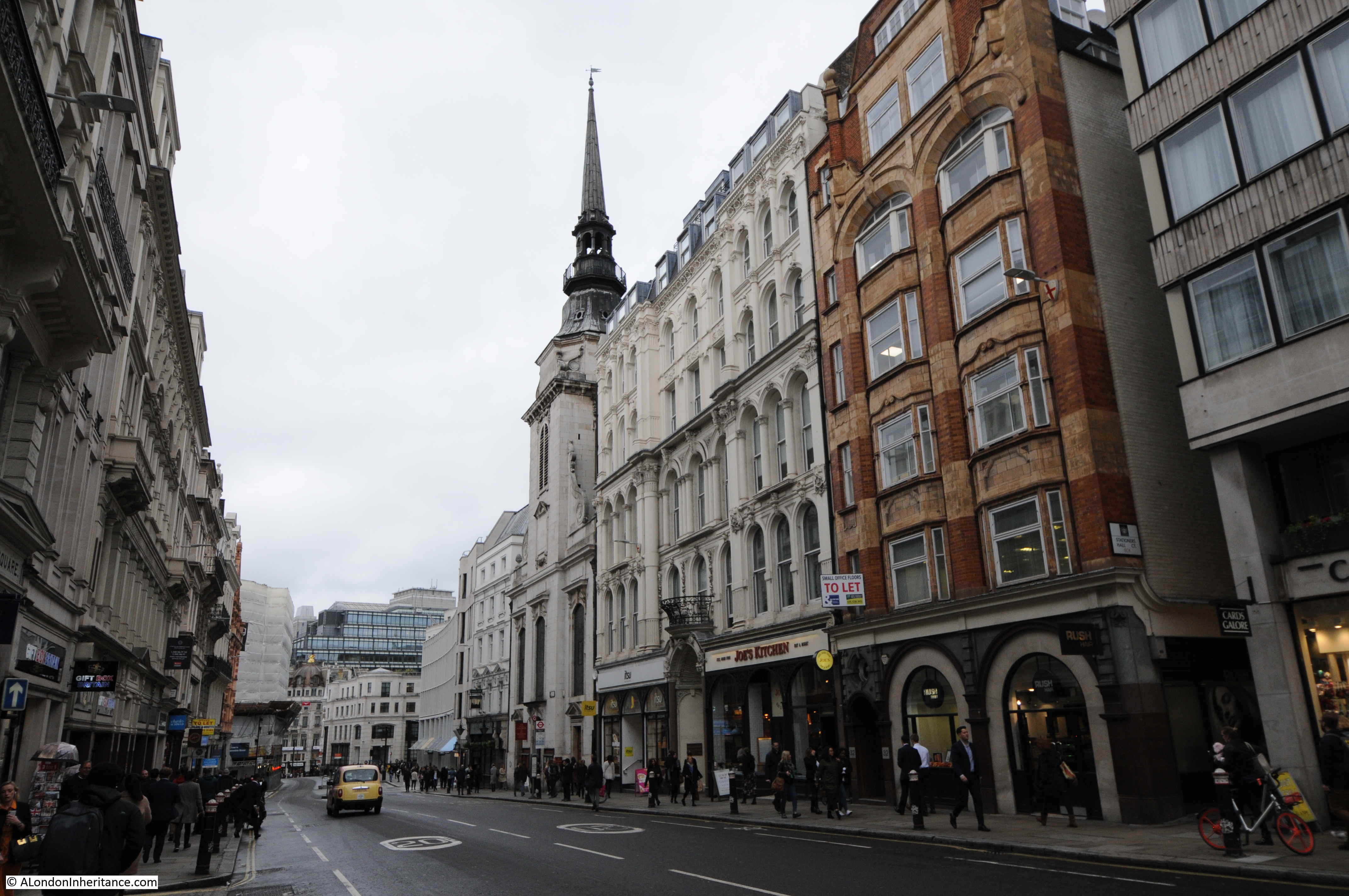
St Martin Ludgate is on the northern side of Ludgate Hill. I suspect that the church suffers from the fact that St Paul’s Cathedral is at the top of Ludgate Hill and the cathedral tends to attract the gaze, rather than the historic church along the side of the street.

The view looking down Ludgate Hill with the church and spire of St Martin Ludgate on the right:

St Martin Ludgate

St Martin is an old City church, with written evidence dating the church to the 12th century, however Geoffrey of Monmouth writing in the 12th century claims that the church was founded by the Welsh King Cadwallader in the 7th century. Given that this was 500 years before Geoffrey of Monmouth, I doubt very much whether this was based on any truth or factual record.

The claim was embellished in the text with the following print from 1814 which shows the tower and steeple of St Martin Ludgate standing clear from the surrounding houses. The author adds that Cadwallo was buried here. The text included evidence that the site was ancient as “several antiquities were discovered to prove it being a Roman burial-place”.

St Martin Ludgate

The location was certainly interesting, being adjacent to Lud Gate and the Roman Wall. Travelers from the west would have approached the City along what is now the Strand. Crossing over the River Fleet, then a short distance up the hill to the Lud Gate, with the location of St Martins just inside the wall on the left.

The current church dates from between 1677 and 1686 when it was rebuilt by Wren following the destruction of the previous church in the Great Fire of London, although there is a possibility that rather than Wren, it was Robert Hooke who was responsible for the church.

The original church was slightly clear of the Roman Wall, however the new church was moved slightly to the west and included the Roman Wall in the foundations of the church. Ludgate Hill was also widened at this time, so the new church was also set slightly further back

The spire of the church was designed to be a counterpoint to the dome of St Paul’s Cathedral.

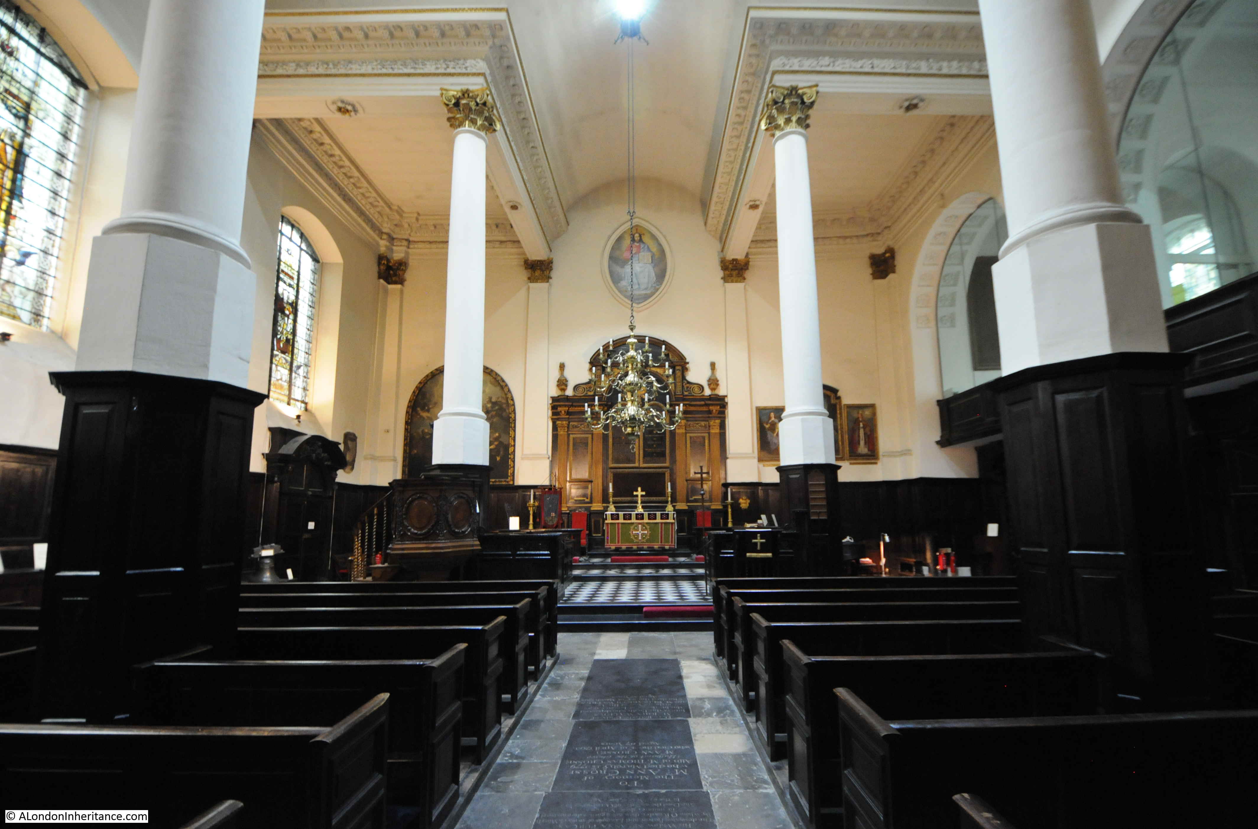
Through the entrance to the church and there is a wide corridor running the width of the building before entering the church proper. This was an attempt to sound proof the church from the noise on Ludgate Hill which must have been one of the busier and noisier streets in the City.

Entering the church and we can see a typical Wren designed City church of the 17th century.

St Martin Ludgate

The organ loft above the font:

St Martin Ludgate

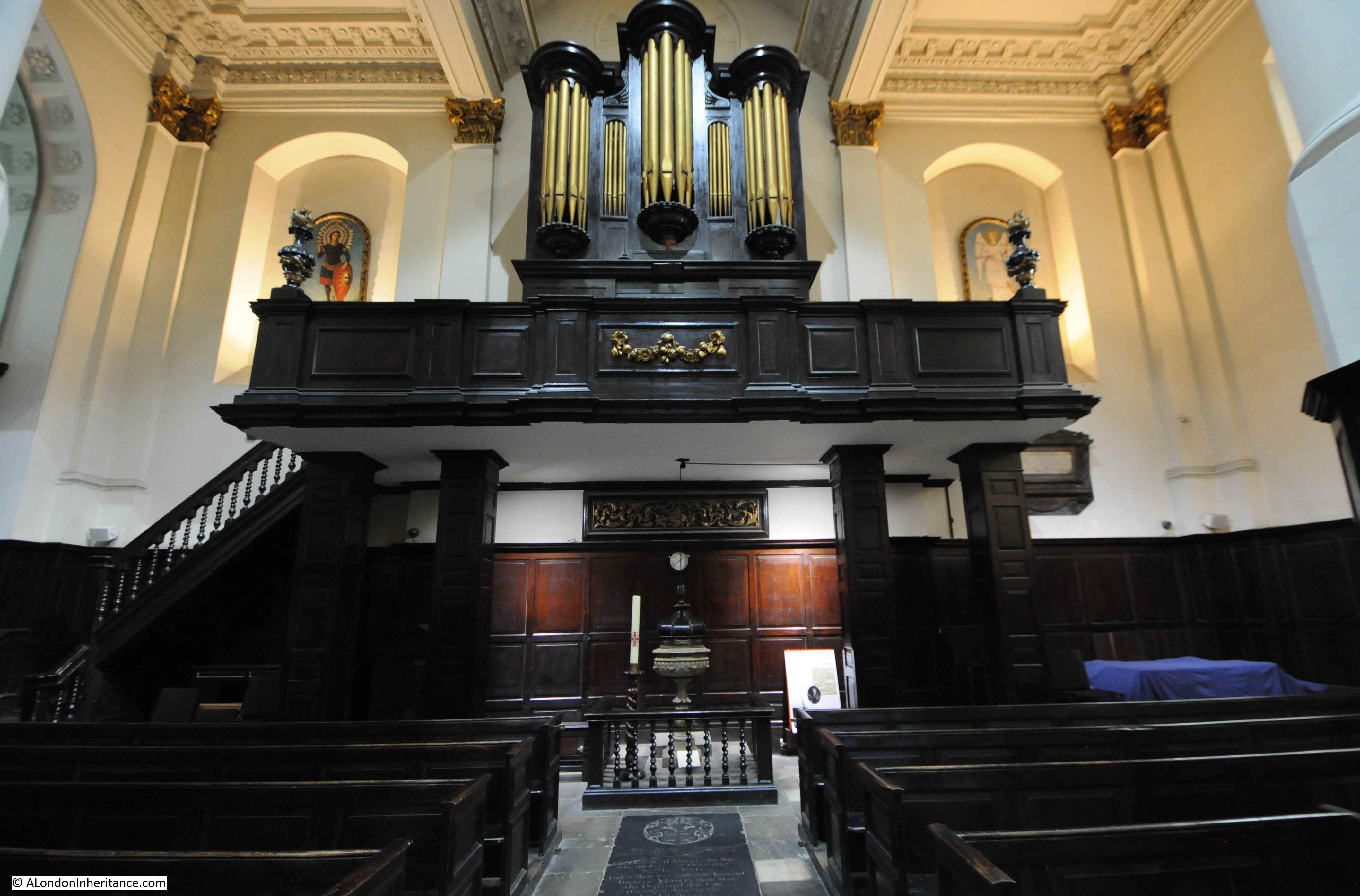
The font dates from 1673 and was a gift to the rebuilt church from one Thomas Morley.

Behind and to the right of the font is an information panel that confirms that this wall of the church was the original western limit of the Roman City, and below the floor and wall are the foundations of the original Roman Wall, along with remains of the later Medieval Wall.

The full name of the church St Martin within Ludgate indicates that the church was within the City walls.

There is an interesting plaque in the church, which holds a hidden message in the text. A brass plaque, now in St Martin’s was originally in St Mary Magdalene’s on Old Fish Street. A serious fire severely damaged much of St Mary in 1886, and as a number of City churches were closing and being demolished under the Union of Benefices Act (an Act to reduce the number of City churches as the population of the City had decreased), the decision was taken not to rebuild St Mary and a number of artifacts were moved to St Martin Ludgate.

The plaque is shown in the following photo and dates from 1586.

St Martin Ludgate

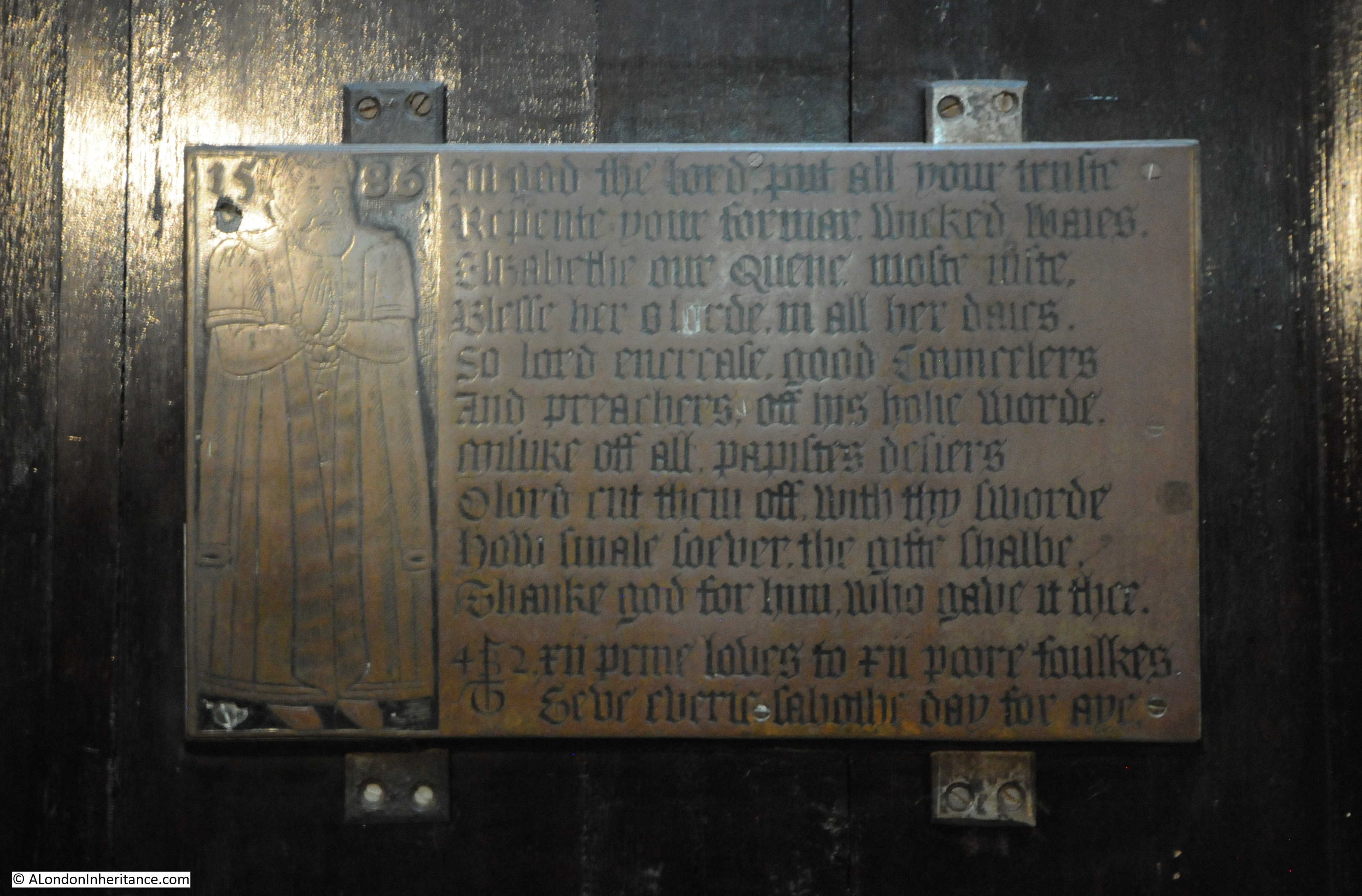
The plaque records a charity set up by Elizabethan fish monger Thomas Berry, or Beri. He is seen on the left of the plaque, and to the right are ten lines of text, followed by two lines which describe the charity:

“XII Penie loaves, to XI poor foulkes. Gave every Sabbath Day for aye”

The plaque is dated 1586, and the charity was set up in his will of 1601 which left his property in Edward Street, Southwark to St Mary Magdalen, with the instruction that the rent should be used to fund the loaves. The recipients of the charity were not in London, but were in Walton-on-the-Hill (now a suburb of Liverpool), a village that Berry seems to have had some connection with. The charity included an additional sum of 50s a year to fund a dinner for all the married people and householders of the town of Bootle.

The interesting lines of text are above those which describe the charity. Thomas seems to have spelled his last name either Berry or Beri and these ten lines of anti-papist verse include his concealed name.

The ten lines are shown below (thankfully “If Stones Could Speak” by F. St Aubyn-Brisbane (1929) have the transcribed text as it was hard to read from the plaque):

St Martin Ludgate

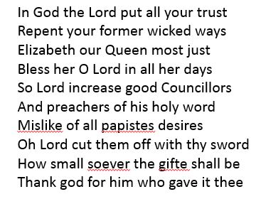
If you take the first letter from each sentence and read from the last sentence, you get the name Tomas Beri.

St Martin Ludgate

The parish church in Walton-on-the-Hill had a similar brass plaque, however it was badly damaged when the church was destroyed in the Liverpool Blitz in May 1941. The Walton church was rebuilt after the war, and a replica plaque can now be seen.

Unlike the Walton church, St Martin Ludgate suffered the least damage of any City church during the last war, with only a single incendiary bomb damaging the roof.

A closer view of the font. The wall behind the font marks the limit of the original Roman City, and remains of the Roman Wall are below the wall of the church.

St Martin Ludgate

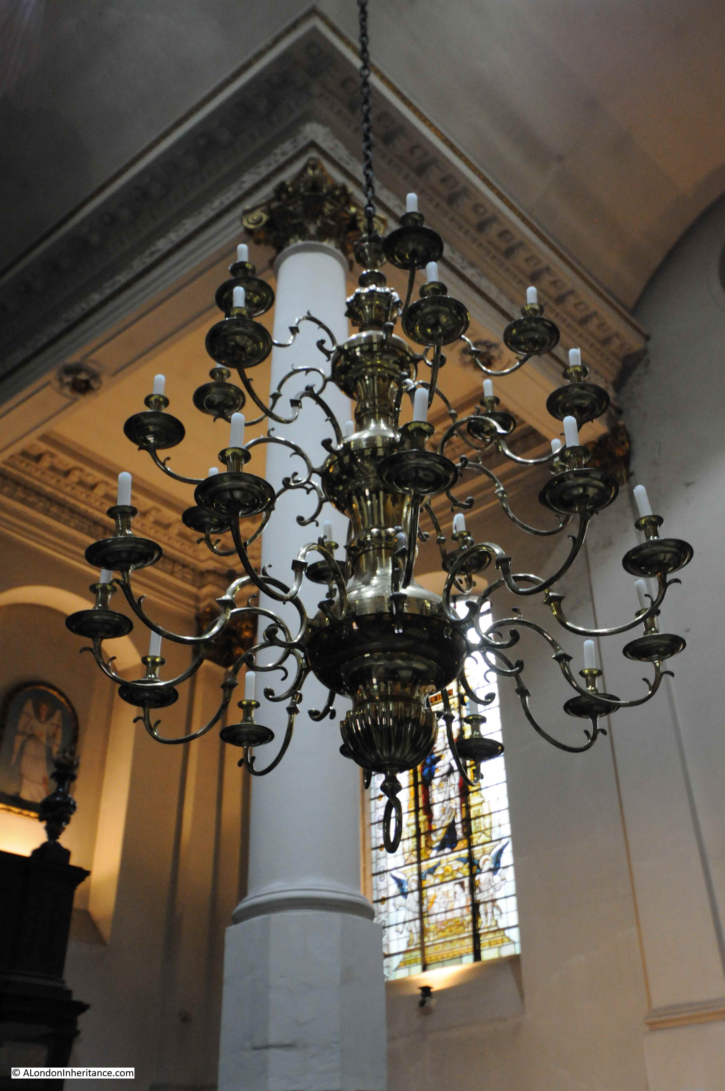
City churches tend to accumulate objects, not just from other City churches, but from across the world. For some reason, St Martin Ludgate has a large chandelier from the 18th century which was originally in St Vincent’s Cathedral in the West Indies.

St Martin Ludgate

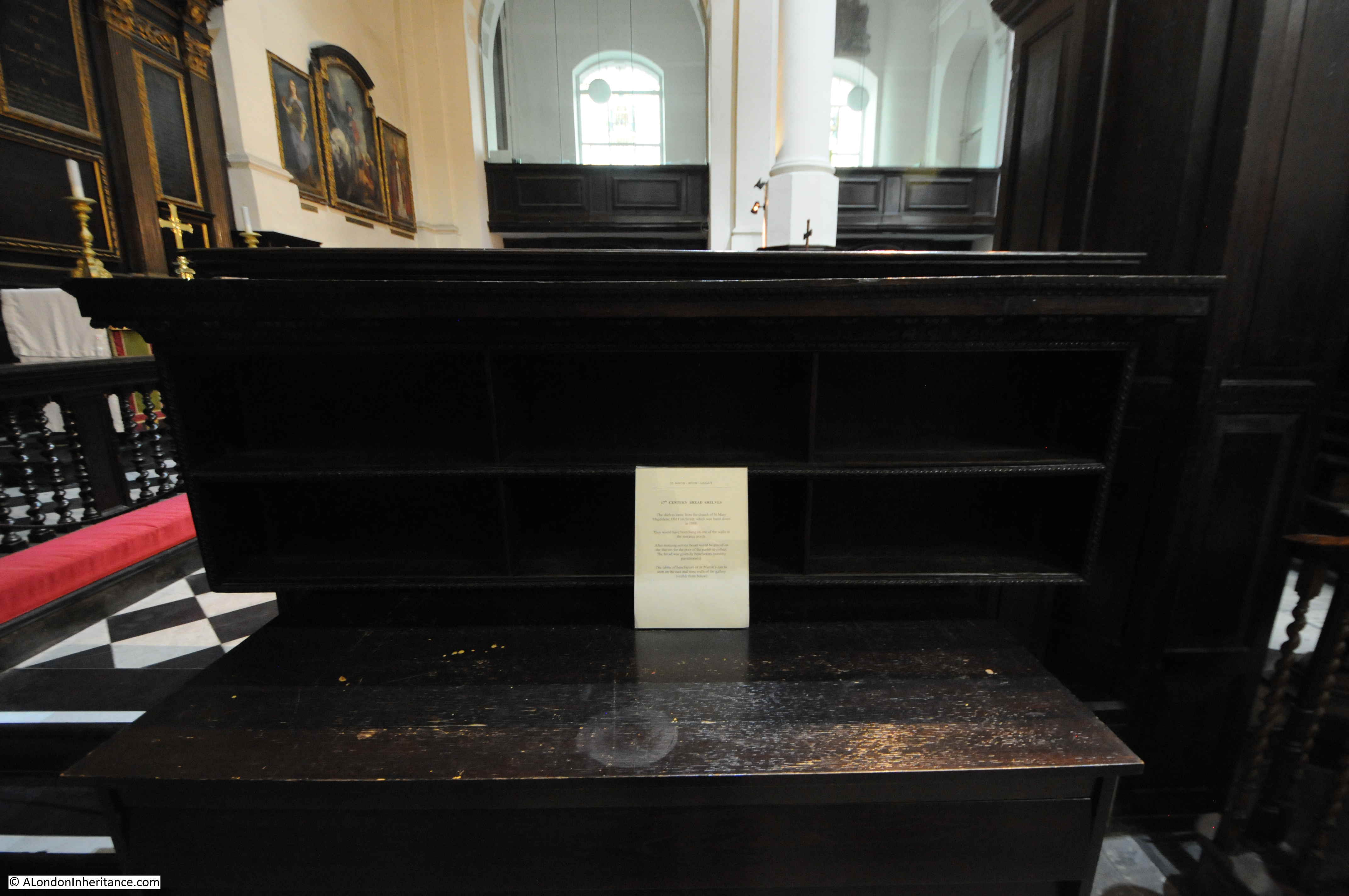
The chandelier is unusual as the majority of objects in the church appear to have come from St Mary Magdalen, including these bread shelves:

St Martin Ludgate

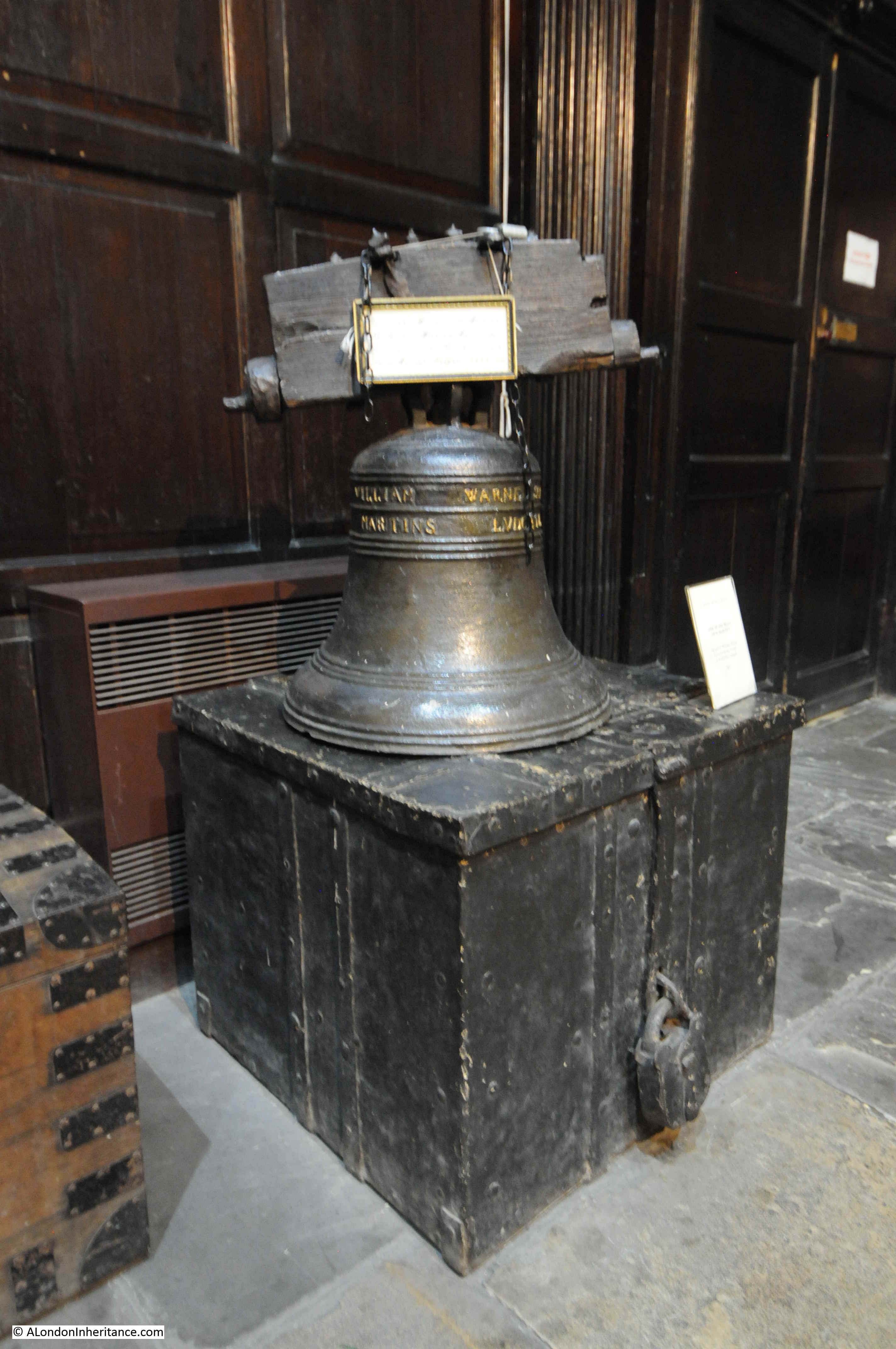
On display within the church is one of the bells from the post Great Fire rebuild. The bell dates from 1683 and was a “Gift of William Warne, Scrivener to the Parish of St Martin’s Ludgate”:

St Martin Ludgate

In a side room of the church is an interesting 17th century carved pelican:

St Martin Ludgate

The symbol of the pelican feeding its young is a very early Christian representation of Jesus. It comes from a pre-Christian legend that in times of famine, a mother pelican would pierce her breast, allowing her young to feed on her blood, thereby avoiding starvation.

Apart from the slender spire, there is nothing remarkable about the building of St Martin Ludgate, and the church is over shadowed by the much larger cathedral a bit further up Ludgate Hill.

The key though with City churches is that despite the ever-changing City, they are stable reference points, providing the same function for over 900 years.

St Martin Ludgate has the added bonus that the west wall of the church marks the western boundary of the original Roman city, and the Roman wall.

And whilst pondering the Roman city, we can also wonder why Thomas Beri decided to conceal his name in the plaque, or what game he was playing with the future back in 1586.

alondoninheritance.com

The Waterman’s Arms – Isle of Dogs

For this week’s post, it is 1986, and I am standing outside the Cutty Sark pub in Greenwich, looking across the River Thames to the south eastern tip of the Isle of Dogs. The photo below shows the view which includes the spire of Christ Church, on the corner of Manchester Road and Glenaffric Avenue, the Newcastle Draw Dock leading down into the river, and to the left, a pub, the Waterman’s Arms.

Waterman's Arms

The same view today:

Waterman's Arms

Although the weather was the same for the “now” photo, the tide state was different which does change the views, however the Newcastle Draw Dock is still there today, just below the water.

Apart from the spire, Christ Church is still hidden by trees. Housing on the right is the same, however a large new build of apartments has been built on the left of the dry dock which completely obscures the Waterman’s Arms and the towers of the City, which in 1986 consisted only of the Nat West Tower.

The Waterman’s Arms was originally the Newcastle Arms, built as part of the Cubitt Town development. It seems to have opened in 1853, and that year is the first that I can find any written references to the pub, with two contrasting newspaper mentions.

In the Morning Advertiser on the 30th April 1853 there was an advert for a Servant, Potman and Waiter – possibly the first staff for the newly opened pub. In October 1853, the Kentish Mercury had a very different report on the pub, where George Henry Wood, the step son of Mr Harris, the landlord of the Newcastle Arms, was charged with stealing a horse, the property of Mr Brooker, a grazier of Poplar.

Apart from these mentions, there seems to have been very little reported about the Newcastle Arms, apart from the occasional advert for staff, and reference to the adjoining dry dock. most often related to criminal activity.

The most significant period in the pub’s history were a couple of years in the 1960s when the pub changed name to the Waterman’s Arms and became an East London centre for pub entertainment, attracting many national and internationally famous celebrities. I will cover this phase later in the post.

In 2011 the pub changed name to the Great Eastern and became a pub on the ground floor and backpackers hostel on the upper floors, and it was this version of the pub that I photographed when I was in the area last year.

Waterman's Arms

The adjacent Newcastle Draw Dock, photographed at low tide and looking across the river to the Cutty Sark pub.

Waterman's Arms

The reason why the Waterman’s Arms has a rather unusual history compared to other Isle of Dogs pubs is down to a brief period between 1962 and 1964 when the pub was run by Daniel Farson.

Daniel Farson was an interesting character. Born in 1927, he was the son of Negley Farson, an author and American foreign correspondent. After National Service in the American Army Air Corps (he had dual US / UK citizanship – he would later renounce US citizanship), he went to Cambridge University, then took a post as photographer with the Picture Post.

He had a variety of jobs in journalism and also the Merchant Navy, before joining Associated Rediffusion, one of the early independent television companies.

During his time at Associated Rediffusion, Farson proposed a TV programme on the boom in pub entertainment. This he saw as a continuation of the Music Hall tradition which was one of his interests. The proposed programme was to be called “Time Gentlemen Please!” and to help with research he visited a number of East London pubs. It was during this research that he found the Newcastle Arms. The pub was described as being “down on the floor” and the “pub with no beer”. The pub attracted very little trade and the brewery refused any credit for the purchase of beer.

Farson was also interested in the area of East London along the river, and had been living at 92 Narrow Street in Limehouse so was relatively close to the Newcastle Arms, although he admits to knowing very little about the Isle of Dogs, and his view of the location of the Newcastle Arms would have been very different if he had approached the pub from inland, rather than from the river.

Despite all the warning signs, he purchased the pub in 1962 using money left to him by his parents, and set about converting the pub to accommodate space for an enlarged stage area. He would use this to put on pub entertainment, based on Musical Hall traditions and building on the entertainment to be found in many East London pubs, although he attracted stars that would not normally be found in a pub at the tip of the Isle of Dogs, or a usual East End crowd.

Farson also changed the name of the pub from the Newcastle Arms to the Waterman’s Arms, a name he felt better suited the pub’s riverside location.

Farson’s proposed programme “Time, Gentlemen Please!” was shown at 9:45 on the evening of the 5th December 1962, and part was filmed in the Waterman’s Arms. The Daily Mirror description of the programme was:

“ITV commentator Dan Farson, who recently became landlord of a pub in London’s East End. takes a look at pub-land entertainment in tonight’s ‘Time, Gentlemen Please!’. 

Says Farson: ‘If the spirit of music-hall lives anywhere today, you’ll find it in the East End pubs.’ Many pub owners say that entertainment is a good boost for business.

So Farson and director Rollo Gamble visited four public-houses to film some of the professional and semi-professional acts that appear there.

One of the pubs was Farson’s own, the Waterman’s Arms, near the docks at the Isle of Dogs.

Most of the pub entertainers are singers, who present modern pub tunes along with the old music hall hits. One artist is 80 year-old Ida Barr, a star of the Edwardian music hall.

Others in the programme rejoice in such names as Tommy Pudding, Sulky Gowers, Welsh George, Queenie Watts and Tex, who wears a cowboy hat.

Says Gamble; ‘Though some of the performers are unknowns, there’s a lot of talent there. Some of these people live by touring the pubs, others entertain in the evening after a hard day’s work.”

Ida Barr, one of the original stars of the Edwardian music hall was a popular performer at the Waterman’s Arms, and she was still very active, including performing at London’s last remaining music hall, the Metropolitan Theatre in Edgware Road. She sang at the last performance at “The Met” on the 14th April 1963 before its demolition later that year as part of the road widening scheme for the Edgware Road.

As well as the Waterman’s Arms, the other pubs that featured in the programme were the Lansdown Arms, part of the old Collins Music Hall at Islington Green, the Rising Sun in Bethnal Green, and the King’s Arms in the Old Kent Road.

The entertainment put on by Farson in the Waterman’s Arm consisted of both local amateur and professional acts, old-time music hall stars, as well as those that you would not expect to see in a Victorian pub on the Isle of Dogs such as Shirley Bassey.

The audience at the Waterman’s Arms attracted not just the locals, but also those from the West End, and a global set of celebrities from the early 1960s. Names such as Lord Delfont, George Melly, Groucho Marx, Lionel Bart, Trevor Howard, Tony Bennett, Mary Quant, Norman Hartnell, Judy Garland and Clint Eastwood (who wrote the word ‘rowdy’ in the guest book).

Daniel Farson also discovered local talent who went on the perform at the Waterman’s Arms. One of these was Kim Cordell who Farson saw performing at the Rising Sun in Mile End Road and who was described in The Stage as: “In the booming world of pub entertainment, one personality is causing more and more comment. This is Kim Cordell, first seen in Dan Farson’s TV pub show Time, Gentlemen Please! and now the compere/singer of his pub on the Isle of Dogs, the Waterman’s Arms. Kim herself says: ‘Without a doubt, this has been the best year of my life. I seem to have found a real incentive for the first time’. Apart from her success at The Waterman’s, the year has included appearances on TV; two films, one called ‘Songs of London’ for the British Tourist and Travel Association, the other ‘London After Dark’, not yet released; and the lion’s share in a forthcoming L.P. ‘A Night At The Waterman’s'”.

Kim Cordell performing at the Waterman’s Arms:

Waterman's Arms

The Waterman’s Arms was a success in terms of the number of people arriving to watch the entertainment, the number of stars attracted to perform, and those who came to the Waterman’s Arms to be in the crowd, but it could not last.

In 1964 Farson received a call from his bank manager to tell him that he was £3,000 overdrawn.

The financial challenges were down to how much was being sold to fund the costs of running the pub. People would not arrive until 8pm, from then on the bar was crowded. Crowding meant that people could not easily get to the bar, so drink sales were limited.  For many there was more interest in the entertainment rather than a long evening’s drinking. They would watch the entertainment than move on. The costs of putting on entertainment were also high, particularly for the more famous acts.

He could not go on, and after a battle with the brewery, a new tenant was found, Daniel Farson sold up and left the Waterman’s Arms and Narrow Street and moved down to north Devon to start a career as an author.

One of the books that came out of this move was Limehouse Days. A record of his time in Limehouse and at the Waterman’s Arms. The front cover of the book shows Daniel Farson behind the bar at the Waterman’s Arms, talking to customers.

Waterman's Arms

The book does have some strange diversions, such as a chapter where Farson claims to identify Jack the Ripper, however the book, and the photos taken by Farson provide an intriguing view of life in East London in the late 1950s and early 1960s.

Daniel Farson was also part of Soho in the 1950s and early 1960s (and continued to visit after his move to Devon). He photographed and wrote about Soho in another book Soho in the Fifties, although due to his level of drinking there was always some doubt as to the details of the stories Farson would recall and tell.

His obituary by Philip Hoare in the Independent started with the paragraph “Mythomaniacal, egotistical, and often unable to tell the truth or the difference between it and fiction, the character of Daniel Farson – photographer, writer, and drunk – is redeemed by at least one grace: that of self-awareness: “One of the more bizarre aspects of my life is the way it has veered from triumph to disaster without my seeming to notice the change.”

He was also frequently mentioned in the obituaries and memoirs of others who found the pubs, bars and clubs of Soho as a second home. For example the following is from the obituary of the journalist and author Sandy Fawkes: “One close friend for 30 years was Daniel Farson, the television journalist, chronicler of Soho and spectacular drunk. He would suddenly turn from an intelligent conversationalist into a growling monster. “I loathe you,” he would shout suddenly between fat, quivering cheeks. Sandy Fawkes would go to stay with him in Devon, where he enjoyed comparative calm, though barred from local pubs.”

It was also in Soho that Farson met people such as the artists Francis Bacon and Lucian Freud, who would also go on to visit the Waterman’s Arms.

The Waterman’s Arms and Daniel Farson tell of a very different time. Soho has since lost so much of its character, and East London pubs have been disappearing rapidly over the last few decades.

The Waterman’s Arms is part of a listed group around the Newcastle Draw Dock, which also includes Glenaffric Avenue, Christ Church and Christ Church Vicarage, Manchester Road.

The future of the pub as the Great Eastern looked in doubt, running as a pub on the ground floor and backpacker hostel on the upper floors. The pub has a good location, close to the river and the Newcastle Draw Dock, so could easily have fallen to the fate of so many other London pubs, and been converted into apartments. The good news is that a very recent story in the Docklands and East London Advertiser reports that starting this month, the pub will get a £600,000 refurbishment,. The name of the pub will also be changed from the Great Eastern back to the Waterman’s Arms.

So although not visible from Greenwich as it was in 1986, hopefully the Waterman’s Arms will have a good future.

For a glimpse of the Waterman’s Arms when owned by Daniel Farson, the 1964 film London in the Raw by Arnold Louis Miller includes a sequence filmed in the Waterman’s Arms. The film is available from the British Film Institute.

alondoninheritance.com

A Winter Walk from Tower Bridge to Westminster

The photos from Hungerford Bridge for last Sunday’s post were part of a walk over the New Year from Tower Bridge to Westminster. I sometimes think that at this time of the year, London looks better after dark than during the short, grey days when a low sun and cloud cover conspire to subdue the city. Having said that, a sunny winter’s day brings out all that is best in the city.

I also take plenty of photos, because the city keeps changing, and because I just find all aspects of the city fascinating. For a mid-week post, here is a selection showing just how good the city looks when the grey sky is hidden by the dark of night, and the lights are on across London.

I started on the south bank of the river, looking back at Tower Bridge:

Winter Walk from Tower Bridge to Westminster

And across to the Tower of London:

Winter Walk from Tower Bridge to Westminster

The ever growing number of office towers in the City:

Winter Walk from Tower Bridge to Westminster

London seems to have hit peak Christmas Market, and now wooden sheds selling vaguely Christmas related products can be found anywhere across the city where high footfall and  tourists are likely to congregate. Along the south bank, they start near Tower Bridge and can then be found dotted along the route to the London Eye.

Winter Walk from Tower Bridge to Westminster

Hay’s Galleria, the old Hay’s Wharf with more Christmas market themed shops.

Winter Walk from Tower Bridge to Westminster

Themed sculpture trails have been a trend of the last few years, and this year London Bridge City (another trend whereby areas of the City are given brand names to promote a sense of identity, usually by the corporations who own large areas of the city) are hosting a sculpture trail where twelve of Raymond Briggs Snowman characters have been individually decorated to represent the twelve days of Christmas.

The is “A Partridge in a Pear Tree” by Jodie Silverman:

Winter Walk from Tower Bridge to Westminster

Crossing London Bridge, it was down into Borough Market. Very quiet at this time of the evening, with the majority of stalls packing up, although hot mulled wine was still available.

Winter Walk from Tower Bridge to Westminster

Brightly lit interiors contrast with the dark of the exterior arches.

Winter Walk from Tower Bridge to Westminster

Borough Market:

Winter Walk from Tower Bridge to Westminster

Taking a photo of someone else taking a photo – Monmouth Coffee in Stoney Street by Borough Market:

Winter Walk from Tower Bridge to Westminster

Pubs always look very welcoming at this time of year – the Market Porter on the corner of Stoney Street and Park Street:

Winter Walk from Tower Bridge to Westminster

The Anchor, Bankside:

Winter Walk from Tower Bridge to Westminster

Many of London’s bridges are now part of the Illuminated River project where the intention is to light up each bridge with a unique lighting scheme from the Albert Bridge to Tower Bridge. Many of the inner City bridges have been completed and the aim is to complete the rest during 2020.

This is Southwark Bridge:

Winter Walk from Tower Bridge to Westminster

A good place to view the project is where multiple bridges can be seen at the same time. The following photo is looking back at Southwark Bridge, Cannon Street Railway Bridge and London Bridge.

Winter Walk from Tower Bridge to Westminster

The Illuminated River project will be in place for 10 years, after which the lighting and associated running and maintenance costs will be transferred to the bridge owners.

The changing light schemes across multiple bridges does focus the attention on the river rather than the surrounding buildings which is good.

A short distance along are the buildings that are part of the Globe Theatre complex on the corner of Bankside and New Globe Walk. Very different to the Emerson Wharf building that once stood on the site.

Winter Walk from Tower Bridge to Westminster

Entrance to Blackfriars Station on the south bank of the river:

Winter Walk from Tower Bridge to Westminster

Passing Blackfriars Bridge and this is the view looking over to the north bank of the river:

Winter Walk from Tower Bridge to Westminster

The three cranes are part of the construction site for the Thames Tideway Tunnel, which will also be one of the intercept points between the existing sewage system and the new tunnel.

On the right is the Unilever Building. The illuminated building in the centre is the old City of London School.

Further along we come to the South Bank complex, and here is a good point to look back towards the lights of the City, framed by the Oxo Tower on the right and St Paul’s Cathedral on the left.

Winter Walk from Tower Bridge to Westminster

Fast food on the South Bank:

Winter Walk from Tower Bridge to Westminster

South Bank walking:

Winter Walk from Tower Bridge to Westminster

The night and lighting softens the architecture of the buildings along the South Bank. This is the National Theatre:

Winter Walk from Tower Bridge to Westminster

Evening book browsing and selling under Waterloo Bridge:

Winter Walk from Tower Bridge to Westminster

The South Bank has many restaurants, and during the Christmas period, these dining pods are a colourful addition:

Winter Walk from Tower Bridge to Westminster

Opposite is the under croft of the Queen Elizabeth hall which from 1973 has been used for skateboarding:

Winter Walk from Tower Bridge to Westminster

Threatened with closure in 2013 / 2014, the space has been saved and refurbished and continues to offer a long term space for skateboarding on the South Bank.

Possibly a bit optimistic for mid -winter is this ice cream van:

Winter Walk from Tower Bridge to Westminster

Illuminations between the Royal Festival Hall and the river:

Winter Walk from Tower Bridge to Westminster

From here, I crossed over the river to take the photos from the Golden Jubilee Bridge for last week’s post, then continued up to just north of Trafalgar Square, where the London Coliseum looks impressive after dark:

Winter Walk from Tower Bridge to Westminster

Seven St Martin’s Place is between the church of St Martin in the Fields and William IV Street and faces the Edith Cavell Memorial. Back in July i wrote a post about the building which at the  time was undergoing conversion to a hotel.

That conversion now appears to be complete and the hotel open.

Winter Walk from Tower Bridge to Westminster

One of the reasons for my interest in the building was the future of the sculptured panels on the facade of the building facing St Martin’s Place. These panels were the work of Hubert Dalwood, a sculptor in the Modern British movement.

The conversion looks complete and I am really pleased that the panels are in their original position, and look to continue to decorate the building in its new function.

Whilst much of the West End was relatively quiet, Leicester Square was busy, with the central square being occupied with another Christmas Market (further confirming that London must by now have reached peak Christmas market).

Winter Walk from Tower Bridge to Westminster

Brightly lit market stall in Leicester Square:

Winter Walk from Tower Bridge to Westminster

The surroundings of Leicester Square were full, and the area continues as a centre for the brands that attract the tourist trade.

In the following photo, a reminder of the old Swiss Centre is in the centre, with the M&M store on the right.

Winter Walk from Tower Bridge to Westminster

Directly opposite is the Lego Store, and whilst walking between the two stores you can still get your portrait drawn.

Winter Walk from Tower Bridge to Westminster

Trying to avoid the crowds, I headed down Waterloo Place, across the Mall, then into Horse Guards Road, and there was not a person in sight.

Winter Walk from Tower Bridge to Westminster

Apart from a single walker, I did not see anyone whilst walking the full length of Horse Guards Road between the Mall and Birdcage Walk.

Winter Walk from Tower Bridge to Westminster

An empty Horse Guards Road:

Winter Walk from Tower Bridge to Westminster

Westminster was the destination of the walk from Tower Bridge and here Westminster Abbey was looking impressive against a dark sky. Again, the area was deserted apart from a couple of people looking in the window of the closed visitor centre.

Winter Walk from Tower Bridge to Westminster

And then it was back to Westminster Underground Station. Although this was a walk along what could be described as the tourist focused areas of the city, it is always a pleasure to walk alongside the river, and it is fascinating to see how London is evolving.

Also, London does look really good after dark.

alondoninheritance.com

The View from Hungerford Bridge – 1985 and 2020

I usually try to get in a couple of evening walks in that quiet period just after Christmas and before the main return to work at the start of January. This year, part of one of these walks crossed the River Thames using the Golden Jubilee walkways alongside Hungerford Bridge. I wanted to photograph the same scenes as 35 years ago in 1985, and to have a look at what has changed. Although the formal name of the crossing is the Golden Jubilee Bridge, I have called the post the view from Hungerford Bridge, as this was the original 1985 walkway and seems to be the most used name for the crossing.

This was the view in 1985, looking south across the river towards the Royal Festival Hall.

View from Hungerford Bridge

The same view 35 years later:

View from Hungerford Bridge

The viewpoint is slightly different, as seen by the different location of the tall office block on the left, however the area around the Royal Festival Hall is still an illuminated focal point on the South Bank.

The 1985 photo does include a feature that was a focal point of the South Bank. To the left of the Royal Festival Hall was a tall, illuminated lattice structure. The coloured lights were continuously changing.

I was working on the South Bank for much of the 1980s, and these ever changing lights were always in the background when working or walking in the area after dark. I moved abroad for a few years at the end of the decade, and cannot remember when these lights disappeared. It is these subtle changes that are so easy to miss.

The following photo shows a detailed section from the original 1985 photo, which includes the lights, and also another unique feature from the 1980s.

View from Hungerford Bridge

In a previous post on London postcards, I included one of a large birthday cake created by the Greater London Council on the South Bank as an exhibition and celebration of 95 years of the London County Council / Greater London Council. I had visited the exhibition within the cake, and taken photos, but had not yet scanned the negatives. In scanning negatives I finally found some which included the GLC cake.

This can be seen in the 1985 photo above, and also in the extract, which does give an indication of the size of the cake, and how incongruous a traditionally decorated birthday cake looked against the concrete architecture of the South Bank.

The following photo is from the original postcard which shows the cake close up.

View from Hungerford Bridge

There was also some event advertising along the front of the Royal Festival Hall. The following is an extract from the 1985 photo which shows this advertising along the front of the building.

View from Hungerford Bridge

The red banner requests “Keep GLC Working for the Arts in London”. The mid 1980s was a time of conflict between the Thatcher led Conservative Government and the Labour majority Greater London Council led by Ken Livingstone.

This resulted in the 1985 Local Government Act which dissolved the GLC in 1986. Campaigns by the GLC could not influence the majority of the Conservative Government, and at the time there were serious concerns about future funding of South Bank complex. Probably one of the reasons why now the majority of the exterior ground level of the Royal Festival Hall is occupied by commercial businesses.

In the centre of the hall, there is a banner advertising that “EROS: Back in Town at the Royal Festival Hall”. I had completely forgotten about this, but in the 1980s the statue on the top of the Shaftesbury Memorial Fountain in Piccadilly Circus (so I assume technically correct to state Eros, which is frequently applied to the whole fountain), had been removed for restoration.

Prior to the return of the statue to Piccadilly Circus in 1985, it was displayed for a short period in the Royal Festival Hall.

The banner on the right advertises the “Mars London Marathon Exhibition” in advance of the marathon which took place in April of that year. Perhaps strange now that a health focused event would be sponsored by a brand such as Mars, but at the time (and for many years previously), the energy giving benefits of glucose were a major advertising feature of Mars bars.

The following 1985 photo again shows the GLC cake, and also the Festival Pier.

View from Hungerford Bridge

The same view from a slightly different angle, as to the right, the Kings Reach Tower office block now appears from behind the square office block of what was London Weekend Television.

View from Hungerford Bridge

A similar view in 2020 is shown in the photo below. The Kings Reach Tower building is now much taller having had several floors added during conversion of the block from offices to apartments.  The future of the old London Weekend Television building (known after the closure of London Weekend Television as the London Studios and operated by ITV) is not clear. ITV moved out of the complex a few years ago, originally intending to return to refurbished studios, but they now uses studios at the redeveloped BBC Television Centre site in White City. I am sure that this high value location on the South Bank will become yet more expensive apartments.

View from Hungerford Bridge

The following 1985 photo is looking along the river towards Waterloo Bridge, St Paul’s Cathedral and the City of London.

View from Hungerford Bridge

In the above photo, the cathedral stands clear, as does the old Nat West Tower to the right. This building, now called Tower 42, was the tallest building in the City.

The same view today is shown in the following photo. The Nat West Tower is now dwarfed and almost lost by the City developments of the last few decades.

View from Hungerford Bridge

The following 1985 view is of the north bank of the river from the Hungerford Bridge walkway. The brightly lit building is the wonderful 1931, Grade II listed, Shell-Mex House, occupied at the time by Shell UK.  The building is now known as 80 Strand. To the left is the Adelphi building, and the Savoy on the right.

View from Hungerford Bridge

The same view today, although a bit later in the evening so a somewhat darker sky. The front of the Shell-Mex building is covered in sheeting as part of an ongoing refurbishment.

View from Hungerford Bridge

Walking along the walkway towards the north bank, and this was the 1985 view from Hungerford Bridge looking towards the Embankment.

View from Hungerford Bridge

The same view in 2020:

View from Hungerford Bridge

The Embankment is much the same, however the main change is the scale of the Embankment Pier. This is a relatively small feature in the 1985 photo, which has since been replaced by a much larger pier by the 2020 photo. This is indicative of the considerable growth in passenger transport along the Thames in the 35 years since 1985, when river piers were mainly used for tourist focused cruises of the river. The opening of the Thames Clipper Service in 1999 has contributed significantly to passenger traffic on the river, with the resulting upgrades and additions of river piers to support this traffic.

The main change between 1985 and 2020 has been the bridge across the river from which the photos were taken.

In 1985 there was only a single walkway on the side of the bridge looking towards the City. It was a narrow walkway, frequently covered in large puddles of water, and from experience, not somewhere that you would really want to walk across late at night.

The following photo shows the original walkway:

View from Hungerford Bridge

Today, there is a walkway on either side of Hungerford Bridge. Officially named the Golden Jubilee Bridge, these new walkways were completed in 2002 and provide a considerably improved walking route between the north and south banks of the River Thames.

With the growth of attractions and events along the South Bank, the number of people walking across the bridges has grown considerably. According to the website of the architects Lifschutz Davidson Sandilands, who with engineering company WSP, won the competition for the bridges, they are the busiest walking routes across the river in London, with 8.4 million pedestrians in 2014.

The following photo is the view south along the walkway, towards the Royal Festival Hall.

View from Hungerford Bridge

A view during the day of the Golden Jubilee bridge:

View from Hungerford Bridge

The architects state that the bridges “are slung from inclined pylons that pay homage to similar structures created for the 1951 Festival of Britain, held on the adjoining South Bank”.

As evidence of this, the following photo was taken by my father from the southern end of Hungerford bridge, just after the Festival of Britain had closed, and shows the structures referenced by the architects.

View from Hungerford Bridge

The view looking north along the walkway towards the illuminated buildings above Charing Cross Station.

View from Hungerford Bridge

One final photo before I headed off north of the river – the Embankment from the walkway looking unusually quiet:

View from Hungerford Bridge

The Golden Jubilee Bridge is a considerable improvement over the previous walkway and provides a wonderful location to look at a spectacular view of the river, north and south banks, and the City, whether by day or night. The second walkway on the other side of Hungerford Bridge provides superb views towards Westminster.

The opening up of a walking route from the South Bank through Bankside and to Tower Bridge and beyond, along with attractions such as the London Eye and growth in the numbers of bars and restaurants has significantly increased walking across the river, along with the always present use of the bridge as a route between the north bank of the river and Waterloo Station.

Use of the river has grown since 1985 as evidenced by the considerably enlarged Embankment Pier.

In another 35 years time, the Royal Festival Hall will be just over 100 years old – it will be interesting to see how the area changes in the coming decades. One change I suspect will happen is the growth of tower blocks on the south bank beyond Waterloo Bridge and across the City. The area around the old London Weekend Television tower block and the London Studios will certainly look very different.

alondoninheritance.com

Wapping Old Stairs

I have touched very briefly on Wapping Old Stairs in a previous post, when I went for a walk along Wapping High Street and Wapping Wall. I am returning to the stairs as when working through the photos my father had taken on a boat trip along the Thames in August 1948, I found one of Wapping Old Stairs and the adjacent Oliver’s Wharf.

Wapping Old Stairs

I tried to take a photo of the same view when out on the river a couple of months ago, but failed completely to get as good a photo as the one above.

The following photo is the area today. Oliver’s Wharf is the building on the right, the stairs are to the left of Oliver’s Wharf.Wapping Old Stairs

What I love about these photos is that they frequently show people, often children, on the stairs (for example, see the post on Emerson Stairs), and this includes the photo of Wapping Old Stairs, see the following enlargement from the original which shows two children at the bottom of the stairs.

Wapping Old Stairs

Wapping Old Stairs are – old. There is the possibility that stairs at this location date back to the 16th century or earlier. The first newspaper reference I can find is from the 12th August 1736 when “The Body of a young Man well dressed, with a Watch and a Sum of Money in his Pockets, was taken up floating at Wapping Old Stairs: Upon fetching him he appeared to be an Apprentice belonging to Mr. Stilton, a Currier in Bermondsey-street; but by what Means he came drowned is very uncertain.”

This report confirms that in 1736 they were called the “Old” stairs. This part of the name was used to separate these stairs from another set of stairs built slightly to the east along the river, which were called Wapping New Stairs (these can also be found today).

The following extract from the 1896 Ordnance Survey Map shows Oliver’s Wharf and Wapping New Stairs to the left of the map, just before the Wapping Entrance to Wapping Basin of the London Docks. Towards the right of the map are Wapping New Stairs, just by Old Aberdeen Wharf.

Wapping Old Stairs

Credit: ‘Reproduced with the permission of the National Library of Scotland’ 

So presumably Wapping Old Stairs were the original stairs, and Wapping New Stairs came latter, with the old and new being added to uniquely identify the stairs. This method of identifying stairs can be found in the names of a number of Thames stairs, for example I have already written about Horselydown Old and New Stairs.

Despite being called “New”, Wapping New Stairs are also old, and I found a newspaper reference to them a couple of years before that for Wapping Old Stairs, when, from the 28th December 1728:

“On Monday, between one and two in the Morning, a Fire was discovered at the Waterman’s Arms Ale-House near Wapping New Stairs, and by timely assistance was quenched, having only burnt some Apparel and a Chest, on which the Servant Maid of the House had stuck a Candle, but had fallen asleep and left it burning.”

The number of fires in the timber buildings along the river was considerable, and a regular occurrence. In the same newspaper was another report of a fire at the nearby Gun Dock:

“Yesterday Morning early, a Fire broke out at a Hatter’s near Gun Dock in Wapping, which in a short space consumed the same, and three other Houses adjoining to it: In one of the Houses a Man and three Women went upstairs to save some Goods, but were prevented by the Flames from getting down again: one was saved by escaping over the Tops of some Houses, and the three Women flung themselves out of a Window into the street but one of them (a Servant Maid) pitched on her Head and died on the Spot.”

Both stairs therefore date from at least the early 18th century, with Wapping Old Stairs almost certainly being of a much earlier date.

Both stairs also feature on the 1746 Rocque map. The following extract shows Wapping Old Stairs to the right of the map (the new stairs are also on the map, but on a separate page in my copy of Roque’s maps).

Wapping Old Stairs

Thames stairs provide a useful geographic reference point to events on the river, and newspapers from the early 18th century onward are full of reports of bodies being found, arrivals and departures, crime, lost goods, arriving and departing ships etc.

One report from the 28th October 1738 gives an idea of the types of exotic goods that were arriving at Wapping in the 18th century:

“On Saturday Mess. Wills and Fleming, two Tide Surveyors, found 200 lb of Venice Glass at Wapping Old Stairs, which were sunk in the River in three Bags, fix’d to two Boat-Hooks very artfully. ‘Tis a rich Capture.”

I suspect that 200 lbs of Venice Glass would indeed be a rich capture. What the report does not help with is why they were in the river – lost while transferring from river to land, or perhaps hidden in the river by a thief, ready for later recovery.

Thames river stairs are rich sources of history for that part of London that forms the boundary between river and land (see my post on Life and Death at Alderman Stairs, where I explored in more detail the history of one set of Thames stairs).

Wapping Old Stairs also probably has more cultural references than the majority of other river stairs.

Wapping Old Stairs was the title of a Comic Opera at the Vaudeville Theatre in 1894:

Wapping Old Stairs

The St. James’s Gazette review of the play, which had a rather serious subject for a comic opera:

“The author and composer of ‘Wapping Old Stairs’, the new opera or operetta produced at the Vaudeville on Saturday night, may be congratulated on having achieved a genuine musical and dramatic success. There is but little of the spectacular element in the piece; the same set scene does duty throughout, and almost the only dresses are those of sailors and of their constant associates, ‘the merry maids of Wapping’. The eminent musician in using for his score the old melody of ‘Wapping old Stairs’ , which might have been treated with dramatic effect. 

Mr Stuart Robertson’s book, with but little dramatic basis is ingeniously constructed, and his lyrics are written with grace and point. It appears that in the last century, or even earlier, two sailors of Wapping fell in love with the same girl; on which the most unscrupulous of the young woman’s admirers committed a murder, and so arranged matters that his rival was looked upon as the assassin and, to save his life, fled to foreign parts. But after the lapse of many years the truth came out; when the good man returned to the land of his birth and the girl of his heart, while the bad man was executed, and after ‘ suspension by the neck’ hung ignominiously in chains.

This story is, no doubt a little tragic for a comic opera, and the librettist, whilst softening its harsher features, has introduced in abundance the element of mirth.”

The Vaudeville Theatre is probably the nearest that most West End theatre goers would get to the realities of life in 19th century Wapping. The review of the play also comments on the execution by hanging, which refers to the practice of hanging criminals along the river and a number of places, including Wapping Old Stairs have been referenced as “Execution Dock”. I suspect no single site was used and a number of locations along the Wapping riverbank would have been used.

The Tatler in 1903 produced the following print to go with a song written by Charles Dibdin which referenced the stairs:

“Your London girls with all their airs

Must strike to Poll of Wapping Stairs

No tighter lass is going

From Iron Gate to Limehouse Hole

You’ll never meet a kinder soul

Not while the Thames is flowing”

Wapping Old Stairs

Wapping Old Stairs is reached today, as it has been for many years, by turning off Wapping High Street and walking alongside a pub, which possibly dates back to the 15th Century as the location for a pub. Known from 1533 as The Red Cow, then the Ramsgate Old Town and finally from 1811 as the Town of Ramsgate. This may also date the origins of Wapping Old Stairs as a pub alongside stairs would be ideal for those arriving or departing on the river.

Wapping Old Stairs

The narrow alley leading to the stairs:

Wapping Old Stairs

View of the stairs at low tide:

Wapping Old Stairs

The liquefied mud covering the stairs at low tide does make the stairs a rather risky route down to the foreshore, but once at the bottom, the reward is a superb view along the river. The photo below is the view looking west towards the City. The entrance to what was the London Docks can be seen where the river wall appears to break.

Wapping Old Stairs

The foreshore is littered with London’s history. Rounded nodules of chalk, once used to provide a flattened base on the foreshore for mooring barges and lighters. The bricks that once built the City and Docks, now broken and worn by a thousand tides.

The distinctive two sets of stairs. I suspect the stairs on the right are the original Wapping Old Stairs, and those on the left were added to provide private access for the buildings on the left, built alongside the entrance to the London Docks.

Wapping Old Stairs

It was at the base of these stairs that the children were sitting in the 1948 photo. Interesting to speculate on the countless thousand who have arrived or departed along these stairs, transported cargo to and from the river, or just sat here and watched the river.

The small dock space to the right of the stairs is much the same as in 1948.

Wapping Old Stairs

In the centre of the dock wall, at the point between light and shadow in the above photo is a large round pipe that looks to have been filled, above is a manufacturer’s name:

Wapping Old Stairs

J. Burton Sons & Waller were Gas, Hydraulic and Sanitary Engineers  of John’s Place, Holland Street, Blackfriars, Southwark.

As usual, a brief exploration of part of London’s history, and writing these posts always generates a long list for further research. When were Wapping Old Stairs first used and named, and what part did the stairs play in the development of Wapping. Confirmation of the reason for the double sets of stairs. What did J. Burton Sons & Waller install at Wapping Old Stairs.

For me, the Thames Stairs are where I feel closest to London’s long history in that unique area between the river and the land, and there are many more stairs to explore.

alondoninheritance.com