I hope you have had a good Christmas in whatever form that may have taken in these strange times. As well as Christmas, last week also saw the shortest day of the year, and slowly the days will start to lengthen. The weather has also been very grey and cloudy and the period between Christmas and New Year is often a good time to get out for a walk.
The Thames Estuary is an ideal place for a walk. Close to the Thames and the sea, usually a good breeze to blow away any late December lethargy, and plenty of historic places to explore.
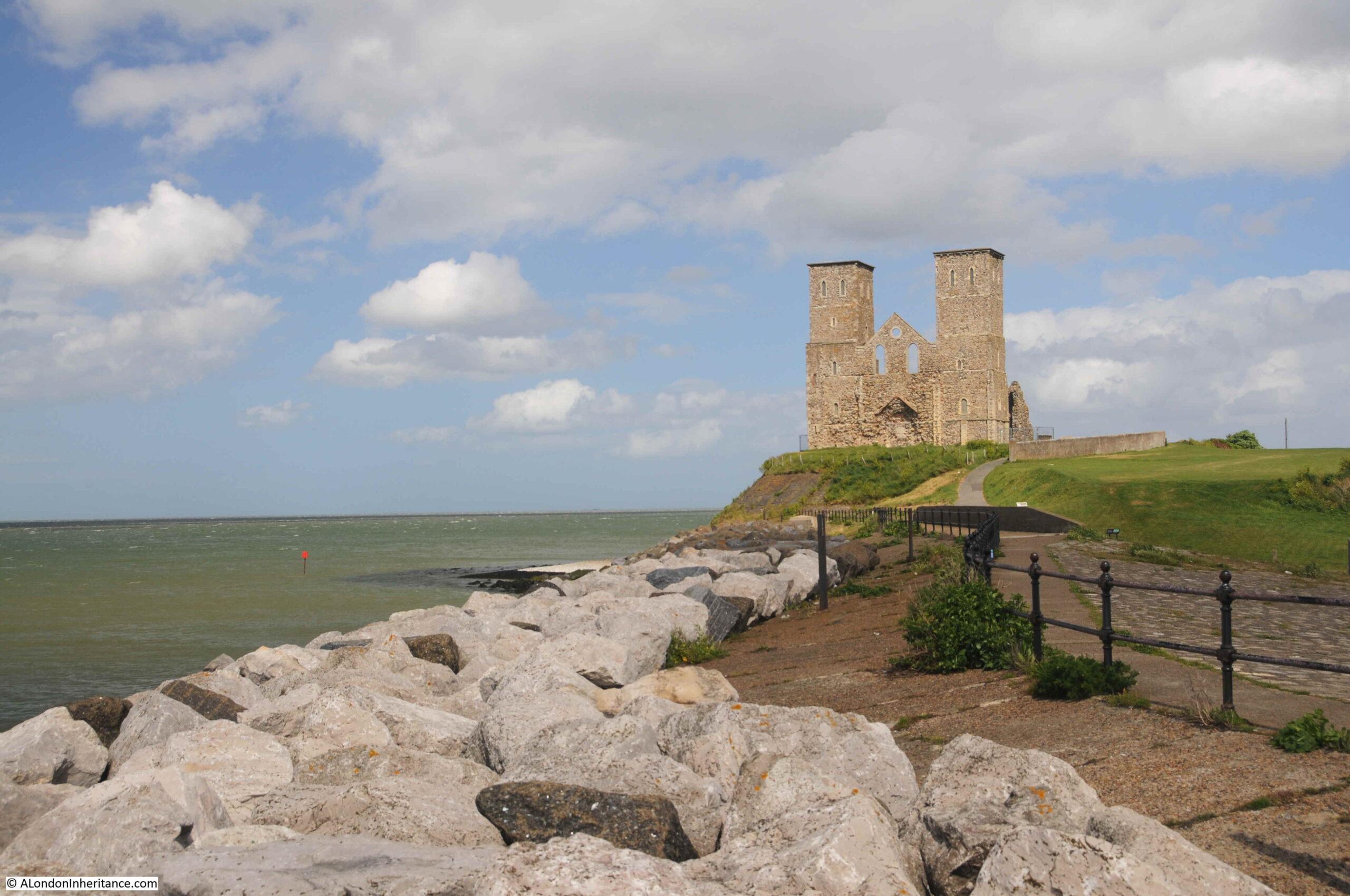
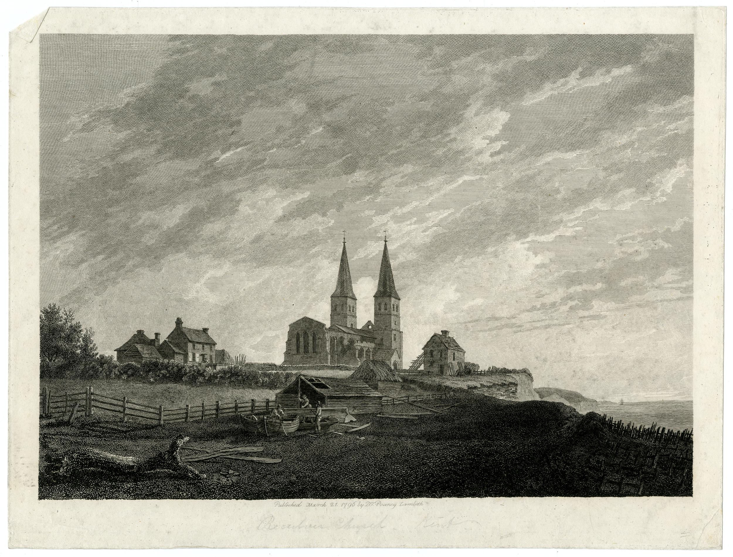
One of these is the ancient church of Reculver on the north Kent coast. The remains of a church built in an old Roman camp, with two distinctive towers that for long were navigation markers for those sailing on the estuary.
This has long been an important location, with the first major construction on the site being an early Roman fort. A Saxon church was built at some point around the year 669, with the church forming the core of a small monastic settlement.
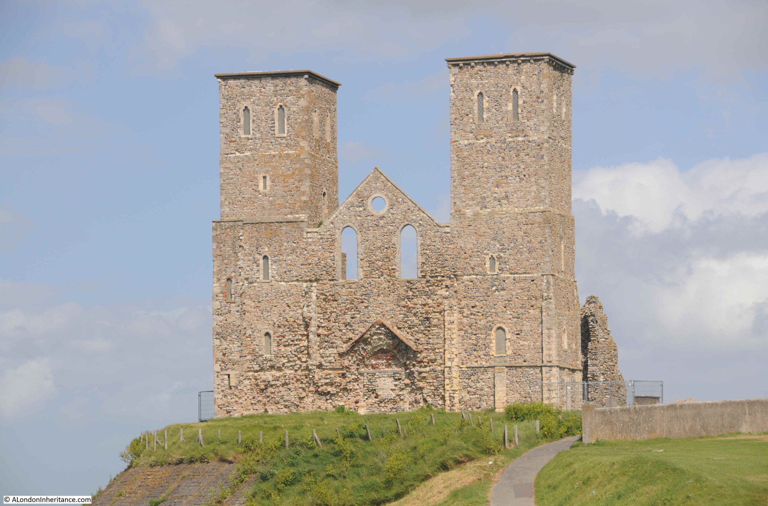
The towers were added when a series of alterations were made to the church at the end of the twelfth century. This work included a new, large west facing doorway.
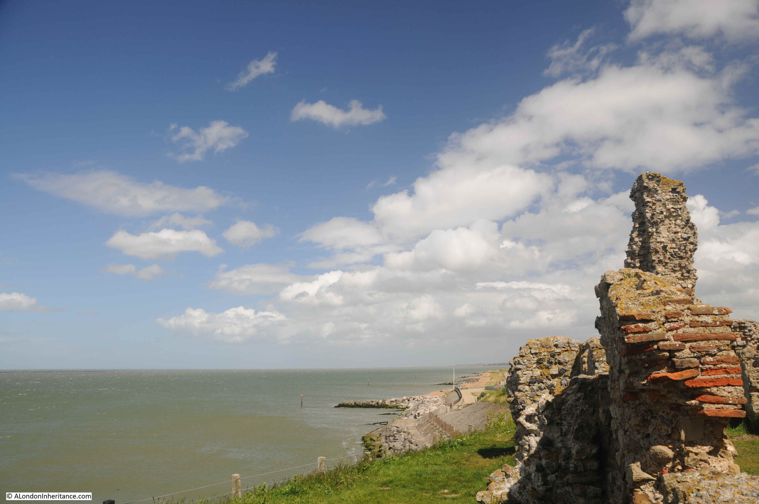
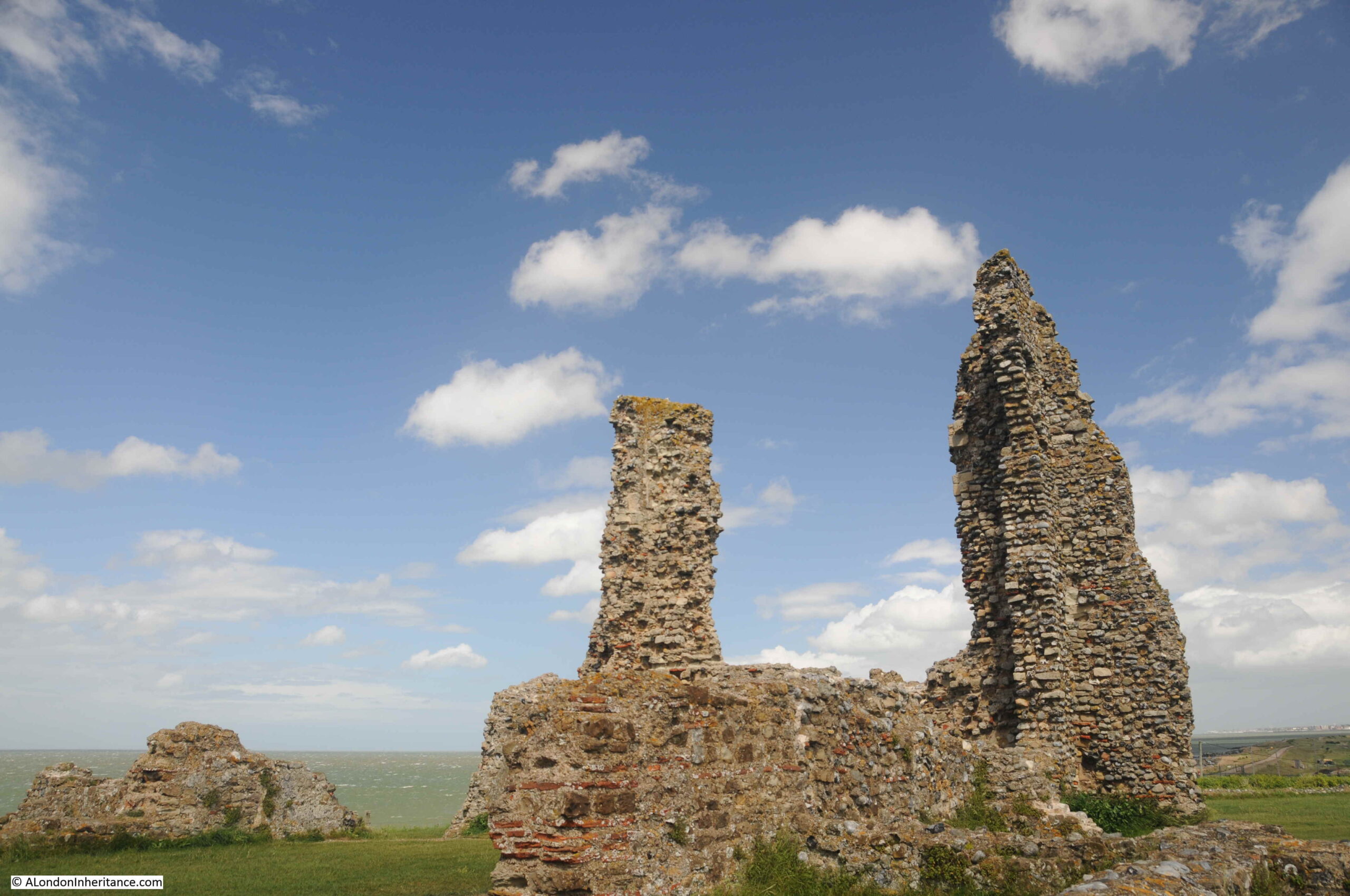
The church was built in the centre of the original Roman fort, and the church was originally almost a mile from the sea, however erosion has taken the sea up to the edge of the church, and the land occupied by almost half of the Roman fort has been lost.
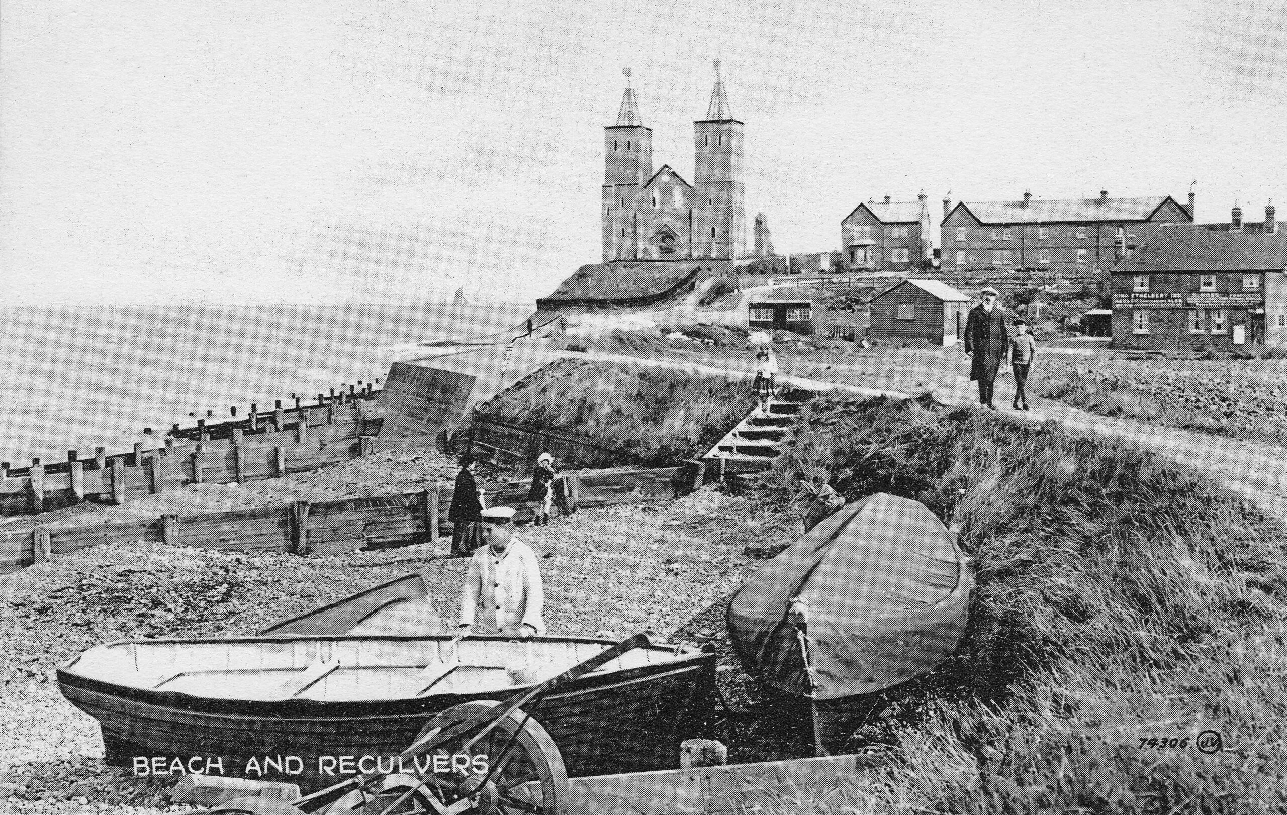
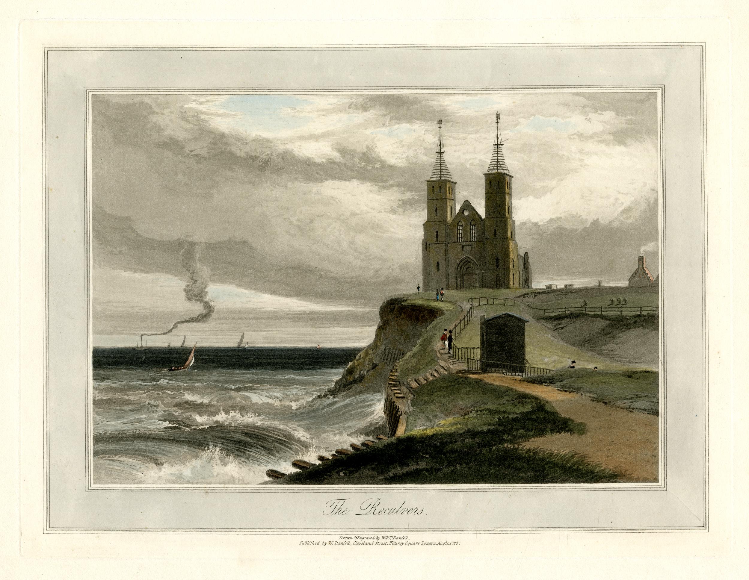
The beach (now occupied by large rocks to prevent further erosion) and the church has long been a tourist destination, and the following early postcard shows what would have greeted visitors in the early 20th century:
The Monastic establishment came to an end in the year 949 when the building took on the role of a parish church. The rebuild of the late twelfth century utilised the remains of the old monastery to construct the new church.
Over the centuries, land was gradually being eroded, and by 1780, the northern corner of the church was only 50 yards from the sea. In 1802 much of the core of the church collapsed and by 1805, the two towers were at risk.
The prominence of the two towers, on the cliff, overlooking the sea and the Thames estuary was critical to navigation. The minutes of Trinity House from 1662 record the need to make repairs to the steeples of a building that was long regarded as an “ancient sea mark”.
With the two towers at risk in 1805, Trinity House took action and purchased the remains of the old church in 1810 and built groins along the beach in front of the cliff, to break up the action of the waves. They also faced the cliff with stone to prevent further erosion, and following this work, the two towers have been able to continue to help those navigating at sea.
Trinity House also rebuilt the wooden steeples at the top of the towers, which had been blown down (it can get very windy along this exposed coast).
Navigation markers, such as the towers at Reculver, were becoming less relevant in the early 20th century for navigation on the Thames estuary, so Trinity House handed over the site to the Government’s Office of Works in 1925, and it is now the responsibility of English Heritage.
Getting closer to the church and the original west facing entrance can be seen, now blocked up.
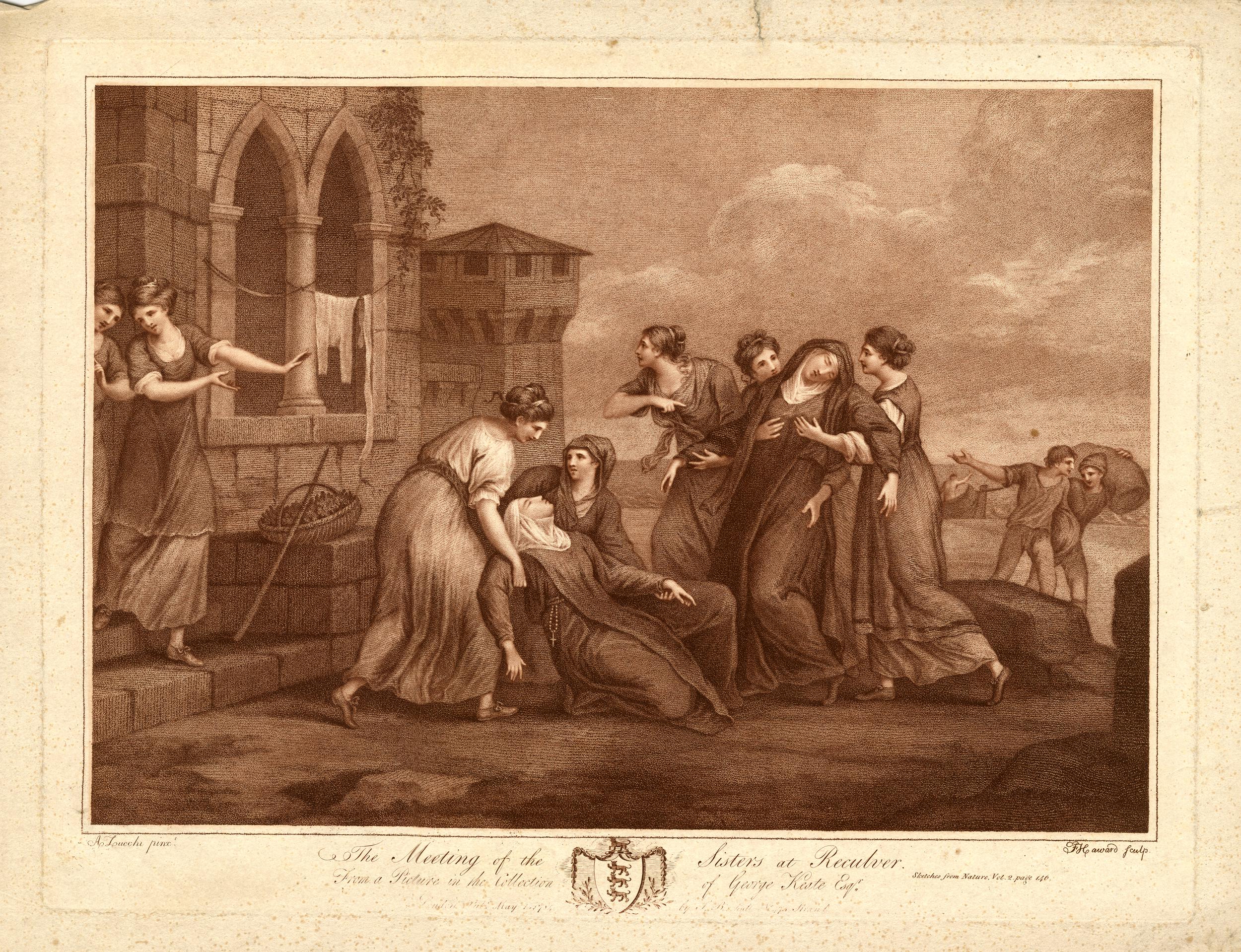
A legend associated with the twin towers of the church is that they were either caused to be built, or where repaired around the year 1500 by Frances St. Clair, Abbess of a Convent of Benedictine Nuns at Davington.
There are a number of variations to the legend, with the majority recording that Frances, along with her sister (also a nun) were travelling on a ship that was shipwrecked near Reculver. They were brought ashore at the church. Some variations record that her sister Isabelle died in the ship wreck, other that they were both saved.
Either way, due to the shipwreck, Francis had the towers built / repaired as a result of being saved, or in memory of her sister.
The site of the church has probably been in use for well over 2,000 years. Archaeological excavations have shown that the Roman fort probably started as a small initial camp for the invading Roman forces in the year 43. Excavations have also revealed that Reculver was the site of an earlier Iron Age farmstead.
The site was occupied throughout the Roman period, and the main walled fort was built early in the third century. It became one of the line of forts known as the Saxon Shore Forts which were established along the eastern and southern coast of England, and the northern coast of France, in the late third century, to protect against raiding parties as the Roman empire started to face many of the threats that would result in Rome abandoning England in the early 5th century.
The remains of a number of the walls of the fort can still be seen around the site, and Roman tiles and stone were used in the construction of the church. The distinctive red / orange Roman tiles can be seen embedded in many of the remaining walls of the church:
My last visit to Reculver was on a brilliant sunny day, and the ruins of the church stood out against a blue sky.
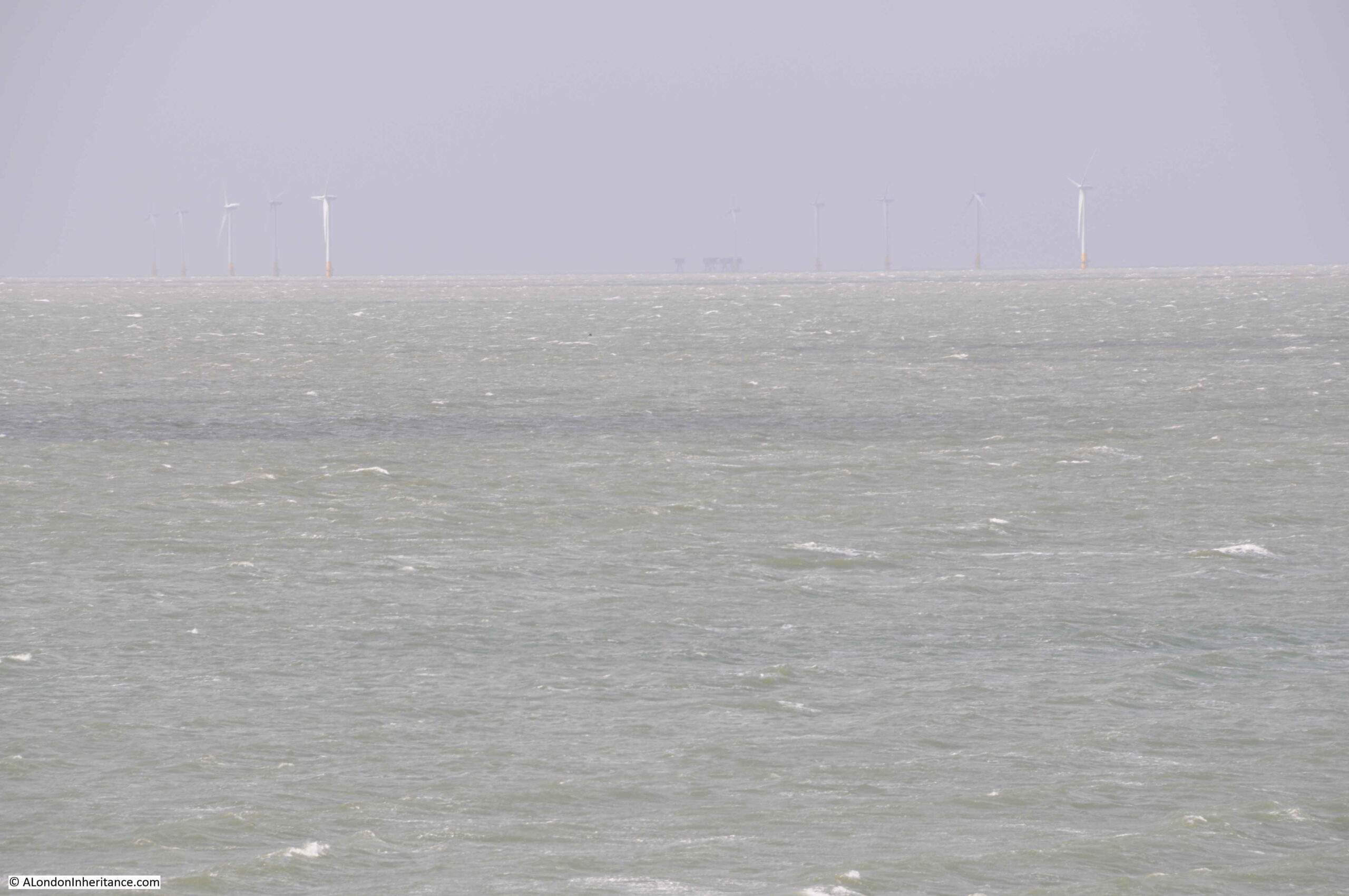
Whilst today there are very few sailing ships off Reculver using the towers as navigation markers, the view from Reculver includes the Kentish Flats wind farm, roughly six miles offshore, and in the middle of the following photo, just visible on the horizon, is the Red Sands fort:
Reculver is a fascinating place to visit at anytime of year. It is also a good place to see the impact of coastal erosion, with getting on for a mile of land having been lost in recorded history. Without the work of Trinity House, it is doubtful whether the two towers, the remains of the body of the church, and some of the walls of the Roman fort would remain for us to see today.
That’s my last post for 2021. Thanks for reading over the last year, and can I wish you all a very happy and healthy 2022.
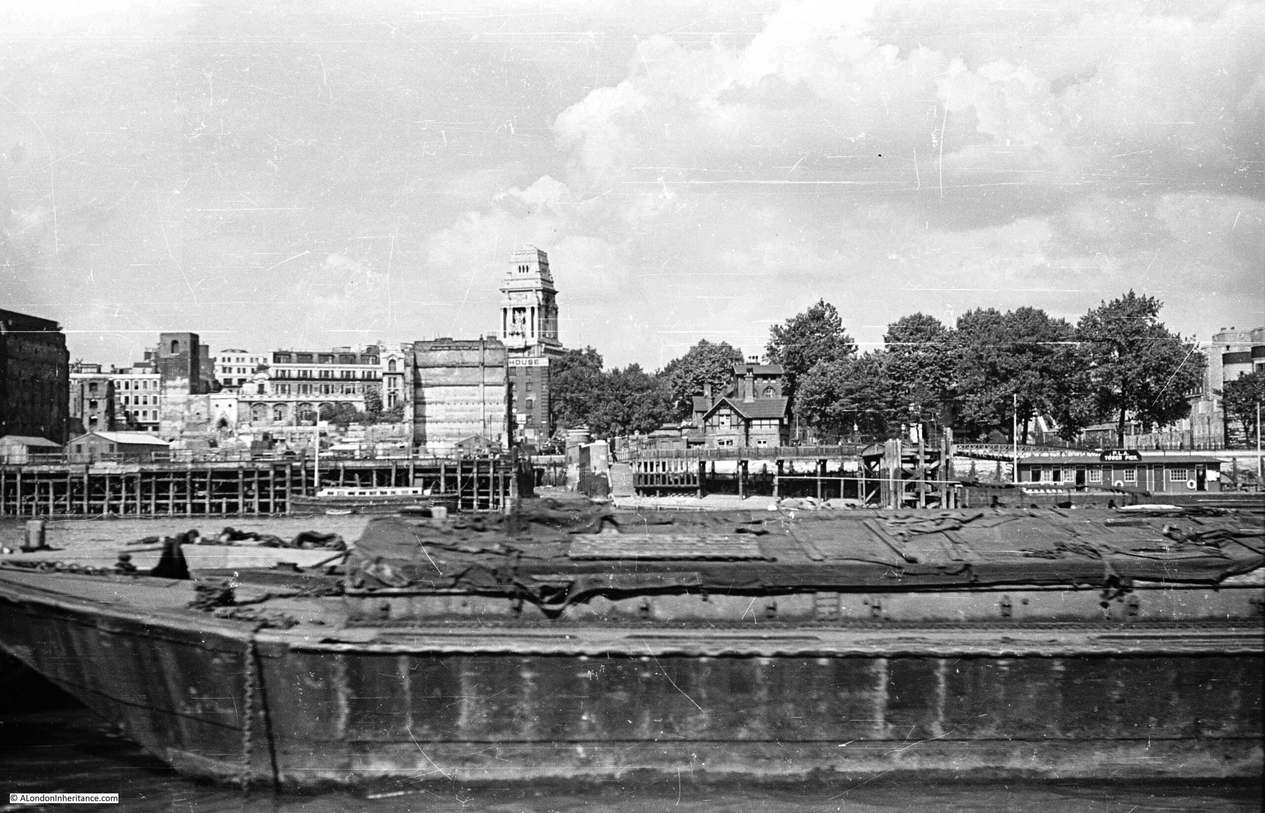
The following photo was taken by my father in 1947, from the south bank of the River Thames, looking over to the north bank, just to the west of the Tower of London (part of which can be seen on the right hand edge of the photo).
The tall building in the centre of the photo is the former headquarters of the Port of London Authority on Trinity Square. Lower, and to the left can be seen a blackened tower. This is the remains of the church of All Hallows by the Tower after the area was very badly damaged by wartime bombing.
Hard to see, but in the very centre of the photo, along the river edge is a set of stairs. I have enlarged the section of the above photo to shows the stairs below:
This was Tower Stairs – one of the many old stairs leading from the land down to the river, described in an 18th century newspaper as “the greatest plying place in all London”.
I have written about a number of these stairs in previous posts, and I must admit to be fascinated by them. They connect two very different worlds, the land and the water, although they are an integral part of both, and for so many people they have been a point of arrival or departure.
Along with City churches, they have been in the same location for centuries. They are a fixed point where we can trace events in the history and life of everyday Londoners.
The majority of Thames Stairs are not that obvious, and people probably walk by without noticing them.
A wonderful project would be plaques alongside to restore the original name of each of these stairs, and perhaps some of the key events that happened at each stair. An initiative to try and reconnect people with the river.
Tower Stairs were an important set of stairs to the river. They were adjacent to the Tower of London and they were to the east of London Bridge, therefore if you were travelling to places along the east of the river, such as Greenwich, by using Tower Stairs you would avoid having to pass through the narrow arches of London Bridge, where the fast flow of water through a narrow gap was always a risk.
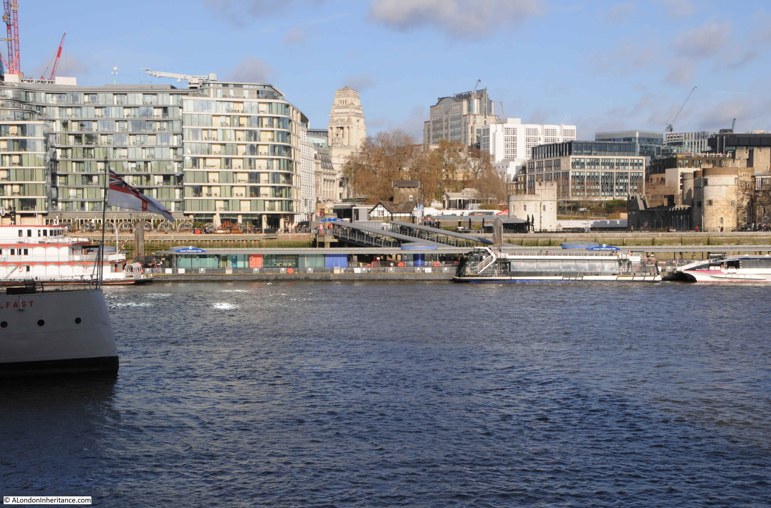
The following photo is my 2021 view of the same photo taken by my father in 1947:
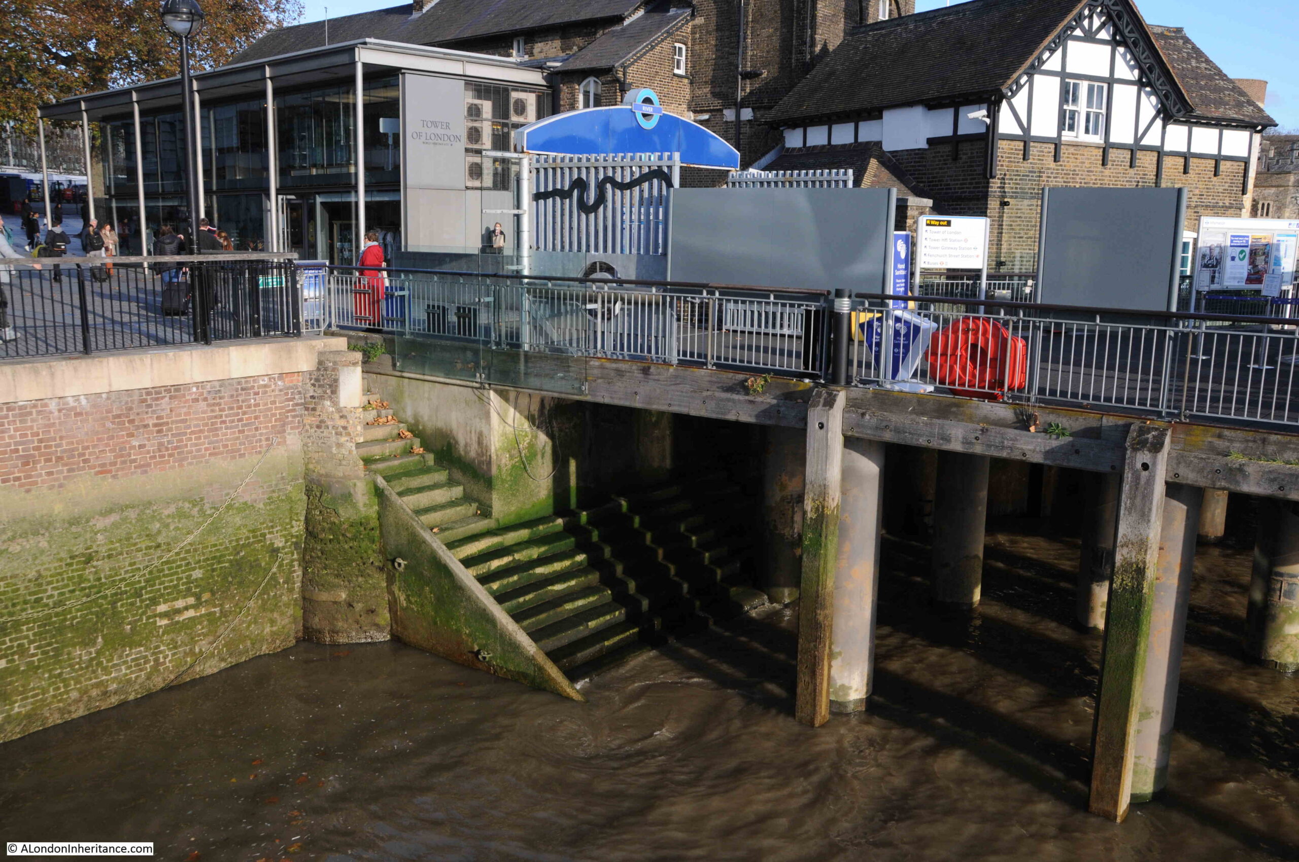
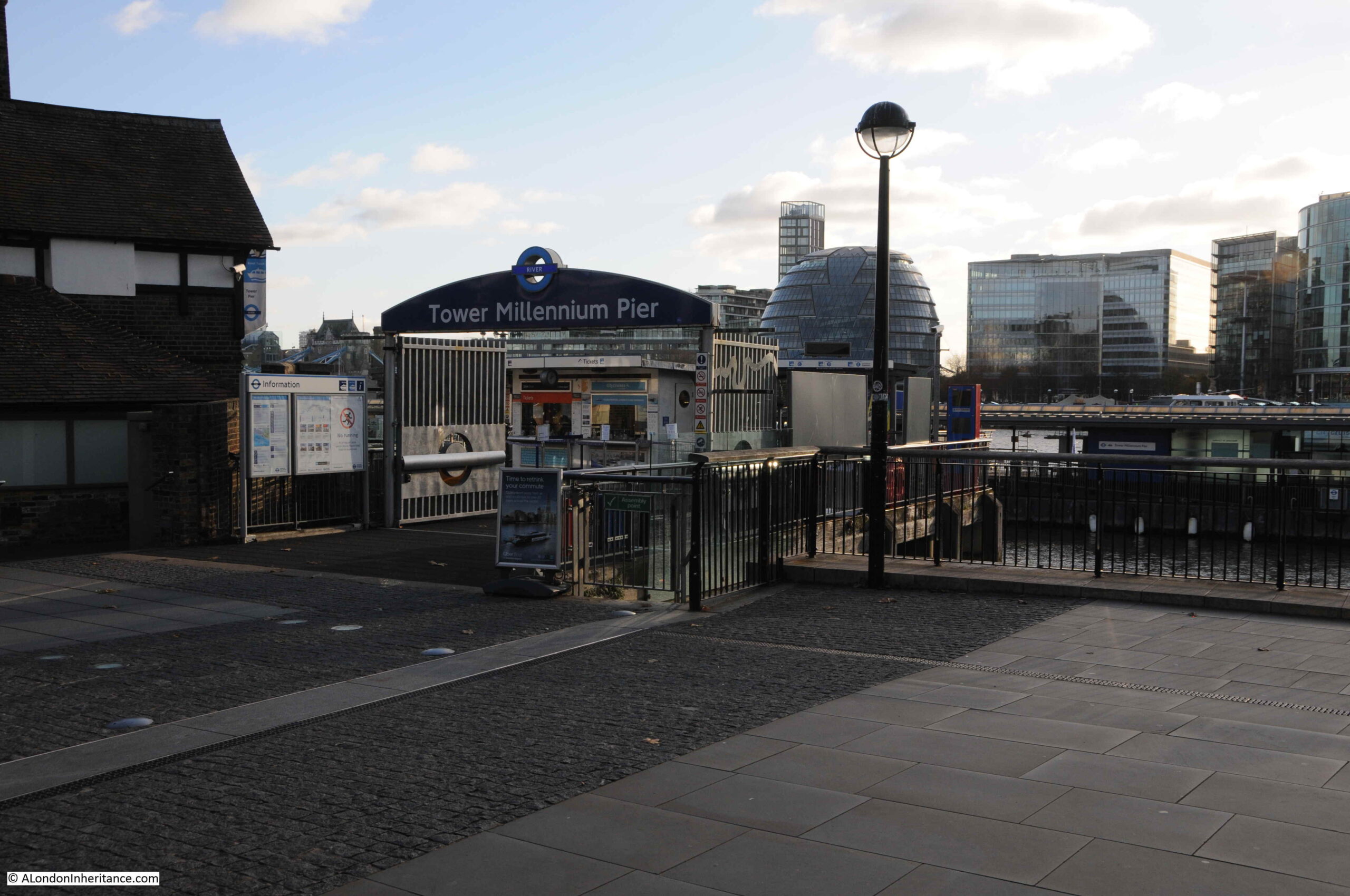
Tower Pier now hides the location of the stairs in the above photo, so to find them, we need to cross the river and look for them under the entrance walkway to Tower Pier:
A wide set of stairs remain, although a considerable width of the stairs has been built on to provide support for the entrance to Tower Pier. Only a narrow section on the left of the stairs runs up to street level.
The following photo is looking at the entrance to Tower Pier. The entrance to the stairs is to the lower right of the pier entrance, at the end of the central light section of paving which runs between the two dark sections.
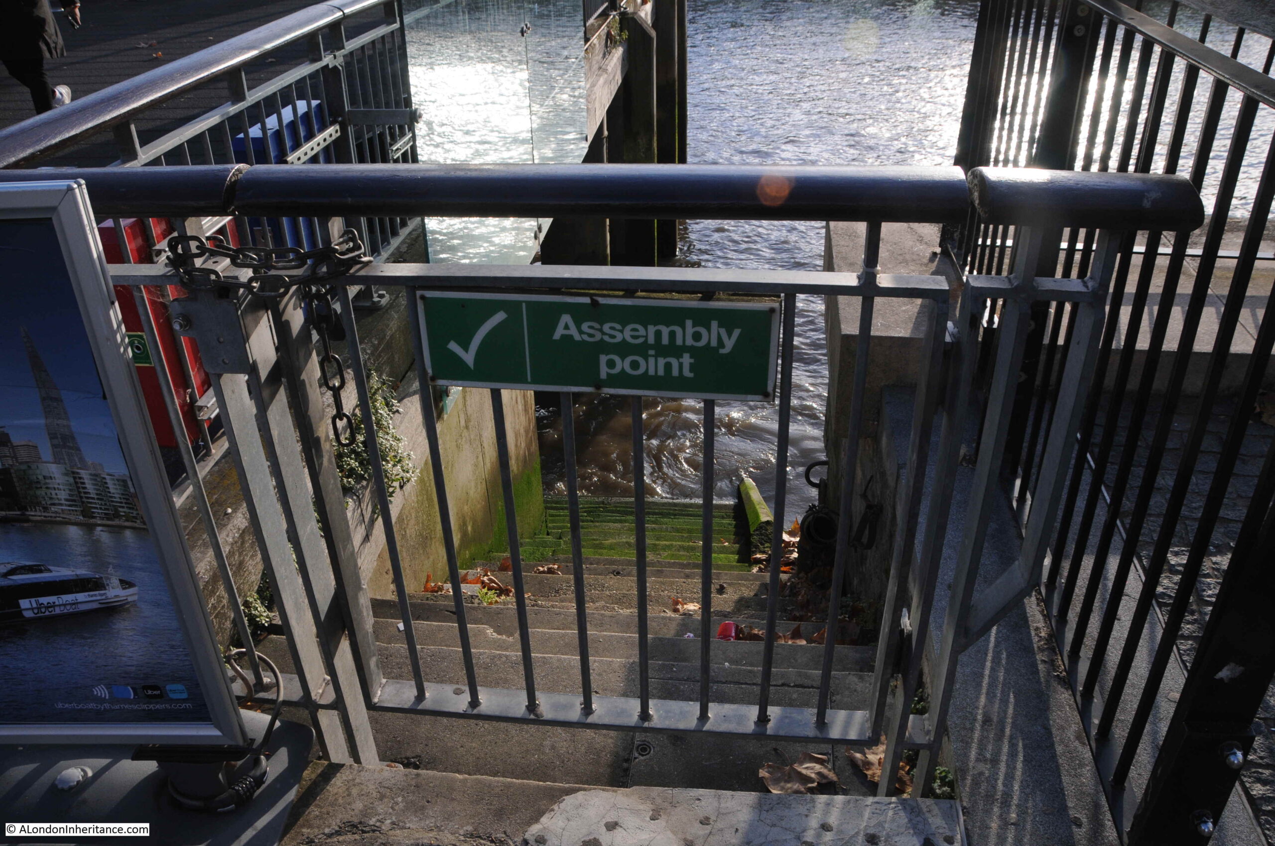
The entrance to Tower Stairs (unfortunately locked), showing the narrow section which leads down to the wider stairs and to the river.
There are numerous newspaper reports about events happening at these stairs.
In March 1793, it was reported that “one hundred and fifty Frenchmen, chiefly officers, who had fled from Dumourier’s army, landed at Tower Stairs from Holland. They gave the most deplorable accounts of the wants and distresses of Dumourier’s soldiery”.
In May 1750, after reviewing the First Regiment of Foot Guards in Hyde Park, the Duke of Cumberland arrived at Tower Stairs , where he took to the water “to go Pleasuring for a few days in the Caroline Yacht”.
In January 1768, the stairs were described in the words I used in the title to this post as “the greatest plying place in all London” which gives some indication of their importance. The same report stated that old houses adjoining Tower Stairs would be pulled down in the spring to make the “landing more commodious”.
Tower Stairs was also the site of the numerous small tragedies that were almost a daily occurrence on the river. In May 1739 “a young lad, about 18 years of age, servant to a Druggist in Wood Street, washing himself in the river off Tower-stairs, was taken suddenly with the Cramp, and drowned, in sight of numbers of spectators, none of whom could be quick enough to save him”.
And in October 1738, “Captain Collier, Commander of a Norwayman, landing at Tower Stairs, upon stepping on shore, his foot slipped, and he fell into the river and drowned”.
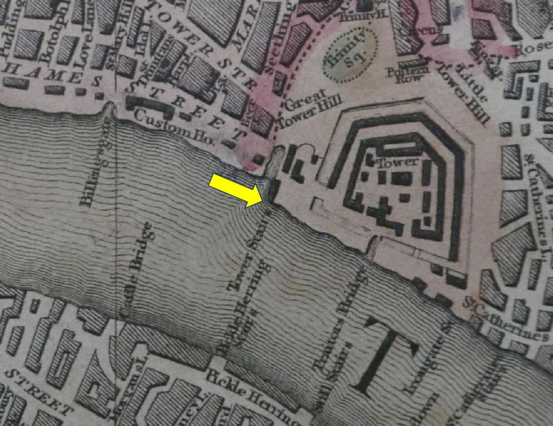
Tower Stairs are very old. Although not named, they are shown on the 19th century reprint of the mid 16th century map known as the Agas map (although the original has not survived, only later, modified copies).
The stairs are not named, but in the following extract, look to the left of the Tower of London, and a wide street runs down to the river, where there is a break in the river wall. A man appears to be driving a couple of animals into the river at the point where the stairs are located.
The stairs are shown and named Tower Stairs on Rocque’s 1746 map of London. They appear right on the edge of the page on my reprint of the map so I have not included an extract.
They are also shown on Smith’s New Plan of London, dating from 1816. I have arrowed the stairs in the following extract:
The importance of the stairs can be judged by their location, adjacent to the Tower of London, and where Great Tower Hill meets the Thames. As can be seen in the above map, there was also a small inlet to the left of the stairs, which probably provided additional mooring space for Watermen, and boats loading and unloading at the stairs.
As you have probably seen from previous posts, I use newspaper archives as one of the historical sources when researching posts.
Being newspapers, they have to be read with some care, to try and see through the way the story has been edited and added to by the journalist, however they do provide an account that was written at the time.
There are numerous references to Tower Stairs, so I decided to take a few from the 18th century to see what was happening at the stairs. I have already recorded some local events, but there were four accounts mentioning Tower Stairs that tell of a wider story of life in London in the eighteenth century, based on people who walked along Tower Stairs, so for the rest of the post, four stories about Press Gangs, the Frozen Thames, the Blackheath Chocolate House and when Cherokee Indians visited London.
The Press Gangs
The danger of being taken by a Press Gang and tricked into service in the Navy was more often a risk for those living and working in the streets to the east of the City, however those sleeping in their beds in the City were at risk, but the City of London would always protect their citizens, as this report from the12th of September 1755 records:
“Monday at the Sessions at Guildhall, Robert Alsop, a Midshipman of one of her Majesty’s men of War, was convicted, upon his own confession, of riotously entering the Dwelling-House of Mr. William Godfrey at Billingsgate, a reputable Citizen, and Livery Man of London, at the Head of a Press-Gang, on the 25th of June last, in the Night-time; and for seizing him by the collar, knocking him down, forcibly dragging him through the Streets of London to the Tower-Stairs (with only one Slipper on), carrying him on board a Tender on the River Thames, and confining him in the Hold for twelve hours, without any Warrant of lawful Authority, to the great peril of his Life; when the Court were pleased to fine him £5, and to order him to be imprisoned one Year in Newgate. This Prosecution was carried on by the Directions of the Court of Alderman, at the Expense of the City, in order to vindicate the Rights and privileges of its Citizens, and to prevent such Insolences for the future.”
The City of London was always ready to defend the “Rights and Privileges” of their citizens. I suspect a fine of £5 and one year of imprisonment was a reasonably hard sentence, which also acted as a deterrent to others.
During the 18th century, the Navy was in almost constant need of men to man the ships. The Derby Mercury on the 17th March 1743 described another event at Tower Stairs, when “They press so strong upon the River Thames for Seamen, that not a Day passes but they get a great many Hands, and last Saturday, a Waterman, belonging to Tower Stairs, who had a Protection, was pressed five different times”.
Protection was mainly issued by the Admiralty or Trinity House for specific types of employment, and the bearer had to prove their protection if they were caught by a press gang. This would normally stop a person being taken, however in times of war, even protections were abandoned and almost anyone could be taken.
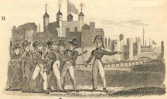
The 1828 edition of City Scenes by William Darton shows a press gang in operation at Tower Hill. I assume the man at the front is pointing towards Tower Stairs where the unfortunate man is being dragged. A Royal Nay ship can be seen in the background.
Having avoided the Press Gangs, there is another danger in the Thames off Tower Stairs:
The Frozen Thames
Up until the mid 19th century, a period known as the Little Ice Age had been causing very cold winters and periods when warm summers were not always dependable. This period of colder weather began around the 14th century, but the impact on London is well documented in the 17th, 18th and 19th centuries.
Whilst the popular image is of ice fairs held on the Thames, for those who had to work or travel on the river, ice would also present a danger. For those without the sanctuary of shelter and warmth, very low temperatures would also be a risk to life.
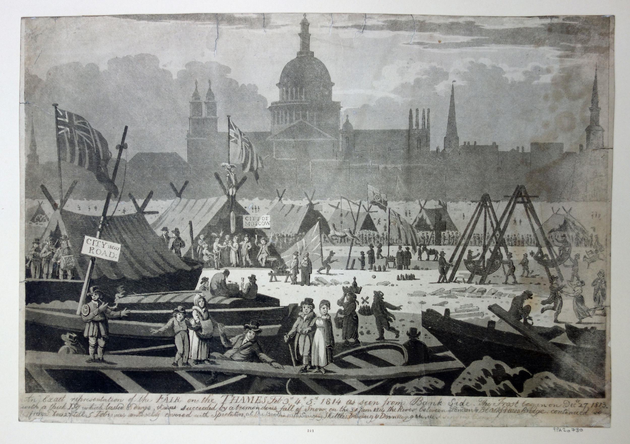
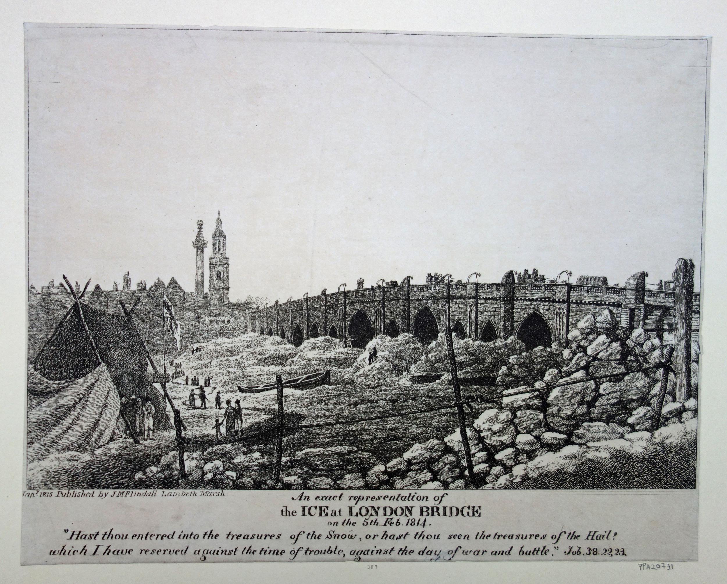
News reports referencing Tower Stairs show the dangers of the frozen River Thames. On the 12th January 1740, the Ipswich Journal reported: “On Tuesday Night an adventurous Waterman undertook to carry his Fare, a Woman and a Child, from Tower-stairs to Battle-Bridge, as the tide was coming in; but the Islands of Ice floating down upon them they were drove to the Bridge, where they lay in sight, perishing with the Cold, but out of reach of Relief from any of the Inhabitants of the Bridge, but at last were fortunately carried through to St Mary Overy’s Stairs, and taken up almost to Death. Tis thought neither the Woman nor Child can recover.”
The Bridge was London Bridge when it still had houses and businesses running along the bridge over the river. The relatively narrow arches for water to flow under the bridge caused a fast flow and it was a very dangerous place to get trapped.
In the same report was an indication of the amount of ice on the river “Yesterday morning at Low Water, the Thames was so covered with Ice above Bridge, that several Men walked over from Old Swan to Pepper-Alley Stairs”.
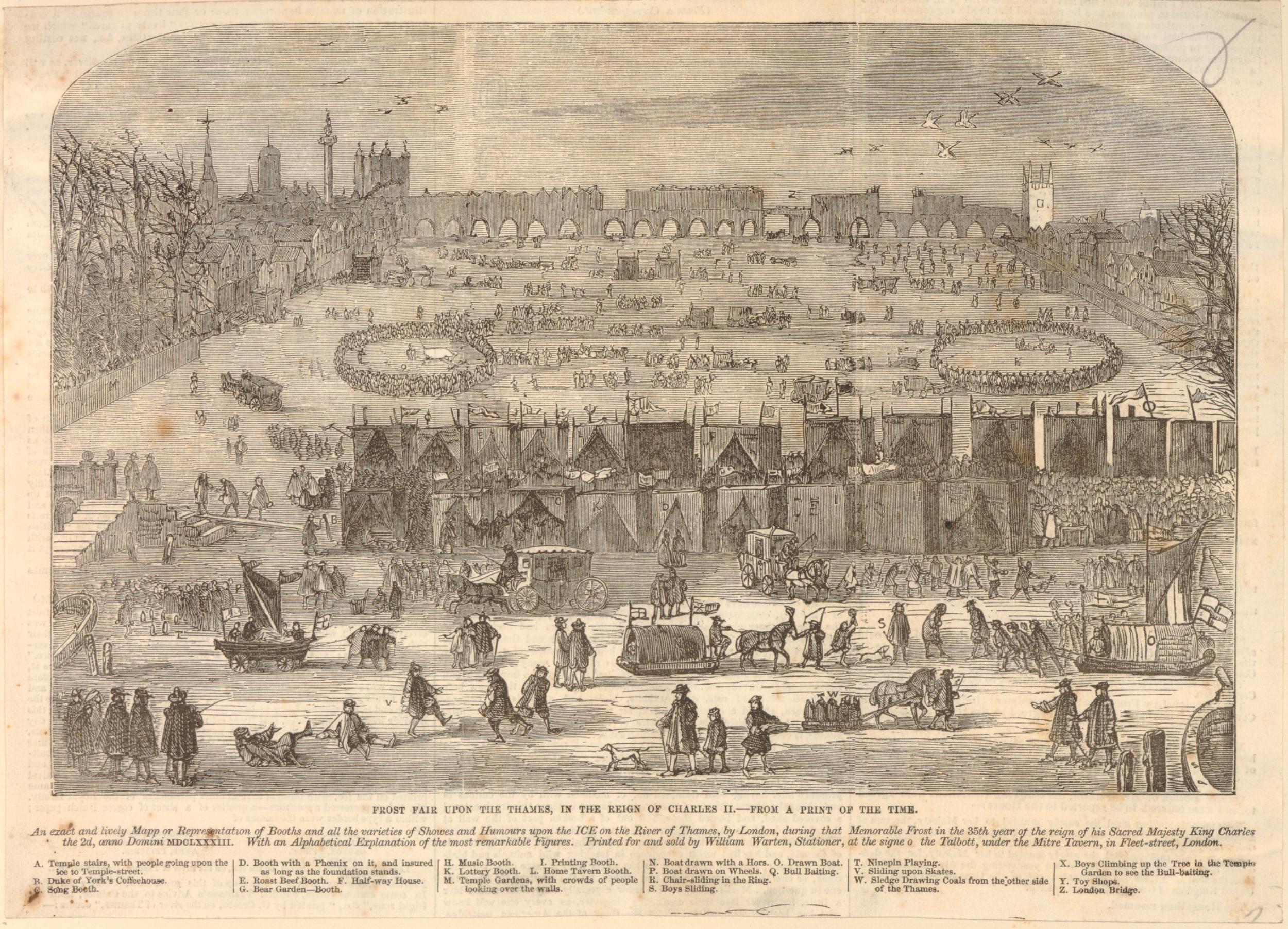
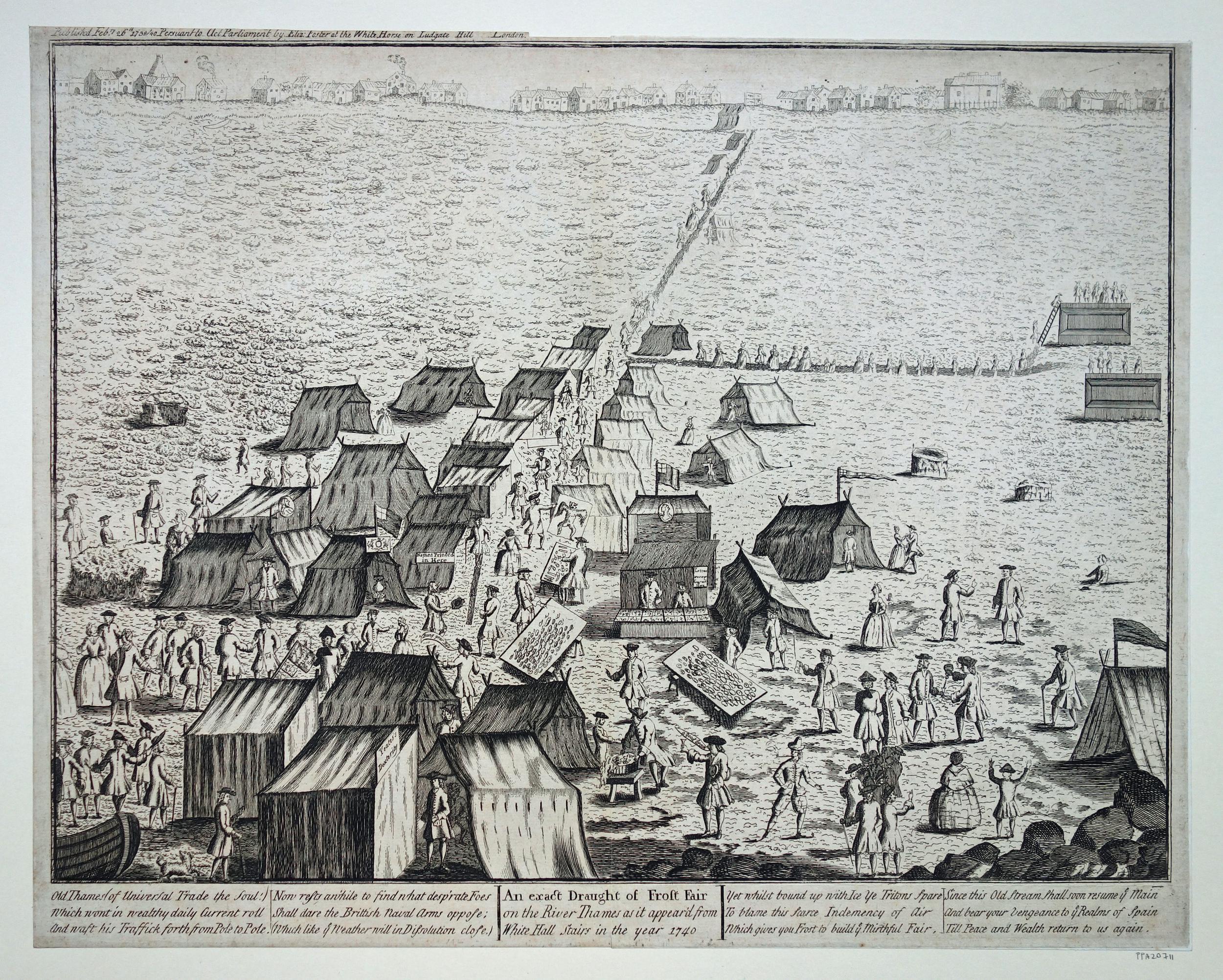
Although prints such as the one above show a scene of celebration on the frozen river, there was a very dark side as the Kentish Weekly Post reported on the 9th January 1740 where “Several dead Bodies float up and down with the Tide and Ice, but none of them can be taken up”.
The winter of early 1740 seems to have been a particularly bad winter for those on and off the river. On the 5th of January “Above 30 boats, twas judged lost between Tower-stairs and Woolwich, most of which were stav’d, but some sunk under the Ice and were not seen afterwards”.
The above paragraph referencing Tower Stairs was at the end of a longer description of the January weather in London: “On Saturday Night, by the Violence of the Wind, several boats were drove from their Fastenings above Bridge near Shore and stav’d to Pieces by the large Flakes of Ice that were brought down by the Tide. The same day in the morning, a Hoy laden with Malt was sunk in Chelsea Reach by the Violence of the Wind.
Two Coasters were drove from their Anchors at Horselydown upon the Sterlings at London bridge, where they lay for some time being beaten against the Houses, to the great Terror of the Inhabitants; but by the turn of the Tide they were luckily carried off, tho’ not without having sustained very great Damage.
Besides the two Vessels above-mentioned, there have been five more since cut from their Anchors by the Ice and drove down against the Bridge, where their Bowsprits have broke into several of the houses of the Eastern side and done great Damages to the Inhabitants.
On Sunday three Boys in a Boat off Rotherhithe were drove away by the great Flakes of Ice and perished thro’ the Severity of the Frost.“
As ever, what is a danger to some is an opportunity for others, although in this instance, without the hoped for outcome:
“Yesterday great Numbers of London Gunners assembled at the several Stairs leading to the Thames, to shoot Ducks, Gulls and Road Geese, which appeared in great Plenty; and many of them were killed, tho’ none could be brought off, the Frost not yet having prevented the Currency of the Tide. Dogs were of no use to bringing them off, the Edges of the Ice on which the birds settled being too weak for the Dogs to get up by.“
As well as freezing much of the Thames, the cold winter of 1740 was a danger to those without the benefit of shelter and warmth:
“A poor man without either Money or Friends, on Friday night last was obliged to take up his Lodging on a Laystall in Tyburn Road, and was on Saturday Morning found dead thereon; although he had covered himself over with Dung and loose Litter.
On Sunday Night last, about nine o’clock, a Man about 60 years was found dead in Pensioners Alley in King-street, Westminster, supposed to have perished for Want; as were also two aged Men by the Waterside at White-friars, and two Women in Old Street, all through excessive Cold and for Want of Nourishment.”
A laystall, referred to in the article was a place where “waste and dung” was deposited.
Now off to a warmer place, as my next stop from Tower Stairs is:
Blackheath Chocolate House
Tower Stairs appear to have been one of the main routes for Royalty when they headed to Greenwich. From the Newcastle Courant on the 8th September 1722:
“This day the young princesses, with a Guard, came through the City, took water at Tower Stairs for Greenwich; dined at Sir John Jennings, and after seeing the Hospital of Greenwich and other Rarities of the place, returned in the evening to Kensington”.
On the 30th June 1736, the Kentish Weekly Post was reporting another Royal visit to Greenwich, which included a visit to a place of entertainment at Blackheath:
“On Saturday evening their Royal Highnesses the Prince and Princess of Wales came through the City from Kensington, and taking Water at the Tower Stairs, went down the River in a Barge, attended by two others, in one of which was a fine Band of Music. Their Royal Highnesses landed at Greenwich, and went to the Chocolate House on Blackheath, where they had an elegant Collation, and about twelve returned back to Kensington.”
The Prince and Princess of Wales were the future King George II and his wife Caroline of Ansbach.
The Chocolate House was a popular place for people to meet, drink chocolate, scheme and plot in the 17th and 18th centuries. The chocolate drink was very different to the type we would drink today. It was heavily sweetened, and would be flavoured with spices and fruits.
There were several Chocolate Houses in London, but I was not aware of one at Blackheath, which if not already a popular place, would be the place to be seen after the Prince and Princess of Wales visit.
The article referenced Blackheath rather than Greenwich, so it was not close to the river or in the park, and luckily a series of articles in the Kentish Mercury in 1902 located the site of the Chocolate House, starting with the following article on the 22nd August 1902:
“THE CHOCOLATE HOUSE ON BLACKHEATH: A glimpse of the ‘manners and customs’ of some 130 years ago is obtained in the following paragraphs taken from the Kentish Express of July 4th, 1774 – ‘Friday, the Kentish Society held their annual feast at the Chocolate House in Blackheath, where there was a most elegant entertainment, and it was unanimously agreed to support the Hon. Mr Marsham and Mr Sawbridge to be the Members of the County of Kent at the General Election, being gentlemen of very considerable property in the said county, and independently to support the interest of the same. Lord North’s name was mentioned, that he is tended to offer, but they all declared to oppose him’.
Perhaps some of our readers can identify the site of the Chocolate house on Blackheath.”
The challenge of finding the location of the Blackheath Chocolate House was one that the readers of the Kentish Mercury rose to, and a series of articles followed based on reader feedback. On the 29th August 1902:
“A correspondent says that while he is unable to identify the site of the Chocolate House on Blackheath, he remembers that twenty years ago there was a pond at the top of Hyde-vale known as Chocolate Pond. He suggests that this may offer some clues.”
On September 5th, 1902: “Mr Alderman Dyer appears to put the matter to rest with the interesting statement that it was in The Grove between Nos. 4 and 5, and was a fashionable resort of the period. The beaux and belles of Blackheath much resorted thereto in the days when George the Third was King, for the purpose of drinking chocolate and discussing the scandal of the neighbourhood. The house was subsequently used as a ladies’ school, but was pulled down some years ago.”
The Kentish Mercury declared success in finding the location of the Chocolate House on the 26th September 1902, when “The question of the site of the Chocolate House on Blackheath, with a view to the definite fixing of which we some time solicited information, can now, we opine, assumed to be settled. documentary evidence in our possession goes to show that the site is now occupied by the houses 4 and 5, The Grove, Blackheath.
By the kindness of a gentleman living on Blackheath-hill we have been afforded the opportunity of inspecting a lease dated from 1776, from Mr. John Wilkinson to Mr. Charles Walker, of the property which stood upon the site in question., described in the document, which is mutilated, as in ‘Chocolate-row’.
Mr Charles Walker, aforementioned, is described as of ‘Chocolate House’. That this Chocolate House was a place of fashionable resort and entertainment we have previously mentioned. Proof is afforded by the fact that on the lease there are clauses relating to the use of the assembly rooms for ‘dancing, music and other diversions’. Our informant himself remembers the premises referred to, before the building was pulled down for the erection of those at present standing.”
The article also mentions an “Olde House” in Hyde Vale where the footmen and attendants would wait whilst their “masters and mistress were disporting themselves in the Chocolate House” – which gives a good impression of the atmosphere in the Chocolate House.
There were a number of Chocolate Houses in eighteenth century London, with Blackheath being described as one of the five most important. They were:
Blackheath Chocolate House – was much favoured by officers from Woolwich
The Cocoa Tree in Pall Mall, on what is now 87, St James’s, Pall Mall, gave its name to the Cocoa Tree Club, the oldest of existing London clubs. It was famous as a resort for Tory politicians.
Lindhart’s was in King Street, Bloomsbury
The Spread Eagle in Bridge Street, Covent Garden
White’s the most famous of any, was started in 1698, and was at the southern end of St James’s Street.
Having found the location of the Blackheath Chocolate House, there is one more story of those who had at one time passed along Tower Stairs, a delegation from the US, when:
Cherokee Indians Visit London
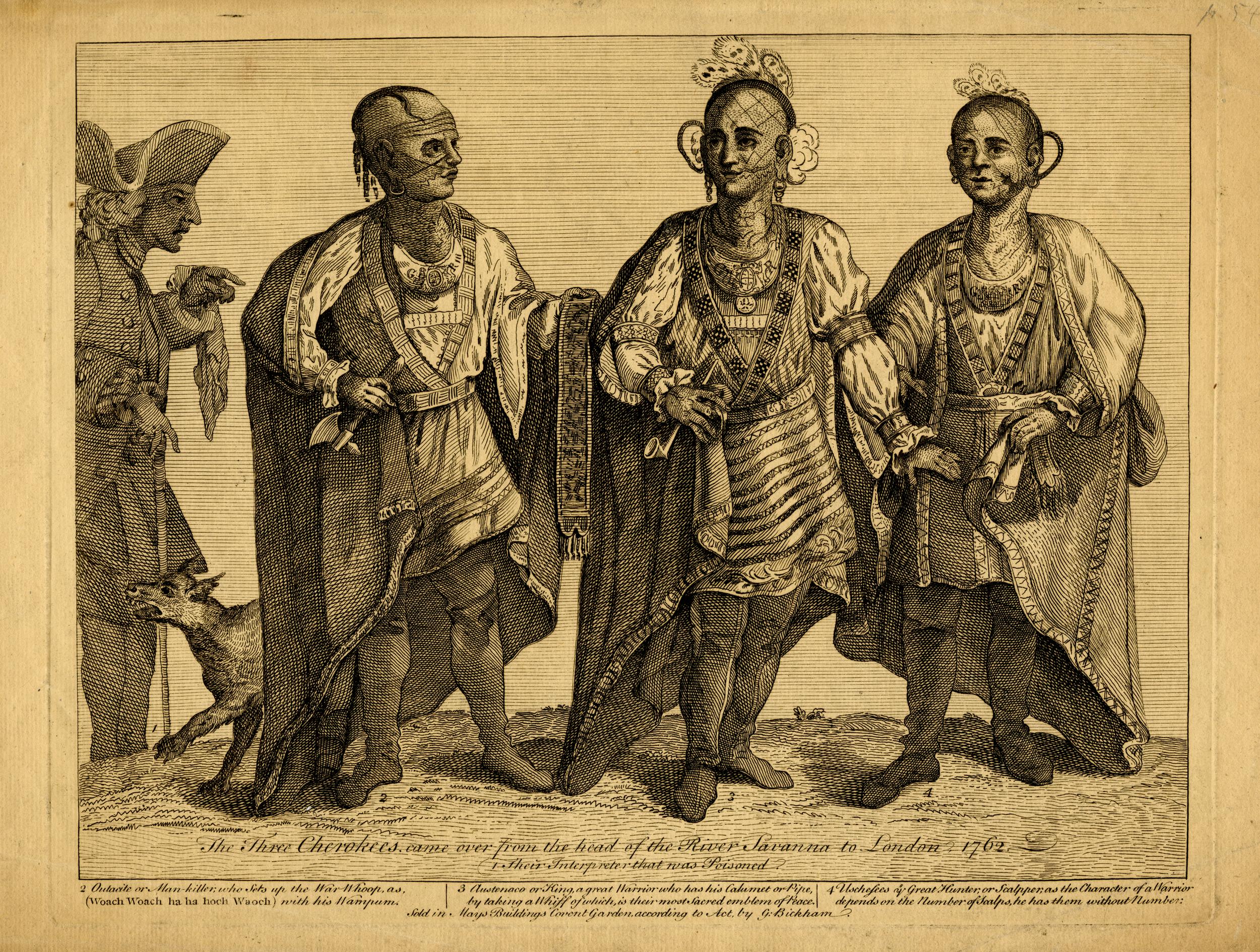
Reading through newspaper reports mentioning Tower Stairs, I found the following from the Oxford Journal on the 24th July 1762 – a report I was not expecting to find of some rather unusual visitors to Tower Stairs:
“This day the Cherokee King, and his two Chiefs, went in their Coach to the Tower-stairs, and about half an hour after Ten o’Clock, went on board the Admiralty Barge, in which they proceeded down the River to Deptford, Greenwich &c.”
The British had established an alliance with the Cherokee nation early in the 18th century, with both a trading and military alliance. This was important as the Cherokee were one of the major native American tribes and controlled land across what is now the states of Virginia, North and South Carolina, and Georgia.
An earlier Cherokee delegation had visited London in 1730 when a group of seven Cherokee, led by chief Oukanaekah spent time in London and had several meetings with King George II at Windsor Castle. This led to a treaty where the British supplied military equipment and the Cherokee agreed to trade only with, and fight alongside, the British.
The relationship between the Cherokee and British was tense at times, and the British did occasionally attack and burn Cherokee villages.
The Cherokee fought with the British against France and during the American War of Independence.
A member of the British Virginia Militia was instrumental in arranging the visit to London. Henry Timberlake had lived with the Cherokee for a number of months and was asked by Chief Osteneco for an opportunity to visit England and to meet with the King.
After sailing across the Atlantic (during their voyage their interpreter died which caused problems until a new interpreter could be found), they arrived in Plymouth and then traveled across country to reach London, where newspapers described their appearance:
“The Cherokee Indians lately arrived in Town, are tall men, six feet high, dressed in a shirt, trousers and mantel round them and their heads adorned with Shells’ Feather and Ear-Rings, unfortunately their interpreter died in his passage and they can now only express their wants by signs. They are shy of company, especially a crowd. This King’s business here is to pay his respects to our Monarch, with whom he has lately entered into alliance. In his own country, he can raise 10,000 fighting men.”
The following print shows the Cherokee leader, Osteneco (centre) with his two chiefs:
So what would a Cherokee delegation to London do in 1762. It appears they did much the same as a delegation from a country would do in London today. They were wined and dined, taken to shows, met key people such as the Lord Mayor and visited displays of military power.
I have been able to trace some of their itinerary as follows:
11th June 1762 – An Indian King and two Chiefs belonging to the Cherokee Indians arrived in London after landing in Plymouth from America
12th June 1762 – Cherokee Indians met the Earl of Egremont at his House in Piccadilly
28th June 1762 – King of the Cherokees, with his attendants, dressed in the English fashion, walked for some time in Kensington Gardens, and seemed highly delighted with the place. They dined with Governor Ellis.
3rd July 1762 – The Cherokee Chiefs were at Sadler’s Wells, and expressed great satisfaction at the entertainments of the place
7th July 1762 – At Vauxhall where they had a very sumptuous entertainment. The wines first set before them were Burgundy and Claret, which however they did not greatly relish. Others were then placed on the table, when they fixed upon Frontenac, the sweetness of which highly hit their palate and they drank of it very freely
11th July 1762 – Dined with the Lord Mayor at the Mansion House. They seemed greatly pleased with the numerous concourse of ladies and gentlemen who crowded the windows &c. to see them pass
23rd July 1762 – Mr. Montague conducted the Cherokee Chiefs to the Parade in St James’s-Park; they happened to enter the Guard Room just as the Grenadiers were fixing their bayonets in order to Troop the Colour. The formidable appearance of the men and the business that accidently were engaged in threw them into such agitation that it was with the utmost difficulty they were persuaded to advance a step on the parade. They had a suspicion of treachery, were extremely impatient to be gone, and when they got home defined to see no more of those warriors with caps.
24th July 1762 – This day, the Cherokee King and his two chiefs, went in their coach to the Tower Stairs, and about half an hour after ten o’clock, went on board the Admiralty Barge, in which they proceeded down the river to Deptford, Greenwich, Woolwich &c. They were much delighted with the hospital. An entertainment was laid on for them at the Greyhound, and after dinner they saw the park and the Observatory
28th August 1762 – The Cherokee Indians, in a Landau with six horses, visited Winchester Camp; at its appearance they seemed greatly surprised
30th August 1762 – Arrive in Portsmouth and visit the Theatre.
31st August 1762 – They went on board the Epreuve Frigate, and the wind being fair, sailed directly back to America
Whilst in London, Joshua Reynolds painted Chief Osteneco:
Soon after the Cherokee visitors had returned to America, the War of Independence started. The Cherokee nation allied with the British, but in reality this was more against the settlers who were continually moving closer to, and taking parts of Cherokee land.
As part of the War of Independence, in 1776 Osteneco led his forces against the Province of Georgia, however this resulted in the destruction of the towns occupied by Osteneco’s Cherokee tribes. He would then lead his people to the west and he eventually settled in the town that is today Chattanooga in Tennessee.
He died in 1780 at the house of his grandson Richard Timberlake. Henry Timberlake, who had lived with the Cherokee and was instrumental in bringing the delegation to London in 1762 was the father of Richard with one of Osteneco’s daughters being the mother.
After American independence, the British had no interest in the Cherokee nation. The following decades saw frequent skirmishes and battles with the forces of the independent state of America, and they would gradually loose their land and freedoms.
Today, Tower Stairs are hidden beneath the walkway to Tower Pier, however they were one of the key river stairs. Many thousands of people would have walked along these stairs, either passing to or from the river.
Of those thousands, four tell us a wider story of Press Gangs, the Frozen Thames, London’s Chocolate Houses, and when a delegation of Cherokee Indians visited London.
I just wish there was a conspicuous plaque naming these river stairs and providing some information on their history.
The problem with research using old newspaper archives is that there is so much else of interest to read and it is so very easy to get distracted. I was looking for a totally different subject, when I found an article that referenced a long closed east London Station, in the East London Observer on the 27th August 1887:
“A MILE END EXCURSION. It was one of the jolliest and most pleasant excursions in which we have ever taken part that started off from Globe-road station, in the very early hours of Tuesday morning. There was nothing stiff and starched about either the excursion or the excursionists – it and they were as delightfully and pleasantly informal as the origin of the Association in whose aid it was held – the Mile End Old Town Victoria Park Hospital Association.”
I love these insights into London life, written at the time they happened. There is more to discover about their association in a moment, but I wanted to find out more about Globe Road station.
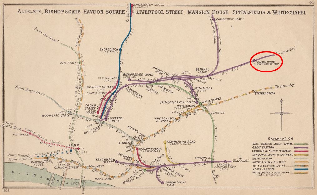
The full name of the station was Globe Road and Devonshire Street Station. It was located on the main line between Liverpool Street and Stratford stations and was originally part of the Great Eastern Railway’s efforts at generating traffic from the dense housing being built across east London, and growing demand for easier travel.
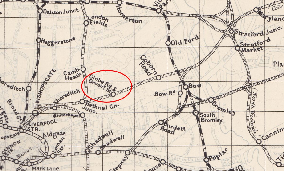
I have highlighted the station in the following page from the 1902 Railway Clearing House maps:
Another map showing Globe Road and Devonshire Street station on the route from Liverpool Street to Stratford. There are several other lost stations and stations that have changed name on the map.
So returning to the article that mentioned Globe Road station, where were the excursionists going on the 27th August 1887. The rest of the article:
“It was then the annual excursion which had drawn so many Mile-enders together on the Globe-road Station on Tuesday morning. In point of numbers, the gathering could scarcely be said to equal those of previous years – a result due rather to the vacillation and delay experienced at the hands of a railway company with whom the Association had first attempted to arrange, than to any lack of energy and perseverance on the part of the officers of the Association.
But no regretful consideration such as that was allowed to weigh with the excursionists; they were out for a day’s excursion to Harwich and Dovercourt, and like the thoroughly honest and hard working, genial Mile-enders as they were, they were determined to enjoy themselves to the uttermost. And everything on Tuesday seemed to favour that determination.
The day was one of the best and brightest with which the Metropolis has ever been favoured, and the round, red faced sun peered from behind the misty heat, and gave promise of even more charming weather in store. The special train too, hired for the conveyance of the excursionists, seemed to heartily enter into the spirit of the thing, and flew shrieking, past houses, villages, woods, fields and rivers, until, with a snort of satisfaction, it drew up at quiet, sleepy Dovercourt, with its breezy common, its golden sands, and its magnificent stretch of sea.”
They spent the day enjoying everything that Dovercourt had to offer before returning to Globe Road Station on their special train, a journey of a couple of hours through the Essex countryside.
Globe Road and Devonshire Street Station was a relatively short lived station, opening in 1884 and closing for passenger use in 1916.
In the 5th of July, 1884 edition of the East London Observer, a report on the opening of the station provides a detailed description of the new station:
“The station is entered from either Globe-road or Devonshire-street. It is a double station, having a spacious booking office at Devonshire-street and Globe-road respectively. The platforms are approached from the booking offices on street level, by staircases 9 feet in width, constructed of ‘Hedges patent wood treads’.
The platforms are 600 feet in length, by an average width of 25 feet, and are covered from end to end by a light ornamental glass, iron and zinc roof. The platforms are paved with ‘Victoria Stone’ throughout. This material is well-known, but these platforms will serve as an excellent specimen of the pavement. On each platform are well arranged ladies and gentlemen’s waiting-rooms for each class of passenger. A drinking fountain for the use of the passengers is placed on each platform. Offices for staff are provided, the platforms are well lighted throughout, and every improvement and modern requirement for a London suburban station, has been carefully studied and provided.
The works have been carried out by Messrs. Perry & Co. contractors, Bow, Messrs. Lead & Co. of Stratford carrying out the gas lighting arrangements. All the works have been designed and executed by the company’s engineer-in-chief and staff. There is a very frequent service of trains to Liverpool-street and Stratford, about 80 trains calling at the station on week-days. The journey to Liverpool-street is done in seven or eight minutes, and the return fares are 6d first class, 5d second class, and 4d third class.”
This was a significant suburban station for east London and if we assume services were running between 04:00 and midnight, then 80 trains a day is 2 trains an hour to Liverpool Street and the same to Stratford.
In the same newspaper, the results for the first half of 1884 of the North Metropolitan Tramway Company were reported. The area covered by the company included the trams not far from Globe Street and Devonshire Road station. The company had carried 17,428,145 passengers during the half year, however there was an outstanding issue of fares for short journeys and the report in the paper ended with a reference to the new station “We would remind the directors that the subject of penny fares for short distances is a matter worthy of consideration, especially in view of the opening of the new station by the Great Eastern Railway Company at Devonshire-street, Mile End”.
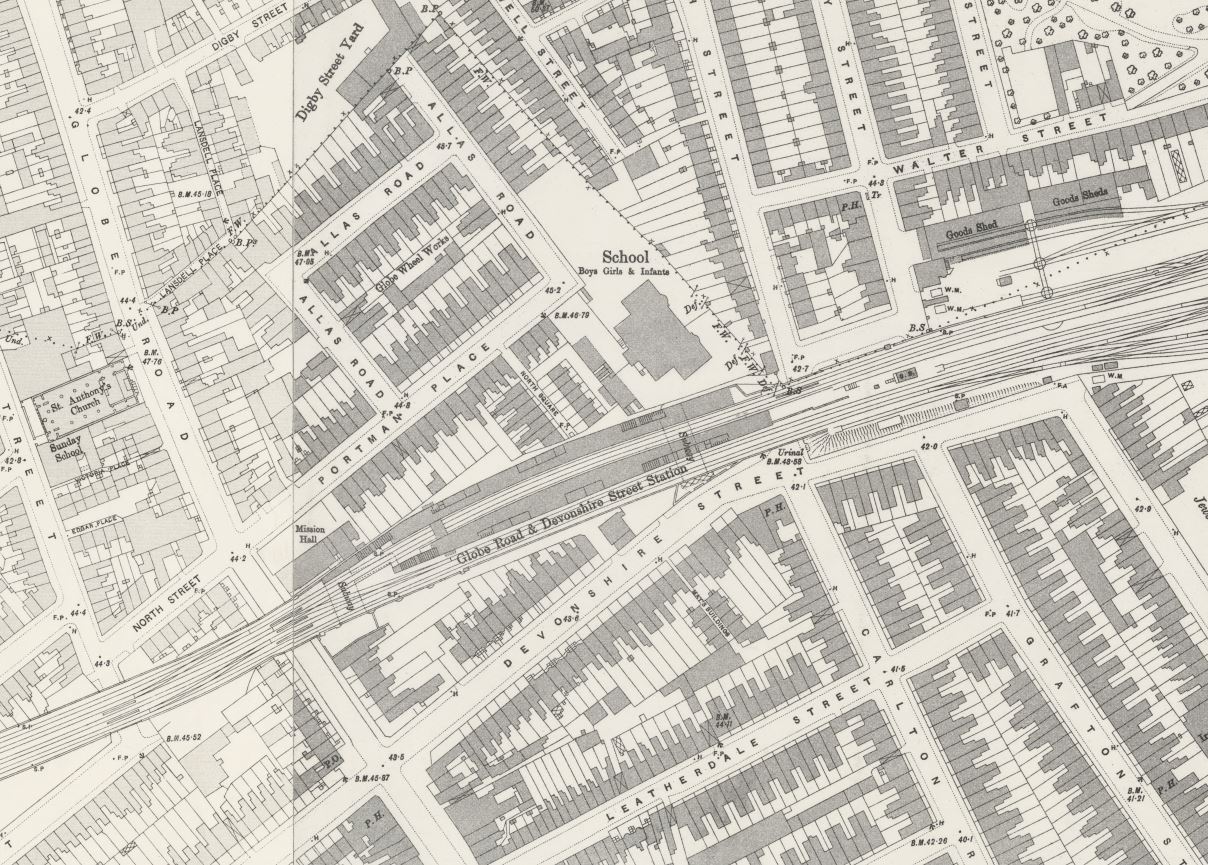
The 1895 Ordnance Survey map shows the station on either side of two tracks on the northern part of the rail route. Presumably the two tracks on the southern side were for fast trains not stopping at Globe Road (‘Reproduced with the permission of the National Library of Scotland.
Having a local station was, as now, a benefit for those who lived and worked locally. During the years that the station was open there were numerous newspaper adverts for properties for sale or rent that mentioned their proximity to Globe Road and Devonshire Street station.
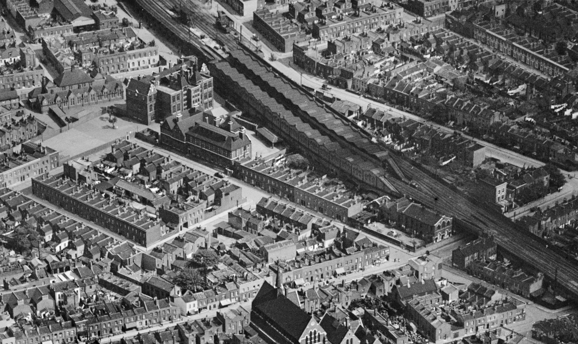
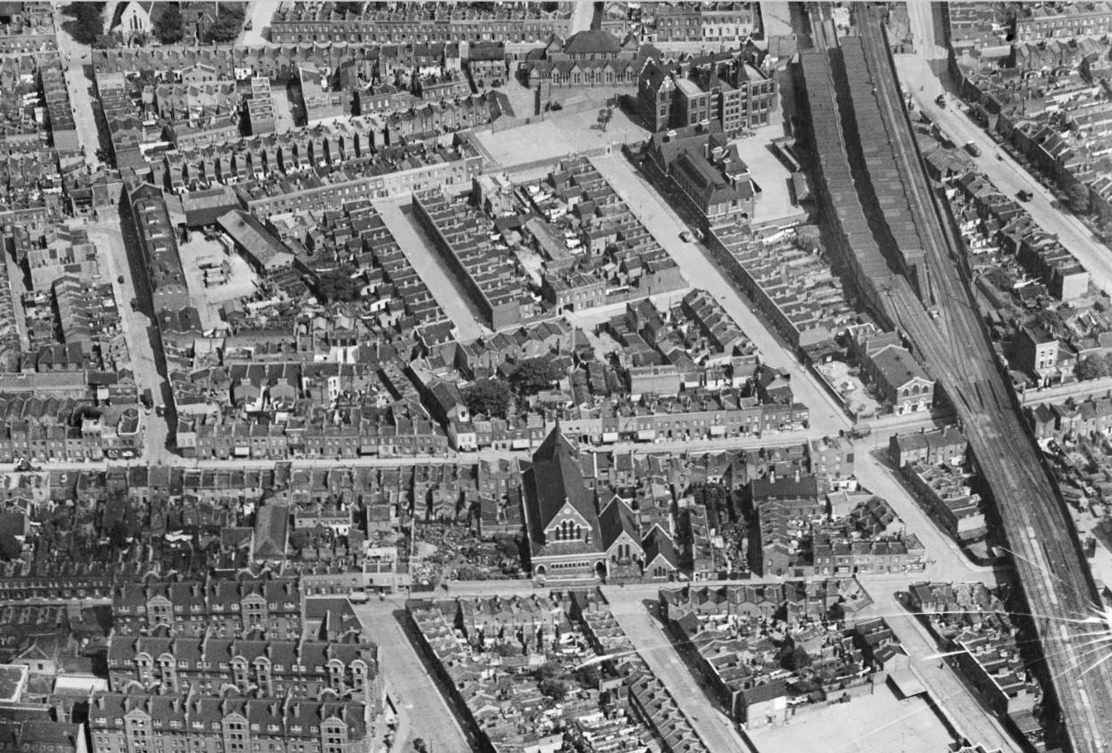
The Britain from Above archive includes a couple of photos of Globe Road station. In the following photo, the platform buildings can be seen running either side of the tracks running through the station:
The full name of the station was Globe Road and Devonshire Street Station. Whilst we can still find Globe Road, Devonshire Street has changed name and is now Bancroft Road.
I have annotated the above photo to show the local roads, a couple of key buildings, entrances to the station, and the direction to Stratford and Liverpool Street stations:
Another view of Globe Road and Devonshire Street Station, where the tracks for stopping at the station are seen on the left, and the fast tracks for trains not stopping at the station can be seen on the right:
The end for Globe Road and Devonshire Street Station came in 1916. The Great Eastern Railway had been proposing to close a number of what were classed as suburban east London stations. Presumably the long distance routes into Liverpool Street were more profitable, and stopping trains at stations in east London were taking up capacity that could be used for faster, long distance trains.
There were also a number of underground routes serving east London along with a network of trams, however many of the stations that were proposed to close were still being well used and there was much concern that closure would transfer additional passengers to already busy tram and underground services.
On the 15th of April 1916, the East London Observer announced a “Mass Meeting of Inhabitants of Mile End, Bow and Bromley and Bethnal Green”, The meeting was held in the People’s Palace on Mile End Road, and chaired by Warwick Brookes M.P. and supported by the Right Hon. Lord Burnham, along with the “Leading Public Men of the districts affected”.
In May 1916, meetings were held with the London County Council to protest the proposed closures. the “Housing of the Working Classes Committee” reported that their attention had been drawn to the closures (there were complaints that the LCC were somewhat late at looking at the impact of the closures), and they were concerned about the impact on travel times, the lack of alternative rail routes, and the problems that would be caused by additional load on the trams.
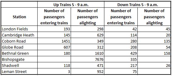
The East London Observer provided a table showing the number of users of the stations that the Great Eastern Railway were proposing to close between 5 and 9 a.m. on a typical weekday morning.
As can be seen, Globe Road was well used in the morning, with 607 passengers boarding trains during the four hour period to travel towards Liverpool Street.
Despite the meetings and protests, the Great Eastern Railway, after a short delay, confirmed their intention to close Globe Road and Devonshire Street Station, with closure on the 22nd of May, 1916. I will cover the story and fate of the other stations in future posts.
Much of the station buildings and infrastructure remained in place until 1938 when they were finally demolished leaving very little evidence that the station had existed.
Although there would be nothing much to see, I still wanted to visit the site of the station, and take some photos.
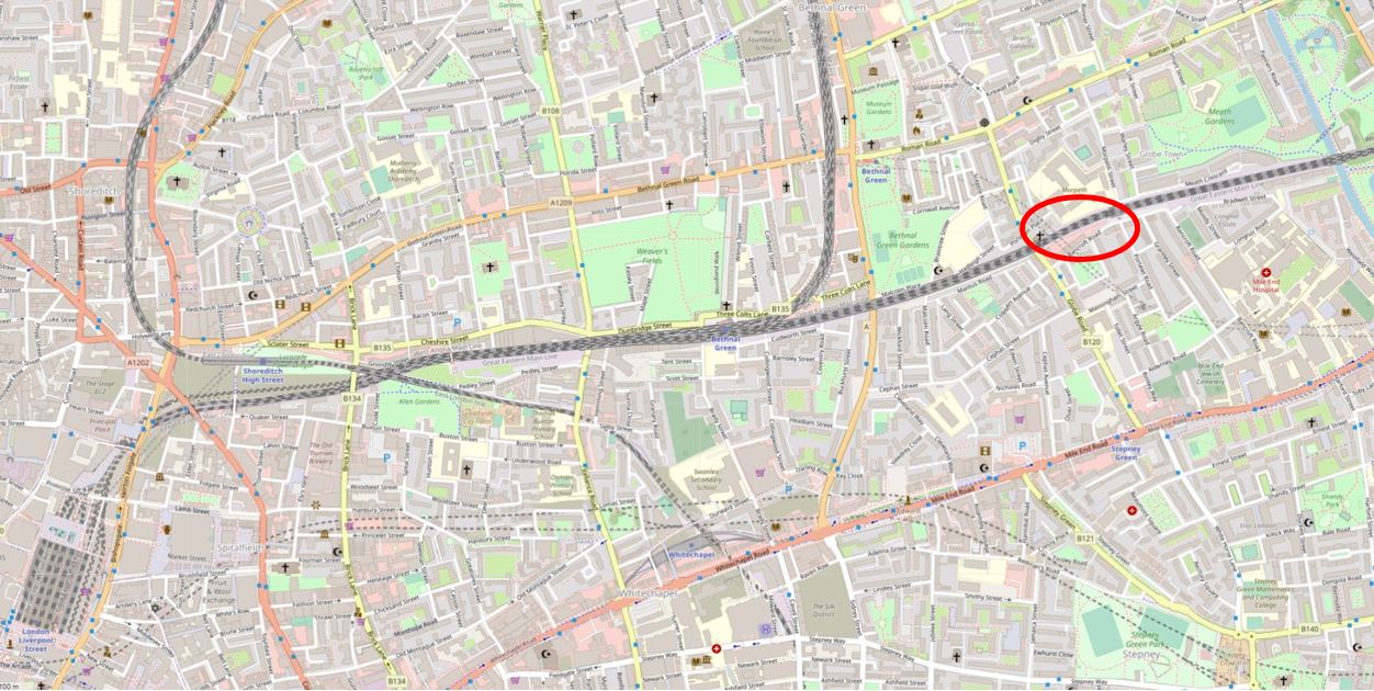
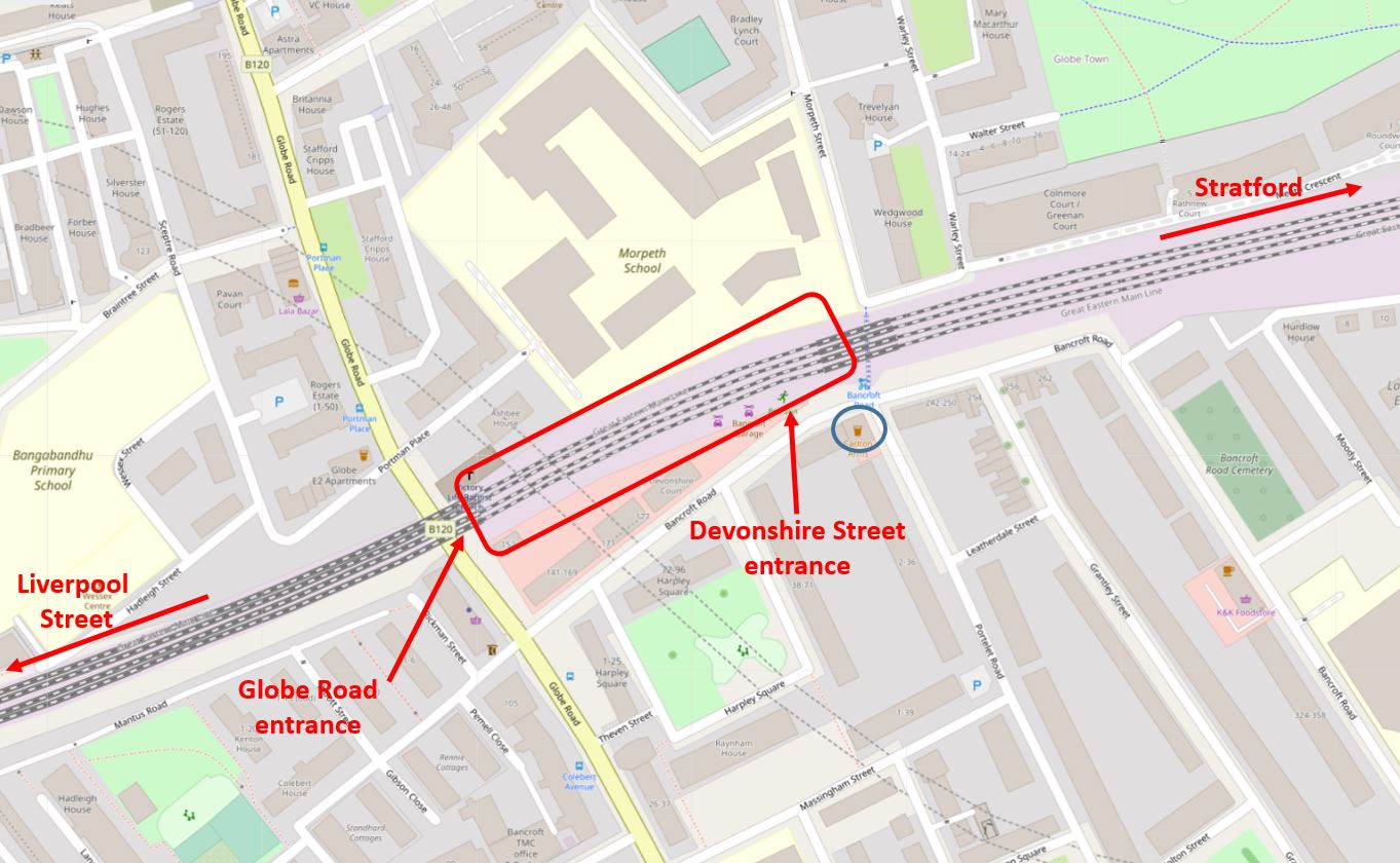
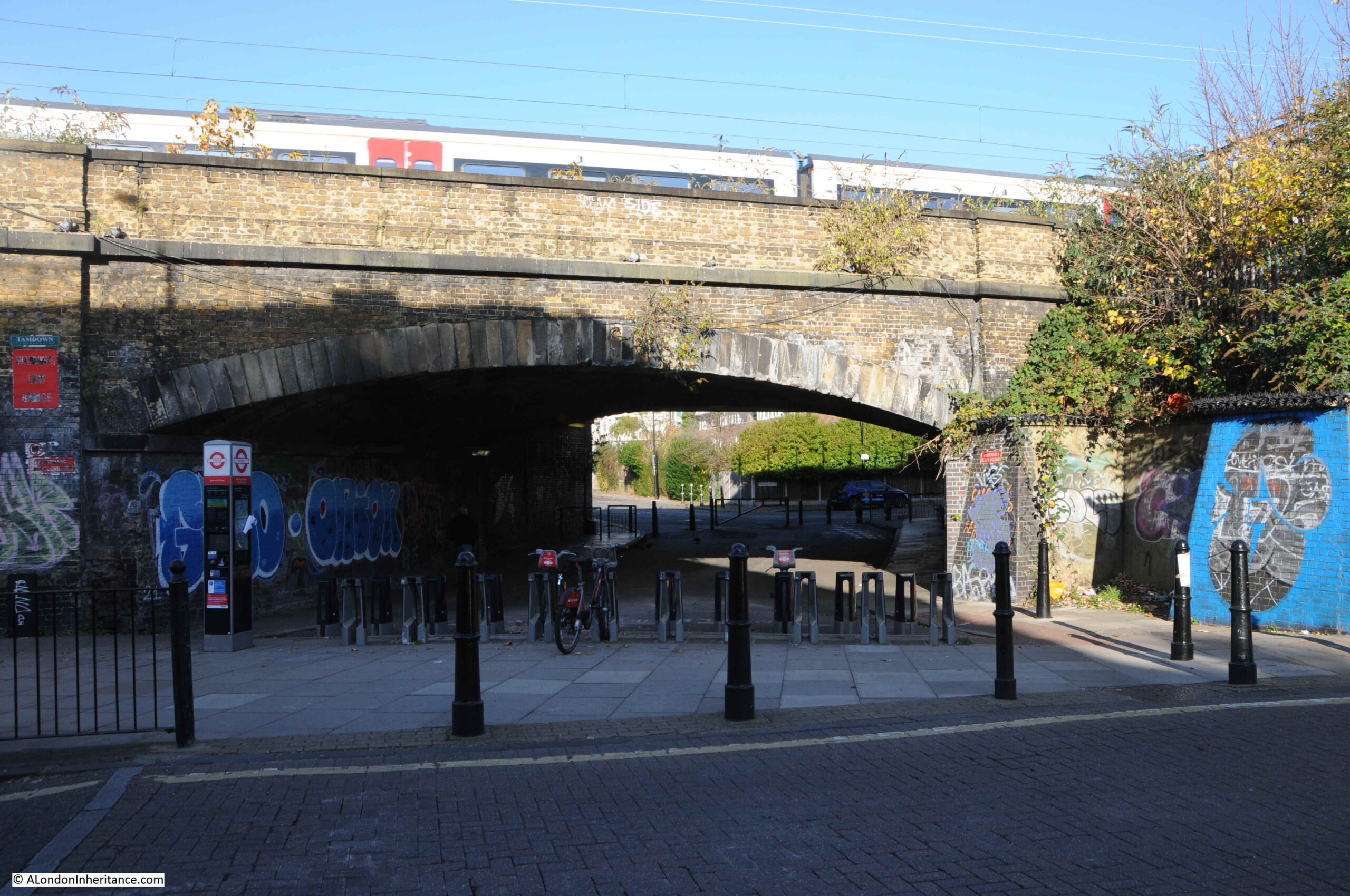
The following map shows the area today. Devonshire Street has been renamed Bancroft Road. The other street names rename the same. I have marked the locations of the entrances to the station in Globe Road and Devonshire Street:
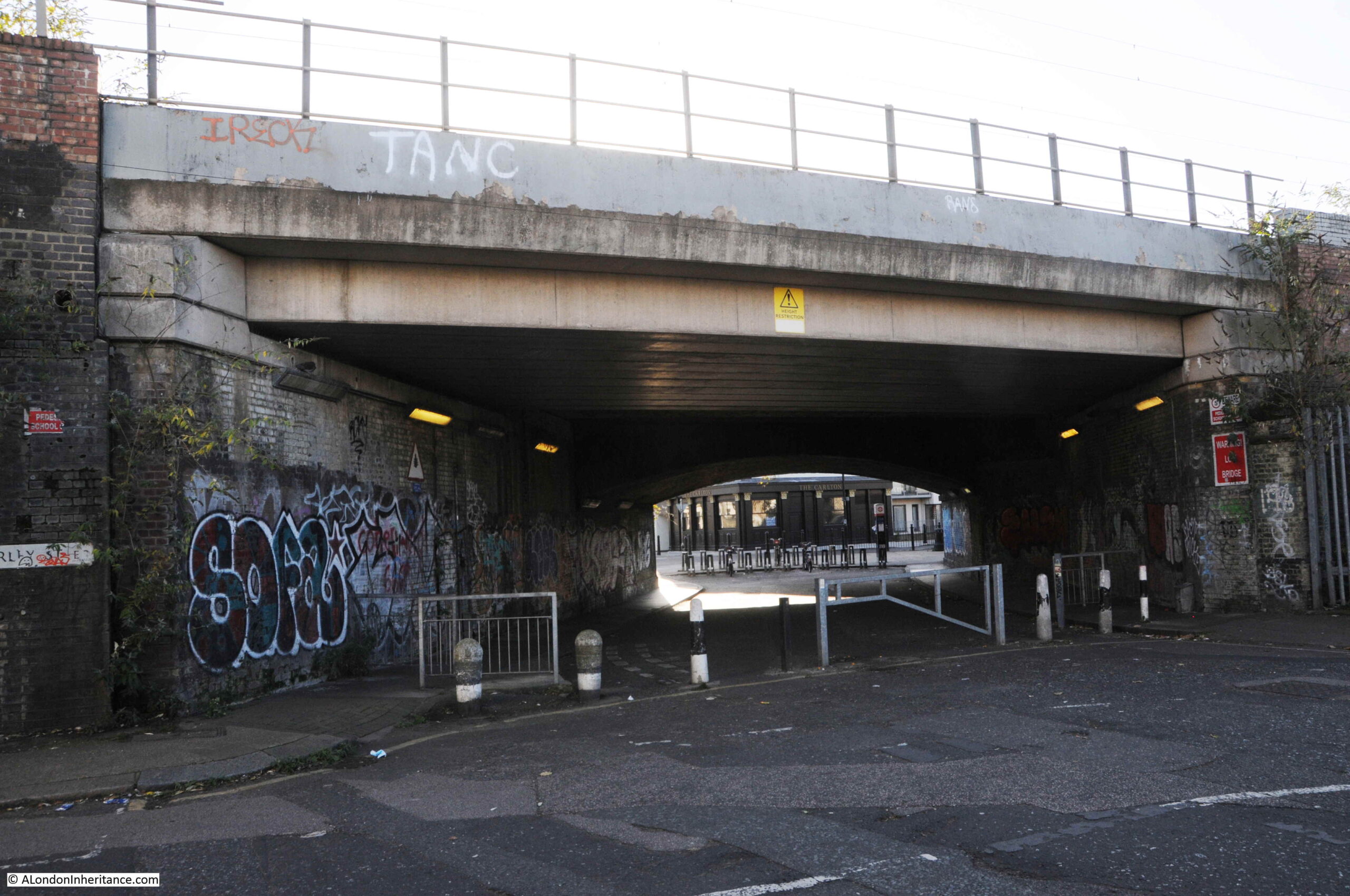
The blue circle is around the Carlton pub which has a sad recent history.
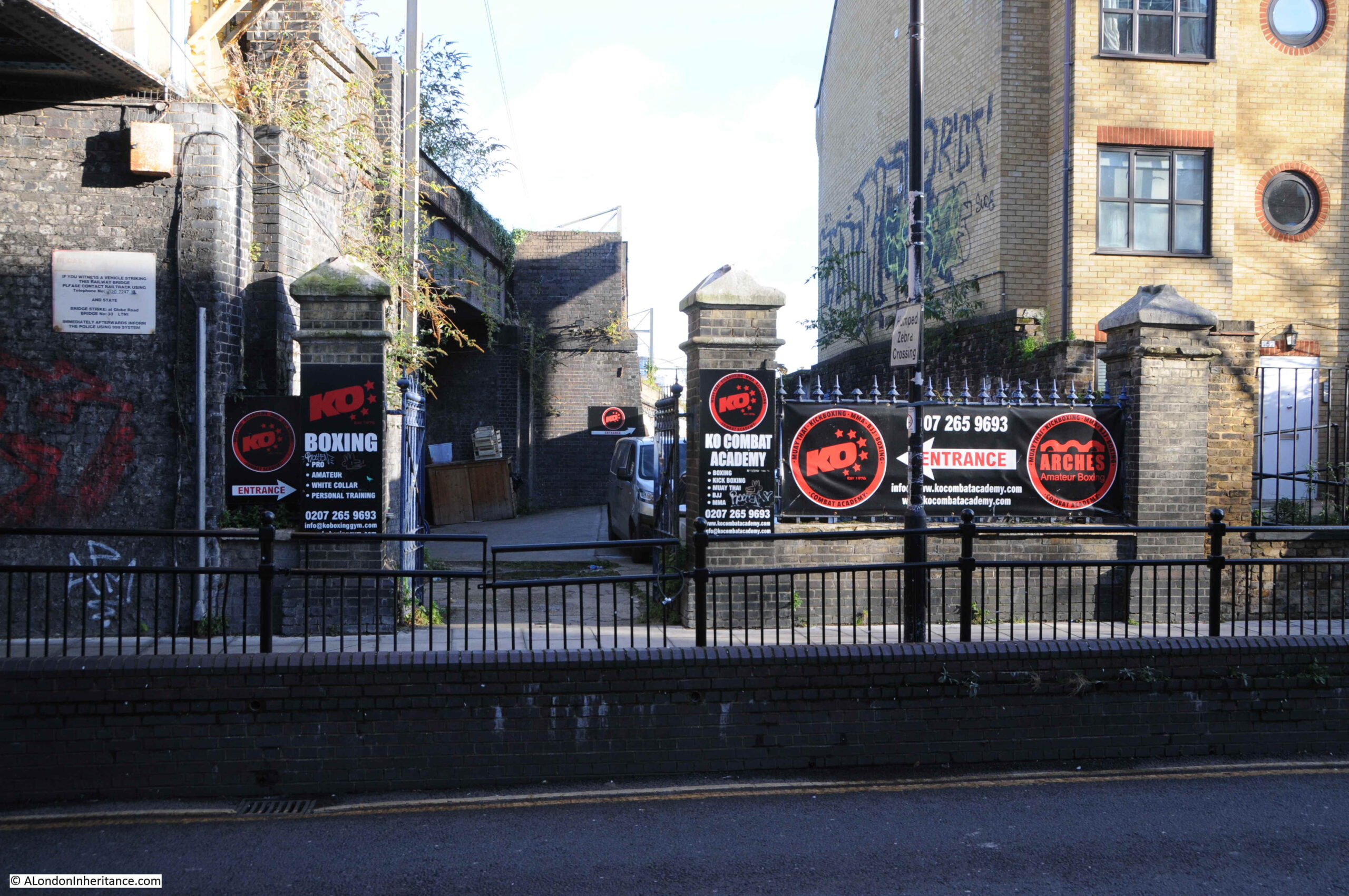
I walked down Morpeth Street (to the upper right of the station, the location of which is marked by the red rectangle), to get to the bridge that runs under the rail tracks and provides access to Devonshire Street / Bancroft Road.
To the right of the bridge is the old Morpeth Street entrance to the station.
There were originally two brick pillars on either side of the entrance, only the left hand pillar, up against the viaduct, survives today.
There was a gate between the two pillars, and a cast iron curved sign above the entrance running between the two pillars. The station name was on the sign, and a round gas lamp was mounted at the top of the curved sign above the entrance.
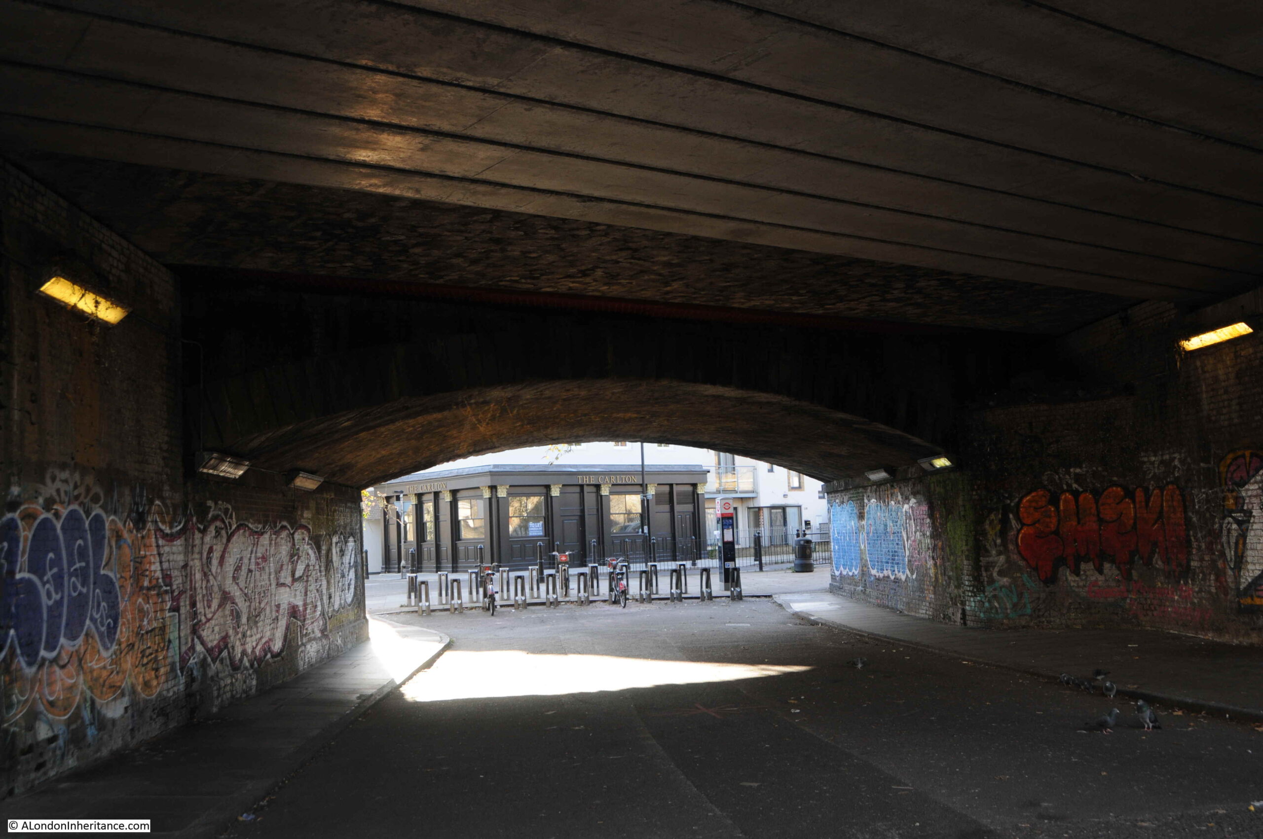
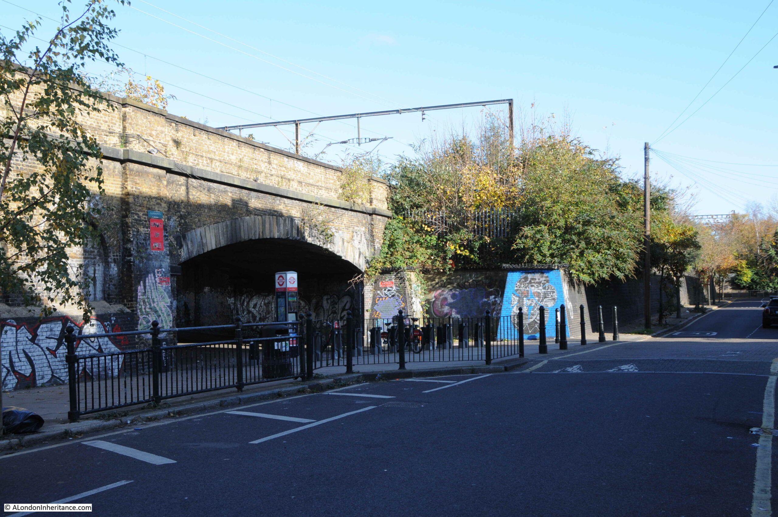
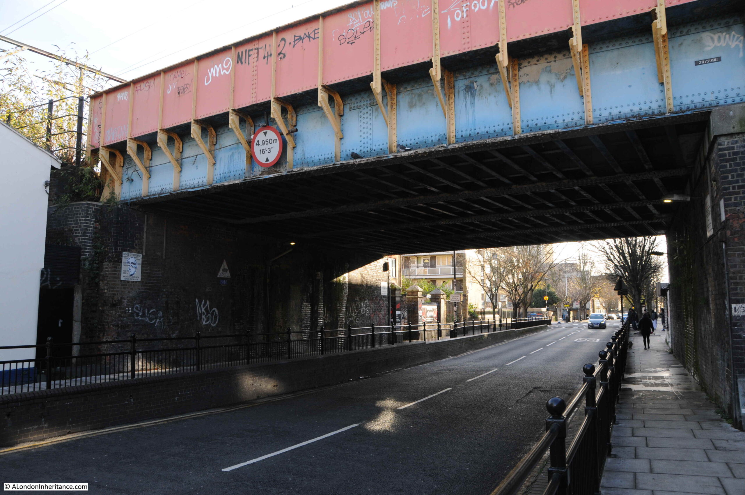
Turning to the left, and this is the view under the viaduct, which provides a walkway between Morpeth Street and Bancroft Road.
The viaduct carrying the tracks towards Liverpool Street has been extended and modified a number of times over the years since the lines were originally constructed in the mid 19th century.
Some of these changes can be seen by the different construction and materials in use to carry the tracks over the tunnel:
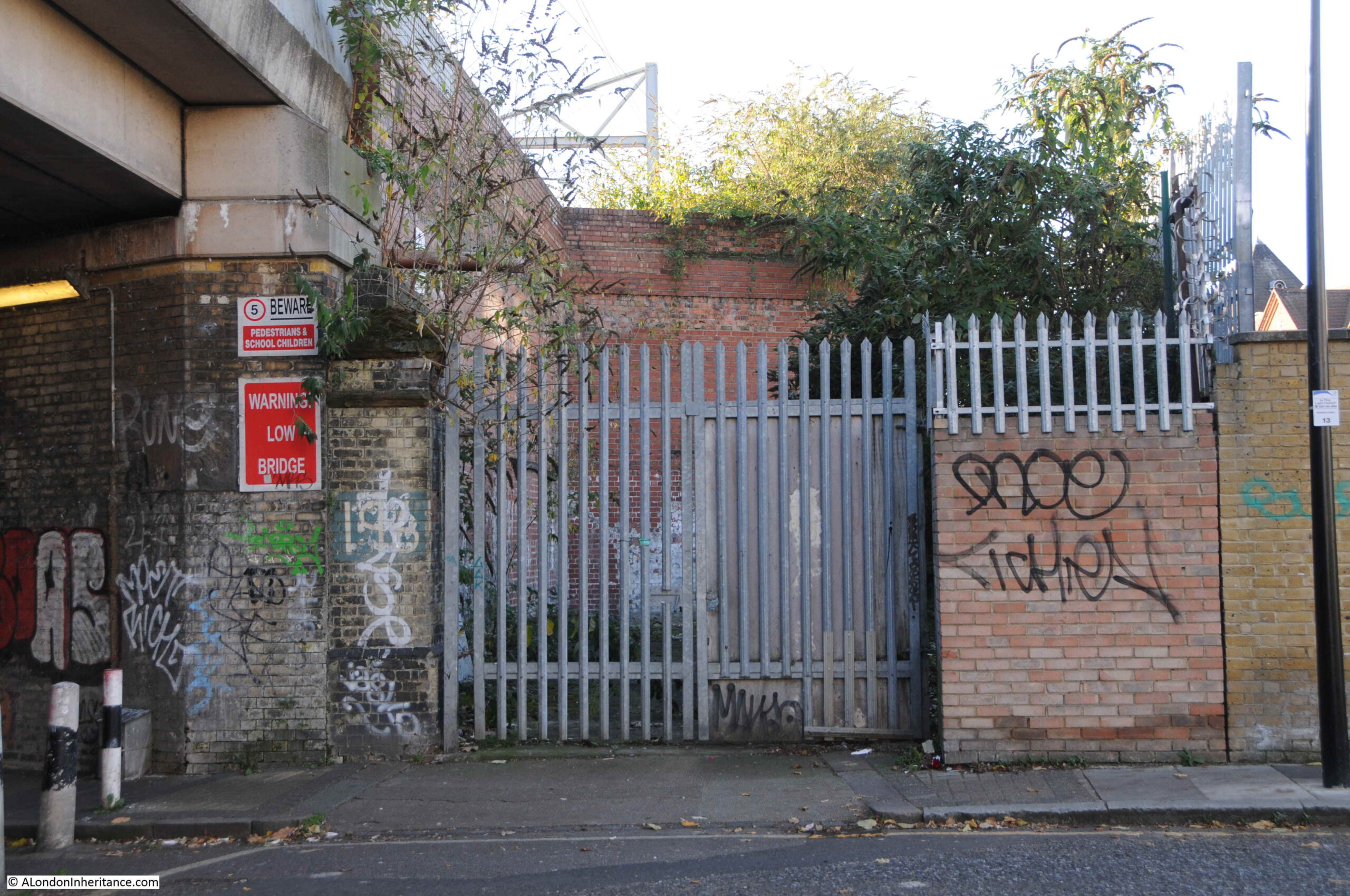
The opposite side, now on what was Devonshire Street, now Bancroft Road:
Looking towards the location of the Devonshire Street entrance to the station, now occupied by businesses using the arches and space between Bancroft Road and the viaduct:
The section of viaduct along Bancroft Road is Grade II listed. It was built between 1839 and 1840 by John Braithwaite, the engineer for the Eastern Counties Railway. The bridge that I have just walked under is included in the listing and is described as “The skew bridge is a very shallow elliptical opening, with radiating voussoirs of sandstone set above an impost band of sandstone.” (I had to look up the meaning of voussoir, and apparently it means a wedge shaped or tapered stone used to construct an arch).
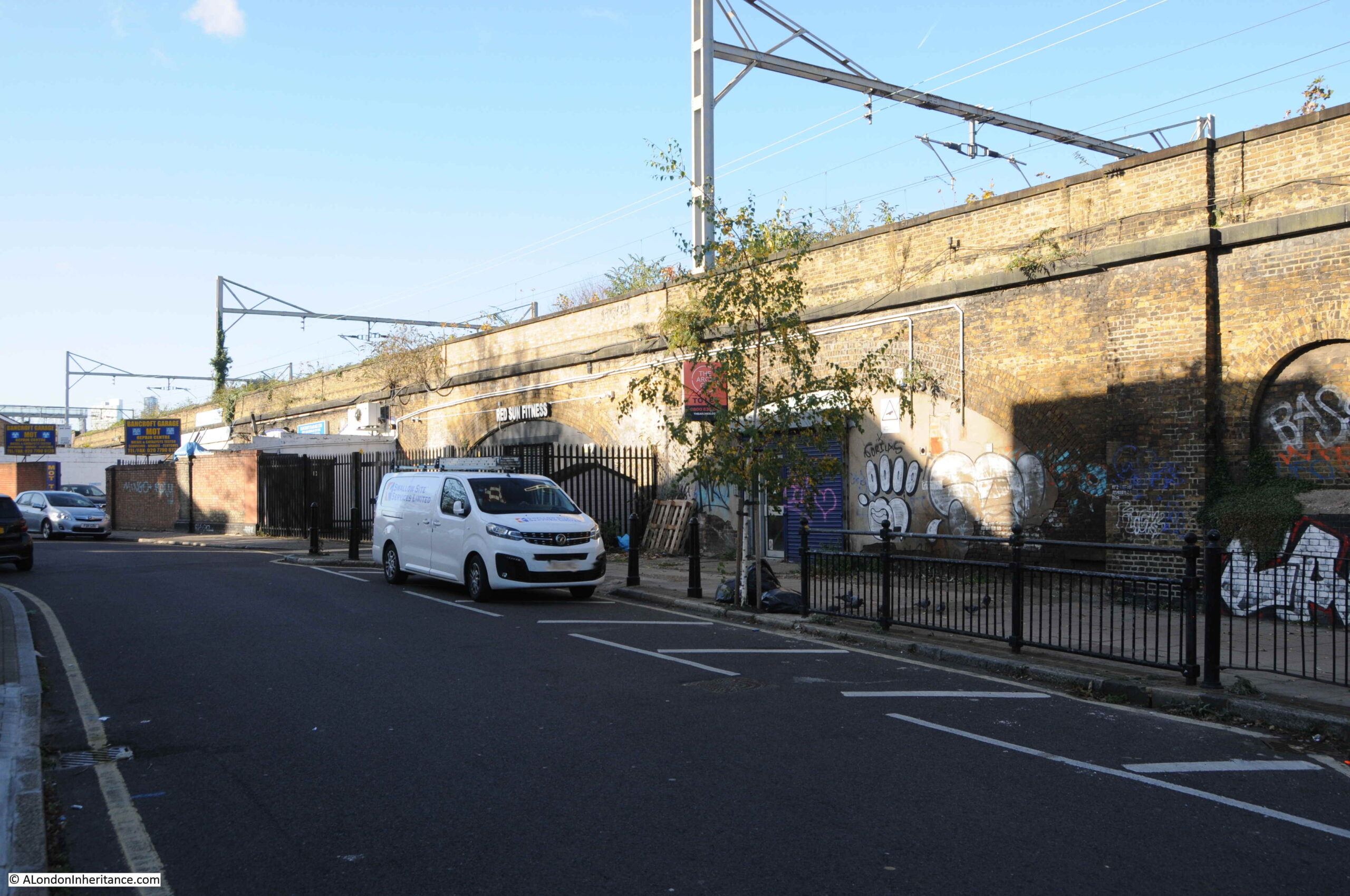
Between the bridge and the area that was occupied by the station are two, small, blind arches:
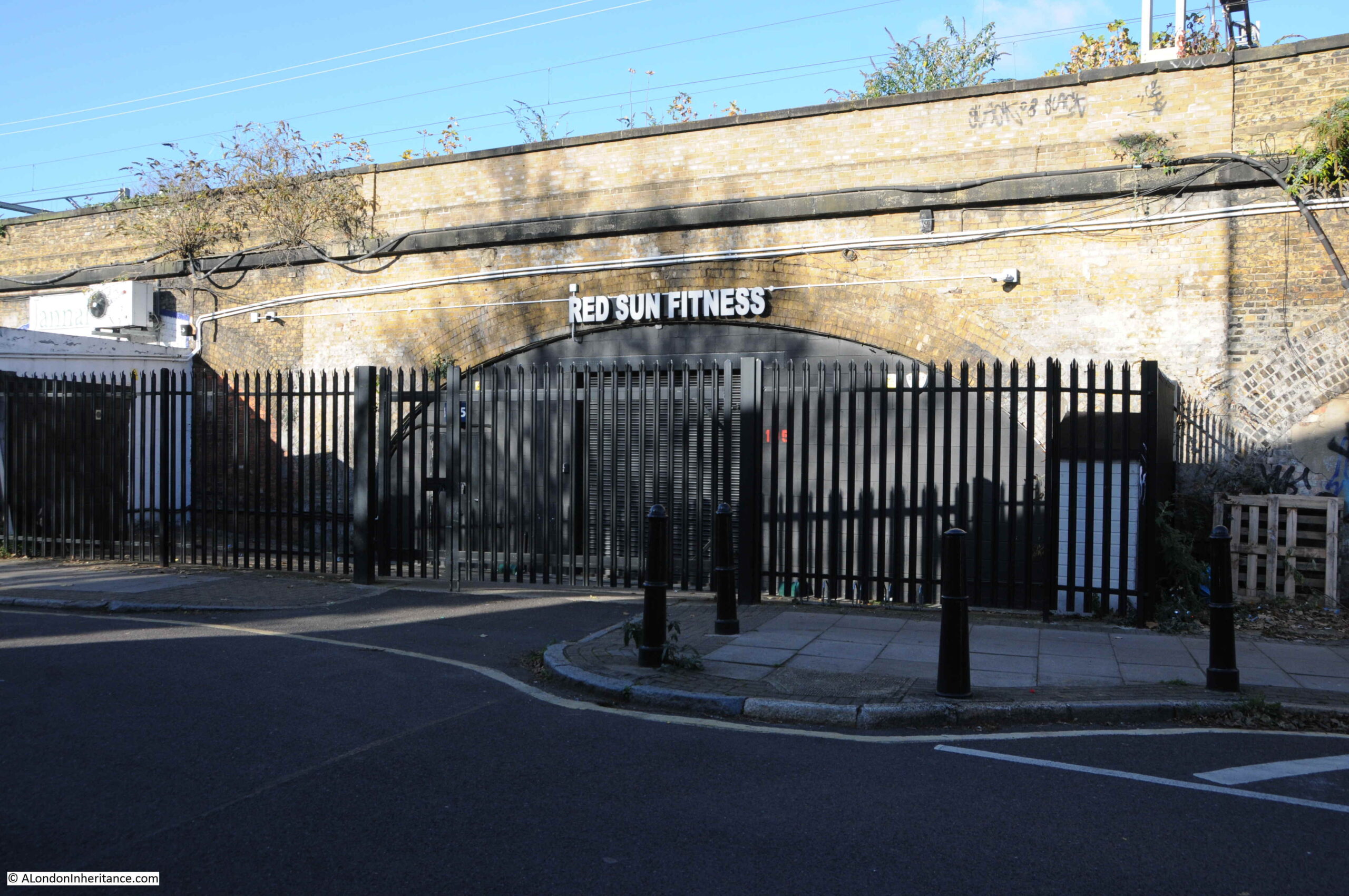
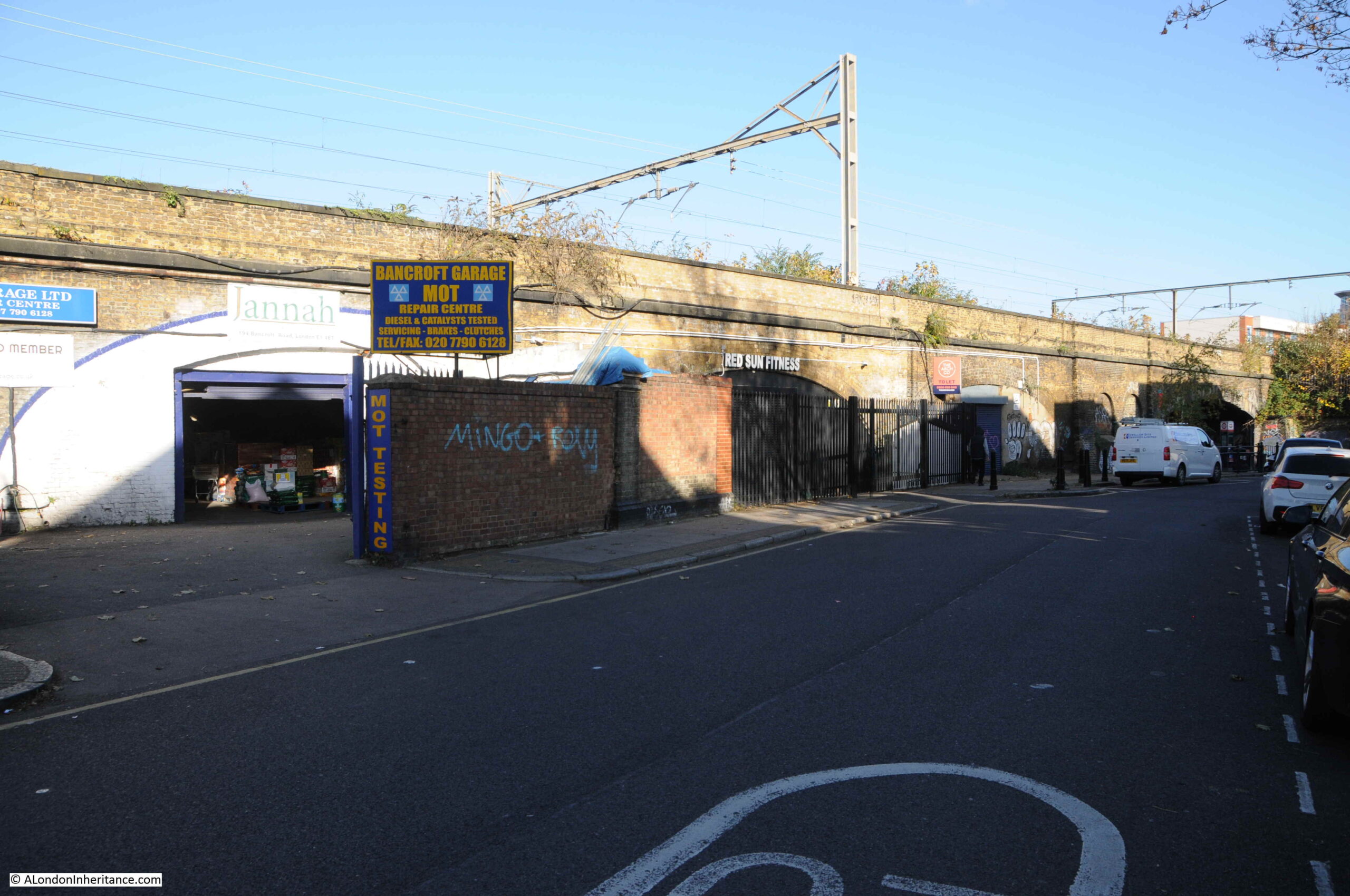
The arch that was occupied by the station is now the site of Red Sun Fitness:
When in use, the name Great Eastern was above the arch, running along the brick parapet at the very top of the viaduct.
The following photo is looking back to the bridge that provides access from Morpeth Street. The Historic England listing describes the viaduct along Bancroft Road as “the viaduct is among the earliest, and longest, examples of a first-generation railway structure to survive in London.“
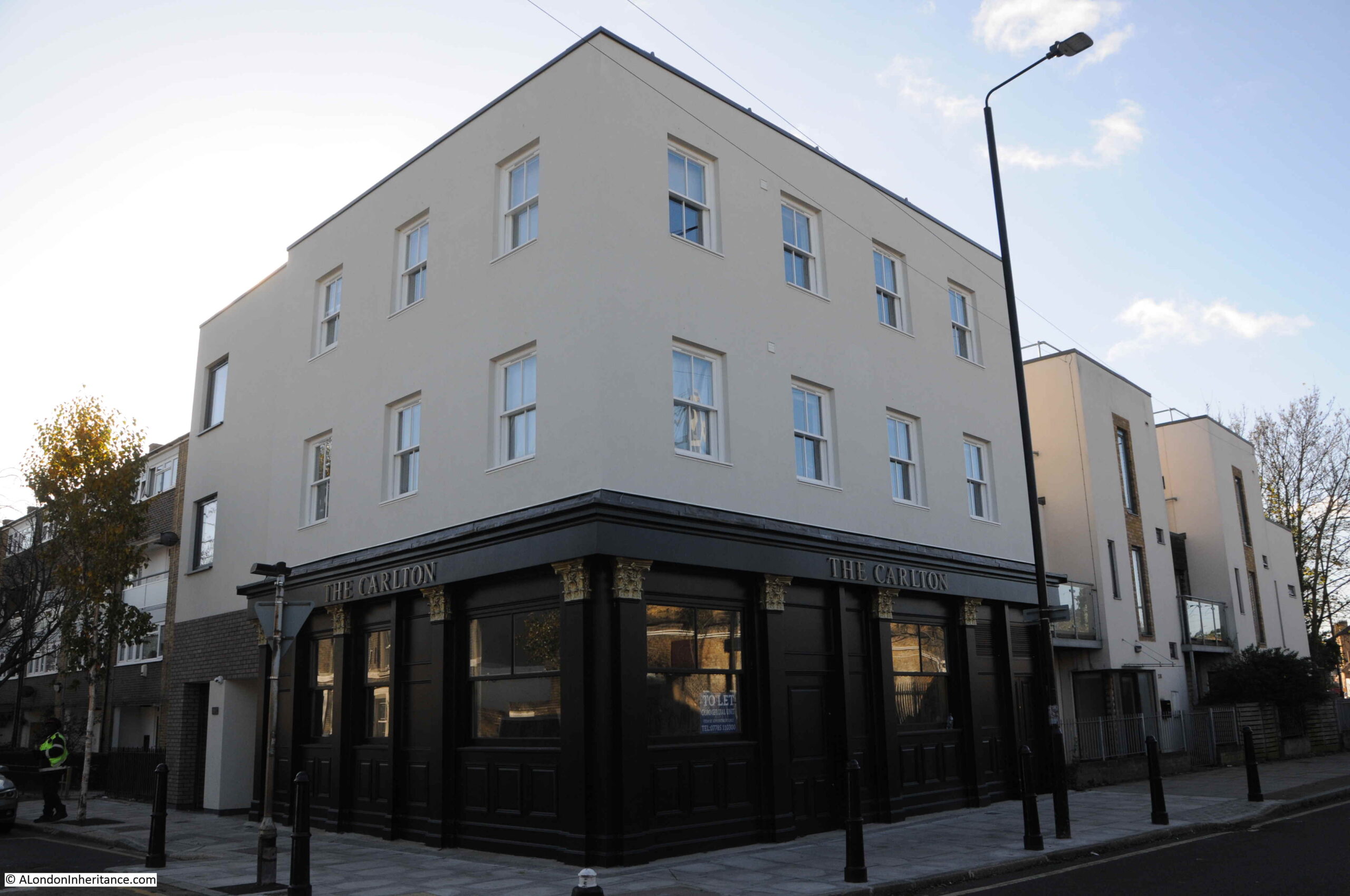
On the corner of Bancroft Road and Portelet Road, and opposite the tunnel under the rail tracks, is a building which appears to be a pub called the Carlton, although the pub is not what it seems.
There was a pub, originally called the Carlton Arms on the site since at least the early 1850s. A typical east London pub with a large corner advertising sign, advertising around the top of the building and wood paneling around the ground floor.
The pub closed in early 2018 and a couple of months later, Tower Hamlets Council had approved a planning request to convert the site to five flats, which would involve demolishing the first floor, adding additional floors and a new basement. Planning approval required that the historic ground floor of the pub should be retained.
Contrary to planning approval, the whole pub was then demolished. The developers argued that demolition was the only option due to the condition of the structure. It was then rebuilt with a modern wooden trim to the outer ground floor, but was substantially a new building.
The ground floor and basement are currently available to rent as an empty commercial space, and are ready to be transformed to a “traditional pub/restaurant”. If you have £2,500 per month to spare, plus the cash to convert to a pub, it is currently listed on Rightmove.
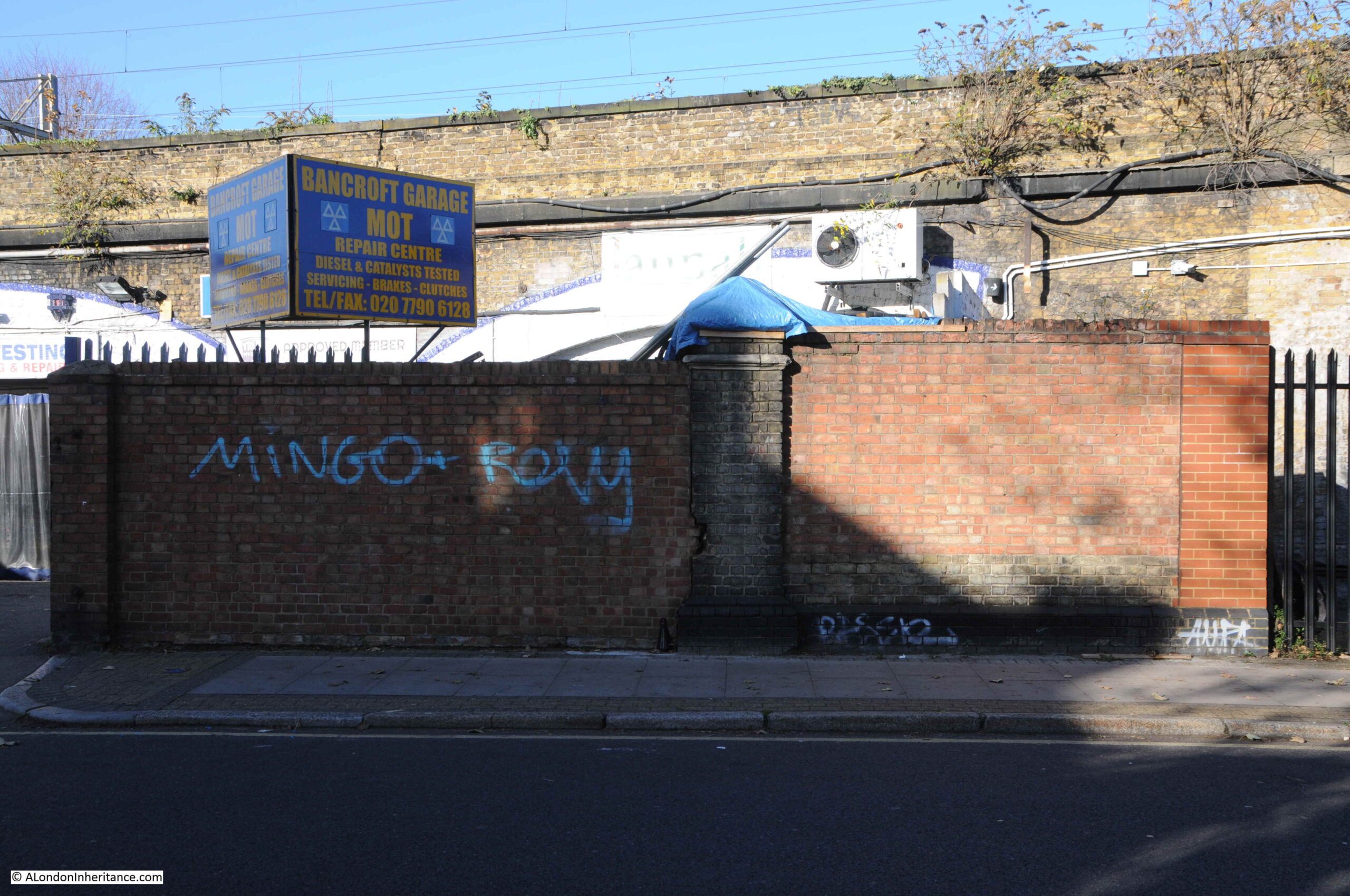
There is a very small part of the station left in Bancroft Road. As Bancroft Road and the railway viaduct head east, the land where the station entrance was located forms a small triangular site. On the edge of this site, along Bancroft Road, what was Devonshire Street, was a wall surrounding the entrance to the station, with two brick pillars on either side of the opening in the wall to access the station.
One of these brick pillars survives and is now part of a modern brick wall.
In the following photo, the original brick pillar can be seen in the centre of the wall.
View looking back along Bancroft Road, with the brick pillar on the left:
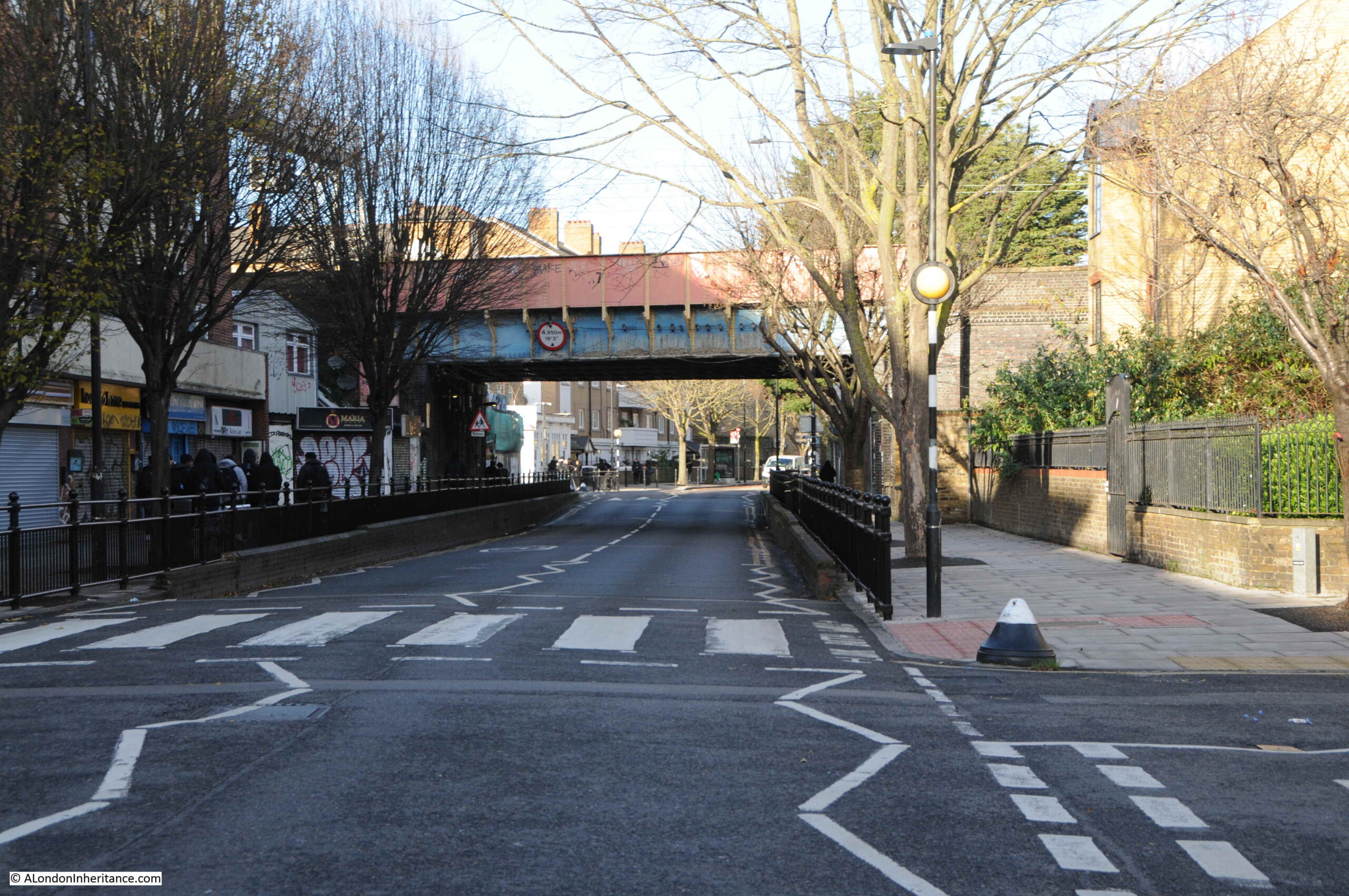
I next wanted to find the Globe Road entrance to the old station, so I walked to the junction of Bancroft Road and Globe Road, and turned right to see the bridge carrying the railway across the road.
Walking towards the bridge, and up against the viaduct, on the east of Globe Road is the old station entrance. Very similar to the Morpeth Street entrance, with brick pillars either side of the entrance, however at this entrance more pillars survive:
As with Morpeth Street, there was a curved, cast iron station name sign above the entrance from pillar to pillar, with a gas lamp in the middle.
Walking under the bridge, and this is the view looking south along Globe Road. The station entrance is just under the bridge on the left:
Only some of the brick piers at the station entrances appear to have survived, but good that there is something left from this east London station, from a time when there was a number of suburban stations as trains from the east approached Liverpool Street.
The station was only open for 32 years, and provided a fast method of transport for those who worked in the City, as well as providing a route into Essex for those such as the excursionists of the Mile End Old Town Victoria Park Hospital Association on the 27th August 1887, who were leaving the noise, congestion and smoke of east London for a very different day on the Essex coast at Dovercourt.
And if any TV production company is looking for a Victorian soap opera based in east London, then my outline for Mile Enders is ready and waiting.
Thirty five years is a relatively short time, however during that time so much of London has changed considerably. Back in 1986, a large part of east London was run down. The area was still home to some wonderful communities, people who had lived and worked there for decades, but an area that would soon change. I recently went back to Cannon Street Road to photograph the site of two shops last photographed in 1986.
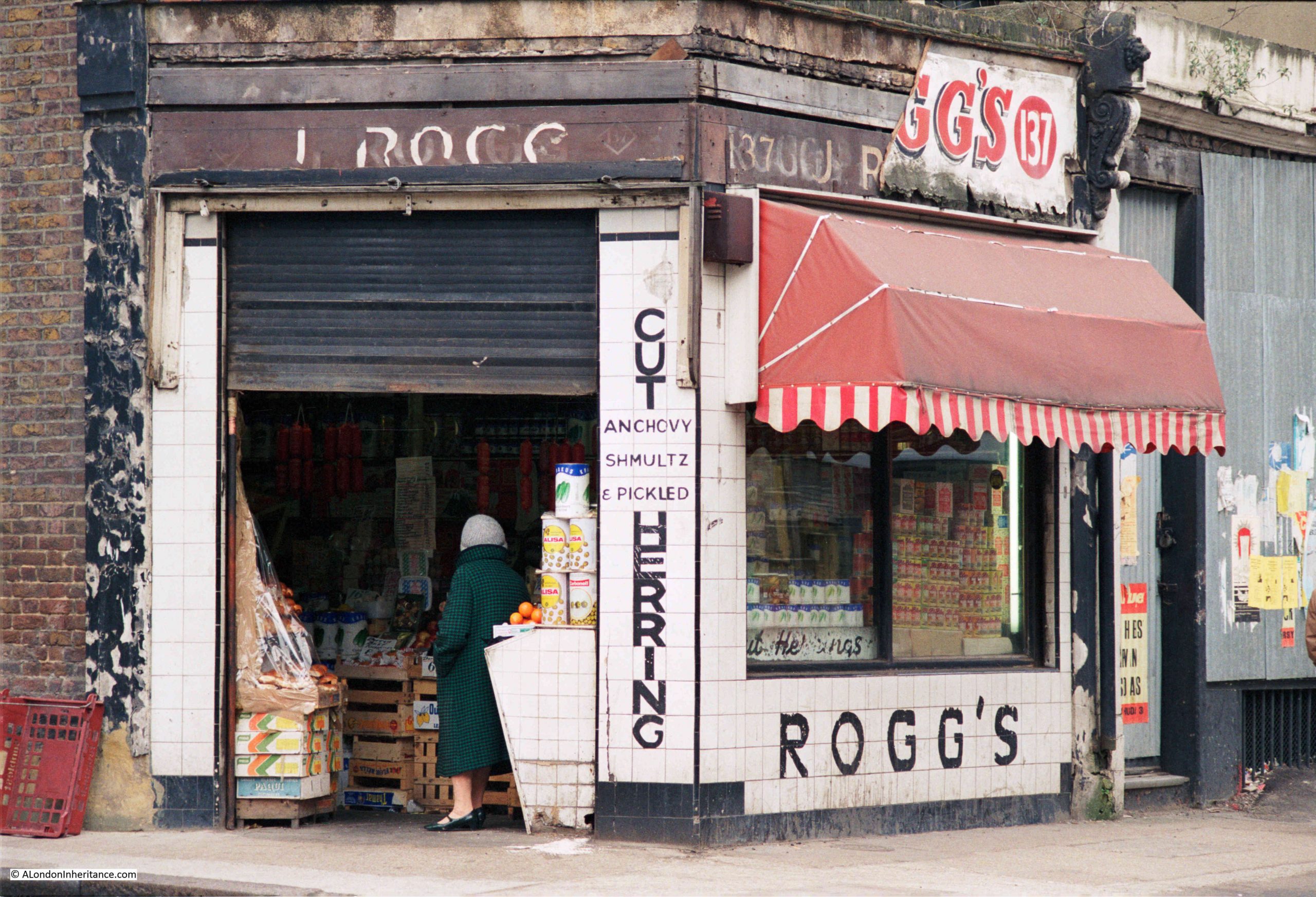
This is Rogg’s at 137 Cannon Street Road:
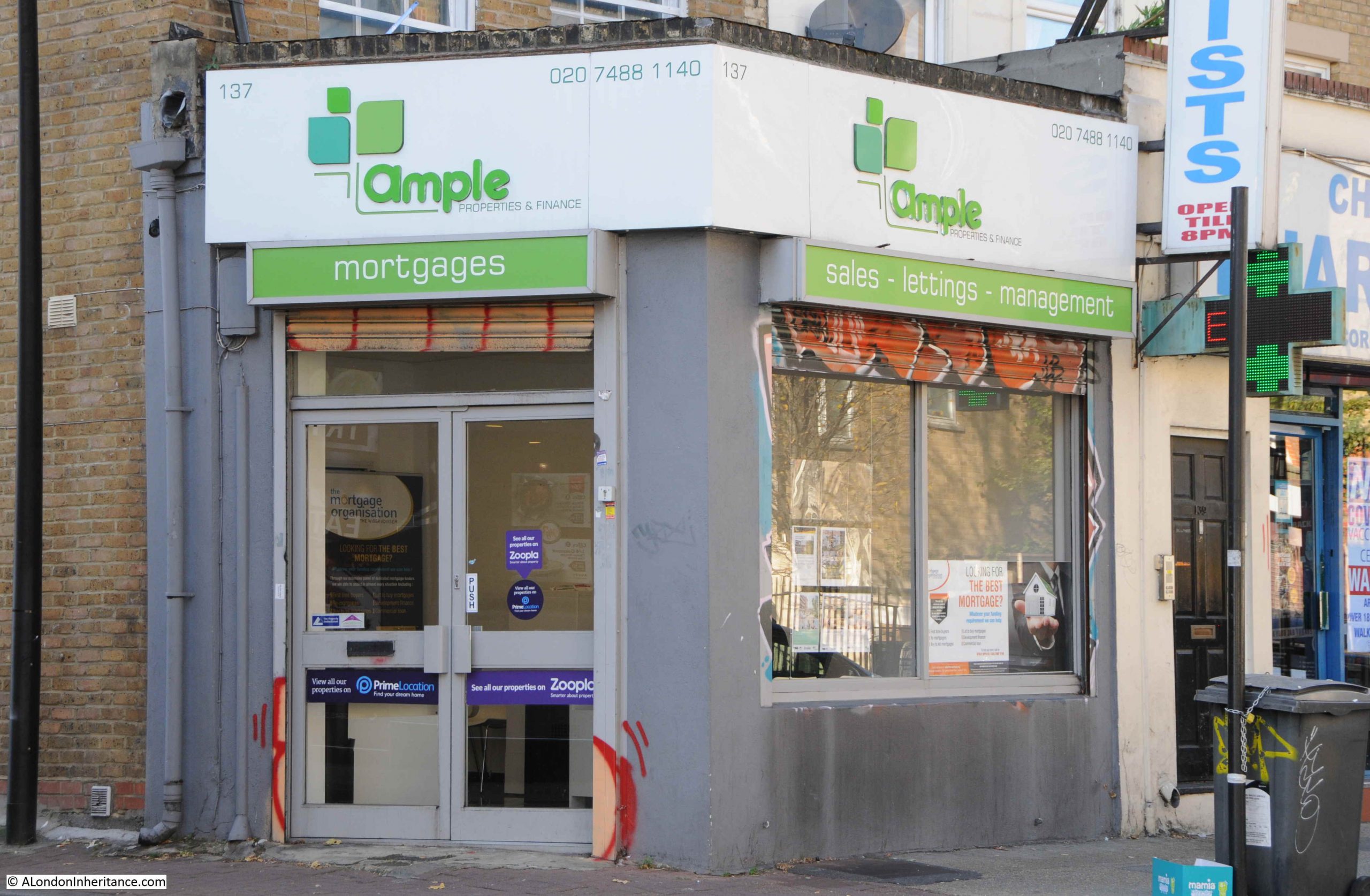
Number 137 is today the home of Ample, a property and finance company:
Rogg’s was on the corner of Cannon Street Road and Burslem Street and had been open since the early 1940s. A typical 1980s corner shop with products piled high in the windows. Inside, there was a wide range of traditional Jewish food.
The shop was at the end of a terrace of mixed date and designs. I am not sure if the building of which Rogg’s was the ground floor shop, has had a rebuild as the bricks look too clean and the corners / sides of the building are a little too sharp and clean for a building of some age:
As well as Rogg selling Jewish food, another building that supported the local Jewish population was a synagogue that occupied the space in the above photo, to the right of the white building with part of a blue sign just above the ground floor.
The Cannon Street Road synagogue opened in 1895, but closed in the early 1970s due to the declining local Jewish population.
There was a rather infamous murder in the street in 1974, when Alfie Cohen, who ran a small all-night cigarette kiosk in Cannon Street Road was murdered during a robbery on his kiosk. The robbers got away with what was in the till and a quantity of ciggarettes, however they missed a considerable fortune.
Alfie had worked 7 nights a week for almost 50 years, and rarely took a night off. Rather than bank the money he made, he kept it under the counter in the kiosk, and when police came to investigate the murder, they found a total of around £100,000 in bags hidden in the kiosk.
A tragic story, but indicative of the characters that could be found in the street, and also of the relatively high level of crime in the 1970s.
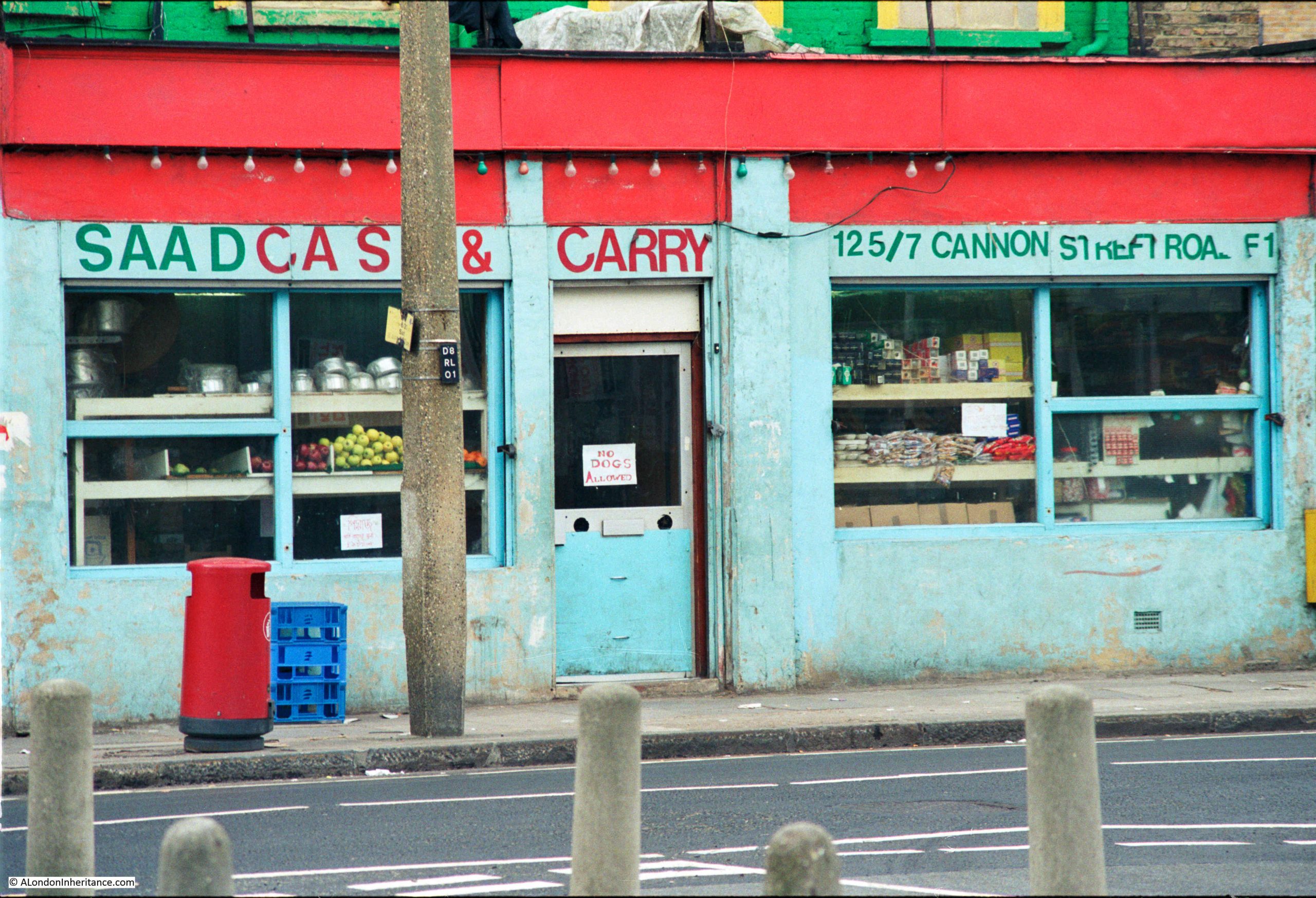
Continuing south along Cannon Street Road, and at numbers 125 and 127 was Saad Cash and Carry:
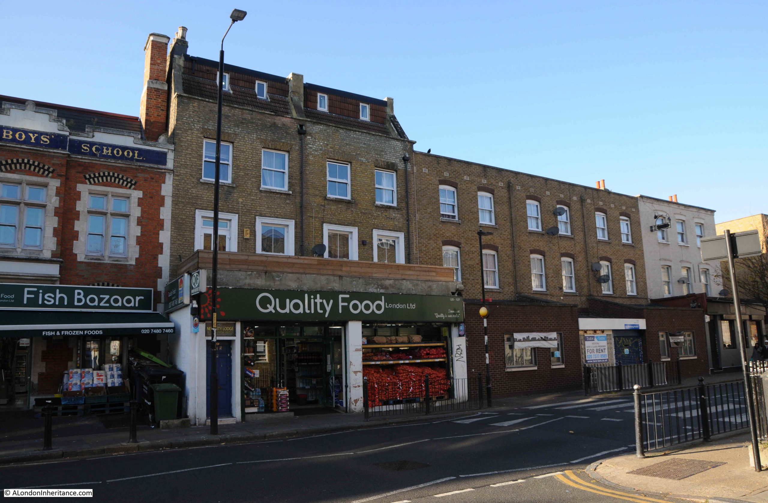
The same building today, now home to Quality Food London Ltd:
A wider view of the terrace with 125 and 127 occupying the ground floor of the largest houses:
Cannon Street Road is a typuical east London street. Shops and businesses catering to a diverse range of local residents, and with an equally diverse range of architecture. The condition of the buildings are much better than they were in the 1980s.
Cannon Street Road runs between Commercial Road to the north, and the Highway to the south, cutting across Cable Street rouighly two thirds along the street.
The lower section of Cannon Street Road is old. The stretch between The Highway and Cable Street is shown in Rocque’s map of 1746. The upper section was then all fields with only the area between Cable Street and the Thames having much development as London’s expansion followed the line of the river.
Rocque’s map shows the street name as simply Cannon Street. I cannot find exactly when, or why, the name changed to Cannon Street Road, however the first mention of the longer name I can find is a newspaper advert from the 24th January 1803, which called for subscribers to the Commercial Road development who could collect their interest from an office in Cannon Street Road.
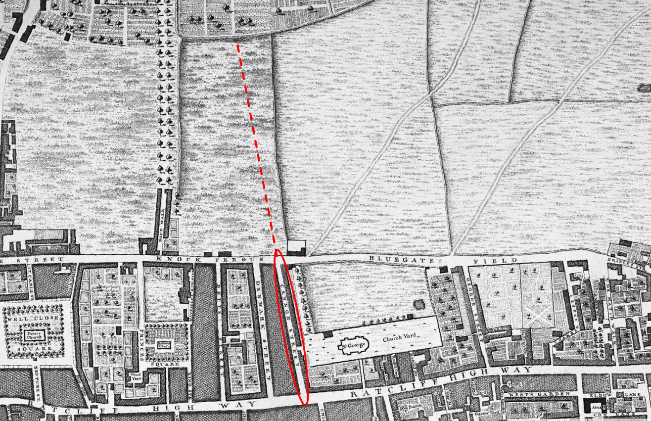
The following extract from Rocque’s map shows the 1746 length of Cannon Street (red oval), with the red dashed line showing the extension of the street that we see today.
What I did not realise is that the development of Commercial Road appears to have been paid for by subscribers. As well as the advert, there is the following statement in the same 1803 newspaper:
“COMMERCIAL ROAD SUBSCRIPTION – at a MEETING of the TRUSTEES under the Act of Parliament, passed in the 42nd year of the Reign of King George the Third, for making a New Road from the West India Docks in the Isle of Dogs to the City of London, held at the Cannon-street-road office this day; it was ordered, that a further Call or Installment of £25 per cent, on the several Subscriptions, should be paid into the hands of Messrs. Harrison’s, Prickett and Newman, Bankers, Mansion-house-street, on or before the 1st day of February next. Limeshouse, Jan. 18th, 1803. THOMAS BAKER”
Thomas Baker was the Clerk to the Trustees, and the office was somewhere in Cannon Street Road.
I suspect that it was down to the development of Commercial Road, that Cannon Street changed to Cannon Street Road.
As the street provided a route between Commecial Road, Cable Street and The Highway, it would be a busy street (as it is today), and perhaps “Road” was added to avoid confusion with Cannon Street in the City of London.
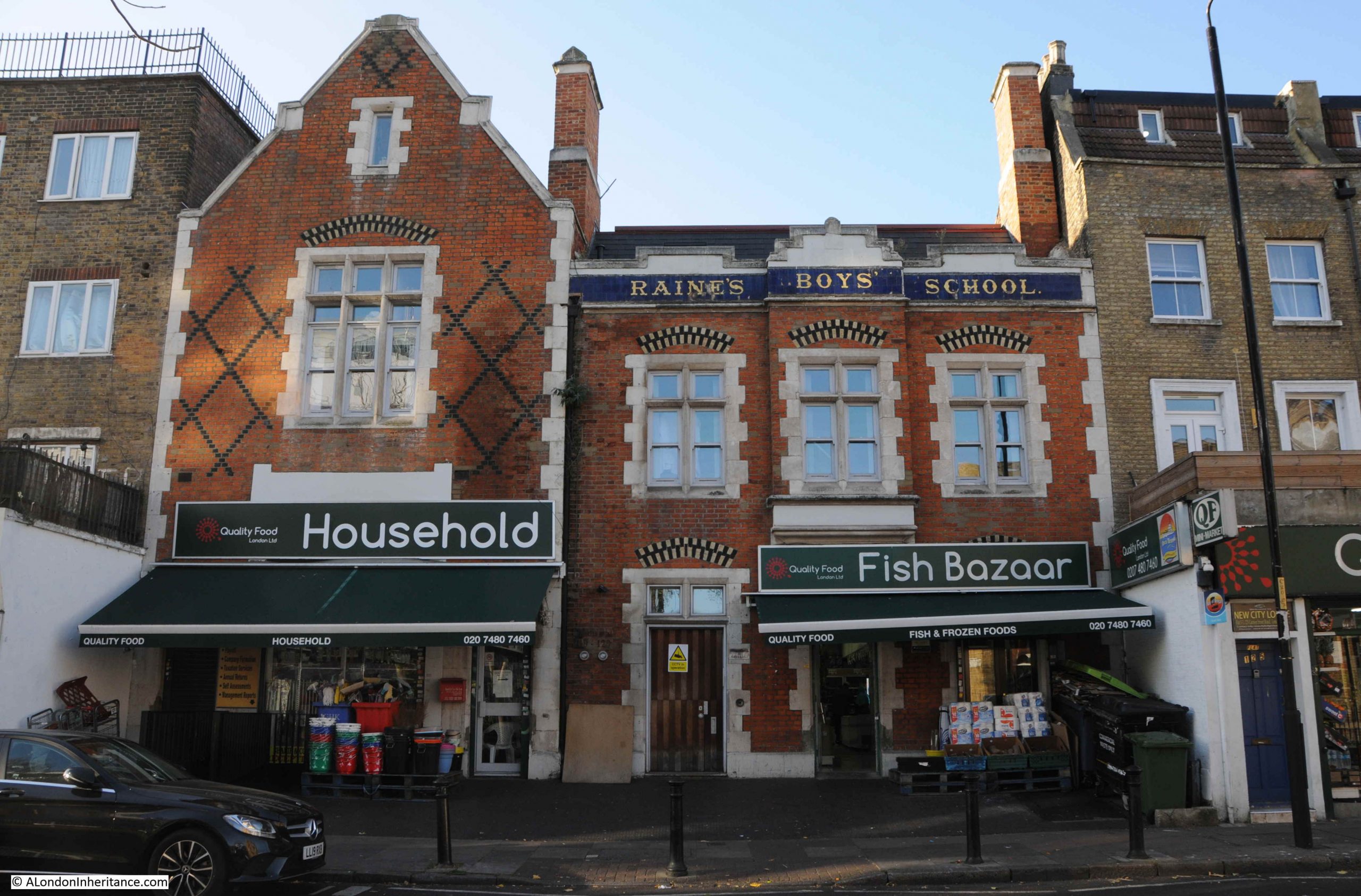
Just to the left of the Saad Cash & Carry / Quality Food shop is an historic building, with the ground floor converted into shops. This was Raine’s Boys School:
The history of Raine’s schools goes back to around 1719, when brewer Henry Raine opened a school for 50 boys and 50 girls. The original school was in what is now Raine Street in Wapping. The building is still there, although was in a poor state in the 1970s and at risk of demolition. I wrote about the building in this post.
As the London Docks were built, the original school found itself rather isolated from the parish that the school was intended to serve, so in 1875 the Boys element of the school moved to the Cannon Street Road building, photographed above.
The building did not serve as a school for too long, as by the first decade of the 20th century, the buildings used by the school were too small, and the school consolidated into a large building in Arbour Square, just north of the Commercial Road. The building still exists as the Tower Hamlets New City College.
Cannon Street Road had already been home to a form of school / childrens home some forty year earlier when within the street could be found the Merchant Seamens’ Orphan Asylum.
This institute was founded in 1827 to care for the children of men lost at sea.
In 1833, an advert appeared in the Public Ledger and Daily Advertiser stating that the orphan asylum was ready to receive applications for the February election. This seemed to be standard practice for many institutions of the time, where applications were made and these were voted on by a Board of Management (see my post on the General Lying In Hospital, where this approach was taken with Subscribers being able to propose pregnant women for admission to the hospital).
In 1833, the orphan asylum had 41 boys and 23 girls. The advert stated that subscriptions and forms of petition for admittance could be had at the school in Cannon Street Road.
We do not often get a glimpse inside the houses of streets such as Cannon Street Road, however another advert from the Public Ledger and Daily Advertiser on the 12th of September, 1833 reports on the sale of the leasehold residence and contents of number 2 Cannon Street Road, at the direction of the Executors of the late Mr. Richard Neale:
“Leasehold Residence, Cannon Street Road, with Immediate Possession. Household Furniture, Plate, three Watches, Linen, China and Effects – By W.S. FRANCIS on the Premises, No. 2, Cannon Street Road, St George’s East, on Tuesday September 17, at 11, by direction of the Executors of the late Mr. Richard Neale.
The Leasehold Residence, with immediate possession, held for a term of 17 years, at the trifling ground rent of £2. The furniture consists of fourpost and other bedsteads and furnitures, goose feather beds and bedding, mahogany double and single chests of drawers, mahogany nail-over chairs, sofa, secretary and bookcase, looking glasses, Brussels carpet, and various other articles”.
If the contents of number 2 are typical of the street, then the residents of Cannon Street Road seem to have been reasonably comfortable. The house was at the southern end of Cannon Street Road, close to the church of St George in the East.
The southern end of Cannon Street Road mainly consists of post war rebuilding. It was the southern end that received the most damage during the Second World War, the northern section of the street appears to have escaped relatively undamaged.
Much of the north of the street still appears to be 19th century terrace housing, however it can be difficult to confirm what is original and what is a later rebuild.
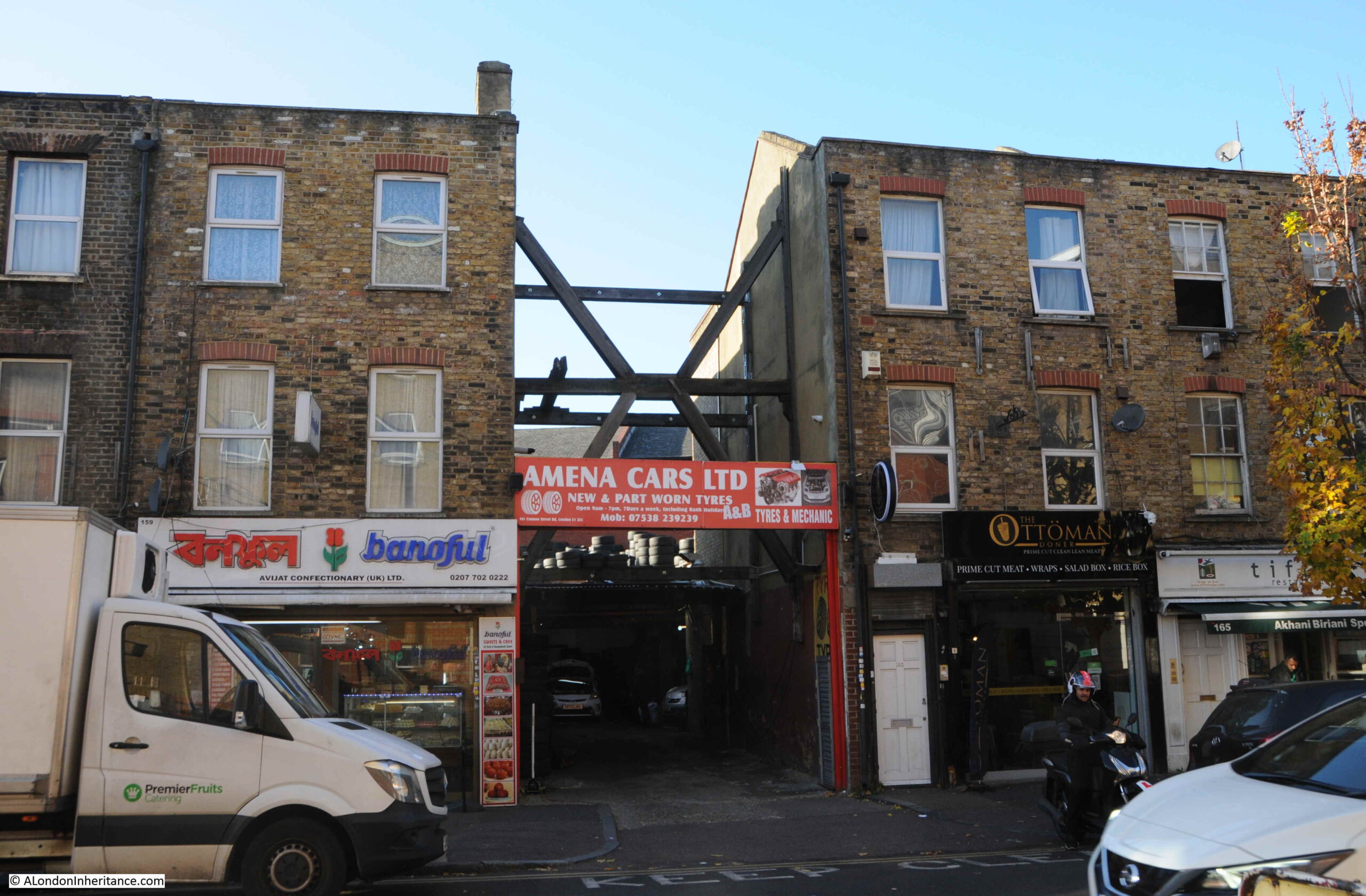
The following photo shows part of the street where I assume a single house within the terrace has gone, to be replaced with an entrance to a car tyre dealers. The houses either side needing some serious support as the terrace has been broken.
Cannon Street Road is part of east London’s expansion north from the original ribbon development along the Thames, and although east London streets have changed considerably over the last few decades, they are still fascinating places to walk as although wartime bombing has resulted in much new building, there is still many of the original terrace houses along the street, along with an ever changing range of shops.