Monthly Archives: July 2014

A Lost Bank and the Adam and Eve Pub on the corner of Euston Road and Hampstead Road

There are some photos from my father’s collection that I was unsure of whether I could find the location where the photo was taken. This week’s post is a typical example of this type of photo, but also how such a simple photo leads into further investigation of the area where the photo was taken. This is what I wanted to get out of this journey, find the location of where all my father’s photos were taken and increase my knowledge of the history of London.

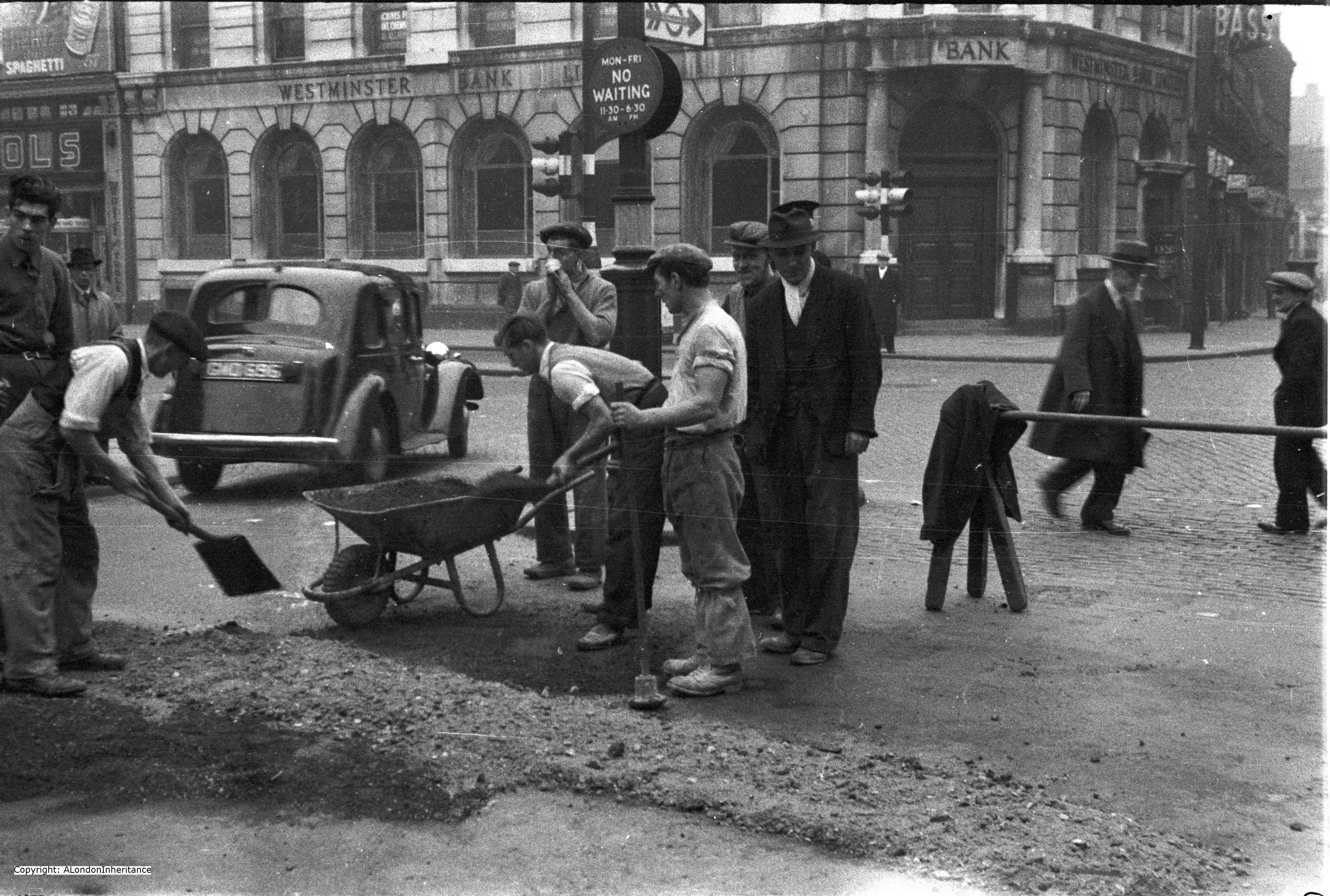
Two very similar photos taken in the late 1940s show a group of men working on the road at a road junction, with a Bank on the corner behind them.

old hampstead road 2

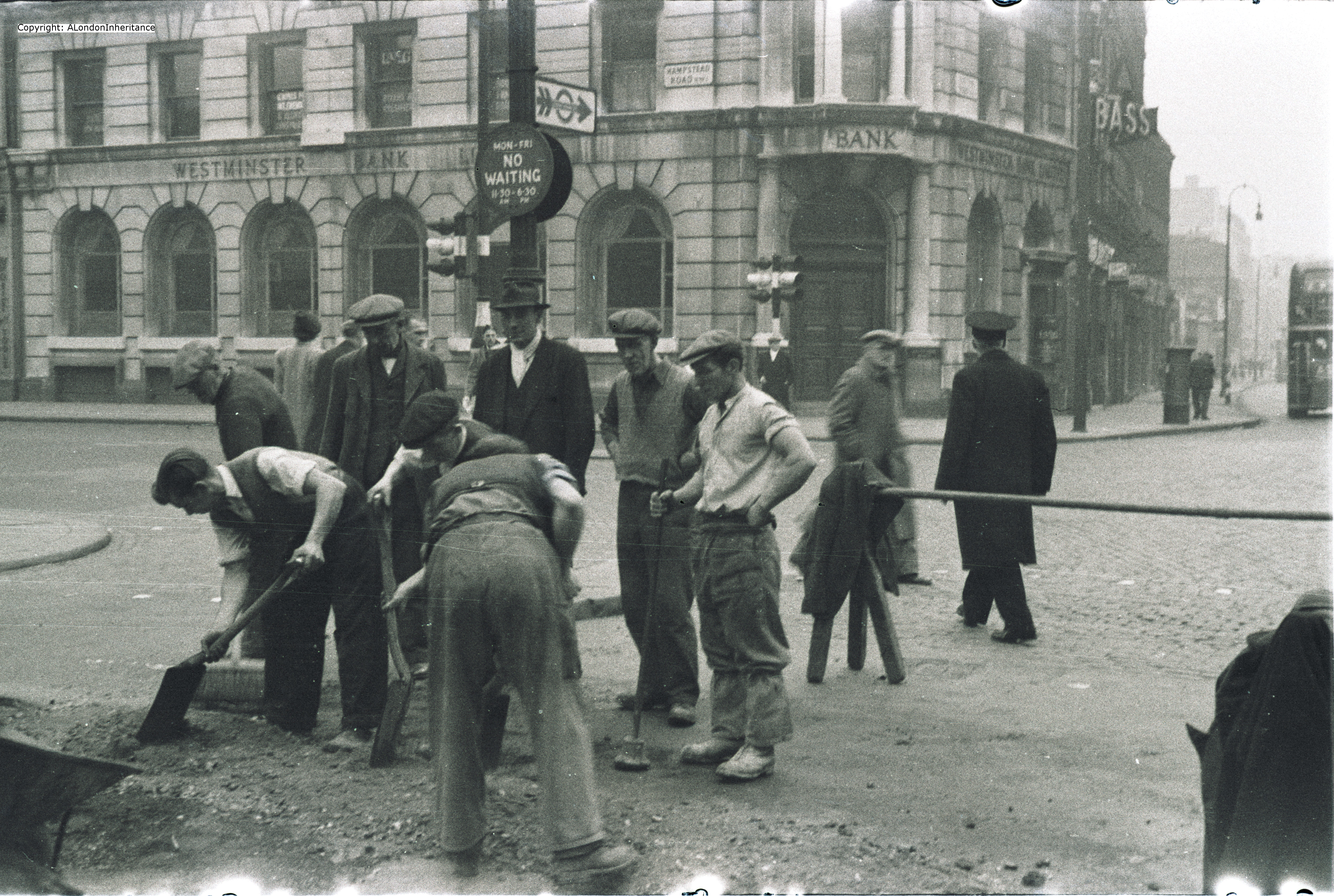
There was nothing really to identify the location, however on closer examination of the Bank, there is the street name of Hampstead Road. The name on the sign on the right of the Bank cannot be identified so I could not work out the road junction. The angle and the distance does not allow a name to be resolved. So I knew this was in Hampstead Road on a street corner, but where? I have walked Hampstead Road before and could find no location that fits these photos.

I have a number of sources to search, both written and online to try to find locations and I eventually found the location for this one following a search on the English Heritage website searching for a Bank in Hampstead Road. This resulted in a photo of the same bank, identifying the location as on the corner of Hampstead Road and Euston Road, so now I had the location with the photo being taken outside Warren Street underground station looking across the Euston Road to the Bank on the opposite corner.

The junction of Euston Road, Hampstead Road and Tottenham Court Road has changed dramatically over the years since this photo was taken. The Euston Road has been considerably widened with the Euston Underpass being constructed to take traffic along the Euston Road under the junction of Tottenham Court Road and Hampstead Road.

Working along the Euston Road to Great Portland Place underground station shows how the road has been widened at this junction with the road at Great Portland Place being about the original width.

There are still many original building on the south side of Euston Road with Warren Street underground station being one of these that has not changed, therefore the south side marks the original alignment of Euston Road. The north side has all been redeveloped with Euston Tower and the more recent Regent’s Place office buildings. My estimation of where the bank was located is therefore half way across the new road, just over the Euston Underpass.

There was one point that worried me in confirming the location of this photo, there is an Underground sign pointing east along Euston Road, I would have assumed that if this was outside Warren Street it would be pointing to the station, however a quick check confirmed that in the direction of the sign, a short walk along Euston Road is Euston Square underground station, so this sign was directing travellers emerging from the Northern line at Warren Street to the Circle, Hammersmith and Metropolitan lines at Euston Square.

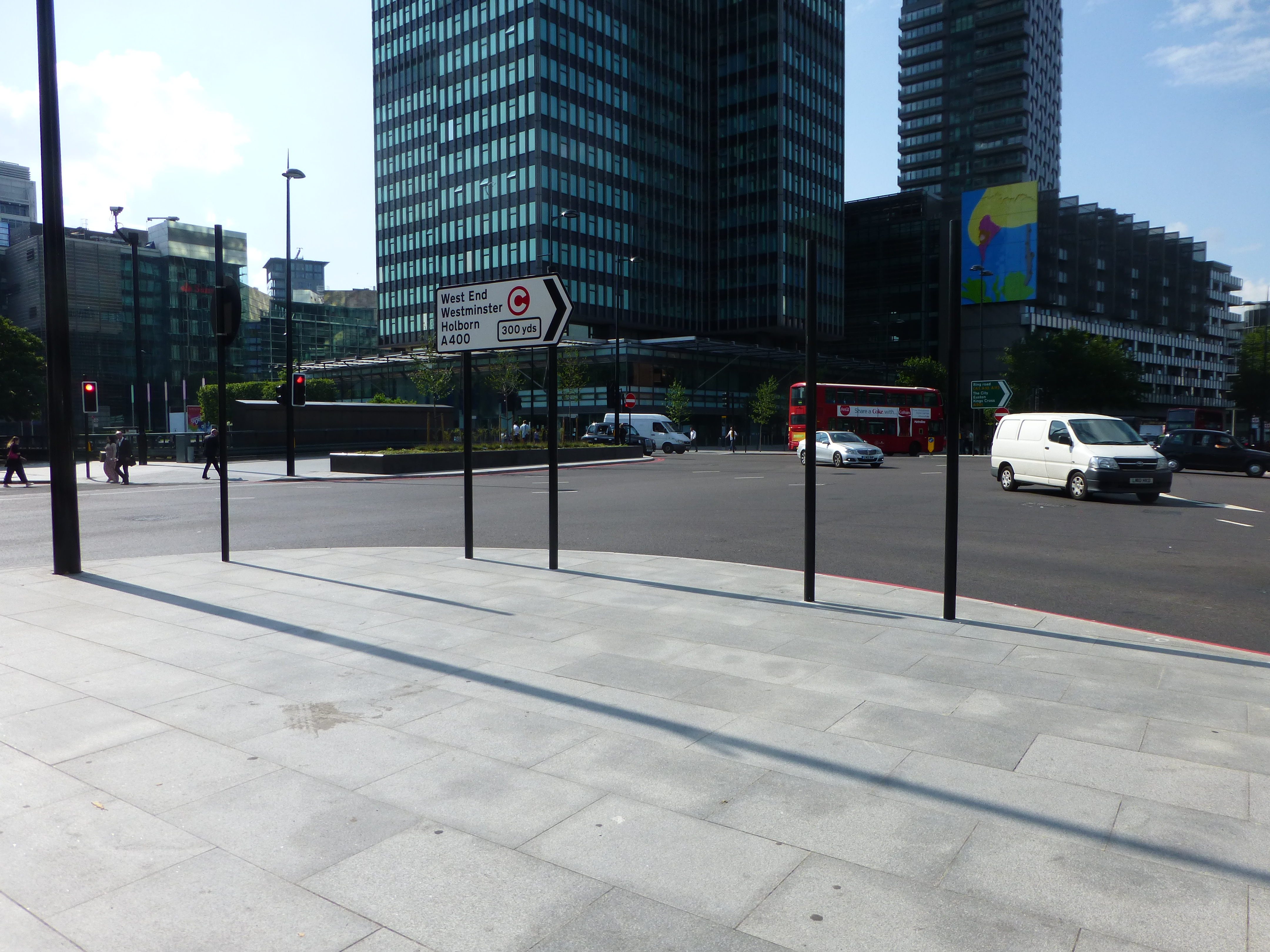
The following is my 2014 photo from roughly the same position outside Warren Street underground station as the original.

P1020335

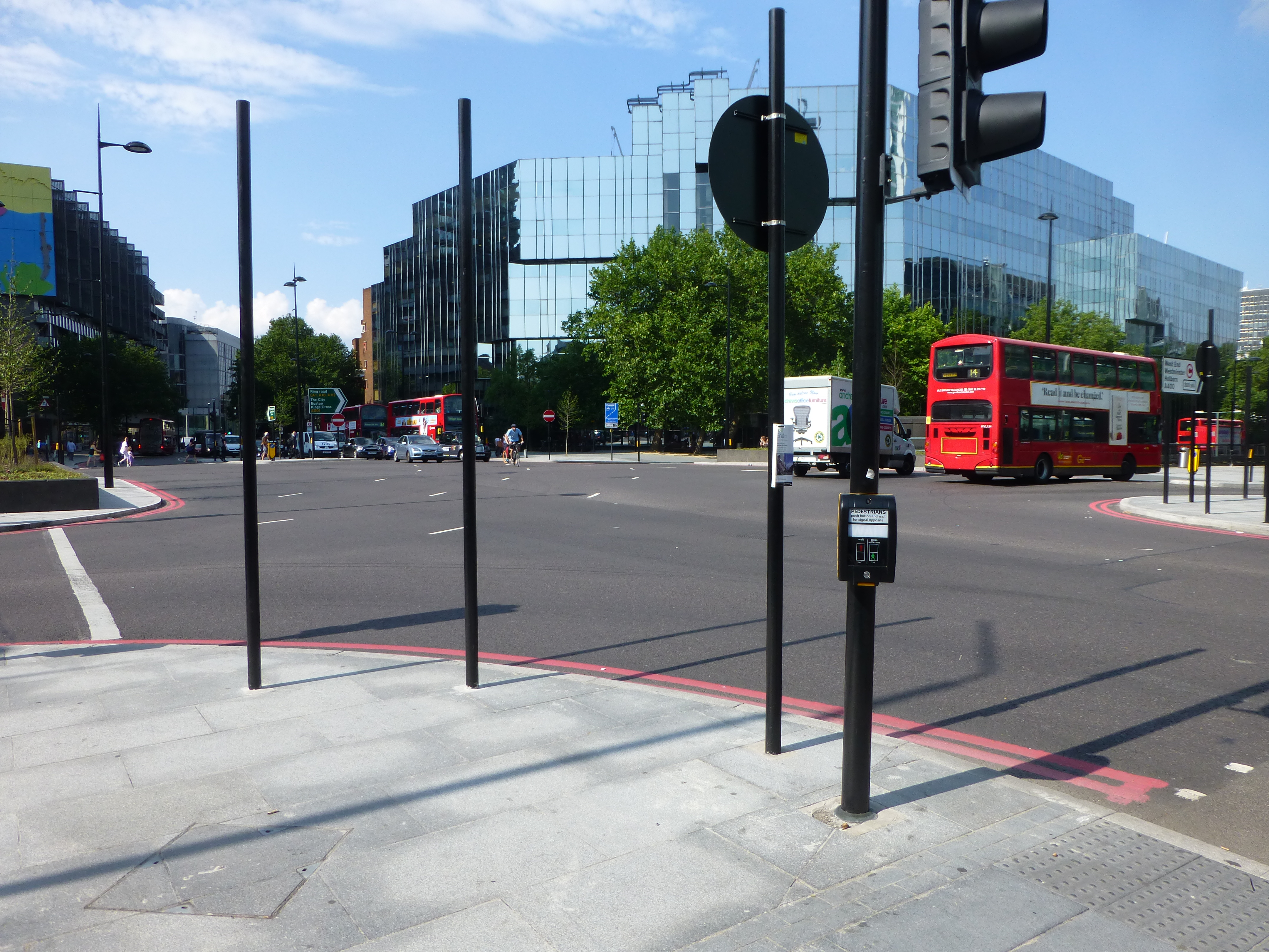
Very hard to be precise as there has been so much change since the original, and I suspect I should have been more on the current edge of Euston Road slightly to the left. If I have worked out the original road widths correctly then the corner of the Bank in the original photo is roughly where the white truck is in the 2014 photo.

Despite the appearance of this road junction and the surrounding areas, as with anywhere in London there is a considerable amount of hidden history to be discovered.

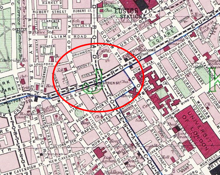
The following map is from the 1940 edition of Bartholomew’s Reference Atlas of Greater London with the red oval covering the area of today’s post. The junction of Tottenham Court Road, Hampstead Road and Euston Road is under the “J” in the centre of the oval. Warren Street station can just be seen and the photo was taken outside looking diagonally across Euston Road.

Map1

If we cross the Euston Road from Warren Street to the north side we find Euston Tower and the Regent’s Place development. This has completely obliterated Eden Street, Seaton Place, Fitzroy Place, indeed this whole area bounded by Drummond Street and Osnaburgh Street.

Eden Place was probably where the front of Euston Tower is now located and was lost in the widening of Euston Road and the construction of the underpass. Seaton Place was probably at the rear of Euston Tower, this is now a pedestrian walkway between Euston Tower and the other office blocks of Regent’s Place which for some reason is called Brock Street. No idea why the original name could not have been retained.

It was on this corner of Hampstead Road where the Adam and Eve Tavern was located. The location now is probably exactly where the underpass dives under the Hampstead Road, Tottenham Court Road junction. This was built on the original site of the Tottenham Court from which Tottenham Court Road takes its name. The manor was converted to the original Adam and Eve somewhere around 1645. Up until the later part of the 18th century the tavern and extensive gardens were very popular with Londoners. In the road outside the Adam and Eve, Hogarth set the scene for his “March to Finchley” where a military camp had been set-up and the picture shows the disorderly Guards in true Hogarth style on their way to the Finchley Camp as part of the journey to Scotland to meet the Jacobite Pretender (Charles Stuart).

The March to Finchley is shown below:

Hogarth

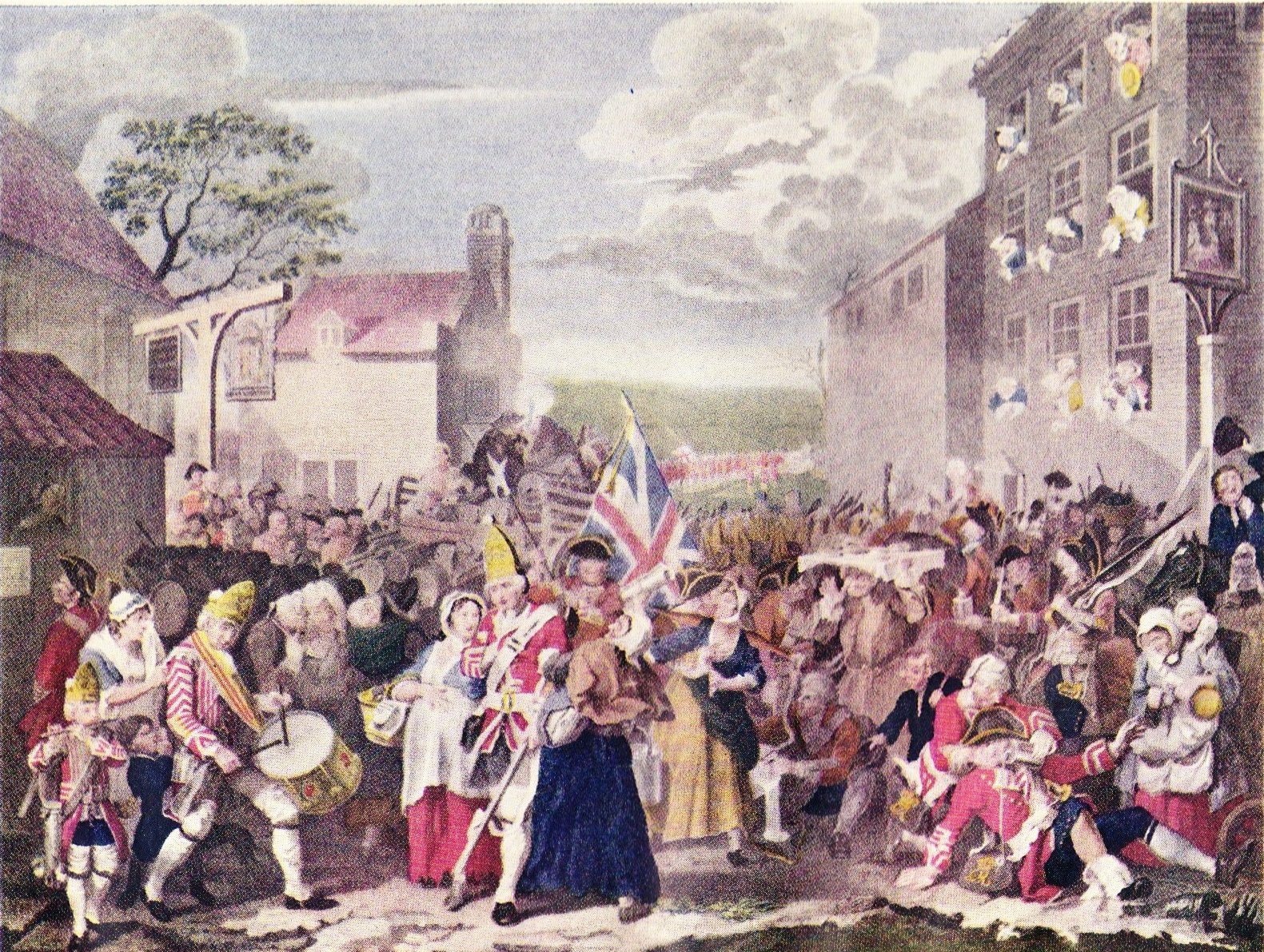
The Hogarth picture shows two Taverns with the Adam and Eve on the left and the Old Kings Head is on the right. Strange to think that the Euston Underpass is now running left to right across this picture. The King’s Head was demolished in 1906 to make way for the widening of the Hampstead Road. The very narrow road width of the junction at this point had long been a problem as the King’s Head jutted out into the thoroughfare and calls had been made to address this from the start of the nineteenth century.

Also, when the Adam and Eve and Kings Head were at the peak of their popularity, much of this area was countrified and to demonstrate the rural nature of the area, the following advert appeared in The Postman for December 30th 1708 of a house to be let:

“at Tottenham Court, near St. Gile’s and within less than a mile of London, a very good Farm House, with outhouses and above seventy acres of extraordinary good pastures and meadows with all conveniences for a cowman, are, to be let, together or in parcels, and there is dung ready to lay in”

I took the following photo on the east side of Tottenham Court Road looking over towards Euston Tower and Regent’s Place. The Adam and Eve Tavern was roughly where the red traffic lights are now located with Eden Street just in front of Euston Tower.

P1020337

The following photo is the second of the same scene. It is fascinating to compare working conditions of the late 1940s with those of today. Not a single high visibility jacket or traffic cone in sight.

old hampstead road 1

I have recently received some fantastic photos of the Euston Road, Hampstead Road junction and the building of the underpass from John Cinnamond. They show the junction before the widening of the Euston Road and the building of the Underpass.

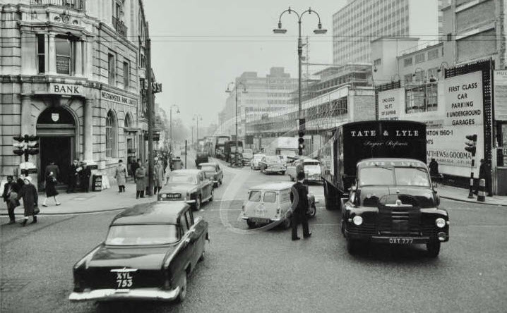
The first photo, taken in 1961, is looking east along Euston Road. The bank on the left of the photo is the same as the one in my father’s photo, however this now shows the full view of the road.

Euston Road (Looking East From Hampstead Road) - 1961

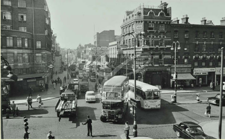
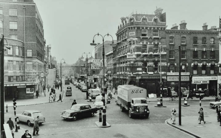
The next photo, also taken in 1961 is looking west along Euston Road. Warren Street Underground Station is on the left and this is basically the same today, however the very significant change is to the right of the photo. The pub on the corner is the Adam and Eve. All the buildings on the right of this photo were pulled down in order to make way for the widening of the Euston Road and the Euston Underpass. Where the buildings on the right, facing the camera stood, is now the underpass and a bridge over the underpass leading to the north side of Euston Road.

Euston Road (Looking West From Hampstead Road) - 1961

I have repeated one of my photos from earlier in the post. This is looking across to where the pub and the buildings running to the right in the photo above used to stand.

P1020337


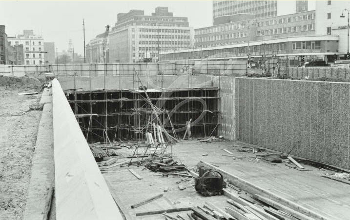
Now we come to the building of the Underpass. These photos were taken in 1966 and this is looking across to Warren Street Underground station, the curved building to the left of the photo. The pub and buildings in the early photos ran across to the right, where the hoarding can be seen, but have now been pulled down and the Underpass is being built.

Euston Road Underpass Construction - 1966 (01)

And looking in an easterly direction, the Underpass is where the bank used to stand, which would have been roughly left of centre, slightly set back from where the Underpass goes under the road.

Euston Road Underpass Construction - 1966 (02)

One final photo which again is from 1961 and is looking to the west. The lorry is from the company G.E.C. the engineering and electrical conglomerate that failed so spectacularly after trying to turn itself into an internet / communications business at the height of the dot-com bubble. Interesting not only how the urban landscape changes, but also the businesses operating in that landscape.

Euston Road (Looking West From Hampstead Road) - 1961 (02)

An amazing series of photos and I am very grateful to John for sending and letting me include in the post as they complete the story of how this road junction has changed so considerably.

So, one simple road junction in London, but as with most places across London, a fascinating history.

The sources I used to research this post are:

  • London’s Old Latin Quarter by E. Beresford Chancellor published 1930
  • London by George H. Cunningham published 1927
  • Old & New London by Edward Walford published 1878
  • Bartholomew’s Reference Atlas of Greater London published 1940

 alondoninheritance.com


The Sunday Pictorial Film Garden Party

This time of year (if you ignore the recent thunderstorms over London and the vagaries of the British weather) is the ideal time for a Garden Party and what could be better than sharing that Garden Party with your favourite British and visiting American Film Stars.

And this is what took place each year between 1947 and 1952 when Morden Hall Park on the edge of South London would host the Sunday Pictorial Film Garden Party in either June or July when up to 25,000 people would regularly attend these events (the Sunday Pictorial became the Sunday Mirror in 1963)

This was an event where you could meet your favourite Film Star and build an autograph collection or get a photo, as well as raising money for the NSPCC and the Church of England’s Children Society.

These are a series of photos taken by my father at the Garden Party at the point where the Stars would enter the garden on a Jeep, and be driven round from stall to stall where you could queue to meet the Star and collect an autograph or a photo.

Despite trying to identify the Film Stars in each of the photos, I have not had any luck. Some possibles but I do not want to name them until I can be sure. Any feedback with names would be appreciated.

The following photo shows one of the Jeeps emerging from the Stars entrance to the Garden Party  and shows the glamour and excitement created for the waiting crowds as each Jeep would emerge with a new set of Film Stars.

The Stars packed into a Jeep including standing on the edge and balancing on the bonnet. A very nervous man with a camera perched somewhat precariously on the very front, the eager crowd looking to see who would be entering and who they could recognise.

film 8

The Associated Pictures on the front windscreens of the Jeeps in the above and below photos shows that these were Film Stars from the Associated British Picture Cofilm 6rporation.

Although in the following photo the Jeep has just passed, look at the faces of the people on the right of the photo. The excitement of recognising someone who up to now you have only seen on the big screen (this was in the days before the Television was a common part of the home  and the cinema was still the main source of entertainment).

film 5


film 4

Crowds pressing up against the temporary fencing:

film 7


film 3

Perhaps they had run out of Jeeps?film 2

I recognise the actor sitting in the front of this Jeep, but I cannot find his name:

film 1

There are some superb newsreels from British Pathe covering these Garden Parties. A good example being found here.

So, if you visit Morden Hall Park one weekend this summer, this is the type of event it was hosting over sixty years ago and you would be one of 25,000 other people all looking to get an autograph or photo with their favourite Star.

And if you recognise any of the Film Stars in the photos I would really appreciate a comment or e-mail so I can put names to the photos.

 alondoninheritance.com


The Royal Festival Hall – Before, During and After Construction

A few weeks ago I published a post about the South Bank before the Festival Hall with some photos taken on the South Bank. This week I want to cover the same area, but this time showing the scene from the north bank of the Thames as this provides a very clear view of how a small area between Waterloo and Hungerford Bridges has changed.

The following photo was taken by my father from the north side of the Thames next to Hungerford Railway bridge in 1948:

Festival 4

Hungerford Railway Bridge is to the right and Waterloo Bridge is on the left hand side, both bridges framing the future site of the Royal Festival Hall. To the left of the photo is the Shot Tower and to the right is the Lion Brewery.

Until the 16th Century, this area was foreshore to the Thames, overgrown with rushes and willows and subject to flooding at high tides. The road behind the Royal Festival Hall, Belvedere Road was the Narrow Wall, a road built on the embankment to the Thames.

From Old and New London (Edward Walford (1878)): The spot between the Belvedere Road and the river between Waterloo and Westminster Bridges – till recently known as Pedlar’s Acre – was called in the fifteenth and sixteenth centuries Church Osiers from the large osier-bed which occupied the spot (an Osier is a type of Willow) This is a plot of land of some historical notoriety. It was originally a small strip of land one acre and nine poles in extent , situated alongside the Narrow Wall and has belonged to the parish of Lambeth from time immemorial. It is said to have been given by a grateful pedlar. (There is also a story that the pedlar’s dog discovered treasure there whilst scratching around in the ground). On Pedlar’s Acre at one time was a public house with the sign of the pedlar and his dog and on one of the windows in the tap-room the following lines were written:

“Happy the pedlar whose portrait we view,
Since his dog was so faithful and fortunate too;
He at once made him wealthy, and guarded his door,
Secured him from robbers, relieved him when poor.
Then drink to his memory, and wish fate may send,
Such a dog to protect you, enrich and befriend”

What ever the truth of this story, it is still fun whilst walking round the Royal Festival Hall to imagine the Pedlar and his dog digging in the willow beds and finding treasure.

Continuing from Old and New London:

Not far from the southern end of Waterloo Bridge on the site now occupied by the timber-wharfs of Belvedere Road and close by the Lion Brewery, which abuts upon the river stood formerly a noted place of public resort known as Cuper’s Gardens. As far back as the eighteenth century if not earlier it was famous for its displays of fireworks.  

The Shot Tower was built in 1826 as part of the lead works on the site for the production of lead shot. The tower is built of brick, with a diameter at the base of 30 feet. The tower tapers slightly so at the top gallery the diameter is 20 feet. The gallery is 163 feet from ground level.

From the gallery, molten lead was dropped to form large shot, half way down the tower was a floor where molten lead could be dropped to make smaller shot.

The Lion Brewery is on the site of a former Water Works where water was taken from the river for distribution to the local area. Pumping water from the river was replaced by a supply from reservoirs on Brixton Hill and the works were removed in 1853. The site then became a brewery which became the Lion Brewery Company Limited in 1866. The building was damaged by fire in 1931, it was then used for a short time for storage and then remained derelict until demolition in 1949 to make way for the construction of the Royal Festival Hall.

The following photo was taken from the same position a few years later during the construction of the Royal Festival Hall in 1950 (judging from the position of the shadow on the river this was taken at the same time as the 1948 photo, some careful planning to get the comparison right). Construction was fast, from the foundation stone being laid by Clement Atlee in 1949 to the hall being opened on the 3rd May 1951

Festival 1

The Shot Tower remains (apart from the gallery at the top) and would remain for the duration of the Festival of Britain. The core of the Royal Festival Hall is under construction, covered in scaffolding and cranes. The new river frontage is also under construction.

The Royal Festival Hall was constructed by the London County Council and was planned as the one permanent building to remain from the overall Festival of Britain site that occupied the South Bank.

The following is my 2014 photo of the same area. I could not get into exactly the same position as my father when he took the original photos as the new foot bridge extends further into the river from the railway bridge.

DSC_1260

The following Festival of Britain postcard shows a model of the site with the Royal Festival Hall on the left of Hungerford Railway Bridge. Difficult to see from this model, but Belvedere Road runs behind the Royal Festival Hall, under the railway bridge and behind the Dome of Discovery on the right. It is incredible how this small area changed in a few years either side of 1950.

Fesitval postcard

On the north bank of the Thames opposite the Royal Festival Hall is Shell Mex House. The following is a painting of the view from Shell Mex House included in the programme for the Festival of Britain. The Shot Tower and Lion Brewery with Waterloo Station in the background.

View from Shell Mex

The text below the picture is typical of the mood surrounding the Festival of Britain, the prospect of a bright future following the long years of war. The Royal Festival Hall is the only remaining building from the Festival of Britain as the rest was quickly removed after the closure of the festival.

Photo focussing on the area around the Shot Tower:

Festival 2

And again showing the Shot Tower and river:

Festival 3

You may also like to read my earlier post covering the site of the Royal Festival Hall and the area towards Waterloo Station before construction started which can be found here.

 alondoninheritance.com

Hairdressers of 1980s London

For this week’s post, I bring you a collection of photos taken in 1985 and 1986 that focus on the Hairdressers of east and central London. These show a type of business that whilst providing the same function, has changed over the years and provides a snapshot of London streets in the recent past. Many have long since disappeared, but good to see that a couple still survive maintaining a continuity of business across many decades.

The first photo is of Ron’s Gents Hairdressers – 27 Three Colts Lane, Bethnal Green, E2.

After almost 30 years, this building is still there, but has changed from a Hairdressers to a Barbers, fascinating that the same type of business has been operating in this location for many decades as Ron’s had obviously been long established in 1985.

Hair 1

The perfect location for an “Executive Mood” or “Avant Garde Mood” hairstyle. 1980s “big hair”.

Hair 3

Dave & Syd Strong, Gent’s Hairdresser. Typical of the time, always with photos in the window showing typical hairstyles:

Hair 9

Dennis Gents Hair Stylist. Note the razor blade advertising sign, the long term association between barbers and shaving.

Hair 10

Gents Hairdressers moving into Ladies Hairdressing:

Hair 11

If it was not for the sign you would not know this was a hairdresser:

Hair 12

Apples Hair Stylist:

Hair 13

Peter Individual Gents Hair Stylist. Again with model photos in the window. The painting of the wall to the left of the shop continues the association of red and white stripes with barbers. This is more usually seen as red and white stripes around a pole and symbolises bloody bandages wrapped around a pole when barbers also performed surgery, blood letting, the use of leaches and teeth extractions.

Hair 14

The Saloon. Faces of customers peering out from the left of the shop window:

Hair 8

Mario’s Men’s Hairstylist. With the traditional red and white pole.

Hair 7

Hairdresser at 10 Laystall Street, EC1 with plaque commemorating Giuseppe Mazzini “the apostle of modern democracy inspired young Italy with the ideal of independence unity and regeneration of his country. ” I am not sure why this plaque is on this building, when he was in London he lived at 183 Gower Street where there is a London County Council Blue Plaque.

The plaque is still there, although the hairdresser is long gone.

Hair 6

The Pleasant Gent’s Hairdresser. Rosebery Avenue, Clerkenwell, EC1. Still going as the Pleasant Barbers – http://pleasantbarbers.co.uk/ (Interesting to see the change over the last 30 years from Men’s Hairdressers to Barbers)

Hair 5

Gentlemen’s Hairdressing Salon, 59a Carter Lane EC4 (central London). The building is still there as are the same bollards, however the building is now a coffee shop.

Hair 4

Junes Ladies Hair Stylist. Closed and being cleared. Note on the sign the old London telephone number format with the area name rather than number. STE was the code for Stepney Green. Letters were replaced by numbers around 1966.

Hair 2

 alondoninheritance.com