Monthly Archives: December 2020

Blogs, Books and Population Statistics

After a strange and tragic year, a year in which so many have suffered loss of loved ones, financial loss and the day to day stress of living through a pandemic, I thought I would end 2020 with a rather different post. One that looks back on the blogs and books I have been reading during the past ten months, and looks at how previous population trends across London may change in the future.

Three very different subjects, but hopefully suited for the period between Christmas and the New Year, when the days lack their normal structure and blend into each other, made even worse with the restrictions of Tier 4, and when the change to a new year brings thoughts of the past and the future.

Blogs

I started writing the blog back in 2014 after attending a blog writing course run by the Gentle Author of Spitalfields Life. I had been trying to summon the motivation, and a purpose for a project I had been thinking about for years, to track down the location of the sites my father had been photographing from 1946.

It seemed the structure and routine of a blog would provide the right motivation and purpose, although I did not expect to be still writing almost seven years later.

One of the blogs I have been reading for years is Diamond Geezer, who has been writing since 2002 and publishes daily. One of the topics Diamond Geezer occasionally touches on is the loss of many long form blogs, and whether this form of writing is a gradually disappearing format.

I hope not given that I probably started rather late using blogging as a medium, so I thought I would celebrate the diversity of blogs with a sample of those that I read regularly. I will also be adding what WordPress terms a Blogroll to the side bar of the blogs main page.

So starting with the blog that started me writing:

Spitalfields Life – A blog that probably needs no introduction from me. Written by the Gentle Author, a daily exploration of the people and places of east London, and indeed London as a whole. Spitalfields Life has become a campaigning blog, addressing some of the proposals that seem to want to change London without considering the history or future of the city, probably apart from a quick commercial return.

Diamond Geezer –  Another blog that posts daily, with the added benefit that you are never sure what the topic will be. Covering London, as well as visits to the rest of the country, analysis of data published about London’s transport network, anniversaries, street names etc.

What I envy about the Diamond Geezer blog is the ability of the author to craft a wonderful 50 words on a topic, where I would waffle through 500 words trying to say the same thing.

Bug Woman – Adventures in London – Mainly focused on the flora and fauna of London, Bug Woman shows another side of the city. The animals, plants, trees that are around us, but need that extra bit of attention to see and understand.

Bug Woman started with a weekly post, but for the last few months has been posting daily and provides a fascinating alternative view of the city.

Flickering Lamps – Although posts from this blog are not frequent, what the blog lacks in quantity is easily covered by the quality of the posts. A historical blog which brings to life some unique stories with in depth research and some wonderful writing and photography. A blog which demonstrates how much there is to be discovered across the streets of London, and further afield exploring the churches, graves and ruins to be found across the country.

Nature Girl, or “nature writing from a country warden” – I found this blog when I was researching a visit to the London Stone by Yantlet Creek on the Isle of Grain. The author is an Environmental Consultant in that wonderful area of Kent along the River Thames and inland to the River Medway. Although the blog is not about London, the proximity and influence of the Thames on north Kent has always fascinated me, and London looms as a potential threat to the area from expansion of the city, schemes such as the estuary airport, housing development, energy projects etc.

Nature Girl writes about the natural beauty of the area, and the importance of looking after such a special area of the country, not that far out from London.

Historic Southampton – Southampton is a city that like London was badly bombed in the last war, grew significantly because of the city’s access to the sea, and has a long and continuing history as a major port. The Historic Southampton blog explores the history of this fascinating city, and through some unique research and presentation of data, has mapped the location of Titanic crew members who lived or lodged in the city, and really brings home the impact of the disaster on the families in just one city.

The above is just a sample, there is so much creativity and research to be found across the blogging world, and hopefully the format will continue to gain an audience for many years to come.

London 2020 Reading

I have probably read more during 2020 than in any previous year. I have also tried to expand my London reading to explore recent history, and the London that I have experienced from the mid 1970s. The following books are a sample of my 2020 London reading (over the years, I have been offered books to review, I never except these. All books have been chosen and purchased by me, usually in a bricks and mortar book shop. It is very important to me to keep the blog free of any external, commercial or hidden influence):

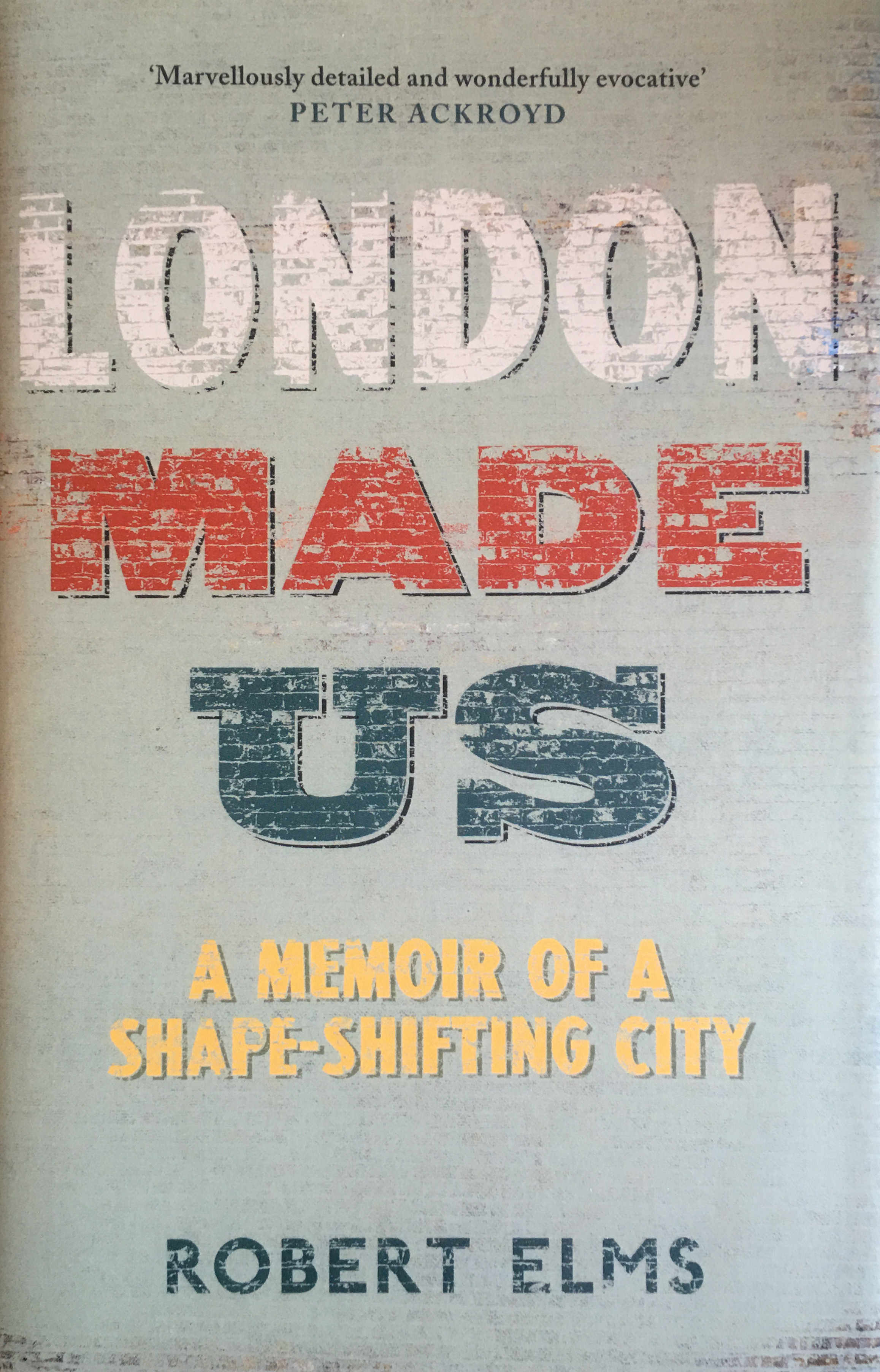
London Made Us – Robert Elms

Robert Elms is a broadcaster on BBC Radio London, a writer and once a journalist with the New Musical Express (NME). The title London Made Us very much describes the contents of the book – a family history of London, growing up in London and how London has changed.

I will use the word evocative a number of times in the rest of the blog, and for London Made Us, the book is brilliantly evocative of London in the 1970s and 80s.

Elms supports Queens Park Rangers, who play at Loftus Road. I have a very different experience of Loftus Road, it was where I saw my first major stadium concert in 1975 when Yes were headlining – a memorable day which still seems as if it was only yesterday.

Blogs

Alpha City – Rowland Atkinson

One of the reasons that London has such a global presence is the attraction of the city to the super-rich of the world.

The attraction of London as an asset rich city, a place where wealth can be accumulated and preserved has an impact on all those who live and work in the city. This has influenced the buildings we see grow across the city, the ownership of the city’s land and buildings, on the type and price of housing across the city.

Alpha City helps explain why London is the London we see today, and what the impact of these trends will be on the future of London and in-equality in the city, and goes some way to explaining why the population density of Kensington & Chelsea has reduced so significantly (see later in this post).

Blogs

Soho. A Guide to Soho’s History, Architecture and People – Dan Cruickshank

This is a wonderful book on a unique area of London. The first half provides historical background, the initial development of the estates that would come to form Soho and some social history of the area.

The second half is titled The Walk and presents a detailed walk through Soho, street by street and frequently house by house. I read the first half at home, then took the book out and followed the walk.

Soho is at risk of the type of development that will gradually erase what makes Soho a defined area in the city with its own unique character. Books like Cruickshank’s will help prevent this, or will help provide a record of a unique place for the future.

Blogs

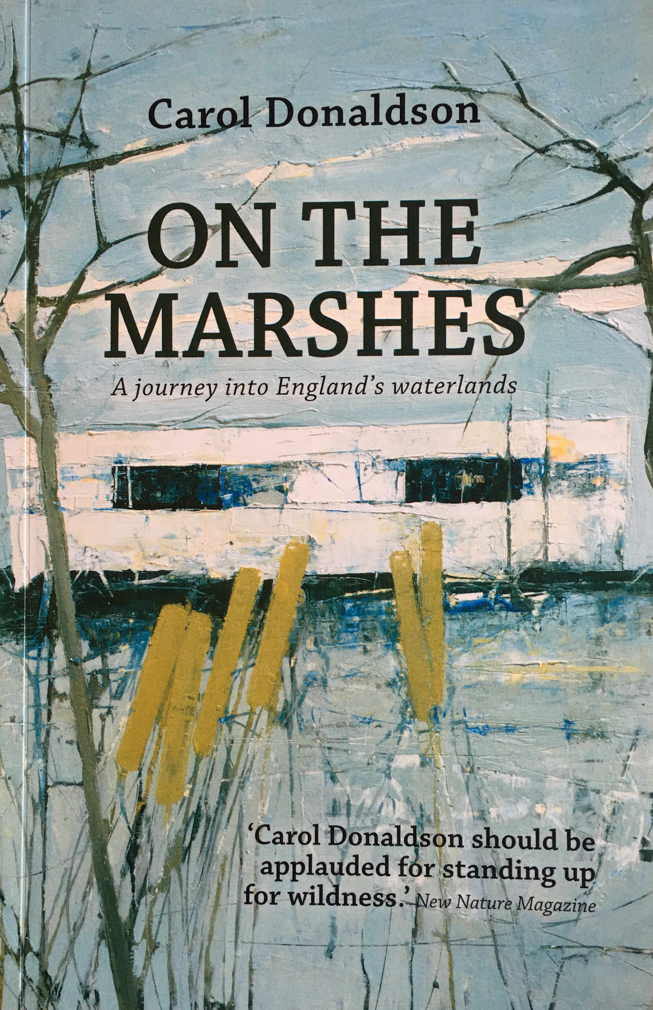
On The Marshes – Carol Donaldson

Carol Donaldson is the author of the Nature Girl blog mentioned above, and I purchased the book after reading the blog.

On The Marshes is a record of a journey across north Kent from Gravesend to Whistable whilst coming to terms with the break-up of a long-term relationship.

On the Marshes provides a wonderfully evocative view of the north Kent marshes and rivers, and covers aspects such as the plotland developments – plots purchased by individuals, frequently those escaping London, who built their own home and lived based on what they could find around them.

A good read to really understand this area, and then get out for some walking.

Blogs

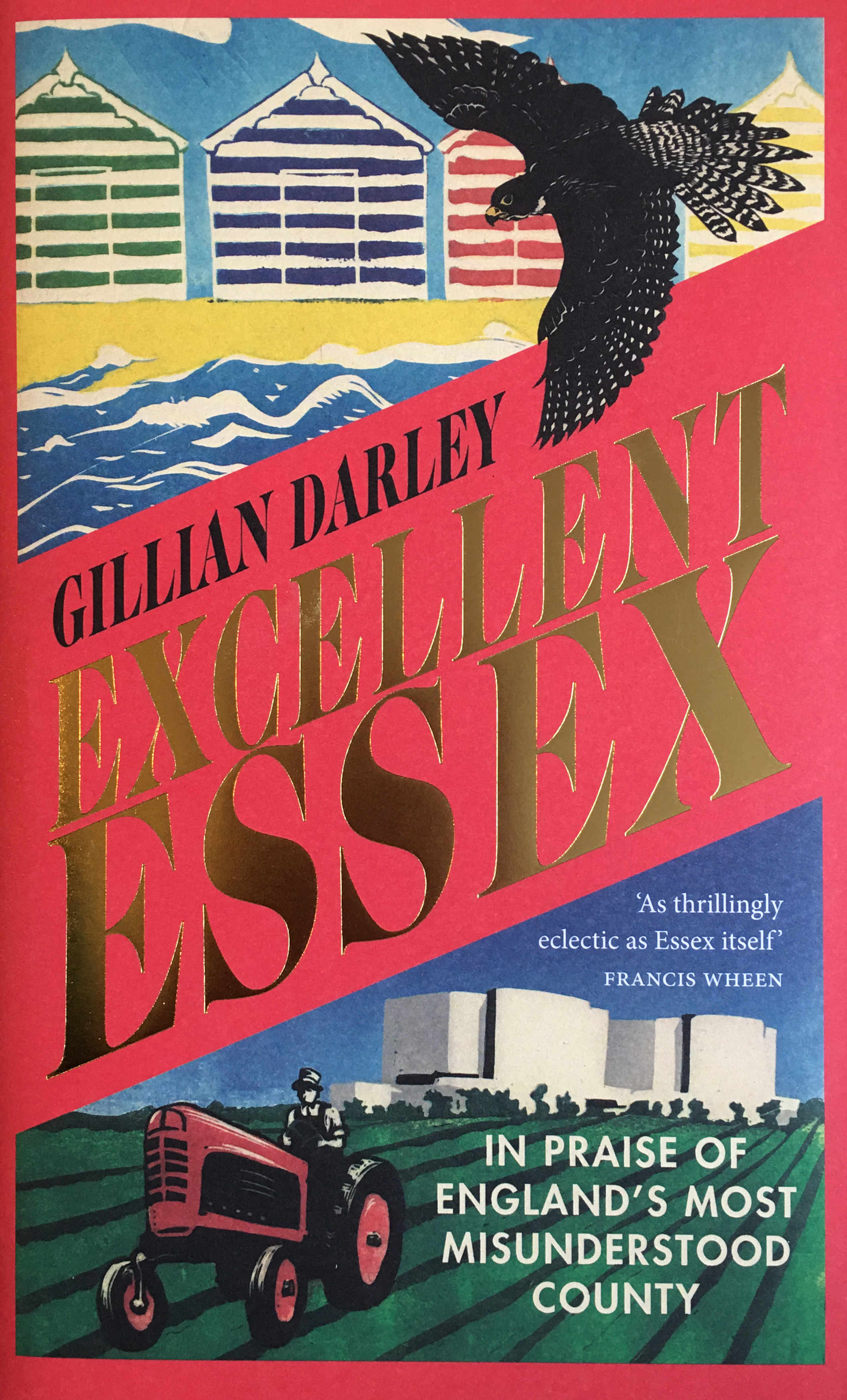
Excellent Essex – Gillian Darley

Again, not a London book, but a book which tells the story of a county that borders, and has been influenced by London. A county that has lost many of its original south western towns, villages and lands into Greater London.

The Essex coast has been a holiday destination for Londoners (Southend and Clacton), where many Londoners moved after the war, to new towns such as Basildon, and a county that has a long relationship with the River Thames and North Sea.

The book’s sub-title is “In Praise Of England’s Most Misunderstood County” which is a good summary. Essex has long been the focus of jokes about Essex Girls, Brentwood was a lovely country town on the main A12 into London before TOWIE gave the town a different reputation.

Basildon was one of the key constituencies that signaled the swing to Margaret Thatcher’s Conservatives in 1979, and became known for “Mondeo Man”.

Although these are the aspects of Essex that are frequently in the media, there is far more to Essex. Travel to the north of the county and it is a very different place to the south and Excellent Essex takes the reader through the whole history and geography of the county of Essex.

Blogs

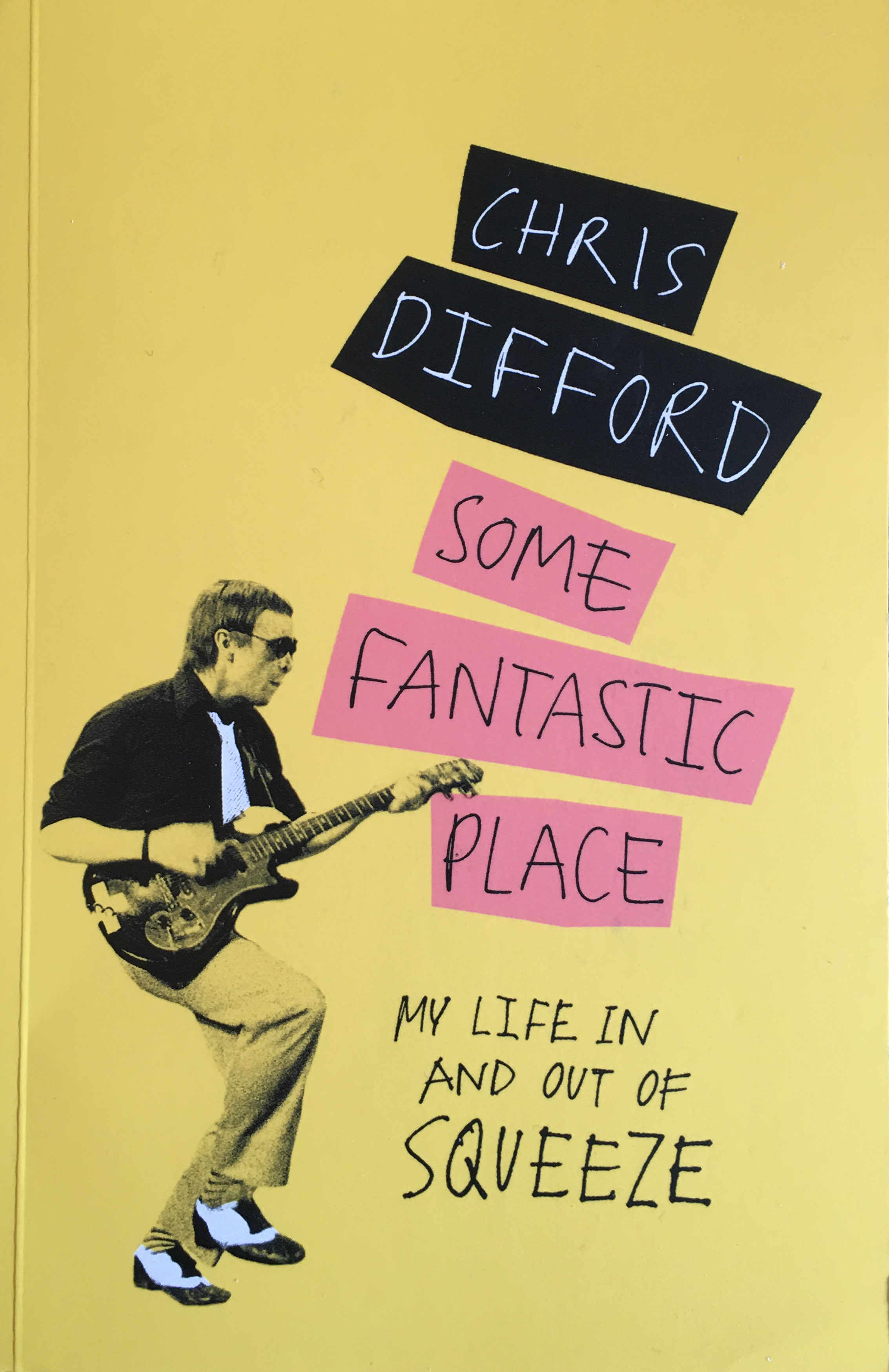
Some Fantastic Place – Chris Difford

Chris Difford was, along with Glenn Tilbrook, one of the original founders of the band Squeeze, and has been responsible for the majority of their lyrics.

Squeeze has long been one of my favourite bands and whenever I hear the opening of Take Me I’m Yours, I am transported back to driving around in my first car with their music playing on an Amstrad car cassette player.

Chris Difford grew up in Greenwich and his dad worked at the gas works on the Greenwich Peninsula. The book is an evocative story of growing up in Greenwich, and starting a band in Greenwich, Blackheath and Deptford. The book also touches on the London music industry, Bryan Ferry and Elvis Costello.

A brilliant read about growing up in south London, and a life in the music industry.

Blogs

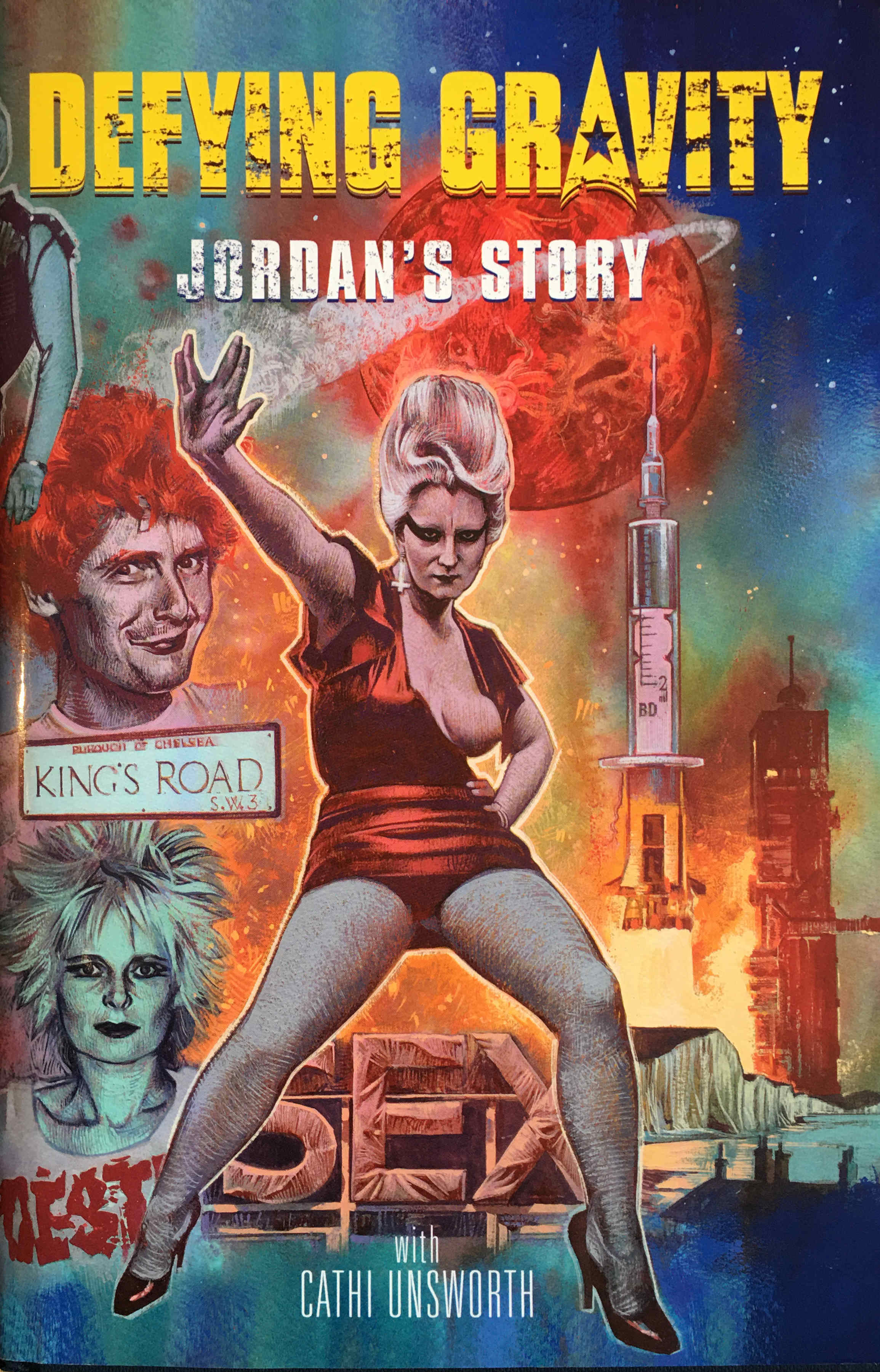
Defying Gravity, Jordan’s Story

The book is about Pamela Rooke, or Jordan as she was known as the face of Malcolm McLaren and Vivienne Westwood’s shop SEX at 430 King’s Road. later known as Seditionaries.

Jordan was there at the start of Punk in London, and if what punk was intended to be could be summarised by one single person, then it was probably Jordan.

Jordan played the part of Amyl Nitrate in Derek jarman’s 1978 film Jubilee, a film that portrayed Jarman’s view of punk, and England in the years around the 1977 Royal Jubilee, when Queen Elizabeth I is transported to London to see the decline of the country in the late 1970s. The film is great for a bit of location spotting as it was filmed at many locations around London, including Shad Thames, where Jarman had a studio at Butler’s Wharf.

The book is a brilliant read and brings to life not only Jordan’s story, but also that unique time when punk, music and fashion converged, against the backdrop of a London about to go through a period of considerable change.

Blogs

Changes in London’s Population

This year there have been many stories in the media about people moving out of London. The growth in working from home enabled by the ability to work from anywhere with an Internet connection, with many companies seeming to accept that a high degree of home working will become normal in the future.

This has been a rapid acceleration of an existing trend and it will be interesting to see what impact it has on the need for office space, London housing and London’s population in the coming years.

Up until the start of the year, London gave all the impressions of a very busy city. Streets full of people, crowded underground trains where frequently standing was the only option, the West End teeming with people in the evenings, busy cafes, restaurants and pubs.

Lock downs have had a catastrophic impact on so many London businesses in the entertainment and service industries. Add to this the collapse of tourism, and London feels a very different place to this time last year.

Although up until the start of the year, London felt very crowded, in reality London’s population was only catching up to levels last seen at the start of the 1960s.

The Office for National Statistics (ONS) publish some fascinating data, and I was recently browsing through some London population data (to pinch the words of Rowan Atkinson in Blackadder – the long winter nights must just fly by), and converting the data to graphs as I find it much easier to see trends using graphical presentation.

The following graph shows population numbers for inner (blue line) and outer (red line) London from 1961 to 2015.

Blogs

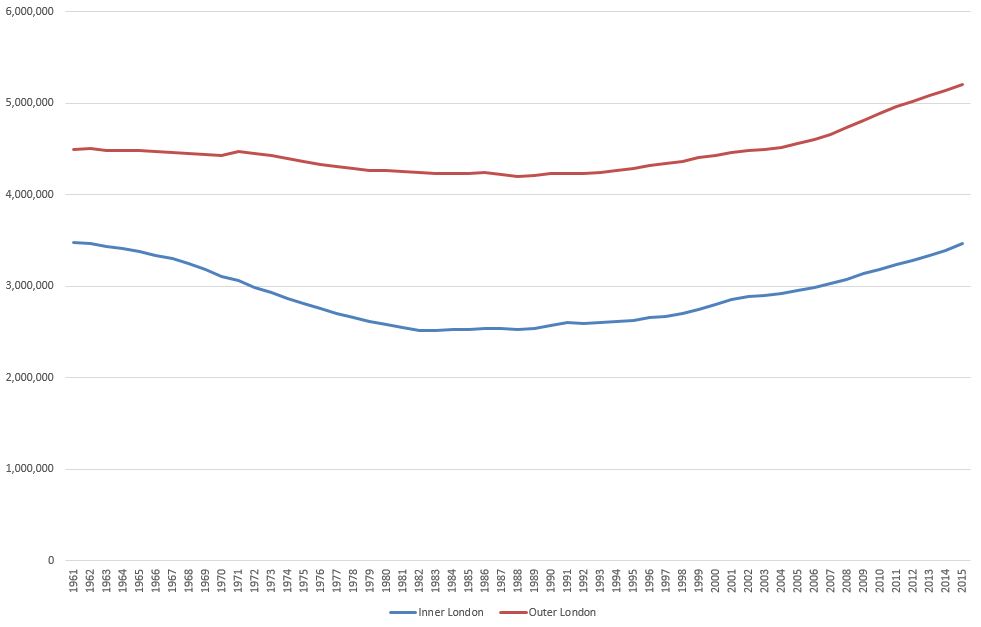
The graph shows that for inner London there was a fall in population of almost 1 million from 1961 (3.481 million) to 1983 (2.517 million), a fall of around 27%.

The fall across outer London was less dramatic, declining from 4.496 million to 4.202 million in 1988.

A number of factors contributed to such a significant decline across inner London, including:

  • slow rebuild of housing lost during the war
  • closure of industry, and the move of industry outside of inner London
  • slow down in trade on the Thames, containerisation and eventual closure of the inner docks
  • migration to new towns such as Harlow and Basildon

We can see the areas included in the ONS definition of inner London, as well as their individual population movements by graphing each individual area over time as shown in the following graph.

Inner London Population – 1961 to 2015

Blogs

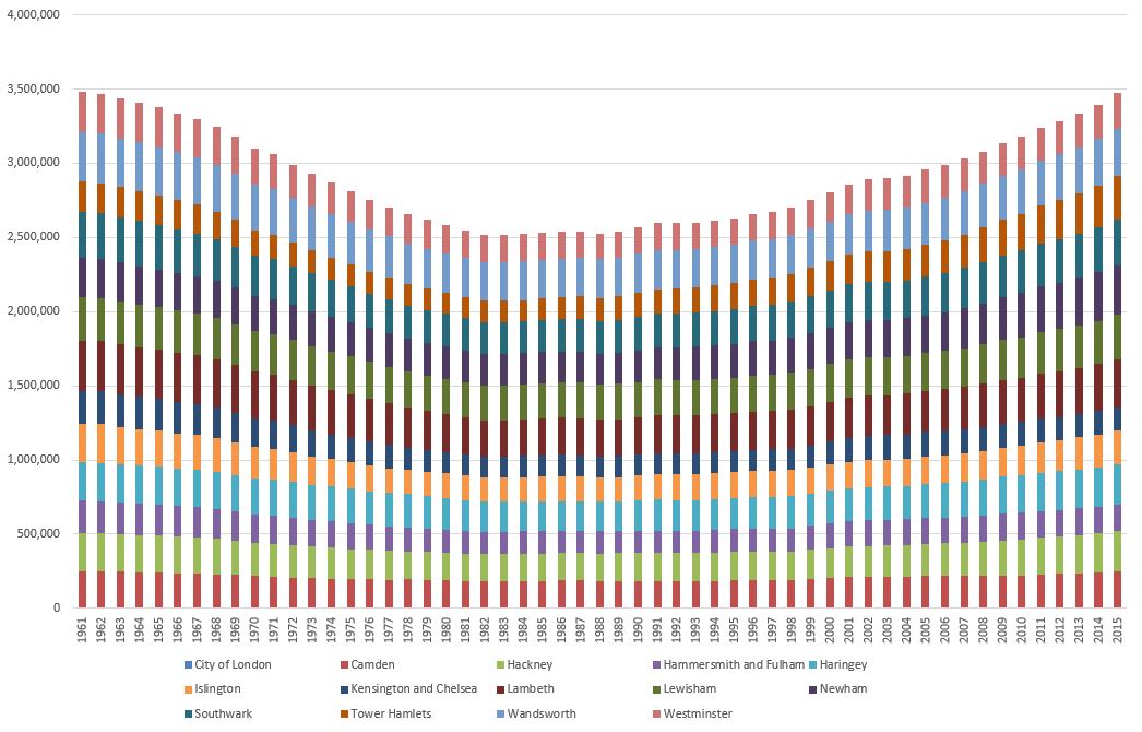
The City of London should be at the bottom of each column, however the population of the City is so low compared to the rest of inner London that it is does not show based on the vertical population scale. The population of the City changed from 5,000 in 1961 to 8,760 in 2015, with a low of 4,000 for most of the 1960s.

Whilst many areas of inner London returned to a similar population in 2015 that they had in 1961, there are some variations.

The populations of Hammersmith & Fulham and Kensington & Chelsea are still below their 1961 levels. Tower Hamlets and Newham are both above their 1961 levels.

One of the reasons that the population of the City is so low, as well as the City being mainly a business area, it is also the smallest of the areas classed as inner London. The following graph shows the area in square kilometers for each area of inner London.

Inner London – Size of each Borough in 2016

Blogs

By comparing the population with the area, we can see the population density of each area of inner London, as shown in the following graph which illustrates the number of people per square kilometer.

Inner London – Population Density in 2015

Blogs

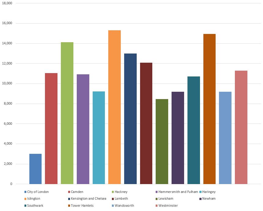
In inner London in 2015, Islington was the most densely populated area, with Tower Hamlets not far behind.

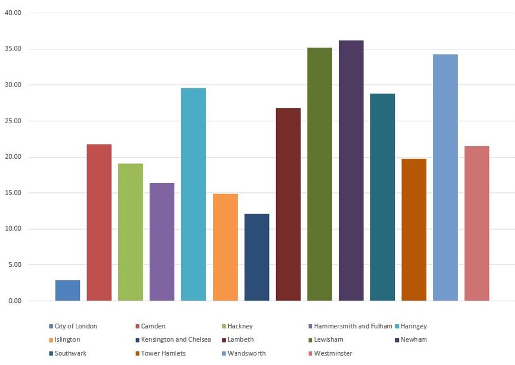
Inner London – Changes in Population Density between 1961 and 2015

What is really interesting is to compare the change in population density for each area of inner London between 1961 and 2015, as shown in the following graph where the blue column represents people per square kilometer in 1961 and the brown column represents 2015.

Blogs

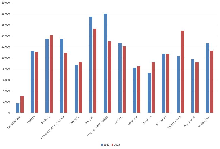
Islington, whilst being the most densely populated borough in 2015, was more densely populated in 1961.

The highest reduction is in Kensington & Chelsea, which in 1961 was the most densely populated borough, but this had reduced considerably by 2015. Possibly a result of housing policy in the borough, changes in multiple occupancy, housing treated as an investment rather than a home and often left empty etc.

The borough which has increased population density the most is Tower Hamlets. Possibly due to reconstruction after the war, land once occupied by industry and docks now occupied by housing, and that east London has long been the traditional initial destination for immigration into London.

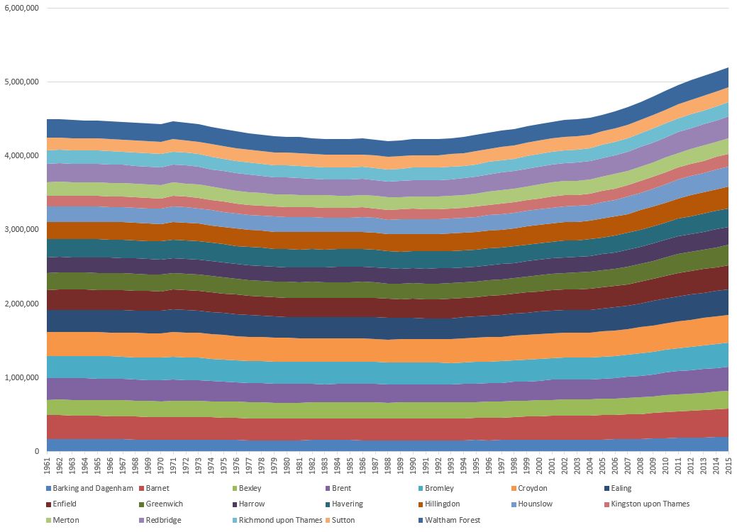
Whilst the population of outer London reduced after 1961, it did to a much smaller degree than inner London, reflecting the different industrial and commercial mix in inner than outer London, as well as a gradual move of population from inner to outer London.

What is marked is the increase in the population of outer London, so that whilst inner London had recovered to 1961 levels by 2015, outer London has seen an increase of over 700,000.

The following graph shows the population changes in outer London from 1961 to 2015.

Outer London Population – 1961 to 2015

Blogs

As with inner London, the geographic size of the outer London boroughs varies considerably with Bromley being by far the largest. This does not mean that population size follows geographic size as Bromley has a similar population to the much smaller Ealing.

The following graph compare the size of each outer London borough (in square kilometers):

Outer London – Size of each Borough in 2016

Blogs

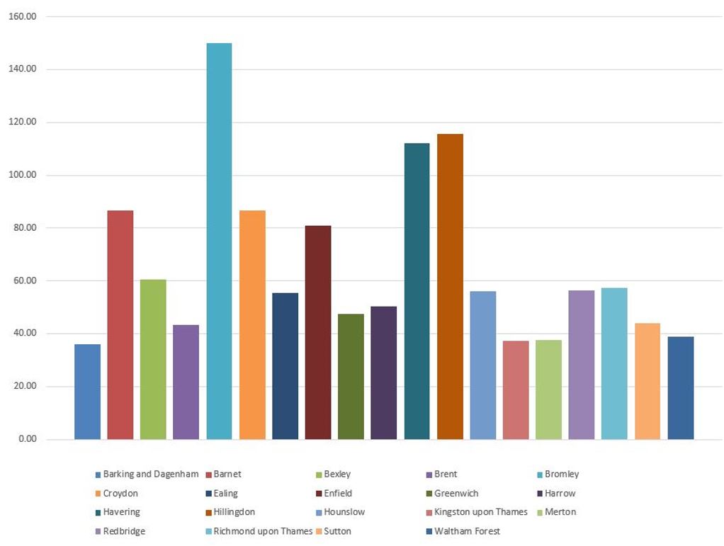
We can compare population density in the following graph, which charts the number of people per square kilometer for each borough.

Outer London – Population Density in 2015

Blogs

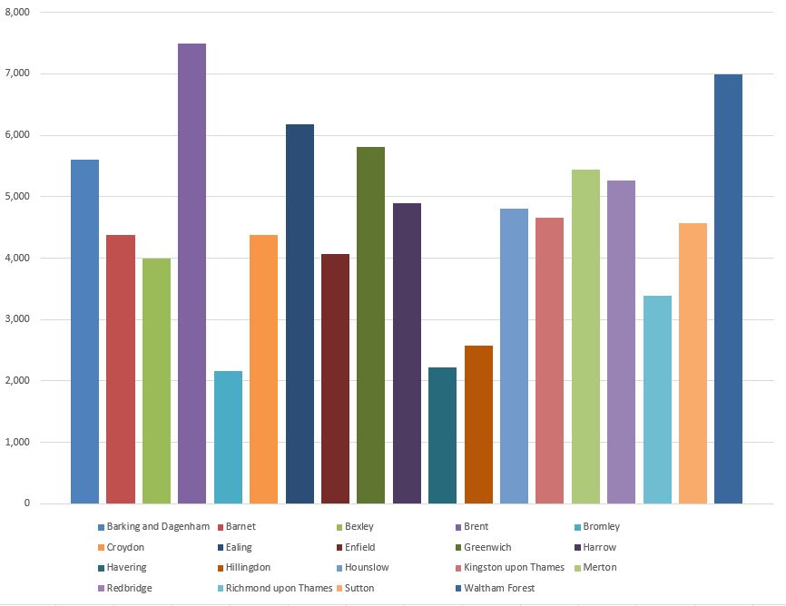
Compare the above two graphs. Bromley is by far the largest in land area, but the smaller when defined by population density. Brent has the highest population density with almost 7,500 people per square kilometer.

The following graph compares population density of the outer London boroughs in 1961 (blue column) with 2015 (brown column).

Blogs

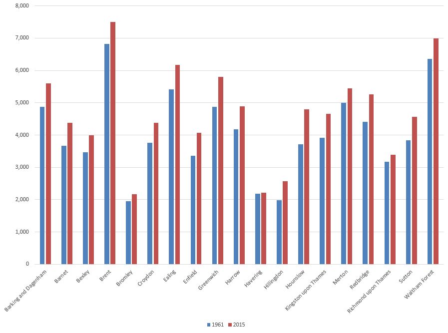
Where a number of inner London boroughs population density has reduced from 1961 to 2015, all outer London boroughs have increased their population density, reflecting a migration of people from inner to outer London, and perhaps those moving to London preferring to live in the outer rather than the inner London boroughs.

The cost of housing will also drive this change with housing costing slightly less the further from the centre of the city (although still very expensive).

All the above ONS data is from 2015. Numbers have almost certainly increased since then, and it will be interesting to see what happens in the coming years.

Will changes to working patterns influence where people want to live, and will the loss of jobs in the entertainment and service industries result in a long term contraction, or will coffee shops, restaurants, bars and shops return to their former numbers.

Will Brexit have any impact on the businesses that make London their base?

The themes of today’s post may be very different, but they are really about the same thing – exploring and recording how London changes, and the individual experiences of those who come into contact with the city. Whether that is through a long life in the city, having been part of a key period of London’s cultural life, or being part of the counties surrounding London. Individual experiences recorded in a blog or book, or the experience of large populations recorded in the ONS data.

Can I wish all readers a very happy New Year, and hopefully 2021 will turn out to be much better than 2020 and London returns to being the busy, dynamic and diverse city that makes it in my totally unbiased view, the best city in the world.

alondoninheritance.com

A Thames Dolphin at Rotherhithe

The title for this week’s post is a bit deceiving. The Thames dolphin in question is not one of the marine mammals, rather it is a structure in the river which is also called a dolphin.

The definitions for this type of dolphin include a pile, or a collection of piles in the river to which a boat can be moored, or a cluster of piles at the entrance to a dock, and it is this later definition which I suspect applies to the dolphin in my father’s photo at the entrance to the Surrey Lock and Basin in Rotherhithe – photographed in 1947:

Dolphin

The photo was taken from the Thames foreshore, adjacent to the air shaft of the Rotherhithe tunnel, looking across to the Shadwell / Wapping side of the river.

The negative with the photo was in poor condition and took some processing to get to the copy you see above, which unfortunately still has the opposite bank of the river with a rather poor contrast and lack of detail to the buildings.

I could not get down to the foreshore to take a similar photo as the tide was not sufficiently out, so the angle of the 2020 photo is slightly different. The following photo shows that the dolphin can still be seen today, along with some landmarks visible in 1947 on the opposite side of the river.

Dolphin

The following extract is from the 1948 revision of the Ordinance Survey map. The lines converge on the approximate point where my father was standing to take the photo. A blue circle marks the location of the dolphin (‘Reproduced with the permission of the National Library of Scotland’).

Dolphin

The green circle on the opposite side of the river is the position of the air shaft of the Rotherhithe tunnel which can be seen in the 1947 photo. The centre red arrow shows the alignment of the airshaft in relation to the dolphin.

The arrow on the left points to the church spire that be seen in the 1947 photo. This is the spire of St Mary’s in Cable Street. The spire can also be seen in the 2020 photo, and I photographed the church when I was walking the area a few years ago.

Dolphin

The arrow on the right points to the buildings which can be seen to the right of the dolphin. These are the buildings and cranes of Charringtons Wharf, which were demolished some years ago to be replaced by the large block of flats on the site today. The cranes to the right of the tunnel air shaft in the 2020 photo mark one of the construction sites for the Thames Tideway Tunnel, or Super Sewer.

There is a prominent line of buildings running between the dolphin and the spire of the church. These were buildings along the northern edge of The Highway – buildings that have now been demolished.

The gap in the centre of the line of buildings is open space between The Highway and Glamis Place, with the ruins of a pub to the left.

The entrance to Shadwell Basin is also in the photo, but is hard to see due to the lack of contrast, and the lighting of the scene across the river. The entrance is also at an angle to the river so the northern side of the entrance looks like a continuation of the river wall.

I have marked these features on the original 1947 photo as shown below:

Dolphin

There is one feature in the 1947 photo that I could not locate, however the Britain from Above archive came to the rescue.

The following photo from 1946 shows the Wapping / Shadwell area. The tunnel air shaft is lower left and I have ringed the church. I have written the name of The Highway along the street and the row of buildings along the north side of the street can be seen.

Dolphin

From the church spire, look diagonally to the lower left and you will see a chimney. This is the chimney seen in the 1947 photo and is the feature I could not locate.

Comparing the photo and the OS maps, the chimney looks as if it may have been part of the Queen Elizabeth Hospital for Children.

The following map shows the area today. The lower solid red circle is the point from where the photo was taken, and for reference, the upper red ring is the location of the church (Map © OpenStreetMap contributors).

Dolphin

The entrance to the Surrey Basin can be seen to the right of the lower red circle and the entrance to Shadwell New Basin is on the opposite bank.

The following photo is looking slightly to the west. The air shaft of the tunnel is opposite, and it is strange to imagine the thousands of cars and lorries that are running daily, under the river between where I am standing and the air shaft opposite.

Dolphin

The dolphin has been repaired since the 1947 photo, but still retains the mooring bollard on top.

Across the river, there is a second church spire to the left, this is St Paul’s Shadwell. The white building on the extreme left is the Prospect of Whitby pub.

A close-up view of the air shaft on the north bank of the river. To the left of the air shaft are the Shadwell Dock Stairs, which I wrote about here.

Dolphin

The area behind the northern airshaft is the King Edward VII Memorial Park – a fascinating area which I wrote about here.

The following photo shows the Rotherhithe tunnel air shaft on the south bank of the river, mirroring the design of the structure on the opposite bank.

Dolphin

The location of these airshafts can be seen when travelling through the Rotherhithe tunnel. They are each located where the tunnel bends, and with the walls of the tunnel set back for the infrastructure leading up through the air shaft.

If you look along the river wall in the above photo, you will see steps descending down to the foreshore, which at the time I was there were still partly underwater.

I suspect this was the method my father used to get down to the foreshore to take the 1947 photo, as the steps are also shown on the 1948 Ordnance Survey map.

The entrance to the Shadwell New Basin on the opposite side of the river is almost impossible to see in the 1947 photo. The entrance is at an angle and is still not that obvious today. The following close-up photo shows the entrance to the basin.

Dolphin

The Prospect of Whitby on the northern bank of the river (I can only dream of having a beer there at the moment):

Dolphin

View looking west along the river with the dolphin:

Dolphin

The dolphin is just outside the entrance to the Surrey Lock, which was the western entrance to the Surrey Basin, and the large complex of docks that once occupied the peninsula. The following extract from the 1940 edition of Bartholomew’s Reference Atlas of Greater London shows the considerable size of the docks. The entrance by the dolphin is on the left and labelled Surrey Docks.

Dolphin

The following photo shows more clearly the position of the dolphin and the entrance to the docks, which today have two posts marking the entrance.

Dolphin

The mooring bollard on the top of the dolphin implies that ships could have been moored on the dolphin, however I would have thought a ship moored in that position could have been an obstruction for ships coming in and out of the dock.

Dolphins at the entrance to docks were also used as a type of fender where the dolphin provided something for a ship to gently hit up against, and as an aid to align and position the ship.

At the entrance to a dock this may have helped a ship enter or exit the dock rather than drift further up or down stream.

Whatever the use of the dolphin, I assume it is now redundant as the docks have long since closed, with the majority disappearing under new building, and the entrance from the lock into Surrey Water closed off by Salter Road which runs across the old entrance into the basin.

The entrance does have an interesting base, which appears to be composed of metal plates.

Dolphin

I suspect the design is to reduce the amount of sediment that settles on the base of the lock. The angled plates which run along the centre will result in water draining to left and right as the tide goes out, and the higher flow of water along the edges that this causes reduces the amount of sediment left in the dock.

Facing out of the dock, towards the Thames, the tunnel air shaft is on the left, and a large pub, the Salt Quay, on the right:

Dolphin

Looking in from the river, along the Surrey Lock, and a rolling lift bridge can be seen, carrying Rotherhithe Street across the lock.

Dolphin

The bridge is a rolling lift bridge as it has a large counter weight at one end of the bridge, with a curved framework connecting the counter weight to the deck of the bridge.

Dolphin

When the bridge opens, the counter weight moves to the ground, rolling the deck of the bridge upwards. The following photo shows the bridge in action, with the deck fully raised to allow ships to move from the lock and into the docks.

Dolphin

The above view is looking south-west from the Thames. The chimneys in the background are at the Rotherhithe Gas Works which I covered a couple of weeks ago.

The docks were a prime target for bombing during the last war, and the original bridge was badly damaged in September 1940. Whilst it could continue to provide a road across the dock, it could not lift, so only barges were able to enter, not the usual sea going ships that would have normally entered the docks via this route.

The original bridge was built in 1858 as part of the development of the dock complex, but was finally replaced in 1952 when the new bridge was completed and opened by Viscount Waverley, the chairman of the Port of London Authority.

When the bridge was opened, it was reported that “the people of Bermondsey will again be able to observe the daily spectacle of sea-going ships on their way in and out of this dock entrance”.

The bridge also had a wider roadway than the original bridge, along with improved approaches to the bridge which would help with the substantial volume of road traffic along Rotherhithe Street.

The bridge cost £110,000 to construct, and the fine balance of bridge and counter-weight enabled the 720 tons of the bridge to be raised or lowered in three minutes, by just a 50 horse power electric motor.

Newspaper reports of the time stated that “incorporated in the main structure are 100 tons of cast-iron blocks from an old bridge across the river at Limehouse”. An intriguing statement that I have not had the time to research.

The bridge today sits quietly in an area that those who attended the 1952 opening would be hard pressed to recognise, the area having been significantly redeveloped after the closure of the docks.

Dolphin

The following photo is looking from the bridge, along the Surrey Dock towards where Salter Road now closes off the entrance to the basin. Salter Road being part of the development of the area after the closure of the docks.

Dolphin

The dolphin at the entrance to the Surrey Lock is a reminder of the sea going shipping that once was so common on this part of the river, and that would have either moored on the dolphin, or used it as an aid to enter or leave the dock.

The Surrey Commercial Docks to give the dock complex their full name is an area I have yet to explore. My father took more photos of the area, so hopefully some return visits in 2021.

alondoninheritance.com

Pickfords Wharf and the original Seven Dials Pillar

Pickfords Wharf and the original Seven Dials Pillar. A strange title for this week’s post about two subjects. The only relationship they have is one with London. The original Seven Dials pillar is a follow-up to my post on Seven Dials a couple of week’s ago, and Pickfords Wharf is the subject of the following photo that I took from London Bridge in 1979.

Pickfords Wharf

The same view of Pickfords Wharf from London Bridge, forty one years later, in 2020:

Pickfords Wharf

Much of the south bank of the river between London Bridge and Southwark Bridge is unrecognisable compared to the late 1970s. Some of the outer walls of some buildings have survived, but as can be seen with Pickfords Wharf, where they have, they have been subject to very substantial rebuild.

In my 1979 photo, there are two named buildings on the site. Pickfords Wharf and Cole & Carey.

Pickfords Wharf was originally Phoenix Wharf and comprised four warehouses that had been built and modified at different times over the life of the complex. The original riverside warehouse was built in 1864, however, as can be seen in the 1978 photo, the front of the building does have very different architectural styles, with the section to the right almost looking like an early example of facadism, where the ornate columns and facade have been retained on a modified building behind.

Some of the warehouses of Pickfords Wharf were on the other side of Clink Street to the rear of the building seen in the photo, and included parts of the walls of the original Winchester Palace.

Originally built by wharfingers (an owner or operator of a wharf) Fitch & Cozens, with the wharf being named Phoenix Wharf. The Pickfords name came in 1897 when Pickfords & Co purchased the site and renamed the wharf.

Although the wharf still carries the Pickfords name today, the company only owned the building for twenty four years as Hay’s Wharf Ltd. took over the site in 1921.

Pickfords Wharf was used for the storage of a wide variety of different products over the years. The 1954 edition of the Commercial Motor publication “London Wharves and Docks” has the following details for Pickfords Wharf:

  • Cargo dealt with: General canned goods, sugar
  • Cargo specially catered for: General
  • Maximum cranage: 60 cwt
  • Storage space: 400,000 cubic feet
  • Customs facilities: Sufferance and Warehousing privileges
  • Parking facilities: Yes
  • Nature of berth: Quay
  • Maximum length of ship accommodated: 150 feet
  • Depth at High Water: 17 feet

The building to the left of Pickfords Wharf with the Cole & Carey sign was St. Mary Overy’s Wharf. Originally built in 1882 for a George Doo, for use as a granary.

He would only use the building for eight years as in 1890, Cole & Carey, listed as general wharfingers would take over the building. It was purchased by the company behind Hay’s Wharf in 1948 to add to their adjacent Pickfords Wharf building.

Cole & Carey were still operating at the wharf when the 1954 edition of the Commercial Motor guide was published and the details for the wharf are recorded as:

  • Cargo dealt with: General canned goods, dried fruit
  • Cargo specially catered for: Canned goods
  • Maximum cranage: 25 cwt
  • Storage space: 380,000 cubic feet
  • Customs facilities: Sufferance and Warehousing privileges
  • Parking facilities: Yes
  • Nature of berth: Quay
  • Maximum length of ship accommodated: 60 feet
  • Depth at High Water: 17 feet

Cole & Carey had the benefit that their warehouse was alongside the river and also had a small inlet, St Mary Overy’s Dock alongside.

Both warehouses ceased to be used from the late 1960s, and they were left to slowly decay. There was a fire at the Cole & Carey building in 1979, not long before I took the photo, and the exposed metal frames of the roof, a result of the fire, can be seen.

The Cole & Carey building (St Mary Overy’s Wharf), and the core of Pickfords Wharf were demolished towards the end of 1983. Pickfords Wharf was substantially rebuilt to leave the building we see today, St Mary Overy’s Wharf was not rebuilt.

A wider view of the south bank of the river, east of Southwark Bridge, with Pickfords Wharf in the centre:

Pickfords Wharf

One of the 1950s editions of the Ordnance Survey map shows Pickfords Wharf with St Mary Overy’s Wharf alongside, with St Mary Overy’s Dock. Note the walkways constructed over Clink Street to the warehouses on the southern side of Clink Street which were part of the same warehouse complex (maps ‘Reproduced with the permission of the National Library of Scotland’).

Pickfords Wharf

The 1894 edition of the Ordnance Survey Map shows the building with its original name of Phoenix Wharf. St Mary Overy’s Wharf is labelled as a Warehouse and is alongside, but is yet to be extended out, and to be integrated with the jetty running along the river facing side of both buildings.

Pickfords Wharf

In 1894, the inlet alongside the warehouse appears to have been named St Saviour’s Dock. I need to research further, however perhaps the name was changed to avoid confusion with the St Saviour’s Dock to the east of Tower Bridge in Bermondsey.

The inlet that was St Mary Overy’s Dock is still there, but is now semi-closed off from the river and the space is used as a dock for the Golden Hinde, the early 1970s replica of the ship that Sir Francis Drake used to circumnavigate the world between 1577 and 1580.

The masts of the ship can just be seen in the following photo:

Pickfords Wharf

The replica Golden Hinde had a remarkable couple of decades sailing, including a circumnavigation of the world and a number of crossings of the Atlantic.

The following photo is of the bow of the Golden Hind, the eastern side of Pickfords Wharf, and some of the new buildings, built to resemble warehouses.

Pickfords Wharf

This is a fascinating area that needs a more detailed post. Winchester Palace could be found here, and the short distance between London and Southwark Bridges form a key part of Southwark’s history.

That will be for a future post, as for today’s post I also wanted to follow-up on my post of a couple of week’s ago on Seven Dials, as I went to find the:

Original Seven Dials Pillar

A couple of week’s ago I wrote about Seven Dials, and the pillar that now stands at the junction of the seven streets. The current pillar is a recent replica, as the original had been removed around 1773 as it had become the focal point for so called undesirables and the Paving Commissioners ordered the removal of the pillar to prevent this nuisance.

The remains of the demolished pillar were stored at the home of the architect James Paine, at Sayes Court, Addlestone.

In 1822, the demolished pillar was re-erected at Weybridge, Surrey, and last week I was in the area so a short diversion took me to the place where the original, 1694, Seven Dials pillar can still be seen today:

Pickfords Wharf

The pillar stands appropriately on Monument Green, alongside the street that leads to Thames Street, which leads down to as you have probably guessed, the River Thames.

Pickfords Wharf

An information panel provides some history of the original location of the pillar (note the map of Seven Dials), and the reason for its relocation to a green in Weybridge, which was to commemorate local resident “Her Royal Highness The Most Excellent and Illustrious Frederica Charlotte Ulrica Catherina Duchess of York” who lived in the parish for upwards of thirty years, and died on the 6th of August 1820.

Pickfords Wharf

Panels added to the base of the pillar also explain why the pillar was erected in Weybridge:

Pickfords Wharf

The Duchess of York came to be living in Weybridge as her marriage to Prince Frederick, Duke of York was not a long term success and there were no children which as is often the case with royal marriages, having children appears to have been the main reason for the marriage. They separated towards the end of the 1790s, and the Duchess moved to Oatlands in Weybridge, a house owned by the Duke of York.

Pickfords Wharf

Frederica Charlotte Ulrica Catherina, Duchess of York and Albany  by A. Gabrielli, after Edward Francis Cunningham (Calze) stipple engraving, published 1792 NPG D8581 © National Portrait Gallery, London

One of the panels at the base of the pillar implies that she must have been charitable to the poor of the parish as “Ye poor suppress the mournful sigh, her spirit is with Christ on high”.

Pickfords Wharf

When plans were being developed for the renovation of Seven Dials in the 1980s, which included the return of a pillar at the junction of the seven streets, attempts were made to move the original pillar back from Weybridge, however the local council were against the move and refused to allow the pillar to leave.

Frederica Charlotte Ulrica Catherina Duchess Of York, a Prussian Princess who married a British Prince, is buried in St James Church, Weybridge, and still commemorated 200 years after her death by a pillar that was originally erected in the late 17th century development of Seven Dials by Thomas Neale.

Pickfords Wharf and the original Seven Dials pillar – two very different subjects for today’s post, but share some similarities in that they have both survived an amount of demolition, and they are now serving very different purposes to those which were intended at the time of their creation.

alondoninheritance.com

St John’s Gate, Clerkenwell – A Brief Introduction

Walk the side streets of Clerkenwell between Smithfield and Clerkenwell Road, and you will come across a rather ornate gate, standing over a narrow walkway between St John’s Lane and St John’s Square. This is St John’s Gate:

St John's Gate

The reason for the Gate’s existence in Clerkenwell goes back to the founding of a hospital in Jerusalem around the year 1080.

Jerusalem has long been a pilgrimage destination, and in the 11th century a number of Benedictine monks founded the Order of St John and established a hospital to care for the sick of all faiths, and for pilgrims after the long and arduous journey. The work of the Order within a hospital led to them being called Hospitallers. Threats from Muslim forces to retake Jerusalem resulted in the Hospitallers taking on a military role, along with the continuing provision of a hospital and care for the sick.

The Hospitallers expanded across Europe, and their presence in England starts in the early decades of the 12th century with some small grants of land, leading to the foundation of the Priory of the Order of St John of Jerusalem in 1144 when 10 acres of land was granted to Jordan de Bricet in Clerkenwell.

From the construction of a church between 1144 and 1160, the Priory grew to become powerful and wealthy. The ten acres of land was divided into an Inner and Outer Precinct with important buildings such as the Priory Church, the Prior’s Hall and the Great Hall within the Inner Precinct. The Outer Precinct included the houses of the knights of the Order, tenements for servants and workers, gardens along with the buildings needed to maintain an almost self sufficient operation.

The priory flourished until the 16th century, when Henry VIII’s efforts to divorce Catherine of Aragon and marry Anne Boleyn led to the king declaring himself as the Supreme Head of the Church of England, followed by the Dissolution of the Monasteries, when the Crown took control of the buildings, lands and income of religious establishments across the country.

The Clerkenwell priory was taken by the Crown, some officials of the priory were allowed to retain their houses, others were sold or granted to favourites of the king, and the buildings and land of the priory began the process of being broken-up, sold, demolished and rebuilt, that has resulted in this area of Clerkenwell that we see today.

The outline of the priory site can still be seen in the pattern of streets bordering the area.

St John’s Street formed the eastern boundary, Turnmill Street the western boundary, with Cowcross Street in the south and Aylesbury Street / Clerkenwell Green forming the north boundary. I have marked these on the map extract below, including the division of the inner and outer precincts  (Map © OpenStreetMap contributors):

St John's Gate

St John’s Lane formed the main approach to the inner precinct from the south, and the blue rectangle in the wall of the inner precinct is St John’s Gate.

There may have been some form of a gate at the southern entrance to St John’s Lane (shown by the lower blue rectangle). Research and excavations by the Museum of London Archaeology Service found mentions of tenements and possible evidence of a timber gatehouse (MoLAS Monograph 20 – Excavations at the priory of the Order of the Hospital of St John of Jerusalem).

The River Fleet, roughly along the alignment of Farringdon Road was at the western boundary of the site, and St John’s Street which ran up to Islington and was one of the main northern routes out of the City of London formed the eastern boundary.

At the time of the founding of the priory, the area was still mainly countryside, marshy land, springs and streams. The priory almost certainly had its own water supply, with a small tributary of the River Fleet, the Little Torrent rising at the south west corner of the Inner Precinct and flowing through the Outer Precinct to the Fleet.

The original boundaries of the Priory stand out more in William Morgan’s 1682 Map of London which show the area before Clerkenwell Road cut through:

St John's Gate

St John’s Gate can be seen at the end of St John’s Lane, with the Inner Precinct of St John’s Priory above. This is the area that now forms St John’s Square. Just above the number 12 on the map, to the left of St John’s Lane can be seen one of the large houses and gardens that once lined the street leading up to the gate.

I wrote about Albion Place a few weeks ago. This street runs from St John’s Lane through what was the Outer Precinct.

The Dissolution of the Monasteries marked the end of the Order of the Hospital of St John of Jerusalem (apart from a very brief resurrection during the reign of the Catholic Queen Mary I between 1553 and 1558). The original Order continues to this day, headquartered in Rome.

From the 12th century, the original Order had been shifting through southern Europe as military success and loss forced a change. After the loss of Jerusalem, they moved to Acre, then through Cyprus, Rhodes, Malta and finally Rome.

The last prior of the Order in Clerkenwell was William Weston. He appears to have been in favour with Henry VIII for cooperating with the handover of the Clerkenwell priory and was awarded a significant pension of £1,000 a year, however apparently he died on the day that the priory was taken by the Crown.

Over the following centuries, the Gate was used for a number of different purposes.

After the dissolution, the Inner Precinct appears to have been occupied by the Crown’s Office of Tents and Revels, with the rooms of the Gate being occupied by Crown officers.

The building began an association with the printing trade in the 1670s when a printing press was established in the Gate. Matthew Poole wrote a significant commentary on the bible whilst living in the Gate in the late 1660s and 1670s.

Richard Hogarth, the father the artist, opened Hogarth’s Coffee House in the Gate at the start of the 18th century. His unique selling point for the coffee house was that it was a place for gentlemen to meet and converse in Latin. It continued as a coffee house through the 1720s, but under different ownership and later became part of a tavern – the Jerusalem Tavern.

By 1730, one Edward Cave was living at St John’s Gate and it was from here that he established the Gentleman’s Magazine.

The Gentleman’s Magazine used an image of the Gate on its title page, and Edward Cave went so far as to use the image of the gate on the side of his coach, rather than a coat of arms:

St John's Gate

Photograph by MichaelMaggs; original author “SYLVANUS URBAN, Gent”., Public domain, via Wikimedia Commons

Dr Johnson had a small room in the Gate during the publication of the magazine to which he was a contributor whilst also working on one of the best known early editions of the English Dictionary.

Cave died in 1754 and the Gentleman’s Magazine ended publication from St John’s Gate in 1781.

Throughout the rest of the 18th and first half of the 19th century, the Gate went through a number of different uses including being used for storage and providing space for a parish watch house.

By the 1840s, St John’s Gate was in a serious state of repair, and was considered a dangerous structure, and the new Metropolitan Buildings Act enabled an order to be served on the owners of the gate that it had to be either repaired or demolished.

An appeal was made for funds to restore the Gate, but this met with limited success. The City Press of March 16th 1861 reported that: “In 1851 the gate was threatened with total ruin. Repairs were essential to keep it standing. Mr W. Petit-Griffith proposed a subscription for its restoration. This unfortunately he failed to effect; yet with the aid of a few lovers of antiquity, he was able to strengthen the defective portion of the structure, and avert the ruin which seemed inevitable”.

During the mid 19th century, the history of the Gate seems to have attracted a number of societies who would use the large room directly above the arch. The St John’s Gate Debating Society met regularly at the Gate, although in newspaper reports of their meetings there seems to have been more “toasting” than debating. The Gate was also used by the imaginatively named “Friday Knights” as a meeting place – it does seem to have attracted a number of Victorian societies attempting to recreate a link with the medieval foundations of the Order.

The main change to the recent history of St John’s Gate was during the later part of the 19th century when it became the home for a modern version of the Order of St John.

The Victorian workplace was a highly dangerous place and accidents were common, with limited protection for workers and only extremely basic healthcare.

William Montagu, the 7th Duke of Manchester, Sir John Furley and Sir Edmund Lechmere identified a need for an organisation that would provide medical support for workers. They formed the modern Order of St John, and it was granted a royal charter by Queen Victoria to become a Royal Order of Chivalry.

Edmund Lechmere purchased St John’s Gate to be used as the headquarters of the new order, and an extensive series of renovations were carried out.

In 1877, the Order formed the St John Ambulance Organisation, who provided training and first aid equipment. This led to the founding of the St John Ambulance Brigade as a volunteer organisation, trained and equipped to provide medical support.

As well as restoring the main gate, the late 19th century restorations included the construction of a new building, in a similar style and joined to the gate, along the eastern edge of St John’s Lane.

In the following photo, the Gate is to the left, and the new extension to the Gate is visible, with a large door at ground level, sized to take ambulances of the St John Ambulance Brigade.

St John's Gate

Returning to the Gate, and there are a number of shields above the arch:

St John's Gate

These are, from left to right:

  • the arms of Henry VII who was the King at the time the Gate was built
  • the arms of Edward VII, the 1st Grand Prior of the modern order
  • the arms of Queen Victoria, the 1st sovereign head of the modern order
  • the arms of Prince Albert, Duke of Clarence, Edward’s son
  • the arms of Thomas Docwra who was responsible for the rebuild / construction of the Gate in 1504

Walking through the arch in the Gate, and there is a plaque on the wall which gives some additional detail on the history of St John’s Gate:

St John's Gate

The plaque refers to the original gatehouse being burnt down by Wat Tyler during the Peasants Revolt. There is now some doubt as to whether there was much destruction at the Priory during the Peasants Revolt, however the Prior at the time did come to a sticky end.

The Prior was Sir Robert Hale (also written as Hales), known as Hob the Robber for his collection of the Poll Tax through his role as Lord High Treasurer. The unfairness of the Poll Tax, where the tax was the same for any individual regardless of their ability to pay, provoked the Peasants Revolt in 1381.

Looking for Hale, the rebels camped on nearby Clerkenwell Green and possibly ransacked part of the priory. Hale had taken refuge in the Tower of London along with the Archbishop of Canterbury, Simon Sudbury. They were found in the tower by the rebels, carried out to Tower Hill and beheaded.

Walking through the arch, up to Clerkenwell Road and we can view St John’s Gate from the north:

St John's Gate

The Gate would have once presented a more imposing appearance with a taller archway.

Over the centuries, the road has been heightened by around three feet. Evidence for this can be seen in two doors on either side of the northern side of the gate (in the side towers so not visible in the above photo).

The doorway on the eastern side appears to be much smaller or part buried in the ground:

St John's Gate

The doorway on the opposite side is full height:

St John's Gate

The full height doorway was rebuilt in 1866 with the door on the opposite side left in its half buried position.

Photos and prints of St John’s Gate show how the Gate and surroundings, have changed over the years. The following photo is from the late 19th century publication “The Queen’s London” and shows the southern face of the Gate from St John’s Lane.

St John's Gate

Another photo of the Gate, dated 1885, and looking through towards Clerkenwell Road.

St John's Gate

Image credit: London Metropolitan Archives, City of London: catalogue ref: p5369514

Underneath the name sign W.C. Gay are the words Wines and Spirits, indicating the type of business that occupied the Gate during the 19th century.

The south face of the Gate in 1829 (©Trustees of the British Museum):

St John's Gate

All these photos and prints show the archway through the Gate being open for traffic. Today, bollards prevent any traffic passing through, with the route being for pedestrians only. The gate was closed for traffic due to the narrow width and low height of the arch sides, as well as the potential for damage to the Gate from the vibrations caused by traffic passing through.

The following drawing dates from 1720, and again shows the south side of the Gate, facing St John’s Lane (©Trustees of the British Museum):

St John's Gate

The 1504 rebuild of the Gate by Thomas Docwra had included crenellations, or battlements along the top of the gate, however as shown in the drawing above, by 1720 these had been removed and a more traditional sloping roof had been installed, presumably to provide the room at the top of the Gate with additional height and roof space.

The sign above the arch reads “Old Jerusalem Tavern – R. Comberbatch”, from the days when a tavern occupied the Gate.

The following print is one of the earliest views of St John’s Gate. After Wenceslaus Hollar, the print is from the mid 17th century, and shows how impressive the Gate must have been before the construction of the buildings of St John’s Lane and Square which would later crowd around the gate.

St John's Gate

Credit: Gate of the Hospital of the Knights of St. John of Jerusalem, Clerkenwell, London, surrounded by thatched domestic buildings. Engraving after W. Hollar. Credit: Wellcome CollectionAttribution 4.0 International (CC BY 4.0)

The following print, also after Hollar and from the mid 17th century, show some of the surviving buildings of the Priory:St John's Gate

Credit: Hospital of the Knights of St. John of Jerusalem, Clerkenwell, London. Engraving after W. Hollar. Credit: Wellcome CollectionAttribution 4.0 International (CC BY 4.0)

The views are looking from the south east of the Gate and as well as the gate, show the (top right) remains of the western front of the chapel of the House of Hospitallers of St John of Jerusalem, and (lower illustration), the main House of Hospitallers of St. John of Jerusalem.

The print gives a very good impression of how impressive the buildings of the Priory must have been.

As mentioned earlier in the post, one of the activities that took place within the Gate was a coffee house, with Richard Hogarth being the first proprietor of such an establishment, and the following print shows a coffee-room in St John’s Gate:

St John's Gate

Image credit: London Metropolitan Archives, City of London: catalogue ref: SC_PZ_FI_01_091

Although an early 16th century reconstruction, St John’s Gate is still a tangible link with the medieval priory that once occupied 10 acres of land in Clerkenwell. We can still follow the boundaries of the Priory in the streets of Clerkenwell and see where the inner and Outer Precincts were located.

St John’s Square is home to the Priory Church of the Order. A post war rebuild following wartime destruction of the earlier church, however below the church is a crypt with some evidence going back to the 12th century.

St John’s Gate is still home to the modern Order of St John, and the St John Ambulance Brigade which continue their work to this day, and, and during the current pandemic, the organisation has taken on its biggest mobilisation during peacetime.

There is a museum in St John’s Gate and tours are given of the building. Although closed at the moment, St John’s Gate is well worth a visit to discover an intriguing part of London’s history.

alondoninheritance.com