Monthly Archives: July 2022

Bills of Mortality – Death in early 18th Century London

Bills of Mortality – Death in early 18th Century London. A cheerful subject for a Sunday morning’s post, but a really interesting subject, and one that sheds light on living in London 300 years ago, in the early years of the 18th century.

What were Bills of Mortality? They were lists of deaths in the city, detailing the number that had died by individual cause of death. The majority of deaths were from some form of disease or illness, however the Bills of Mortality also included lists of Casualties – those who had died through some form of accident.

I took a random year in the early 18th century which had a good sample of weekly Bills of Mortality, the year 1721.

So what was happening in 1721?

George I was the monarch, with the country having survived the Jacobite rebellion of 1719 which aimed to restore James Stuart to the throne. Edmond Halley (after whom the comet would be named) was Astronomer Royal. Grinling Gibbons died – his remarkable wood carving can still be seen at a number of sites across London.

The collapse of the South Sea Company, known as the “South Sea Bubble” was in the previous year. One person who made a considerable amount of money from shares in the South Sea Company, and who sold before the collapse of the company was Thomas Guy. In 1721 he founded Guy’s Hospital

In 1721, Robert Walpole became the first Prime Minister.

London was expanding rapidly to the north and west, and by 1746, John Rocque’s map would show the new estates north of Oxford Street, and between Oxford Street and Piccadilly.

Executions were still taking place on the Thames foreshore in Wapping for any crimes that carried the death penalty and came under the authority of the Admiralty.

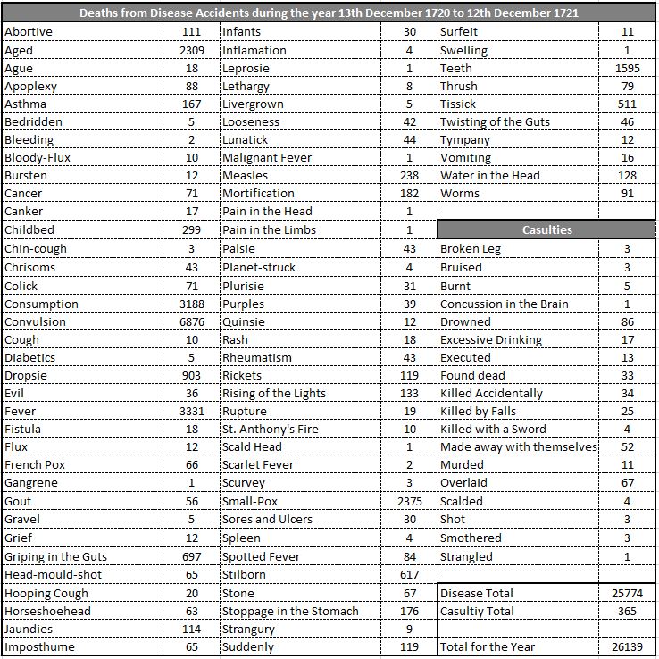
So, with that background, lets have a look at what might have killed you if you were living in London in 1721, starting with a compilation of all the weekly Bills of Mortality for the year:

Bills of Mortality

There is so much to follow-up in these records. Firstly, some of the strange causes of death.

Many of the causes are recognisable today, however some need an explanation, and a sample are listed below:

  • Bloody Flux – A horribly descriptive term for Dysentery, which I am surprised was as low as 10 for the year given the polluted state of drinking water in early 18th century London
  • Evil – This appears to have been a form of tuberculosis
  • French Pox – Syphilis
  • Head-mould-shot – An injury or disease of the bones of the skull
  • Mortification – Referred to death caused by Gangrene or similar diseases
  • Planet Struck – A really strange name. It seems to have been used for a sudden death that some believed had an astrological connection with the planets
  • Rising of the Lights – Lights seems to have been a Middle English word for the lungs and rising of the lights refers to some form of lung disease
  • St. Anthony’s Fire – This appears to have been horrible. It was caused by eating grains such as rye, that had been infected by a fungus with the name of Claviceps purpurea. Symptoms included a burning feeling in the extremities of the body (hence the use of the word Fire in the name), along with sores, hallucinations and convulsions. St. Anthony comes from monks dedicated to the saint who offered help to suffers.
  • Strangury – The symptom of this was painful urination, and the cause was some form of bladder disease
  • Teeth – Nothing to do with something being wrong with your teeth, this appears to have been how the death of a child was recorded when they were teething
  • Tissick – Death following a cough which must have been due to some form of lung disease

Many of the causes of death had names that described the symptoms or cause of death, and a number of names could all refer to the same cause of death. Some of the names make you wonder how much thought there was into the cause before recording the death.

For example, with some of the deaths with very low numbers, you can imagine the following conversation:

What did he die off?

Don’t know, but he had a pain in the head

That will do, record that as the cause

The total for the table shows that in 1721 there was a total of 26,139 deaths. It is difficult to get an accurate population count for London in 1721, however a number of sources and years either side (1700 and 1750) seem to converge around 650,000 as a good estimate for 1721. Based on this total population, then 4% of the population died in the year.

Comparing this with today, and the data.london.gov.uk site provides a mid year estimate of the population of London in 2020 as 9,002,500 and the annual number of deaths in that year was 58,800. Based on these figures, 0.65% of the population of London died during 2020.

Even with some errors in the above figures, they do show that the ratio of deaths to total population has decreased significantly in the intervening 300 years.

I sorted the table of deaths to show the causes that resulted in the greatest number of deaths, and the following table shows the top ten causes in 1721:

Bills of Mortality

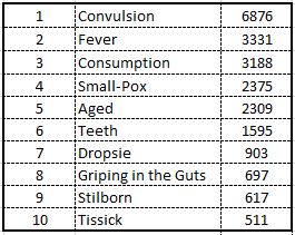
Convulsion caused by far the highest number of deaths with 6871, double the second highest of 3331 Fever deaths.

Convulsion in the early 18th century was not what we would expect today. It was used to describe any general cause of death in infants. It had been replacing “chrisomes” as an archaic term for death in infants. Chrisomes had, and continued for a while, been used to describe the death of an infant under one month of age. The term came from the name of a white linen cloth that was used to cover a baby’s head when baptised, and was also used as a shroud for a dead baby.

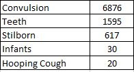
There is a chance that some of the deaths recorded as a Convulsion could have been an adult, however if we assume they were all deaths of infants, then sorting the table on child deaths, we get a total of 9,138, or 35% of all deaths attributed to diseases, which just shows that even with a degree of incorrectly recorded deaths, surviving childhood was the greatest challenge of being born in early 18th century London.

The following table shows the causes of death for children:

Bills of Mortality

The risk to life during birth was also to the mother, and in 1721, 299 deaths were recorded as “Childbed”, the cause of which was an infection following birth also known as puerperal fever.

The record for 1761 listed the numbers christened and buried during the year:

  • Christened – 18,370
  • Buried – 26,142
  • Increase in burials this year – 688

These figures show that numbers buried were higher than numbers christened. This could be for a number of reasons:

  • Not all children were christened, however I suspect that given the religious and superstitious views of the time, a high percentage of births led to a christening
  • Presumably non Christian children were not recorded as being baptised, however the numbers of these was probably low
  • The population of London was not dependent on births within the city. There was a high level of immigration to the city from the rest of the country, and from abroad, so many of the deaths were of people who had moved to London
  • The fact that the number of burials increased over the previous year of 1720, and buried outnumbered christenings shows the rate at which London’s population was expanding

The high number of burials was also due to the very basic level of medical care during the early 18th century. Poor sanitation, sterile conditions to treat wounds and illnesses, poor diets and quality of food, lack of clean drinking water, cramped living conditions, etc. all contributed to the high rate of death.

People also still believed in many of the superstitions around illness and death, and also in many of the supposed cures that were available. One example of the type of cure widely reported in newspapers is the following from 1722:

“We hear that a few weeks ago, a Spring hath been discovered near a Town called Goring, within 12 Miles of Reading in Berkshire, which hath such virtues in it, that lame people who have made use of it by Bathing, have soon dropped their Crutches. Tis said the Clay there cures old sores and green wounds to admiration, and every one who hath made use of it hath found such relief, that they are constantly setting forth its virtues.”

The weekly Bills of Mortality also listed what were called “Casualties”, and included the cause of death. These casualty lists show the many bizarre causes of death across early 18th century London, and many still recognisable names are listed as the place of death. A sample covering four weeks in 1716:

15th to the 22nd January 1716

  • Burnt accidentally at St. Mary Aldermanbury – 1
  • Choked with a Horse Bean at St. James Dukeplace – 1
  • Hanged himself (being Lunatick) at St. Olaves Southwark – 1
  • Killed by the Wheel of a Cart at St. Andrews Holbourn – 1
  • Overlaid – 3

Overlaid appears to have been the death of an infant by smothering when a larger individual sleeps on top of them. There are Overlaid deaths almost every week in the Bills of Mortality and were probably caused by parents, or older children, sleeping with infants.

5th to the 12th March 1716

  • Bruised at St. Mary Rotherhithe – 1
  • Found dead in the Fields at St. Dunstan at Stepney – 1
  • Killed by a Blow with a Catstick at St. James Clerkenwell
  • Killed by a Sword at St. Martin’s in the Fields – 1
  • Overlaid – 1

12th to the 17th June 1716

  • Hanged himself (being Lunatick) at St. Peters in Cornhill – 1
  • Killed with a Musket Ball at Christ Church in London – 1
  • Killed by a Blow with a Stick at St. Mary in the Savoy – 1
  • Overlaid – 3

The use of the term “Lunatick” is very problematic. The term was often used for deaths of someone with a mental illness, and for those who had committed suicide when it was assumed that they must have been a “Lunatick” for going through with a self inflicted death.

Also in the above two weeks, there are deaths by a blow, by a sword and by a musket ball, presumably these were all some form of murder / manslaughter.

17th to the 24th July 1716

  • Cut his throat (being Lunatick) at St Matthew in Friday Street – 1
  • Drowned in a Tub of Water at St. Clement Danes – 1
  • Executed – 1
  • Hanged themselves (being Lunatick) at St. Stephen Coleman Street
  • Hanged themselves (being Lunatick) ay St. Katherine Creed Church

Some of these records cry out for more information. How did someone drown in a tub of water at St Clement Danes? How big was the tub, why could they not get out, were they drunk?

The above week’s record also lists one person as being Executed. Strange that this was recorded as a Casualty, however I suspect there was no other way of recording such a death as the weekly Bills of Mortality tried to capture all the deaths in the city.

London’s population and deaths were the subject of a fascinating little book published in 1676 and today a copy is held in the Wellcome Collection. “Natural and Political Observations Mentioned in a following Index and made upon the Bills of Mortality” by Capt. John Gaunt, Fellow of the Royal Society.

John Gaunt writes that he was born and bred in the City of London, and complains that the Bills of Mortality were only used to see how burials had increased or decreased, and for the rare and extraordinary causes of death within the Casualties.

In the book he makes 106 observations on births, deaths, sickness, disease, how information in the Bills of Mortality was used, London’s population, comparison between the City and Countryside etc. The book is a fascinating window on the late 17th century, and explains much of what we see in the 1721 Bills of Mortality.

His observations are really interesting, and I have listed a few of them below:

  • The Occasion of keeping the account of Burials arose first from the Plaque, Anno 1592
  • That about one third of all that were ever quick die under five years old, and about thirty six per Centum under six (this aligns with the figures for the deaths of children in the 1721 statistics)
  • That not above one in four thousand are Starved (so food is generally available and affordable to the vast majority of London’s population, although very many probably only just had enough)
  • That not one in two thousand are Murdered in London (the statement appears to be written as a positive, however compared with today, and the figure for 2020 / 21 was 13.3 per million in London, which is considerably better than 1676)
  • That few of those, who die of the French-Pox are set down, but coloured under the Consumption (this implies that deaths from Syphilis were considerably under-reported. Perhaps the family of the person did not want it known that they had died of a sexually transmitted disease)
  • That since the differences in Religion, the Christenings have been neglected half in half (so there were religious differences resulting in the number of Christenings not being representative of the total number of births)
  • That (be the Plague great or small) the City is fully re-peopled within two years (so even after the worse years of the plaque there were enough people moving into the City to restore the population)
  • The Autumn is the most unhealthful season (something’s do not change)
  • That the people in the Country double by Procreation but in two hundred and eighty years, and in London in about seventy. Many of the Breeders leave the Country, and that the Breeders of London come from all parts of the Country, such persons breeding in the Country almost only were born there, but in London multitudes of others (Women of child bearing ages, and their partners moved in numbers from the Country to the City)
  • That in London are more impediments of Breeding than in the Country (interesting comparison with today with possibly wages, need to work, availability and cost of housing all playing a part)
  • Physicians have two Women Patients to one Man; and yet more Men die than Women (again, something’s do not change – men do not like going to the Doctor)
  • In the Country but about one of fifty dies yearly, but at London one of thirty (so London was not as healthy as the Country, and was getting worse as confirmed by:)
  • London not so healthful now as heretofore

John Gaunt published his findings 346 years ago, but it is interesting how many can still apply to London today.

Gaunt was a fascinating individual. He was a Haberdasher by trade, but had a considerable interest in how the collection of data, the use of mathematics and the statistical modelling of data could reveal what was happening to the health of those living in the city, and to population numbers.

He was one of the first demographers – the statistical study of populations.

As well as the investigations that led to the observations listed above, he also collected data to help understand life expectancy. The Bills of Mortality did not report age, just the numbers dying of specific causes, so Gaunt had to collect this data through further investigations. This work resulted in the following table:

Bills of Mortality

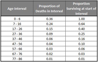
The middle column shows the proportion of London’s population that could be expected to die within the age interval in the first column, so out of 100 people between the ages of 0 and 6 years, 36 could be expected to die.

The column on the right is the proportion surving at the start of the interval, which is why the first entry is 1, as this represents the full popoulation at birth. It then shows the numbers surviving at the start of the interval, so at age 7, 64 out of the original 100 would be alive. At age 16, 40 out of the original 100 would still be alive, and so on through the age intervals.

The table really shows the young age of London in the years around 1676, as by the age of 27, only 25 out of an initial 100 people would still be alive, and at age 57, this would be down to 6 out of the original 100.

A morbid subject, but it does show that in the 17th century and early 18th, the data was available to start understanding disease and death in the City, and people like John Gaunt were beginning the process of understanding how to use and apply this data.

This would be a very long process, as even by 1854, Dr. John Snow was still facing challenges when he used data to demonstrate that a Cholera outbreak in Soho could be traced to a specific water pump.

What is also clear is that if you had made it into your 20s, you were very lucky as only 25% would make it to the age of 27. There were a large number of terrible diseases just waiting to pick you off, and just living in London would also put you at risk of becoming a casualty of any number of possible accidents.

However despite all these challenges, the population of London kept growing.

alondoninheritance.com

Pickle Herring Stairs

Today’s photo from my father’s collection is one I scanned a while ago, but had not investigated until planning my guided walked between Bankside and Tower Bridge. It was taken from the foot of Pickle Herring Stairs. a name that will be familiar to readers as I have written a couple of posts about Pickle Herring Street.

Pickle Herring Stairs

The photo was taken at the bottom of Pickle Herring Stairs, looking towards Tower Bridge, with the travelling cranes that lined the foreshore on the right.

The stairs have disappeared in the considerable redevelopment of the area, and the walkway along the river and embankment have been extended into the river, so it is impossible today to be exactly sure where the stairs were located, however by lining up with features on the opposite side of the Thames, I suspect they were roughly where I took the following photo. The perspective is different as I used a wider lens compared to my father’s photo to show some of the nearby features to help with locating the stairs.

Pickle Herring Stairs

To the right is the old City Hall for the Mayor of London, now closed following the move of the Mayor’s office further east towards the Royal Docks.

The following extract from the 1895 Ordnance Survey map shows the exact location of Pickle Herring Stairs (‘Reproduced with the permission of the National Library of Scotland“):

Pickle Herring Stairs

The above map shows that by the end of the 19th century, the side of the river was lined by warehouses, however the cranes seen in my father’s photo had not yet arrived.

These would be installed during the early decades of the 20th century when the warehouses were expanded, and large cranes were installed to handle the quantity and range of goods that needed to be moved from river to warehouse.

They were called “travelling cranes” as they moved on rails along the platform on which they were built, so they could easily get to the cargo that needed to be moved.

By the 1952 Ordnance Survey map (just a few years after my father’s photo), the jetties had been built on the foreshore, and the travelling cranes had been installed. The following extract from the map shows the length of the jetty which supported the cranes. Pickle Herring Stairs are circled to the left, and the map confirms that my father’s photo is looking at both Tower Bridge, and the end of the jetty (‘Reproduced with the permission of the National Library of Scotland“).

Pickle Herring Stairs

Looking from across the river, the following photo shows where the stairs were located:

View of the south bank of the River Thames

I have written about the area, and Pickle Herring Street, including theories as to the origins of the name in two posts – The Lost Warehouses of Pickle Herring Street, and Pickle Herring Street Revisited.

What is not clear is what came first, the name of the stairs or the name of the street, or whether they were named at the same time.

I suspect the name of the stairs came first, and this could support one of the possible sources of the name down to the landing of Pickle Herring at this point on the river. however I have no evidence to support this.

What is certain is that both stairs and street are old names.

Regular readers will know that I find these stairs fascinating. Not only the physical stairs (where they remain), but that they can tell us so much about life in the area.

I looked back at some early newspaper articles that mentioned the stairs, and found the following sample from the 18th century.

The first is a report about a fire, a very common event in the warehouses full of inflammable goods along the river:

15th January 1740: On Thursday night about 11 o’Clock, a fire broke out at Mr. Brooks’s a Hoop bender near Pickle Herring Stairs, opposite the Tower, that raged with such violence that in three hours time above 20 dwelling houses, besides warehouses were consumed.

A young fellow, a Waterman, who had rescued his wife and child, returning to preserve some of his goods, is missing, and supposed to have perished in the flames.

Last night, Joseph Chitty, one of the Candidates for the Borough of Southwark, sent over a present of 20 Guineas to be distributed among the most necessitous of the sufferers by the said fire.”

There were so many suicides along the Thames, and one of the methods used would be to get a Waterman to row you out into the centre of the river, as this very tragic report of a woman abandoned after becoming pregnant tells:

26th January 1748: Yesterday a young woman took a boat at Pickle Herring Stairs and desired to be ferried over; when the boat came to the middle of the river, she threw down six pence, and jumped over. The Waterman with great difficulty drew her again into the boat; on which she confessed that being far gone with Child by a Noble Lord, and being refused any assistance, had determined her to put a period to her existence.”

Papers were full of so many strange events across the City. One, where someone was tarred and feathered, also ended with what was probably some of the day to day racism which foreign seamen had to endure:

18th October 1784: Friday the following singular occurrence took place. A seaman arriving after being discharged from a vessel lying off Pickle Herring Stairs, on account of his having rendered himself extremely obnoxious to the rest of the crew, was imprudent enough to return on board the ship, upon which he was seized by some of the men, stripped, and tarred and feathered, with as much dexterity as ever that discipline was inflicted in the Country where it was invented, and still practiced.

In this situation he walked to the Public-Office in Shadwell, followed by an immense concourse of people, and exhibited his complaint before Peter Green, the presiding magistrate, by whole order of several pounds of butter and some quarts of oil, were administered, to clear the man from the disagreeable covering.

During the above operation, proper persons were dispatched by the Magistrate in search of the delinquents and in something more than an hour they brought to the Office the Mate and five of the seamen belonging to the ship on board of which the act had been committed, against whom a charge for an assault was substantiated. The Captain bailed the Mate and four of the men, but the other, a youth about twenty, a native of Nevis, was committed to New-Prison, Clerkenwell.”

The earliest newspaper report I could find was the one from 1740, however the stairs are certainly much older. They appeared on the 1746 John Rocque map, as can be seen in the following extract:

John Rocque 1746 map

I suspect these stairs went back to the medieval period, or even earlier. Stairs were such an important way of accessing the river, and naming stairs would have been incredibly important, as:

  • If you were arriving or departing on a ship, you needed to know where on the river the ship would be moored, and the nearest set of stairs to use for arrival or departure. There are plenty of newspaper references where a name of stairs are quoted for the location of a ship;
  • If you asked a Waterman to row you across or along the river, you would have needed to tell the Waterman the destination;
  • For sales of cargo or goods, a location was needed to advertise the sale. There are very many adverts over the centuries using the names of stairs to locate a sale;
  • For events on the river, the stairs provided a reference point, and newspapers used the stairs to refer to the many accidents, deaths, ships departing and leaving, thefts of goods, crimes against people, where press gangs were operating etc.

The unique naming of each individual stair was also important to avoid confusion, so even when stairs almost had the same name, and were in a very similar location, the name always had something to make them unique, for example Wapping Old Stairs and Wapping New Stairs on Wapping High Street.

An example of how the names of stairs were used can be seen in the following 17th century token, of the type issued by merchants and traders to be used instead of cash. The token references the trader’s location as at Pickle Herring Stairs  (© The Trustees of the British Museum):

Pickle Herring Stairs

The name on the token is that of James Acrigg. The only record I could find of him was his marriage in London in February 1675.

The very last newspaper report I found about an event at Pickle Herring Stairs was dated the 16th of August 1928, when “The body of an unknown man aged about 40 was found today floating in the Thames near Pickle Herring Stairs. It is believed the man has been in the water for several hours.”

Following the above report, the story of Pickle Herring Stairs goes silent. They would still have been in use, however this would be much reduced. Better street and underground transport removed the need for a Waterman to row you along or across the river.

Access to ships on the river was now mainly from piers or when ships were docked alongside the infrastructure on the waters edge (such as the jetty seen in my father’s photo).

They were finally lost under the redevelopment of the area between London and Tower Bridges, when the open space and riverside walkway was built and extended out into the river.

I will leave the final words in today’s post to the London Rivers Association, who were quoted in the Illustrated London News on the 1st of May 1996, which reported on their campaign that “The London Rivers Association believes that the Thames should be made better use of for both public and freight transport. ‘Getting in touch with the Thames’ is endeavouring to open up all access points to the river – steps and stairs which once had such distinctive names as Elephant Stairs, Hoy Steps or Pickle Herring Stairs. Some of the Millennium projects are very glamorous, said a spokeswoman for the association. this scheme is more modest and will benefit everyone.”

Too late for Pickle Herring Stairs – but a scheme that I would fully support.

alondoninheritance.com

BBC Broadcasting House

This year, the BBC is celebrating 100 years of broadcasting, having started in 1922 with a limited programme of music, drama and talks. There is another BBC anniversary this year, as it is 90 years since Broadcasting House on Langham Street / Portland Place opened as the first building in the country, purpose built for the new medium of broadcasting.

I have a copy of the book the BBC published in 1932 to celebrate the opening of the new building, so I thought I would take a look at the building and some of the many photos from the original book, which show leading edge broadcasting design and technology from 1932.

Walk north along Regent Street from Oxford Circus, into Langham Place, and this is the first view of Broadcasting House, just behind the distinctive tower and spire of All Souls:

Broadcasting House

When the BBC first started broadcasting, the BBC’s premises were at Savoy Hill, however with the rapidly growing popularity of broadcasting along with equally fast technical development, it was soon clear that a new building was needed, ideally a building custom designed for broadcasting.

The site of Broadcasting House was initially to be developed as what were described as “high-class residential flats”, however the location was perfect for the BBC. It offered a central London location, close to multiple transport links, and with just enough space to construct a new building.

The owners of the site agreed to build the BBC’s new centre and offered a long lease, however the BBC purchased the site before the building opened.

The site was of some size, but was strangely shaped, with a long curved section along Portland Place. The building was limited in height as there were a couple of nearby buildings that had their right to light protected under the custom of “ancient lights”.

The architect of the building was Lieut-Col G. Val-Myer FRIBA, who was supported by the BBC’s Civil Engineer, M.T. Tutsbery.

Broadcasting and the functions of the BBC dictated some challenging requirements. Despite being called Broadcasting House, the building would house a considerable number of people working on the administrative functions of the BBC. These would all require naturally lit space.

A wide range of studios were also needed, of very different size and function, from small studios for one or two people, up to concert hall size. These studios needed to be sound proofed both from the noise of the street, and internally generated noise.

A creative design solution met these competing requirements. Broadcasting House was constructed as a building within a building. A central core was constructed of brick, avoiding as much as possible the use of steel girders and stanchions which would have transmitted sound. The studios were located within this central core, and they were separated where possible by quiet rooms such as the library.

The outer core of the building housed office space, so these rooms had natural light and acted as an additional level of sound proofing between street and studios, with the inner brick core providing internal sound proofing.

The external design of the building had some distinctive features. Looking above the main entrance, and one of the aerial masts stands above a clock:

Broadcasting House

The main entrance at bottom left:

Broadcasting House

Eric Gill was responsible for the sculpture decorating the building. The BBC requested that the works would feature Shakespeare’s Ariel as the BBC considered this would represent the “invisible spirit of the air, the personification of broadcasting”.

The sculpture above the entrance shows Prospero, Ariel’s master, sending him out into the world. Gill created the work in situ during the winter of 1931 / 1932. Before being uncovered and revealed to the public, the Governors of the BBC inspected the work and considered that, Ariel’s “appendage” was too large for public decency and a reduction of a couple of inches was made.

Eric Gill was also responsible for some of the sculpture on 55 Broadway – London Underground’s Head Office.

To the right of the above photo is the considerable extension that has been added to the original Broadcasting House.

Walking along Portland Place, and we see the curved façade of the buildings, with the rows of windows providing natural light to the offices behind:

Broadcasting House

To the lower right of the above photo is Eric Gill’s “Ariel hearing Celestial Music”:

Broadcasting House

Much of the building is faced with plain stone, with identical, regularly space windows, however there are some key features along the centre of the façade:

Broadcasting House

At the top are the Coat of Arms of the BBC. The circle in the centre represents the world, to show the breadth of the BBC’s coverage. Running along the bottom of the sculpture is the BBC’s motto “Nation shall speak peace unto nation”:

Broadcasting House

Below the arms is a long balcony decorated with birds of the air:

Broadcasting House

And below the balcony are “wave” symbols:

Broadcasting House

On the northern end of the façade is another work by Eric Gill, representing Ariel between Wisdom and Gaiety:

Broadcasting House

Looking back towards Langham Place with Broadcasting House on the left:

Broadcasting House

A large extension has been added to Broadcasting House. This was done to help consolidate many of the different BBC London activities into a single building, with the move of BBC World Service from Bush House into the new extension, along with many of the functions that were in Television Centre such as News, when the BBC left Television Centre.

Looking to the east of Broadcasting House, and we can see the original building to the left, with the new building to the right and at the far end:

Broadcasting House

The BBC’s 1932 book celebrating the opening of the building is full of photos of the new building, internally and externally, and shows what was considered leading edge design for the new medium of broadcasting in 1932.

At the start of the book is a map showing the location of Broadcasting House, with an emphasis on the closeness of the building to a range of travel options. This was important not just for those who worked full time in the building, but for the many people who would visit the building for a short time to participate in one of the many concerts, talks and plays that were broadcast.

Broadcasting House

An aerial photo shows Broadcasting House, just completed, and gleaming white among the surrounding dirty buildings of the city:

Broadcasting House

The book includes a rather unusual photo, looking north from the roof towards Hampstead. The photo was taken using an infra-red camera, which at the time improved the level of detail at a distance, and had the effect of showing green objects such as trees as dazzling-white:

Broadcasting House

The clock and mast which are still visible today. On the balcony, to the left of the clock is a loud speaker which was used to broadcast the sound of Big Ben, imitating the natural strength of the bell.

Broadcasting House

The following diagram shows the internal core of the building with the outer offices removed. The diagram shows how much had been crammed into the space available, as well as the positioning of quiet rooms between the studios:

Broadcasting House

The book covered all aspects of the new building, including the technical infrastructure that enabled broadcasting. The following photo is the Control Room and apparatus is described as being “battleship grey with stainless steel fittings”:

Broadcasting House

Two of the amplifier bays, one with a cover removed showing the valves that were critical to this type of equipment, long before transistors had been invented:

Broadcasting House

One of the issues with being in London was the polluted air with still plenty of smoke in the atmosphere. Broadcasting House featured state of the art air conditioning equipment, which included outside air being passed through a spray of water to remove particles in the air, as shown in the following photo:

Broadcasting House

The book also includes plans of each floor, the following plan of the seventh floor being an example, with the studios located in the central core:

Broadcasting House

The BBC provided tours for journalists in May 1932, and papers of the time were full of glowing articles about the new building. The following is from the London Correspondent of the Dundee Courier, who wrote an article titled “The Palace of Broadcast – A peep into new home of the BBC”:

“When the British Broadcasting Corporation decided to build themselves a new home they did the job thoroughly.

After a tour of Broadcasting House in Portland Place my mind was in a whirl of gigantic boilers, pictures of the most modern studios, miles of corridors, hundreds of lights, and a thousand and one other things.

The tour reflected the BBC’s thoroughness and started in the basement, which is three floors below street level, and finished eight floors above.

The people who matter in broadcasting said ‘we must have no noise from the outside in our studios’ therefore, each studio, which has no communication with the outside world apart from the door, has its own exclusive current of air for ventilation and heat so that no sound is carried through from one room to another.

The experts have taken sound well in hand, and controlled its unruly antics. The studio for ‘talks’ has been made so dead that there are no reverberations at all. If you speak in the studio your voice sounds like a voice heard in a dream. It is most eerie.

The furnishing is definitely 1932, and about this studio for discussions there is a make-yourself-at-home atmosphere.

Soft beige carpets cover the floors. The walls and the ceilings are delicate shades of beige, with a touch of orange and cream stripes around the walls. Below a mirror which stretches across one side of the room there is a jade green vase containing huge flowers.

The chapel studio is of great beauty. The cream walls are lit by pillars of light. Two tall columns painted green reach the ceiling, which is of blue with silver stars and signs of the Zodiac.

Next to each studio, of which there are 22, there is a little listening room. There is a window through which the performers can be seen. Here an announcer can make announcements without the artists being able to hear him, and he can check the quality of the transmissions.

The ‘effects’ room is above. here it is all very scientific. In the centre is a large table that swivels round. It is divided into sections, each of which is covered in a different substance to give different sounds when it is rapped or hard objects dropped upon it.

The equipment of this room also includes a pall full of lumps of bricks and a tank of water, and to mention a humble sheet of iron for thunder.

Then there are a series of records for crowd noises, angry, and jolly, English or foreign. Others give cries of babies and every form of animal.

All those cheery messages about depressions of Iceland and anticyclones together with news, emanate from a very chic little studio of which the walls are matted silver. Light is thrown upon the subject from a large globe at the end of a long telescope-like stand.

Such is the ‘Radio Village’. There are dressing rooms, waiting rooms, artists’ foyers, refreshment lounge, libraries and, to complete it all, a small black cat who wanders about at will, and not at all impressed with the dignity of the surroundings.”

Photos from the book show the “make-yourself-at-home atmosphere” described in the article, for example Studio 8B used for Debates and Discussions:

Broadcasting House

Studio 6E – Gramophone Effects, with plenty of turn-tables to play records of effects:

Broadcasting House

The Music Library, which the book claimed to be the largest in the world, with every kind of music from manuscript parts of Bach cantatas to the latest comic songs:

Broadcasting House

The Office of the Director of Programmes:

Broadcasting House

One of the interesting aspects of studio design in the early 1930s is that the studios were made to replicate the place where the production would take place. Studio 3E for Religious Services had the appearance of a religious building, however this could be changed for secular broadcasts when the vase of flowers (as shown in the photo) were used to replace the cross used for religious broadcasts:

Broadcasting House

Studio 3B for Talks looks like a domestic setting. There were no windows behind those curtains.

Broadcasting House

The interior design of Broadcasting House was led by Raymond McGrath, an Australian born architect who led a team of young designers. They were given a degree of freedom with their designs, which resulted in a curious mix of homely and modernist features.

The studios are very different today, and in the past 90 years the function of broadcasting has taken over from the designs of 1932.

The Chairman’s Office:

Broadcasting House

Broadcasting House opened when the autocratic Sir John Reith was Director General. It was Reith who defined the BBC’s purpose as being to “inform, educate, entertain”. It was probably with some fear that employees would be summoned to the Director-General’s Office:

Broadcasting House

The majority of the photos in the book show empty studios and equipment rooms. Very new, and no people to be seen. The only photos with people are of some of the offices of Broadcasting House, such as the following photo of the Accounts Office.

Broadcasting House

Note in the photo the windows facing out. To the left would have been a corridor, then the brick wall of the inner core with the studios to avoid sound transmission from outside or from the internal offices.

The entrance hall from Portland Place, with staff lifts to the right and the Artists’ Foyer behind the pillar at the far end:

Broadcasting House

The Latin inscription on the right reads “This Temple of Arts and Muses is dedicated to Almighty God by the first Governors of Broadcasting in the year 1931, Sir John Reith being Director General. It is their prayer that good seed sown may bring forth a good harvest, that all things hostile to peace or purity may be banished from this house, and that the people, inclining their ear to whatsoever things are beautiful and honest and of good report, may tread the path of wisdom and uprightness.”

The Council Chamber:

Broadcasting House

The Lower Ground floor provided access to the concert hall, from where concerts with a live audience would be broadcast. View towards the platform:

Broadcasting House

View towards the rear of the Concert Hall:

Broadcasting House

The Concert Hall is now known as the BBC Radio Theatre.

All the studios, along with other rooms involved with the broadcast process, were in the central core of the building, so they did not have windows and there was no natural light. The designs for these rooms attempted to address this with decoration, and in the following photo is Listening Hall 1, where a seascape had been added on the wall at which those listening would have been facing:

Broadcasting House

And in Listening Hall 2, gold and silver foil had been put on the walls to simulate the effect of sunlight:

Broadcasting House

Broadcasting House was built long before the days of electronically created sound effects. These were usually prerecorded on records as seen in one of the earlier photos, or involved making noises with physical objects.

Some sound effects needed a different approach such as the creation of an echo, or the impression that the sound was created in a large space rather than a small, sound proofed studion.

To provide echo effects, Broadcasting House had the Echo Room, where sound from a studio were played in the room which had reflective, resonant walls to bounce the sound, which was picked up by a microphone at the end of the room:

Broadcasting House

Broadcasting House was a leading edge facility at the time of construction for the new medium of broadcasting. It was however designed to meet John Reith’s view of the BBC, and the studios were designed for talks and discussions (nearly always by men), and for broadcasts of plays and concerts.

In the previous building at Savoy Hill it was common for those arriving to give a broadcast talk to be offered cigars, brandy and whisky before broadcasting – operating almost like a Gentleman’s Club.

News would become an increasing feature of the BBC, with the use of external agencies to provide news before the BBC developed their own internal news gathering capability.

As well as broadcasting to the country, broadcasting to the world would become an integral part of the BBC’s mandate, beginning with what was called the Empire Service, then the World Service.

The first broadcast specifically to the “Empire” was made from Broadcasting House on the 19th of December 1932, with John Reith speaking an introduction to the broadcast.

The BBC’s Centenary celebrations seem to have a different focus to 1972 when they celebrated 50 years.

In 2022 the focus seems to be more of the present day relevance of the BBC, with the breadth and depth of services provided. I suspect this is down to perceived threats to the BBC’s charter and the licence fee.

In 1972, the focus was more on the historical, showing the BBC almost as the official recorder of the great events of the previous 50 years.

The BBC produced a double album in 1972 containing excerpts from key broadcasts of the Corporation’s first 50 years. I was given a copy at the time, a strange present given the age I was in 1972, but one I appreciate now for the historical context.

Broadcasting House

The double album opened up and inside there is a listing of all the broadcasts on the records.

Side 1 covers from 1922 to 1932, so pre Broadcasting House. Included are music from the Savoy Orpheans and the Savoy Havana Band, a recording of the opening of Tutankhamun’s tomb, a news item from the 1926 General Strike, and the first Royal Christmas Message broadcast on Christmas Day in 1932.

Side 2 covers the six years from 1933 to 1939, when many of the recordings would have come from Broadcasting House. Along with recordings of musical items, the slow build up to war can be seen, from a 1934 speech by the Nazi Joseph Goebbels to Prime Minister Chamberlain’s announcement of the outbreak of war on the 3rd of September 1939.

Broadcasting House

Side 3 covers the Second World War, from the fall of France in 1940 to the final surrender of Japan in 1945.

Side 4 covers the period from 1946 to 1972 and includes an FA Cup Final, Oxford – Cambridge Boat Race, a Royal Wedding, Coronation and Funeral, shows such as the Archers, Goons and Twenty Questions. The First Man in Space, assasination of President Kennedy and England’s 1966 World Cup victory.

The final track on side 4 is appropriately the funeral of Lord Reith in 1971, who was instrumental in building up the BBC and was Director-General when Broadcasting House was planned and built.

Broadcasting House

The BBC does have some pages on their website on the 100 years, which can be found here.

Broadcasting House comes from a simpler time, when the BBC was virtually the only form of mass electronic media, with only newspapers for competition.

Today, the broadcaster has no end of competition, from multiple broadcasters, online services and streaming providers. Shifts from linear broadcasting to time shifting and on demand programming.

The BBC suffers accusations of bias from almost every part of the political spectrum. It seems to tie itself in knots in trying to tread carefully and appear impartial around contentious subjects.

The licence fee is indeed an anachronistic way to fund the organisation, but a fair alternative that provides sufficient funding for the organisation has yet to be proposed.

The BBC has made some huge mistakes over the years, but still has a global reputation for independence, and is a prime example of the country’s soft power.

After 90 years, it is brilliant that Broadcasting House is still part of the country’s broadcasting fabric, and with the BBC it must be an example of where the phrase “you never know what you’ve got, till its gone” strongly applies.

alondoninheritance.com

Bull and Mouth Inn, Northumberland House, French Church and Aldersgate – City of London Blue Plaques

Today, I am starting in St Martin’s le Grand for the third post in my search for all the City of London Blue Plaques.

Three plaques can be seen on a building on the western side of the street, each arrowed in the following photo:

Bull and Mouth Inn

Starting from the left, and the blue arrow is pointing to:

Bull and Mouth Inn

Bull and Mouth Inn

The Bull and Mouth Inn was an old coaching inn located in a side road off St Martin’s-le-Grand / Aldersgate Street. This side road had the same name as the inn – Bull and Mouth Street.

The Bull and Mouth was an old inn, and can be found in William Morgan’s 1682 map of London. In the following extract from the map, the inn is numbered 407 (circled red), and the large courtyard can be seen, surrounded by the buildings of the inn, and with a narrow entrance on to Bull and Mouth Street.

Bull and Mouth Inn

The name is unusual, and appears not to have been the original name. An article about the inn in the London Mercury on the 15th April 1848 records that the 16th century historian and antiquarian John Stowe referred to the inn as of “great antiquity”, and that the current name was a corruption of the original name of Boulogne Mouth or harbour)

The Bull and Mouth was a very busy coaching inn, with regular coach services to the north of the country. The inn was mentioned in the 1909 book “Inns, Ales and Drinking Customs of Old England” by Frederick Hackwood:

“Where could have been found a finer or more typical specimen of the old coaching-house than the Bull and Mouth in Aldersgate Street?

The scene presented by a coach-yard in full activity was always an animated and interesting one. The coach, a handsome, well-built vehicle, in all the brilliancy of a highly varnished claret ground, or it may be of a bright yellow, when ready, would stand well in the middle of the drive. the four beautiful, spirited animals attached to it, with their glossy, velvety skins, covered with cloths till the moment of ‘putting to’, would be under the charge of two stablemen in corduroy breeches and heavy boots.

Then the coachman, mounted on the box, getting his whip and his ribbons adjusted exactly to his mind. He is well buttoned up to the throat in an enormous box-coat of whitish drab colour, fastened with immense mother of pearl buttons. There is a rakish brim to his hat, which goes well with the air of nonchalance he affects – for is he not the skipper as it were, not only in command of the gallant equipage, but controlling, for the time at least, the destiny of all his passengers.”

Probably a bit of a romantic description of a lost method of travel, however it must have been an impressive sight, a coach being readied for departure, and the travelers heading across the country from the yard of the Bull and Mouth.

And coaches from the Bull and Mouth really did travel some distance.

The first mention I could find of the Bull and Mouth, was from the Derby Mercury on the 27th December 1733 where George Paschall was advertising that his wagon made a regular journey between Derby and London, leaving the Red Lyon in Derby every Saturday, reaching the Bull and Mouth on the following Saturday, from where it would depart on the Monday, arriving on either the following Friday or Saturday.

The wagon was probably for carrying goods rather than people, and the journey time between Derby and London was around five / six days.

The Bull and Mouth must have been incredibly busy. The Bull and Mouth listed the coaches and wagons departing from the inn in the Public Ledger and Advertiser on the 27th April, 1824.

The following table shows the destinations of Royal Mail coaches departing every evening from the Bull and Mouth (these were the ultimate destinations, each of these was an individual route that had plenty of intermediate stops):

Bull and Mouth Inn

The same listing also included the destinations of coaches that were not part of the Royal Mail network, along with passenger carrying wagons, again, plenty of intermediate stops before these destinations were reached:

Bull and Mouth Inn

It must have been remarkable to watch the immense amount of activity at the Bull and Mouth with the number of coaches, wagons, passengers and goods for transport, arriving or departing from the inn.

Some of these journey’s must have been incredibly arduous if you were heading to the end point of the coach’s route. I mapped out the stops of the Bull and Mouth to Glasgow coach in the following map  (© OpenStreetMap contributors):

Bull and Mouth Inn

Starting at the Bull and Mouth Inn, the stops to Glasgow were then: Barnet, St. Neots, Buckden, Stilton, Grantham, Newark, Ollerton, Worksop, Doncaster, Ferrybridge, Wetherby, Boroughbridge, Leeming Lane, Catterick Bridge, Bowes, Brough, Appleby, Penrith, Carlisle, Longtown, Lockerby, Moffat, Hamilton, and finally arriving at the Pontine Inn, Glasgow.

The coach to Glasgow departed London in the evening, and arrived in Glasgow on the second morning after departure, so a total of around 36 hours, plus or minus, depending on the exact time of departure and arrival.

A long running project has been to list and map out the routes from London’s many coaching inns as they provided the city with a very comprehensive network of routes connecting London with the rest of the country. In many ways, the network of destinations and stops seems more comprehensive than the current rail network, although coach services were not as frequent, had far less capacity, and took far longer to complete than a journey by train.

A view of the inner yard of the Bull and Mouth inn dated 1810, showing the galleried interior of the inn with the rooms available for a stay, running around the galleries. A loaded wagon on the left, and barrels and boxes on the right, possibly ready for collection, or for their transport across the country (© The Trustees of the British Museum).

Bull and Mouth Inn

The following print, dated 1829, is titled “The Post Office, St Paul’s Cathedral and Bull and Mouth Inn”. The view must be along St Martin’s le Grand, so I assume there must have been an entrance to the inn from this street, as well as the street named after the inn. This entrance can be seen on the right where there is an archway entrance through the buildings, with some sculpture on the upper floors of the building (© The Trustees of the British Museum):

Bull and Mouth Inn

A sign from the Bull and Mouth inn can be found in the garden of the Museum of London:

Bull and Mouth Inn

According to Henry Harben’s Dictionary of London, the Bull and Mouth Inn was destroyed in the 1666 Great Fire, was rebuilt, and then rebuilt again in 1830 as the Queen’s Hotel.

The London Mercury confirms this change and in an issue dated the 15th of April, 1848 comments that: “The Bull and Mouth had been a coaching inn ever since coaches had an existence”, and that it was the “largest and most generally recognised inn in London”. The article also alludes to the demise of the Bull and Mouth, in that when the inn was rebuilt around 1830 the railways were not yet in existence, but beginning to be talked about, and if the railways had not spread quickly across the country “the magnificent Queen’s Hotel would not have arisen on the site of the old coach-house”.

It is difficult to know the date of the Bull and Mouth sign in the Museum of London garden. The very good condition of the sign probably indicates that it was from the 1830 rebuilding of the inn.

Bull and Mouth Inn

The core of the sign is a perfect visual representation of the name of the inn:

Bull and Mouth Inn

Leaving the Bull and Mouth, we now come to the middle of the three plaques, highlighted by the orange arrow, for:

Northumberland House

Northumberland House

There seems very little to be found about Northumberland House. The only reference I could find was in Henry Harben’s A Dictionary of London, which states:

“Northumberland House, on the west side of St Martin’s Lane, now St Martin le Grand, in the parish of St Anne and St Agnes, in Aldersgate Ward.

It is described as a messuage, shop and garden belonging to the Earl of Northumberland, granted to Queen Joanna by Henry IV, by name of the Hostel of the Earl of Northumberland.

Stow says it was called the Queen’s Wardrobe, but now a printing house.”

A messuage was the term used to describe the collection of a residential house, outbuildings and garden.

Queen Joanna was Joan of Navarre, whose second marriage was to Henry IV in February 1403.

The Northumberland House plaque typifies one of the problems with these plaques. As a plaque it is almost meaningless. There is no context, no dates or anything to suggest why Northumberland House should have a plaque.

Information on Northumberland House is hard to find, and for the casual walker of London’s streets the plaque would get a quick glance before being forgotten. A reference to Queen Joanna, and the fact that the house must have been 15th century would at least add some background as to why the plaque is there.

The final plaque on the wall of three is the one on the right with the green arrow, and is for the:

French Protestant Church

French Protestant Church

An article in the Illustrated London News in 1848 provides background information on the French Protestant Church, and a good description of St Martin’s le Grand at the time:

“Another new church for London! – just now finished, and about to be opened. The site chosen is one which has felt the full benefit of modern improvements. Not many years ago St Martin’s le Grand had little to recommend it to the eye – now it is surrounded by fine buildings, and forms one of the choicest openings in the tortuous monotony of London bricks and mortar.

We have here one of our best Grecian buildings, the Post-Office, next to the Hall of the rich Goldsmiths; then that most magnificent of caranserais with the most un-euphonious of titles – the Bull and Mouth; and last and least, the small, but picturesque chapel of the French protestants.

The French Protestants original church was in Threadneedle Street; their church being an old structure, with few architectural pretensions. This having been demolished, they have removed their place of worship to St Martin-le-Grand.

The architect, Mr. Owen, has succeeded in completing a very perfect, though small, pointed Gothic chapel. The interior, with its lancet windows, tall roof, and appropriate pulpit, is well managed, considering the confined space the artist had to work in. The cost has been £5,000 and the public will soon have the opportunity of judging how wisely it has been expended, as the church will shortly be opened for divine service.”

Although the church was demolished, we can still have the “opportunity of judging how wisely it has been expended“, by looking at the following photo of the French Protestant Church:

French Protestant Church

Source: Unknown author, Public domain, via Wikimedia Commons

I cannot confirm the date of the above photo, however given the church was only about 40 years old when it was demolished, it does give the impression of being much older. Probably the Gothic design, along with the level of dirt on the building from the smoky atmosphere of London.

The church was demolished by 1888, and newspaper articles in June 1887 reported on the closure of the church “The last service has been held in the French Protestant Church in St Martin’s-le-Grand and the singularly beautiful and interesting little church is doomed to prompt destruction in order to make way for an extension of the General Post-office.”

The origins of the French Protestant Church date back to 1550, when Edward VI signed the charter granting freedom of worship to Protestants from France, Wallonia, and the Netherlands.

The majority of Protestant immigrants from continental Europe came after 1661, when the Edict of Nantes (which had protected the Protestant faith in France) was dismantled by Louis XIV. In the following years around 50,000 Huguenots fled to England, and a number of churches were set-up specifically for the new arrivals.

After the St Martin’s-le-Grand church was demolished, the church received £26,000 of compensation which enabled a site in Soho to be purchased (an area which had at the time the greatest concentration of French protestants), and the current French Protestant Church of London on Soho Square was built.

That’s a brief overview of the three plaques on the western side of the street. Directly opposite is another plaque, which can be seen on the side of the Lord Raglan pub:

Aldersgate

Aldersgate

The plaque records that one of the original gates in the City wall was on the site and was demolished in 1761:

Aldersgate

Aldersgate was one of the principal gates through the City wall, and can be seen in the same extract from Morgan’s map that I used for the Bull and Mouth inn (circled in red):

Aldersgate

The name appears to derive from the name of an individual, either Ealdred or Aldred, however the problem with being sure of the source of a name for something as old as the gate is that there have been many different variations, and no written records that confirm the original source.

Harben’s Dictionary of London lists a number of variants to the name, and states there were sixty-two variations of the name to be found in documents between 1274 and 1597.

A view of Aldersgate can be seen at bottom left in the follow print showing the gates of the City from William Maitland’s 1756 History of London (© The Trustees of the British Museum):

Aldersgate

Harben lists some dates when there were changes to the gate:

  • 1335 – it was ordained that the gate should be covered with lead and a small house made under it for the gate-keeper
  • 1617 – The gate was taken down and rebuilt
  • 1670 – Repaired and beautified after the 1666 Great Fire
  • 1739 – Repaired again by the Lord Mayor
  • 1750 – The apartments over the gate were occupied by the Common Crier

The gate was finally demolished in 1761, with the materials sold for £91.

By the later years of the 18th century, the City gates were an obstruction for the traffic that moved through the gate. With the northwards expansion of the City, the gate had long lost its role as a protective gateway into the City, so it made sense to demolish and open up the road for the growing numbers of people and horse drawn traffic travelling along the City streets.

A final look down St Martin’s-le-Grand. Aldersgate would have been just in front of me. The Lord Raglan pub with the Aldersgate plaque is on the left, and the other three plaques are along the building on the right.

Aldersgate Street

The photo was taken from the point where St Martin’s-le-Grand (in the photo) changes into Aldersgate Street (behind me).

That is four more City of London plaques recording the diverse range of buildings and structures that have been lost from the City’s streets.

There will at some point, be an interactive map of the plaques, along with a spreadsheet to download listing all sites and details of each plaque.

alondoninheritance.com

Fred Cleary and the Flowering City

The City of London has always been a busy and congested place. For centuries, gardens and green space were only to be found around the halls of the Livery Companies and the gardens of some of the larger houses owned by rich City merchants and well connected residents.

As trade, manufacturing and finance expanded within the City during the 19th century, open space was not treated with the some level of priority as buildings that served the commercial purposes of the City.

Significant destruction of buildings and damage to large areas of land during the war resulted in new thinking as to how reconstruction should take place. I have written about a couple of plans for the City such as the 1944 report on Post War Reconstruction of the City, and the 1951 publication, The City of London – A Record Of Destruction And Survival.

More green space, places for people to sit, and the planting of flowers was one of the initiatives pushed forward by Fred Cleary, and in 1969 he published a book about the new gardens in the City titled “The Flowering City”:

Fred Cleary

Fred Cleary was a Chartered Surveyor who worked for a City mortgage and investment company. He was also a longtime member of the City’s Court of Common Council, and according to the author information in the book was Chairman of the Trees, Gardens, and City Open Space Committee, and the Chairman of the Metropolitan Public Gardens Association.

The aim of the book was to “record something of the considerable efforts made by the City Corporation who, supported by many business interests and voluntary bodies, have endeavoured to make the City of London one of the most colourful and attractive business centres in the world.”

Through his interests and his membership of a number of key City committees, Fred Cleary had a leading role in the post war development of many of the gardens across the City, and the book includes a map of some of these gardens, many of which feature in the book:

Fred Cleary

The book is full of photos of the first gardens to be created as the City reconstructed after the war. Many of these gardens still remain, although they have changed significantly over the years.

Originally, they had a rather formal layout with basic planting. Today, many City gardens are far more natural with lots of planting and almost a wild feel to some of the best.

What I think is the very latest City garden almost looks straight from the Chelsea flower show and has an incredible central water feature. I will come to this garden later in the post, but the first garden on a brief walk to some of the City gardens, was the one named after Fred Cleary.

Looking south, across Queen Victoria Street, and we can see the start of Cleary Gardens:

Fred Cleary

One of the entrances to Cleary Gardens from Queen Victoria Street:

Fred Cleary

A long brick pergola facing onto Queen Victoria Street with seating between each of the brick columns:

Fred Cleary

Many of the new post-war gardens were built on bomb sites, and Cleary Gardens occupies such a site. The land drops away to the south of Queen Victoria Street towards the Thames, so the gardens are tiered. Walk down to the middle tier and there is a small enclosed space:

Fred Cleary

At the end of the above space, there is a blue City plaque on the wall, commemorating Fred Cleary who was “Tireless in his wish to increase open space in the City”.

Fred Cleary

The remaining walls from the buildings that once occupied the site have been included in the structure and tiers of the gardens:

Fred Cleary

Cleary Garden was initially planted by a City worker in the 1940s and on the evening of the 26th July 1949, the garden was visited by the Queen (mother of the current Queen) who was on a tour of City and East London gardens.

The gardens were significantly remodeled in the 1980s and it was following this work that they were named after Fred Cleary who had died in 1984.

The lower tier of the gardens:

Fred Cleary

Huggin Hill forms the eastern border of the gardens. Excavations at the gardens, under Huggin Hill and under the building on the left have found the remains of a Roman bathhouse.

Fred Cleary

Fred Cleary argued not just for open gardens and green space, but also for more planting of flowers across the City, and an example of what he would have appreciated can also be found in Queen Victoria Street, outside Senator House, where the office block is set back from the street, and raised beds full of flowers have been built between building and street:

Fred Cleary

Almost all of the City gardens featured in Cleary’s book have been remodeled several times since their original construction, and those in the book look very different to the gardens we see today.

Hard to keep track with change in the City, but I think the very latest example of how gardens change are the recently reopened gardens on the corner of Cannon Street and New Change.

There have been gardens on the corner of these two City streets for many years. The gardens were last redesigned in 2000 based on a design by Elizabeth Banks Associates, however they recently reopened following another major redesign.

These gardens are in front of 25 Cannon Street, and Pembroke, the developers of the building included a transformation of the gardens by the landscape and garden design practice of Tom Stuart-Smith.

I must admit to being rather cynical of many new developments which are aligned to an office project. Too often they are a low cost bolt on, designed to make the planning process easier, however these new gardens are really rather good.

The key new feature at the centre of the gardens is a large reflection pool:

Fred Cleary

The pool was the work of water feature specialist Andrew Ewing. The water in this pool is very still (although it does appear to be flowing over the internal edge), and is positioned to provide some brilliant reflections of St Paul’s Cathedral:

Fred Cleary

The outer wall of the pool provides seating, and the surrounding gardens are planted to such an extent that the traffic on the surrounding streets is effectively hidden.

Although good for taking photos, I was surprised that on a warm and sunny June day, very few people walked through the garden or used the seating. Not easy to see the central pool from outside the garden, but it is very much worth a visit.

View across the central pool to the buildings of One New Change – the mature trees from the previous development have been retained, and the central layout and smaller planting is new:

Fred Cleary

Possibly one of the reasons why the above gardens were so quiet is the large amount of open space and gardens across the road around the south side of St Paul’s Cathedral.

These gardens were all part of the late 1940s / early 1950s development of new green / garden space, but have become more planted since.

The garden’s in the 1960s were rather basic green space, as shown in the following photo from The Flowering City:

Fred Cleary

The office blocks in the above photo have long been replaced, and the only recognisable feature in the photo is the church of St Nicholas Cole Abbey in the background.

The garden consisted of mainly grass with some planting in the centre and around the edge.

Today. the gardens are very different with plenty of planting and some works of art:

Fred Cleary

Plants, hedges and walkways:

Fred Cleary

Looking towards the City of London Information Centre:

Fred Cleary

City gardens tend to be very well maintained and the gardens to the south of St Paul’s were being worked on during my visit:

Fred Cleary

Across the road from the above photos to the immediate south east of St Paul’s Cathedral, there is another large area of green space:

Festival Gardens

These gardens have changed the area considerably, and have been through a series of post war development.

The following photo is one of my father’s photos from the Stone Gallery of the cathedral. The church in the photo (minus the spire), is the same church as seen in the above photo.

Festival Gardens

The space occupied by the gardens to the south east of the cathedral were once a dense network of streets and buildings as can be seen by their remains in the above photo.

My comparison photo to my father’s is shown below – a very different view:

Festival Gardens

The gardens in the above photo were the first to be constructed in 1951 to tie in with the Festival of Britain, and go by the name of Festival Gardens. The book Flowering City shows the gardens as they were originally built:

Festival Gardens

The gardens seen in the above photo remain, however the gardens have been extended all the way back to cover the road and circular feature at the top of the photo and the road to the right.

These original gardens and the three fountains are very much the same today, as can be seen in the following photo:

Festival Gardens

View back from the top of walkway behind the fountains:

Festival Gardens

This original part of the gardens were timed to open for the Festival of Britain (hence their name), and were decorated with flags during the festival as shown by my father’s photo below:

Festival Gardens

Plaque on the wall commemorates the year of opening:

Festival Gardens

And another plaque on the wall behind the fountains records one of the ancient streets that were lost during the construction of the gardens:

Old Change

As well as large, formal gardens, Fred Cleary was keen to encourage the use of flowers in as many settings as possible, and devoted four pages to photos of City buildings with window boxes.

I found a number of these adding colour to City streets:

window boxes

Many of the window boxes across the City in the 1960s were the result of a campaign, as described in the book:

“In 1963 the Worshipful Company of Gardeners in conjunction with the Metropolitan Public Gardens Association and supported financially by the City Corporation launched a ‘Flowers in the City’ campaign under the patronage of the Rt. Hon. The Lord Mayor and in recent years there has been considerable response from the business houses and firms by providing more and more flowers giving a very colourful effect to many parts of the City.”

As well as windows boxes, the book encourages the planting of flowers across the streets and includes a section titled “Pavement Treatment” which shows how plants can be distributed across the streets in pots, wooden boxes and within raised concrete walled beds. The aim was to add flowers and colour to as many points across the City as possible.

An example of the type of planting featured in the section on “Pavement Treatment”, can be seen today at the junction of Cheapside and New Change:

Pavement flowers

At the start of the book, it mentions that originally gardens in the City were mainly part of Livery Company sites, or surrounding some of the more expensive houses in the City.

There are still a number of gardens on land owned by Livery Companies. One of these is at the junction of Copthall Avenue and Throgmorton Avenue and is on land owned by the Drapers Company who have their hall in Throgmorton Avenue.

The gates to the garden are locked, however peering through the gates delivers this colourful view:

Drapers Gardens

The book also shows just how much areas of the City have changed. In the following photo, the wall to the left is the medieval wall that sits on top of the original Roman wall, just to the north of London Wall, close to the Barbican development:

London Wall

When the area around the wall went through its first post-war phase of development, it was surrounded by new office blocks and the high level pedestrian ways that followed the wartime proposals for City redevelopment which included below ground car parking, wide streets for car, and raised walkways to move pedestrians away from traffic.

The photo below shows the wall surrounded by the first phase of post-war development. Note the shops and pedestrian ways to the right.

London Wall

What looks like the original route of London Wall is in the lower right corner of the photo. This is now a walkway with the route for traffic moved slightly south as the dual carriageway routing of London Wall.

A small section of gardens is between the wall and street.

The medieval wall is the only feature that remains today from the above photo.

The area today is landscaped with gardens where the steps and building in the background of the above photo were located, and the medieval walls of St Mary Elsing have been fully exposed:

St Mary Elsing

The City of London has benefited considerably from the work of Fred Cleary, and the book shows just how much was achieved to green the City during immediate post-war redevelopment, and the very many photos in the book shows how much the City has changed since it was published.

Fred Cleary was awarded an MBE in 1951 and a CBE in 1979 for his environmental and philanthropic work. He was also active in building conservation.

The Cleary Foundation was a charity established in his name, and today continues to provide grants to fund projects in the areas of Education, the Arts, Conservation, and the Natural Environment.

The majority of the gardens in The Flowering City remain, and many have developed from a formal simplistic style, to more heavily planted, and attempt to isolate the garden experience from the surrounding streets.

Fred Cleary dedicated the book “To all who live and work in the City of London”, and there can be no doubt that the gardens across the City enhance the experience of living and working in this historic place.

alondoninheritance.com