Monthly Archives: October 2020

Albion Place, Clerkenwell – A Lost Terrace

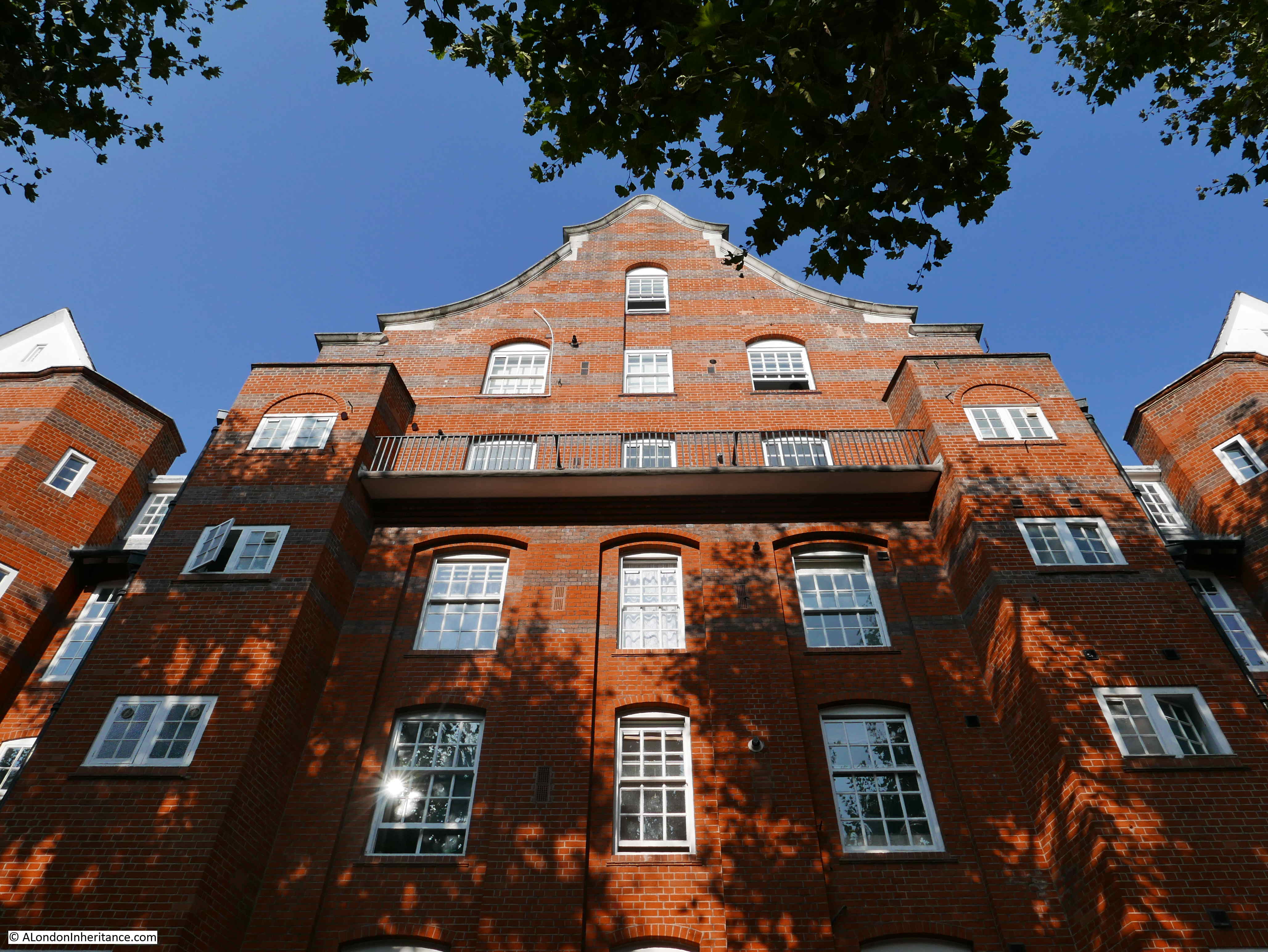
Walk up St John Street, north of Smithfield, and turn up St John’s Lane towards St John’s Gate, and on the left you will find Albion Place. My father’s 1947 photo of the street shows a pedestrianised street with a row of terrace houses. In the distance the street descends rapidly towards Farringdon Station, the descent of the street indicating that this was once down to the valley of the River Fleet.

Albion Place

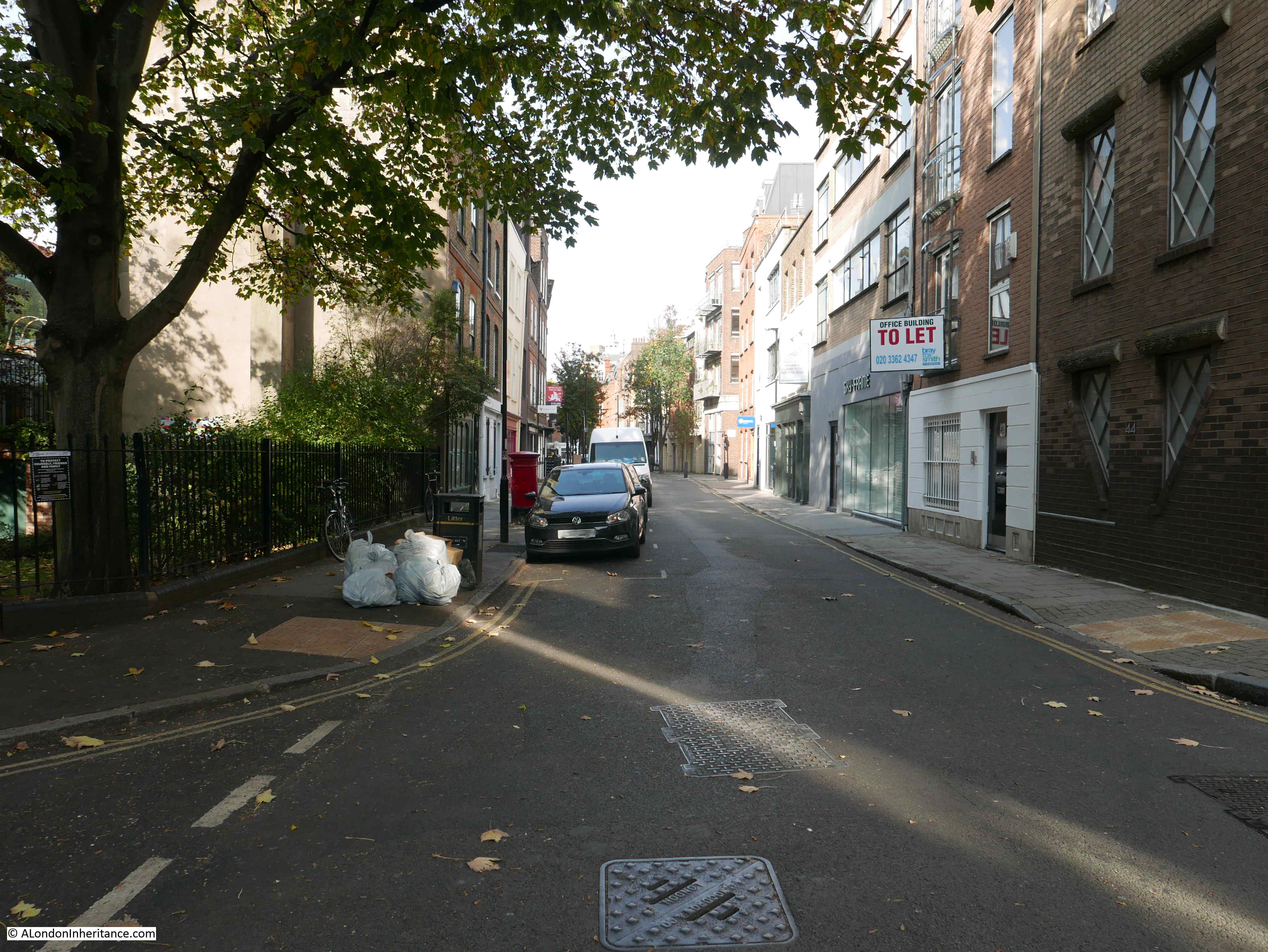
Albion Place in 2020:

Albion Place

The name Albion Place was in my father’s notes to the strip of negatives which included this photo. I was concerned whether this was indeed the right location. Apart from the way the street descends, there are no other visual clues. All the buildings in the 1947 photo have since been demolished. Albion Place is no longer pedestrianised, and the street today looks wider than it appeared in 1947.

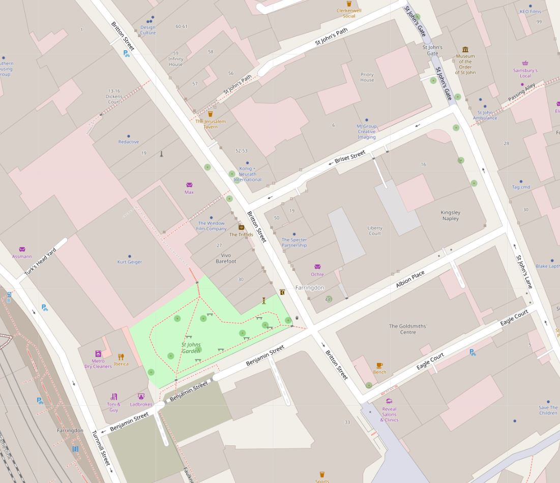
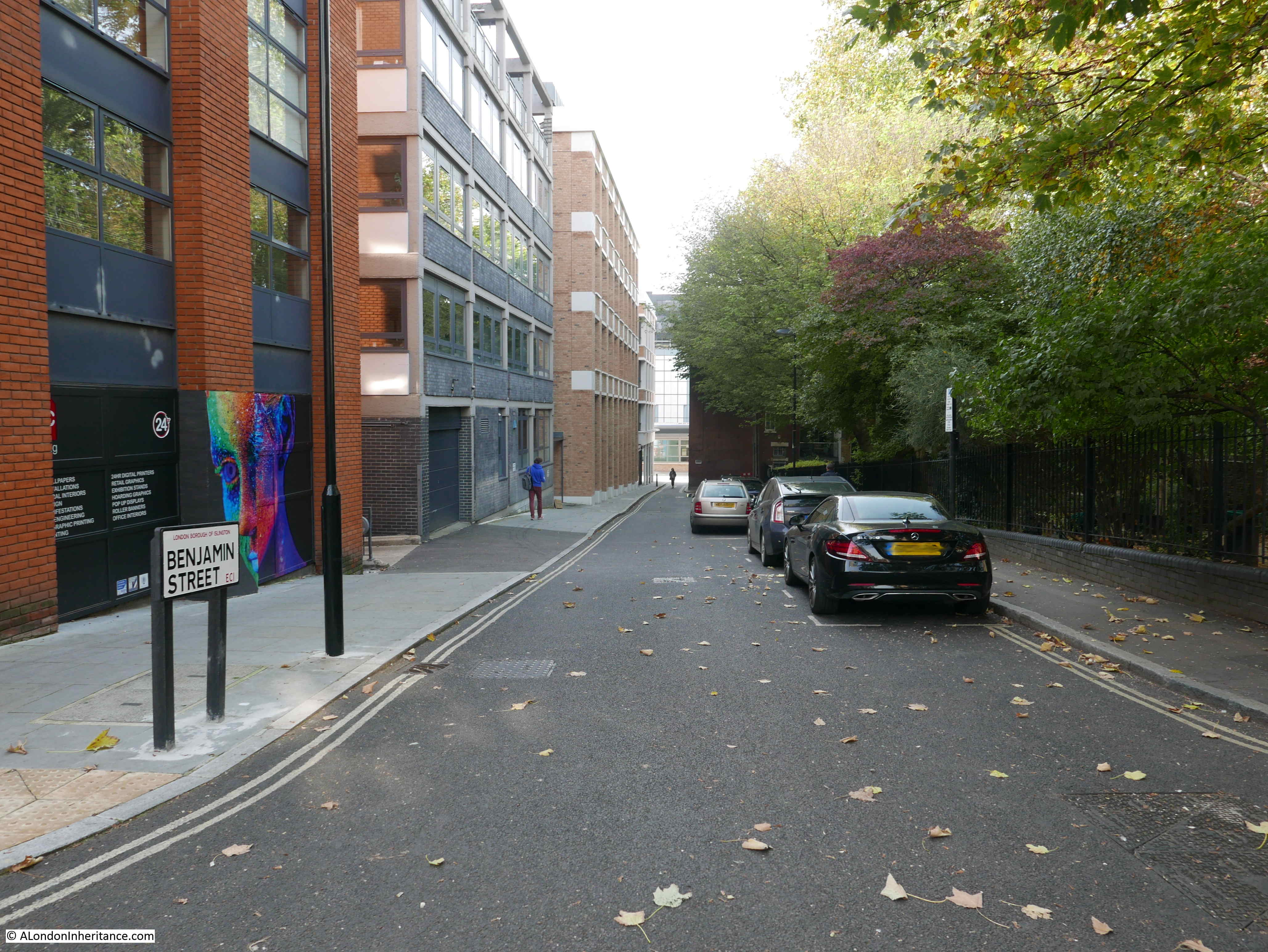
Albion Place is shown in the lower right of the following map, between St John’s Lane and Britton Street. Benjamin Street then continues on towards Turnmill Street and the tracks of the railway into Farringdon Station (Map © OpenStreetMap contributors).

Albion Place

The main cause of my doubt about the location was the junction with Britton Street. This is on the right, at the end of Albion Place, just before Benjamin Street descends towards Farringdon.

The junction with Britton Street cannot be seen in my father’s photo – indeed the street appears to be a continuous row of buildings.

I have been able to confirm this is Albion Place through a single visual clue, as well as a couple of other pointers.

Firstly, towards the end of Benjamin Street, there is a building that juts out and narrows Benjamin Street towards the junction with Turnmill Street.

The building has a unique outline. Today, a tree has grown up against the building and hides the edge of the wall and roof:

Albion Place

However I can demonstrate this is the same building as one seen at the very end of the 1947 photo.

In the photo below, on the left, is an enlargement from my father’s photo showing the very end of the street. There is a building jutting out and I have outlined in red the shape of the upper wall, up towards the roof.

In the photo on the right, I have marked the same outline of upper wall and roof.

Albion Place

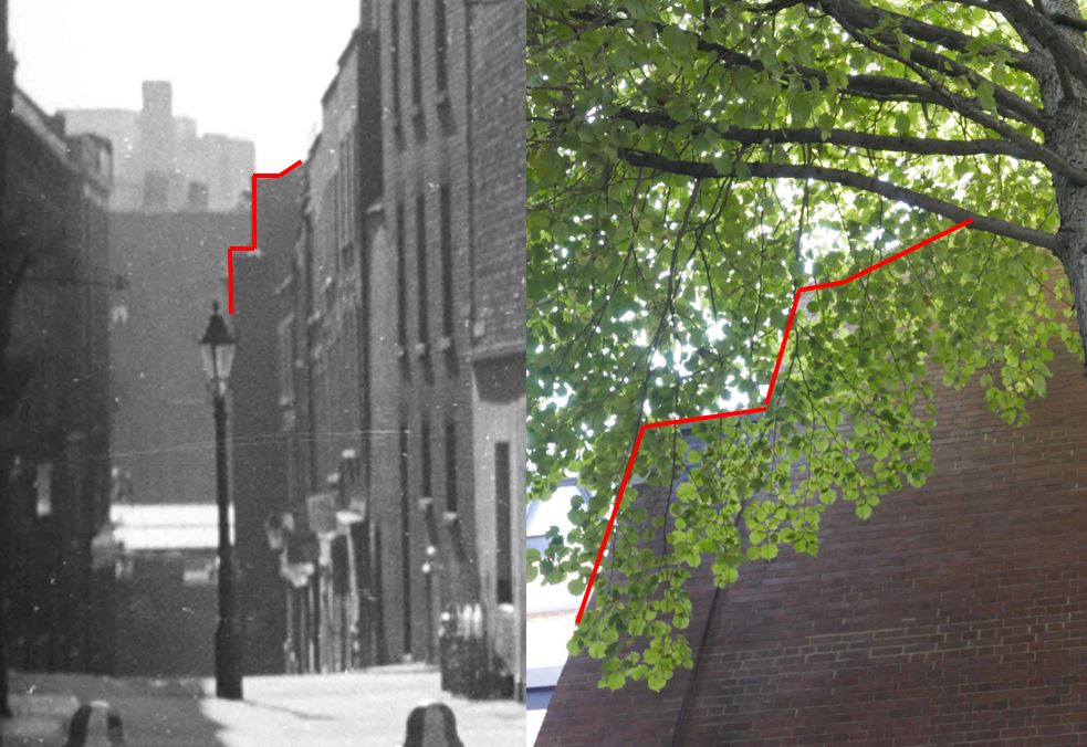
The two buildings both edge out into Benjamin Street, and both appear to have the same upper wall and roof shape. Would be clearer without the tree, but they appear to be the same.

I also checked the 1894 Ordinance Survey map, and in Albion Place, there is a row of terrace houses in exactly the right place (‘Reproduced with the permission of the National Library of Scotland’):

Albion Place

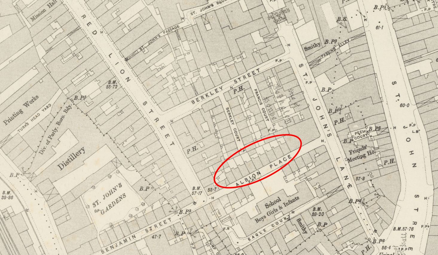
The OS map also shows Britton Street (then Red Lion Street) and the junction with Albion Place. I have no idea why this does not appear in my father’s 1947 photo, I assume the junction is there – just the perspective of the photo, and the way the buildings line the route of Albion Place and continue straight down to Benjamin Street.

I found one final confirmation of the location. The London Metropolitan Archives, Collage Collection has a single photo of Albion Place, dated 1956 which although photographed in the opposite direction towards St John’s Lane, includes a view of the same terrace.

Albion Place

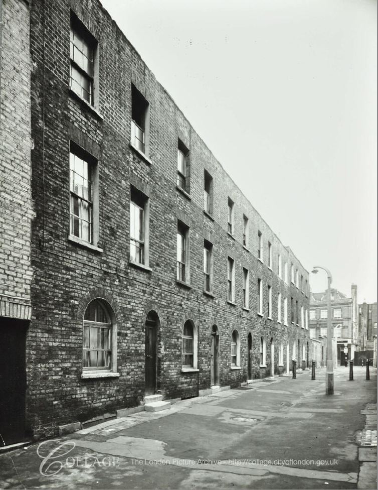
Image credit: London Metropolitan Archives, City of London: catalogue ref: SC_PHL_01 080 56 4132

The houses look the same, even the house on the left having the two steps to the door, with single steps serving the rest of the houses – exactly the same as in my father’s photo.

In the 9 years between the two photos, Albion Place has lost the rather nice lamp posts. In 1956 a new concrete lamp post is in place.

The following photo is looking up Albion Place from the junction with Britton Street, and shows the same building at the end of the street, on St John’s Lane, as in the Collage photo above.

Albion Place

Albion Place has a long history. The land was originally part of the outer precinct of the Hospitallers’ Priory of St John of Jerusalem, which extended down to Cowcross Street by Smithfield Market, Turnmill Street to the west and St John (‘s) Street to the east.

The street seems to have been built in the late 17th century, and was probably part of the gradual growth of the City northwards, as housing and industrial premises were built over what had been the lands of St John’s Priory.

The following map extract from William Morgan’s 1682 map of London shows the area as it was with the location of Albion Place marked by the red oval, on space then occupied by what appears to be the Earl of Berkleys property.

Albion Place

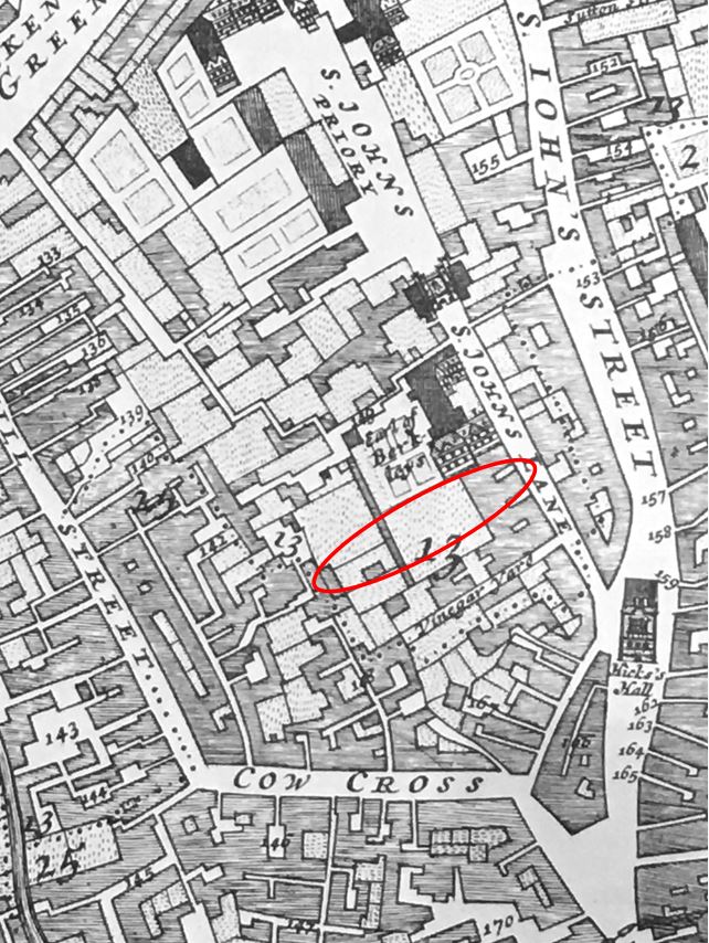
When built, the street was originally called George’s Court, and had changed name to Albion Place by 1822 when the court had been rebuilt to the form seen in my father’s photo, and is presumably from when the terrace of houses date.

The growth of Clerkenwell was linked to industries such as watch and clock making and Albion Place was home to the inventor of an alloy which would reduce the price of ornate 18th century clocks.

Gold was originally sold as 18 carat standard, and was therefore expensive when used as the casing for a clock or watch. Christopher Pinchbeck, who lived in Albion Place invented an alloy of copper and zinc which very nearly resembled gold. Pinchbeck moved from Albion Place to Fleet Street in 1721.

The name “Pinchbeck” was given to this new alloy, which was widely used for the cases of clocks and watches up until the mid 19th century when the sale of lower carat gold was legalised.

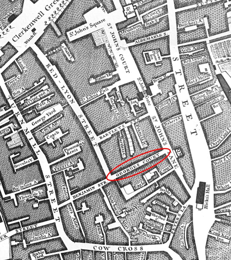
By the time of Rocque’s 1746 map of London, the street that would become Albion Place was now shown on the map as George’s Court. Benjamin Street had also been built down to Turnmill Street.

Albion Place

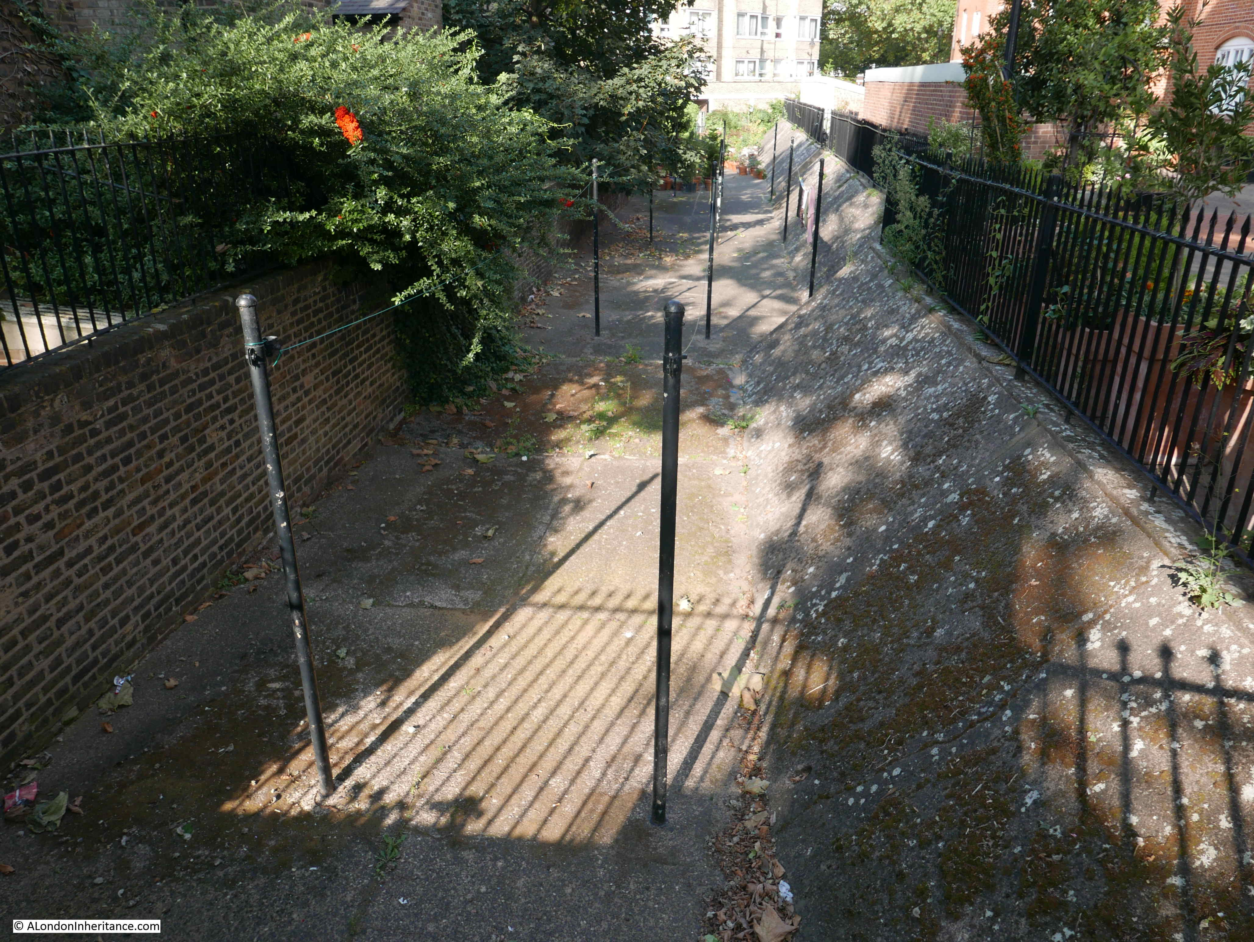
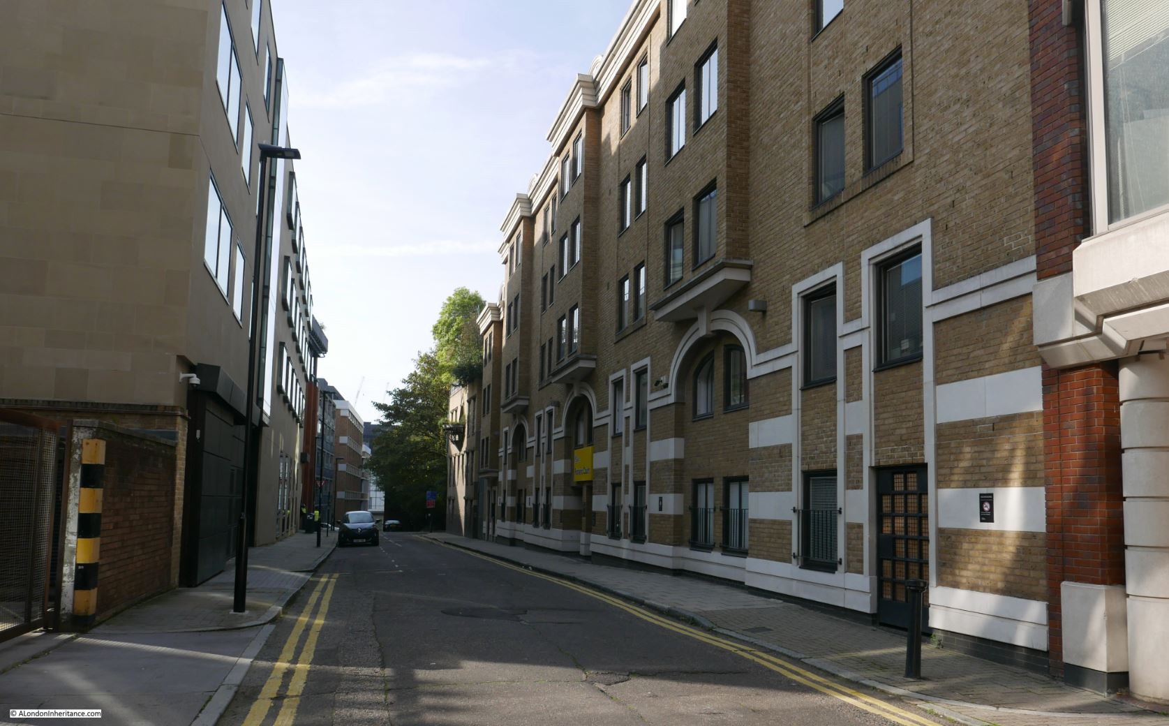
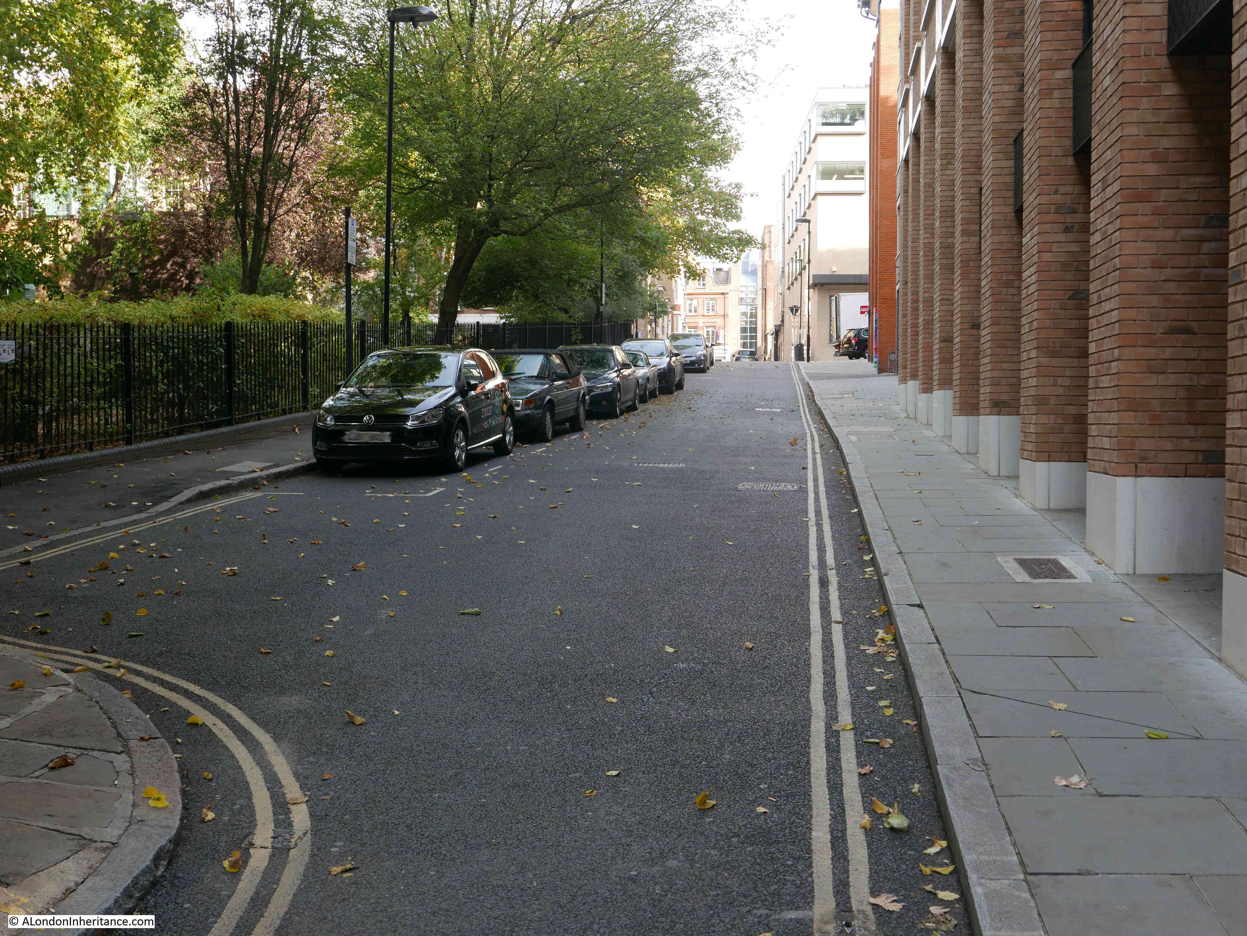
The following photo shows Benjamin Street. Albion Place has a shallow reduction in height, which is far greater in Benjamin Street, as the land descends to what was the Fleet valley which ran just across the railway tracks into Farringdon Station, roughly along the route of Farringdon Road.

Albion Place

The following photo shows the view along Britton Street – the street originally named Red Lion Street. This is the junction that caused me to doubt whether the photo was of Albion Place as it could not be seen in my father’s photo.

Albion Place

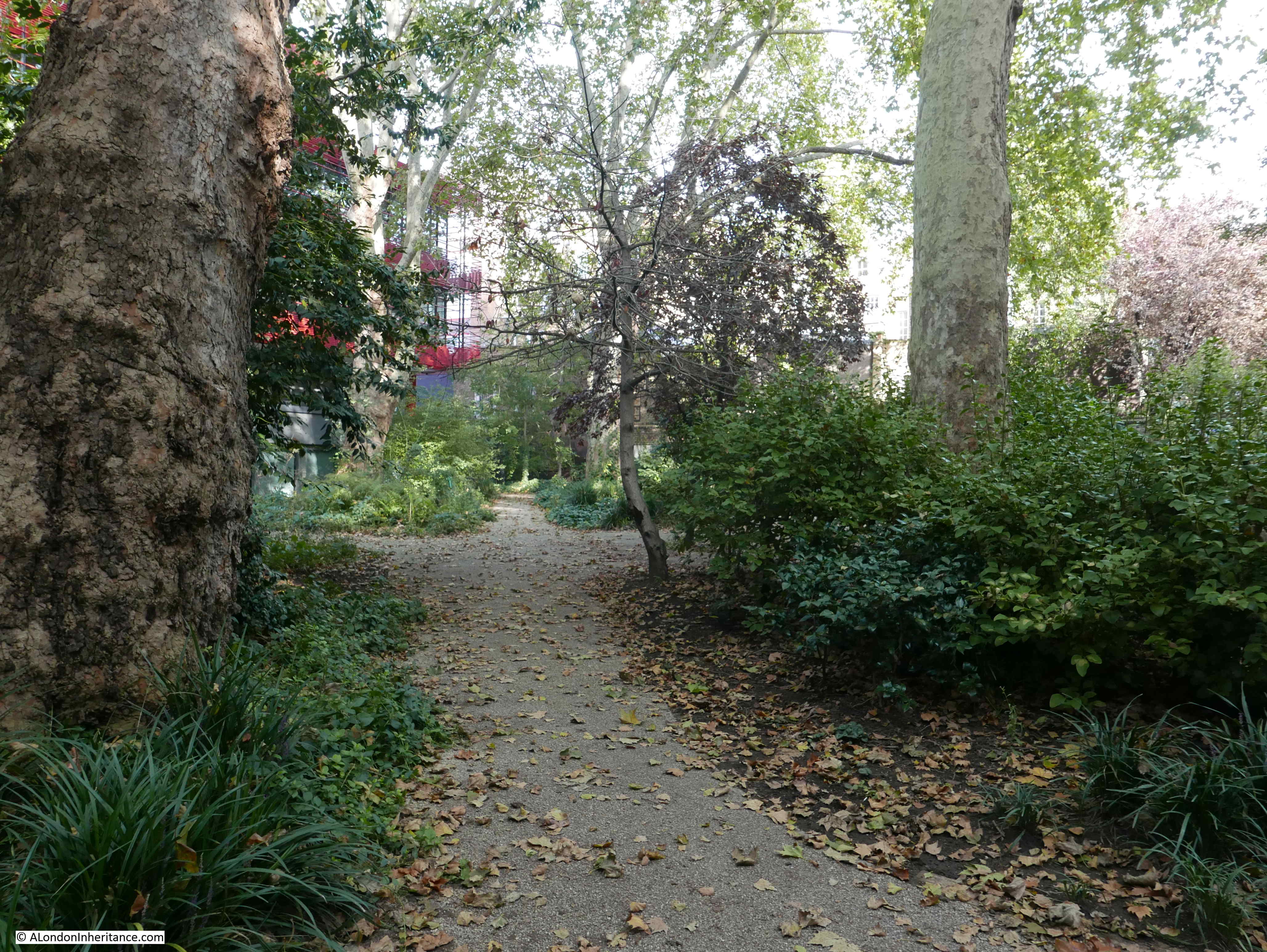
View back up Benjamin Street and Albion Place. To the north of Benjamin Street (to the left in the following photo) is a small green space – St John’s Gardens.

Albion Place

St John’s Gardens was originally the burial ground of St John’s Church – the parish church that was in St John’s Square, and following wartime bombing, now rebuilt as the Priory Church of the Order of St John.

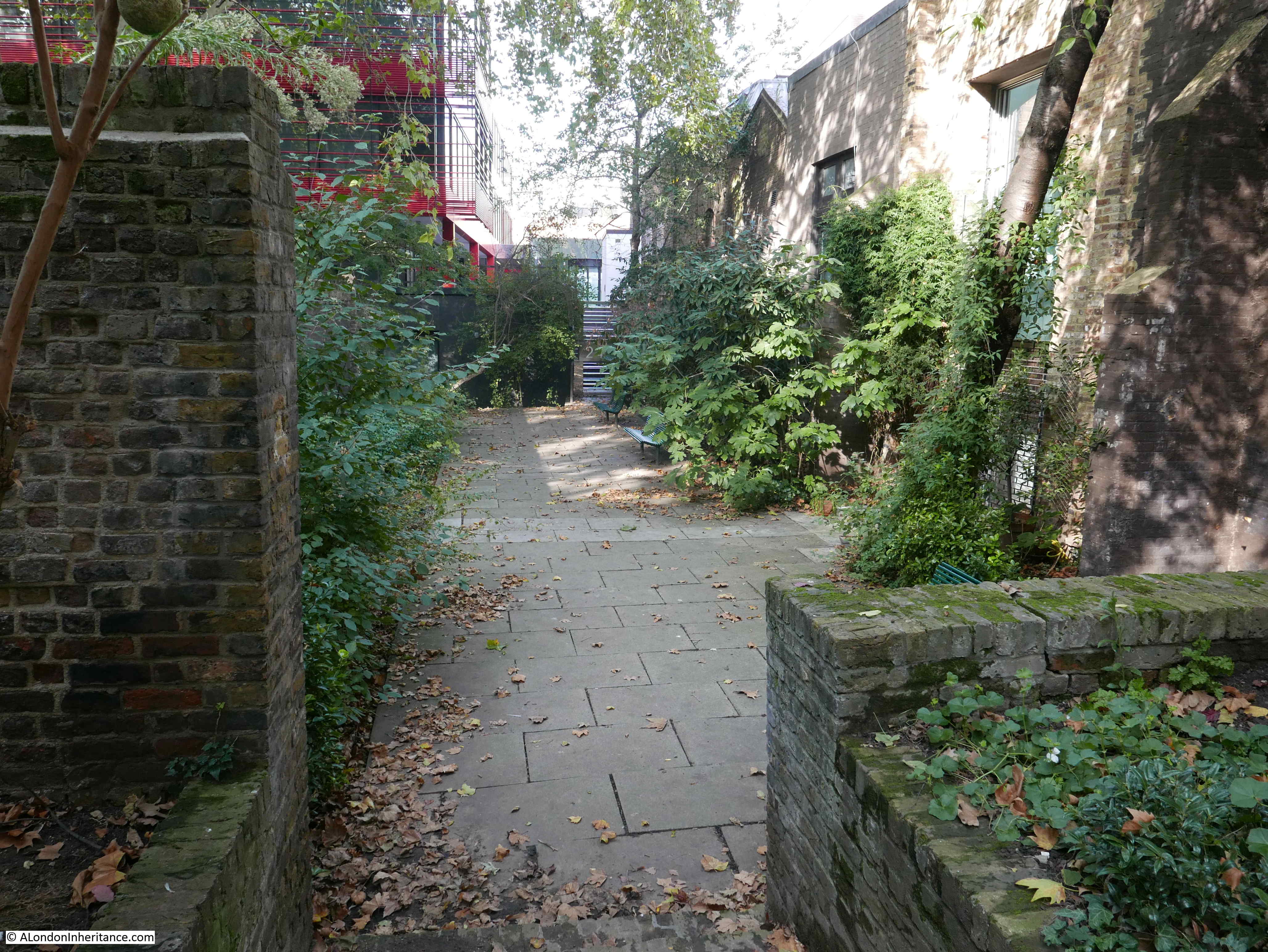
The area was taken on by the parish in 1754 and used until 1853 when it was closed under the Burials Act. The burial ground originally did not face directly onto Benjamin Street. As shown in the 1894 OS map earlier in this post, a line of buildings ran along Benjamin Street with St John’s Gardens being an enclosed square. This can also be seen in the 1947 photo where buildings line the far end of the street.

Today, the gardens form a valuable bit of green space.

Albion Place

Albion Place

There is a rather poignant mural in the gardens.

Albion Place

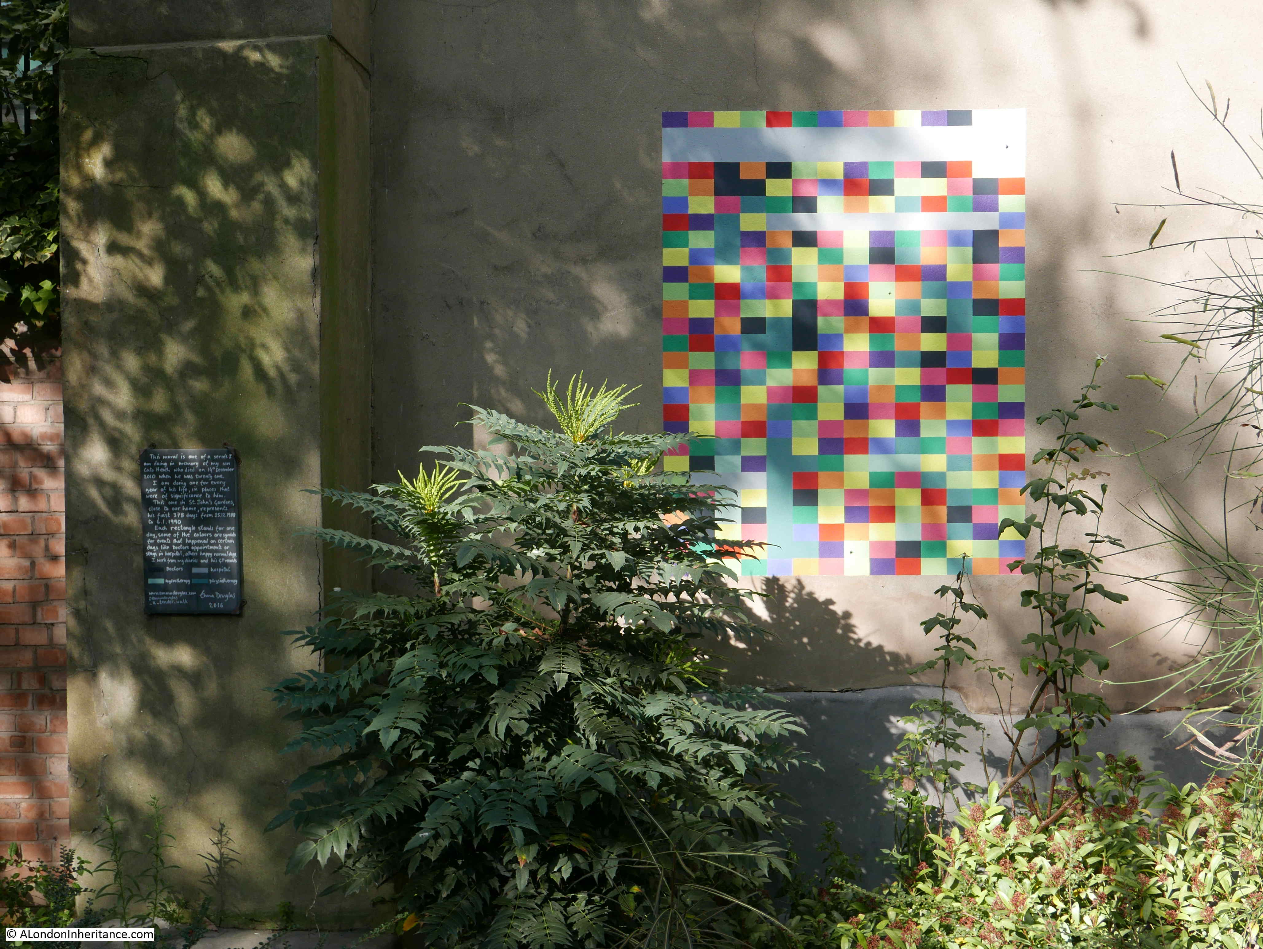
It was created by Emma Douglas in memory of her son Cato Heath who died aged twenty one in 2010. Each coloured rectangle represents a day in the life of her son, with the colour of the rectangles representing an event, for example a black rectangle for a doctor’s appointment.

The mural created by Emma in St John’s Gardens is one of a number to be found.

On the corner of Albion Place and Britton Street is a rather interesting building:

Albion Place

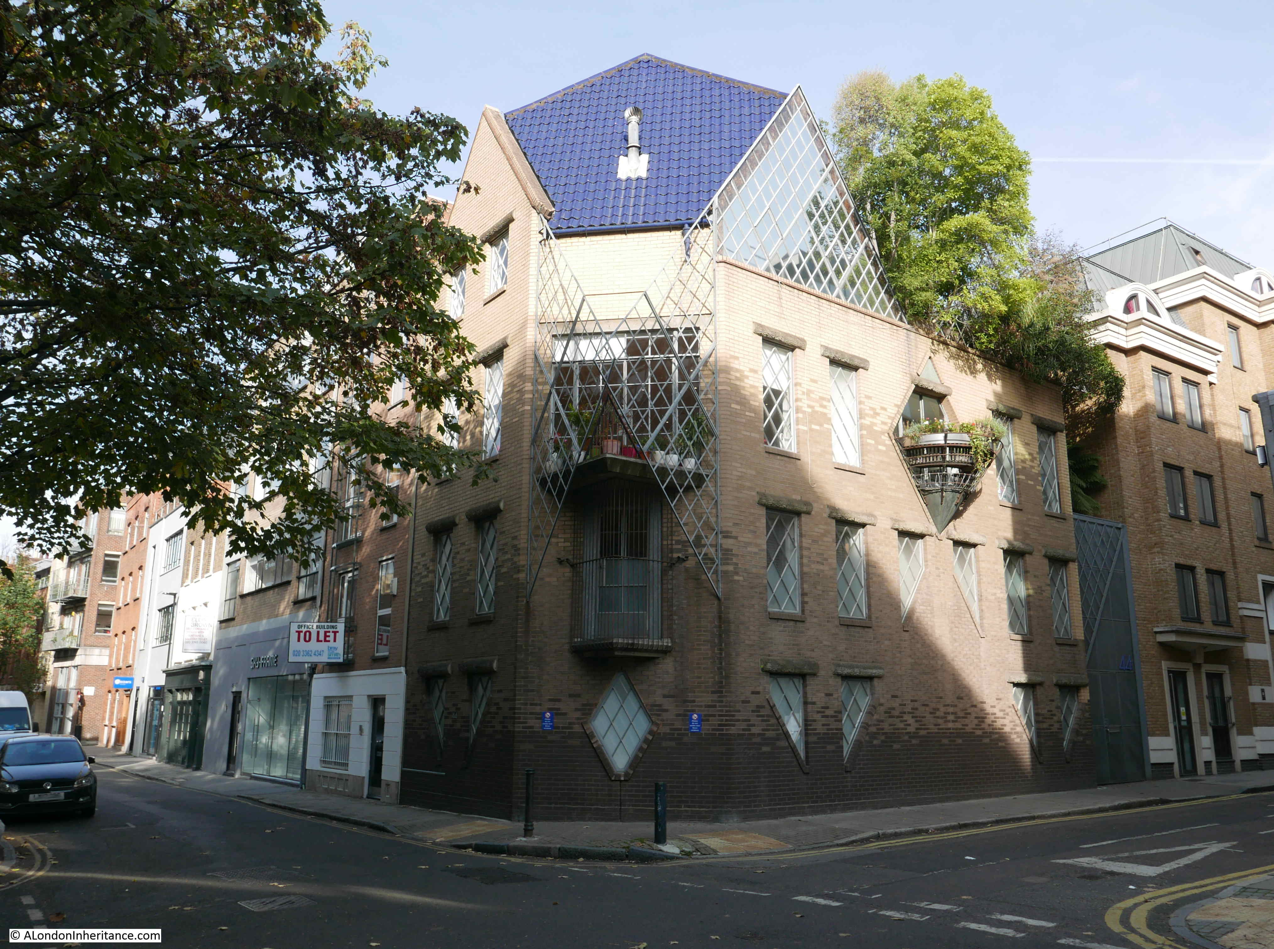
This is the Grade II listed 44 Britton Street originally built for Janet Street-Porter and designed by Piers Gough.

Before her career in the media, Janet Street-Porter trained at the Architects Association where she met Piers Gough. She wanted a house that did not follow the old English tradition with rooms being in well defined places. She also wanted a house that did not look too friendly and looked a bit hostile, so there is no outward facing door to the building. The entrance is tucked away at the rear of the building in a courtyard.

The bricks used in the construction are shaded, starting with dark bricks at the base, getting gradually lighter towards the top of the walls. This was to give the impression that the base of the building is in shade, with the top of the building in perpetual sunlight.

The external lintels above the windows are in the shape of concrete logs.

Janet Street-Porter lived in the house from 1988 to 2001. There is an episode of the BBC programme Building Sights dating from 1991 with Janet Street-Porter talking about, and showing the interior of the building. The programme can be found on the BBC iPlayer here – it is worth a watch.

On the opposite corner of Albion Place and Britton Street there is another interesting building. This is the Goldsmiths Centre:

Albion Place

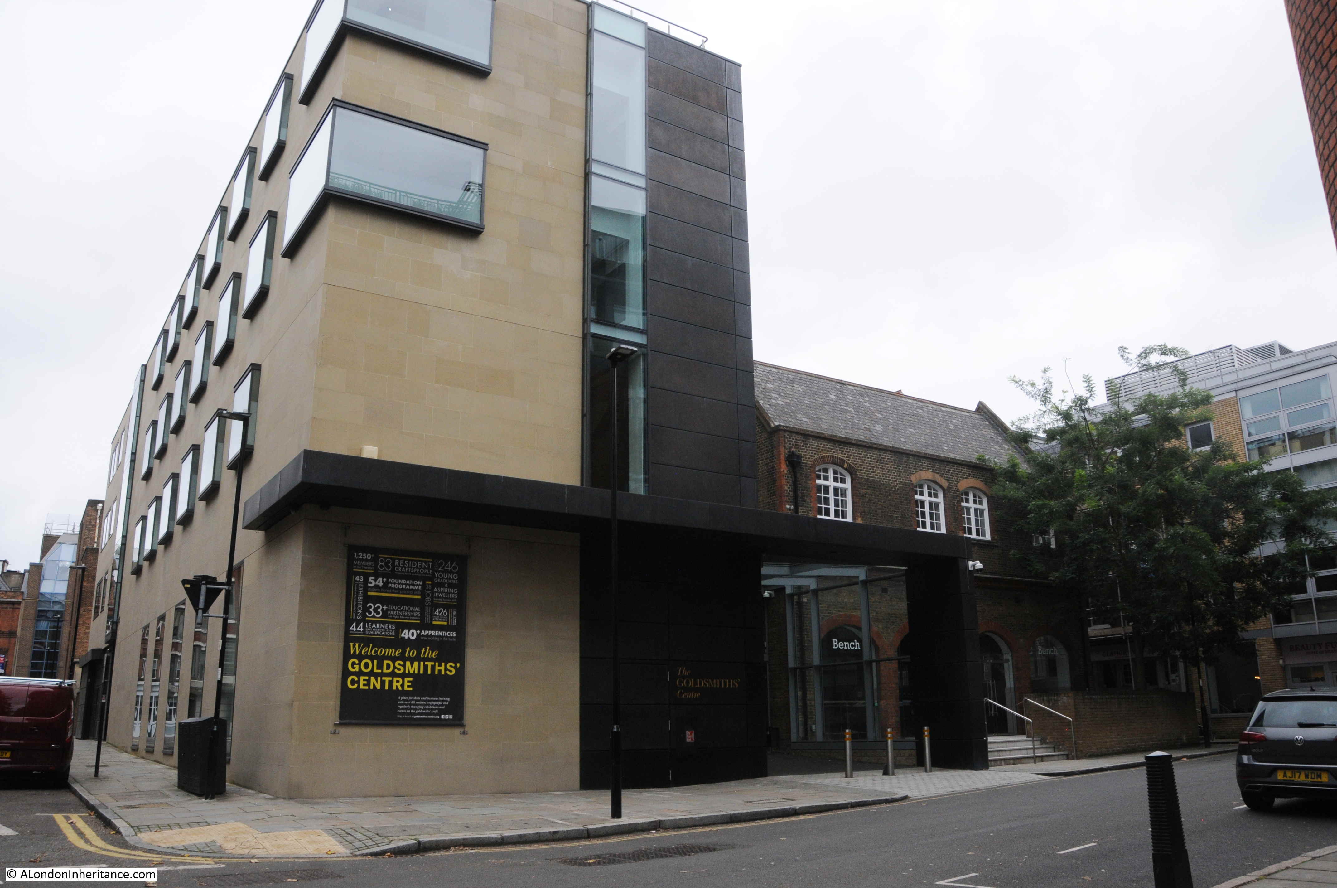
The Goldsmiths Centre was founded by the Goldsmiths Company, one of the twelve great livery companies of the City of London, as a charity for the professional training of goldsmiths.

The centre provides a location where the technical skills of gold and silversmithing and jewelry working can be taught and developed. The building also provides support for developing business, with shared studio space in which to work.

The Goldsmiths Centre is in a rather appropriate location given the history of Clerkenwell with the trades associated with metal working.

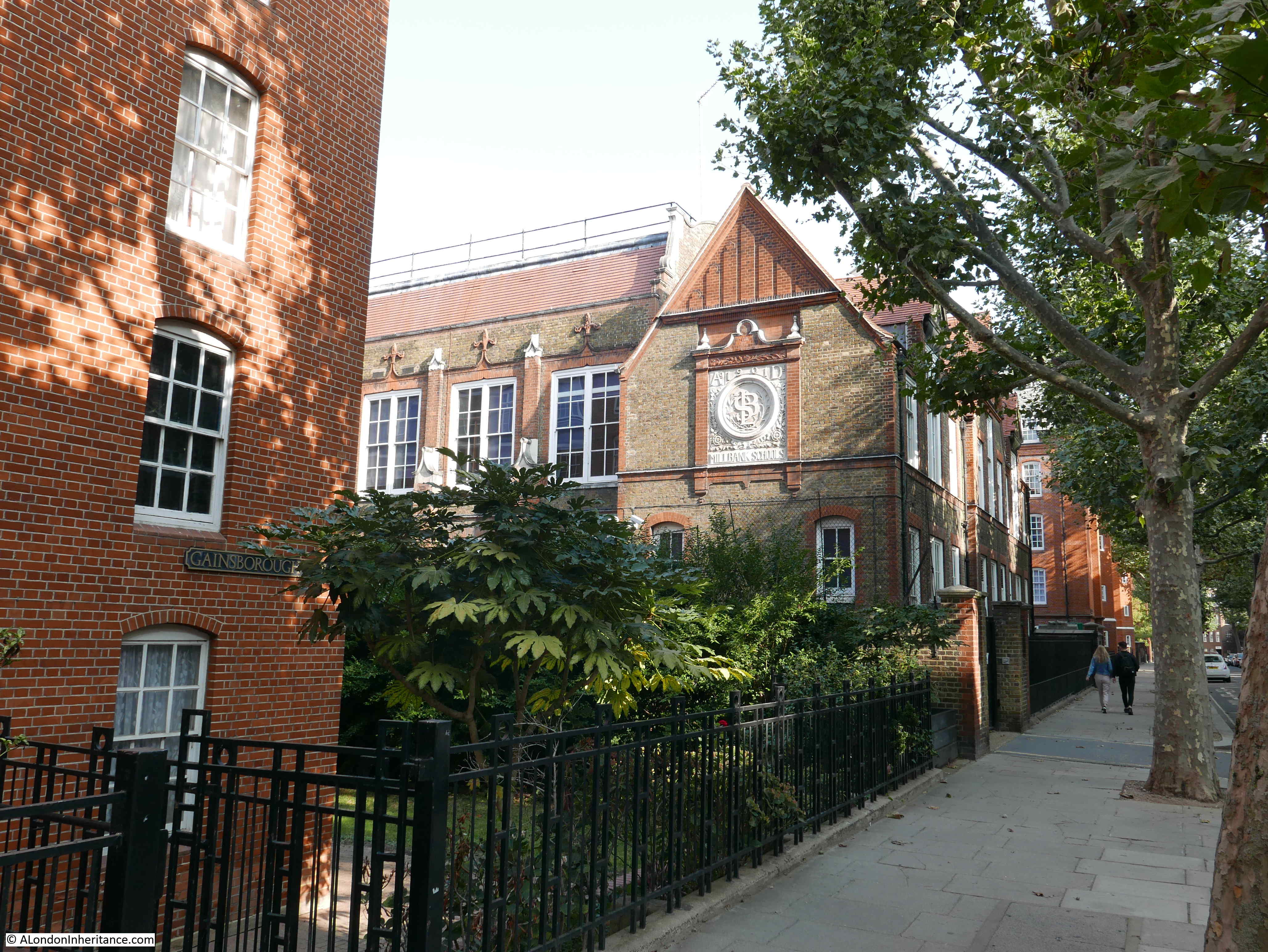
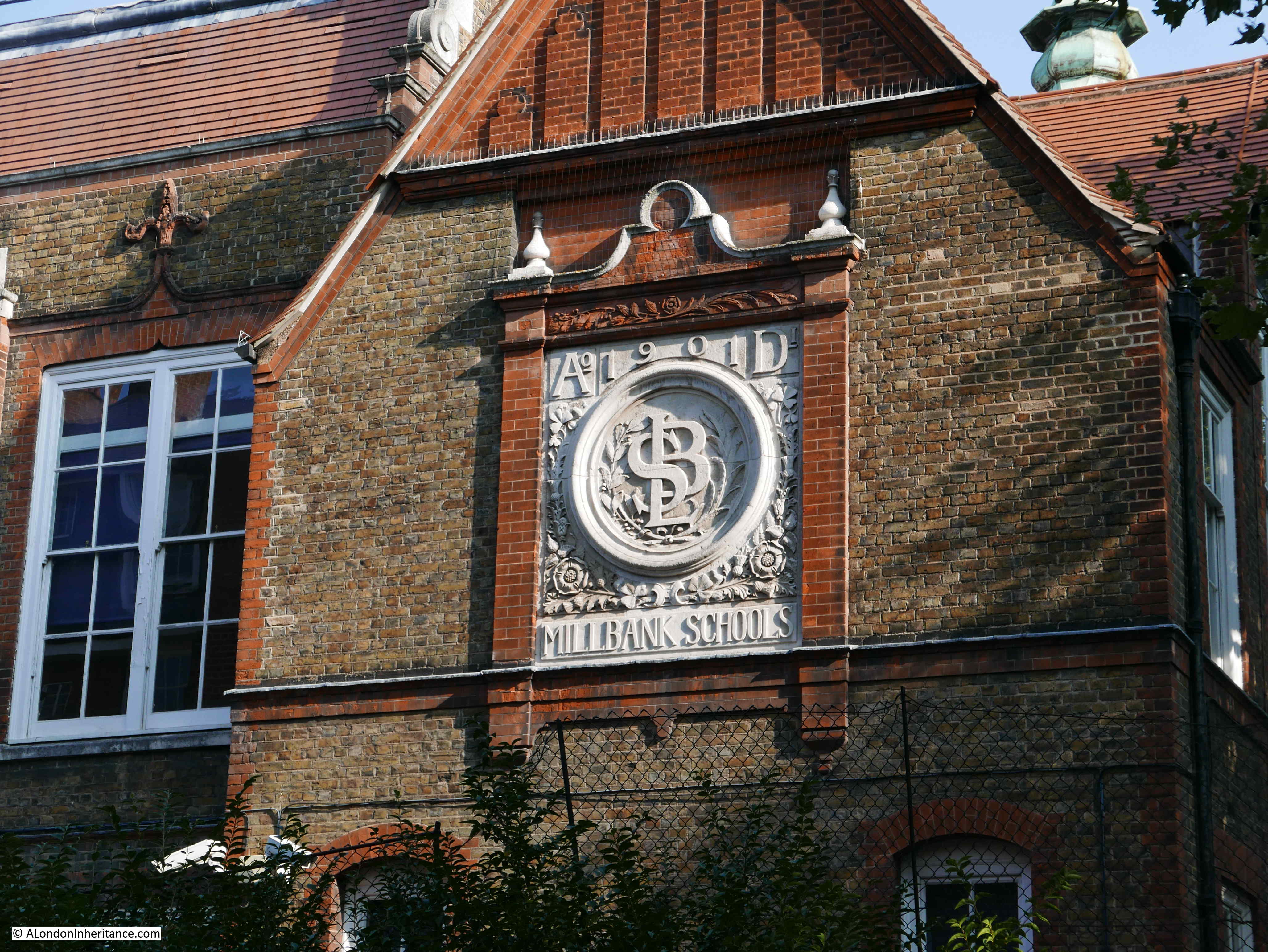
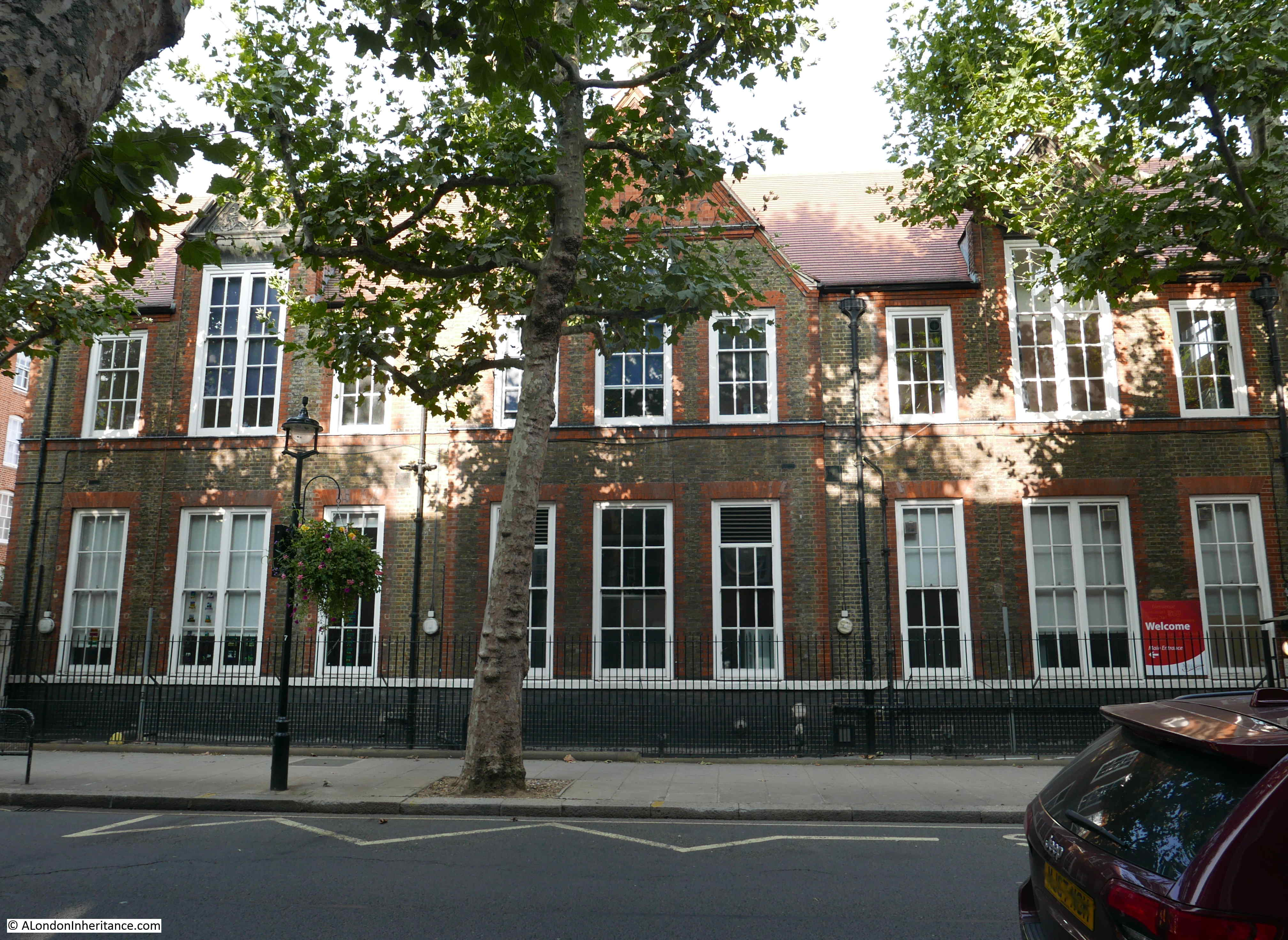
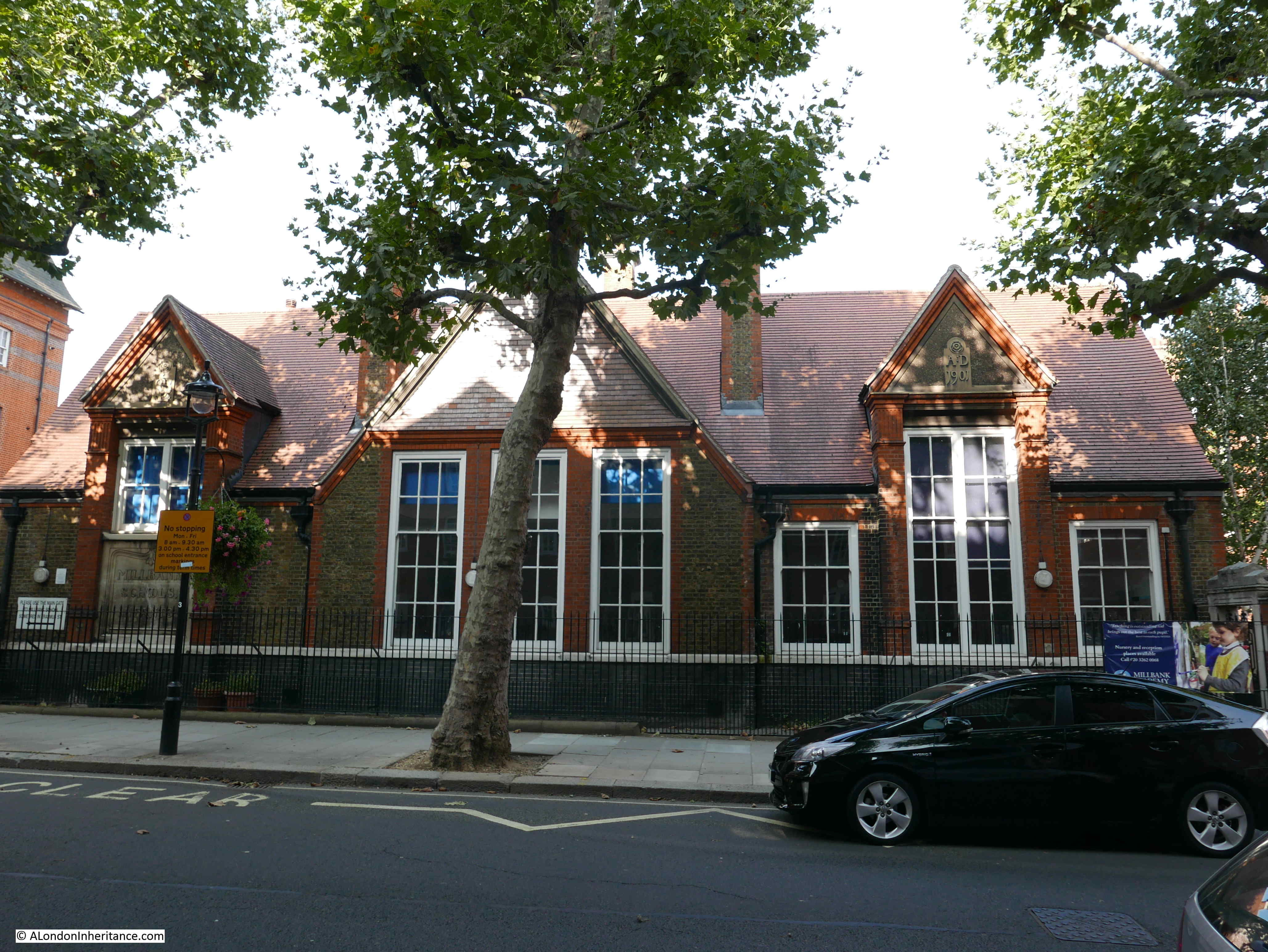
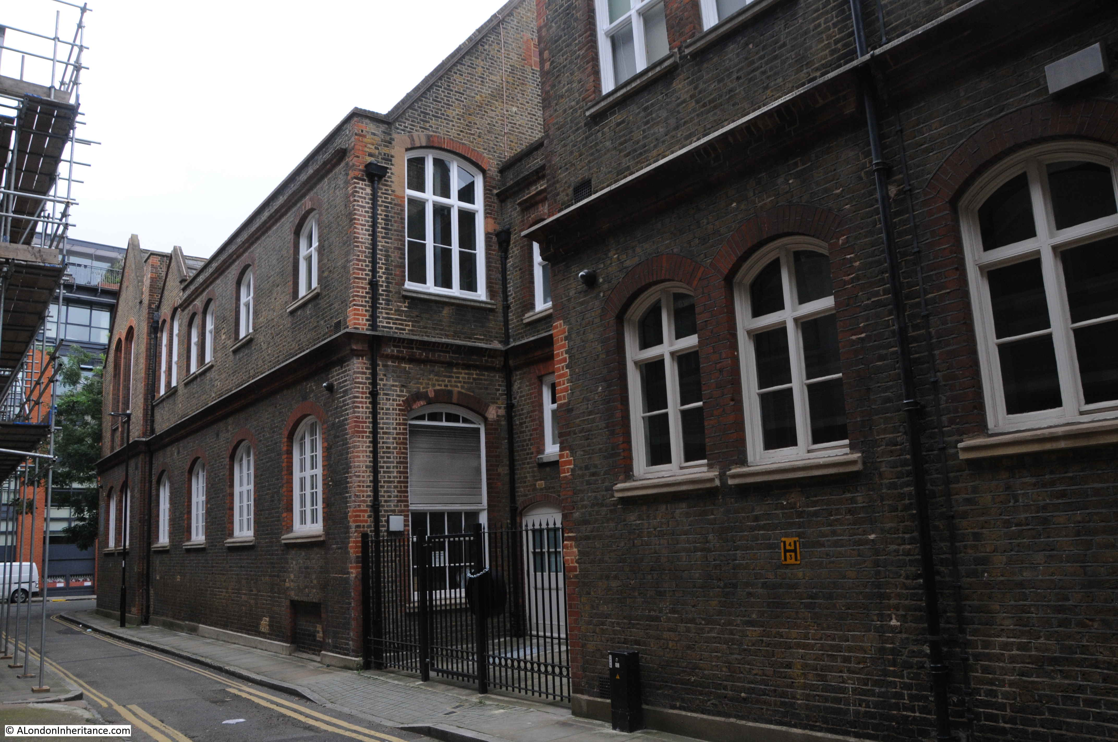
The Goldsmiths Centre was opened in 2012. The building on the Albion Place corner is a modern addition to a Grade II Listed 1872 Victorian London Board School, which together form the Goldsmiths Centre.

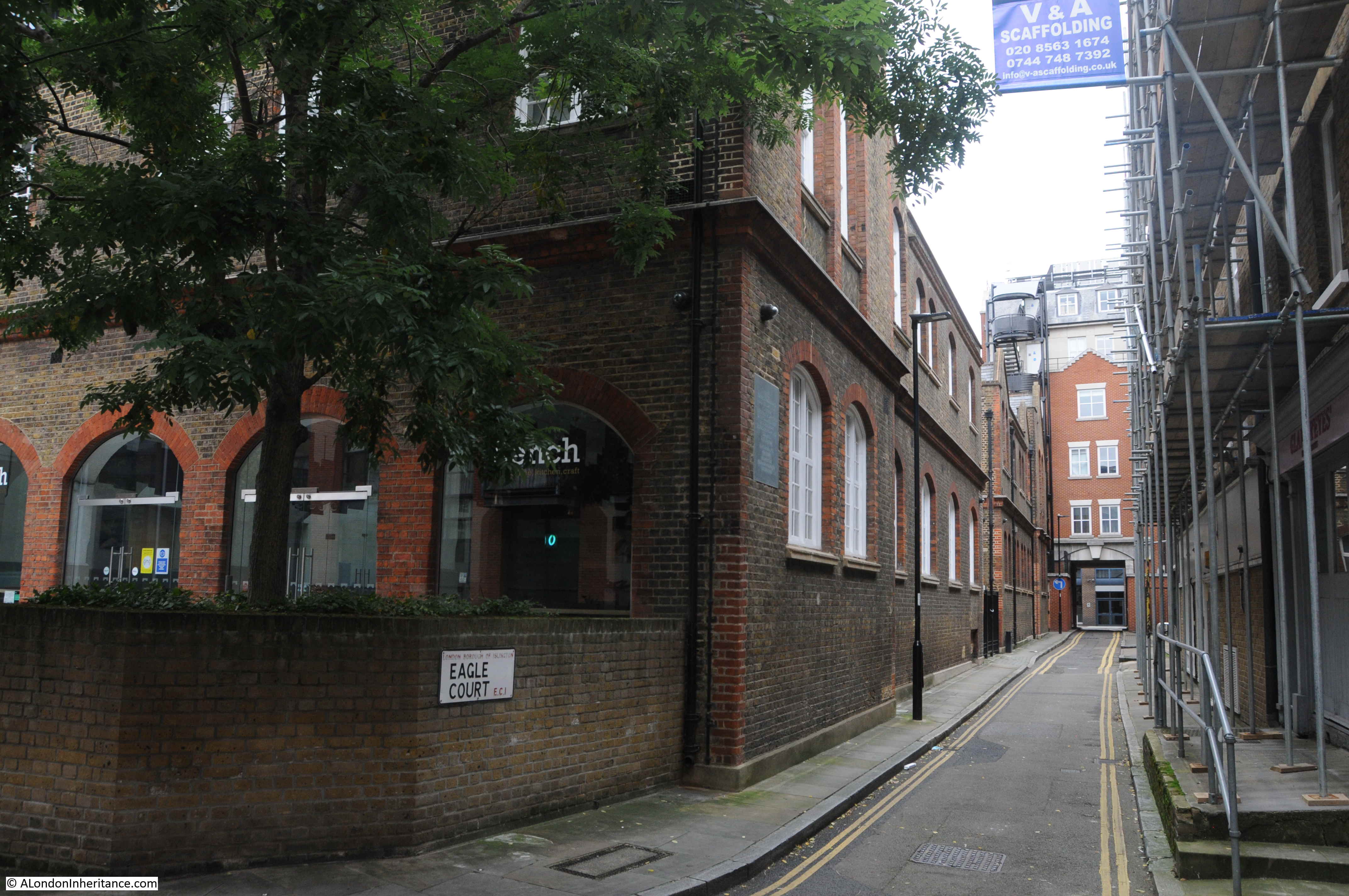
The main entrance to, and the main school building is in Eagle Court which runs from Britton Street back up to St John’s Lane.

Eagle Court is shown in Rocque’s map, and in the earlier 1682 map by Morgan appears to be shown as Vinegar Yard, so Eagle Court is older than Albion Place.

The name Eagle Court comes from Eagle’s House which appears to have been a mid 14th century mansion built along the western edge of St John’s Lane. The house was named after the Templar preceptory of Eagle in Lincolnshire and acted as the Clerkenwell residence of the bailiff as the senior official of this preceptory.

The view up Eagle Court towards St John’s Lane:

Albion Place

Before the school was built, Eagle Court had long been a dense court of workshops and houses. Industrial processes being performed next to living space.

Work was dangerous and accidents were frequent. for example on December 5th, 1738 “A fire broke out in the workshop of Mr Tabery, a Japanner in Eagle Court, St John’s Lane, occasioned by the Varnish Pot boiling over. Two men were so miserably burnt that their lives are despaired of”.

The area around Albion Place and Eagle Court was densely populated and criminality was rife. The location for the school was chosen by the London School Board for this very reason, as introducing a formal education was seen as one of the means to improve the future prospects of the residents.

When the school was being built in 1873 and 1874, the workmen and the location needed a police guard to protect them and the building materials for the school from the lawless elements of the local population.

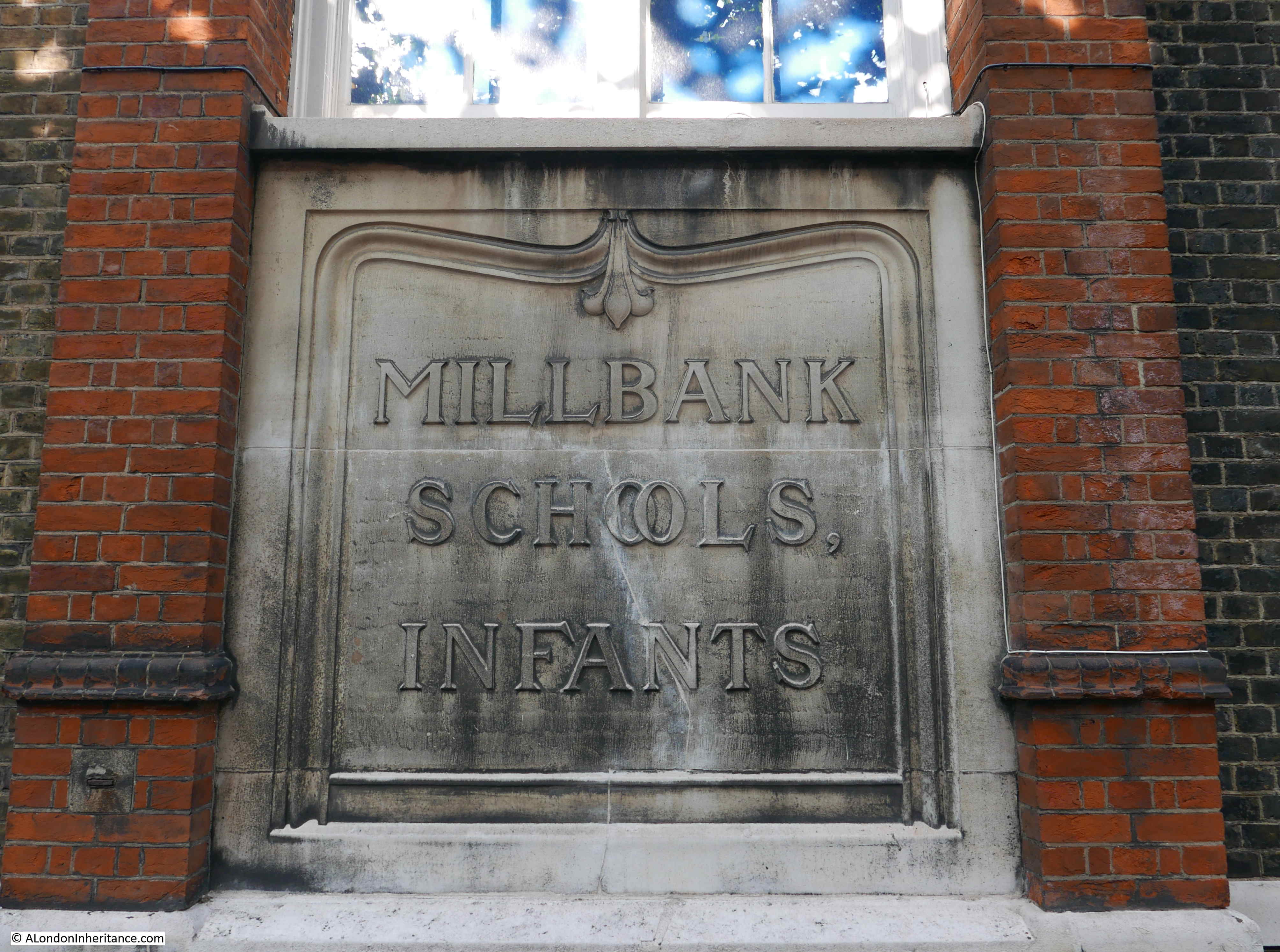
The school backs onto Albion Place, and is often referred to as being in Albion Place. The following article from April 1906 provides another example of the crime in the area which was probably heightened by the precious metals which could be found in the workshops:

“DESPERATE BURGLARS – SCHOOL CARETAKER ATTACKED WITH JEMMY. The caretaker of the London County Council School at Albion Place, Clerkenwell, was found lying in a pool of blood with his head severely cut on Saturday night under mysterious circumstances.

When the premises next door were opened the ground floor window was found to have been forced and the entire premises ransacked. The second floor was occupied by a gold refiner. Several hundred pounds worth of gold and silver were on this floor, and the men removed a considerable quantity.

It was when the burglars were leaving via the schoolyard that they were surprised by the caretaker. He was rendered unconscious by blows from a jemmy, which the men dropped.

The caretaker has not yet been able to give any account of the affair. The burglars worked leisurely, and cleaned the window before leaving to remove all traces of incriminating finger prints”.

The increasing level of workshops and industry in the area resulted in the reduction of family homes and the number of children resulting in the closure of the school in 1918.

For the rest of the 20th century, the old school buildings hosted a wide range of educational functions including Cordwainers’ Technical College, the LCC Smithfield Institute and Smithfield College of Food Technology, the College of Distributive Trades, and following a merger with the London College of Printing, the old school buildings became the London Institute.

The current use of the building as the Goldsmiths Centre therefore continues a long educational tradition, including a century of use as a technical educational centre.

Unlike many buildings created by the London School Board, the building consists of only two floors. This was intentional so as not to cast the buildings opposite in this narrow street, in permanent shadow,

Albion Place

I have walked just a few short streets, down Albion Place, along Benjamin Street, then back up to St John’s Lane via Eagle Court, but these few streets reveal their part in the long history of Clerkenwell. From the Priory of St John of Jerusalem, through the industrialisation of the 18th and 19th centuries when the area was home to watch, clock and metal working, an area of dense population with high levels of crime.

The terrace shown in my father’s photo survived until the late 1960s. If the terrace had been renovated, and if Albion Place had stayed a pedestrianised street, with bollards and cast iron lamps, this could have been a lovely street. Although, we always need to be careful when looking back at the past, and remember the lessons of Christopher Pinchbeck’s alloy that all that glitters is not gold.

alondoninheritance.com

John Snow and the Soho Cholera Outbreak of 1854

Epidemiology has come to public attention as one of the key areas of expertise needed to reduce the spread of Covid-19. The pandemic has come as something of a shock given the significant reductions in disease over the last 100 plus years, although in reality, such a global event was probably only a matter of time given the background transmission of new diseases, and the interconnectedness of the world in the 21st century.

Contagious disease has long been a very significant problem. Outbreaks would rise and fall, killing many thousands of people, often in limited areas. Prior to the mid 19th century, thinking was often that disease was caused and transmitted by a miasma – a form of “bad air”.

It took the work of a number of Doctors and Scientists to prove this was not correct, and to trace the real cause of disease transmission, and one of these was Dr. John Snow, often called the founding father of Epidemiology. His work on the transmission of Cholera in London would demonstrate conclusively how this killer of large numbers of Londoners was transmitted.

The British Medical Journal describes Epidemiology as “the study of how often diseases occur in different groups of people and why. Epidemiological information is used to plan and evaluate strategies to prevent illness and as a guide to the management of patients in whom disease has already developed.”

Although John Snow’s work on Cholera covered the whole country, including outbreaks across London, he is more widely known for one outbreak in 1854 in Broad Street, Soho, and a couple of weeks ago I had a walk around the area to find the focal point of the outbreak, and the pub that bears his name:

John Snow

The John Snow pub stands on the corner of Broadwick Street (originally Broad Street) and Lexington Street (originally Cambridge Street). A number of streets in this area of Soho have changed their names since the mid 19th century.

The pub building dates from the 1870s, and was originally called the “Newcastle-upon-Tyne”, The name changed in 1955 to commemorate the centenary of the work in the area of John Snow.

He traced the source of the local Cholera outbreak to a water pump that stood in the street outside the current pub. I will detail how he did this later in the post. Today, there is an imitation pump in the same spot:

John Snow

The pump was installed in its current position in 2018, having been removed three years earlier due to building work which included extension of the pavement. The replica pump had been installed in a slightly different position to the original, and a pink granite curb stone had marked the location of the original pump.

One of the fascinations of London is that historical reminders tend to accumulate, and the pink granite curb stone was retained, and can now be seen to the left of the plinth on which the pump is mounted, now in the correct position.

The pump is also unusual in that it does not have a handle – the reason for this will be explained later in the post.

And on the pub wall is a plaque by the Royal Society of Chemistry naming John Snow as the founding father of Epidemiology for his work in the area:

John Snow

The pump and pub in Broadwick Street:

John Snow

John Snow was born in York on the 15th of March 1813. A career in medicine seems to have been defined at an early age,. When he was 14 he started work as an apprentice for William Hardcastle, a surgeon in Newcastle-upon-Tyne.

He had early experience with cholera outbreaks, and during 1831 he worked on an outbreak at Killingworth Colliery. It was here that he appears to have started making detailed notes on the outbreak – gathering the data that would be essential in understanding the root cause.

He moved to London in 1836 to study at the Hunterian School of Medicine, and a year later started hospital practice at the Westminster Hospital. The following year, 1838, he became a member of the Royal College of Surgeons, and in 1850 became a member of the Royal College of Physicians.

Doctor John Snow:

John Snow

Data gathering in 19th century London was actually rather good. The Registrar General published regular returns detailing the number of deaths by date, cause and location. Where possible, information also included age, gender and profession, so a mass of data was available for evaluation, however outdated theories often prevented the use of data to find the root cause of disease outbreaks.

London could be absolutely filthy. Much of London was not yet connected to the expanding sewer network. Houses often had cesspools directly underneath, raw sewage was pumped into the Thames, contaminated water would be dumped in the streets and ditches.

The city’s cemeteries were overflowing, with bodies piled high in crypts and churchyards.

One of the main theories was that disease was carried in dirty air. Air polluted by rotting vegetables, dirty water, the waste from industry, and from the city’s cemeteries.

There was also no real separation between drinking water and contaminated water. For example, raw sewage was pumped into the Thames, a short distance from where water was taken out for distribution to houses and pumps.

There were frequent outbreaks of cholera. 1849 being the year of the most recent outbreak, however there was also a background rate of cholera deaths happening every year.

Data recorded by the Registrar General identified the number of deaths per week, aligned with the source of water for the house where the person lived, or the death occurred. The following table shows a period of six weeks in 1854. The table focused on south London, an area where there were significant numbers of cholera deaths.:

John Snow

The table shows the source of the water supplied to each house where there was a death. The “Unknown Sources” column included a large number of houses where the residents did not know where their water came from as the landlord would pay the bill (and therefore they had no control of the source of their water).

The table implies significant problems with the supply of water by the Southwark Company, but this may have been down to a much larger population.

Much of the evaluation of the data was by John Snow. He obtained the addresses for houses where deaths had occurred from the Registrar General, and spent time going house to house to gather more information.

Evaluation of the data enabled a comparison of the mortality rate for each of the water companies to be identified, and this confirmed the issues with the Southwark Company, who had a mortality rate of 857 per 100,000 inhabitants compared with 169 and 194 for the Lambeth and Kent companies:

John Snow

The Lambeth Company had problems during a previous outbreak in 1849, but had since moved their intake from the Thames upriver to Thames Ditton, which was above the tidal limit of the river at Teddington.

At Thames Ditton, water flowed towards London and there was no wash back in of water due to the tide. This meant that water was less polluted. In central London, there was more inflow of sewage, and this was often swept back in on a rising tide, increasing significantly the level of pollution.

The Southwark Company were still drawing their water from the river at Battersea, not far from a number of sewage outlets at Vauxhall.

Lambeth was the only company to change where they took water following the 1849 outbreak. In 1854, the Southwark Water Company was classed as having the most impure waters, and would not change their water intake till later in the year.

John Snow investigated the source of water used by as many of those who died from cholera as he could find. Some of his records are truly appalling by modern standards:

  • At 4, Bermondsey Wall, on 23rd July, the daughter of a bookseller, aged 4 years, cholera 9 hours – Thames water, by dipping a pail in the water
  • At Falcon Lane, Wandsworth, on 3rd August, the daughter of a chemist deceased, aged 14 years, premonitory diarhoea 4 hours, cholera 24 hours – Water from a ditch into which cesspools empty themselves
  • At Charlotte Place, Charlotte Row, Rotherhithe, July 29th, the son of a barge-builder, aged 3 years, cholera 3 days – Tidal ditch
  • At 5 Slater’s Alley, Rotherhithe, July 29th, a labourer, aged 33, cholera 3.5 days – Thames Tunnel water, fetched from John’s Place

Rotherhithe was badly effected. and John Snow mentions Charlotte Row, Ram Alley and Silver Street as “places where the scourge fell with tremendous severity”.

He also states that Rotherhithe had been badly supplied by water for many ages past, and that people were forced to drink from old wells, old pumps, open ditches, and the muddy stream of the Thames.

Cholera deaths across London were increasing rapidly during the months leading up to the first week of September. I took the weekly total from the Registrar Generals report, put them in a spreadsheet, and created the following graph which gives a good visual view of the increase.

John Snow

So in the summer of 1854, cholera was causing deaths across the city, and John Snow was using methods that would become common in epidemiology to understand the impact, and to identify the cause. As well as the cases caused by infected water supplies, the case for which he would be remembered was an outbreak in Soho – a poor area where many of the residents were dependent on water from water pumps.

John Snow investigated the Soho outbreak, and he provided a comprehensive report to the St James, Westminster Cholera Inquiry Committee in July 1855.

Some houses in the area who could afford the cost were supplied by piped water from the Grand Junction and the New River Companies, and in houses that took this water he had found very few instances of cholera. His examination of the water pumps in the streets found the majority had impurities visible to the naked eye. Residents of Broad Street had also informed Snow that water from their local pump had an offensive smell.

At the start of his investigation, Snow requested data on deaths from the General Register Office. He found that the majority of these deaths had taken place near the Broad Street water pump, and after interviewing many of the residents found that those who had died from the disease had regularly drank water from the pump.

There was no other major outbreak in the area, and the common factor was the Broad Street water pump, so on the evening of Thursday 7th September 1854, John Snow had a meeting with the Board of Guardians of St James’s Parish and presented his findings. As a result, the handle of the pump was removed on the following day.

John Snow plotted cholera deaths on a map of the area, with the number of bars representing the number of deaths at each location. The Broad Street pump was close to the long dark line just to the right of centre of the map.

John Snow

Many of the street names have since changed. To show the number and spread of deaths on a street map of today, I have plotted the numbers on the map below. The dark blue star in the centre is the location of the pump. The numbers represent the total deaths listed for that street, so for example the number 44 to the right of the pump represents the total number of deaths in Broad Street to the left and right of the pump (Map © OpenStreetMap contributors).

John Snow

There were a high number of deaths in Poland Street (21), and many of these occurred at  the workhouse which is represented by the black rectangle in the above map.

Some of the deaths recorded by Snow at the workhouse are really sad, as often these would be recorded as “female unknown, age unknown”.

The workhouse is also shown in this extract from the 1894 Ordnance Survey map. The pump is again marked by the dark blue star. A short distance to the right is another building that demonstrated to John Snow that the pump was the source (‘Reproduced with the permission of the National Library of Scotland’).

John Snow

None of the workers at the Lion Brewery caught cholera, despite being in the centre of the outbreak. On interviewing those at the brewery, it was found that “none of the workers drink water” – so perhaps they only drank beer.

John Snow wrote to the Medical Times and Gazette, describing his findings:

“I had an interview with the Board of Guardians of St. James’s parish, on the evening of the 7th, and represented the circumstances to them. In consequence of what I said, the handle of the pump was removed on the following day. The number of attacks of cholera had been diminished before this measure was adopted, but whether they had diminished in a greater proportion than might be accounted for by the flight of the great bulk of the population I am unable to say. In two or three days after the use of the water was discontinued the number of fresh attacks became very few.

The pump-well in Broad-street is from 28 to 30 feet in depth and the sewer which passes a few yards away from it is 22 feet below the surface. the sewer proceeds from Marshall-street, where some cases of cholera had occurred before the great outbreak. 

I am of the opinion that the contamination of the water of the pump-wells of large towns is a matter of vital importance. Most of the pumps in this neighbourhood yield water that is very impure; and I believe that it is merely to the accident of cholera evacuations not having passed along the sewers nearest to the wells that many localities in London near a favourite pump have escaped a catastrophe similar to that which occurred in this parish. ”

The lack of a handle on the replica pump we see today is a reminder of the work by John Snow to get the handle removed.

The affected area formed the sub districts of Golden Square and Berwick Street. The number of deaths for each street in these two districts are shown in the following tables:

John Snow

John Snow

There is other interesting data to be extracted from the Registrar General’s lists. They also include the age of each of those who had died (where known). I extracted these to a spreadsheet, sorted and created the following graph to show the numbers that died within each age range.

John Snow

The fall off at later ages is not a reflection of reduced impact of cholera, rather there were fewer people to infect in these age groups – London was a young city.

This is reflected in the high death rate of those aged between 0 and 9 years. The reduction between the ages of 10 and 29 was a surprise as there would be more people of these age groups in the area. Perhaps people of these age groups worked away from the pump, were not at the stage when they were in the workhouse, or perhaps being younger and stronger there was a higher survival rate.

The Westminster Cholera Inquiry Committee in July 1855 included a detailed investigation of the sewer and water infrastructure in the street and the house closest to the pump. The report produced by the Committee included the following drawing:

John SnowThe diagram shows how close the drains were to the well. The inquiry also examined the cesspool shown by the front of the house and the well. It found the cesspool in very poor condition, and that the mortar between the bricks of the cesspool had decayed allowing the contents to leak into the ground, only a very short distance from the well.

The report also includes the following drawing showing the front of the house, the vaults underneath the pavement, drain and well.

John Snow

The Westminster Cholera Inquiry Committee report of July 1855 includes a substantial section from the Reverend Henry Whitehead who was assistant curate of St Luke’s Church in Soho during the 1854 outbreak. Whitehead had assisted John Snow with many of the interviews of those living in the streets around the water pump.

Whitehead had initially been sceptical about the cause of the outbreak, being a believer of the miasma theory however he came to the same conclusions as Snow, and was very diligent in his research and interviews of the population.

In his report to the committee, Henry Whitehead  recorded the challenges of follow-up research as so many people had moved out of Broad Street, and that approaching the summer of 1855 there was a general feeling of uneasiness in the street – concern that cholera would once again return with warmer weather.

Henry Whitehead identified two houses opposite the pump. One had deaths from cholera and confirmed that they took water from the pump. The adjacent house used water from the New River Company and had no illness.

Although the initial findings to identify the source of the outbreak concentrated on deaths, the follow-up inquiry found that there were 50 cases where people had survived.

John Snow’s map shows the water pumps of the area. I plotted these on a modern day map to show where the water pumps of 1854 would have been located on today’s streets. Again, the Broad Street pump is the dark blue star, red stars the other water pumps:

John Snow

Comparing the above map with the map of deaths does again show the high values clustered around the Broad Street pump, with lower numbers as other water pumps became closer.

Broad Street is today named Broadwick Street. the name change happened in 1936 when the eastern section leading to Wardour Street was included – this small section had formerly been called Edward Street (named after Edward Wardour who also gave his name to Wardour Street).

Much of Broadwick Street has changed since the cholera outbreak of 1854, however almost opposite the John Snow pub is a terrace of houses that were there, having been built between 1718 and 1723 as part of the westwards expansion of Broad Street. The terrace is shown in the following photo:

John Snow

The following photo shows the view looking west along Broadwick Street from close to the Berwick Street junction. The Lion Brewery, which did not have any cholera deaths as none of the workers drank water, occupied the block on the left which now has the brick facing to the upper floors. The brewery was demolished in 1937.

John Snow

On the corner of Broadwick Street and Berwick Street is the Blue Posts pub. The current rather attractive building dates from a 1914 rebuild, however there had been a pub on the site since the original development of the area, and it is shown on the 1894 OS map.

John Snow

A rather obscure claim to fame for the Blue Posts pub is that a model of the pub was destroyed by a brontosaurus in the 1925 film Lost World. The following clip shows the pub just before the brontosaurus crashes in and demolishes the building.

John Snow

Apparently the animators, who created a rather impressive animated film for the 1920s, drank in the pub they chose to destroy for the film.

Lantern over the corner of the Blue Posts pub:

John Snow

View down Berwick Street showing how a present day pandemic has effected the restaurant trade in Soho:

John Snow

North western corner of Broadwick Street and Berwick Street with demolished building leaving only the corner façade for inclusion in whatever comes next:

John Snow

Further back towards Wardour Street, and the following building is on the corner of Broadwick Street (the part that was Edward Street), and Duck Lane, which being towards the Wardour Street end of Broad Street “only” suffered two deaths during the outbreak of 1854.

John Snow

The ground floor of the building is occupied by the Sounds of the Universe record store:

John Snow

John Snow’s work was not only around research into the causes of cholera. He was a practicing physician at the Westminster Hospital, and also worked on the technique of anesthesia including how different doses of anesthetic effected the human body.

When Queen Victoria gave birth to Prince Leopold in 1853 and Princess Beatrice in 1857, it was John Snow who administered the obstetric anesthesia.

During the 1854 outbreak he was living at 18 Sackville Street, off Piccadilly. He was a teetotaler and vegetarian for much of his life. He died in 1858 at the young age of 45.

For further reading, the report on the cholera outbreak in the Parish of St. James, Westminster, during the autumn of 1854 can be found in the Wellcome Library collection here.

The second edition of John Snow’s “On the mode of communication of cholera” can be found on Google Books here.

Reading these publications really does make you appreciate the engineering, rules and regulations that are behind the clean water when you do something as simple as turn on a tap.

And the next time an epidemiologist comes on the TV or Radio to talk about the current pandemic, think about John Snow, knocking on doors across London, gathering data on the many cholera outbreaks of the mid 19th century.

alondoninheritance.com

Broad Street Station – A Lost London Station

London has lost a number of stations on the rail network over the years, for example I have written about Spa Road Station in Bermondsey, but they are usually stations serving trains that pass through the station, rather than a terminal station. One lost station that was a terminus for the North London Railway was Broad Street Station.

The station was demolished in 1986, and just as work was about to start, I took a couple of photos of the front and side of the building from Liverpool Street.

Broad Street Station

The station was replaced by the Broadgate office complex. The following photo shows the same view today:

Broad Street Station

The history of Broad Street Station starts in 1850 when the North London Railway started running services between Camden Town and Poplar.

The line was extended, firstly to Hampstead in 1851 and in 1858 this was followed by a connection with the London and South Western Railway to Richmond.

Although the railway circled around north London, it did not have a route into the City, and a City terminus was seen as essential to drive additional goods and passenger traffic from the expanding northern suburbs. The extension into the City and Broad Street Station was opened in late 1865 as the central London terminus of the North London Railway.

An indication of the volume of different types of traffic carried by the railway can be found from the directors report of the North London Railway in 1865, covering the year before the opening of Broad Street Station:

Broad Street Station

The higher value and greater increase over the previous year of Merchandise and Minerals than Passengers perhaps reflects the importance of the connection with the London Docks, and the lack of a connection directly into the City of London.

In the same Directors Report, the chief engineer for the extension to Broad Street states the current situation with construction of the station, and the route between Broad Street and the existing North London Railway at Kingsland:

“I have now the pleasure of being able to report that the whole of the works on the City Branch, between Kingsland and Broad-street, are complete, with the exception of the permanent way and signals, upon which the contractors are at present busily engaged. The stations at Dalston and Shoreditch are nearly ready for occupation, and the office-buildings, platforms and roofs at Broad-street station have made considerable progress since February last, but recently these works have been retarded by the strike amongst Messrs. Cubitt’s workmen, Every effort is being made to open this railway for public traffic at the earliest possible period”.

Broad Street station and the route into the station was sufficiently completed to open in the last months of 1865, and the following year the North London Railway company was able to advertise special trains which took advantage of the route around north London and down to the west:

“NORTH LONDON RAILWAY – OXFORD and CAMBRIDGE BOAT RACE. Saturday, March 24th, 1866 – A SPECIAL TRAIN will leave Broad Street Station at 6.35 a.m. for Hammersmith, calling at all intermediate stations and arriving at Hammersmith at 7.40 a.m.”

Broad Street station was built in the heart of the City, and provided a route for passengers and goods from multiple stations circling north London. The location of the station was directly to the west of the larger Liverpool Street Station.

The following map from 1940 shows the location of Broad Street Station:

Broad Street Station

Liverpool Street Station rail tracks headed east, whilst Broad Street’s headed north with the first stop being the original Shoreditch Station on the north west corner of the Kingsland Road / Old Street junction.

My second photo of the station again shows the main building of Broad Street Station, slightly further to the east than the first photo. The road that dived down between Broad Street and Liverpool Street stations can be seen running down alongside Hills, whilst in one of the open arches to the right of the station, an orange crane can seen, working on the station’s demolition.

Broad Street Station

The 1865 directors report demonstrated the significant value of goods being transported on the North London Railway, and whilst new passengers were an important source of revenue for the new Broad Street Station, the transport of goods directly into the City would also continue to drive revenue for the railway company.

A large Goods Station was constructed to the west of the passenger station as can be seen in the following extract from the 1894 Ordnance Survey map (‘Reproduced with the permission of the National Library of Scotland’):

Broad Street Station

The map also shows the relative size of Broad Street compared to the adjacent Liverpool Street Station. Liverpool Street was considerably larger with many more platforms.

The above map shows that the warehouses associated with the Broad Street Goods Station faced onto Eldon Street. The end of these warehouses came in January 1952 when a major fire destroyed the warehouses. It was the most significant fire in London since the war and three firemen lost their lives following a collapse of one of the warehouse walls.

The loss of the warehouses added to the general sense that Broad Street Station was in a terminal decline.

The peak of the station’s success was probably around the time of the above Ordnance Survey map, at the end of the 19th century. North London was being well served by underground routes, buses and trams, and the popularity of Broad Street Station, on the end of a relatively slow, stopping route, was in decline.

The station, and the lines running out of the station were damaged by wartime bombing and the reduction of local services started with the cessation of trains to Poplar. The station building was not repaired and much of the main building was closed in 1950, leaving just an entrance from the street onto the concourse. Just two platforms continued to operate.

The following photo from the Britain from Above archive, shows the station and the lines running out of Broad Street in 1947. Broad Street passenger station is in the lower centre of the photo. The tracks for the goods station are on the left with the goods warehouse on the left of the photo. The larger Liverpool Street station is on the lower right.

Broad Street Station

Broad Street station survived the Beeching Report, however the stopping services that ran into the station were identified as services for modification, and the gradual cease of services accelerated throughout the 1960s and early 1970s.

Plans for the demolition of the station started in the 1970s and a number of schemes were put forward for the use of a considerable area of prime land at the eastern edge of the City’s business area.

In 1975, British Rail proposed a scheme that would not only demolish Broad Street Station, but would also demolish the Great Eastern Hotel and the cast iron train sheds above the platforms of Liverpool Street.

Liverpool Street as a station would remain, but the station, and the surrounding area, including the land occupied by Broad Street Passenger and Goods Stations would be built over, with office blocks now dominating the area.

The following photo shows British Rail’s 1975 scheme. The tracks running into Liverpool Street Station can be seen heading underneath a plaza and office blocks.

Broad Street Station

The Liverpool Street Station Campaign proposed an alternative solution which would retain most of the existing Liverpool Street Station, the train sheds and the façade of Broad Street Station.

Other campaigns were more concerned about the transport options than the architecture. For example, in 1982:

“Tory MP Anthony Grant and Harrow Liberal councilor Stephen Giles Medhurst have joined forces to try and make British Rail change plans to demolish Broad Street Station in the City.

The pair met BR representatives at the House of Commons to give their objections to the plan for Broad Street, which is the terminus for a frequent service from Watford Junction through Harrow and Wealdstone and Kenton.

Mr. Grant, MP for Harrow Central, said: ‘I am satisfied that in the long term the service will be maintained to Broad Street and Liverpool Street when the new station is built, but this will take six years.

Meanwhile, my constituents who work in the City will suffer hardship through being dropped off at a temporary station nearly half a mile away’.

Cllr Giles-Medhurst, a regular user of the line, said ‘I’m pleased to say that as a result of our meeting they undertook to reconsider improving the interchange facilities at Highbury to make it easier to change to the Moorgate line or to provide a shuttle bus service from the temporary station to Broad Street in peak hours”.

There had been earlier schemes for the redevelopment of Broad Street and Liverpool Street stations. In 1944 an exhibition at the Incorporated Association of Architects and Surveyors in Eaton Place hosted an exhibition of drawings by Mr. Kenneth Lindy and Mr. B.A.P. Winton Lewis showing their proposals for the re-planning of the City of London.

Their proposals transformed London into a future version from a science fiction film, and probably highlight the thinking at the time that the bombed City offered the opportunity for a sweeping change, with the car, towers and wide boulevards at the heart of the scheme. Their proposal for Broad Street and Liverpool Street stations is shown in the following drawing. The railway lines and platforms would move underground. Hotel and office buildings on top, and high above would be landing platforms for a gyroplane passenger service.

Thankfully, these 1944 proposals never got any further than the exhibition.

The eventual scheme for rebuilding involved the full demolition of Broad Street Passenger and Goods Station, but retained Charles Barry’s Great Eastern Hotel at Liverpool Street and part of the train sheds above the platforms of Liverpool Street station.

The go ahead was given in 1985 as reported by the Hammersmith and Shepherds Bush Gazette:

“Commuters lose rail link with the City – The final nail in the coffin of West London’s rail link with the City. 

Secretary of State for Transport, Nicholas Ridley has agreed to the closure of the North London line between Dalston Junction and Broad Street stations.

The closure will come in May 1986, when Broad Street and Liverpool Street stations will be redeveloped. Commuters travelling from Acton and Chiswick will be among the first to be affected by the change.

From next Monday, May 13, their service will be diverted from Broad Street to North Woolwich. Passengers bound for the City will have to change at Islington and Highbury. There will be no through rail link from West London to the City”.

The Conservative government of the 1980s did not seem very supportive of the railways. It was the same Nicholas Ridley who in 1985 oversaw bus deregulation and the privatisation of bus services. There was even talk of closing rail lines and using the routes for dedicated bus services. I remember one TV commentator at the time suggesting that if they did this, with the number of buses needed to bring commuters into London, it would soon be recognised that it was more efficient to connect all the busses together and run them on a dedicated track.

The Broadgate office complex was built over the land once occupied by the Broad Street stations.

The original North London Line is now part of the London Overground network.

The empty concourse of Broad Street Station as it would frequently appear in 1975.

Broad Street Station

Where did the name Broad Street come from as the station faced directly onto Liverpool Street?

Broad Street originally ran from London Wall to Threadneedle Street. An extension up from London Wall was named New Broad Street. The whole street today is called Old Broad Street.

I have marked the location of the passenger and goods station on Rocque’s map of 1746 and we can see New Broad Street extending up to the corner of the station and Broad Street Buildings running under where the main station building would be constructed.

Broad Street Station

The front of the main station building was over an interesting feature – Bethlem Burying Ground.

This was the “New Churchyard” which opened in 1569 and later became known as the Bedlam or Bethlem burying ground. The burial ground was used for well over 100 years, finally closing for burials in 1739.

The graveyard was disturbed during the construction of Broad Street Station, however no archaeological investigation was carried out. This was the mid 19th century and the City’s churchyards were being emptied as quickly as possible due to the conditions of these places in a growing City.

In parallel to the demolition of Broad Street Station, the Museum of London Department of Urban Archaeology carried out a detailed investigation with according to the museum’s web site “Several hundred skeletons were reburied on site and a sample c. 400 individuals were retained for research”.

The site has again been investigated as part of the preparations for Crossrail, and 3,300 burials were uncovered. Testing of five of the skeletons identified the plague pathogen, apparently the first time that plaque DNA from the 16th and 17th centuries has been identified in the UK.

In my 1986 photo at the start of the post, there is a busy road in front of Broad Street Station. This road was closed off for a few years as a work site for Crossrail. Liverpool Street will be one of Crossrail’s stations, so although Broad Street Station is long gone, the area continues to be an important transportation hub.

alondoninheritance.com

Millbank Estate and Millbank Penitentiary

I have a postcard with a photo dated 1906 of the recently completed London County Council, Millbank Estate. The view shows some of the new blocks of flats, wide streets, newly planted trees, and children – probably residents of the new estate.

Millbank Estate

The same view in September 2020:

Millbank Estate

The trees have grown and now obscure the view of the blocks of flats. The wide streets now have parked cars, and the children in the view went on to see and hopefully survive, two world wars.

Remove the cars, see through the trees and the two views are much the same.

Both photos were taken at the south western end of the estate, looking north east. The street in front of the camera is Cureton Street and Erasmus Street is on the left and Herrick Street on the right.

The Millbank Estate is a large estate, built at the start of the 20th century, to provide flats for the working class. The estate was designed to accommodate upwards of 4,430 people in a number of separate blocks.

A map of the estate is displayed on a number of panels across the estate:

Millbank Estate

The Millbank Estate is adjacent to the Tate Britain gallery which was opened a couple of years before work started on the Millbank Estate, and the artistic theme of the Tate was extended to the new housing estate as each of the blocks was named after an artist. The full list of names is shown on the lower right of the above panel.

The Millbank Estate was built between 1897 and 1902 by the London County Council and was one of their most significant estates in terms of size and design. It was designed within the LCC’s Architects Department under Owen Fleming and was influenced by the arts and crafts style of design.

The estate is stunning on a sunny day, when the colour of the brick brings a richness to the buildings. The trees – which I assume from their size were planted at the time of the estate’s construction – break up the sunlight and leave patterns on the walls of the blocks.

The trees are regularly pollarded, when their branches are cut back significantly leaving stumps pointing at the sky, but they always grow back and enhance the view.

The view along St Oswulf Street with Hogarth House at the end of the street:

Millbank Estate

The area occupied by the Millbank Estate has a fascinating history. On land to the west of the River Thames, between Lambeth and Vauxhall Bridges, it was a large area to be free for building at the end of the 19th century. In the map below, the red rectangle shows the approximate area occupied by the estate (Map © OpenStreetMap contributors).

Millbank Estate

The area occupied by the Millbank estate, and indeed the Tate Gallery was available for new development because of the demolition of a large establishment that had previously the same space.

In the following extract from the 1847 edition of Reynolds’s New Map of London, there is a structure with a rather unusual design in the lower centre of the map. This was the Millbank Penitentiary or Prison.

Millbank Estate

Millbank Penitentiary opened in 1816 and was in use until 1886, and was demolished by 1890. The shape was unusual for the time, with six individual pentagons of cells radiating out from the central governor’s block.

The pentagon design enabled the whole of the prison to be viewed from the central governor’s block.

The prison was initially designed to hold 1,000 prisoners, however as always seems to be the way with prisons, the population was frequently much higher.

Each of the pentagons was home to different types of prisoner. Writing about the prisons of London in 1862, Henry Mayhew and John Binny identified pentagon one as being the reception wing. Number two being for prisoners to work at various trades in their cells. Pentagon three was for women prisoners. Pentagon four housed the infirmary, along with a mix of different prisoners. Number five had individual cells, but also had shared cells which prisoners often preferred for the company and conversation instead of the individual cells.

Mayhew and Binny do not list the functions of the sixth pentagon, but looking at the diagram of the prison in the book, the sixth pentagon was were you would find the surgeon and the chaplain, with a corn mill in the centre.

Birds-eye drawing of Millbank Penitentiary:

Millbank Estate

Millbank Penitentiary was often used as a holding prison before prisoners moved onto other establishments. This included a period where prisoners sentenced to transportation were held at Millbank before boarding ship.

Mayhew and Binny’s book states that in 1854, 2,461 male prisoners passed through Millbank.

Six hundred and ninety seven remained at the end of the year. During the year, prisoners had been moved to other prions. One thousand and ninety five prisoners had been moved to sites of “public works” projects across the country. Of the total number of prisoners passing through Millbank in 1854, only four were pardoned, had a conditional pardon, or were set free.

One hundred and ninety eight female prisoners were in Millbank at the start of 1854, but by the end of the year they had all been moved to Brixton Prison apart from nineteen who had been discharged and one who had died.

Conditions were harsh for the prisoners at Millbank. The location next to the River Thames must have meant the prison could be very cold and damp in winter. The prison also suffered a cholera outbreak. Prisoners would also be transported or held in irons, and the prison had a Chain Room where the implements to restrain prisoners were stored:

Millbank Estate

The following print shows the main entrance to the prison, with some of the prison wings behind the walls. This must have been drawn from the edge of the river, and shows the road running towards Westminster on the right, between prison and river.

Millbank Estate

I have mapped the location of Millbank Penitentiary on the map of the area today in the following map extract.

Millbank Estate

The Tate Gallery, Millbank Estate and a number of other buildings now occupy the site today, but does anything remain of the prison?

In the above map, I have added a red oval to the rear of the houses that face onto Ponsonby Place. This is the boarder with the south western edge of the Millbank Estate, and Wilkie House is the block that was built with the rear of the block facing the rear of the houses in Ponsonby Place.

There is a gap between the rear of Wilkie House and the houses to the west as shown in the following photo:

Millbank Estate

Look over the railings into the gap, and we can see the ditch and sloping wall of the original Millbank Penitentiary:

Millbank Estate

The City of Westminster Conservation Area Audit states about the ditch and wall:

“Of great importance is the octagonal shape of the former Millbank Penitentiary site, not only for its definition of the shape of the conservation area but also for the surviving sections of wall. This is an important historical and townscape characteristic of the area.”

The Millbank Penitentiary really deserves a dedicated post, so I will continue with my exploration of the Millbank Estate.

Families were a significant percentage of those living in the estate, so there was a need to provide schools for such a large estate and two were built at the same time as the housing blocks.

The two schools are both in Erasmus Street on the western side of the estate. The first one comes into view:

Millbank Estate

On the side of the first school is a rather ornate decoration stating Millbank Schools and the year of construction, 1901. In the centre are the initials LSB. These are not the initials of a person, rather the initials are of the London School Board who were responsible for the construction of the schools and it was their architects who produced the designs.

Millbank Estate

The fount of the first school facing onto Erasmus Street:

Millbank Estate

Further along is the infant school, also by the London School Board:

Millbank Estate

Plaque confirming  this building as the infants school:

Millbank Estate

There are entrances and playgrounds at each side of the school building. A stone arch with the word “infants” provides access:

Millbank Estate

The reason for the two schools becomes apparent as you walk around the estate and realise the size, number of flats and how many children must have lived across the estate.

Between the main blocks of flats there are large courtyards, providing a very child friendly play area:

Millbank Estate

The blocks are not a monolithic design, they have plenty of individual features which break up the brick. In this view, staggered windows provide light to internal stairs:

Millbank Estate

Despite the large scale of the estate, there are small features dotted across the blocks, such as this small corner window:

Millbank Estate

Following photo shows the view looking up the central part of Hogarth House, with a curving, triangular roof line, and long balcony:

Millbank EstateThe Millbank Estate is Grade II listed, however Hogarth House has a higher Grade II* listing. It was the first block to be started in 1899 and the design of Hogarth House by the architects Henry Spalding and Alfred Cross was the winning design in the competition run by the London County Council Architects Department for the design of the estate.

A living room in Hogarth House was photographed in 1909, not long after the building opened.

Millbank Estate

Image credit: London Metropolitan Archives, City of London: catalogue ref: SC_PHL_02_0832_70_1063

Being almost 120 years old, the Millbank Estate has been through a number of renovations. The condition of the flats had deteriorated by the late 1940s, and there were renovations throughout the 1950s and 1960s. The following photo shows a living room in Millais House in 1962.

Millbank Estate

Image credit: London Metropolitan Archives, City of London: catalogue ref: SC_PHL_02_0832_62_1623

The coal fire has by now been replaced with an electric fire, and the flats have moved into the television age.

The 1909 photo shows a well furnished Edwardian living room, and looking at the census data we can get an impression of the residents of the Millbank Estate (I was going to produce some detailed tables, but ran out of time).

Many or the residents were working / professional people, London County Council employees, Policemen, Workers from the nearby gas works (there were gas holders just to the west of the estate) and also at the Army and Navy Co-Operative Stores both on the Millbank river front, and at the end of the nearby Johnson Street – a street that has since been built over.

There were also residents who had come from the West End following the demolition of many of the slum housing in the area. LCC building was frequently to provide housing for those who had been moved following many of the late 19th century improvement schemes.

Despite this range of jobs, many of the newspaper reports of the opening of the estate still classed the new residents as poor. For example, this report from February 1906 was titled “The King And The Poor”:

“The King visited Millbank on Wednesday and inspected the model dwellings the London County Council had erected on a portion of the site of old Millbank Prison. The Queen accompanied his Majesty. The Royal party left Buckingham Palace at three o’clock in open landaus. The occasion was regarded as semi-private, but thousands of people collected near the point where the reception was to take place. The schools in the neighbourhood were given a half-holiday, and many of the children assembled to see the King.

As to the buildings, the King said they appeared light and comfortable, and these qualities were all the more striking in view of what he saw when visiting some of the lowest slum districts a few years ago. He sincerely hoped that the Council’s scheme would result in nothing but good to those whom it was sought to benefit.”

The Queen’s main concern appears to have been the lack of cupboards in the kitchen, and those who guided the Royal party around the estate promised they would look into the matter with urgency.

As well as the architectural features across the Millbank blocks, it is also worthwhile looking down at the ground, as across the estate are these LCC access covers, dated 1900, so from the original construction of the estate:

Millbank Estate

The inspiration of the arts and craft movement to the design of the estate is apparent in many of the features, such as the entrances to the blocks:

Millbank Estate

View between the blocks of Reynolds House, showing the distinctive chequer board patterns of the housing scheme in Vincent Street built for the Grosvenor Estate in the 1920s:

Millbank Estate

Another example of staggered windows:

Millbank Estate

The external condition of the Millbank Estate today is very good, and the estate has been through a number of renovations, however this has not always been the case. In 1947 the West London Press reported on a tenants’ protest and a Millbank Estate petition:

“A petition signed by 600 tenants of the Millbank Housing Estate, protesting about the conditions there, was handed by Mrs Lawler of 5 Morland Buildings to Communist L.C.C. member Jack Gaster when a crowded meeting of 200 Millbank Estate tenants was held at Millbank School recently.

Cllr. Gaster will hand the petition to the L.C.C. when their meeting takes place at County Hall next Tuesday.

The petition, which Mrs. Lawler said had met with great support throughout the estate, asks the L.C.C. to provide suitable storage facilities for the storage of coal, so that tenants can build up adequate supplies for the winter months. It also asks for the erection of pram-sheds in the yards to safeguard young mothers from undue strain in pulling prams up many flights of stairs.

The need for the L.C.C. to take immediate steps regarding essential repairs and decorations and to provide labour and materials for cleaning stairs and windows are also stressed in the petition, while a plea is made for railings to enclose the yards to keep children off the streets.”

The L.C.C. did agree that the work was needed, but did not expect the work to completed for a while due to post war shortages of materials and labour.

I suspect that the following photo shows that one of the requests from the tenants of 1947 was delivered, with the provision of pram sheds in the courtyards between the blocks:

Millbank Estate

Many of the internal courtyards have been decorated with plants and flowers which provide a lovely contrast to the brick of the blocks of flats.

Millbank Estate

Internal courtyard with plants and lamp post:

Millbank Estate

The Millbank Estate was built for the working class, and it is interesting how the influx of the new residents changed the demographic of the area. The Morning Post on the 11th January 1906 noted the impact the new estate could have on the General Election, and the re-election of the Conservative MP Mr. W. Burdett-Coutts who had held the Westminster seat for the past 20 years:

“The struggle is rendered the more interesting from the fact that the character of the constituency has greatly altered since the last election. The present electorate is 7,530, and the extensions of artisans’ dwellings on the Millbank Estate and the City of Westminster Council buildings in Regency-street has increased the working class vote to 5,000. This important fact, together with the general effect of the swinging of the political pendulum, and the prejudice raised against the late Government on education, fiscal and other questions, induce the Liberals to think they have a good opportunity of winning the borough in which the Houses of Parliament and so many other important buildings are included.”

Burdett-Coutts did not have to worry, as he won the 1906 election, and would go on to hold the Westminster seat until it was abolished in the 1918 election.

This is Maclise House with the Millbank Tower in the background:

Millbank Estate

Maclise House is one of the blocks on the Millbank Estate that has this wonderful doorway – it almost looks as if it is providing a portal into another world.

Millbank Estate

Note how above the entrance doorway, there is the stairway that juts out from the wall, ending at the top with a curved roof.

View back across the courtyard of Maclise House:

Millbank Estate

This is the view from the north-eastern end of the estate. I am standing by Marsham Street, which turns left in front of the camera. Herrick Street then on the left and Erasmus Street on the right.

Millbank Estate

There was relatively little bomb damage to the Millbank Estate. Where there was damage it was well repaired – this included the side of the building directly facing the camera in the above photo.

Those children in the 1906 photo at the top of the post could therefore step straight back into the estate and notice few differences – the main changes being almost 120 years of tree growth and parked cars now lining all the streets.

Externally, the housing blocks look impressive and in a well maintained condition. I talked with a few residents in the courtyards and they appeared very happy with their flats.

The London County Council’s Millbank Estate is a far better use of the land than the Millbank Penitentiary that previously occupied the site, however it is good that we can still find a physical reminder of the prison on the boundary of the estate, which shows how the shape of the prison influenced the space occupied by the estate, built by the London County Council for the working class of London.

alondoninheritance.com