Monthly Archives: November 2022

Police, Bandits, Marine Society and Coffee Houses

I have written a number of posts about the City of London blue plaques that can be seen along the street of the City, however there are also many more interesting plaques that tell an aspect of the City’s history, so starting with this post, I am expanding the scope of this occasional series.

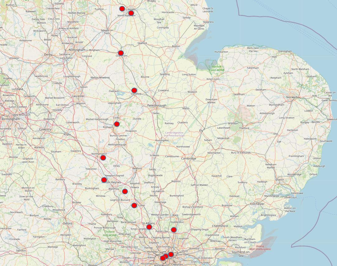
I have also created a map which shows all the City plaques that I have so far covered, with links to the relevant post. The map can be found here.

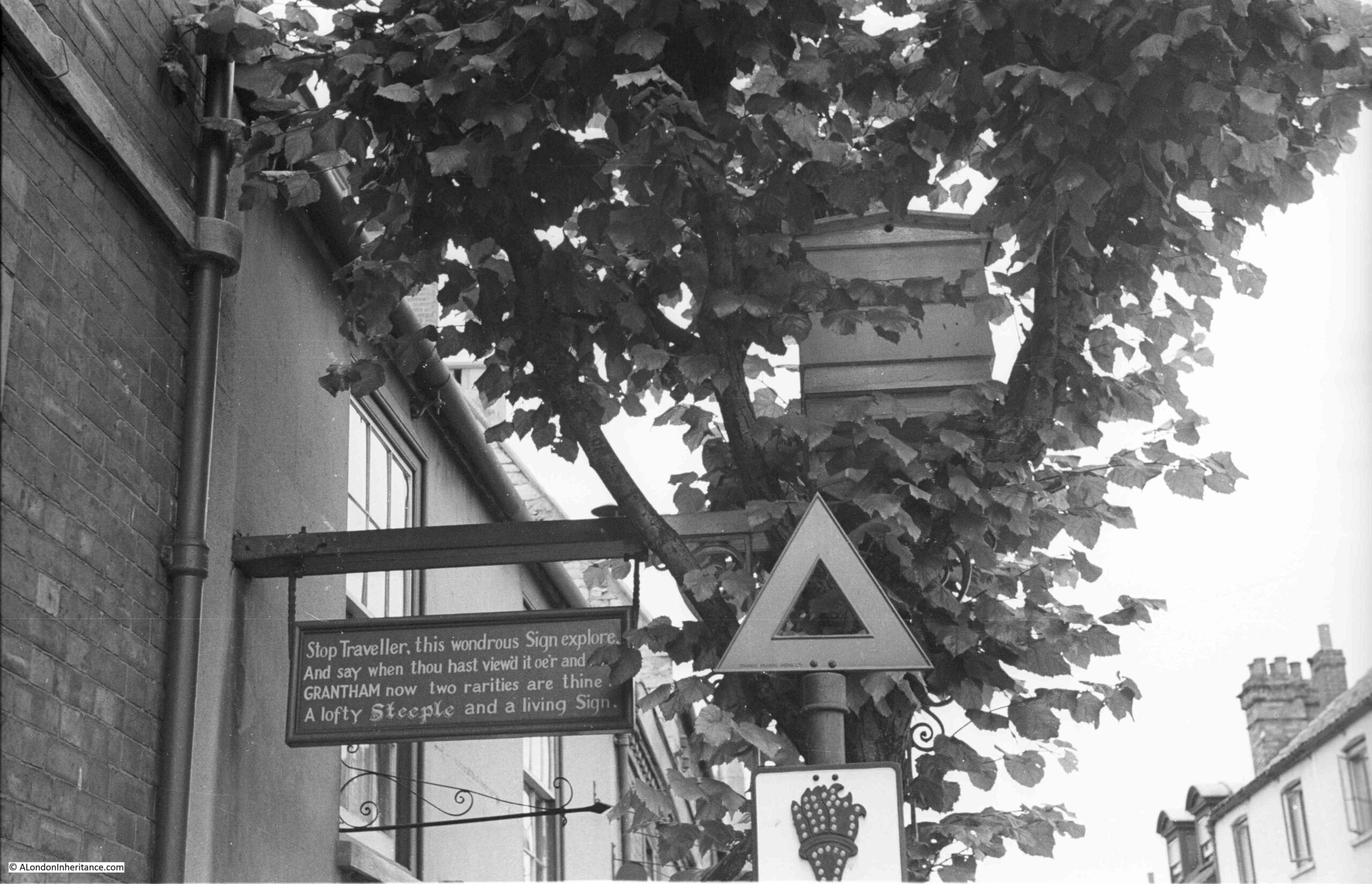
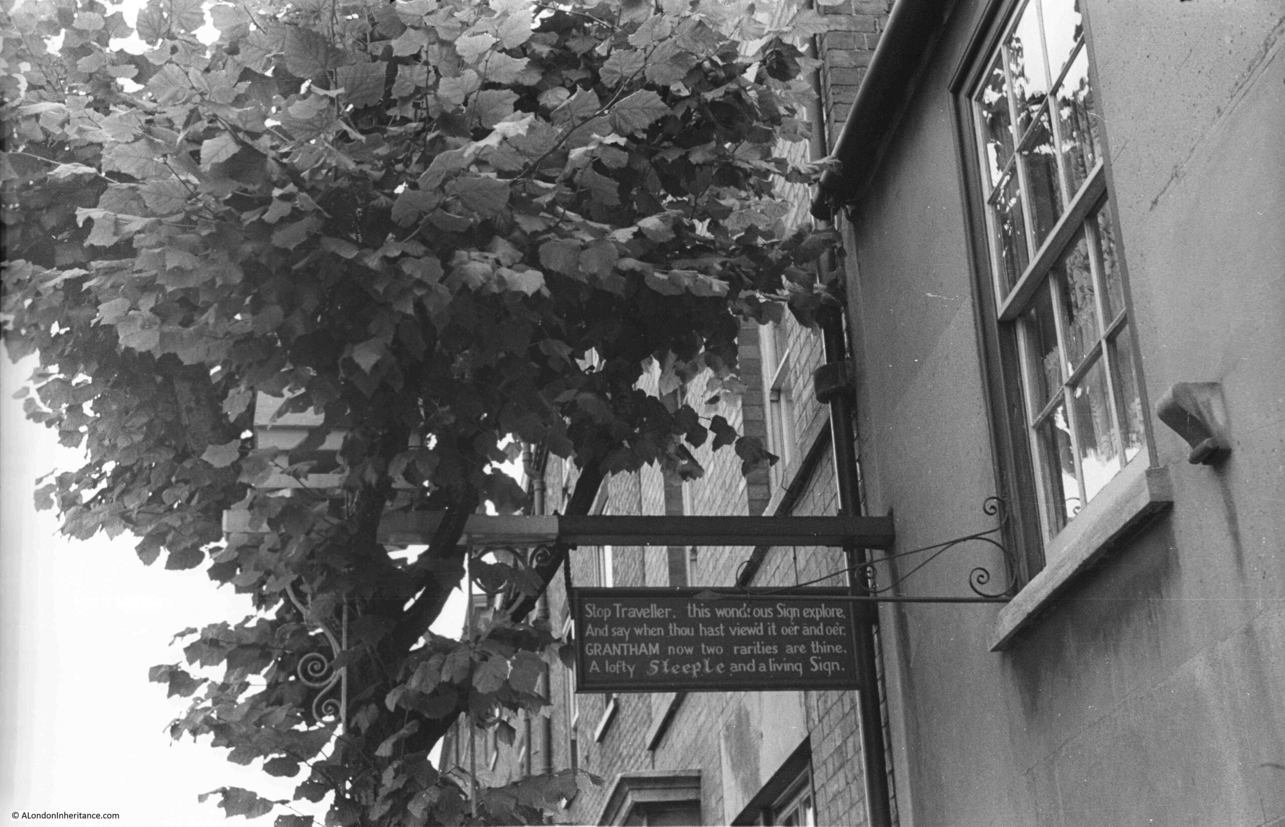
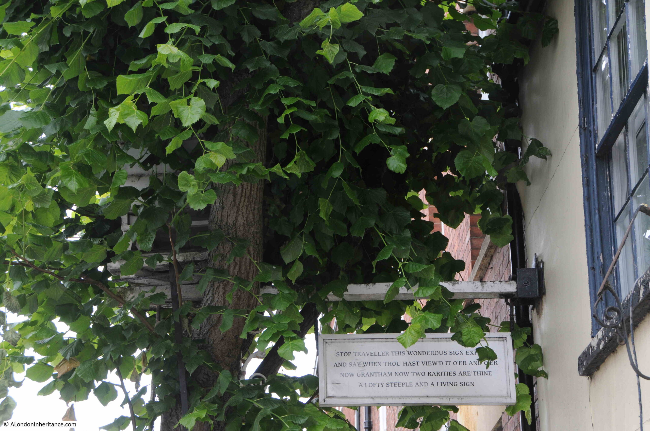
City of London Police District – Princes Street

I am starting with what appears to be a remarkable survivor that can be seen just above the entrance to the Bank Underground Station on Princes Street:

City of London Police District

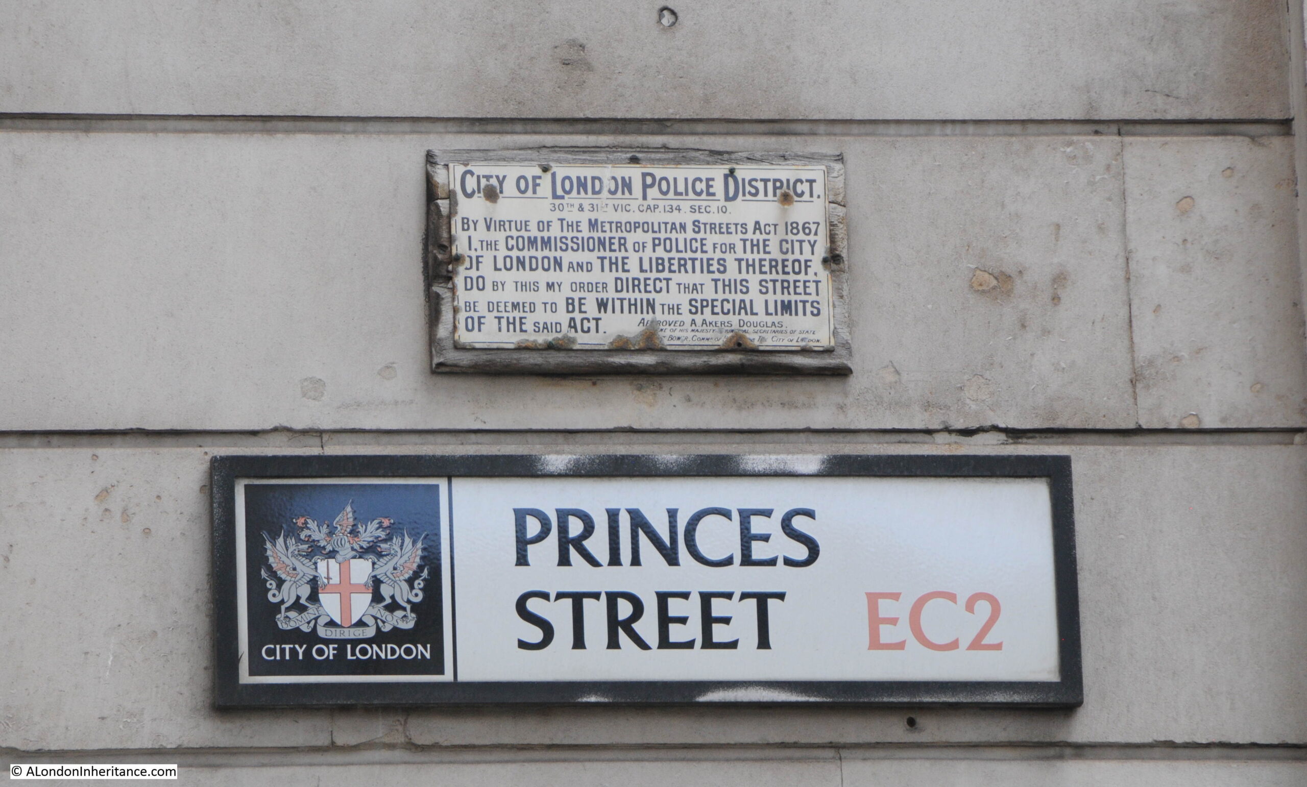
The plaque states that the street is deemed to be within the special limits of the Metropolitan Streets Act of 1867:

City of London Police District

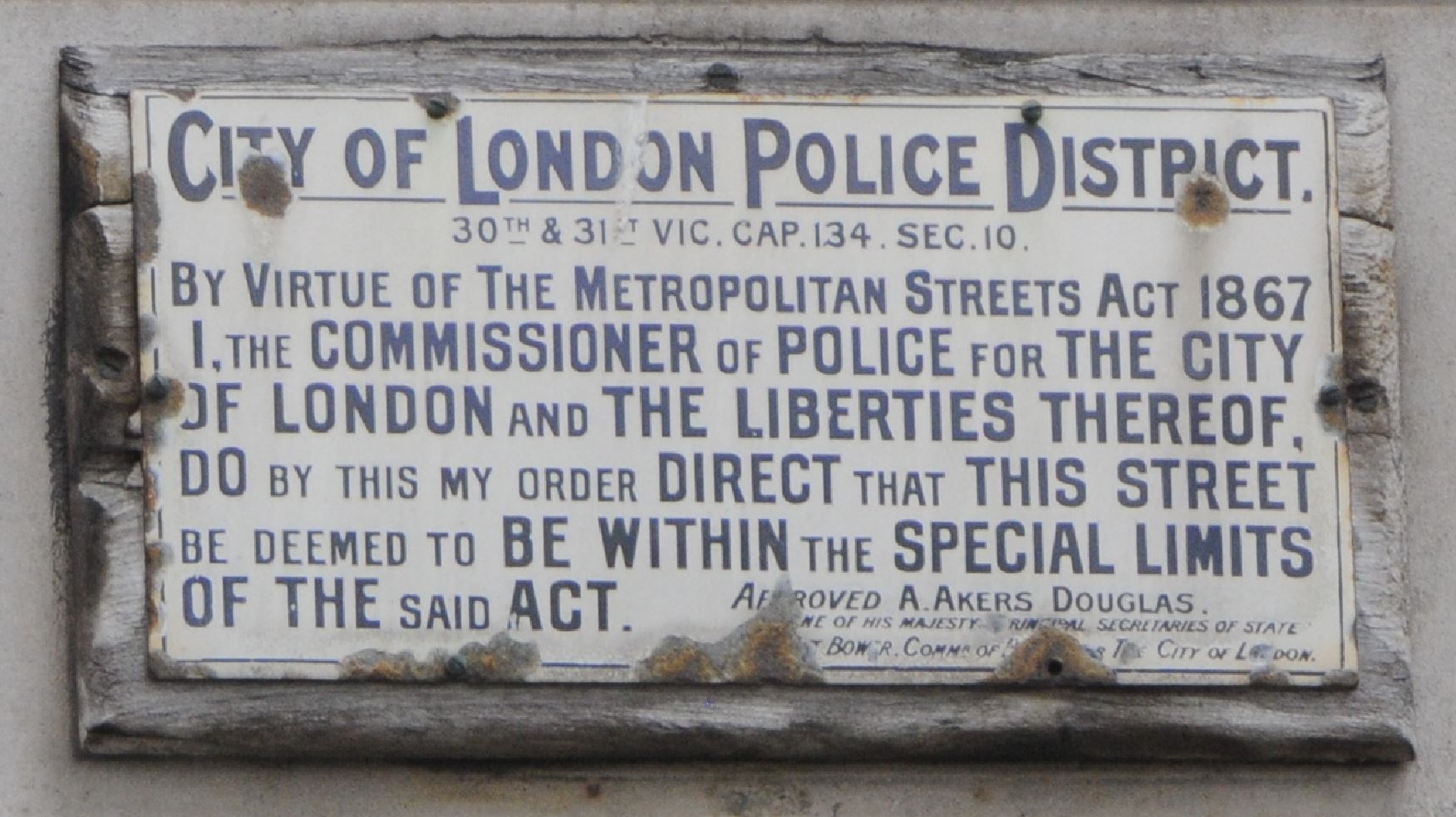
The Special Limits were powers granted by the act to Police Commissioners, allowing them to set or amend regulations on vehicle traffic along the street, as well as what could be loaded and unloaded along the street, and which could have blocked footpaths. These regulations usually applied for the majority of the working day, and presumably were intended to avoid too much traffic or activities that could have slowed down both traffic and pedestrians.

For Special Limits to apply, the Police had to advertise the fact at the street, ten days before they came into force, so presumably the sign is one of these advertisements that the Special Limits of the Act would apply to Princes Street.

The Act dates from 1867, but I was interested in the date of the plaque.

For Special Limits to apply, the City of London Police would have needed the approval of a Secretary of State, and at the bottom of the plaque is the name of A. Akers Douglas, stating that he approved the request and that he was a Secretary of State.

This was Aretas Akers-Douglas, 1st Viscount Chilston, who was Home Secretary between 1902 and 1905.

To confirm this date, there is the name of Bower at the bottom of the plaque, and although this line of text is damaged, he is listed as a Commissioner of the City of London.

Bower refers to William Nott-Bower who was Commissioner of the City of London police from 1902 to 1925, so his first years in this role align with the time that Akers-Douglas was Home Secretary, so the plaque dates from between 1902 and 1905.

It is remarkable what this plaque has seen. The Imperial War Museum archive includes a photo of bomb damage at the Bank road junction on the 11th of January 1941 when a bomb crashed through the road and exploded in the booking hall of the underground station.

The photo is not one of those that are downloadable and able to be reused on non-commercial sites, so a link to the photo is here.

Look to the left edge of the photo, and on the wall of the Bank there appears to be a couple of signs, one at the correct place and size to be the sign we see today.

It is a remarkable survivor.

Captain Ralph Douglas Binney – Birchin Lane

The next plaque is in Birchin Lane, part of the network of narrow streets and alleys between Cornhill and Lombard Street. Roughly half way along the lane, close to the entrance to Bengal Court, there is a plaque on a side wall, to the right of the following photo:

Captain Binney

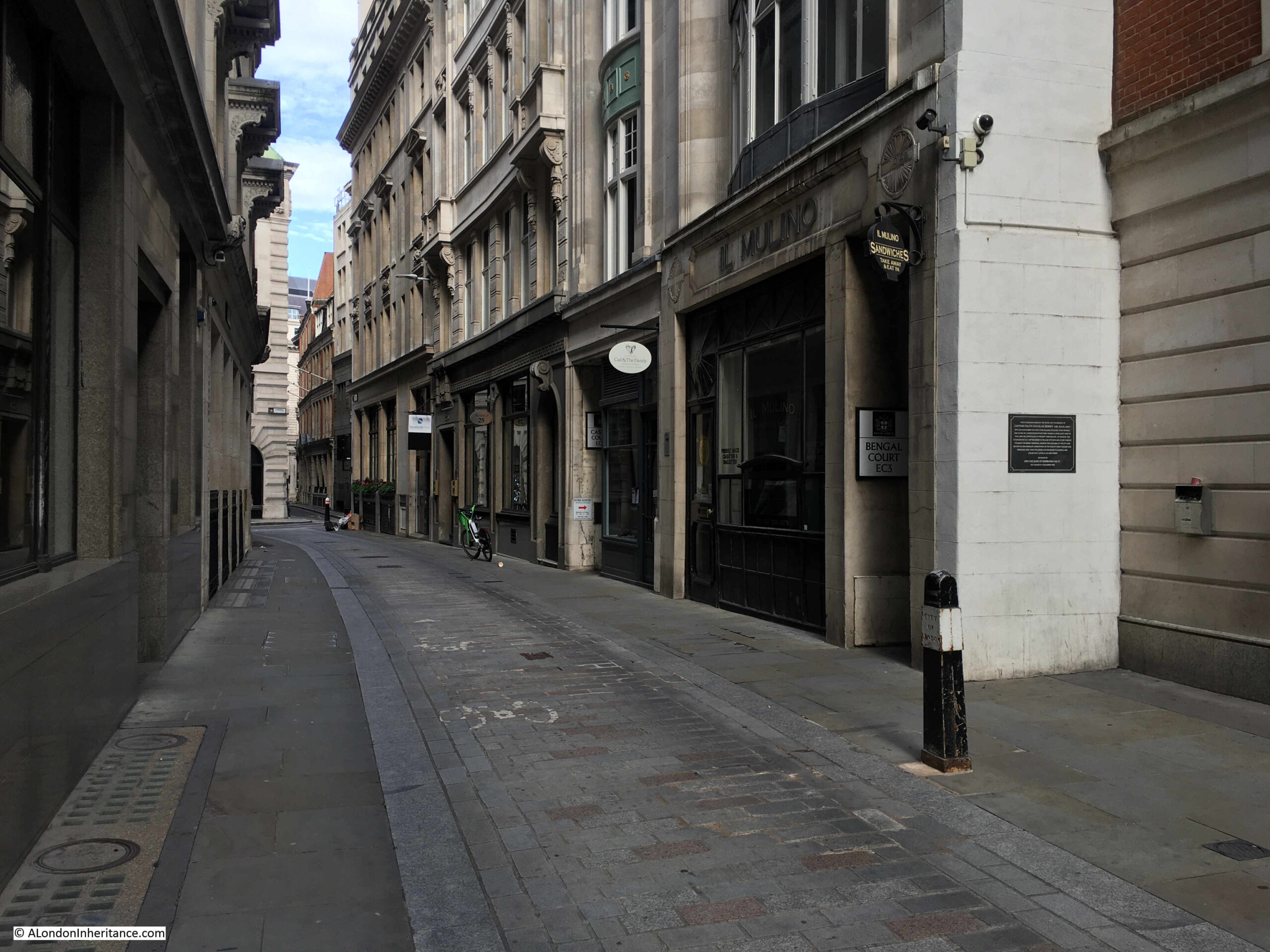
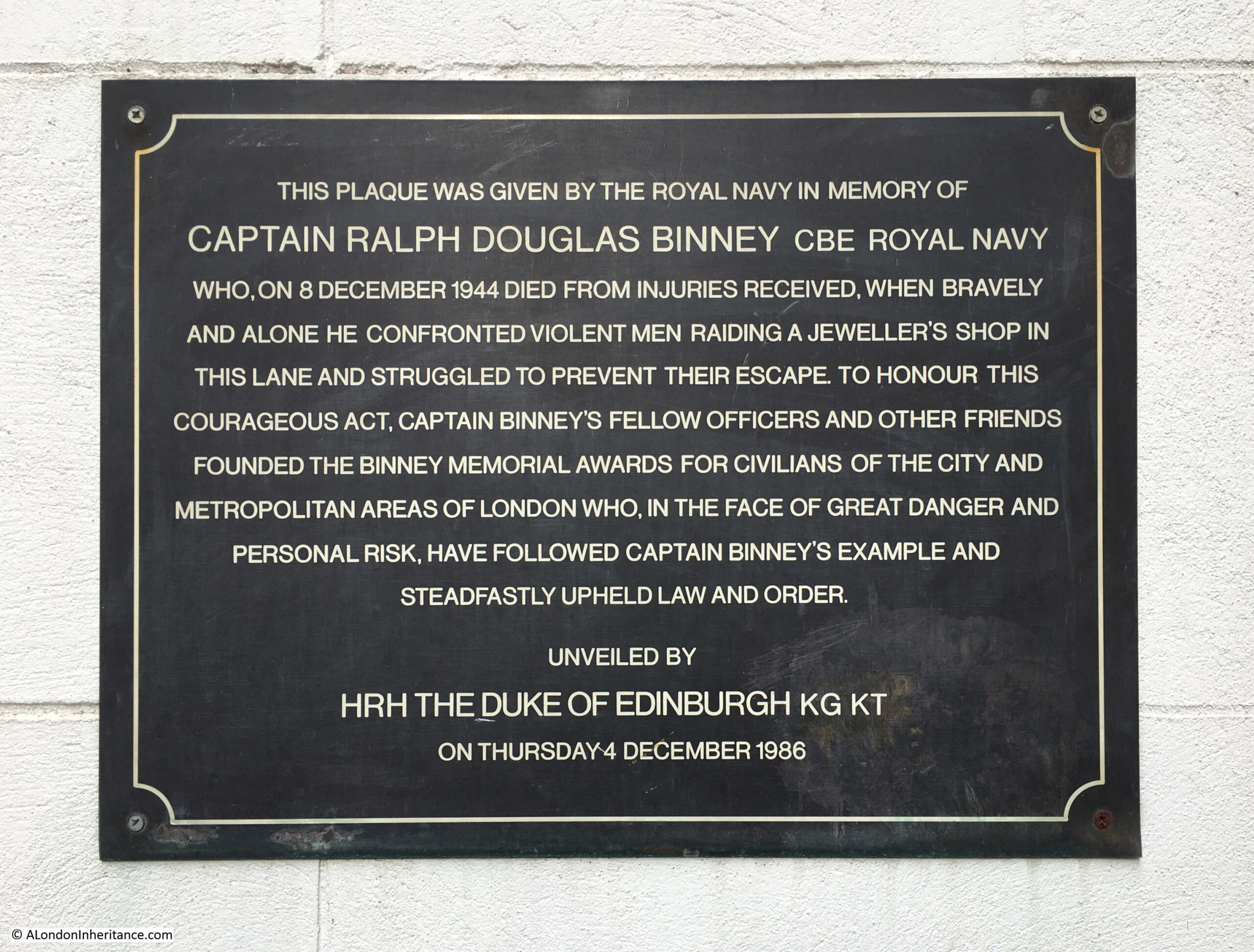
The plaque was given by the Royal Navy in memory of Captain Ralph Douglas Binney who died on the 8th of December 1944 from injuries received, when bravely and alone he confronted violent men raiding a jeweller’s shop in the lane:

Captain Binney

The event made the national newspapers, and the following is from the Daily Mirror on the 9th of December 1944:

“Captain Dragged To Death By Bandits’ Car: Horrified crowds saw an act of gangster callousness in the streets of London yesterday, as cold-blooded as anything known in the wild days of Chicago under prohibition.

They saw a 56 year old naval officer who had flung himself at a smash and grab bandits’ car dragged along to drop dying in the roadway half a mile further along.

They saw the car speed ruthlessly on as the officer, Captain Ralph Binney, caught in the chassis of the car, cried out for help. Captain Binney, chief staff officer to Admiral Naismith, leapt on to the running board of the car as it swept away at high speed from the shop of a jewellers in Birchin-lane, EC4.

The Captain called to the bandits to stop, but £3,500 of jewellery, looted from the shop window, and their own freedom was worth more than a human life to the robbers.

Driving on to King William-street, carrying the captain with them, the bandits disappeared towards London bridge.

Three hours later, in a quiet ward in Guy’s Hospital, the heroic captain murmured a dying farewell to his wife and his brother, Colonel Binney. His chief, Admiral Naismith hurried into the ward twenty minutes too late.

Last night the car was found abandoned in Tooley-street, SE. Police are anxious to contact anyone who, during the last few days, sold a new woodman’s axe, the weapon believed to have been used to smash the jewellers’ window.

Captain Binney had served thirty six years in the Navy. After six years in retirement he was put in charge of harbour defences at Gallipoli. On his return home in 1942 he was awarded the C.B.E.

Captain Binney leaves behind a widow and a daughter who is training as a nurse. His sub-lieutenant son was killed aboard H.M.S. Tyndale a year ago.”

There was a huge police hunt for those who had carried out the raid, and on the 12th of January, 1945 newspapers were reporting that “At Mansion House, London, today, Thomas James Jenkins (34), welder, of Rotherhithe, and Ronald Hedley, (26) labourer, were charged, with two men not in custody, with the murder of Capt. Binney, who, said counsel, was killed while doing his duty as a brave citizen.”

Ronald Hedley was convicted of the murder of Captain Binney and was sentenced to death, however this was later reprieved and he served 9 years in jail. Thomas Jenkins was convicted of manslaughter and was sentenced to 8 years in prison.

It appears that there were three others involved in the raid, but I cannot find any reference to their being identified, caught or sentenced.

Following Binney’s death, his naval colleagues formed a trust that would award a medal to a recipient who had shown bravery in the support of law and order in the areas controlled by the Metropolitan Police and the City of London Police.

The Binney award / medal appears to be an award that is still given, and is administered by the Association of Chief Police Officers, now covering the whole country, rather than the Metropolitan and City of London Police forces.

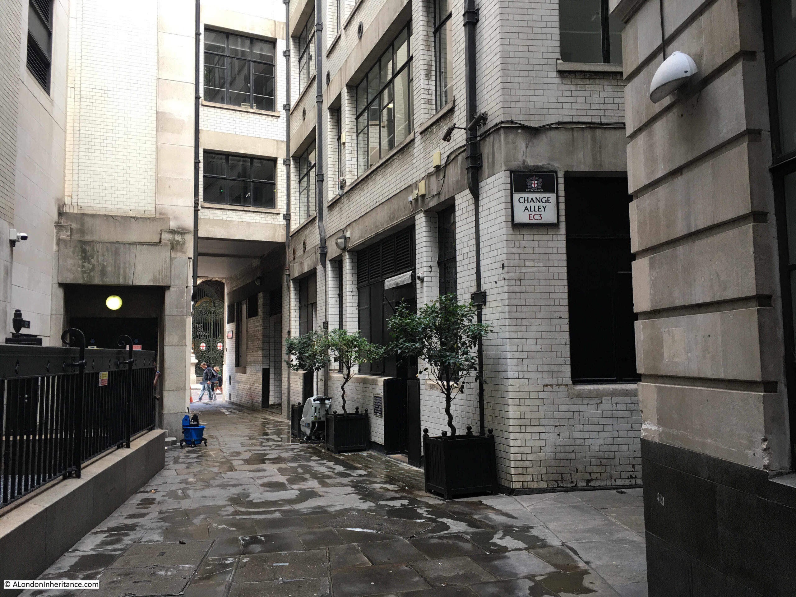
The next plaque is in Change Alley, which runs off from Birchin Lane:

Marine Society – Change Alley

Change Alley is a strange alley as there are multiple branches of the alley, including two separate branches between Cornhill and Lombard Street. In the core of this network of alleys is a blue plaque on the corner of a building:

Marine Society

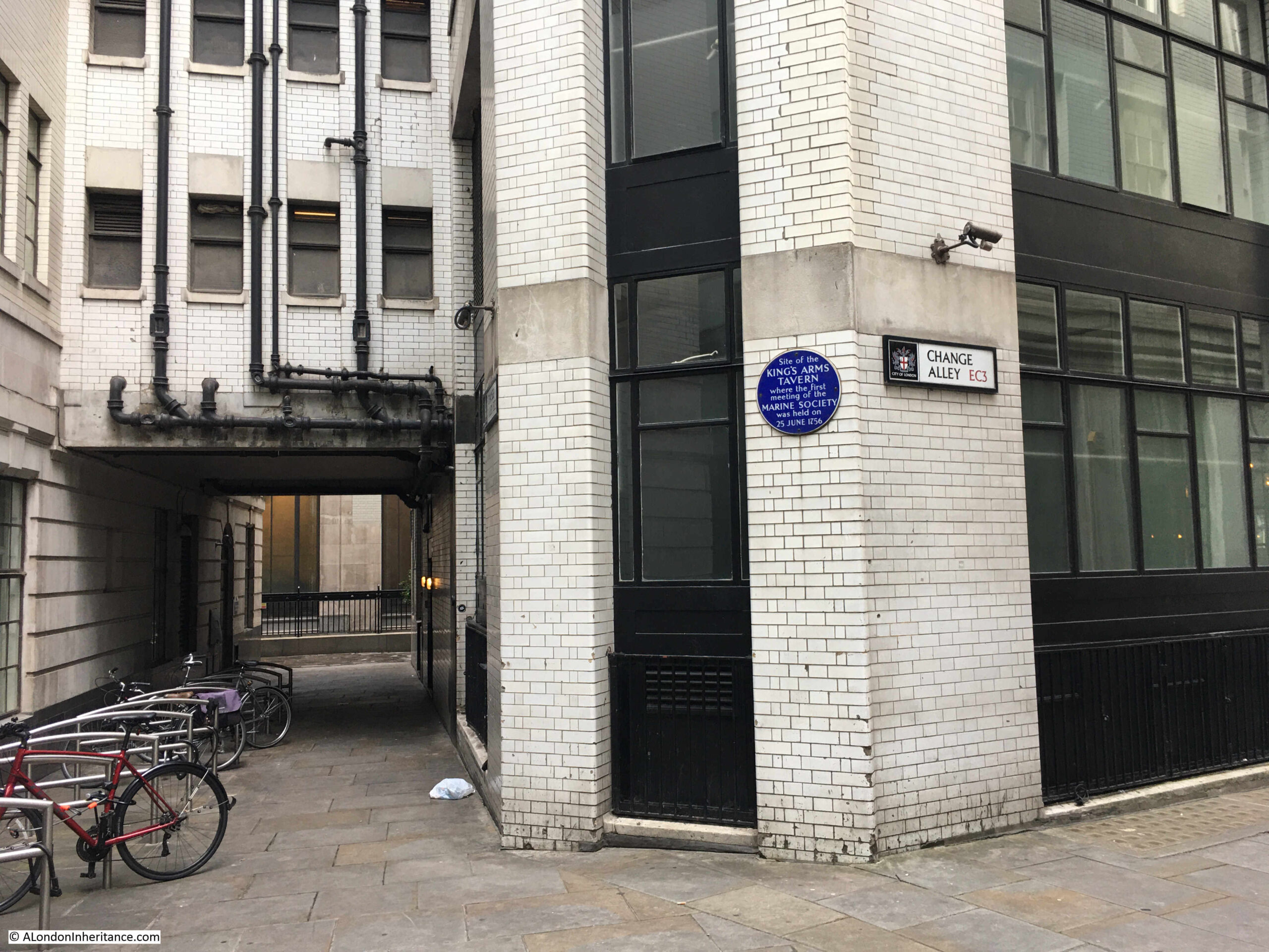
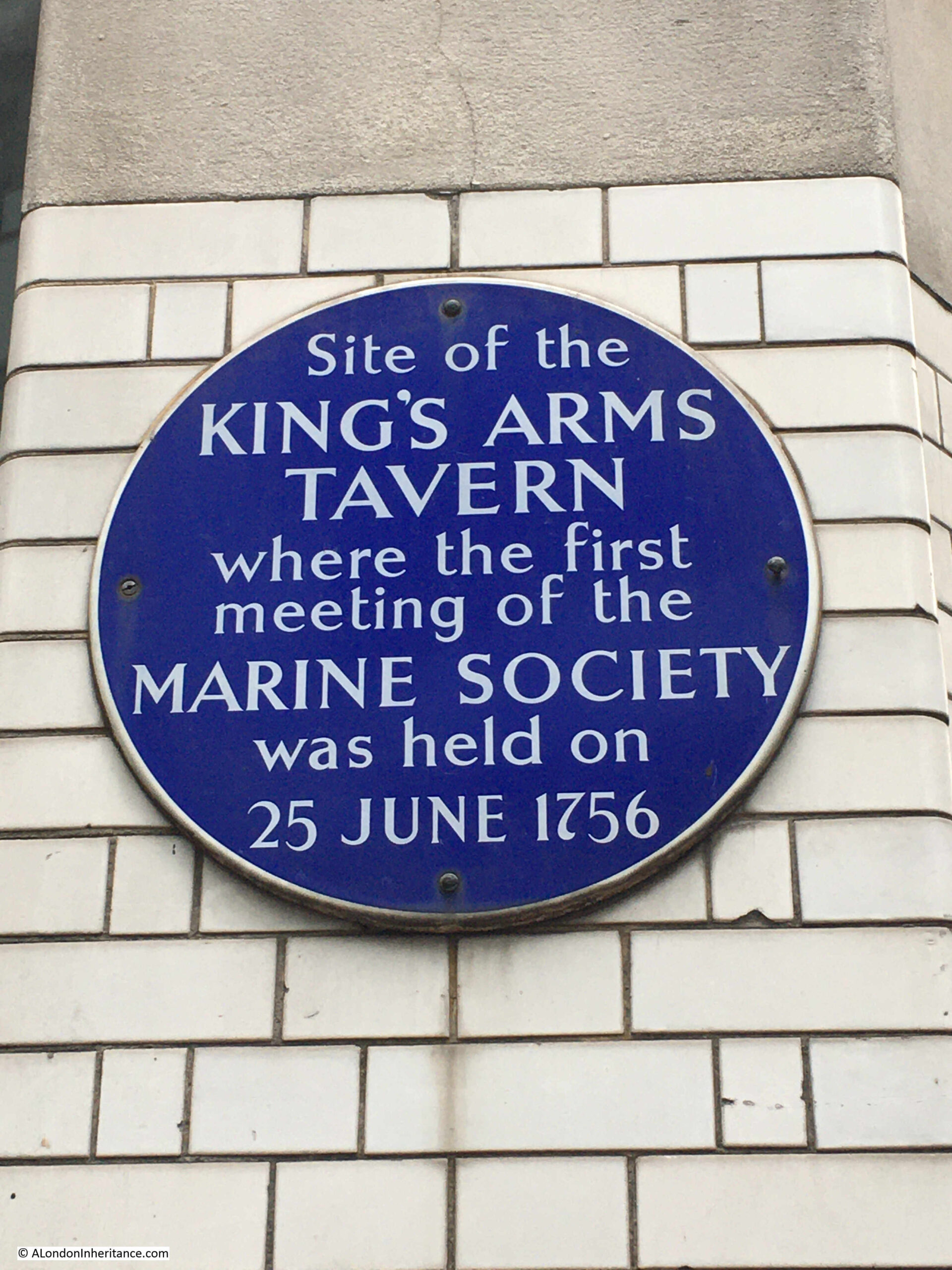
The plaque records that it is on the site of the King’s Arms Tavern, where the first meeting of the Marine Society was held on the 25th of June, 1756:

Marine Society

1756 was the year of the start of the Seven Years’ War, which ran between 1756 and 1763, and could be called the first world war, as it involved England, Spain and France, Prussia, Austria, Russia and Sweden. With conflict taking place in North America, across the Oceans and in the colonies occupied by the countries involved.

England was at war with the French, and the Marine Society was formed to provide additional naval resources to support the conflict. A newspaper report from the 2nd of July, 1756 reports on the founding purpose of the society:

“We hear the Marine Society lately formed by some eminent Merchants of this City, intend to open with the following noble Scheme. They purpose to fit out a Number of fine sailing Ships of War, and to send them to invest the Island of Minorca quite round, in order to prevent the French from sending to their Army any Reinforcements of Supplies; and at the same time to distress their Commerce in the Mediterranean. We wish there may be Time for the Execution of such a public spirited project.”

The primary aim of the Marine Society was to recruit boys and young men for the Navy. They would be recruited from the poor, orphans, the homeless. They would be clothed and fed, then sent from London to join ships at one of the Navy dockyards.

The following year, in 1757, the Marine Society were sending recruits to the Navy. The following newspaper report is a typical example of mid-18th century journalism, and describes the process and ceremony when the recruits left London:

“Last Wednesday 75 friendless Boys and 40 stout young Men, all Volunteers, were completely clothed by the Marine Society to go on board the Fleet, and at One o’clock the same Day they were drawn up on Constitution Hill, in order to express their Gratitude to his Majesty with three Cheers for his late Royal Bounty.

His Majesty’s Coach went very slow all along the Bank, and a Smile expressive of paternal Delight overspread his Royal Countenance; from thence they marched to the Admiralty who expressed great Pleasure at the Sight; from thence the Boys went to Lord Blakeney’s Head in Bow-street, Covent Garden, to dine on Roast Beef and Plumb Pudding; and Members of the Marine Society to the Crown and Anchor Tavern to Dinner, which consisted of one Course made up of Dishes truly English, namely, Roast Beef, Hams and Haunches of Mutton; after Dinner his Majesty’s Health, the Prince of Wales’s, &c. were drank, attended by the proper Salutes of Cannon; in the Evening they marched with the Men and Boys at their Head, to the Theatre Royal in Drury-Lane, where the Comedy of the Suspicious Husband was performed for the Benefit of the Marine Society, to a most brilliant Audience.

The Men and Boys were on Thursday reviewed by the Marine Society, at the Royal Exchange, and marched off to Portsmouth.”

The term “friendless boys” refers to orphans. With the relatively high mortality rate among the poor of the City, it was not unusual for a child to loose both parents and be left on the streets. These children were one of the target recruiting areas for the Marine Society. How much they knew of what they were getting into, and whether they really were volunteers is questionable.

After the recruiting exercise covered in the above report, the King gave £1,000 “to be paid for the use of the Marine Society”.

The number of conflicts the country was involved in during the late 18th century required a continual supply of manpower for the Navy, and in 1790, the Marine Society “since the appearance of a Spanish war, have already clothed and fitted out for sea, 1672 men and boys, most of them poor wretches, a burden to the community”.

The last sentence again highlights the target area for recruits, and that they were considered a burden to the community. Their transfer to the Navy relieved that burden and put them into a role that society at the time considered worthwhile.

The Marine Society would evolve over the late 18th and 19th centuries. It was recognised that sending recruits to the Navy who had a degree of training was of more benefit, so the society started training, and in 1786 the Marine Society became the first organization in the world to have a dedicated training ship, moored in the Thames at Deptford, where recruits would be trained before being sent to the Navy and the Merchant fleet.

Training became a growing element of the Marine Society’s role. The Navy would grow their own recruiting and training operation, so the Marine Society expanded their brief to the Merchant Navy and seafarers in general.

Based in a rather nice red brick building in Lambeth, next to the railway into Waterloo, the Marine Society is still in operation today. In recent years it has merged with the Sea Cadets and is now a major training organisation for seafarers and the maritime community – all from that meeting in a tavern in Change Alley in 1756.

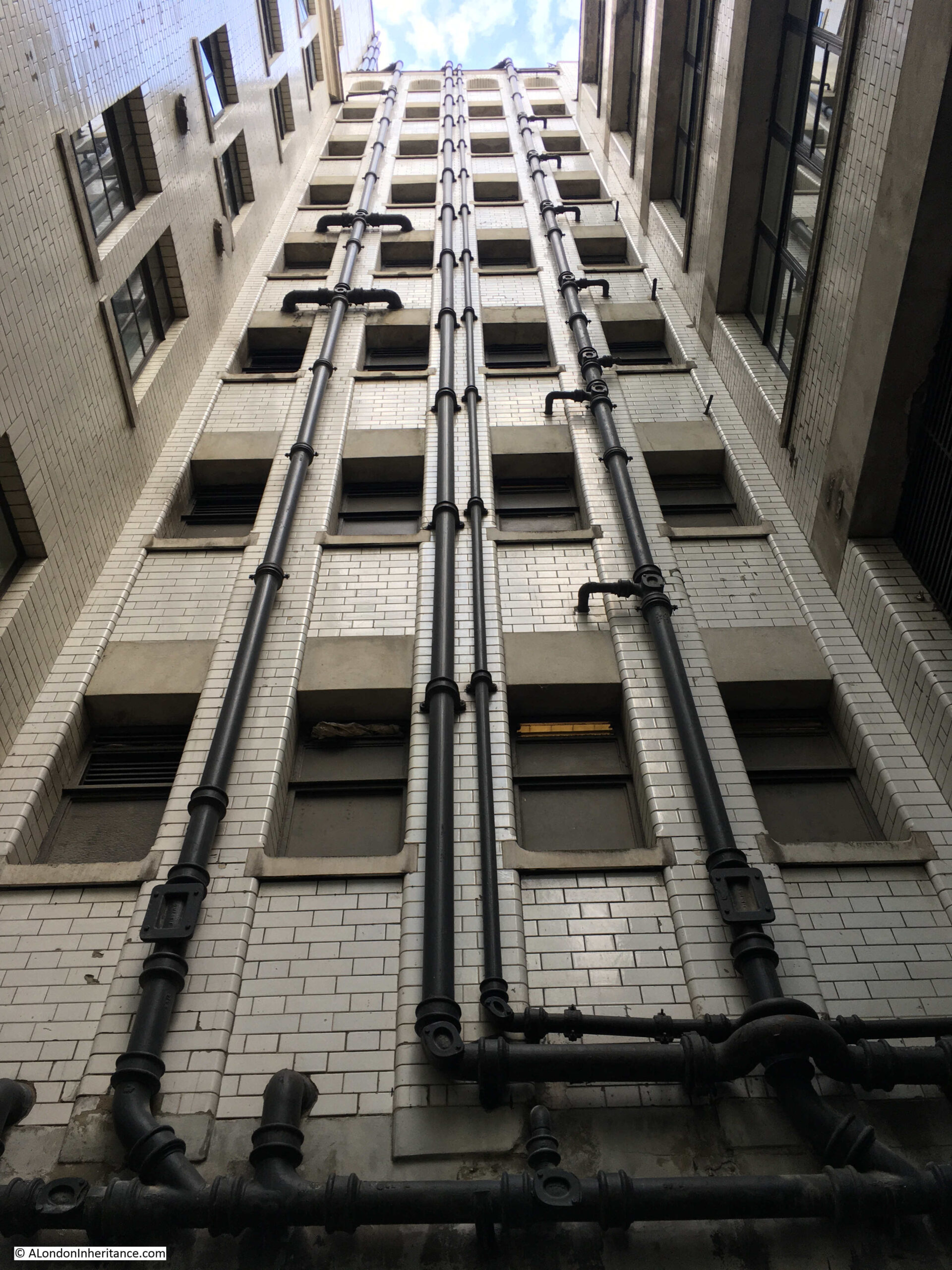
Change Alley is an interesting set of alleys to explore. Many of the buildings that face onto the alley are the backs of the buildings that face onto the main streets of the area, so they present a very different view. Of much cheaper construction, no ornamentation, and with exposed utilities, such as the following building with multiple pipes leading up to the sky:

Marine Society

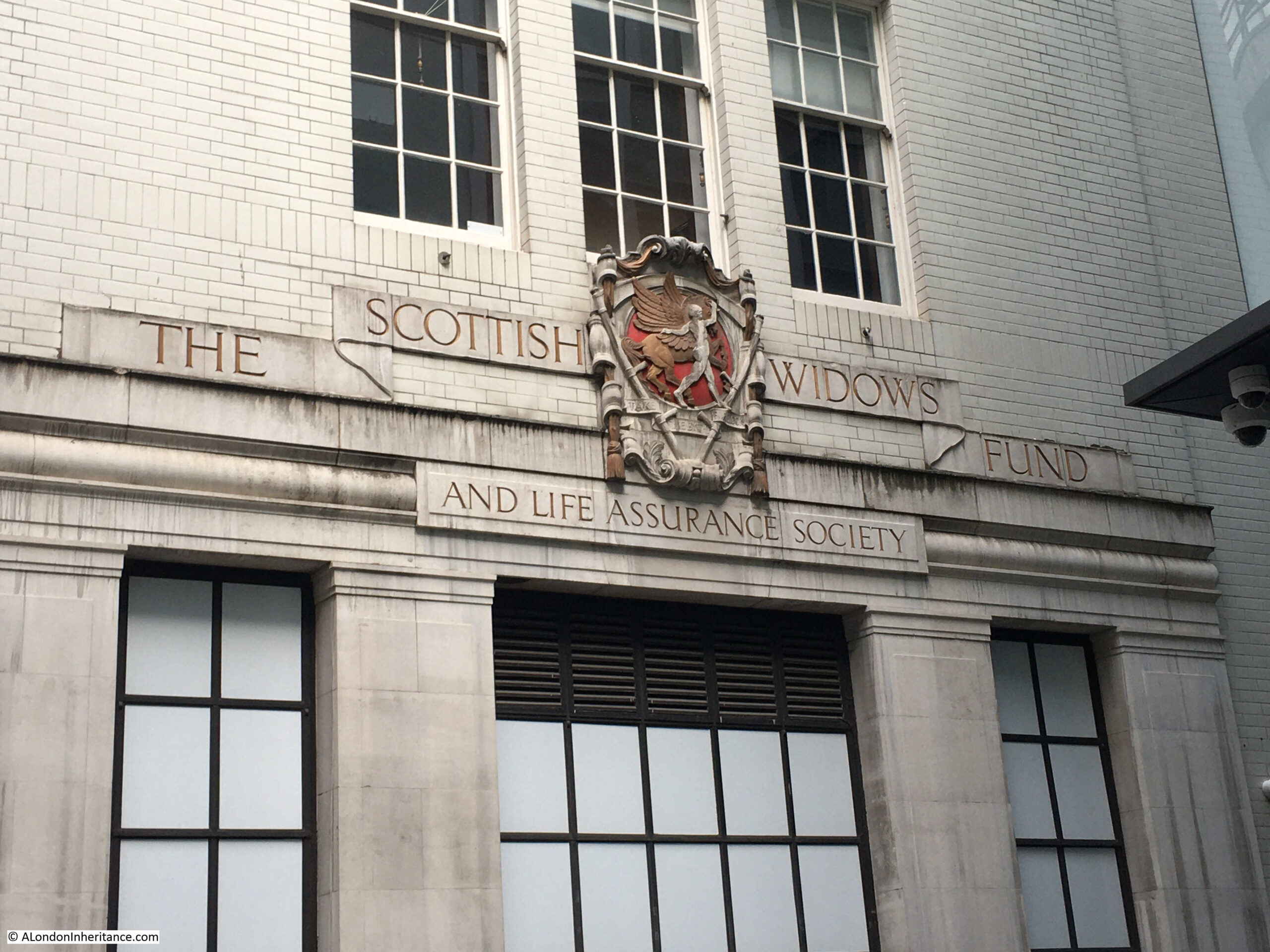
Despite many of these buildings being hidden in the alley, some do have a degree of decoration relating to the company that occupied the building:

Marine Society

My next plaque was in the same alley:

Jonathan’s Coffee House – Change Alley

The following photo is in one of the legs of Change Alley, and to the right of the middle small tree, there is a blue plaque, down almost at ground level:

Jonathan's Coffee House

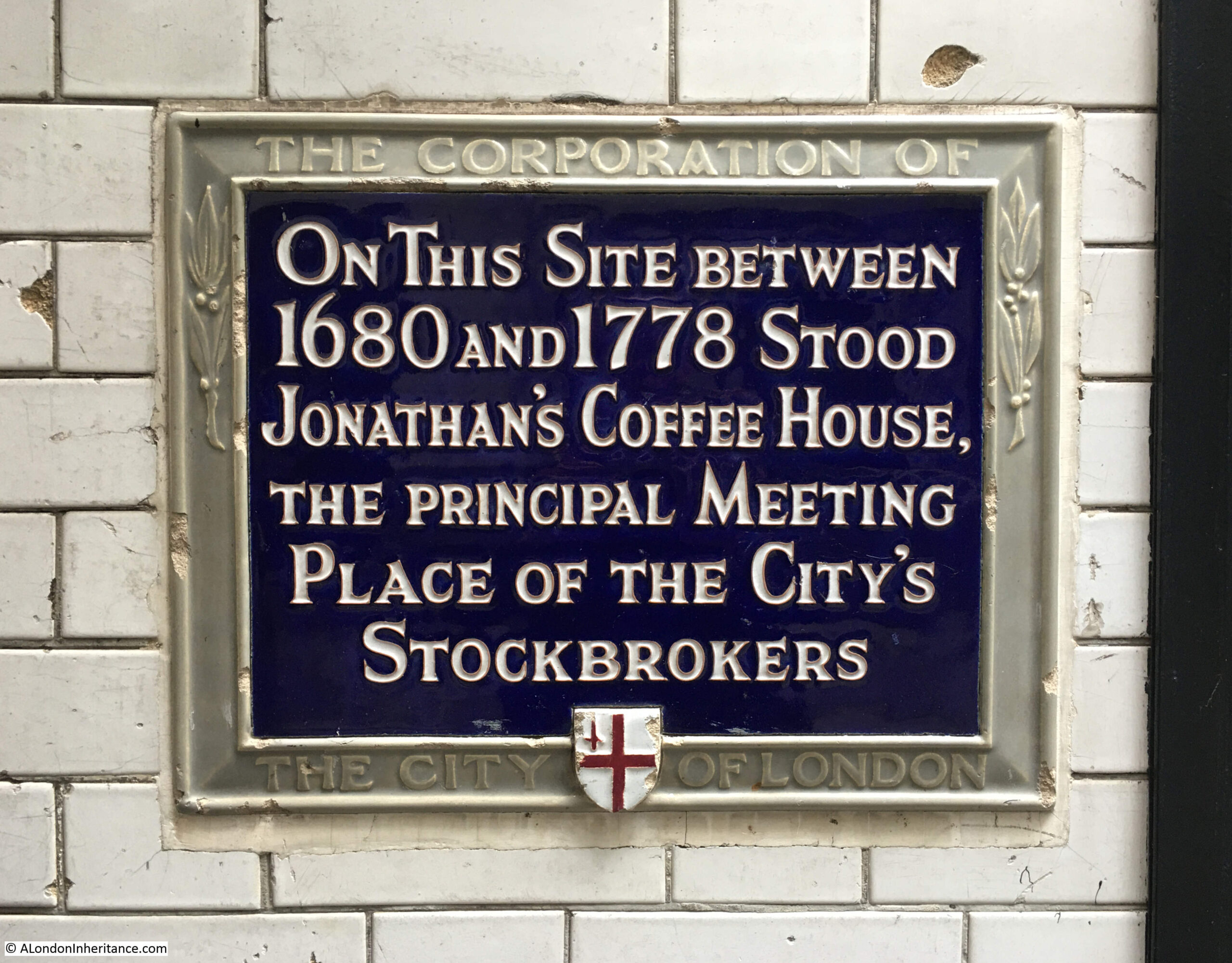
The plaque states that on the site stood Jonathan’s Coffee House between 1680 and 1778, the principal meeting place of the City’s stockbrokers:

Jonathan's Coffee House

Funds raised by the Crown and by Government had been in the form of arbitrary taxes and by the selling of the right to operate a monopoly, along with the raising of debts which were often not repaid.

As commercial activity expanded, and trade increased a more formal system was needed which ensured that the state could raise funds, and those lending these funds were assured that they would be repaid, with interest.

This led to the creation of “English Funds” which were basically the government debt which could be bought and sold. These funds would have a repayment date, and paid the owner of the funds interest. They therefore had a value.

Trading of these funds started in the Royal Exchange, and in 1698, many of those involved in the trading of these funds and securities started operating in Jonathan’s Coffee House in Change Alley. The move was down to laws that were enacted to limit the numbers of brokers and to more regulate the market, as so many people had been tempted into the market based on “false rumours and reports were propagated to raise or depreciate the value of stocks. Mines of wealth were promised, stratagems of every kind were rife; some made fortunes, others were ruined”.

Many of the roles and terminology in play at Jonathan’s Coffee House are still in use today, although many did disappear as recently as the 1980s with the deregulation of the Stock Market during the “Big Bang”.

An 1828 description of Jonathan’s Coffee House also describes the meaning of many of the terms associated with stocks and share trading:

“In Change-alley was formerly a rendezvous of dealing in the funds, and the term Alley is still a cant phrase for the Stock Exchange, and hence a petty speculator in the funds is styled ‘a dabbler in the alley’. A stock-broker is one who buys and sells stocks for another; his commission is one-eighth per cent. A stock-jobber is one who buys and sells on his own account, buys in when low and endeavours to sell out at a profit.

A gambler in the funds is one who speculates to buy or sell at a future time for a present price, who may lose or gain according as the prices then fall or rise; this being illegal, no action for recovery of loss can be maintained. The buyers are styled ‘bears’ as they endeavour to trample down the prices; the sellers are named bulls, for a like reason as they attempt to toss them as high as possible. One who becomes bankrupt is termed a lame duck, and he is said to ‘waddle out of the alley’. Those who have thus waddled are not again admitted to the Stock Exchange”.

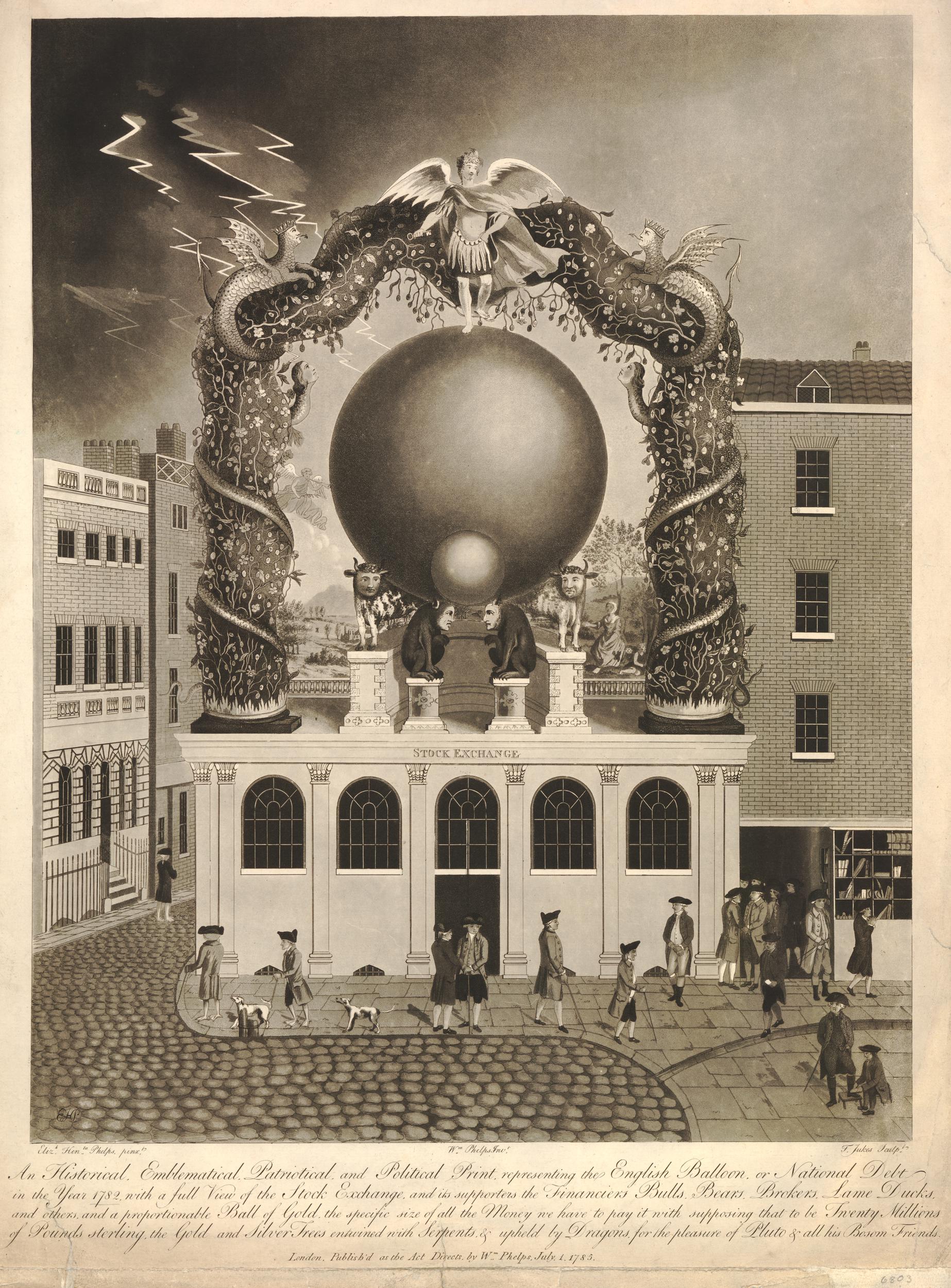
The following satirical print, dated the 2nd of May, 1763 shows Jonathan’s Coffee House, and the text below describes a visit by the Devil, who sees the characters in the coffee house, including the bull, the bear and the lame ducks, and old Nick cries that “there’s room for you all in the regions below”, and that “For sure ’tis a shame that such vile occupations, should suck the best blood from the best of all Nations” (© The Trustees of the British Museum):

Jonathan's Coffee House

Jonathan’s Coffee House was destroyed in a fire that started on the 30th of March 1748 in Change Alley, in the premises of Mr Eldrige’s, a Peruke-maker (the long wigs worn by upper class men). Much of Change Alley, and some houses on Cornhill were destroyed, however Jonathan’s Coffee House was soon rebuilt, and trading continued.

Those engaged in trading at Jonathan’s Coffee House moved to a new location in Threadneedle Street in 1773, and papers on the 17th of July 1773 were reporting that at the new location: “Yesterday the brokers and others at New Jonathan’s came to a resolution, that instead of it being called New Jonathan’s, it should be named The Stock Exchange, which is to be wrote over the door. The brokers then collected sixpence each, and christened the House with punch.”

The Stock Exchange as it was now called began trading on more formal lines, and traders had to pay a fee to enter the trading room.

The Stock Exchange would continue trading within a physical place until the 1980s, when the deregulation of London’s financial markets resulted in the transition to screen based trading. The Stock Exchange moved from their Threadneedle Street location to offices in Paternoster Square in 2004 as a trading location was not needed, only offices for the administration, regulation and management of the Stock Exchange.

Following the change of debt being raised by the country, rather than the Crown imposing taxes or borrowing money, the national debt has always been a cause for concern.

The print below is a satirical print published in 1785 showing the Stock Exchange supporting the national debt in 1782, or what the print called the “English Balloon” (© The Trustees of the British Museum):

Jonathan's Coffee House

In 1783, the National Debt stood at around £250 million. It had risen throughout the 18th century due to the many wars that the country was involved with. and which required considerable funding. Pitt the Younger who became Prime Minister in December 1783 put in place a number of changes to both clamp down on tax evasion (such as smuggling), and increasing taxes which resulted in the debt coming under control and confidence in the Pound being restored.

By comparison, the Office for National Statistics reports that the UK debt was £2,436.7 billion at the end of Quarter 2 (Apr to June) 2022. Taxes are increasing and there was recently a brief loss of confidence in the Pound – something’s never really change. The “English Balloon” just gets much larger.

My final location is in Lombard Street, to the south of Change Alley, however my last comment on the alley is the origin of the name. It was originally called Exchange Alley as it was opposite the Royal Exchange. The name simply became abbreviated to Change Alley. Now leaving the alley to the south to find:

Lloyd’s Coffee House – Lombard Street

To the right of the main entrance to Sainsbury’s in the following photo is a blue plaque:

Lloyds Coffee House

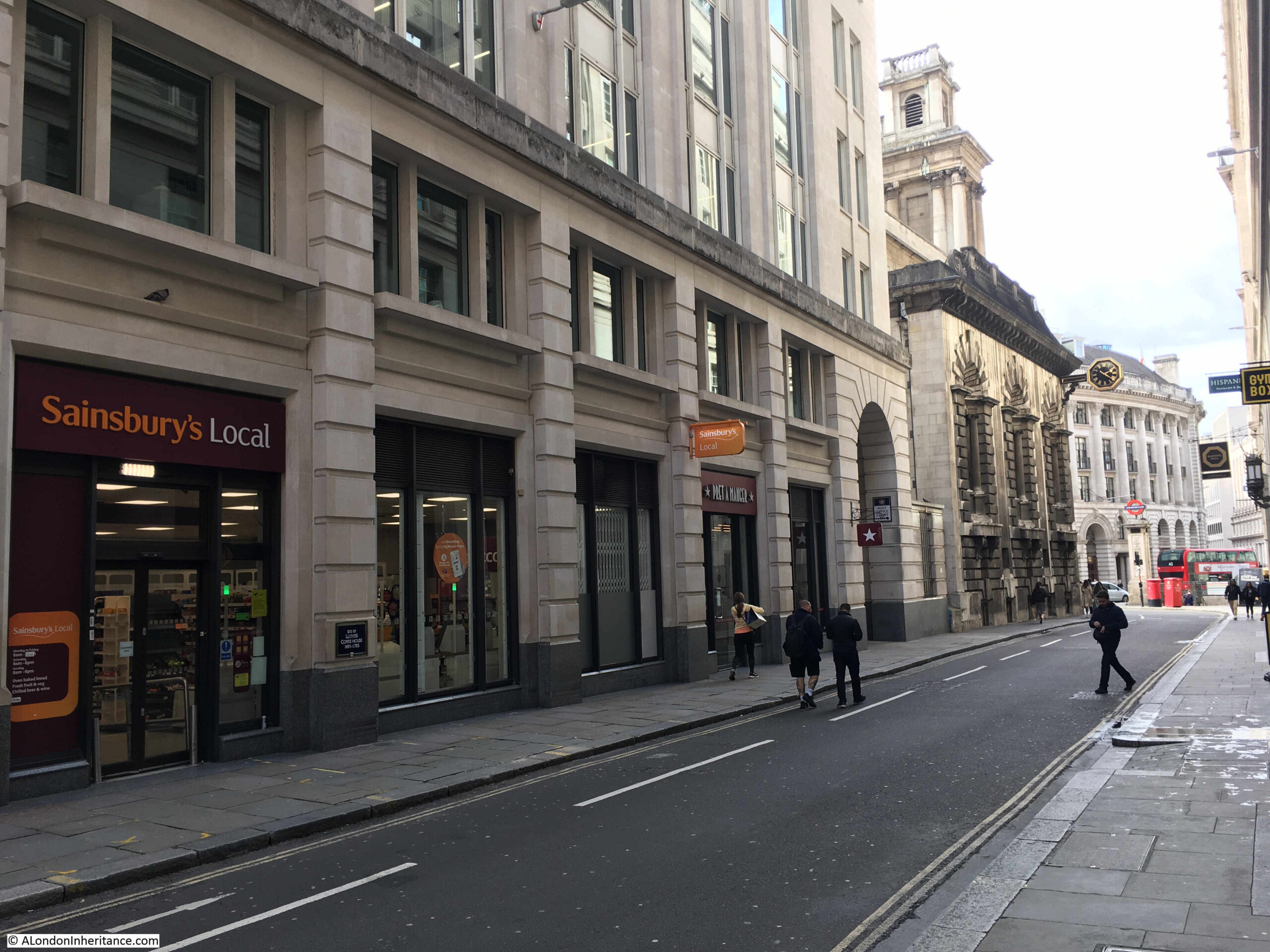
Marking the site of Lloyd’s Coffee House:

Lloyds Coffee House

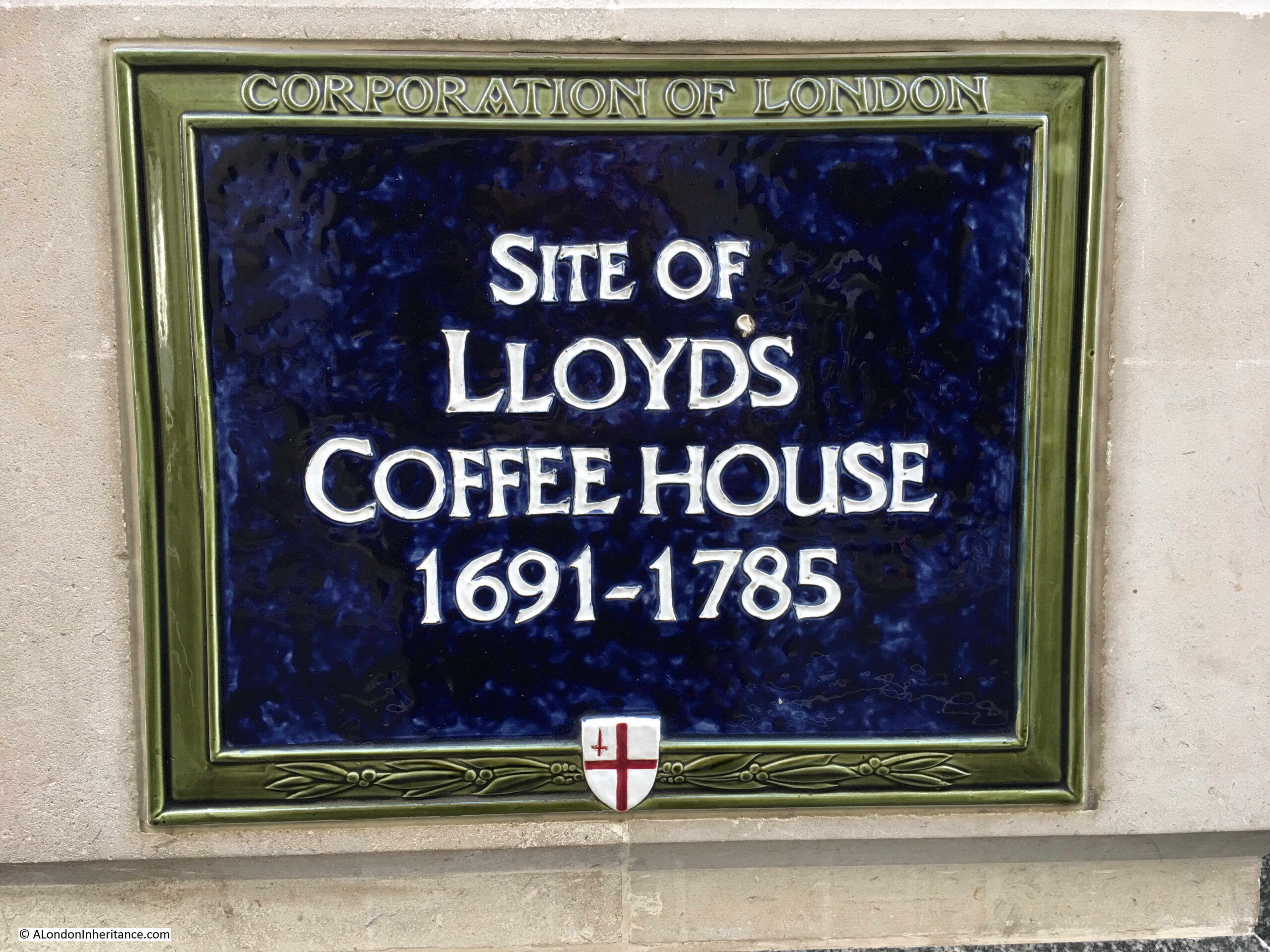
Very much like Jonathan’s Coffee House, Lloyd’s Coffee House was the original site for a City institution that is still running today.

Lloyd’s Coffee House was opened by an Edward Lloyd in February 1688. Initially in Tower Street, the Coffee House moved to the Lombard Street location indicated by the plaque in 1691.

Lloyd’s Coffee House became a meeting place for those involved in shipping and marine insurance.

The coffee house started publishing its own newspaper using the information gathered from customers, and the paper became an essential resource for those working in shipping related industries of the City.

An article / advertisement published on the 12th of June, 1758 explained why the paper had so much early information:

“This day is published number 140 of Lloyd’s Evening Post and British Chronicle. A paper of Military, Naval, Commercial and Literary Intelligence published every Monday, Wednesday and Friday evening at Seven O’clock.

Lloyd’s Coffee House is known to be the centre of intelligence, from the most considerable trading parts of the world, and accounts of naval transactions are frequently received there even before they arrive at the First Offices of State. Many articles of intelligence have therefore appeared in this paper, the authenticity of which has been questioned by news writers in the common posts, who, unable to fathom how they were attainable at first have, after exploding them, adopted and inferred them in their Papers as new, many days after they appeared in this.

It is no wonder therefore that this paper has met with uncommon opposition, the most notorious falsehoods have been propagated to prejudice it, its connection with Lloyd’s Coffee House has been publicly denied, and the facts inferred in it have been efficiently discredited. Notwithstanding which the paper thrives. Truth, which will always manifest itself, has dispersed the clouds of falsehood, and the merit of the paper has rendered all detraction and opposition ineffectual.

Advertisements are taken in at Lloyd’s Coffee House in Lombard Street.”

I love that the colourful language of the article, defending its position as an early source of news, ends with a simple statement about where advertisements should be sent.

Edward Lloyd died on the 15th of February 1713, and his son-in-law William Newton took over. Newton had married Lloyd’s daughter Handy, who died in 1720.

After 1763, the reputation of the coffee house started to decline. It became a place of gambling and also stock jobbing (as took place at Jonathan’s Coffee House), and a New Lloyd’s Coffee House opened at 5 Pope’s Head Alley in 1769, although the Lombard Street coffee house continued in business, still a meeting place for those in the shipping and maritime insurance trades.

The Society for the Registry of Shipping was founded at Lloyd’s Coffee House in 1760, and in 1786 the society moved to new premised at number 4 Sun Court, Cornhill.

So from Lloyd’s Coffee House, two City institutions evolved:

  • what would become the Lloyds of London Insurance market were the activities that moved from Lloyd’s Coffee House to 5 Pope’s Head Alley and;
  • what would become Lloyd’s Register which is now in Fenchurch Street were the activities that moved from Lloyd’s Coffee House to 4 Sun Court.

Five very different plaques which highlight the varied history of the City of London, and which have had significant influence on the city we see today.

alondoninheritance.com

The Spaniards Inn, Hampstead

Thanks for all the feedback to last week’s series of posts on Eleanor of Castile – very much appreciated. A very different post today, as I am visiting the site of one of my father’s photos, and this is of the Spaniards Inn in Hampstead, photographed in 1948:

The Spaniards Inn

I had to be in Hampstead last week, so used the opportunity to cross this one off my list of my father’s photos to visit, however it was a misty, autumn day. I waited for much longer than the weather forecast predicted it would take for the mist to disappear, and finally had to take a misty comparison photo before I had to leave, so this is the same view today, a misty Spaniards Inn in 2022:

The Spaniards Inn

Different weather, different perspective due to very different cameras, and colour vs. black and white, however, look past that and the two views are almost identical across 74 years.

Even the small triangular pavement between the two car park entrances is still the same. The cars approaching along the road from behind the pub are though very different.

The Spaniards is a very old pub, believed to date back to the 16th century.

As with any pub of such age, there are plenty of stories about the pub, many of which have been repeated in newspapers and books for at least the last 150 years, so may well have a grain of truth.

Regarding the name, I have read two different accounts, firstly that there may have been two Spanish owners of the pub, who killed each other in a duel, secondly, that the pub was named after the Spanish Ambassador to James II.

There are stories that the highwayman Dick Turpin used the pub, and kept his horse in one of the buildings.

What does seem to be true is that the pub played a role in the Gordon Riots. This was in June 1780 when there were violent anti-Catholic riots in London. At the time, Kenwood House, not far from the Spaniards, was the home of the Earl of Mansfield, the Lord Chief Justice. He was rumoured to have pro-Catholic sympathies, so the rioters set out from central London with the intention of burning down Mansfield’s Kenwood House.

The rioters stopped in the large gardens of the Spaniards Inn, and the landlord, along with the Earl of Mansfield’s steward gave the rioters large amount of drink, which gave them time to summon soldiers, and by the time they arrived, the rioters were in no fit state to resist.

The Spaniards Inn also features in Dickens’ book, Pickwick papers where Mrs. Bardell and her friends take the Hampstead Stage to the Spaniards Tea Gardens. The Inn is also mentioned in Bram Stoker’s Dracula, where the vampire hunter Van Helsing, after having supper in Jack Straws Castle, then: “By good chance we got a cab near the “Spaniards,” and drove to town.”

Many of the literary and artistic inhabitants of, and visitors to Hampstead are believed to have visited the Spaniards Inn, including Keats, Shelley, Byron, Hogarth and Constable.

I walked to the Spaniards Inn from Hampstead, firstly walking up to Spaniards Road, where there is one of type of street signs that can be found across Hampstead, which also has a pointing hand symbol indicating the direction to Highgate.

Spaniards Road

The road between Hampstead and Highgate runs along the north and north-western borders of the heath, and the Spaniards Inn can be found at roughly the half way point along the heath’s border. Spaniards Road runs up to the inn, and soon after the road changes name to Hampstead Lane – one of the indicators that the inn has long formed a boundary between Hampstead and Highgate.

The location of the Spaniards Inn is circled in the following map (© OpenStreetMap contributors):

The Spaniards Inn

My father’s photo shows the corner of the Spaniards Inn directly on the road, with a car just coming from behind the pub. To discover why the inn is at such a historic location, we need to zoom out to a wider view of the road that runs to the side of the inn:

The Spaniards Inn

As the road passes the Spaniards Inn, it narrows and bends around the corner of the inn. On the opposite side of the road is a small square building.

This point in the road was the location of a toll gate, and travelers had to pay a toll when passing along the road in the direction of Highgate, as the land to the west of the tollgate was owned by the Bishops of London.

The square building on the opposite side of the road was the 18th century toll gate house.

The Spaniards Inn and the toll gate feature in John Rocque’s 1746 map of London.

In the following extract, I have circled the location of the inn and the gate:

Location of the toll gate

I love the detail that can be found in Rocque’s maps. In the map below, I have zoomed in on the location of the inn and the toll gate. Where the toll gate is located, there is a dotted line across the street (see red arrow), which I assume is a representation of the gate that would have barred the street to allow collection of tolls.

Location of the toll gate

The name Spaniards Gate can be seen above, implying that the gate took the name from the inn. one interesting feature is the way the road is represented on either side of the toll gate. To the right of the toll gate is the Bishop of London’s land. The road looks wider and more defined. To the left of the gate, the road is narrow and seems more like a track.

The toll was collected when you travelled into the Bishops of London land, moving left to right in the above map, and when you passed through the gate, you also started to travel on better roads. Even today, the road widens soon after passing the toll gate heading to the east.

The following print from around 1840 shows a very similar scene to today, although the road and traffic along the road are very different  (© The Trustees of the British Museum).

The Spaniards Inn

As the road between Hampstead and Highgate passes the Spaniards Inn, traffic has to slow as there is not really enough space for two cars to pass through the gap.

The road is a busy road with an almost continuous stream of traffic. It took a while to get some reasonably traffic free photos.

it is remarkable that the toll gate house, and the narrow width of the road has remained as traffic has increased. There have been a number of attempts to remove the toll gate house, and widen the road, for example, one hundred years ago, the Hampstead and St John’s Wood Advertiser on the 14th of December 1922 reported that:

“The proposal to widen the road where it forms a sort of bottle-neck by the Spaniards Inn at the Highgate end of Hampstead Heath, if carried out, would probably mean a destruction of the famous old tavern, and the little brick building that stands opposite to it, on the Kenwood side of the road. In spite of the great volume of traffic on the Spaniards-road itself, on high days and holidays, it is not really a main thoroughfare to anywhere.”

The 1922 proposal to widen the road did not make any progress, and almost 40 years later, in 1961 there was another attempt, as reported in the Hampstead News, Golders Green Gazette and Journal on the 27th of January 1961:

“Tollhouse: Council Must Act – The L.C.C.’s proposed demolition of the Tollhouse at the Spaniards Inn, Hampstead Heath, for road improvements was brought to a head at a meeting of the Hampstead Borough Council at the town hall last night.

Cllr. Richard Butterfield asked the council to approve a motion opposing the demolition because of the historical association and usefulness in helping the traffic problem. He asked that copies of the resolution be sent to the L.C.C., other local authorities involved, local Members of Parliament, and to the Minister of Transport.”

The future of the toll gate even reached the House of Lords when a question was put to the Government on the 2nd of February 1966. Lord Colwyn obviously wanted the toll gate demolished and asked the following question:

“To ask Her Majesty’s Government whether they will arrange for the removal of the obstruction at the Spaniard’s Inn, Hampstead Lane.”

Lord Lindgren, the Parliamentary Secretary in the Ministry of Power replied – “My Lords, I presume that the noble Lord is referring to the old toll gate opposite the Spaniard’s Inn. Her Majesty’s Government have no powers to arrange for its removal. This is a problem essentially for the Greater London Council and the London Boroughs of Barnet and Camden, as the local authorities concerned, and I understand that they will be discussing it soon.”

Lord Colwyn wanted some action, as he replied – “My Lords, I thank the noble Lord very much for his Answer. May I ask whether he would get in touch with the Camden Council and the Barnet Council with a view to moving this obstruction backwards, putting it on Hampstead Heath, or putting up traffic lights? At the moment it causes a terrific traffic block.”

Lord Colwyn was Mr. Frederick Smith. He died not long after asking the above question, and the only reason I can find for appearing to want the demolition of the toll gate was that reports of his death included that he lived in St John’s Wood to the south of Hampstead, so perhaps he travelled along Spaniards Road and felt having the narrow bend in the road was an inconvenience.

The toll gate survived both the plans of the L.C.C. and the attentions of Lord Colwyn, however it would have to wait until 1974 when it would finally be listed as a Grade II building, under the ownership and care of Camden Council.

The following photo shows the toll gate house as seen from the Hampstead side. The oval plaque on the side of the building was put up by the Heath and Hampstead Society to record the function of the building.

Toll gate house

In the above photo, a black and white bollard can be seen at the corner of the building. This was installed in 2008 to provide some protection from the traffic that passes so close to the building.

It is Grade II listed, and the Historic England listing states that the building is inspected regularly and is in good condition.

Just behind the Spaniards Inn is one of the many large buildings that can be found across Hampstead. It is a challenge to walk any distance in Hampstead and not find a blue plaque, and my walk to the Spaniards was no exception.

The building has a blue plaque at the entrance, recording that Dame Henrietta Barnett and Cannon Samuel Barnett lived in the house and that Henrietta was founder of the Hampstead Garden Suburb.

Dame Henrietta Barnett house

The Barnett’s were a married couple that had a significant impact on Hampstead, and on London. On her death in 1936, the Hampstead News dedicated a full page to her life, and the following is an introduction:

“Born 85 years ago, she dedicated herself at an early age to a life of social service. When she was 21 she married Canon S.A. Barnett, who had just been become Vicar of St. Jude’s Whitechapel. This was a very poor district affording ample scope for her unusual abilities and unbounded energy, and she at one threw herself into parish work. In 1875 she was appointed manager of the Forest Gate District School, holding this position until 1897, and from 1876 to 1898 she was honorary secretary of the Metropolitan Association for Befriending Young Students. During this period she found time to engage in promoting homes for workhouse and feeble-minded girls.

It was Mrs. Barnett who started the Children’s Country Holiday Fund, and in 1884 she founded the London Pupil Teachers Association, of which she was President from 1891 to 1907. She also put in much hard work as a member of the committee which formed the Whitechapel Art Gallery.

In 1883 a number of undergraduates from Oxford and Cambridge came, at the suggestion of Mrs. Barnett to live in Whitechapel during the vacations. From this Toynbee Hall developed, and Mrs. Barnett helped her husband enthusiastically in this new field. She later introduced the settlement system in America with great success.

It is, however, as the founder of the Hampstead Garden Suburb that she will be best remembered, at any rate in North West London. Her aim was to establish a healthy community in beautiful surroundings, coupled with architecture and town planning on artistic lines, in a way which did not limit these advantages to the wealthier classes. She formed the Hampstead Garden Suburb Trust, and building was commenced in 1907. All who live in north-west London know what the ‘suburb’ is today.”

The Hampstead Garden Suburb Trust is still in existence, and looks after the more than 5,000 properties and 880 acres of the estate.

Three buildings with some fascinating history. The Barnett’s house, the Spaniards Inn and the toll gate house, all at this historic crossing point between Hampstead and Highgate, and the original western boundary of the Bishops of London land. A boundary that can still be seen on the street today.

Hopefully, both the Spaniards Inn and the toll gate house will still mark the boundary for very many years to come.

alondoninheritance.com

Eleanor Crosses – The End of the Journey in London

The procession carrying Eleanor’s body now commenced the final part of the journey, which would take Eleanor’s coffin through the City of London, then west towards Westminster Abbey where she would be buried.

In the following map, three of the key places in London are highlighted with blue circles – Cheapside, Charing Cross and Westminster Abbey, however there were a number of other places which were involved with Eleanor’s funeral, which I will also cover (© OpenStreetMap contributors):

Journey of Eleanor of Castile from Harby to London

The map also shows the distance covered by the procession taking Eleanor’s body from the site of her death in the small village of Harby at the very top all the way to London. Each of the red circles indicates one of the overnight stopping points which I have covered in previous posts.

The procession left Waltham Abbey on Thursday the 14th of December 1290, headed to the location of the future Waltham Cross, where it turned south towards London.

The aim of the easterly diversion to Waltham Abbey may have been due to the importance of the Abbey, and it may also have been to allow an entry into the City from the east, as the procession entered the City of London through the gate at Bishopsgate.

Once in the City of London, the procession stayed in the east of the City, and headed to Holy Trinity Priory in the Minories, which I wrote about in an earlier post here and here.

Eleanor’s coffin rested in Holy Trinity Priory overnight, and the procession set off again the following day to head west. Passing along Cheapside, one of the main streets of the City, the procession headed to the Franciscan friary of Grey Friars, which I have touched on in this post.

After Grey Friars, Eleanor’s coffin was taken to the old St Paul’s Cathedral, where it probably stayed overnight as it would not head to Westminster until the following day.

An Eleanor Cross was built in Cheapside, possibly confirming that Eleanor stayed overnight in St Paul’s, also because the procession had passed along Cheapside, and also because Cheapside was a major City street, and it has been clear from finding the sites of the previous crosses that they were placed in prominent positions. Edward I wanted Eleanor remembered, so putting a cross in a prominent place would ensure that Eleanor was kept in the public memory for centuries to come.

There are no remains of the Cheapside cross today, however we do have a record of its location.

The so called Agas map of around 1561 (probably wrongly attributed to the surveyor Ralph Agas), shows the cross in Cheapside, circled in the following extract:

Eleanor Cross Cheapside

The cross was located just to the west of where Wood Street joins Cheapside, as can be seen in the followed detailed extract from the Agas map:

Eleanor Cross Cheapside

The Eleanor Cross is to the left, and Wood Street can be seen heading north from Cheapside. There appears to be another, much smaller cross just to the east, and Bow Church can be seen in the lower right of the map.

In the following photo, I am standing in the middle of Cheapside, looking west. The tree on the right is in Wood Street, so the Eleanor Cross would have stood in the middle of the road, just behind and to the right of where the person is crossing the road.

Eleanor Cross Cheapside

Just in Wood Street, and to the right of where the tree is located, was the church of St Peter, West Chepe, and in the book “London Churches Before The Great Fire” by Wilberforce Jenkins (1917), the old church was described:

“The ‘Church of St Peter, West Chepe, stood on the corner of Wood Street, Cheapside, and was not rebuilt after the Fire. The well-known tree in Cheapside marks the spot, and a small piece of the churchyard remains. It was sometimes called St Peter-at-Cross, being opposite the famous Cross which stood in the middle of the street, and was at one time an object of pride and veneration, and at a later period the object of execration and many riots, until pulled down and burnt by the mob. The date of the ancient church is uncertain, but there would appear to be a reference to it in 1231. In the ‘Liber Albus’, one Geoffrey Russel is mentioned as having been present when a certain Ralph Wryvefuntaines was stabbed in the churchyard of St Paul’s and being afraid of being accused, fled for sanctuary to the Church of St Peter.

Thomas Wood, goldsmith and sheriff, is credited with having, in 1491, restored or rebuilt the roof of the middle aisle, the structure being supported by figures of woodmen. Hence, so tradition says, came the name of the street, Wood Street.”

The “famous Cross” mentioned in the above extract in bold text, was the Cheapside Eleanor Cross.

The cross was a large structure and had been rebuilt in the late 15th century when it was decorated with religious iconography including images of the Pope and the Virgin. From the mid 16th century onwards, the cross was the subject of attack by puritans who objected to the religious symbols on the cross.

On the 2nd of May, 1643, the cross was demolished, an act which was illustrated in the following print produced by Wenceslaus Hollar in the same year  (© The Trustees of the British Museum):

Eleanor Cross Cheapside

1643 was one of the early years of the English Civil War, and was a time when many of the Eleanor Crosses were destroyed. They were seen as being religiously symbolic and it was also the royal references which led to damage and destruction of the crosses.

The Cheapside Cross had been rebuilt and by the end of the 15th century appears to have been more a religious monument than the original design dedicated to Eleanor, The text that goes with the above print states that “Leaden Popes burnt in the place where it stood”, which must have been lead statues of the Pope which had been placed on the cross.

The lower part of the print shows the “Boocke of Sportes” being burnt where the cross stood on the 10th of May.

The Book of Sports was a controversial book originally published by James I in 1618. This was in response to the growing Puritan influence on the church, which tried to ban sports and pastimes on Sundays. Not a popular action given that Sunday was the only day off for much of the population. The Book of Sports was a declaration confirming the right of all persons to engage in ‘lawful recreation’ on Sundays after they had attended a church service.

The book was reissued by Charles I in 1633, and he ordered the document to be read in churches to make clear that people could continue with their normal recreations after service.

The growing Puritan influence brought about by the Civil War enabled the restrictions on Sunday recreations to be imposed, and the Book of Sports was often burnt as shown in the print.

On the assumption that Eleanor’s coffin stayed in St Paul’s Cathedral overnight, if not, it must have been a nearby religious establishment, the procession left on Saturday the 16th of December 1290, and headed to the Dominican Priory at Blackfriars, where a mass was held.

If you remember back to the first post in this series, Eleanor’s heart had been one of her organs removed in Lincoln, and the box containing the heart had travelled separately to London, where it was held at Blackfriars. We shall return here at the very end of the post.

Leaving Blackfriars, the procession then continued west to Westminster Abbey, passing through the village of Charing, the name of which appears to have come from the old English word for a bend in a river.

Charing was the site for the last of the Eleanor Crosses, built by the King’s Mason Richard Crundale between 1291 and 1293. Richard was helped by his son, and here is another example of how difficult it is to be sure of names and facts. The English Heritage references to the cross refer to his son Robert, however The London Encyclopedia by Ben Weinreb and Christopher Hibbert, refers to his son as Roger. A minor detail, but I do find that unless you can find an original, primary resource, it is very difficult to be absolutely sure of facts.

The Charing Cross was apparently the most impressive of all the crosses, which would have made sense given the location of the cross.

It was taken down on the orders of Parliament in 1647, and the stones were allegedly used in various building works in Whitehall.

The site of the cross was where the statue of King Charles I stands today, on the edge of Trafalgar Square, seen slightly to the right of the following photo:

Eleanor Cross Charing Cross

The Agas map also shows the Charing Cross, and as can be seen in the following extract, it stood in a very prominent position. Much of the area was still undeveloped, however it stood in the centre of the junction of a major road to the north, east to the City and west to Westminster. Again so that Eleanor’s memory would be kept in the public memory for many centuries to come.

Eleanor Cross Charing Cross

Following the restoration of Charles II, one of the Regicides (those who had signed the death warrant of Charles I), was executed on the site of the Eleanor Cross. This was Colonel Thomas Harrison who was hung, drawn and quartered on the site of the cross.

A closer view of the statue of Charles I where the Eleanor Cross once stood:

Eleanor Cross Charing Cross

Just behind the statue is a plaque set into the ground which records that the site of the statue was the site of the Eleanor Cross.

Eleanor Cross Charing Cross

The plaque also states that mileages from London are traditionally measured from the site of the original Eleanor Cross, so another example of how the influence of Eleanor’s death can be found today.

As well as adding the word “Cross” to the original village name of “Charing”, Eleanor’s influence can also be seen outside the station of Charing Cross where a Victorian reproduction cross stands in front of the old station hotel:

Charing Cross

This reproduction Eleanor Cross was designed by Edward Barry and finished in 1865.

Edward Barry was building on a mid 19th century trend for crosses based on the surviving Eleanor Crosses. This trend was started by the architect George Gilbert Scott. He was working in Northampton in the 1830s and therefore may well have seen the Hardingstone cross.

He would go on to design a number of similar crosses, including the Martyrs Memorial in Oxford, which looks very much like an Eleanor Cross.

Charing Cross:

Charing Cross

The lower part of the cross displays the arms of England, Ponthieu and of Eleanor of Castile. Above are statues of Eleanor looking out from the cross:

Charing Cross

Reminders of the Eleanor Cross extend below as well as above ground at Charing Cross. If you use the Northern Line at the station, you will be greeted by murals running the length of the station platform:

Charing Cross Northern Line

These were created in 1979 by David Gentleman. He researched in detail how a mason would have built the crosses, and the murals run the length of the platform telling the story of the crosses from quarrying the stone, through to completion:

Charing Cross Northern Line

The man on the left is holding a pair of dividers which were used for measurement. In the middle, a stone mason is working on a statue of Eleanor:

Charing Cross Northern Line

Pulling a statue of Eleanor towards a cross, not sure what the two people are doing who appear to be fighting:

Charing Cross Northern Line

A statue of Eleanor arrives at the cross, ready to be installed:

Charing Cross Northern Line

Passing the future location of the cross at Charing, the procession with Eleanor’s body continued on to Westminster Abbey where it stayed overnight.

The funeral was held on Sunday the 17th of December 1290. The service was conducted by the Benedictine monks of the abbey, and Eleanor was buried in a temporary coffin in the abbey as with the suddenness and early age of her death, a fitting tomb for a Queen of England had not yet been prepared.

Westminster Abbey, much modified since Eleanor’s funeral in 1290:

Westminster Abbey

The history of Westminster Abbey deserves several blogs, so for today’s post, the main aim of my visit is to find Eleanor’s tomb rather than explore the history of the abbey.

The interior of the abbey:

Westminster Abbey

Stained glass:

Westminster Abbey

Eleanor’s tomb was built in the chapel of St Edward the Confessor at Westminster Abbey. I contacted the abbey to see if it was possible to take a photo of the tomb with the bronze effigy of Eleanor, however they do not allow photography within the chapel as it is the spiritual heart of the abbey.

You can see the tomb from outside the chapel, as the tombs in the chapel are arranged around the edge, so after following the route of Eleanor’s body from the small village of Harby where she died, through all the towns and villages where Edward I ordered a cross to be built in memory of Eleanor, I finally stood alongside the tomb where her body was placed:

Eleanor of Castile's tomb in Westminster Abbey

The tomb was built by Richard Crundale, who was also responsible for the Eleanor Cross at Charing. On the top of the tomb, the gilt bronze effigy of Eleanor, cast by goldsmith William Torel in 1291, is just visible.

On the side of the tomb are the arms which have also been found all along the journey from Harby. The arms of England, of Ponthieu (Eleanor’s mother and which Eleanor also inherited) and of Eleanor of Castile.

Nearby is the tomb of Eleanor’s husband, Edward I, who died almost 17 years later in July 1307:

Edward I tomb in Westminster Abbey

There is so much to discover at Westminster Abbey, but for now, a couple of highlights, including a door that is believed to date from 1050, so would have been from the time of Edward the Confessor:

The oldest door in England Westminster Abbey

The interior of the Chapter House, believed to have been built by Edward’s father, Henry III:

Westminster Abbey

Decorated seating for the monks around the outer wall of the Chapter House:

Westminster Abbey

The floor of the Chapter House is one of the finest medieval tile pavements in England, and contains the arms of Edward’s father, Henry III:

Westminster Abbey

Eleanor and Edward could well have walked on this tiled floor.

Nearby is the Pyx Chamber, one of the oldest parts of the abbey, dating from around 1070:

Westminster Abbey

The funeral of Eleanor at Westminster Abbey was not however the final act in the long funeral of Eleanor of Castile, there was one last act for Edward I to attend to, and that was the burial of Eleanor’s heart at the Dominican Priory at Blackfriars on Tuesday the 19th of December, 1290.

The priory at Blackfriars was well known to Edward and Eleanor as they had refounded the friary in the 1270s. The heart of their son Alfonso who had died in 1284 at the age of 10 had already been buried at Blackfriars, so Eleanor probably had been planning for her heart to be buried with that of her son.

Apart from the name, there is not much left of Blackfriars today. I did visit a place where the ceremony during the burial of her heart may have taken place, in a previous post on Carter Lane.

An alley by the name of Church Entry turns off from Carter Lane:

Blackfriars

There is a small garden on the western side of the alley:

Blackfriars

With a plaque that states that this plot of land is where the preaching nave of the church of the Great Dominican Priory of Blackfriars once stood, so standing in the garden you are in the general area of where the last acts in the funeral of Eleanor of Castile played out in 1290.

Blackfriars

Standing at Blackfriars marked the end of my journey from the village of Harby, all the way to London. A fascinating story of a fascinating woman.

There are two main books I have read to research the life of Eleanor of Castile. The first is Eleanor of Castile – The Shadow Queen by Sara Cockerill:

Sara Cockerill Eleanor of Castile The Shadow Queen

Eleanor of Castile – the Shadow Queen is a thoroughly researched and comprehensive book on the life of Eleanor, highly recommended.

Another book is The Eleanor Crosses by Decca Warrington:

Decca Warrington

This book is more focused on the life of the crosses, but also contains sections on the life of Eleanor. Recommended as a shorter introduction to Eleanor and the story of the crosses.

For Edward I, the book “A Great and Terrible King: Edward I and the Forging of Britain” by Marc Morris is an excellent read, and for a more academic study of Edward I, the book “Edward I” by Michael Prestwich and published by Yale University Press is an in depth read.

To research the journey and the posts, I also used some of the Victoria County History volumes for the appropriate counties (these can be found online), as well as various publications on the churches and abbeys on the route.

Edward I did remarry after Eleanor’s death. Nine years later in 1299 he married the 20 year old Margaret of France. Edward was 60.

Margaret and Edward had three children (Edward therefore had 19 children in total). The first two were boys. The third was a daughter born on the 4th of May 1306. This daughter was named Eleanor, and whilst this was a common name for women in royal families at the time, she must have been named Eleanor after Edward’s first wife who had died almost 16 years before.

Unfortunately, Eleanor did not live for too long, dying in 1311.

Edward I died in 1307 at the age of 68. Margaret of France was 26 when widowed, but never remarried. Edward I was followed by Eleanor’s eldest son, Edward II, who had a troubled reign, was forced to abdicate, and had a mysterious death in 1327.

Eleanor of Castile was a fascinating woman – one of those from history who would have been brilliant to meet.

Born into a Spanish royal family, highly educated, and with older brothers who were involved in military campaigns when Eleanor was growing up, and whilst her father was reclaiming much of Spain.

Edward was educated, although the English court did not tend to educate their children to the same level as Castile. Much of Edward’s childhood was also spent in Windsor Castle, and he was not so involved with military activity, beyond the basic training needed by a future king.

Edward was though successful when it came to military campaigns. His conquest of Wales led to the building of the string of Welsh castles such as Caernarfon and Harlech castles.

Edward was also brutal in his campaigns in Scotland, focusing brutally on those he thought were disloyal, to such an extent that he acquired the nickname of Hammer of the Scots.

How much of Edward’s success was due to Eleanor would be interesting to discover.

As usual, there is so much I have had to leave out from the format of a blog post (the books mentioned above are well worth a read), but thank you for accompanying me on this journey, alongside Eleanor of Castile.

alondoninheritance.com

Eleanor Crosses – St Albans and Waltham Cross

We are getting closer to London in our journey following the route of the funeral procession of Eleanor of Castile. There are just two overnight stops remaining before the procession heads to the City of London and then Westminster Abbey. These stops are at St Albans and Waltham Cross, shown as blue dots in the following map (© OpenStreetMap contributors):

Route of Eleanor of Castile

Before stopping at St Albans, there is more to discover about the life of Eleanor of Castile.

The marriage of Eleanor and Edward was based on rival claims for the Duchy of Gascony, part of Aquitaine in southern France, which was part of the Angevin Empire and ruled over by English kings through the House of Plantagenet. The marriage settled these rival claims by uniting the English throne with that of Castile through the marriage.

Medieval royal marriages also had another key purpose – to produce an heir to the throne.

Having a son to take over the throne was a key concern for medieval kings. If there were no children from a royal marriage then on the death of a king there would be many competing claims from rival factions within the extended family. This would often result in conflict and confusion in the country until a new monarch was finally agreed.

Edward, being the eldest son of Henry III, therefore had an undisputed claim to the throne. The fact that he had also distinguished himself in many of the conflicts that his father had with the Barons and also on campaigns in Wales, along with Edward’s time on Crusade in the Middle East, also helped support his claim to the English Crown.

The fact that it was just under two years from Henry III’s death, to Edward’s return to England and his coronation shows that there was no competition for the crown.

In carrying out this expectation of a Queen, Eleanor had 16 children, the first, a stillborn girl, when she was at the ridiculously young age of 14.

Thankfully there then appears to have been a gap of 9 years before the first of her remaining 15 children would be born.

Her children are listed in the following table:

Eleanor of Castile's children

The table shows that from 1263 to 1284, Eleanor was in an almost permanent state of pregnancy. This was in addition to travelling with Edward on his various campaigns and royal visits, including his time on Crusade, when Eleanor was still giving birth as they travelled across Europe and the Middle East.

The table shows the very high early death rate among her children. Her last child, Edward, born in April 1284 would be the surviving son, who would become Edward II. All Eleanor’s other sons died at a relatively young age. The only other son that lived to any age was Alfonso who died at the age of 11. If he had of lived, England would have had a King Alfonso I rather than an Edward II.

Her children are part of one of the two main criticisms of Eleanor. She was said to be rather detached from her children, and would not hurry to be by their side, even when one was close to death.

The other criticism is in how she acquired an extensive holding of properties across the country. One of the methods used was that if a property owner was in debt, and could not pay, she would cancel the debt, and take the property.

It is obviously impossible to know the true character of someone from the 13th century, however, from my reading (sources in the final post), Eleanor comes across as an educated, strong woman, finding her own way to survive in the challenging environment surrounding a medieval queen.

Regarding her children, the fact that she was pregnant almost continuously for twenty years must have been a considerable burden, both mentally and physically. During this period, she was travelling with Edward at a time when travel was not that easy.

Children would not always have accompanied a King and Queen. Boys would have been kept at safer locations until they were of fighting age, girls would have been prepared for the royal marriage market of alliances between families and countries. Boys and girls would both have been given experience of life at Court when they were at an appropriate age.

Eleanor’s approach to her children may also have been a defence mechanism given the number that died so young.

Regarding her property holdings, which were extensive, these were encouraged by Edward. Usually a Queen would have outlived a King, and it appears that Edward encouraged Eleanor to have sufficient properties so that after his death, she would have been financially independent.

Again, it is impossible to really know a person at a distance of over 700 years, and who lived in a period of the country’s history that is so very different to today.

Back to the route that the procession followed, and after leaving Dunstable, the next overnight stop was at:

St Albans

St Albans would have been a logical destination for the procession carrying Eleanor’s body to London, due to the important religious monastery that was at the heart of the town.

This had been founded in around 793 by King Offa as a Benedictine monastery. The reason for the monastery goes back to the Roman period, and Britain’s first saint who would give his name to the town.

Alban was apparently a resident of the Roman city of Verulamium in the 3rd century. Verulamium was located not far from the centre of the current town. Alban gave shelter to a Christian priest who was fleeing from Roman persecution. Alban learned more about the Christian faith from the priest and decided to swap clothes, let the priest escape and to take his place.

The priest was later caught, however Alban would not renounce his new found faith, so he was given the same death sentence as the priest, taken outside the Roman city and beheaded.

The monastery and church was rebuilt after the Norman conquest, and is unusual in that it made use of the bricks from the old Roman city, for a large part of its construction, and this is still very evident today.

An Eleanor cross was built to mark Eleanor’s overnight stop at St Alban’s, however this was destroyed, parts remaining until 1703 when these were replaced by a new market cross, which has also since been taken down.

To find the site of the cross, we had to find the site of the clock tower, which was easy to find to the south of the town:

St Albans Clock Tower

There are two plaques on the tower. The first records that the tower is near the site of the Eleanor Cross:

St Albans Eleanor Cross

The second provides some detail on the clock tower:

St Albans Clock Tower

The clock tower is a scheduled ancient monument and is Grade I listed.

The clock tower appears to have been built due to a conflict between the abbot of St. Albans and the rest of the town. The clock tower allowed the town to sound their own hours, and the time of a curfew, independently of the abbot and the church.

The plaque makes two claims regarding French Row and the Fleur de Lys Inn. French Row is adjacent to the clock tower:

French Row

The plaque makes the claim that French troops (the Dauphin was the heir to the French throne) occupied French Row in 1216. This may be true, although I cannot find any firm confirmation. French troops did land in England in support of the Barons during their conflict with King John, and there was a French claim to the English crown at the time.

The second claim, that John, King of France was detained in the Fleur-de-Lys pub is repeated on a large sign on the front of the pub:

Fleur de Lys pub St Albans

The St Albans Architectural and Archaeological Society has researched this claim and can “find no primary evidence for the French king’s staying in or on the site of the Fleur”.

St Albans Cathedral is a very large building that hints at the importance of the site in past centuries.

St Albans Cathedral

The original monastery buildings occupied the land surrounding the church. The church, and one other building which we will find later, are all that have survived, and there is a large open space south of the church that runs down to the River Ver.

As with many of the other religious buildings we have met on this journey, the monastery was surrendered to Henry VIII in 1539 during the dissolution, and the monastery and church buildings were plundered for valuables and building materials.

The church was at risk, but was brought by the town of St Albans in 1551 to become a parish church, although it appears that the church was not maintained and rather neglected. Too large a church for a small market town to support.

The church became an Abbey in 1877, and then went through a period of expensive and insensitive Victorian restoration.

The west front of the Abbey today:

St Albans Cathedral

A view of the tower and upper part of some of the walls shows the use of brick in the construction of the abbey, much from the Roman town of Verulamium.

St Albans Cathedral

The interior of the abbey is much as you would expect of a medieval building, but has some unique decorative features:

St Albans Cathedral

Looking up towards the base of the tower:

St Albans Cathedral

There are features within the abbey that hint at the former size of the monastery. The following door once led to external monastic buildings and the Abbot would lead monks into the church through the doorway:

St Albans Cathedral

Graffiti which appears to date from 1668:

St Albans Cathedral

The nave of St. Albans Cathedral is the longest in the country at 85 metres:

St Albans Cathedral

On many of the columns along the side of the nave are medieval wall paintings, many of which date from the early 13th century:

St Albans Cathedral

So it is possible that many of these paintings were there when Eleanor’s coffin rested overnight in the cathedral.

St Albans Cathedral

Luckily these paintings survived the 19th century “restoration”, and serve to illustrate how decorated and colourful abbeys and churches were before the dissolution.

These highly decorated interiors suffered during the dissolution, then during the English Civil War, and again during 19th century, Victorian restoration. All these periods of change resulted in rather plain church interiors, often white washed walls, and very simple decoration at best.

St Albans Cathedral

The interior of the roof of the church was also decorated, and on the wall is a panel taken from the roof of the tower, that was decorated in the fifteenth century:

St Albans Cathedral

The Shrine of Saint Alban:

St Albans Cathedral

St Alban was buried on the site of the church, and a shrine was built in 1308, however this shrine was destroyed during the dissolution. Parts from the original shrine were used to build the new shrine in 1872 with additional work in 1993.

Relics of St Alban were lost during the dissolution.

The Abbey has a second shrine, this to St Amphibalus who was the Christian priest protected by St Alban. Again this is an 1872 rebuild of an earlier mediaeval shrine:

St Albans Cathedral

The High Altar:

St Albans Cathedral

The High Altar was considerably restored during the 19th century, including replacement of the statues that had originally stood in the niches across the Altar Screen.

Eleanor’s body would have spent the night in front of the High Altar, with a watch being kept over her coffin and prayers being said during the night.

Apart from the Abbey, the only other building that survived from the original monastery is the Great Gateway:

St Albans Gatehouse

The size of the Great Gateway, as well as the Abbey, helps us understand the overall size and construction of the original monastery, as it was when Eleanor stayed there in December 1290.

Leaving St. Albans, the procession headed to the last town prior to entering the City of London. This town would modify its name due to Eleanor’s visit and became:

Waltham Cross

The destination of the procession was Waltham Abbey, a short distance to the east of Waltham Cross. The church at Waltham Abbey was an important religious centre and was reputed to be the place where King Harold Godwinson, the last Anglo-Saxon king of England was alleged to have been buried after his body was brought back to the church after the Battle of Hastings.

Waltham Abbey is to the east of St Albans, and the route south from St Albans would have been a shorter route into London, however by heading east, the procession would have been able to enter the City from the north east and therefore head through the City on the route to Westminster.

Edward I also had to leave the procession at St Albans and head directly to London, presumably to arrange the final details of the procession through the City, and the funeral at Westminster Abbey.

Waltham Cross is the site of one of the few remaining crosses, and it was built at a key cross roads where the procession would have passed from St Albans to Waltham Abbey, and then from Waltham Abbey back to pick up the road to the City

Today, the crossroads have disappeared, and the cross stands in the middle of a pedestrianised area:

Waltham Cross

The cross has the same standard design as the other surviving crosses, with the lower tier consisting of decoration and coats of arms, above are statues of Eleanor, and above a decorated section leading to a cross.

Waltham Cross

The arms of England and Ponthieu:

Waltham Cross

The cross looks to have been significantly restored. The stone of the lower section looks to be a slightly different colour to the upper sections, and is very clean. The arms and surrounding carvings show no sign of the type of erosion which would have occurred to stone over centuries.

The arms of England and Eleanor of Castile:

Waltham Cross

Eleanor looks out from the mid tier of the cross:

Waltham Cross

That the cross has been considerably restored, and how the area around the cross has changed, can be seen in early prints of the cross, for example the heavy state of decay in the following 18th century print  (© The Trustees of the British Museum):

Waltham Cross

The cross in 1720  (© The Trustees of the British Museum):

Waltham Cross

The cross in the early 19th century is shown in the following print. This illustrates that, as with the other surviving crosses, and probably with all the crosses that have been lost, they were placed in prominent positions where they could be seen by both locals, and those traveling along the roads of the country (© The Trustees of the British Museum).

Waltham Cross

A photo of the cross from 1864  (© The Trustees of the British Museum):

Waltham Cross

Comparing the photo of the cross in 1864, and the previous prints of the cross, it would appear that significant restoration took place during the first half of the 19th century. The cross in 1864 (with a clean up) looks much the same as the cross we see today, although without the houses and the road.

As with Stamford, Waltham Cross retains an inn sign across what was the road:

Waltham Cross

This was for the Four Swans Hostelry, which was a coaching inn on the road through Waltham Cross. There was an inn sign hanging below the length of timber across the street, and on the sign was a claim that the inn dated from 1260, so if this claim was true, it would have been there when the procession carrying Eleanor’s body passed by on the way to Waltham Abbey.

Comparing the prints and 1864 photo of the cross shows a remarkable change in the area surrounding the cross. Once a cross roads, with an inn and houses, the cross now standards in the middle of a pedestrianised shopping centre:

Waltham Cross

On Thursday the 14th of December 1290, the procession left Waltham Abbey, passed through the crossroads that would later become Waltham Cross (the area in the above photo), and headed towards London, which will be the subject of the final post of this series.

alondoninheritance.com

Eleanor Crosses – Hardingstone, Stony Stratford, Woburn and Dunstable

Having left Geddington in the last post, today’s post will visit the next four sites where the procession taking Eleanor of Castile’s body to Westminster Abbey stopped overnight. The stops are shown as blue dots in the following map and are at Hardingstone, Stony Stratford, Woburn and Dunstable (© OpenStreetMap contributors):

Hardingstone Eleanor Cross

Leaving Geddington, the procession headed towards:

Hardingstone

Just south of Northampton, Google maps shows this as a distance of 22 miles, however they probably went through Kettering rather than taking the bypass, so the distance was around 20 miles.

Hardingstone has now been swallowed up in the suburbs of Northamption, but in 1290 it was a very small village, and the destination of the procession was Delapre Abbey, to the south of Northampton, and north-west of Hardingstone.

Delapre Abbey was founded around the year 1145. It was a Cluniac nunnery, which followed the Benedictine Cluny Abbey in France.

In 1290, the abbess was Margery de Wolaston, and she would have looked after Eleanor’s coffin and arranged for prayers to be said throughout the night. Being a nunnery, Edward would have been unable to stay, so he retired to Northampton Castle for the night.

A cross was built, not in the grounds of the nunnery, but on a high point alongside a road that ran along the western perimeter of the nunnery’s grounds.

That road today is the A508, with the name of London Road, implying that it was the main road leading out of Northampton in the direction of London.

Travelling along the A508, it was easy to spot the Eleanor Cross:

Hardingstone Eleanor Cross

The Hardingstone cross is one of the few survivors, and although it has lost the very top of the cross, it is still an incredibly impressive monument, and is more substantial than the Geddington cross.

Hardingstone Eleanor Cross

Possibly because of their care of Eleanor’s body, Edward I gave the abbess a grant of royal protection in 1294, although by 1300 the abbey’s standards seemed to have slipped as according to the Victoria County History edition for Northampton, “The bishop in 1300 issued a mandate to the archdeacon of Northampton to denounce Isabel de Clouville, Maud Rychemers, and Ermentrude de Newark, professed nuns of Delapré, who had discarded the habit of religion and notoriously lived a secular life, as apostate nuns, also to inquire as to who had aided them in their apostasy.”

The abbey was surrendered to the Crown in 1538 during the dissolution of the monasteries, and a few years later it was in private ownership where it would remain for the next few centuries.

Northampton Corporation purchased the building in 1946, and the building soon housed the County Records Office. It is now owned by the Friends of Delapré Abbey, and is open to visit.

In the 1897 revision of the Ordnance Survey, Delapre Abbey is shown, with Queen Eleanor’s Cross marked towards the lower left of the abbey grounds. The village of Hardingstone is lower right. Apart from the abbey grounds, today, much of this area of the map has been built over (‘Reproduced with the permission of the National Library of Scotland“).

Hardingstone Eleanor Cross

The following print shows the Eleanor Cross, when there was still a cross at the very top. The print is dated 1802 (© The Trustees of the British Museum).

Hardingstone Eleanor Cross

The cross is missing in this photo from later in the 19th century (© The Trustees of the British Museum):

Hardingstone Eleanor Cross

I crossed over the London Road to take a closer look.

Hardingstone Eleanor Cross

There is a plinth on the grass which adds some confusion to the top of the cross as it states that “The design of the original top is unknown. the present broken shaft having been placed in position in 1840”. I am not sure how that works with the earlier print, and whether there was a cross on the top when the print was made, or whether this was some artistic license being used.

On the wall to the side of the cross, along the edge of the old grounds of Delapre Abbey, there is a set of stones:

Hardingstone Eleanor Cross

The large stone on the left of the panel has some very faded text. Fortunently, the panel at the top has a copy of the text:

“In everlasting memory of conjugal love, the honourable assembly of judges of the County of Northampton resolved to restore this monument to Queen Eleanor when it had nearly fallen down by reason of age in that most auspicious year 1713 in which Anne, the Glory of Mighty Britain, the most powerful avenger of the oppressed, the arbitress of peace and war, after Germany had been set free, Belgium made more secure in her defences, the French overcome in more than ten battles by her own and by the arms of her allies, made an end of conquering and restored peace to Europe after she had given it freedom.”

Well that confirms that the cross was significantly repaired in 1713, followed by some major crawling to Queen Anne.

The panel also states that the three stones to the right are the original stones from around 1291 when the cross was built, removed from the cross during restoration in 1984. The stones were the bases for three of the statues of Eleanor.

The text from 1713 starts with “In everlasting memory of conjugal love“, and it is the love between Eleanor and Edward that has really defined their story.

Royal marriages were almost always marriages aimed at establishing relationships between different royal families, to cement alliances, to prevent war etc. They were very rarely for love, and although Eleanor and Edward’s marriage was arranged for them, and they were incredibly young at the time, they do appear to have been devoted to each other.

Very unusually for medieval Kings, Edward I appears to have been faithful to Eleanor. He did not have any mistresses which was considered normal practice at the time.

Eleanor travelled widely with Edward, including when in 1270 Edward left the country to join the French King Louis IX on Crusade.

The French King died of the plaque before Edward could join him, so Edward continued to Acre (in what is now Israel) to free the city from Islamic control.

Edward’s force was relatively small, so had very little success, and he had to agree a truce with the Baibars or Baybers – Egyptian rulers of much of the eastern Mediterranean.

During his time in the middle east, he narrowly survived a murder attempt, when he was stabbed by a dagger which was believed to be poisoned. The person who attempted to murder Edward was an Assassin, from an order or sect of Shia Islam that existed middle ages, and from where the term used to describe a hired or professional murderer has come from.

Edward and Eleanor left Acre for Sicily, and it was here that news finally reached them that Edward’s father, Henry III had died on the 16th of November 1272.

On the death of a king, what would frequently happen was a rush back to one of the main centers of Royal power, such as London or Winchester to claim the throne. This was a time when there were often many competing claimants for the throne, however Edward as the eldest son of Henry III, and because of the way he had supported his father during many previous rebellions, and his exploits on Crusade, was proclaimed King in his absence, and it would be just under two years before he finally arrived back in London and where he was crowned at Westminster Abbey in August 1274.

Eleanor has been with Edward during all this time away on Crusade, whilst in Sicily, and on the journey back

Returning to the Hardingstone Cross, and it has the same recurring features that are found on many other original or later monuments to Eleanor.

The arms of England, Eleanor of Castile and the arms of Ponthieu:

Hardingstone Eleanor Cross

Whilst the Hardingstone cross is more substantial than the cross at Geddington, it follows the standard design of having a lower section with coats of arms, with above a section with statues of Eleanor. I assume due to the wearing of the stone, these statues are original, and they have been looking out from the cross for around 730 years:

Hardingstone Eleanor Cross

The Hardingstone cross is a remarkable survivor and an unusual sight for those travelling along the A508. A reminder of the area’s medieval history.

Leaving Hardingstone, the next stop is:

Stony Stratford

I have read some accounts that state that the stop at Stony Stratford was not the intended destination for the night, and that the procession had planned to continue on to Woburn. Stony Stratford is a short journey of around 14 miles from Hardingstone, much shorter than the typical 20 miles a day that the procession had been achieving.

As with some of the other places on the journey, Stony Stratford is the location of a crossing point over a river, the River Great Ouse, so it may be the crossing that dictated the route via the town, as well as the road that runs through the town.

There is no record as to where either Edward or Eleanor’s body stayed during the stop in Stony Stratford. A cross was built here between 1291 and 1293 by John of Battle, however it was destroyed during the English Civil War and there is nothing left of the cross today. There is a plaque on a building marking roughly where the cross was located, towards the northern end of the main street, so stopping in Stony Stratford, the plaque was my first destination, seen in the following photo on the white wall:

Eleanor Cross Stony Stratford

Details of the plaque:

Eleanor Cross Stony Stratford

Stony Stratford is a wonderful town, with a very long high street. I have not been here since the late 1970s when as a BT apprentice I was training at nearby Bletchley and the pubs of Stony Stratford were an attraction.

The view along Stony Stratford High Street:

Eleanor Cross Stony Stratford

Stony Stratford is one of those towns, like Grantham in the previous post, that is on a major, long distance road. Before being bypassed, the A5 ran through Stony Stratford.

The A5 runs from Marble Arch, through Shrewsbury, and on to the Holyhead ferry terminal in Anglesey. This latter part was an extension of the road in the early 19th century by Thomas Telford.

For this reason, Stony Stratford has a number of large hotels and inns which would have been coaching inns when stagecoaches passed through the town. One of these is the Cock Hotel:

Cock Hotel Stony Stratford

Another is the Bull Hotel:

The Bull Hotel Stony Stratford

Which has a plaque on the wall recording the age of the hotel and a link with the Grand Union Canal:

Grand Union Canal Stony Stratford

Stony Stratford also has some wonderful shops, including Odell & Co, the type of hardware store that has many of their products on view on the pavement outside:

Stony Stratford

The Old George, an old pub which has a secret that explains why the A5 runs through Stony Stratford:

The Old George Stony Stratford

A plaque on the side of the pub explains that the ground floor dates from 1609 and remains at the original Watling Street road level:

The Old George Stony Stratford

Watling Street is an incredibly old road, parts of which may predate the Roman period, but it was the Roman’s that established the road as a paved route from Dover, passing by Reculver, crossing the Thames in London, then heading up to Wroxeter. (I wrote about Reculver here, and Wroxeter here).

The area to the south west of Stony Stratford is now extremely built up, as this was the site where the new town of Milton Keynes was built. The street that was Watling Street, and then the A5 is now partly buried within the Milton Keynes development, however if we look at one of the old Bartholomew Contour maps of the country, we can see Watling Street as one of the easily identifiable, very straight, Roman roads.

In the following extract, Stony Stratford is just off the top left corner (it was just on the edge of a different map), and Watling Street can be seen running diagonally across the map from top left to bottom right:

Watling Street

The A5 / Watling Street was an important road for centuries, and is why Stony Stratford High Street is long and straight and is why the town has so many large inns and hotels.

There is another plaque on a building that was once a pub:

Rose and Crown Inn Stony Stratford

Where the plaque tells another Royal story that has touched Stony Stratford:

Rose and Crown Inn Stony Stratford

Stony Stratford is a wonderful, historic town, however the 21st century does roam the streets, in the form of Starship delivery robots, following their 2020 launch in Northampton, and expansion across towns in the area.

Starship Stony Stratford

Leaving Stony Stratford, the procession with Eleanor’s body continued south on the A5 / Watling Street, and then made a small detour to head to:

Woburn

The destination was Woburn Abbey, a Cistercian monastic establishment founded in 1145. The Eleanor Cross marking the overnight stay in Woburn has disappeared, and there is no record of its appearance or a confirmed location.

One place to visit in the town to find a reference to the cross is the old St. Mary’s church which is now run by the Woburn Heritage Centre Trust:

Woburn Eleanor Cross

Where there is a sign by the entrance that records Eleanor’s stop in Woburn, and that the cross could have been built in frount of the chapel that was originally on the site of the current church building:

Woburn Eleanor Cross

Woburn Abbey, where the body is believed to have stayed overnight, and which is the obvious location being a religious establishment, lasted until the mid-16th century, when it was taken by Henry VIII during the dissolution of the monasteries.

In 1290, Woburn Abbey was a Cistercian monastic establishment and had been founded in 1145.

Henry VIII gave the property and the surrounding lands to John Russell, the 1st Earl of Bedford, and the lands and house that was built following the demolition of the original abbey buildings, is still in the possession of the Russell family. A prime example of how many large land owners today, owe their holdings to being in favour with the monarch in previous centuries.

The Russell family have very many London connections, for example with the development of parts of Bloomsbury, and with locations such as Russell Square, named after the Russell family, which I wrote about here.

Woburn has a wonderful high street, mainly built of brick:

Woburn High Street

Many of the buildings in Woburn have a listing, and the building in the centre of the following photo with the Woburn China Shop is Grade II listed:

Woburn High Street

The majority of buildings to left and right of the following photo are also Grade II listed:

Woburn High Street

After leaving Woburn Abbey, the procession must have returned to the A5 / Watling Street and continued on the route to London for the next overnight stop at:

Dunstable

As with Stony Stratford, the original A5 / Watling Street ran through the town of Dunstable, and although now partly by-passed by the M1, the main street through Dunstable remains very busy.

There are no remains of the Eleanor Cross built in the town, however there is a plaque recording the approximate location. There is a large cross roads to the south of the town, and the following photo was taken from the south west corner of the cross roads, looking at the NatWest Bank on the opposite corner.

Dunstable Eleanor Cross

A plaque can just be seen in the above photo, to the left of the NatWest Building.

This plaque records that the cross roads was the site of an Eleanor Cross, built between 1291 and 1291 by John of Battle.

Dunstable Eleanor Cross

William Camden, the 16th / 17th century antiquarian, recorded the cross as being engraved with heraldic arms and statues of Eleanor, so as the cross was built by the same stone mason as earlier crosses, and based on William Camden’s description, it must have been very similar to the cross at Hardingstone.

The cross was destroyed during the Civil War by soldiers of Sir Thomas Fairfax, who was Lord General of the New Model Army.

The plaque records that Eleanor’s body rested in the Priory Church for the night of the 11th of December 1290.

Part of the Priory Church of Dunstable Priory still remains and it would have been in the following church where Eleanor’s body rested:

Dunstable Priory Church

The Priory Church looks incredibly impressive today, but it is only part of the original church (the nave), which in turn was part of the overall priory buildings and grounds.

Dunstable Priory had been founded in 1132 as an Augustinian monastic establishment. It really is remarkable how many religious properties there were across the country in the medieval period, however as with so many others, Dunstable Priory was taken by the Crown in the mid 16th century.

The priory then fell into decay, stones of the buildings were taken for other construction projects, and the remains of the Priory Church became a parish church.

Apart from the church, not much else of the Priory remains. One of the few examples being what is left of the Priory Gatehouse:

Dunstable Priory Church

The size, detail and quality of carving of what remains of the Priory Church gives an impression of what the overall Priory site must have looked like when Eleanor’s body was rested here overnight in frount of the high altar.

Dunstable Priory Church

The rear of the Priory Church is bricked up. This is where the church would have continued, and there are carved remains that show how the church was decorated. This figure could well have looked on as Eleanor was in the church:

Dunstable Priory Church

From Dunstable, there were only two more stops before reaching the City of London, and these stops will be covered in the next post, before an exploration of the London crosses, and Eleanor’s final resting place, in the final post of the series.

alondoninheritance.com

Eleanor Crosses – Grantham, Stamford and Geddington

Having left Lincoln, following the route that the procession taking the body of Eleanor of Castile to Westminster Abbey, in today’s post, I am visiting Grantham, Stamford and Geddington, marked with blue circles in the following map, which shows the overall route:

Eleanor Cross route

In two of these places, the original cross was destroyed many years ago, however I also find the most complete example of an original Eleanor Cross.

I also find three interesting places, the site of some of my father’s photos, and what is believed to be the only living pub sign in the country.

The first stop is at:

Grantham

Grantham, roughly 25 miles to the south of Lincoln, was the first of the overnight stopping places on the journey to London.

There is no exact location of the cross that was built to mark the overnight stop, or where Eleanor’s body rested for the night. English Heritage states that the cross was in the widest part of the High Street, by St Peter’s Hill.

Eleanor’s body may have rested at the parish church of St Wulfram, or in the Grey Friars property where the Franciscans had recently settled. The Victoria County History of Lincoln, published in 1906 records that Edward I “gave these friars 12s. 8d. for two days’ pittance and 21s. for three days’ pittance”, so they must have been in favour and therefore they could have looked after the body.

The Eleanor Cross was destroyed during the Civil War in the 1640s, and there are no confirmed remains of the cross to be seen, however English Heritage state that some of the stones from the Eleanor Cross may have been used to repair / rebuild Grantham’s market cross, so this was the first destination on arriving in Grantham.

Grantham’s market cross seen from the main street running through the town:

Market Cross Grantham

My father visited Grantham on the 25th of July 1952, almost 70 years to the day of our visit. Grantham has been on the list for a visit so I can track down the location of his photos, and the project to follow the route of the 1290 procession also provided the opportunity for some then and now photos.

At the road junction from where I had photographed the market cross shown above, is the Angel Inn. A plaque on the wall by the Grantham Civic Society states that the gatehouse inn dates from the 15th century and that King Richard III received the Great Seal here in 1483, and that over the years other monarchs have also stayed in the inn.

A1 Grantham

Seventy years ago, my father took a photo of the same view:

A1 Grantham

The road that runs through Grantham, and is the road in front of the Angel Inn in the above two photos is now the B1124, however if you take a look at the direction sign in the photo, this was originally the A1, or the Great North Road – the main road to the north from London.

If I look at a London street atlas of the time, the A1 is shown starting at the junction of St Martin’s Le Grande and Cheapside, and Aldersgate Street is still marked as the A1. Detail of the 1952 direction sign:

A1 Grantham

Walking down to the market cross, and it is located in a large open space, which at one time held the town’s local market.

The cross is Grade II listed, and along with the surrounding space are classified as a scheduled ancient monument, and intriguingly the listing states that this does not cover the surrounding paving stones, but does cover the ground below due to the lack of development probably preserving ancient remains from the construction of the cross.

The cross is believed to be medieval in origin, but with later repairs and restorations, when some of the stone from the Eleanor Cross may have been used.

View of Grantham’s market cross:

Market Cross Grantham

On his 1952 visit to Grantham, my father also photographed the market cross, and the photo below shows roughly the same view as my 2022 photo above.

Market Cross Grantham

In 1952, the large building behind the cross was the Blue Lion Hotel. Today, the building appears to be a private house. The van to the left of the cross was Welbourns Ices and Snacks.

A minor detail of how things change, the cross on the top of the market cross appears to have turned by 90 degrees at some point over the last 70 years.

Another feature that my father photographed near the cross was a water conduit:

Conduit Grantham

A conduit is a building that contained a cistern, or holding tank for water, and allowed water to be taken via a form of tap on the building by the local population.

The conduit has its origins with the Grey Friars who purchased the land around a spring outside of Grantham and piped the water to their property.

In 1597 the water supply was extended by pipe to the conduit in the market place. The conduit and pipeline was constructed by the Corporation of Grantham.

The conduit has seen many repairs since it was built, in 1927 the roof was replaced, along with three of the distinctive pinnacles.

Conduit Grantham

The conduit today:

Conduit Grantham

View from the front of the conduit, with the date near the top, and the bowl below where water was drawn off from the conduit:

Conduit Grantham

Rear of the conduit in the corner of the market place with the cross in the background:

Conduit Grantham

Grantham has a number of interesting historical features, and there was a pub I wanted to find, so we went for a walk.

A brick building on the corner of the street down to the market cross has a plaque:

Grantham

The plaque records that a parcel of land was given to the “Commonality of Grantham” by Richard Curtis in 1494:

Grantham

An end of terrace house has a blue plaque that records that the early antiquarian Rev. Dr. William Stukeley lived in a house near the site of the plaque between 1726 and 1730:

William Stukeley Grantham

William Stukeley was the first to accurately record Stonehenge, and the stones at Avebury, and he also wrote a memoir of Grantham resident Isaac Newton.

Another of my father’s photos in Grantham was of a pub which was, and I believe still is, known as the only pub in the country with a living pub sign.

This is the Beehive in 1952:

Beehive pub Grantham

The Beehive has a beehive in the tree directly outside the front of the building. It was visible in my father’s photo above, however in my 2022 photo from the same side of the tree, it was covered with leaves:

Beehive pub Grantham

View from the other side of the tree:

Beehive pub Grantham

Not really visible in my 2022 photos, but there were bees flying within the branches of the tree.

The same view in 2022, where the beehive is just visible to the left of the tree:

Beehive pub Grantham

The sign was restored in 2017, and reads: “Stop traveler this wonderous sign explore and say when thou hast view’d it o’er and o’er now Grantham now has two rarities are thine a lofty steeple and a living sign”.

The Beehive pub sign:

Beehive pub Grantham

I have found various dates for the age of the pub. The restoration of the sign was by the Grantham Civic Society, and a newspaper article in the Grantham Journal states that the pub dates back to at least 1783 when the pub was drawn by John Claude Nattes, with the beehive being in existence at that time.

My father took the following photo of the pub in 1952:

Beehive pub Grantham

Visiting the sites photographed by my father has taught me that you cannot always believe what you see. The following photo shows the Beehive pub in 2022. in the above 1952 photo is appears to be only the smaller part on the left of the pub in 2022. In 1952 there was a building with a very different frontage to the right of the first ground floor window.

Beehive pub Grantham

I do not know if the building on the right of my father’s photo was part of the pub, but it appears to have been a very different building to the right half of the pub today.

A recent statue in Grantham has resulted in some rather mixed feelings – the statue of Margaret Thatcher, who was born in Grantham in 1925:

Margaret Thatcher Grantham

Soon after being unveiled, people started throwing eggs at it, and an enterprising individual started selling eggs in front of the statue. CCTV was installed and there was a prosecution. The statue was very egg free on the day of our visit.

Another statue is that of Isaac Newton:

Isaac newton Grantham

Newton was educated at the King’s School in Grantham, and today, as well as the statue, he has a shopping centre named after him:

Issac Newton Grantham

A blue plaque can be seen to the right of The George in the following photo. The plaque states that it is on the site of a house owned by Mr Clarke, the Apothacary, and that Isaac Newton lodged in the house whilst he was attending school in Grantham between 1655 and 1660.

The George Grantham

The George was built in 1789 as a coaching inn, servicing the considerable traffic that would have run through the town when the Great North Road / A1 ran through the town. It is now a shopping centre.

The next stop as the body of Eleanor was carried towards London would be further south along the old Great North Road, at:

Stamford

The Stamford Eleanor Cross was another of the those probably destroyed during the English Civil War, it seems to be the period most commonly referenced in a number of the books I have consulted.

The English Heritage page on the cross states that it is not known exactly when the cross was destroyed, although it was before the mid 18th century. The page also refers to William Stukeley recording the hexagonal steps of the cross, which is all that survived in 1745.

We have already seen a plaque to Stukeley in Grantham, which was his destination after he moved out of London. Whilst in Grantham he married, and found that his income was insufficient to support a family, and when he saw that the living of All Saints in Stamford was vacant and provided an income of £589 per annum, he used his contacts to secure the role, and moved the Stamford.

There is no confirmed location for either the original cross, or where Eleanor’s body was rested overnight whilst in Stamford.

In 2008. to commemorate the original Eleanor Cross, a representative spire was installed in Stamford’s Sheep Market:

Eleanor Cross Stamford

Part of the spire has a spiral of roses. These were the personal badge of Edward 1st.

Eleanor Cross Stamford

Another view of the spire in Stamford’s Sheep Market:

Eleanor Cross Stamford

Stamford is another very old town, and like Grantham, it was on the old Great North Road / A1, which now bypasses the town, and the high street is now pedestrianised which makes for a very pleasant environment:

Stamford

Stamford shows its age through the buildings that line the streets of the town. Many built of local stone, with the following house dating from 1655 according to the small plaque above the upper window:

Stamford

The vacuum store:

Stamford

Stamford is roughly 22 miles from Grantham, and this seems to be about the average distance travelled by the procession carrying Eleanor’s body in a day.

Eleanor died at the end of November, so the procession to London took place during the first weeks of December. These were weeks of short days and long nights. possibly cold and wet with poor road conditions so this must have been a difficult journey.

Nightly stops needed to be at a place where Eleanor’s body could be rested in a suitable place, and that there were appropriate lodgings for Edward I, and those who accompanied him on the journey to London.

The route also needed to avoid major obstacles such as rivers, and this is one of the reasons why Stamford was on the route, as in Stamford, the Great North Road crossed the River Welland, and still today, with the exception of the A1 by-pass of the town, the route over the Welland is the only crossing for some distance.

The following photo shows the bridge over the Welland on the approach into Stamford:

Stamford

View from the bridge to the west, where the River Welland splits into two before joining again in a couple of miles:

Stamford

Looking in the opposite direction, away from the town, along the old Great north Road:

The George Stamford

This stretch of the road is unique in retaining a wooden inn sign that stretches across the road. This is for the George Hotel which is on the right in the above photo.

The George is an old inn, again one of many coaching inns that were on the old Great North Road. The sign across the road, as well as the current view of the George dates from the 18th century.

The George Stamford

The George is certainly on the site of a centuries old inn, however the George’s claim that an ancient hostelry existed on the site in 947 is difficult to confirm. A hostelry could well have been next to a key river crossing on the main road from London to the north for many centuries.

A plaque on the hotel states “In medieval times when the house of the Holy Sepulcher stood on this site knights of Saint John of Jerusalem were entertained here. In the garden at the rear Crusaders in their black robes with white cross walked and talked. The gnarled mulberry tree dates from the time of James I. The main block of the hotel was erected in 1597 by Lord Burghley, Lord High Treasurer to Queen Elizabeth I. At least three kings and many other famous travelers have stayed here”.

Next to the George are a row of almshouses that have their origins back in the 12th century, when they formed part of the medieval hospital of St John the Baptist and St Thomas:

Stamford

For the next stop on the route to London, the procession left the Great North Road and headed across country to a small village, where I finally find a surviving Eleanor cross, at:

Geddington

The procession arrived at Geddington on the 6th of December 1290. Geddington is a small village, and the reason for choosing the village as a stop is that a royal hunting lodge was close by, just north of the church. The lodge had been built in 1129 and was used by royal hunting parties in the local forests, indeed Edward and Eleanor had stayed at the lodge in September of 1290.

Geddington has the best preserved of all the remaining Eleanor crosses, which is located in an open space at the centre of the village:

Geddington Eleanor cross

The cross has been repaired a number of times, and has been used for a rather gruesome, local custom. The book Old Crosses and Lynchgates by Aymer Vallance, published in 1933 reports that:

“Tradition says that a favourite sport of the place used to be squirrel-baiting. A sufficient number of wild squirrels having been caught for the purpose, would be turned loose in the village, where the crowds, surrounding them in a ring, with shouts and all manner of hideous noises, proceeded to hunt and beat the helpless victims to death. Sometimes the terrified little creatures would vainly seek refuge by running up the cross and trying to hide behind the pinnacles and tabernacle work. but their cruel tormentors ruthlessly dislodged them thence, pelting them with stones until they were driven forth and killed. The only marvel, in the circumstances, is that any part of the original stonework of the cross should have survived such reckless violence.”

Rather hard to believe that such a cruel activity took place in this quiet village space, however the past was a very different place.

The cross dominates the centre of the village. It is roughly 42 feet in height and can be seen from surrounding side streets, and from the raised graveyard of the nearby church:

Geddington Eleanor cross

English Heritage state that whilst Edward I stayed overnight in the hunting lodge, Eleanor’s body rested in the parish church of St Mary Magdalene:

Statues of Eleanor look out from half way up the cross:

Geddington Eleanor cross

On the body of the cross, we can see again the arms of Ponthieu and of Eleanor of Castile, along with the level of decoration on the cross:

Geddington Eleanor cross

Geddington has another treasure to find, a bridge that dates from around 1250, 40 years before the procession carrying Eleanor’s body passed through the village:

Geddington bridge

The Geddington bridge is over the River Ise and is a Scheduled Ancient Monument with a Grade II* listing. The Historic England listing states the bridge is “Circa 1250, with later repairs”, and some of those later repairs date from 1784 as there is a key stone in the middle arch with the date.

There was a wonderful little series of books published in 1932 by the Architectural Press titled Ancient Bridges, with each of the three books covering a different region. There is an entry covering the bridge in the volume for Mid and Eastern England:

“Three of its four arches are pointed in shape; but at least one of these appears to have been rebuilt, and the southern arch has been repaired with blue bricks. The cut-waters are immense, with correspondingly large recesses for foot-passengers, but these were neccessary as the parapets are less then 11 feet apart. The total span is 29 yards. A by-pass bridge has recently been built a short distance upstream of this ancient bridge.”

The bridge is too narrow for vehicles, and a ford is in the river alongside the bridge, where the water of the River Ise flows over a concrete base, allowing vehicles to cross. The large features projecting from the bridge are what were described as cut-waters in the above description.

Geddington bridge

The River Ise flowing away from the bridge on a summer’s day:

Geddington bridge

There is no way of knowing whether the procession carrying Eleanor’s body crossed the bridge. Geddington is today bypassed by the A4300, which crosses the River Ise over what must be the by-pass bridge mentioned in the 1932 book.

If the A4300 is not there, the bridge at Geddington is the only bridge over the river for a reasonable distance, so it is probably safe to assume that the procession did cross the bridge in 1290.

It would be interesting to know what the villagers of Geddington thought of the arrival of the procession with King Edward I, the body of Eleanor of Castile and the supporting party. Being December, they probably arrived after dark.

It must have been with a mix of fear and fascination that the villagers watched such a solemn procession arrive in their village, with the King of England, and the body of his dead Queen.

View from the bridge looking back to the cross in the centre of Geddington:

Geddington bridge

Geddington is a very different place to the location of the rest of the Eleanor crosses, and it has the Royal Hunting Lodge to thank for putting the village on the map with the superb 13th century cross.

The next post will continue the journey to Eleanor of Castile’s resting place at Westminster Cathedral.

alondoninheritance.com

Eleanor of Castile – A 13th Century Journey to London

I have always been fascinated by London’s place in the wider country. One aspect of this has been London as a destination for journeys over the centuries, which in the past has been driven by London’s role as a centre of royal, political, judicial, religious and commercial power. One such journey was in the 13th century, when the body of Queen Eleanor of Castile was brought from the place of her death near Lincoln, for burial in Westminster Abbey.

This was a long journey, and where the procession with Eleanor’s body stopped for the night, a cross would later be built to commemorate the journey, the Queen and provide a focal point for prayers for the Queen.

I have long wanted to follow the route, to find the remaining crosses, and the sites where they are missing, so this summer, we traveled the route, starting at Harby, the location of Eleanor’s death, through to Westminster Abbey.

Starting today, and with some additional posts during the coming week, join me on a trip across the country, from a small village in Nottinghamshire to a tomb in St Edward the Confessor’s chapel at Westminster Abbey, with the stopping points identified in the following map (© OpenStreetMap contributors):

Eleanor of Castile route of Eleanor crosses

The first red dot is at Harby, Nottinghamshire, then Lincoln, Grantham, Stamford, Geddington, Hardingstone, Stony Stratford, Woburn, Dunstable, St. Albans, Waltham and then into Central London at Cheapside, Charing Cross and finally Westminster Abbey.

Today’s post covers the first two red dots, Harby and Lincoln.

Harby is a very small village, which although being very close to Lincoln, is on the edge of the county of Nottinghamshire. Harby is ringed on the left of the following map, showing a small village in a very rural location. Lincoln is the city on the right:

Eleanor of Castile

Arriving at the village of Harby, and the name sign at the entrance to the village includes a plaque to Queen Eleanor:

Eleanor of Castile

So who was Queen Eleanor of Castile, and how did she end up in the small village of Harby?

Eleanor of Castile was a remarkable woman.

Born in 1241 in Burgos, Spain, Eleanor was the daughter of Ferdinand III of Castile and Joan, Countess of Ponthieu.

Ferdinand III was responsible for the considerable expansion of Castile as he took back much of the south of what is now Spain that had been taken by the Almohad Caliphate, who had originally come from north Africa where they ruled extensive lands.

Ferdinand III took back the area then known as Al-Andalus, and the current name Andalusia is derived from the earlier Arabic name.

During Eleanor’s early life, her father Ferdinand was away for considerable periods of time, however he was responsible for ensuring his children’s education, and unusually for a royal daughter of the time, Eleanor was highly educated.

When not on military campaigns, Ferdinand and Joan would travel across Castile and Andalusia, and their children would often come with them along with the royal court. It is from her upbringing that Eleanor probably saw the role of a Queen as being expected to accompany the King and royal court on their travels, and she did travel with Edward I on his campaigns and journeys across his British kingdom, and abroad.

Ferdinand III died in Seville in 1252, and Eleanor’s half-brother, Alfonso X took over the Castilian crown.

As was standard in medieval royal families, children were often seen as important in establishing relationships through marriage with other royal families, with the settling and prevention of disputes, and to bring key European areas of land under the control of a royal family looking to expand their power.

This is what Eleanor would have been brought up to expect, and what did indeed end up happening, although unlike many royal marriages, Eleanor’s appeared to have been a very happy one, with Edward and Eleanor being devoted to each other.

The marriage that Alfonso arranged for Eleanor was based on rival claims for the Duchy of Gascony, part of Aquitaine in southern France, which was part of the Angevin Empire and ruled over by English kings through the House of Plantagenet. Europe at the time was a complex web of kingdoms and families, most of which also were part of a complex web of family relationships.

The marriage arranged by Alfonso X of Castile and Henry III of England resulted in the marriage of thirteen year old Eleanor with Henry’s son Edward, then aged fifteen and put together a relationship between the two royal families that would avoid a potential Castellan attack on Gascony.

They were married in the Abbey of Santa María la Real de Las Huelgas in the city of Burgos, after which they spent a year in Gascony, with Eleanor then travelling to England, followed soon after by Edward. One wonders what a fourteen year old must have felt travelling to a new country, on her own, and without any supporting family members, although she must have had some members of Edward’s court with her.

The following image from an early fourteenth-century manuscript shows Edward and Eleanor, Source: https://commons.wikimedia.org/wiki/File:Edward_I_and_Eleanor.jpg Attribution: Unknown author, Public domain, via Wikimedia Commons

Eleanor of Castile

I will cover more about Eleanor’s life as queen in the coming posts, but for now I will jump forward to the time of her death.

Prior to her death she had been in Gascony, and it seems she may have contracted a form of malaria whilst there. Following her return to England, along with Edward, she started a tour of the north with the intention of visiting many of the properties that Eleanor owned.

She was heading towards Lincoln, but became too unwell to continue travelling, and stopped at the house of Richard de Weston in the village of Harby, and it was here that she died on the 28th of November 1290.

Although an Eleanor Cross was not erected in Harby, as the place of her death, the village seemed the appropriate place to start if I was to follow her route back to Westminster Abbey.

Harby is a small village in the flat, agricultural lands to the west of Lincoln. Although very close to Lincoln, it is in the county of Nottinghamshire, not far from the border.

in the 2011 census, the village had a population of 336, and the village dates back to at least 1086, when Harby was mentioned in the Doomsday book. The Primary School in Harby is named after Queen Eleanor.

Very little has happened in Harby. Apart from the death of Eleanor of Castile, and more recently, the crash of an RAF Meteor jet into the centre of the village, killing the pilot, one person on the ground, injuring a number of others, and destroying some houses.

The site of the house of Richard de Weston is close to Harby church. The current church is not that old, having been built between 1874 and 1877. It has a rather impressive side tower and spire for a relatively small village church.

Eleanor of Castile Harby Church

Eleanor of Castile features prominently at the base of the tower:

Eleanor of Castile on Harby Church

The arms on the left are the three lions of the Royal Arms of England. It is interesting that the origins are these arms date back to the Plantagenet’s, a royal family who had their origins in Anjou, France.

The arms on either side of the statue are those of Eleanor of Castile (the arms of Leon and Castile). To the right are the arms of Ponthieu (Eleanor’s mother was Joan, Countess of Ponthieu and Eleanor became Countess of Ponthieu in her own right in 1279 following her mother’s death). We will see these arms many times on the journey to London.

Path and lamppost in Harby churchyard heading to the rear of the church:

Eleanor of Castile Harby Church

The moated house of Richard de Weston where Eleanor of Castile died is just to the west of Harby church, and the following view is to the west from the edge of the churchyard. An outline of the site is apparently still visible, believed to be the area surrounded by the small trees / bushes:

Eleanor of Castile Harby

In the hours following Eleanor’s death, Edward must have been at a complete loss. She had died at the age of 49, and should have expected a longer life despite the early mortality of the age. Her mother was still alive and Edward was probably expecting to spend more years with his wife. They had been married for 36 years.

Edward finally agreed to leave Harby, and a procession headed towards Lincoln, where the start of Eleanor’s last journey to London would begin, so Lincoln was my next stop.

The procession headed to St Katherine’s Priory which was to the south of Lincoln, just outside the City walls.

The priory was part of the Gilbertine Order, founded in the 12th century by a local Lincolnshire saint, St. Gilbert. On the arrival of the body of Eleanor, the monks had the task of removing many of the internal organs and then embalming the body of Eleanor, ready for the long journey to London. Her heart was placed in a box, and remaining internal organs in another box.

Eleanor’s coffin was then carried in procession up the steep hills through the centre of Lincoln that lead to Lincoln Cathedral.

We had stayed in Lincoln overnight, and getting up early had the benefit of walking the quiet streets of Lincoln up to the cathedral, before the shops and cafes opened, and lots of other people followed the same route.

The route from lower Lincoln up to the cathedral is via the High Street, the Strait, and then along the appropriately named Steep Hill.

Glimpses of the cathedral in the distance:

Steep Hill

Eleanor’s body was taken along these streets twice. Firstly from priory to the cathedral, then leaving the cathedral on the start of the journey to London.

Eleanor of Castile

Remarkably there is a house still standing that would have seen Eleanor’s body pass by. This is Jews House on the Strait:

Jews House

Jews House is believed to have been built between 1150 and 1160, so was already over 100 years old by the time of Eleanor’s death. Lincoln had a thriving Jewish community in the 11th and 12th centuries, and as Christians were not allowed to be moneylenders, Jews were known, and resented for holding this occupation.

1290, the same year as Eleanor’s death, was the year that the Jews were expelled from England, as Edward I had issued the Edict of Expulsion on the 18th of July 1290 requiring all Jews to be expelled from the country by All Saints Day (1st November).

This was the culmination of years of anti-Semitic attacks and persecution by both the population and the state.

Houses owned by the Jews were seized by the Crown at the time of expulsion, so Edward I may have been the owner of Jews House at the time of Eleanor’s death.

Continuing up Steep Hill, with Well Lane (and water pump) to the right:

Eleanor of Castile

Almost at the top:

Eleanor of Castile

There are two 12th century buildings on the streets leading up to Lincoln Cathedral. The first is Jews House, and the second is Norman House:

Norman House Lincoln

This house would also have seen Eleanor’s body pass. as it was built between 1170 and 1180, however the plaque on the wall to the right reveals some confusion between the two 12th century houses:

Norman House Lincoln

The plaque explains that Norman House is mistakenly known as “Aaron the Jew’s House”, and this confusion appears to extend to English Heritage, who have a photo of the building, but with the following text (see this link):

“This is probably the best known Norman house in England. It had a first-floor hall with shops below. It was built in 1170-80. It is particularly important as an example of 12th century domestic architecture. The house is also known as The Jew’s house. 900 years ago the Jews were able to work as money lenders and Christians were not. This led to discrimination and persecution. A period known as the Jewish Expulsion in 1290 resulted in violence against and murder of Jewish people including the female owner of the Jews House who was executed.”

Wikipedia’s entry on Aaron the Jew also states that Norman House “is sometimes associated with Aaron of Lincoln”.

I am going with the plaque on the house, as the other house I photographed earlier does have the name Jew’s House on a large name sign on the wall.

Further along the street is a much later house with another plaque:

T.E. Lawrence

The plaque records that the soldier and author T.E. Lawrence (Lawrence of Arabia) lived in the house in 1925. It is now Browns Restaurant and Pie Shop.

At the top of Steep Hill, and at the highest point in Lincoln is an open space, and at either side of this space are the two symbols of medieval power. The cathedral:

Lincoln Cathedral

And Lincoln Castle:

Lincoln Castle

Lincoln Castle was my first destination. An Eleanor cross had been built by Richard of Stowe in the vicinity of St Katherine’s Priory, however it had been destroyed during the dissolution of the monasteries in the mid 16th century. The land and buildings of the priory were taken by the crown, and the site would later become the location of a Wesleyan chapel and then a parish church. The church closed in the 1970s and the building is now used as an events space.

Although what was the first Eleanor cross on the route to London had been destroyed in the 16th century, a small part has survived and can be seen in the grounds of Lincoln castle, and finding this was my aim in visiting the castle.

The surviving part of the Lincoln Eleanor cross, which has the folds of Eleanor’s dress visible:

Eleanor of Castile

A plaque on the ground confirms that this is part of the cross, and also confirms that her entrails, which were removed at St Katherine’s Priory, were entombed in Lincoln Cathedral:

Eleanor of Castile

The cathedral would be my next stop, however time for a look around the magnificent Lincoln Castle.

The castle dates back to 1068, when the Normans constructed a motte and bailey castle (earthen mound topped with wooden defensive walls). This would soon be replaced by a larger stone built castle.

This was an important location, on high ground, commanding the town of Lincoln, and with impressive views over the surrounding countryside. It was meant to be a statement that the Normans were now in charge, and to also act as a base from which to subdue the rebellious northern parts of the country.

The castle has been involved in many military actions during the medieval period, and came under siege a number of times. The last was during the English Civil War, when in 1644 the occupying Royalist force was under siege from Parliamentary forces, who eventually captured the castle.

The castle occupies a large space. Much of the central space is now open and covered in grass. There are a fine set of walls around the perimeter with a walkway along the top. There are a number of interesting artifacts scattered around.

One of these artifacts has a London connection.

The heathland to the south of Lincoln was considered a treacherous and dangerous place to be after dark, in the days before decent roads and street lighting.

In 1751 Sir Francis Dashwood commisioned what was a land based lighthouse to be built to provide some reassurance to travellers. Standing 92 feet tall, the lighthouse had a lantern at the top, which would be lit after dark.

The lantern was destroyed by a storm in 1808, and was replaced by a statue of King George III. The bust was made by the Coade stone company, run by Eleanor Coade, who was based in London.

As far as I know, Coade stone was only made in London, with the main factory being on the Southbank, just to the west of the Royal Festival Hall.

The lighthouse was reduced in size by about 40 feet during the early years of the Second World War. The flat land of Lincolnshire was the site for a number of RAF bases, and the height of the lighthouse was considered a risk to aircraft.

The bust of King George III was saved, and this Coade stone bust, probably made on the Southbank of the Thames in London, is now on display in Lincoln Castle:

Within Lincoln castle is a brick built, Victorian Prison. The view of the front of the prison:

Lincoln Castle Victorian Prison

And the more austere rear view of the prison:

Lincoln Castle Victorian Prison

The prison was in use between 1848 and 1878, and you could have been imprisioned here for all manner of crimes, from the most trivial all the way up to murder. The prison housed men, women and children and employed a seperation system which the Victorians believed would prevent prisoners becoming corrupted and further criminalised by contact with fellow prisoners.

The most remarkable example of this system which we can see today is in the chapel. Each seat for a prisoner was screened from the prisoners who would have sat either side, and from prisoners in the seats above and below. The system ensured that prisoners could attend a service with other prisoners, but without coming into contact with any of them.

Visiting the prison chapel, you can stand in the pulpit and survey the prisoners in their individual place:

Lincoln Castle Victorian Prison

It was rather weird walking into the chapel. You enter from the door at the top of the steps in the above photo, then walk down the steps. You can just see the tops of the heads of the prisoners – for one unsettling moment you are not sure whether or not they are real.

The walk along the top of the walls provides good views over the surrounding town and countryside, including across to the cathedral:

Eleanor of Castile

And down into the centre of the castle with the prison on the left and the Lincoln Crown Court building in the centre of the view:

Lincoln Castle

View along the walls:

Lincoln Castle

Courts have been held in the castle ever since it was first built. A castle was the seat of Royal power and was therefore the place where Royal justice would be dispensed.

The current building was completed in 1823 to a design by Sir Robert Smirke. Remarkably, this building in the centre of a castle is still a Crown Court. There have been a number of attempts to move the court out of the castle grounds, however the latest attempt was abandoned in 2020 when Her Majesty’s Courts Service claimed that a moved to new premises would not offer value for money, or any benefits to the public or court users.

Lincoln Crown Court, providing some hundreds of years of continuity of use within the castle grounds:

Lincoln Castle Crown Court

The Observatory Tower offers fine views over the surrounding countryside:

Lincoln Castle Observatory Tower

Including views down into the centre of Lincoln, which is why the Normans originally built the castle on this high point.

View from Lincoln Castle

After a visit to the castle, my next stop was the cathedral, to find Eleanor’s tomb:

West front of Lincoln Cathedral

The above photo is of the western front of the cathedral. Remarkably the two towers once had wooden spires adding considerable height, and from the 14th century, for two hundred years, Lincoln cathedral was the tallest building in the world. The top of the spires were about 10 feet taller than old St Paul’s Cathedral in London.

The author A. F. Kendrick, who wrote a comprehensive description of the architecture and fabric of the cathedral in 1898 did not think much of this view of the cathedral:

“The West Front is massive and imposing, and possesses some features of considerable interest; beyond this, little can be said for it, as it is architecturally somewhat of a sham.

His view was that the west front was basically a large screen wall, that obscured the view of the rest of the cathedral, and whilst impressive, once you view it as a screen, you realise what the original architects could have achieved. I suspect this is looking at the building with a 19th century view, many hundreds of years after construction.

The origins of Lincoln Cathedral, as with the castle, date back to the Norman Conquest, after which William the Conqueror gave the land to a Benedictine monk by the name of Remegius. He had been a supporter of William during the conquest, and this was his reward, although he then had the task of constructing the cathedral.

Work started in 1071, and twenty years later the cathedral was consecrated.

Lincoln Cathedral

The cathedral suffered a fire and an earthquake in the 12th century, and then Hugh of Avalon (his birthplace in France) was appointed as Bishop of Lincoln in 1186.

He commenced a rebuilding project in 1192, and it is substantially this cathedral that we see today.

Eleanor of Castile

Lincoln cathedral is a magnificent building, but I wanted to see Eleanor’s tomb. Not where her body was laid to rest, rather where her entrails that had been removed at St Katherine’s Priory were buried. The monks at the priory also served in an adjacent hospital, and it is probably because of this that they had the skills needed to prepare and embalm Eleanor’s body.

And it was here that I had a problem with my camera. I dropped it a while ago, and dented the lens. Since then the anti-vibration and focus functions sometimes play up, particuarly in low light, and this happened when I photographed the tomb, resulting in a couple of unusable photos, one of which was Eleanor’s tomb.

A lesson in checking photos after taking, but thankfully I found a good photo on the Geograph site which allows reproduction under a Creative Commons License, so here, thanks to Richard Croft is a photo of Queen Eleanor’s tomb in Lincoln Cathedral:

Tomb of Eleanor of Castile

Queen Eleanor’s tomb cc-by-sa/2.0 – © Richard Croft – geograph.org.uk/p/241010

The tomb is rather impressive given that it contained only some of her organs. As with the church in Harby, the side of the tomb has the Royal arms of England on either side, the arms of Ponthieu and those of Queen Eleanor of Castile in the middle.

Following the interment of her organs, which presumably was accompanied by a religious service, Eleanor’s body was then taken out of the cathedral, and the long journey to London began.

The architecture and scale of Lincoln Cathedral is a fitting place for the first of her tombs.

Eleanor of Castile

The exterior of the cathedral is impressive enough, however internally the cathedral is magnificent, with some wonderful carved stone decoration:

Lincoln Cathedral

The cathedral treasury contains a collection of valuable objects. The majority of these have been assembled over the last few hundred years as many of the cathedral’s valuable artifacts including gold, silver and books were taken by the Crown during the dissolution of the monasteries by Henry VIII. View through the entrance to the treasury:

Treasury

A number of the objects in the treasury have been found during archeological excavations in the cathedral, including a couple of silver chalice, one of each were recovered from two tombs of 13th century bishops of Lincoln who were buried in the cathedral.

View of the Choir, looking to the west:

Lincoln Cathedral

The following photo is looking towards the Father Willis Organ which stands proud above the choir screen

Lincoln Cathedral

The Chapter House at Lincoln Cathedral is one of the earliest of the polygonal chapter-houses in England. Construction was started in 1219, and employed a large central pillar as at the time architectural and building methods had not yet devised a method to support the whole roof from the side walls.

Chapter House

Surrounding the Chapter House are alcoves built into the lower part of the side wall, each one being a seat for use when meetings and other ceremonies were held in the room. One of which was the Parliament of 1301 which met in Lincoln.

Petitions were heard at the Lincoln Parliament for restoration of the city’s liberties which had been taken away in 1290 by Edward I due to issues with corruption and poor management within the city, that had caused a violent response within the city.

The internal roof of the Chapter House, which has been restored since being built in the early 13th century.

Chapter House

There was much more to see in both the Castle, the Cathedral and throughout Lincoln, however we had eleven more places to find where a cross had been erected to commemorate one of the places where the procession carrying Eleanor’s body stopped for the night, on their way to Westminster Abbey.

We left the cathedral and headed back down Steep Hill, following the assumed route of the procession as it left the cathedral back in 1290, although we had an early stop off at a Steep Hill cafe.

I will continue the journey in posts during the coming week, and also learn more about Eleanor of Castile, Edward I and England during the reign of Edward I.

alondoninheritance.com