Monthly Archives: June 2020

St Mary Woolnoth – The Church with the Underground in the Crypt

St Mary Woolnoth is an unusual church. A short distance from the Bank, the church can be found at the junction of Lombard Street and King William Street. St Mary Woolnoth has one of the more unusual towers of the City churches, a Hawksmoor church, built after post Great Fire repairs to the medieval church failed, a church that survived the blitz, but 50 years earlier had almost been lost to the City and South London Railway.

The view of St Mary Woolnoth from the Bank junction.

St Mary Woolnoth

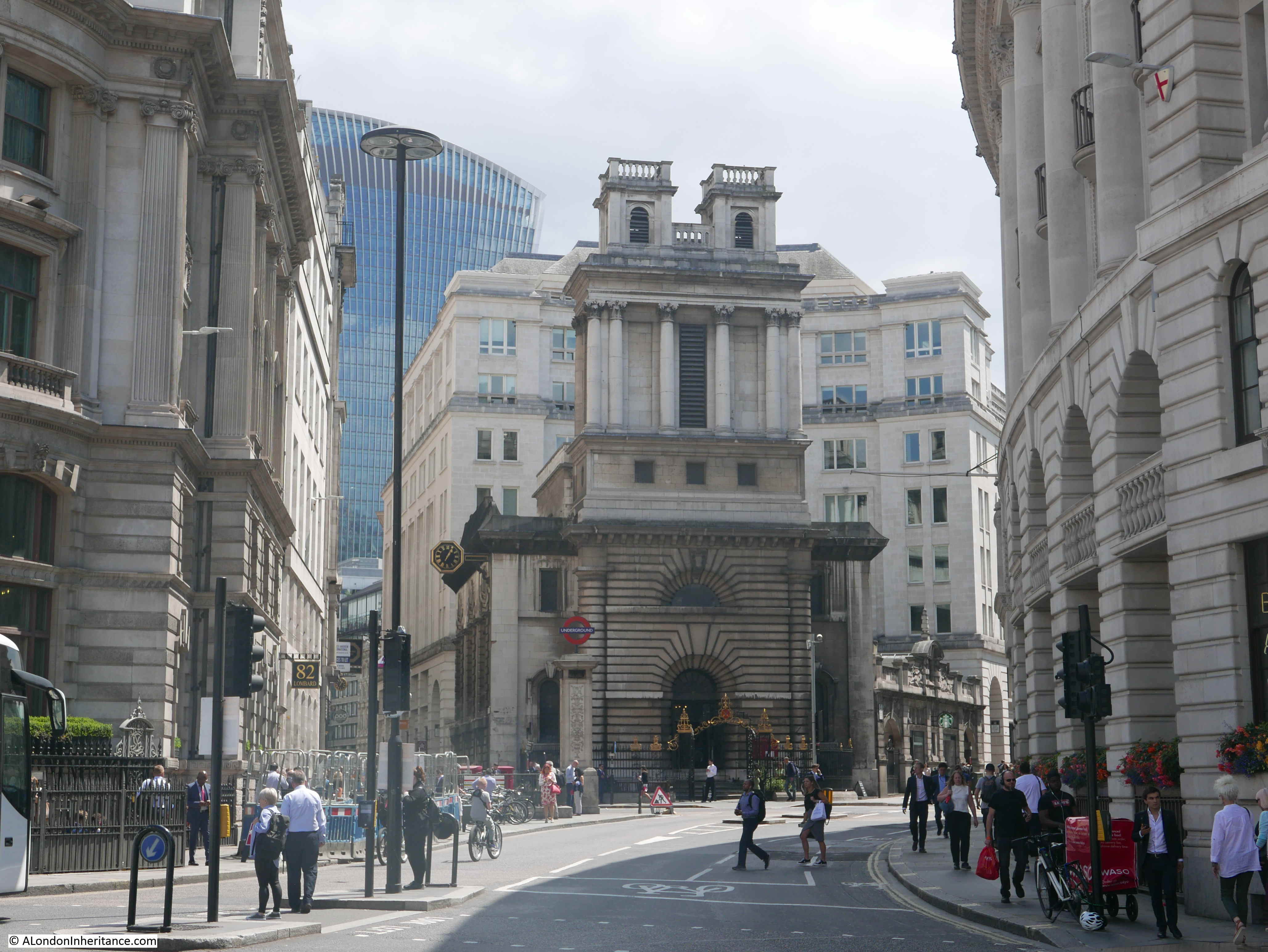
The church occupies a small space, surrounded by City offices and from this perspective, the unusual tower is clearly viewed.

The current church was built between 1716 and 1727 by Nicholas Hawksmoor. The previous church had partly survived the Great Fire of 1666, but needed considerable repair. This work was carried out from 1670, but there were obviously problems repairing a medieval church which led to the decision for Hawksmoor’s replacement church in the early decades of the 18th century. The new church was part of the plan for 50 new churches, funded by a tax on coal.

The tower is interesting. From the front it is substantial and broad, but look from the side and the tower is narrow. Four columns give the impression of two separate towers, this view being reinforced by the two small turrets rising at the top. The turrets are small versions of the square towers that would normally be expected on a City church.

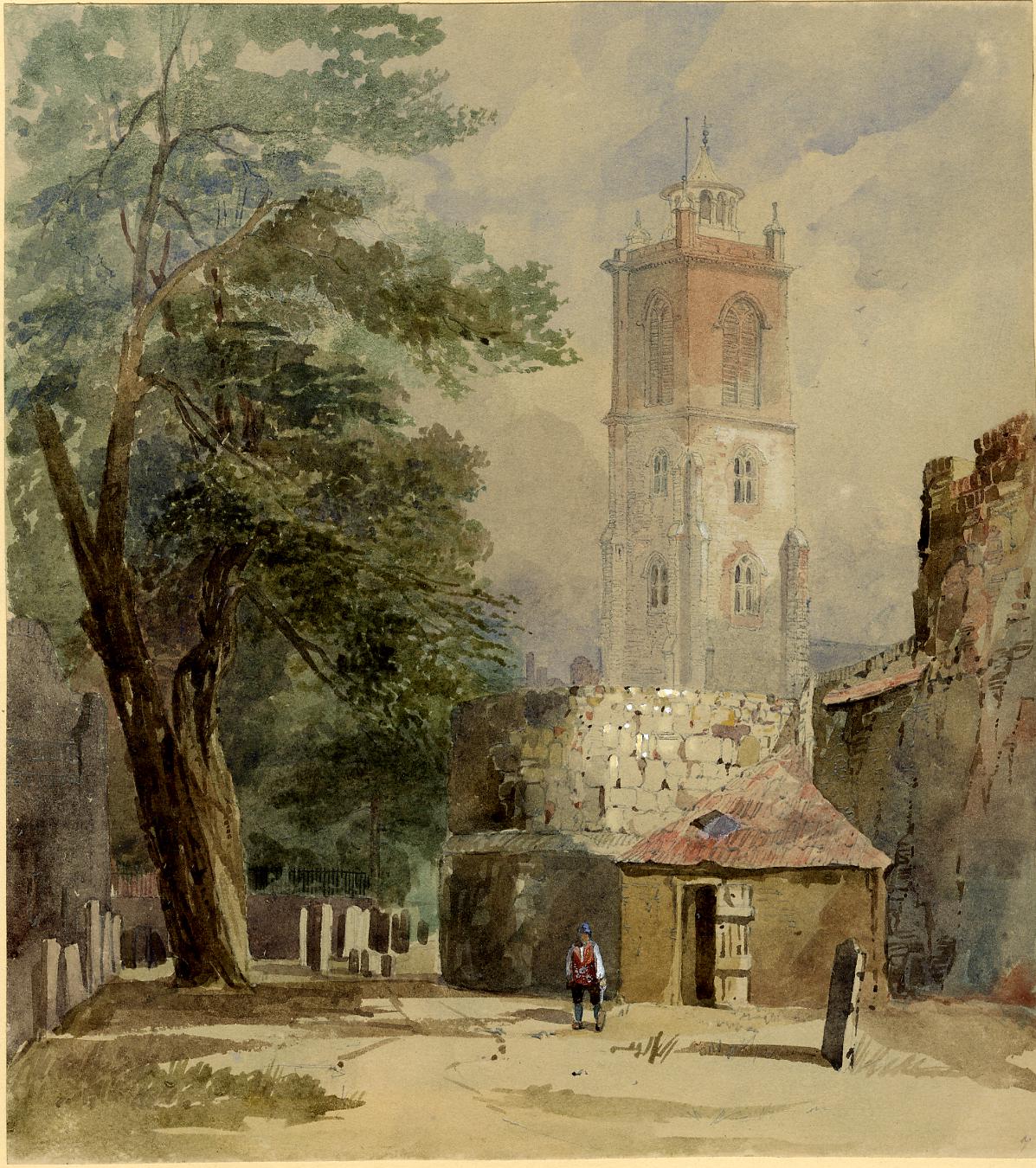
This print from 1838 shows St Mary Woolnoth when the tower of the church was still higher than the surrounding buildings. Note the clock on the left wall of the church, over hanging the street. The clock is still a feature of the church today.

St Mary Woolnoth

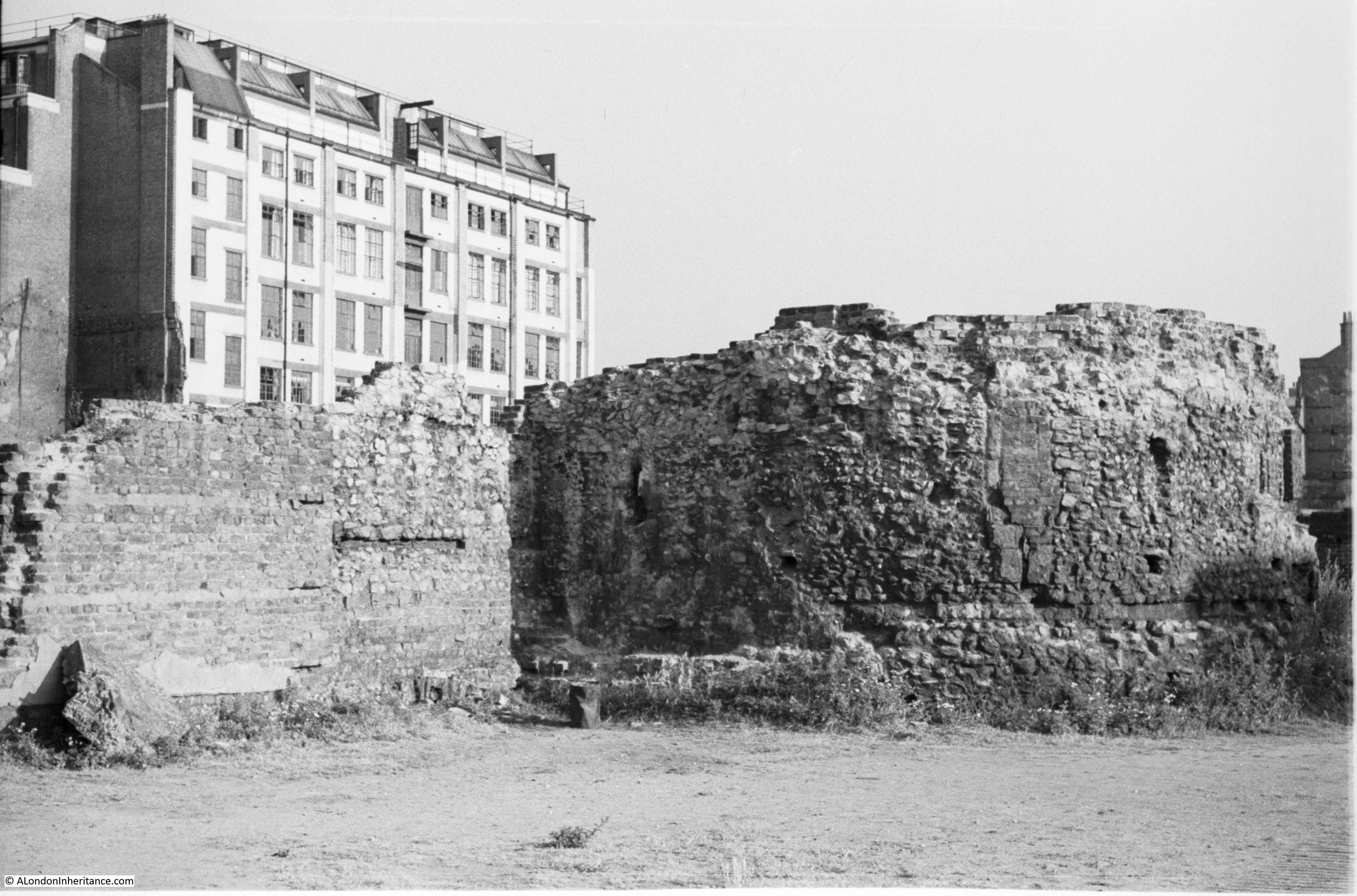
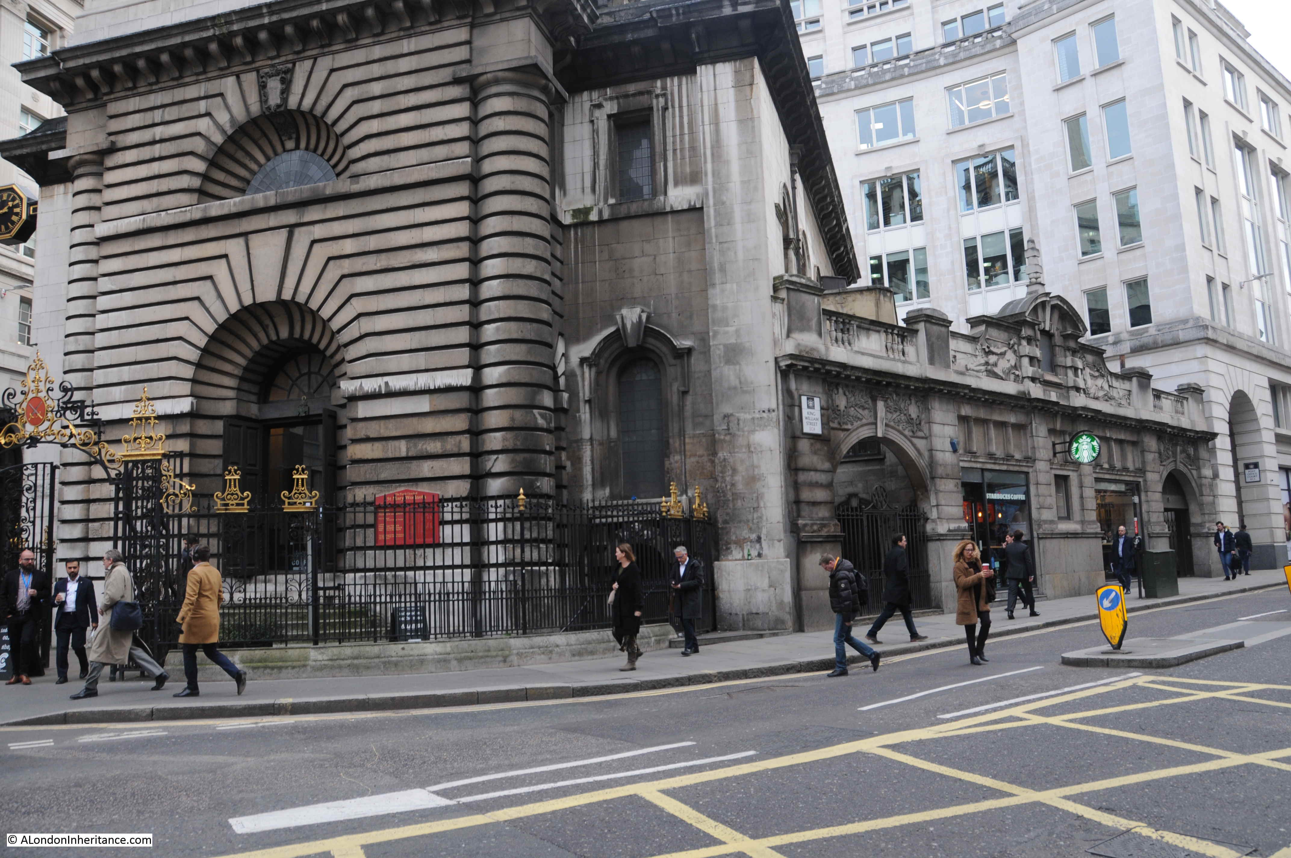
As well as the tower, another feature of the church is one that almost led to its destruction. If you look along the King William Street side of the church, there is an ornate wall projecting out from the corner of the church, today being the location for a Starbucks. In the far arch of the wall can be found the entrance to a lift.

St Mary Woolnoth

The City and South London Railway had opened in 1890. The railway had originally been planned to run from King William Street to the Elephant and Castle, however extensions were being quickly implemented and the line would eventually become the eastern branch of the Northern Line.

The City and South London Railway required space around the Bank in what was already a very congested area. The late 19th century was a time when a number of City churches were demolished as the population of the City had declined and there was no longer a sufficient congregation for what was still a number of churches that suited the Medieval City rather than the Victorian City.

Although proposals for the demolition of the church were put forward, a compromise was agreed, as detailed in the following report from the Standard on Friday November 23rd 1900:

“In 1893 the Railway Company obtained an Act for making a railway, and under that Act they scheduled the site of the church. Owing to the lack of means there was no opposition to the Act on the part of the churchwardens, and the only portion of the Act which affected the church was the clause relating to the removal of human remains which might be disturbed.

Nothing was done till 1896, when the Company obtained an Act to extend the period for the construction of the line. Opposition was then raised by the present Claimants and the Bill was opposed in both Houses, though in the protection of public monuments. the result was that in the Act a clause was inserted that the Company could not purchase any part of the church, but only portions of the land adjacent and under the church, and the clause provided that the arbitrator, in considering the compensation, should take into account the additional cost to the Company of this change to their plans.

in February 1897, the Company under their powers served notice on the Churchwardens, and shortly afterwards took possession of the church and carried on their works. These works had been in progress nearly three years, and all the Company had done was strictly within their rights. On the lands they had made approaches to the station, which was formed of the crypt of the church, and was 4ft above ground level. So far as the engineering went, it was a wonderful piece of work”.

It was indeed a wonderful piece of work. The church lost its crypt, which became part of the station infrastructure for the City and South London Railway, and the church above ground was strengthened with steel reinforcement.

Most importantly, it was a compromise which ensured this unique Hawksmoor church would survive.

The side of the church facing King William Street is now masked by what was the former Underground Station, designed by Sidney R.J. Smith and built between 1897 and 1898 as part of the works described in the Standard article above.

The Pevsner “London: The CIty Churches” does not think much of the facade,  describing it as “a Hawksmoorish rusticated centrepiece, let down by mediocre flanking figures in low relief”.

St Mary Woolnoth

The arch on the right provides access to a lift for step free access to the Northern Line platforms – the old City and South London Railway.

The churchwardens probably regarded the loss of the crypt as an extremely good result as only a few years earlier the church had to be closed because of the state of the crypt. This also sheds light on what an appalling state most City churches must have been in during the 19th century until their crypts were cleared. The following article explains:

“One of the oldest churches in the City of London has actually had to be closed in consequence of the effluvia arising from the dead bodies in the vault. This is St Mary Woolnoth. The congregation who worshiped there were not only annoyed, but made ill, and the clergyman, after the three services, generally went home with a sore throat. At times there would be no smell in the church, at others an intolerable odour came up in whiffs and gusts. It is computed that the remains of between seven and eight thousand bodies are massed together within a few feet of the floor”.

So the City and South London Railway fixed the problems with the crypt and the churchwardens received back a strengthened church, although now without a crypt.

The article mentions that the church is one of the oldest in the City. There appears to have been a church on the site in the 12th century. The church was rebuilt in 1438, and it was this church that was badly damaged in the Great Fire.

There are a number of explanations as to the name “Woolnoth”. Pevsner states that the name “probably commemorates an 11th century founder named Wulfnoth”. Wilberforce Jenkinson in London Churches Before The Great Fire (1917) links the name with the wool trade.

This print from 1812 also associates the name of the church with the wool trade stating that “the distinctive term arises from the Wool Mart being near”.

St Mary Woolnoth

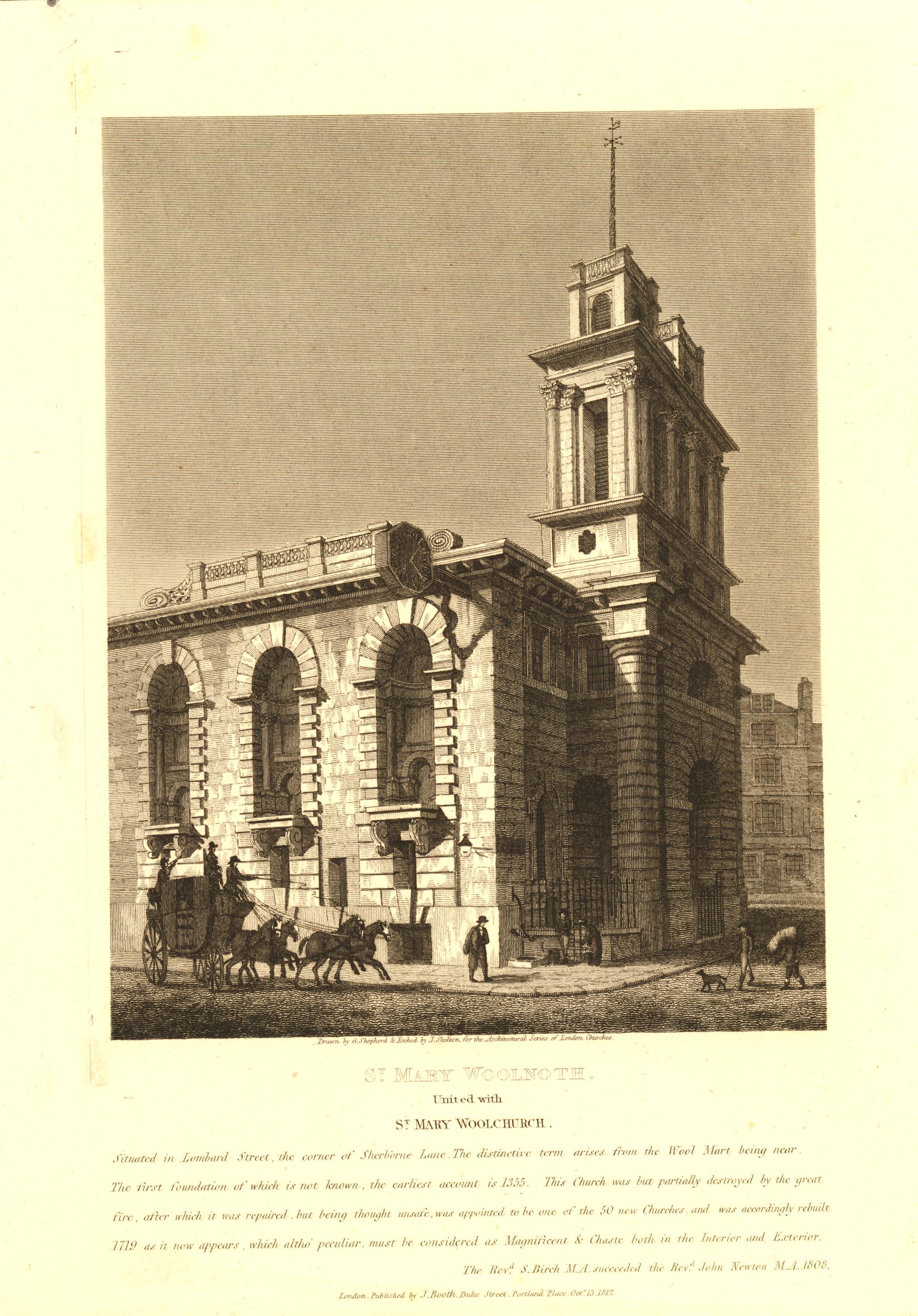
The side view of the church in the above print shows how narrow the tower is from the side, compared with the width of the front view.

Another view of the church from around 1830 with a good view of the clock.

St Mary Woolnoth

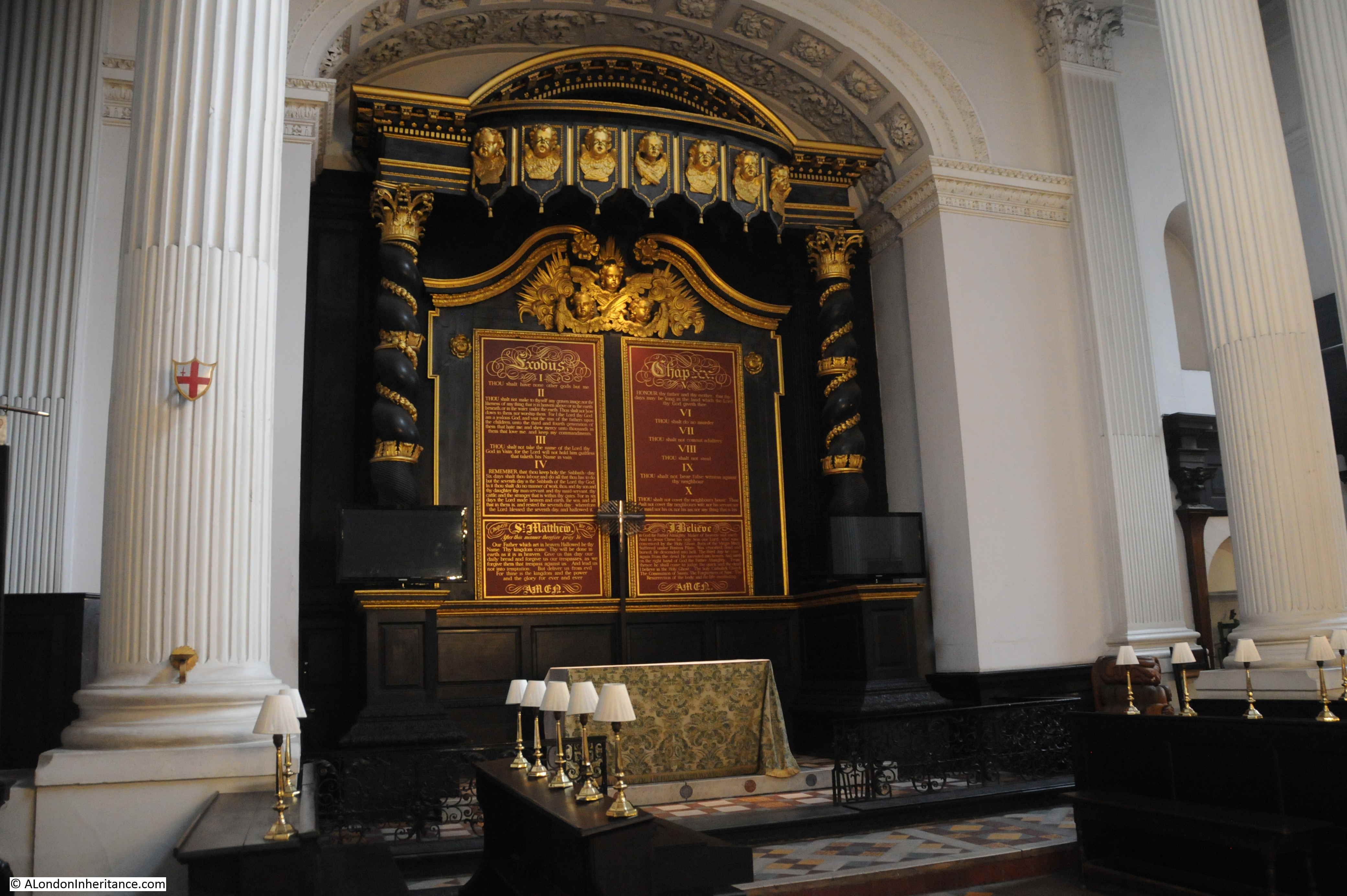
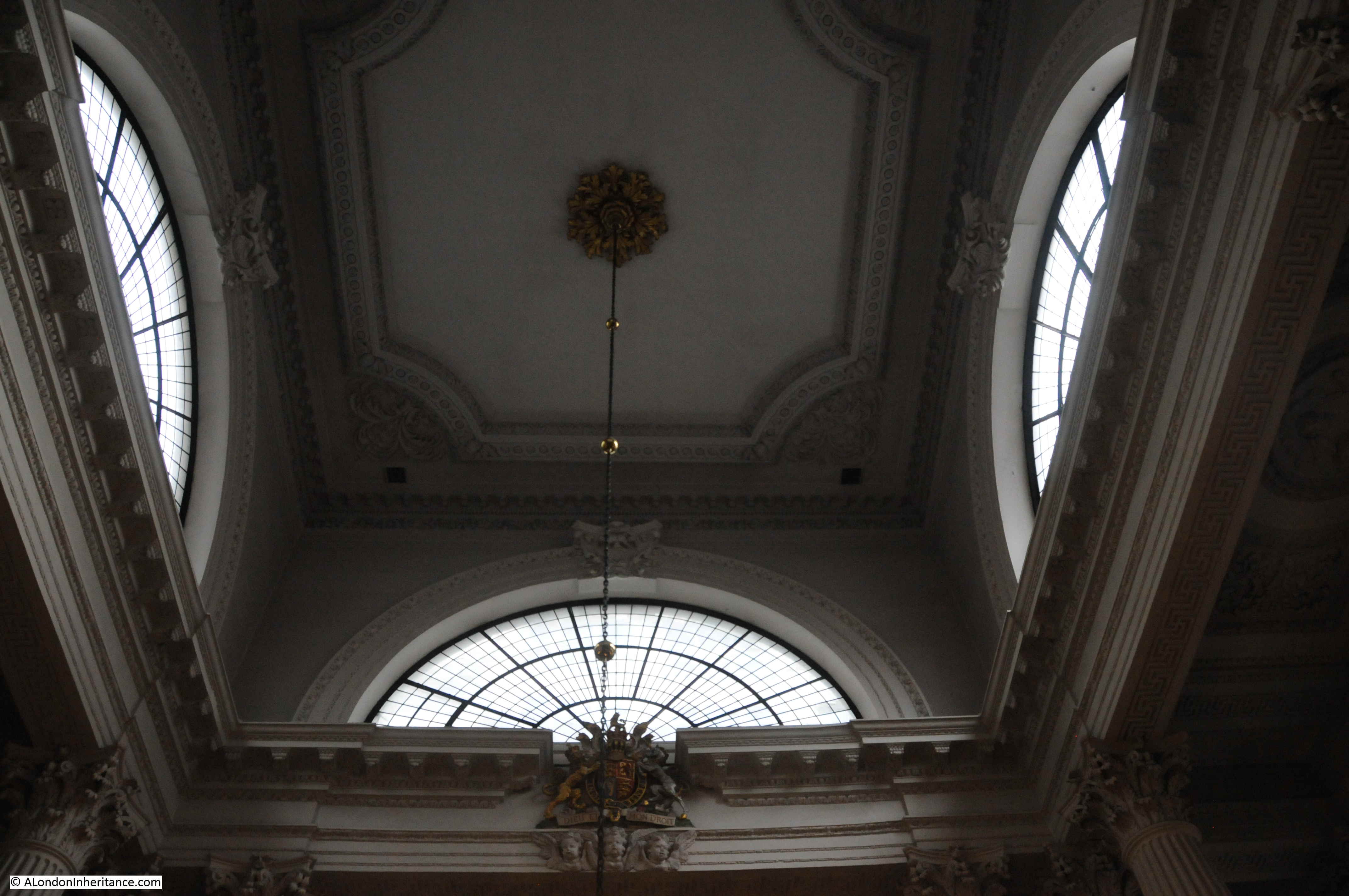
The interior of St Mary Woolnoth is relatively compact, Three large columns on each corner support a square opening, above which there is a space with an arch shaped window on each side, with a chandelier hanging from the centre of the ceiling.

St Mary Woolnoth

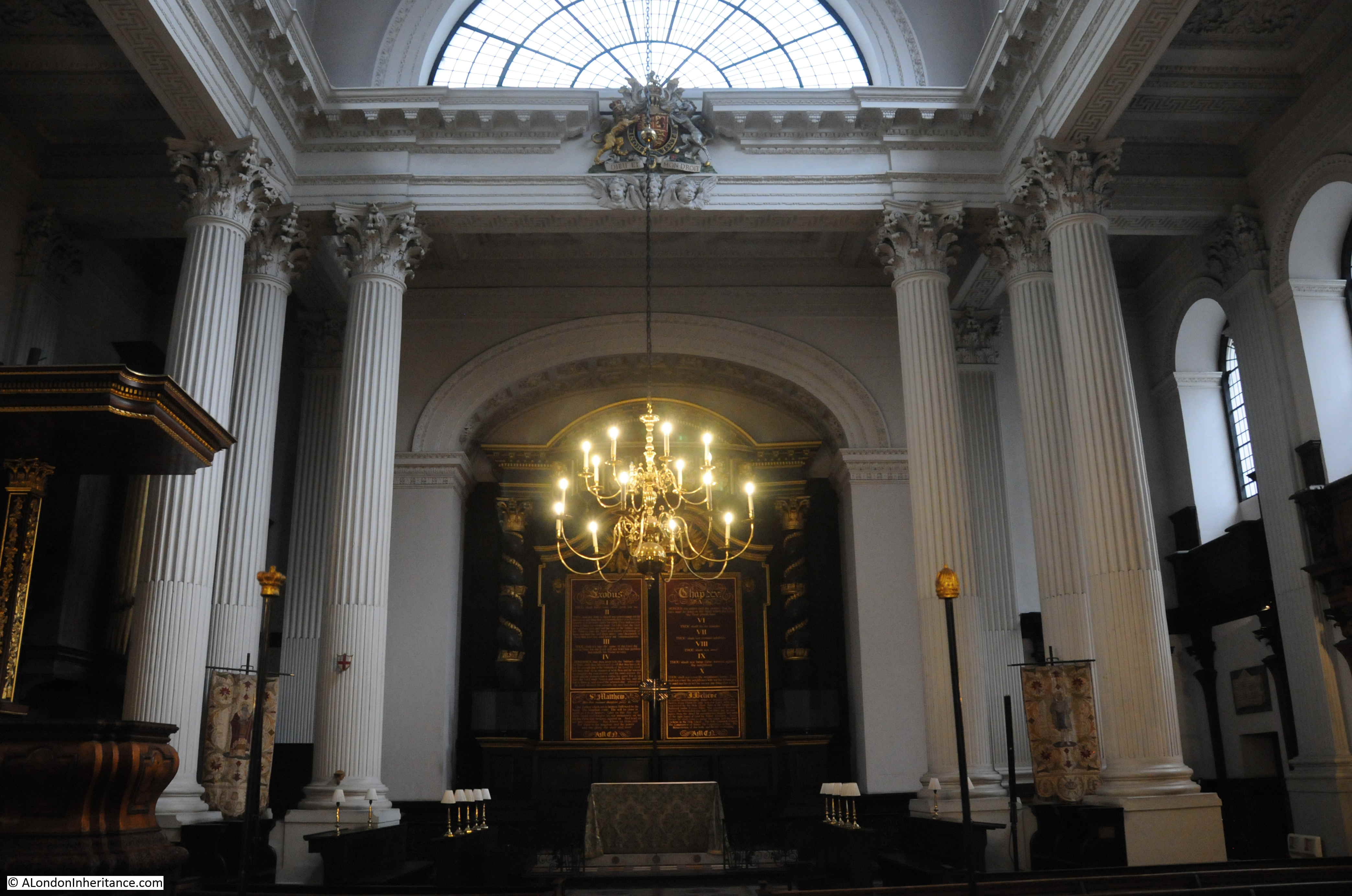
Surrounding the altar is some impressive woodwork, with two ornately carved columns supporting a canopy decorated with gilded cherubs.

St Mary Woolnoth

View up to the roof. It was overcast on the day of my visit, and the windows do not let much natural light through to the church interior below.

St Mary Woolnoth

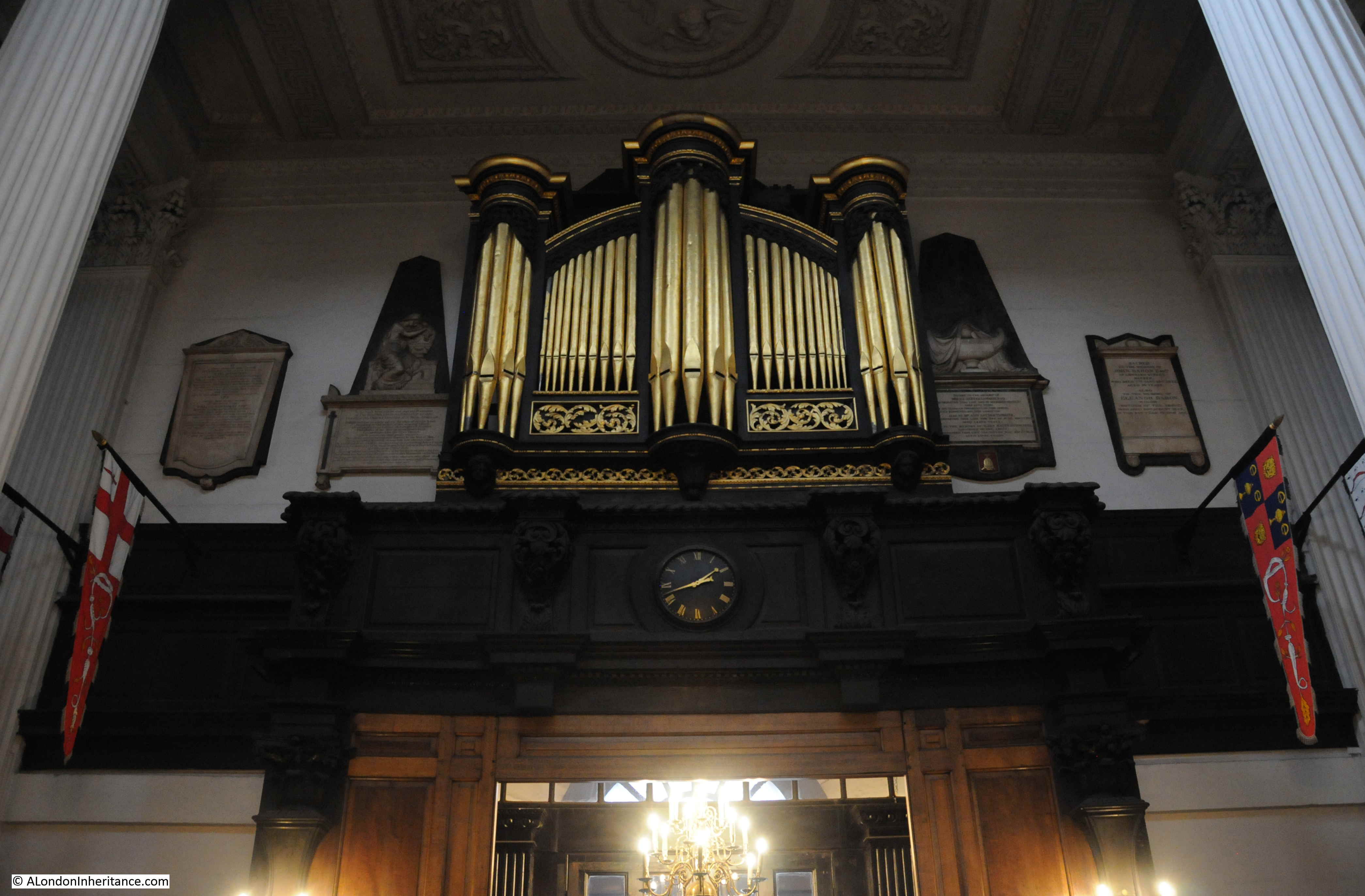
The organ gallery and organ case above the entrance to the church. According to the Pevsner guide, the organ case dates from 1681, so perhaps it was part of the post Great Fire restoration of the medieval church, and was saved for use in Hawksmoor’s church.

St Mary Woolnoth

In a corner of the church is a clock mechanism:

St Mary Woolnoth

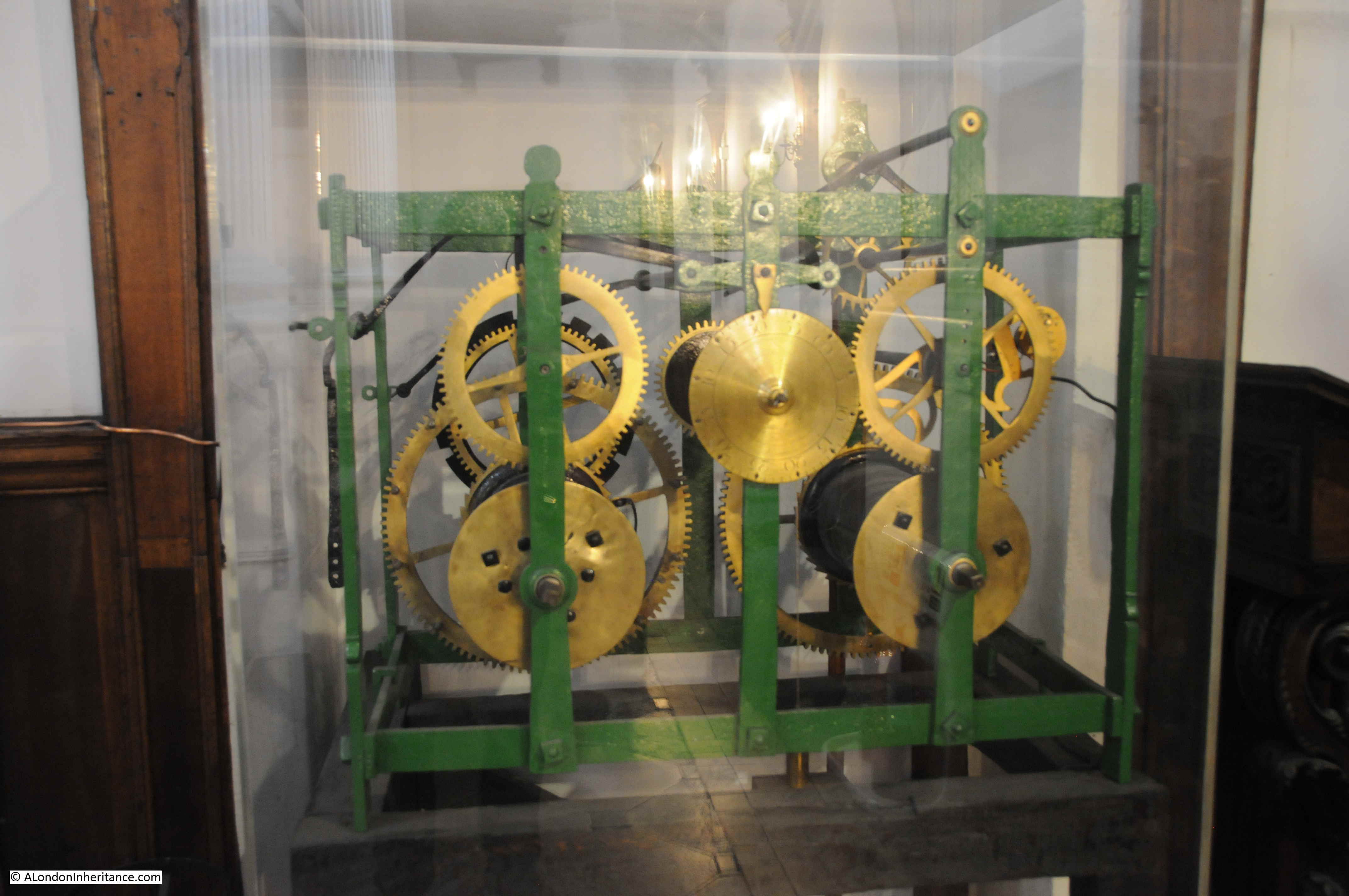
The mechanism is within a perspex cover, and just below is printed an extract from The Waste Land by TS Eliot:

St Mary Woolnoth

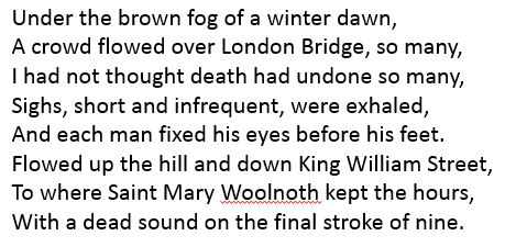
Thomas Stearns Eliot was an American who moved to England in 1914 when he was 25 and became a UK citizen. In The Waste Land, Eliot is concerned about the state of Europe in the 1920s and the impact the modern world is having on the cultural, spiritual and moral state.

He worked in the City for a bank, so must have known the area well, and the description is of City workers flowing over London Bridge, up and down King William Street as they make their way to work, with the clock at St Mary Woolnoth reminding them of the time they needed to be in their offices.

Although written in the 1920s, it is a scene that could still be seen up until March of this year, and I suspect Eliot would be just as concerned today as he was then about the moral state of the world.

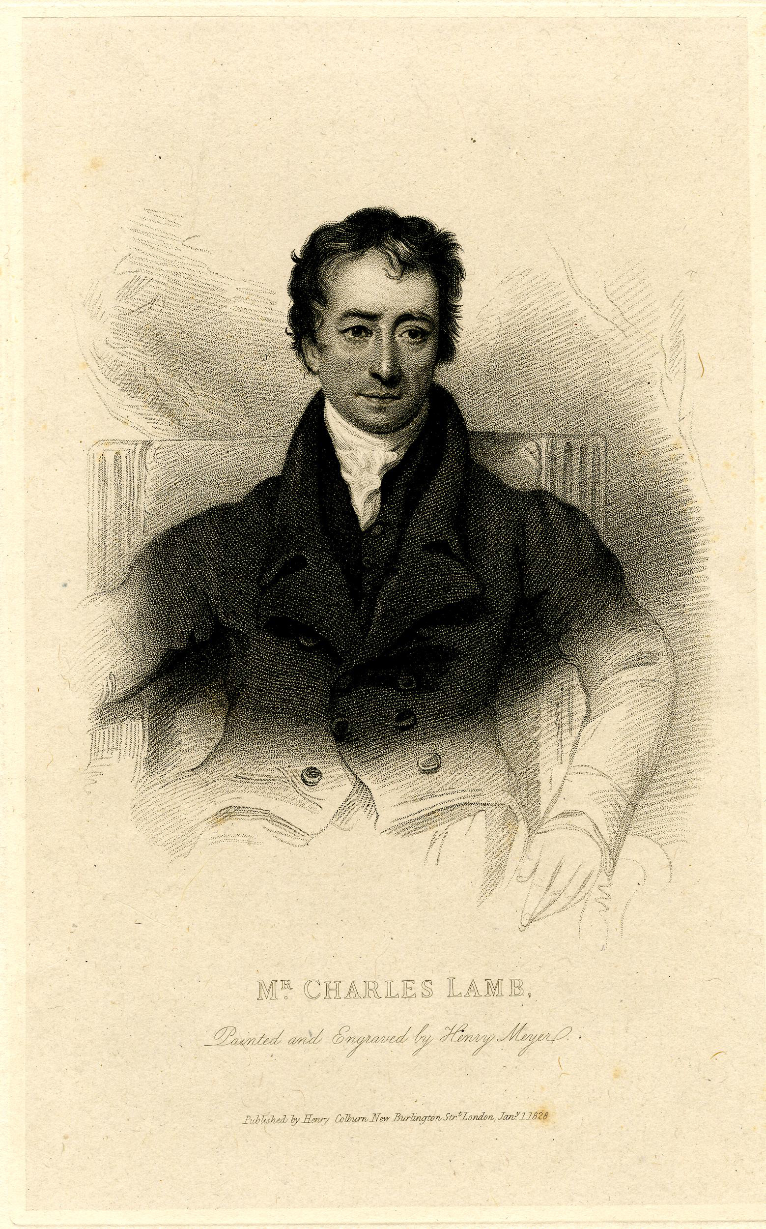
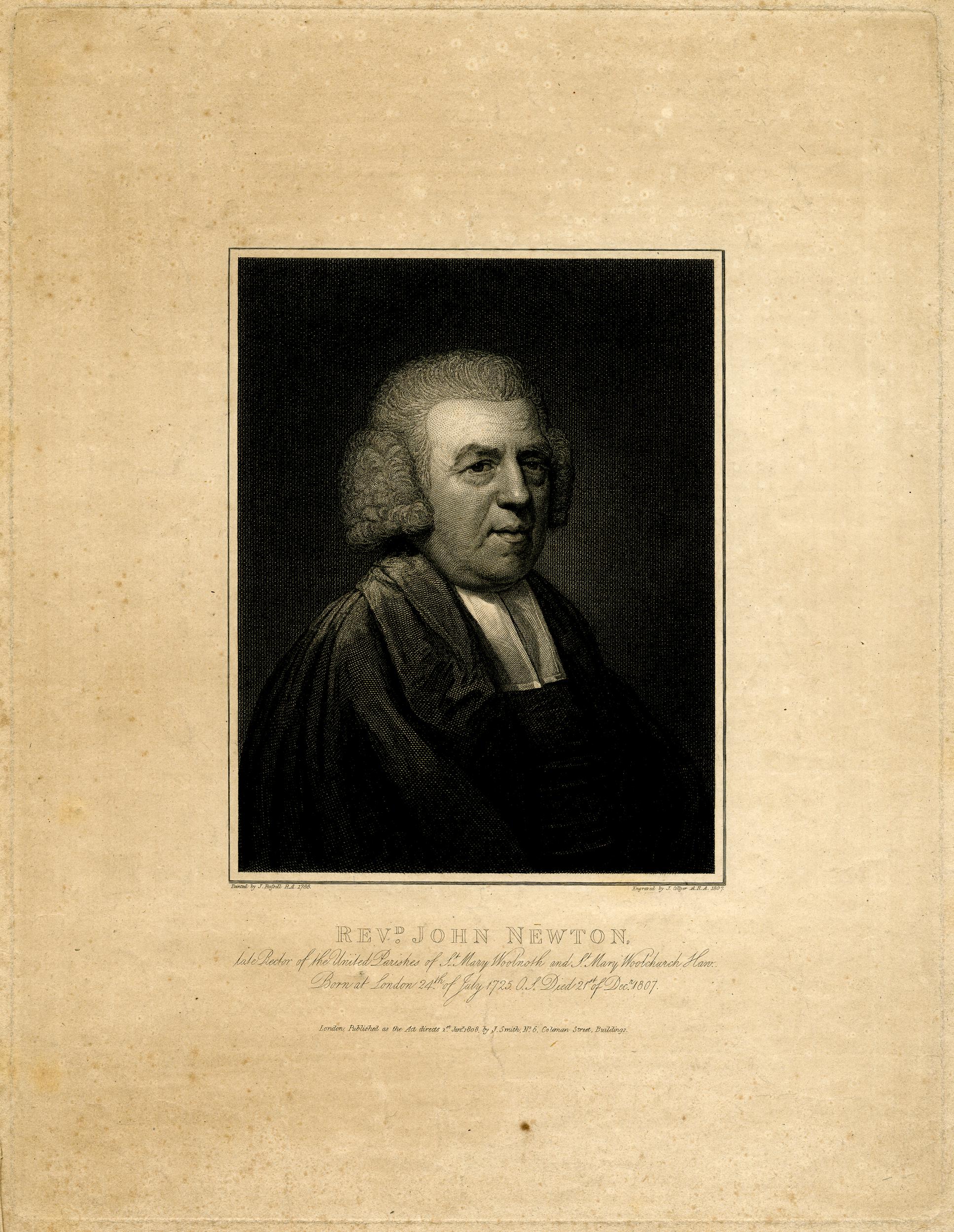
St Mary Woolnoth has a memorial to perhaps the most celebrated rector of the church, John Newton:

St Mary Woolnoth

John Newton was born in Wapping in 1725, the son of a Master Mariner, so his life at sea was as good as guaranteed. His early career at sea was in the slave trade, working on slave ships, including three voyages as captain. In 1748 he converted to Christianity and from the same year worked as the Surveyor of Tides in Liverpool. During his time in Liverpool he studied theology and although considered a radical, finally found a position as curate at the church of Saints Peter and Paul in Olney, Buckinghamshire.

Whilst he was at Olney, he worked with the poet William Cowper on a collection of hymns which included Amazing Grace.

His time at St Mary Woolnoth started in 1780 when he became rector of the church. During his time at the church, he supported William Wilberforce, he published a pamphlet titled “Thoughts upon the African Slave Trade” in which he wrote about his time as a slave trader, wrote about his regret of his role and was outspoken in his condemnation of the slave trade.

He supported the Committee for the Abolition of the Slave Trade which had been formed in 1787, and the committee purchased copies of Newton’s pamphlet to be sent to every member of the House of Commons and the House of Lords

John Newton provided evidence to the parliamentary committee set up to examine the slave trade, and used his experience as a slave trader to speak about the appalling conditions of the trade.

The law to abolish the slave trade, the Abolition Act passed into law and soon after, in December 1807, John Newton died. He was buried in the crypt of St Mary Woolnoth, alongside his wife.

When the crypt was cleared for the construction of the Underground station, the bodies of John and his wife Mary were moved to the church in Olney where he had been churchwarden.

Newton’s pamphlet “Thoughts upon the African Slave Trade” provides a very clear account of the unbelievable cruelties of the trade and makes for a very harrowing and upsetting read.

The Cowper and Newton Museum in Olney can be found here, and they also have a copy of the pamphlet in PDF form which can be downloaded from the following link:

https://www.cowperandnewtonmuseum.org.uk/wp-content/uploads/2012/01/thoughtsuponafri00newt.pdf

The Reverend John Newton:

St Mary Woolnoth

St Mary Woolnoth is an important church. A church has been on the site since the 11th century. Architecturally, it is a fine example of Hawksmoor’s work. The church survived the arrival of the Underground railway and suffered minimal damage during the blitz.

Many millions of City workers must have looked up at St Mary Woolnoth’s clock on their way to and from work, and from John Newton we can learn first hand about the appalling cruelties of the slave trade.

alondoninheritance.com

New Terrace, Duncan Terrace, Colebrooke Row and Charles Lamb

The following photo is from the early 1980s and shows part of a terrace of houses. The house on the left with the pediment has a plaque stating “New Terrace – 1791”.  The location is in Islington, a short distance south east of Islington Green. New Terrace, now Duncan Terrace is separated from Colebrooke Row by a strip of grass which has an interesting history.

Colebrooke Row

This is the same view almost 40 years later. The perspective is not exactly the same as the trees in front of the house with the pediment have grown significantly and obscure the pediment and plaque when looking from the original viewpoint.

Colebrooke Row

Many of the terraces in this part of Islington were in a poor state in the early 1980s, but the decade would bring a transformation to the area. New Terrace at the time seemed to have escaped the problems suffered by many other terraces and was in good condition as the terrace approached the age of 200 years.

The location of New Terrace is shown in the following map extract. To the south east of Islington Green, the terrace is the upper row of houses in the red oval, north of Charlton Place (Map © OpenStreetMap contributors).

Colebrooke Row

The houses in this area have a complex history, with piecemeal construction starting in the 18th century. Originally, the land was comprised of agricultural fields, clay pits and nursery gardens.

In 1613, the New River was constructed, and the route can still be traced today by the grass strip that runs from New Terrace all the way down to City Road. In the above map, the green strip shows the grass and public park between Duncan Terrace and Colebrooke Row, the grass strip running further north in front of New Terrace is not shown on the map, but is indicated by the gap between the terrace and Colebrooke Row.

Duncan Terrace is named after Admiral Duncan the commander of the Naval Fleet at the Battle of Camperdown against the Dutch in 1797.

Colebrooke Row is named after Sir George Colebrooke who developed the Colebrooke Row side of the street.

New Terrace was built in 1791 by James Taylor, a young surveyor and builder. The terrace has gone through a number of name changes from New Terrace to Colebrooke Terrace, to Duncan Terrace, the name which remains to this day.

The grass strip running in front of the terrace was the route of the New River. The river was enclosed in a pipe in 1861 which was covered and planted. The pipe was out of use by 1950 and was then removed leaving the grass strip as a reminder of the early history of London’s water supply.

Colebrooke Row

Looking north along the original route of the New River:

Colebrooke Row

The view to the south showing how the terrace was built at a raised level to the river:

Colebrooke Row

As the terrace could not face directly onto the New River, a raised pavement was built in front of the terrace, and this remains today to give access to the front doors of each house:

Colebrooke Row

In 1793, Taylor continued the southern extension of the terrace and built what are now numbers 46 to 49 Duncan Terrace on the opposite side of the junction with Charlton Crescent. This area was originally known as Clay Pit Field as it had been occupied by clay pits, extracting clay for the manufacture of bricks, but as the clay was exhausted, the land was more valuable as a site for houses.

This southern terrace followed a similar design to the northern New Terrace with a raised pavement between the houses and the New River:

Colebrooke Row

Further south along Duncan Terrace is the rather magnificent church of St John the Evangelist, built as a result of the Catholic Emancipation Act of 1829 which released Catholics from the restrictions that had been imposed on them since the Reformation.

Colebrooke Row

The land was purchased for the church in 1839, and the design completed by the Catholic architect Joseph John Scoles. It took a number of decades for the church to be completed with work on the towers commencing in 1873.

The terraces either side of the church are today in lovely condition, but as with much of Islington this is a result of restoration work over the last few decades and the considerable increase in value of properties in the area.

In 1953, the route of the New River had not yet been landscaped, or turned into a park, as shown in the following photo from 1953, and there was a gap in the terrace where one of the houses had suffered bomb damage.

Colebrooke Row

Image credit: London Metropolitan Archives, City of London: catalogue ref: SC_PHL_01_182_53_19

Crossing the route of the New River and into Colebrook Row and the street is lined with similar terraces:

Colebrooke Row

And this is where the Regents Canal enters the Islington Tunnel – this is the view looking along the canal on approach to the tunnel:

Colebrooke Row

The entrance to the Islington Tunnel, under Colebrooke Row. The tunnel runs to Caledonian Road and is 878 meters long.

Colebrooke Row

Walking back along Colebrooke Row, and the park follows the route of the New River and separates Colebrooke Row and Duncan Terrace. They are now landscaped, planted with trees, with a central path running the length of the park:

Colebrooke Row

Although today there is a one way system running through the parks, with the appropriate warning signs about social distancing:

Colebrooke Row

The following photo shows the eastern side of Colebrook Row, with the street, then the New River route on the left, then Duncan / New Terrace (on the left but not visible in the photo). As can be seen from the slight differences in architectural styles, the terrace has changed over time. as different builders added to, demolished parts of, and changed the style of the buildings.

Colebrooke Row

I have walked from New Terrace at the top of the oval in the map, to the Regents Canal at the lower end of the oval, and back again along Colebrooke Row, as there is one house to find that is earlier than all the other houses, and was once the home of a rather interesting character.

The white painted house at the end of the terrace in the following photograph is Colebrooke Cottage, number 64 Duncan Terrace, dating from around 1760.

Colebrooke Row

Colebrooke Cottage was originally a single house, standing alone in the fields that covered the area, and faced onto the New River. It remained a single house until the construction of New / Duncan Terrace on the left. The following photo shows Colebrooke Cottage, New / Duncan Terrace to the left and the route of the New River running between terrace and road.

Colebrooke Row

The following print shows Colebrooke Cottage as it was before the construction of New Terrace. It is rather idyllic view. The cottage is surrounded by trees, the New River runs along the front and a boy is fishing in the river  © The Trustees of the British Museum.

Colebrooke Row

Comparing the two prints shows a number of differences mainly down to 19th century changes, including a reduction in the number of windows. Restoration work in the 1970s uncovered evidence of the side windows that would have had to have been bricked up when New Terrace was built.

The print is titled Charles Lamb’s House At Islington.

Charles Lamb was a poet and essayist. Born in Office Row in the Temple in 1775 where his father worked in the legal profession. On the death of his father’s employer, the family consisting of Charles, his sister Mary and their mother and father had to leave the house tied with his father’s job and move into cramped lodgings nearby.

After a short spell at the South Sea Company, he moved to the East India Company in 1792, where he would spend the rest of his working life. He was employed as a clerk, a job he did not enjoy.

His first published work was a small collection of sonnets that he provided for a book of poems published by Coleridge in 1796.

But it was not until the 1820s that he achieved a degree of fame when he published a series of essays in the London Magazine under the name of Elia (a name he adopted, allegedly the last name of an Italian man that had also worked at the South Sea Company)

However in many ways he had quite a tragic life which probably influenced his writing.

After the death of his father’s employer, the family were forced to move to cramped lodgings, and Charles and his sister Mary seem to have been responsible for supporting the family, and it was the resulting pressure which probably led to his sister Mary, in a fit of insanity to kill their mother and badly wound their father.

Charles took Mary to an asylum, and to avoid her imprisonment, he agreed to look after her at home, which he did for the rest of his life.

Mary did suffer mental health problems for the rest of her life, but she also published works with Charles, including a retelling of Shakespeare for children, a book which is still published today.

He did not marry. His first proposal of marriage to one Ann Simmons was rejected which led to a short period of what at the time was called insanity, probably what we would now call depression.

His second attempt at marriage, with a proposal to an actress Fanny Kelly was rejected, probably because she could not contemplate a life which involved looking after Mary.

He moved to Colebrooke Cottage in 1823 and stayed there for only 4 years, but it was here that he was the happiest he had ever been. He retired from work at the East India Company, and lived here with Mary, surrounded by books and the Islington countryside, and entertained literary friends. He described leaving his job as “33 years’ slavery…a freed man, with £441 a year for the remainder of my life”.

He described the house as a cottage, “for it is detached, with six good rooms. The New River runs close to the foot of the house and a spacious garden is behind. I feel like a great lord, never having had a house before”.

However the writer Thomas Hood called it a “cottage of ungentility for it had neither double coach house nor wings, and like its tenant, it stood alone”. Some author snobbery or competition perhaps.

The New River caused occasional problems for his guests as the myopic writer George Dyer fell into the river after leaving the house.

In 1827 he left Islington and moved to Enfield, followed by a move to Edmonton in 1833, where he died the following year after a fall.

A print of Charles Lamb dating from 1828  © The Trustees of the British Museum:

Colebrooke Row

A London County Council plaque is on the front of Colebrooke Cottage to commemorate Charles Lamb’s time on Colebrooke Row, Islington.

Colebrooke Row

Walking along Colebrooke Row, there is not really anything that would stand out – it’s a street of rather nice late 18th / early 19th century terrace houses as can be found across much of Islington. I went there to find the location of one of our 1980s photos. However, what makes this street so special is a single house that remains from the time when this was all agricultural land and clay pits. Finding one of the few places where the route of the New River can still be clearly seen, and how houses were built to face on to the New River.

And finding a literary character who was in the shadows of the major literary characters of the time, who should have had a happier life, but who seems to have enjoyed a few years surrounded by the Islington countryside.

alondoninheritance.com

Bastion 14, Cripplegate

This week, I am very close to Monkwell Street, the subject of a post a couple of weeks ago. I was going to include this location in the Monkwell Street post, but I did not want to inflict an even longer post on you, so Bastion 14 in Cripplegate gets its own post. At the end of the post, I also have a couple of photos of an archaeological dig in the City which I need help identifying.

The following is my father’s 1947 photo of Bastion 14 of the Medieval City wall. The bombed buildings have been cleared away from around the bastion, which is now almost fully exposed, for the first time in many years.

Bastion 14

This is Bastion 14 today:

Bastion 14

The main difference between the two photos is the height of the bastion. In 1947 only part of the structure was above the surface. Future development including the nearby build of the Museum of London, the Barbican and the landscaping of the green space along the line of the old Roman Wall, resulted in the lowering of the ground level and the exposure of a considerable part of the bastion.

Some of the features on the external wall of the bastion can be seen in both photos. The brick line along the top of the wall extending from the left of the bastion is also the same, although the lowering of ground level has revealed the arched feature in the lower part of the wall.

In the background of today’s photo are the glass and steel office blocks that now line London Wall, whilst in the 1947 photo, the Wood Street telephone exchange is in the background.

Bastion 14 is one of a number of bastions that line the route of the north east corner of the Roman Fort / City Wall, just to the south of St Giles’ Cripplegate. The following map shows the location and numbers of the bastions I will cover in today’s post  (Map © OpenStreetMap contributors).


The map shows the green space that was created as part of the post war development of the area. It is now possible to walk from London Wall, through the green space up to Bastion 12. The redeveloped Barber Surgeons Hall is set back from Bastion 13.

The area was so very different before the devastation of the Second World War. The following map shows the area in 1894:

Bastion 14

Credit: ‘Reproduced with the permission of the National Library of Scotland’ 

The map shows that in 1894 Bastion 14 was not free standing, indeed it was an integral part of the buildings that ran along Castle Street. To take today’s comparison photo, I was standing roughly where Castle Street once ran looking up at the bastion.

Part of Bastion 13 was visible, and the structure was part of the Barbers Hall. Bastion 12 was facing on to the churchyard of St Giles.

I am gradually documenting how the area has changed. In the above map you can see Monkwell Street, covered in this post and immediately to the south of Bastion 14 is now the new route of London Wall covered in this post.

The following photo is looking west along the southern edge of Bastion 14. London Wall is immediately to the left, and the entrance to the underground car park that runs under much of London Wall can be seen to the lower left.

Bastion 14

There is a Roman wall (not part of the City wall) in the underground car park – a subject for a later post, and for those who walk London, there are some toilets just inside the entrance.

The story of the post war excavation of the bastions is just as interesting as the history of these structures. There are two excellent books I have used to research the bastions, these are:

  • The Excavation of Roman and Mediaeval London by W.F. Grimes (Routledge & Kegan Paul Limited 1968), and;
  • Excavations at Medieval Cripplegate, London by Gustav Milne with Nathalie Cohen and contributors (English Heritage, 2001)

Professor W.F. Grimes was the excavation director for many of the post-war excavations across the City and his book is a fascinating read covering many of these sites, and Gustav Milne’s book covers the post war archaeology between 1946 and 1968 of Cripplegate with a detailed review of post war work and a modern update and interpretation.

The bombing of London resulted in large areas of destruction across the City. As many of my father’s photos show, buildings had been demolished down to their foundations and cellars to remove any danger of the walls collapsing and to prepare the areas for whatever development would be coming next.

This presented an opportunity to excavate and discover what lay beneath the surface – an opportunity never before available on such a scale. However, as with all things, archaeological excavations cost money, and after the war, money for such work when there were so many other demands was not easily available. The Ministry of Public Buildings and Works contributed £26,300, and Grimes’ book records several pages of donations from Business, Livery Companies and individuals, with the names of those donating down to £1 being recorded.

The scale of the work was such that the Society of Antiquaries in London formed the Roman and Mediaeval London Excavation Council to organise excavations across the City, and work began in July 1947.

Grimes writes that there were some twenty one bastions known or recorded along the City walls, with the stretch to the south of St Giles having a number of the bastions that have survived, with Bastion 14 being the best preserved.

The bastions are not Roman, they form part of the medieval City defences and were built up against the medieval wall, which used the Roman wall for foundations. Their use as a defensive structure did not last long and for much of their time they were used for other purposes, and with Bastion 14 that included being an integral part of a warehouse built across the site.

A quantity of pottery was found at the base of the excavated bastion during the work in 1947, however it was not till later that this was used, along with other findings during the excavations, to firmly date the bastions to the thirteenth century.

Bastion 14 displays medieval stone work and features on its outer facing, but internally the bastion has been faced with much later brickwork and other features. The following photo shows the internal view of Bastion 14.

Bastion 14

In the above photo, the gravel covering the floor of the bastion marks the floor level at the time of the excavations. The work digging below this floor level revealed a number of finds that helped date the bastion and also exposed the medieval base of the bastion.

The following photo is from Grimes’ book, and I have identified the main features of the bastion. By comparing with the above photo, you can see where the floor level was dug out revealing the medieval base.

Bastion 14

Grimes included the following drawing of Bastion 11 at All Hallows on the Wall in his book. It looks very similar to Bastion 14 with the bastion built up against the line of the original Roman wall, with the City ditch falling away in front of the bastion.

Bastion 14

The reduction of ground level in front of Bastion 14, and the way the ground slopes down from the base of the bastion means the view today must be very similar to when the bastion was originally built.

Grimes also included a photo in his book showing a section cut through the interior of Bastion 14 “showing gravel floor (arrows) overlying the Roman city ditch, its inner end coinciding with the top of the Roman fort wall (extreme right) as surviving”.

Bastion 14

The exterior of the bastion retains a number of early features which are still visible today. I have labelled these on my father’s photo of Bastion 14.

Bastion 14

The area between bastions 14 and 12 is a lovely bit of green space, and as well as the bastions, parts of the walls remaining from the buildings that occupied the site can still be seen.

This is the view looking back at Bastion 14 from the north, with a line of wall extending from the bastion (built on the original alignment of the Roman Wall). London Wall is on the elevated structure behind the bastion.

Bastion 14

The following view is looking in the opposite direction to the above photo, and shows the post war Barber Surgeons Hall.

Bastion 14

The location today of Barber Surgeons Hall is slightly different to the pre-war location and the large bay windows are relevant to the previous location.

The hall was originally built right up against Bastion 13, but as part of the planning for the new hall, it was a requirement to move the hall 30 feet to the east, separating the hall from the bastion (see my post on Monkwell Street).

That is the reason for the gap between the hall and Bastion 13 which is shown in the following photo.

Bastion 14

Grimes writes that Bastion 13 was once part of the courtroom of the Barber Surgeons Hall, the shape of which is today mirrored in the large bay which now faces the bastion across the 30 foot gap,

Bastion 13 is not in such good a condition as 14, and as well as once forming part of the Barber Surgeons Hall, the north west section was at the end of St Giles churchyard which as can be seen in the 1894 map above, originally curved around Bastion 12 and had a narrow extension down to Bastion 13.

Grimes writes “Bastion 13 survives only to the level of St Giles’ churchyard and has suffered extensive mutilation in other ways. Recent investigation has shown that on the north externally it ends on the city wall; to the south the junction has been destroyed. Internally, the ends of the bastion have been cut away or underpinned by modern foundations. In spite, however, of the low level of the cellar enough remained to show that the foundation, a little over 2 feet deep, was set in the floor of the Roman city ditch, the base of which has survived”.

A closer view of Bastion 13 and the adjacent Barber Surgeons Hall:

Bastion 14

Continuing walking north and there are more walls from the buildings that once stood here.

Bastion 14

On a sunny morning it is hard to believe that you are so close to London Wall and the Barbican:

Bastion 14

Approaching the northern end of the green space, part of what was St Giles’ churchyard and the buildings along Well Street have disappeared under one of the lakes built as part of the Barbican development.

Bastion 14

At the end we find Bastion 12 which formed the north west corner of the Roman Fort / City Wall, and from here the wall turned to the right, running to the south of the church which was “without” the City wall.

Bastion 14

Grimes does not have too much to say about Bastion 12, and refers to it as “the well known Cripplegate bastion”. Bastion 14 had been hidden within pre-war buildings, Bastion 13 had been part of the Barber Surgeons Hall, so they were the main points of interest.

In Gustav Milne’s book, reference is made to the bastion as standing “some 9m above the contemporary ground surface, which has been substantially lowered since the 1950s during landscaping”. So, the exterior probably looked like Bastion 14 in my father’s 1947 photo with much of the bastion still below the pre-war ground level.

Bastion 12 was excavated in 1947, but unlike Bastion 14, no artifacts were recovered from the interior. The bastion had already been excavated at the start of the 20th century and it had been through a number of restorations which made interpretation of the age of phases of the bastion somewhat complicated.

Bastion 12 may have been part of Lamb’s Chapel which I explored in my Monkwell Street post.

Looking back at some of the pre-war walls that remain:

Bastion 14

The following print from the LMA Collage archive and dated 1779 shows Bastion 12 at the point where St Giles’ churchyard curves round to extend down to Bastion 13.

Bastion 14Image credit: London Metropolitan Archives, City of London: catalogue ref: q4769128

At the right edge of the print is Bastion 13 as it was included in the Barber Surgeons Hall. The following print from 1800 shows the bay extension to Barber Surgeons Hall in detail. The medieval bastion 13 was incorporated within this feature.

Bastion 14


Image credit: London Metropolitan Archives, City of London: catalogue ref: v9041147

The following print from 1841 shows Bastion 12 with the churchyard of St Giles’ curving round the bastion  © The Trustees of the British Museum.

Bastion 14

Grimes book was published in 1968 and allowed some discoveries to be included which had not been part of the original excavations. As part of the Barbican development, the churchyard around St Giles’ was lowered ready for the Wallside building along the southern edge of the development, with space for grass and a water feature.

This lowering of the ground level revealed the remains of a new bastion. This was identified as Bastion 11A as it was between the known Bastion 12 and Bastion 11 at All-Hallows-on-the-Wall.

This new bastion survived as two curving stumps built against the city wall. The outer part had been cut away by a 17th century sewer which had been following the line of the ditch built along the external side of the city walls.

The remains of Bastion 11A can be seen in the photo below which is looking along the remains of the city wall towards Bastion 12. The remains are the low curved stones jutting out into the water.

Bastion 14

These bastions provide a fascinating glimpse of the medieval defences of the city, and how London made use of these features as the need for a walled city was replaced by the ever expanding need for warehouses, housing and halls. Thankfully the integration of bastions 13 and 14 meant that they survived, and Bastion 12 seems to have survived as the corner feature of St Giles’ churchyard.

I suspect that there was concern as to whether the bastions would survive the redevelopment of the City. On the 12th October 1942, a Mr Sydney R. Jones wrote to The Times:

“Recently I proceeded from Guildhall to the garden of St John Zachary and its adjacent neighbourhood to find not only interest but excitement as well. It is now possible to trace the line of the Roman wall in a manner which has not been known for hundreds of years. A sharp eye may detect many relics of the rampart incorporated in the work of subsequent buildings. These show all along London Wall on each side of the upstanding relic that had always been visible in the disused churchyard of St Alphage. At St Giles, Cripplegate, the wall joins the well-known bastion, and at that point, the right angled turn, carrying the wall southward, may be plainly followed until it meets another bastion which, though known of, hitherto has remained hidden. The once hidden bastion, now in full view, and other relics make a visit to this spot well worth while for those interested in the story of London. I do hope that all these Roman remains will be adequately recorded, for they may be lost for ever when London rises again glorious on its ancient foundations”.

My father took the original photo in the same year as W.F. Grimes had started excavations. He was limited in the number of photos he could take by the cost and availability of film, but it is always frustrating when looking at these photos as I always wonder what else could be seen – could he have photographed the inside of Bastion 14 and seen the excavations underway?

The book by W.F. Grimes provides a fascinating account of post war excavations across the City of London, and the book by Gustav Milne, along with Nathalie Cohen and contributors provides an equally fascinating update and appraisal of these excavations of Roman and Medieval London. Together they provide a comprehensive view of how our understanding of Roman and Medieval London developed during the later half of the 20th century.

The Sphere on the 15th November 1947 included a report on the excavations with the following photo of “Mr W.F. Grimes, Keeper of the London Museum, assisted by Miss Adrienne Farrell, a volunteer worker”:

Bastion 14

An Unknown City Excavation

I have recently scanned more of my negatives and came across a number of photos of an excavation somewhere in the City in the early 1980s. I cannot remember where it was and did not make any notes, so would be really grateful if by any chance, a reader recognises the site:

Bastion 14

There are some interesting features exposed at the bottom of the excavations.

Bastion 14

Today, with the number of photos limited by the size of memory card, I would take lots of photos of the surroundings of the excavation. Back then I was using 36 exposure film, and these were on the end of a film. How very different photography is today – I currently have a 4TB hard drive filling with photos and scans.

alondoninheritance.com

Limekiln Dock and the Black Ditch

Walking between Tower Bridge and the Isle of Dogs back in early March, I crossed the entrance to Limekiln Dock. The tide was out and the dock presented the strange view of being completely empty of water.

Limekiln Dock

Limekiln Dock is a relatively short expanse of water leading off from the Thames at Limehouse. Over the last few centuries the dock has been called several variations of the name, including Limekiln Creek, Limehouse Creek and Limehouse Dock.

Limekiln Dock seems to be the most commonly used name.

The following map extract shows Limekiln Dock in the centre of the map (Map © OpenStreetMap contributors).

Limekiln Dock

The map implies there is a road running over the entrance to the dock. This is the Limehouse Link Tunnel and runs underneath the entrance to the dock – the lighter colour used for the road on the map shows the extent of the underground routing.

Limekiln Dock is an old feature. In the following Rocque map extract from 1746, the dock is to the right.

Limekiln Dock

Rocque shows that on the southern side of the dock entrance was Lime Kiln Yard. This was the location of the lime kilns that as well as giving their name to the dock, were also the origin of the name Limehouse.

The following extract from Haines & Son map of 1796 also shows Limekiln Dock to the right of the map.

Limekiln Dock

The views of Limekiln Dock in the two 18th century maps show an inlet from the Thames, wider at the entrance, and tapering along the length of the dock. It was not the shape of many other docks along the river, which were more of a rectangular shape, with the full width of the dock staying almost constant along the length.

The reason for the shape of Limekiln Dock is that it is a mainly natural feature. Whilst the shape may have been modified over the years, the dock is the shape it is as it was the entry point into the River Thames of the Black Ditch.

The Black Ditch is one of the many London rivers and streams that has long been hidden underground, becoming part of the City’s sewer system.

As can be seen in the two maps, during the 18th century, the city was extending along the Thames and had reached Limehouse, although still the majority of building was located close to the river. Inland, most of the area was still field and agricultural, although long rope walks could be found, where the open space provided the large elongated area needed for the manufacture of ropes for the shipping industry.

We can get an impression of the area from the following 1773 print. The entrance to Limekiln Dock is just visible, about three quarters of the way along the shoreline © The Trustees of the British Museum.

Limekiln Dock

The whole area saw a dramatic increase in industry and housing during the 19th century, and by 1894, Limehouse was a large area of East London, covered in streets, warehouses, factories and terrace housing.

Limekiln Dock had grown a Dry Dock, with a second Dry Dock built just to the south of the entrance, all part of Limekiln Dockyard – it seems that the original Lime Kilns had disappeared many years earlier ‘Reproduced with the permission of the National Library of Scotland’ ..

Limekiln Dock

Walking along Narrow Street, Three Colt Street and Limehouse Causeway, it is not obvious that Limekiln Dock is there – hidden behind the old warehouse buildings and the recently constructed apartment buildings.

The photo at the start of the post was taken from the footbridge that now crosses the entrance to Limekiln Dock, and from on the river, we can get a good view of the entrance to Limekiln Dock today.

Limekiln Dock

The footbridge is a swing bridge as there are historical rights to bring ships into the dock and moor at the warehouse buildings, although I suspect that this very rarely happens. The bridge was completed in 1996 and designed by YRM and Anthony Hunt Associates and built by Littlehampton Welding.

The photo above shows all the new apartment buildings that now line the majority of Limekiln Dock. These have been built over the last 30 years, and in 1981, the entrance to Limekiln Dock looked very different:

Limekiln Dock

Image credit: London Metropolitan Archives, City of London: catalogue ref: SC_PHL_02_0912_81_120_6813_4

The only buildings that remain from the 1981 photo are some of the older buildings visible in the above photo towards the end of the dock.

I love finding little details in these photos which are the same, despite significant change in the area. If you look at the right hand corner of the dock entrance, on both photos there is a section with vertical lines, perhaps reinforcing rods. There is also the same crack visible leading down to the base of the wall, although in the 2020 the crack seems to have extended higher.

I have enlarged the two sections below:

Limekiln Dock

During the 19th century, Limekiln Dock was a very busy place, with goods being unloaded and loaded into the surrounding warehouses. It cannot though have been a very pleasant place to work as the state of Limekiln Dock was a continuing problem.

In a letter to the East Observer on the 27th February 1869, a Mr P. writes:

“THE LIMEKILN CESSPOOL – On several occasions the Limekiln-dock has been alluded to at the Limehouse District Board, as the common receptacle for the sewerage of part of Fore-street, and also being a harbour for a large portion of the animal refuse of the Thames. The place alluded to is Limekiln Creek. The sanitary condition of the place may be seen by any of your readers who will ask permission of several occupiers of houses adjoining the abominable place; we hear of fevers and other contagious diseases being prevalent. Need we wonder ! What will be the consequence if the present mild winter is succeeded with a warm spring?”

The letter was one of the few places I found the word Creek being used rather than Dock. The state of the dock was obviously a long standing problem, as 24 years later, the responsibility for cleaning Limekiln Dock had reached the courts. From the Standard on Thursday December the 14th 1893:

“The Conservators of the Thames V. The Sanitary Authority of the Port of London – This was a specially constituted Court for a hearing of a special case stated by Mr. Mead, Metropolitan Police Magistrate, sitting at the Thames Police-court, in respect to a dispute between the Corporation of the City of London, in their capacity as Sanitary Authority for the Port of London, and the Conservators of the Thames.

The dispute arose in reference to the cleansing of Limekiln Creek, at Limehouse. The Creek, which runs inland some 500 feet from the river is occupied by wharves on each side, is said to have become a public nuisance, and dangerous to health, through the accumulation of foul sewage matter, besides floating dead animals, refuse thrown from barges, &c.”

Initially, the Magistrate found in favour of the Corporation of the City of London, and that it was the Conservators of the Thames responsibility to clean Limekiln Dock, however on appeal, this was overturned and the responsibility was with the Corporation of the City of London as Sanitary Authority.

The following photo is of the far end of Limekiln Dock. You can see at the end there is a large pile of rubbish left as the tide has gone out. I suspect the dock has the same problem as the 19th century articles described where the incoming tide carried rubbish into the dock, which settled and remained at the end of the dock as the water then went out.

Limekiln Dock

As well as everything that washed up from the Thames into Limekiln Dock, the dock also suffered from everything that was washed down the Black Ditch and into the dock as the Black Ditch’s access point to the River Thames.

The Black Ditch is one of London’s lost rivers and has not been very well documented. Most of the detailed routings come from the time when the Black Ditch was a sewer, and whilst the name was used for the full extent of the sewer, it may not have been the original route of the stream.

Care is also needed as the words “black ditch” seemed to have been used as a generic description of a polluted, dirty stream or ditch of water and there are a number of references to other black ditches across London.

The East London Observer had a fascinating regular column going by the name of Roundabout Old East London. The column would be packed with local history, although it is difficult to know how true there all were, but the columns always provide some interesting background information to East London at the time. In the 5th April 1913 column, there was reference to the river running from Limekiln Dock, but under a different name (although the Black Ditch was mentioned). The paragraph was headed The Barge River:

“It would seem from old records of place names in the parishes and hamlets along the Thames side, that Limehouse Hole was so-called because a stream – a Century ago called the Barge River – at that place found its way to the great River.

This effluent, which through the greater part of its course came to be little more than an open ditch, is now the Limekiln Dock Sewer. It is described in the first Metropolis Act 1855 as a Main Sewer of the Metropolis, as commencing at Bonner’s Hall Bridge, leading into Victoria Park, and it extends along Victoria Park-road, East side of Bethnal Green, Globe-road, White Horse-lane, and Rhodeswell-road. It passed under the Regent’s Canal at Rhodeswell Wharf, thence along the Black Ditch, Upper North-street; and discharges into the River Thames at Lime Kiln Dock.

For a considerable length before it entered the Thames the Barge River was tidal, even within living memory.

In 1835 there was an old resident of Narrow-street, Limehouse, who recalled through his father, some strange yarns of smugglers and Revenue Officers on the Barge River when it was navigable for ships and boats for a considerable distance at some seasons and tides.

There are vague references to this stream, and to another which probably joined it across what was afterwards called Bow Common by way of South Grove in the extreme west of Mile End Old Town in very old land records. Of this latter now subterranean river, the engineers of the extension of the Underground Railway made troublesome acquaintance when the tunnel was being constructed”.

I suspect that the use of the name Barge River was an error. I cannot find any other references linking the name to the Black Ditch. There are a few cryptic references to a Barge River near the Lee and in Tottenham, but that is it – I suspect the author was describing the route of the Black Ditch.

I checked the referenced 1855 Metropolis Act and it does not mention the Barge River, but does list the same route for the Limekiln Dock Sewer. The Metropolis Act is a fascinating document (if you like that sort of thing, which I do) as it lists all the main sewers across London in 1855, and there was a considerable number of them. Many were old rivers and streams, covered in and converted to sewers.

The route compares well with the route of the Black Ditch described by Nicholas Barton and Stephen Myers in The Lost Rivers of London. Running alongside Upper North Street, Rhodeswell Street and the east side of White Horse Lane.

One tributary then goes a short distance over Mile End Road to Globe Road. Where the book and article differ is that Barton and Myers do not have the Black Ditch heading up to Victoria Park. They have the ditch in three separate streams heading to Whitechapel, Spitalfields and Bethnal Green.

I suspect the 1855 Metropolis Act correctly routed the sewer which ran from Bonner’s Hall Bridge. Part of the route included the route of the Black Ditch, with pipes leading from the main sewer carrying the old Black Ditch to the destinations listed by Barton and Myers.

There are very few maps which show any part of the Black Ditch. Some show some tantalising river like features. For example, the following extract from Rocque’s 1746 map shows a river like line to the south of Rhodes Well.

Limekiln DockRhodes Well is the source of the name Rhodeswell Road, and was located roughly within the red oval as shown in the following map extract – exactly where the Black Ditch was described as crossing the Regent’s Canal (Map © OpenStreetMap contributors).

Limekiln Dock

One of the tributaries of the Black Ditch was from Spitalfields and in the following extract from 1746, there is a wavy line forming a boundary between what appears to be cultivated fields to the north and grassland to the south. This must be a natural feature due to the irregular line which looks as you would expect of a stream.

Limekiln Dock

The possible stream in the above map runs from the junction of Vallance Road and Buxton Street down to Woodseer Street on today’s streets, and is similar to the route mapped by Nicholas Barton and Stephen Myers.

The Black Ditch may have formed a boundary between Mile End and Bethnal Green. At a meeting of the Mile End Old Town Vestry in August 1877, the upgrade of a sewer was one of the points for discussion, and the sharing of costs between Bethnal Green and Mile End Vestries. During the meeting, it was stated that “The old sewer, as it had been called, was really no sewer at all, but the old black ditch through which the ancient boundary of the two hamlets ran. It was in a horrible state, and if not attended to at once, should heavy rains ensue, it was hard to say what might happen”.

The state of the Black Ditch had been the subject of complaint for many years prior to the work in 1877.

In 1859 it was described as the “receptacle for the sewage from a great number of houses”. The Black Ditch ran under houses for part of its route. In an 1831 murder investigation it was revealed that there was no problem with access to a house which was built over the Black Ditch as anyone could gain access to the premises from the Black Ditch than accessing the house above.

The route of the Black Ditch is on my list of future walks, however I suspect that there is very little to see of this lost river which now runs below the streets in London’s sewers, but it is always worth having a listen at any manhole covers along the route after heavy rains.

Returning to Limekiln Dock, lets have a look at some of the buildings that line the dock.

When walking along Narrow Street, it is not immediately obvious that the dock is behind the buildings, however the names of the buildings provide a clue.

Dunbar Wharf is one of the buildings that date from the time when Limekiln Dock was a busy dock on the Thames. Today, the building retains many of the original external features:

Limekiln Dock

Dunbar Wharf was named after the Dunbar family who had a very successful business at Limekiln Dock.

The Dunbar family wealth was initially from a Limehouse brewery established by Duncan Dunbar. It was his son, also called Duncan, who used the money he inherited from his father to build the shipping business that was based at Dunbar Wharf.

Dunbar’s ships carried passengers and goods across the world as well as convicts to Australia. Whilst very successful, this was not without the occasional disaster, as described in this article from the Western Times on the 7th November 1865:

“The Wreck Of The Duncan Dunbar – The passengers and crew of the Duncan Dunbar reached Southampton on Saturday morning on board the Brazil mail steamer Oneida. It seems that the vessel struck on the reef Las Rocas at about half past eight in the evening of the 7th of October, and an awful night was passed on board. On the following morning they were all, 117 in number, landed on a little island or bank of sand, which was covered with birds. They remained in this situation, with the exception of the captain, one of the passengers and six seamen, who started in a lifeboat to Pernambuco for aid, till the 17th, when they were fetched off by the Oneida. Though the sufferings, mental and bodily were indescribable, not a life was lost or a limb broken.”

The Duncan Dunbar stuck on the reef off the coast of Brazil.

Limekiln Dock

The problem I find with researching a specific subject is that it always opens up another interesting subject, and so it was with Duncan Dunbar.

He was widely known as a “protectionist” in matters of trade, and the battle between trade protection and free trade came to a head in 1849.

During the previous couple of centuries, a number of Navigation Acts had been put in place which protected British trade, and gave a commercial advantage to British manufacturers, agriculture and shipping.

By the mid 19th century the Free Trade movement was pushing for the repeal of these acts, and the opening up of Global Trade.

A large meeting was held in the City of London in May 1849 of what were known as “Protectionists” and Duncan Dunbar was at the meeting and was elected to the committee – an indication of his reputation. An association was formed and went by the name of the The National Association for the Protection of British Industry and Capital. One of the resolutions passed stated:

“That it is of the opinion of this meeting, that the adoption of a Free Trade policy has failed to produce the national benefits predicted by its promoters; that it has been followed by deep injury to many of the great interests of this country; that a reaction in public opinion is widely diffused, and is rapidly extending in favour of just and moderate protection to the productions of the land, the manufacturers, and the industry of the United Kingdom and British possessions; and that it is of the utmost importance to the restoration of the prosperity to the nation, that the influence of agricultural, colonial, mercantile, manufacturing and shipping interests should be united in resistance to the further progress of experimental legislation”.

Duncan Dunbar and his fellow members of the new association were not successful, and the repeal of the navigation acts remained in force.

Duncan Dunbar died in 1862. The report of the funeral, published on the 17th March 1862 provides a view of the standing of Duncan Dunbar in London and the wider shipping community:

“Funeral Of The Late Mr Duncan Dunbar, the Shipowner – The funeral of the late Mr Duncan Dunbar, the eminent shipowner, took place on Friday at Highgate cemetery. The mournful cortege, which comprised ten mourning coaches and several private carriages, left the deceased gentlemen’s residence, Portchester Terrace, Bayswater, at 12 o’clock, and reached the cemetery shortly after 1 o’clock. the mourners comprised a number of gentlemen of high standing in the commercial world. At Poplar and Limehouse much respect was shown. Nearly all the shipping in the East and West India Docks had their colours hoisted half mast high, as also the flags on the pier head entrances of the docks, the lofty mast house at Blackwall and Limehouse Church, the bells of which tolled during the hours appointed for the mournful ceremony.”

Duncan Dunbar did not have any children so his wealth was divided across his wider family members, although no one in the wider family wanted to continue the shipping business. The ships and warehouses were sold, however Dunbar Wharf remains to this day as a reminder of a once highly successful shipping business.

As well as Dunbars Wharf, there are a number of other building remaining along Narrow Street that face onto Limekiln Dock, including Dunstans Wharf:

Limekiln Dock

And Limehouse Wharf:

Limekiln Dock

On the corner of Narrow Street and the southern stretch of Three Colt Street is an old pub:

Limekiln Dock

This was the Kings Head, a late 18th Century / early 19th Century pub, that although it is still clear that this was once a pub, closed a long time ago, around the early 1930s after which it became the office of a banana importing business.

Walking along Three Colt Street towards the river is Limekiln Wharf, dating from 1935:

Limekiln Dock

Further along is one of the new apartment blocks that now surround the entrance to Limekiln Dock:

Limekiln Dock

At the end of the wall with darker bricks, there is a dark green door built into the wall.

A rather faded plaque on the door provides some background:

Limekiln Dock

“This is a replica of the door which served the old Limehouse built around 1705 and demolished in 1935. The original door was donated to the Ragged School Museum Bow E.3.”

Which really brings me back to where I started. The Lime Kilns at the southern entrance to Limekiln Dock that gave the dock its name, and indeed the area of Limehouse.

Standing on a new footbridge looking along Limekiln Dock opens up the history of the dock, one of London’s lost rivers that ran to Spitalfields and Bow, one of the 19th centuries most successful shipping companies, the tension between protectionism and free trade, and the location of Limehouse Lime Kilns.

alondoninheritance.com