
I have written a few posts about the blue plaques that can be found across the City of London, and for today’s post I would like to illustrate another feature that can be found across the City’s streets.
Wards are still a part of the way the City of London is organised, and in previous centuries, the division of the City into Parishes was also a key feature, and the City Livery Company’s also owned various properties, as they still do.
There was a need to mark these boundaries and ownership of property. Boundaries also needed to be regularly reaffirmed to maintain the boundary, and this needed to be done in a way that was obvious to those who walked and lived in London’s streets, with a clear record, before the ready availability of detailed maps.
The way to do this was by physical markers on a building or street, to show a boundary, to show in what part of the City’s parishes or Wards buildings belonged, or who owned the building.
There must have been hundreds of these within the City, and even today there are very many to be found, with almost every City street having a marker of some type.
In this post, I would like to highlight a selection of the boundary and ownership markers that can still be seen across the City’s streets.
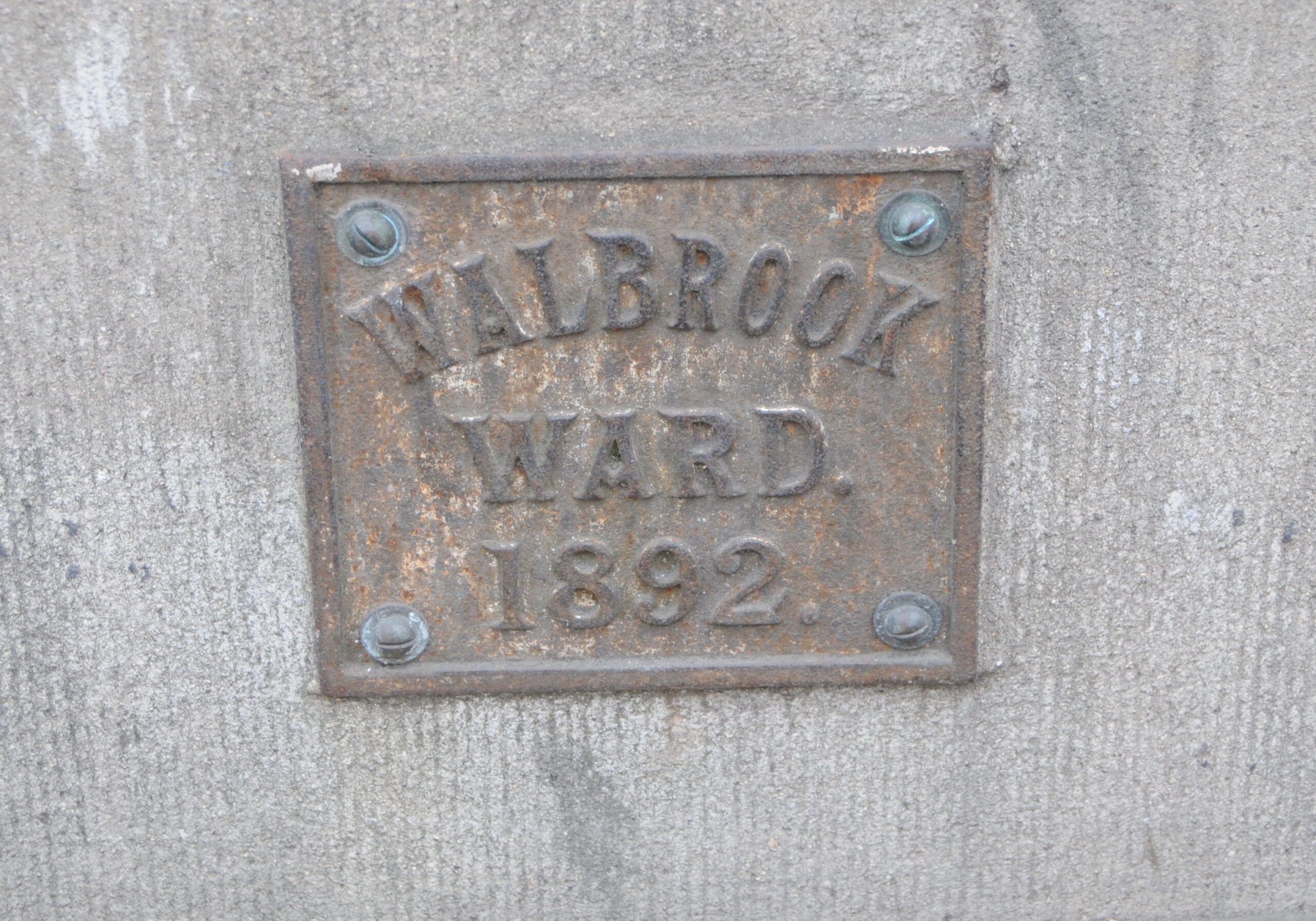
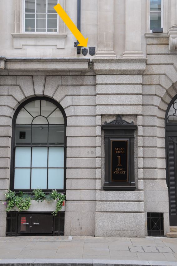
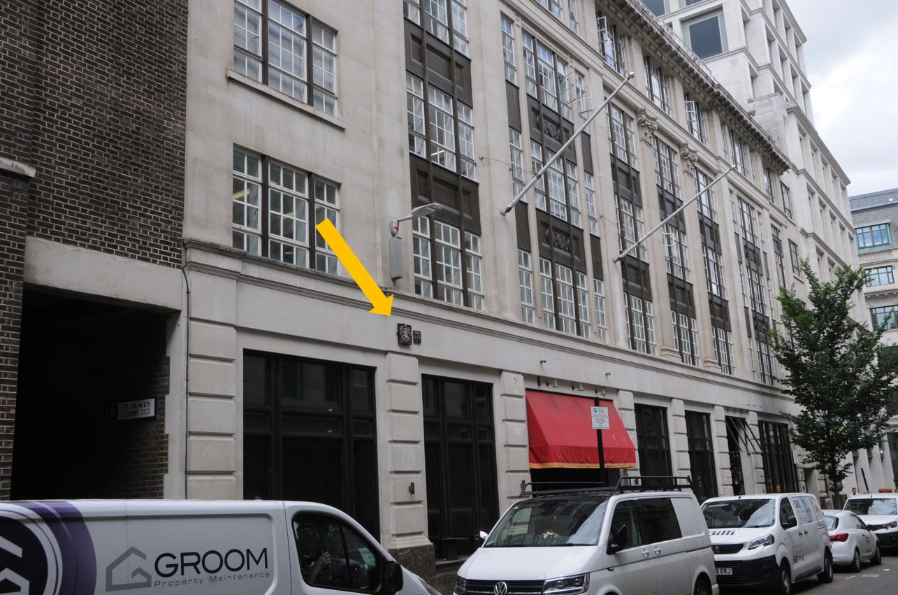
The first is on the City of London Magistrates Court on the corner of Queen Victoria Street and Walbrook. I have arrowed the marker which is low down on the building:
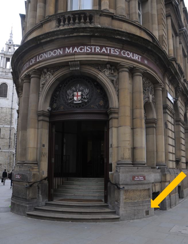
Where there is a simple marker dated 1892 for the north-western boundary of Walbrook Ward:
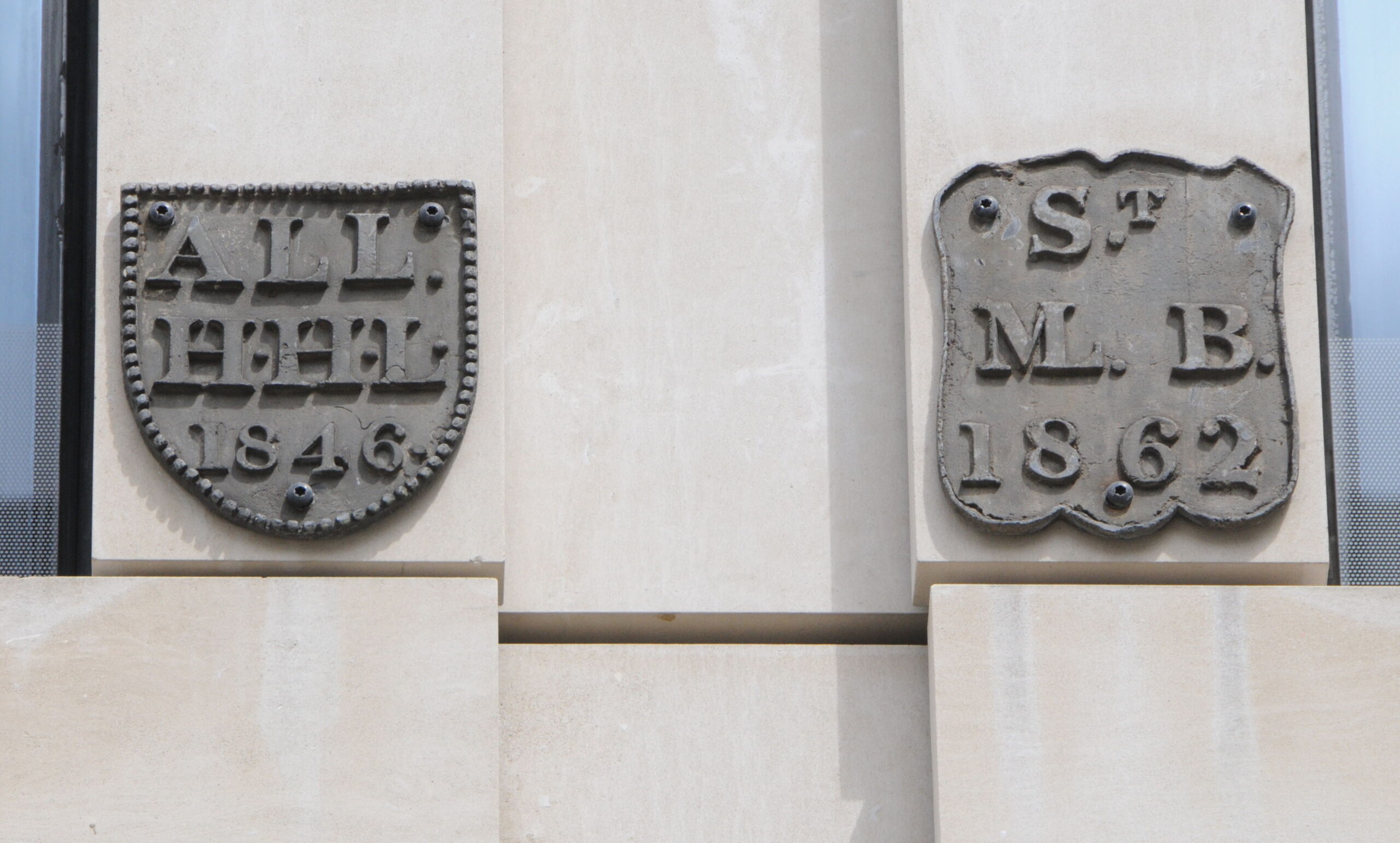
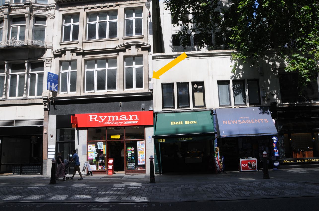
Many boundary markers have survived multiple rebuilding’s of a site, and can still be found on relatively recent buildings, such as the location arrowed in Cheapside:
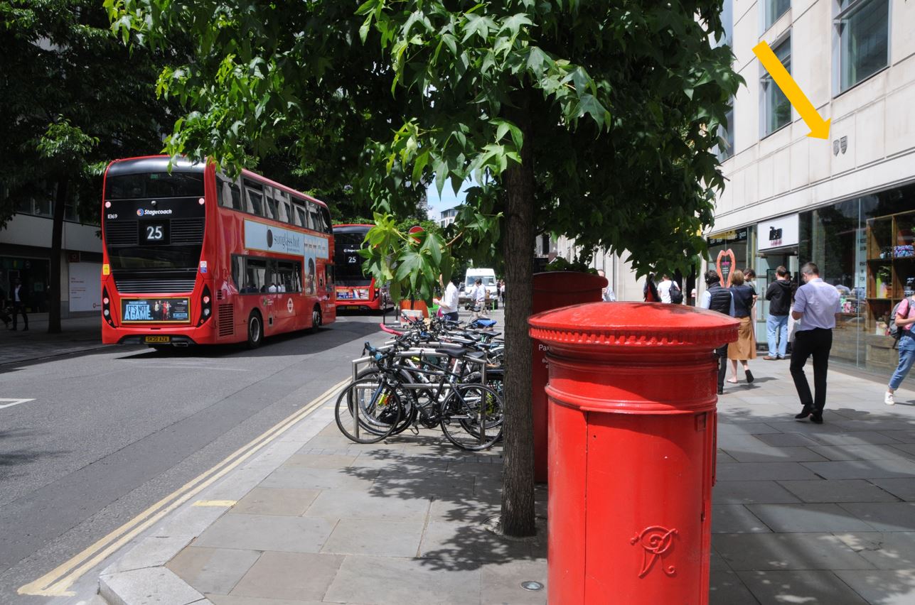
On the left is a parish boundary marker from 1817 for St. M. M. This is for St Mary Magdalene which could be found on Milk Street. This was one of the many City churches destroyed in the Great Fire of 1666, but the parish boundary still survived.
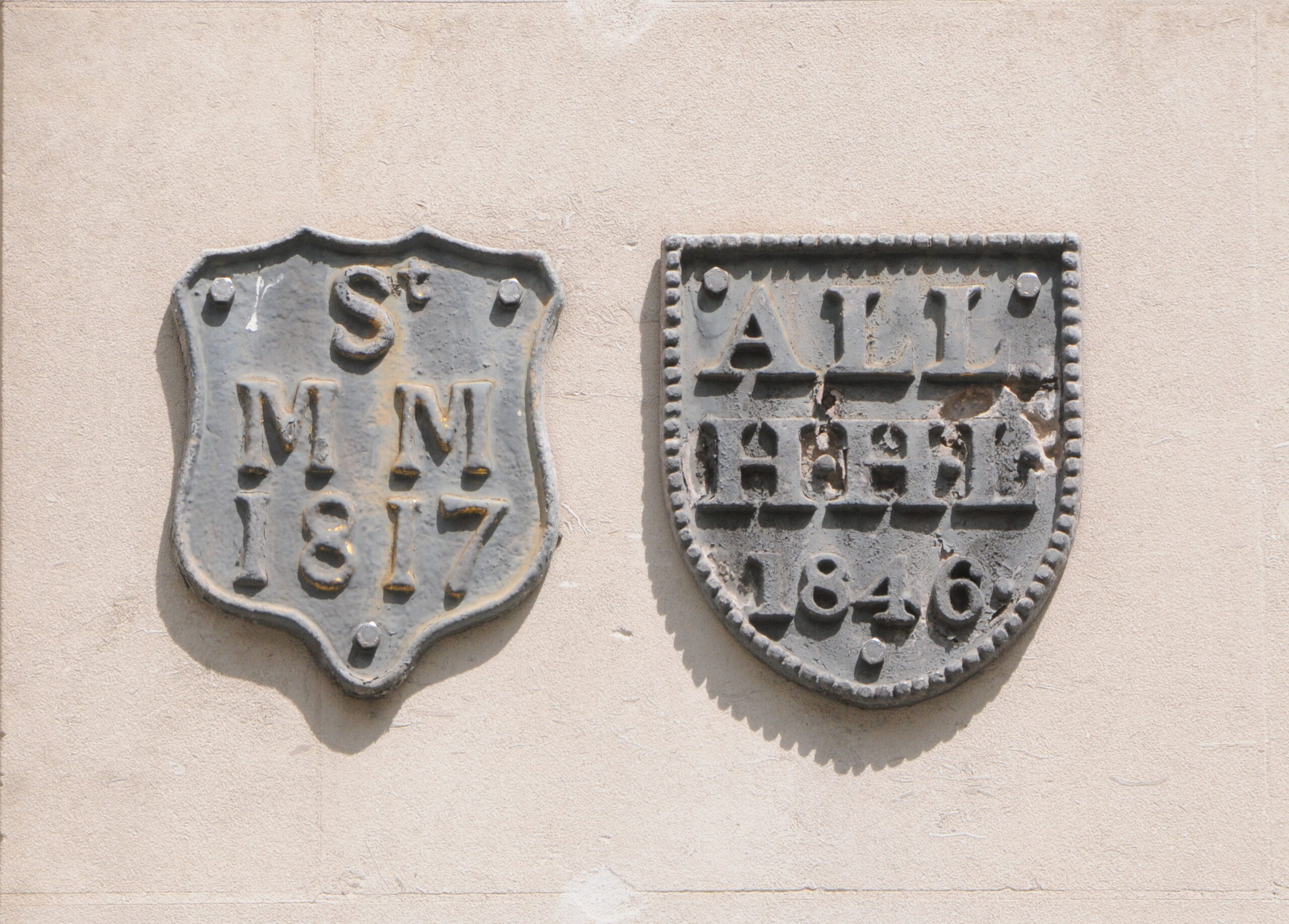
The boundary marker on the right is for the parish of All Hallows Bread Street, another church that is long gone, not in the Great Fire, but during the late 19th century when the City lost a number of churches due to declining numbers of parishioners.
There are another couple of plaques, the left plaque again for All Hallows, and the plaque on the right for St Mary-le-Bow (look closely to see how the right vertical of the letter M has been combined with the L):
There are a number of boundary markers along King Street, including the pair shown in the following photo:
On the left is the marker for St Martin Pomeroy, which was in Ironmonger Lane, again another church lost during the Great Fire and not rebuilt:
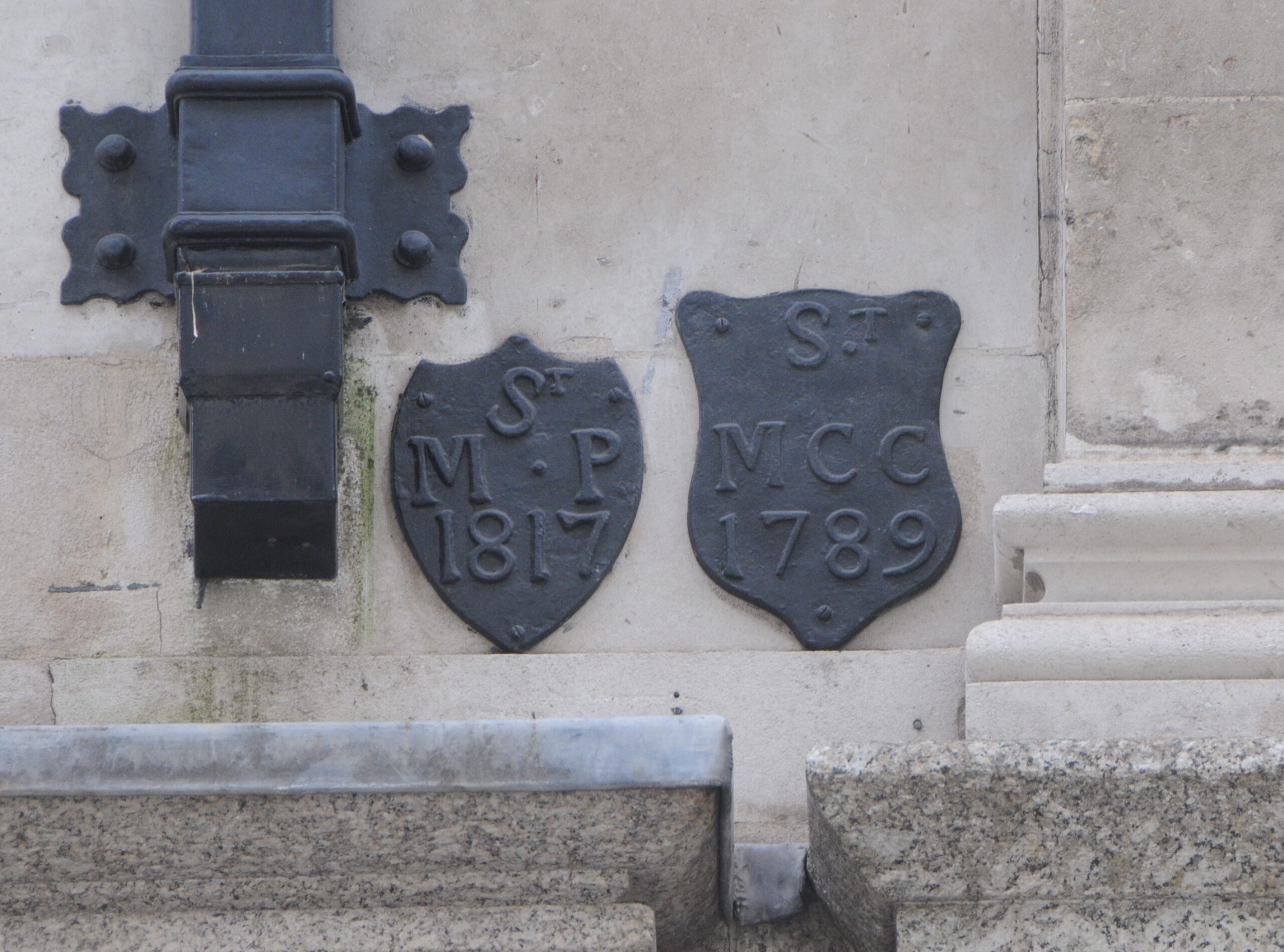
On the right is St Mary Colechurch, again lost during the Great Fire, but stood on the corner of Cheapside and Old Jewry. This is one of the older parish boundary markers in the City, dating from 1789.
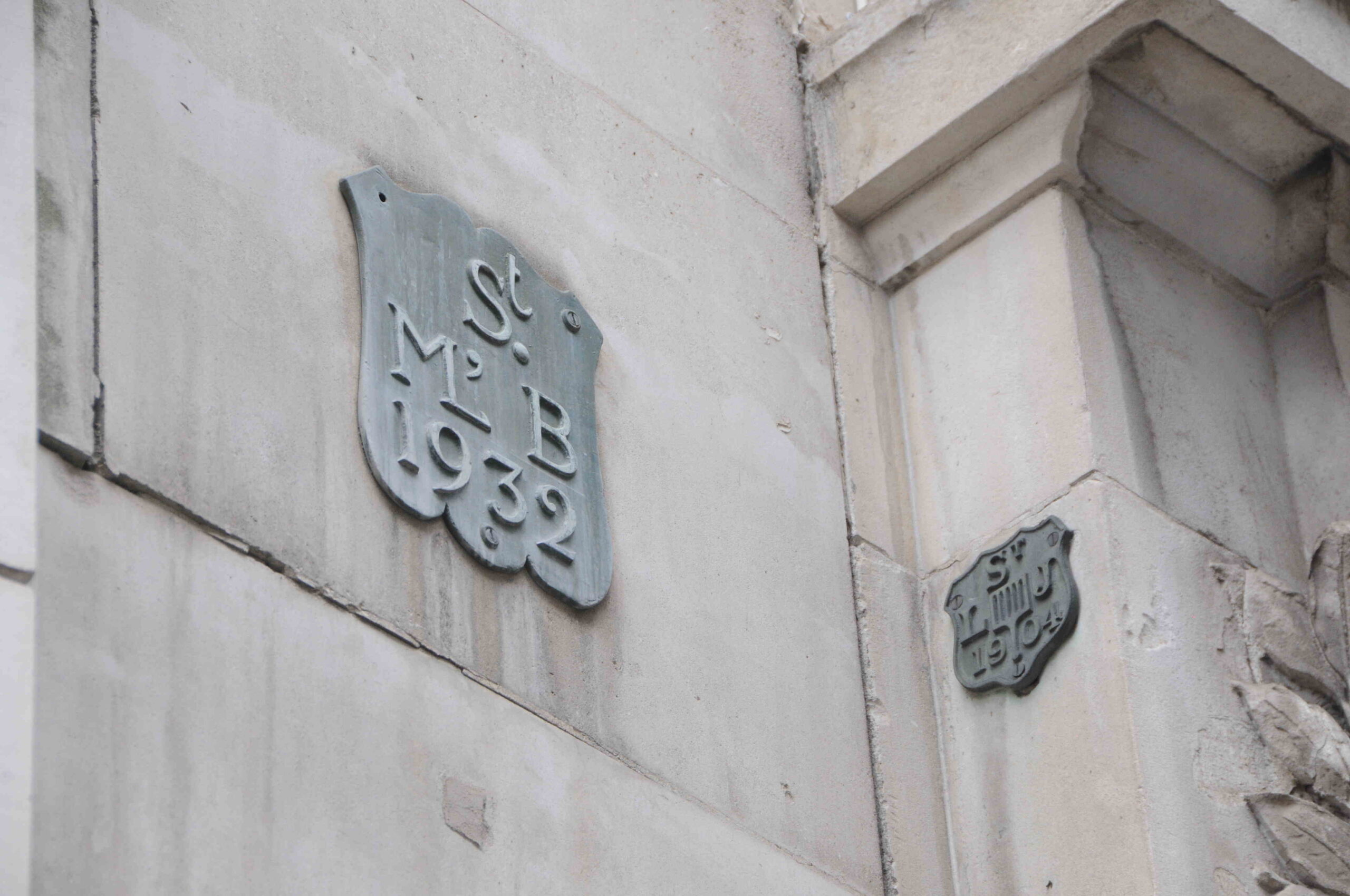
Below are two boundary markers. On the left is St Mary-le-Bow and on the right, St Lawrence Jewry in Guildhall Yard. Both of these plaques date from the 20th century showing that they were still relevant, and being updated.
Parishes had multiple boundary markers to show their boundaries with adjacent parishes, so another marker for St Martin Pomeroy:
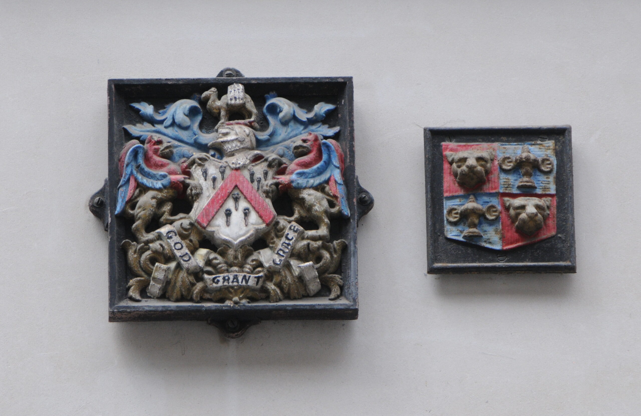
There are also markers recording the ownership of property, as on the side of the building in the following photo:
Where on the left are the armorial bearings of the Grocers’ Company, and on the right those of the Goldsmiths:
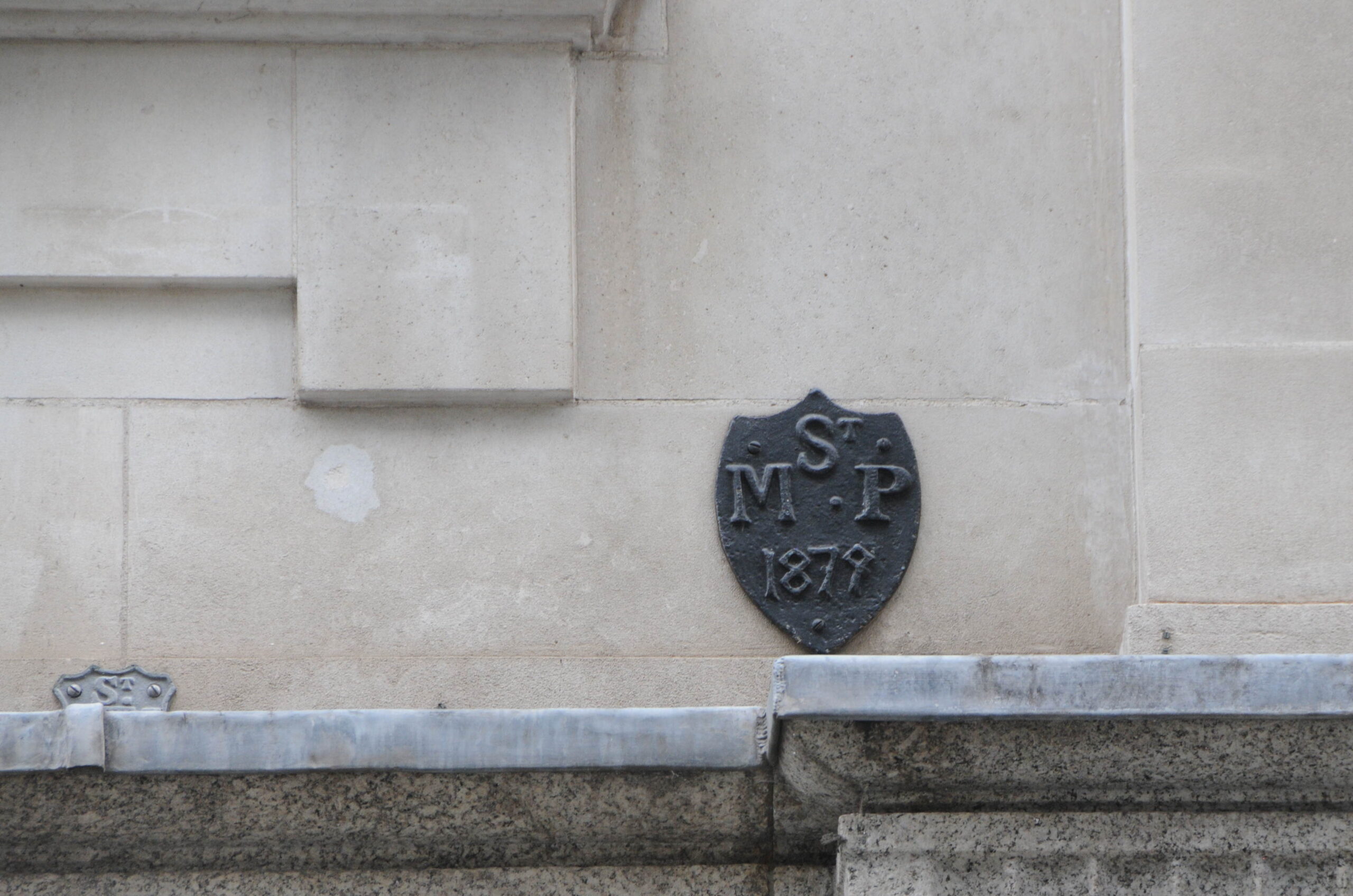
On the corner of Old Jewry and Frederick’s Place:
There is a plaque with two dates, 1680 and 1775. I think this may be a parish boundary marker for St. Olave Jewry, a church that was demolished in 1888:
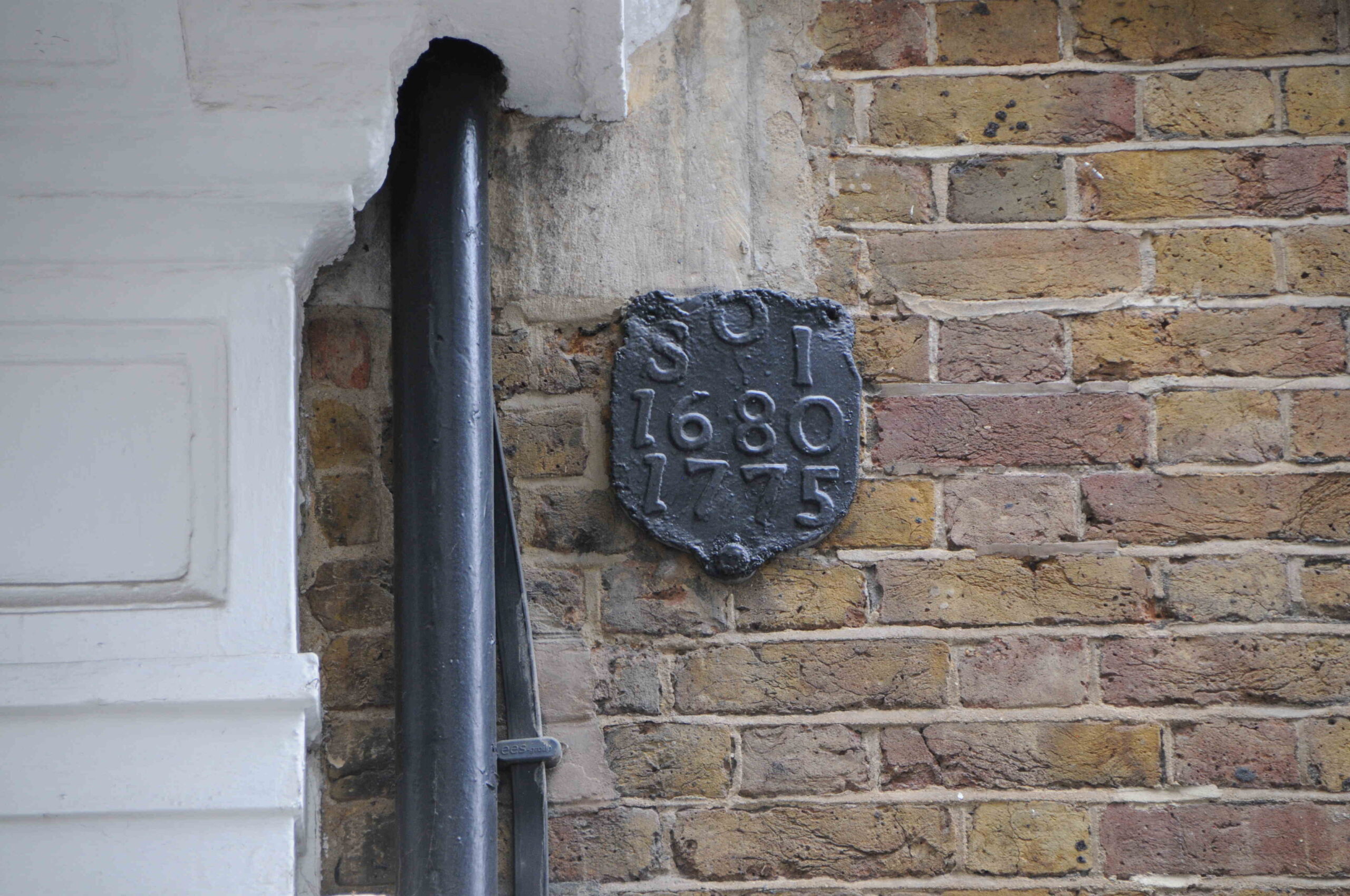
I am not sure why there are two dates, and whether the plaque originally dates from 1680, and the 1775 date was added when the boundary of the parish was reviewed and confirmed.
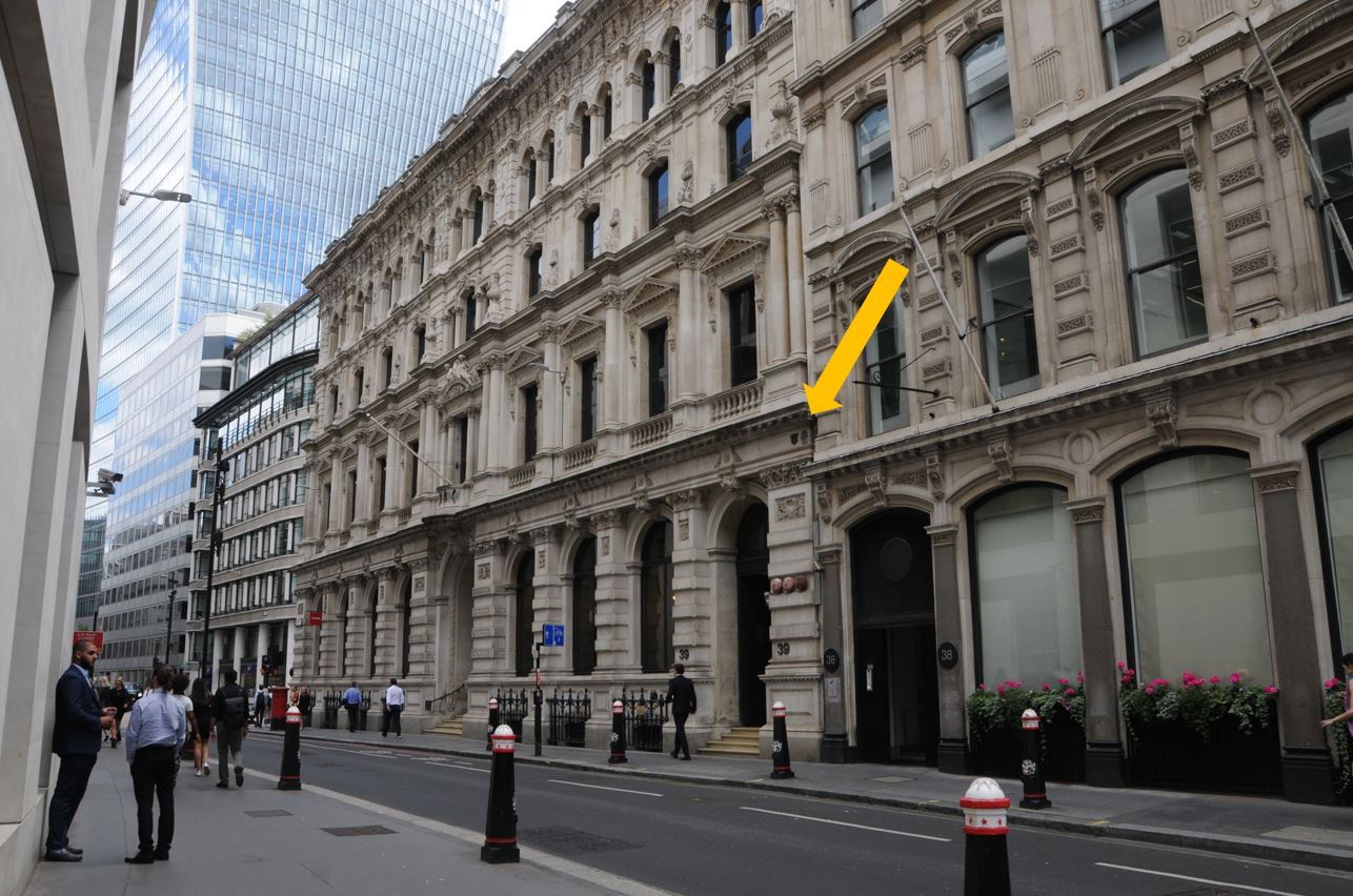
In Princes Street, on the wall of the Bank of England:

There are multiple plaques, with top left, St Margaret Lothbury. Top right is St C.P. a plaque for the church of St Christopher which was on the site of the current day Bank of England. Bottom left is a second plaque for St Margaret Lothbury, 43 years after the plaque above.
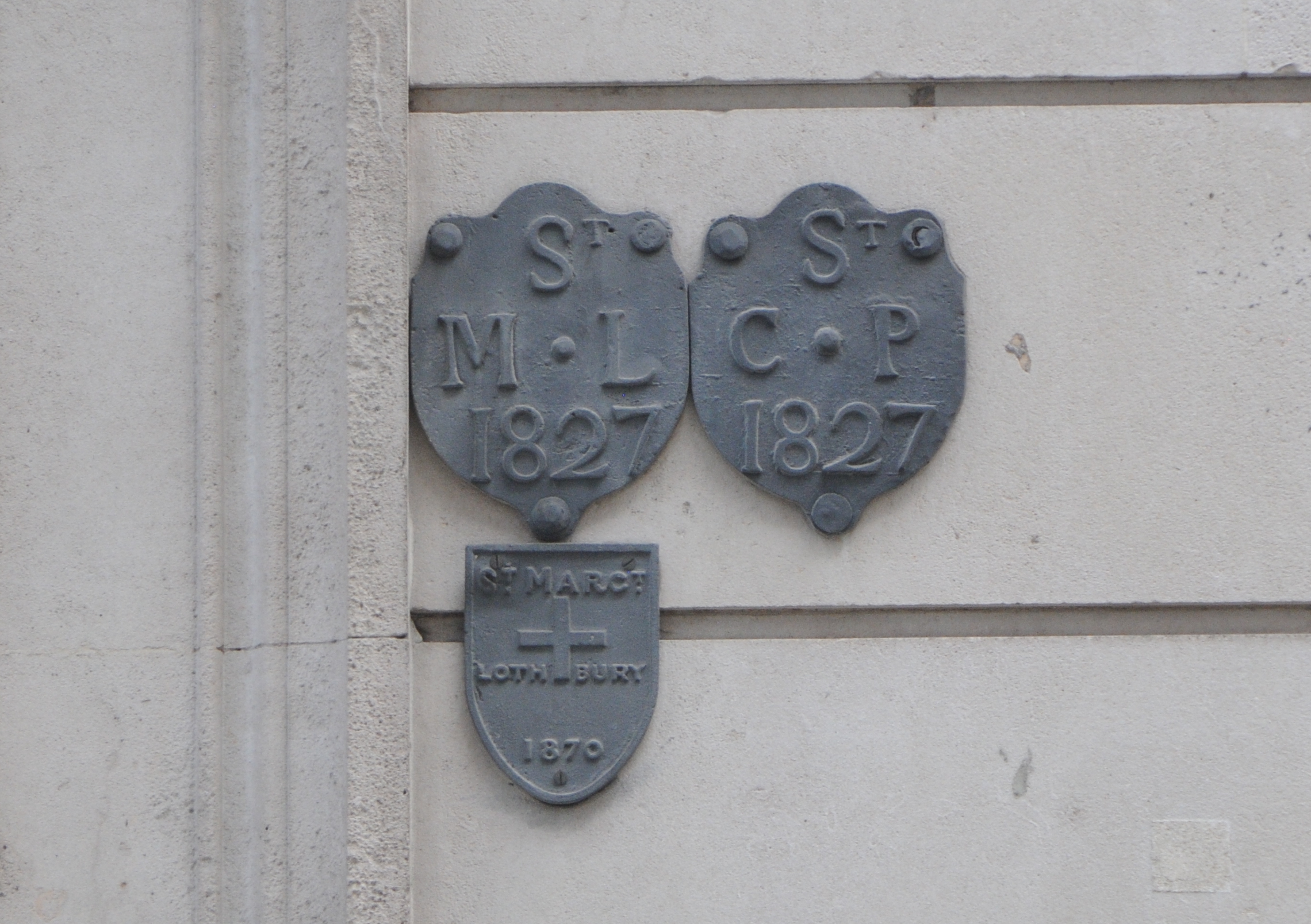
The plaques for St Margaret Lothbury are on the left as that was their side of the parish boundary, and the two dates show the years when the boundary was confirmed.
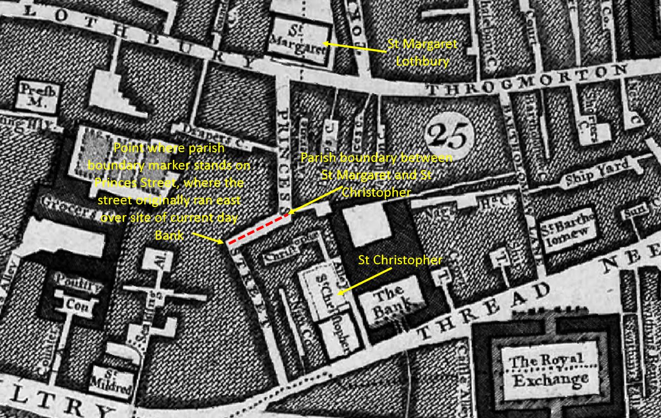
Plaques such as these now in the middle of a wall of a building show where the parish boundary would have been when the area was more subdivided into smaller streets and plots of land. Indeed Roque’s 1746 map of London shows Princes Street turning east at this point, into where the Bank now stands, and where the parish boundary would have run, as illustrated in the following map:
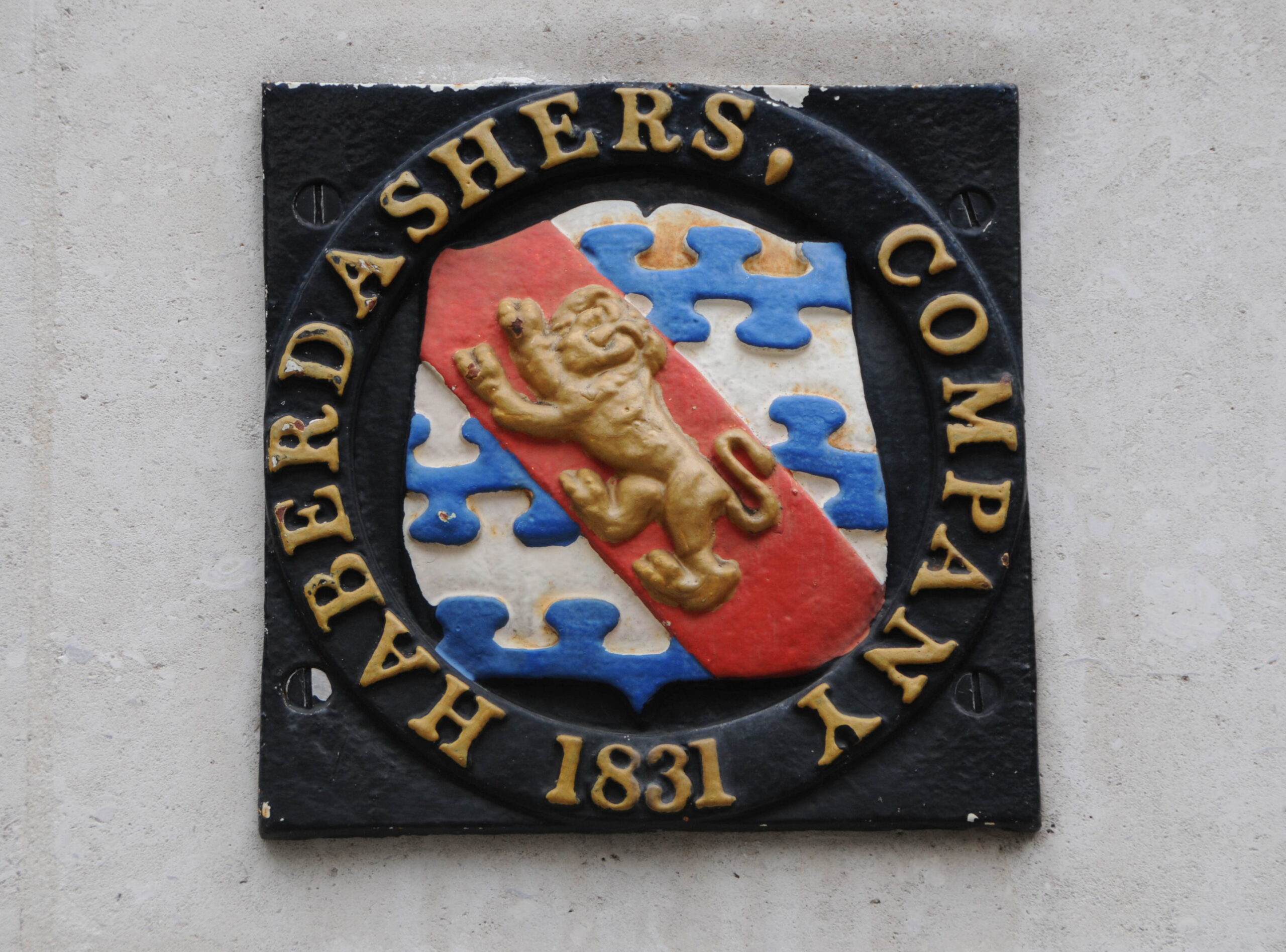
In Lombard Street is another cluster of markers:
Shown in detail below, on the left is a plaque of the Fishmongers Company, then is All Hallows, Lombard Street which was demolished in 1939, although the tower was moved to Twickenham, where it can still be seen (subject for a future blog post). Then there is a plaque of the Haberdashers Company, which must have been there to show property ownership of adjoining properties by the Fishmongers and Haberdashers. The plaque at lower right is showing the boundary of St Edmund, King and Martyr, a church which is still on Lombard Street:

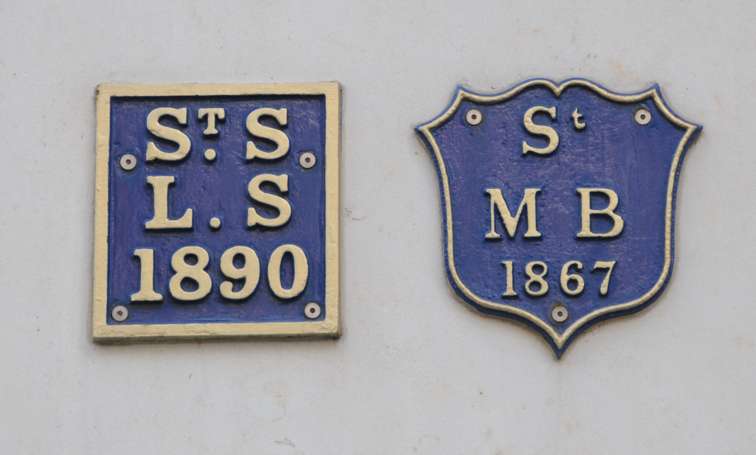
On the Marks and Spencer, at the entrance to Cannon Street station, are two plaques:
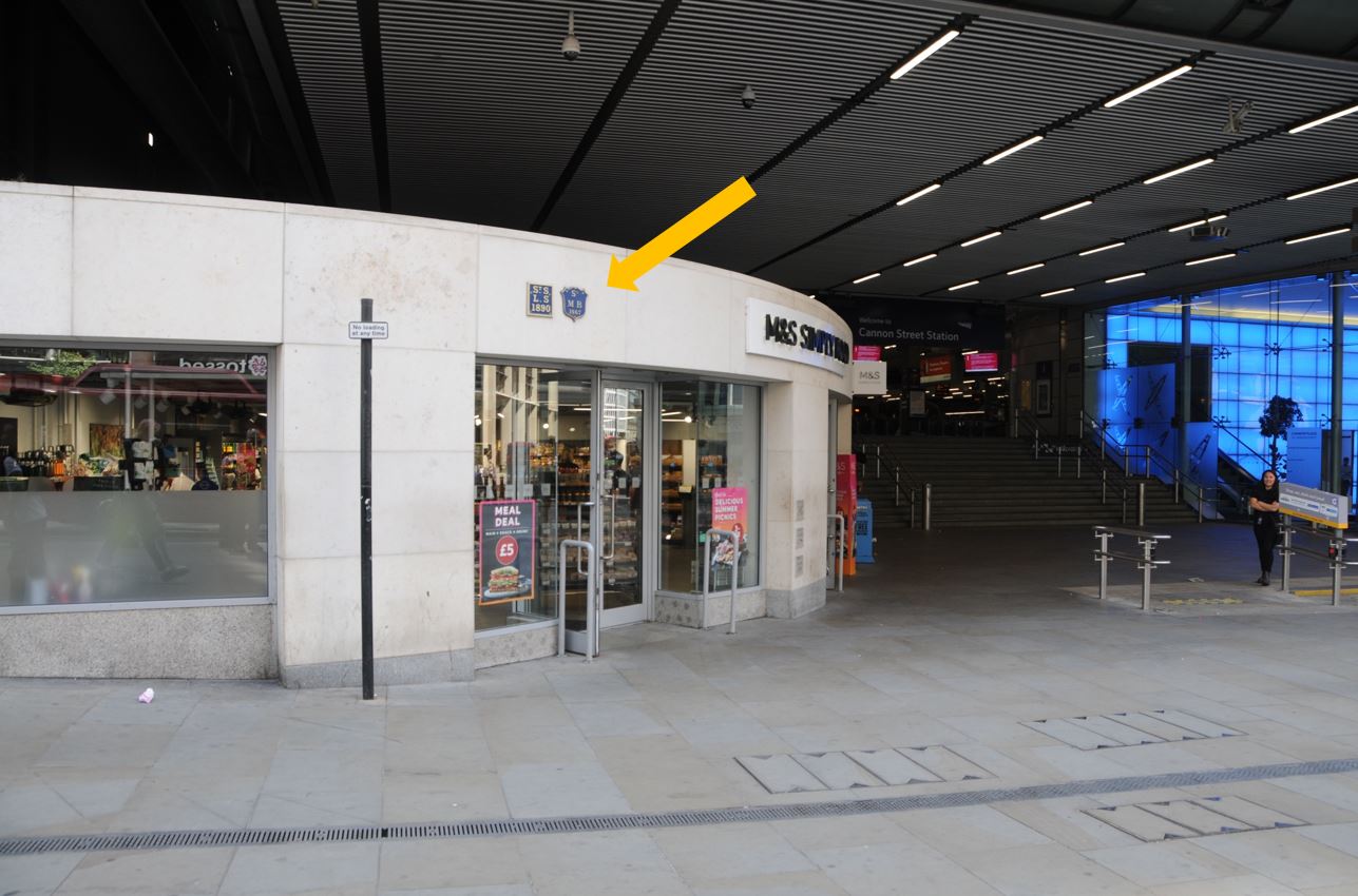
On the left is the boundary marker of St Swithin, London Stone, a church that was badly damaged in 1949, and demolished in 1962. On the right is the boundary marker of another church lost during the Great Fire, the church of St Mary Bothaw, that stood on the site of Cannon Street station.
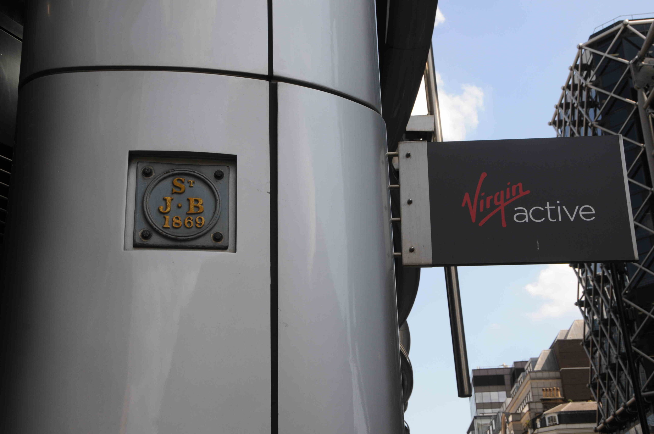
Opposite Cannon Street Station is a plaque to St John the Baptist. Destroyed during the Great Fire, a church that originally stood on the banks of the Walbrook:
Back on Cheapside, there is a small plaque on the first floor of a building:
The plaque has the arms of the Skinners Company:
Markers showing ownership of property are often on the edge of a building, to show where the boundary is with the adjacent property, as shown in the photos above, and the photo below:
Where there is a plaque showing the arms of the Haberdashers Company:
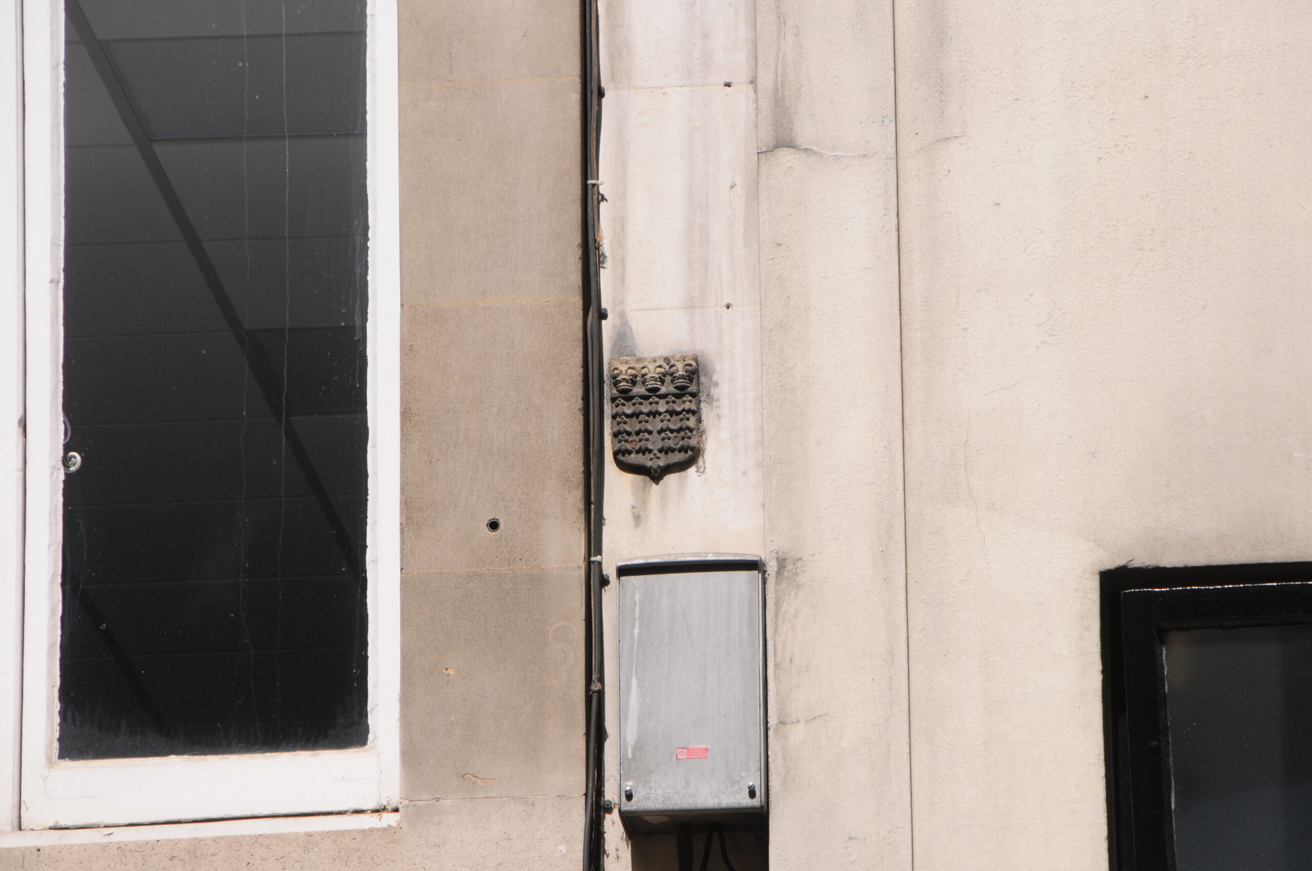
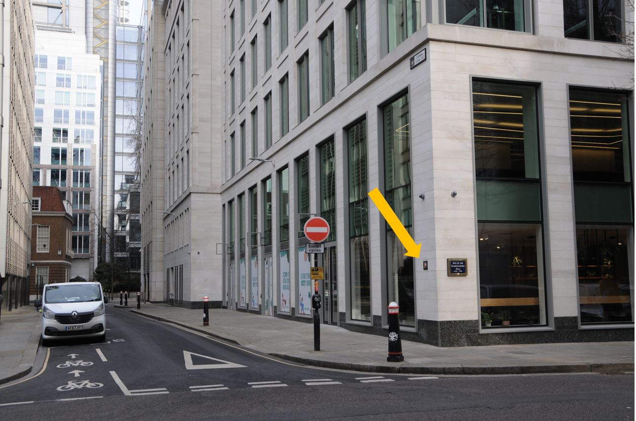
On a wall in Great Trinity Lane are three plaques:
The plaque on the left includes the full name of the church, details the distance from the wall to where the boundary extends, and includes the names of the churchwardens in 1889.
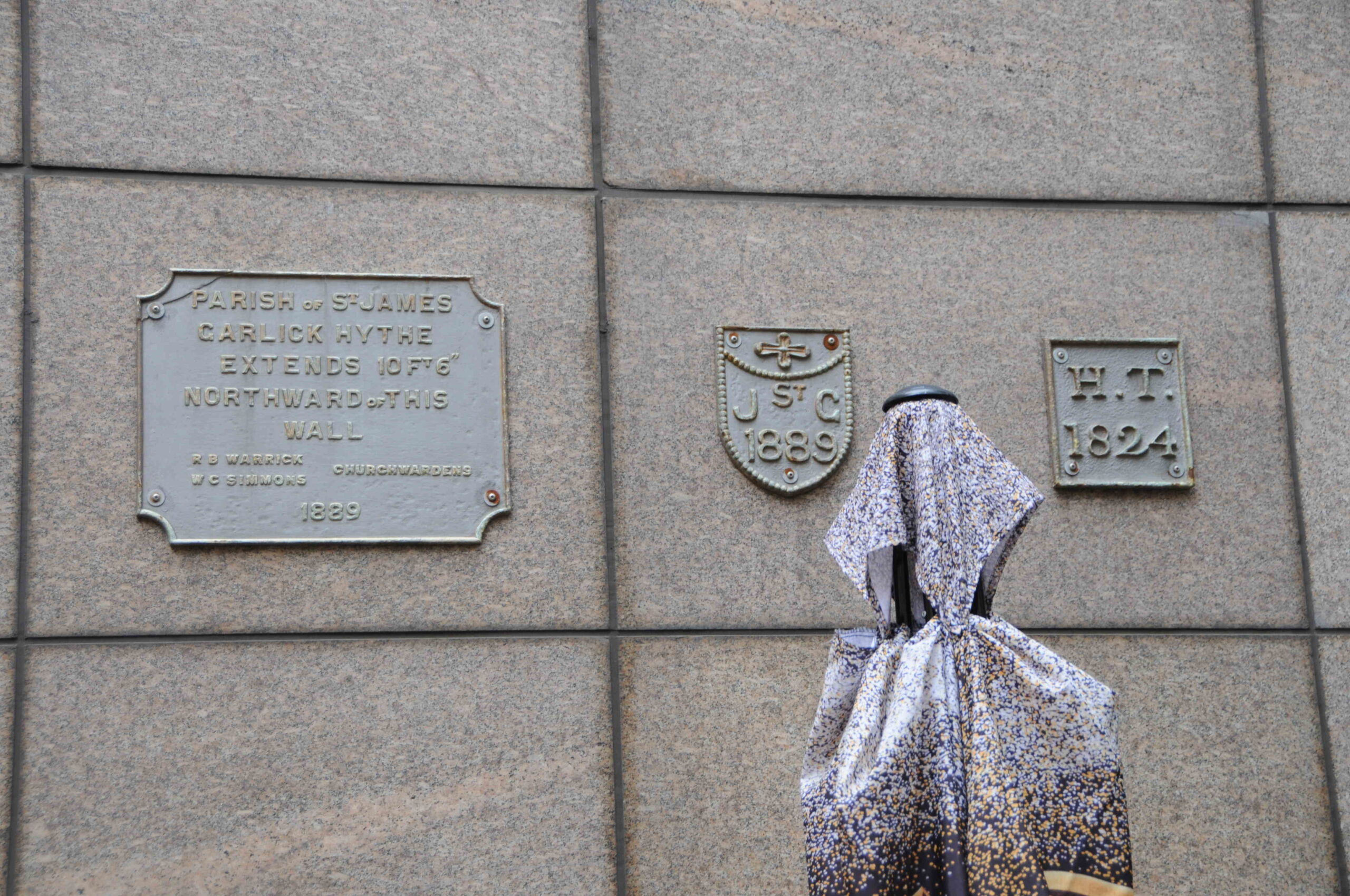
In the middle is St James, Garlickhythe. I cannot find the meaning of the H.T. plaque on the right. It does not have the “St.” prefix of a church, but not sure what else it could be.
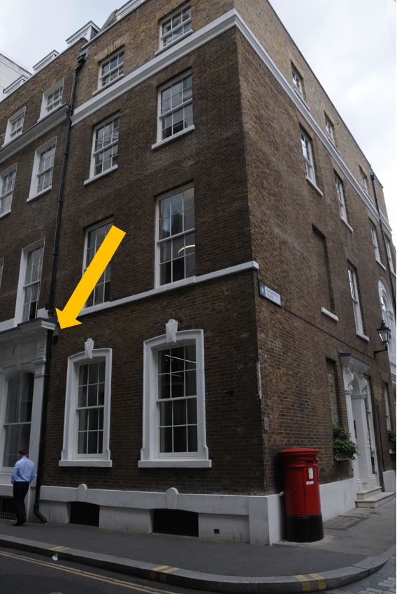
In Carter Lane, on a building at the junction with St Andrews Hill:

On the right is a plaque identifying the boundary of Farringdon Ward Within:
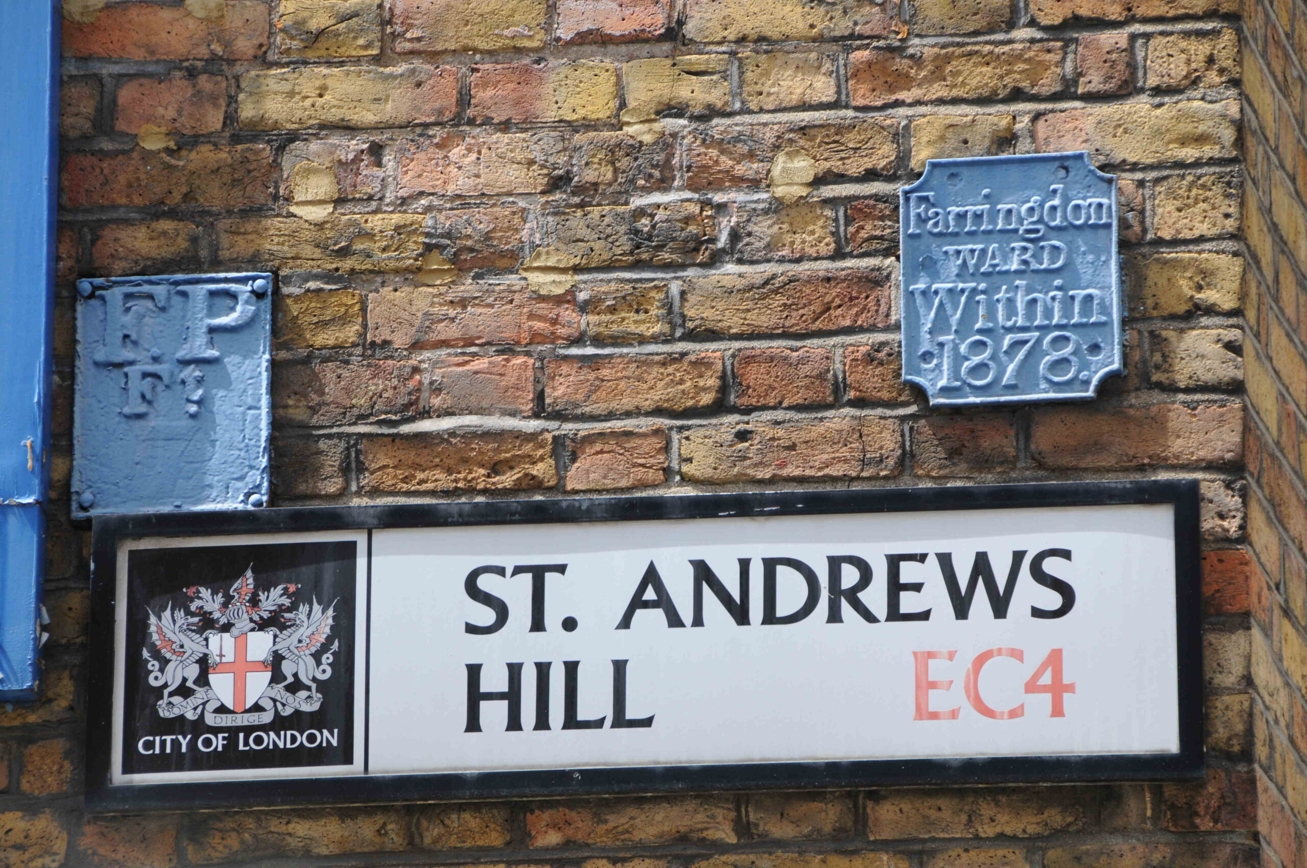
And an FP plate on the left, which stands for Fire Plug. Apparently in the early days of the fire service, and when many underground water pipes were made out of wood, firemen would dig down to the water main and bore a small, circular hole in the pipe to obtain a supply of water to fight the fire.
When finished, they would put a wooden plug into the hole, and leave an FP plate on a nearby wall to alert future firefighters that a water main with a plug already existed.
That is just a small sample of the very many boundary markers and markers identifying property ownership, that can be found across the City of London. Considering how many must have been lost over the years, there must have been a considerable number, probably lasting to the early 20th century, identifying Ward boundaries, Parish boundaries and where the City Livery Company’s owned properties.
Of course, it is not just the City where these can be found, there are markers all over London.
As an example, the following view is looking towards Horse Guards, from Horse Guards Parade:
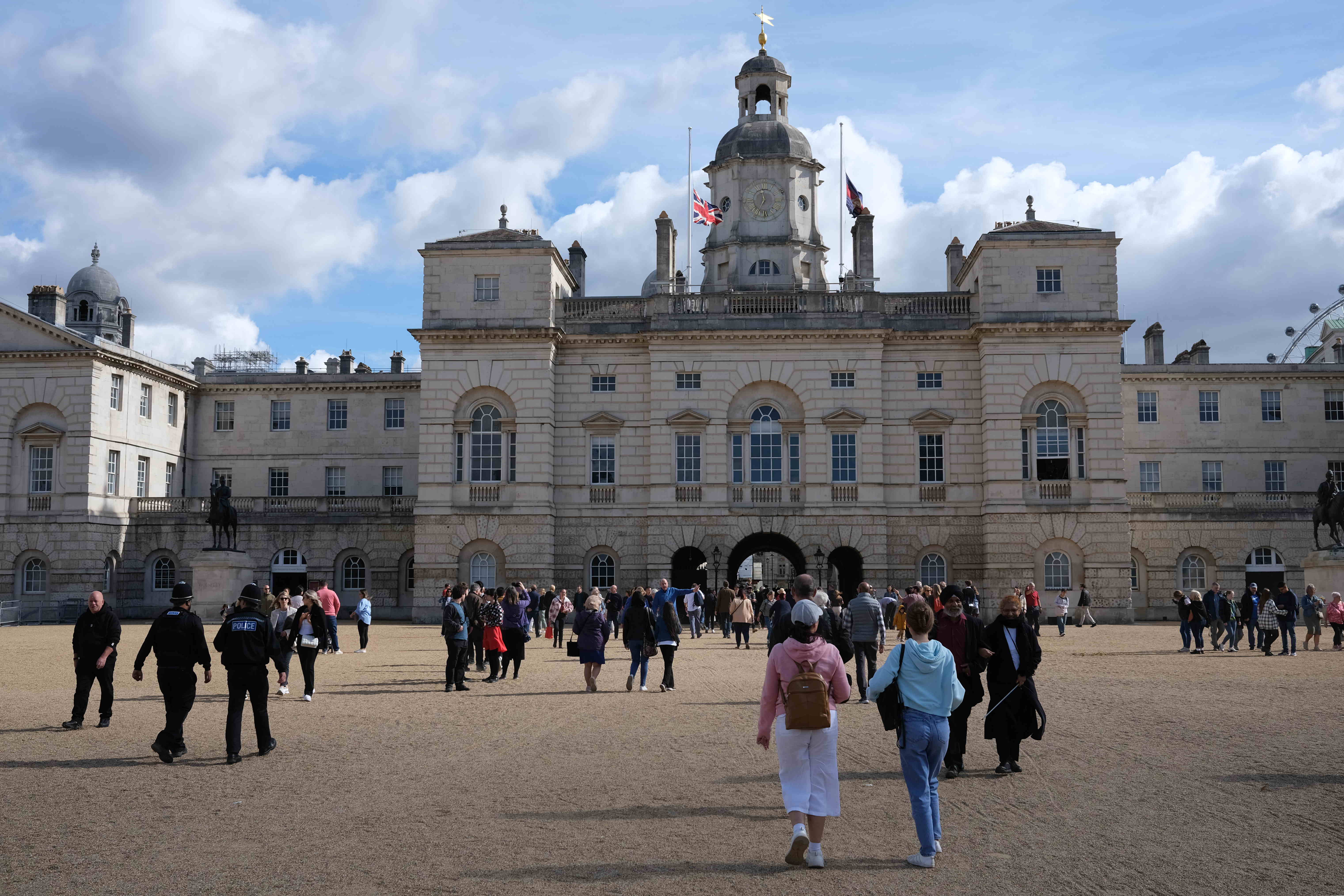
There is a central arch through the Horse Guards building, a route that has featured in recent royal events where processions will frequently pass through the arch, and a roof mounted camera follows processions through, however look to the roof of the arch as you walk through, and there are two parish boundary markers:
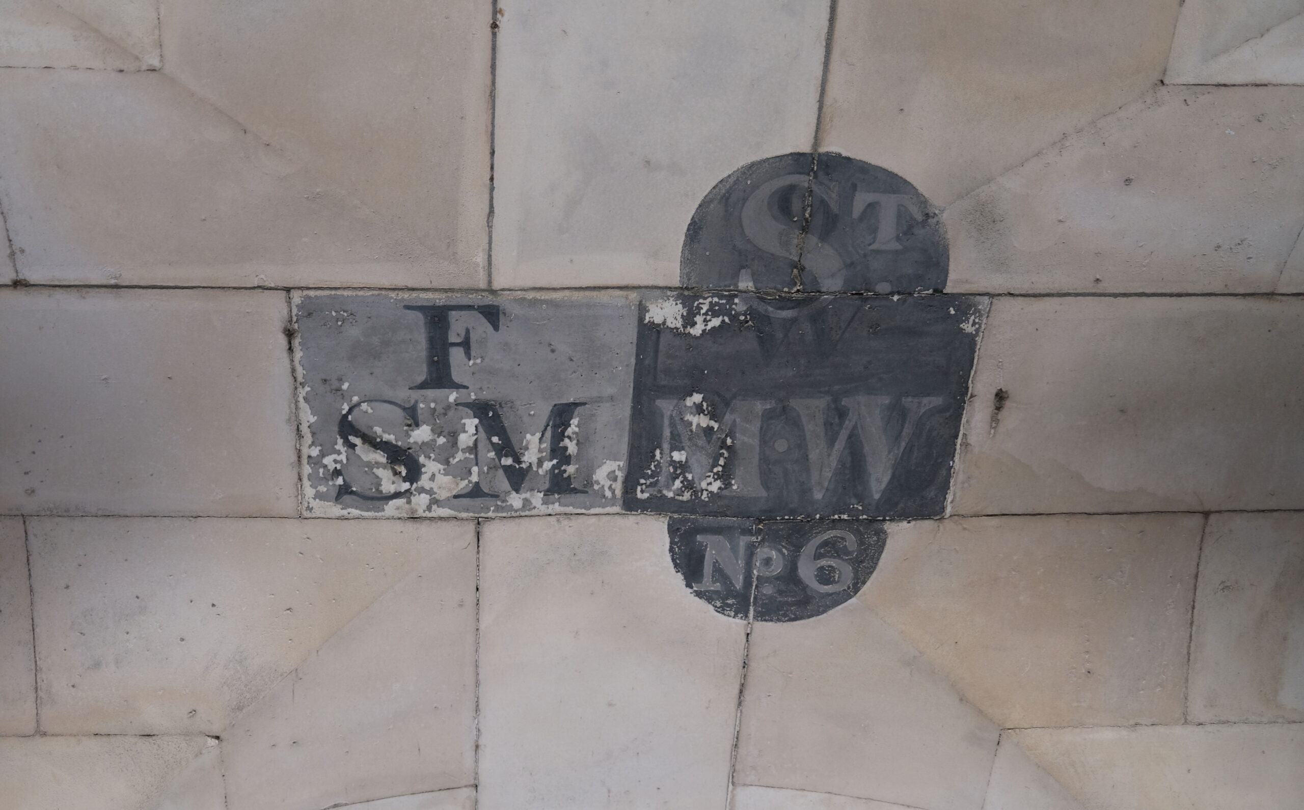
On the right is St Margaret, Westminster, with the suffix of No. 6 which presumably means that this was the 6th marker in a series that marked the parish boundary.
I suspect the marker on the left refers to St Martin in the Fields, adjacent to Trafalgar Square.
These boundary markers are a fascinating reminder of the importance of the parishes and wards in the City of London, even how churches that were lost during the Great Fire in 1666, and not rebuilt, still have their parish boundaries marked on the streets.
Historic property ownership by the livery companies of the City can also be traced by the plaque on the walls of City buildings.
Once you notice them, you will find them on walls all across the City.
Would the HT maybe stand for Holy Trinity? Was there a church of that name nearby? Just a thought!
HT might refer to Holy Trinity in a church context, explaining the lack of a Saint prefix.
Always a fascinating blog. I particularly enjoyed today ‘s detailed information on City boundary markers. “Fire Plugs” what a fascinating historical snippet. Impressive research.
Well, that was a joyful stroll on a chilly Sunday morning! Can I add the two plaques high up on Talbot House in Talbot Court, just off Eastcheap?
Fascinating post as always. Just a thought, perhaps HT stands for Holy Trinity?
Thanks for another interesting post. I like to look out for these markers but I am impressed at the ones you have spotted – I must have walked past them often and not seen them.
The HT probably refers to Holy Trinity the Less which, according to the London Encyclopaedia, stood in Knightrider Street. It was destroyed in the Great Fire and not rebuilt.
I am so intrigued by all the small details and knowledge you share with us. How did you know what these boundary markers were and what they mean? Is there a book or description that lists them all? Do you also catalogue and publish your findings, or have a published book containing these facts. I love this blog and it would be great to have all your photos etc in one place to re-read. Many thanks Sarah
Thank you I’ve seem them on walls but never knew the history of them.
I used to serve as an Environmental Health Officer for the London Borough of Islington. I was often concerned as to where the boundary between the City and Islington (and, for that matter, LB Hackney) was, exactly. In the Smithfield area there was a line of brass studs set into the pavement of Charterhouse Street near the junction of St John Street. These were important for they defined the boundary between two jurisdictions in an area where trade in the transport of meat (Bumerees and their carts) took place in the street. The boundaries frequently run through the middle of buildings (Whitbreads brewery and Old Street underground station plaza spring to mind). One, non-compliant, barrow boy (fruit and veg.) set himself up in South Place on the corner of Wilson Street EC2. He could skip from Islington into Hackney or the City whenever I appeared. I enlisted the Met Police for assistance in the end.
I very much enjoy your posts and I am amazed at how the streets I used to walk have changed in 40 yrs.
Holy Trinity the Less, Knightrider Street (demolished 1871) or Holy Trinity Gough Square (demolished 1906)?
I believe HT is Trinity the Less, destroyed in the Great Fire but not rebuilt. A Lutheran Church on the site was demolished when Mansion House station was built.
There is a second HT plaque on 63 Queen Victoria St.
Thanks for filling in the gaps for me on other markers – I’ll be out looking up Skinners and Grocers later!
“I cannot find the meaning of the H.T. plaque on the right. It does not have the “St.” prefix of a church, but not sure what else it could be.”
Is is possibly for “Holy Trinity”?
Thanks as ever for your interesting postings and wonderful photos.
With reference to the three plaques on Great Trinity Lane, could the far plaque on the right be a reference to the parish of Holy Trinity the Less? This parish is marked on a map of 1896 from the National Library of Scotland
I found it fascinating to see these little plaques. I expect you know that large oak trees were traditionally planted to mark County boundaries. The house where I grew up, now in Ealing W5, looked out upon the big oak tree that marked the boundary with Brentford. M. Cowen
Another fascinating journey around the history of London. Could HT stand for Holy Trinity ? It could be a long-gone church ? Best Wishes Michael
What a fasinating blog!. I am a recent addition to this site and love the research. I worked in the City for 29Y and loved the history and this brings back happy memories of lunchtime walks.
Keep up the great work!
HT night be Holy Trinity?
As always, fascinating and thank you
This is a very interesting article. Although I worked in the city, I have never noticed a marker.
I love that old Plaques have been place on newer buildings so we don’t lose track of history.
As a girl I loved crossing the road and reading the Plaque for Tyburn where so many were hung in history.
Thank you so much for your wonderful work.
In Canada, and I presume the UK, boundary markers are registered survey markers and it is illegal to move them without a court order. As a result, the new buildings still display the old markers. They probably had to get a court order to give them permission to move them. When the government were building a new road, they came across a mining claim post in the middle of their clearing. It stood there for some time until they could get the court order and move the post and complete the road.
Another fascinating post..I love your blog even though I live in the North West of England
I did a little map sleuthing—could the initials H. T. stand for High Timber?
Fascinating, thanks!
Absolutely brilliant article.
Kevan
“There was a need to mark these boundaries and ownership of property. Boundaries also needed to be regularly reaffirmed to maintain the boundary, and this needed to be done in a way that was obvious to those who walked and lived in London’s streets, with a clear record, before the ready availability of detailed maps”.
A thing in Oxford too :-
https://www.bnc.ox.ac.uk/about-brasenose/history/215-brasenose-traditions-and-legends/416-beating-the-bounds
https://www.smng.org.uk/wp/about-us/history/beating-of-the-bounds/
https://www.oxfordmail.co.uk/news/17675639.beating-bounds-still-going-strong-oxford-city-centre/
A splendid article, Thankyou. A complete aside, but David Nattress’ comment brought back a memory. In the early 1970s I knew the barrowboy and his brother, who set up on the corner of South Place and Wilson Street. I worked in Worship Street and passed them most days on my way to Barclays on the corner of South Place and Moorgate, and they used to drink in the Old King’s Head, at the joining of Holywell Row and Scrutton Street. I never knew their names. It must have been about 1973, while I was buying apples, the younger of the two brothers rushed across South Place to the aid of a woman who fell on the pavement in an epileptic fit, made her comfortable and waited with her until an ambulance arrived. So, perhaps rather fly, but not all bad!
When looking at the parish boundary markers, they are sometimes accompanied by the old insurance plates which indicated (i think) that if there happened to be a fire, the insurance company’s own fire fighters would attend and, hopefully, put it out.
Fabulous article as always. I’ve just begun to notice the fire insurance badges, now I’ll look for more on London buildings.. (Although, I should probably take a pair of binoculars to see them properly!)
Great read
As an ex South londoner thanks
For a comprehensive guide to London’s parish boundary markers I would recommend the inventory, maps and photographs prepared by the late Mike Horne which can be found here: http://www.metadyne.co.uk/Parishboundaries.html
Pleasing that so many remain and have been resited on modern buildings
Excellent Sunday morning read as your posts always are. With the City being endlessly redeveloped as it is now, there’s a danger of these markers, and the history they represent, being lost.
Incidentally, one suggestion: I think the parish boundary marker in your Cheapside photograph with the initials AHHL isn’t All Hallows Bread Street, although that’s near too, but All Hallows Honey Lane, a church which burnt down in the 1666 Great Fire and was not rebuilt.
In addition to the comprehesive survey Paul has noted on the late Mike Horne’s website, with which I helped in a small way, readers might be interested in my own material at http://www.dougrose.co.uk