
Following last Sunday’s post covering the first part of my walk around London’s West End theatres, I had been expecting to publish the second part a couple of days ago, however I must admit I have never really counted up how many theatres there are (over 40), so I am still working on the post. Therefore today, back to one of my father’s photos of London 70 years ago.
This is my father’s post war view of the stretch of the north bank of the River Thames between London Bridge and Cannon Street Station:
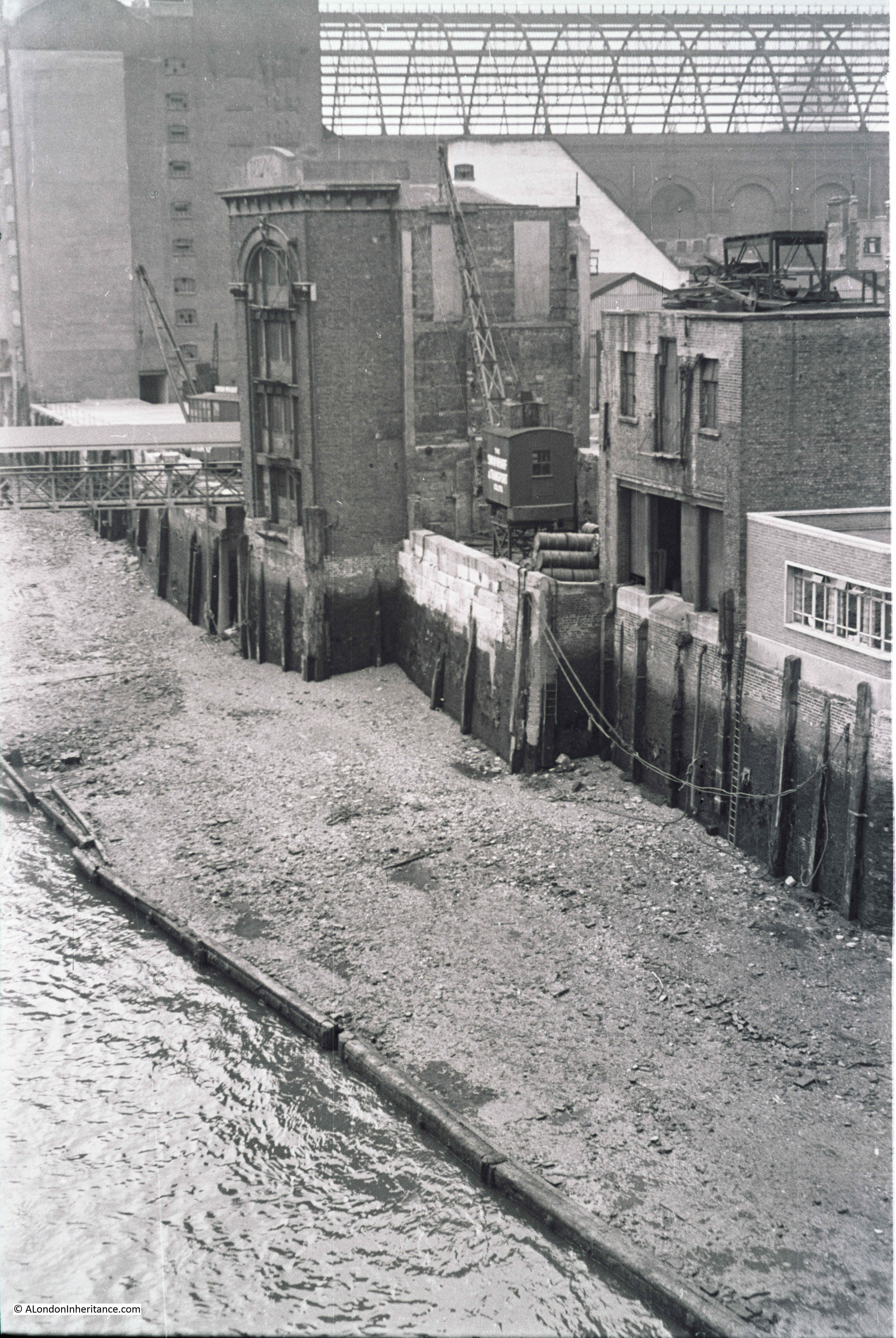
The magnificent framework of the original glass roof of Cannon Street Station is in the rear of the photo, the glass had previously been removed so this is just the metal framework.
My father was standing on London Bridge to take the photo and the river front consists of space cleared of buildings damaged by wartime bombing and some of the remaining warehouse and wharf buildings.
I took a wider photo of the scene today to set the context as the side walls of Cannon Street Station are now obscured and the station has long since lost the original roof.
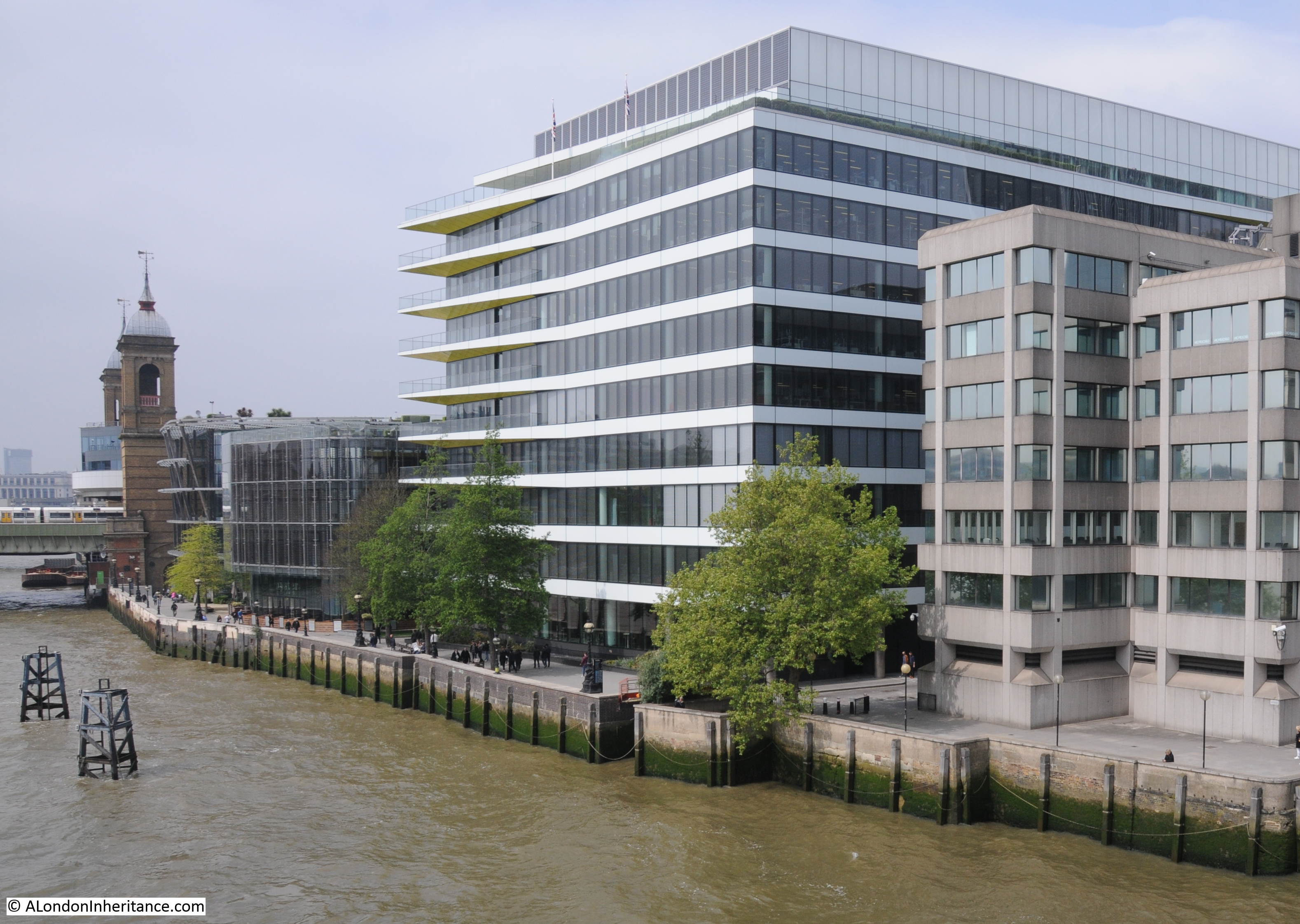
The scene has completely changed, and the perspective of the two photos looks different due to very different lens and camera types, however there are some features remaining that allow the buildings in the original photo to be located.
The following map extract is from the 1952 Ordnance Survey map of the area (published in 1952, surveyed the previous year).
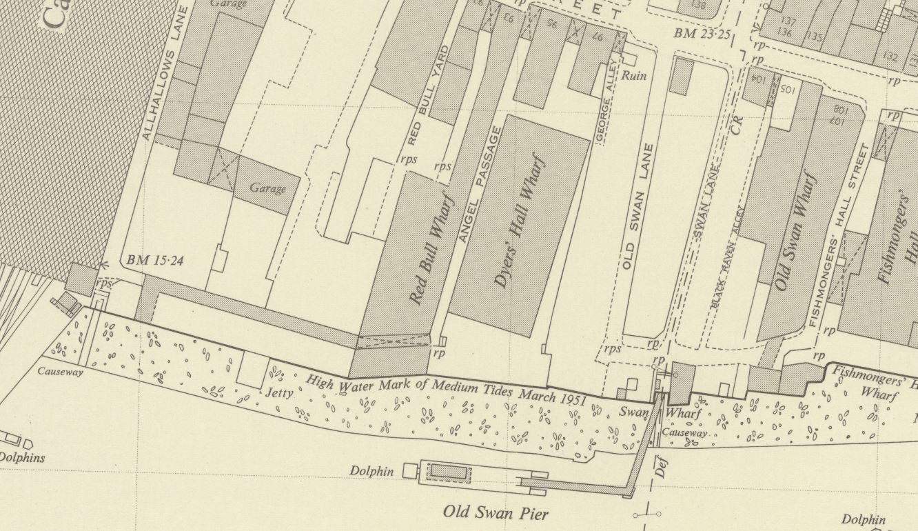
In the map, Cannon Street Station is the large building, partly shown on the left of the map.
The first feature to identify on the photo is Old Swan Pier. In the map, this can be seen running from a small, rectangular indentation in the river wall. In the original photo, this is the metal walkway that can just be seen running out from the river wall, with the small indentation in the river wall also partly visible.
This allows the building to be identified adjacent to the pier, this is Swan Wharf, the building has a date on the very top which I can just make out as either 1896 or 1894.
Now follow the river wall from the pier and Swan Wharf back to the right hand edge of the photo and the river wall steps back twice, once alongside the edge of the Swan Wharf building, and the second slightly further along. These two steps backs in the river wall can also be seen in the 1952 map which identifies the building to the right of the crane as the building at the end of Old Swan Wharf in the map.
The definition of the original film is not sufficient to clearly read the white writing on the side of the crane, but it appears to read “The Swan Wharf & ———“. I cannot make out the last word.
Given the level of redevelopment in this area it would be surprising if any of these features (apart from the station) remain, however there are some that allow the location of the original buildings to be placed along the river’s edge today.
Firstly, look along the river wall in today’s photo and you will see an indention in the river wall. This is the same indentation as at the location of the pier in the original photo and was retained as this gap in the river wall is the location of Old Swan Stairs, one of the many historic stairs leading down to the river.
Two dolphin structures can also be seen in the river, these are a couple of the remaining supports from the Old Swan Pier.
To the right of the stairs in today’s photo is a large tree, this is the location of the Swan Wharf building in the original photo.
From the tree to the right of today’s photo there are two step backs in the river wall. These are the same as those in the post war photo, with the old building to the right of the crane being the building at the end of Old Swan Wharfe in the 1952 map.
Old Swan Stairs have been here for many centuries. The following extract from John Rocque’s map of 1746 shows Old Swan Stairs.
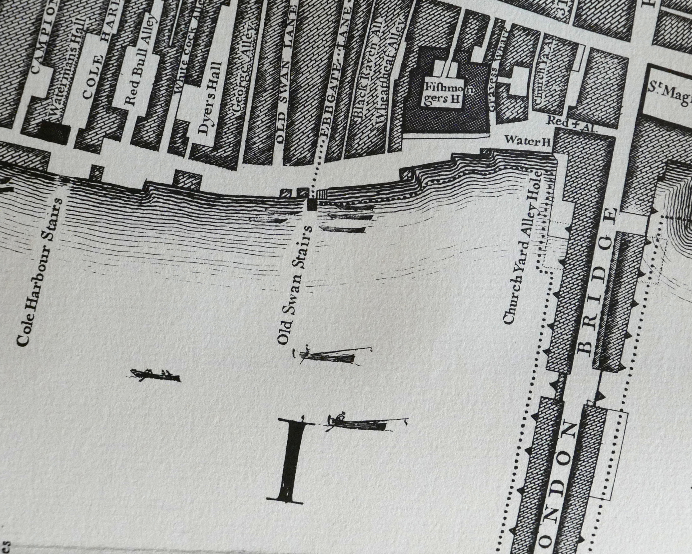
In the 1746 map, the stairs are at the end of Ebbgate Lane, in the 1952 map this lane was then Swan Lane with Old Swan Lane to the left in both maps.
Swan Stairs were mentioned in the diaries of Samuel Pepys and in Stow’s 1603 Survey of London there is a mention Old Swan: “This ward turneth into Thames streete westwarde, some ten houses on a side to the course of the Walbrooke, but East in Thames streets on both sides to Ebgate lane, or old Swan.” in his description of the boundaries of Downegate (Dowgate) Ward.
In Old and New London, Walter Thornbury writes about how Swan Stairs were used to avoid the dangers of passing under the old London Bridge by boat: “The Swan Stairs, a little ‘above bridge’ was the place where people coming by boat used to land to walk to the other side of Old London Bridge when the current was swift and narrow between the starlings, and ‘shooting the bridge’ was rather like going down the rapids. Citizens usually took boat again at Billingsgate, as we find Johnson and Boswell once doing, on their way to Greenwich in 1763.”
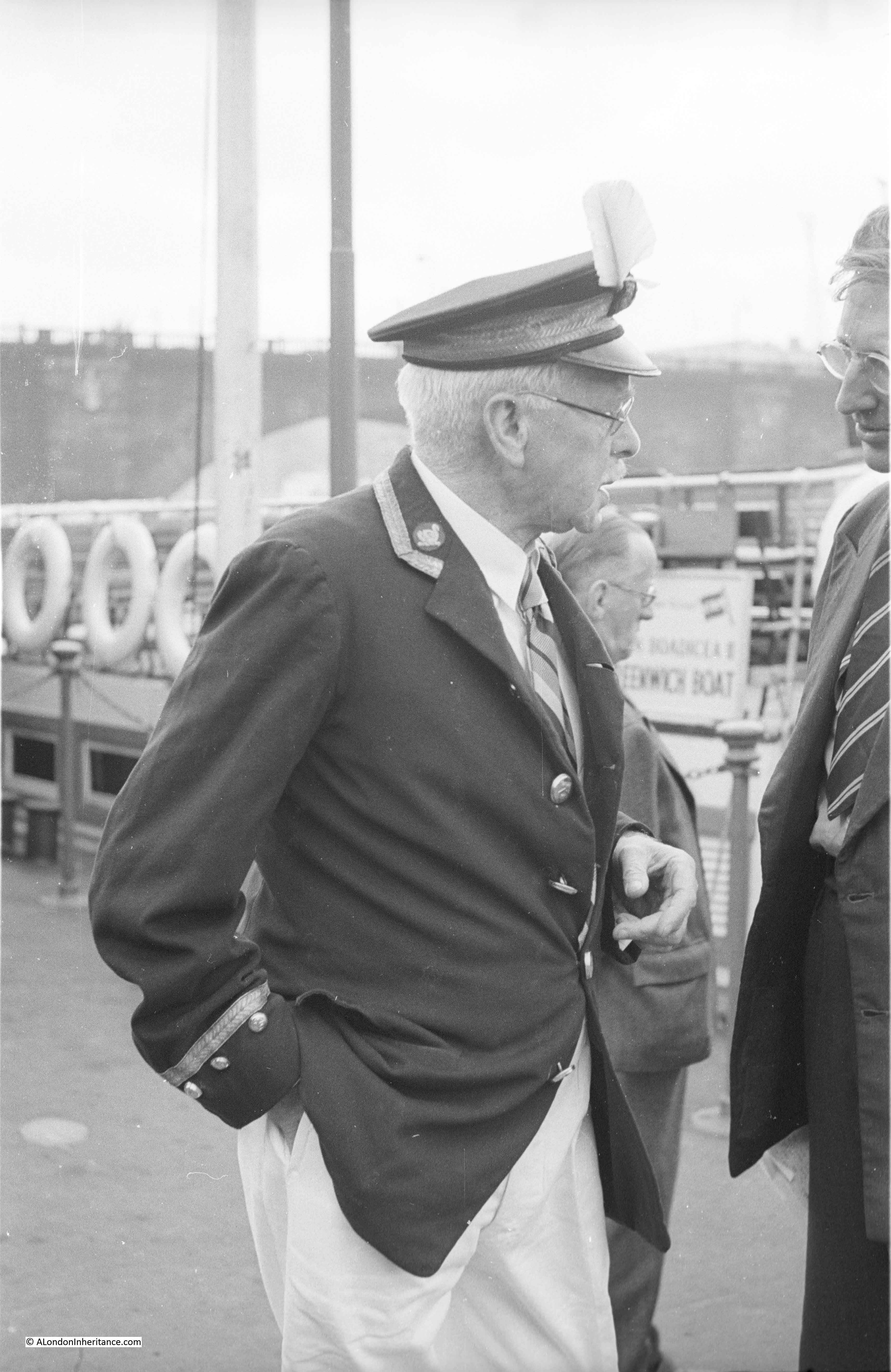
Old Swan Stairs were also the starting point for the Swan Upping ceremony when it started in central London. My father took some photos of Swan Upping starting around Old Swan Stairs and in the following photo is Mr Richard Turk who was the Vintners Swan Marker and Barge Master, with the Old Swan Pier in the background. The sign on the right of the piers indicates that boats to Greenwich could be boarded here. My full post on Swan Upping can be found here.
I am not sure exactly when Old Swan Pier opened, however the first adverts I can find for sailings from the pier are from 1838, when on the 21st May the Shipping and Mercantile Gazette carried an advert for “Steam – Cheap Fares from Old Swan Pier” . The sailings were:
- To Gravesend – every morning at 9 o’clock, precisely. Cabin 1s: Saloon 1s 6d
- To Richmond – Daily at half-past 9, calling at Hungerford at 10 o’clock, and to Twickenham every Monday, Wednesday and Friday. Week days 1s 6d; on Sundays 2s.
- To Woolwich – Every Sunday at 10, 2 and 5, calling at West India Dock Pier, Blackwall, at 11, 3 and 6. To Woolwich 1s, to Blackwall 9d, from Blackwall to Woolwich, 6d
The earliest newspaper report I could find referring to Old Swan Stairs is from the 9th August 1729, when it was reported that:
“Last Monday a Waterman, naked all but his shirt, rowed in a Butcher’s Tray from the Old Swan Stairs, to Greenwich, for a Wager of four Guineas, and won the same”
There are frequent mentions of Old Swan Stairs in newspaper reports since the early 18th century, and they describe the life and tragedies that must have been day to day experiences along this stretch of the Thames.
From the London reports of the Ipswich Journal on the 12th February 1743:
“Sunday Morning a young Man, dressed in a Sailor’s Jacket with Trowsers and a speckled Shirt was found in the Mud near the Old Swan Stairs; his Buckles, which were supposed to be Silver, were taken out of his Shoes. He was carried into the Church-yard, near the Stairs, till own’d, or a Warrant granted for his Burial”.
The implications being that either he was murdered for the silver shoe buckles, or he had died accidentally and his shoe buckles had been stolen.
Standing at Old Swan Stairs would have provided a fascinating view across to what would later be Southwark Cathedral with London Bridge to the left. John Cleverly made the following drawing (©Trustees of the British Museum) of the view from Old Swan Stairs in 1792. 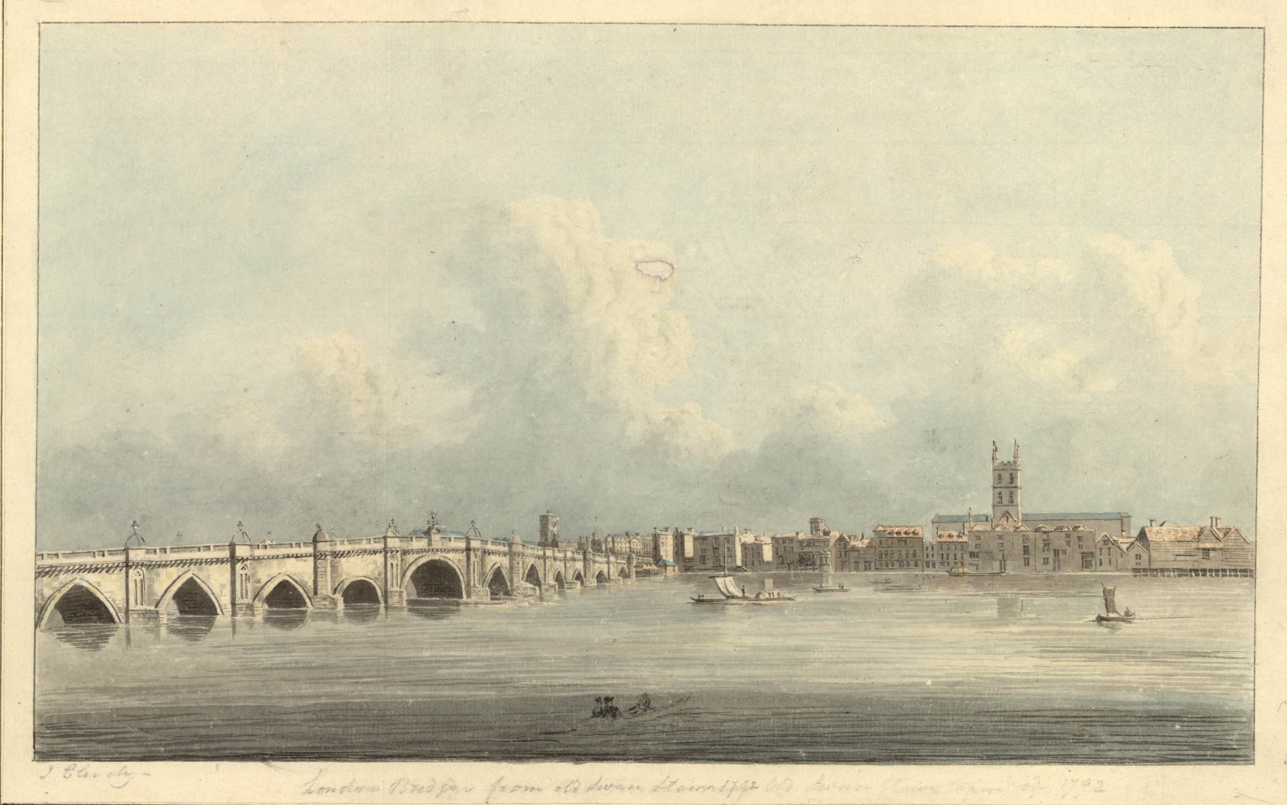
Despite the land along the river having changed so dramatically over the last 70 years, we can still find features that date back hundreds of years and allow us to accurately place events from centuries of London’s history.