
In my last post I wrote about the sites between Whitechapel and Limehouse in the 1972 Architects’ Journal article. Whilst walking to these locations, I took a number of detours from the direct route between the article locations to explore more of the history of Whitechapel and Limehouse.
Whilst walking the streets there is so much to see of the history of an area and how London is changing. This is a follow-up post to explore some of the other fascinating aspects of rambling around London.
To get from Wellclose Square down to Wapping High Street, I crossed over East Smithfield and walked down Vaughan Way. As with so much of London, Vaughan Way is being occupied with almost identical blocks of apartments. Across London you will find these, frequently with an artist impressions of the aspirational life style that those living in these apartments will enjoy.
If you have every looked at these pictures, they always have a number of common features. It is nearly always summer and the sun is shining, the age group of those pictured in the scene generally appears to be below 40, there are always people relaxing in the sun and often some form of coffee / food shop.
The artists’ impression of the London Dock development in Vaughan Way fits the standard model and appears to have a particularly well stocked fruit shop / florist on the corner.
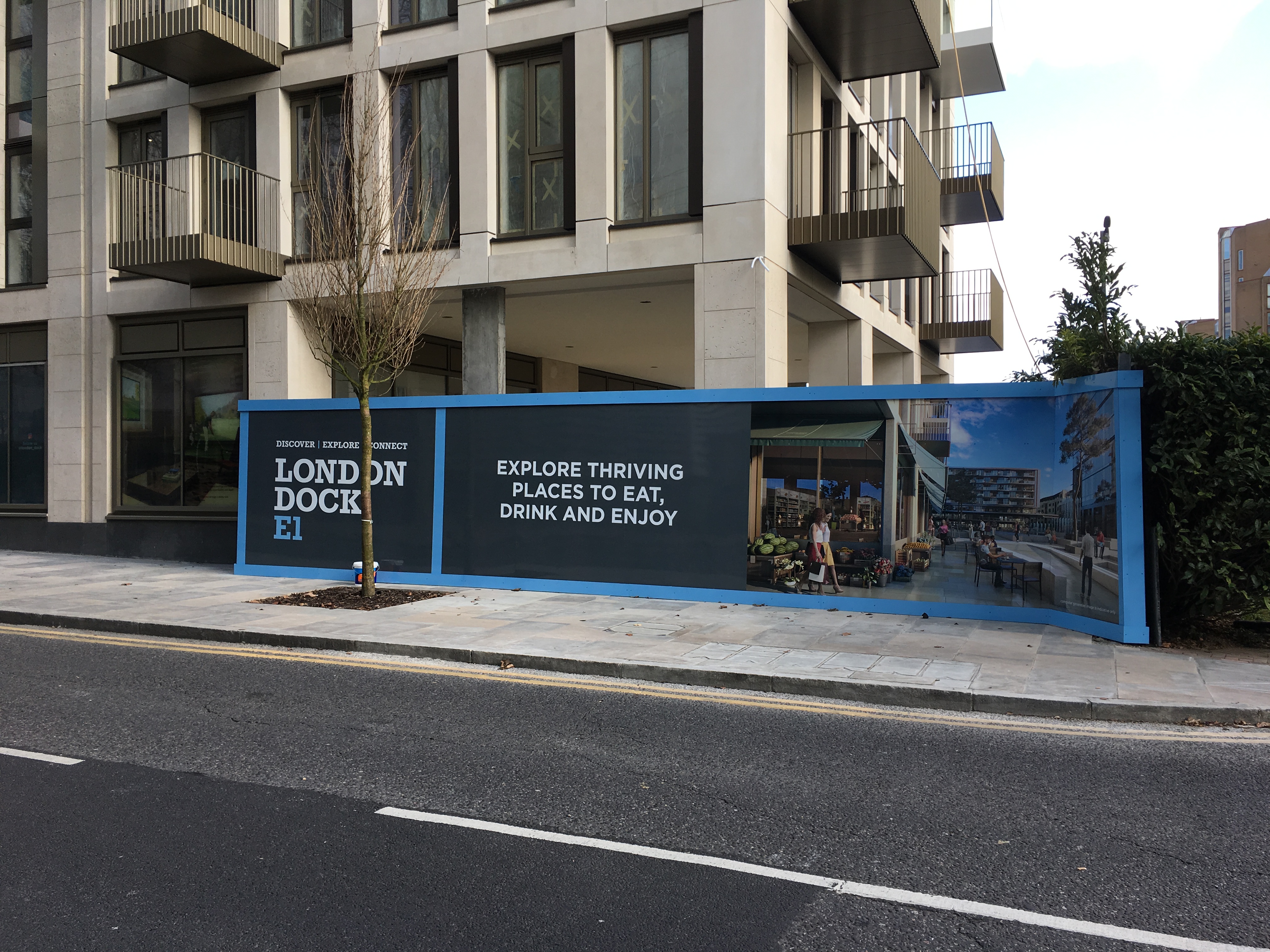
I have been taking photos of these pictures for some time for a mini project to come back and compare whether the places as built meet the artists’ impressions (strange, I know but that what happens when you walk). I somehow suspect that in reality they will be rather different.
After walking around the buildings in Wapping, I walked up Wapping Lane and there is a small collection of shops including a butchers, wine merchants and a launderette, all housed in buildings from the first decades of the 20th Century and built by the London County Council. The following building, Columbus House, still has the LCC coat of arms mounted proudly on the centre of the 2nd floor of the building.

Whilst walking around East London you will find so many closed pubs. Changes in employment, culture and demographics have resulted in an area where you would have once been unable to walk for a couple of minutes without finding another pub, now having hardly any. In Wapping Lane, you will find one of the few remaining in this part of East London, the White Swan and Cuckoo.
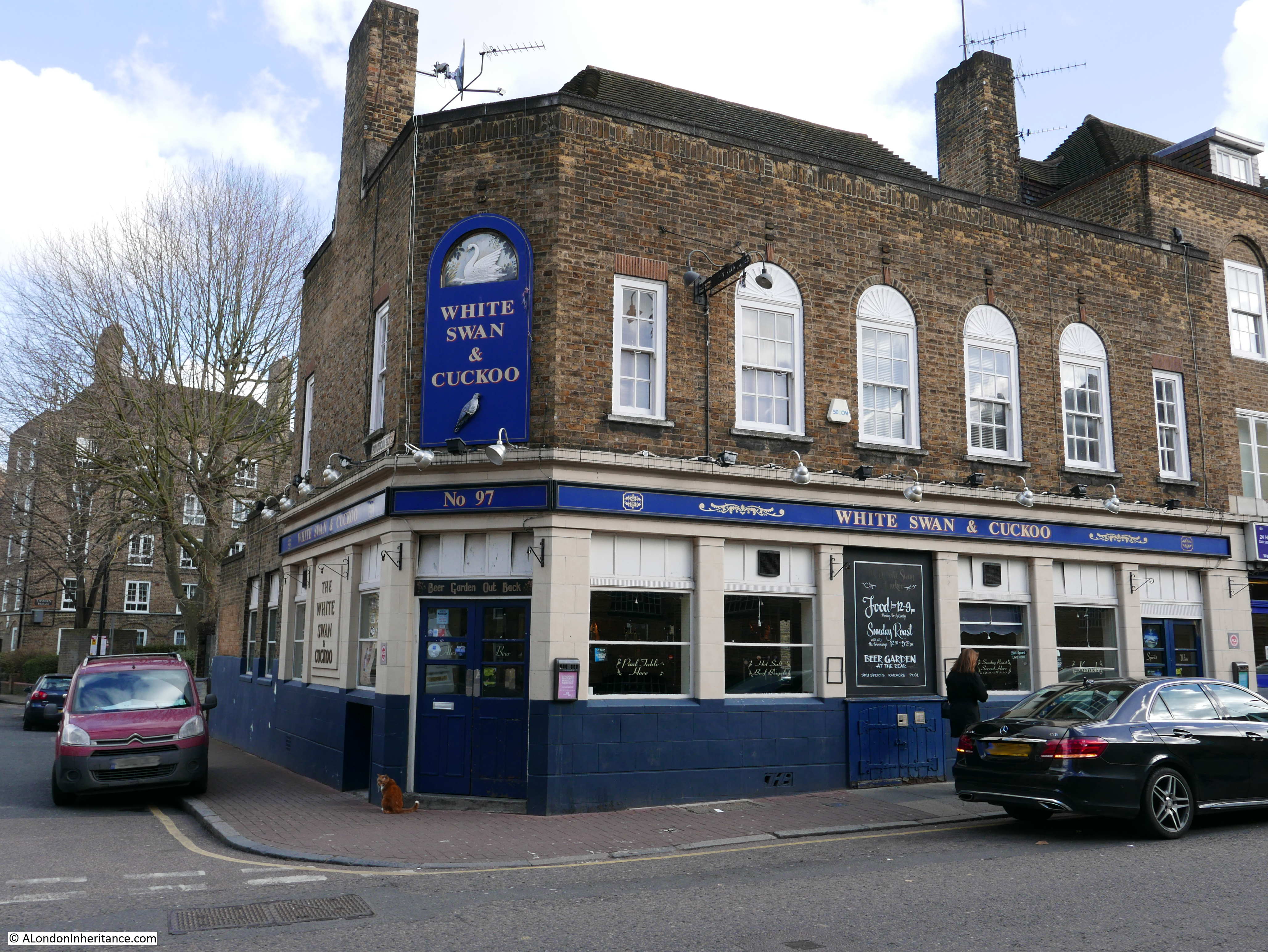
What amused me with this pub, was the pub’s ginger cat walking up and down outside, waiting to be let in. In the above photo he is sitting outside the corner entrance.
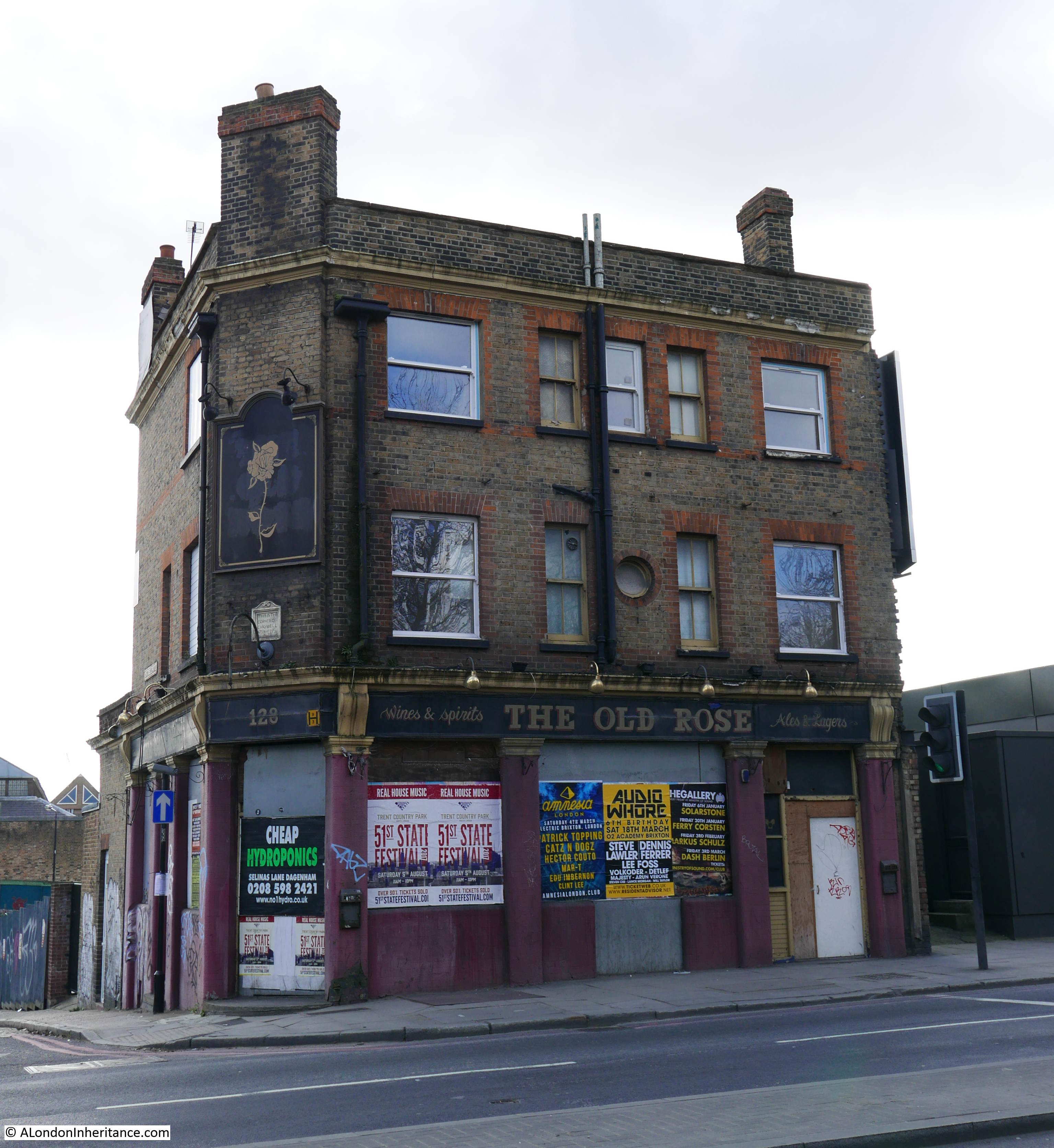
One of the pubs that closed a number of years ago was The Old Rose on the corner of The Highway and Chigwell Hill. I walked up Wapping lane to the Highway to see whether there was any change in the derelict state of this pub.
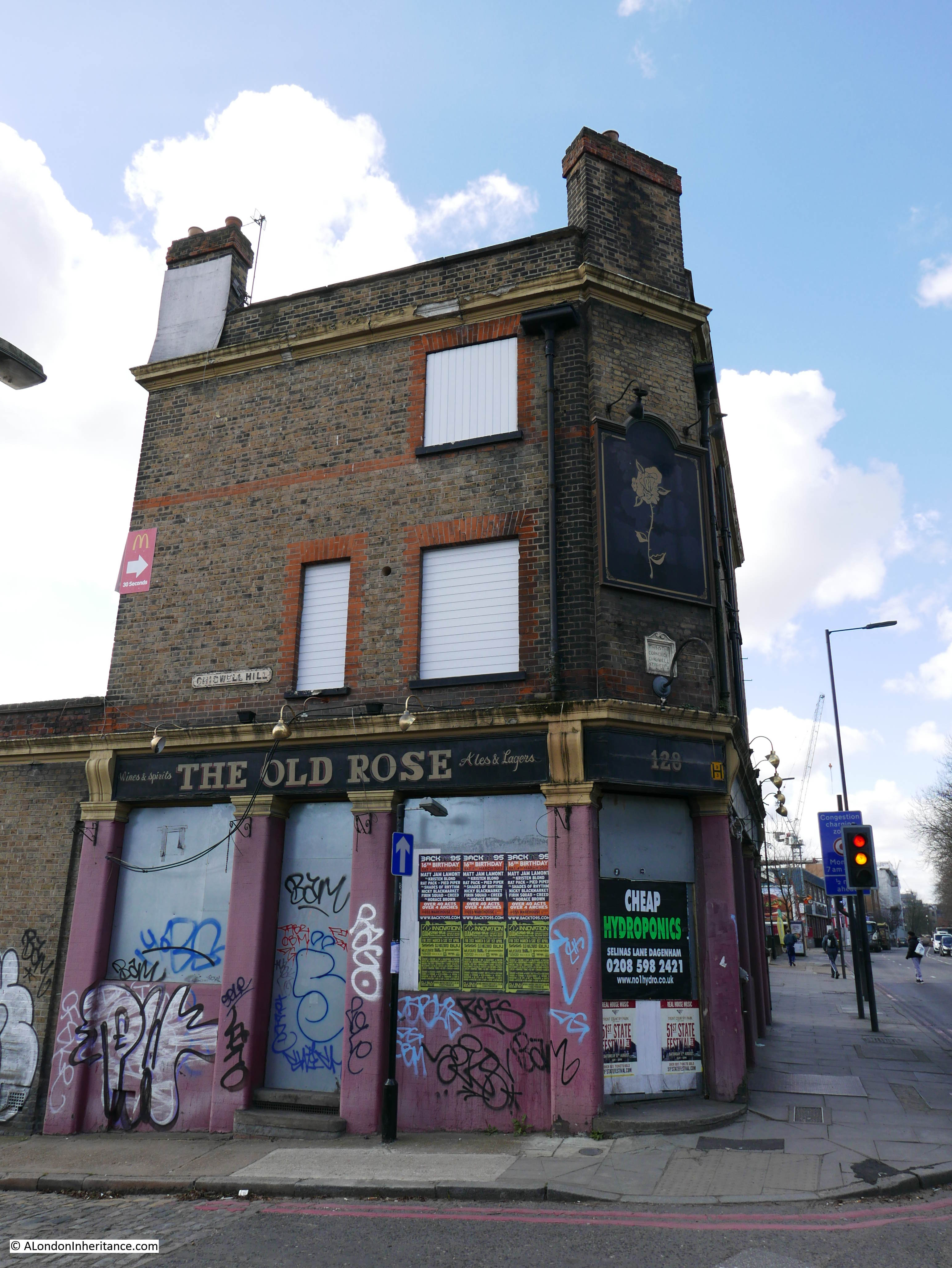
The only survivor in this stretch of the Highway between a McDonald’s and Petrol Station on one side and a potential building site on the other. If you look just above the door, there is the following plaque:
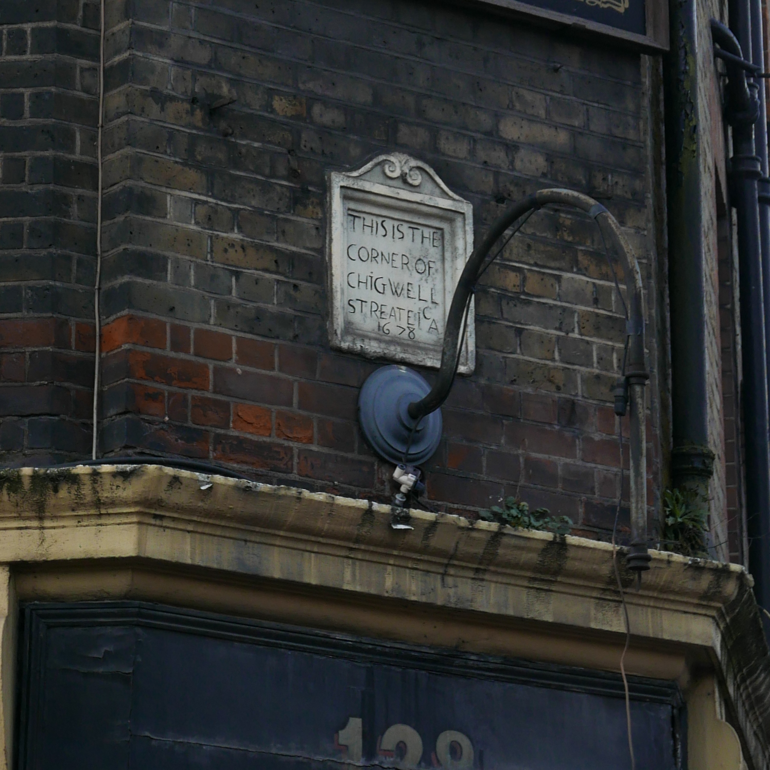
Which if it is the original from 1678 would have been on the building here prior to the current Rose pub. What is strange though is that the plaque on the pub states Chigwell Streat. Today, the road to the side of the pub is called Chigwell Hill and checking John Rocque’s map from 1746, as can be seen below it was also called Chigwell Hill (to the left of centre), so if it was originally a Street, the name change must have been prior to 1746.
The open land at the end of Chigwell Hill in 1746 would become part of the London Docks in a little over 60 years.
The Old Rose appears in newspaper records from the early 19th Century, although prior to 1810 it appears to have been called the Old White Rose. There are newspaper reports of all the usual East London pub events – inquests into deaths in the nearby Docks and from the river, sales of good and property, sports meetings and strangely, the meeting place of Lodge No. 2 of the Ancient Order of Druids.
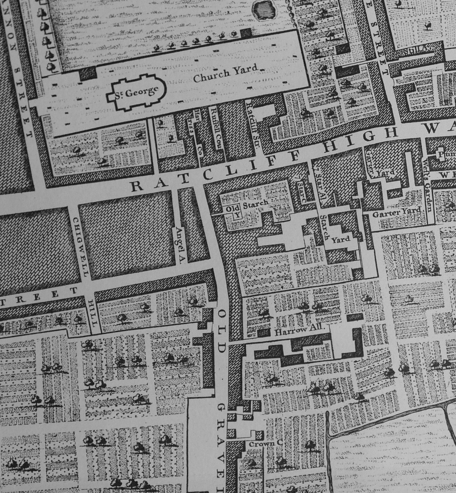
Today, The highway runs all the way to the junction with Butcher Row and the Limehouse Link Tunnel. This was not always so. For example, in the 1832 map of London, “drawn and engraved for Lewis’ Topographical Dictionary” , the Ratcliff Highway as it was then called only ran just under half its current length, before turning into a series of different streets called High Street of Upper Shadwell, Cock Hill and Broad Street.
Most of the area was devoted to trades related to the River Thames and the shipping that used the river. For example, just north of what was the High Street of Upper Shadwell were the Sun Tavern Fields which included some very long rope walks, where the rope used on ships could be manufactured in long lengths.
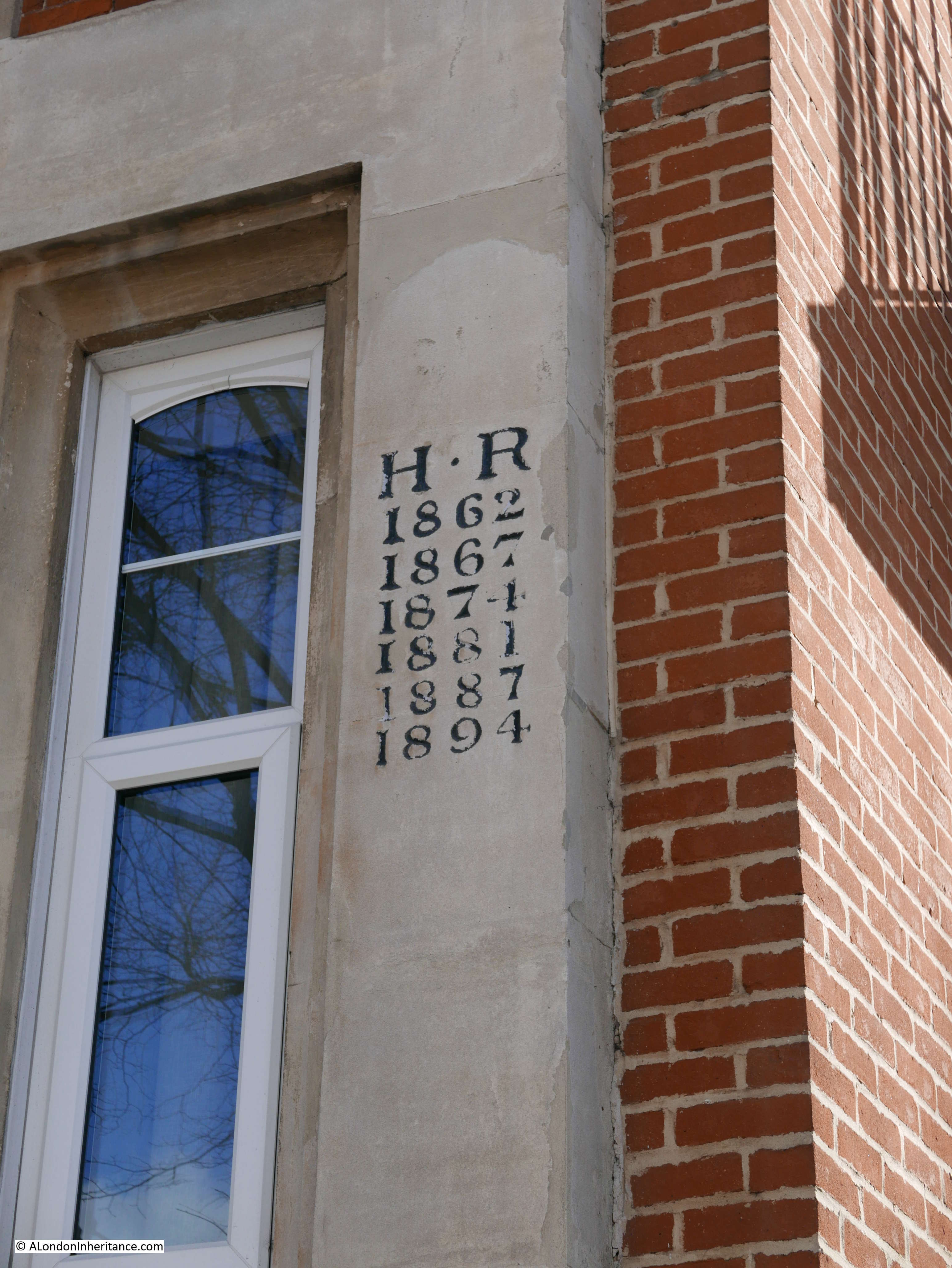
Along the Highway is this building with a blue plaque installed by the Stepney Historical Trust on the side which reads “Captain James Cook, the ablest and most renowned Navigator this or any country hath produced, lived in a house a few yards from this spot, 126 Upper Shadwell, 1763 – 1765“.

But what intrigued me was that on the front corner of the building are these initials and series of years. I have no idea what they mean.
At the end of the Highway, a short distance up Butcher Row at the junction with Cable Street is this building, Thames House. A mix of different structures from Victorian to the 1960s, it has had rather a number of problems with the way that some of the units within the building were sub-let. A planning application was expected to be made to Tower Hamlets Council towards the end of 2016 for a rejuvenation of this building, however I am not aware of the current status or plans.
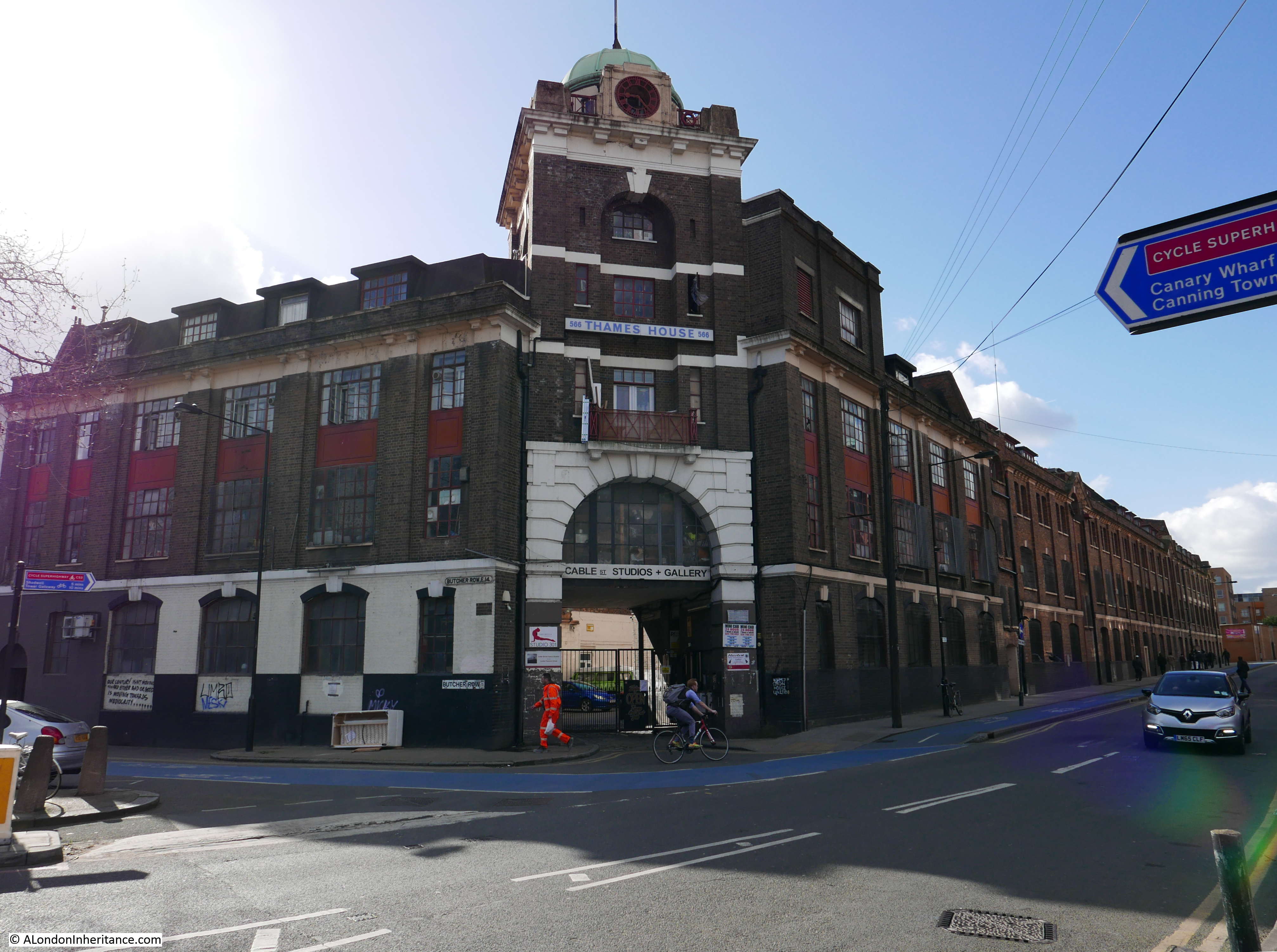
But there is some rather philosophical graffiti on the side of the building – another good subject to collect and photograph whilst walking around London. (see this post for some photos of 1980s East London graffiti from my collection).

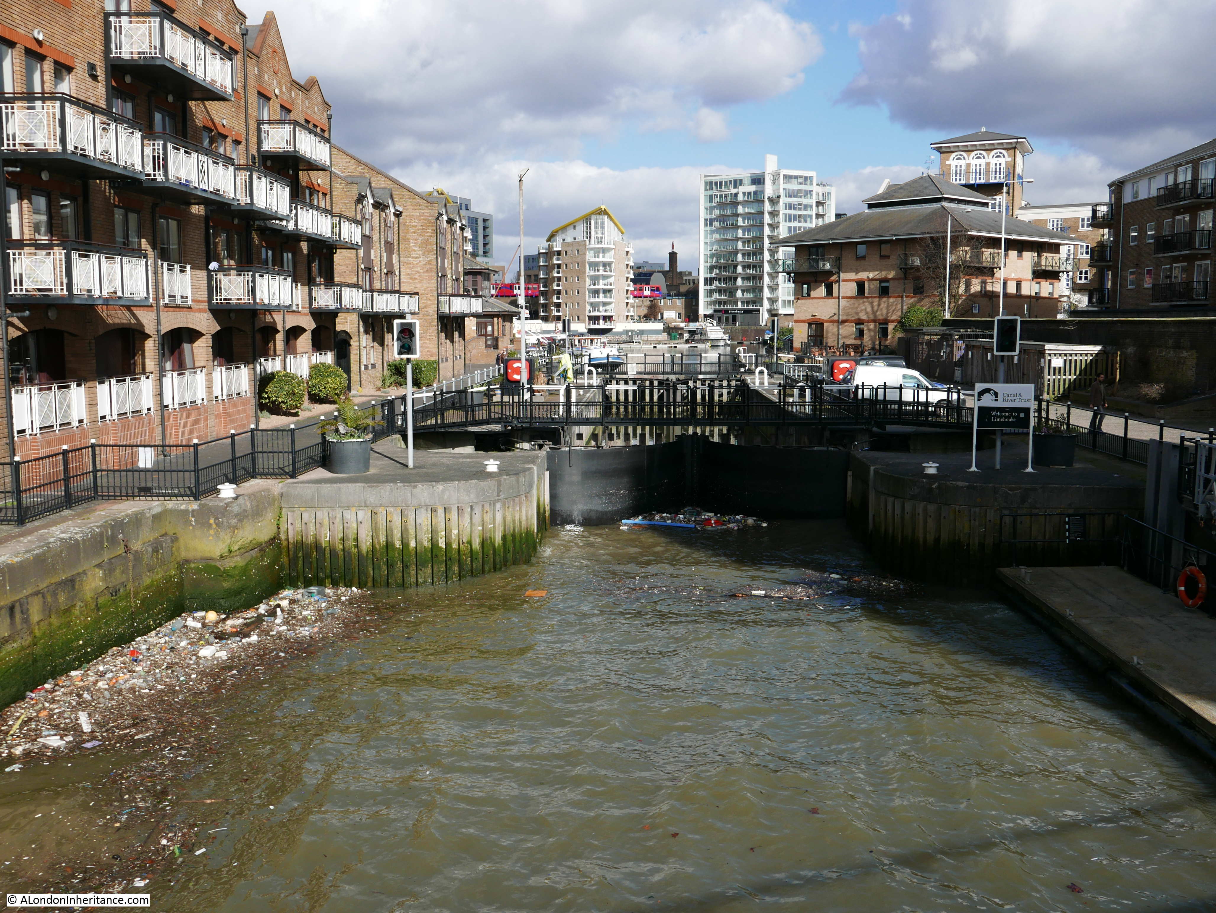
Walking along Wapping High Street, Wapping Wall and Narrow Street, it is easy to forget that the River Thames is close by, just the other side of the large former warehouses that line the southern side of the streets. Occasionally the river reveals itself, with a view of the full sweep of the river. One such place is along Narrow Street where the street crosses the entrance to Limehouse Basin.
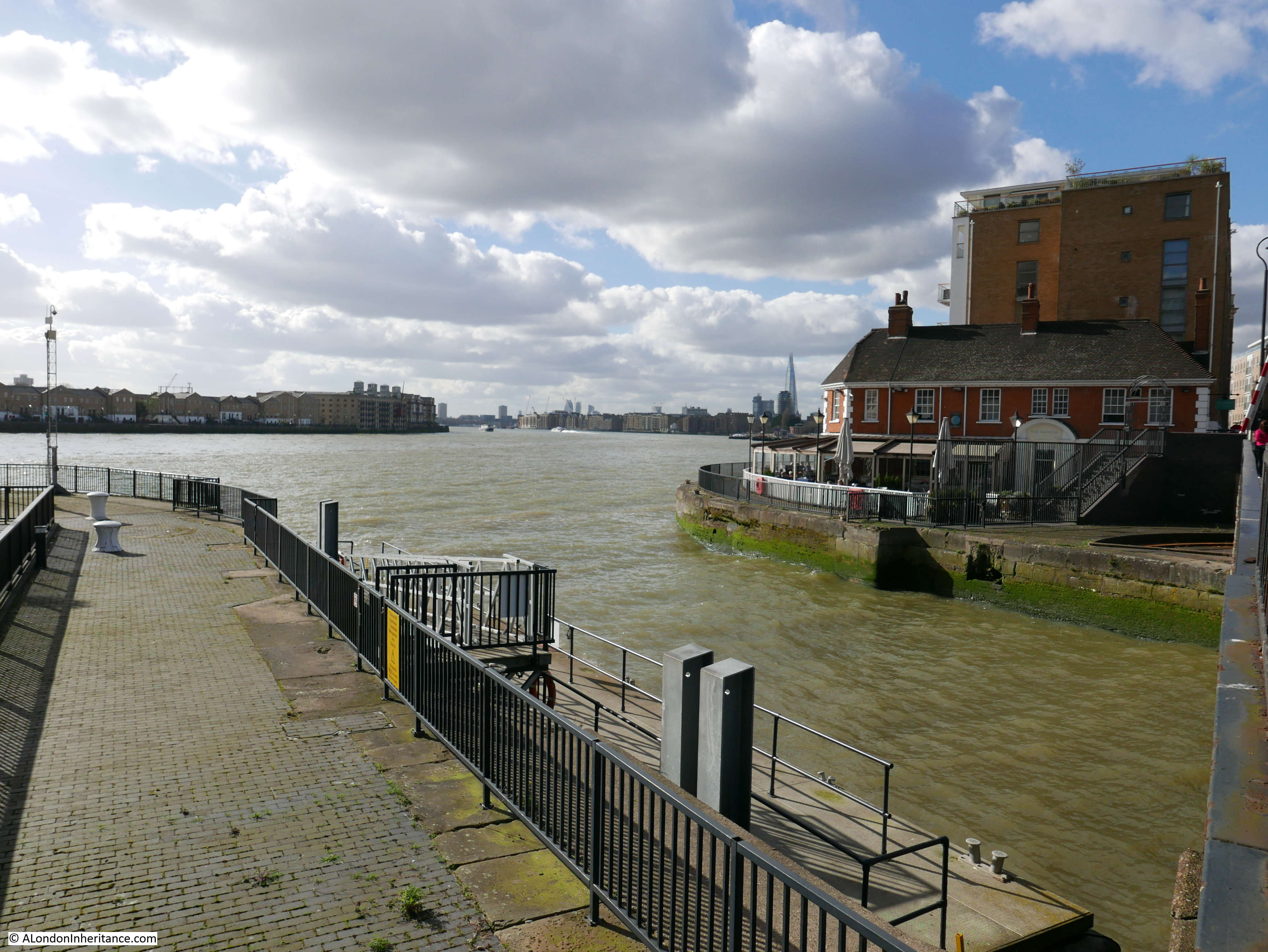
A swing bridge carries Narrow Street across the entrance to the basin which is now a Marina. Formerly the Regent’s Canal Dock, the basin provides access to the Regent’s Canal, allowing cargo to be carried from the Thames, along the Regent’s Canal to the north of London. The basin also provides access to the Limehouse Cut which runs up to the River Lea, and therefore by the River Lea and the Regent’s Canal, the basin provided access between the Thames and the inland waterways of England.
Along Narrow Street is Dunbar Wharf, still looking much as it must have done when a working wharf owned by the Dunbar family in the 19th century.
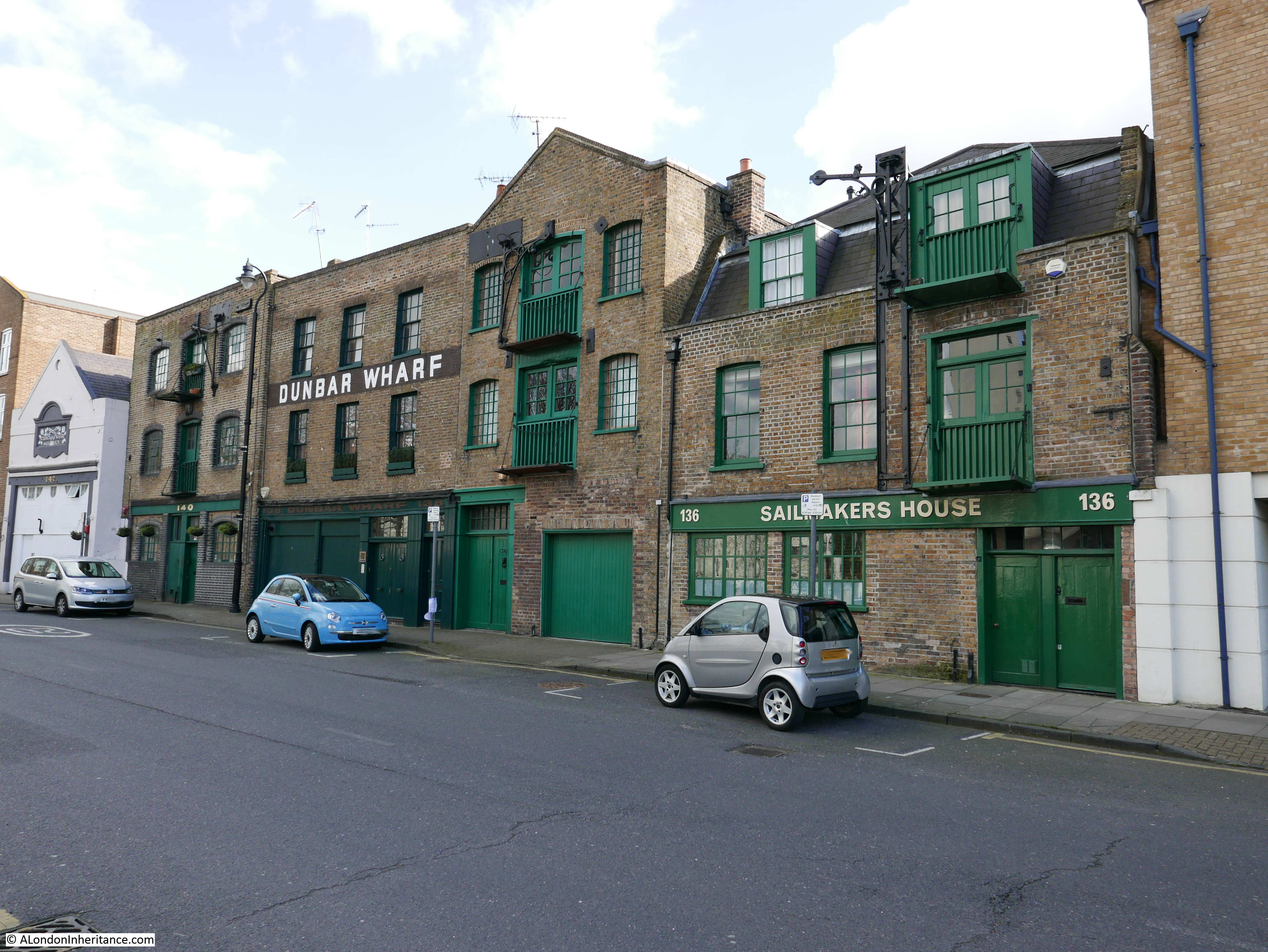
The Dunbar family wealth was initially from a Limehouse brewery established by Duncan Dunbar. It was his son, also called Duncan, who used the money he inherited from his father to build the shipping business that was based at Dunbar Wharf.
Dunbar’s ships carried passengers and goods across the world as well as convicts to Australia. Whilst very successful, this was not without the occasional disaster, as described in this article from the Western Times on the 7th November 1865:
“The Wreck Of The Duncan Dunbar – The passengers and crew of the Duncan Dunbar reached Southampton on Saturday morning on board the Brazil mail steamer Oneida. It seems that the vessel struck on the reef Las Rocas at about half past eight in the evening of the 7th of October, and an awful night was passed on board. On the following morning they were all, 117 in number, landed on a little island or bank of sand, which was covered with birds. They remained in this situation, with the exception of the captain, one of the passengers and six seamen, who started in a lifeboat to Pernambuco for aid, till the 17th, when they were fetched off by the Oneida. Though the sufferings, mental and bodily were indescribable, not a life was lost or a limb broken.”
Duncan Dunbar died in 1862. The report of the funeral, published on the 17th March 1862 provides a view of the standing of Duncan Dunbar in London and the wider shipping community:
“Funeral Of The Late Mr Duncan Dunbar, the Shipowner – The funeral of the late Mr Duncan Dunbar, the eminent shipowner, took place on Friday at Highgate cemetery. The mournful cortege, which comprised ten mourning coaches and several private carriages, left the deceased gentlemen’s residence, Portchester Terrace, Bayswater, at 12 o’clock, and reached the cemetery shortly after 1 o’clock. the mourners comprised a number of gentlemen of high standing in the commercial world. At Poplar and Limehouse much respect was shown. Nearly all the shipping in the East and West India Docks had their colours hoisted half mast high, as also the flags on the pier head entrances of the docks, the lofty mast house at Blackwall and Limehouse Church, the bells of which tolled during the hours appointed for the mournful ceremony.”
Duncan Dunbar did not have any children so his wealth was divided across his wider family members, although no one in the wider family wanted to continue the shipping business. The ships and warehouses were sold, however Dunbar Wharf remains to this day as a reminder of a once highly successful shipping business.
A few other wharf buildings remain with their facade much as they would have been when operating as a working wharf.
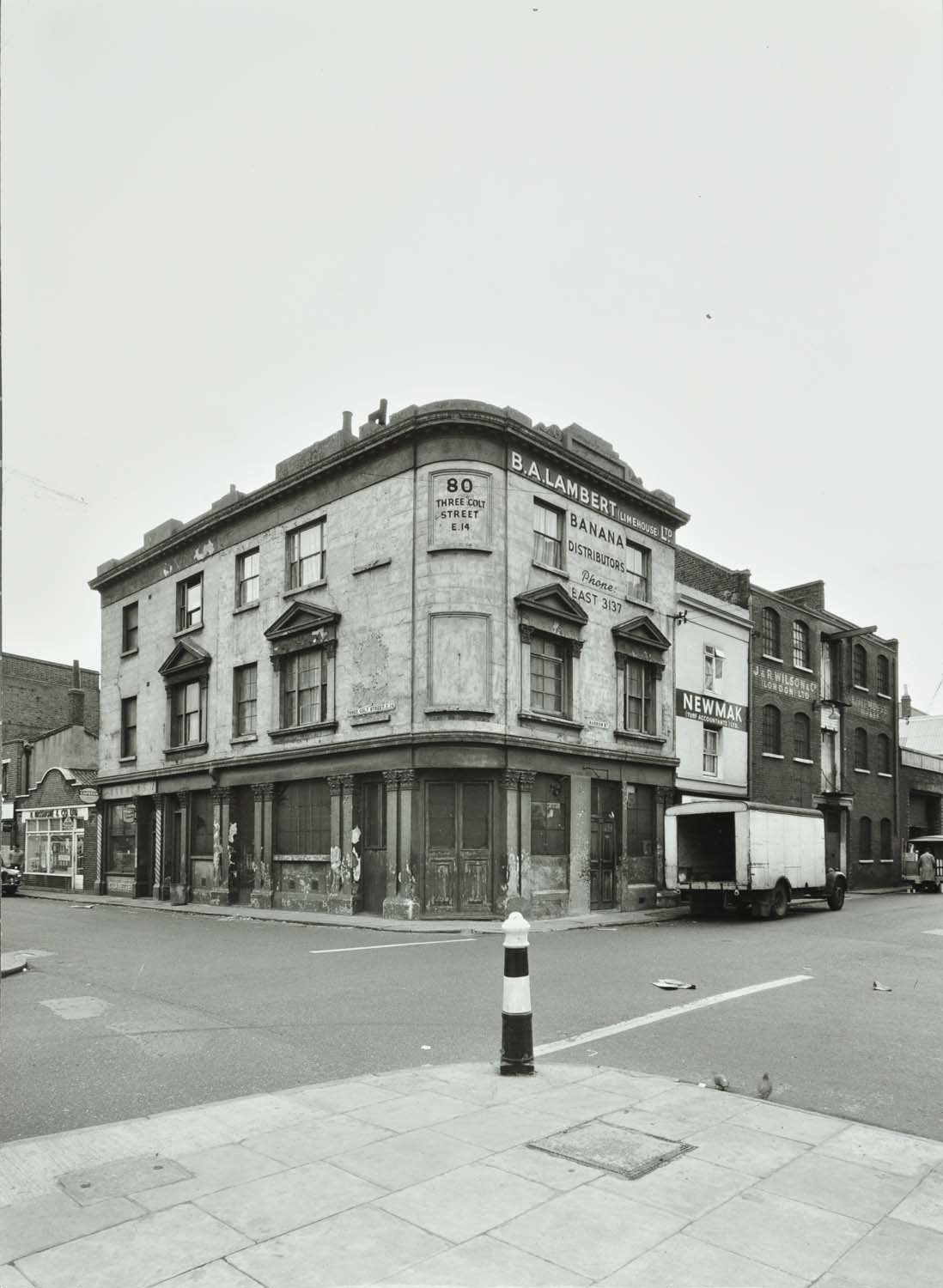
I continued along Narrow Street to the junction with Three Colt Street where I found another example of a closed East London pub. This was the Kings Head, a late 18th Century / early 19th Century pub, that although it is still clear that this was once a pub, closed a long time ago, around the early 1930s after which it became the office of a banana importing business.

The following photo shows the old Kings Head building in 1964 when used as the office for a banana importer and distributor.
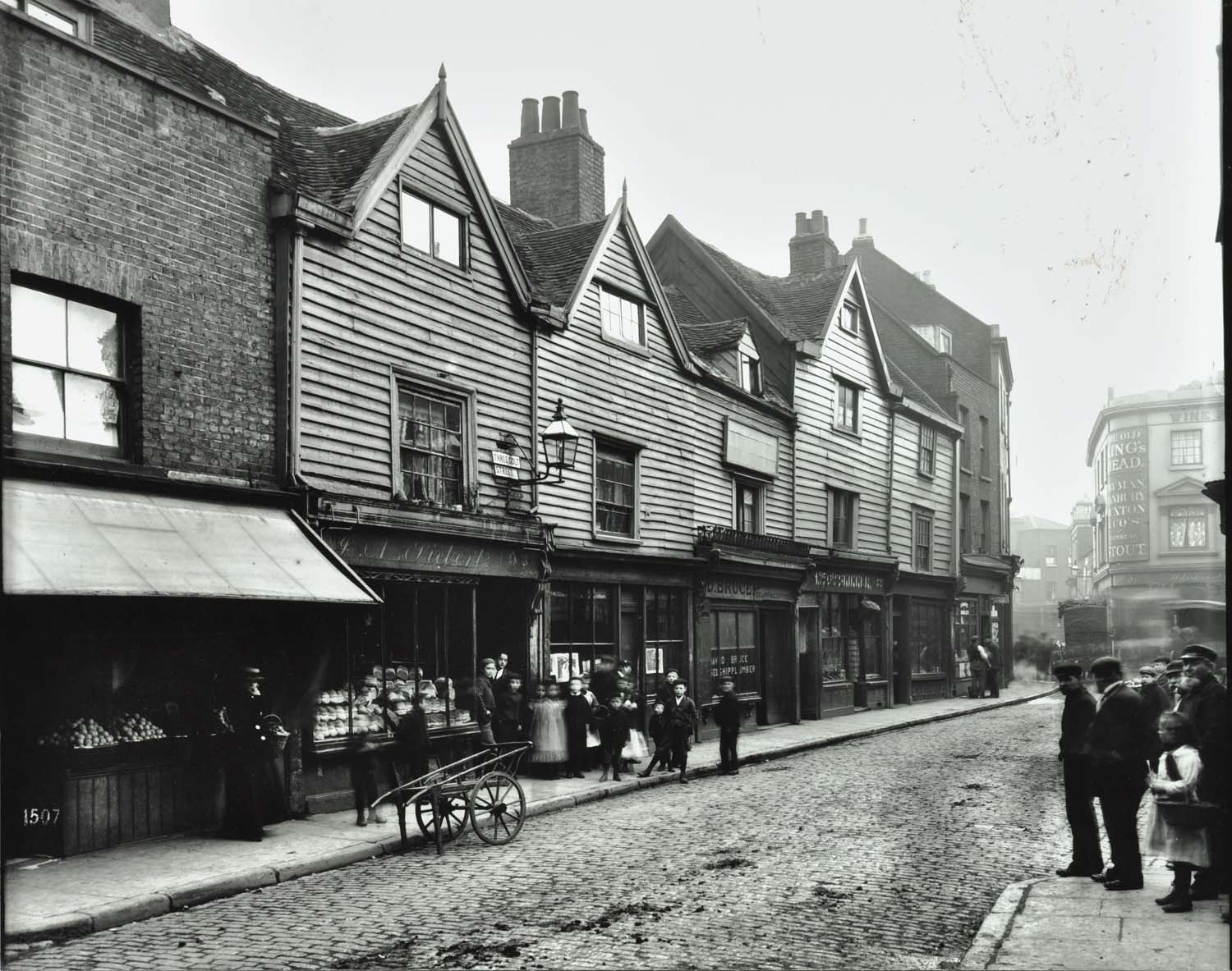
And this fascinating photo from 1902 looking down Three Colt Street towards the junction with Narrow Street shows the building when it was a pub in the distance on the right hand side.
Across the junction from the old Kings Head pub are these buildings:
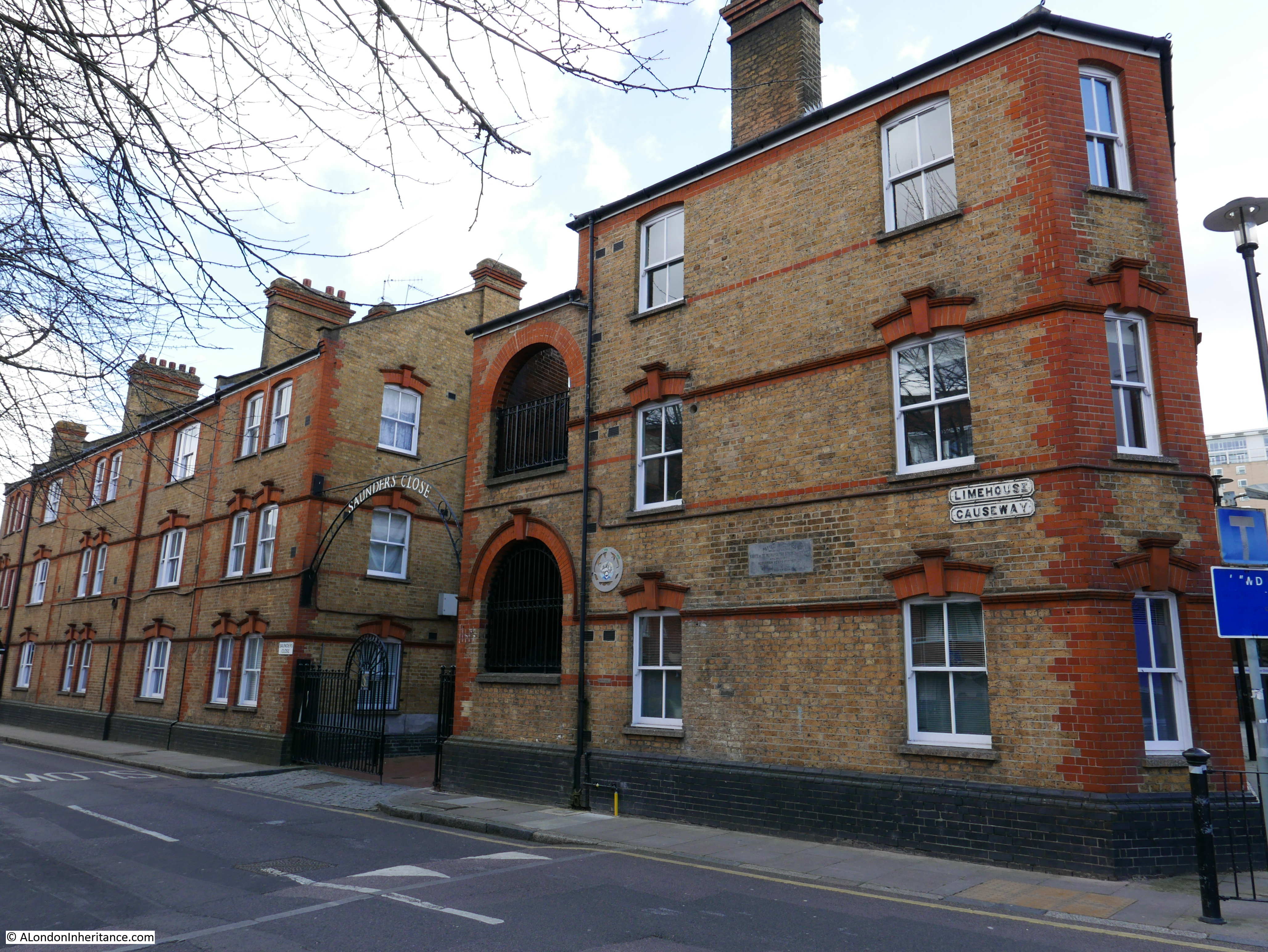
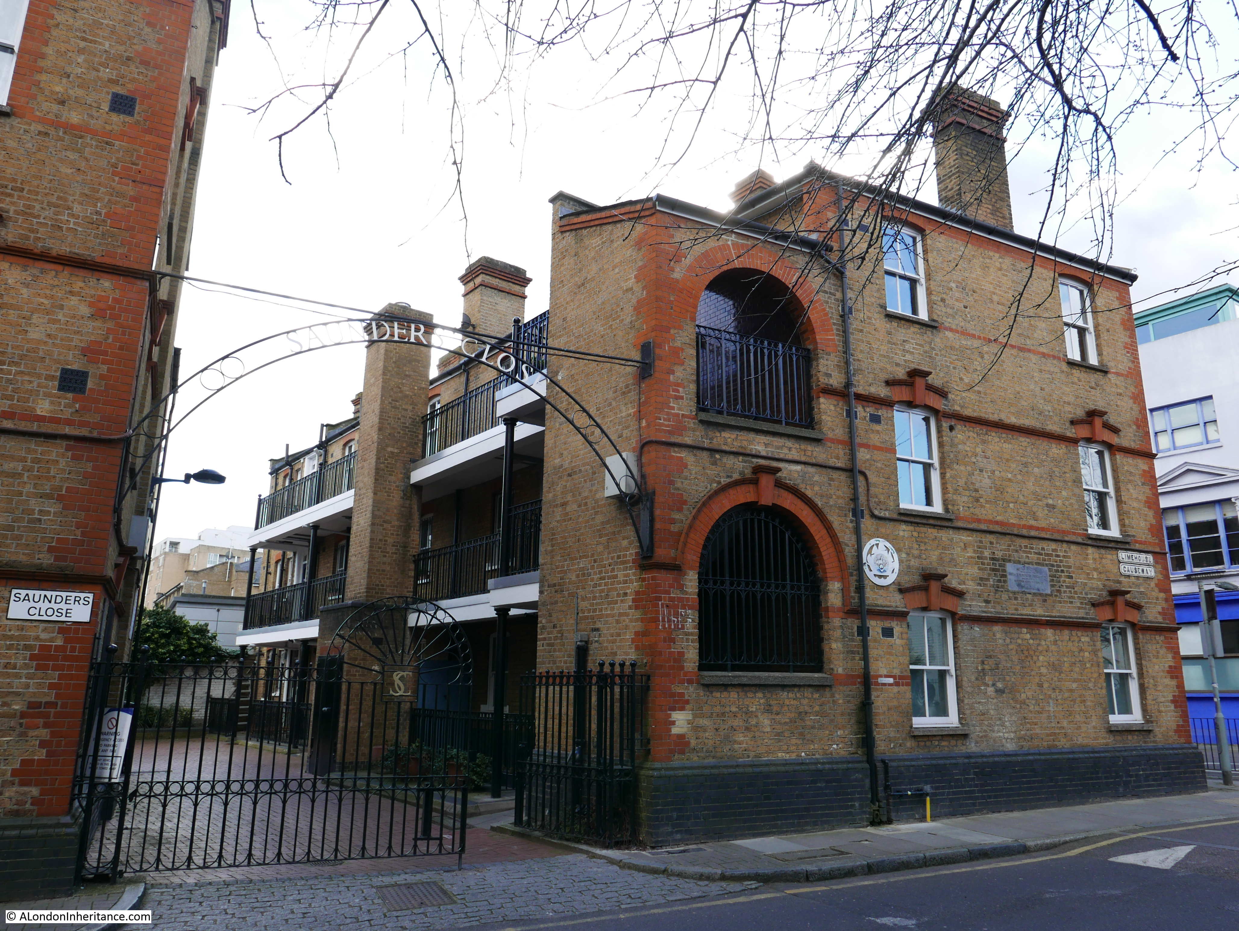
They were originally named Potter Dwellings after Alderman Henry Potter, also Mayor of Stepney.
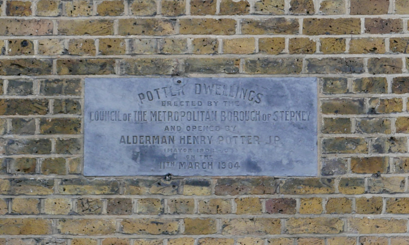
There are plenty of records of Alderman Potter – opening events, chairing meetings, presenting prizes etc. but I could find no record of him opening these buildings or involved in their planning. Post war, they were renamed Saunders Close. I have seen references to the new name being after a Mr Saunders, a caretaker of Potter Dwellings during the war, and that the buildings were named after him following an act of bravery, but again, I can find no evidence in support.
It is good though, to see these survivors of very early 20th century East London housing which have survived both wartime bombing and post war development.
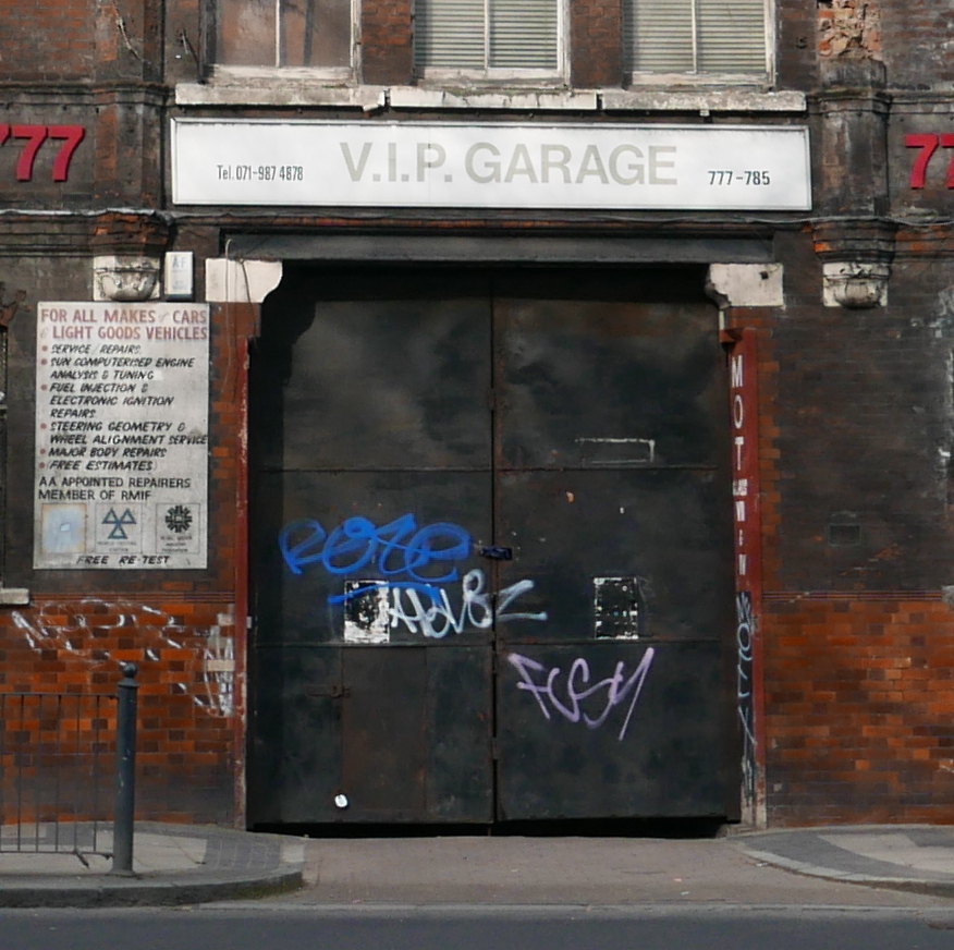
The one permanent feature across East London is continuous change and there are still so many buildings that I suspect will be demolished or transformed in the coming years. On the opposite side of Commercial Road from the church of St. Anne’s, Limehouse are these derelict buildings.

Once the home of that standard business which occupies all such sites across East London, the building will probably not be standing in a couple of years.
Further along Commercial Road is the Star of the East.
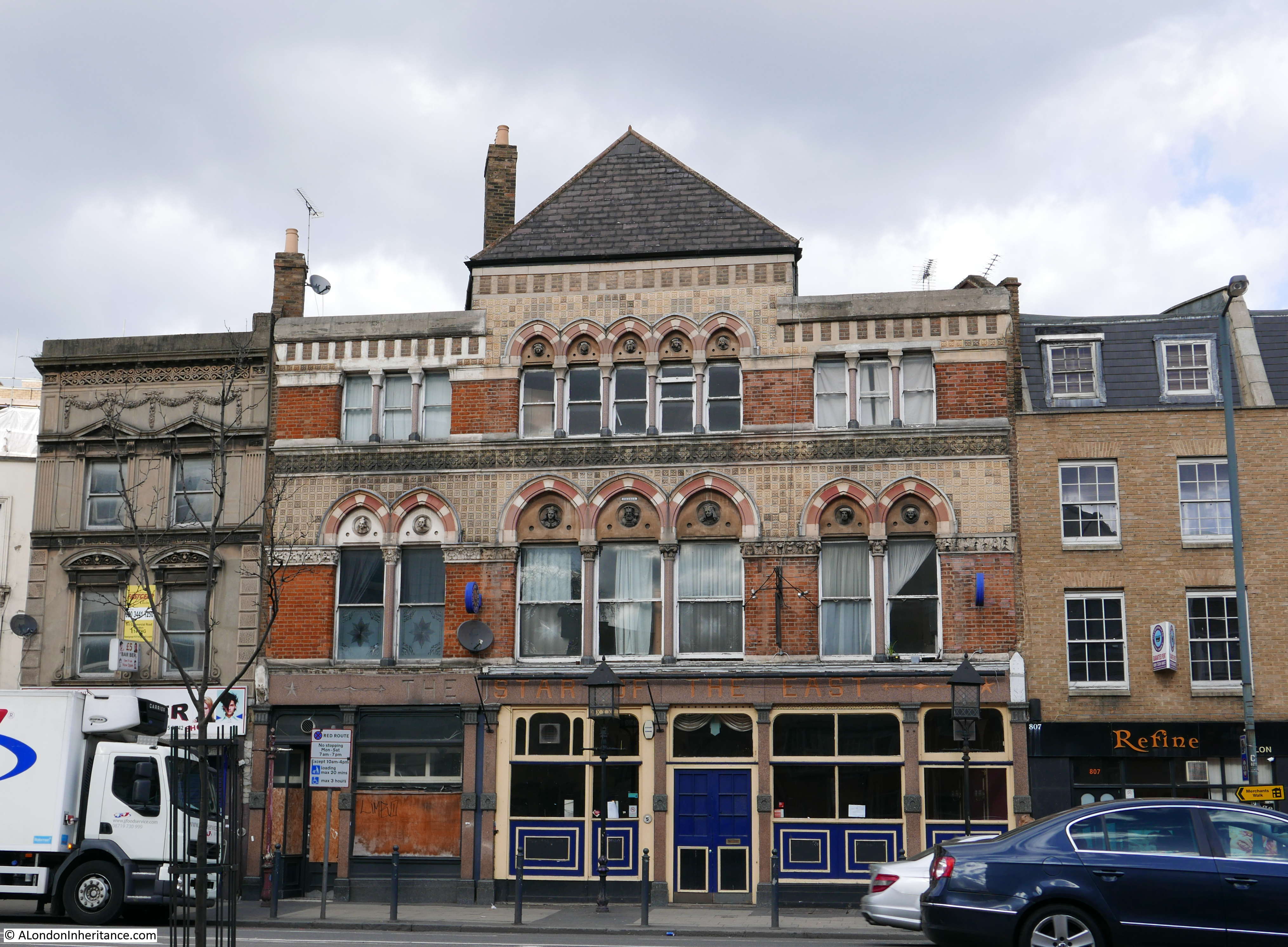
Another East London pub from the first half of the 19th century, the pub has been through a series of recent reopening and closures and is currently closed. The building has some ornate carving and decoration, very different from many other East London pubs and was probably due to its prominent position on the Commercial Road at the junction with the East and West India Dock roads, rather than being a local corner pub.

I had not intended this to be another long post, however I find that just rambling round the streets of London is an endlessly fascinating exercise. There is so much to see and learn of how the city has evolved and how this process is the one consistent feature of London’s long history.
Fascinating article as usual. Sad about the pubs and it’s the same here in Wandsworth with more wretched gastro pub featuring exotic menus and high chairs yes high chairs! Nuff said,it’s too painful!
Jane – it appears to be happening all over London with a gradually reducing number of “traditional” pubs remaining. Very sad.
This is really good. I would love to know what those ‘HR’ numbers mean.
Best regards
Mark
High River?
I did wonder about that as the listing of years is typical for recording years of flooding, however as you can see from the first photo, the years are higher then the blue plaque, so this would have been a remarkably high flood and I am not aware of any of this height and this far inland. It is possible that the stone is not in it’s original location and may have been closer to the river and lower down and moved to the new location to preserve the stone. All rather strange.
many thanks for another great posting
I am fairly sure they are boundary markers for the Hamlet of Ratcliff, one of the four divisions of Stepney. You can see similar – and similar dates – here. https://charlessaumarezsmith.com/2015/02/22/ratcliff/
I am very glad they have been retained.
Annie – that is brilliant, thanks. Interesting that three of the dates are the same. This must be when the boundaries of Ratcliff were confirmed each year. I wonder if there are any more of these around? Thanks again.
Dear Admin,
Your wish is now granted. This is quite a work of research but fascinating. Found it yesterday. It would make a great post, tracking some down. As ever, London minutiae continue to grab the imagination. Happy hunting!
http://www.metadyne.co.uk/Parishboundaries.html
Annie – thanks for the link, what a fantastic site. I have seen and photographed so many of the boundary markers across London, but that site has brought them all together in a single collection. You are right, it is the London minutiae that grabs the imagination. Reminders of the past that have somehow survived over the centuries. That is what worries me about the plaque on the Rose pub, I hope that survives whatever fate awaits the rest of the building.
“I had not intended this to be another long post, however I find that just rambling round the streets of London is an endlessly fascinating exercise.”
Ramble on, David! I’ve never yet read a post that was too long.
Isn’t it? And all those Ghost Signs…..A sight to behold!
Thanks Geraldine
Thank you again, a wonderful read and guide to a part of London, coming from the Midlands, I have yet to visit . Immensely saddened, as in earlier comments, about the continual closing of our pubs .
Thanks Neil, yes, the ongoing closing of pubs is very sad. The ones along the river will always hopefully do well due to their location. There are so few inland now, that I hope it can go no further. The area is well worth a visit if you get a chance.
I grew up at 80 Three Colt Street, when the Banana warehouse was there, I remember there was a flat which was a slum, my family lived there until the council re=housed us
Keep it up – fantastic work and patience. THANK YOU, Laura. born and bred just off Burdett Road. My family came from Limehouse, Old Church Road, now known as Newell Street, most of my male family worked for Robert Hough Paper Mill, Narrow Street.
Thanks Laura. I bet if your family came from Old Church Road they would have been in the old Coopers Arms pub that was in my previous post. It is a lovely street and I am pleased that the houses on one side of the street have survived.
This is more or less following the route of the Black Ditch? Do you have any info on this waterway?
Have just been directed to your blog. Why haven’t I come across this great site before? Researching various London ancestors, mostly in Stepney (but they crop up all over the place – usually in the “Blackest Streets”), and also love maps.
Brilliant stuff!
I have been researching my family history for sometime now and your blog is of great interest. I was born in East end maternity hospital and lived at Faraday Dwellings Limehouse until I was five years old. I often went back with my parents to visit neighbours who still lived there and still have a lot of memories of the area. I remember as a child feeling nervous crossing the swing bridge fearing that it would start moving as I was half way across. I would love to find any photos of Faraday dwellings from back in the 1960’s/70’s so if anyone can help or direct me to any sources it would be very much appreciated.
I lived in limehouse in 1978/9 and would frequent a pub close by and on the river,Dickens was meant to have written ‘our Mutual Friend ‘ there but I can’t remember the name of the pub. Do you know the one I mean?
Charles Dickens used to frequent The Grapes in Narrow Street Limehouse and although I’m not sure if he wrote the story there it was referenced in the opening chapter of ‘Our Mutual Friend’
Thanks Jean – been meaning to answer the question but keep getting focused on writing the posts.
Thank you, I think it was The Grapes.
If you’re rambling round there again, can you try to find Nightingale Lane, which I don’t think exists any more; there was a Nightingale Lane just to the east of St. Katherine’s Docks, and another, the one I’m interested in, running North/South below Limehouse Cut and near to the Limehouse workhouse. (see Booth map here https://booth.lse.ac.uk/map/17/-0.0359/51.5091/100/0) My family were coopers here in the early 1800s before moving across to Rotherhithe in the middle of the century. I can’t find much about the coopers in this particular area, and I’d be interested to find out more
Hi Nikki, I’ve been researching family who also lived on nightengale Lane at the same time. It’s now called brightlingsea place. I went to visit the area to confirm.
Was massively hit by cholera and my 5th grand grandfather died there from it. If you google nightengale street there’s articles from the papers of the time detailing it.
Best
Sophie
wonderful blog entry as usual.
A quick update – The Star in the East is open again, and very nice inside. Well worth a visit..