
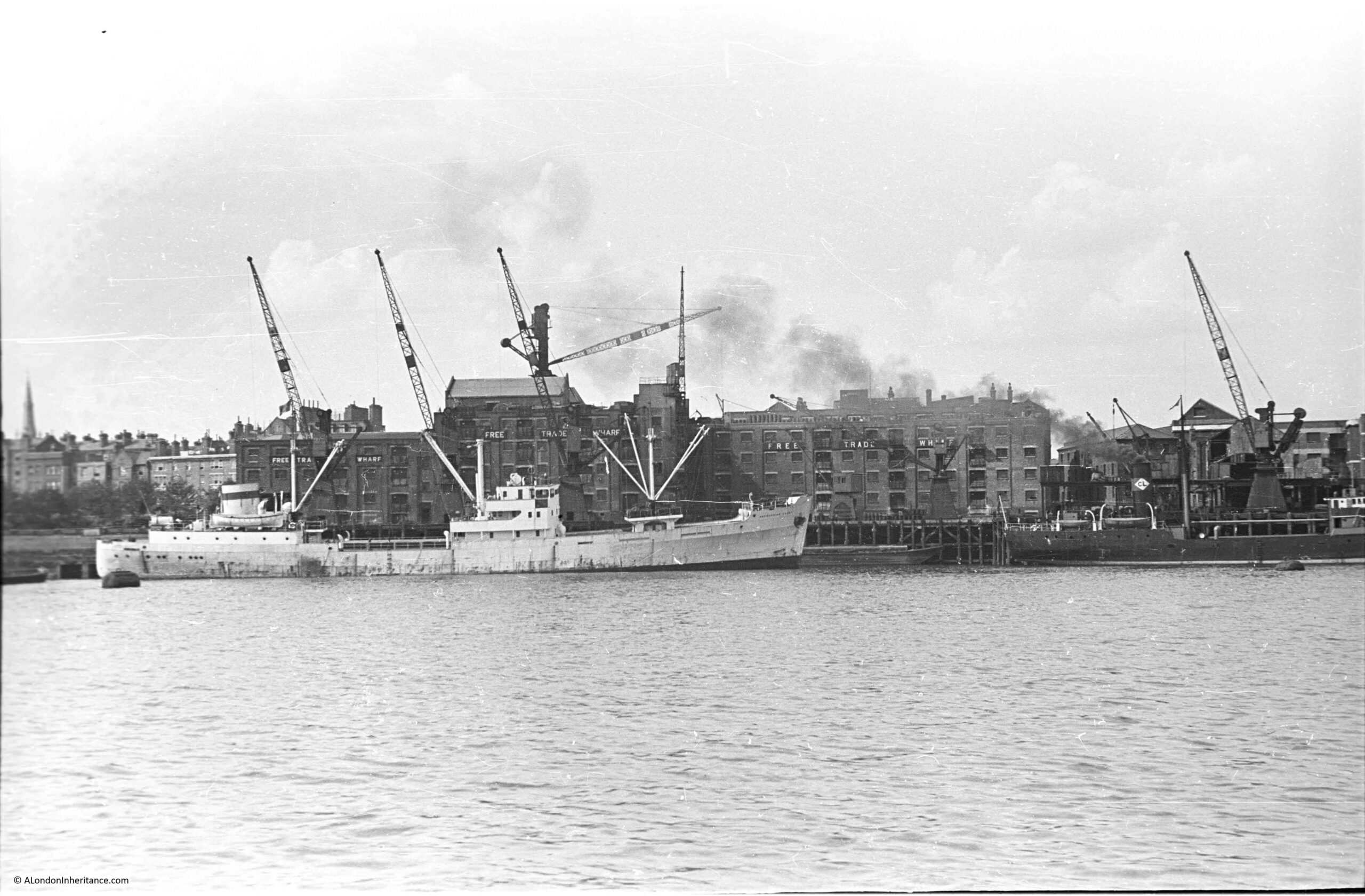
The following photo was taken by my father in August 1948, and shows the buildings of Free Trade Wharf in the old area of Ratcliffe:
The same view, seventy six years later in 2024:
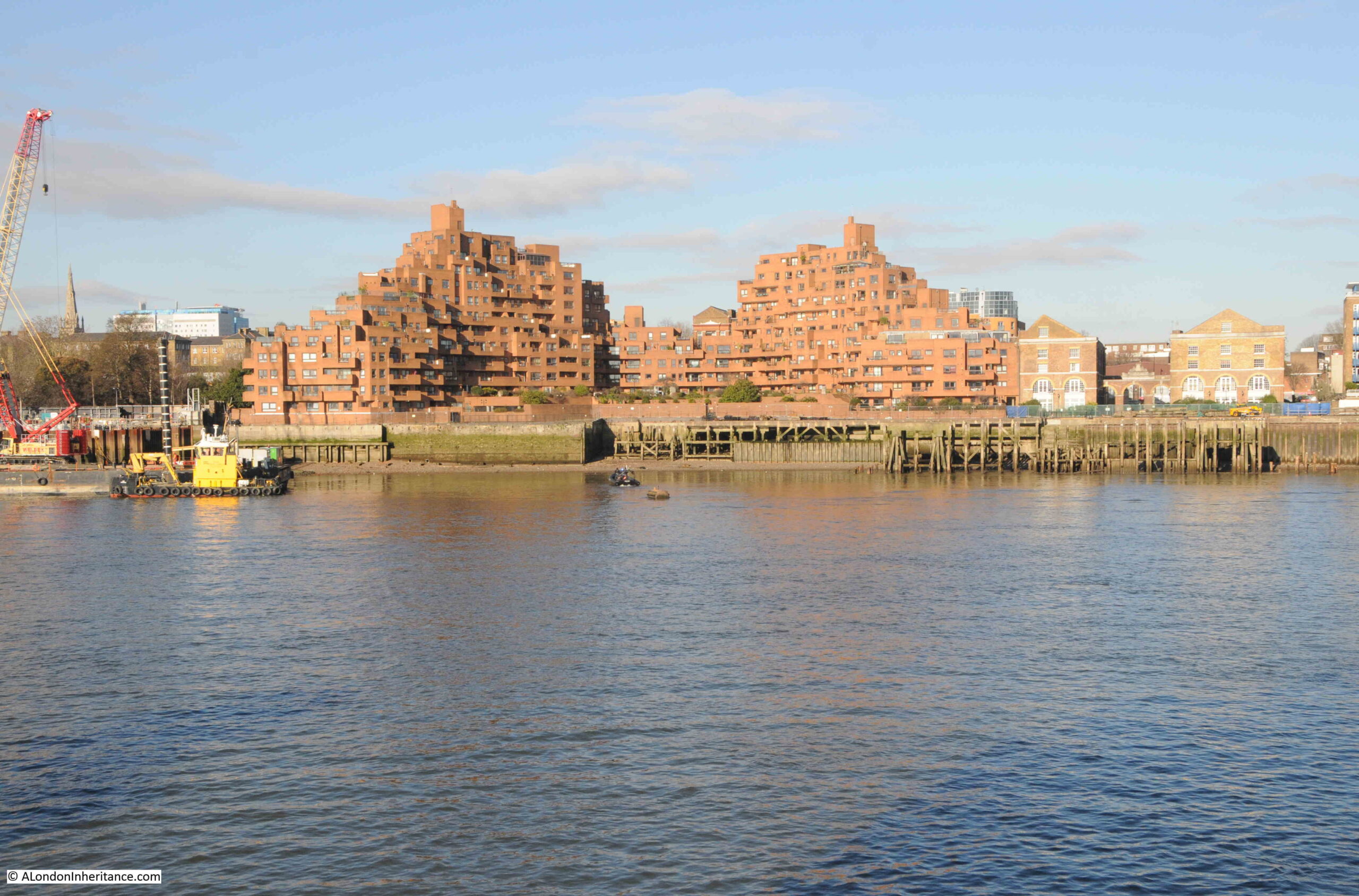
Despite the loss of the central Free Trade Wharf buildings, there are some features that can be found in both photos.
On the left of both photos, there are no buildings along the edge of the river, and trees can be seen in an open space leading back from the river. This is the King Edward VII memorial park.
The park, and the space it occupies, has a fascinating history which I wrote about in this post.
Staying on the left of both photos, a church steeple can be seen in the background. This is St. Mary’s Cable Street.
The central part of the photo is very different. The Free Trade Wharf was purchased by the Inner London Education Authority in 1977 with the intention of building a campus for the City of London Polytechnic, which had been formed in 1970 with the consolidation of the City of London College, Sir John Cass College and the School of Navigation.
These plans did not follow through, and the site remained vacant until the early 1980s when the growing trend for the construction of residential properties along the banks of the Thames resulted in the purchase of the site for residential development, and the building on the site we see today was built.
It is one of the more distinctive residential buildings along the river, and was designed by the architects Holder Mathias Alcock, who are still practicing today, although the name Alcock has been dropped.
Their distinctive design has been described as being of “dramatic ziggurat-style terraces”, and also looking as if it could have been made out of Lego.
Faced by red brick, the building does look good in direct sunlight, and the from what I have read, one of the reasons for the shape of the building, where the sides step back towards the centre, was to maximise the number of apartments that had a river view, rather than being a flat building along the river.
This new development retains the name Free Trade Wharf, and looking at an extract of the 1948 photo, we can see this name was displayed in white lettering along the side of the building facing the river:
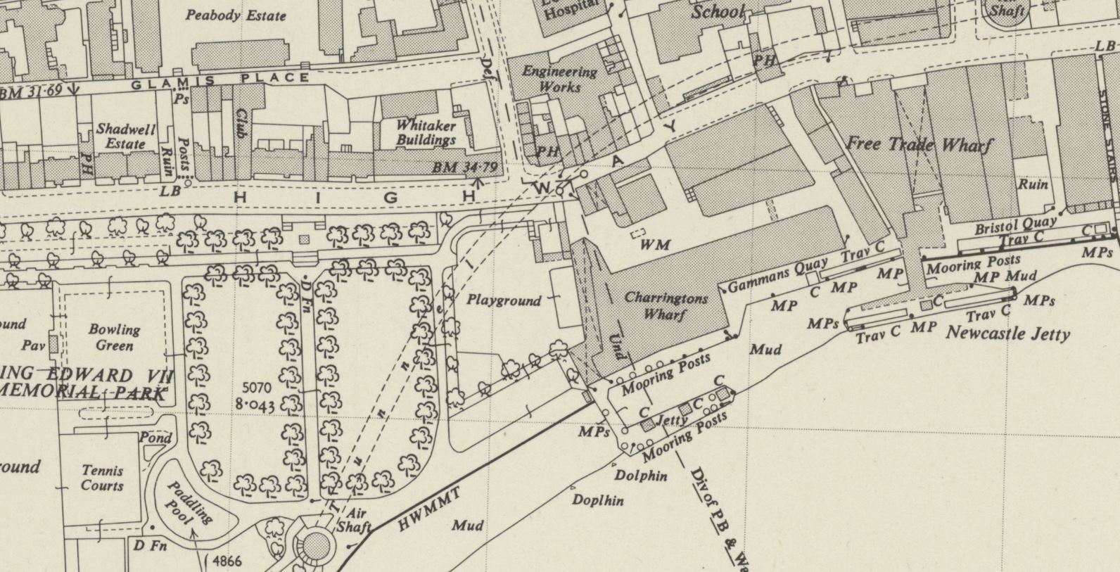
Although this very clear naming of the Free Trade Wharf did throw me into a momentary bit of doubt about whether I had identified the correct location for the photo, as in the OS map, published a couple of years after my father’s photo, the building is marked as Charringtons Wharf, as can be seen in the following map, along the river and to the right of the park (‘Reproduced with the permission of the National Library of Scotland“):
To confirm, I checked in the book “London Wharves and Docks”, published by Commercial Motor in 1953, and the entry for Charringtons Wharf included a reference that “Occupier: Free Trade Wharf Co. Ltd”.
The Charringtons name came from the ownership of the site by Charrington, Sells, Dale and Company, who traded in coal and coke. I cannot find exactly when this part of the site became known as Free Trade Wharf, however as you can see from the above map extract, this name was also in use for the buildings to the right, which are on the right of my father’s photo, but hidden behind the cranes, and the black coloured ship on the right.
The Commercial Motor book provides some detail on trade at the wharf in 1953:
“Facilities: a. General, b. Rubber, matches, canned goods. Maximum cranage (cwt) 45, Storage space (cubic feet, covered); 869,450, Storage Space (cubic feet, uncovered): 5,000.
Customs facilities included Sufferance Wharf, Dry Bond, Captain’s Imperfect Entry (a Sufferance Wharf is a licensed private wharf where goods can be kept until the duty is paid. A Dry Bond is where goods can be stored before customs duty is paid. Dry refers to the type,, so dry goods unlike wet goods such as alcohol. Captain’s Imperfect Entry is a strange one. Captain’s Entry is where the Captain of a ship has provided the details of the goods he wants to unload to the warehouse, but I am not sure what Imperfect refers to).
The wharf had a jetty and a quay, with 250 feet being the maximum length of ships accommodated at the jetty and 210 feet at the quay. and the depth of water went from 24 feet at high water down to 2 feet at the jetty, and from 19 feet to drying out at the quay. “
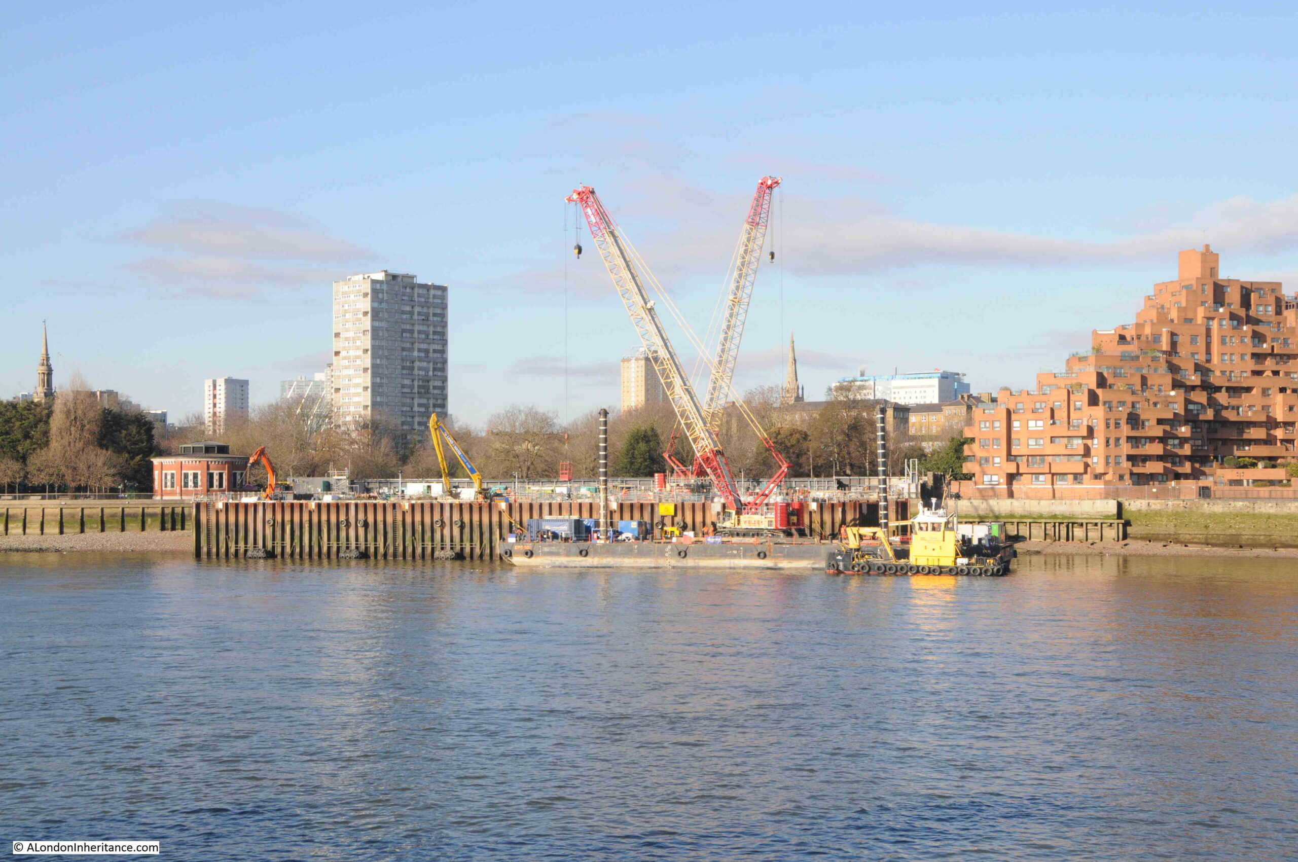
Just to the left of the site today, is one of the construction locations for the Thames Tideway Tunnel:
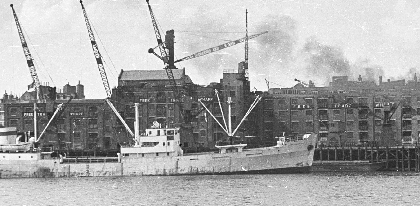
The OS map shows the buildings to the right of my father’s photo, labelled as Free Trade Wharf. These buildings are much earlier than the main block, but are hidden behind the ship and cranes in my father’s photo.
An extract from this photo showing the dark coloured ship, with part of these buildings just visible in the background:
The buildings, the ones labelled as Free Trade Wharf in the OS map as can be seen in 2024:
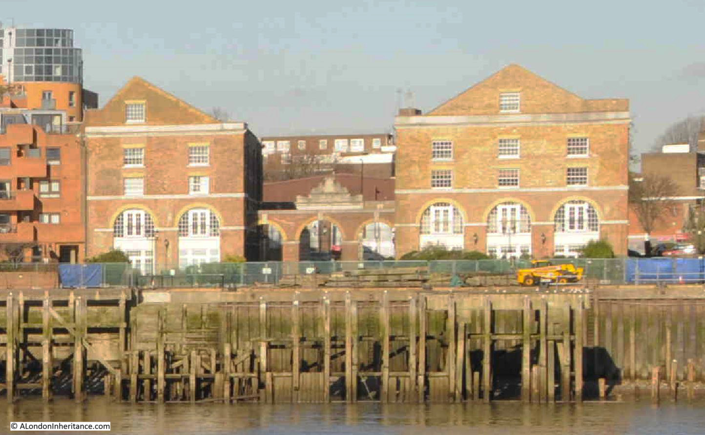
These buildings are Grade II listed and they date from 1796, although there have been many alterations over the years.
They were built for the East India Company, and handled a variety of goods, including saltpeter, which was used in the manufacture of gun power.
The site later became a place where colliers from the coal fields in the north east of the country would unload, and is presumably where the Charringtons connection comes from.
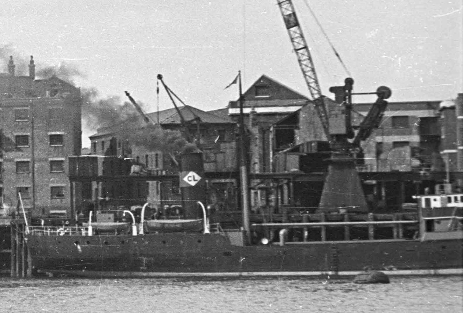
There are two ships in the 1948 photo. the ship on the left has no visible feature to help with identification. I use a high resolution scan for my father’s photos, and despite this, I cannot read the name of the ship on the bow.
The ship on the right has no visible name, presumably it is on the bow and only the rear section of the ship is visible in the photo. What can be seen is the funnel, and this has the letters CL in a white diamond.
Ships with the identifier of the owning / operating company were once a frequent sight on the Thames, and as kids in the late 1960s / early 1970s, we would often go down to the Thames by Coal House Fort, through East Tilbury (which always fascinated with its village and Bata shoe factory in this isolated part of Essex).
I had the Observer’s Book of Ships and used this to check of the passing ships. I still have the book and checked it to see if the CL in a white diamond is listed, and fourth down, on the left column, I found it:
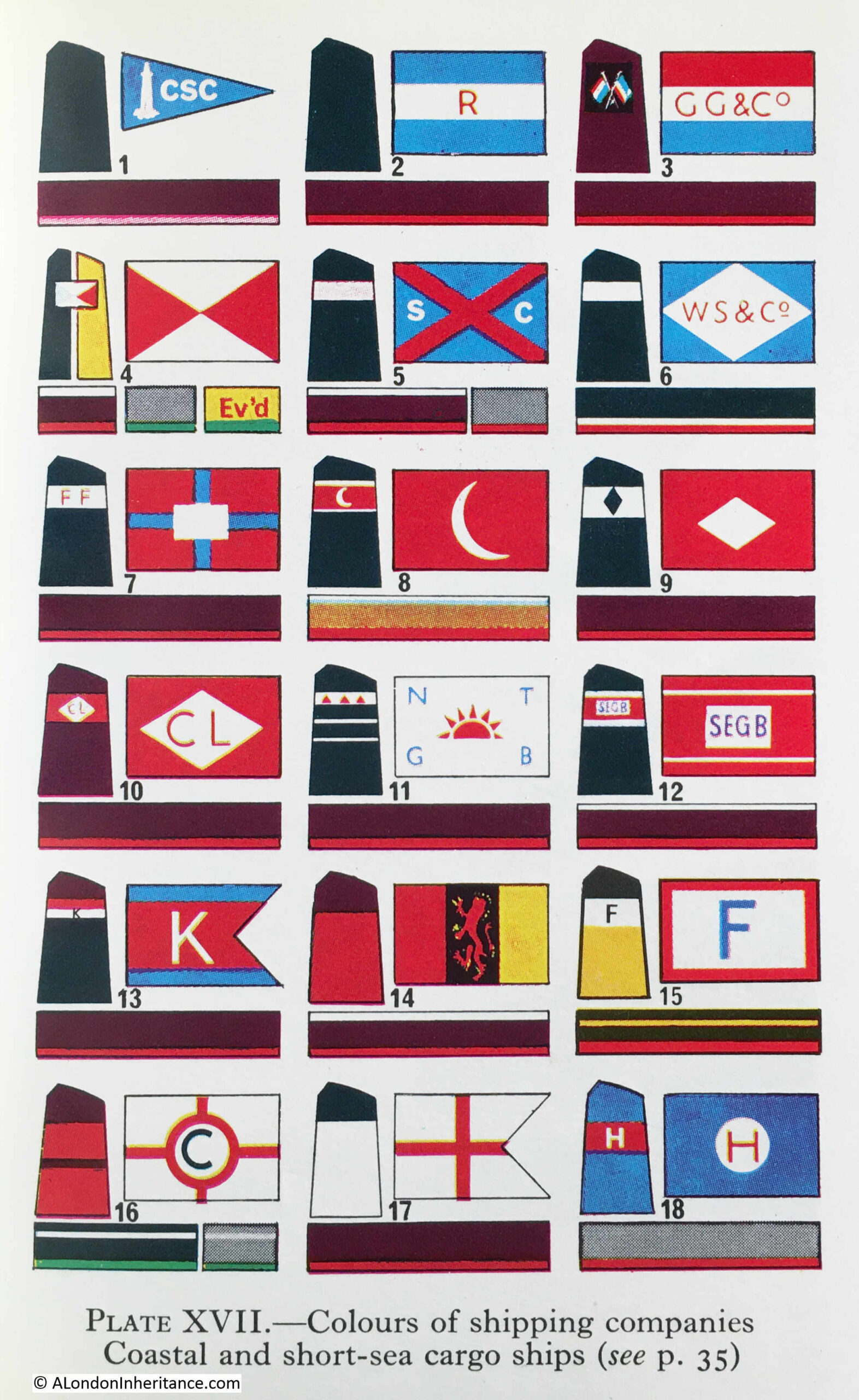
Turning to page 35, and CL is for Comben Longstaff & Co. Ltd of London, and who were listed as Colliers.
The company was named after William Comben Longstaff, who was born in Lambeth in 1896.
Comden Langstaff & Co. Ltd was originally involved in a range of maritime services including insurance, owning, managing and operating a fleet of ships that delivered raw materials and goods to the ports around the coast of the UK.
Newspapers of the time have many references to the purchase of new ships, sale of older ships, trade, routes etc. and the company seems to have been reasonably active.
The majority of their ships seem to have been built by John Lewis of Aberdeen, and the following article from the Aberdeen Press and Journal on the 9th of June 1948 is typical of the company’s coverage in the press:
“STEAM COASTER LAUNCHED – I have great faith in this country, but its only salvation is hard work, said Mr. Comben Longstaff at a gathering after the launching yesterday of the steam coaster Lancasterbrook, built by Messrs John Lewis and Sons Ltd, Aberdeen, for his firm, Messrs Comben Longstaff and Co. Ltd, London.
Mr. Andrew H.S. Lewis said the Lancasterbrook was a sister ship of the Londonbrook, built by his firm two years ago. She was an oil burner and was fitted with patent steel hatch covers.
They were building two other ships for the same owners.
Mrs. Comben Longstaff named the vessel which is 200ft in length and is of the raised quarterdeck type. The rudder is semi-balanced and streamlined and was made to the owners’ own design.”
The article mentions the Londonbrook, which had been built by the firm two years earlier, so presumably in 1946, and from checking photos of the Comben Longstaff ships, I believe the ship to the right of my father’s photo is the Londonbrook.
The company was sold in 1954, and William Comben Longstaff died in 1966.
Their ships continued operating around the coast of the country and in the late 1970s, two new ships were built, the Durhambrook and Devonbrook, continuing the Comben Longstaff tradition of adding “brook” to the end of their ship names.
The company ended operations in 1981, and all the ships were sold.
Both the Free Trade Wharf and the ships that docked at the wharf are from a time when you could sit on the river wall at Tilbury on a summer’s evening, and watch the ships passing along the river, checking them off in your Observer’s book.
Fascinating history of the different companies involved in shipping-interesting reading.
The Free Trade Wharf residential development we see today is only half completed. The original plan was for the Grade II listed buildings to be in the middle of the site with a West and East development either side of it. Only the West side was built before the downturn of the early 90s put a stop to the East site being developed.
I think my grandfather Frank Monk owned Hayes Wharf. He died quite young as a result of getting pneumonia while meeting a ship.
On leaving school in 1955 I worked in offices in the London Dock and used to travel to Tower Hill underground station (the old one). Free Trade Wharf was then occupied by Coast Lines and there was a coach every morning in Trinity Square waiting to transport its staff to the location.
My father worked for Coast Lines, based in Freetrade Wharf, all his life. He served in the RAF from 1940 – 1946. Even though suffering from emphysema in 1960’s, he travelled there every day, using London Transport, all the way from South London. Working on the British and Irish line, he would bring home posters of the ships, mount them on plywood and using a fret saw, made us children wooden jig saw puzzles. He was the only man, in an office full of women.
The design of the Free Trade Wharf always seemed to owe a great debt to the far more unfashionable (back then) Dawson’s Heights in South London. Further the views from Free Trade Wharf are rather limited in comparison to those at Free Trade Wharf since the public space is privatised and you can’t move around the site as easily to enjoy the striking panorama that is possible at Dawson’s Heights. Unless you want to get on the top of FTW I suppose.
While I was doing volunteer work to geocode and describe some of the photographs in the London Metropolitan Archive Collage Collection of which I did over 3500 photos I described this area with photos of Broad Street and the frontages of these buildings which can be seen using the ‘Advanced Search’ option;
https://www.londonpicturearchive.org.uk/advanced-search?WINID=1709460821791
and in then in LMA Catalogue Number typing;
SC_PHL_01_381*
Thank you so much for this bulletin. In researching my husband’s family, we have found several births in Ratcliffe and was never sure exactly where in London it was.
Very interesting.
I really enjoy your weekly emails., having studied Geogaphy as my main at Whitelands Teacher Training College1969-72 and explored the Development of London as one of our units.
Again, thank you so much.
Would ‘Captain’s Imperfect Entry’ relate to goods that were either not described or part-described and that were then awaiting furher clarification before Custom’s clearance?
[A casual exploration online, part-prompted by your superb occasional posts and update and part-prompted by exploring for a possible pub that Joan Aiken might have modelled her Two Jolly Mermaids on, as well as planning an exploration with a visitor from the States later this month ….. can lead one into researching far too much 🙂 ! ]
You comment that ‘The Charringtons name came from the ownership of the site by Charrington, Sells, Dale and Company, who traded in coal and coke. I cannot find exactly when this part of the site became known as Free Trade Wharf’
It appears that it had happened by 1978, according to some sources, viz.,
Analysis of The Heart Within (1957) Captures 16 and 17
https://www.reelstreets.com/films/heart-within-the/
The Cable Street 1921 Directory contains background on the development of Charringtons, and much (at least) suggestive material that the change in name happened a lot earlier than ‘by 1978’.
In 1922 Charrington, Sells, Dale & Co., became Charrington, Gardner, Locket & Co Ltd.
In 1923 Tyne-Tees Shipping Company Ltd had bought Charrington’s coal wharf, with work to be undertaken to build new jetties and roadways, and a road to the Free Trade Wharf.
http://www.stgitehistory.org.uk/media/cablestreetdirectory1921.html
Tyne-Tees Shipping Co Ltd (and the two companies that formed that company in 1903) had operated the Free Trade Wharf Company since 1884.
https://discovery.nationalarchives.gov.uk/details/r/d979e60e-434d-4038-9904-da5c80d4cbaa
It’s probably reasonable to infer that Charrington’s wharf became part of (and also known as) Free Trade Wharf at, or not long after, the time of that acquisition.
1978 is also referenced also in this consideration of the inscription
‘H. R
1862
1867
1874
1881
1887
1894’
at the entrance to ‘what was known as Charrington’s Wharf and/or Seaborne Coal Wharf’ ……. but to no firm conclusion.
https://www.londonremembers.com/memorials/charrington-s-coal-wharf
My wife is a US licensed customs broker and while the term “Captain’s Imperfect Entry” isn’t used here in the USA she says it very likely meant an entry point where goods entered the wharf warehouse in an “imperfect” condition but left it having been “perfected” by someone doing something to the shipment in the sealed warehouse prior to duties being paid. Examples of “perfection” are sticking labels on bottles, or inserting corks in them, or putting the goods in packaging etc, acts which would normally/otherwise happen only after the shipment was released through customs once duty is paid.
Hello,
I am glad you have now covered this area but I was surprised to see no mention of ratcliffe wharf(not to be confused with the steps on narrow street) which according to maps is right near there. I can find no reference point to where this is today except sort of near Free trade wharf. I am particularly trying to find where they filmed the scene driving onto the wharf in the episode of leap in the dark?
https://www.youtube.com/watch?v=NLp8zrpIYlw&list=PLW5sa-46Ba692DCOy7ov–zD5yl9SKyEn
and for info on the clip and what I mentioned:
Here’s my favourite episode – In the Mind’s Eye (1977) – A Local Legend about an Evil 18th century vicar and his pretty female accomplice who murder and rob unsuspecting Seamen along the docks of East London. The programme investigates the supposed many stories of local workers of sightings of a ghostly 18th century old vicar still seen wandering along the docks in 1977.
Here’s what the maker of the programme Colin Wilson had to say about the making of it.
“The Ghost of Ratcliff Wharf
by Colin Wilson
Prof Wiseman and Psychic Suggestibity
Back to… Skeptics in the Media
I suspect that the scene where they drove onto the wharf wasn’t filmed in London. Have a look, for example, at about 28:20 or 34:50. On the far bank of the river the ground seems to rise to a substantial hill. I don’t think that resembles anywhere in London’s docklands. However, the credits at the very end of the film say ‘BBC COLOUR BRISTOL’. My guess is that it was filmed somewhere in the Bristol area.
As will be seen from the London topographical map, to the south of Shadwell and Ratcliff across the river, the first higher ground isn’t until you get to roughly the Forest Hill, Brockley, Honor Oak, Nunhead, & Sydenham Hill areas.
Equally it isn’t until you go to the north west of Shadwell that the higher ground, Hampstead, Highgate, etc., is seen.
You can click around the map to get the elevation.
https://en-gb.topographic-map.com/map-kffs8/London/?center=51.50874%2C-0.0769&popup=51.49856%2C-0.04875
Footage e.g. from about 19:02, and from around 20:25, shows the breadth of the Thames.
That’s very different from those segments e.g. from 21:40 as Colin Wilson then does a piece to camera.
The weird thing they were supposedly bringing a witness to the actual location and other scenes were filmed in Wapping?
How can they test someone’s psychic ability in the wrong location?
I am not interested in any details of the haunting they describe, I was just like apparently others trying to figure out where they could have driven onto the actual wharf and if indeed it was the actual lost wharf?
I went to Nicholas Gibson primary school (formerly Broad street school) located in the Highway, right opposite the main office buildings of the Free trade Wharf. These buildings were rather grand, faced with white (Portland?) stone blocks.
I know this because when school photographs (eg football/cricket teams/ play productions) were taken, in the Upper school hall, you can see the front of the Free Trade Wharf through the windows behind. (I still have these photos) The inscription on the building reads Free Trade Wharf and underneath Sutherland House.
Nicholas Gibson school buildings still exist, but the school was closed once the Highway was widened. The school playground and outside toilets were removed, along with most of the the buildings on the north side of the Highway to create a dual carriageway. The school buildings are now the Shadwell Centre.
Incidentally the road was known as Ratcliff Highway for many centuries, but became notorious for crime and depravity in the early 1800s – so it got renamed with different names along various parts of the road. Broad Street was one of these ‘new’ names. However when I lived in the road in 1950s/60s it was back to being the Highway again!
An interesting essay to read ( you probably have already) on the infamous Radcliffe Highway murders in the 1800s is by Thomas de Quincey. I think it’s called ” Murder Considered As A Fine Art ” !
“These buildings are Grade II listed and they date from 1796, although there have been many alterations over the years.
They were built for the East India Company, and handled a variety of goods, including saltpeter, which was used in the manufacture of gun power.”
These must, surely, be the warehouses referred to in this British Library Untold Lives Blog by their lead curator for the East India Company records.
They were a rebuild following a disastrous fire in 1794.
https://blogs.bl.uk/untoldlives/2017/02/east-india-company-saltpetre-warehouses-at-ratcliff.html
I haven’t found Cock Hill Shadwell, though will be looking further at mapping available via the British Library – see the links to these, the OS maps and the Insurance Plans, at https://www.londonremembers.com/memorials/charrington-s-coal-wharf
Well, I think one mystery is solved, that of Cock Hill Shadwell
This https://isleofdogslife.files.wordpress.com/2017/03/cross15b1851.jpg and captioned Ratcliffe 1851 ..from Isle of Dogs Life https://isleofdogslife.wordpress.com/tag/ratcliffe-cross-stairs/ ….. shows Cock Hill as a continuation west …. of Broad Street ….. not far from where Broad Street met Butcher Row.
It’s on the rough east/west alignment of the more modern day Highway ….. and I had been looking for a road running north/south.
It was surprising to learn that the Ratcliffe incident of 1794, the explosion and then more the subsequent fire was the largest in London between the Great Fire 1660 and the blitz of 1940 …..
It was not one that I recalled ever reading about. (Another that I hadn’t heard of before, the Great Tooley Street fire, is another matter https://symbolsandsecrets.london/2023/01/26/the-great-tooley-street-fire/ )
There is a building that has survived, apparently, at 2 Butcher Row, so one to see if it can be found when next in Limehouse for a photography course at Shadwell Centre.
https://www.historic-uk.com/HistoryUK/HistoryofEngland/Ratcliffe-Fire-of-1794/
One pretty sizeable fire of the late C18th that I had known about clearly wasn’t on the same scale …
https://collection.sciencemuseumgroup.org.uk/objects/co45327/fire-at-the-albion-mills-blackfriars-bridge-on-3-march-1791-print
https://www.onlondon.co.uk/vic-keegans-lost-london-70-albion-mills/
That 1851 map in full – from Cross’s London Guide
https://london1851.com/index.htm
The road east along High Street or Upper Shadwell to Cock Hill and Ratcliffe is quite clear.
https://london1851.com/cross15.htm
Ratcliffe Wharf
You said that you “can find no reference point to where this is today except sort of near Free trade wharf. I am particularly trying to find where they filmed the scene driving onto the wharf in the episode of leap in the dark”
As much has been swept away in re-development, it’s likely that the actual location is within the site (Atlantic Wharf https://www.architeknic.co.uk/majorprojects/housing/atlanticwharf.html) just to the west of Keepier Wharf (said to be named for a mining area in Durham, likely to be Kepier Colliery http://www.dmm.org.uk/colliery/k007.htm) , and marked on the O.S. maps as Ratcliff Stairs Wharf (1915) and earlier (1870) as Ratcliffe Dry Dock, and on the Goad Insurance Plan https://britishlibrary.oldmapsonline.org/compare#map/55f9c620-5a2b-5c5a-bec2-43505f4a1a89
I will be in the area soon, and will see if there are any signs of the old dock and wharf. From what I recall from occasional walks down and upstream along the Thames Path, there was nothing obvious along the riverside path or on the Highway.
From the Highway, the development looks as if it pretty well swept away everything from earlier eras. There was some archaeological work https://archaeologydataservice.ac.uk/library/browse/issue.xhtml?recordId=1024402&recordType=GreyLit
https://archaeologydataservice.ac.uk/library/browse/issue.xhtml?recordId=1067699&recordType=GreyLit
Architeknic Architects who developed the design for Atlantic Wharf wrote ‘Whilst building foundations we came across 16th century dry docks, which were used to build ships to go to the New World. Across the site was a listed stairs and path to allow freemen of London access from the highway to the river.’
https://www.architeknic.co.uk/majorprojects/housing/atlanticwharf.html
The BBC Programme Index has In the Mind’s Eye, the last of twenty four in the series of Leap in the Dark, as having aired on February 18th 1977.
https://genome.ch.bbc.co.uk/76bc3594693441b88d7e79b709fa7079
It would be a longshot but there’s a chance that the BBC Archive will have some of the production files, scripts and programme logs.
Access is currently limited https://www.bbc.co.uk/archive/bbc-written-archives-centre/zdy9scw but might be possible via the BFI https://www.bfi.org.uk/bfi-national-archive
Thank you so much for all the info, I am from the U.S. and was visiting last year and tried to walk the river walkway twice last year but it was completely blocked off by Thames waterworks construction.
I’ll be walking that way again east from St Katharine Docks and will see what if any of the Thames Path is closed.
LB Tower Hamlets refer to damage to the walkway at Free Trade Wharf, which means that the way in and out of King Edward Memorial Park was closed. I can’t find an update so far.
https://www.towerhamlets.gov.uk/lgnl/leisure_and_culture/parks_and_open_spaces/King_Edward_Memorial_Park.aspx
The Thames Water Tideway construction site in King Edward Memorial Park, which had meant that the Thames Path was diverted, should be coming to a close with the testing and commissioning of the tunnel starting
https://www.tideway.london/locations/king-edward-memorial-park-foreshore/
https://www.tideway.london/news/press-releases/2024/february/london-s-super-sewer-getting-ready-for-testing-to-protect-the-river-thames-from-pollution/
I can confirm that the way out of King Edward VII remains blocked off. I walked that way from Tower Hill and Wapping Wall on Friday. By the way, the Tideway work sites remains active and alive. The Thames Path is diverted up on to The Highway and then along past Free Trade Wharf to Atlantic Wharf through which you can walk back down to the river. You can also walk back to where the Thames Path is blocked at the eastern side of the park (just by the west of the two surviving C18th buildings), and I noted and photographed as much as I could, which are at
https://www.dropbox.com/scl/fo/gcq8f8do0g8a23vlxsbng/h?rlkey=rrw7kiqdzttwpxazbca6te6n1&dl=0
It appears that some work was going on, with planks lifted … and I also found Reclaim Our River, and this post concerning the application to demolish the Charrington Jetty – together with useful aerial and other photographs of the structures.
https://reclaimourriver.com/2022/07/20/demolition-of-historic-jetty-on-thames-path/
See also the aerial photo and video at https://reclaimourriver.com/2022/11/05/tideway-closes-thames-path-in-wapping/
Thank you again.Also to all who took the time to respond.
My father started working for Coastline Seaways when he left school and after his National Service returned there, worked in the manifest dept. until he died in 1966. He travelled by train from Dulwich to the East End every day, even though suffering from emphysema. Years later, we went looking for Freetrade Wharf and arrived on the day that it was being raised to the ground. One of those heavy demolition balls was swinging against the wall where a wooden sign ‘Freetrade Wharf’ was dangling. All very sad but at least the Wharf has a new life.