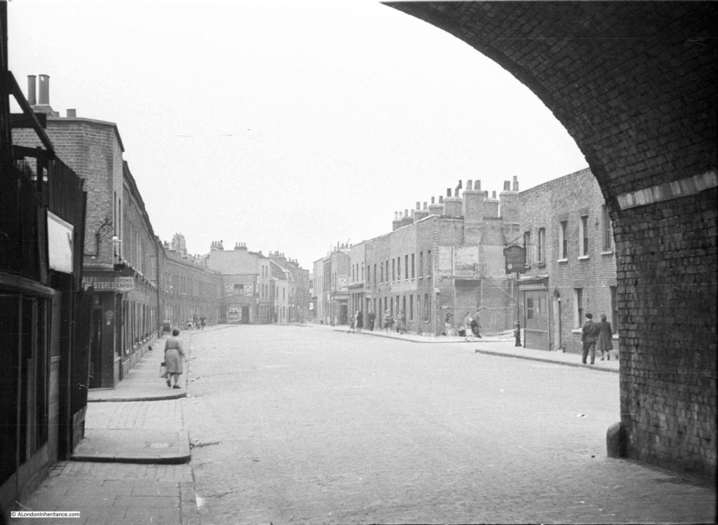
For this week’s post, it was a short walk after leaving last week’s location at Westferry Road, to find what remains of a street my father photographed in 1949. When sorting through his photos this was one location I was doubtful I would find. I did not recognise the scene and there were no clues to place the photo, apart from being taken from within what looks like a railway arch. I published the photo in one of my mystery location posts in 2015 and was really pleased when it was identified as Hardinge Street, just off Cable Street, a third of a mile east of Shadwell Station.
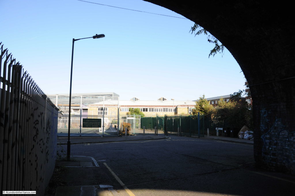
And this is the view from the same location today:
Hard to believe that this is the same place, however there are a number of clues. In addition to the obvious railway arch, in both photos the left hand section of the arch is fenced off, it was probably some form of workshop or storage area in 1949. There is access from the street to the fenced off area in both photos, and just past this there is another street leading off to the left.
There are also the sort of small details I love finding. On the pavement and kerb edge of the street, just before the street on the left there is a manhole cover on the pavement and a drain cover next to the kerb in the street. These are in the same locations in both photos – when the street above changes, often the utilities below the streets follow the same routes for decades.
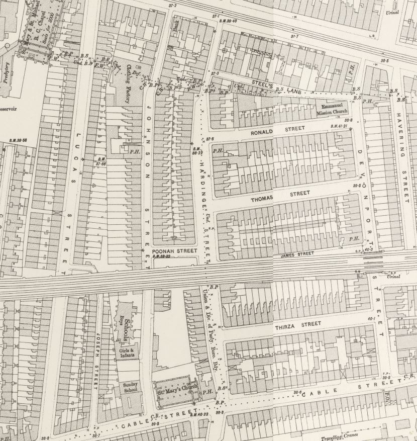
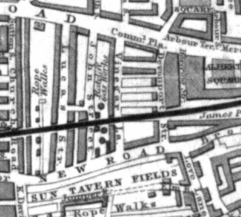
Hardinge Street is one of the many streets that ran between Cable Street and Commercial Road. The following extract from the 1895 OS map shows Cable Street along the bottom, Commercial Road along the top and in the centre of the map, Hardinge Street running between the two.
The railway, built in the late 1830s that runs into Fenchurch Street can be seen cutting Hardinge Street in two.
The streets are densely packed with houses, as can be seen in my father’s photo. The street on the left is named as Poonah Street in the map. The streets running off to the right can be seen in both map and photo.
Perhaps surprising is that the street looks intact after the heavy bombing east London suffered during the war. I checked the London County Council Bomb Damage Maps and the houses in my father’s photo are coloured yellow – “Blast damage, minor in nature”. the only exception is on the right side of the photo, the building on the corner of the street leading off to the right, there appears to damage and scaffolding. This building is coloured orange for “General blast damage, not structural”. A bomb must have fallen in the street leading off to the right as in the map there is a row of houses on both sides of the street coloured purple for “Damaged beyond repair” and black for “Total destruction”. It is the blast from this bomb that must have caused the blast damage to Hardinge Street.
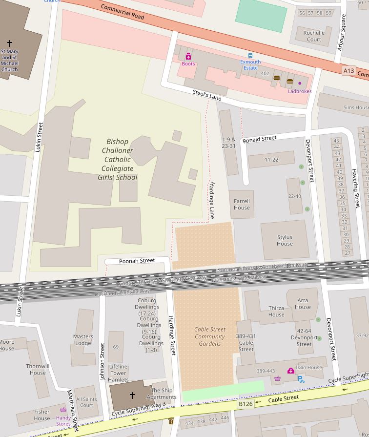
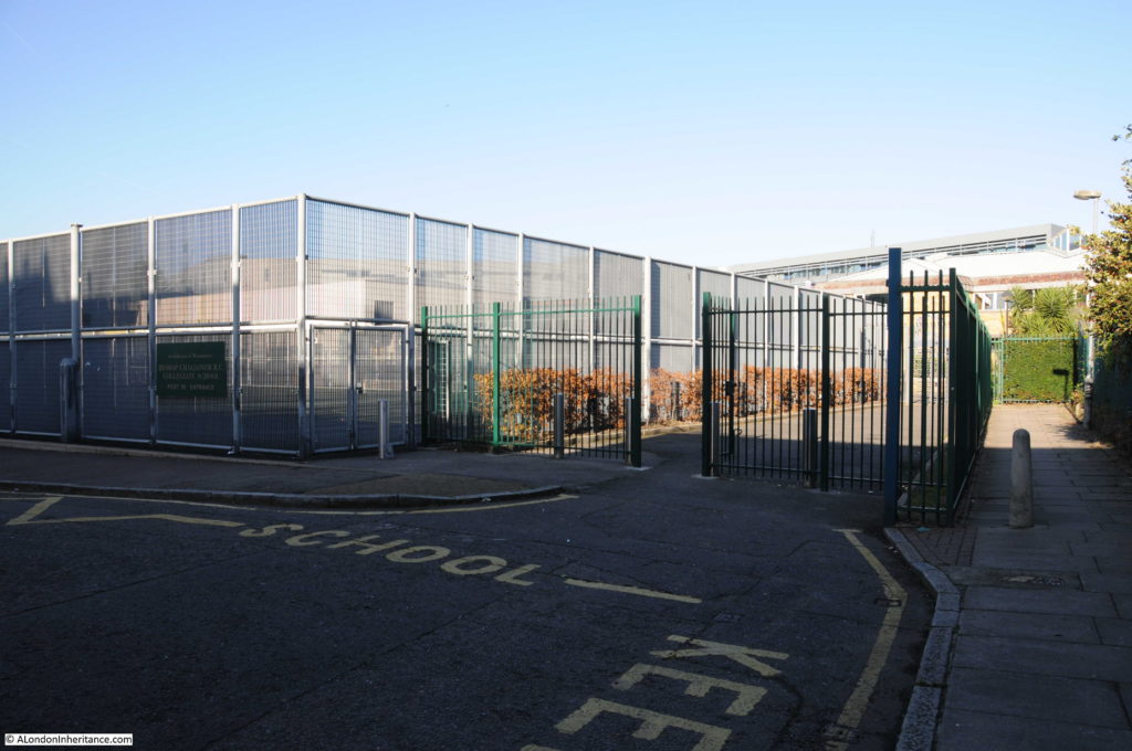
The fate of Hardinge Street is very different either side of the railway. To the north, the view in my father’s photo, all the buildings, Hardinge Street and most of the side streets have all been demolished and replaced with the Bishop Challoner School. The map extract of the area today shows roughly the same area as the 1895 map and highlights how significantly the area has changed.
It is fascinating to trace the history of the area. Hardinge is an unusual name. I could not find any reference to why the street was given this name, however Poonah Street gave me a clue.
Poona was the name given by the British to the Indian city of Pune during the 19th century – I suspect the ‘h’ at the end was added as the pronunciation of the word probably ended with ..ah.
Following the Indian connection, Henry Hardinge, 1st Viscount Hardinge was Governor General of India between 1844 and 1848, so I suspect that when the street was redeveloped at some point between the 1850s and the 1895 OS map, it took the name of a Governor General of India.
Why do I say redeveloped? This is an extract from an 1844 map of the same area.
The name Cable Street had not extended for the full length of the street covered today – in 1844 this section was called New Road. What would become Hardinge Street is again in the centre of the map, but in 1844 was called Vinegar Lane. The railway is in the same position and comparing the map with later maps, Devonport Street on the right is the only street that has survived with the same name from 1844 to 2017. John Street on the left is now Johnson Street and next left, Lucas Street is now Lukin Street (and today follows a different route south of the railway).
To the left of Vinegar Street can be seen the Ratcliffe Gas Works along with the round symbols of gas holders. By 1895, the gas works had been demolished, Vinegar Street became Hardinge Street and the area was full of densely packed housing, corner shops and pubs.
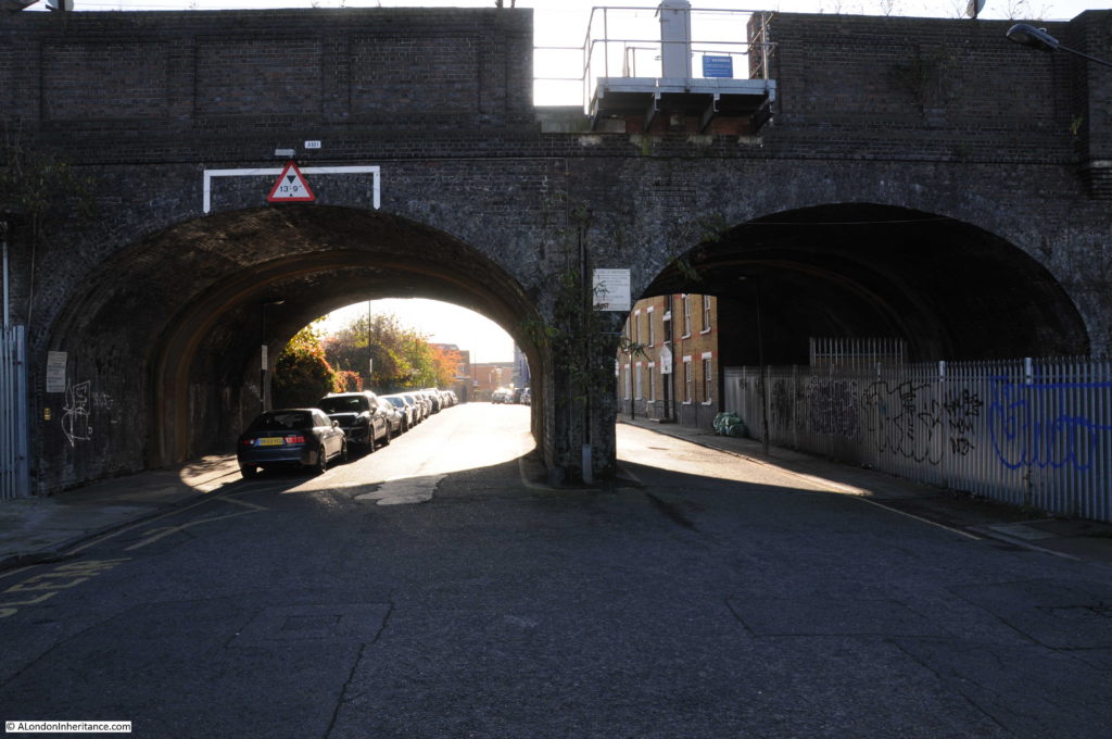
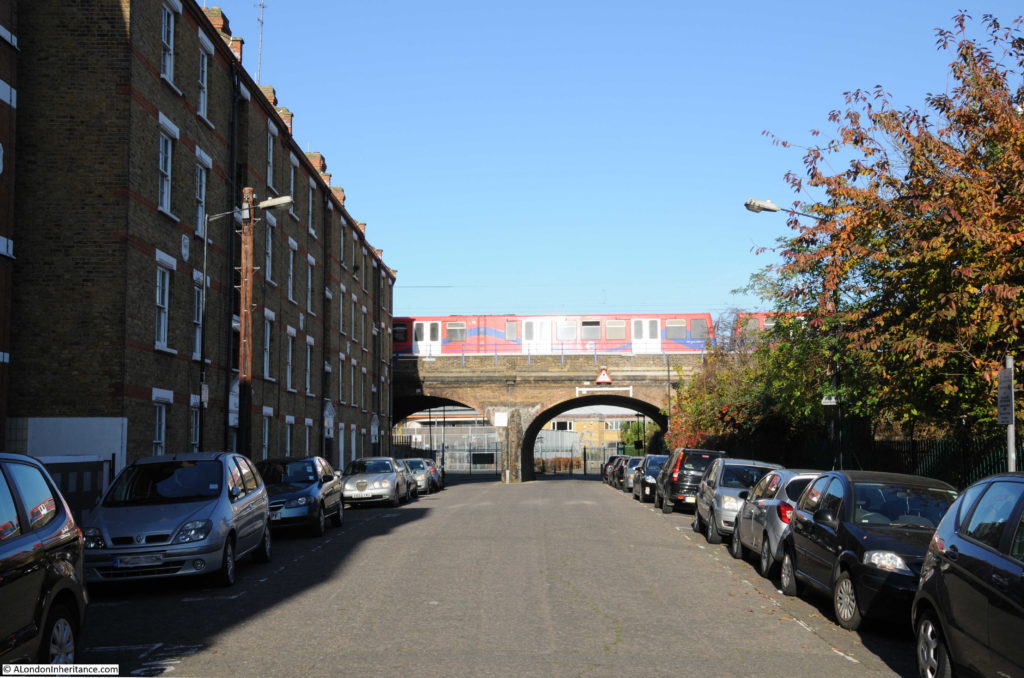
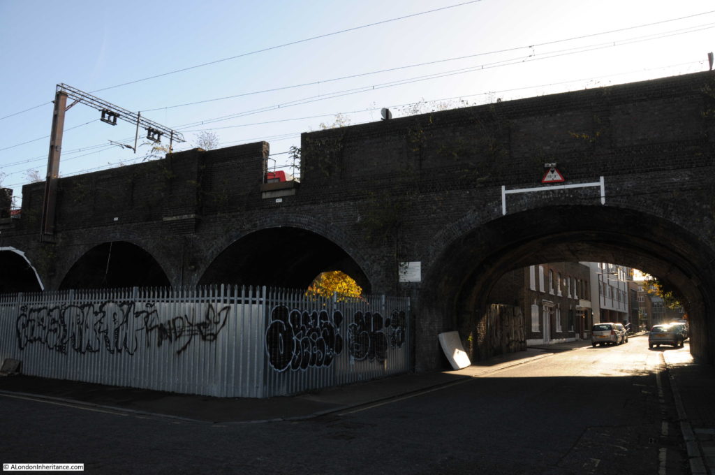
Time for a walk around the area. The following photo is looking south, through the arches to the southern end of Hardinge Street. The location of my father’s photo and my later photo is just inside the arch to the right, up against the metal fencing.
This is looking at the corner of Poonah Street and Hardinge Street. In the 1949 photo this was the location of the corner shop.
A footpath can be seen to the right of the above photo. Although Hardinge Street as a road has now been cut off from Commercial Road, a footpath runs along the side of the school up to Steel’s Lane (another survivor from the 1895 map) and then to Commercial Road. The footpath is called Hardinge Lane, retaining the name, but Lane reflecting the loss of the through street.
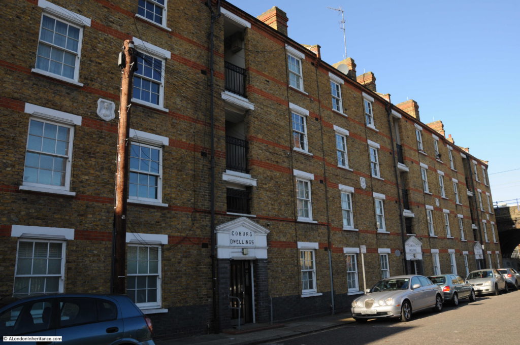
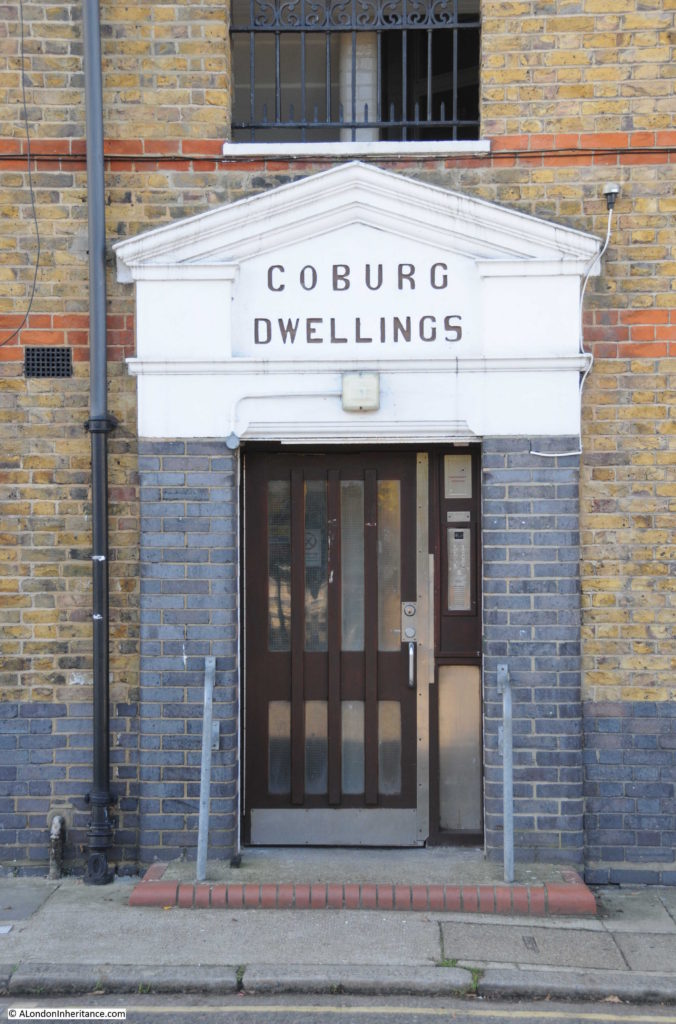
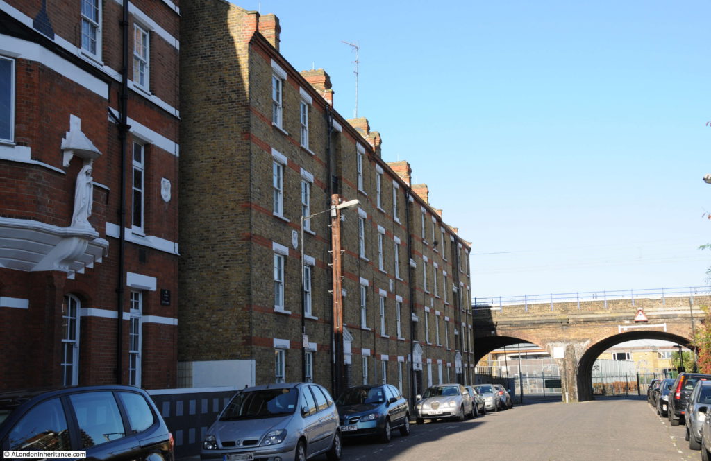
Walking back under the rail bridge, south towards Cable Street, on the western side of Hardinge Street are Coburg Dwellings. The building dates from 1904 and was constructed by the Mercers Company. The name comes from the region of Germany where Queen Victoria’s husband, Prince Albert was born.
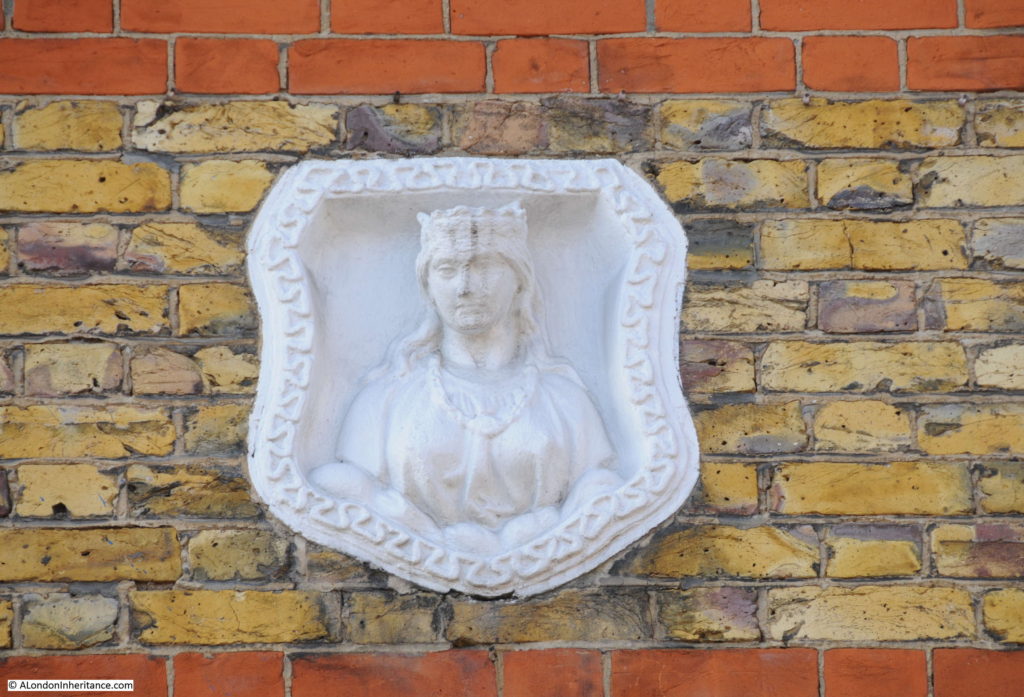
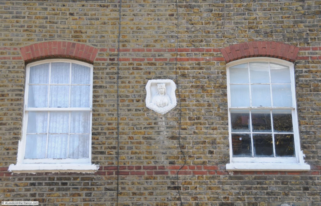
In the above photo, there are a number of white plaques between the first and second floors of Coburg Dwellings. These are Mercers’ maiden property marks to show that the land and buildings belonged to the Mercers Company. A Mercers’ maiden in close up:
The Mercers Company is one of the oldest of the City’s Companies. The earliest mention of the Mercers is the appointment of the fraternity in 1190 as patrons of the Hospital of St. Thomas of Acon, On the 13th January 1394 the “men of the Mistery of Mercery of the City of London” were incorporated by royal charter.
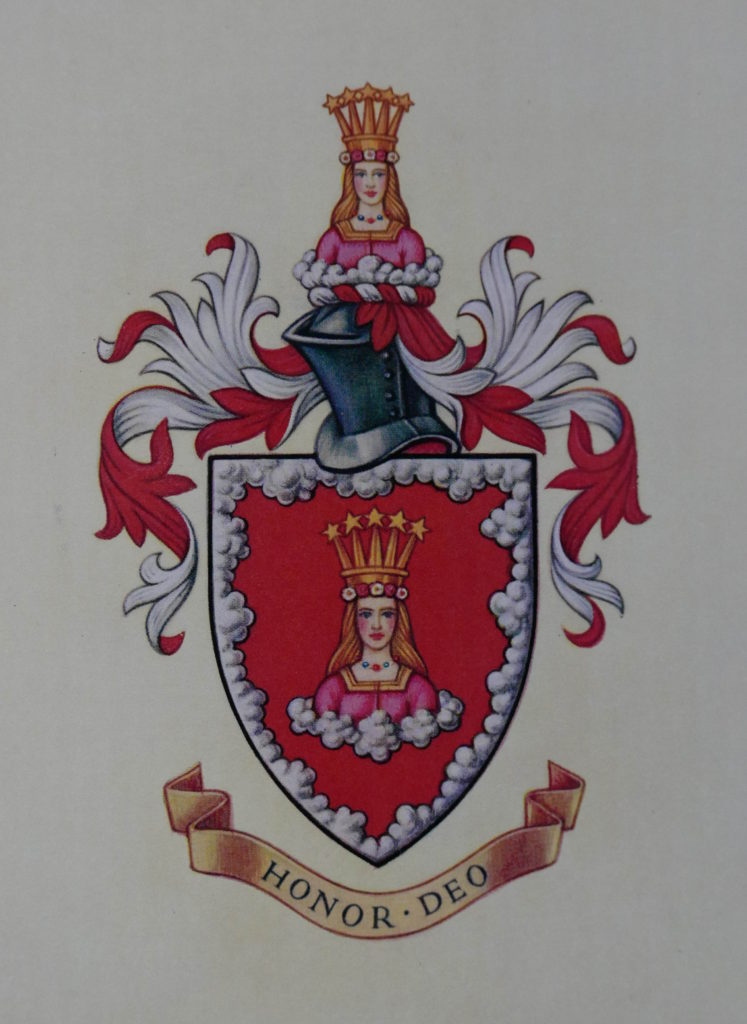
The Virgin is part of the Armorial Bearing of the Mercers Company and was used for the Maiden property marks on Mercers’ buildings. Many of these can still be found across London.
The Armorial Bearings of the Mercers Company:
One of the entrances to Coburg Dwellings:
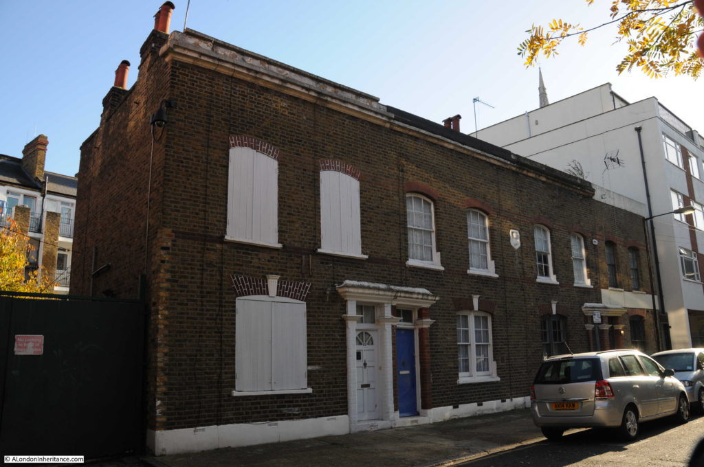
Another Maiden mark is on the building to the left of Coburg Dwellings, built as a Convent for the Sisters of Mercy:
Looking up towards the railway arches. As I explored the area there were frequent DLR and mainline trains passing over Hardinge Street:
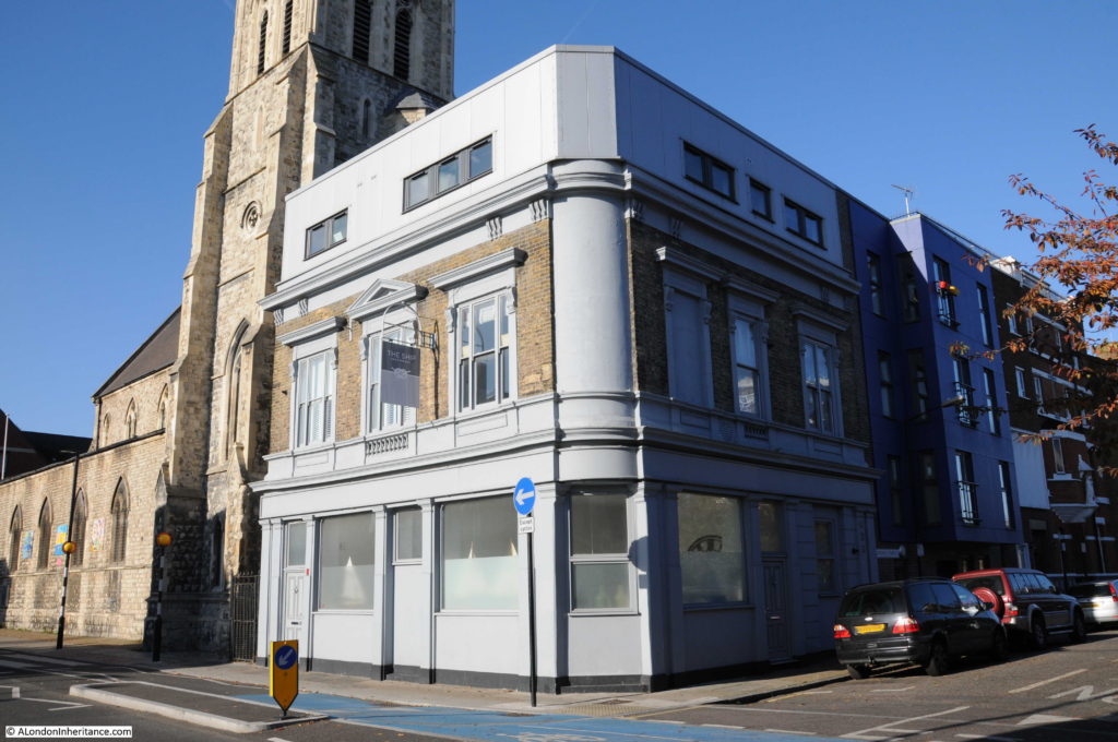
On the corner of Hardinge Street and Cable Street is the building that was once the Ship pub:
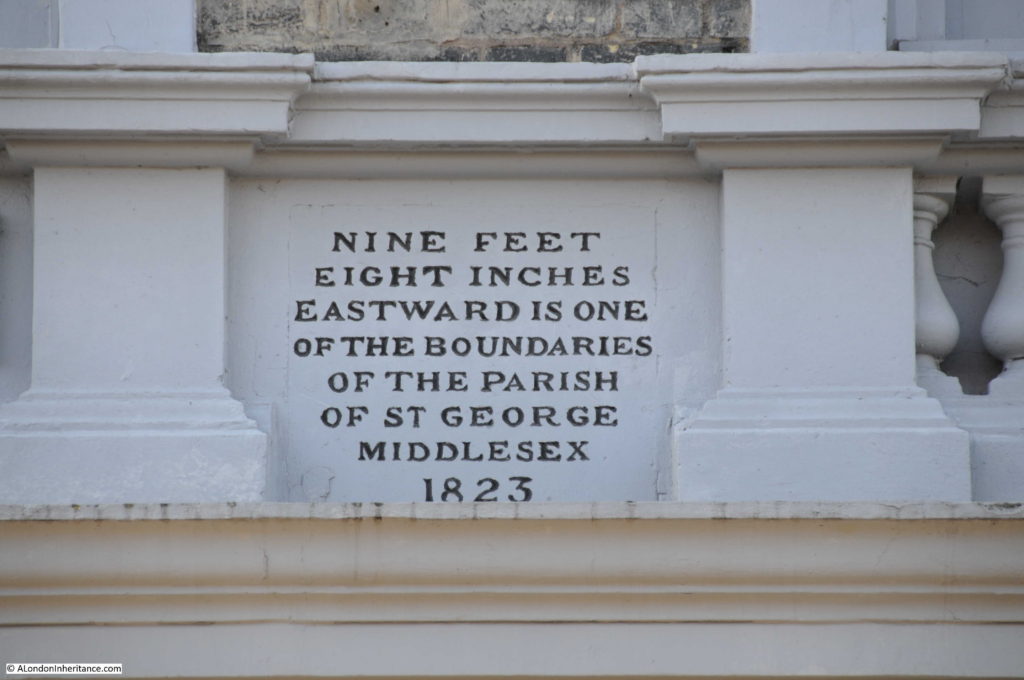
The pub closed in 2003 and has since been converted into flats with an additional floor added to the top of the building. Fortunately a boundary marker from 1823 (which probably dates the construction of the pub) remains on the Hardinge Street side of the pub, between the ground and first floors:
Newspapers during the 19th and early 20th century included the usual adverts for staff at the Ship and also using the pub as a contact address for sales, however in 1893 there is a report which would have made the landlord very unpopular with the residents of Hardinge and Cable Streets:
“At the Thames Police court, London, on Wednesday, William Williams of the ‘Ship’ public-house, Cable-street, St. George’s was summoned at the instance of the Excise Commissioners, for diluting beer. and for not entertaining his permits in the spirit stock-books, and for not cancelling said permits, whereby he had rendered himself liable to penalties amounting to £200. The defendant pleaded guilty. Mr Mead fined him £35 for the dilution and £5 each for the other two summonses.”
His fines seem light compared to what the maximum penalty could have been, however I can imagine the reception he received back at the pub after having been convicted of diluting the beer.
The church seen next to the pub is St. Mary, Cable Street. A relatively recent church having been consecrated on the 22 May 1850 to serve the growing population as the district developed.
After the church, I turned into Johnson Street. This street runs back up to Poonah Street to take me back to the location of the original photo. This is the view looking down Johnson Street:
The 1844 map had the location of the Ratcliffe Gas Works on the right of Johnson Street, filling in the area between Johnson Street and Hardinge Street, although there does look as if there was a narrow line of buildings along Hardinge Street.
When the use of gas for lighting and power started, the small scale of production and lack of large distribution systems meant that gas works would be built to serve a local area, very much within the centre of the area they were serving, even if that meant building a gas works in the middle of housing, or either side of a railway viaduct.
Gas works were dirty and dangerous places and would also produce fumes and smells that would blanket the local area. The following extract from the Essex Standard on the 31st October 1834 reports on an explosion at the Ratcliffe Gas Works:
EXPLOSION OF THE RATCLIFFE GAS-WORKS. On Tuesday morning, about five o’clock, a terrific explosion was heard to proceed from the Ratfcliffe Gas Works, which caused the greatest consternation and alarm in the neighbourhood. The inhabitants rose from their beds in all directions, and on proceeding to the spot, it was discovered that one of the large gasometers had burst at the back of the factory, adjoining Johnson Street and had carried away the outside case or vat in which the gasometer was placed, besides forcing down a brick wall, several feet in thickness, the materials of which were thrown in every direction.
It appears that the gasometer contained at the time of the accident not less than 16,000 feet of gas, and owing to the chive hoop, which binds the bottom of the tank giving way, the pressure became so great on the other parts of the gasometer, that it gave way, and sank with a tremendous crash on one side, forcing the gas out at the top, and splitting the massive timbers which composed the case, and the large upright beams which supported the whole fabric. Heavy pieces of timber were reduced to splinters and others forced to a considerable distance. A ponderous wheel, by which the gasometer was suspended, was hurled into the yard, a distance of 50 feet, and fell by the side of a man employed on the premises, who narrowly escaped destruction.
A stable by the side of the gasometer was blown in and reduced to ruins, the corn-bin, rack and everything were displaced, but singularly enough a horse within escaped unhurt.
After the explosion the place presented one mass of ruins – bricks, iron and wood lying about Johnson-street and the factory-yard in every direction. The damage is estimated at upwards of £20,000, but it is gratifying to add that no lives were lost, nor was any person injured; but if the explosion had taken place a few hours later, there is no doubt that a great many would have been killed, as Johnson Street is a very populous and much frequented thoroughfare, and several labourers were generally kept employed about the tank which burst.
Another gasometer only five feet from the other remained uninjured, which is accounted for by the great strength of the outer casing, which is formed of wrought iron, braced by large girders. A gas light in a lamp close to the tank was blown out; a circumstance which prevented the contents of the gasometer from being ignited, and probably saved property to a large amount from destruction.”
There are many other reports in the papers during the 19th century of the terrible fumes and smells that would come from the gas works, and of injuries to workers including the death of a worker during the construction of a new gasometer.
These were not good places to have in built up areas and the proximity to a busy rail viaduct cannot have helped. As can be seen in the 1895 OS map, the gasworks had been closed as part of the redevelopment of the area.
At the top of Johnson Street is this row of houses that have survived from the 19th century redevelopment of the area:
Again with a Mercers’ Maiden to show ownership. I assume that the Mercers owned the block of land that formed a rectangle between Hardinge Street, Cable Street, Johnson Street.
At the top of Johnson Street at the corner with Poonah Street:
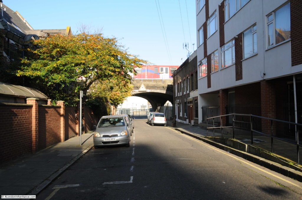
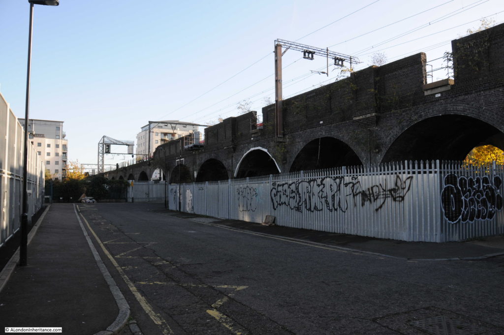
The photo below is looking along Poonah Street towards the junction with Hardinge Street. In the above and below photos, the metal fencing that formed a boundary in the Hardinge Street arch can also be seen running along Poonah Street and to the arch in Johnson Street.
The Mercers Company owned the land before the railway was built and I suspect that the fencing shows the boundaries of the Mercers land as it is aligned with the buildings in Johnson and Hardinge Streets. This would explain why part of the area under the arch in Hardinge Street is fenced off – a reminder of land ownership from long before the railway was built, and that continues to this day.
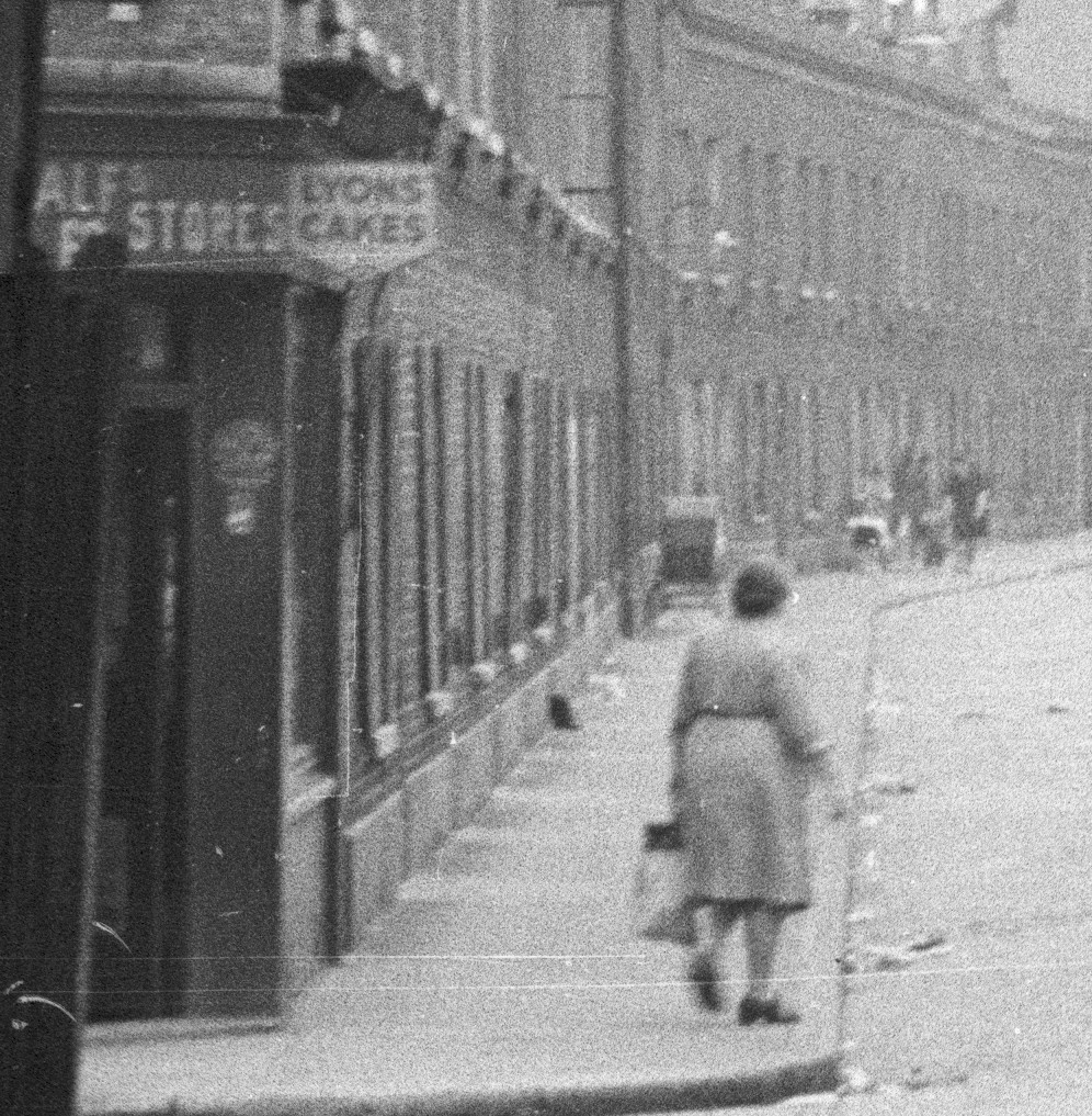
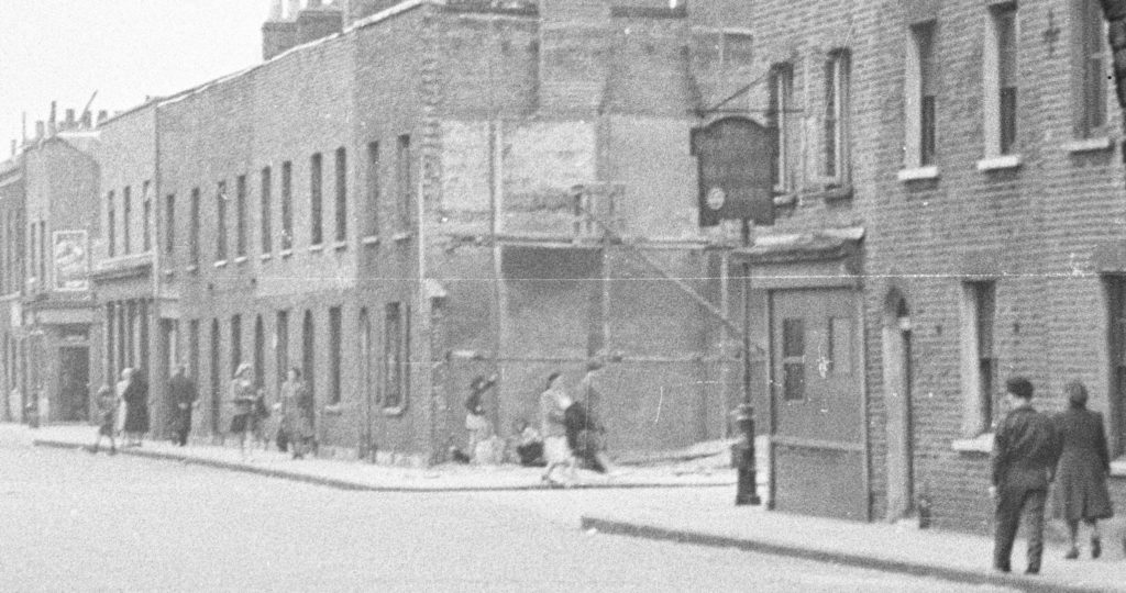
To finish of this week’s post, here are a couple of extracts from my original high-resolution scan of the negative. I find the detail in these photos fascinating and as a reminder that it is not just the buildings that have long since disappeared, but also the people who made this area their home.
The following extract shows the left side of Hardinge Street. A woman with a shopping bag has possibly just been shopping in the shop on the corner of Poonah Street and Hardinge Street.
There is a large pram parked outside the terrace of houses and further along what could be two women, a small child between them and a pushchair.
And on the right of Hardinge Street, there is a pub on the corner, people walking along the pavement and what looks to be a couple of children underneath the scaffolding on the corner of the house.
Hardinge Street along with Emmett Street and Westferry Road in last week’s post have changed dramatically over the past seventy years. The people in the original photos, outside the newsagent in Westferry Road and those in Hardinge Street could probably never have imagined how much their streets would change.
I wonder what the next seventy years will bring?

Thank you,Admin,another interesting post which this morning made me giggle. Not,I hasten to add, your writing, but a quote from that report of a gas explosion. ‘The inhabitants rose from their beds in all directions.’
What will the next seventy years bring? I shudder to think.
“Chive hoop” – I was going to google it, but it is probably not as exciting as it sounds!
Thank you so much for this. At the end of the century my great grandfather and family all 10 of them lived at Arbour Street in what I suspect was a house similar to those above. I thought that it was bombed out but perhaps it was the gas explosion after all!
Very interesting photos. My great aunt and my mother lived at 60 Hardinge Street opposite what was an off licence.
The hoarding under the arch on the left was known as “Yorkies”. I vaguely remember horses there, he was possibly a scrap metal collecter.
My mum shopped in the little shop on the corner known as Alfs although when I used to go in with her he was no longer alive . His wife ran it then, a lady called Anne with her son Ivor.
All the information was very informative, thank you.
I have just found the picture of Alfs corner shop in Hardinge Street.. Alf and Anne were my parents and Ivor is my brother was amazed to find this after all this time
I can remember Anne in the shop. Ivor went to Raine’s School.
Hello Roz i have only just found this posting. I responded just now to Margi but would love to see your picture of your parents shop on Poonah St . I lived at the end of Hardinge St in Con O’Briens shop and wondered if your family knew mine.
Your other readers and writers might be interested to know that the name Cable Street derives from the cable that was used to pull the railway carriages into Fenchurch Street station, the first station to be built within the City of London, that served commuters on the Blackwall Railway from 1841. Until 1891, it must have been the quietest station in London, because no steam locomotives came into it; the carriages were pulled from Blackwall to Minories, at the edge of the City by cable and continued onto the station under their own momentum. On their outward journey they were set in motion by gravity and ‘a slight push from the platform staff’. Cable Street has ofcourse another claim to fame as it’s ofcourse where In 1834 Charles Henry Harrod established a wholesale grocery in Stepney, at 4, Cable Street, with a special interest in tea, before moving to the present site on the Brompton Road, essentially to exploit business generated by interest in then nearby Great Exhibition of 1841.
Cable Street was so named in the 1700s, and is derived from the manufacture of ships cables in the area.
My father’s family were wholesale grocers. They had a warehouse at the top end of Hardinge Street which had originally been a pub and a corner shop on other side of the road, both are now demolished. Company was A. Duboski and Sons – ring any bells ?
My great grandfather, George Frederick Swanson was born at 11 Hardinge Street in 1867. His father was a fire wood dealer.
I am a friend of Ruth (above) and we were surprised when we found out that her grandparents and Mr great grandparents lived near each other 100 years apart!
Hello Jean just seen your post. Are you related to the Swansons who lived opposite Shadwell Park by any chance ?
My great grandfather John Brown was born at 4 Hardinge St in 1850. Great to get some idea of what it looked like, even though a century separates his birth and the 1949 photo. His father, also John Brown was a rope maker/twine spinner and it’s clear he was ideally placed to work at the rope works shown on the 1844 map both to the west and south of hardinge St
My Great Grandfather was born in Hardinge Street in 1852
This is ancestral home for me! In the 1850s my great-great grandfather lived at his uncle’s house, 3 Johnson Street (I presume at the Commercial Road end, now more or less buried under Bishop Challoner’s school). From there he married my great-great grandmother in 1857, at St Mary’s church at the end of the road on Cable Street. The uncle was a “gas fitter” in the 1861 census – possibly initially working at the gas works at the Cable Street end. My great-great grandfather died at sea the same year he was married, leaving 3 sons (two of them born before the marriage).
OMG, I grew up in 53 Hardinge St. nextdoor to Con O’brien’s tobacco shop on the corner of Cable and Hardi nge. I would get beer for my dad at The Ship and feed the horses that delivered the beer. Even remember their names. Used to shop at Anne’s who was a friend of my mum’s. I remember the Off License and on the corner of the next street was a fish and chip shop. On the corner of Thirza, where my best friend lived, was a cobbler, a thing of the past. I used to get milk in great big urns for The Sister’s of Mercy.,
Hello Margi i was looking into connections to Hardinge Street and saw the lovely pictures of the old and new Hardinge Street. I was Diane O’brien and lived in the shop you lived next door to. I was there from 1959 to 1966 because we came from The Highway originally. My grandad John O’brien and nan Ellen ran the shop before my dad. I too had a best friend in Thirza Street (did we share this best friend?) mine was Sylvia Butler and i havent heard from her since we all moved away but would love to know what happened to her as we had such lovely times together. I also helped out the nuns by walking them to SS Marys and Michaels/Bishop Challoner each day. My aunts often helped out in the shop and had parties in the basement of the shop. The O’briens were a lively lot and the stories of their shennanigans during and after the war years were hilarious (although I suspect a lot were embellished) . My earliest memories are of the nursery in Thirza Street and I remember the corner shop on Poonah Street. Very happy memories and am very grateful for the inital posting.
Hello Diane, I’m afraid we moved 1957. I didn’t know Sylvia. My best friend Pauline, lived next door to the nursery. I still have a scar on my wrist from climbing up the wall and sliding my arm over a nail. I did go to a party in the basement of Con O’brien’s. He also organized street parties in Cable St. I have a photo of Thirza St. I found in a geography book in Australia. I still can’t believe I found it. I don’t know when it was taken as there is now a block of flats at the end of Thirza where the Court used to be where we had bonfires on Guy Fawkes night. The woman that owned the shop on the corner, I believe her name was Aggie, is in the photo. Unfortunately I don’t know how to put on this site. Any suggestions? Margi.
Hello Margi only just seen your response. It was lovely to read your comments on the parties in the basement of my dads shop. They carried on with my brother and his friends in the early 1960 s. I do remember the corner shop on Thirza and Hardinge and when i used to go for the odd errand her name was Chrissie. Do you remember my dads sisters Mary who lived opposite the shop at 434 Cable St and Sheila and Rose were they at the parties. What year would that have been ? As for help with copying the picture of Thirza St im not the best at this but have you got a camera on mobile phone ?
Hi Margi, whilst researching my family, I found the marriage certificate of my great great grandparents James (Jas) Prior and Caroline Kate Loader. They married at the Parish Church on the 16th of July 1876. They were both living at 53 ‘Harding’ Street, Stepney (as written on marriage document). I was searching to find the street and found this great blog (thank you). So was very pleased to find another family that had occupied the No. 53! My 2x great grandfather was an ‘oil and colour man’ and his father Charles was a carpenter and joiner. I am very much enjoying reading the tales of the street.
My father in law was born at 30 hardinge Street in 1922 and his family lived there for many years before him, ver interesting post
Hi Dawn, do you or your family live in that area or have friends there. Margi.
I came across this post when looking for the history of Lucas/Lukin Street. My great great grandfather is listed on the 1861 census in Lucas Street.
The information about the name change of Hardinge Street led me to a google search for Lukin and I found Sir Henry Lukin, a military commander in South Africa who died in 1925. It would be interesting to know if the name change coincided with his death, or with any of his military achievements.
Does anyone know the construction dates of the flats which are now at the south end of Lukin Street?
My dad John Champion lived at 34 Harding’s Street. His wife was Queenie Leary. I am their son John Champion.
The article brought back my childhood memories. My friends were , Edwards, Caperts?, Lueninterns? and Linda Farmer. I used to go with Sammy Berry on his horse and cart to deliver vegetables. Sammy used Yorkers to stable his horse.
I can vaguely remember you I I am Valerie rowland I lived in Johnson street great old memeries
Tom & Annie Sullivan, my Grandad and Nan lived at 1 Hardinge Street through the war years. There was a pub next door known locally as The Chain Locker although I don’t know what it’s real name was. On the corner opposite was the Ship pub. Nan died in February 1955 and at some stage after that Grandad moved to a maisonette in Cleveland Way together with two of my aunts.
I lived at 5 Thirza street in the fifties till I was six.Can remember the little corner shop think it was Anns lovely lady.Does any one remember the shop.
Yes, my best friend lived on Thirza. The corner shop I believe was Aggie’s. I have a photo of her and Thirza St. that I found in a geography book in Australia. Can tou believe it. Our paths must have crossed as we moved 1957. Did you know Pauline Dangalitis? Margi (aka Margaret then)
Sorry didn’t know Pauline or Margo as I was only six when we moved in 1957 so as you say we must of been there the same time remember Witney street market place has changed so much now go there now and again go to shadwell park even that’s different now
Hi Barbara, You talk about Watney St. and Shadwell Park so are you still in the area? I don’t have a cell so will try to get somebody to take a photo of my copy of Thirza St. and Aggie. Margi.
Hi Margaret
It would be lovely to see An old picture of Thirza street.I don’t live there I live in Kent but when up London sometimes go to see the way it’s changed.Brings back memories.Where Thirza street was it’s an allotment now only the cobbled road left.Coburg buildings are still there.Under the arch in Harding street there’s a school built on the site looks so different now wouldn’t believe it’s the same place.Barbara.
Hi Barbara, I’m on it. Will send when I have it copied. I managed to see Coberg Dwellings on Goopgle map buy wasn’t able to see where my old house was. It was opposite the Ship pub, the house next to the corner shop owned by Con O’brien. I used to play in Thirza St. You must have known the LePort family? Margi.
Hi Margaret
I don’t remember the LePort family as I was only six when we moved.We had the top floor in the house it was owned by Charlie and Jane Drinkwater.They had a son and I think the dad was a rag and bone man used to have his horse and cart outside the house sometimes.You say you lived opposite the Ship pub that was in Cable street now it’s converted into flats still looks the same from the outside.There is still a row of about six of the old houses left in Cable street just up from Hardinge Street they look lovely how they’ve been done up pity they didn’t keep more of them.Look forward to seeing the picture of Thirza street.When I go up there next I will take some picture of it round there now.Barbara.
Hi Barbara, so lovely to hear from you and it’s exciting. I vaguely remember Charlie, he went to my school, Nicolas Gibson. Now what end of thirza did you live? The photo I have I found in a geography book in Australia, how amazing is that? I emigrated to Oz. 1965 and then to USA 1973 and am now in Arizona. I lived in Hardinge St. the last house across from The Ship, I would love to see pics of what it looks like now. My computer guy was just here and couldn’t load the pic here but has downloaded it to my computer and so if it’s not an infringement on your privacy could you send me your email so I can send the pic. My email is below this reply. Kind regards, Margi.
Many thanks for a fascinating post. I came across this while searching for info about Johnson Street, having recently found out that one of my ancestors (a great great great grandfather) lived there for about 10 years in the 1840s-1850s. He and his wife were originally from the Isle of Wight, and he was a plasterer by trade, so Im assuming he moved to London to find work. I know they lived on Johnson Street from the mid 1840s through the early-to-mid 1850s (before heading off to Australia in search of gold). I was wondering why I hadnt been able to find it on some of the old maps until your post told me about The ‘John St’ name. Many thanks!
My dear Candida, you just made my day. How wonderful to know a bit about previous tenants. I loved that house and its energy. I cried my heart out when we moved away. I remember a scene in To Sir With Love, loved that movie, was filmed in the area, when Sidney Poitier was walking towards Juniper St. on Glamis Place I could almost see 53 Hardinge St. Sigh! Thank you.
While doing my family history i discovered that my maternal Grandparents had a Bakery in Hardinge Street in the late 1800’S. they used to,let residents bring their christmas dinners to cook in the large ovens, and were aledgedly the first people to cook and sell Christmas Puddings by the Ib. They moved in the early years of 1900 as the flour got to Granddads lungs and the doc told him to get some fresh air or he would be dead in a year, so they moved to Brighton, where my mother and two of her brothers were born, they already had 4 other children. Their name was Newman. I visited Hardinge street some years ago but could see no sign of the shop and guessed it had been subject of a bomb in the war?
My mum family lived in Johnson Street until my Nan and Aunt left in the early 70s. My nans name was Brenda Rowland they lived at 40 Johnson Street. I was baptised at St Mary’s at the end of Johnson Street with my sister. My mum was then Jean Rowland. I found this article because my mum was talking about a pub in Hardinge Street called The Chain Locker and what an unusual name in was.
I lived at 5 Johnson St from 1946 to 1957.Since demolished.Bank on corner with Commercial Road. Our local shop was Coleman’s on corner with Harding’s St. Our end of Johnson St had Freeman’s a clothing manufacturer.The Church Army Men’s Hostel.Went to Heckford St Infants school andNicholas Gibson school.Great memories.
Omar, I also went t to Nicholas Gibson the same years as you. Were you in Mr. Fisher’s class, the teacher with the steel ruler, Mr. Buglass class then Mr. Macavitch’s (spelling) class. I seem to have a vague recollection of you.
Hi Margaret.Yes I vividly remember Mr Fisher He was pretty strict. old Maccaby who became headmaster when Miss Holt left and Buglass .I was in their classes. Other class members I remember Johnny Champion our goalscoring center forward,Georgie Laporte Joe Hopkins David Wolfe our goalie.I also remember our School Play..It was a great street.The Coronation Street Party.,Guy Fawkes night. I could go on but it would sound like a Book.
Yes Margaret I remember Fisher Buglass and Maccaby? also Miss Gold,Miss Holt the Headmistress..Johnson St was great .The Coronation Street Party .Bonfire night .I could go on ….
My grandmother Mary Charlton lived in no 10 Dorset Street (now Pitsea Street) she was born n 1891. Her family were ropemakers at 3 Brook street which what the area from Devonport street to Butcher row was called at that time. When she married my grandfather (George Davis-Cornish) they lived a 5b Glamis Road opposite the Ship. My mother and her siblings were all born there. I remember O’Brian’s on the corner of Cable street and Hardinge street also further along there was The Hastings pub, Warmans the dairy Mick’s the sweet shop in Devonport street. On the other side of Cable there was the Red Lion pub, Levy’s the grocers and a drapery shop called Rose. My mum used to tell me that Warmans kept cows under the railway arches and took them for a walk around the streets on Sunday morning. On three corners of Glamis road were the Meredith & Drew biscuit and crisp factory which was bombed during the war. The Childrens Hospital and Fire station were badly blasted. Y name at the time was Dawn Bennett
cows under the railway arch
My grandmother Mary Charlton lived in no 10 Dorset Street (now Pitsea Street) she was born n 1891. Her family were ropemakers at 3 Brook street which what the area from Devonport street to Butcher row was called at that time. When she married my grandfather (George Davis-Cornish) they lived a 5b Glamis Road opposite the Ship. My mother and her siblings were all born there.
Hi Dawn, I remember all the places you mentioned, I lived next door to O’Brien’s on Hardinge St. I also remember Alf Tadman the funeral guy opposite The Ship. I used to see him standing outside his shop.
Hi Margaret, when did you move into the house next to O’Briens? I think my mum and dad lived in that house when they were first married in 1940. If it wasn’t that one it was the one next to it. They had the downstairs of the house and my aunt and uncle had the bottom half. What a small world!! I still live in the area and have seen so many changes (not always for the better) and have so many memories. The house that you lived in has long gone but the area has been turned into Cable Street Community Gardens. I have stood in what would have been the garden of the house. I was born in 1941 and my mum and dad moved into Glamis Road to a bigger flat. Alf’s business is still going albeit in Bow Road and Bethnal Green Road. It’s great to be in touch with you. Take care
Hi Dawn, I don’t think the house I lived in from 1948 to 1957 was the one your parents lived in. It butted up to O’briens and had a large cobbled stone ground floor that dad had a green grocer shop in for a while until somebody nicked mum’s bag and then he closed it. There were 2 upstairs floors. There was a pickle factory in between us and the next house where the Sorensons lived. I have tried to find pictures of what it looks like now but the internet only shows the side of the road where Coburg Dwellings, the Convent and The Ship from Glamis Road. Where are you now.? My best friend and I used to slide down the biscuit chute at Meredith and Drew and mum wanted to know why I always had rust In my hair. LOL. Please write back, I love hearing from you. Margi.
Hi. Margaret great to hear from you. I think my mum and dad lived I. The house that the Sorensons lived I . They moved out in I think 1941 just after I was born. My aunt who lived downstairs moved to Bournemouth and my mum and dad couldn’t afford the whole house so they moved across to Glamis road in block 6. They lived there until they moved to maroon street. I continued to live there when I married in 1962 when the buildings were pulled down. The space is now a childrens nursery and an adventure playground. I think that the building stipulation for the land was that it must be used for children n some way. I still live in the area and I walk past where my Nan and her family lived no 10 Dorset street (now called Pitsea street) nearly every day..there was many years ago a stream that ran from Devonport street to Butcher row and this part of a cable street was called Brook street. My Nan who was born in 1891 remembered it well. This now runs underground but if you stand near what is now Limehouse station you can still hear the water rushing through the grating.
Lovely to be in touch with you please reply if you can.
Okay Omar, I must be a couple of years older than you because Linda Laporte, Georgie Laporte’s older sister was in my class and my friend. They lived round the corner to me on Thirza St. I want to recommend a book I think you will love. “A 1950’s Childhood” from tin baths to bread and dripping by Paul Feeney. He’s rolled all our memories into one place. On reading the book I felt he must have been following me around. It’s a real treasure of a wonderful time when we had nothing but were happy. Kids today wouldn’t make it, they need their gadgets to fulfil them. Great to connect with you Omar. Do you still live in the area?
Hi Margaret. I have ordered the Book you recommended .Just up my street.I moved from Johnson St in 1957.due to “slum clearance”but only to the area around Cannon St Road.I will say that we were friends mainly from our street.,and didn’t even know that Georgie Laporte lived so close.I remember his horrific road accident and on his return to school from hospital he was captain of our school football and cricket team. In no time. I agree that we used our imagination more and stayed indoors only if we wasn’t well.
i now have retired to Spain but will always miss the sights and sounds of the “Old East End”
Hi Omar, I also moved in 1957 to Luton. How funny, Linda Laporte was captain of our netball team, I was vice captain. Spain eh, I emigrated to Australia in 1965 and then to America in 1973. I have lived in the Sedona area in Arizona since 1980, not far from the Grand Canyon. From the slums of Stepney to Spain and Arizona, what a leap. I, like you, will never forget my roots and even now enjoy mostly English programs. Great to connect with you Omar, let me know what you think of the book. My email is chorse143@gmail.com if you ever want to write. Margi (I go by that name now).
Hi Dawn, so nice to be in touch with you. Where was Devonport St? I’ve been away most of my life. I used to have a good friend that lived on Glamis, in a basement flat on the left hand side facing from Hardinge St.
Her name was Georgina Greenaway. She may have been your age. Did you know her by any chance? Stay well. ☮
Hi Margaret thanks for staying in touch. I certainly did know Gina she lived in the block next to me. I think she had come from Aldershot and her dad had been in the army. We were at school together at Nicholas Gibson until she moved away. Are you still in touch with her?. If so give her my love. Things are so different here now with the gentrification of the docks. Shadwell basin is still there but the docks leading from there have been partially filled in and a canal link formed. This goes through a wooded area and on to St Katherine’s basin. The apartments that have been built are really expensive. The pubs haven’t changed and it’s nice to sit outside on the river at the Prospect of Whitby. Please stay in touch. Keep well love Dawn
Hello Dawn, lovely to get your reply. No, I haven’t been in touch with Gina since we moved away in 1957. Wow, you went to Nicholas Gibson also. We probably have some of the same memories. Is it possible to send any photos of where I used to live and changes in the area? I know we can’t download to this site, I have tried to put a picture of Thirza St. but it doesn’t work. If you can send pics. I’ll send my email. Lovely to have a pen-pal from the wayback machine. Love, Margi.
Hi Margi how are you and yours. Well I ve been out of circulation for a while as my husband passed away quite suddenly but I’m getting back on track. I trying to look,out some photos to send to you a sort of then and now compilation. So much has changed over the years but some places are still recognisable. Look forward to hearing from you. Love from Dawn xx
Is the school building (that was) still i Johnson street, I went their in the 1960s, I think it’s called the masters lodge, what’s left of it
Hi all, bit late to the party.
I believe my Great Grandparents had something to do with the Crown and Anchor at number 3
I was always told it was known as the Chain Locker and that it had been knocked down .
I have some pics ( that I’ll have find from my cousins) that might be of the area. I also have a beer glass from the pub. They would have been Selby or Hathaway-selby or Selby-Hathaway.
Apologies if they barred anyone’s grand parents or parents.
Any tips on researching this please let me know.
Hi all, I’m a bit late to the party.
I do believe my great grand-parents worked or ran the Crown and Anchor, aka known as the Chain Locker at No 3 Hardinge Street. Apologies if they barred any of your distant relatives.
I was always told it had been knocked down along with some of the area, which seems to fit the bill
I have some photos from the time so will have to dig them out, I’ve also got a beer glass (or Port and Lemon) from the pub. I’m assuming my great-Gran would have been Lily Livinia Selby with her daughter being Lilian,not mentioned.
Anyone know anything about the Chain Locker or Crown and Anchor at number 3, I’d love to know. Kind doing my research this end.
Hi Adrien, you are not late to the party, you have reinvigorated it.. I was so happy to find this site with fellow East Enders. Unfortunately we seem to have hit a fallow time, maybe we feel we have to be stuck in the past and nobody would be interested in our now. I would, I’d love to see where life’s adventures have taken people. Maybe there will be responses, I hope so. Happy Valentine’s Day fellow East Enders.
Margi.
v
Hi Dawn, what a lovely surprise hearing from you. I am so sorry to hear of the loss of your husband. Do you have children that can hopefully be with you at this time?
I would love some pics but don’t think we are able to put them on this site, at least I was able to figure out how.. Did I give you my email? Please stay in touch: chorse143@gmail.com.
Love, Margi.
Hi Margi thanks so much for replying. It’s great to be in touch with you. I felt a bit lost when Ron passed but I’m getting stronger now. He went two weeks before our diamond wedding but at least we had a long time together. I have one son and two grandsons who are so good to me. They phone and text me two or three times a day and are always visiting me. I have a little cockerpoo dog and he keeps me on my toes. We went for a walk today around Shadwell park, it’s all so different now but some things never change. I will email you if that’s alright. My email is dbeaver1@sky.com. Looking forward to hearing from you lots of love Dawn xx
Just came across this post.
On my computer screen wallpaper currently I have a photo showing the Nicholas Gibson cricket team from 1957. Mr Buglass is in it – plus
our captain David Wolfe (Shadwell street) Georgie Leport (Thirza street), myself (The Highway) Omar Gaber (?Johnson street) Geoff Alexander (also Thirza) Robert Bruce (Shadwell Gardens) Georgie England (Juniper street) plus others whose names I have forgotten.
I also have a photo of the double winning football team of 1957 – all of the above plus John Champion (Hardinge street) and Norman Thompson. Both Mr Buglass and Mr Fisher are also in this photo.
I also have the photo of Mr Buglass’ production Knight of the Swan (aka Lohengrin)
I used to go to Thirza street a lot as I was good friends with Geoff Alexander (he later moved to Downe in Kent) I was also friendly with the Higgs brothers Douglas and Robert who lived in Coburg dwellings.
Happy days.
I am going this weekend to see the musical Cable Street – on at the Southwark Playhouse.
Peter, how do we get to see these photos? I know some of these people. That would be awesome to see them. Margi.
I am Omar Gaber a member of the football and Cricket team photographed and was in the play.I remember David Wolfe our goalie and John Champion our top goal scorer amongst the others I We’ll remember the others.
I saw the photos originally I believe from Michael Coplen on another website.I was very thankful for his original post .
Margi,
I did put these photos on Friends Reunited – almost a generation ago now!
However I am not on any current social media platforms and do not intend to join.
I shall have a word with my son and see if I can find somewhere neutral to put them.
Hi Peter, you could send them to my email please. I’m not on any social media platforms either. Yesterday was my birthday. this would be a really nice treat. Margi.
Rather than put your email address in a comment which is publicly visible, if you would like I can forward your email address
Sorry Peter, I don’t understand your comment? chorse143@gmail.com.
Sorry did not explain, the comment was from the author of the blog. If your email is in a comment isn’t is visible to everyone, so to keep it private I can forward it directly to mom via email. Hope that makes sense, David
I was brought up in Hardinge Street until I was 8 years old, I remember going to Fredas the corner shop for my Nan and the fruit shop, the Chain Locker pub and the garage at the Commercial Road end that belonged to the Quill family, also the shoe menders, wolfies, my family lived there for many years at No.8.
What an interesting and informative article. Thank you!
I am in Northern Ontario, Canada, and have been writing a short book about my great-great grandmother. I have just discovered that she was living at 32 Hardinge Street in Ratcliffe in 1863 when her eldest son was born. I’m wondering if the terrace houses along the left side of Hardinge Street (woman with shopping bag) would date back as far as the 1860’s, or are they newer buildings?
I was also led to believe that she lived in a seriously poor slum area. It certainly doesn’t appear to be now. Any feedback on what it may have been like then would be greatly appreciated.
Thank you!
Thanks for a most interesting post. Our Dad (Jack Plant) worked much of his teaching career at the Bishop Challoner school, and my sister Susan did the first few years of hers there too. My maternal grandparents, James and Ann Bousfield after many years living in 701 Commercial Rd were rehoused into the new flats in Sutton Street and many of our family were parishioners of the catholic church on the corner. So these images carry a lot of resonance with our early memories.