Tag Archives: 1980s London

His & Hers Hairdressers, Middleton Road, Hackney

Following last week’s post on London Fields, for this week’s post I am again in search of another of my father’s 1980s photos, also in Hackney, but this one, judging by other photos on the same strip of negatives, seems to be from 1986.

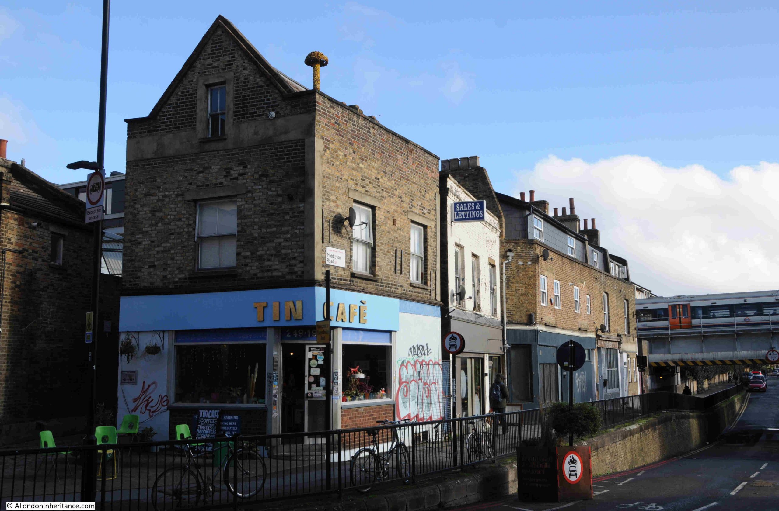
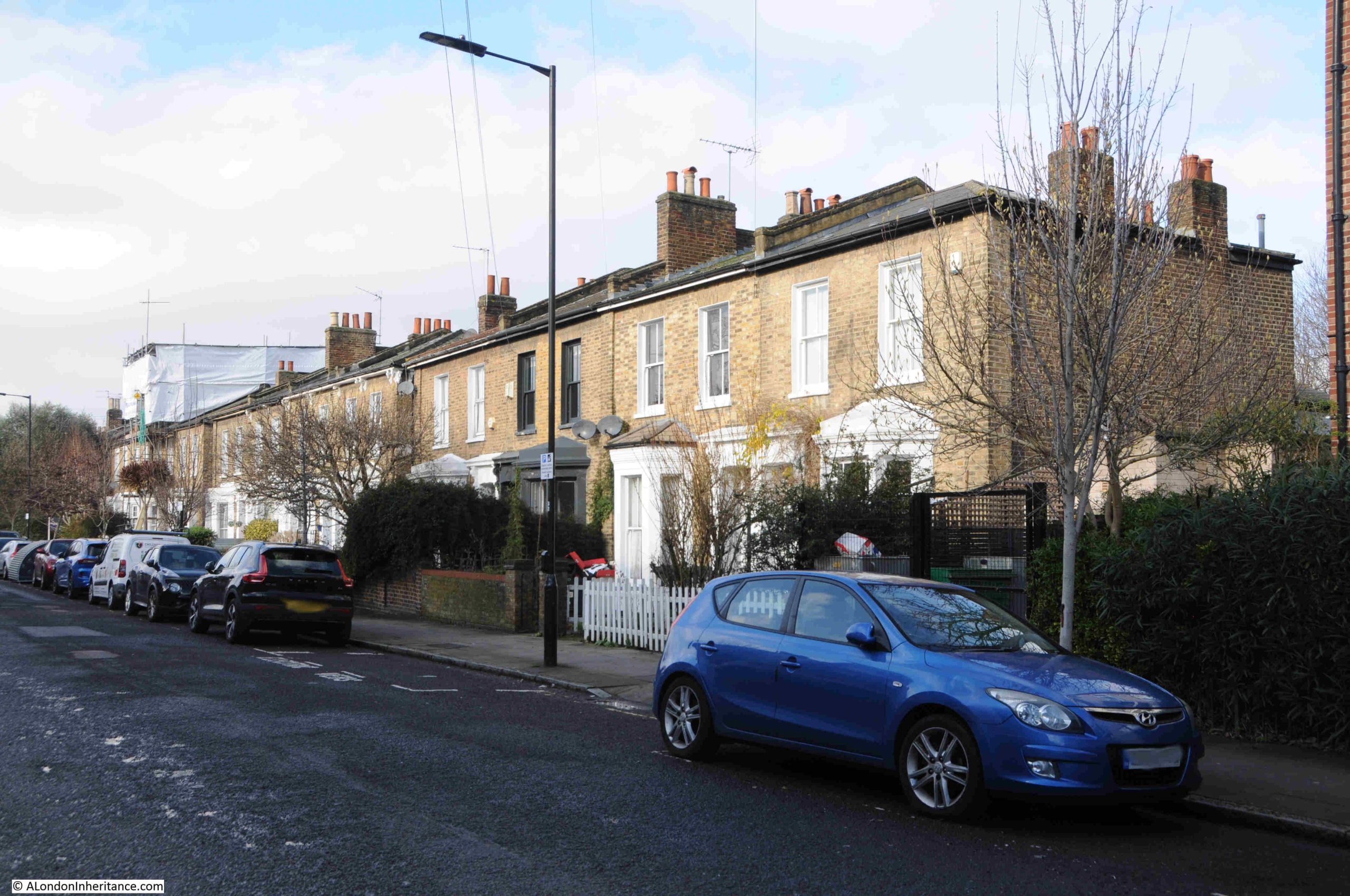
This is His & Hers Hairdressers at the Kingsland Road end of Middleton Road:

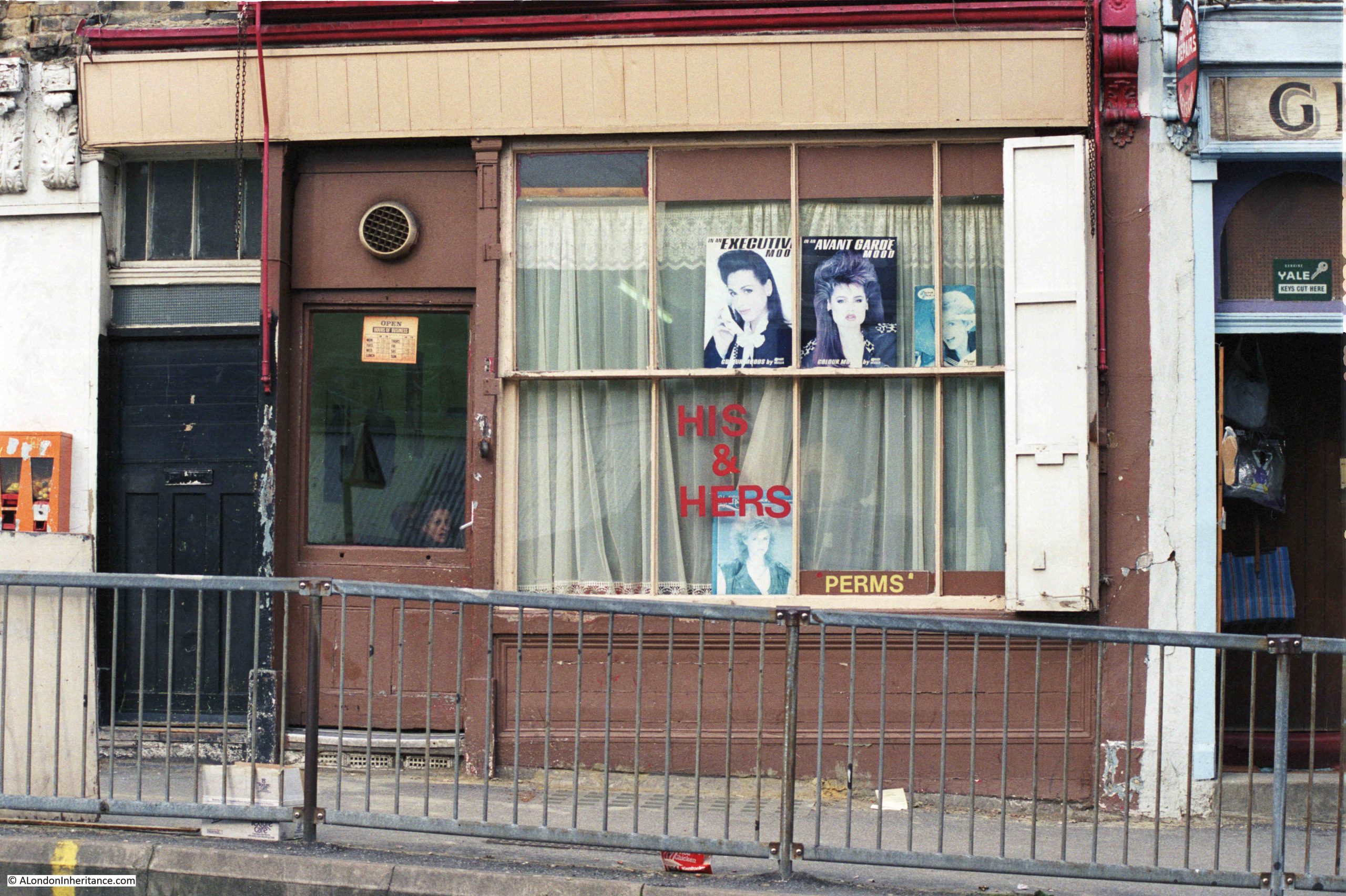
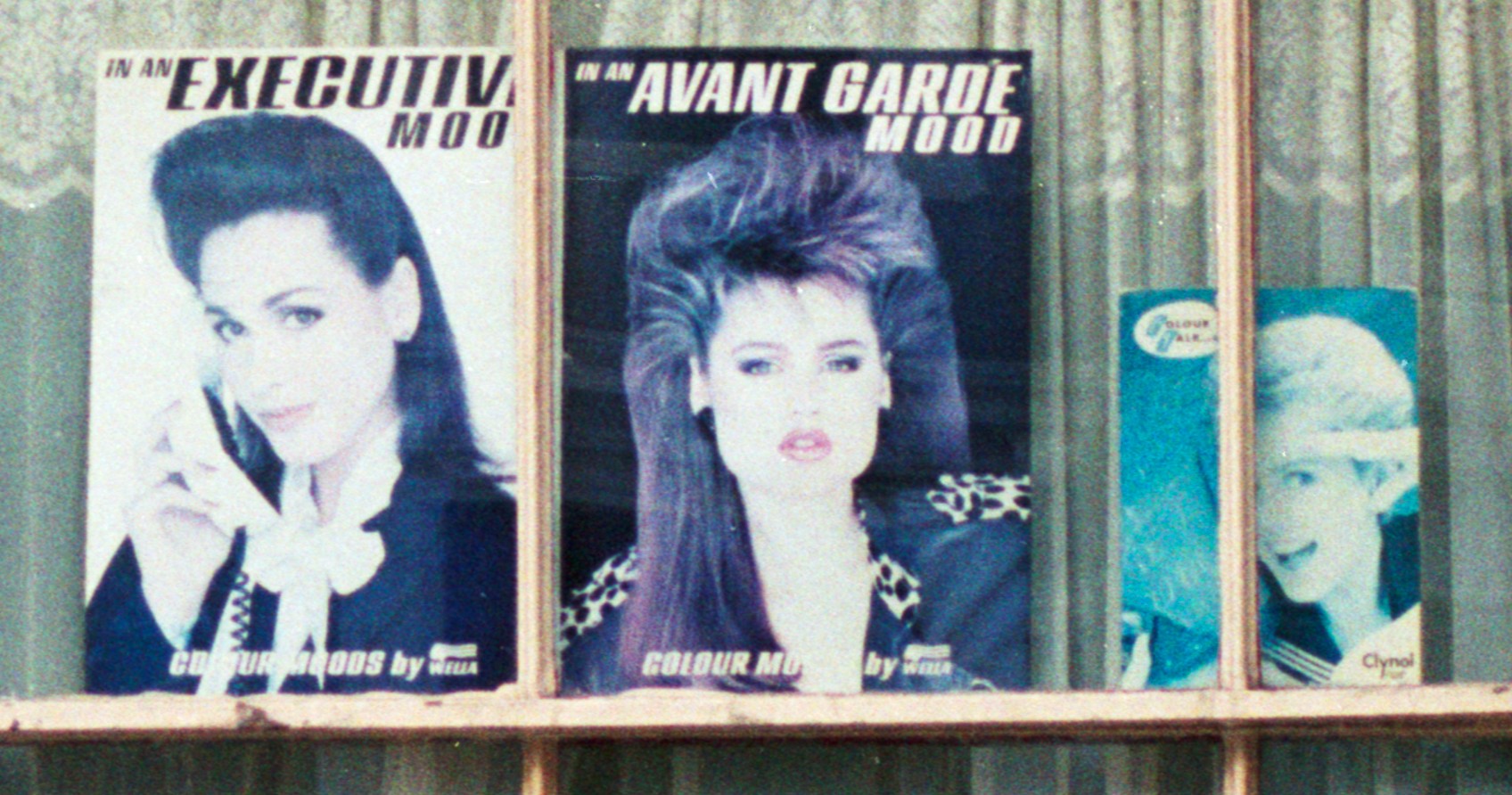
The photo is typical of the many small businesses that occupied run down Victorian shops in the 1980s, and for a hairdressers of that decade, the shop has the obligatory display of hair style photos.

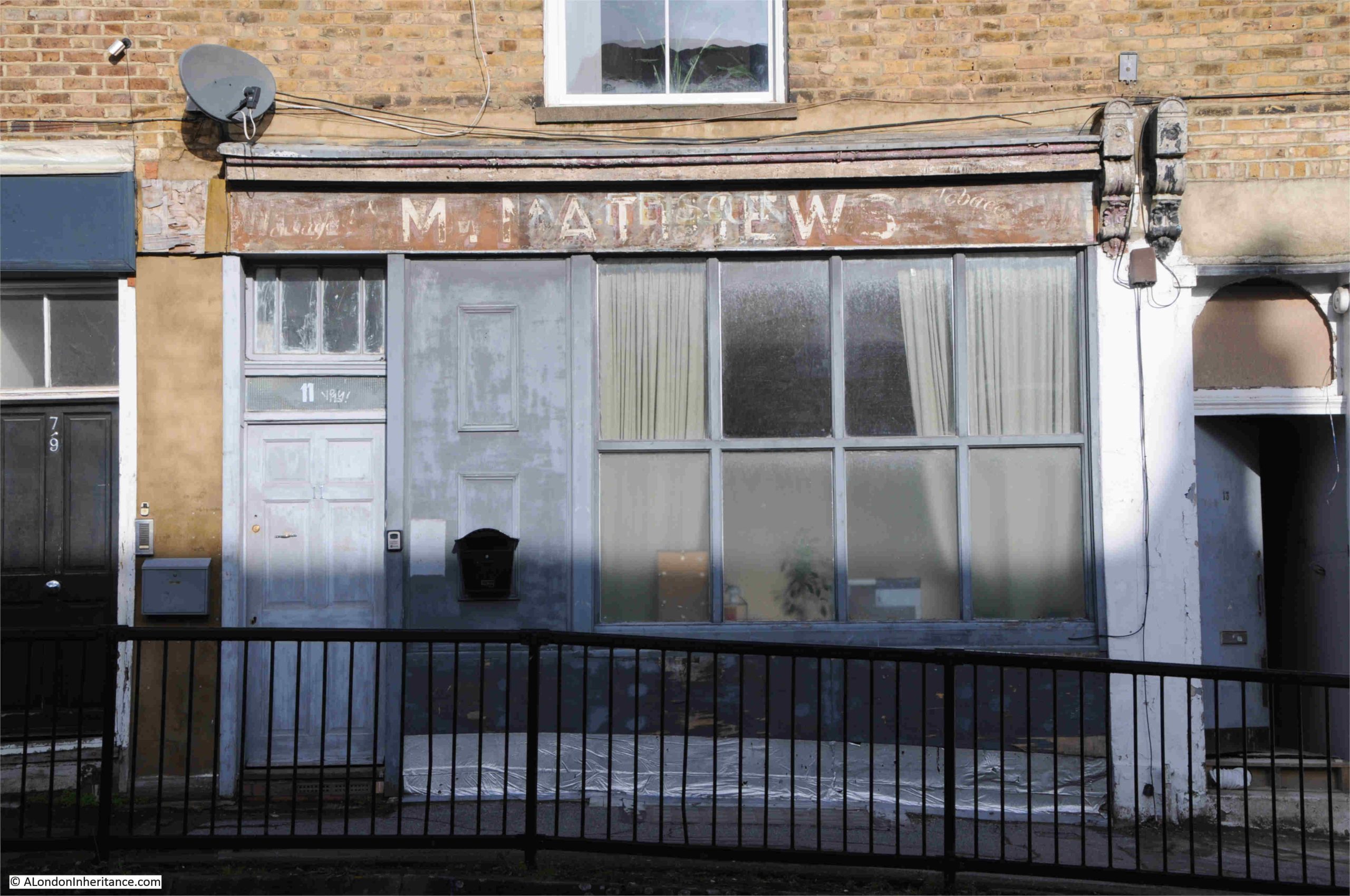
This is the same shop, forty years later in 2026:

With photos of hairdressers, you can normally tell the decade of when the photo was taken by the photos in the windows, and His & Hers had photos of 1980s big hair:

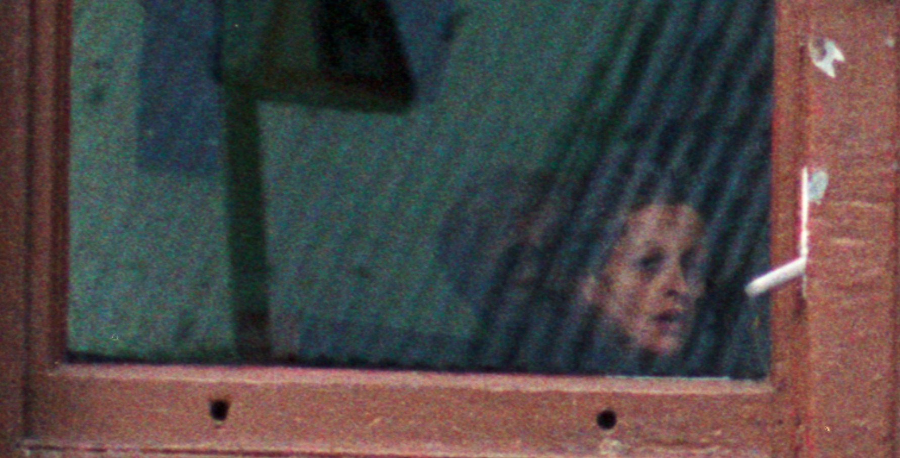
Small details in the photo, such as the person inside, probably wondering why my father is taking a photo:

On the wall to the left of the shop, something that was once a common sight:

And there are details in the 2026 photo, where an earlier shop sign has been exposed:

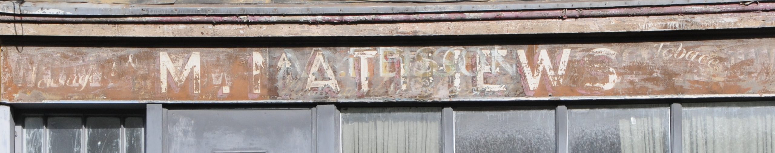
If you go back to the 1986 photo, there is wooden boarding across the location of the above sign, so I suspect this was covered up in 1986 and dates from an earlier business.

M. Matthews is the central name. There does appear to be a shadow name, but this also looks like M. Matthews, so perhaps an earlier version of the same name. To the right is the word Tobacco, and a bit hard to make out, but to the left the letters do seem to form Newsagent.

I cannot find a reference to an M. Matthews, but the ground floor of the building has always been a shop, and searching through Post Office directories, I found that in 1899 the shop was a Confectioner, run by Miss Elizabeth Winstone, and in 1910 it was still a confectioner, but now run by Mrs Matilda Watkins.

A jump from being a Confectioner, to a Newsagent and Tobacconist, but who also probably continued to sell confectionary does seem like a natural evolution of the shop.

I have no idea when the shop changed to a hairdressers, or when His & Hers closed. In the 1986, the ground floor occupied by the hairdresser does seem to have undergone some structural alteration, as above the windows and doors, there is the full width of the panel over the name sign, and this can also be seen in my 2026 photo, where the name sign extends over the windows and two doors.

The ornate carvings typical of the sign endings on Victorian shops can also be seen in the 1986 photo, although the one of the left had been removed by 2026.

This is probably the result of the building being converted from a shop occupying the full width of the ground floor, to a building where the first and second floors became separate residential accommodation, hence the door on the left, and the door to the shop being the one on the right.

Today, the old shop on the ground floor also appears to be residential.

The shop was built in the mid 19th century as the fields and nurseries of Hackney were covered in new homes.

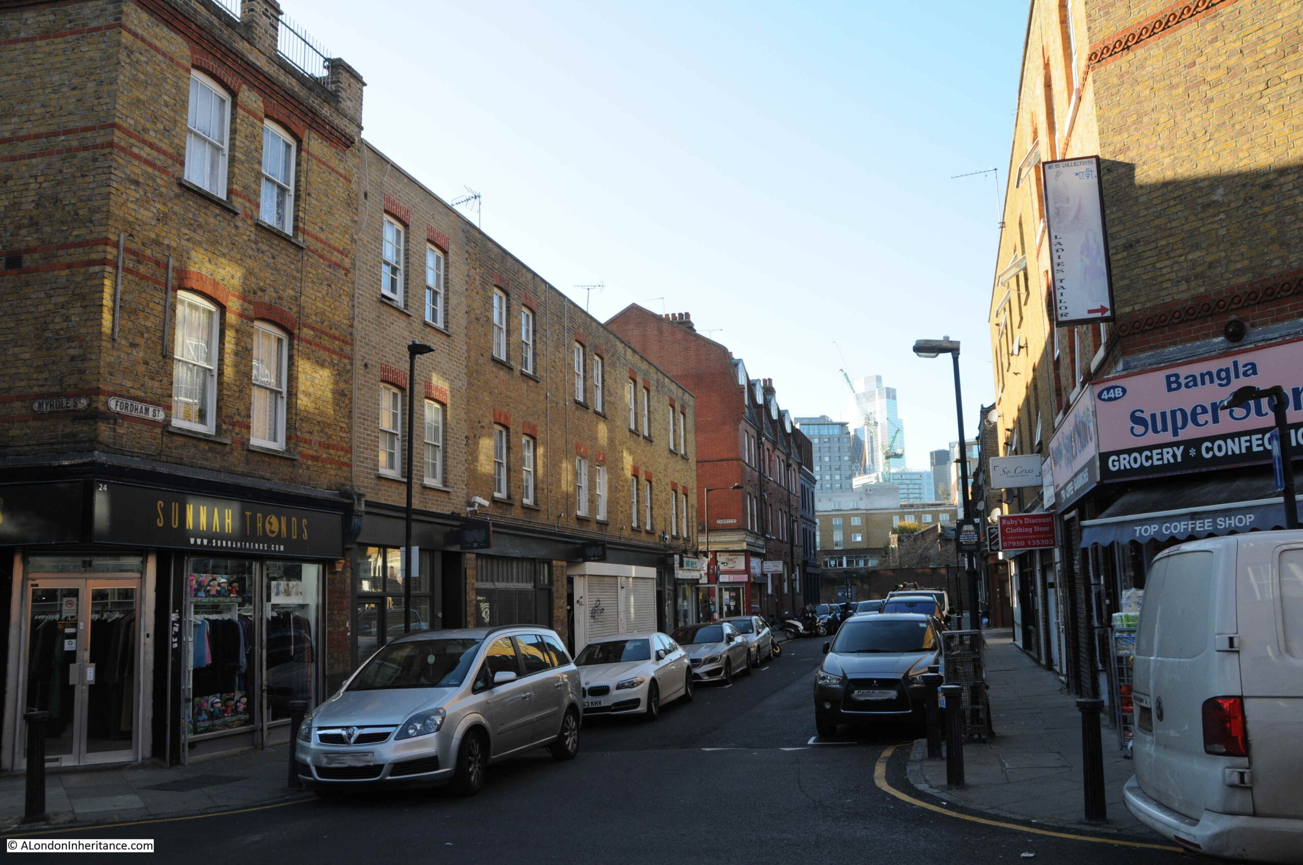
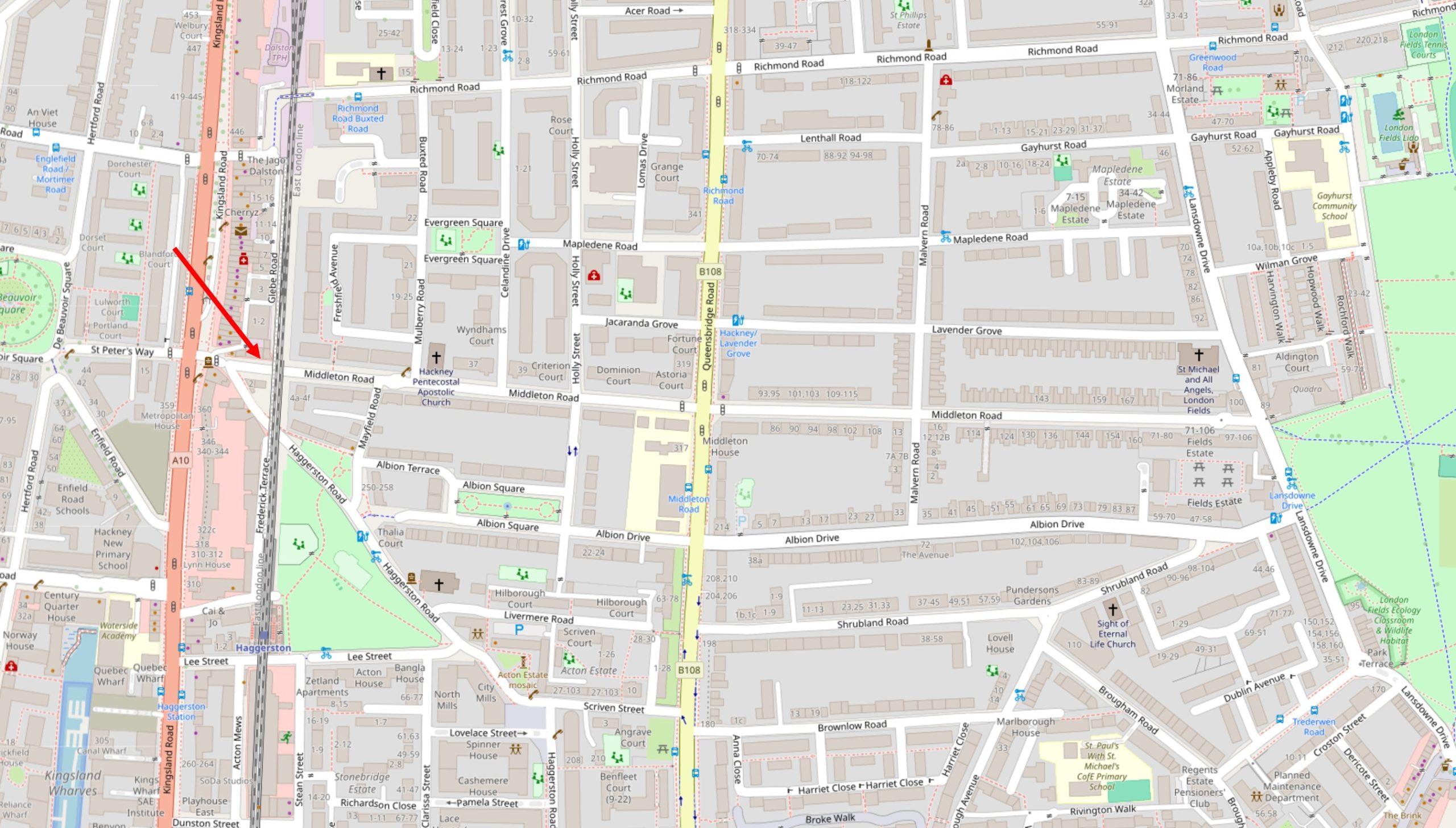
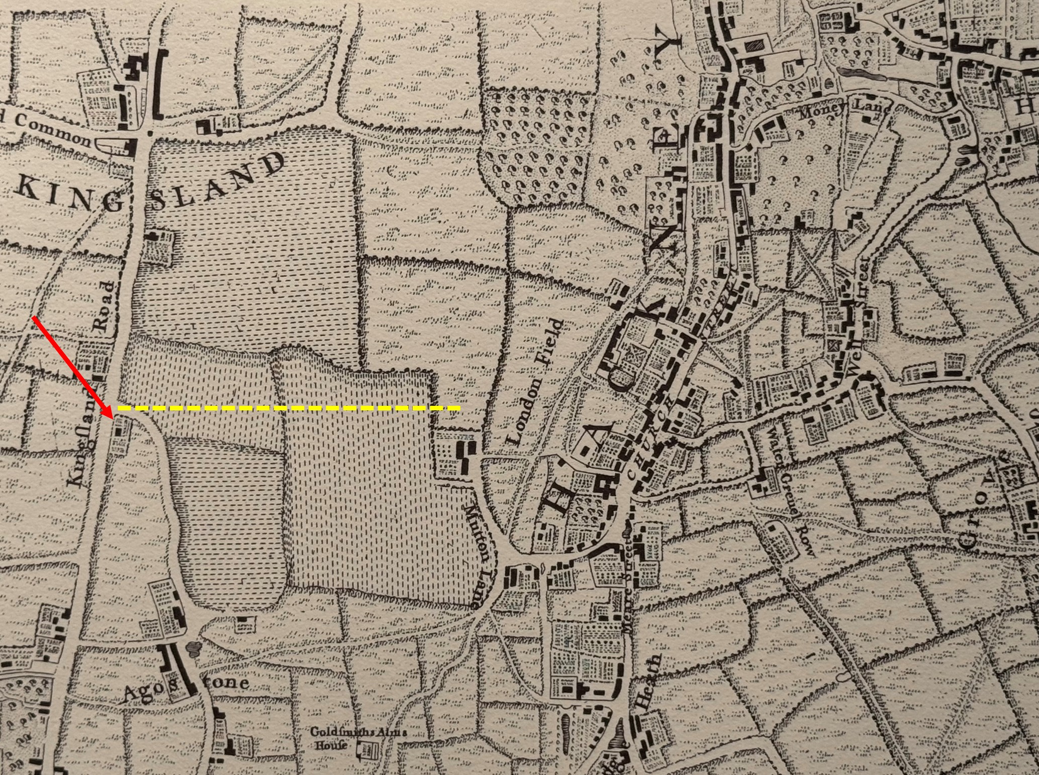
In the following map, I have marked the location of the shop with the red arrow on the left. The darker road running vertically just to the left is Kingsland Road, and to the right of the map is the edge of London Fields. Middleton Road is the street with the Hairdressers, and which runs from Kingsland Road to London Fields.

Nearly all of the straight streets in the map are Victorian housing, serving the growing numbers of middle class workers of London with aspirational new homes.

The shop was part of a street design where small businesses were distributed across new residential developments, so that people who moved out to these new homes would have access to the necessities of life within local walking distance, and this included pubs.

On the corner of Middleton Road and Kingsland Road is the Fox – a rare example of a London pub that closed in around 2018, but has recently reopened (I believe with the upper floors converted to residential):

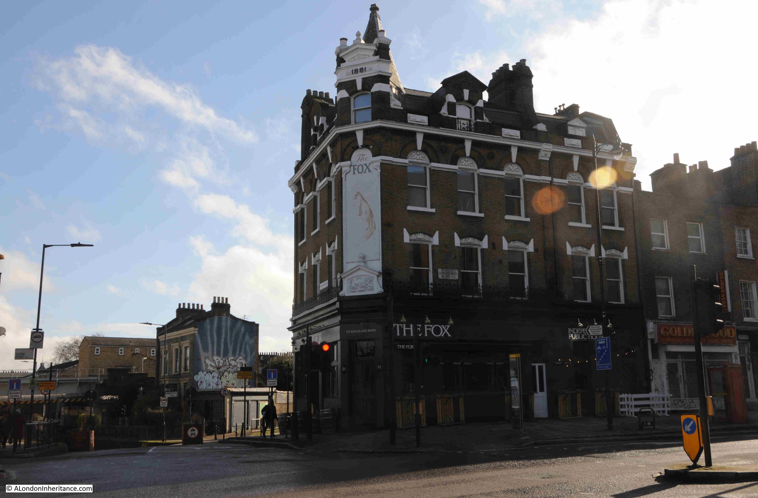
At the very top of the corner of the building is the date 1881, and this is from when the current building dates, although there has been a pub on the site for a number of centuries.

The earliest written refence I can find to the Fox is from 1809, when on the 21st of July, there was an advert in the Morning Advertiser for the auction of five, neat, brick built dwelling houses between Kingsland Green and Newington Green. Details about the properties to be auctioned could be had from Mr. Taylor at the Fox, Kingsland Road.

When the 1809 advert appeared, much of the area surrounding the Fox was still farm land and nurseries, but the pub was here because Kingsland Road was an important road to the north from the City and would have been busy, with many of those using the road in need of refreshment.

Search the Internet for stories about the Fox, and a story about the pub being used to stash part of a £6 Million Security Express robbery in 1983, by Clifford Saxe, one of the robbers and landlord of the Fox is one of the common stories from recent years.

I cannot find a firm reference from the time that it was the Fox, an account of the robbery from the Sunday Mirror on the 1st of July 1984 on wanted criminals who were living in Spain referenced that “It claimed Saxe, 57, formerly landlord of an east London pub was the brains of the gang”. Presumably that east London pub was the Fox, but again I cannot find a direct reference from the time.

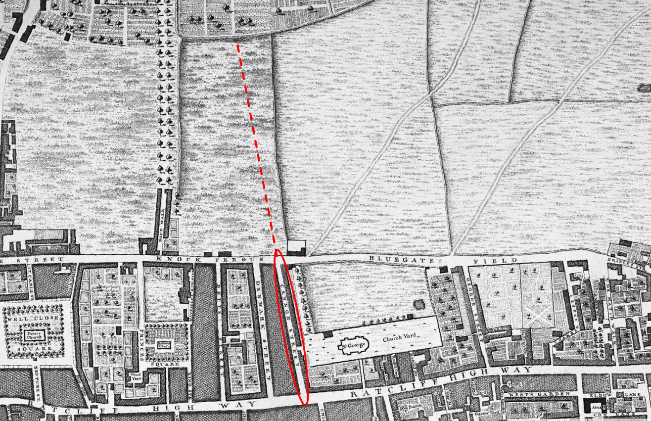
In the following extract from Rocque’s 1746 map, I have marked the location of the Fox with a red arrow. The yellow dotted line shows the route of the future Middleton Road, running from Kingsland Road to the edge of London Fields, over what was nursery land, and by 1823 would be known as Grange’s Nursery:

The 1881 rebuild of the pub must have been to transform the premises that had once been surrounded by fields, to an establishment suitable for the large population who occupied the terrace streets by then covering the fields.

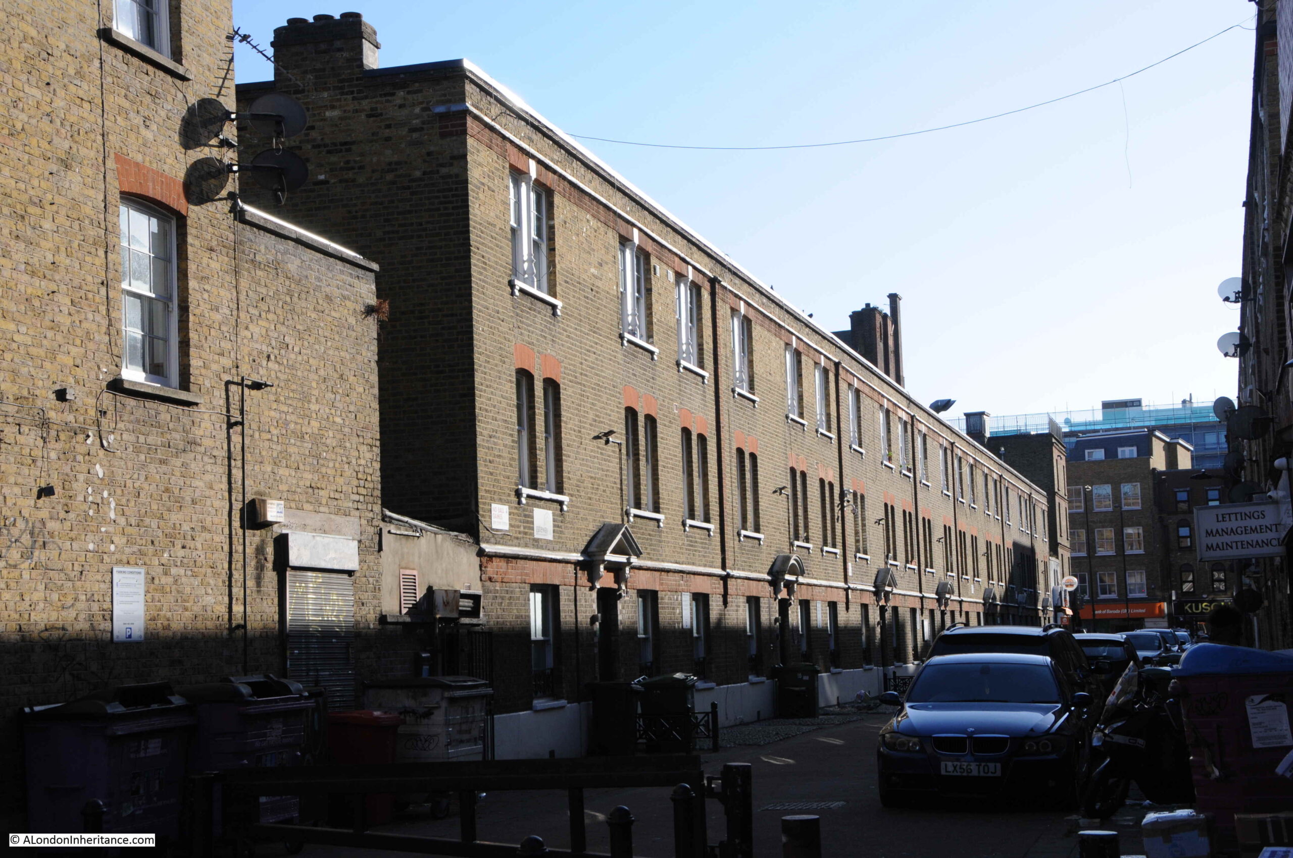
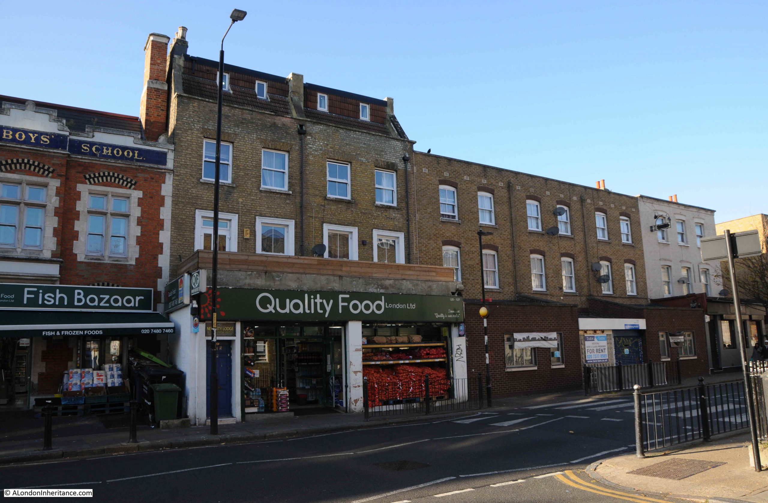
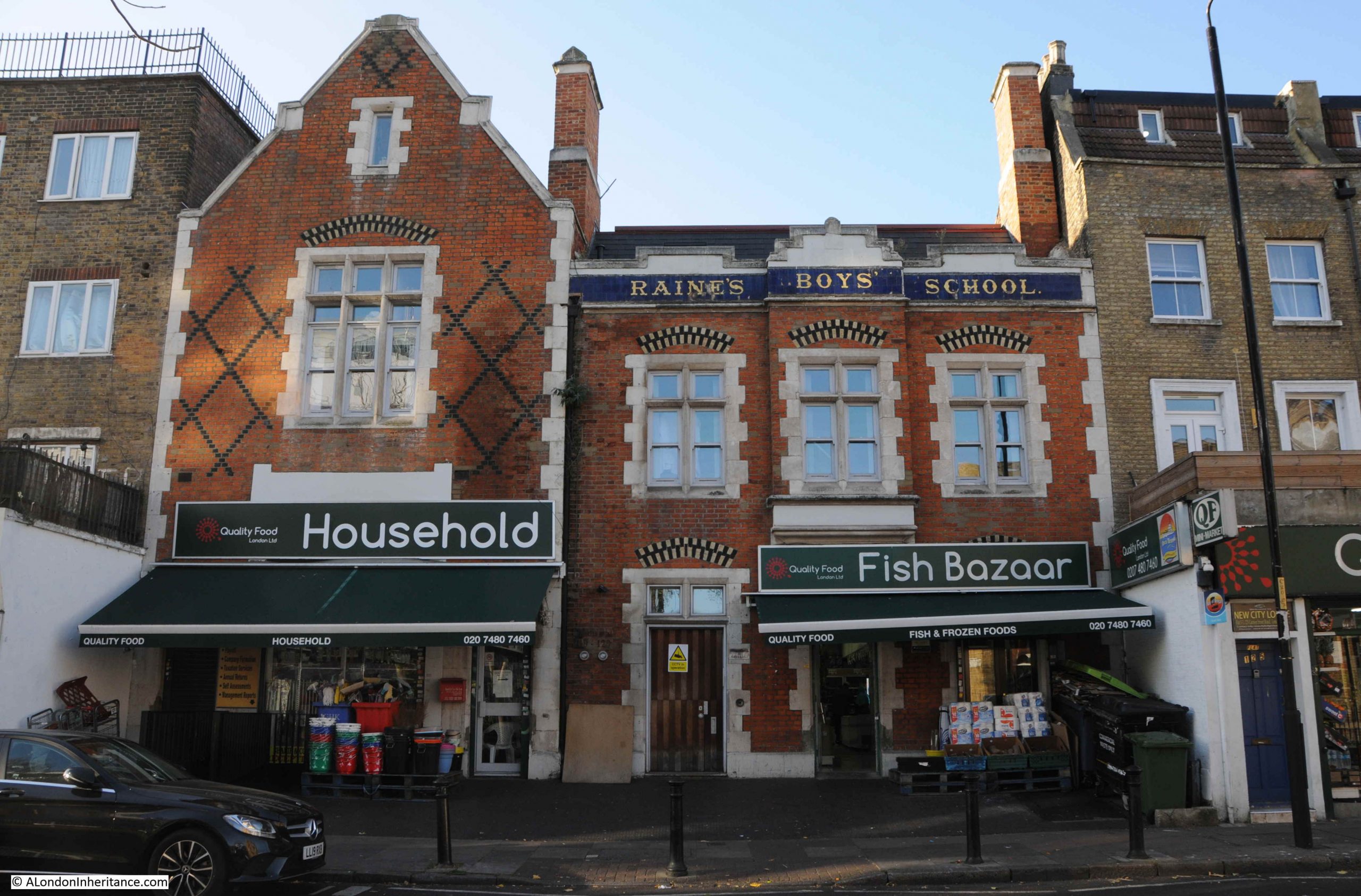
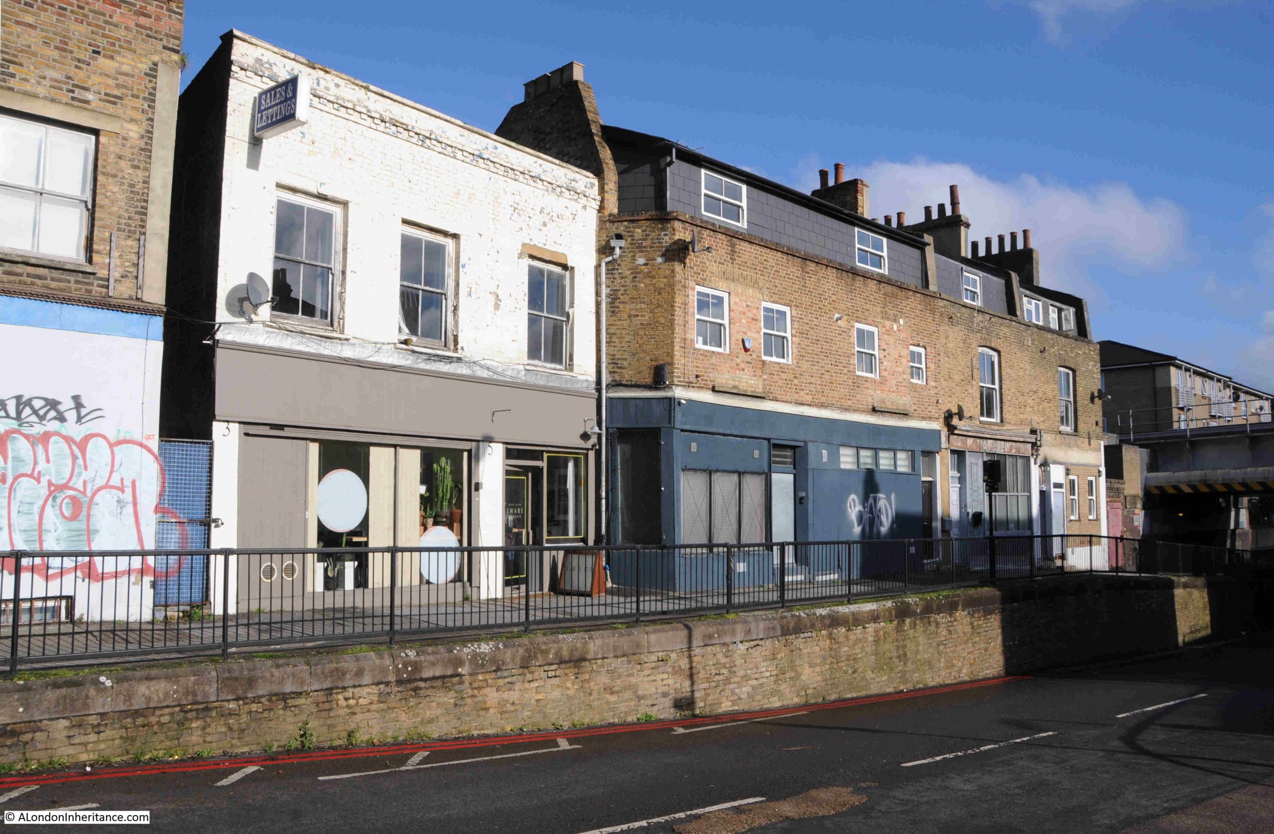
The population growth of Hackney mirrors this housing development. In 1801 the population was 12,730, and a century later in 1901, Hackney’s population had grown to 219,110, and this new population needed local shops, and the confectioners / newsagents and tobacconists / hairdresser shop was part of a terrace of shops at the end of Middleton Road, with the following photo being today’s view of this terrace:

In 1899, this terrace consisted of (number 11 in bold is the shop that is the subject of today’s post):

  • Number 1: John Biddle – Fishmonger
  • Number 3: Mrs Stark – Baby Linen
  • Number 5: John Edward Stark – Tobacconist
  • Number 7&9; Benjamin Wilkinson – Chemist
  • Number 11; Miss Elizabeth Winstone – Confectioner
  • Number 13: Robinson Locklison – Laundry

By 1910, the terrace consisted of:

  • Number 1: Walter Hart – Fried Fish Shop
  • Number 3: James Arthur Mullett – Grocer
  • Number 5: William Leigh – Hairdresser
  • Number 7&9: Benjamin Wilkinson – Chemist
  • Number 11: Mrs Matilda Watkins – Confectioner
  • Number 13: John Hart – Bootmaker

The above two lists shows that in the eleven years between the two, there was a high turnover in owners and types of shop. Number 1 had changed from a Fishmonger to a Fried Fish Shop, illustrating the rapid expansion of this type of take away food across London, from what is believed to be the first such shop in east London in 1860.

Number 1 is still supplying food, as today it is the Tin Café.

The only business that is the same is the Chemist of Benjamin Wilkinson. At number 13 in 1910 was John Hart, a Bootmaker. In 1986 it was a shoe repair shop, just visible to the right of the photo at the start of the post, so in the same type of business.

Another view of the terrace, number 3 to 13:

Just visible to the right of the above photo, and in an earlier photo with a train, is a bridge, which adds an unusual feature to this end of Middleton Road.

Walking along Middleton Road, under the bridge and looking back, this is the view:

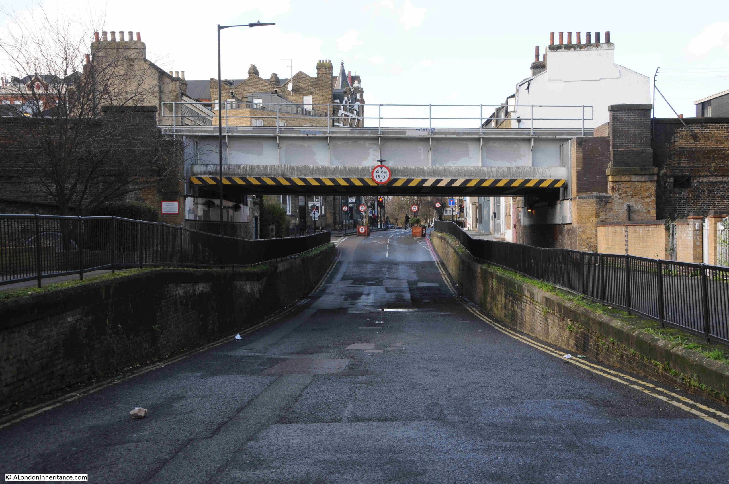
The bridge carries what is now the Windrush Line over Middleton Road, and the reason for the large dip in the road is because the railway is carried on a viaduct, which runs parallel to Kingsland Road, and needs to run as a level structure, so where the railway carried by the viaduct runs across a road, the runs needs to be lowered to pass under the viaduct.

This railway was built as part of the North London extension of the London and North Western Railway, and the following extract from Railway News on the 3rd of December 1864, when the viaduct was nearing completion, explains the benefits and route of this railway:

“The London and North Western reaches the City by means of the North London extension, but the undertaking may be considered as that of the North Western.

The City extension runs from Kingsland to Liverpool Street, Bishopsgate, and is now rapidly approaching completion. The advantages of this line are very considerable.

The station is within a short distance of the Royal Exchange, the Bank of England and many offices in which the chief monetary transactions of the City are conducted. Five or seven minutes walk will bring you to Threadneedle-street, Moorgate-street, or Gracechurch-street, and all the other busy thoroughfares, lanes and courts hard by – no small consideration to the thousands of railway travellers who come from the North daily within that important radius who are anxious to economise time.

Further, this line shortens the distance between all the stations on the North London line, from Camden to Kingsland and the City by no less than five miles. At present time the North London, on leaving Kingsland, goes by Hackney, Bow, and Stepney, describing nearly three-quarters of a circle before it reaches Fenchurch Street. This detour, with its super abundant traffic and crowded junctions, with therefore be avoided by all coming west of Kingsland to the City.

The extension is about 2.5 miles in length, and proceeds almost in a direct line from its junction with the North London proper to Bishopsgate, With the exception of a cutting near the starting point it passes all the way on a brick arch viaduct which has all but been finished. Running parallel with the Kingsland-road.”

The line would go on to terminate at Broad Street Station, next to Liverpool Street.

This railway helped with the construction of the houses across the fields of Hackney, as for workers to move to Hackney, they needed an easy form of transport to their place of work, and the new railway extension was ideal. For the residents of Middleton Road, Haggerston Station was a short walk south along Kingsland Road. The station opened on the 2nd of September 1867.

Bells Weekly Messenger on the 9th of September 1867 described the new station: “NEW STATION, NORTH LONDON RAILWAY – A large and commodious new station was opened on Monday on the North London Railway, in Lee-street, Kingsland Road. The new Haggerston Station commands the neighbourhood, and also the Downham-road and De Beauvoir Town, which places are situated too far from the Dalston Junction to profit by the latter.”

The line closed in 1986 (Haggerston Station had closed in 1940 due to a number of factors including wartime economy measures and bomb damage to the station).

The station and railway along the viaduct reopened in 2010 as part of London Overground, and in 2024 the railway was renamed as the Windrush Line.

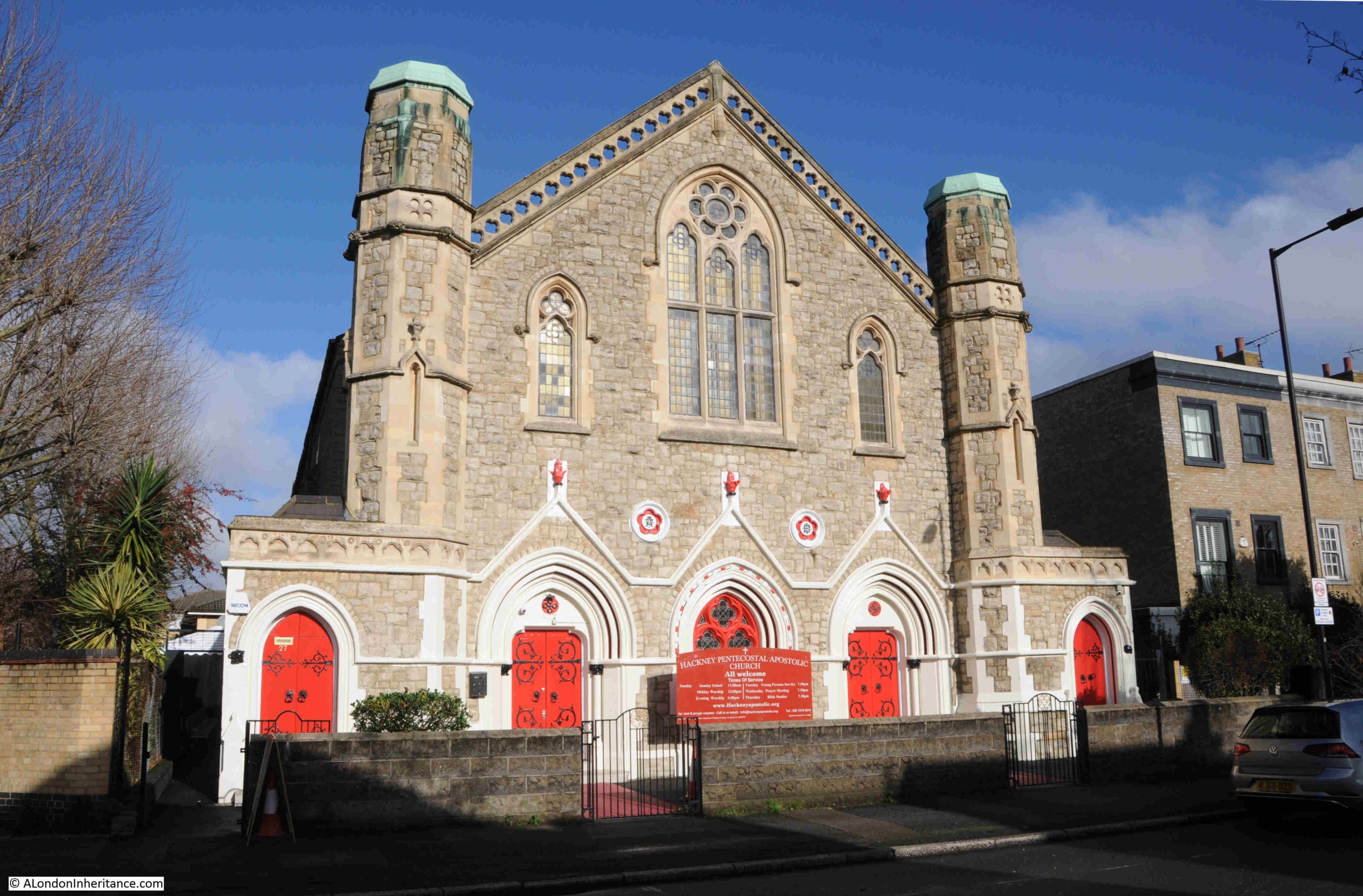
So this small part of London had shops, a pub and a station connected to the City. The other important attribute of a Victorian city was a church, and In Middleton Road is the 1847 Middleton Road Congregational Church, now the Hackney Pentecostal Apostolic Church:

Middleton Road is mainly comprised of terrace houses, but there are some interesting exceptions, such as the building in the middle of the following photo:

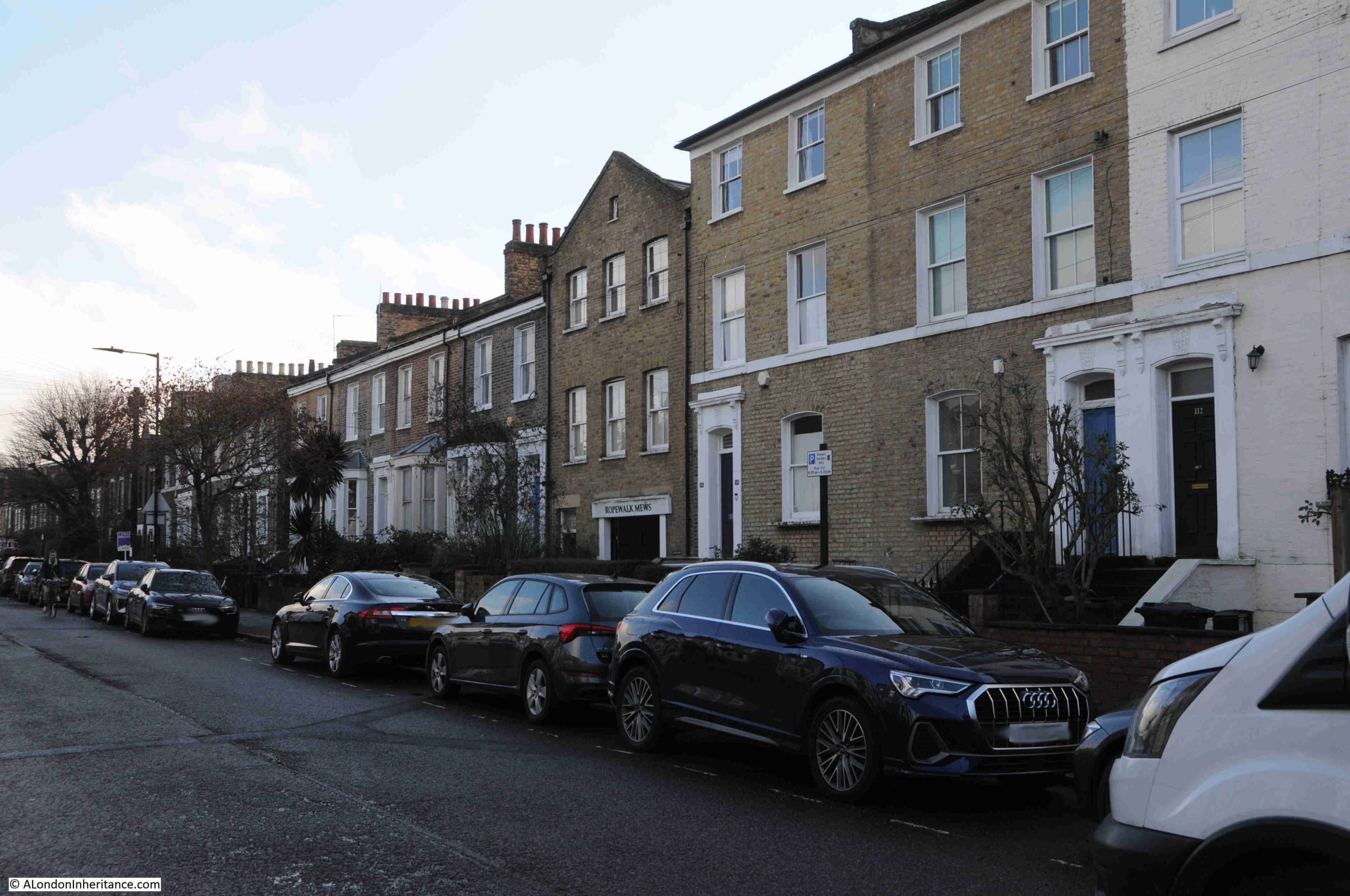
Which has an entry to the rear of the building named Ropewalk Mews:

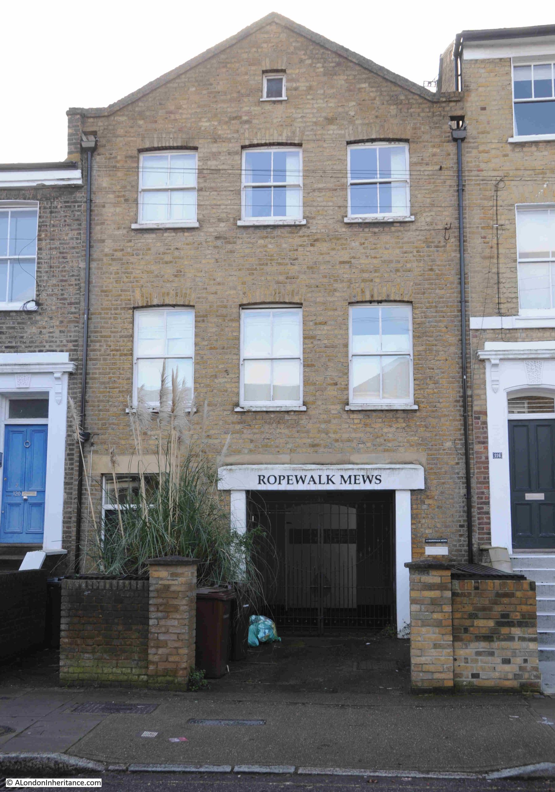
I cannot find the reason for this name, and why the building is very different to the terrace houses that occupy the street.

A ropewalk was / is a long length of land or covered space, where the individual strands of a rope could be laid out and then twisted to form a continuous length of rope.

London had plenty of ropewalks, but these were usually close to the Thames, as the main customer for the ropes produced would have been the thousands of ships that were once to be found on the river.

Rocque’s map of 1747 does not show a ropewalk, although the map does identify ropewalks in other parts of London. In 18th and early 19th century maps of the area, the land is shown as agricultural and a nursery, no mention of a ropewalk.

It may have been that there was a small ropewalk here to produce rope to be used in the bundling of produce from the nursery, but I cannot find any confirmation of this.

One of the architectural developments that was seen in Victorian houses of the mid 19th century was the bay window, which was a way of breaking up a terrace, and a change from the Georgian emphasis on an unbroken terrace of flat, uniform walls facing onto the street. We can see this development in the terrace houses of Middleton Street:

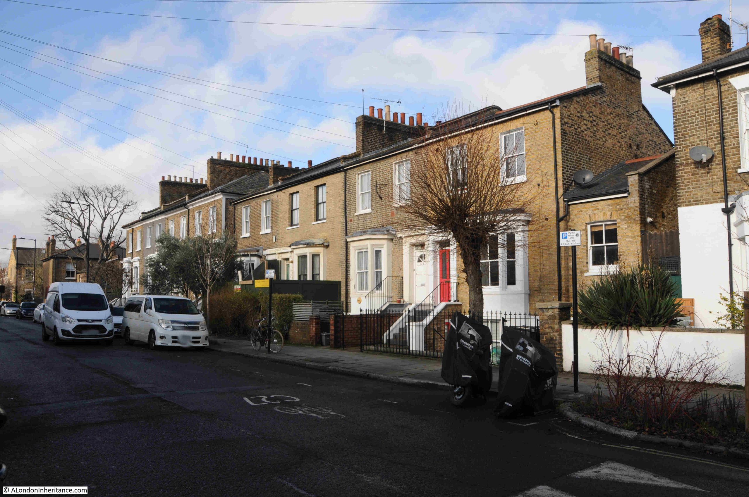
Another change was the semi-basement, where the ground floor is slightly raised, and reached from the streets by steps, allowing the upper part of the basement to just poke above ground level, with a space between basement window and the retaining wall to the street. This development allowed natural light into the basement, and again we can see this in the above terrace.

The 1881 census provides a view of the employment of those who moved into Middleton Road. There were a very wide range of jobs, including: Bank Clerks, Decorators, Commercial Travellers, Commercial Clerks, Boot Makers, Locksmiths, Plumbers, Stock Brokers Clerks, Stationers Assistant, Printers, Teachers, Newspaper Advertising Agents, Drapers, Draughtsmen, Watchmakers, etc. All the vast range of trades and employment types to be found in the rapidly expanding Victorian London of the late 19th century.

Where a job was listed such as a Bootmaker, these were frequently not an individual worker, rather an employer, for example at number 33 Middleton Road was George Clarke, a Bootmaker who was listed as employing 25 men and two boys.

Some of the residents had private means, for example at Oxford Cottage in Middleton Road was Fanny Smyth, listed as a widow, with her occupation as “income from interest of money”. What is fascinating about the 19th century census is how frequently people would marry later in life, and in Fanny Smyth’s household were three children, two daughters aged 31 and 21 and a son of 28, all listed as single.

Many of the houses in Middleton Road also had a Domestic Servant, again confirming that these new streets were occupied by the new middle class.

Whilst in 1881, the majority of people who lived in Middleton Road were listed a being born in Middlesex, (the historic county that from 1965 is now mainly part of Greater London), there were a very significant number of people from the rest of the country, and a small percentage from Ireland. Throughout much of the 19th century, London was expanding both in terms of employment and residents, by attracting people from the rest of the country.

More of the homes in Middleton Street in which the Bank Clerks, Decorators, Commercial Travellers etc. of 1881 would live:

Middleton Road is a perfect example of the mid 19th expansion of London, as the fields of Hackney were taken over by the houses of the growing middle class.

The shops and pub at the Kingsland Road end of the street are a perfect example of how local shops were planned as part of this expansion, and for decades served the needs of the local community.

One can imagine the early morning being busy with the working residents heading to the train station to travel into the City for their work, and in the evening, a busy pub, with the option of a stop off for fish and chips after the pub, then heading back to your terrace home in Middleton Road.

When writing these posts, I often have music on in the background, and for this post it was YouTube, as it has a random playlist based on what I have listened to before, and a track I have not heard for many years came up, the 1982 Lucifer’s Friend by the Rotherham / Sheffield band Vision.

The His & Hers Hairdressers was photographed in 1986, and the track by Vision is a perfect example of brilliant 1980s music, including the type of hair styles that you may have been able to get in His & Hers:

David Bowie Centre and V&A East Storehouse

Last week, we went to have a look at the small David Bowie exhibition, which forms part of the David Bowie archive held by the V&A. It is located at the new V&A East Storehouse at the Queen Elizabeth Olympic Park:

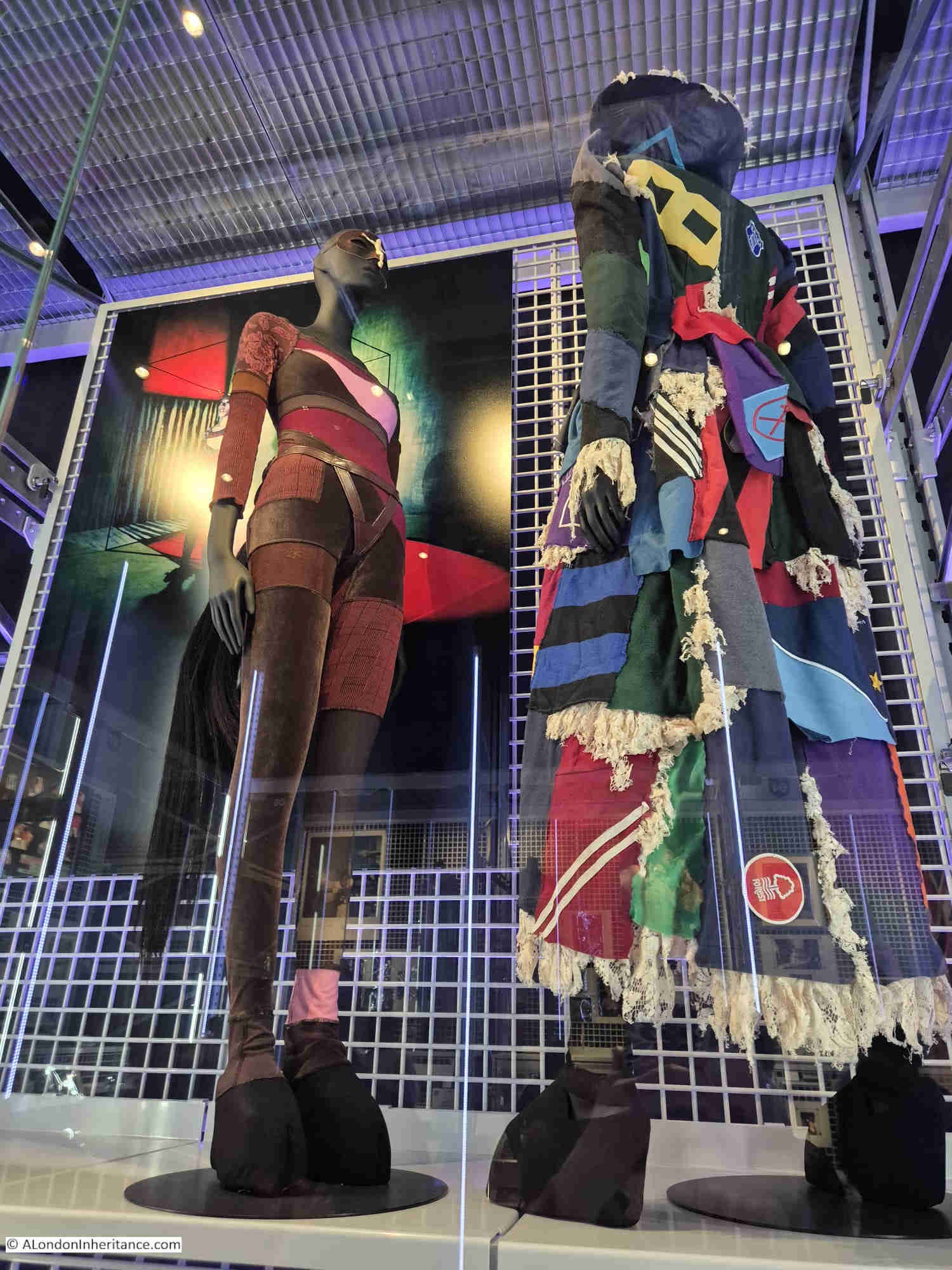
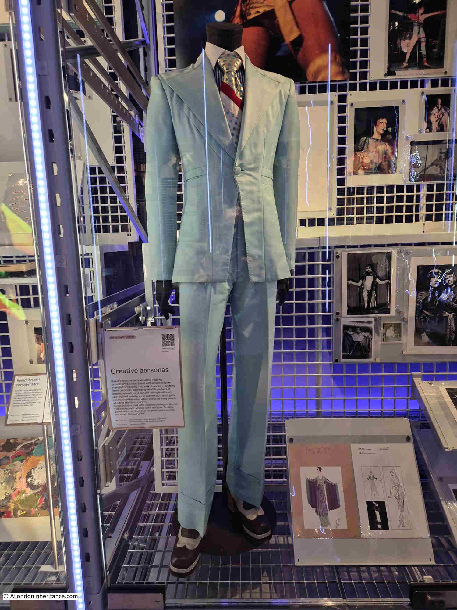
It is a small, but interesting exhibition of some of the costumes worn by Bowie, photos, song lyrics, ideas for films, plays etc.

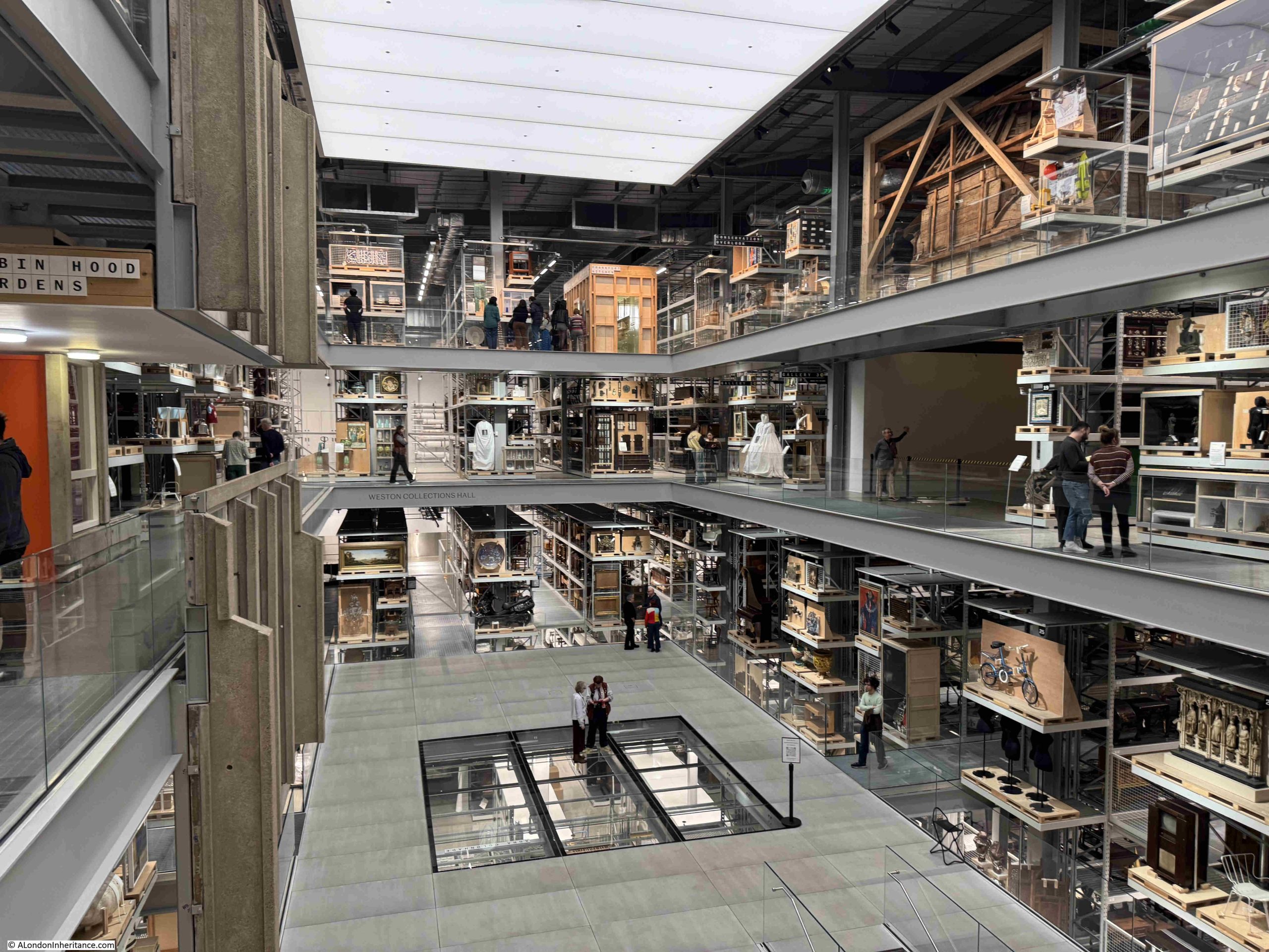
The Bowie exhibition and archive is a small part of the Storehouse, which is home to a vast collection of items not on display in the main museums.

You are free to wander around the walkways on several levels between racks of items collected over very many years:

There were a number of London related items on display, for example a London County Council plaque recording that Emma Cons and Lilian Baylis lived here:

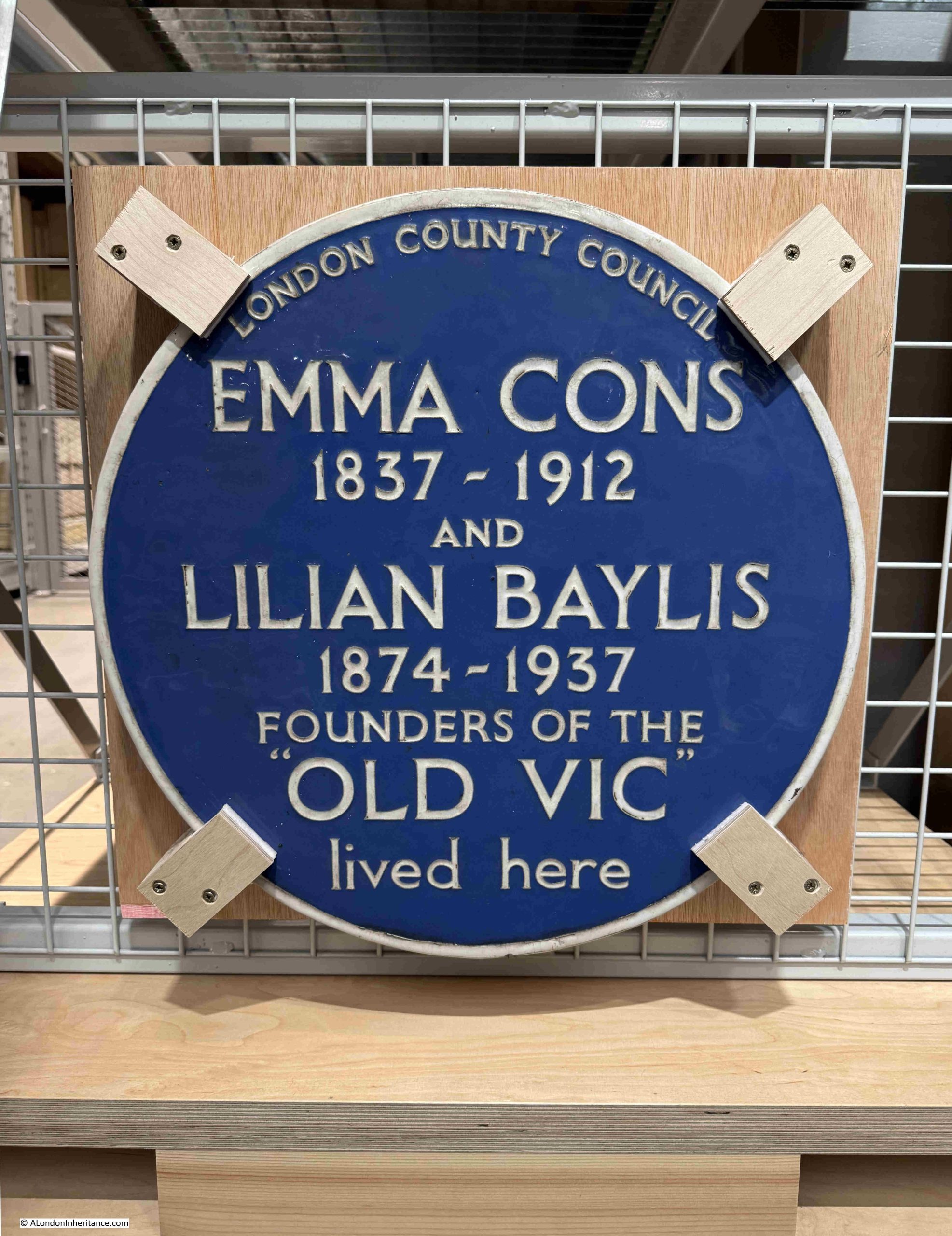
The plaque dates from 1952 and was installed on the house at 6 Morton Place, Stockwell. The house was demolished in 1971 and the plaque was saved with the intention that it would go on display in the V&A Covent Garden Theatre Museum. The Theatre Museum closed in 2007, and the plaque is now on display the V&A East Storehouse.

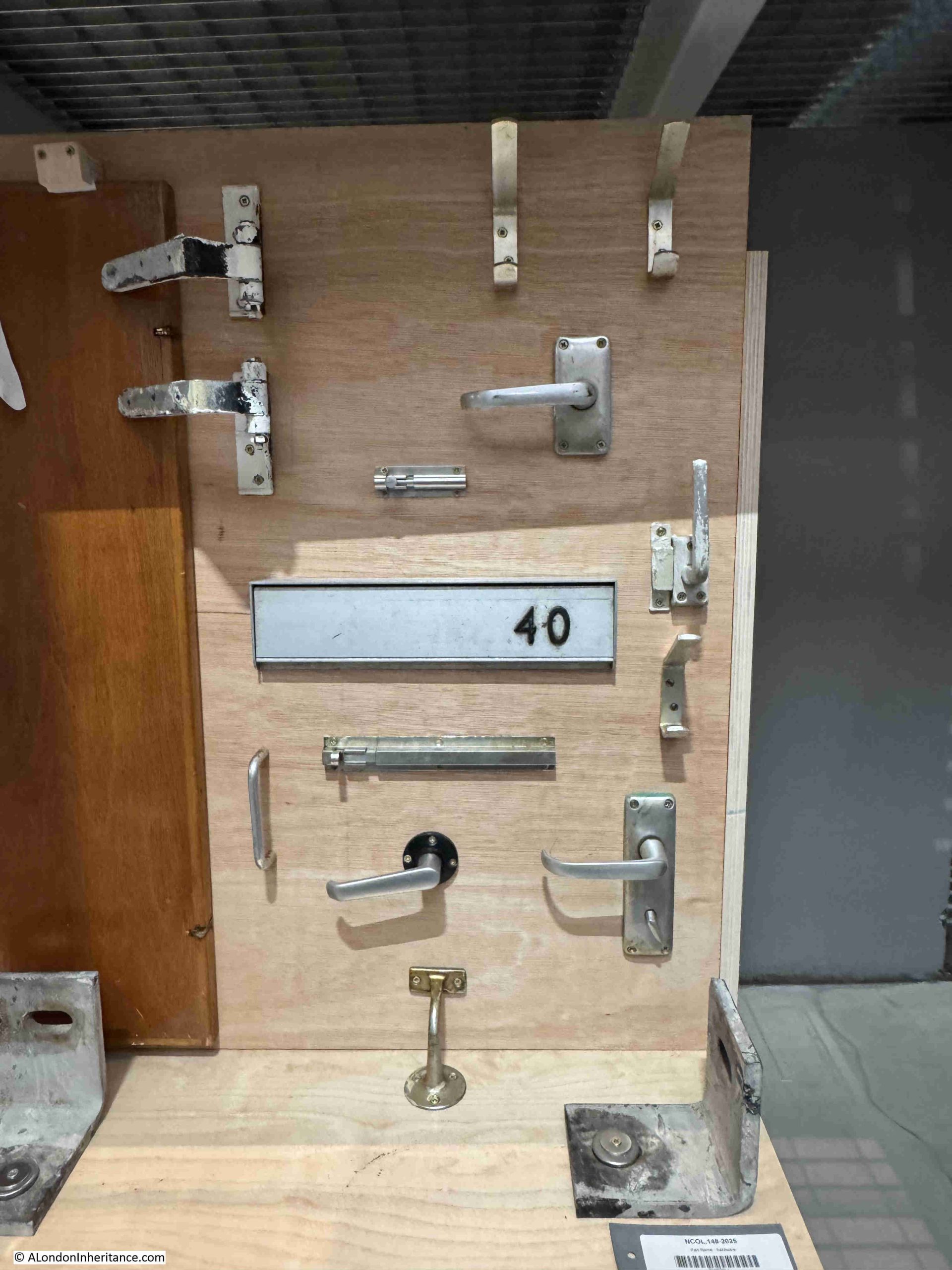
The V&A also has a number of items relating to Robin Hood Gardens, the social housing estate in Poplar, east London, including a section of the west block, to preserve the architectural vision.

One of the items on display is a collage from the Robin Hood Gardens Project:

And some of the fittings from Robin Hood Gardens:

The V&A East Storehouse is a fascinating way to display part of the collection that would not normally be on display in the V&A museums, and is well worth a visit.

East London 1980s Shops – Fordham Street

Thanks for the feedback to last week’s post. The pub at the top of the stairs leading down to the Thames, next to Westminster Bridge Road was identified as the Coronet, and there is a good drawing of the pub and the stairs on the Closed Pubs site. It was good that I did not get any comments or e-mails that the bronze box beneath the foundation stone of County Hall has been removed, so hopefully it is still there for archaeologists in the distant future to dig up.

For this week’s post, I am in East London, looking for the location of a shop in Fordham Street, photographed here in 1986:

Fordham Street

The same location today. The old general stores type of shop has been replaced by the Algiers Barber and Café:

Fordham Street

The 1986 photo is typical of the type of shop. Goods piled high in the window, bread, bottles of Fairy Liquid and Woodbines advertising running along the top of the window.

No idea whether that is a customer entering the shop, or the owner locking or unlocking.

Fordham Street is in the heart of east London, roughly half way between Whitechapel and Commercial Roads. The street leads from New Road which is a main street leading between Whitechapel Road and Commercial Road, and is part of a residential area that has long housed the changing populations of east London.

In the following map I have circled the location of the shop photographed at the top of the post:

Fordham Street

A view of the corner location of the shop, at the end of a short terrace of houses:

Fordham Street

Although a relatively short street, as was typical in east London of old, the street had two pubs, both now long closed. On the corner opposite the shop is the building that housed one of the pubs:

Bricklayers Arms pub

The pub was the Bricklayers Arms. I can find very little information about the pub, and there are only a couple of newspaper reports that mention the Bricklayers Arms. The first is when a 19 year old labourer, Frederick Perrie was sentenced to six months hard labour after trying to use a counterfeit florin in the pub in 1893.

Throughout the first decade of the 20th century, Friday evenings seem to have been the time when the East London (Jewish) branch of the London Central Council met in the pub. Regular adverts about the event featured in newspapers. The licensee at this time appears to have been Isaac Ernest Marks.

The last reference to the pub is in 1911 when Isaac Ernest Marks had his license renewed. It does not appear to have stayed open long after 1911 as Closed Pubs suspects the pub was closed by the 1920s, and there are no newspaper reports mentioning the pub after 1911.

Pubs such as the Bricklayers Arms would have served those living in the densely populated terrace housing that lined the streets around Fordham Street. Whilst many of these have been demolished, some remain, although the following photo shows the challenges of taking photos with a low winter sun on a bright day:

Fordham Street

Many of the corner shops in Fordham Street have survived, and have changed over the 20th century to serve the changing population of east London:

Fordham Street

The second pub in the street was the Duke of York. The Bangla Super Store on the corner of Fordham Street and Myrdle Street now occupies the building that was once the pub:

Duke of York pub

The Bangla Super Store maintains the tradition of a corner shop stacked high with a wide range of goods for the local community.

Rather strangely, I cannot find any newspaper report mentioning the Duke of York, and cannot find any record as to when the pub opened or closed. It is marked as a Public House on the 1894 Ordnance Survey map of the area, and the building has the large, flat corner on the upper floors, so typical of 19th century pubs where their large pub name / advertising signs were located.

Myrdle Street runs across Fordham Street, and the straight lines of this network of streets indicate that they were laid out as part of a significant development of the area, however the street plan that we see today appears to be the second since the fields that once covered the area were built on.

In 1746, John Rocque’s map was showing the area now occupied by Fordham Street as a field, surrounded by other fields, ponds and cultivated land (the red line indicates the future location of Fordham Street):

Fordham Street

The following is an extract from the 1816 edition of Smith’s New Plan of London. I have ringed the area now occupied by Fordham Street and surrounding streets:

Fordham Street

Comparing with the map of the area today (see below), and the streets, along with their street names are very different. To confirm the location, Whitechapel Road runs along the top of both maps, the start of the Commercial Road development runs along the lower part of the 1816 map, and one of the few consistent street names is Fieldgate Street which runs just south of Whitechapel Road in both maps.

New Road can be seen in both maps, new as this was a major new road built as part of the development of the area.

I cannot find exactly when Fordham Street was initially developed. It is shown in the 1894 OS map. The first newspaper reports which mention the street date to the 1880s, including one from 1886 which advertises a building plot available to be leased in Fordham Street.

Charles Booth’s poverty maps include Fordham Street, with the occupants of the street falling within the classification “Mixed. Some comfortable, some poor”. There was one area described as “Very poor, casual. Chronic want” on part of the land now occupied by Fieldgate Mansions (see further in the post). The street may then date to the early 1880s, however this does seem rather late.

I like that the Footpath to Stepney in the 1816 map is now the Stepney Way, to the upper right of the following map.

Fordham Street

So the streets we see today are not those from the original development of the area, and were built in the decades following the 1816 map. Interestingly, in 1816 there was a York Street roughly where Myrdle Street is today, where the Duke of York pub was located on the corner with Fordham Street, so this lost pub may have been named after the name of the original street.

Myrdle Street was a long run of terrace houses, but one side of the street has been replaced by Fieldgate Mansions:

Fieldgate Mansions

Fieldgate Mansions is a large complex of tenement dwellings that extend along Myrdle Street and further back towards New Road. They were built between 1903 and 1907 to replace the much smaller terrace houses that ran the length of the street. They take their name from Fieldgate Street which runs at the northern end of Myrdle Street.

The original tenants were mainly Jewish immigrants, which probably explains why meetings of the East London (Jewish) branch of the London Central Council were held in the pub at the end of Fordham Street.

Post war, the blocks were neglected by their landlords, some had suffered bomb damage, and by the early 1960s prostitution was a considerable problem in the area.

Many of the apartments in the blocks were empty by the late 1960s and 1970s, and were occupied by squatters campaigning for the restoration and use of derelict property.

They were redeveloped during the 1980s and it is the restored Fieldgate Mansions that we see today:

Fieldgate Mansions

Unlike the Duke of York pub, there are plenty of references to Fieldgate Mansions in the press, that tell of everyday life, and the challenges of those who lived here.

On the 4th of December 1942, the East London Observer has a Naturalization Notice, where “Notice is hereby given that H. LEVY of 48, Fieldgate Mansions, Myrdle Street, E.1. is applying to the Home Secretary for naturalization, and that any person who knows any reason why naturalization should not be granted should send a written and signed statement of the facts to the Under-Secretary of State, Home Office, S.W.1.”

On the 5th December 1941, Fieldgate Mansions were advertising for “two fire watchers, good references essential”. An important role where fire watchers would look out for fires started by incendiary bombs and then do their best to extinguish fires before they took hold. This was a role my grandfather had in his flats.

A strange case reported on the 31st March 1944 was when Morris Lakin, 32, a traveler of Fieldgate Mansions was in court accused of receiving stolen goods, described as property of the Canadian Army. A strange combination of “five revolvers, 83 rounds of ammunition and 63 pairs of woollen socks”. He was also charged, along with two others of receiving a “quantity of cosmetics, a wireless set and an Eastman cutting machine”.

The tenants of so many east London apartment blocks were subject to rent rises, and there were frequent strikes where tenants refused to pay their rent. On the 4th of July 1939, one rent strike ended and another began “Sixty-four tenants of Fieldgate Mansions, who have withheld their rents for 20 weeks, have reached agreement with their landlord. Rent reductions are to be made from May 1st, some amounting to 3s a week. At Linden Buildings, Brick-lane, Bethnal Green, 68 tenants started a rent strike yesterday”.

Just five years where within Fieldgate Mansions we have rent strikes, protecting the community by fire-watching, stolen goods, and H. Levy’s application for naturalization.

Myrdle Street crosses Fordham Street and on the south-western corner of the junction is another business housed in what was an original corner shop. The wooden decoration just visible around the top and to the right of the current shop signs demonstrates that this has long been a corner shop.

Fordham Street

The following photo shows the view west, along Fordham Street at the junction with Myrdle Street. The towers of the City can be seen in the distance.

Fordham Street

Fordham Street is a very ordinary east London street, but it can tell so much about how the area has developed from the field of the 18th century to the network of streets we see today.

The demise of east London pubs, changing populations, and snapshots of the lives of people who have made this part of the city home for a brief few years.

alondoninheritance.com

East London 1980s Shops – Cannon Street Road

Thirty five years is a relatively short time, however during that time so much of London has changed considerably. Back in 1986, a large part of east London was run down. The area was still home to some wonderful communities, people who had lived and worked there for decades, but an area that would soon change. I recently went back to Cannon Street Road to photograph the site of two shops last photographed in 1986.

This is Rogg’s at 137 Cannon Street Road:

Cannon Street Road

Number 137 is today the home of Ample, a property and finance company:

Cannon Street Road

Rogg’s was on the corner of Cannon Street Road and Burslem Street and had been open since the early 1940s. A typical 1980s corner shop with products piled high in the windows. Inside, there was a wide range of traditional Jewish food.

The shop was at the end of a terrace of mixed date and designs. I am not sure if the building of which Rogg’s was the ground floor shop, has had a rebuild as the bricks look too clean and the corners / sides of the building are a little too sharp and clean for a building of some age:

Cannon Street Road

As well as Rogg selling Jewish food, another building that supported the local Jewish population was a synagogue that occupied the space in the above photo, to the right of the white building with part of a blue sign just above the ground floor.

The Cannon Street Road synagogue opened in 1895, but closed in the early 1970s due to the declining local Jewish population.

There was a rather infamous murder in the street in 1974, when Alfie Cohen, who ran a small all-night cigarette kiosk in Cannon Street Road was murdered during a robbery on his kiosk. The robbers got away with what was in the till and a quantity of ciggarettes, however they missed a considerable fortune.

Alfie had worked 7 nights a week for almost 50 years, and rarely took a night off. Rather than bank the money he made, he kept it under the counter in the kiosk, and when police came to investigate the murder, they found a total of around £100,000 in bags hidden in the kiosk.

A tragic story, but indicative of the characters that could be found in the street, and also of the relatively high level of crime in the 1970s.

Continuing south along Cannon Street Road, and at numbers 125 and 127 was Saad Cash and Carry:

Cannon Street Road

The same building today, now home to Quality Food London Ltd:

Cannon Street Road

A wider view of the terrace with 125 and 127 occupying the ground floor of the largest houses:

Cannon Street Road

Cannon Street Road is a typuical east London street. Shops and businesses catering to a diverse range of local residents, and with an equally diverse range of architecture. The condition of the buildings are much better than they were in the 1980s.

Cannon Street Road runs between Commercial Road to the north, and the Highway to the south, cutting across Cable Street rouighly two thirds along the street.

Cannon Street Road is the yellow road running north – south in the centre of the following map  (Map © OpenStreetMap contributors):

Cannon Street Road

The lower section of Cannon Street Road is old. The stretch between The Highway and Cable Street is shown in Rocque’s map of 1746. The upper section was then all fields with only the area between Cable Street and the Thames having much development as London’s expansion followed the line of the river.

Rocque’s map shows the street name as simply Cannon Street. I cannot find exactly when, or why, the name changed to Cannon Street Road, however the first mention of the longer name I can find is a newspaper advert from the 24th January 1803, which called for subscribers to the Commercial Road development who could collect their interest from an office in Cannon Street Road.

The following extract from Rocque’s map shows the 1746 length of Cannon Street (red oval), with the red dashed line showing the extension of the street that we see today.

John Rocque map of London

What I did not realise is that the development of Commercial Road appears to have been paid for by subscribers. As well as the advert, there is the following statement in the same 1803 newspaper:

“COMMERCIAL ROAD SUBSCRIPTION – at a MEETING of the TRUSTEES under the Act of Parliament, passed in the 42nd year of the Reign of King George the Third, for making a New Road from the West India Docks in the Isle of Dogs to the City of London, held at the Cannon-street-road office this day; it was ordered, that a further Call or Installment of £25 per cent, on the several Subscriptions, should be paid into the hands of Messrs. Harrison’s, Prickett and Newman, Bankers, Mansion-house-street, on or before the 1st day of February next. Limeshouse, Jan. 18th, 1803. THOMAS BAKER”

Thomas Baker was the Clerk to the Trustees, and the office was somewhere in Cannon Street Road.

I suspect that it was down to the development of Commercial Road, that Cannon Street changed to Cannon Street Road.

As the street provided a route between Commecial Road, Cable Street and The Highway, it would be a busy street (as it is today), and perhaps “Road” was added to avoid confusion with Cannon Street in the City of London.

Just to the left of the Saad Cash & Carry / Quality Food shop is an historic building, with the ground floor converted into shops. This was Raine’s Boys School:

Raine's School for Boys

The history of Raine’s schools goes back to around 1719, when brewer Henry Raine opened a school for 50 boys and 50 girls. The original school was in what is now Raine Street in Wapping. The building is still there, although was in a poor state in the 1970s and at risk of demolition. I wrote about the building in this post.

As the London Docks were built, the original school found itself rather isolated from the parish that the school was intended to serve, so in 1875 the Boys element of the school moved to the Cannon Street Road building, photographed above.

The building did not serve as a school for too long, as by the first decade of the 20th century, the buildings used by the school were too small, and the school consolidated into a large building in Arbour Square, just north of the Commercial Road. The building still exists as the Tower Hamlets New City College.

Cannon Street Road had already been home to a form of school / childrens home some forty year earlier when within the street could be found the Merchant Seamens’ Orphan Asylum.

This institute was founded in 1827 to care for the children of men lost at sea.

In 1833, an advert appeared in the Public Ledger and Daily Advertiser stating that the orphan asylum was ready to receive applications for the February election. This seemed to be standard practice for many institutions of the time, where applications were made and these were voted on by a Board of Management (see my post on the General Lying In Hospital, where this approach was taken with Subscribers being able to propose pregnant women for admission to the hospital).

In 1833, the orphan asylum had 41 boys and 23 girls. The advert stated that subscriptions and forms of petition for admittance could be had at the school in Cannon Street Road.

We do not often get a glimpse inside the houses of streets such as Cannon Street Road, however another advert from the Public Ledger and Daily Advertiser on the 12th of September, 1833 reports on the sale of the leasehold residence and contents of number 2 Cannon Street Road, at the direction of the Executors of the late Mr. Richard Neale:

“Leasehold Residence, Cannon Street Road, with Immediate Possession. Household Furniture, Plate, three Watches, Linen, China and Effects – By W.S. FRANCIS on the Premises, No. 2, Cannon Street Road, St George’s East, on Tuesday September 17, at 11, by direction of the Executors of the late Mr. Richard Neale.

The Leasehold Residence, with immediate possession, held for a term of 17 years, at the trifling ground rent of £2. The furniture consists of fourpost and other bedsteads and furnitures, goose feather beds and bedding, mahogany double and single chests of drawers, mahogany nail-over chairs, sofa, secretary and bookcase, looking glasses, Brussels carpet, and various other articles”.

If the contents of number 2 are typical of the street, then the residents of Cannon Street Road seem to have been reasonably comfortable. The house was at the southern end of Cannon Street Road, close to the church of St George in the East.

The southern end of Cannon Street Road mainly consists of post war rebuilding. It was the southern end that received the most damage during the Second World War, the northern section of the street appears to have escaped relatively undamaged.

Much of the north of the street still appears to be 19th century terrace housing, however it can be difficult to confirm what is original and what is a later rebuild.

The following photo shows part of the street where I assume a single house within the terrace has gone, to be replaced with an entrance to a car tyre dealers. The houses either side needing some serious support as the terrace has been broken.

Old terrace houses in east London

Cannon Street Road is part of east London’s expansion north from the original ribbon development along the Thames, and although east London streets have changed considerably over the last few decades, they are still fascinating places to walk as although wartime bombing has resulted in much new building, there is still many of the original terrace houses along the street, along with an ever changing range of shops.

alondoninheritance.com