
A couple of months ago, I featured a photo that my father had taken in Bermondsey. He had written the following notes to explain when and where the photo was taken “Flockton Street looking south from Bermondsey Wall. 19th century slum dwellings ravaged by the blitz – Summer 1948”. When I visited what remains of Flockton Street I was doubtful that this was the right location. Many features of the existing streets and in the photo did not line up.
I am really gratefull to a number of readers who identified the correct location as being Bevington Street in Bermondsey, and that a couple of the features in the original 1948 photo can still be seen to confirm. A quick look at Google Streetview clearly showed the location, however I was not content just to use Streetview as the purpose of this project is to revisit and photograph from the same viewpoints as in my father’s photos, so a couple of weeks ago I took another walk to Bermondsey to photograph Bevington Street – a location I have walked past a number of times, but for reasons I will explain later in the post, I was looking in the other direction.
My revisit also enabled the location of another photo to be confirmed, and I also found the location of a building photographed for the Wonderful London series of books published in 1926.
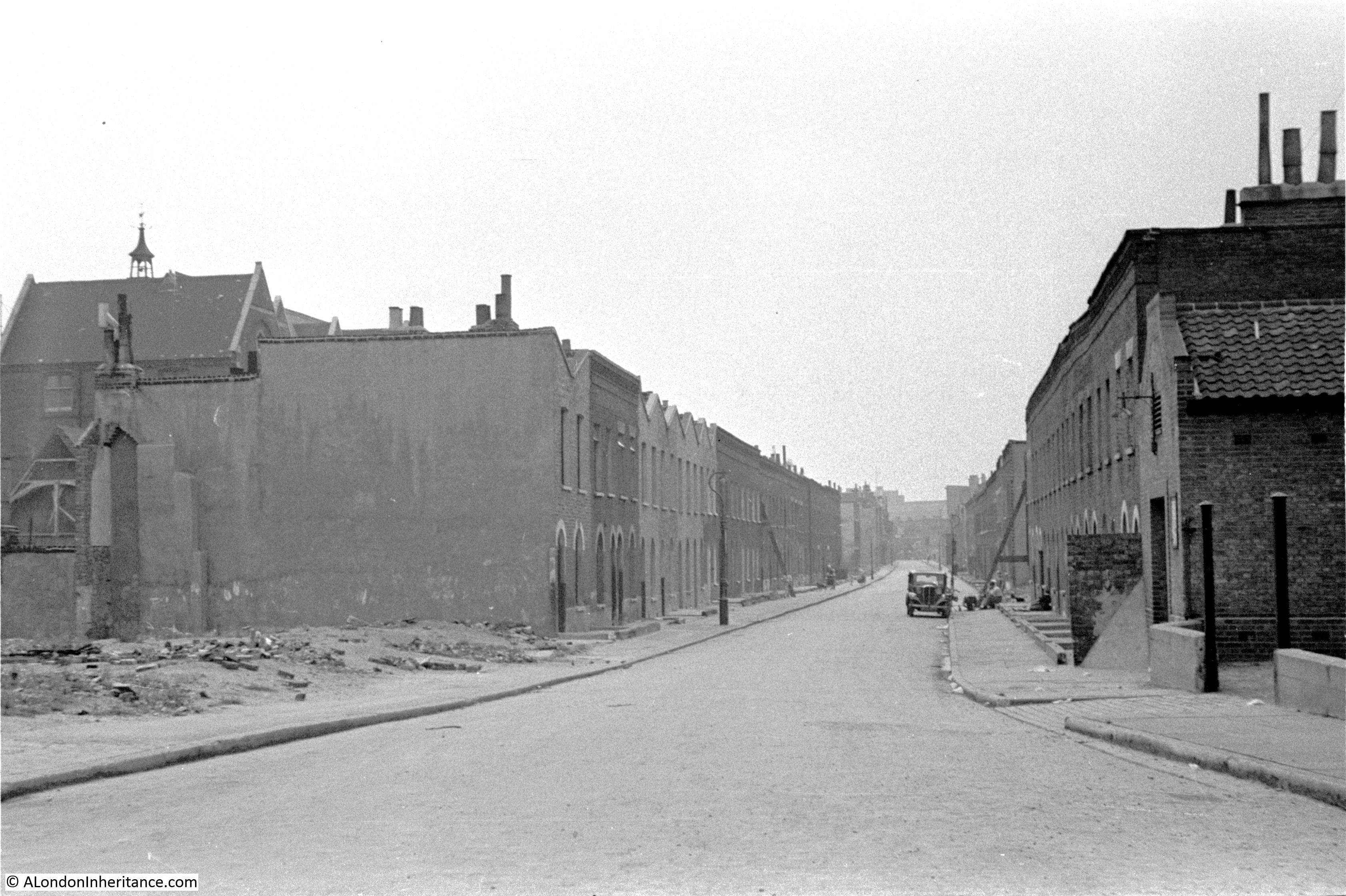
This is the view of Bevington Street from Bermondsey Wall photographed by my father in 1948:
And this is the same view today:
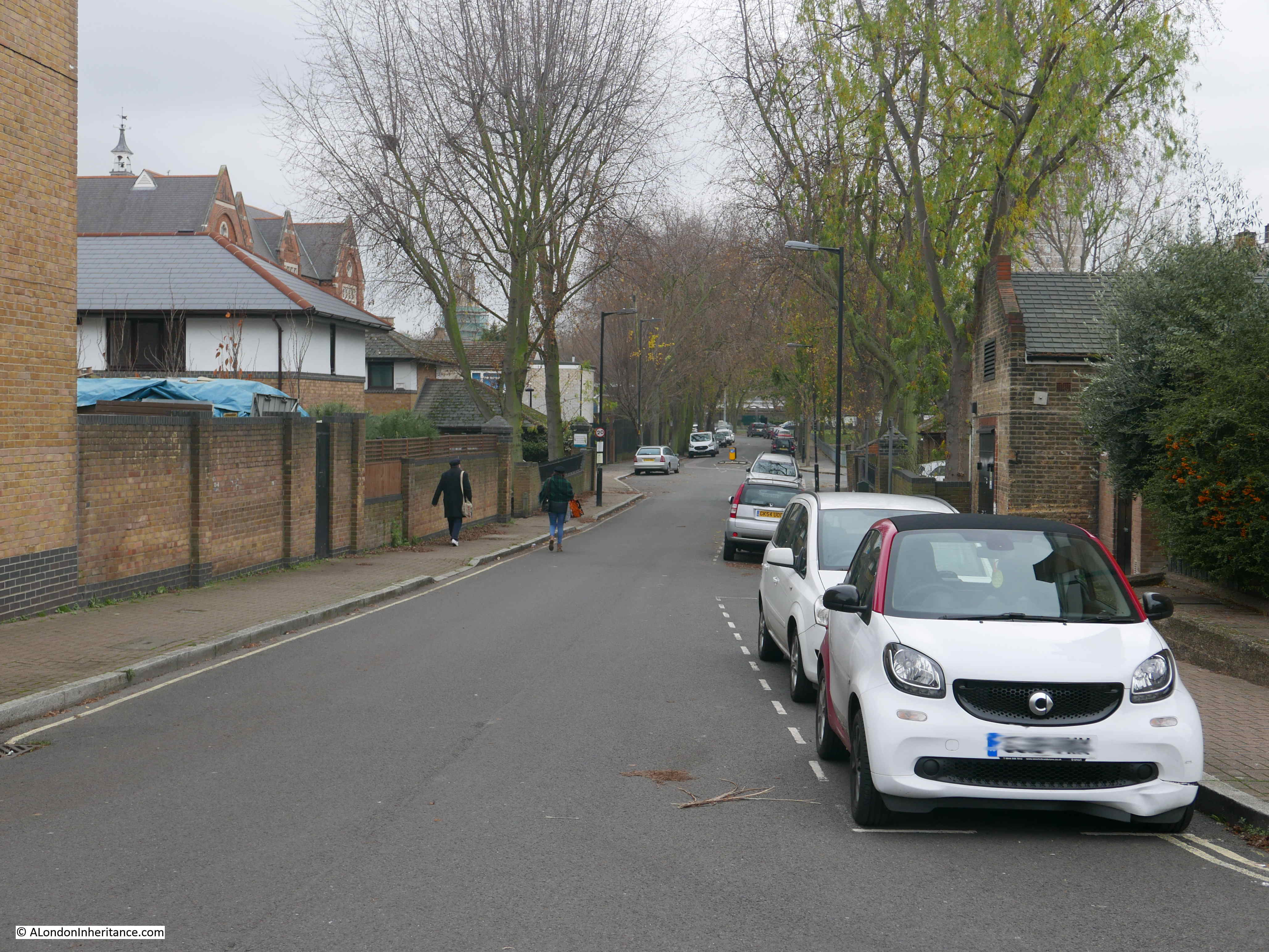
There are only two features that remain the same, but serve to confirm the location. The school on the left and the small brick building on the right which now appears to house an electrical substation – remarkable that in all the redevelopment of the area this small building has survived.
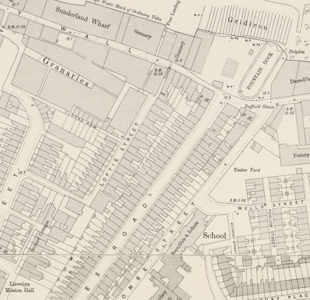
So where is Bevington Street? The following extract from the 1940 Bartholomew’s Atlas of Greater London shows the location. Bevington Street can be seen just to the right of the large Y. The school is further to the right, just across Farncombe Street.
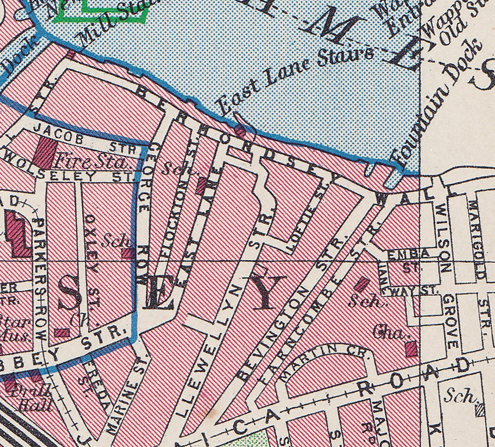
Flockton Street, the wrongly identified location can be seen to the left, leading off from Bermondsey Wall, so these streets are very close. I suspect my father wrote up his notes for the photos after developing the negatives and looking at his route on the map, accidentally picked the wrong street.
I have used this 1940 map as it helps to explain a feature that can be seen today.
Bevington Street ends at Bermondsey Wall, and directly across from Bevington Street, between Bermondsey Wall and the River Thames is Fountain Green Square. The following photo is the view from the end of Bevington Street, looking across Bermondsey Wall to Fountain Green Square.
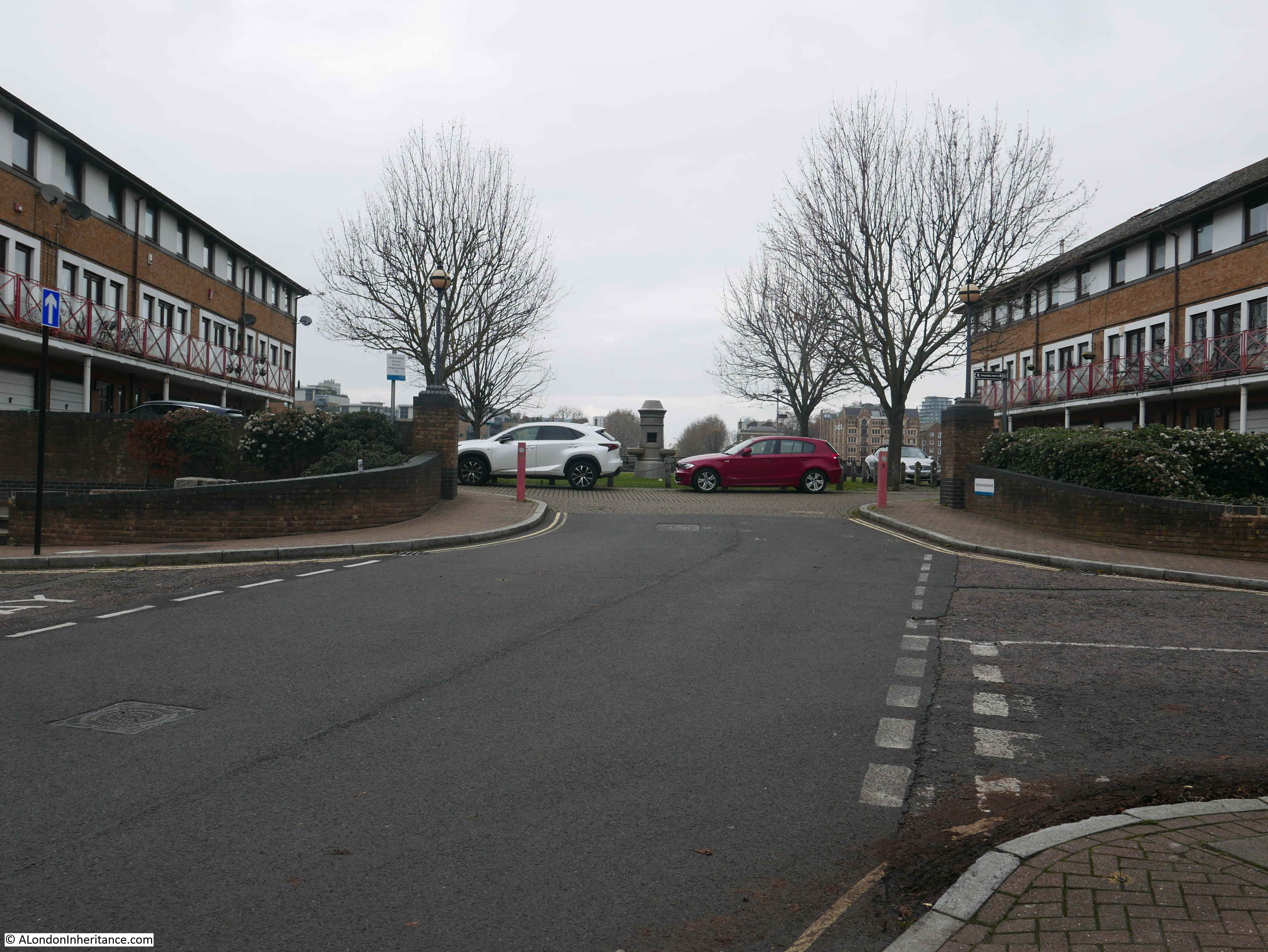
The name is very appropriate as there is a central green with a stone fountain in the centre. New housing is arranged around two sides of the green and the River Thames is alongside the far side of the green.
Looking back at the 1940 map and there is a feature here called Fountain Dock. The 1895 Ordnance Survey Map provides some additional detail and shows the shape and location of Fountain Dock.
Credit: ‘Reproduced with the permission of the National Library of Scotland’
The Southwark Council Conservation Area Appraisal (February 2013) confirms that the site of Fountain Green Square was the site of Fountain Dock, and that the dock was one of the few dry docks that operated along this part of the river.
Checking the overlay feature on the National Library of Scotland site, the dry docks appears over the easterly part of the green and partly under the houses on the eastern edge of the green, rather than occupying the full space of the green.
I checked the London Metropolitan Archives, Collage site and there are two photos from 1929 that show the dry dock. The first is looking from the north west corner of the dock, back towards where Bermondsey Wall runs right to left.
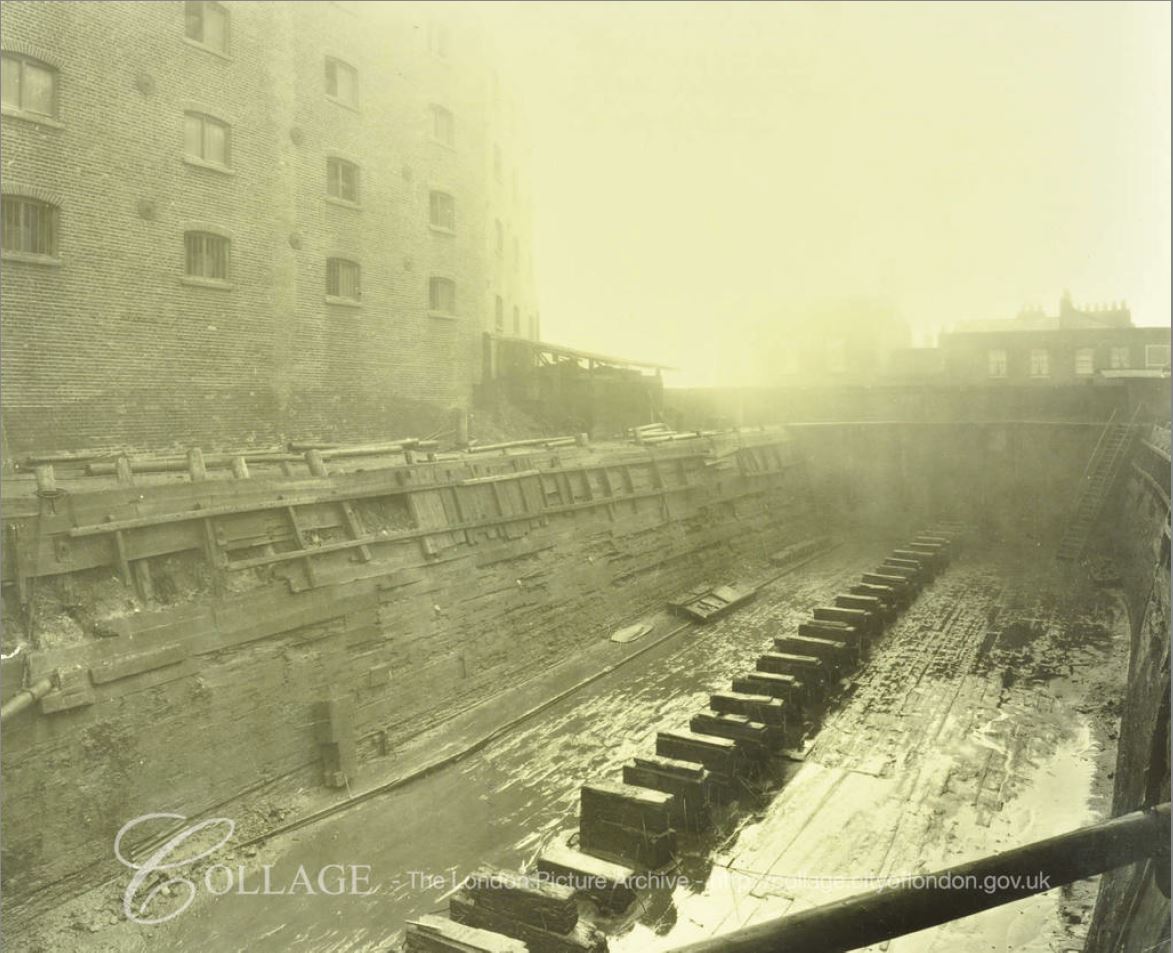
Image credit: London Metropolitan Archives, City of London: catalogue ref: SC_PHL_02_0912_A52734
The second photo, also from 1929, is looking from the south east corner of the dock, towards the river and the direction of the City.
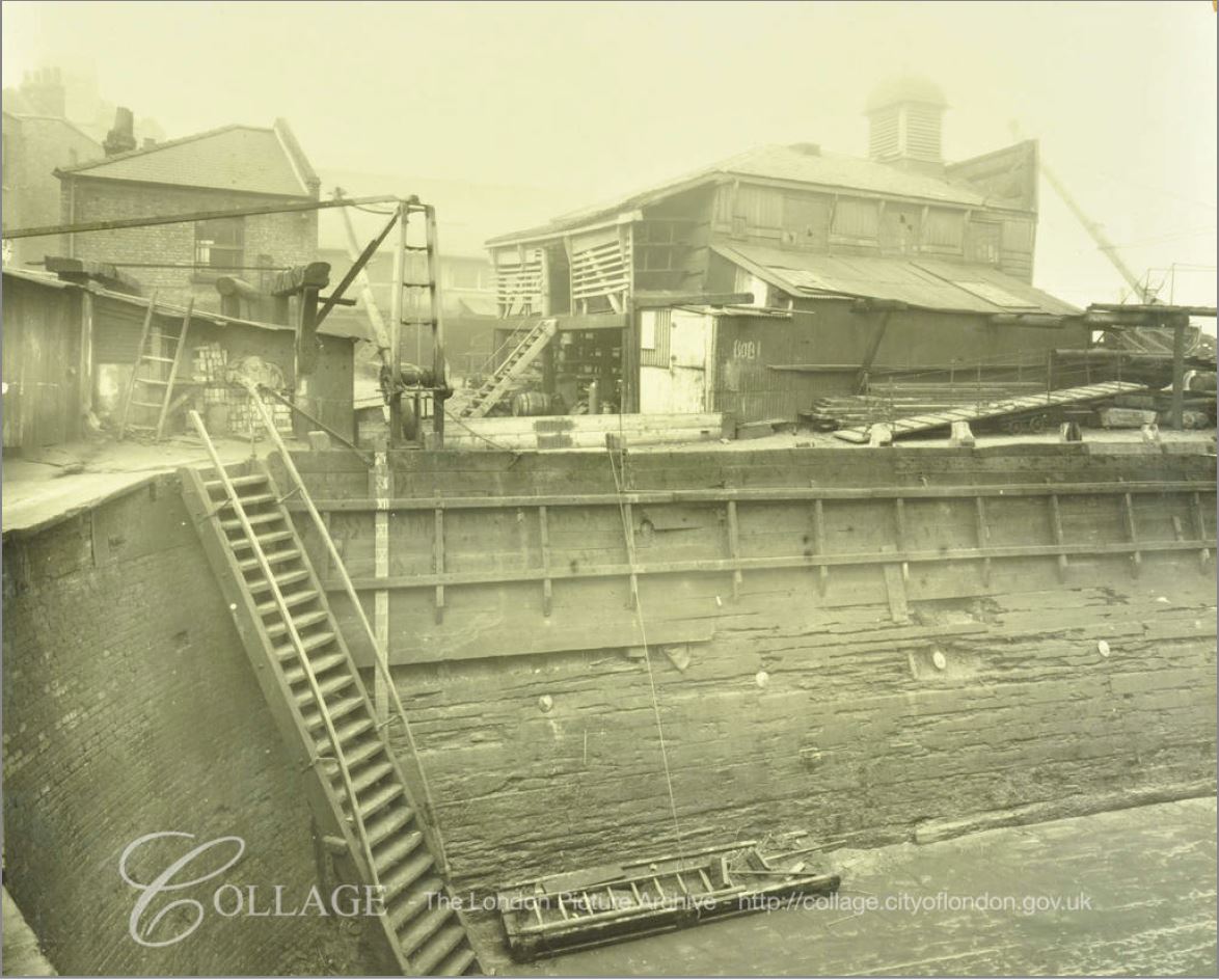
Image credit: London Metropolitan Archives, City of London: catalogue ref: SC_PHL_02_0912_A5273
These photos from 1929 show Fountain Dock much as it must have been in the 19th century. Dry docks are important as they allow the hull of a ship to be inspected and worked on. The ship was moved into the dock, gates to the river closed and water pumped out from the dock, so somewhere alongside there must have been a building that housed the pump.
In an advert for the dry dock in Lloyd’s List on the 13th May 1893, the dimensions are given as a length of 161 feet and depth of 16 feet. The dock was owned by Mills & Knight who also owned the larger Nelson Dry Dock in Rotherhithe.
In addition to numerous adverts for the dry dock, 19th century newspapers included reports of accidents at the dock, as well as ships for sale. It appears to have been standard practice to offer a ship for sale when the ship is in dry dock for repair. The earliest example I could find was from the Shipping & Mercantile Gazette on the 27th August 1850, when the following ship was in Fountain Dry Dock and advertised for sale:
“The A1 Liverpool-built Barque BRAZILIAN, 345 tons, now lying in the Fountain Dry Dock, and ready for inspection; is in the course of re-coppering, &c., and, if not sold within a reasonable time, will be sent out again by her present owner. Length, 107 feet; breadth, 23 1-10 feet; depth 13 3-10 feet; carries a large cargo at an extraordinary light draught of water, and shifts without ballast”.
The following photo is the view taken from roughly the same viewpoint as the above photo. Today there is a fountain in the centre of the green.
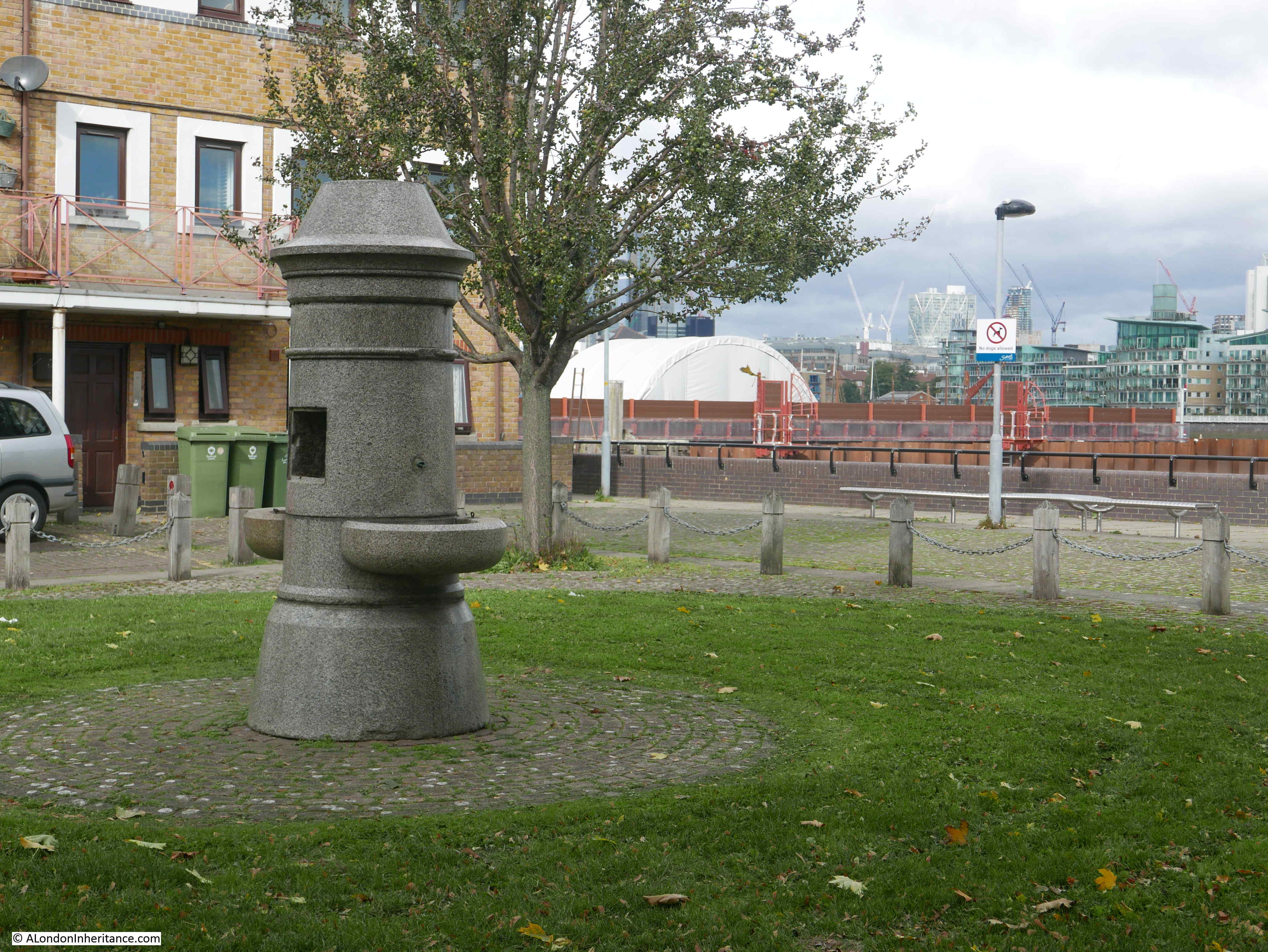
The 1895 Ordnance Survey Map does not show a fountain, so I do not know if the fountain was moved here when the green was created to provide some relevance to the name. I doubt the fountain was here originally as it looks of rather fine construction to have been in such an industrial area – however I also do not know how Fountain Dock was named.
The origin of the name Bevington Street is interesting. When looking for this street on the 1895 OS map, whilst the street is there, in 1895 is was named Princes Road. It had changed to the current name sometime between 1895 and the 1940 map.
Although I have not been able to find any written confirmation of this, I suspect the name change may have been in the first decade of the 20th century. Bevington probably refers to Colonel Samuel Bourne Bevington.
When Bermondsey Borough Council was formed in 1900, Samuel Bevington was the first mayor and he was reelected the following year. He came from the family that had established Bevington and Sons, a company that manufactured leather products at Neckinger Mills in Abbey Street, Bermondsey. He was also a Colonel of the West Surrey Regiment, Justice of the Peace, on school boards and coming from a Quaker background, used family money to support a number of philanthropic activities.
Samuel Bourne Bevington died on the 14th April 1907 leaving a considerable estate to the value of £133,195. His will included money to provide income for four men and four women over the age of 60 who had been engaged in the leather trade.
Because of his role in the leather trade in Bermondsey, that he was the first mayor of Bermondsey Borough Council, and his other activities, I suspect that after his death, the council looked at ways to commemorate him, and one of the ways within their power was to rename one of the local streets, so Princes Road became Bevington Street.
There is much else of interest to be seen from the junction of Bevington Street and Bermondsey Wall.
A very short distance to the east along Bermondsey Wall is a rather unique, listed pub – the Old Justice.
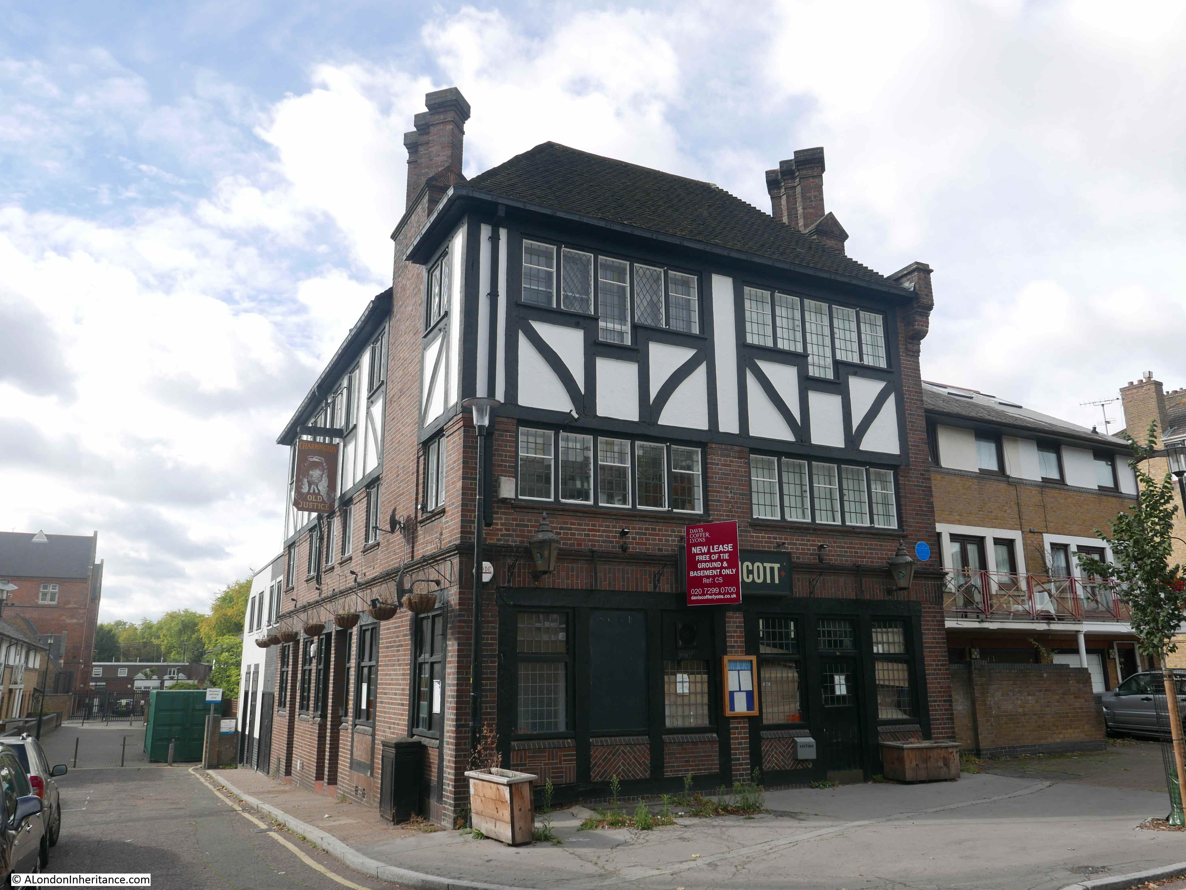
The pub, as with so many London pubs, has closed, however the building is Grade II listed.
The reason for the listing is that the pub is a rather well preserved example of a style of pub design from the inter-war period. The majority of Victorian London pubs were small and focused on drinking. The design initiatives after the First World War, focused on improving the pub environment, the provision of space for other activities apart from basic drinking, for example with the provision of restaurant space and a function room.
The Old Justice was designed by Sidney C Clark in 1933 for the Hoare & Co brewery. It followed a mock Tudor design that was frequently used on many pubs of the period.
Hoare & Co were taken over by Charringtons and the pub has a pair of Charrington lanterns on the frount, these probably date from the 1960s.
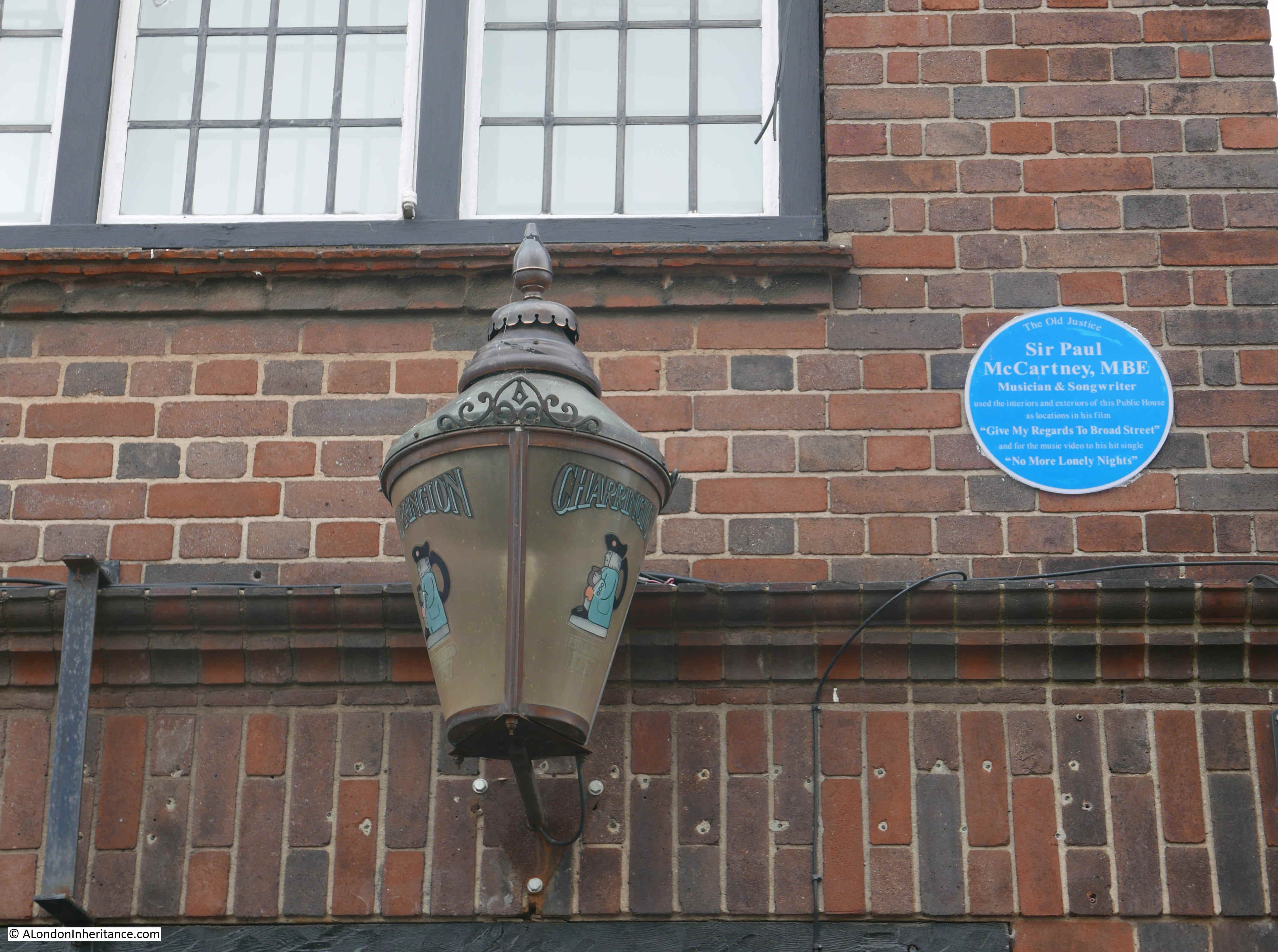
Alongside one of the lanterns is a plaque recording that Sir Paul McCartney used interiors and exteriors of the Old Justice as locations in his film “Give My Regards To Broad Street” and in the music video to “No More Lonely Nights”.
As well as the pub, the film also has some fascinating shots of the front of the warehouses along the Thames in Bermondsey.
I looked in through the windows of the Old Justice and the interior looks to have been reasonably well gutted, although the wooden paneling remains on the walls and the fireplace is still intact.
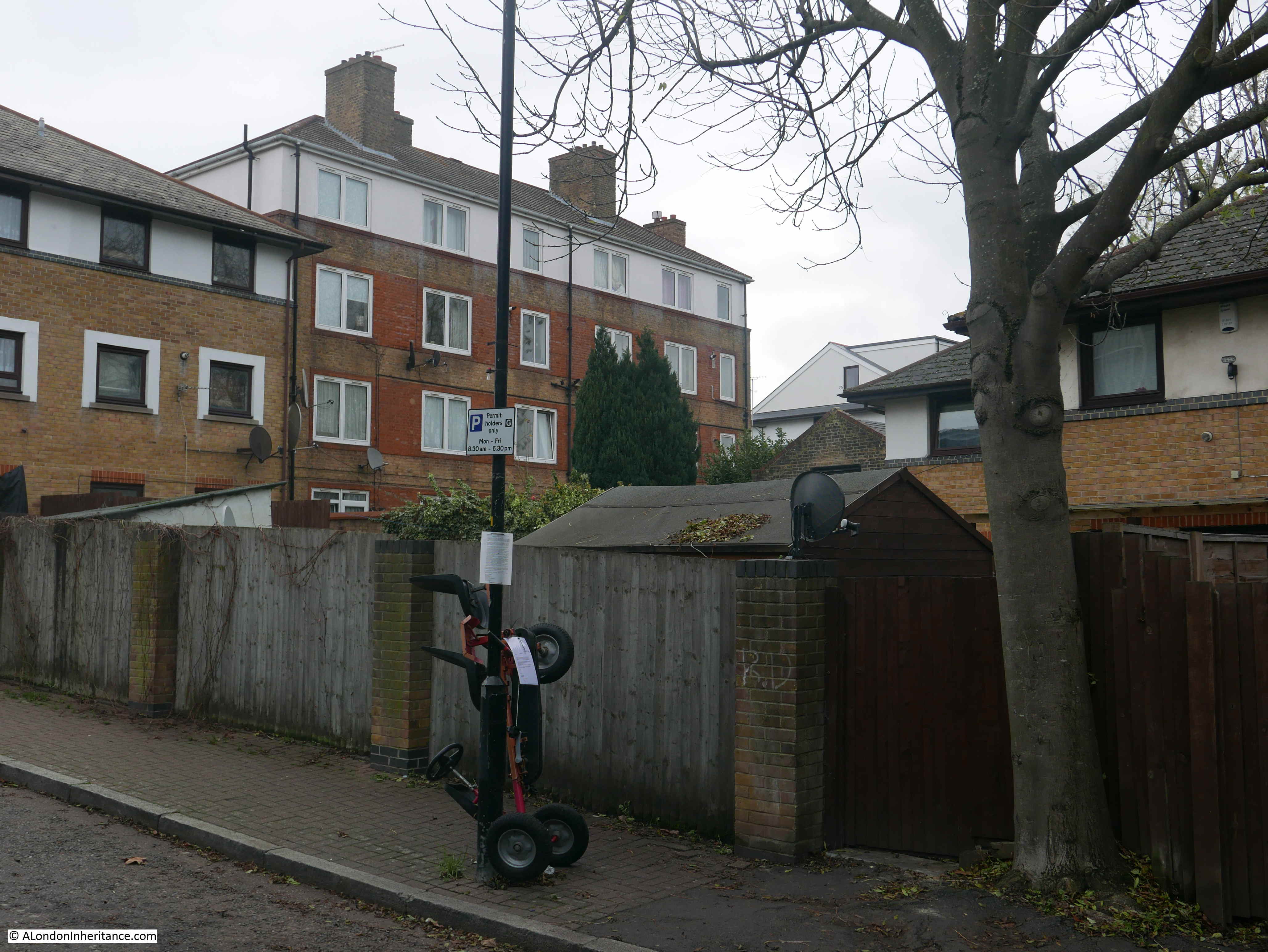
The Old Justice is just to the east of the junction of Bevington Street and Bermondsey Wall. To the west is another building that is earlier than the majority of buildings in the area. This is Fountain House:
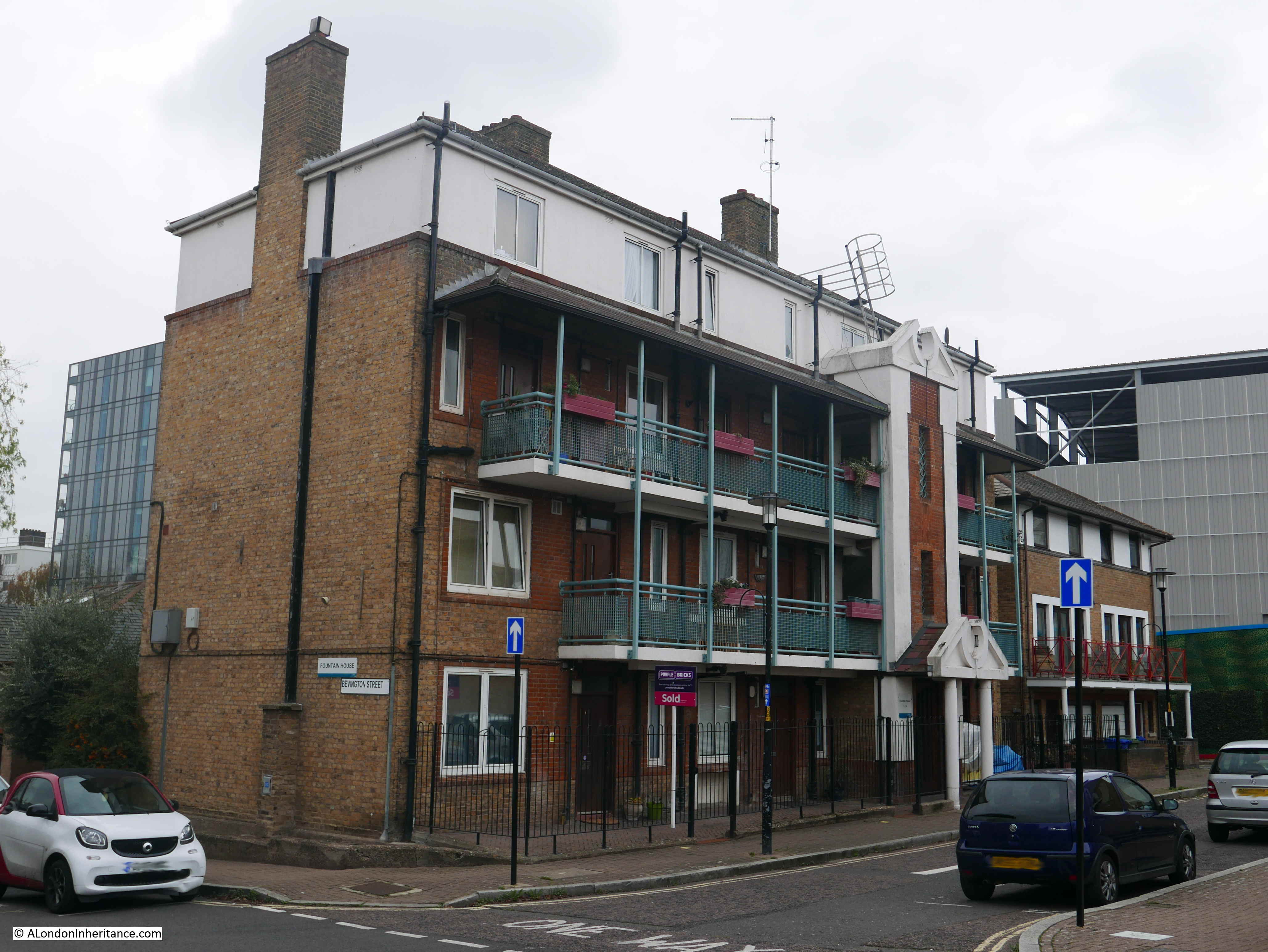
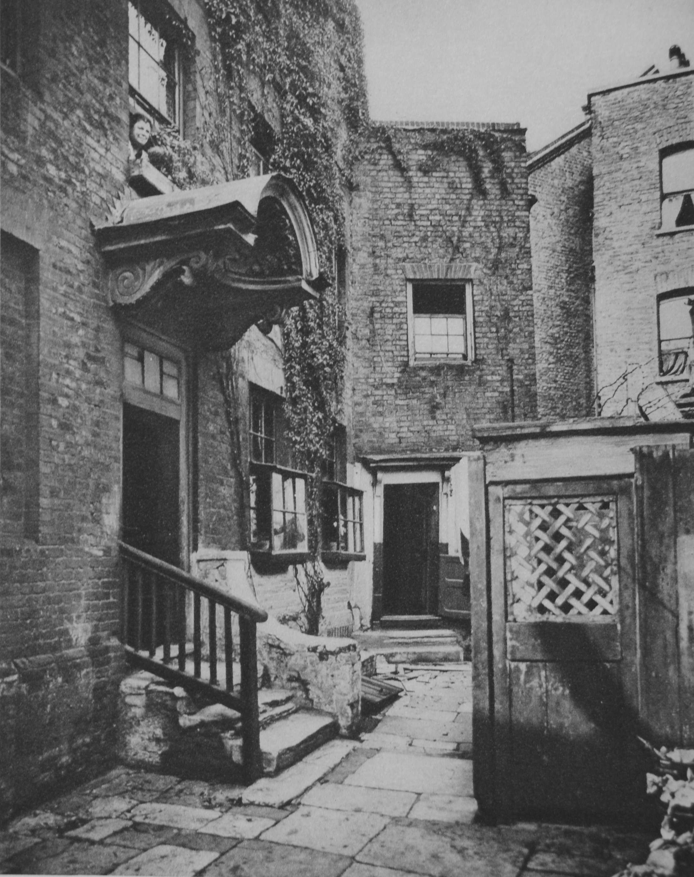
I am not sure when Fountain House was constructed, or whether the name is original. however it did feature in another of my father’s photos of Bermondsey. I have now been able to identify the following photo as having been taken in Loftie Street, which runs parallel to part of Bevington Street.
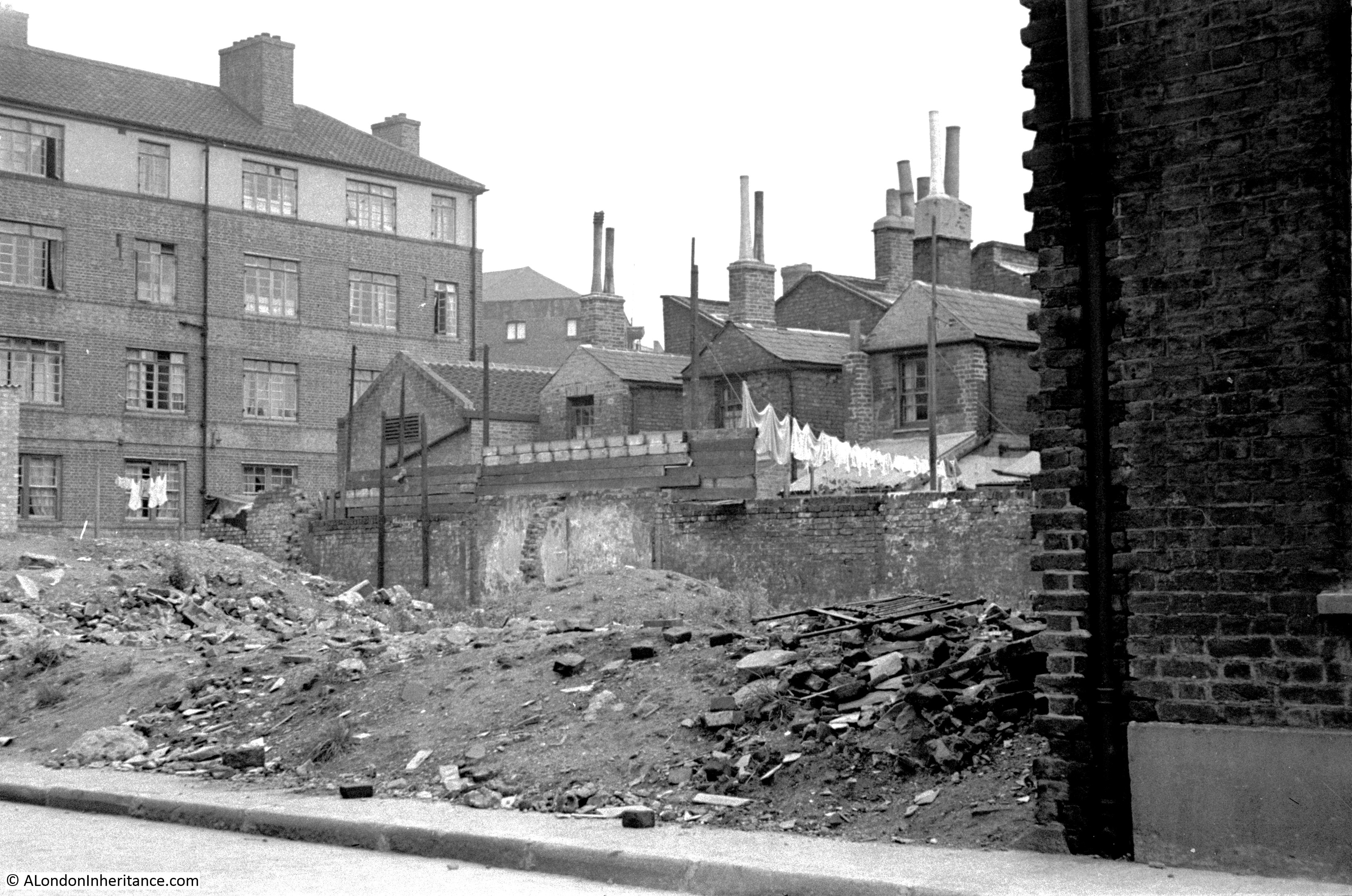
The rear of Fountain House is on the left of the photo, but what confirmed the location was the rear of the electrical substation building that was one of the surviving features in the photo of Bevington Street. The rear of this building can be seen in the above photo, to the right of Fountain House.
The houses are the rear of the houses that front onto Bevington Street. Washing is hanging to dry at the rear of one house, and I am fascinated by the height of the chimneys on these houses.
What must be the remains of a bomb site is to the front of the photo.
I tried to take a photo from a similar position today, but it was not easy with the buildings and fences that now occupy the area, however in the following photo, the rear of Fountain House can be seen, and just to the right, a small part of the top of the rear wall of the electrical substation building is just visible.
There was one additional place I wanted to track down. When I was looking for Flockton Street, I walked along George Row, which runs parallel to the original route of Flockton Street. The name George Row was familiar and I recently remembered where I had seen the name.
In 1926 a three volume set of photos and articles titled “Wonderful London” was published and the first main photo in volume 3 was titled “The Bridge House In George Row, Bermondsey”.
The caption with the above photo read:
“Bermondsey has had its royal palace dating perhaps from Edward the Confessor, and it was only in 1805 that the North Gate of its Abbey was taken down. The building in the photograph is called the Bridge House, since it stands where a bridge was built over one of the creeks that entered the river and made, with what is called St. Saviour’s Dock, Jacob’s Island. This was a densely populated quarter a hundred years ago, and its many canals and ditches had a Dutch air, according to the chroniclers”.
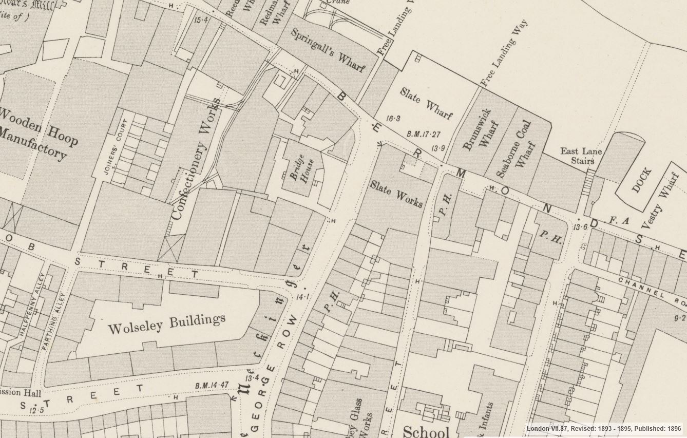
George Row today is a wide street that runs from Jamaica Road down to Bermondsey Wall. There are no buildings that look like the above photo and I was doubtful that I could find the location, however I turned to the 1895 Ordnance Survey map, and at the northern end of George Row, close to the junction with Bermondsey Wall, there is a building clearly labelled Bridge House. The map also shows the steps leading down from the building with what appear to be steps leading down from the building on the eastern side and sidesteps on the western side. This would confirm that the photo from Wonderful London was taken of the eastern face of the building.
Credit: ‘Reproduced with the permission of the National Library of Scotland’
It was easy now to find the location of Bridge House, the map overlay feature helped confirm exactly where to look. Bridge House was not directly on George Row. In the above map there is a space, which appears to be open space between the building and street, and this configuration remains today.
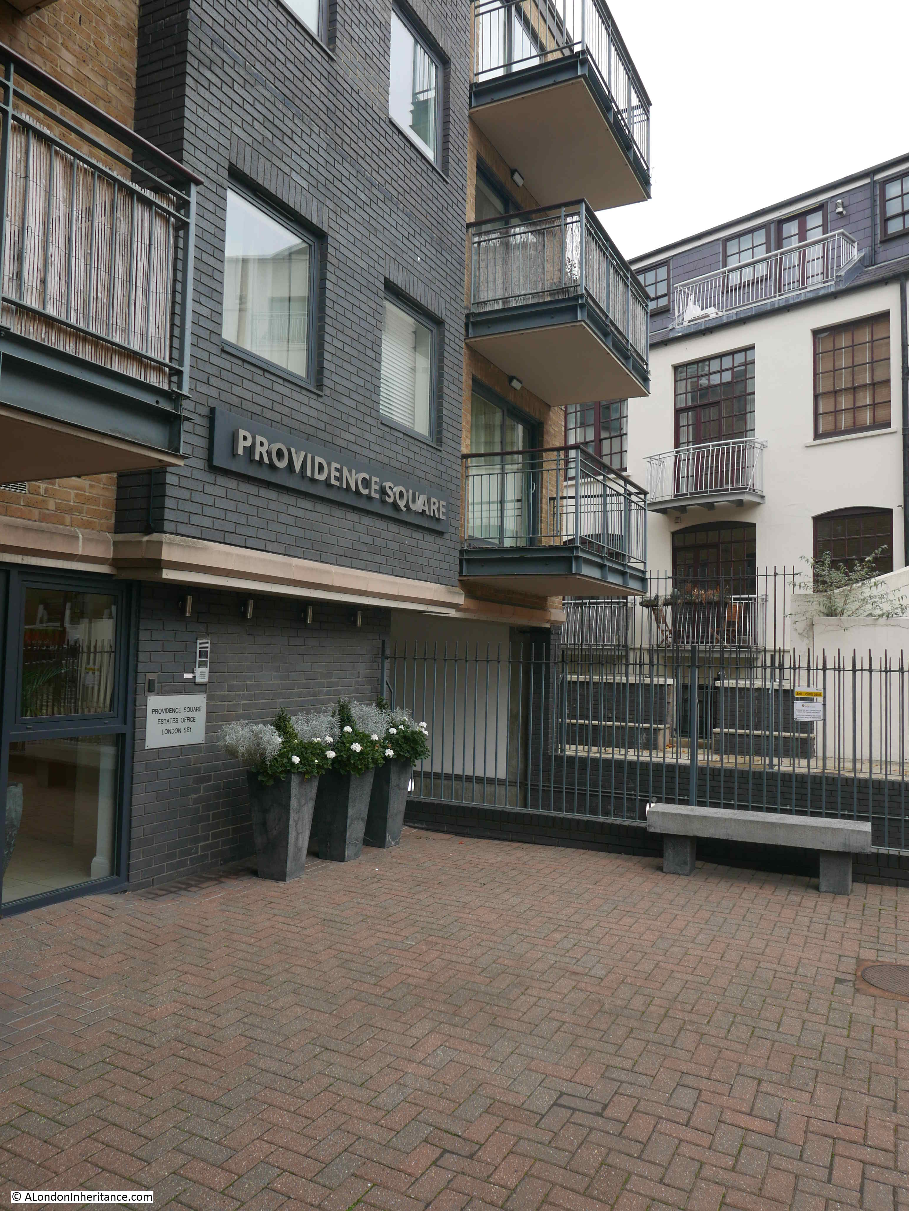
The following photo shows the location of Bridge House today, with a 4 storey block of flats – Providence Square – now standing in what appears to be almost the same footprint of Bridge House.
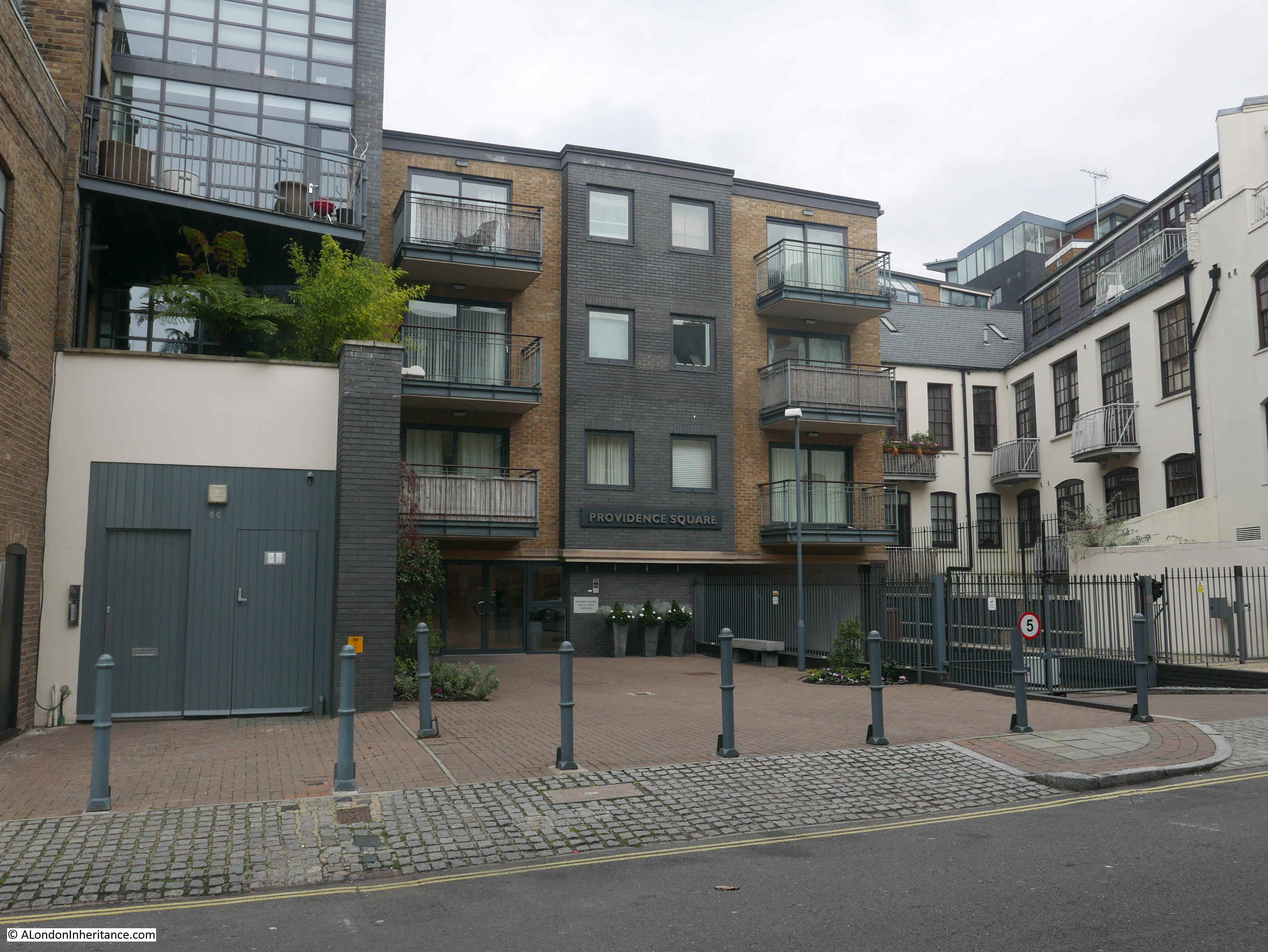
It would be interesting to know why the new building did not extend to George Row. Developers tend to maximise the amount they can build and make use of every available bit of space and the area between the building and George Row serves no apparent purpose.
I walked up to the edge of the building to take a photo from roughly the same position as the photo from Wonderful London.
The caption to the photograph in Wonderful London explains the source of the original name for the building: “The building in the photograph is called the Bridge House, since it stands where a bridge was built over one of the creeks that entered the river and made, with what is called St. Saviour’s Dock, Jacob’s Island”.
There are no signs of the creek today, however maps provide some indications.
In the 1895 Ordnance Survey map the word Neckinger can be seen running alongside George Row. This refers to the River Neckinger. I have read many different accounts of where the Neckinger entered the River Thames, most claim that St. Saviour’s Dock was the main estuary of the Neckinger into the Thames, however this was always low lying marsh land, and there have been many canals and ditches built in this area (I mentioned the 19th century walled drain in my post on Flockton Street, and the outline of this drain can still be seen running across the street).
The book “Bermondsey, Its Historic Memories And Associations” written by E.T. Clarke and published in 1902 provides a location for the creek and bridge. The book includes the following map of the area.
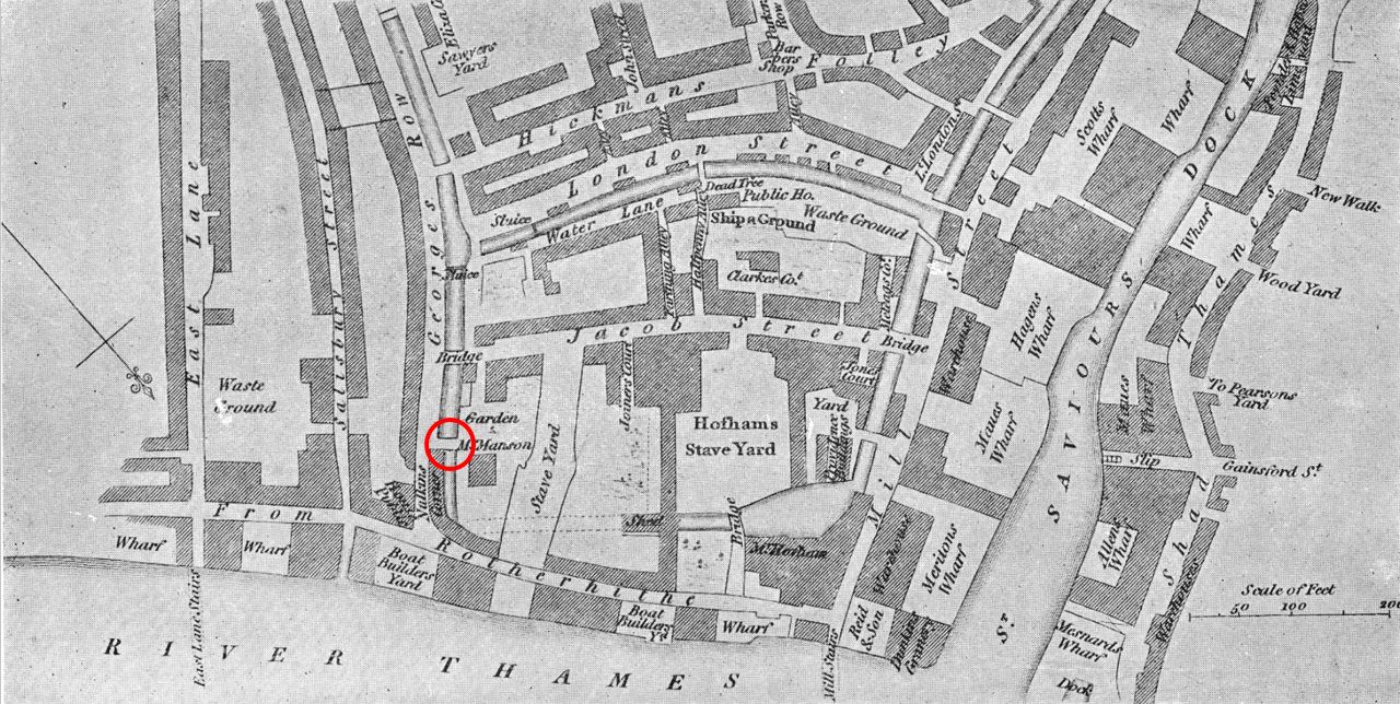
The so called Jacob’s Island is in the centre of the map, bounded by the Thames at the bottom of the map, St. Saviours Dock to the right, a canal running alongside London Street to the top, and on the left, a canal running along the full length of George Row.
Based on the locations of streets that can still be found today, I have circled in red the bridge that gave Bridge House its name.
This is pure speculation, but it may be that Bridge House is the rectangular building on the above map to the lower right of the red circle.
I do not know when this canal or extension of the Neckinger was filled in – it had disappeared by the time of the 1895 map, but it is interesting that the open space between George Row and the building that now occupies the location of Bridge House would have been where the canal ran.
Finding the location of Bridge House helps to understand how this area has developed over the centuries. Fountain Green Square provides a link to the dry dock that once occupied the site, and Bevington Street records the first mayor of Bermondsey and the leather industry of area.
Finding Bevington Street means I can tick off another of my father’s photos from 70 years ago. My thanks again to everyone who identified the correct location of the photo.
Thanks for this post, that particular area of Bermondsey has changed so much in recent years, the original street plan almost unregcognisable. By coincidence my Great Grandmother’s last address was 16 Loftie Street on the 1911 census, I assume it would’ve an incredibly deprived area at that time, looking back at the records my family were struggling a fair bit.
Thanks again for a fascinating post.
Enjoyed it!
Thank you for sharing this. My mum lived in Bevington Street in the 1930s and I’ve never seen images from that period. I also had family living in George Row.
Princes Road was renamed Vienna Road by an order dated 10 November 1896, and was subsequently renamed a second time to Bevington Street by an order dated 30 July 1918. (Per LCC List of Streets and Places, several editions, which covers all renamings).
Michael, thanks for the information regarding the name changes, I had assumed the change to Bevington would have been soon after his death, which by the end of the first world war in 1918 must have seemed a long time ago. That is a book I need a copy of.
There is an online directory of London street name changes at https://www.maps.thehunthouse.com/Streets/Street_Name_Changes.htm which takes info from various editions of the LCC lists of streets and places
Thankyou for this great resource!
Thank you, that’s really interesting, and sheds light on something that has been puzzling me. My Grandparents lived on Vienna Road in 1916 when they were married. After that (1918) their address became Bevington Street before finally moving to Storks Road at about the end of WW2, perhaps they were bombed out.
Hi Simon,
It’s also given me a small (but hopefully helpful) clue … I’m trying to find the birth record for my maternal great-great-grandfather, and on the marriage certificate for his son (my great grandfather), my ggg was listed as living at 65, Vienna Road. They were married at St. Crispin’s Church in Bermondsey on the 5th of May, 1907.
I don’t know if you will see this, as it’s a while since you posted, wouldn’t it be odd if maybe my great grandmother was a neighbour to your grandparents? Sadly, my great grandfather died in 1909.
Debbie
Sorry, too many gggggggs 🙂 My great grandfather (Alfred Wallace) was listed as living at 65, Vienna Road, not my great-great grandfather. Alfred was married to a Rosina Haxton, in the one in a million chance that they were neighbours to your grandparents.
Brilliant stuff. By coincidence, I was thinking about Bridge House yesterday and it turns out I was muddling it up with the Bridge House which was associated with London Bridge, now long gone in Tooley Street. And now you have solved the final piece of the puzzle! That whole part of Bermondsey – where many of my poor and lowly ancestors came from – is completely re-constructed now. I can’t say it is much of a loss, when you consider how terrible the living conditions were round there a century ago. Always worth a wander, though.
I lived in the flats on Wolseley Street ( Peter Butler House) in the mid 80’s, one of the ground floor flats became unlivable as water seeped up through the floor. This was before the area became developed and it was great to walk along Bermondsy wall etc looking absolutely empty
Hi – I’m not surprised that the electricity substation has survived – the functionality hasn’t changed in 100 years and unless the local authority actually wanted to raze the whole area, the electricity undertaker would have wanted to retain the site, and ideally the existing plant, to resupply the redeveloped area. I’m less familiar with London than I am with Manchester, but you can see many original Manchester Corporation substations (from the years before nationalization) still either in service, or in some cases rather grand buildings put to other uses (many have the telltale MCEU in the brickwork or stonework). Many site were secured by the corporation in the last years of C19 or very early in C20, and are still now owned by the descendant undertakers. I would imagine it is much the same in London – although the building churn of the City itself , and its frenetic redevelopment probably makes it less true there than any other city in Britain.
Mike, that is interesting. I had assumed that the changing type of equipment these buildings would need to house would have meant some redevelopment of the building, and the additional local building with the growth of electricity consumption would have meant a large amount of equipment to supply the area, however it is great to see a building serving the same purpose over so long a time.
Thank you for your fabulous research on this area. I believe I can shed light on the naming of Fountain Dock. In about 1980 I was living in Jamaica Road and would go to a derelict wharfside at the end of Bevington St to enjoy the river view. It was just before the wharfs and docks were due to be re-developed. One day an old man came and joined me, saying that as a boy he would swim here with his friends. Pointing to an area of the river in front of us he told me there was a dangerous current there, like a whirlpool, and it was known as ‘The Fountain’ because the boys would swim out and allow themselves to be sucked under, then the current would carry them under the water and shoot them up like a fountain and out of the water some yards further down river. He looked sadly at the river and said ‘I lost a good friend that way, they found his body down at Greenwich.’ My own grandfather used to swim across the Thames from Rotherhithe, so I don’t doubt the old man was telling the truth!
I set some of my novel JAM & ROSES by Fountain Dock and river stairs by the way!
I love your blog and would love to know how you manage to get such hi-res scans of maps. Do you pay for them at various map sites?
Mary, thanks for your comments about the blog. Wonderful story about the whirlpool and the Fountain name. I can believe this could well be the source of the name as there seems no other obvious source. That must have been a highly dangerous activity, but I suspect playing by and in the river was a normal activity for children living in and around the docks and industrial banks of the river. It must have been dangerous, and browsing through the newspapers of the time there are numerous reports of deaths in the river, including many children.
Fascinating that your grandfather swam across the Thames – not the safest of activities given the amount of river traffic there must have been and the strength of the tide, but I guess if you know the river, you know the safest time to get across. There must also have been the risk of catching something from the river water.
The area has so much history and must provide so much inspiration and source material for your books.
My next challenge is finding more about the Bermondsey gas works if you know anything about the place.
Regarding the maps, the 1895 OS maps are screen captures from the NLS web site. The rest are photos or scans of maps I own.
You’re right about the dangers of the river, especially catching something from the dirty water as it was then. Grandad suffered terribly from ear infections as a child which badly affected his hearing – he always put this down to swimming in the Thames! Bermondsey history is a tresure trove I’m so glad you’re uncovering more. Sadly I can’t help with the gas works but will be interested to read your findings. Thanks for the info on the maps.
Thanks again for such an interesting piece of investigative research, we did a walking tour of the area 2 weeks ago with the Georgian Group but didn’t get much time to look at the Old Justice – so your inclusion of it was a bonus. Couldn’t quite work out the significance of the cart chained vertically to the lamp post?
I have since done some research of 41-51 Bermondsey Street (downstream from the former Braithwaite and Dean barge yard building) – please email if this is of interest or your father photographed that location. Kind regards.
What a grand canopy over the entrance to Bridge House. Dates it to early Georgian, I imagine. What a pity it’s been swept away.
On the pump house for Fountain Dock, one might not have been necessary. Generally ships enter dry docks on the high tide. The gates are left open as the tide subsides. At low tide the ship is stranded. The dock gates are then closed, and hey presto! Work on the hull (regular scraping of barnacles, etc) can then commence.
Jonathan, thanks, you are of course right. I experienced the tidal range when I was at the Angel pub in Rotherhithe and low water would have easily drained all the water from the dry dock. Thanks for pointing that out, I was thinking of other dry docks I have seen where water is pumped out.
Tank you for another interesting insight to areas of London.
Found some aerial photographs which relate to the historic photographs in this post.
https://historicengland.org.uk/etl/1452483/c5a6293d-3cd9-45d7-84bf-a4ec5f08c2cc.jpg?width=303&height=400&mode=crop&quality=90
Larger images are right at the bottom of the entry for the Old Justice Pub.
https://historicengland.org.uk/listing/the-list/list-entry/1452483
Interesting article. My mother, who was born in 1928, actually lived in the Old Bridge House for a time with her parents and brother. She remembers it well and often mentions living there.
Should you be interested in knowing more please feel free to contact me.
Thank you. I have really enjoyed this and will probably read it several times over. I remember the fountain and still have a vivid memory of it being within the immediate vicinity and was there in the early 50’s. I never used it because we were told not to (there were several fountains in Bermondsey) When I first came online (circa 2010)I do remember reading that it had been moved. I am now in my 74th year and I live in West Sussex but still miss Bermondsey very much, particularly since my immobility prevents me from travelling there regularly.
Best wishes
Maureen
Maureen and I were at school together and I wish her well. I still visit regularly. My grandmother lived at 11 Martin Crescent, not far from Bevington Street and on the map above, until 1952. It was demolished and Spenlow House built on the site.
How fascinating!
Thank you!
Really interesting article. My dad was born on Bevington Street in 1922. I remember as a child going down to see grandmother but don’t know much about the place my dad grew up in, or what his early life was like prior to joining the army in 1939. So thanks for this the maps and stories are fascinating.
You might be heartened to hear that the Old Justice has reopened as a pub.
The community came together to save it after developers ripped the insides out. The council made them put it back as it was and now you can get a drink in a very fine-looking wood-paneled, inter-war pub!
Thank you so much for this informative site. The car in the 1948 picture of Bevington Streetis a Standard 10 and was owned by my late father in law. It is parked outside his home. My late wife was born in this house in March of 1948 and she with her older sister used to walk over the bomb site area to the left of the picture ever day to get to Riverside Primary School, also visible in the picture. Would you have a higher res image of this photo, as I would love to see the characters by the car.
In the Sixties I viewed two memorable events from the Mayflower outdoor area.
An eight from a rowing club static despite furios rowing because of the tide having turned
A man swimming over to the Prospect of Whitby and back
The old justice has reopened as a pub now
My grandfather and family grew up on bevington street in the 20’s and 30’s – number 61 i believe. Tha ks for sharing this photo – a faacinaring look back in time.
Is there any way to know which hkusenwas no. 61?