
Thirty five years is a relatively short time, however during that time so much of London has changed considerably. Back in 1986, a large part of east London was run down. The area was still home to some wonderful communities, people who had lived and worked there for decades, but an area that would soon change. I recently went back to Cannon Street Road to photograph the site of two shops last photographed in 1986.
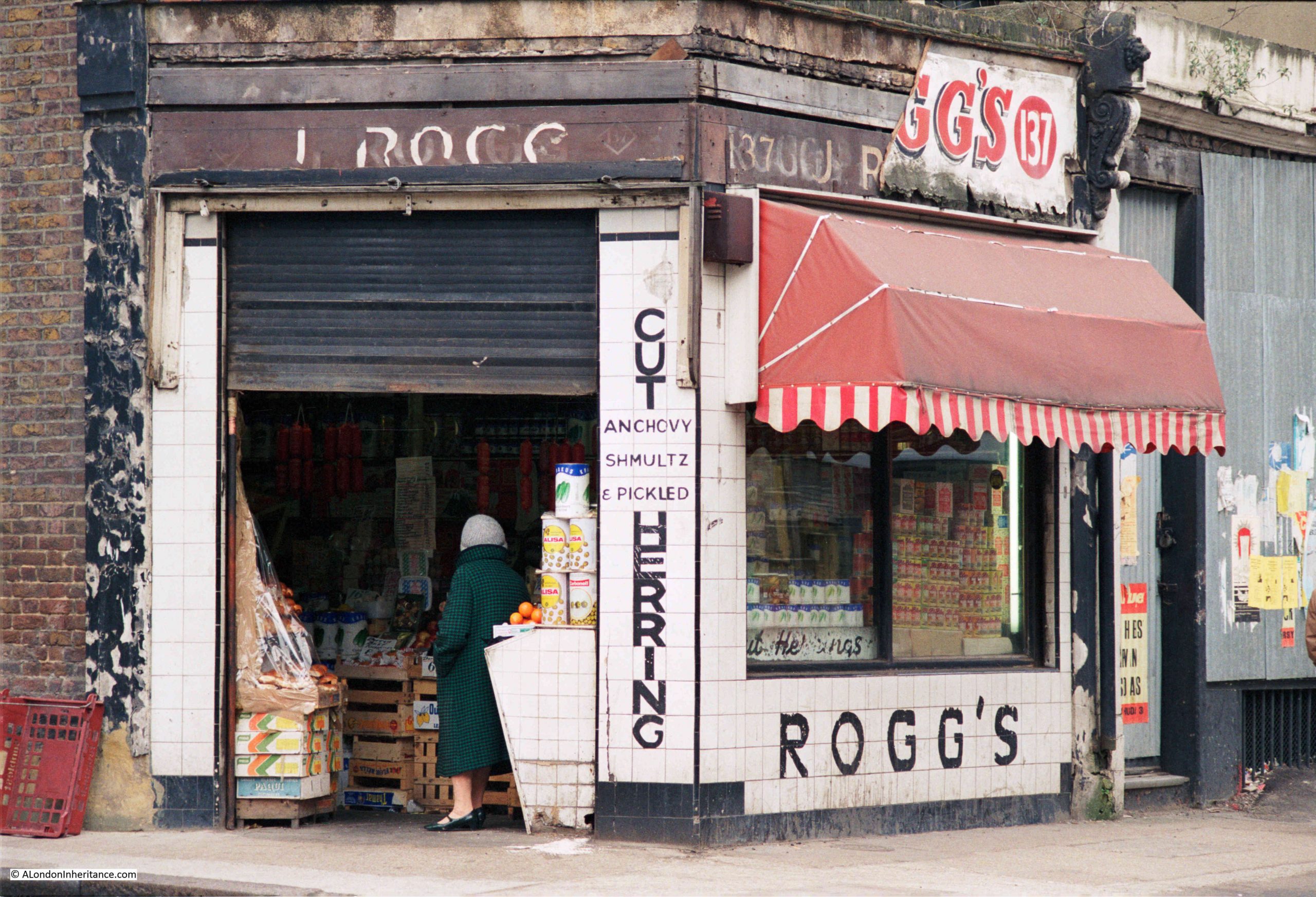
This is Rogg’s at 137 Cannon Street Road:
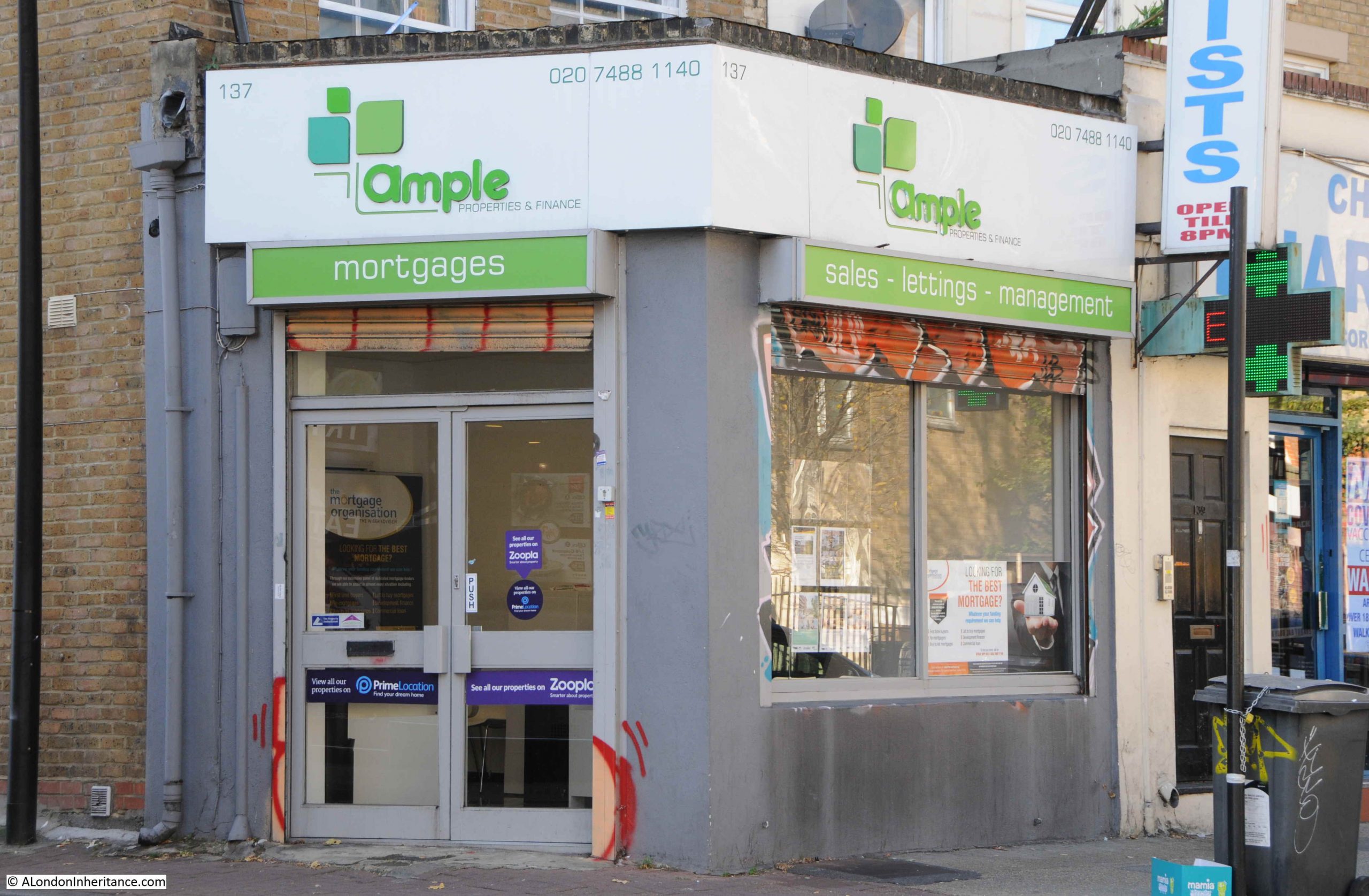
Number 137 is today the home of Ample, a property and finance company:
Rogg’s was on the corner of Cannon Street Road and Burslem Street and had been open since the early 1940s. A typical 1980s corner shop with products piled high in the windows. Inside, there was a wide range of traditional Jewish food.
The shop was at the end of a terrace of mixed date and designs. I am not sure if the building of which Rogg’s was the ground floor shop, has had a rebuild as the bricks look too clean and the corners / sides of the building are a little too sharp and clean for a building of some age:

As well as Rogg selling Jewish food, another building that supported the local Jewish population was a synagogue that occupied the space in the above photo, to the right of the white building with part of a blue sign just above the ground floor.
The Cannon Street Road synagogue opened in 1895, but closed in the early 1970s due to the declining local Jewish population.
There was a rather infamous murder in the street in 1974, when Alfie Cohen, who ran a small all-night cigarette kiosk in Cannon Street Road was murdered during a robbery on his kiosk. The robbers got away with what was in the till and a quantity of ciggarettes, however they missed a considerable fortune.
Alfie had worked 7 nights a week for almost 50 years, and rarely took a night off. Rather than bank the money he made, he kept it under the counter in the kiosk, and when police came to investigate the murder, they found a total of around £100,000 in bags hidden in the kiosk.
A tragic story, but indicative of the characters that could be found in the street, and also of the relatively high level of crime in the 1970s.
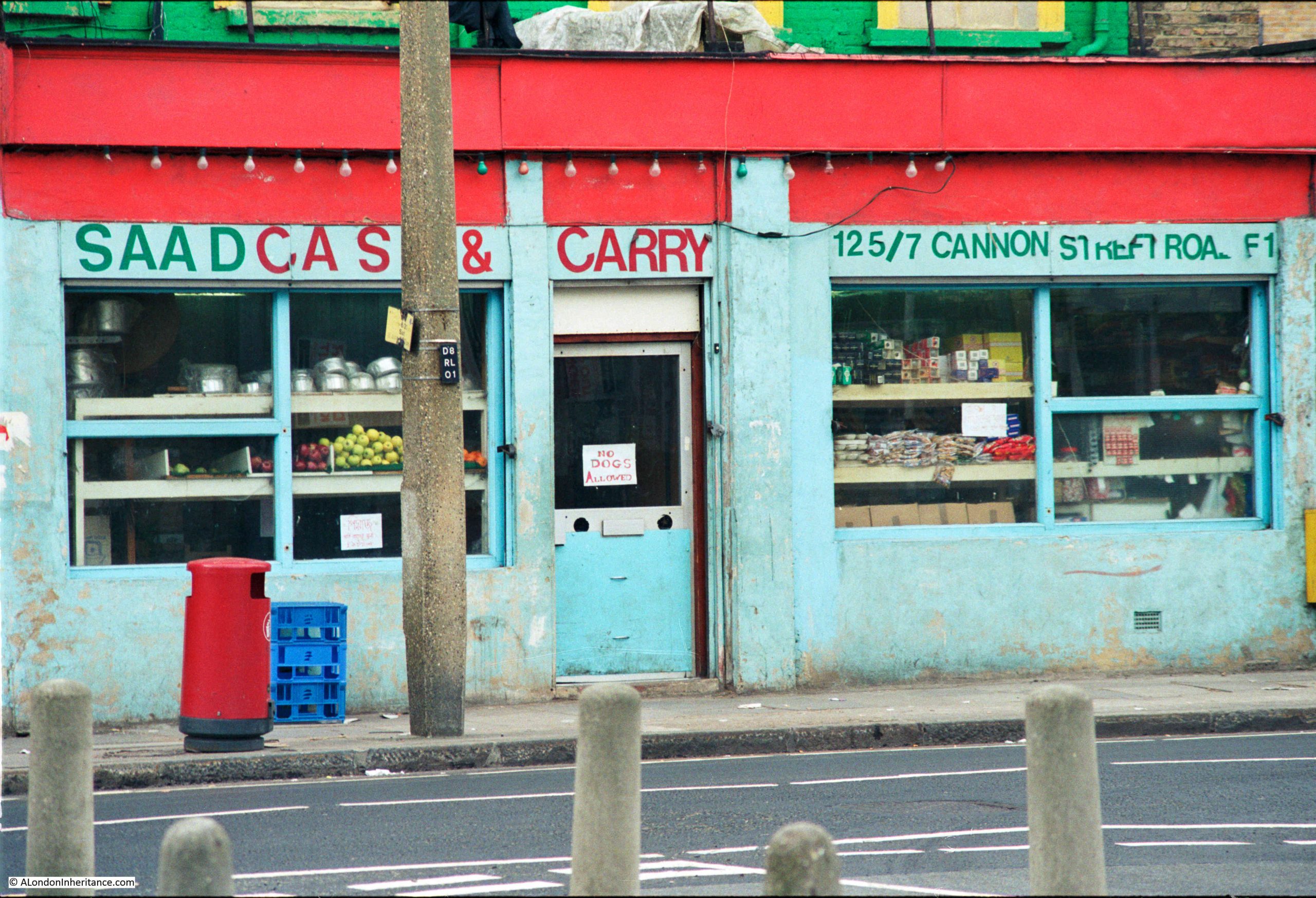
Continuing south along Cannon Street Road, and at numbers 125 and 127 was Saad Cash and Carry:
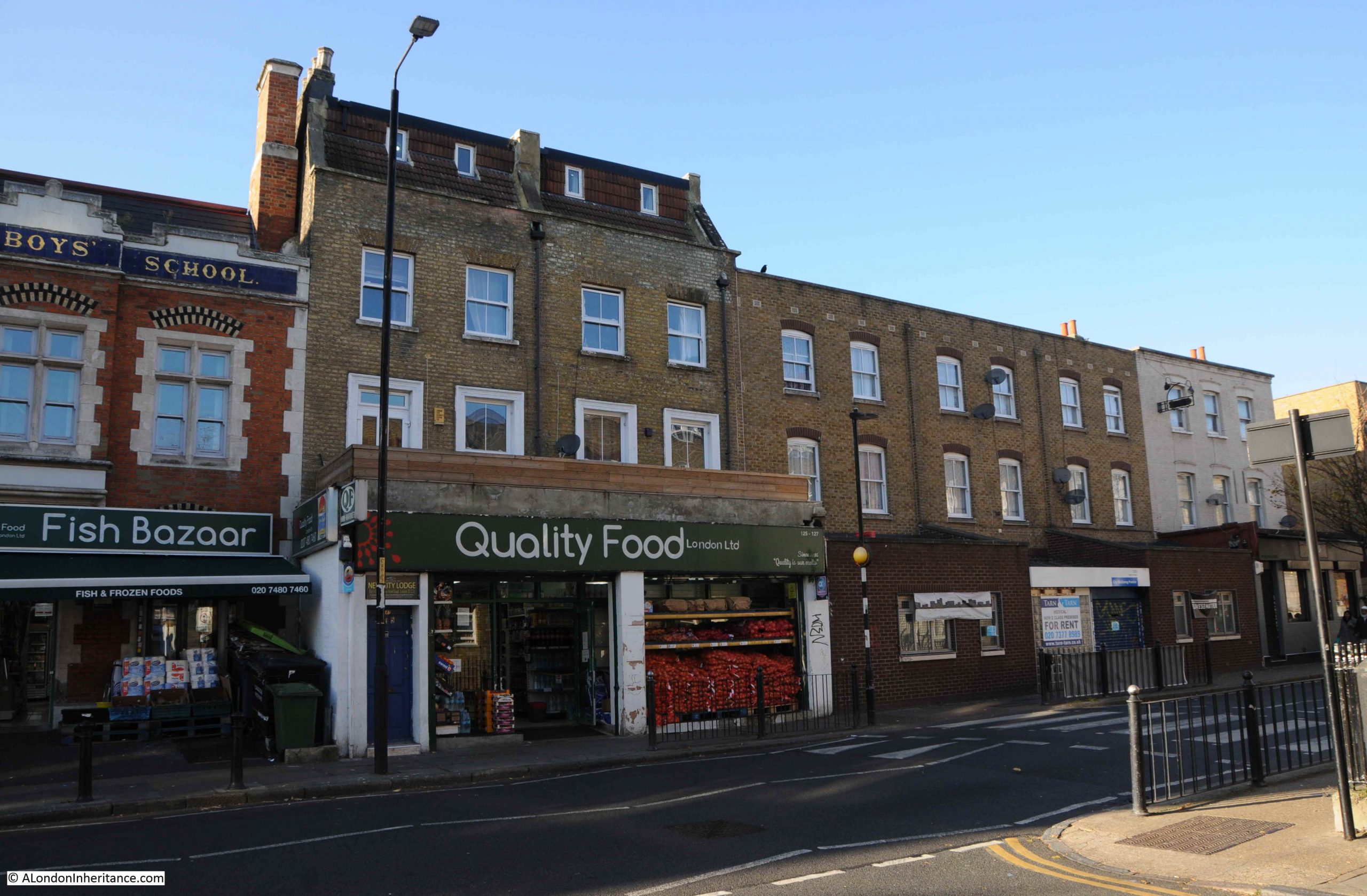
The same building today, now home to Quality Food London Ltd:

A wider view of the terrace with 125 and 127 occupying the ground floor of the largest houses:
Cannon Street Road is a typuical east London street. Shops and businesses catering to a diverse range of local residents, and with an equally diverse range of architecture. The condition of the buildings are much better than they were in the 1980s.
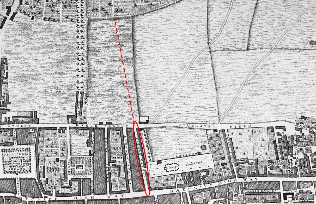
Cannon Street Road runs between Commercial Road to the north, and the Highway to the south, cutting across Cable Street rouighly two thirds along the street.
Cannon Street Road is the yellow road running north – south in the centre of the following map (Map © OpenStreetMap contributors):

The lower section of Cannon Street Road is old. The stretch between The Highway and Cable Street is shown in Rocque’s map of 1746. The upper section was then all fields with only the area between Cable Street and the Thames having much development as London’s expansion followed the line of the river.
Rocque’s map shows the street name as simply Cannon Street. I cannot find exactly when, or why, the name changed to Cannon Street Road, however the first mention of the longer name I can find is a newspaper advert from the 24th January 1803, which called for subscribers to the Commercial Road development who could collect their interest from an office in Cannon Street Road.
The following extract from Rocque’s map shows the 1746 length of Cannon Street (red oval), with the red dashed line showing the extension of the street that we see today.
What I did not realise is that the development of Commercial Road appears to have been paid for by subscribers. As well as the advert, there is the following statement in the same 1803 newspaper:
“COMMERCIAL ROAD SUBSCRIPTION – at a MEETING of the TRUSTEES under the Act of Parliament, passed in the 42nd year of the Reign of King George the Third, for making a New Road from the West India Docks in the Isle of Dogs to the City of London, held at the Cannon-street-road office this day; it was ordered, that a further Call or Installment of £25 per cent, on the several Subscriptions, should be paid into the hands of Messrs. Harrison’s, Prickett and Newman, Bankers, Mansion-house-street, on or before the 1st day of February next. Limeshouse, Jan. 18th, 1803. THOMAS BAKER”
Thomas Baker was the Clerk to the Trustees, and the office was somewhere in Cannon Street Road.
I suspect that it was down to the development of Commercial Road, that Cannon Street changed to Cannon Street Road.
As the street provided a route between Commecial Road, Cable Street and The Highway, it would be a busy street (as it is today), and perhaps “Road” was added to avoid confusion with Cannon Street in the City of London.
Just to the left of the Saad Cash & Carry / Quality Food shop is an historic building, with the ground floor converted into shops. This was Raine’s Boys School:
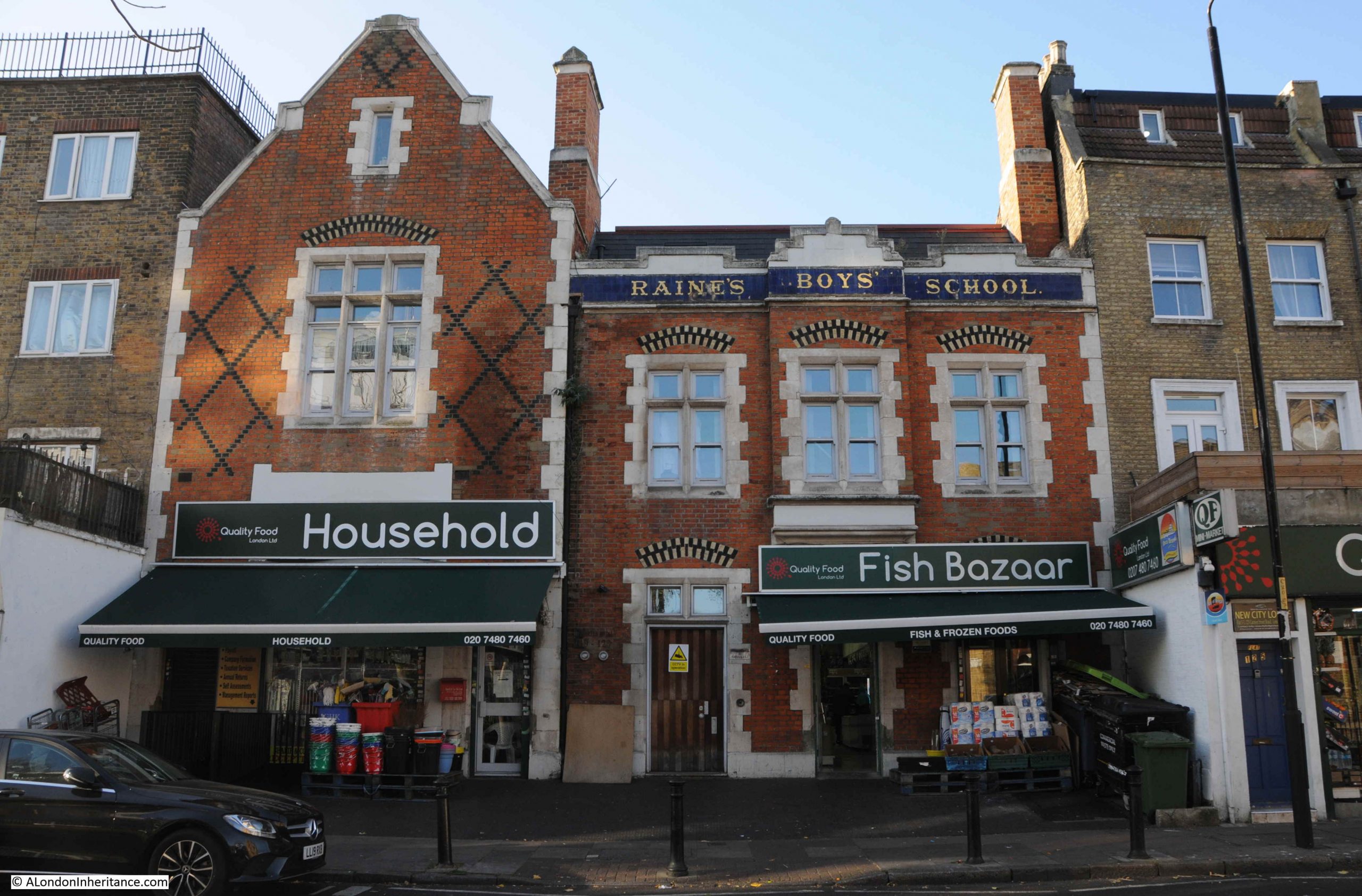
The history of Raine’s schools goes back to around 1719, when brewer Henry Raine opened a school for 50 boys and 50 girls. The original school was in what is now Raine Street in Wapping. The building is still there, although was in a poor state in the 1970s and at risk of demolition. I wrote about the building in this post.
As the London Docks were built, the original school found itself rather isolated from the parish that the school was intended to serve, so in 1875 the Boys element of the school moved to the Cannon Street Road building, photographed above.
The building did not serve as a school for too long, as by the first decade of the 20th century, the buildings used by the school were too small, and the school consolidated into a large building in Arbour Square, just north of the Commercial Road. The building still exists as the Tower Hamlets New City College.
Cannon Street Road had already been home to a form of school / childrens home some forty year earlier when within the street could be found the Merchant Seamens’ Orphan Asylum.
This institute was founded in 1827 to care for the children of men lost at sea.
In 1833, an advert appeared in the Public Ledger and Daily Advertiser stating that the orphan asylum was ready to receive applications for the February election. This seemed to be standard practice for many institutions of the time, where applications were made and these were voted on by a Board of Management (see my post on the General Lying In Hospital, where this approach was taken with Subscribers being able to propose pregnant women for admission to the hospital).
In 1833, the orphan asylum had 41 boys and 23 girls. The advert stated that subscriptions and forms of petition for admittance could be had at the school in Cannon Street Road.
We do not often get a glimpse inside the houses of streets such as Cannon Street Road, however another advert from the Public Ledger and Daily Advertiser on the 12th of September, 1833 reports on the sale of the leasehold residence and contents of number 2 Cannon Street Road, at the direction of the Executors of the late Mr. Richard Neale:
“Leasehold Residence, Cannon Street Road, with Immediate Possession. Household Furniture, Plate, three Watches, Linen, China and Effects – By W.S. FRANCIS on the Premises, No. 2, Cannon Street Road, St George’s East, on Tuesday September 17, at 11, by direction of the Executors of the late Mr. Richard Neale.
The Leasehold Residence, with immediate possession, held for a term of 17 years, at the trifling ground rent of £2. The furniture consists of fourpost and other bedsteads and furnitures, goose feather beds and bedding, mahogany double and single chests of drawers, mahogany nail-over chairs, sofa, secretary and bookcase, looking glasses, Brussels carpet, and various other articles”.
If the contents of number 2 are typical of the street, then the residents of Cannon Street Road seem to have been reasonably comfortable. The house was at the southern end of Cannon Street Road, close to the church of St George in the East.
The southern end of Cannon Street Road mainly consists of post war rebuilding. It was the southern end that received the most damage during the Second World War, the northern section of the street appears to have escaped relatively undamaged.
Much of the north of the street still appears to be 19th century terrace housing, however it can be difficult to confirm what is original and what is a later rebuild.
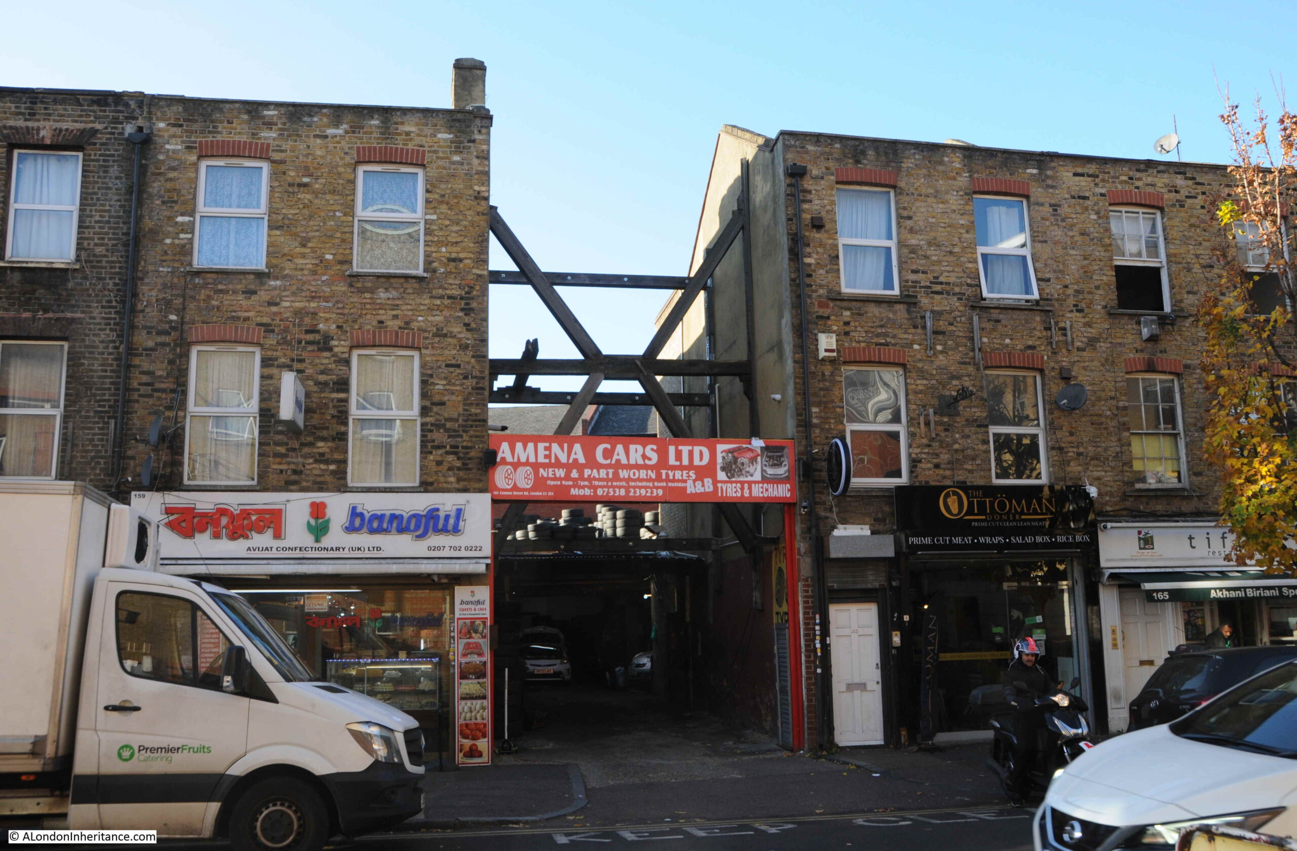
The following photo shows part of the street where I assume a single house within the terrace has gone, to be replaced with an entrance to a car tyre dealers. The houses either side needing some serious support as the terrace has been broken.
Cannon Street Road is part of east London’s expansion north from the original ribbon development along the Thames, and although east London streets have changed considerably over the last few decades, they are still fascinating places to walk as although wartime bombing has resulted in much new building, there is still many of the original terrace houses along the street, along with an ever changing range of shops.
A really interesting post thank you for this. Incredible to see Rocque’s map of 1746 and the fields, squares and open countryside that surrounded the area.
Just woken up by the dog pushing his nose under the duvet this cold, drab, Sunday morning in Downtown Rotherhithe. Reached for my phone to see what’s been happening in this covid world overnight. Saw this London inheritance article and thought let’s read something worthwhile for change. I done the right thing….Thankyou.
My Grandfather b.1891 was brought up in the eastern end of Cable Street when it was Brooke Road pre WW1.
Very interesting post as always. I was particularly interested in the extract from Rocques map because it shows Bluegate Field (adjacent to Cannon Street) which must be Blue Gate Fields where, according to baptismal records of St George in the East, an ancestor of mine was born circa 1765.
Anyone know what schmultz is? Variation on schmaltz?
Now you have brought tears to my eyes! Cannon Street Road was my home until 1999. Shopped at Rogg’s frequently. The frequency with which the Bengali shops closed suddenly to reopen the next week with the ‘under new management/ownership’ banner out front kept things interesting.
I left reluctantly but urgent family needs took precedence.
TY
You could trace the history of the East End via these little local food shops and the type of food they sold and served. Back in the 80s and 90s spices ,balti dishes and ( my favourite) sweet cakes made of condensed milk and pistachios; 60s and 70s jewish delis with salt beef sandwiches on rye bread and thick slabs of cheesecake;before that italian food shops with olives, handmade pasta and cheeses we’d never heard of, all of which would cost a bomb nowadays in some chichi food boutique in a theme market.
An interesting little cafe in naughty Windmill Street off of Shaftesbury Avenue and cheek to cheek with the striptease revue, had been run by a jewish family for generations. The walls were covered with photos of East End boxers, with pride of place given over to ‘ the Kosher Killer’.
>> The shop was at the end of a terrace of mixed date and designs. I am not sure if the building of which Rogg’s was the ground floor shop, has had a rebuild as the bricks look too clean and the corners / sides of the building are a little too sharp and clean for a building of some age…
According to the Tower hamlets website, there has been one planning application in connection with 137 :-
https://development.towerhamlets.gov.uk/online-applications/applicationDetails.do?keyVal=DCAPR_18907&activeTab=summary
Interestingly, there have been numerous planning applications connected to the Golden Lion public house at 135 Cannon Street Road, London E1 2LX. I assume that was on the other corner of Burslem Street ?
It seems as if Cable Street was once Bluegate Field and Knock Fergus showing the agricultural nature of the area. A brilliant post – as usual. Thank you and well done.
Part of my weekly routine now! As usual, an excellent piece. My family came from Rotherhithe, Perseverance Street originally, several moves and finally Trident Street. I believe but can’t prove it, that my G. G. Grandfather ran the Angel on Bermondsey Wall, his name was John Taylor. They eventually went to Kent as fisherman and revisited the area on the opposite banks of the river to off-load their catches at the Town of Ramsgate, coincidentally they settled in Ramsgate too.
I’ve been following your emails and posts a few years now but this one is very special to me and I’d like to especially thank you for it. I’m originally from Bangladesh and spent my teen years in that area. The area was really grim but pockets of gentrification have transformed it. Every time I’d walk past Rogg’s I’d wonder what on earth Shmultz was – there was no Worldwide Web in the 1980s. Come to think of it I still don’t know what it is – off to Google it now!
Rogg’s! That brings back lots of memories for me and my brothers. We used to call in there on the way back from Brick Lane to Wapping in the 60’s, for pickled herrings. We can remember there used to be a wooden barrel just inside the door in which they were stored. Rogg’s also sold packets of Latke mix; our dad was a dab hand at making these lovely potato and onion patties.
Apparently “schmaltz herring” are extra fatty ones, caught just before they spawn: https://en.wikipedia.org/wiki/Schmaltz_herring
I guess “schmultz” here is a variant pronunciation/transliteration of שמאַלץ – “schmaltz” (originally goose or chicken fat). Compare “Schmalz” (fat) in German.
Brilliant evocative pictures spent a whole evening reading some of the previous blogs great stuff.
My great great grandfather, William Osborne, was the publican of The Duke of Wellington in the later part of the 19th century. He also owned a considerable amount of property in the bow area. He had many children one of whom was my great grandfather, Robert Osborne. Robert married Catherine Cook from Bromley by Bow. Her father was a ship’s trimmer in the docks. Robert left bow in the early part of the 20th century with his wife and 3 eldest children to seek a new life in the valleys of South Wales. My grandmother, Lilian Loretta, born 1903 was his eldest child. She entered service upon leaving school possibly aged 14. Her parents had tow more children, Harold (who later died fighting in Burma) and Violet. Upon the early death of both her parents my grandmother, now married to Thomas John Lewis, and with my father as a new baby, left Woodfieldside, Blackwood to return to Bow in order to get support from the family. She took Harold and Violet but left her brother, Robert, at Abergavenny Mental Hospital as he had epilepsy and this was considered a mental illness in the 1920s. Her other sister, Ivy, married Pete Barwick. Pete’s elder brother had married her aunt, Lilian Loretta. Harold married Rose but they had no children before he was killed in action. Violet married Robert Hancock and they had a son and daughter Carole and Robert. Vi’s father, brother, husband, son and son in law were all called Robert. She died at 97 and was able to provide lots of information about the family including William who ran The Duke of Wellington. My grandmother, her eldest sister, died in 1971 and had spoken very little about her past. All I knew was her parents had died very young. My mother told me she had told her that the grandfather was very wealthy and he used to count out sovereigns.
Have really found this interesting!
I wonder if anyone knows of/ remembers a PUB called ‘The Great Eastern Hotel’, 31 Ashwell Rd, Roman Road, Bethnal Green E3?
My Great Grandfather was Landlord there for some years back in the 1930’or 1940’s and I’m trying to collate info