
This week, I am very close to Monkwell Street, the subject of a post a couple of weeks ago. I was going to include this location in the Monkwell Street post, but I did not want to inflict an even longer post on you, so Bastion 14 in Cripplegate gets its own post. At the end of the post, I also have a couple of photos of an archaeological dig in the City which I need help identifying.
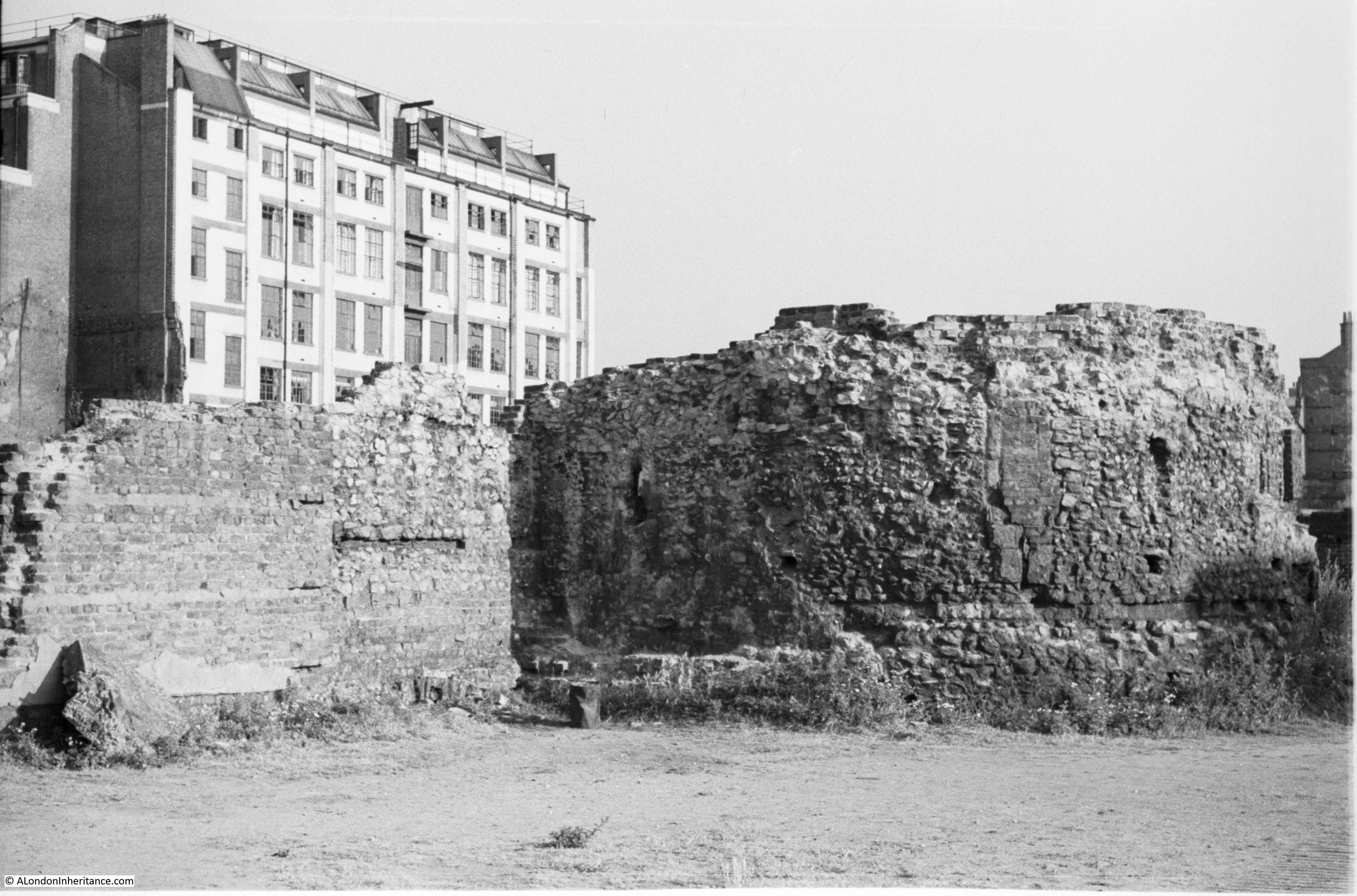
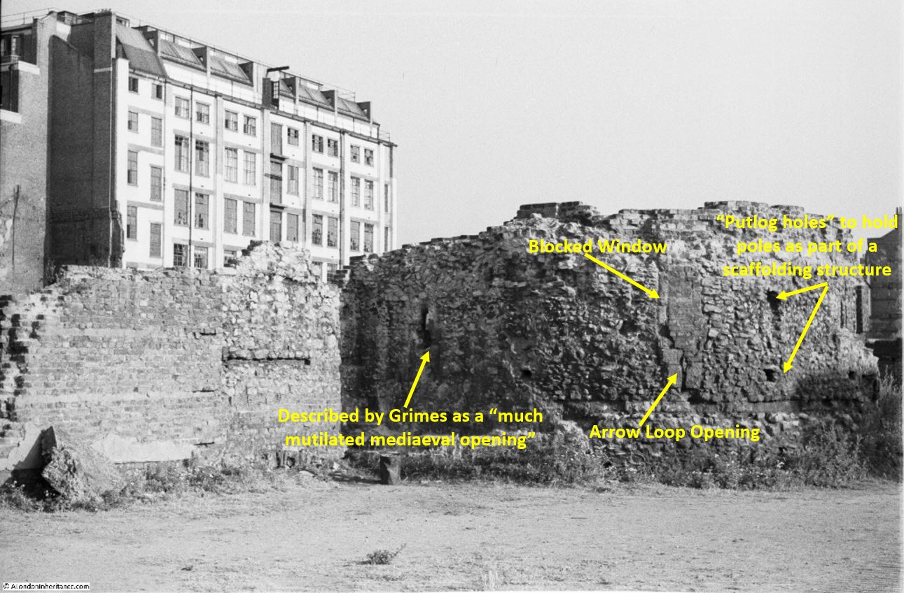
The following is my father’s 1947 photo of Bastion 14 of the Medieval City wall. The bombed buildings have been cleared away from around the bastion, which is now almost fully exposed, for the first time in many years.
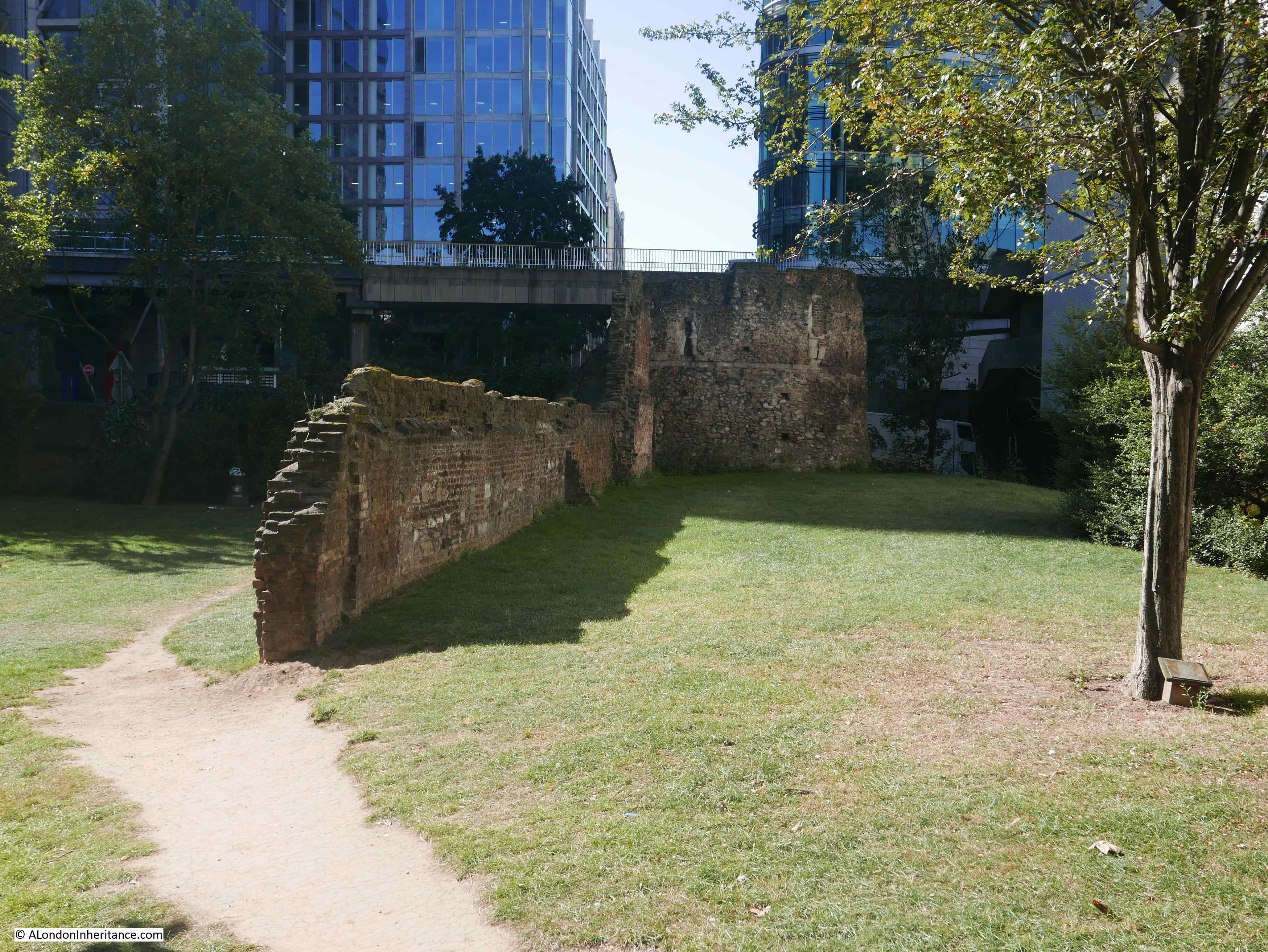
This is Bastion 14 today:
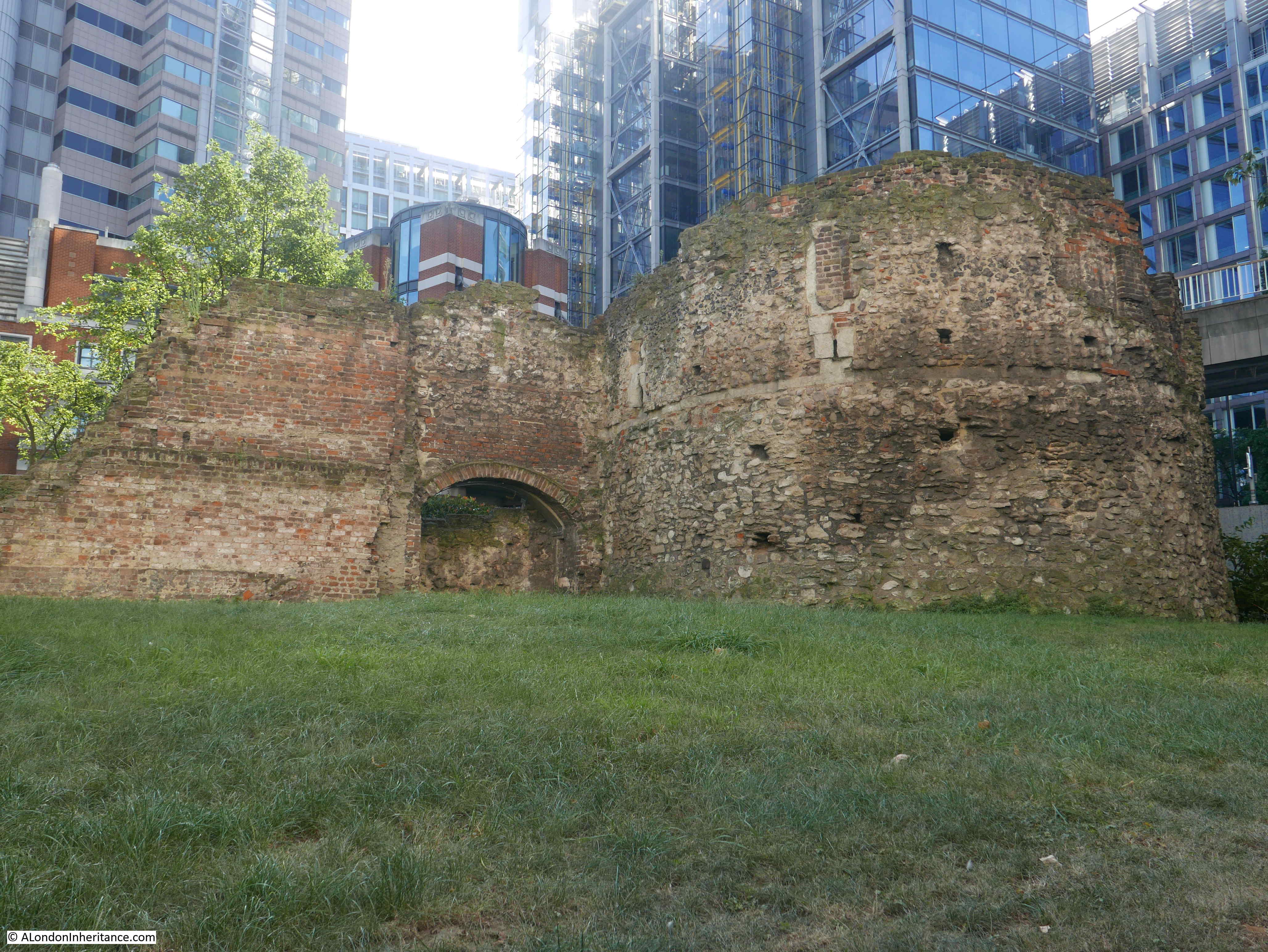
The main difference between the two photos is the height of the bastion. In 1947 only part of the structure was above the surface. Future development including the nearby build of the Museum of London, the Barbican and the landscaping of the green space along the line of the old Roman Wall, resulted in the lowering of the ground level and the exposure of a considerable part of the bastion.
Some of the features on the external wall of the bastion can be seen in both photos. The brick line along the top of the wall extending from the left of the bastion is also the same, although the lowering of ground level has revealed the arched feature in the lower part of the wall.
In the background of today’s photo are the glass and steel office blocks that now line London Wall, whilst in the 1947 photo, the Wood Street telephone exchange is in the background.
Bastion 14 is one of a number of bastions that line the route of the north east corner of the Roman Fort / City Wall, just to the south of St Giles’ Cripplegate. The following map shows the location and numbers of the bastions I will cover in today’s post (Map © OpenStreetMap contributors).
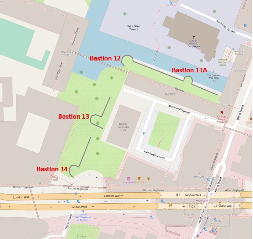
The map shows the green space that was created as part of the post war development of the area. It is now possible to walk from London Wall, through the green space up to Bastion 12. The redeveloped Barber Surgeons Hall is set back from Bastion 13.
The area was so very different before the devastation of the Second World War. The following map shows the area in 1894:
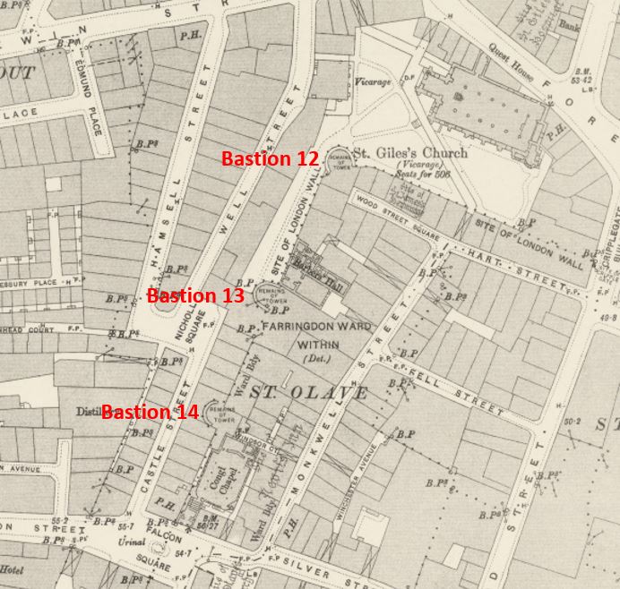
Credit: ‘Reproduced with the permission of the National Library of Scotland’
The map shows that in 1894 Bastion 14 was not free standing, indeed it was an integral part of the buildings that ran along Castle Street. To take today’s comparison photo, I was standing roughly where Castle Street once ran looking up at the bastion.
Part of Bastion 13 was visible, and the structure was part of the Barbers Hall. Bastion 12 was facing on to the churchyard of St Giles.
I am gradually documenting how the area has changed. In the above map you can see Monkwell Street, covered in this post and immediately to the south of Bastion 14 is now the new route of London Wall covered in this post.
The following photo is looking west along the southern edge of Bastion 14. London Wall is immediately to the left, and the entrance to the underground car park that runs under much of London Wall can be seen to the lower left.
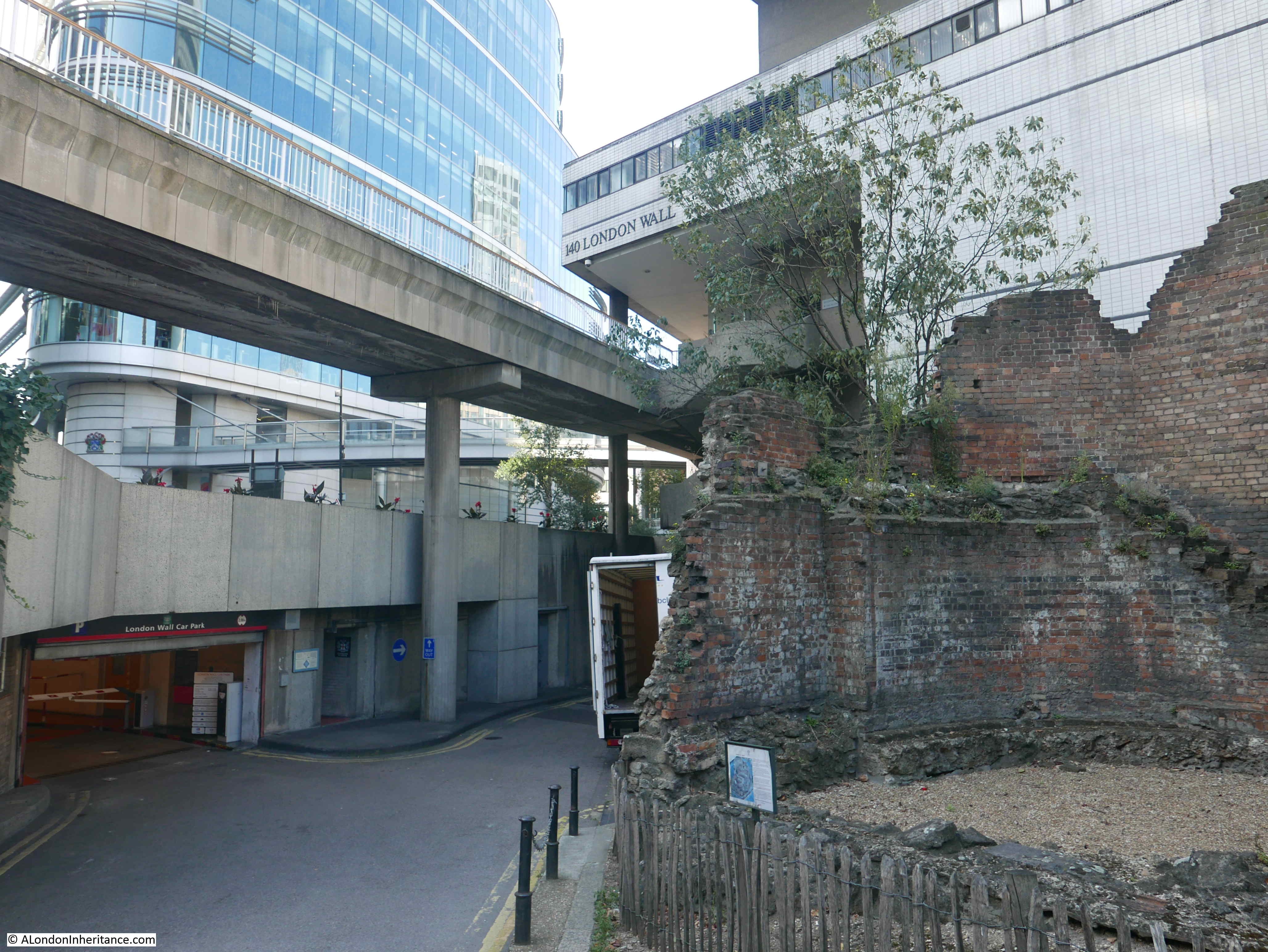
There is a Roman wall (not part of the City wall) in the underground car park – a subject for a later post, and for those who walk London, there are some toilets just inside the entrance.
The story of the post war excavation of the bastions is just as interesting as the history of these structures. There are two excellent books I have used to research the bastions, these are:
- The Excavation of Roman and Mediaeval London by W.F. Grimes (Routledge & Kegan Paul Limited 1968), and;
- Excavations at Medieval Cripplegate, London by Gustav Milne with Nathalie Cohen and contributors (English Heritage, 2001)
Professor W.F. Grimes was the excavation director for many of the post-war excavations across the City and his book is a fascinating read covering many of these sites, and Gustav Milne’s book covers the post war archaeology between 1946 and 1968 of Cripplegate with a detailed review of post war work and a modern update and interpretation.
The bombing of London resulted in large areas of destruction across the City. As many of my father’s photos show, buildings had been demolished down to their foundations and cellars to remove any danger of the walls collapsing and to prepare the areas for whatever development would be coming next.
This presented an opportunity to excavate and discover what lay beneath the surface – an opportunity never before available on such a scale. However, as with all things, archaeological excavations cost money, and after the war, money for such work when there were so many other demands was not easily available. The Ministry of Public Buildings and Works contributed £26,300, and Grimes’ book records several pages of donations from Business, Livery Companies and individuals, with the names of those donating down to £1 being recorded.
The scale of the work was such that the Society of Antiquaries in London formed the Roman and Mediaeval London Excavation Council to organise excavations across the City, and work began in July 1947.
Grimes writes that there were some twenty one bastions known or recorded along the City walls, with the stretch to the south of St Giles having a number of the bastions that have survived, with Bastion 14 being the best preserved.
The bastions are not Roman, they form part of the medieval City defences and were built up against the medieval wall, which used the Roman wall for foundations. Their use as a defensive structure did not last long and for much of their time they were used for other purposes, and with Bastion 14 that included being an integral part of a warehouse built across the site.
A quantity of pottery was found at the base of the excavated bastion during the work in 1947, however it was not till later that this was used, along with other findings during the excavations, to firmly date the bastions to the thirteenth century.
Bastion 14 displays medieval stone work and features on its outer facing, but internally the bastion has been faced with much later brickwork and other features. The following photo shows the internal view of Bastion 14.
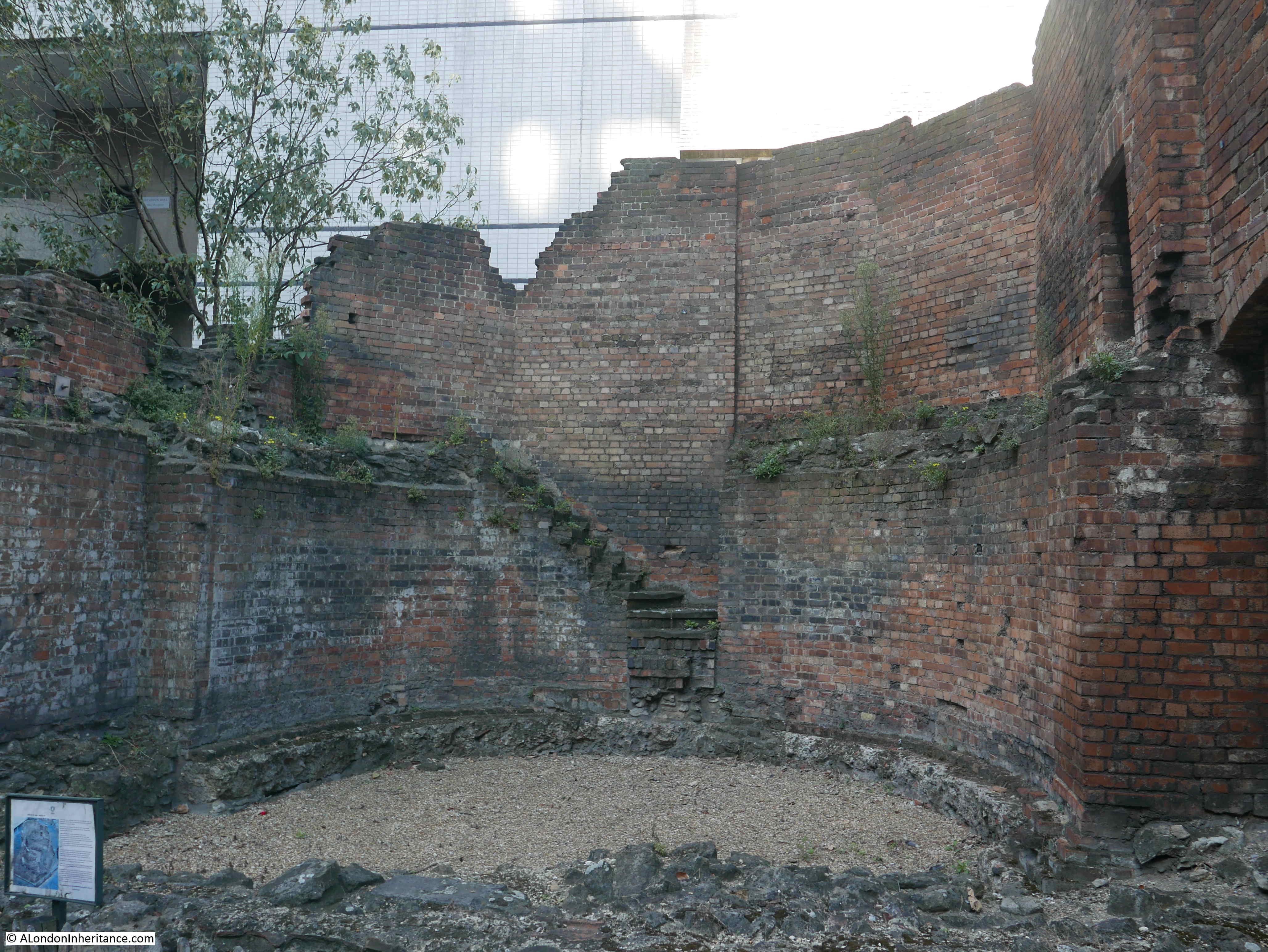
In the above photo, the gravel covering the floor of the bastion marks the floor level at the time of the excavations. The work digging below this floor level revealed a number of finds that helped date the bastion and also exposed the medieval base of the bastion.
The following photo is from Grimes’ book, and I have identified the main features of the bastion. By comparing with the above photo, you can see where the floor level was dug out revealing the medieval base.

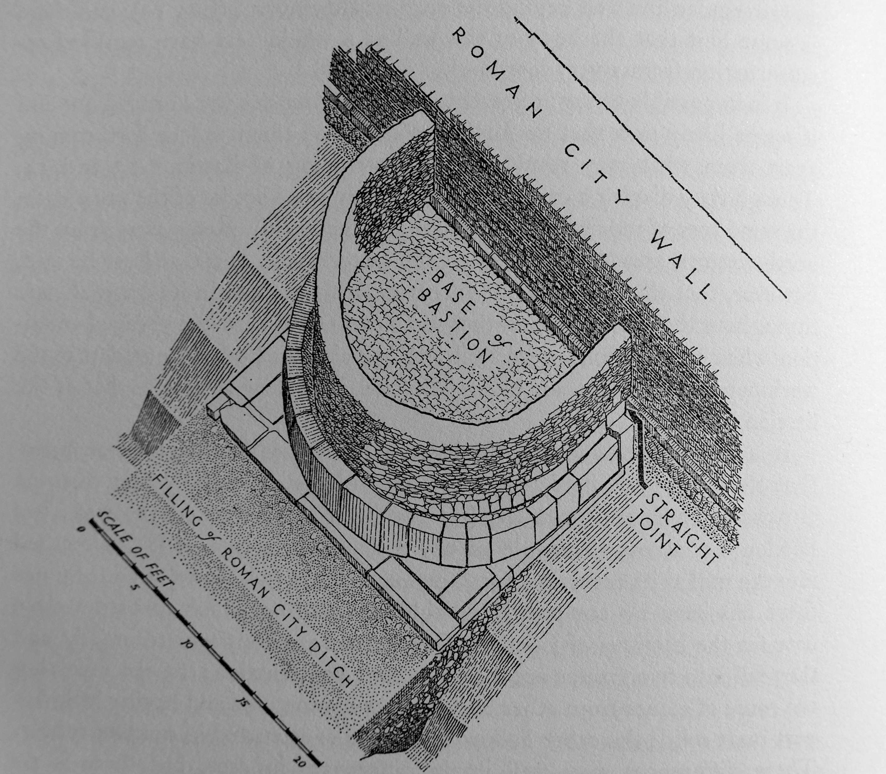
Grimes included the following drawing of Bastion 11 at All Hallows on the Wall in his book. It looks very similar to Bastion 14 with the bastion built up against the line of the original Roman wall, with the City ditch falling away in front of the bastion.
The reduction of ground level in front of Bastion 14, and the way the ground slopes down from the base of the bastion means the view today must be very similar to when the bastion was originally built.
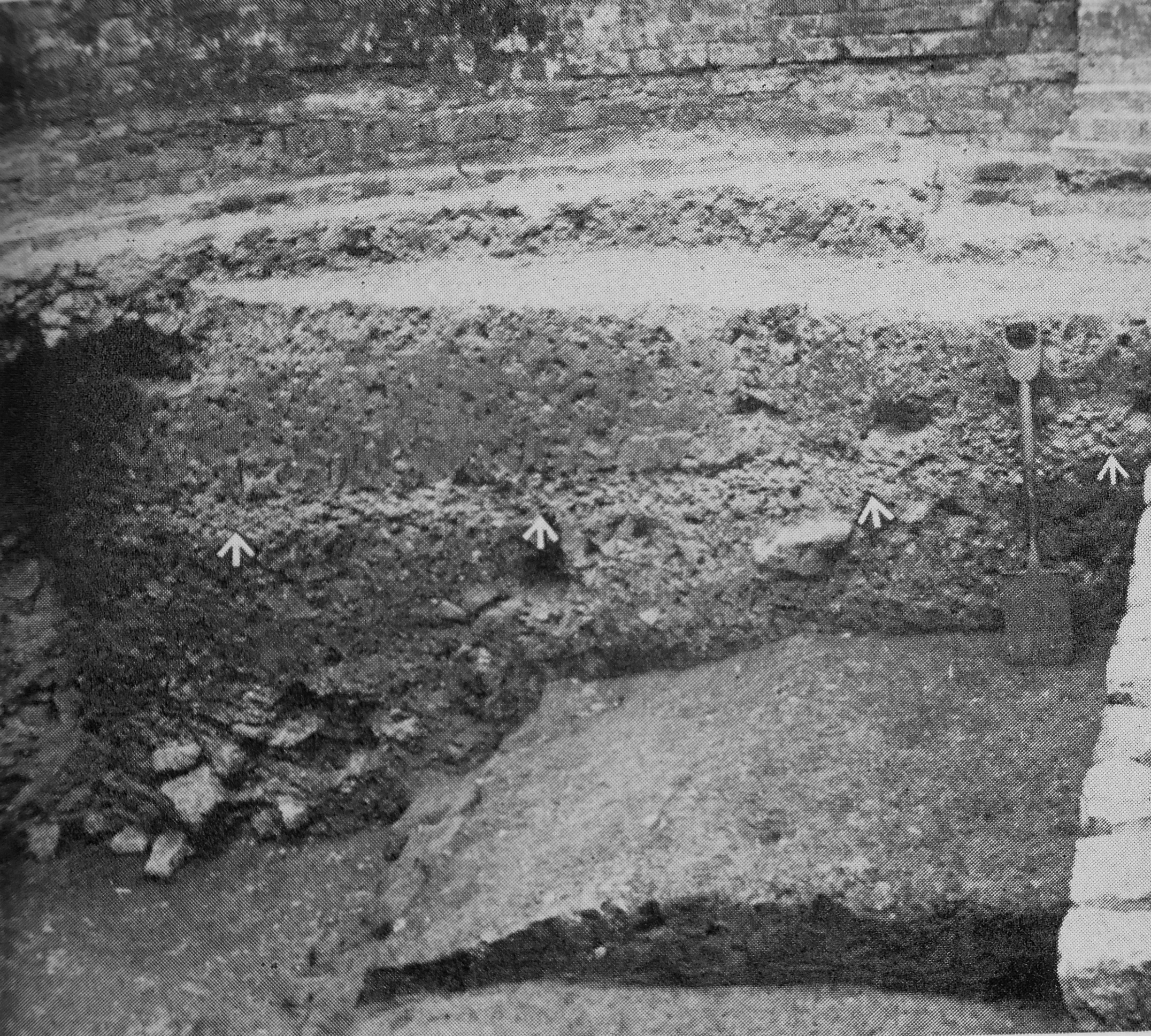
Grimes also included a photo in his book showing a section cut through the interior of Bastion 14 “showing gravel floor (arrows) overlying the Roman city ditch, its inner end coinciding with the top of the Roman fort wall (extreme right) as surviving”.
The exterior of the bastion retains a number of early features which are still visible today. I have labelled these on my father’s photo of Bastion 14.
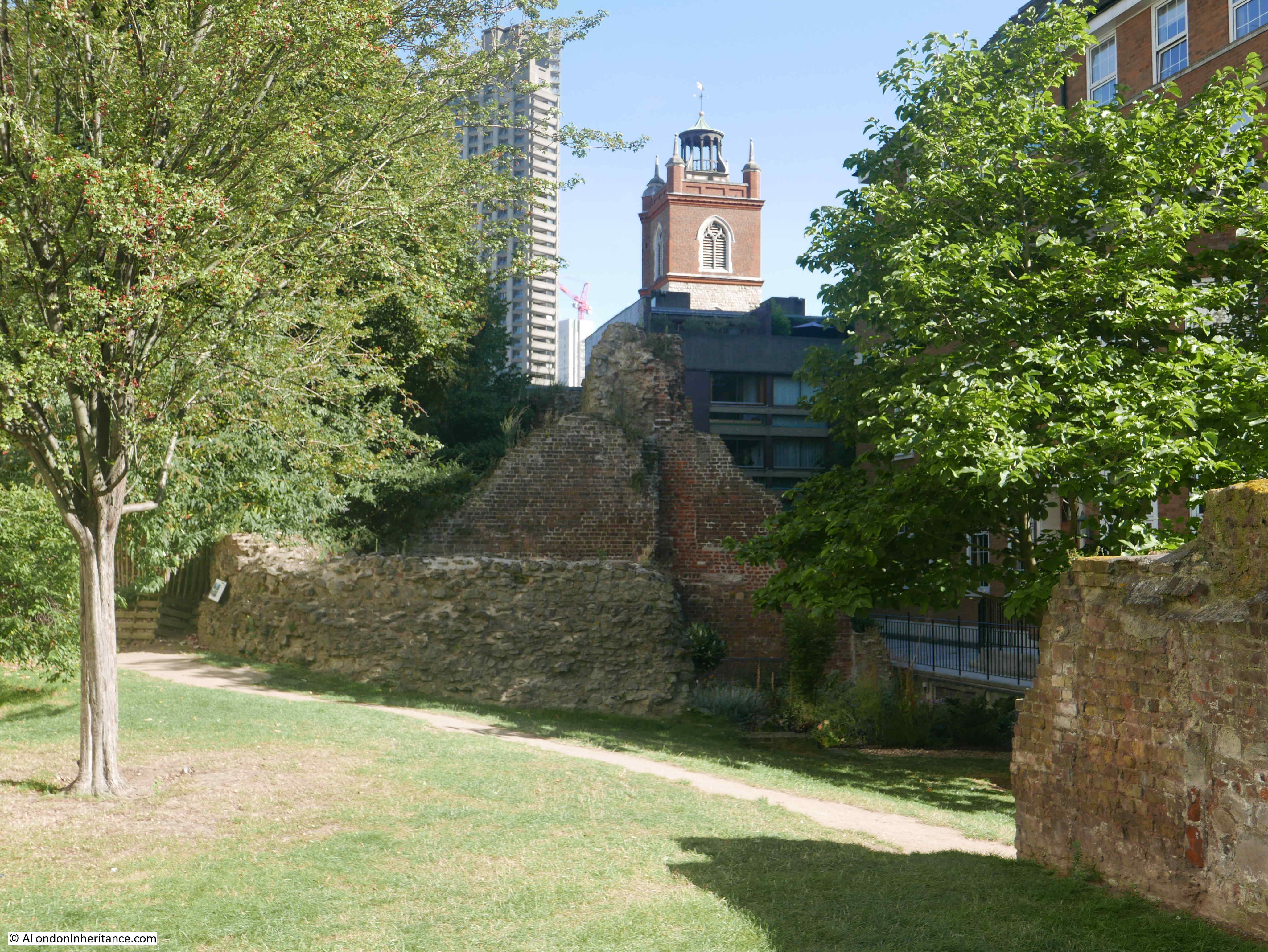
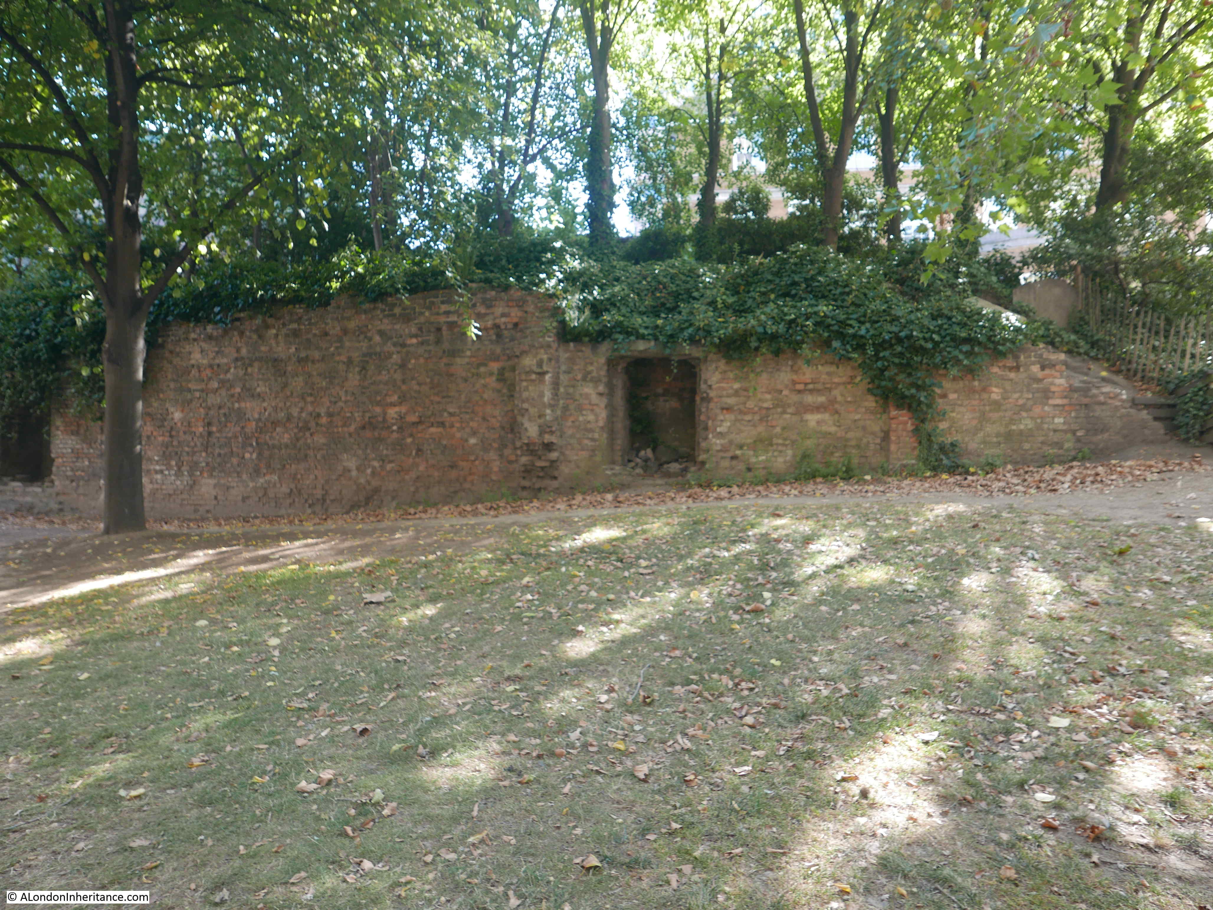
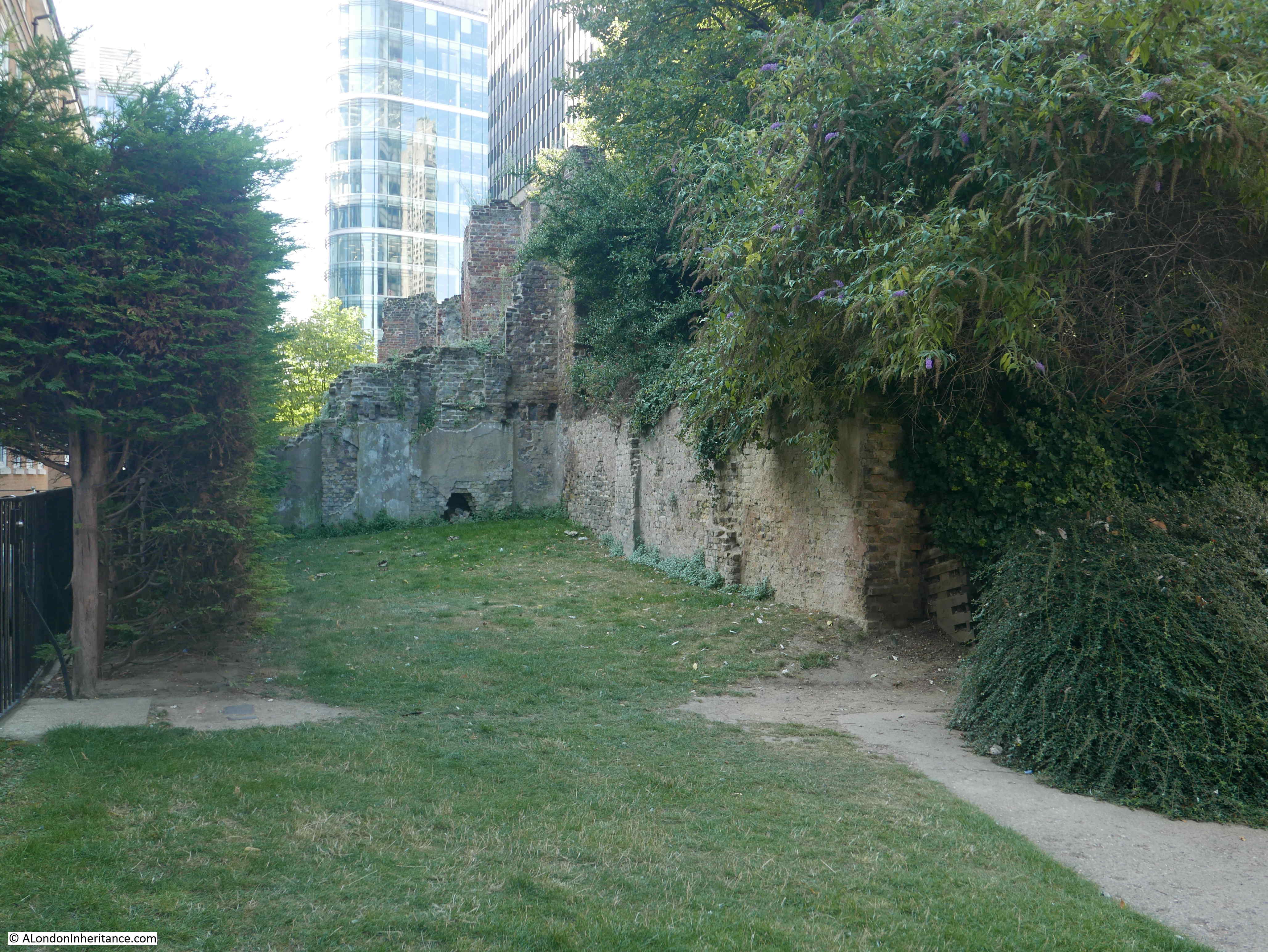
The area between bastions 14 and 12 is a lovely bit of green space, and as well as the bastions, parts of the walls remaining from the buildings that occupied the site can still be seen.
This is the view looking back at Bastion 14 from the north, with a line of wall extending from the bastion (built on the original alignment of the Roman Wall). London Wall is on the elevated structure behind the bastion.
The following view is looking in the opposite direction to the above photo, and shows the post war Barber Surgeons Hall.

The location today of Barber Surgeons Hall is slightly different to the pre-war location and the large bay windows are relevant to the previous location.
The hall was originally built right up against Bastion 13, but as part of the planning for the new hall, it was a requirement to move the hall 30 feet to the east, separating the hall from the bastion (see my post on Monkwell Street).
That is the reason for the gap between the hall and Bastion 13 which is shown in the following photo.
Grimes writes that Bastion 13 was once part of the courtroom of the Barber Surgeons Hall, the shape of which is today mirrored in the large bay which now faces the bastion across the 30 foot gap,
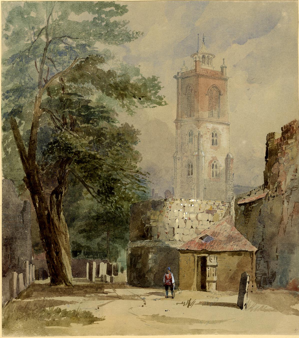
Bastion 13 is not in such good a condition as 14, and as well as once forming part of the Barber Surgeons Hall, the north west section was at the end of St Giles churchyard which as can be seen in the 1894 map above, originally curved around Bastion 12 and had a narrow extension down to Bastion 13.
Grimes writes “Bastion 13 survives only to the level of St Giles’ churchyard and has suffered extensive mutilation in other ways. Recent investigation has shown that on the north externally it ends on the city wall; to the south the junction has been destroyed. Internally, the ends of the bastion have been cut away or underpinned by modern foundations. In spite, however, of the low level of the cellar enough remained to show that the foundation, a little over 2 feet deep, was set in the floor of the Roman city ditch, the base of which has survived”.
A closer view of Bastion 13 and the adjacent Barber Surgeons Hall:
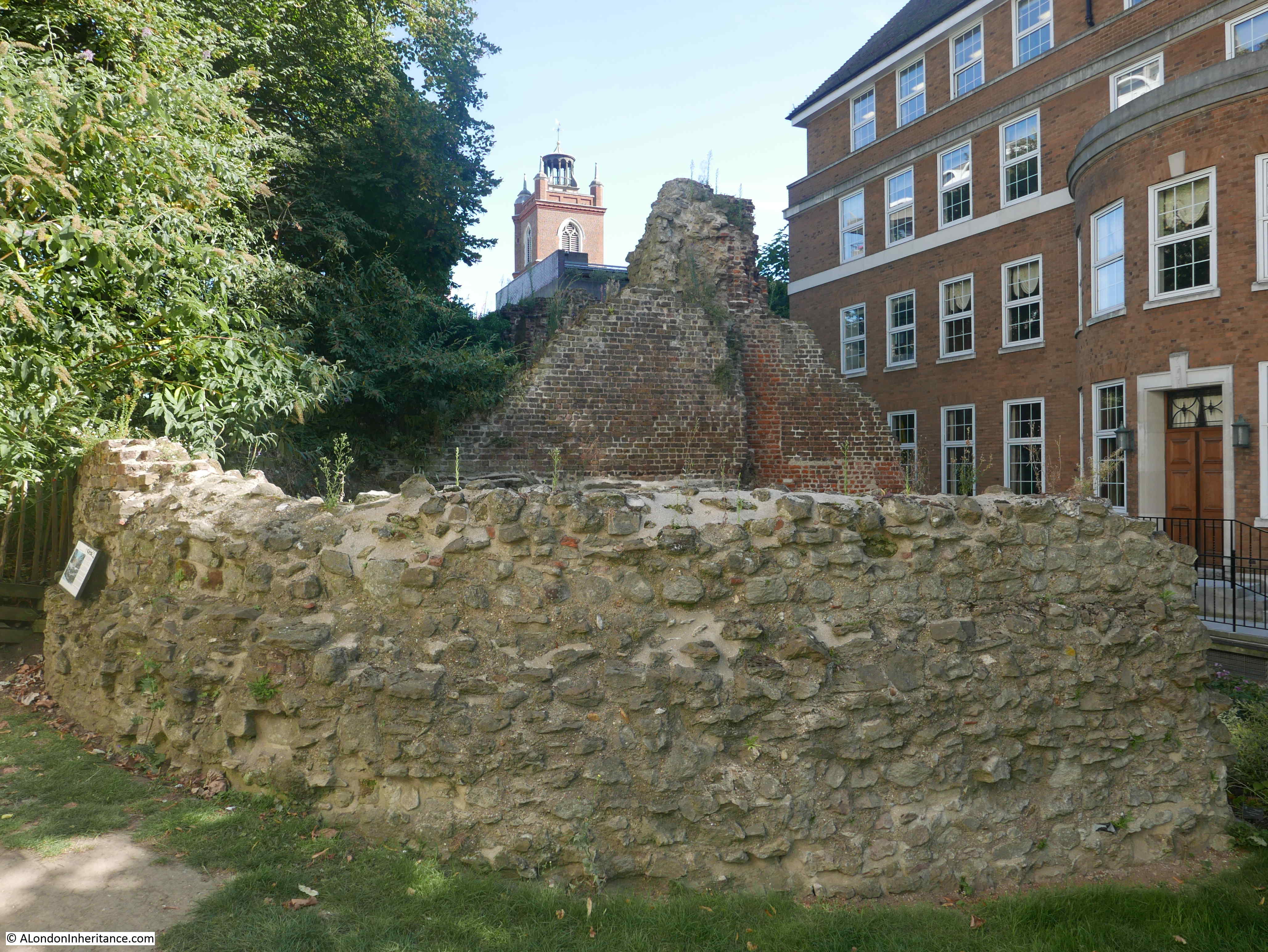
Continuing walking north and there are more walls from the buildings that once stood here.
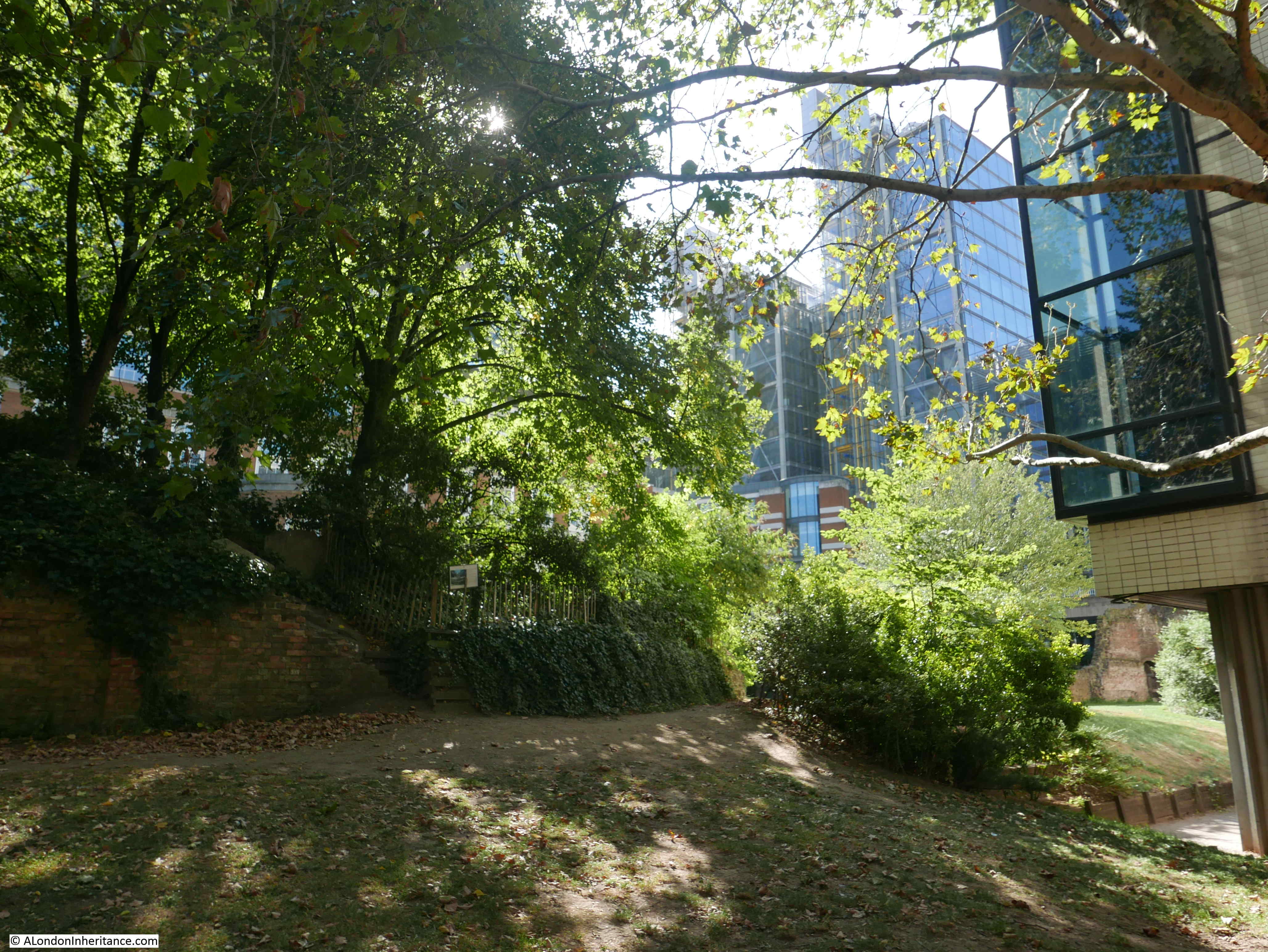
On a sunny morning it is hard to believe that you are so close to London Wall and the Barbican:
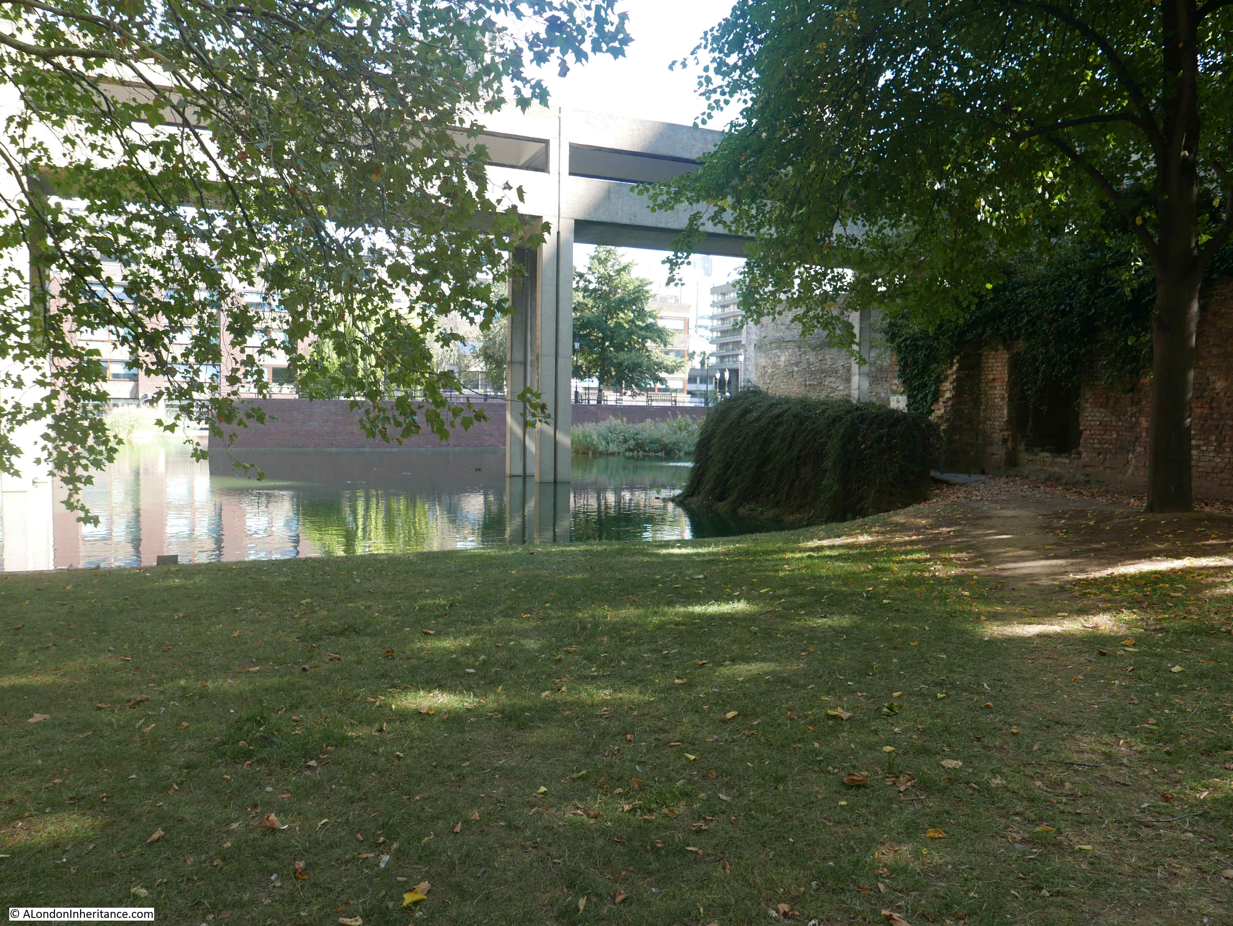
Approaching the northern end of the green space, part of what was St Giles’ churchyard and the buildings along Well Street have disappeared under one of the lakes built as part of the Barbican development.
At the end we find Bastion 12 which formed the north west corner of the Roman Fort / City Wall, and from here the wall turned to the right, running to the south of the church which was “without” the City wall.
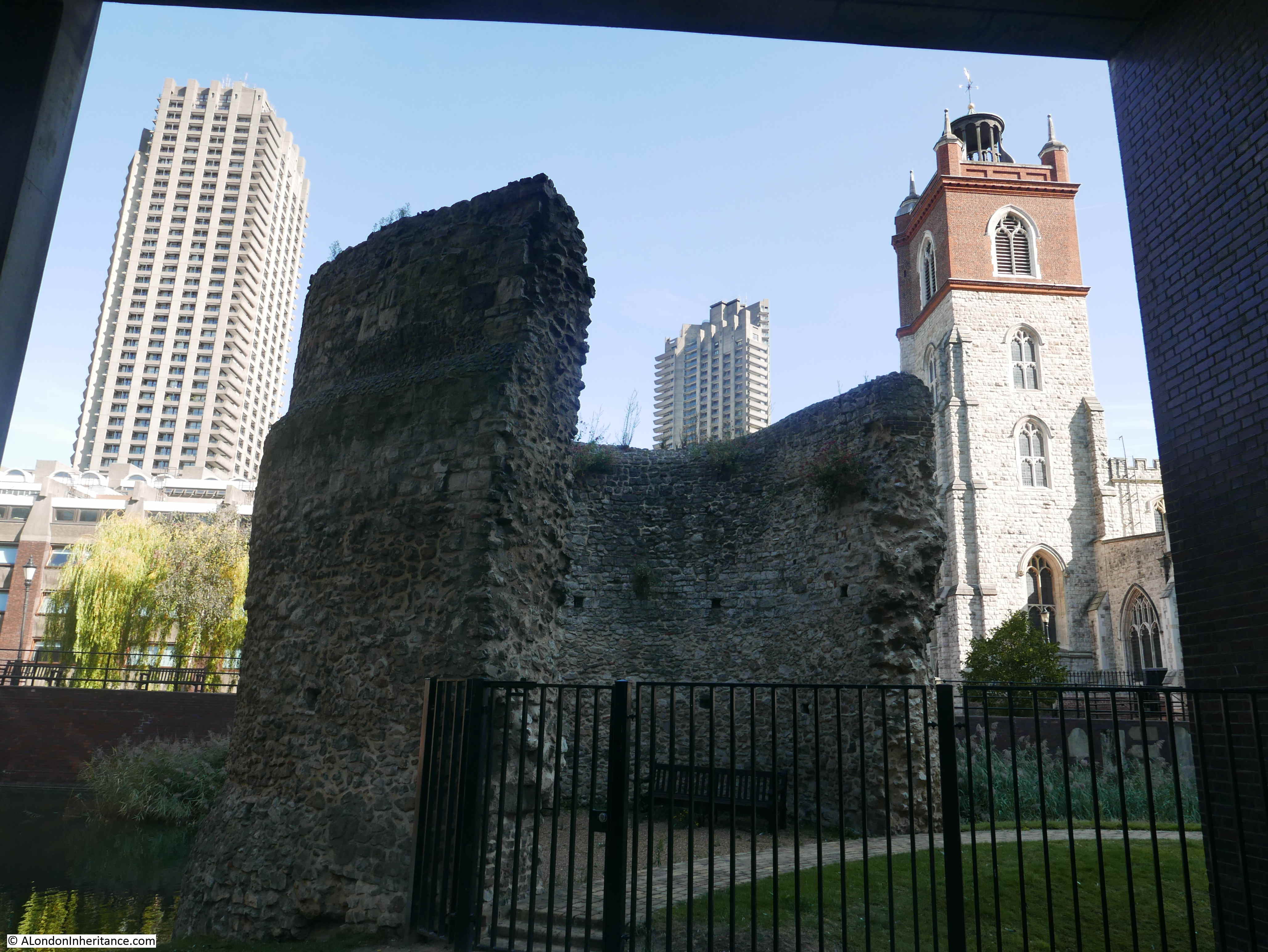
Grimes does not have too much to say about Bastion 12, and refers to it as “the well known Cripplegate bastion”. Bastion 14 had been hidden within pre-war buildings, Bastion 13 had been part of the Barber Surgeons Hall, so they were the main points of interest.
In Gustav Milne’s book, reference is made to the bastion as standing “some 9m above the contemporary ground surface, which has been substantially lowered since the 1950s during landscaping”. So, the exterior probably looked like Bastion 14 in my father’s 1947 photo with much of the bastion still below the pre-war ground level.
Bastion 12 was excavated in 1947, but unlike Bastion 14, no artifacts were recovered from the interior. The bastion had already been excavated at the start of the 20th century and it had been through a number of restorations which made interpretation of the age of phases of the bastion somewhat complicated.
Bastion 12 may have been part of Lamb’s Chapel which I explored in my Monkwell Street post.
Looking back at some of the pre-war walls that remain:
The following print from the LMA Collage archive and dated 1779 shows Bastion 12 at the point where St Giles’ churchyard curves round to extend down to Bastion 13.
 Image credit: London Metropolitan Archives, City of London: catalogue ref: q4769128
At the right edge of the print is Bastion 13 as it was included in the Barber Surgeons Hall. The following print from 1800 shows the bay extension to Barber Surgeons Hall in detail. The medieval bastion 13 was incorporated within this feature.
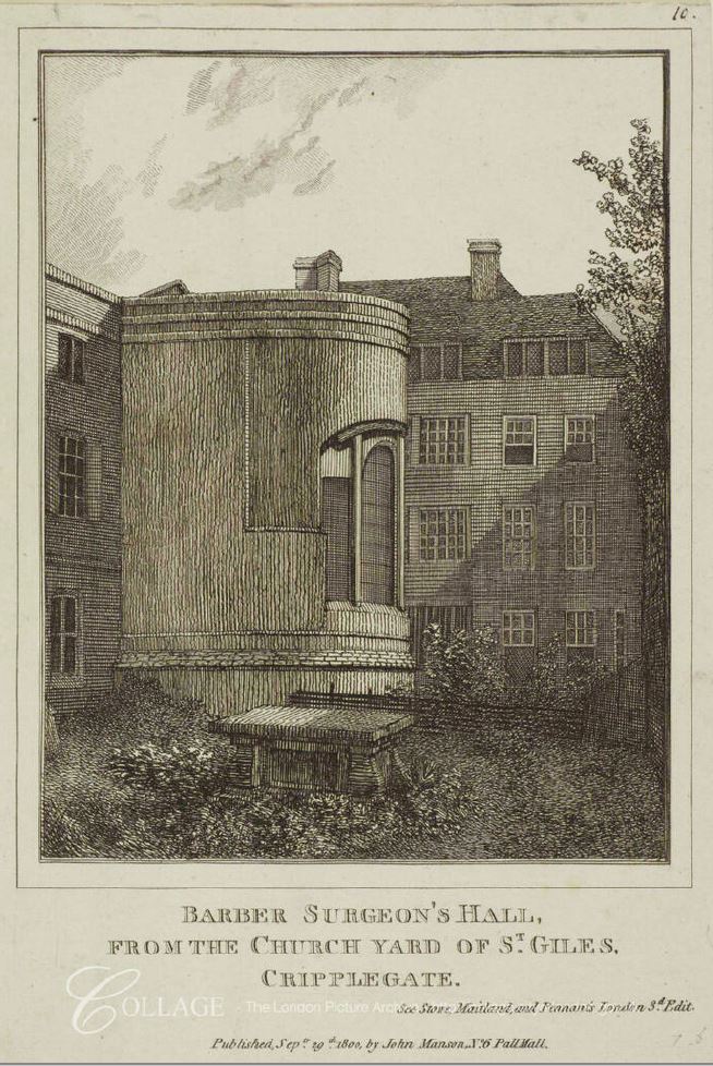
Image credit: London Metropolitan Archives, City of London: catalogue ref: v9041147
The following print from 1841 shows Bastion 12 with the churchyard of St Giles’ curving round the bastion © The Trustees of the British Museum.
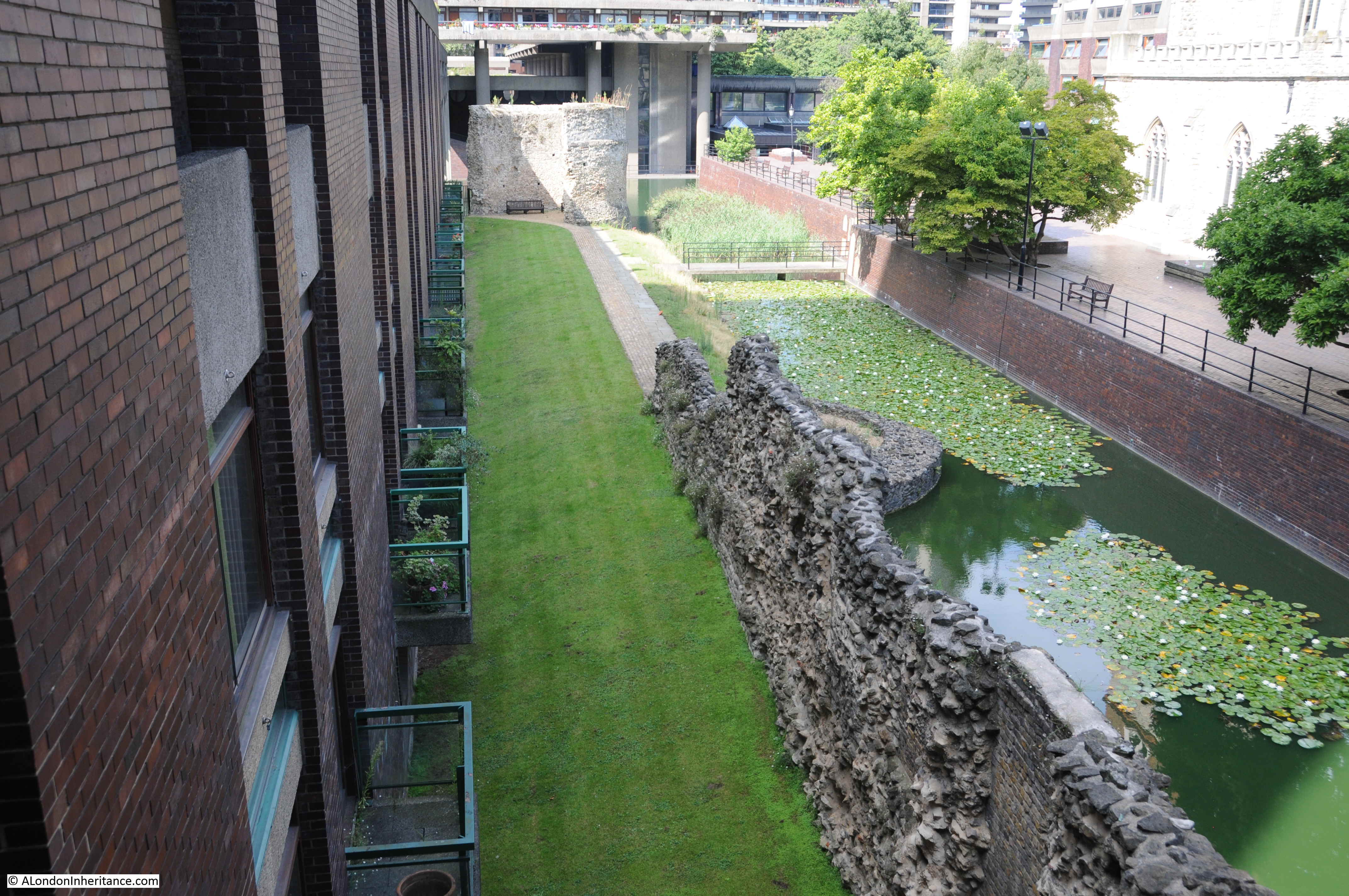
Grimes book was published in 1968 and allowed some discoveries to be included which had not been part of the original excavations. As part of the Barbican development, the churchyard around St Giles’ was lowered ready for the Wallside building along the southern edge of the development, with space for grass and a water feature.
This lowering of the ground level revealed the remains of a new bastion. This was identified as Bastion 11A as it was between the known Bastion 12 and Bastion 11 at All-Hallows-on-the-Wall.
This new bastion survived as two curving stumps built against the city wall. The outer part had been cut away by a 17th century sewer which had been following the line of the ditch built along the external side of the city walls.
The remains of Bastion 11A can be seen in the photo below which is looking along the remains of the city wall towards Bastion 12. The remains are the low curved stones jutting out into the water.
These bastions provide a fascinating glimpse of the medieval defences of the city, and how London made use of these features as the need for a walled city was replaced by the ever expanding need for warehouses, housing and halls. Thankfully the integration of bastions 13 and 14 meant that they survived, and Bastion 12 seems to have survived as the corner feature of St Giles’ churchyard.
I suspect that there was concern as to whether the bastions would survive the redevelopment of the City. On the 12th October 1942, a Mr Sydney R. Jones wrote to The Times:
“Recently I proceeded from Guildhall to the garden of St John Zachary and its adjacent neighbourhood to find not only interest but excitement as well. It is now possible to trace the line of the Roman wall in a manner which has not been known for hundreds of years. A sharp eye may detect many relics of the rampart incorporated in the work of subsequent buildings. These show all along London Wall on each side of the upstanding relic that had always been visible in the disused churchyard of St Alphage. At St Giles, Cripplegate, the wall joins the well-known bastion, and at that point, the right angled turn, carrying the wall southward, may be plainly followed until it meets another bastion which, though known of, hitherto has remained hidden. The once hidden bastion, now in full view, and other relics make a visit to this spot well worth while for those interested in the story of London. I do hope that all these Roman remains will be adequately recorded, for they may be lost for ever when London rises again glorious on its ancient foundations”.
My father took the original photo in the same year as W.F. Grimes had started excavations. He was limited in the number of photos he could take by the cost and availability of film, but it is always frustrating when looking at these photos as I always wonder what else could be seen – could he have photographed the inside of Bastion 14 and seen the excavations underway?
The book by W.F. Grimes provides a fascinating account of post war excavations across the City of London, and the book by Gustav Milne, along with Nathalie Cohen and contributors provides an equally fascinating update and appraisal of these excavations of Roman and Medieval London. Together they provide a comprehensive view of how our understanding of Roman and Medieval London developed during the later half of the 20th century.
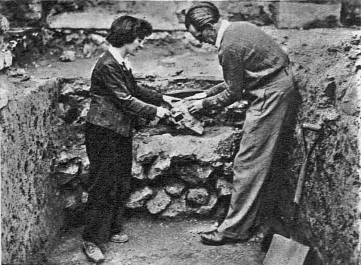
The Sphere on the 15th November 1947 included a report on the excavations with the following photo of “Mr W.F. Grimes, Keeper of the London Museum, assisted by Miss Adrienne Farrell, a volunteer worker”:
An Unknown City Excavation
I have recently scanned more of my negatives and came across a number of photos of an excavation somewhere in the City in the early 1980s. I cannot remember where it was and did not make any notes, so would be really grateful if by any chance, a reader recognises the site:
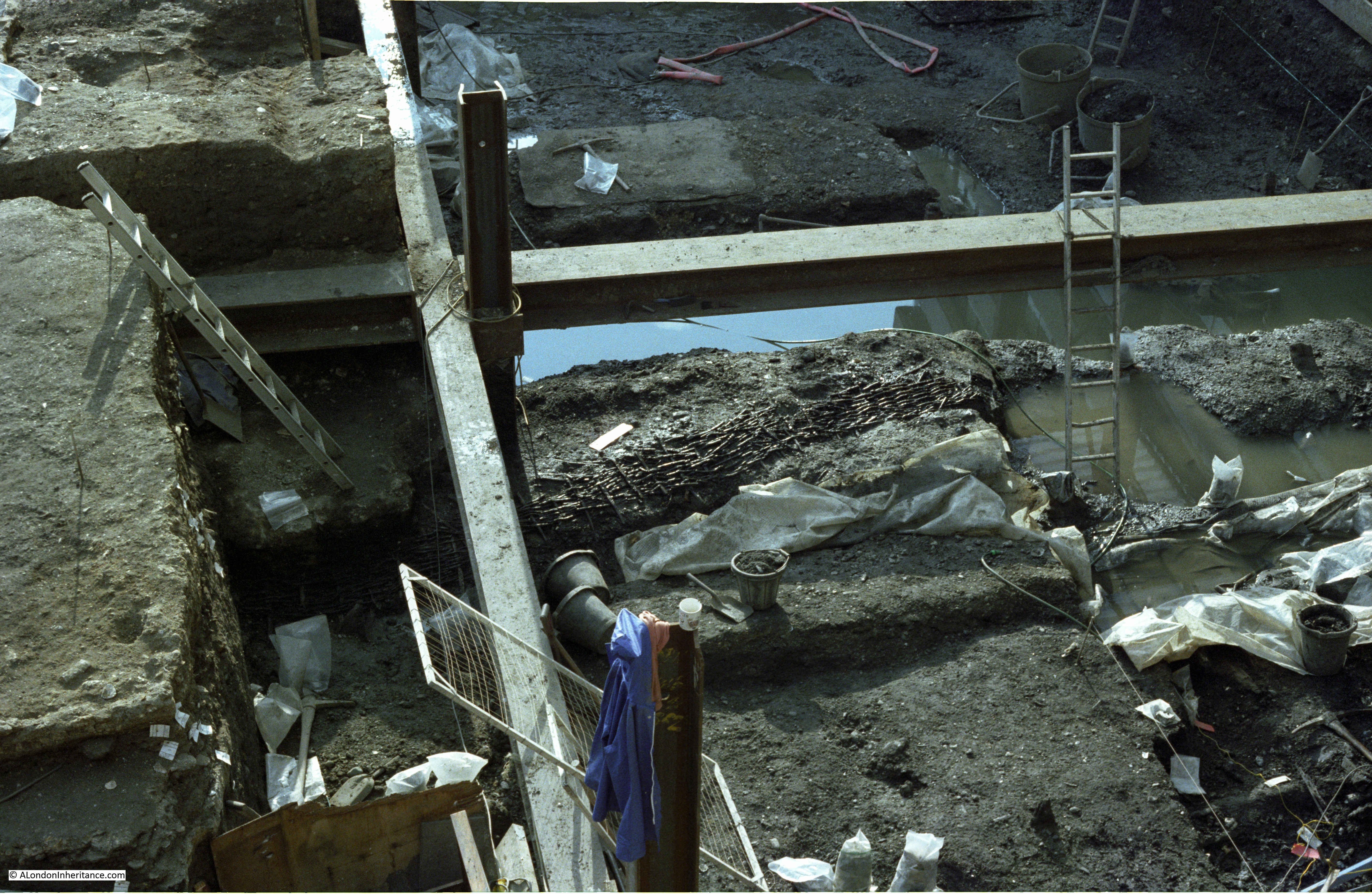
There are some interesting features exposed at the bottom of the excavations.
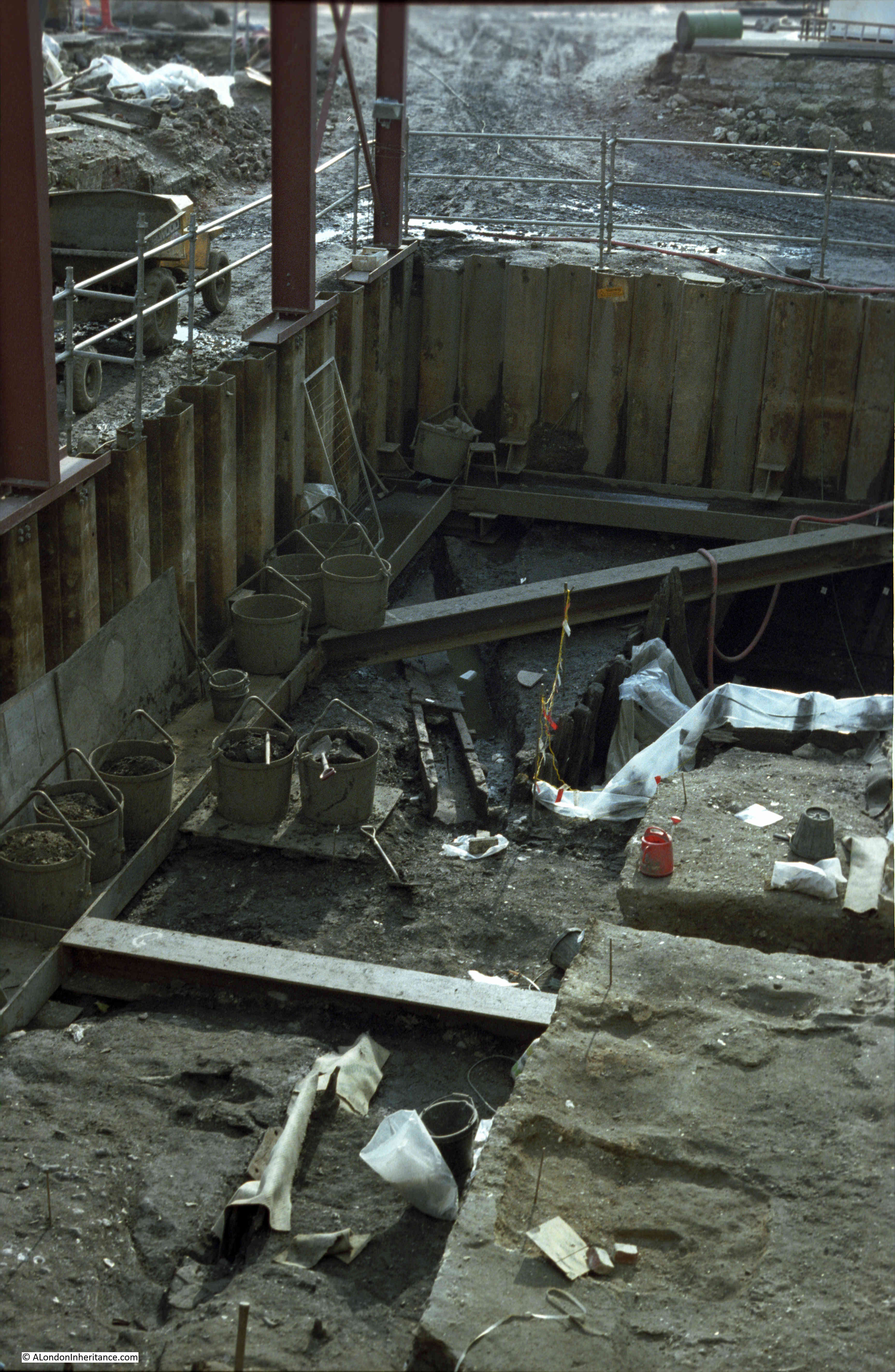
Today, with the number of photos limited by the size of memory card, I would take lots of photos of the surroundings of the excavation. Back then I was using 36 exposure film, and these were on the end of a film. How very different photography is today – I currently have a 4TB hard drive filling with photos and scans.
Great work
Well done once again try the crypt of st brides church A good example of roman pavement
David Ayres cripplegate
There is some footage in the following film from 1946 looking W to Bastion 12 from Monkwell (5:04) and then passing through what’s left of Bastion 11A into the walled pathway through St Giles’ Churchyard.
https://film.iwmcollections.org.uk/record/2080
About half way through another post of yours, ‘Hitler Passed This Way’, 19 December 2016, there are some old photographs of the church showing the churchyard pathway (opened c.1880 according to J J Baddeley’s History of Cripplegate). I have done a chronology of most of the film, but gaps remain.
“…I currently have a 4TB hard drive filling with photos and scans”.
I hope that you have a robust back-up system, with backups also being kept off-site and in the “cloud”. It would be a tragedy if all of that work, all of that history, was lost because of a hard drive crash, a power surge, a fire, a flood or theft.
Your father’s photographs have survived for circa 70 years. You use of them and the way in which you are showing them to a wider audience is splendid. It is interesting to ponder how your illustrated essays might be used by local historians in 2090.
Someone at the Museum of London should know about the mystery dig. In 1979 some of us from our school spent two weeks on a dig in Cutler Street and every find had to be labelled and logged ready to go to MoL. So I’m sure they could identify it. Walking these bastions is going on my list for after lockdown, didn’t know about them before, so thanks!
Last photo: Looks a lot like the Roman drains on display at the Amphitheatre under the Guildhall? Could it be a Roman site? Sorry not to be more specific!
Excellent always a great Sunday read 🙂
Lock down would be so bloody boring without your Posts. Thank you ☺☺
This is wonderful–thank you!
Are there any reconstructions of how it would have looked, back in Roman times?
Hi, The site is Billingsgate Lorry Car Park. BIG82
Streets named ‘Cripplegate’ in the vicinity of St Giles churches are commonplace. St Giles is the patron saint of the ill and infirm, and churches named after him were a place of succour and support for those suffering such afflictions. Yet, whereas the name “Cripplegate’ is commonplace thoughout the country, here in the city of York (and in Pontefract also in Yorkshire) we have “Gillygate” (the ‘G’ is soft, as in ‘Giles’) running past (what is now the site of) St Giles’ church.
I imagine you and your readers may well know this already, but it’s always a useful way of remembering how to pronounce ‘Gillygate’!
Yes almost certainly Billingsgate Fish Market car park site (BIG82). Perhaps some more of those involved will be in touch.
Perhaps many of you know this , but for those who don’t – The Sidney R Jones who wrote to the Times is quite probably the artist and writer (1891-1966) who illustrated at least 18 books on the built environment, many of which he wrote as well, including some for the collectable Batsford Series. His illustrations consist of etchings, pencil and pen and ink. Of interest and relevance to this blog is the book – London Triumphant published 1941 – which has many fine illustrations of interwar and wartime London. It can be bought quite cheaply for a couple of pounds on Abebooks.
I love these weekly blogs and look forward to them every week ! thank you very much author.
Well done Bruce Fleming what an amazing piece of film thank you for bringing it to our attention David Ayres
Ps I can see what was hot water court from our landing window also the Welsh church
There is not too much left of old London Cripplegate Institute survived so did the city mortuary and most of Saint Giles apart from that Not much more I have a very interesting letter from one of the ARp wardens that was based in the Cripplegate Institute he gives a good account of the bombing actually he was very lucky to survive
A pleasure, David (just seen your post). If you’re curious, I found the IWM film among search results for ‘Fore Street Textile Warehouse’. I hope we can chat about the Ward again some time.
Hello Bruce,
Am wondering, within the film, where the camera pans to the right after bastion 12, is the churchyard path the diagonal path on the 1894 map or does it follow the line of the Wall? It’s difficult to gauge without a solid framework of the area
Pete
Oh to be able to start exploring these areas again,
The excavations could be on the corner of Gracechurch Street and. Fenchurch Street and something to do with the Roman Forum? I remember being really excited by the find and taking lots of photos.
Your site is so interesting- thank you.