Monthly Archives: September 2014

Unilever House, De Keyser’s Royal Hotel and the Drinking Fountain Association

Many of my recent posts have covered sites in London where the view has completely changed, however there are still views in London that have seen very little change over the last 70 years. One such view is looking over the river to Unilever House.

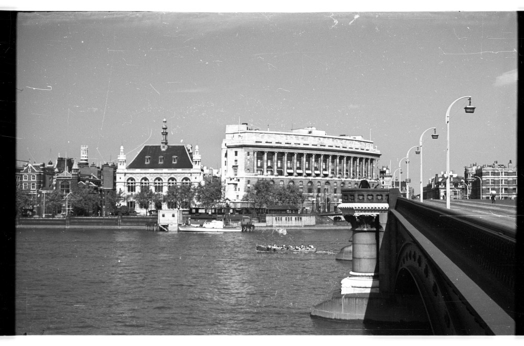
In 1948 my father took the following photo from the southern end of Blackfriars Bridge:

Unilever House

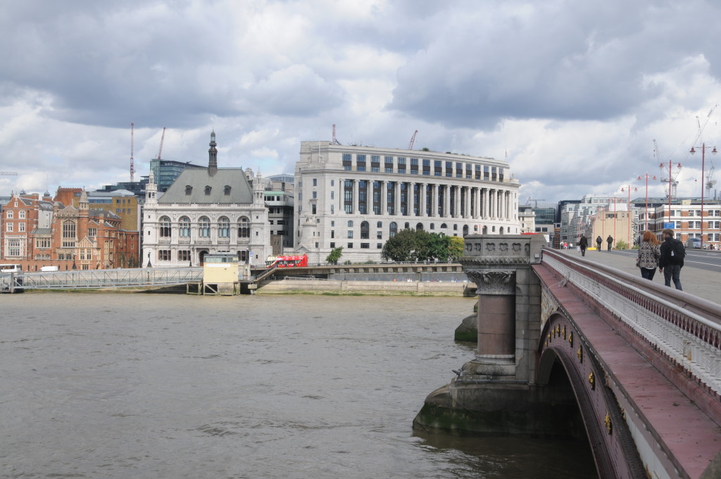
I took the following photo 66 years later standing in exactly the same position:

Unilever House

Very little has changed. The curved building that sits at the north end of the bridge, Unilever House has some cosmetic changes during renovations but is basically the same. Construction of Unilever House was completed in 1933 and since then has been the London head office of Unilever PLC.

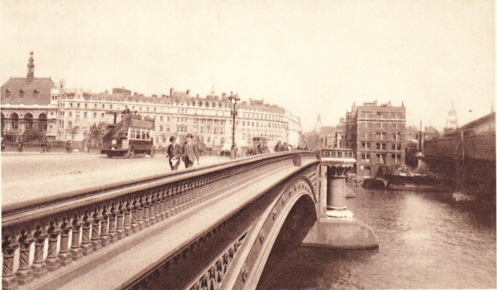
Unilever House was built on the site of the De Keyser’s Royal Hotel. This can be seen in the following early photograph that was taken from the opposite side of the bridge to my father’s photo and shows the hotel following the same curved façade to the road as the current building.

Unilever House

De Keyser’s Royal Hotel was opened on the 5th September 1874 by Sir Polydore de Keyser who came to London as a waiter from Belgium and eventually became Lord Mayor of London.

The hotel was very exclusive and initially every guest had to be introduced personally or by letter before they could secure accommodation.

The hotel had 400 rooms and was taken over by the RAF in 1916 and after the war was acquired by Lever Brothers as their London offices. Lever Brothers became Unilever in 1929 when they merged with the Dutch company Margarine Unie.

Also in the above photo, the building at the end of the bridge on the right is Bridge House, which is still standing, but not in use (more of this later).

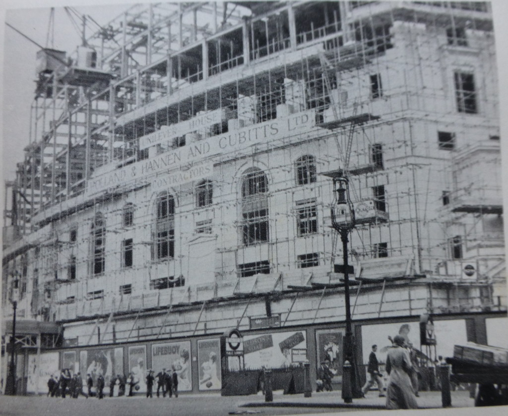
The following photo shows the partly constructed Unilever House on the site of De Keyser’s Royal Hotel:

Unilever House

Note the adverts for Lifebuoy soap on the panels around the base of the construction site, one of Lever’s earliest products.

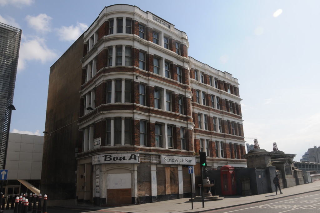
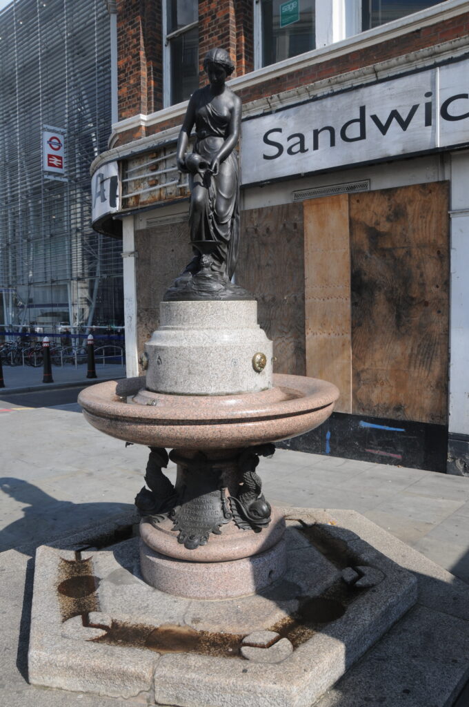
After taking the new photo to compare the view with my father’s I took a walk across the bridge to the north side. On the north-east side of the bridge, just before reaching the new Blackfriars Station is the now empty Bridge House and tucked in the curve of this building is an old drinking fountain erected by the Metropolitan Free Drinking Fountain Association, which now stands rather forlorn in front of Bridge House which from its current state I suspect will soon be demolished, or hopefully renovated.

Unilever House

The Metropolitan Free Drinking Fountain Association was formed in 1859. There is an excellent history of the Association on the site of the Drinking Fountains Association which is well worth reading not just for a history of the association but also for description of Victorian London that supported the formation of the Association.

To quote from the Association’s history:

The supply of drinking water generally available to the poorer classes in London was in those days lamentably deficient both in quantity and quality, coming as it did mainly from pumps and surface wells. A report made in 1866 showed how contaminated this water was, and not only was the impurity of the water held to be largely responsible for the outbreaks of cholera in 1848-49 and again in 1853-54 but the heavy consumption of beer and spirits was in great measure also attributed to this cause. It was therefore high time that something was done to provide a readily available supply of pure drinking water in the cause of temperance, as well as of hygiene and it was to meet this need that the Association came into being.

At the inauguration of the association on the 10th April 1859 the objects of the Association were stated in the resolution:

That, where the erection of free drinking fountains, yielding pure cold water, would confer a boon on all classes, and especially the poor, an Association be formed for erecting and promoting the erection of such fountains in the Metropolis, to be styled “The Metropolitan Free Drinking Fountain Association“, and that contributions be received for the purposes of the Association. That no fountain be erected or promoted by the Association which shall not be so constructed as to ensure by filters, or other suitable means, the perfect purity and coldness of the water; and that it is desirable the water-rates should be paid by local bodies, the Association only erecting or contributing to the erection, and maintaining the mechanical appliances, of the fountains.”

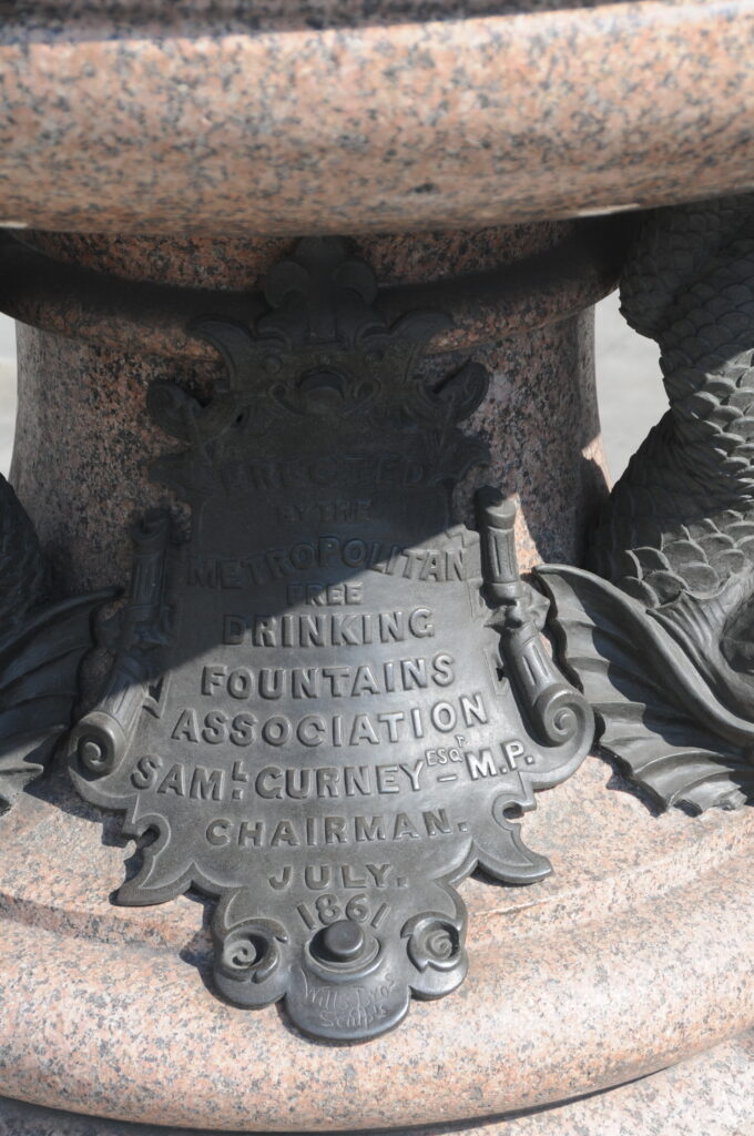
The plaque on the bottom of the Blackfriars drinking fountain states that it was erected by the Association in July 1861 by the Chairman Samuel Gurney MP.

Unilever House

Bridge House with the fountain is shown in the following photo. A telephone box and the fountain, both symbols of earlier ages (with phone boxes I suspect being largely made redundant by mobile phones).

Unilever House

There is much more to say about Blackfriars Bridge which for this post I have only used to cross from the south to the north banks of the Thames, however it has been a busy week so I will leave this for another post to do the bridge justice.

What I hope this post has highlighted is that in almost every corner and building across London there is a fascinating history to be discovered that provides a tangible link back to the lives of Londoners across the centuries.

The sources I used to research this post are:

  • The Face of London by Harold Clunn published 1932
  • London by George H. Cunningham published 1927
  • Old & New London by Edward Walford published 1878
  • The Drinking Fountain Association
 alondoninheritance.com


Cannon Street Station and a Lost Roof of Iron and Steel

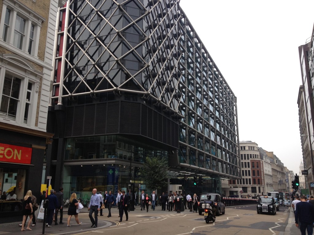
Cannon Street Station is a strange station. If you walk down Cannon Street the station appears to be hiding, pretending to be an office block and blending in with the other recent glass and steel office blocks that now make up so much of the City.

To find any real evidence of Cannon Street Station you need to head to Southwark Bridge where across the Thames you can view the rail bridge heading across the river and entering the station where it is flanked by two brick towers providing passengers their first glimpse of the London Terminus of the original South Eastern Railway.

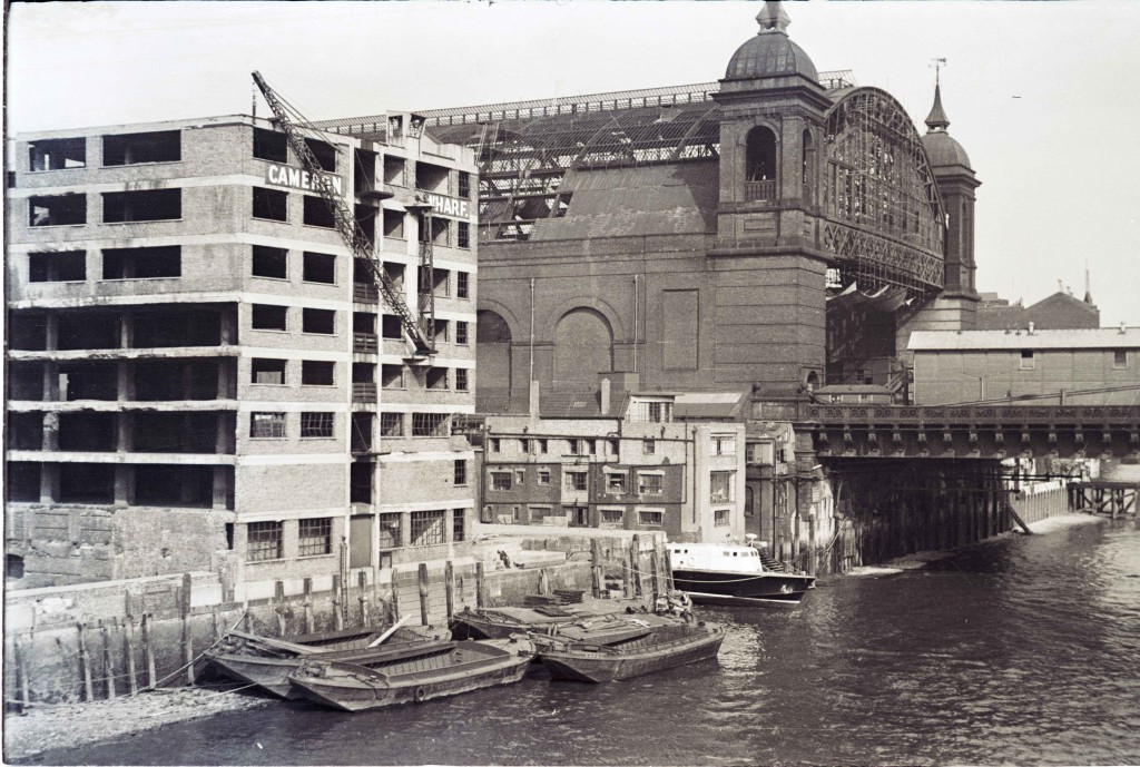
This was the photo my father took back in 1948 of the entrance to the station from Southwark Bridge:

Cannon Street Station

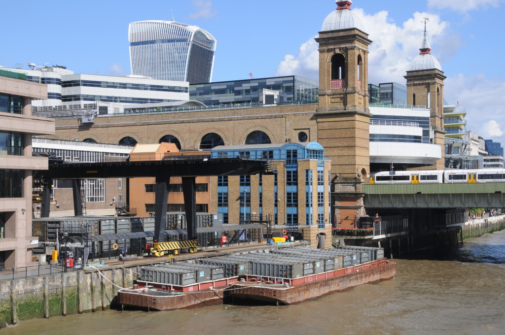
In 2014 I took the following photo from the same spot on Southwark Bridge: Cannon Street Station

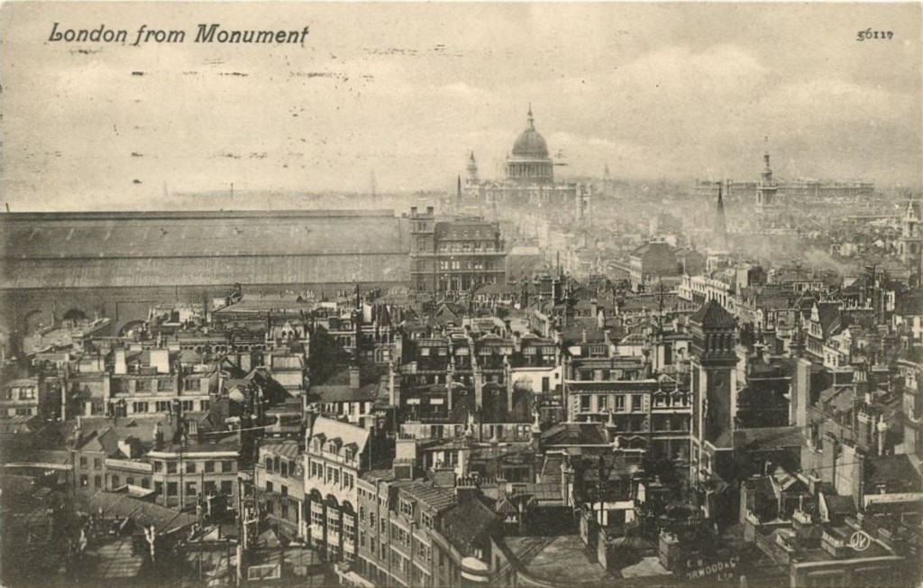
From this perspective the towers and the side walls remain, however the most significant change to Cannon Street Station is the roof. The original roof was glass on an iron frame that arched from side wall to side wall across the width of the platforms and ran the entire length of the station. The shape and length of the roof from the edge of the river to the station entrance made this a very significant landmark in the south of the City. The following photo is from a postcard showing the view across London looking west from the top of the Monument. The size of the roof of Cannon Street Station and how it dominated the area is clearly visible.

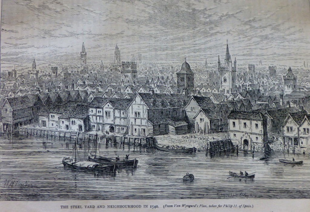
Cannon Street StationCannon Street Station was built on the location of the Steel Yard. According to “Old and New London”, this was:

“the residence of the Hanse Town, German and Flemish merchants who obtained a settlement in London as early as 1250. Henry III, in 1259 at the request of his brother Richard, Earl of Cornwall, granted them very valuable privileges, renewed and confirmed by Edward I. The City also conceded them many privileges, on condition of their maintaining Bishopsgate in repair (they rebuilt it once), and sustaining a third of the charges in money and men to defend it when need was. In spite of English jealousy, the Steel Yard merchants flourished till the reign of Edward VI, when the Merchant Adventurers complained of them and they were held, like all other strangers to have forfeited their liberties. In vain Hamburg and Lubeck sent ambassadors to intercede for their countrymen. Their monopoly was gone, but the Steel Yard men still throve, and continued to export English cloth. Elizabeth, however, was rougher with them, and finally expelled them from the country in 1597-8.”

The Steel Yard derived its name not from the steel imported by the Hanse merchants, but from the King’s steel yard here erected to weigh the tonnage of all goods imported into London, the tonnage office being afterwards transferred to the City.

A view of the Steel Yard and neighbourhood in 1540 can be seen below:

Cannon Street Station

Approval for the construction of the station was given through an Act of Parliament passed in 1861. Construction commenced in 1863 and the station was officially opened on the 1st September 1866. The station and bridge were designed by the Civil Engineers Sir John Hawkshaw and Sir John Wolfe Barry (who was also the engineer for the construction of Tower Bridge).

The station serves suburban South East London, Kent and East Sussex.

Due to pre-war neglect and damage during the war, the roof was demolished in 1958 and the hotel followed soon after in 1960. There followed a series of re-development projects across the station platforms and on the frontage to Cannon Street resulting in the station and offices we see today. Fortunately the towers facing the Thames are Grade II listed so at least what remains of the once magnificent building over and into the platform area is protected.

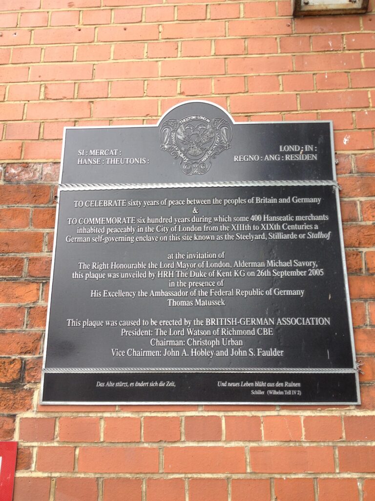
Much of the brick wall on either side of the station that reached up to the base of the roof is still in place and provides a sense of the scale of the original station. If you walk down to Upper Thames Street, then on the east side of the station, walk down Allhallows Lane along the side of the wall to the river, up a small set of steps and on the right is a plaque commemorating the German Hanseatic merchants who were based here in the Steel Yard for so many centuries.

Cannon Street Station

Cannon Street, after which the station is named, was originally Candlewick Street, first mentioned in 1276 and ran from Watling Street to London Bridge and was widened and extended to St. Paul’s Cathedral in 1853-4.

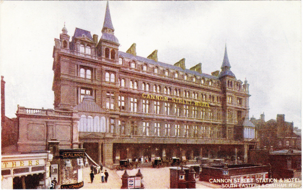
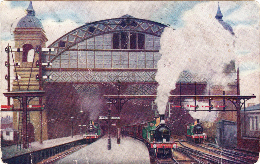
The original station buildings facing the road were in true Victorian station style. Along with the functions needed to support the station, the building also included the Cannon Street Hotel. The following postcard shows the station and hotel building facing onto Cannon Street. The architectural style is very similar to that of Charing Cross Station. Note also the two towers that matched those facing the bridge across the river.

Cannon Street Station

Looking at this postcard of Cannon Street it is hard to believe (or rather perhaps not given how much change there has been in the City) how the station frontage has changed. I took a walk down Cannon Street and took the following photo of the station as it now borders Cannon Street:

Cannon Street Station

As I said at the start of this post, until you get really close and look at the ground floor entrance, would you really know that this is a station, or just another City office building?

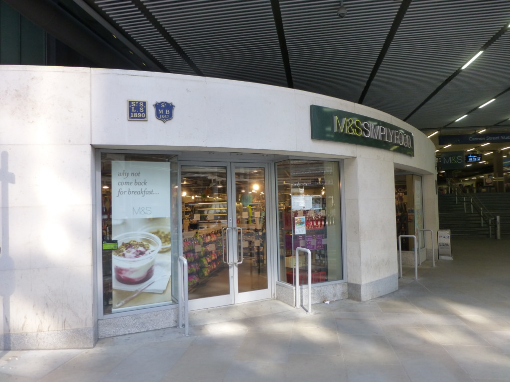
Walk past the station and you will see an M&S Simply Food shop to the left of the entrance. Above this are two parish boundary markers for St Swithin London Stone (the church damaged by bombing during the war and demolished in 1962) and St Mary Bothaw (this church was on the site of Cannon Street Station, but was destroyed in the Great Fire of London and not one of those selected to be re-built).

Cannon Street Station

Passengers arriving into Cannon Street Station would, if they could have looked directly into the station have seen the following view. Looking down into the station from this perspective gives an idea of the scale of the roof as it covered the length of the platforms from the edge of the Thames through to the station buildings on Cannon Street.Cannon Street Station

Today, by London station standards, Cannon Street Station is relatively quiet.  In 2012/13 there were just over 20 Million entries / exits compared to 95 Million for Waterloo (the busiest) and 38 Million for Charing Cross and unlike other central London terminus stations, Cannon Street is closed on Sunday’s (although this will change in 2015).

A shame that this station hides itself in the street after which it is named, however at least the view from the Thames continues to provide a memory of this fantastic example of Victorian architecture and engineering.

The sources I used to research this post are:

alondoninheritance.com


St Vedas and Foster Lane

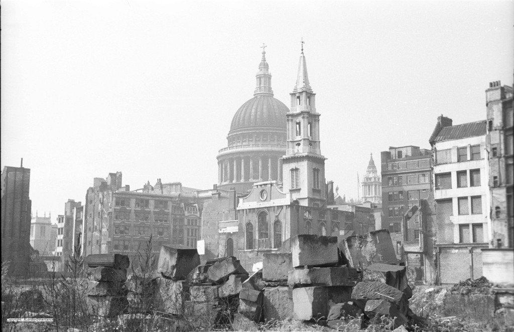
This week’s photo finds us in Gresham Street in 1947 looking towards St. Paul’s Cathedral. With the exception of St. Paul’s and the church spires, all the other buildings have been demolished over the years following the war and only the street names and churches provide a tangible link back to the long pre-war period.

St Vedas

The church in the foreground is St Vedas on Foster Lane, a Wren church built following the Great Fire of London.

As with many City churches, the core of the church has been destroyed with only the shell remaining, however the tower still stands and fortunately is structurally sound. It was the raid on the 29th December 1940 that caused the majority of the damage in the area around St. Paul’s. As well as high explosive bombs, over 100,000 incendiary bombs created so many fires that the area was devastated. Only the work of many volunteer fire-fighters managed to save St. Paul’s.

My grandfather had experience of incendiary bombs during one of the many raids that hit the area they were living in just to the west of Euston Station. An incendiary penetrated the flat above and armed with buckets of water and a stirrup pump he managed to put it out before a fire took full hold. If you could get to an incendiary bomb quickly you would have a chance. The problem was the sheer number of them that would fall in a raid with limited numbers of fire-fighters to get to them quickly, or they would lodge in inaccessible places and could not be put out. This, along with the risk of high explosive bombs falling at the same time.

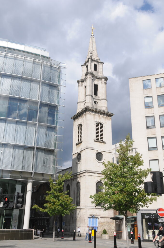
The photo was taken from Gresham Street, looking across Gutter Lane to St Vedas. I spent an hour somewhat optimistically walking around this area trying to get any view of St Vedas from Gresham Street and surroundings for a comparison photo, however with the degree of new building in the area it is impossible. Coming from the Gresham Street area, you do not realise there is a church until you are almost alongside.

The only place I could get a clear photo of St Vedas is from the Cheapside / New Change crossing just across from St. Paul’s where St Vedas still stands proudly in amongst the building of the last 65 years.

St Vedas

A church was established on the site in the twelfth century dedicated to St Vedas who was a French saint, Bishop of Arras and Cambray in the reign of Clovis (who lived from 466 to 511) and apparently performed many miracles on the blind and lame. Following the invasions of the region by tribes in the late Roman period, Vedas helped to restore the Christian Church.

The dedication to St Vedas may have been by the Flemish community in London in the 12th and 13th centuries. It is an unusual dedication for a church in the United Kingdom as there is only one other church that is currently dedicated to St. Vedas which is in Tathwell in Lincolnshire.

Foster Lane was also known in the 13th Century as St Vedas Lane, which was gradually corrupted over time to Foster Lane (the church has also been referred to as St. Foster).

Foster is evolved from Vedast in such steps as Vastes, Fastes, Fastres, Faster, Faister and Fauster. For 100 years or more prior to the Great Fire, the church was known as St. Foster’s and is now also known as St. Vedas alias Foster.

In the 19th century, the interior of St Vedas was described as:

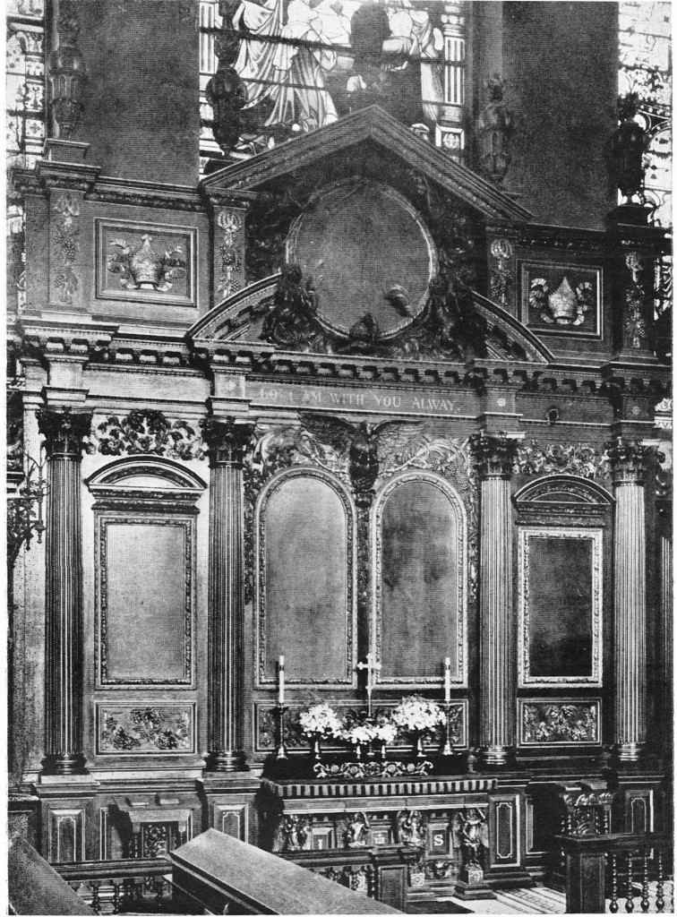
“a melancholy instance of ornamentation. The church is divided by a range of Tuscan columns, and the ceiling is enriched with dusty wreaths of stucco flowers and fruit. The altarpiece consists of four Corinthian columns, carved in oak and garnished with cherubim and palm branches. In the centre above the entablature is a group of well executed winged figures and beneath is a sculptured pelican.”

From 1838 there is a reference that the church did not have stained glass, the windows being covered by transparent blinds painted with various Scriptural subjects.

The following photo from “The Old Churches of London” shows the altarpiece  in St. Vedas before destruction in the war, exactly fitting the 19th century description.

St Vedas

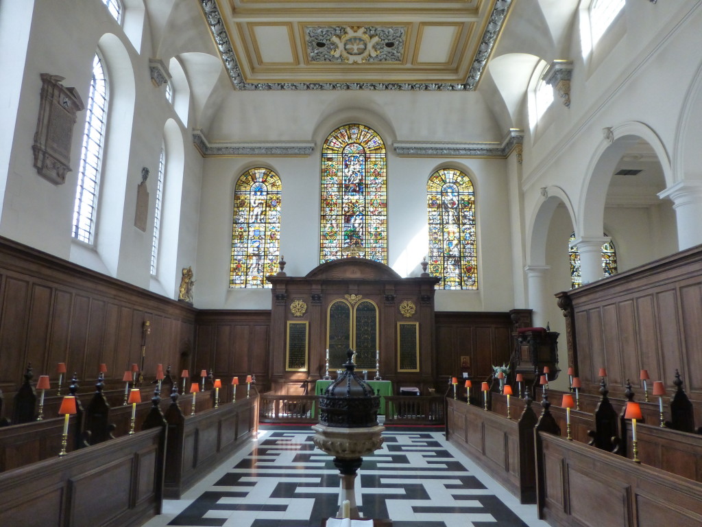
Work on reconstruction of St. Vedas commenced in 1953 and it is now a very bright and simple interior. There is still an altarpiece but without the degree of melancholy ornamentation as in the 19th century description. The following photo is as you enter the church and look down to the altar.

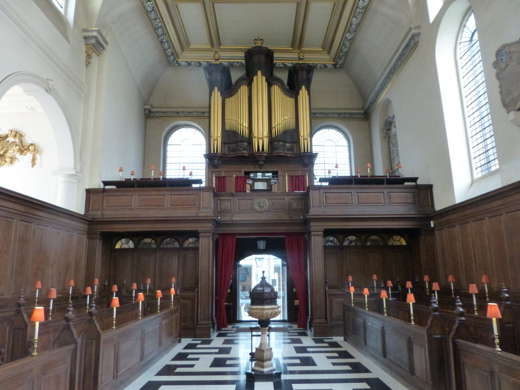
St Vedas And looking back towards the entrance to the church:

St Vedas

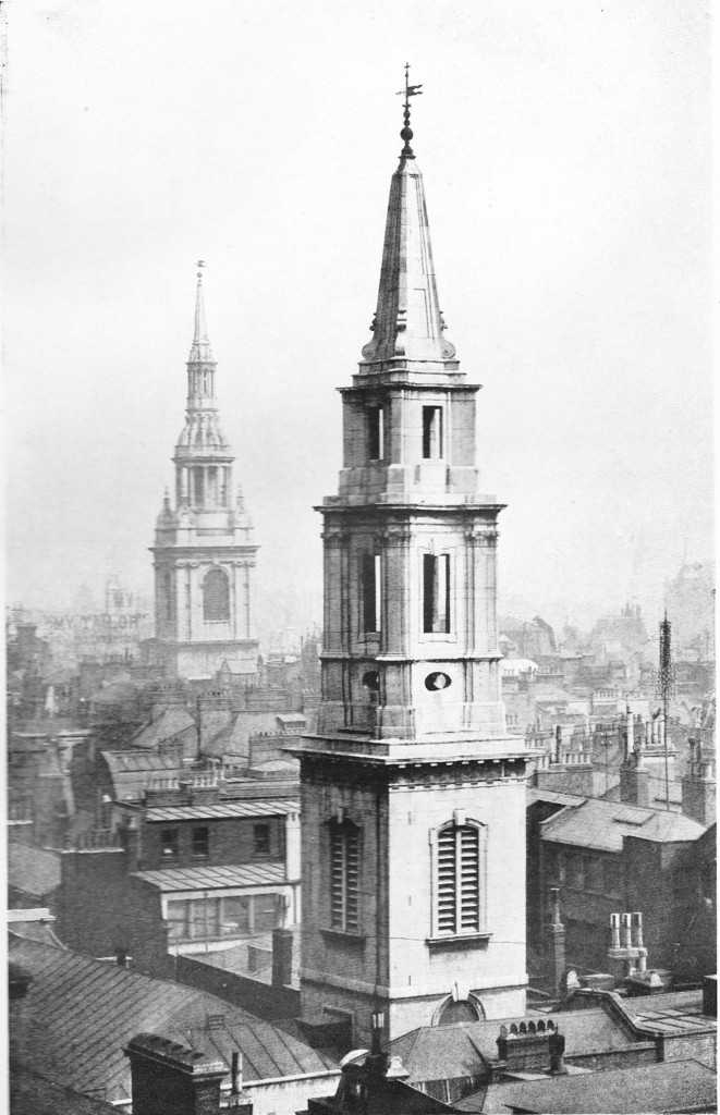
The following picture from “The Old Churches of London” provides an interesting view of the surroundings of St Vedas looking towards St. Mary-le-Bow in Cheapside.

St Vedas

This was still at a time when the spires of the City churches stood well above the surrounding buildings.

The spire of St Vedas is unusual when compared to many other Wren churches in that there are no vases to decorate the spire. The contrasting surfaces and cornices, concave and convex, emphasise the angles and on the light and shade across the spire.

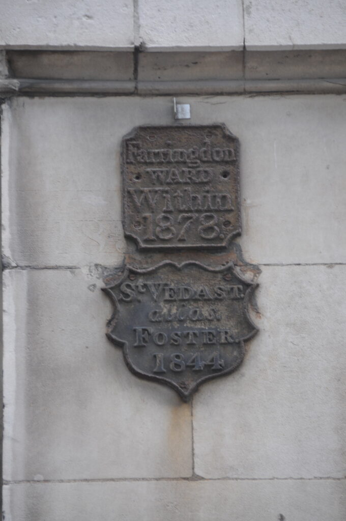
It is always interesting to look at the outside of City buildings and on St Vedas I found two boundary markers just to the side of the main door. Interesting is the use of “alias Foster” as part of the name.St Vedas

St Vedas is a lovely church to visit and despite being so close to St. Paul’s and the thousands of people who visit this landmark everyday, and being in the heart of the city, it is a quiet and peaceful church. In the all too brief fifteen minutes I spent visiting the church I was not disturbed by a single person.

The sources I used to research this post are:

  • The Old Churches Of London by Gerald Cobb published 1942
  • London by George H. Cunningham published 1927
  • Old & New London by Edward Walford published 1878

alondoninheritance.com


Building the Foundations of the Royal Festival Hall

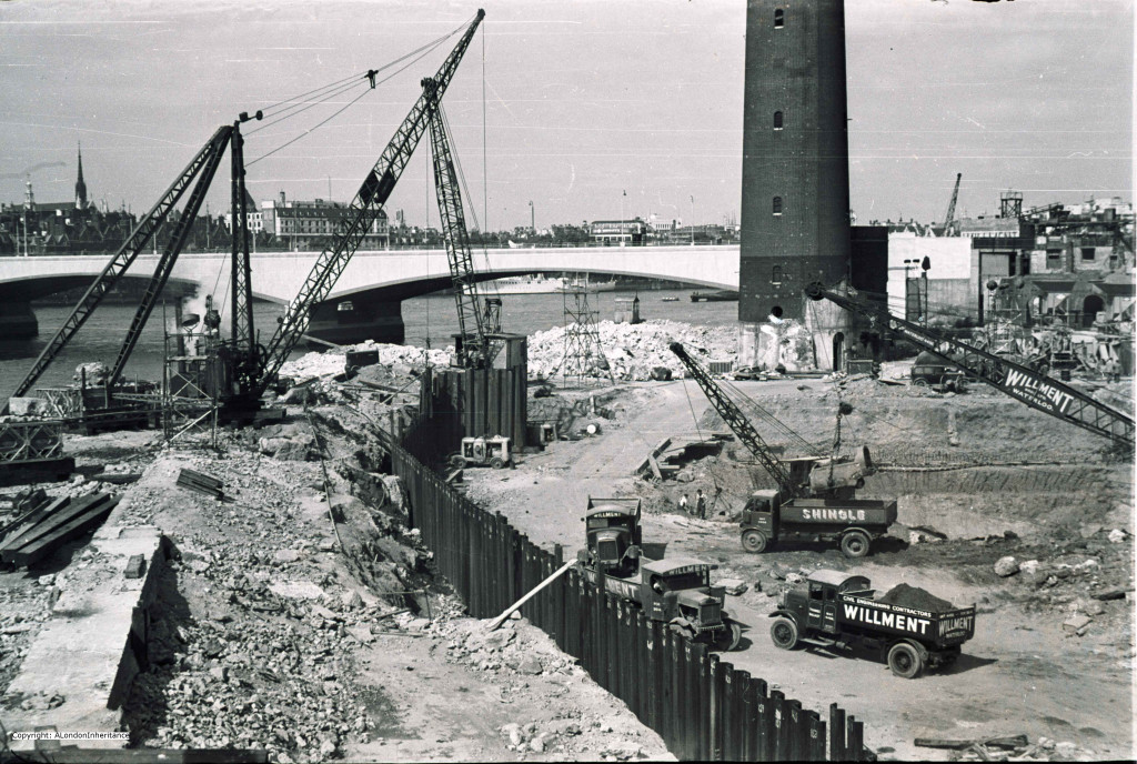
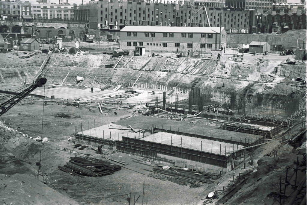
I have a number of photos of the Southbank as it was just after the war and prior to any demolition for the Festival of Britain, along with a few photos of the building of the Royal Festival Hall and I thought I had found all my father’s photos of this area of London, however I was recently scanning some more negatives and found a set of photos taken in 1948 as the site was cleared and the foundations for the Royal Festival Hall were being started.

I find these fascinating on a number of levels. The methods of construction, the immediate surroundings and the views of London in the distance.

These photos were taken from the end of the footbridge that ran alongside Hungerford railway bridge.

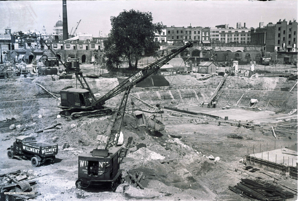
This first photo is looking directly into what will be the Royal Festival Hall. The area has been cleared and the ground dug out ready for the foundations and building to commence.

The remains of the buildings on the edge of the site are running along the roadway that leads to Waterloo Bridge which is just to the left. St. Paul’s can be seen in the distance standing clear as the tallest building in London. The chimney is on the south side of the river, just further along the Southbank.

Old RFH 1

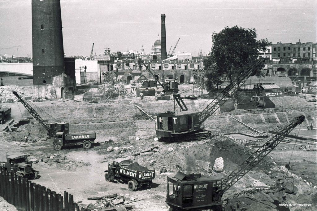
In the following photo the camera has moved slightly to the left and we can now see the Shot Tower that will remain for the Festival of Britain, and the start of Waterloo Bridge. After the Festival of Britain the Hayward Gallery and Purcell Room would be built in the space occupied by the Shot Tower and along the approach road to Waterloo Bridge, filling the gap between the approach road and the Royal Festival Hall. The Hayward Gallery and Purcell Room are true examples of Brutalist architecture with considerable exposed concrete, very different to the Royal Festival Hall.Old RFH 3

And now further to the left again to see not just the construction site of the Royal Festival Hall but also the construction of the new embankment along the Thames.

Old RFH 4

It is surprising how that, apart from the different types of crane where most building sites now use Tower Cranes, the building site is very much as you find building sites today, however on enlarging the photos to look at the workmen, there is an almost complete absence of any of the protective clothing that would now be considered mandatory.

Trying to take a 2014 comparison photo is next to impossible. The following photo is taken from the end of the Hungerford Foot Bridge looking over towards Waterloo Bridge as close to the above photo as I could get, however the trees and building on the Southbank now completely obscure the view.

DSC_1588

The following photo is looking down into the construction site. Note all the old multi-floor, empty window buildings along the approach road to Waterloo Bridge. These would soon be demolished ready for the Festival of Britain. What was the Shell Centre Downstream building (now converted into apartments) now stands on the site of these buildings and the area behind the Royal Festival Hall.

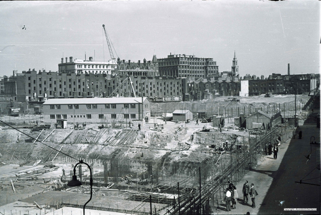
Old RFH 2And turning to the right we can see on the right hand side the pathway along the side of Hungerford Bridge from Belvedere Road. The buildings in the distance still exist. The church is St. John’s, Waterloo, the building to the left of the church is now the James Clark Maxwell Building of King’s College London. The building to the left of this was the Royal Waterloo Hospital for Women and Children (which closed in 1976) and the building to the left of this is now also part of King’s College London.

Old RFH 5

I took the following photo from the end of the footbridge looking down to what was the ground level pathway between the Royal Festival Hall construction site and Hungerford Bridge. Still a very busy route from Waterloo Station to the foot bridge and across to the north bank of the Thames, but as with the rest of the site a complete change to how it was in 1948.

DSC_1584

The original photos were taken from the same position with the same camera settings, so I was able to stitch my father’s original photos together into a panorama showing the whole of the Royal Festival Hall construction site from the edge of the River Thames to the edge of Hungerford Bridge to provide a complete view of the construction site and the horizon as it was in 1948.

Panorama

The Royal Festival Hall is on a superb position on the south bank of the River Thames with sweeping views from Westminster across to the City. The building was the only permanent part of the Festival of Britain and one of the first major construction projects after the devastation caused by the bombing during the war.

Considering many of the other buildings that were constructed in the post war period, the design and architecture of the Royal Festival Hall works well within the location, is well proportioned and does not brutally dominate the area.

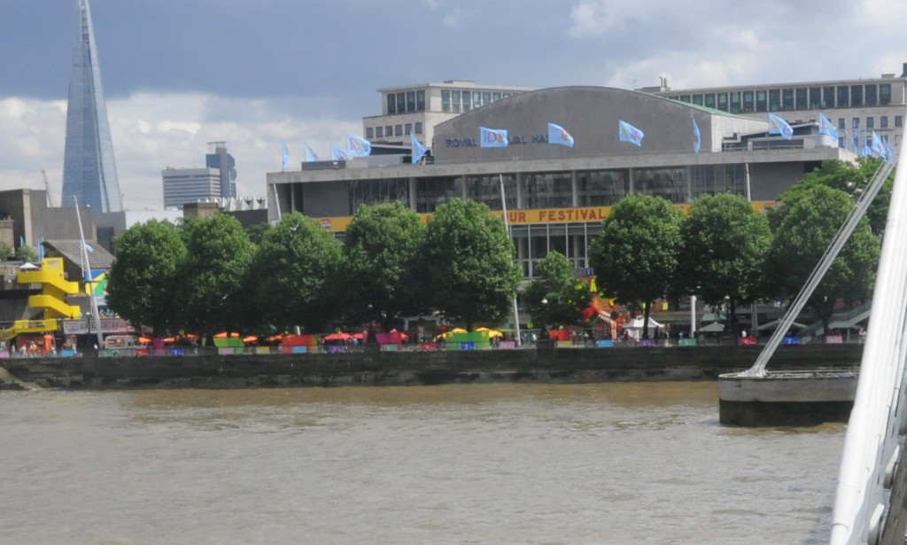
The following photo shows the view from the north bank of the Thames:

trees

I did not really expect to ever take this view as I am a firm believer that London needs more trees and green spaces, however with the river frontage of the Royal Festival Hall the trees tend to obscure the building from the river and the north bank and do not open up a view of the building to the wide sweep of the river and the rest of London as I am sure the original architects intended.

It would perhaps be good to open up this area to provide an unobstructed view of the Royal Festival Hall from the north bank of the Thames and to open up the wide curve of the Thames from Westminster to City from the Royal Festival Hall, and give one of the few good examples of immediate post war reconstruction the visibility it deserves.

You may also be interested in my earlier posts of the Southbank site:

The South Bank – Before the Festival of Britain and the Royal Festival Hall

The Royal Festival Hall – Before, During and After Construction 

 alondoninheritance.com