Tag Archives: Hoxton

Shenfield Street, Hoxton at the Coronation

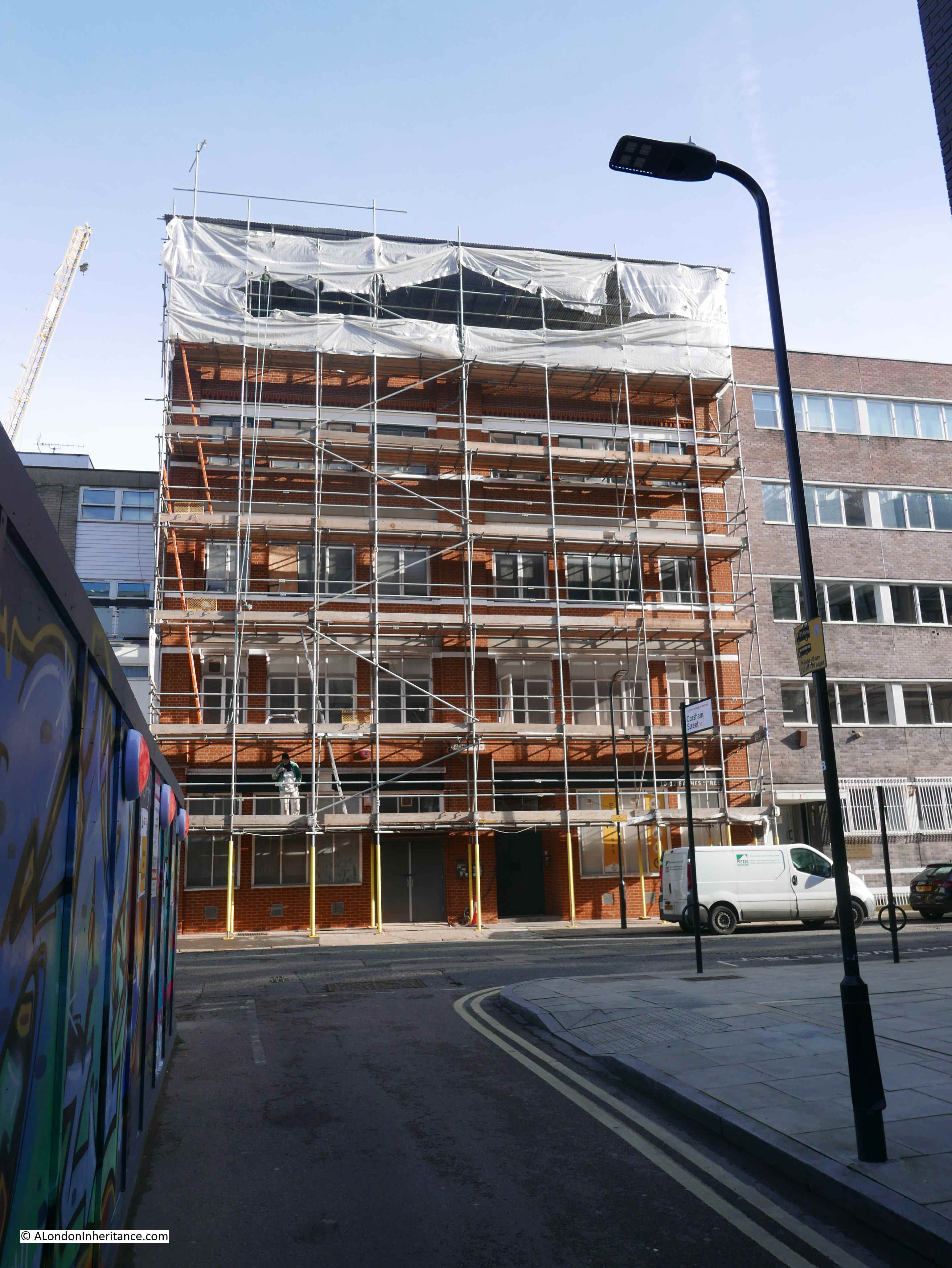
Before heading to Shenfield Street, a quick advert. I am still working on a couple of new walks for 2023, which should be ready in a couple of months, however I have set some dates for a limited number of my walks exploring Wapping, the Southbank and the Barbican.

If you would like to explore these areas, including the locations of many of my father’s photos, they can be booked here.

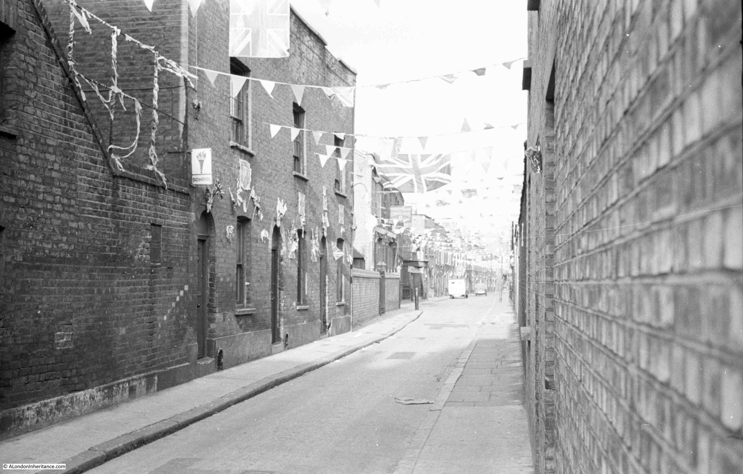
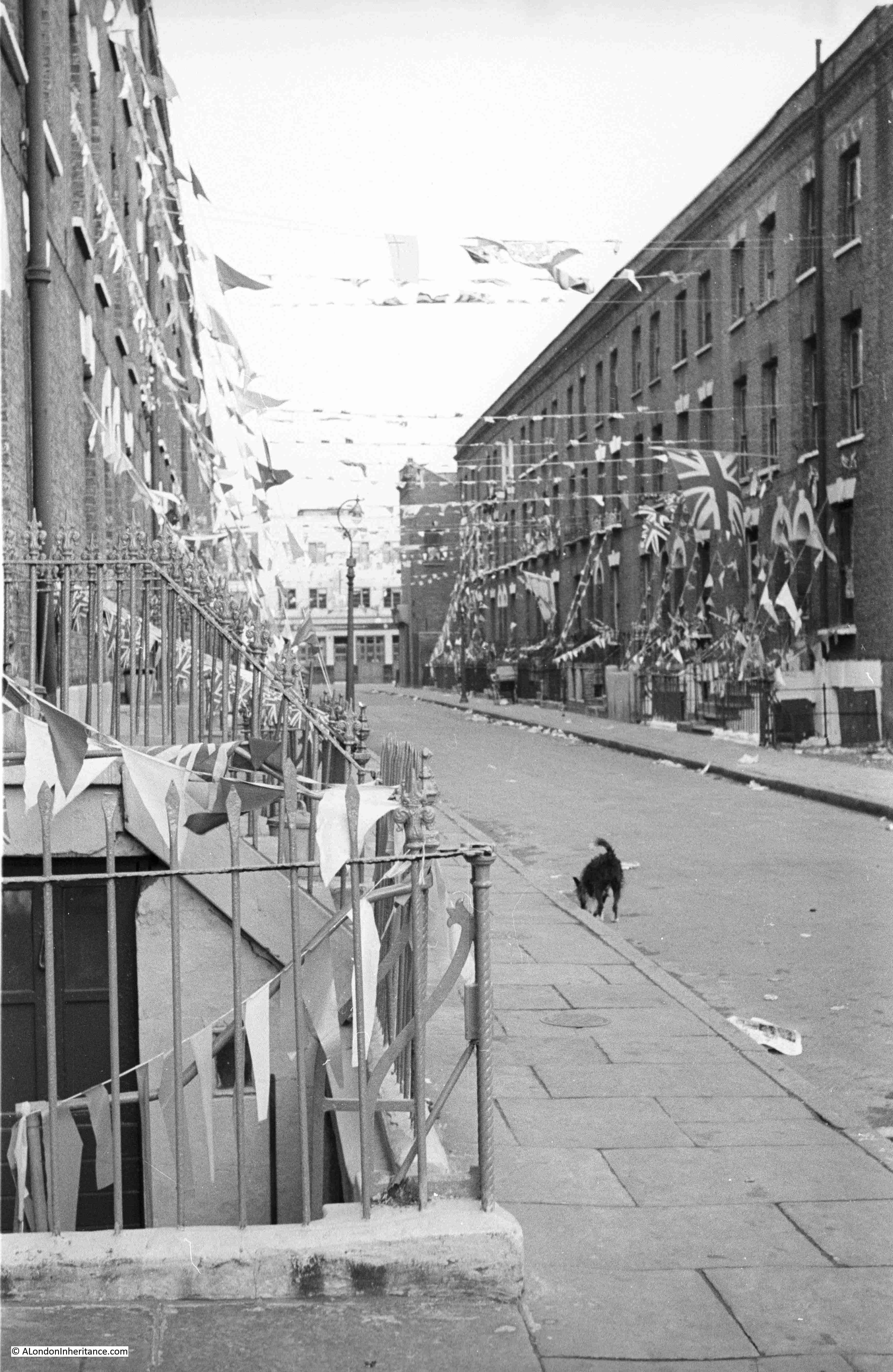
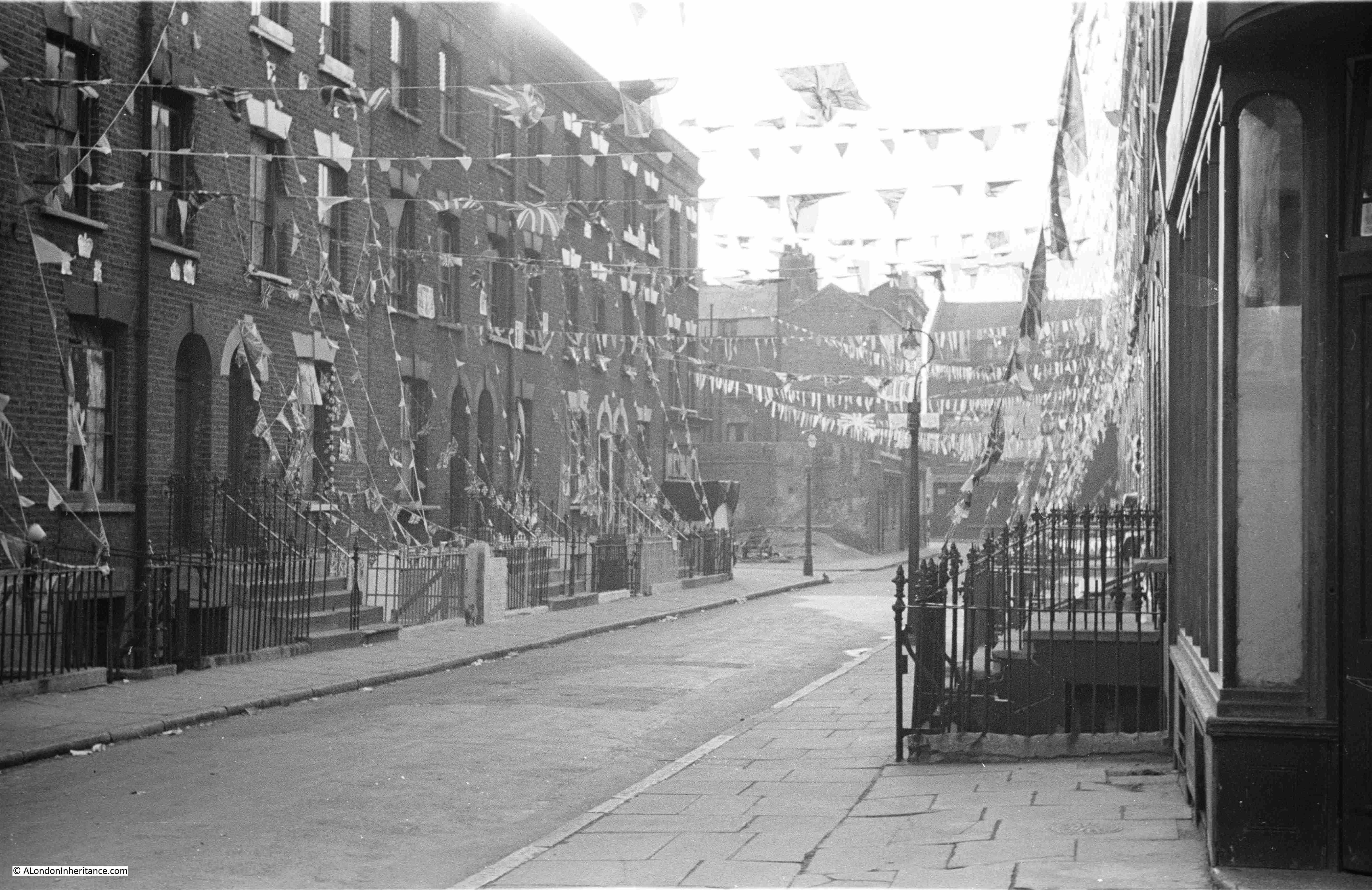
For this week’s post, I am in Hoxton, looking at how Shenfield Street was decorated for the Coronation – the 1953 rather than the 2023 Coronation. This is a series of photos of the street taken by my father. One of the photos includes something that enabled much of his photography across London, and wider afield.

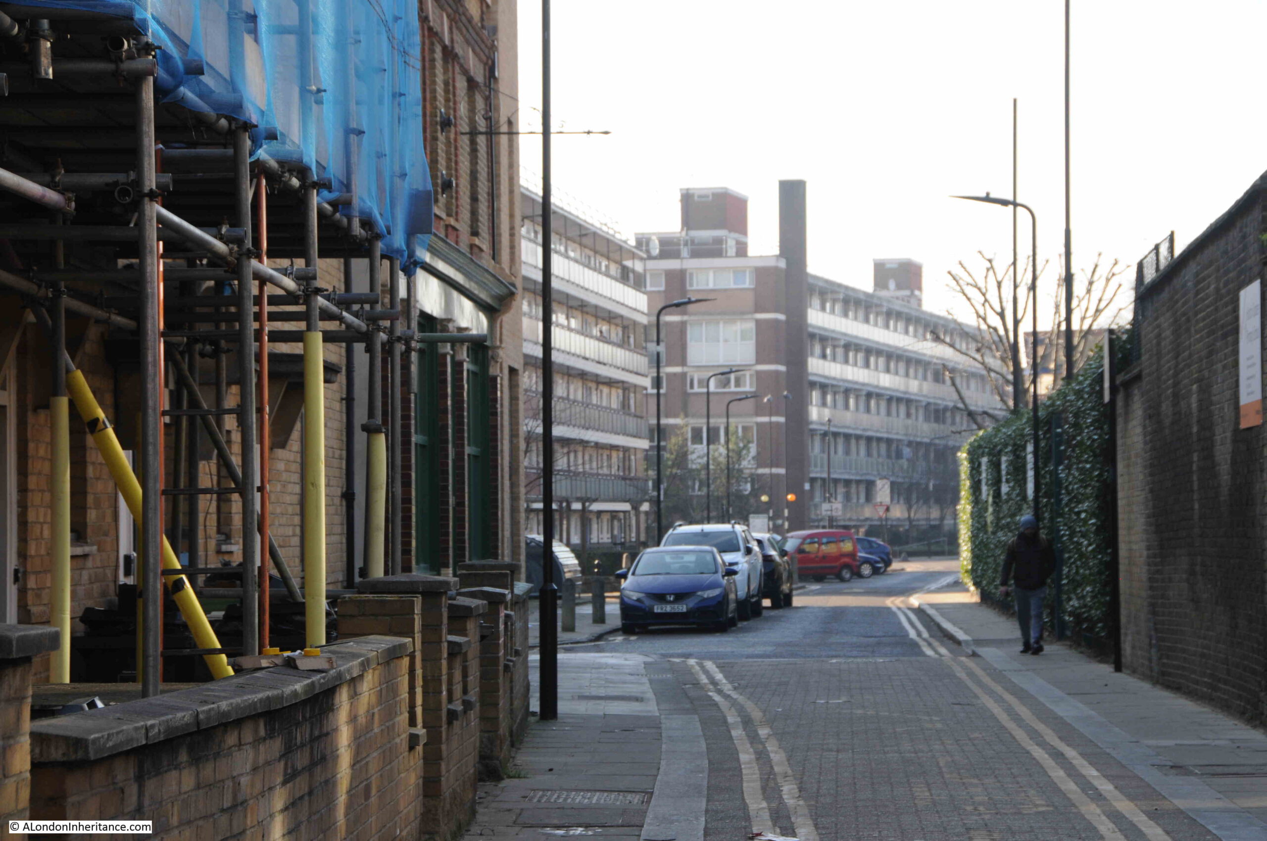
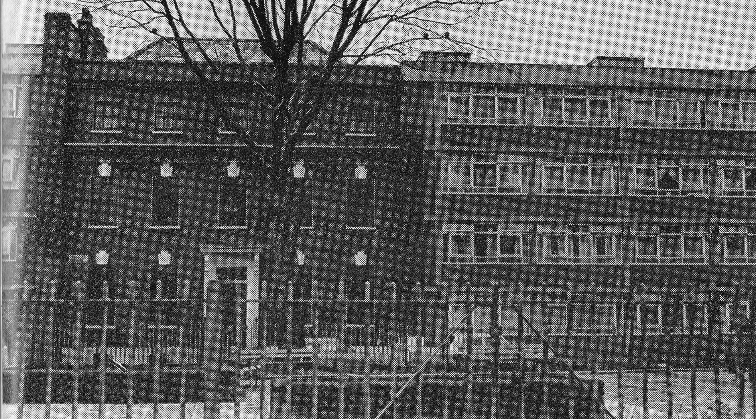
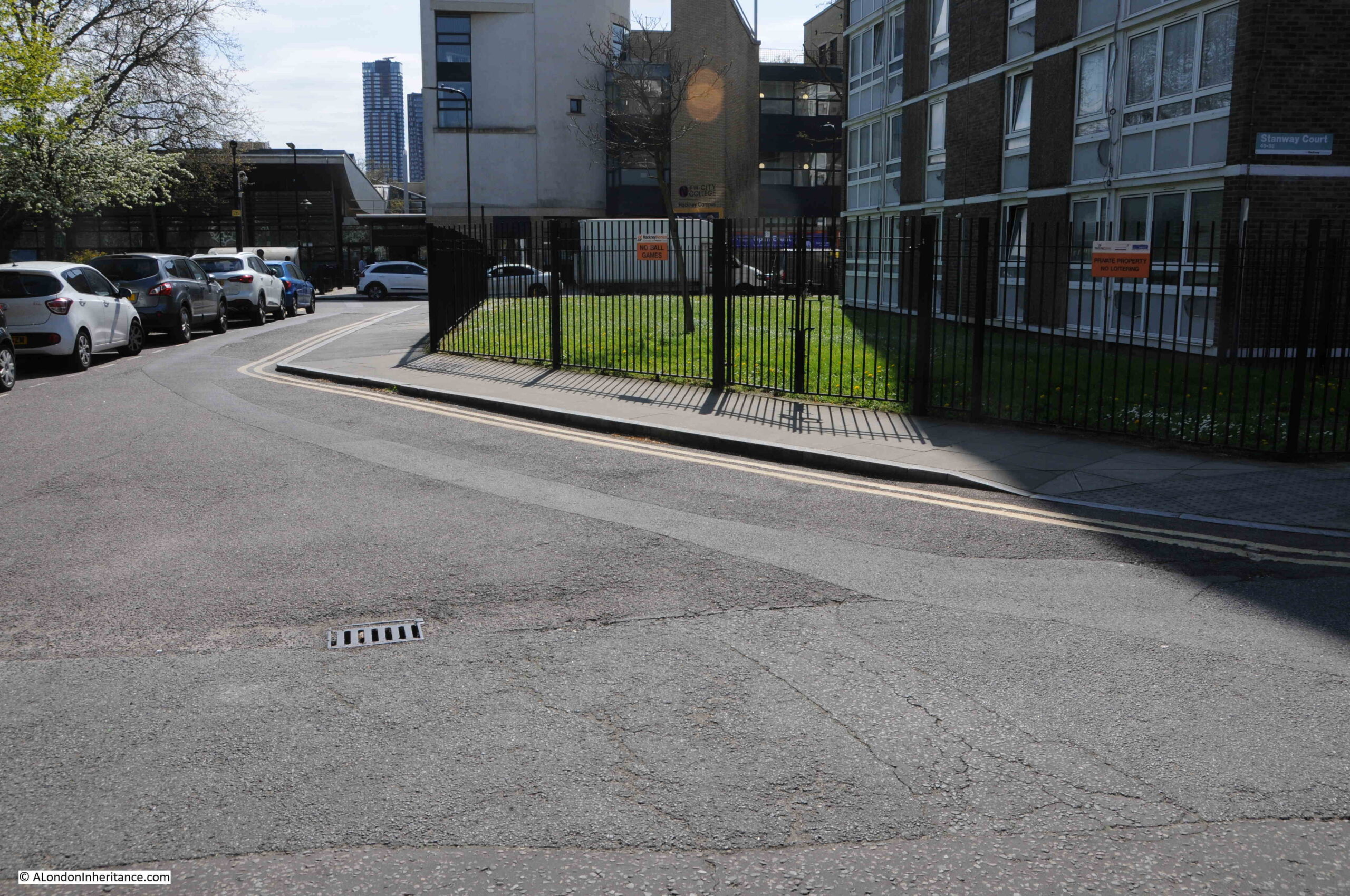
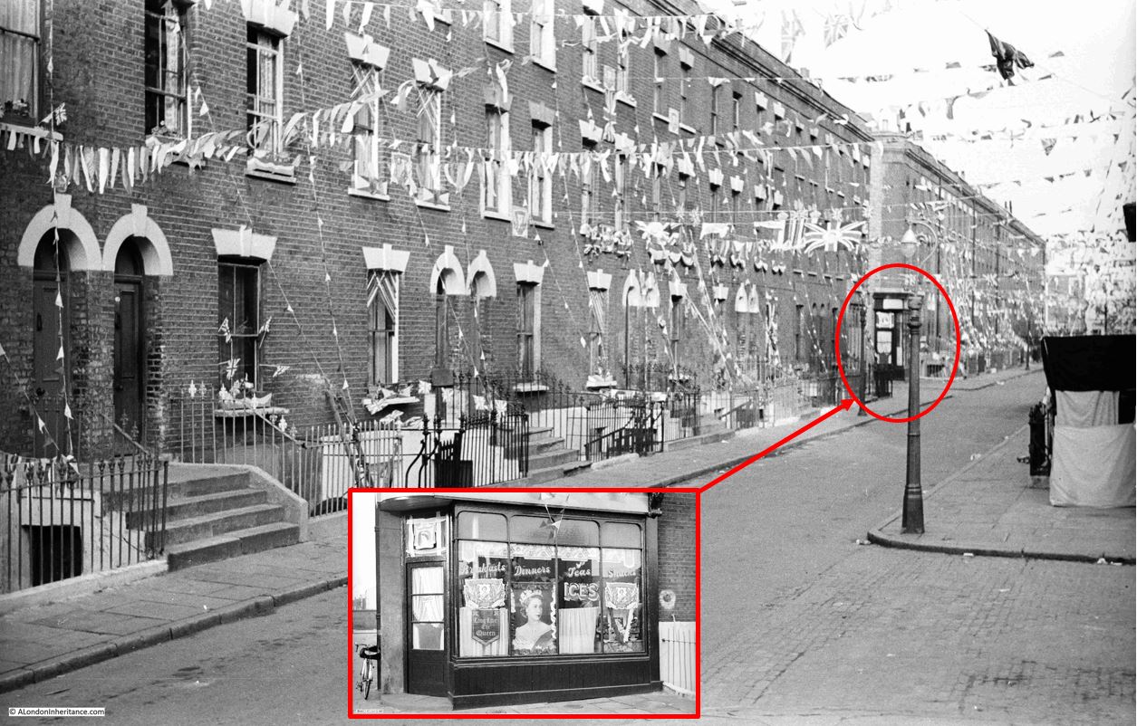
This is Shenfield Street, looking west towards the junction with Hoxton Street, on Sunday the 31st of May, 1953, two days before the Coronation on the 2nd of June:

Shenfield Street

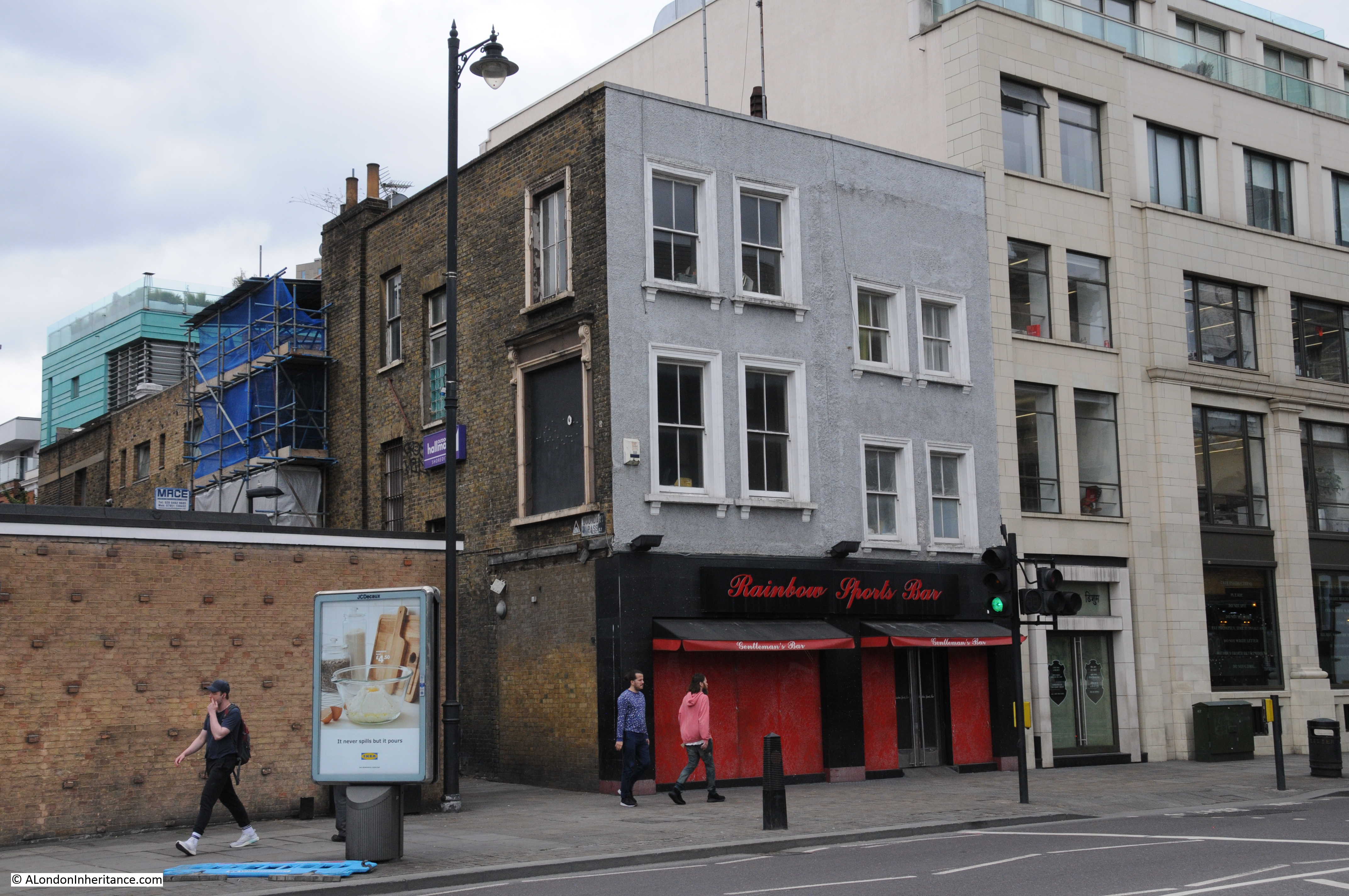
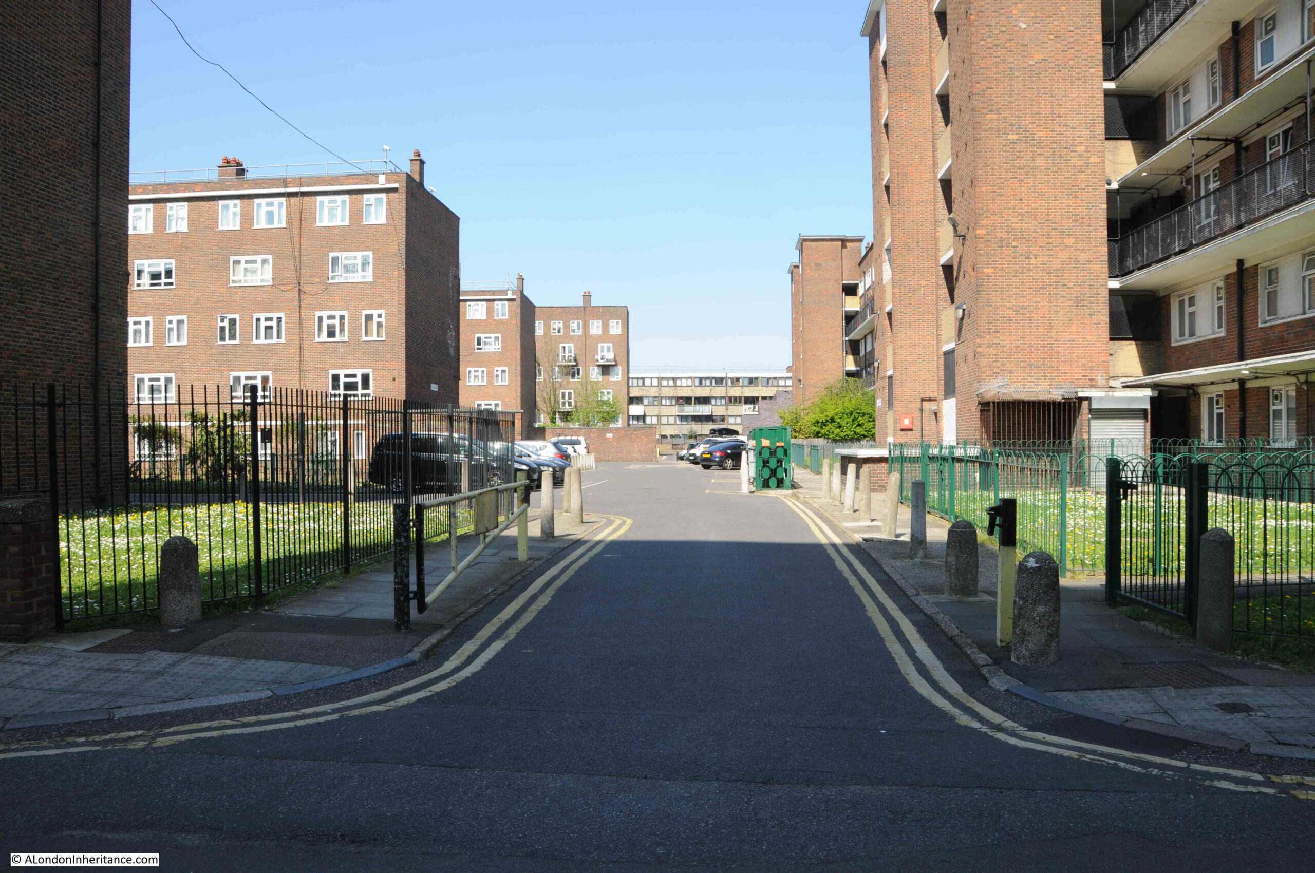
This is the same view today, at the end of April, just over a week before the 2023 Coronation:

Shenfield Street

The white building at the end of the street in both of the above photos is the White Horse pub. Open at the time of my father’s 1953 photos, but closed in 2023, having closed as a pub in 2013.

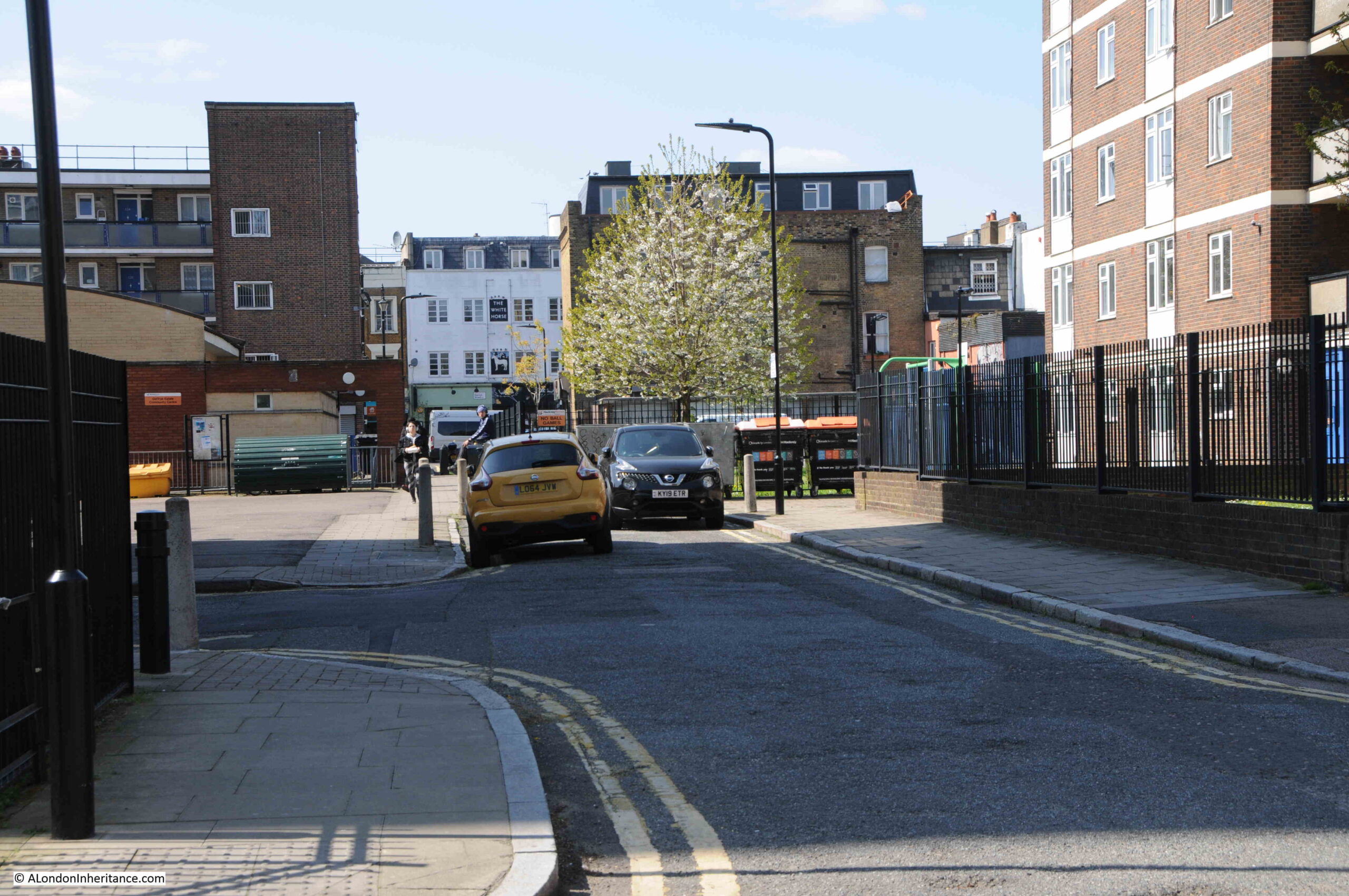
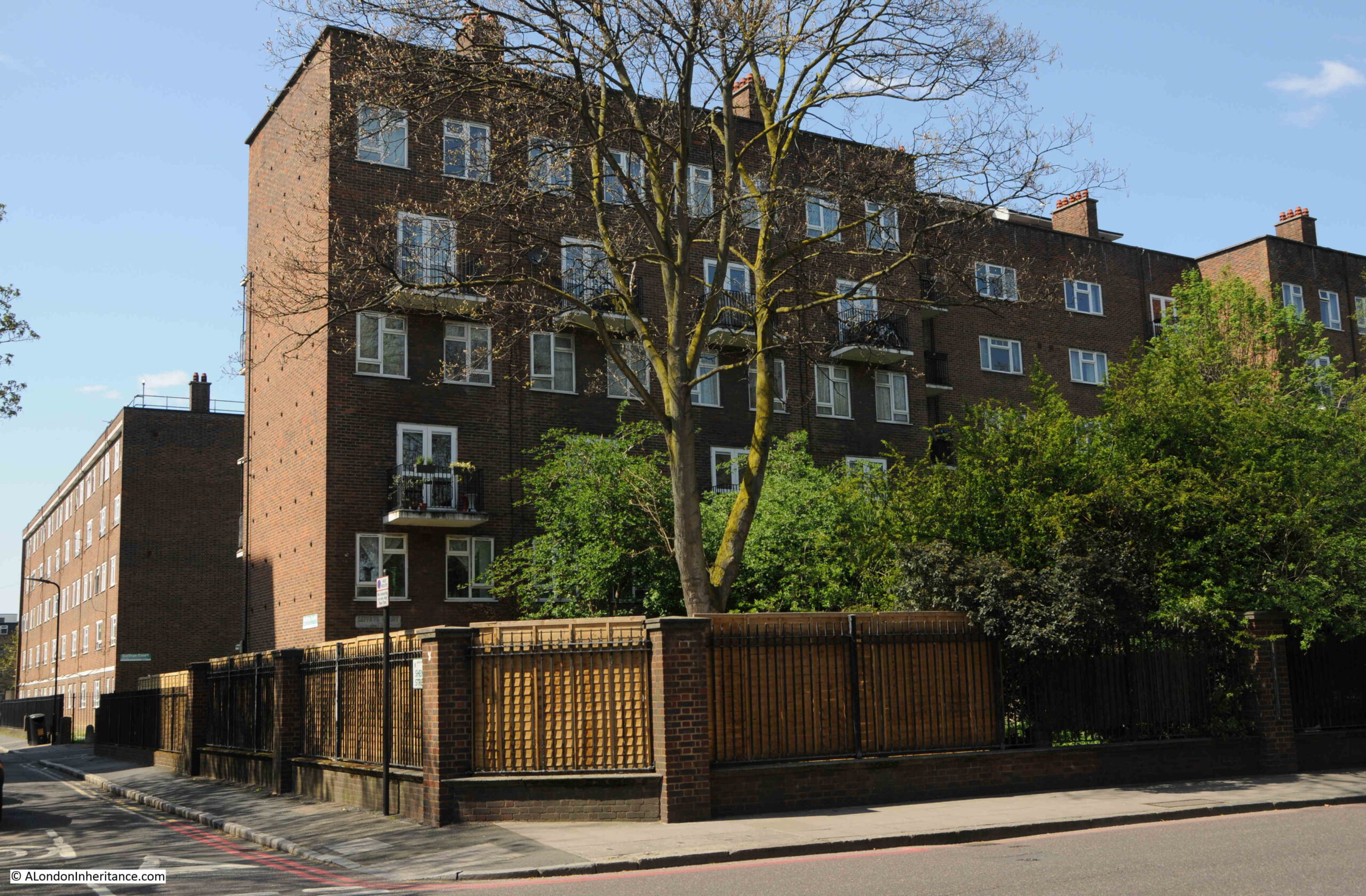
In the 70 years since the last Coronation, Shenfield Street has changed beyond recognition. Once a street lined with terrace houses, they have all since been demolished, to be replaced by the Geffrye Estate.

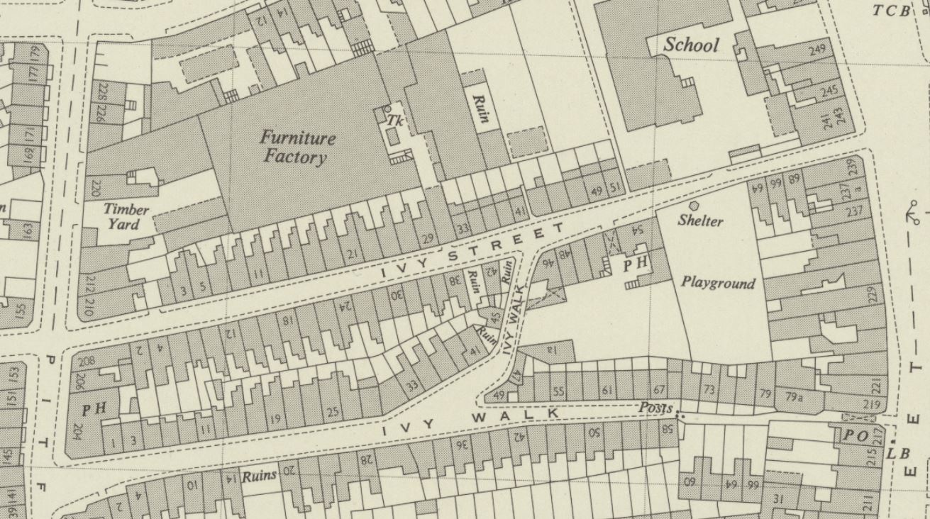
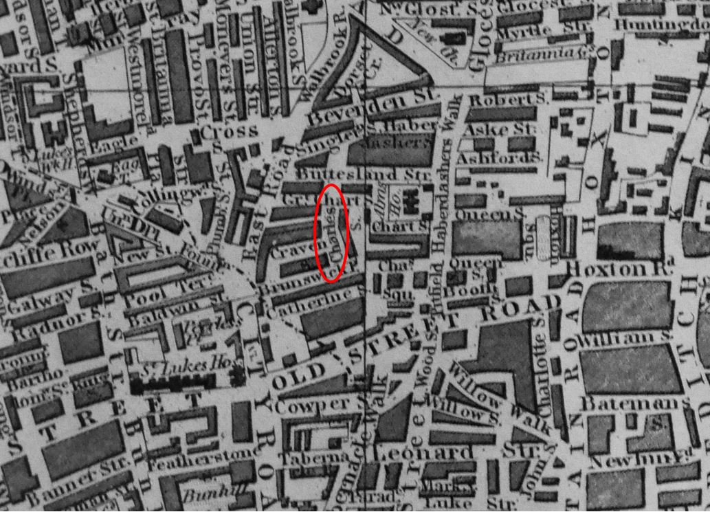
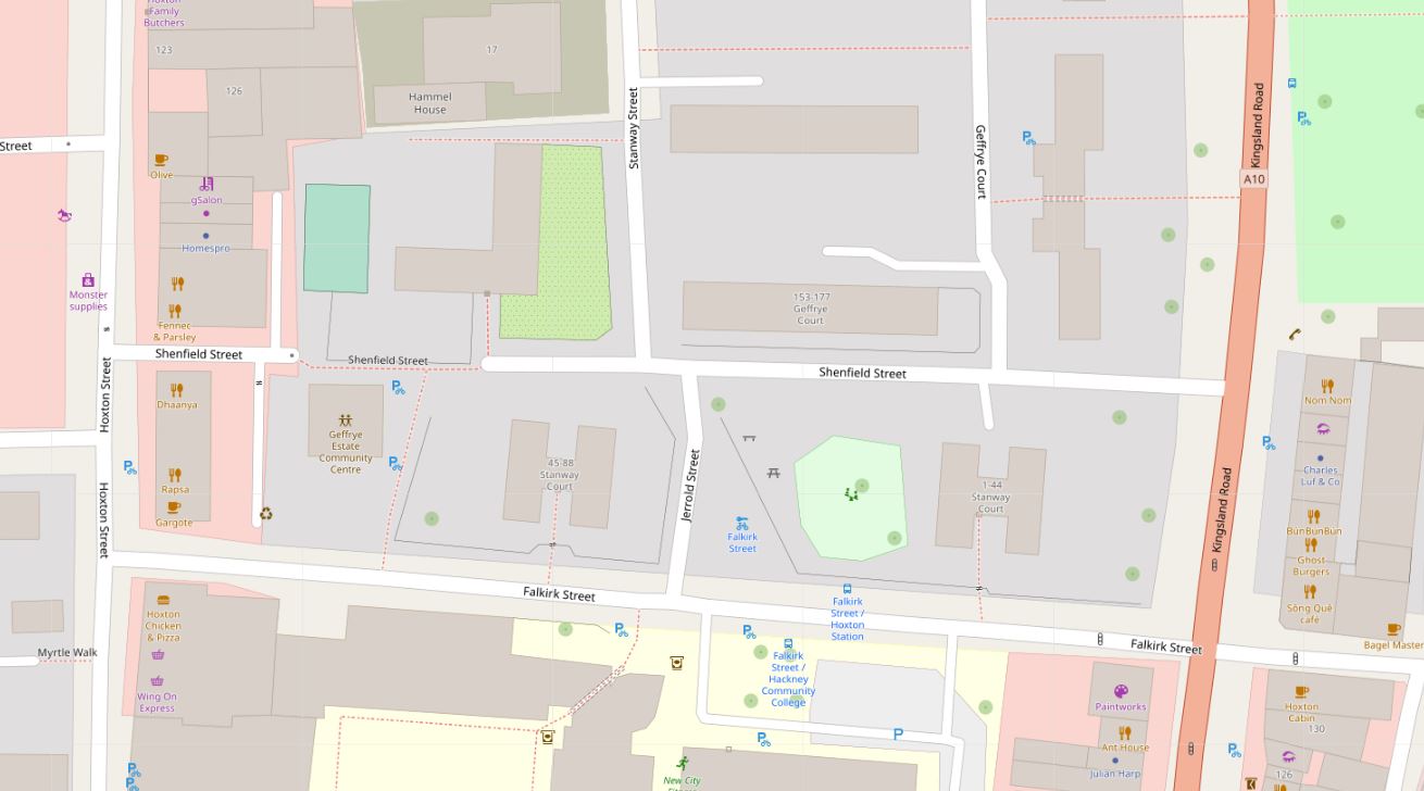
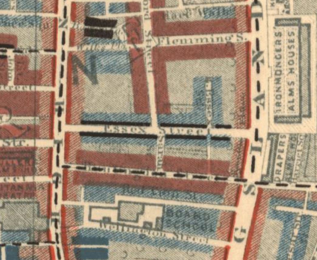
In the following map, Shenfield Street runs across the middle of the map, with Hoxton Street on the left and Kingsland Road on the right. In 1953, Shenfield Street provided a route between the two streets to left and right, but today is blocked for traffic, with only a pedestrian route through as shown by the grey section as the street approaches Hoxton Street (Map © OpenStreetMap contributors):

Shenfield Street

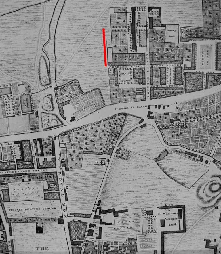
Construction of the street seems to have started in the late 18th century, however in 1799 as shown in the following extract from Horwood’s 1799 map of London, it was then called Essex Street, and is shown running across the centre of the following extract from the map:

Essex Street

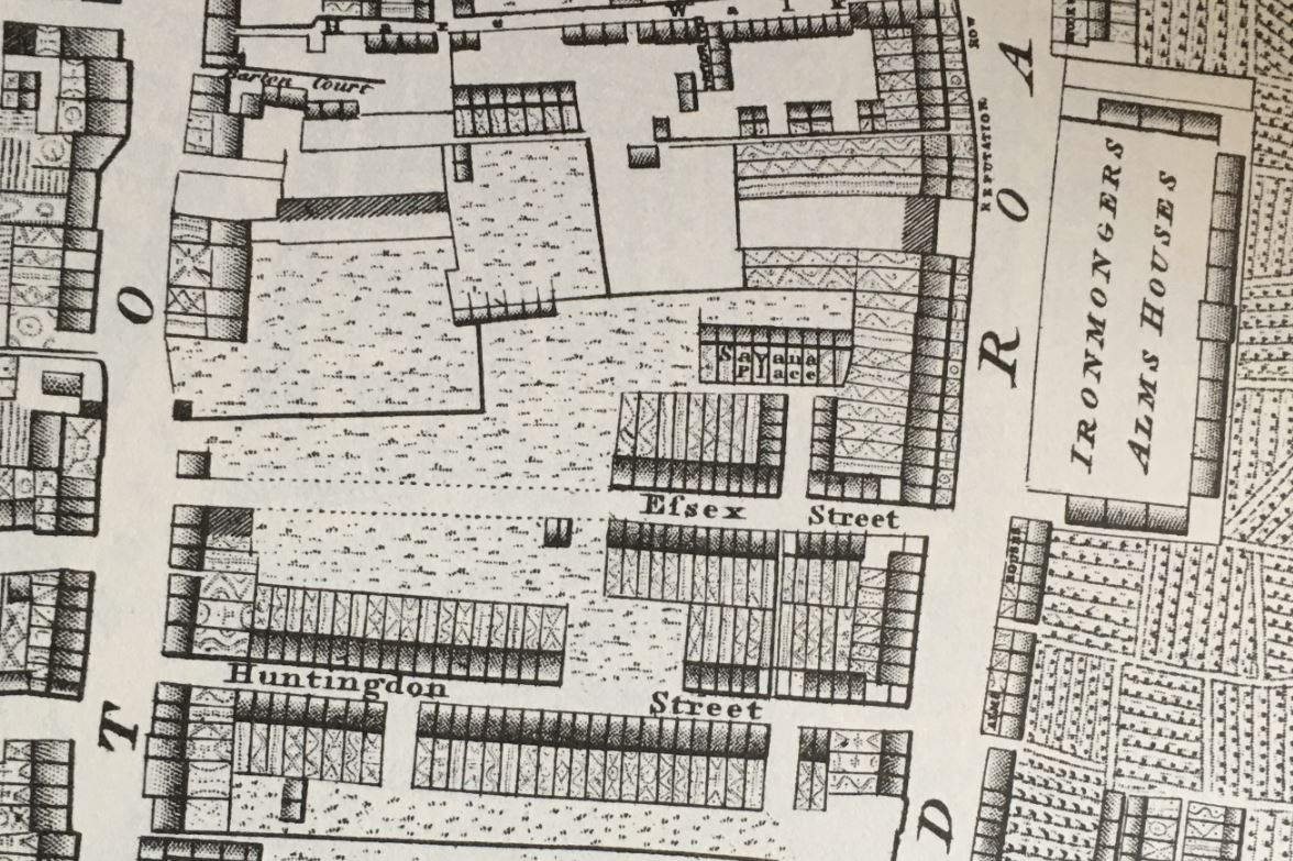
The map shows that building started from the Kingsland Road end of the street, and the houses then constructed appear to be densely built terrace houses, which I assume are the same houses that were still to be found in 1953.

The name change is interesting. I cannot find the source of the name Essex Street, or when it was changed to Shenfield Street. Essex Street was still in use in 1915, but had changed by 1945, when Shenfield was recorded in the LCC Bomb Damage Maps.

Street names were often changed to avoid confusion when there was another local street with the same name, however the nearest Essex Street seems to have been leading off from the Strand, a distance from Hoxton.

Shenfield was an interesting choice for the new name of the street, as Shenfield is a town in Essex, probably now better known as the eastern end of the Elizabeth Line. So by choosing Shenfield there was a continuation of the Essex connection.

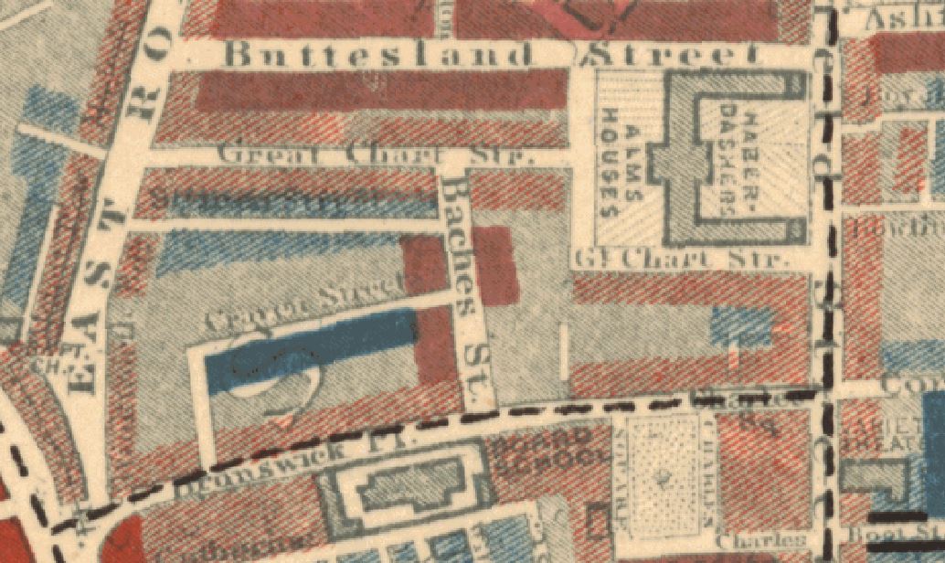
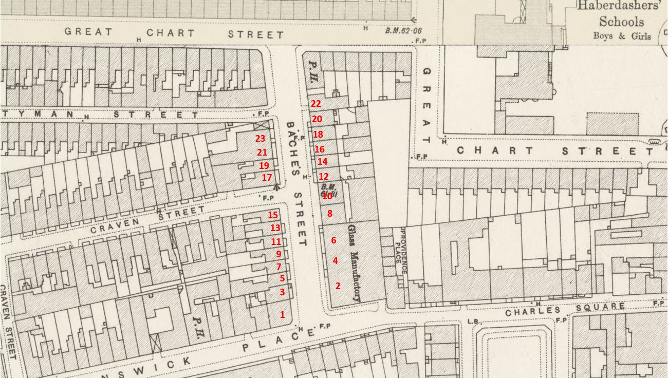
The following map extract is from 1957, and shows Shenfield Street with terrace housing lining the street as in my father’s photos. There is another Essex connection in the map. Towards the right of Shenfield Street, there is a small stub of a street heading north called Tiptree Street. Tiptree is another small town in Essex, some distance towards the northern part of the county, and no connection with Shenfield, so I have no idea why the two streets were given these names (‘Reproduced with the permission of the National Library of Scotland“).

Shenfield Street

My father took five photos of Shenfield Street, and I have located the position from where he took each photo, and the direction of view in the 1957 map (the first photo at the top of the post is the lower right photo):

Shenfield Street

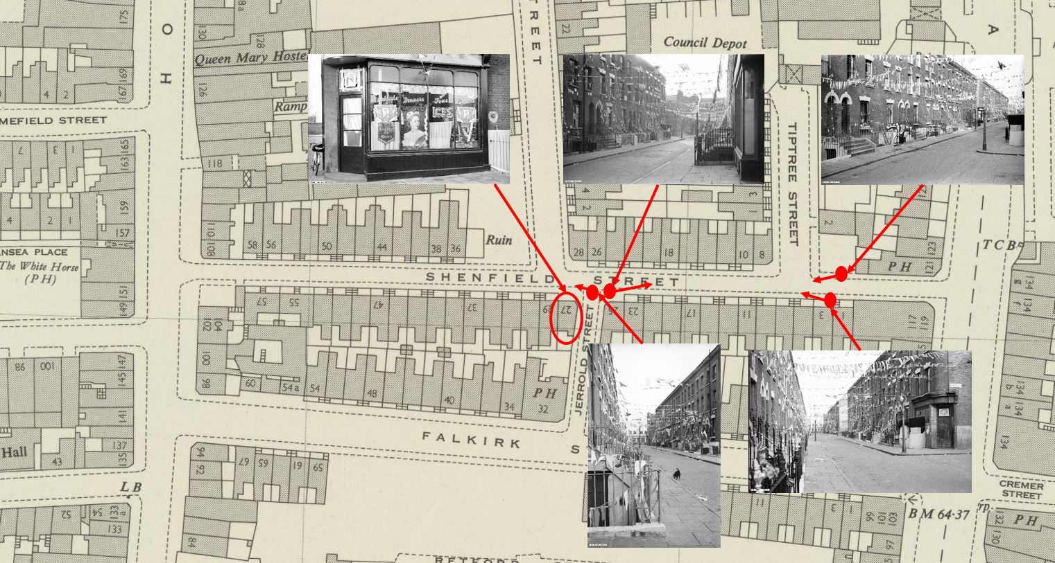
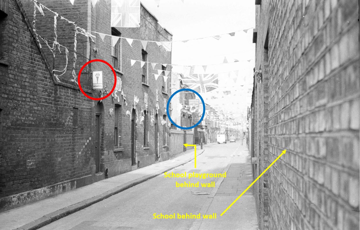
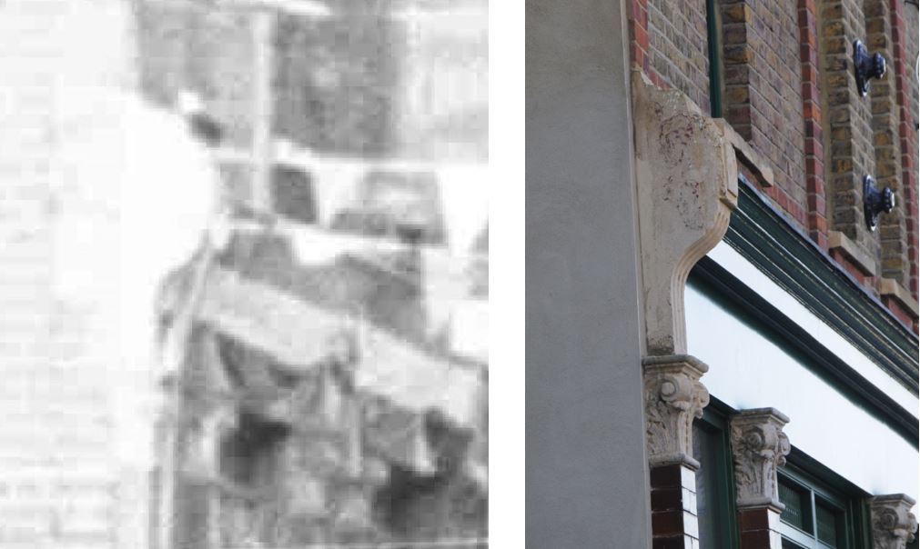
At top left of the above map is a photo that you may recognise as it has been in the header of the home page of the blog since I started in 2014, however I have never been sure of the location. I knew it was around Hoxton, but not exactly where. I will show later how I confirmed the location, that the café decorated for the Coronation was at 27 Shenfield Street, at the junction with Jerrold Street:

Shenfield Street Cafe

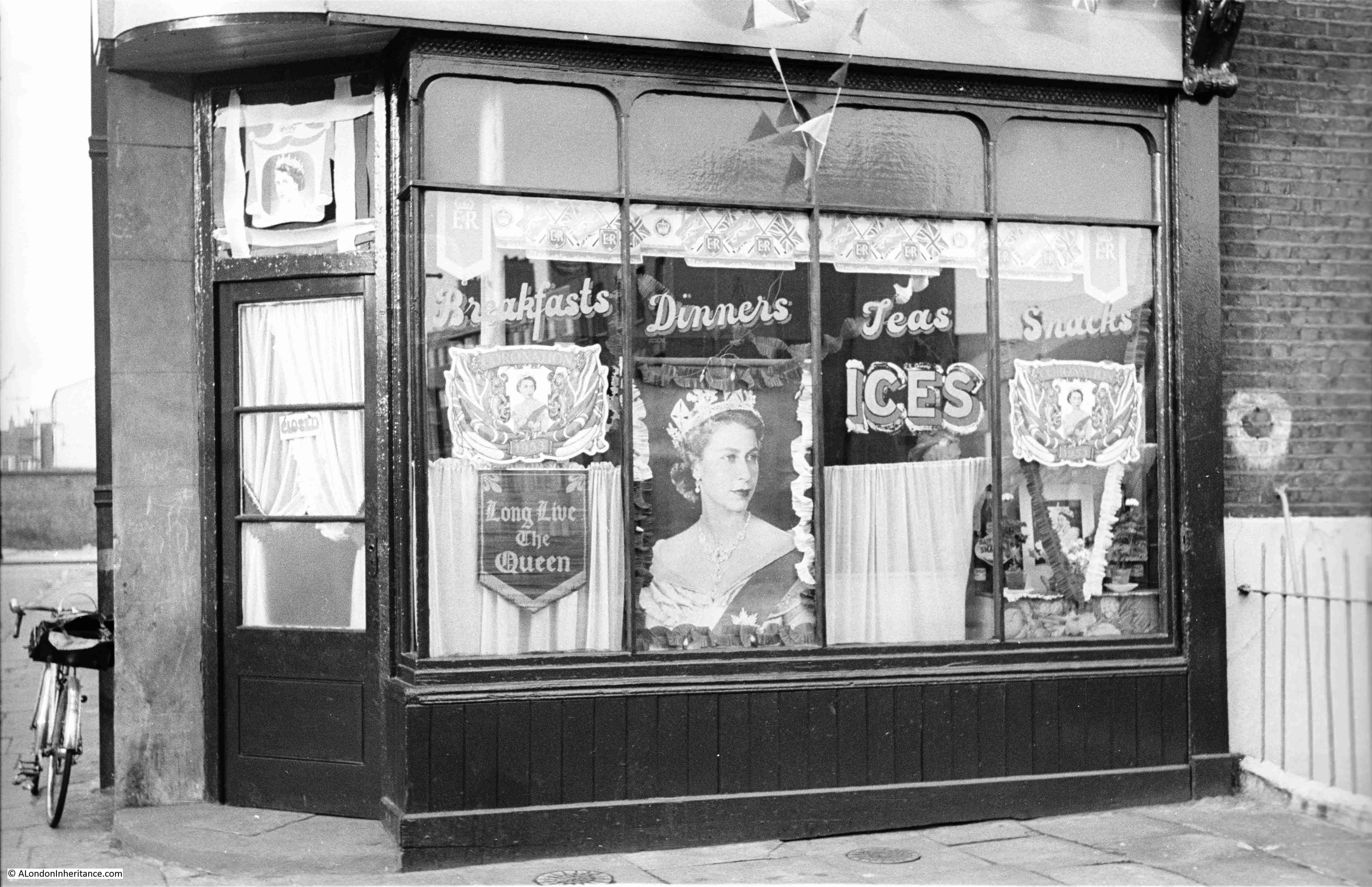
The photo is special for me, as it is the only London photo that shows my father’s bike, which is propped up against the wall to the left of the café. The bike took him all over London whilst taking these late 1940s and early 1950s photos, as well as youth hosteling across the country and to Holland.

The café does appear to have been well kept, and the lettering on the windows advertising Breakfasts, Dinners, Teas and Snacks is rather ornate.

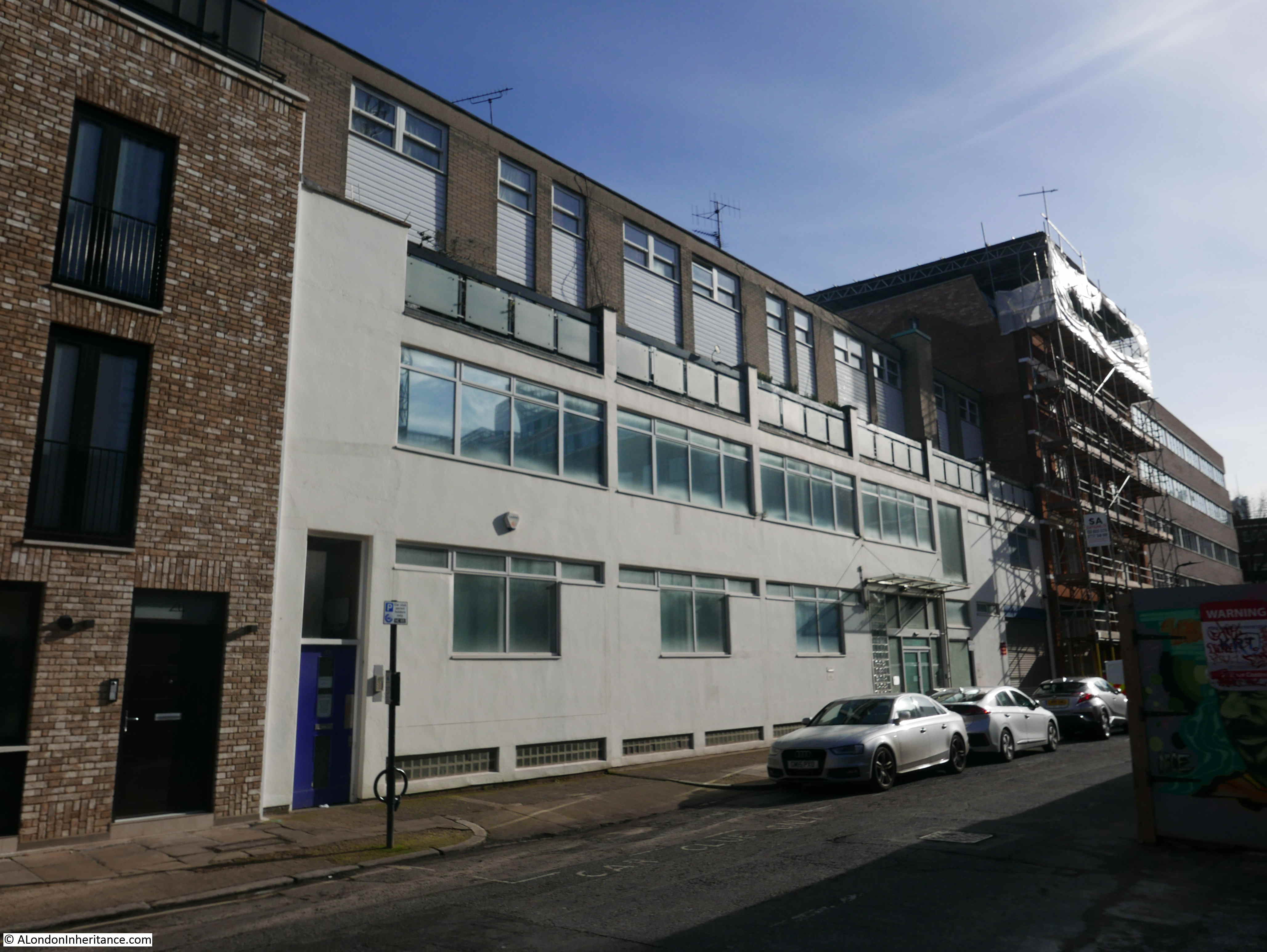
Jerrold Street still exists, however at the junction with Shenfield Street, the corner where the café was located has been cut to form an angled entry to Jerrold Street, so in the following photo the café would have been in the roadway and pavement leading back from the drain cover that can be seen in the road:

Shenfield Street

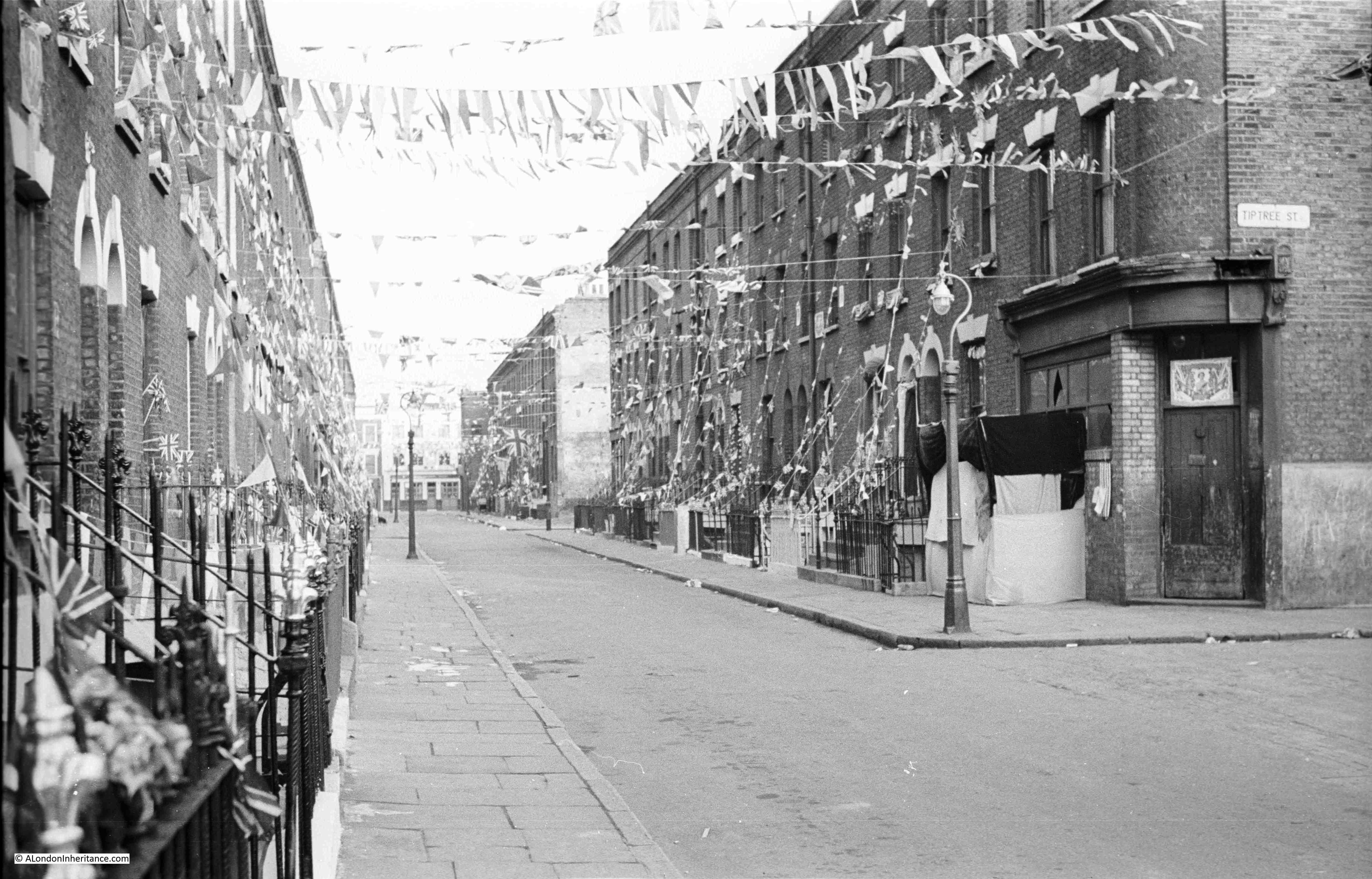
To the right of the café photo in the above map, is the following view, looking towards where Shenfield Street meets Kingsland Road. The photo was taken from the opposite side of the Jerrold Street junction, and the shop on the immediate right of the photo is at number 25 Shenfield Street:

Shenfield Street

In the above photo, Tiptree Street is along the street on the left, just after the lamp post, where Tiptree Street runs to the left.

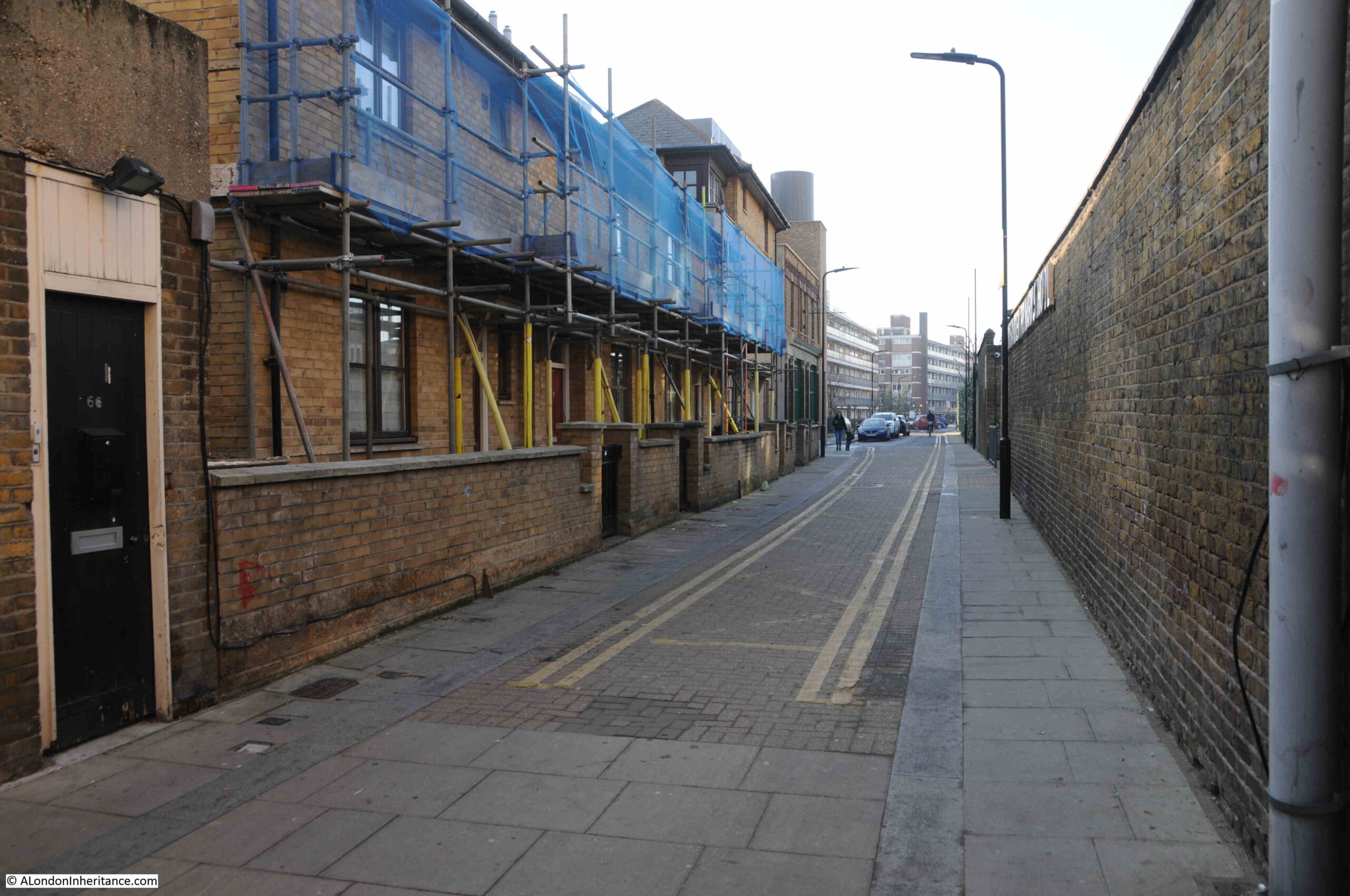
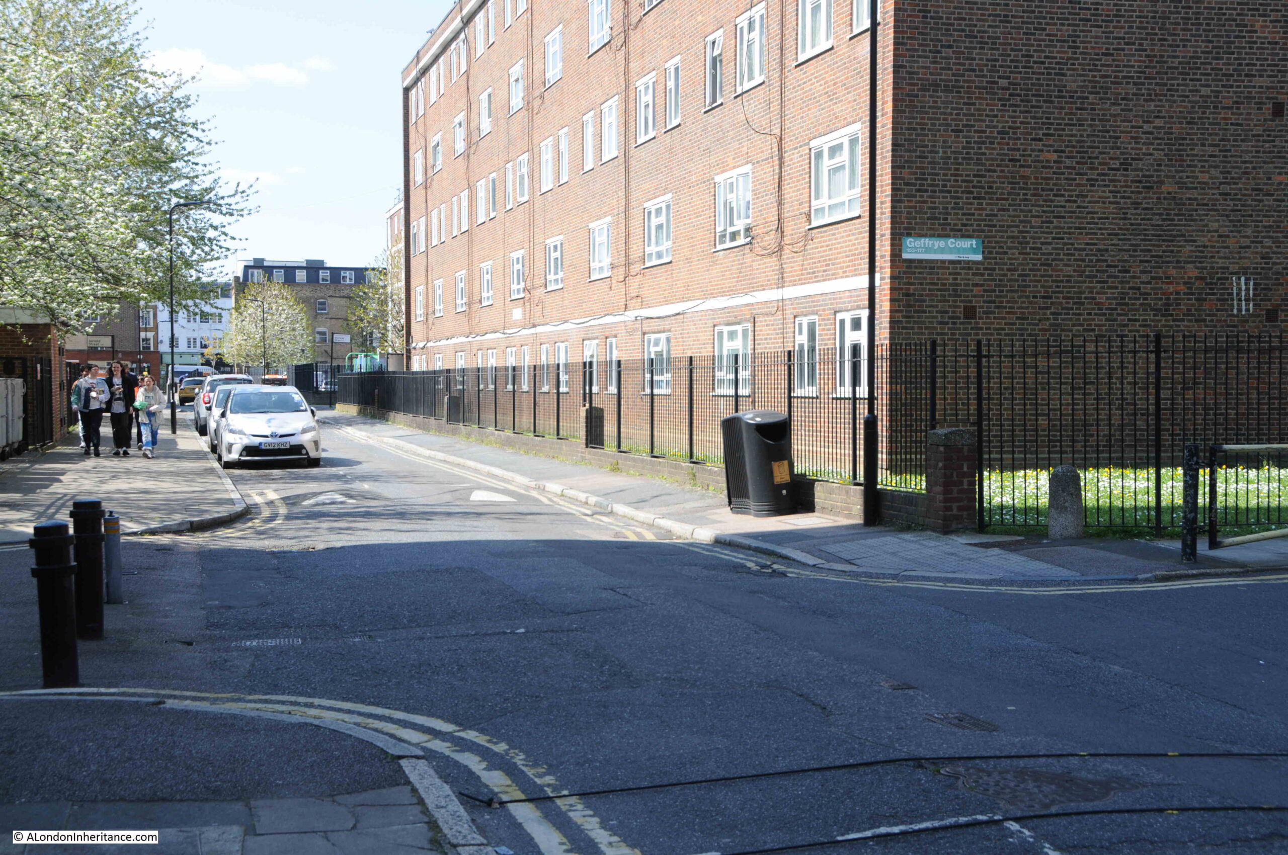
The same view in 2023:

Shenfield Street

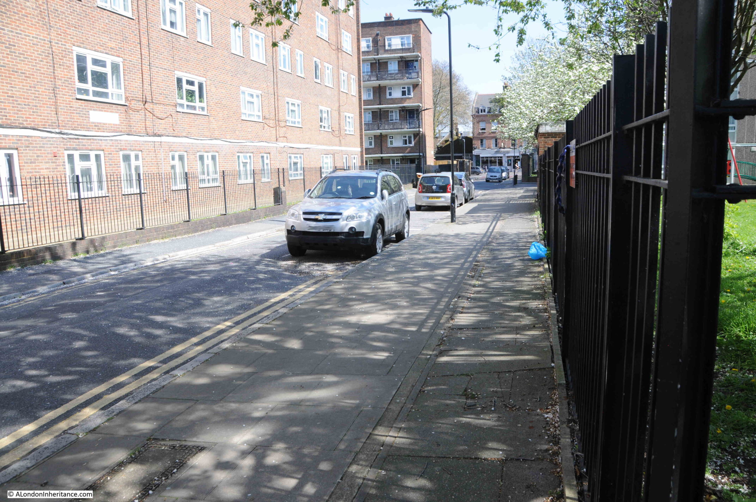
The location of the following photo, and direction of view, is at top right in the above map, it is looking towards the western end of Shenfield Street. The street which is running to the right, immediately in front of the location of the photo is again Tiptree Street:

Shenfield Street

The same view today, with not so much a street, rather an entrance to the estate leading off to the right, where Tiptree Street was once located:

Shenfield Street

It was this photo that allowed the location of the café to be identified. I have circled the location of the café in the following copy of the photo:

Shenfield Street

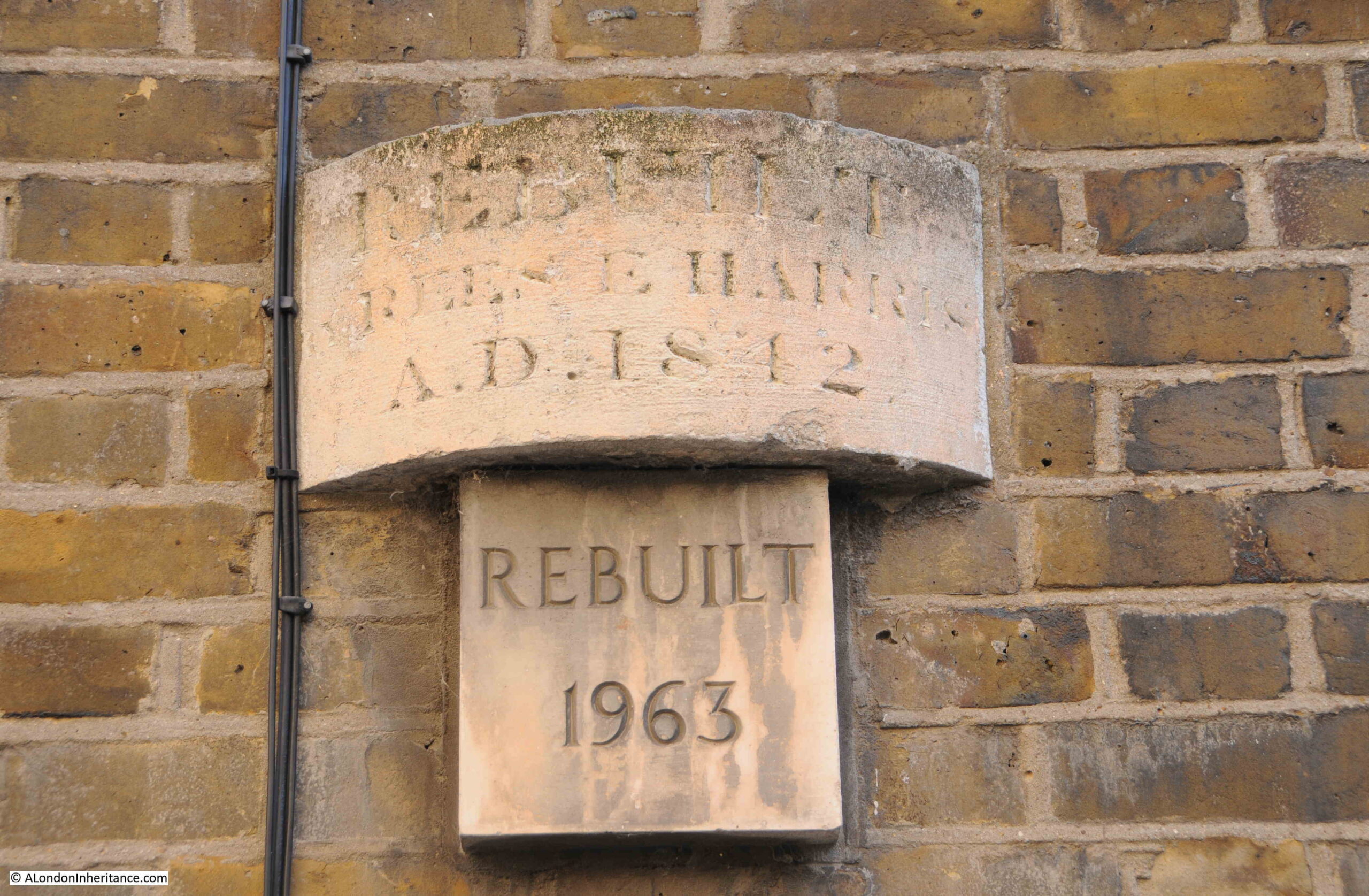
From the outside, the houses lining Shenfield Street look in a reasonable condition. Although there was significant bomb damage in a number of surrounding streets, Shenfield Street survived relatively unscathed, except for one house that was lost.

In Charles Booths poverty map, at the end of the 19th century, the street was classed as “Poor 18s to 21s a week for a moderate family”. In the following extract from the map, Essex Street as it was at the time of the survey, also has black lines running along the street, which means “Lowest Class, Vicious Semi-Criminal”:

Essex Street

A newspaper report from the 26th September 1922 offers a view of the conditions within the street:

“CROWDED STREET OF DOLE-DRAWERS. Amount Received Exceeds Pre-War Earnings. Every household in Essex Street, Hoxton is in receipt of relief from the Shoreditch Guardians, and the total so received is said to exceed the pre-war earnings of the whole street.

Probably one of the most congested streets in Shoreditch, Essex Street has several houses which are shared by six or seven families, and in one or two instances the number of people in each dwelling reaches 30.

Paper serves for glass in many of the windows.”

So the problem with the houses was not necessarily their construction, rather overcrowding and landlords who probably did not bother which much maintenance.

Another report from August 1939 shows how important it was (and still is), to have green, open space locally available:

“Novelty of Grass – Child Wedged In Railings. Three year old Lillian Turner always likes to visit her grandmother because in the backyard of her L.C.C. flat off Walmer Gardens, Hoxton, there was a patch of grass. She rarely sees grass, for there is none near her own home in Shenfield Street, Hoxton.

While her mother went upstairs to chat with her grandmother yesterday, Lillian ran out to the grass patch. She tried to squeeze through some railings to get to it, but became wedged by the shoulders.

Men passing tried to release her, but were afraid of hurting her and sent for the fire brigade. In a couple of minutes, six firemen with a fire pump and an ambulance arrived, but as they did so, Mrs. Turner managed to release her daughter, unhurt but suffering from shock.”

From the above description, you can understand why post war estate planning, such as the Geffrye Estate which was built following the demolition of the houses along Shenfield Street, included plenty of green space scattered across the estate.

The above two news reports also shrink the period for the name change from Essex to Shenfield Street to between 1922 and 1939.

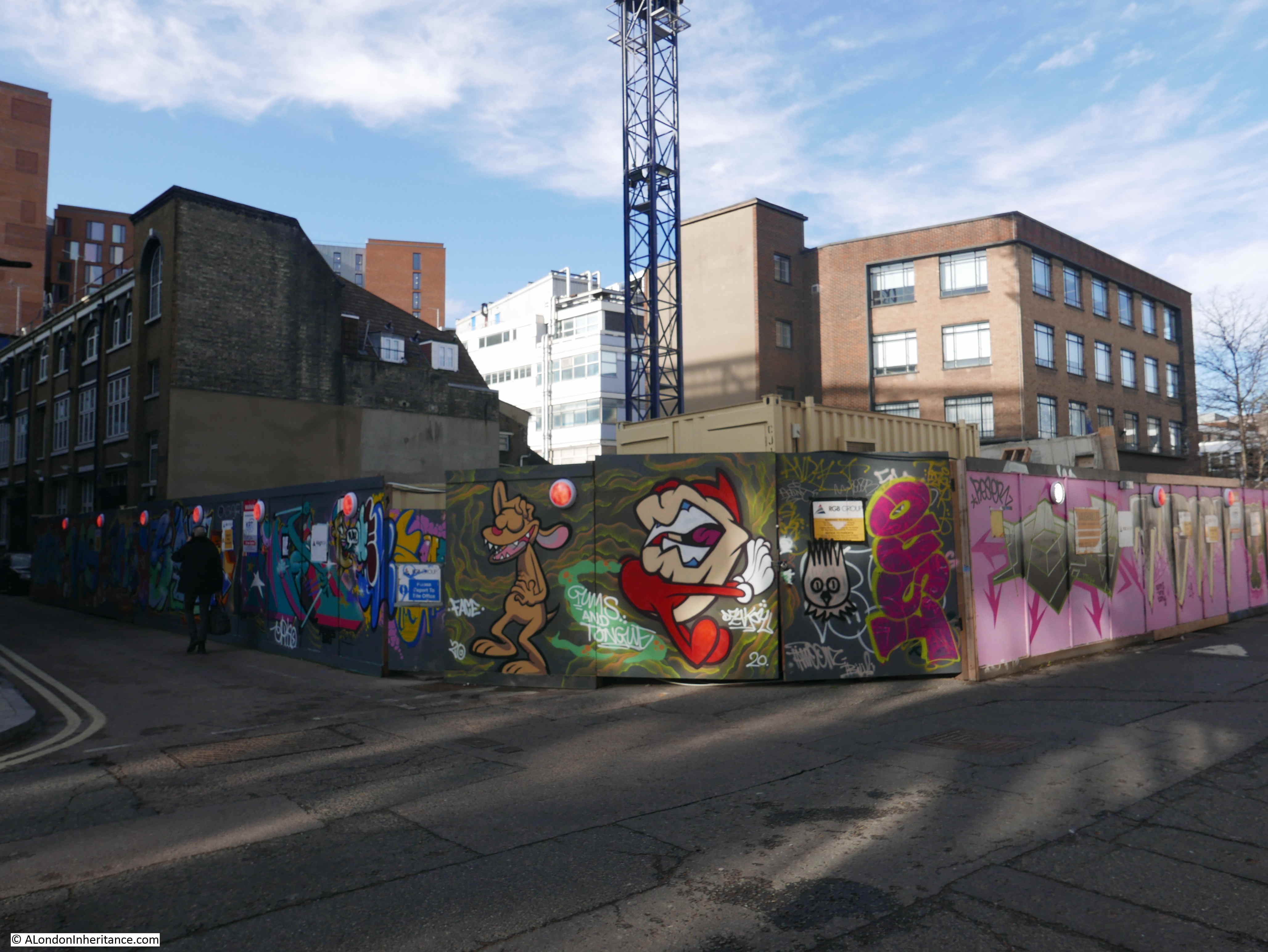
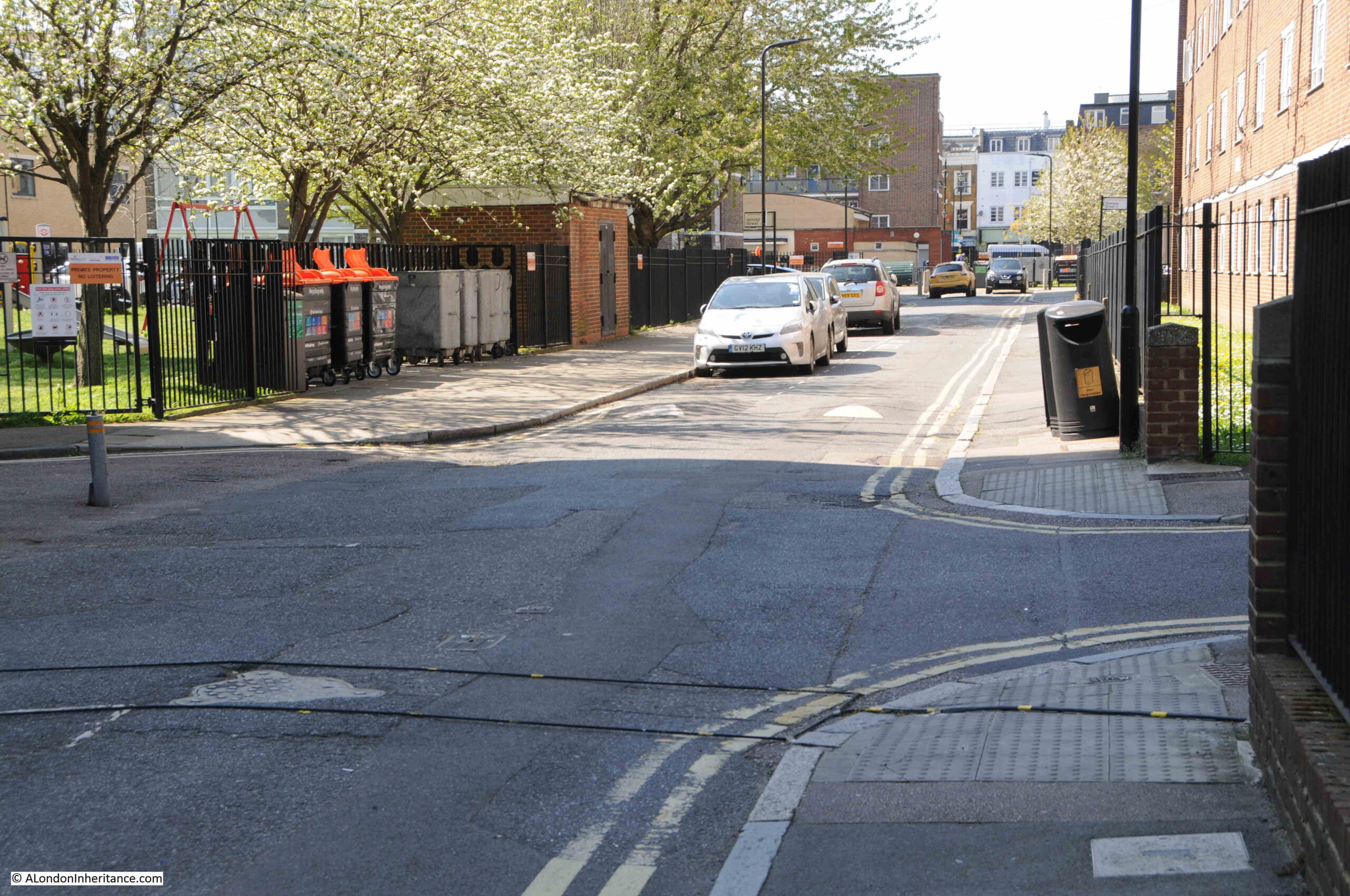
The following photo is from the lower right position in the above map. Tiptree Street is the street leading off at the right. There is what appears to be an old shop on the corner at number 8, however most of the front of the shop appears bricked up and there is some strange contraption in front of the shop:

Shenfield Street

Look along the terraces of houses on the right, and half way along there is a light coloured wall. This was an internal wall of a house that was demolished following bomb damage.

The same view in 2023, with what was Tiptree Street on the right, and the location of the old shop was on the patch of grass:

Shenfield Street

This is the view looking down what was Tiptree Street, today access to the Geffrye Estate without any apparent naming:

Geffrye Estate

Tiptree Street was originally lined with similar terrace houses to those in Shenfield Street. The terrace that was on the left survived the war, however only a single house survived on the right with the rest destroyed by bombing.

The whole area to the north and south of Shenfield Street is now part of the Geffrye Estate, which I again assume was built during the late 1950s / early 1960s. The estate consists of Geffrye Court, Stanway Court and Monteagle Court, as shown in the following estate map:

Geffrye Estate

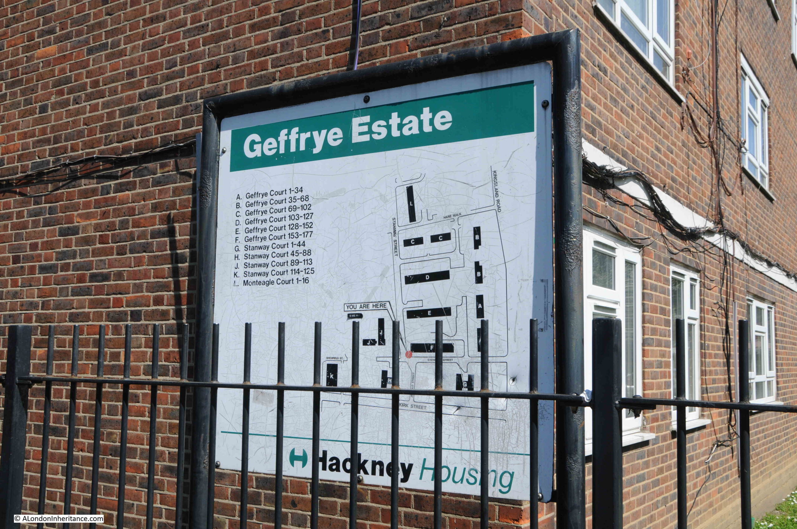
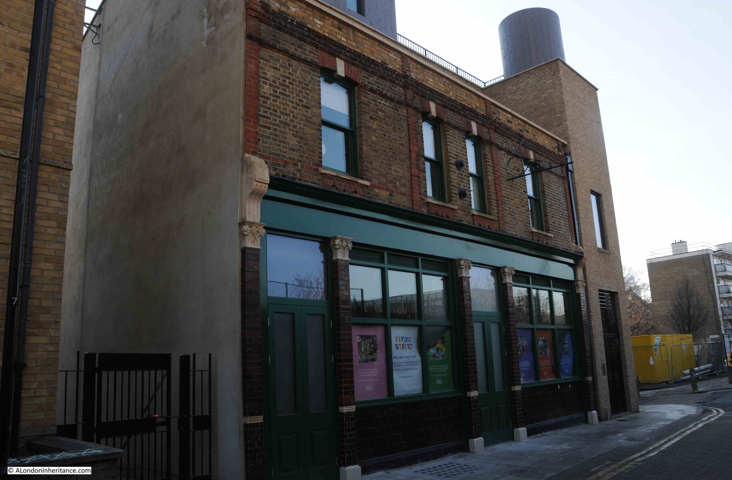
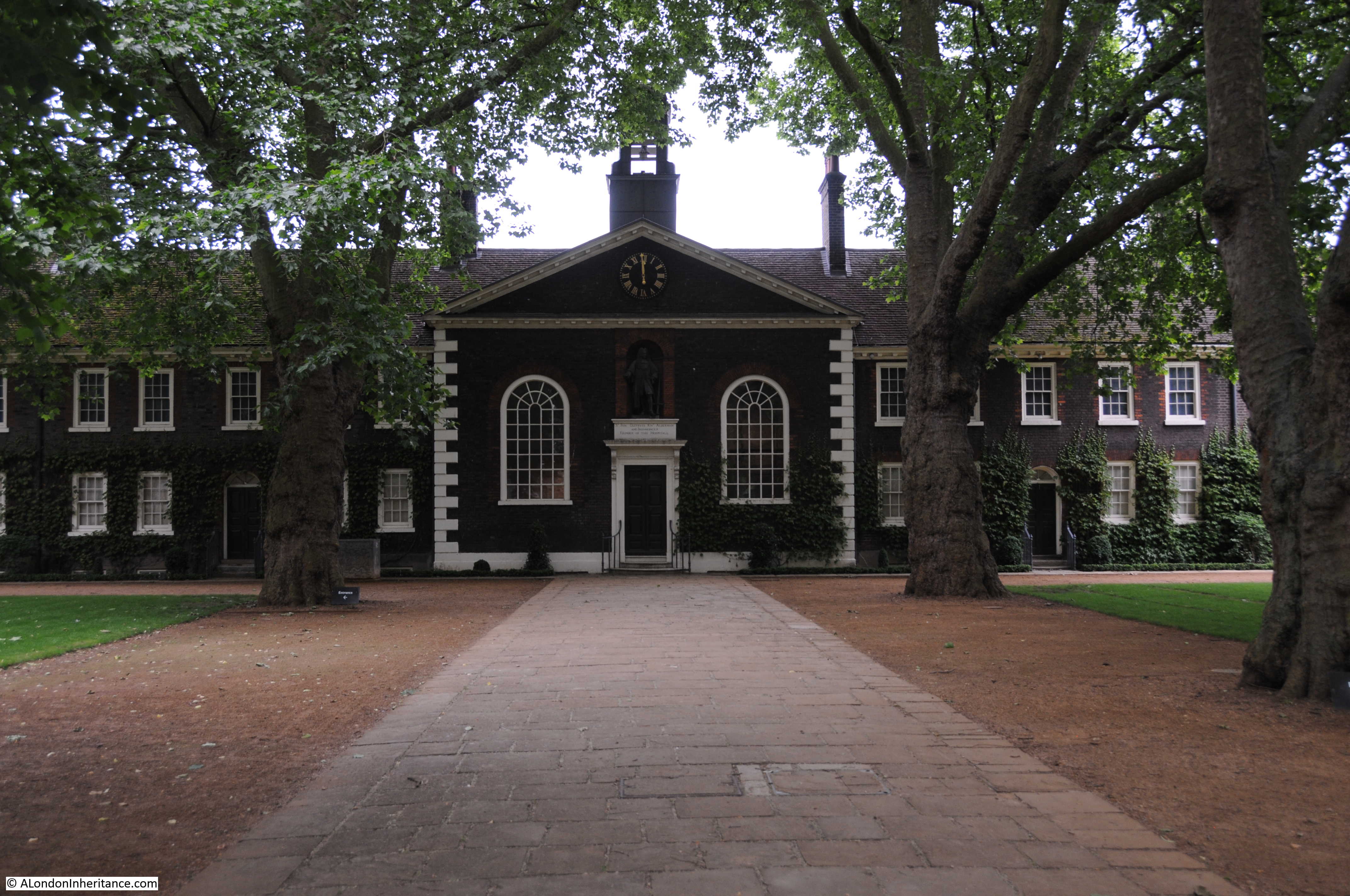
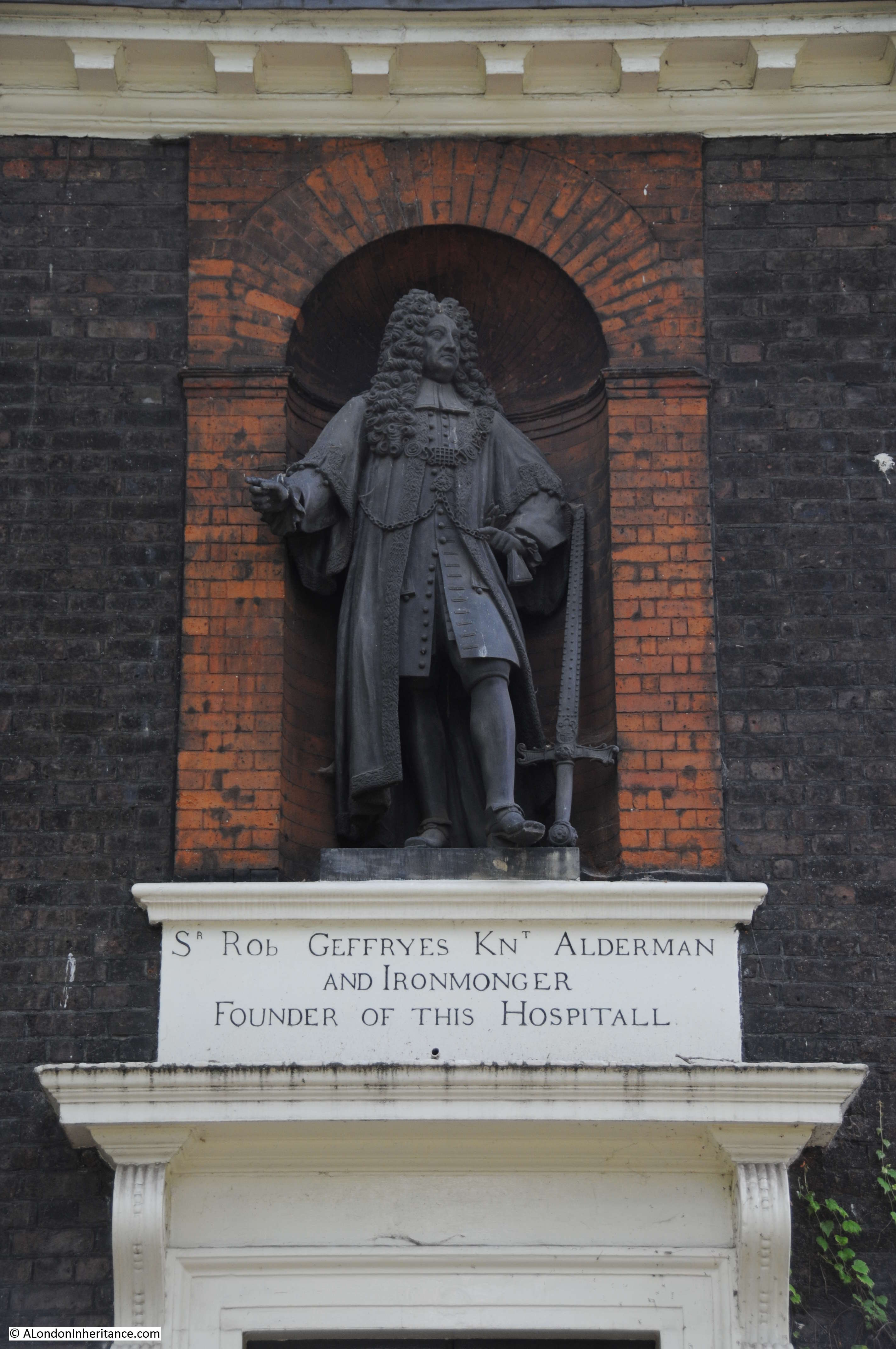
The name of the estate is interesting, and I am surprised it is still in use. I assume it is named after Sir Robert Geffrye who was twice Master of the Ironmongers Company as well as Lord Mayor of the City of London. Geffrye’s financial bequest enabled the Ironmongers Almshouses to be built, which are on Kingsland Road, just north of where Shenfield Street meets Kingsland Road.

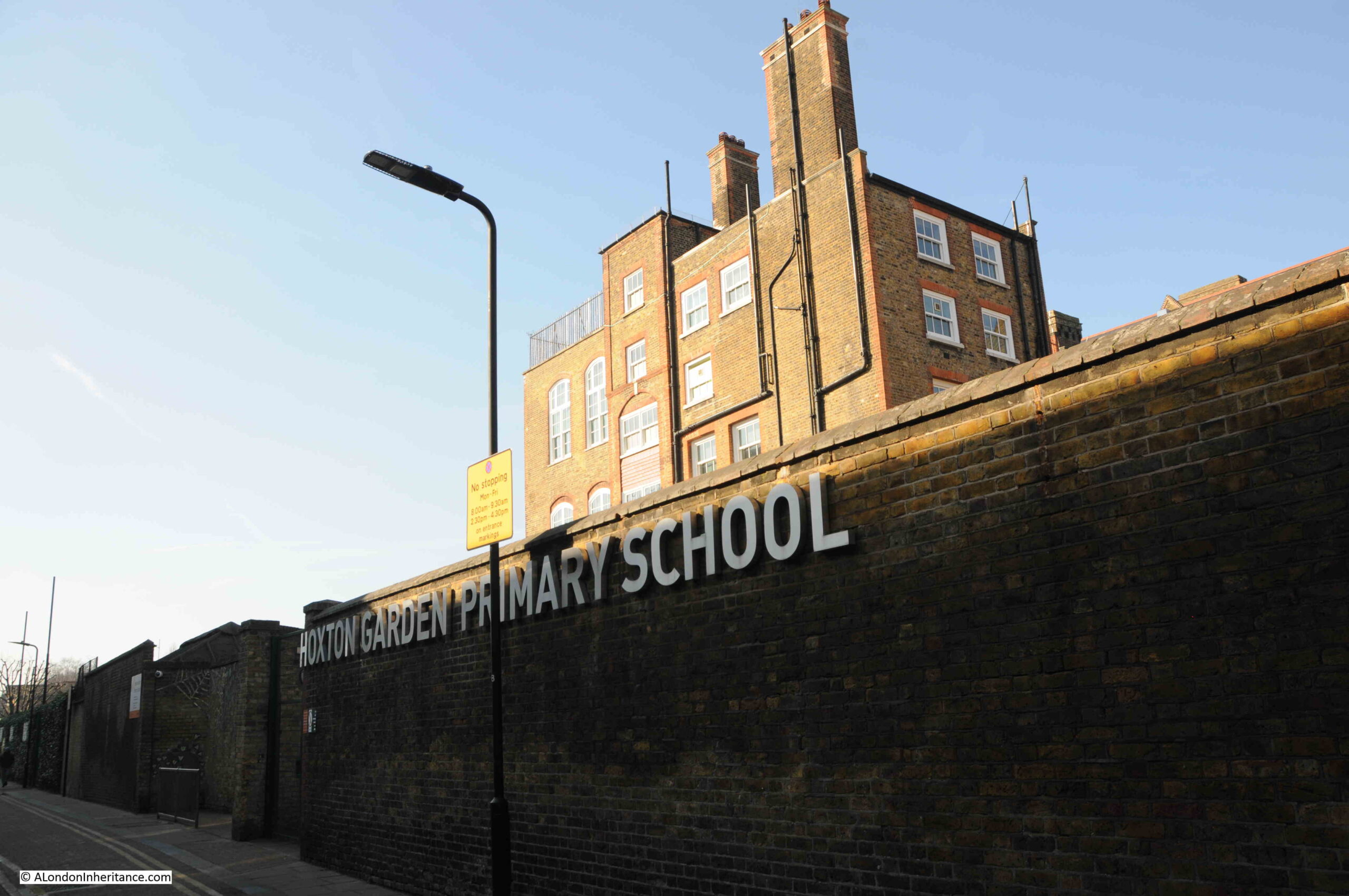
The almshouses were purchased by the London County Council in 1911 to save the green space surrounding the buildings, as this space represented a significant part of the green space in the area.

It then became a museum by the name of the Geffrye Museum, however is now called the Museum of the Home.

Sir Robert Geffrye made some of his money from his involvement in the transatlantic slave trade through his investments in the Royal African Company.

Hackney Council have him as a contested figure in their Review, Rename, Reclaim initiative, and the council supported the Museum of the Home in a consultation as to whether a statue of Geffrye at the museum should be removed. The results of the consultation where that it should, however the museum trust decided to retain the statue.

There does not appear to be any mention on the Council’s Review, Rename, Reclaim web pages about renaming the Geffrye Estate.

Going back to the OS map of the street, and where Shenfield Street meets Kingsland Road, and on the northern corner there was the PH reference for a pub. This was the old Carpenters Arms which was demolished at the same time as the rest of the street in preparation for the construction of the Geffrye Estate. The corner where the pub was located is now an area of green space with a block of flats behind as shown in the following photo:

Geffrye Estate

Shenfield Street today is so very different to 1953. I suspect that there must have been a street party along the street, for the street to be so decorated.

The houses in the 1953 photos look substantial and well built houses, although they were probably poorly maintained and in need of much modernisation. The problem with much of this type of housing was very poor maintenance and over crowding. With some care and updating, they could have been retained and would now form a rather impressive street.

Retaining the street would probably not have achieved the number of individual homes that the Geffrye Estate now provides, or the ability to include green space across the estate, a much needed improvement as green space was so very limited in this area of pre-war Hoxton.

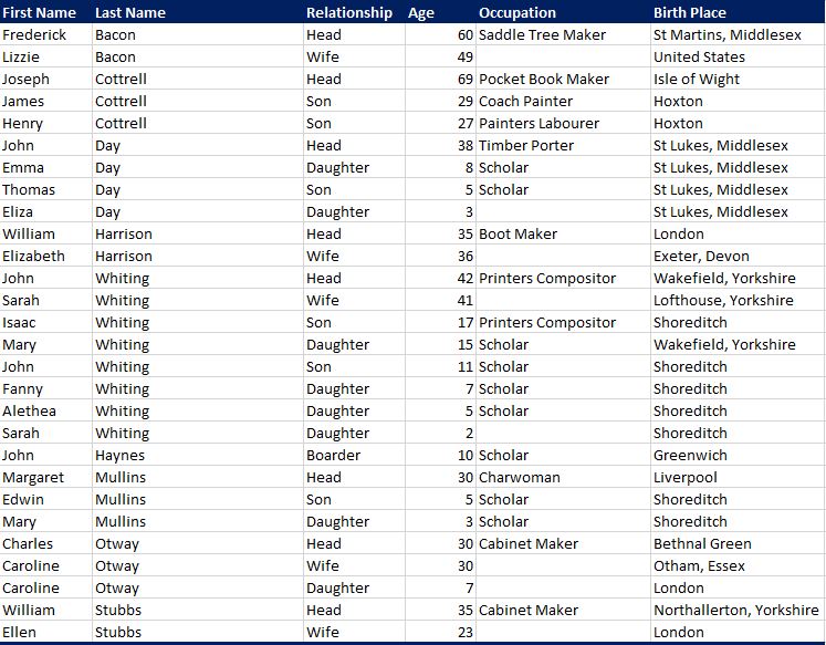
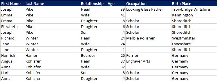
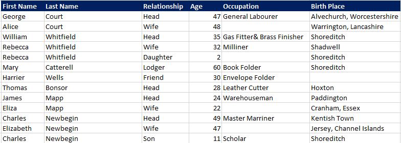
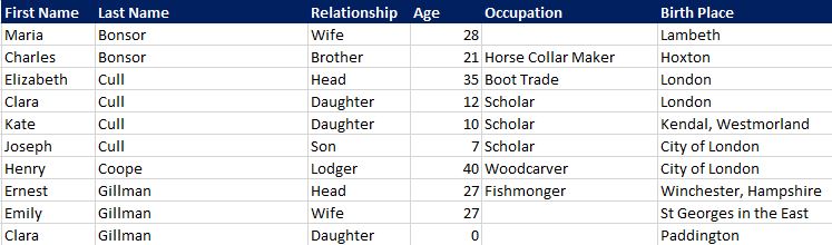
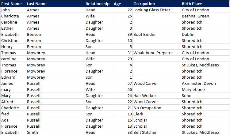
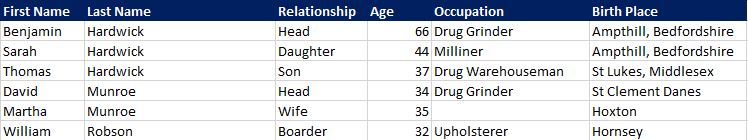
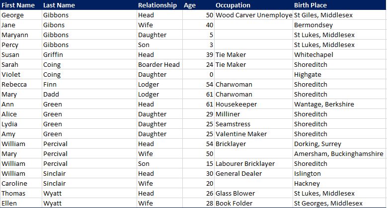
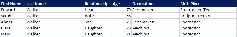
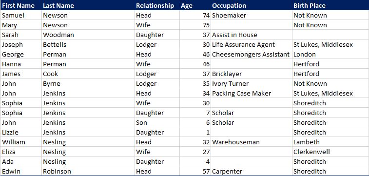
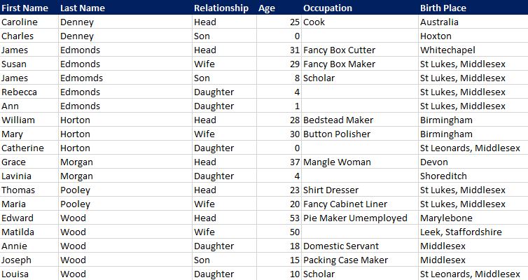
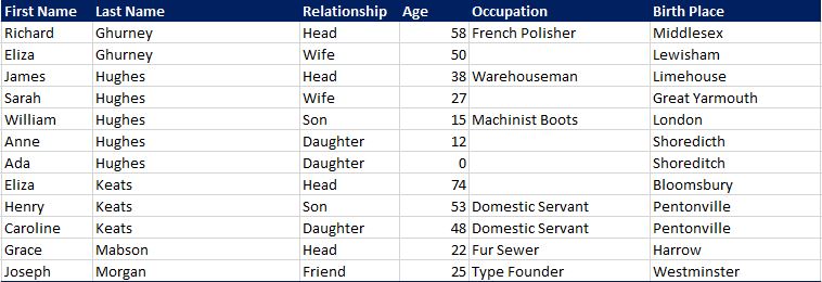
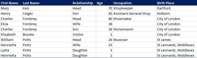
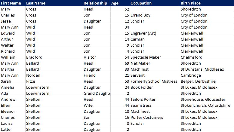
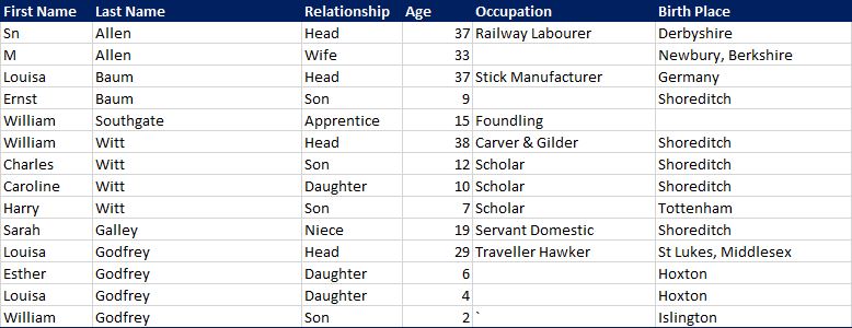
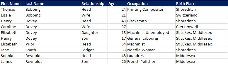
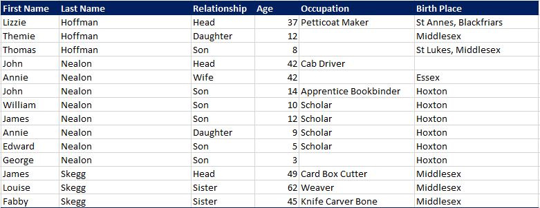
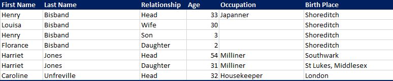
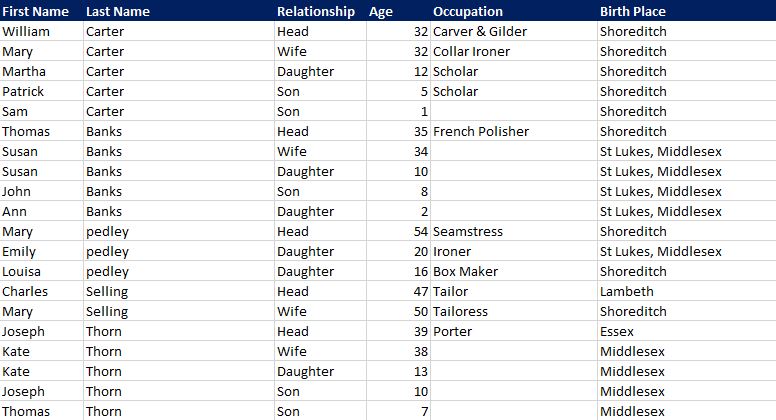
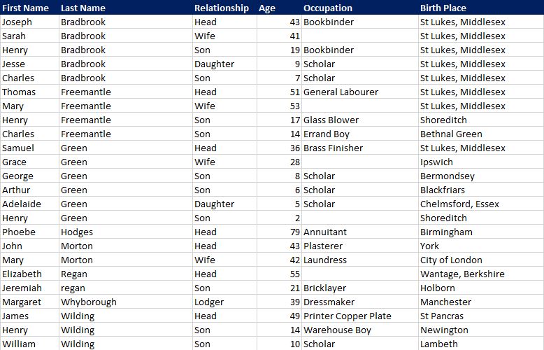
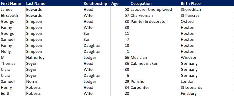
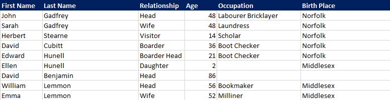
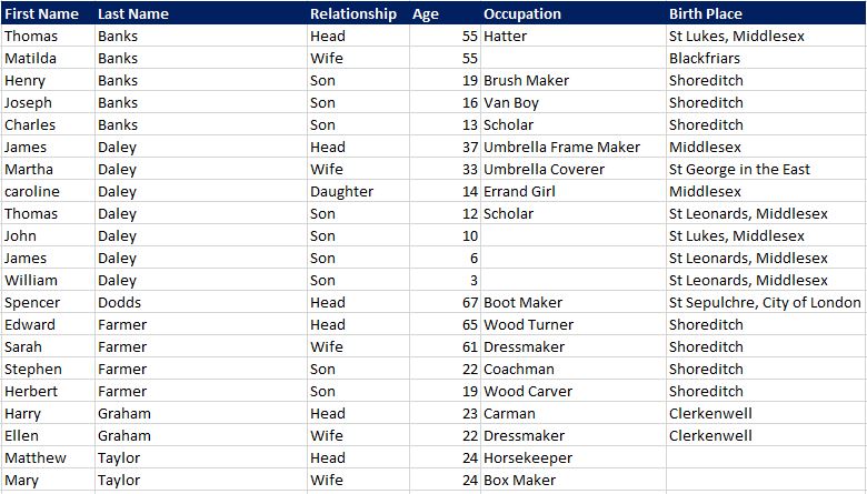
I was planning to use Census data to map who lived in Shenfield Street to each of the houses, as using the OS map, the number of each house is easily identifiable in the photos, although I ran out of time – perhaps I will revisit in a future post.

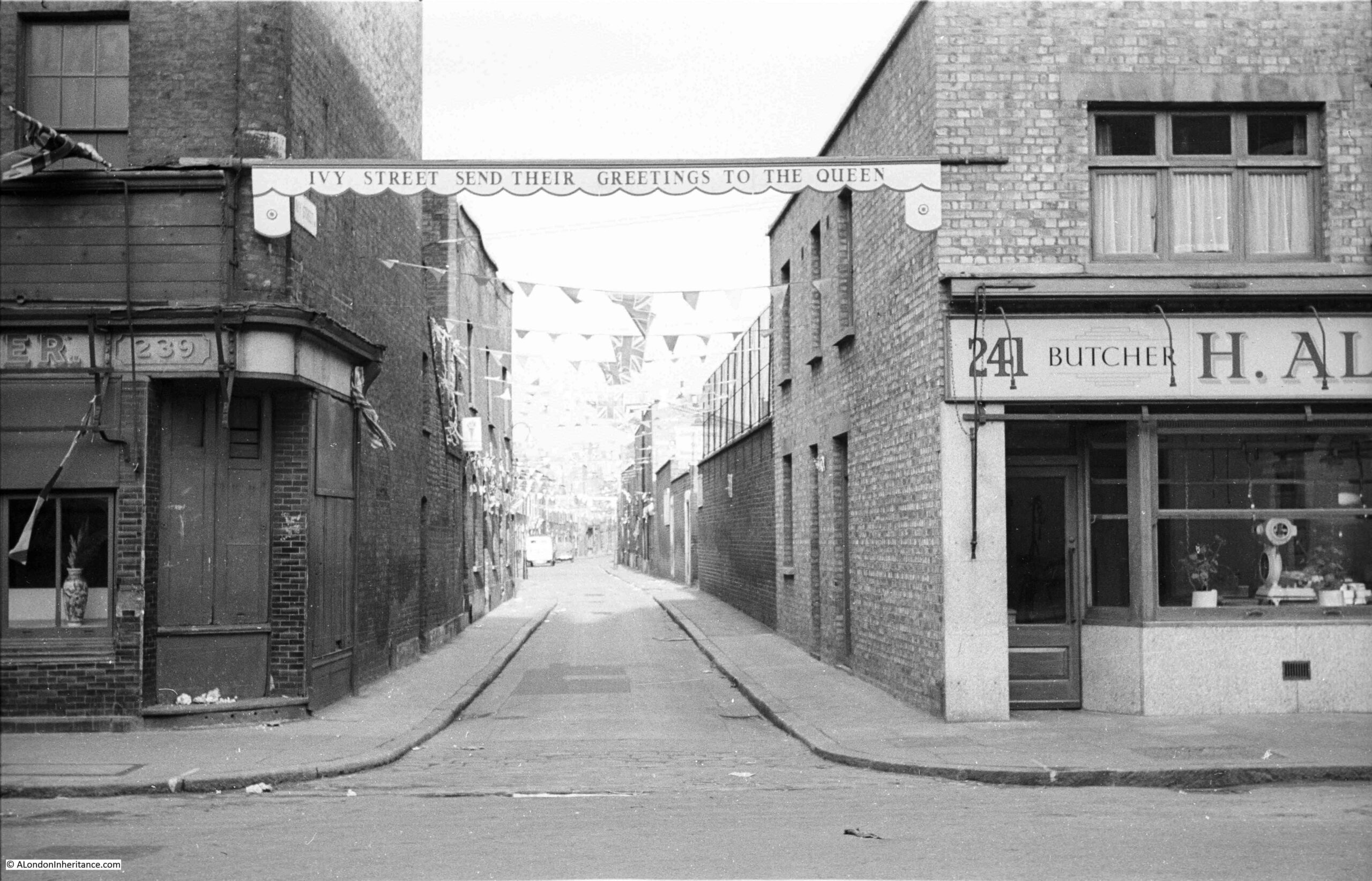
You may also be interested in a couple of other posts showing Coronation decorations in London in 1953, including Whitecross Street and Ivy Street. Also, this post looked at Coronation Day in London.

alondoninheritance.com

Ivy Street – A Hoxton Mystery

The photo for this week’s post was taken by my father on the 31st of May, 1953 in Hoxton Street, looking down Ivy Street. Above the entrance to the street is a banner which reads “Ivy Street send their greetings to the Queen”, and along the street there are flags and decorations that run the length of the visible section of the street. The photo was taken a couple of days before the Coronation of Elizabeth II on the 2nd of June 1953

Ivy Street

This should have been such an easy location to find, however I did have my doubts and the building on the right of the entrance to the street was a bit of a mystery when I compared with the same scene today, as shown in the following photo:

Ivy Street

Where there was a butcher in 1953, today is a shop where you can apparently buy Hoxton’s best kebab. The building on the right looked pre-war, and a view of the complete terrace of which the kebab shop is at the end, further confuses:

Ivy Street

The terrace does not look of post-war design or construction. The end of terrace part with the kebab shop has the same brickwork, windows, decoration etc. as the rest of the terrace. It does not look like a recent addition to an existing terrace.

The butchers shop on the corner in my father’s photo does looks relatively new. Clean brickwork when compared with the building on the left of the entrance to Ivy Street. I did wonder whether the butcher’s shop was a temporary build following wartime bomb damage, however although there was much bomb damage in the area, the LCC Bomb Damage Maps do not show any damage to this corner building.

My father took a second photo, a short walk down Ivy Street, and although Ivy Street has changed considerably, there are a couple of features which confirm the location.

Ivy Street

The same view today:

Ivy Street

The following extract from the Ordnance Survey map was published in 1954, but surveyed in 1953, so the same year as my father’s photo. Ivy Street can be seen running left to right across the centre of the map. Hoxton Street is on the right, and at the junction of Ivy and Hoxton streets can be seen a building with numbers 241 and 243. The butcher’s in my father’s photo is number 241, and with 243 it must have been a double width building. The kebab shop today is number 241  (‘Reproduced with the permission of the National Library of Scotland“).

Ivy Street

There are a number of features which confirm the location and can be traced today, which I have outlined in the photo below, starting the with red circle which surrounds the sign used in the 1950s for a school. As can be seen in the above map, there is a large school to the right of Ivy Street (in the direction of the photo). The school also has a playground on the opposite side of the street, and I have also marked these on the photo, with walls aligning with where the school and playground should have been.

Ivy Street

Further down the street, I have marked a feature in a blue circle. This is on the only building in the street that can be seen in the two photos:

Ivy Street

The feature in the blue circle is the decorative feature on the edge of the building, and the following comparison photos are an extract from the 1953 photo and 2023 photo showing the feature:

Ivy Street

In the above 1953 extract you can just see a sign protruding from the building at top right. In my 2023 photo, the fixings for this sign are still on the wall.

The sign was a pub sign, as this building was the Queen Adelaide at number 54 Ivy Street. The PH in the OS map extract also confirms the location of the pub.

It is hard to date the pub. It does not appear to be that old as the earliest reference I can find date to the 1890s, when the pub seems to have been host to some rather strange competitions, as illustrated with the following from the Sporting Life on the 28th November 1891:

“BIRD SINGING – A LINNET handicap will take place on Nov 29th at 1.15, three pairs of birds, 6s prizes. Also a chaffinch handicap at 8.30 for 6s, three pair. On Saturday night, at 8.30 sharp, a chaffinch handicap. First prize, leg of mutton, second, shoulder of mutton; third, shoulder of mutton,; fourth, shoulder of mutton. open for all comers. Don’t forget – The Queen Adelaide, Ivy-street, Hoxton (five minutes’ walk from Haggerston or Shoreditch Station.” 

And on the 22nd January, 1892:

“BIRD SINGING – LINNET HANDICAP. On the evening of the 17th inst. Mr. Ben Wilton, host of the Queen Adelaide, Ivy-street, Hoxton gave a handsome dinner service to be contested for in an open handicap, which was witnessed by nearly 150 persons. the coveted prize was won by Mr. George Everitt, whose bird achieved 4 score 10, Mr. Chilcott’s bird doing 4 score 6. The remainder of the evening was enjoyably spent, and brought to a most successful issue by a hearty vote of thanks to the popular proprietor.”

The Queen Adelaide closed in the 1960s and the building was acquired by Hoxton Community Projects. It is now home to the Ivy Street Family Centre, and there is a good photo of the old pub on their website here.

In the 1953 photos, it is just possible to see the street has a slight curve to the right. The alignment of the street is the same today, however just after what was the turning into Ivy Walk (after the pub) is the Arden Estate:

Ivy Street

The following extract from one of the 1953 photos shows roughly the same view (I was just standing to the left of the street where I should have been on the right). The pub is on the left in both photos, and where the Arden Estate now stands, was a row of terrace houses:

Ivy Street

Reading reports of the activities in the pub over the years and seeing the photos of the decorated terrace street does illustrate the sense of community that must have existed in these streets, before being swept away with post-war rebuilding.

A clue as to when the buildings on Ivy Street at the junction with Hoxton Street were rebuilt are these stones on the wall of the building on the left of Ivy Street, indicating an original build date of 1842 (the building on the left of my father’s photo), and a rebuild date of 1963.

Ivy Street

What I cannot find is whether this rebuild date also applied to the building on the right – the butcher in my father’s 1953 photo, and the kebab shop in my 2023 photo.

On the right of the Ivy Lane photos is a school, now the Hoxton Garden Primary School, which can be seen above the tall brick wall on the right of old and new photos of Ivy Street:

Hoxton Garden primary School

So, this is the correct location for my father’s photo. It could be that the new terrace on the right was built in the early 1960s when the building on the left was constructed.

What is interesting is the choice of construction material (brick) and design, both of which are broadly in line with the type of terrace houses that would have been in this part of London. If only far more post war rebuilding was as complimentary to the rest of the street in which they were built.

As with almost any London street, there were plenty of other interesting buildings close to where Ivy Street joined Hoxton Street, and the area will be a subject for a future post (I have already explored part of Hoxton in this post).

Almost opposite Ivy Street is this building – “Office For The Relief Of The Poor”:

Offices for the relief of the poor, Hoxton

This was the parish relief office which was part of the St. Leonard’s, Shoreditch workhouse complex that stretched from Hoxton Street back to Kingsland Road. Many of the buildings are now part of St. Leonard’s Hospital.

Opposite Ivy Street is the old Unicorn pub, now a Papa Johns Pizza shop:

Unicorn Hoxton

The Unicorn closed around 2008, and dates back to the very early 19th century. The first reference I can find to the pub is a report in the Morning Chronicle on the 9th of November, 1819, when there was a “DARING ROBBERY – Saturday evening, a little after dusk, some villains robbed the Unicorn public-house, Hoxton, by getting in at the one pair of bed-room window; they carried off a large quantity of wearing apparel, and a five pound Bank of England note.”

The name is unusual and does not seem to have any reference to Hoxton. There were so many pubs in London in the 19th century, and each pub would have wanted their own distinctive identity and name, so people could recognise the pub, and know which was their local and where they would meet friends.

As many people were illiterate at the time, graphical pub signs helped with the identification of a pub, and with the Unicorn, there is the added benefit of a carved unicorn and shield between the windows on the upper floor, leaving no doubt as to the name of the pub, even if you could not read the pub name.

Unicorn Hoxton

A very short walk away is another closed pub – the Green Man:

Green Man Hoxton

The Green Man appears to date from the 18th century. The earliest reference I found was in 1801, when the pub is used as a reference for a location, so was already a known landmark.

The article from the “Oracle and Daily Advertiser” on the 5th of February 1801 reads: “WHEREAS EDWARD SHORT left about two years ago SIX BOXES in the care and possession of Thomas Newman, at No. 1, opposite the Sign of the Green Man, Hoxton Town; if the said Edward Short does not remove said Boxes within fourteen days from the 5th of February 1801, they will be sold.”

The article shows how important visual references to a location were, when many people could not read and pub signs were key local reference points. I wonder if Edward Short did reclaim his six boxes?

There is the ironwork that once held the pub sign, still projecting from the Green Man. It has the hand symbol of the Ind Coope brewery, and the date 1856. This may have been when the pub was rebuilt, however I cannot find any confirmation of this, although strangely there are hundreds of news reports mentioning the pub in the 1840s and 1860, but very few in the 1850s, so perhaps it was closed for a while and rebuilt.

Green Man Hoxton

When I take photos of ordinary streets, away from the landmarks that are a common subject for photos, I often get a curious glance, and a look at what I am photographing – the person probably trying to work out what there is of interest that prompts me to take a photo.

Hoxton was the first time that I have been glared at by a cat, who did not seem to happy to be the subject of a photo:

Hoxton Street cat

When I was researching the photo of Ivy Street, I had nagging doubts over whether it was the right location, despite a large sign over the entrance to the street with the name.

It was just that the building on the right hand corner of the entrance today, looked pre-war, and very different to the building in my father’s photo.

Having now walked along the street, there are many other features that confirm it is the right location, and I suspect the brick terrace from the corner of Ivy Street and along Hoxton Street was probably built in the 1960s, so the mystery is not quite solved, however the choice of brick and a terrace design that would have been in keeping with much of the street has helped preserve the character of this part of Hoxton.

alondoninheritance.com

Bache’s Street – An Ordinary London Street?

The inspiration for this week’s post came when a couple of months ago, a reader e-mailed regarding Bache’s Street, a street a short distance to the north-east of Old Street roundabout.

Bache's Street

There was not much initially to find about Bache’s Street. I found some details about the origins of the street, and a tragic murder, but that was about it.

Bache’s Street is a short street of about 106 metres / 348 feet. Nearly every building dates from the later half of the 20th century, and there is nothing of any real architectural merit. It is the sort of street you would only visit if you had business there, or it was on the route to somewhere else.

The view along Bache’s Street, looking north from Brunswick Place.

Bache's Street

I believe that if you dig deep enough, there is always a story to tell about any street in London, and my approach to Bache’s Street is based on a visit to Chepstow in South Wales last year.

Chepstow have implemented a brilliant scheme to highlight who has lived in buildings, along with the business carried out, along the high street of the town. Plaques in the pavement, in front of each building list the previous residents and trades that occupied the building.

Bache's Street

Close-up of the plaque for numbers 17 and 18 Chepstow High Street.

Bache's Street

I think this is a brilliant idea. It makes the history of a place very tangible at the individual level, and standing in front of a building, you can imagine all those who have lived and worked there before.

How could I apply this approach to Bache’s Street? Using census data, could I develop a similar virtual approach, and what else could this data tell us about a typical street in north London?

Using census data from 1881, I built a spreadsheet so the data could be manipulated and sorted. I only had time to work on the 1881 census, but following through on other census years provides a view of how streets and people change over time – I hope to cover this in a future post.

Later in this post, I will take you on a virtual walk through Bache’s Street to meet all 329 people resident in the street for the 1881 census. The data also provides us with a view of how people lived at the time and where they were from, so I will explore this as well, but before getting into this level of detail, some background to the street.

The following map extract shows the location of Bache’s Street, a short distance north-east of the Old Street roundabout  (Map © OpenStreetMap contributors).

Bache's Street

The street did not exist in 1746. The area consisted of fields, formal gardens and orchards. The Haberdashers Hospital was to the east, and the newly built Charles Square was to the south-east. The following extract from John Rocque’s 1746 map of London shows the area, with the future location of Bache’s Street marked with a red line.

Bache's Street

By 1828, the fields had been built over as London’s northward expansion gathered pace. Greenwood’s map of 1828 shows a street in the position of Bache’s Street, but with the name Charles Street. Buildings are shown on either side of the street, and the length of buildings on the eastern side of the street are named Bache’s Row.

I suspect that Bache’s Row may provide a source for the name. The form of the name implies it could have been named after the landowner, builder or owner of the row of houses along the eastern side of the street.

Reynolds’s New Map of London dated 1847 still has the street labelled as Charles Street. The street is circled in the following map extract which also shows how the area had changed in the 100 years since Rocque’s map.

Bache's Street

By the 1881 census, the street name had changed from Charles Street to Bache’s Street – for some reason, the name of the row of houses on the east side had been used for the whole street.

The 1894 revision of the Ordnance Survey map shows a street with houses lining the majority of both sides, but with a Glass Manufactory on the south-east corner of the street, replacing some of the houses.

The Charles Booth poverty map for the area is shown below:

Bache's Street

Bache’s Street is in the centre of the map, and the colour code used for the households along the street is defined as “Mixed, some comfortable, others poor”.

Bache’s Street was explored by George H. Duckworth for Booth’s survey and he walked the area on the 17th May 1898 with Police Constable W.R. Ryland, and he wrote “Only a few dwelling houses at the north east and south east end left. The rest have been replaced by large factories.” This was the start of the change of the street from residential to commercial.

There are also newspaper reports that report on the poor conditions of some of the houses along the street with Aristocratic landlords (Lord Arlington) charging rents for a well maintained property, but which the Medical Officer of Health had found to be unfit for human occupation.

The 1945 maps used for the LCC Bomb Damage maps still show the street much as it was in 1894. Most of the street survived the war, however there was damage to two building half way along the eastern side of the street.

The remaining houses that originally lined Bache’s Street would disappear in the decades following the war, with the land being used for offices and business purposes – a process which has reversed slightly with some of the buildings being converted to flats.

So what can we learn about Bache’s Street from the 1881 census, and more generally about what life was like in the area north of Old Street in the late 19th century?

I transferred the census data for the 329 people living in Bache’s Street at the time of the 1881 census into a spreadsheet, and this is what I found.

The occupants of Bache’s Street were young. The following graph shows the age distribution of the residents.

Bache's Street

The majority of residents were under the age of 40, and the highest number of residents were in the age range 0 to 9.

From the age of 40 onward, there was a rapid decrease in the number of people, with only one resident older than 80.

This could be explained by the type of people attracted to the street – younger families, or it could illustrate the life expectancy of those living in the area in the late 19th century.

The residents of Bache’s Street were generally poor manual workers. There were only 23 houses in the street, but 329 residents. The following graph shows the number of residents at each house in the street. showing how densely packed they were into this short street.

Bache's Street

These houses were occupied by multiple families, and families were not that large. The following bar chart shows the number of members of each family living in Bache’s Street in 1881 (every other name has been omitted to make the vertical axis readable, all families are included. I have only included family members and have excluded lodgers and visitors).

Bache's Street

The largest families in the street consisted of 8 people. The average number of family members across the street was 3.15, so in many ways not that different to today. The families with a single member are typically widows or widowers.

The majority of people living in Bache’s Street in 1881 were born in London, but a significant percentage had moved to London from the rest of the country, and from abroad.

This included 9 people from Germany, 1 from Australia, 1 from Ireland, 1 from Jersey, 1 from Switzerland and 1 from Australia.

I have plotted the birth towns of Bache’s Street residents from the rest of the country in the following map:

Bache's Street

People moved from major industrial towns such as Manchester and Birmingham as well as market town’s such as Bridport in Dorset.

Not a single resident was listed in the census as being born in Scotland or Wales.

What is interesting is the north / south of the river split. There has always been a very distinctive split across London just by travelling across the River Thames. For those living in Bache’s Street, and being born in London, the vast majority were from north of the river. Of the 329 people in the street in 1881, only 11 people were identified as being born south of the river (Bermondsey 2, Lambeth 4, Lewisham 1, Greenwich 1, Southwark 1, Kennington 1, Newington 1).

There were more people in Bache’s Street from outside the UK in 1881, than from South London. It would be an interesting study to see if this was typical and whether there was very little migration or marriage between south and north London, and how far that has changed.

An extract from the 1894 Ordnance Survey map is shown below with Bache’s Street in the centre of the map.

Bache's Street

Credit: ‘Reproduced with the permission of the National Library of Scotland’ 

There were 23 individual house numbers in the 1881 census and I have tried to align these accurately on the 1894 Ordnance Survey map, so when we take a virtual walk through the street, we can see where the families lived.

The Public House (P.H.) at the top right of the street was the Globe and had an address on Great Chart Street.

The building on the top left also I suspect had an address on Great Chart Street, and the building below this may have had an address on Styman Street as the longer edge was on this street.

The Glass Manufactory at lower right had been built between the 1881 census and the 1894 map, so working down from the top of the street, I assume that house numbers 2, 4 and 6 occupied this space,

So, lets take a virtual walk along Bache’s Street to meet the residents of the street in 1881.

Today, all the houses have disappeared. The “wework” office block shown in the following photo occupies the space of the odd numbered houses from 1 to 15.

Bache's Street

Number 1 Bache’s Street

Bache's Street

Number 1 Bache’s Street had the most people of any individual house on the street, and also included one of the largest families (the Whiting’s).

Lizzie Bacon is listed as being born in the United States, it would be interesting to know why she moved to London, and how she met her husband Frederick.

The children of many of the residents often had a job related to their parent, for example John Whiting was a Printers Compositor as was his 17 year old son.

Directly across the street from number 1, was the Glass Manufactory in the 1894 OS map. Today, the same space is occupied by an office block. In 1881, this was houses 2,4 and 6.

Bache's Street

Number 2 and 3 Bache’s Street

i have combined these two houses, opposite each other on the southern end of the street, as they had a smaller number of people. The Pike family were the only residents of number 2, with the Winter and Kohlsfer families in number 3.

Bache's Street

Number 3 had a German family, the Kohlsfer. They were obviously recent immigrants to London as their youngest daughter aged 4 had been born in Germany.

There were a number of lodgers throughout the street and lodgers often would come from the same home village or town as the main family, demonstrating the contacts between immigrants to London and their place of birth persisted. The Kohlsfer’s had a German born lodger or boarder, Henrich Hamer who was a 26 year old Furrier from Germany.

Number 4 Bache’s Street

Bache's Street

Number 4 has a possibly interesting tale. Charles Newbegin is listed as a Master Mariner. His wife Elizabeth was born in Jersey in the Channel Islands. Did they meet after he had sailed to Jersey, and he brought her back to London?

The list of occupations also shows how specific jobs were at the time. Many tasks which would be automated in the future were still manual, so for example in number 4 you will find an Envelope Folder.

Number 5 Bache’s Street

Bache's Street

It is interesting to speculate on how people moved around at the time.

Take the Cull family at number 5. Elizabeth Cull, the head of the family (she is not listed as a widow, but is living with her children as a single parent) was born in London, as was her oldest daughter and her son. The middle child, aged 10 was listed as being born in Kendal, Westmoreland.

In the 1871 census, Elizabeth Cull is recorded as living in Kendal with her husband Joseph Cull who was originally from Ireland. So had they moved to London where Clara was born, then moved back to Kendal when Kate was born, and back to London for Joseph’s birth (named after his father). There is no record of what happened to the husband / father Joseph Cull – did he return to Ireland?

Number 6 Bache’s Street

Bache's Street

Many of the families in Bache’s Street continued to have older children at home. For example in number 6, the Russel family still had children aged 24, 22, 21 and 19 at home. If children were not married, this was probably an economical way for the family to live with the Russell family having a total of 4 members working. It must though have contributed to very crowded conditions and as there were 4 families and the single Elizabeth Smith living in number 6, the Russell family could not have had more than a couple of rooms.

Number 7 Bache’s Street

Bache's Street

There are so many interesting job descriptions in the census and in number 7 there were two “Drug Grinders”.

Number 8 Bache’s Street

Bache's Street

Lydia Green who is listed in the census as living at number 8 would suffer a tragic fate in the house six years after the census. The following is a report from the London Daily News on the 11th February 1887:

“The victim Lydia Green, an unmarried woman, thirty-one years of age, was found dead in her bedroom last Saturday morning. She was nearly dressed, she lay on her back in a pool of blood, and she bore a terrible wound on the head, as well as other wounds on the hand and jaw. She lived with her mother and a widowed sister at Baches-street, Hoxton, and she and the sister slept in a back room on the ground floor.

Both sisters went out to work, but Alice, the widowed one, usually rose first, and left the house at ten minutes to seven. The deceased woman rose a little later, and at about half-past seven she usually knocked on the ceiling, as a signal to her mother, who slept in the room above.

On Friday last she went to bed in perfectly good health, her mother previously having heard her talking at the street door with Thomas Currell, a young man with whom she had ‘kept company’ for some years. On Saturday morning, just after the widowed sister had left for her work, the mother in her bedroom, heard noises, as of a person falling, in the room below. She heard these noises three separate time, and after them the step of someone walking sharply along the passage and, the slamming of the street-door. The noises do not appear to have alarmed her, and she lay in bed until half-past seven, when she expected to hear her daughter’s signal on the ceiling.

No signal came, and then the mother went downstairs, and found the poor woman dead as described. There were two wounds on the right hand, which seemed to have been inflicted by bullets, though no bullets were found in them, two other wounds on the right jaw, in which were found some piece of metal that might have been parts of bullets, and a wound above the right eye which extended to the brain.”

The article goes on to explain that Thomas Currell had been out of work since the previous August and may have been jealous of Lydia. Currell was known to Scotland Yard and had been twice in trouble before. They were engaged, however a couple of weeks prior to her death, Lydia had wanted to break off the engagement

At the time of the report Thomas Currell had disappeared, however he would hand himself in to the police a few days later, having no money and suffering from cold and starvation. Newspaper reports at the time complained about the failure of the police to find Currell and it was only because he handed himself in that he was caught. If he had more money, he would have escaped London.

He appeared at the Old Bailey during the first week of April 1887, found guilty and sentenced to death. He was hung at Newgate on the 18th April 1887 at the age of 31.

Number 9 Bache’s Street

Bache's Street

Number 9 Bache’s Street only had a single family. If I have my mapping of house numbers to houses on the Ordnance Survey map correct, then number 6 was the same size house as the rest along this side of the street, so no idea why there was only a single family.

Perhaps they were affluent enough to cover the costs of the whole house, or perhaps this was a temporary position, as people in other rooms had moved on, and no one else had yet moved into the house. The census provides a snapshot of a specific point in time.

Moving back to the even side of the street, and the building in the following photo occupies the space where numbers 8, 10 and 12 were in the 1894 Ordnance Survey map.

Bache's Street

Number 10 Bache’s Street

Bache's Street

Number 10 again shows a range of professions, and also how families must have retained contact with their home towns.

Hanna Perman is listed as being born in Hertford, and the family have a lodger, James Cook, a bricklayer who also came from Hertford. Perman was Hanna’s married name, so John Cook could have been a relative.

Number 11 Bache’s Street

Bache's Street

Residents of number 11 show how families worked together, probably working at home. James Edmonds was a Fancy Box Cutter and his wide Susan was a Fancy Box Maker.

Caroline Denney is listed as being from Australia. She is 25, has a newborn son, and there is no other member of her household. It does make you wonder how she came to be living as a single parent in a Hoxton Street, a long way from her birth place in Australia.

Many of the Occupation entries are blank, implying that the person was not employed. Occasionally there is a reference to being unemployed, or out of work, along with their profession. An  example in number 11 is Edward Wood, an unemployed pie maker.

Number 12 Bache’s Street

Bache's Street

An average number of residents, but still with 4 families living together.

Number 13 Bache’s Street

Bache's Street

By far the majority of occupations are manual work, but occasionally there is something different, such as William Potts being listed as a Musician, but no indication of what instrument or where he played.

The building in the following photo occupies the space where 14 to 22 were located in the 1894 map:

Bache's Street

Number 14 Bache’s Street

Bache's Street

By the age of 15, most children were expected to be working, very few are listed as still being a Scholar from 15 onward.

In number 14, 15 year old Charles Cross was an Errand Boy, Edward Wild was an Engraver and Arthur Wild, a year younger at 14, was a Carman.

Number 15 Bache’s Street

Bache's Street

Louisa Baum was a German born Stick Manufacturer and appears to have been a single parent of a 9 year old son, although I will caveat that with the census being a snapshot in time, so her husband may have been away working or travelling. Census data can only can only tell us so much.

Number 16 Bache’s Street

Bache's Street

Whilst the majority of residents were born in the London area, a significant number were from the rest of the country, and from abroad. In number 16, Thomas Bobbing from Shoreditch had married Lizzie from Switzerland. Did they meet in London or Switzerland?

The following photo shows the space once occupied by numbers 17, 19, 21 and 23:

Bache's Street

Number 17 Bache’s Street

Bache's Street

Number 17 had one of the larger family’s with the Nealon’s having 6 children. John Nealon would have been supporting them all through his job as a Cab Driver, and although their eldest son was an Apprentice Bookbinder at age 14, I doubt he was earning very much.

Number 18 Bache’s Street

Bache's Street

In number 18, Henry Bisband’s occupation is listed as “Japanner”. This was a specialist way of applying a varnish or lacquer, and was intended to imitate Asian furniture and small metalwork.

Number 19 Bache’s Street

Bache's Street

Number 19 was one of the most populated houses on the street with five families and 20 people. The house was also one of the few with someone from south of the river as Charles Selling was born in Lambeth. Apart from Joseph Thorn from Essex, everyone else in number 19 was local.

Number 20 Bache’s Street

Bache's Street

Number 20 had more people than number 19 with 24 people across 7 families, although one family had a single member. The census still listed Phoebe Hodges as the “Head” although she appears to be the only family member.

Phoebe’s occupation is listed as Annuitant, someone who receives an annuity. There is no clue as to her previous circumstances, or profession so no indication as to why she was the only person on the street listed as receiving an annuity. I suspect that this was somewhat unusual on streets such as Bache’s Street, but at 79, and apparently on her own, she would have needed such an income to survive.

Most houses on the street had a single parent, probably indicative of the mortality rate at the time. In number 20 as well as Phoebe, James Wilding is listed as a widower.

Number 21 Bache’s Street

Bache's Street

James Edwards in number 21 is listed as an Unemployed Labourer. He was 58, and therefore one of the older residents on the street. Late 19th century diet, healthcare and a life of manual work probably meant that by today’s standards he would have appeared much older than 58, and he could have been unemployed due to health conditions. I would not really have wanted to have been a labourer at the age of 58 in Victorian London. James and his wife Elizabeth would have had to support themselves on Elizabeth’s money as a Charwoman.

Number 21 also had another German family, with the Seyer’s who again must have moved to London relatively recently as their daughter Clara aged 6 was also born in Germany.

Number 21 also illustrates how frequently older, or only children were named after their parents. George Simpson had the same name as his father, Fanny Simpson had the same name as her mother, and Clara Seyer also had the same name as her mother.

Number 22 Bache’s Street

Bache's Street

Number 22 had the oldest resident on the street with David Benjamin at the impressive age of 86. He was one of the few who were born in the 18th century. He is listed as “Head” so must have been on his own (if he lived with his children, then he would have been head and his children, whatever their age, would have been listed as children).

He does not have an occupation, so one wonders how he supported himself.

Number 23 Bache’s Street

Bache's Street

And finally to the last house on the street, number 23. Again, a large number of people in the house with a wide range of occupations.

James and Martha Daley must have worked together as an Umbrella Frame Maker and Umbrella Coverer – again very specific job roles. The four members of the Farmer family consisted of a Wood Turner, Dressmaker, Coachman and a Wood Carver.

Spencer Dodds at the age of 67 still had to work as a Boot Maker.

Number 23 was the last numbered house on the street. At the northern end of Bache’s Street were two large buildings on the 1894 map, but both of these had Chart Street addresses as they do today.

On the north-east corner of the street was a pub in 1894. This was the Globe. The pub closed in 2013 (although a later version of the building than the one on the 1894 map), and the old pub was finally demolished in 2018 to be replaced with the typical London early 21st century brick clad apartment building shown in the following photo.

Bache's Street

Directly opposite, on the north-west corner of Bache’s Street is this building, again with an address in Chart Street.

Bache's Street

So that was Bache’s Street in 1881. If you accidentally walked through the street (unless you live or work there), I suspect you would not give the street a second glance, and hurry on to your destination, however scratch the surface and we can really understand what life was like on the street, 140 years ago.

Was this an ordinary London street? Probably, a typical working class street where families would cluster together in a limited number of rooms with other families in the same house, all working manual jobs, and struggling to make enough money to survive in any degree of comfort.

Bache’s Street also had a significant number of residents from outside of London and abroad. London has always been a city of inward migration.

Bache’s Street would become more industrial in the decades to come. The Glass Manufactory built over houses 2, 4 and 6 was the first sign of this change.

I may try to return to Bache’s Street in the future and follow-up on later census data to track how the street changed, and what happened to those resident in 1881.

Now I wonder if I can get the above carved into paving stones and placed along the street?

alondoninheritance.com

New Deal For East London – Shoreditch And Hoxton

A few months ago I started a series of posts following the sites that were identified as at risk in an Architects’ Journal article written in January 1972. This was a point in time when East London had been through a period of post war decline, and the changes that have developed East London to the area we see today could just be seen on the horizon.

A key focus of the article was a concern that should there be comprehensive development of the area in the coming years, then a range of pre-1800 buildings should be preserved. The article included a map that identified 85 locations where there are either individual or groups of buildings that should be preserved. The area includes parts of south London, although still to the east of the central city area, therefore considered as being east London.

The 85 locations were divided into different categories based on how the locality had developed. I have already written about the Category A sites, and part of Category B. For this week’s post I am starting on the Category C sites which the Architects’ Journal classified as “Medieval village centres”. The article describes these as:

“Inland villages grew more slowly than those on the ‘industrial’ riverside. They remained a series of basically rural communities, with a heavy smattering of rich Londoners’ country retreats until London’s great expansion in the early 19th century. However this countryside, even in the 17th and 18th centuries, was not totally unaffected by its proximity to the City whose dwellers used it for relaxation – Hoxton in the 17th century was a popular fresh air resort and Pepys would walk there across fields from Seething Lane – and also exploited it for industrial purposes. Hanway wrote in 1767: ‘we have taken plans to render its (London’s) environs displeasing both to sight and smell. The chain of brick-kilns that surround us, like the scars of smallpox, makes us lament the ravages of beauty and the diminution of infant ailment'”.

An extract of the map from the article is shown below. For this post I will be walking from site 31 in Shoreditch to site 36 with a detour via Hoxton, covering the sites listed in the Architects’ Journal along with a few of the features I found whilst walking in this fascinating area of East London.

Hoxton

Site 31 – 1725 House In Charles Square, Shoreditch

I walked to Charles Square from Old Street station, with the square being found just north of the junction of Old Street and Great Eastern Street. A small park in the centre of the square is surrounded on all sides with post war housing, however the 1725 house identified in the article stands out clearly.

Hoxton

In 1972 this was the view across the square to the house:

Hoxton

I could not take a similar photo as the trees were in leaf and they obscured the view of the house so I had to get closer, however the house looks much the same today (including the buildings on either side).

Hoxton

The house in Charles Square is a remnant of attempts in the late 17th and early 18th centuries to start a West End type of development that would attract rich City merchants. The house is a very different architectural style to the rest of the buildings that line the sides of the square, however all the later buildings are of roughly the same height as the 1725 house which helps the different styles to integrate.

Leaving Charles Square I headed to the next site in Hoxton Square, firstly crossing Pitfield Street where on the corner with Coronet Street is one of the many old Truman’s pubs that can be found across London. This is “The Hop Pole”. Closed in 1985 and now converted into flats.

Hoxton

Coronet Street leads into a large open area bounded by Coronet Street and Boot Street. At one end is a large brick building that is now the home for the National Centre for Circus Arts:

Hoxton

However originally this was an electricity generating station for the Vestry of St. Leonard Shoreditch. The building dates from 1896, a time when electricity generation was mainly the responsibility of the individual Vestries across London who constructed generation stations to serve the growing electricity requirements of their local area.

The original function of the building is still recorded above the main entrance.

Hoxton

The plaque on the building records that the generating station burnt rubbish to create the steam needed to generate electricity. This was a rather unique power source at the time as the majority of other London electricity generating stations burnt coal.Hoxton

The Shoreditch Electricity Generating Station operated until 1940 then post war developments with the national grid and construction of large power stations meant that this type of local station was redundant.

The building was derelict for some years, but today, as well as the Circus Arts school, the building is also an event venue for hire with the large rooms needed to house the original equipment providing the perfect space for the uses to which the building is now put.

As well as the National Centre for Circus Arts, the square has a statue of a “Juggling Figure” by Simon Stringer, created to “Commemorate the traditions of Theatre and Music Hall in Hoxton and Shoreditch”

Hoxton

From Coronet Street, it was a very short walk to my next location:

32 – A Few Late 17th Century Relics In Hoxton Square

The text is not specific as to where these “relics” can be found in Hoxton Square, however the map shows a black marker at the location on the south western corner of the square where Hoxton Square connects to Coronet Street.

At this location I found the following single building which looks to be of around the right date.

Hoxton

Hoxton Square is a fascinating area that deserves a dedicated post to cover the history of the area. The central garden was laid out in 1709 and the surrounding housing was largely finished by 1720. Although the Architects’ Journal shows the building(s) at a different location, it may just be a mapping error as probably the oldest remaining building on the square is number 32, on the eastern side of the square, probably dating from around 1690. This is the building on the right in the photo below:

Hoxton

Hoxton Square has a variety of buildings of different ages and architectural styles as shown in the following photos:

Hoxton

Hoxton

Hoxton

Hoxton

Walking around Hoxton Square, it is possible to trace how the square has developed from the earliest buildings at the end of the 17th century, when the square was mainly residential, as industry such as furniture making took over many of the buildings, the construction of St Monica’s Catholic Church in 1865 (on the right in the above photo) to serve the poor local Irish population through to the present day.

Hoxton

I could have stayed in Hoxton Square for some time, and I will write further on this fascinating area in the future, however I had many other sites on the map to walk to.

The next location was in Hoxton Street, where firstly I found the following crest of the London County Council on the side of Follingham Court. I love finding these as they are a reminder of a time when London housing was being built for Londoners as genuinely affordable, rather than the so called luxury apartments that now take over almost any available plot of land, or disused building.

Hoxton

The Macbeth – thankfully still a music venue as locations such as these seem to be disappearing from London’s streets.

Hoxton

I was not expecting to see the following plaque on the side of a recent building at the junction of Hoxton Street and Crondall Street:

Hoxton

William Parker, Lord Monteagle had a house here in Hoxton and it was here that he received the letter revealing the details of the gunpowder plot.

The opposite corner of Crondall Street – these are the types of buildings and food outlets that I will always associate with Hoxton.

Hoxton

Site 33 – Early 18th Century Pair

Based on the map in the Architect’s Journal, I believe that the buildings shown in the photo below are the early 18th Century pair.

Hoxton

I assume that when built, these buildings were set back from Hoxton Street with perhaps an ornamental garden between house and street, or given that the other two, much lower status, buildings on the right are also set back from the street, this may have been a small square set back from the road. The 1893 Ordnance Survey map does not help as it shows two buildings set back, one of which (on the left) also has a building extending to the street.

There is also no photo in the Architects’ Journal showing these buildings in 1972 so difficult to tell how long they have been sealed off from Hoxton Street in this manner. A shame that these buildings are hidden in this way.

Also in Hoxton Street – Hayes and English – funeral directors since 1817:

Hoxton

F. Cooke pie and mash shop, the family business started in 1862 by Robert Cooke in Sclater Street.

Hoxton

Leaving Hoxton Street, I walked down Falkirk Street to Kingsland Road to find:

Site 34 – Geffrye Almshouses

The Geffrye Almshouses, or as they are better known today as the Geffrye Museum look much the same today:

Hoxton

As they did in the 1972 Architects’ Journal article:

Hoxton

The Geffrye Museum was originally built as almshouses for the Ironmongers’ Company in 1715. Early in the 20th century, the Ironmongers’ Company moved their almshouses out of Hoxton and there was a serious risk in 1913 that the buildings could have been demolished.

Purchased by the London County Council, they were converted into a museum and are now run by the Geffrye Museum Trust.

I am surprised that the Geffrye Almshouses were included in the Architects’ Journal list as their definition of sites to be included was “buildings that should be considered for preservation if comprehensive redevelopment of East London were undertaken.” Even in 1972, and with the buildings in apparently good condition, I would have thought that there would be no question that these buildings would be preserved.

The article did use the Geffrye Museum as an example of how “Learning and Looking” could be distributed across London, rather than in the overcrowded museums and art galleries in west and central London, The article comments that:

“Indeed it is a matter for astonishment that museums run on the lines of the Geffrye Museum in Kingsland Road, London, E13, are not a recognised part of our education system in every city. As a result of the Geffrye’s aim of interesting and involving children, all sorts of stimulating knowledge-hunts are provided there. As a result it has the unique distinction among museums of having sometimes had to close its doors on Saturdays, declaring ‘ house full’ because the children pour into it in such crowds. 

There seems to be absolutely no serious reason why our great museums and art galleries should not establish new branches, colonising – if you like – such regions as east London, by siting their much needed expansions in that area. This would be good not only for those who live there, and above all their children, it would also bring a number of tourists into this half of London with all the advantages already discussed here, including that of relieving the summer congestion in the West End.” 

A sensible aim which unfortunately did not progress any further than the article.

Hoxton

Above the main entrance to the almshouses there is a statue of Sir Robert Geffrye. He was a former Lord Mayor of London and also a previous Master of the Ironmongers’ Company. Geffrye’s bequest after his death provided for the construction of the almshouses.

Hoxton

Again, the Geffrye Almshouses / Museum justifies a dedicated post however I had more sites to visit on the Architects’ Journal map. I left via the entrance at the northern end of Kingsland Road, adjacent to the small cemetery for those associated with the almshouses.

Hoxton

Hoxton

Adjacent to the northern entrance to the almshouses is this old water fountain dated 1865 and the gift of the Hon. Mrs Rashleigh of Berkeley Square. The only Rashleigh’s I can find are a family from Prideaux in Cornwall. Early in the 19th century Philip Rashleigh was the MP for Fowey. In 1873 a Sir Thomas Rashleigh died, again from Cornwall. I can find no reference that they had a house at Berkeley Square, however Robert Geffrye had been born in Cornwall so perhaps there was some association between them.

Hoxton

At the southern end of the almhouses, the adjacent building retains a large advertisement for Bloom’s Pianos.

Hoxton

I then walked south along Kingsland Road to the junction with Hackney Road to find:

Site 35 – George Dance’s St. Leonard’s Church and 1735 Clerk’s House

St. Leonard’s Church stands in a prominent position at the junction of Kingsland Road, Hackney Road and Shoreditch High Street. A church has been on the site for many centuries, possibly earlier than the 11th century.

Hoxton

The present church was opened in 1740 after the previous church partly collapsed.  Designed by George Dance the Elder the church has an impressive portico topped by an ornate tower.

Walter Thornbury writing in Old and New London however was not impressed with the new church “The present St. Leonard’s Church, Shoreditch, occupies the site of a church at least as old as the thirteenth centruy. The old church, which had four gables and a low square tower, was taken down in 1736, and the present ugly church built by the elder Dance, in 1740, with a steeple to imitate that of St. Mary-le-Bow, Cheapside, and a fine peal of twelve bells. The chancel window, the gift of Thomas Awsten, in 1634, and a tablet to the Awstens, are the only relics left of the old church. St. Leonard’s is the actor’s church of London; for in the days of Elizabeth and James the players of distinction from the Curtain in Holywell Lane, and from “The Theatre,” as well as those from the Blackfriars Theatre and Shakespeare’s Globe, were fond of residing in this parish. Perhaps nowhere in all London have rooms echoed oftener with Shakespeare’s name than those of Shoreditch.”

As with the Geffrye Almshouses I am surprised that the church was included in the Architects’ Journal article as I would have thought there was no threat to the church, even in 1972. The article does though mention several times the risks of “wholesale demolition”, covering large areas without any thought to the buildings that would be demolished – the risks to remaining 18th century buildings in East London seemed very real in 1972.

What may have been at risk was the Clerk’s House which dates from around the same time as the church. This small building is in a corner of the churchyard with a frontage directly onto the street.

Hoxton

A short distance along Shoreditch High Street, at the junction with Calvert Avenue is Syd’s Coffee stall. Both myself and my father have included Syd’s while taking photos around the area over many years. This is from my walk round in 2017:

Hoxton

And in 1986. The car is obviously of the time, but the rest of the photo could be today rather than 30 years ago.  The only other obvious change is the phone number for Hillary Caterers from an 01 number in the photo below to an 0181 today.

Hoxton

Syd’s dates from 1919 and there is an excellent article on SpitalfieldsLife covering the history of the coffee stall.Hoxton

A short distance in Shoreditch High Street from the junction with Calvert Avenue is the last of the locations in today’s post on the category C sites:

Site 36 – All That Remains Of Pre-Victorian Shoreditch High Street

The Architects’ Journal is not that specific regarding these buildings, just stating “all that remains” so it is not possible to check whether all the buildings in 1972 remain in 2017, although I suspect not.

There are a number of pre-Victorian buildings that remain, including this interesting building on the corner with Boundary Passage with a strange set of windows along the side passage included one rather large, blocked up window.

Hoxton

And opposite is this rather nice row of pre-Victorian buildings:

Hoxton

That completes the first part of my walk through the Architects’ Journal category C sites and 45 years after the article was published it is good to confirm that the sites listed as worthy of preservation are still here.

In my next post, I will continue from Shoreditch High Street, via Bethnal Green and Whitechapel to the edge of Shadwell.

alondoninheritance.com