London after Dark by Fabian of the Yard is not really a Christmas book. I have added the Christmas reference to the title of this Christmas Day post for a special reason.
My father had a large collection of books about London, and reading many of these at a young age was probably one of the factors that helped grow my interest in the city.
On the inside page, he frequently wrote the date of purchase, where purchased, and if a present, who gave it to him (often written by the person who gave it). A bit of a tradition that I have carried on to this day, as surprisingly, I am often given London books as Christmas presents.
London after Dark was a present to him, confirmed by the note and date on the front page of Christmas 1954 – Christmas 70 years ago today.
Fabian of the Yard was ex-Detective Superintendent Robert Fabian, whose first book, simply titled “Fabian of the Yard” had been a best seller and was described in newspaper reviews as “the best detective autobiography ever written”. This is the cover of London after Dark:
The author biography on the inside cover reads: “Fabian began as an ordinary constable walking the regulation 2.5 m.p.h. on the beat, and worked his way up through all the grades of the C.I.D.
Few men understand the workings of the criminal better than Bob Fabian; from his earliest days as a probationer detective in Soho he made a point of frequenting the cafes and dives to which hardened old lags tend to return, and from them he learned a strange kind of loyalty which on more than one occasion helped to solve a difficult case.
But the Underworld also knew that when Fabian was roused it faced an enemy whose pursuit would be relentless and whose brain could outwit the most cunning.”
The caption to the following photo reads “I spend much of my time wandering round odd spots in London”:
London after Dark covers the period when Fabian was head of the Vice Squad, and in the book he gives “vivid descriptions of dope, prostitution, blackmail, low night-clubs and all that goes with the murky side of London after Dark“, and that “he eschews sensationalism and deals with them as human problems for which it seems we are all responsible” – I did say it is not really a Christmas book.
“Night closes over London, and under the light of a lamp, two people meet”:
A selection of chapter headings helps provide an idea of the contents:
London’s Night Clubs
Dope – A Traffic in Damnation
Sex and Crime in London
The Street Girls of Soho
The Master Minds of Crime
The Men of Violence
London’s Cocktail Girls
West End Hotel Undesirables
The Blitz Site Murder
The Constable Who Noticed Something
The Killer Left a Thread
“Drama or romance?”:
The book is a fascinating, very descriptive read of crime in London during Fabian’s police career, up to his retirement in 1949.
There is an interesting chapter on the role of the pub in London night life, and the pubs of Soho (or the “square mile of vice” as Fabian describes the area), were places where anything could happen.
To try and maintain order within the pubs of Soho, Fabian included a list of “thou-shall-nots” as a guide for the Soho publican:
Allow betting in the pub. This is very strictly enforced and a publican can very soon lose his licence if he allows any laxity in this rule.
Allow billiards on Sunday. The reason for this is not obvious as it cannot be more wicked to play the game on Sunday than any other day of the week. It is probably a survival of a strict Sabbatarian approach to the Lord’s Day, and, like so many similar rules and regulations, awaits the hand of the reformer.
Allow the pub to be used as a brothel. This is the most important rule as there was a time within living memory when certain pubs were used for immoral purposes, and quite unfit places to take one’s female relations or friends.
Serve liquor to policemen while on duty. Hard luck on a thirsty policeman, maybe, but a very wise precaution.
Allow drunkenness, violent, quarrelsome or riotous conduct to take place on his premises. I am not going to pretend that there is no drunkenness in pubs today – there is – but compared with my young days, it is no longer a serious social problem. I well remember the average Saturday night on the beat when the paths were strewn with drunks of both sexes. Fights were a regular feature, and it was quite common to see two women surrounded by a crowd tearing at each other’s hair and screaming. Not a pretty sight, I can assure you.
Harbour thieves or reputed thieves, policemen on duty or prostitutes. A pub is a natural meeting-place, and a publican has to be especially careful to ensure that his premises are not used for criminal purposes or soliciting by males or females.
“Outside a London pub, ‘hot dogs’ find ready customers”:
“For those who prefer a restaurant, Soho provides for every taste”:
The book is very much of it’s time. The language used to describe sections of the community in Soho is not what we would use today, and the attitude to what were crimes at the time (such as homosexuality) is appalling.
The book describes a Soho (with some diversions to other parts of London as well as some serious crimes across the country) that was over 75 years ago and for the most part is unrecognisable today.
I am not in favour of cancelling books and authors from when attitudes were so very different. They are important in understanding how attitudes have evolved, how London was at various points in history, and how attitudes, places and communities continually change.
Too often we look back on a sanitised view of the past – a golden era when compared to the present time, and an understanding that the past was just a flawed as today is important.
Someone looking back on London in 75 years time will probably be just as critical.
“For some, life begins after dark”:
“A friendly chart with Roy Birchenough at his club”:
Roy Birchenough, on the left in the above photo, seems to have come to the notice of the police on a number of occasions. The following news’s report from the Sunday Express on the 31st of July, 1932 is a typical example:
“VORTEX STRUCK OFF. CLUB STARTED BY TRAGIC VISCOUNTESS. The Vortex Club, Denman Street, Piccadilly, which was started by Eleanor Viscountess Torrington a fortnight before she was found dead from gas poisoning last December, was struck off the register by Mr. Mead at Marlborough Street yesterday.
The new proprietor, Harry Shine was fined £130, and the secretary, Roy Birchenough was fined £120 for selling drinks without a licence during prohibited hours and on credit.
These disreputable clubs necessitate constables having to visit them and drink which is undesirable but necessary, declared Mr. Mead.”
The fine detailed above did not change Roy Birchenough’s approach to keeping a club, as he was fined a number of times during the 1930s, and in 1939, he received a “sentence of one month’s imprisonment was passed at Bow Street on Roy Birchenough, of Norfolk Place, London, W., for selling liquor at Chumleigh’s bottle party, Regent Street, London. He was fined £60 for keeping the premises for public dancing without a licence.”
“Piccadilly Circus, where the pulsing heat of London is most truly felt”:
The big problem for the Vice Squad in Soho in the 1930s and 1940s was drugs, and London’s black market drugs included heroin, cocaine, morphine, pethidine, with the main problem drugs being opium and marijuana, and during a five year period, prosecutions for marijuana increased by 2,100 per cent.
Charing Cross Road was a particular problem area, and it was where “young gangsters use it to get courage. Girls are betrayed by it. It is the easiest, newest weapon of the West End ponce”.
Fabian describes a raid at the Paramount Dance Hall in Tottenham Court Road, where eight men were arrested – one so drug crazed that he attacked the police.
The Paramount Dance Hall and the Club Eleven were both closed by the police. Another closure was the A to Z Dance Club in Gerard Street after a raid by twenty five police officers.
“The lights of Leicester Square act as a magnate to Londoners and visitors from overseas”;
A read of “London after Dark” by “Fabian of the Yard” provides a whole new perspective for when you walk the streets of Soho. A very different place today, but a place that is in danger of changing from the area described in the book to a very sanitised, corporate space that removes almost everything that has made Soho such a unique area of London.
And with that, can I wish you a very happy Christmas, however (or not) you are celebrating, and if you get any books as presents this Christmas, write the date inside, along with who gave it to you (or better still get the giver to write) – a simple message to the future.
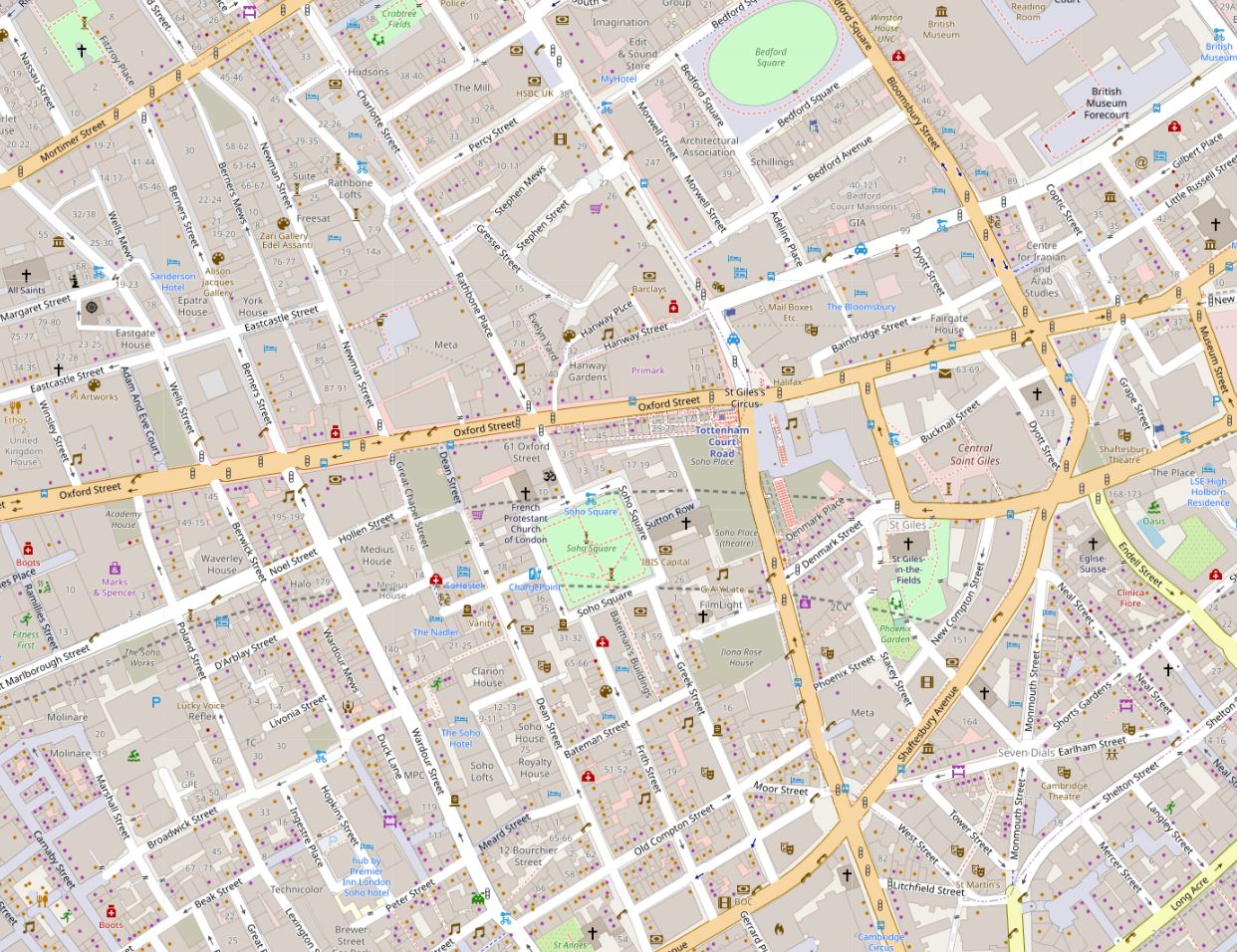
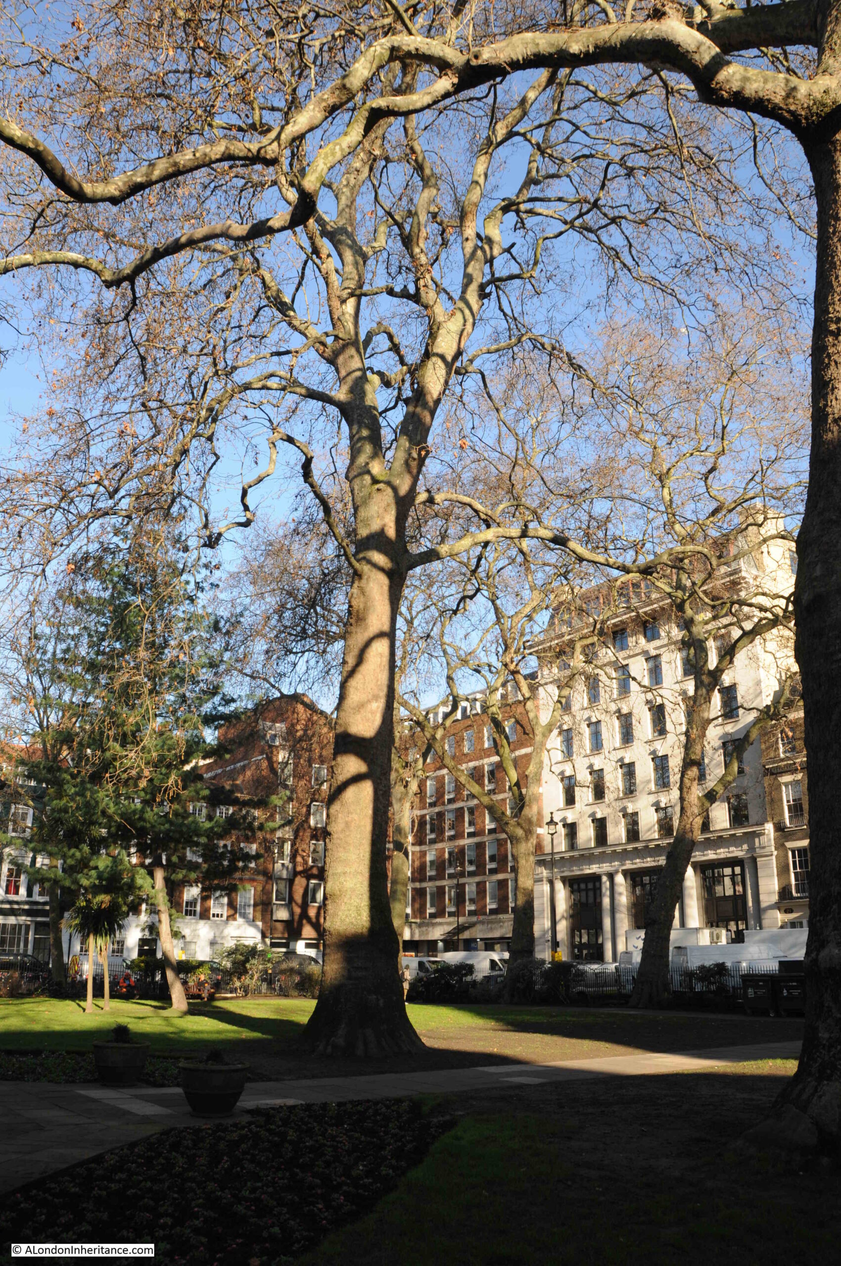
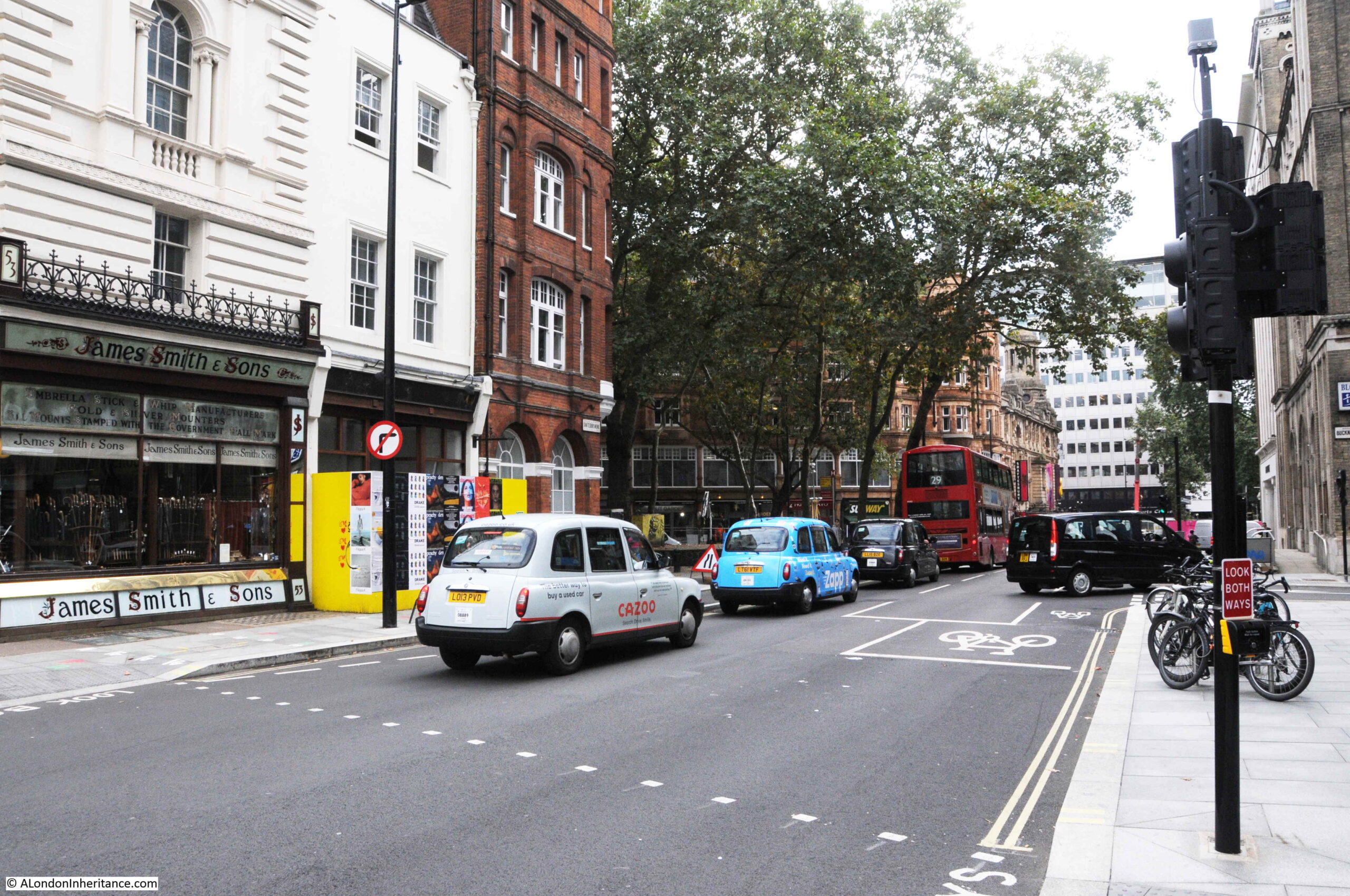
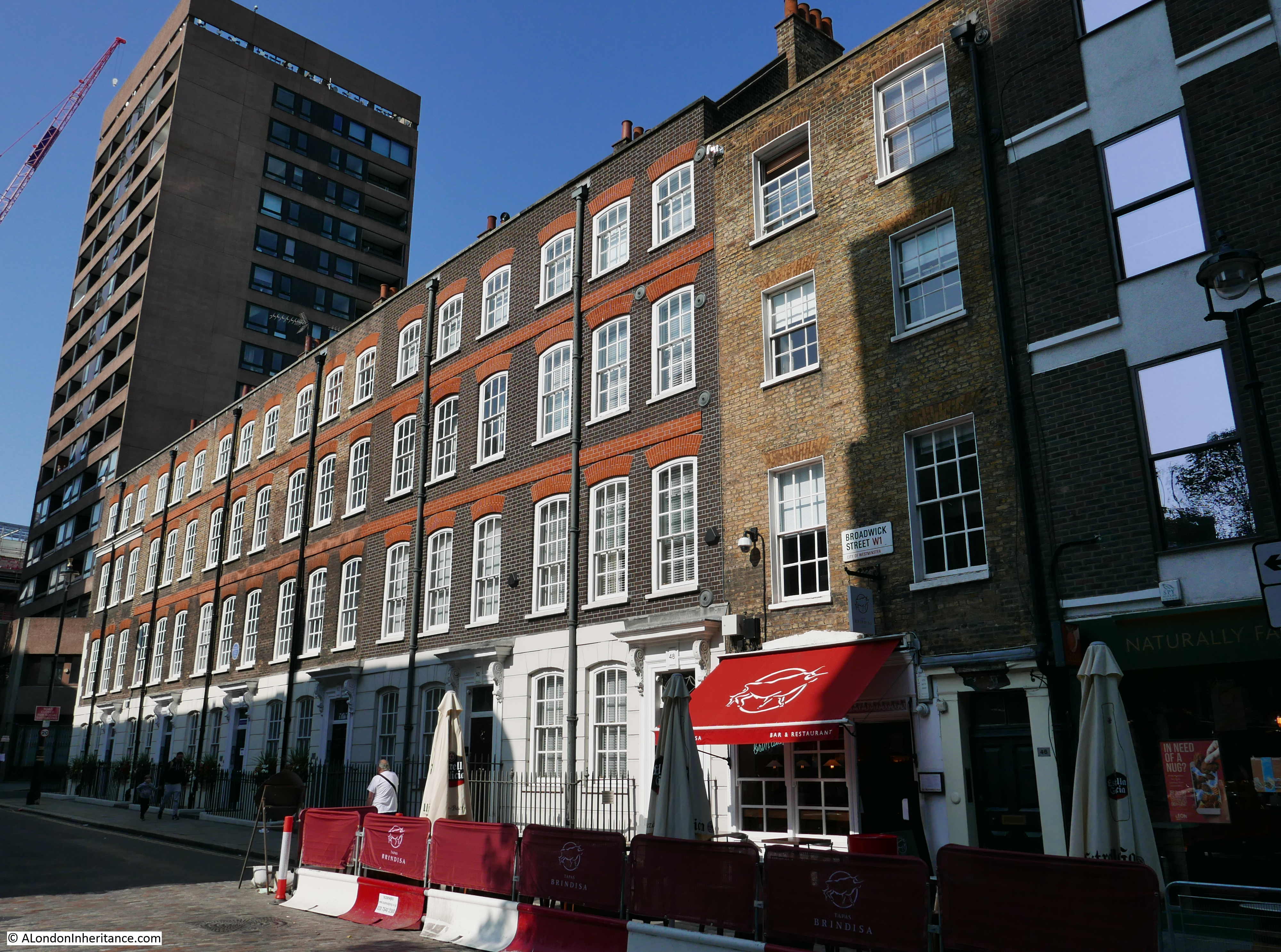
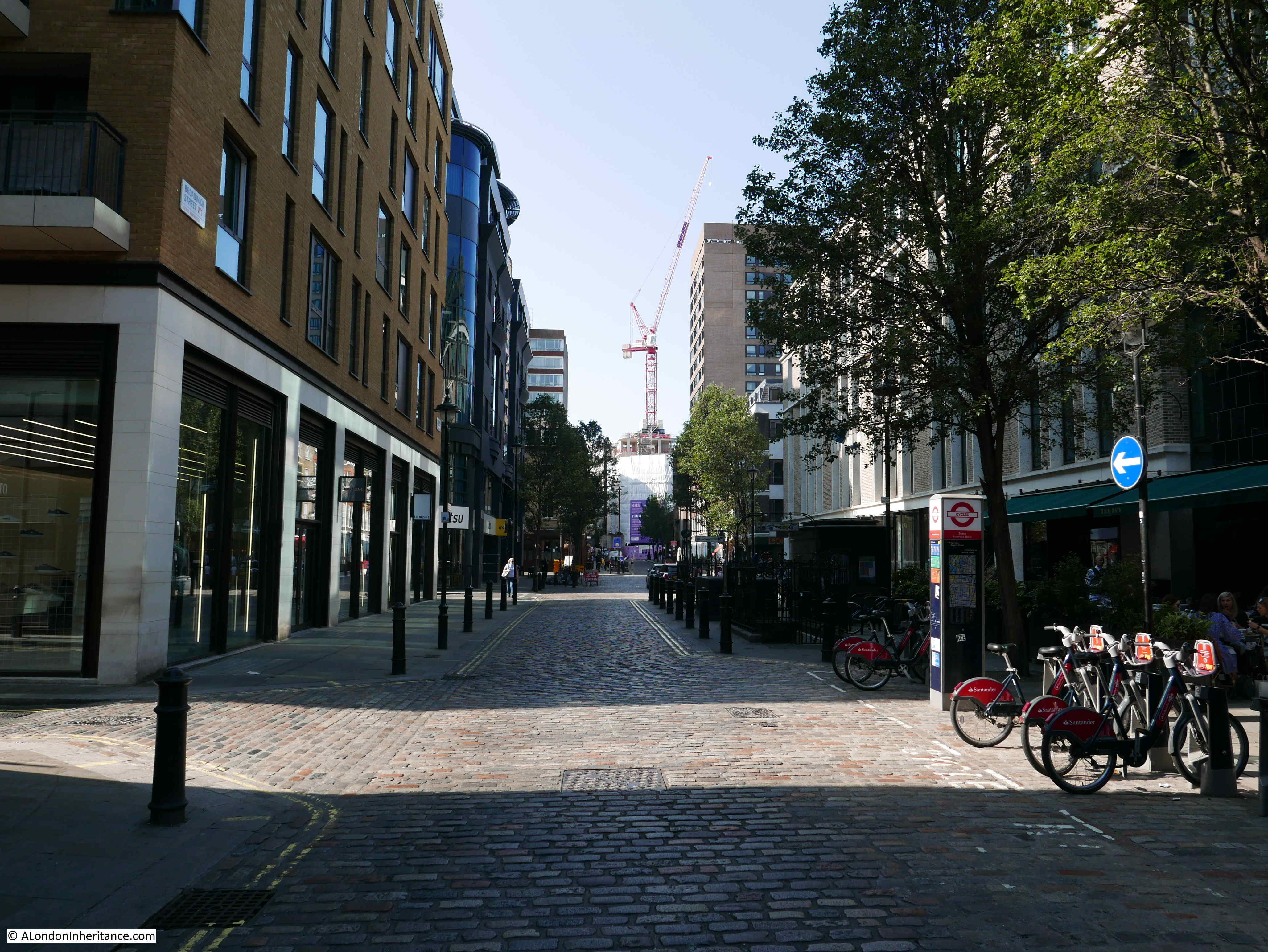
Soho Square can be found near the junction of Charing Cross Road and Oxford Street. A busy square, with lots of traffic, parking and occasionally it is used as a film set.
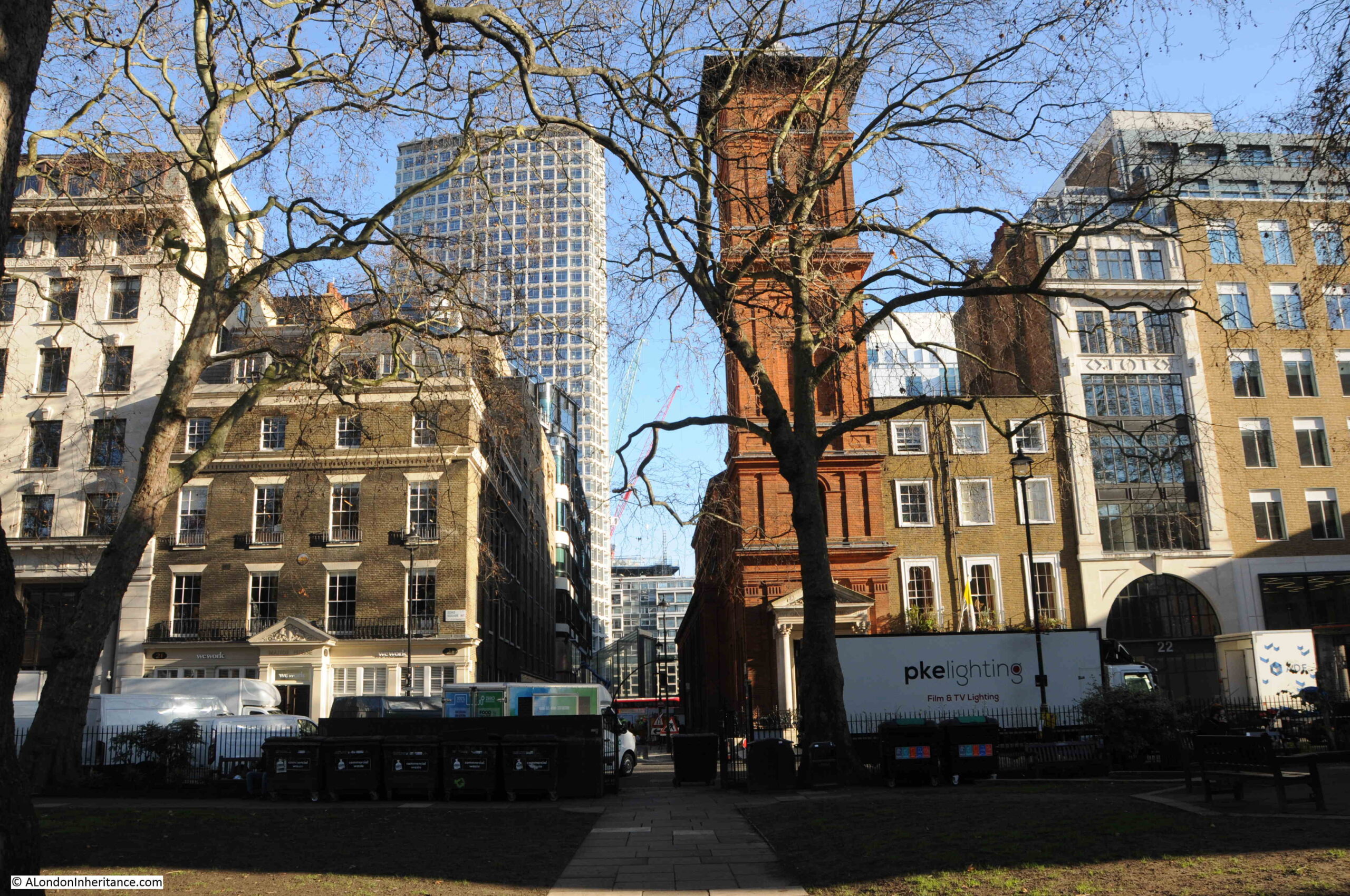
The centre of Soho Square is a large open space, and the square is surrounded by a considerable mix of architectural styles, reflecting the number of times that buildings have been demolished and rebuilt since the square was originally laid out, and the range of individuals. organisations and companies that have made the square their home.
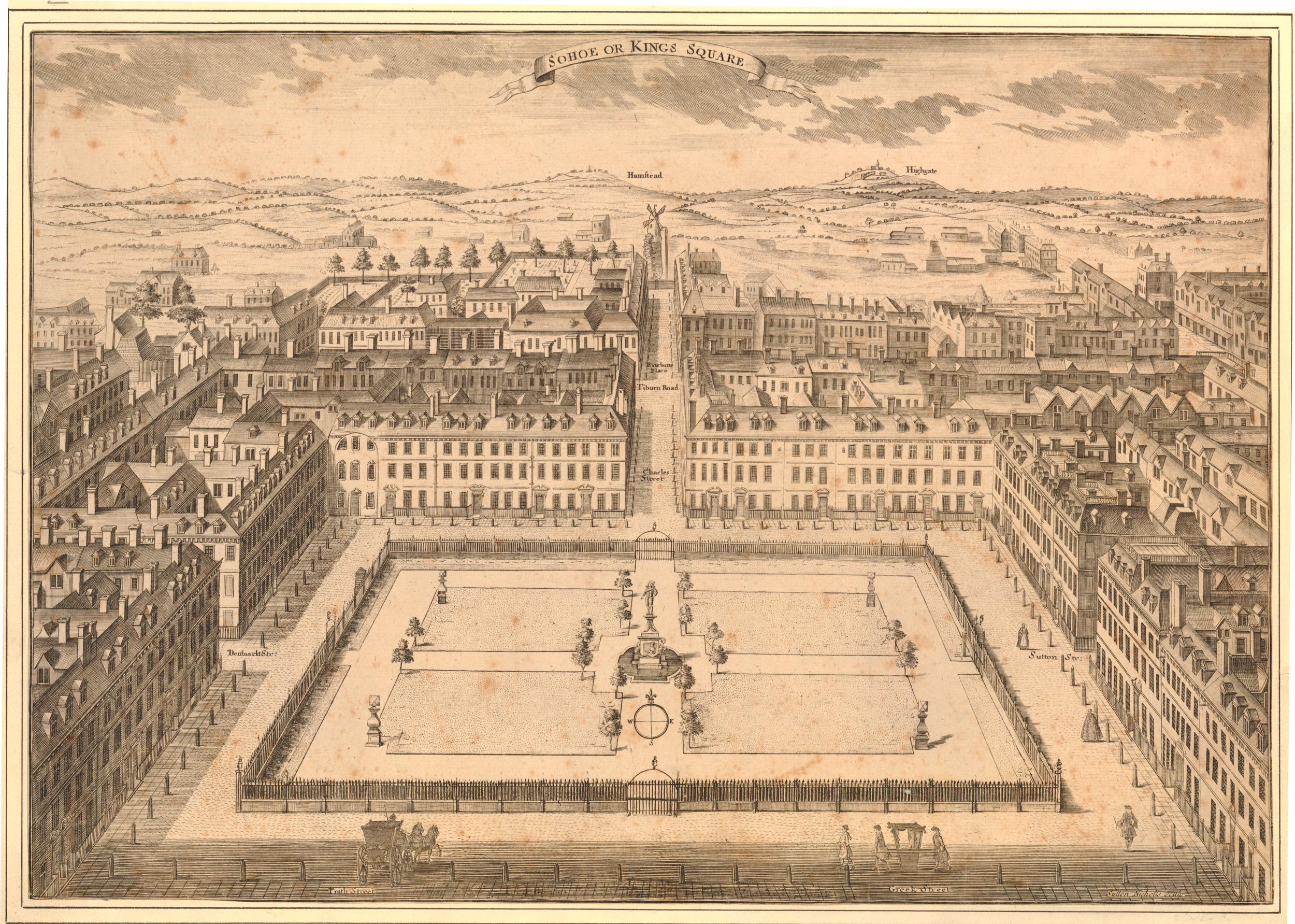
Soho Square was part of London’s northwards expansion and the first houses on the square were originally built around 1670.
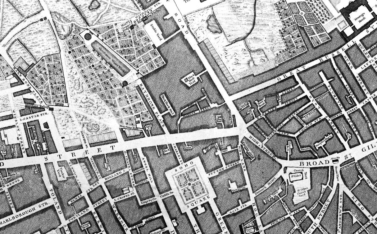
The following extract from Rocque’s 1746 map of London shows Soho Square, with Oxford Street to the north, but still much open space further north, which would be developed during the second half of the 18th century.
Soho Square, as well as many of the surrounding streets, was built on open space known as Kemp’s Field or Soho Fields.
The site of the square was leased to a bricklayer by the name of Richard Frith, who started construction of the first houses, with the first leases of these houses dating to the 1670s and 1680s.
The square was originally called King’s Square, presumably after Charles II, who was on the throne during the early years of the square’s construction. It would keep this name until the first decades of the 18th century, when it would gradually become known as Soho Square, with formal recognition of the new name of the square on maps such as Rocque’s in 1746.
Today, only a couple of the original houses remain, although in a much modified state.
Soho Square has seen continual waves of development, and a walk around the square today reveals a large range of building size and architectural type. Some buildings are on the original narrow plot, larger buildings have incorporated several adjoining plots of land.
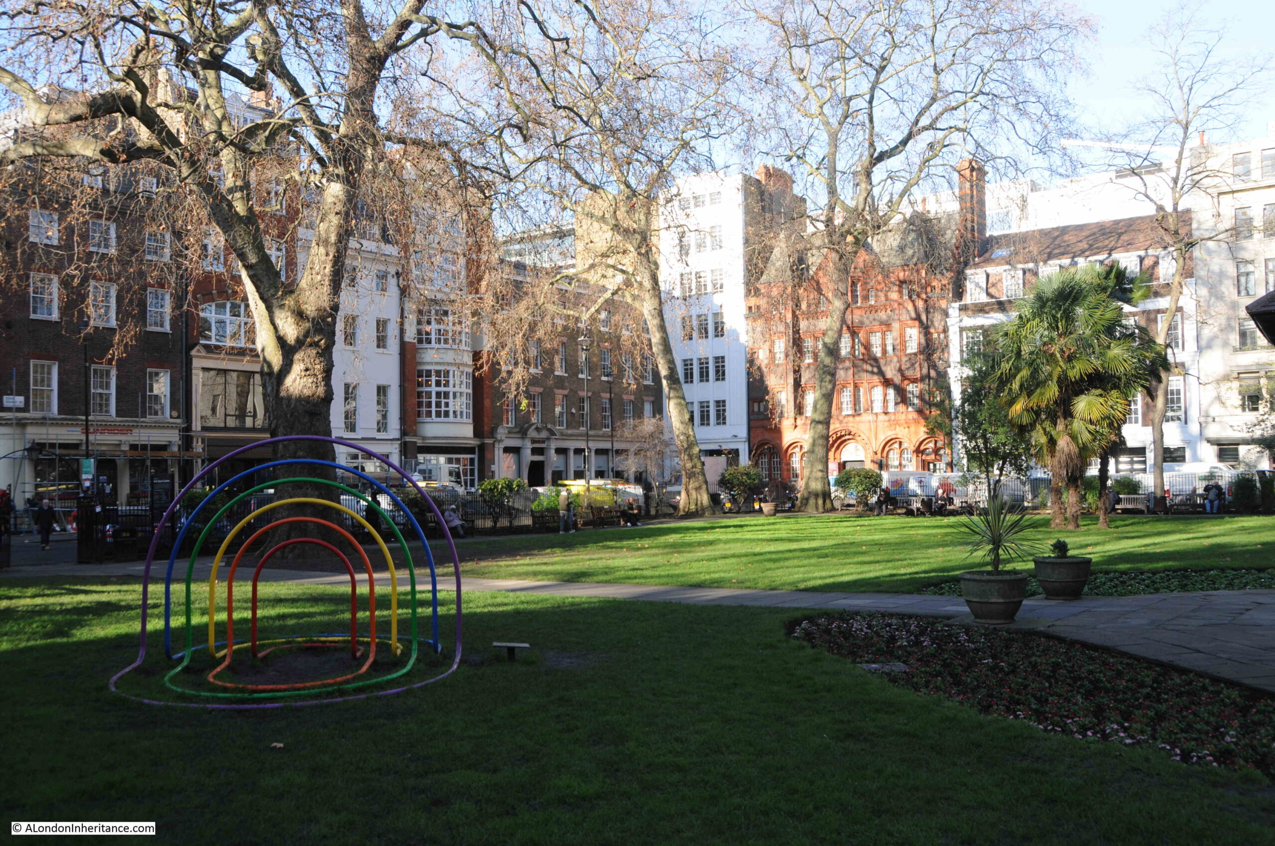
On a weekday, the square is a hive of activity. There is a considerable amount of traffic through the square, parking along both sides of the road around the square, and on the day of my visit, filming had taken over one side of the square.
The open space in the centre of the square was separate from all this activity, and provided a space to look at the buildings surrounding the square before being blocked by leaf growth on the trees.
The following photo is looking to the east, with the tower block of Centre Point in the background.
The brick tower in the background is part of St Patrick’s Catholic Church. During the first years of the square, there were a number of large houses leading back from the square, one of these was Carlisle House, which was built by the Earl of Carlisle around 1690.
Carlisle House was leased by Father Arthur O’Leary, a Franciscan Friar, who managed to raise sufficient financial support from a number of wealthy Catholic families.
The house was converted so that it could be used as a place of worship, and was consecrated on the 29th of September 1792. It was one of the first Catholic places of worship opened after the Catholic Relief Acts of 1778 and 1791, which removed many of the restrictions placed on the Catholic faith during the reformation.
The current church was built on the site of Carlisle House between 1891 and 1893.
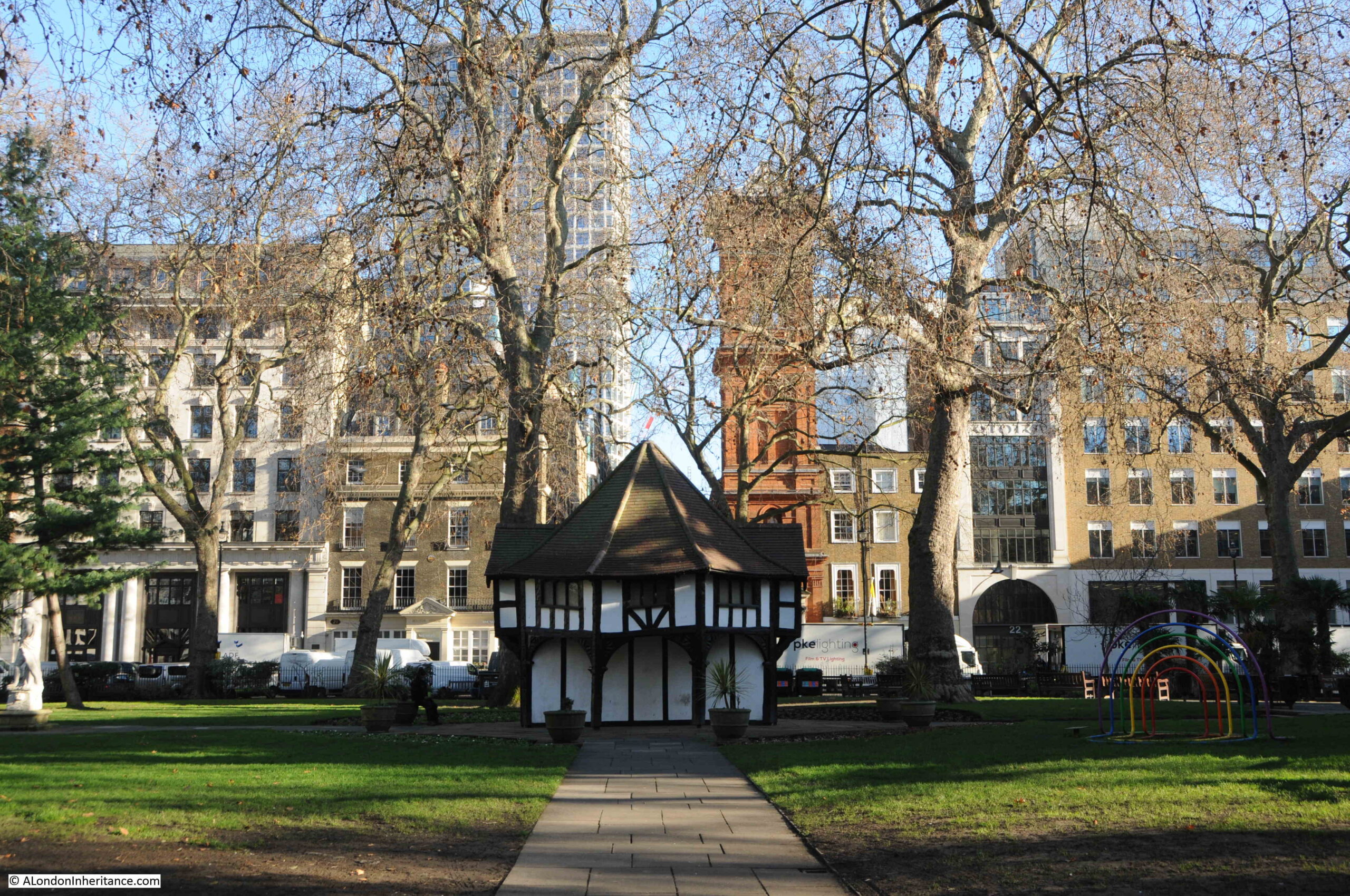
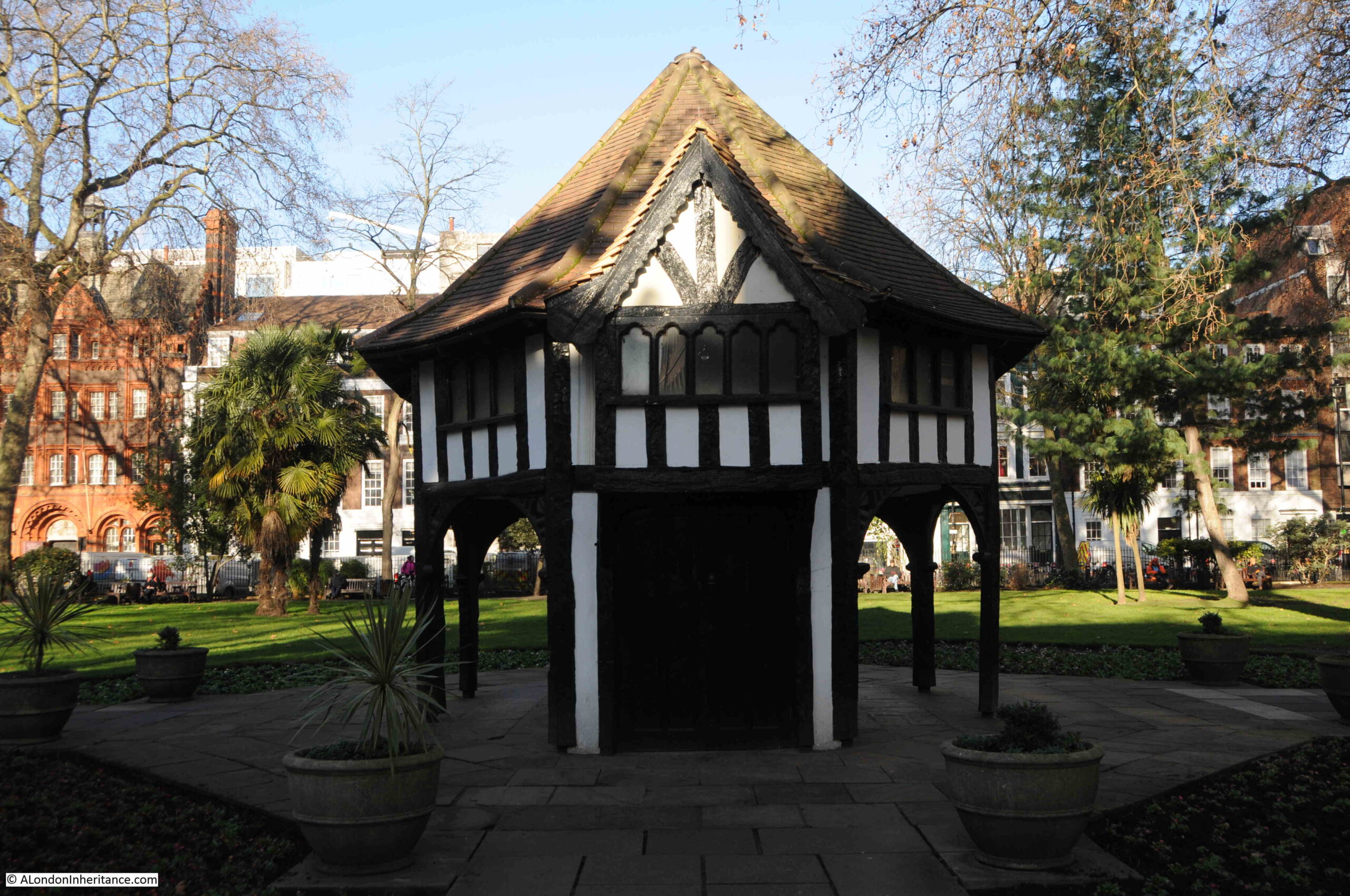
In the centre of the square is a small wooden building:
The wooden building is Grade II listed, and is described by English Heritage as a “Garden arbour/tool shed”. It was built around 1925 for the Charing Cross Electricity Company to provide access to an electricity sub-station below ground. It did not serve this purpose for too long as the underground space would become an air raid shelter during the Second World War.
The electricity substation was not the first utility to be built in Soho Square.
When the first houses in the square were built, there was competition from the water companies that served London to provide water. One of these companies was the New River Company who supplied water from their reservoirs at north Clerkenwell.
Whilst the supply worked to the City, Soho was on higher ground, and this small difference in height between the reservoir and Soho Square, along with the haphazard way in which the water distribution system had grown, resulted in a poor, low pressure supply to the new houses of Soho Square.
Sir Christopher Wren was asked to help with understanding the problems of distributing water to Soho Square and the developing area of the West End, however Wren looked at the whole system and recommended that the problems could only be addressed by effectively replacing the entire system with a new, integrated design.
The New River Company also commissioned John Lowthorp (a clergyman, who was also a member of the Royal Society) to look at the distribution problems,
Lowthorpe established that it was not water supply problems to New River Head (indeed the New River supplied enough water for the whole of London), as with Wren, Lowthorpe identified the distribution network and the organisation of the company.
This would only be fixed over a number of years, one of the short term fixes was the construction of a cistern in Soho Square to store water from the New River Company’s reservoirs for onward distribution.
The north east corner of the square:
The north west corner of the square:
The above two photos show the range of different buildings around the square, and the changes in building height and roof line.
The view is looking north, and shows that in the first decades of the 18th century, Soho Square was really on the northern edge of the built city. The name of the square at the top of the print uses the original name of King’s Square, as well as the future name of Soho Square.
The hills in the distance are those of Hampstead and Highgate, and the street running north from the square crosses Tiburn Road.
This would later be renamed Oxford Street, and was named Tiburn Road as it led to the Tiburn or Tyburn tree or gallows at the western end of Oxford Street, at the junction of Oxford Street with Edgware Road and Bayswater Road.
The above map uses the spelling of Tiburn, rather than the more common Tyburn. Rocque also uses the Tiburn spelling for the street and the gallows.
By the time of the above print, the centre of the square had been laid out as formal gardens.
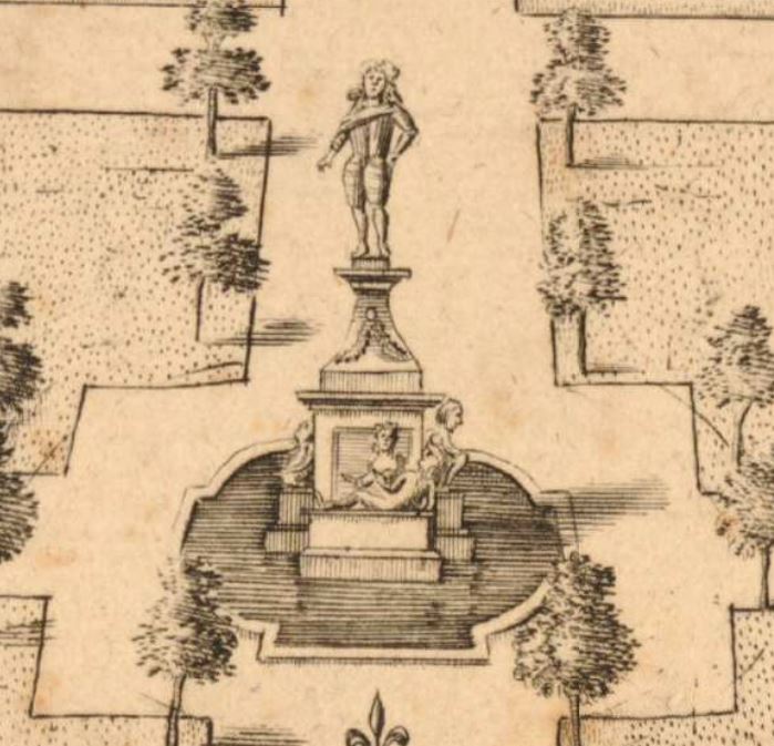
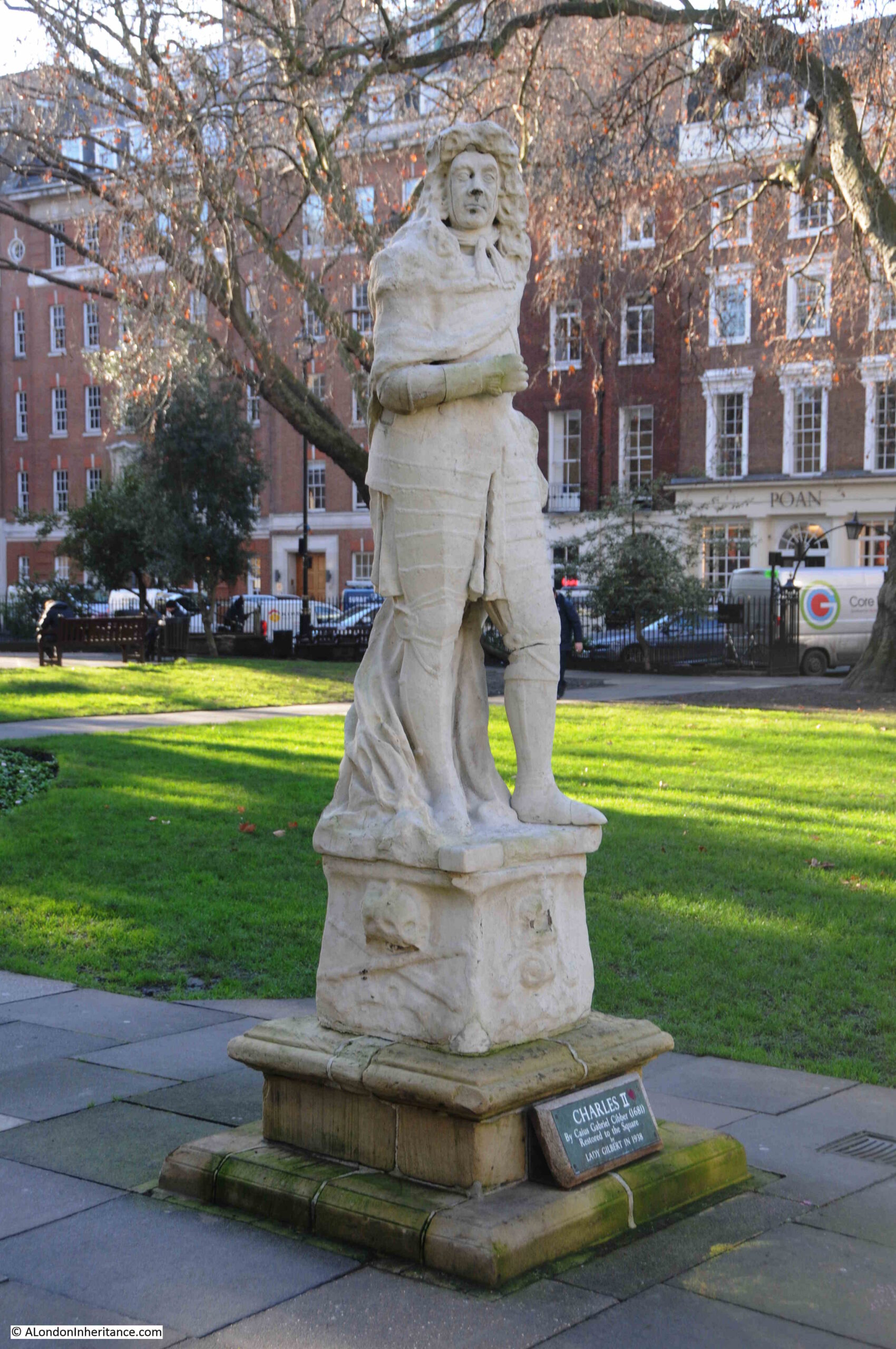
A statue can just be seen in the centre of the above print. I have enlarged this below:
The statue is of Charles II, above a fountain with a small surrounding pond.
Old and New London included a description of the statue and fountain:
“In the centre was a fountain with four streams. In the middle of the basin was the statue of Charles II, in armour, on a pedestal, enriched with fruit and flowers; on the four sides of the base were figures representing the four chief rivers of the kingdom—Thames, Severn, Tyne, and Humber; on the south side were figures of an old man and a young virgin, with a stream ascending; on the west lay the figure of a naked virgin (only nets wrapped about her) reposing on a fish, out of whose mouth flowed a stream of water; on the north, an old man recumbent on a coal-bed, and an urn in his hand whence issues a stream of water; on the east rested a very aged man, with water running from a vase, and his right hand laid upon a shell.”
Old and New London also comments that “the statue is now so mutilated and disfigured, and the inscription quite effaced”. There is also a comment that the statue could be the Duke of Monmouth (who we will come to later), rather than Charles II, however the consensus seems to be that it is the king rather than duke.
The statue was removed around the time that Old and New London was published. An article in the Illustrated London News on the 26th February 1938, records what happened to the statue, and its eventual restoration to the square:
“The statue of Charles II, by Caius Gabriel Cibber, the father of Colley Cibber, Poet Laureate, actor and dramatist, has been restored to Soho Square after an absence of sixty-two years. It was placed in the Square, then called King’s Square, during Charles II’s reign and surrounded a fountain bearing the emblematical figures of the Thames, Severn, Tyne and Humber.
In 1876 it was in such a bad condition that it was taken down and removed to Mr Goodall’s residence at Grims Dyke, Harrow Weald. There it was re-erected in the middle of a large pond, where it remained during the subsequent tenure of Sir. W.S. Gilbert. When Lady Gilbert died in 1936 she bequeathed the statue to the Soho Square Gardens Committee, who had it skilfully restored and have placed it on the north side of the Gardens.”
So although Charles II is no longer on his high pedestal, and the fountain and pond have long gone, he is back in Soho Square:
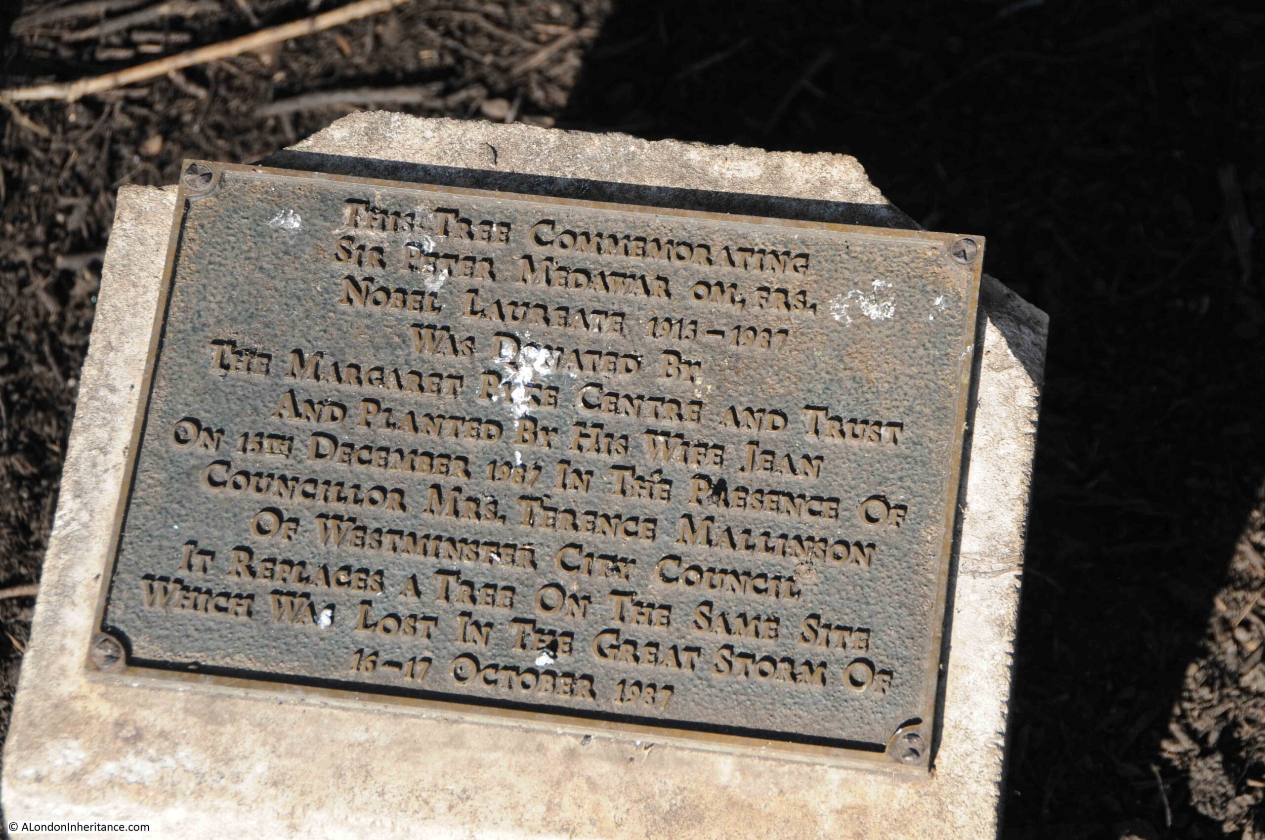
There is a small plaque near the northern entrance to the central garden that records an event in recent history.
Two trees can be seen in the following photo, with a small concrete block between them:
The plaque records that one of the trees (I assume the one on the right) was planted to replace a tree lost during the Great Storm over the night of the 16th to 17th October 1987:
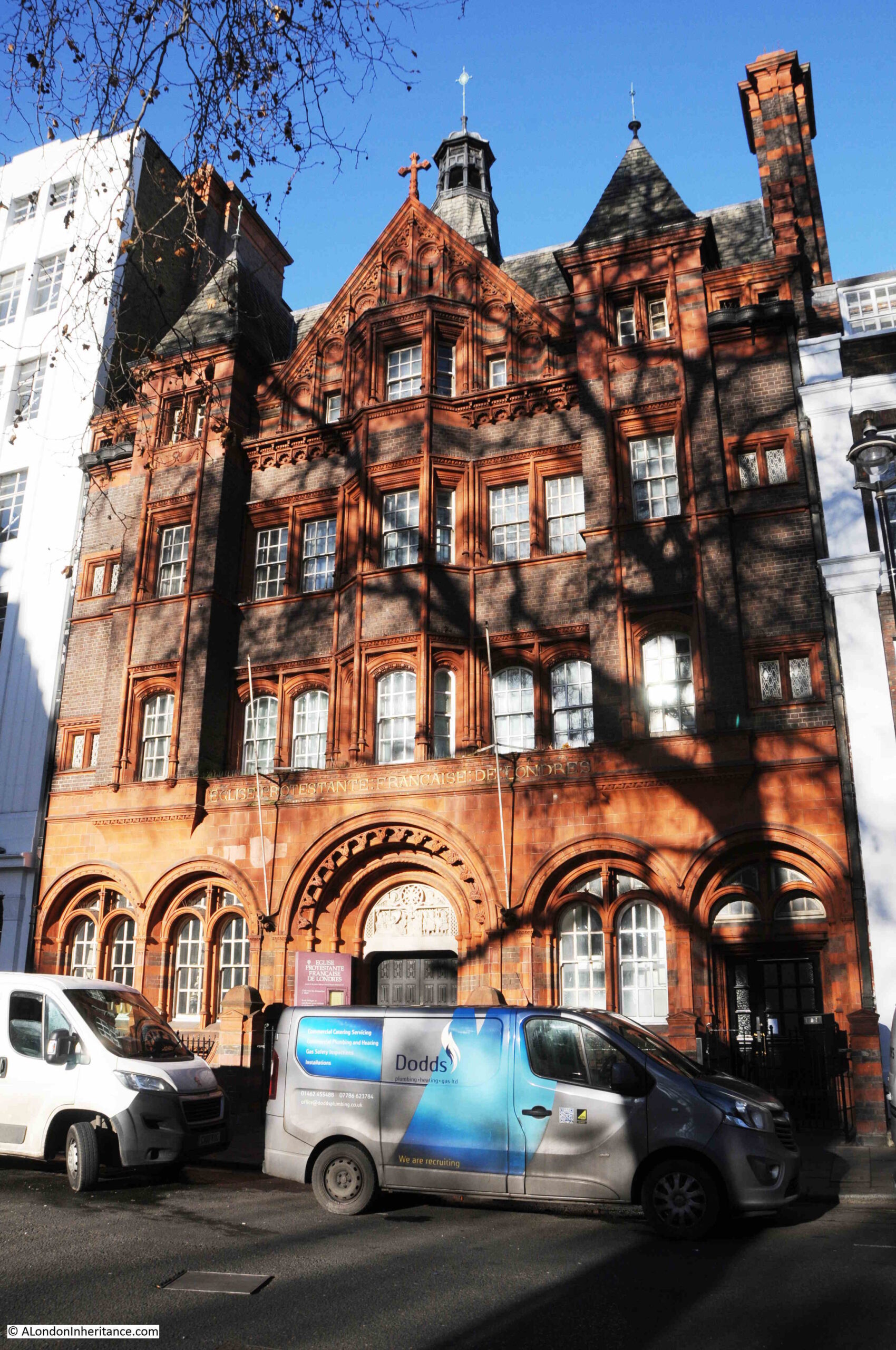
On the north west side of the square, the French Protestant church glows red and orange in the low sun of an early spring day. The church was built in 1891 on the land released when two of the original houses on the square were demolished.
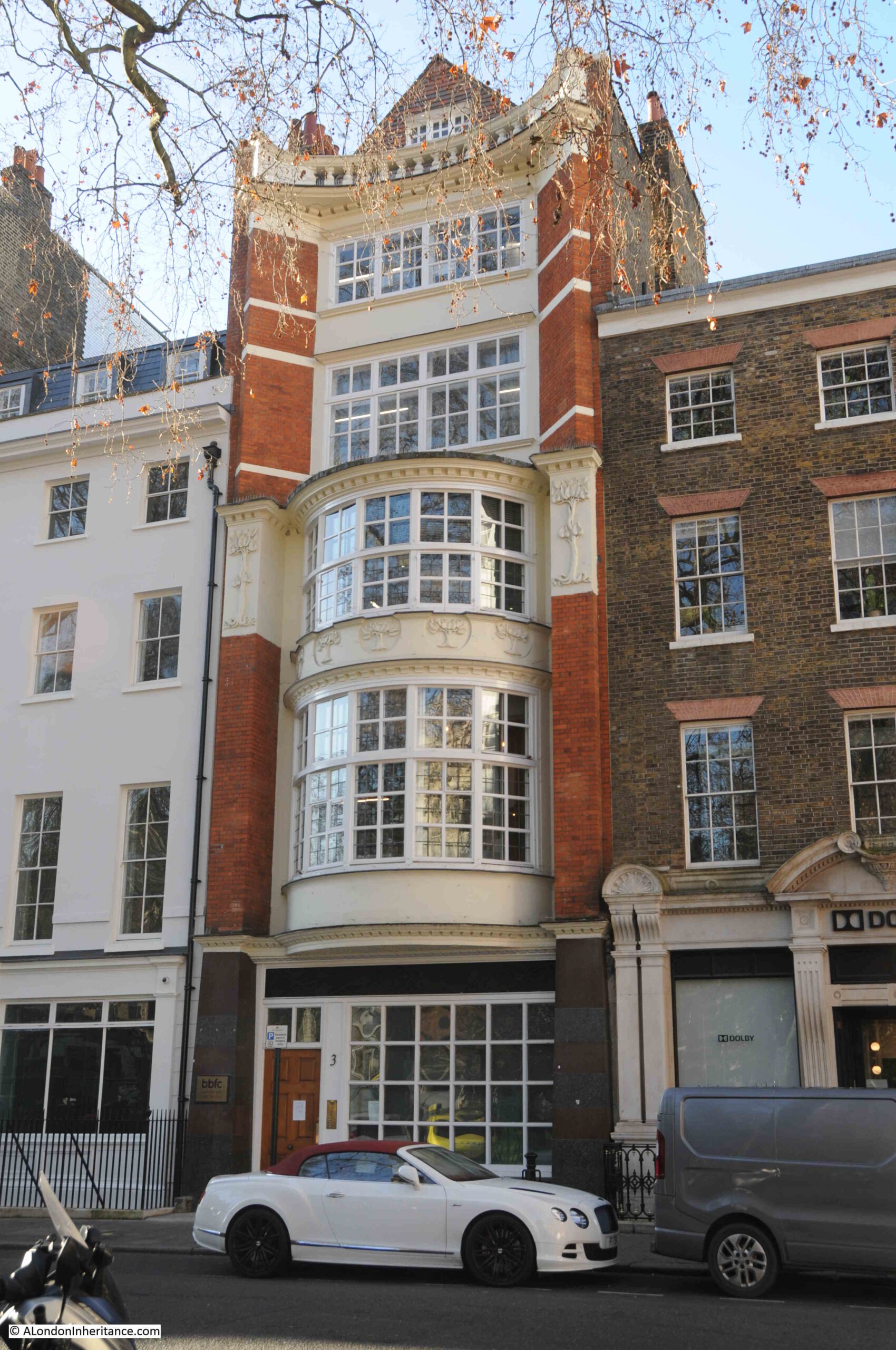
The following photo shows the rather wonderful, number 3 Soho Square:
The building is very narrow compared to many of the other buildings on the street, and although it is the third building on the site, the width of the building is because it is on the same plot of land as the original house when the square was first built.
The first house was built in 1684, it was rebuilt in 1735, which in turn was demolished for the current building which dates from 1902. The mix of the concave upper floors with the large bay windows on floors one and two, along with subtle decoration make number 3 one of the more interesting of the 20th century buildings on Soho Square.
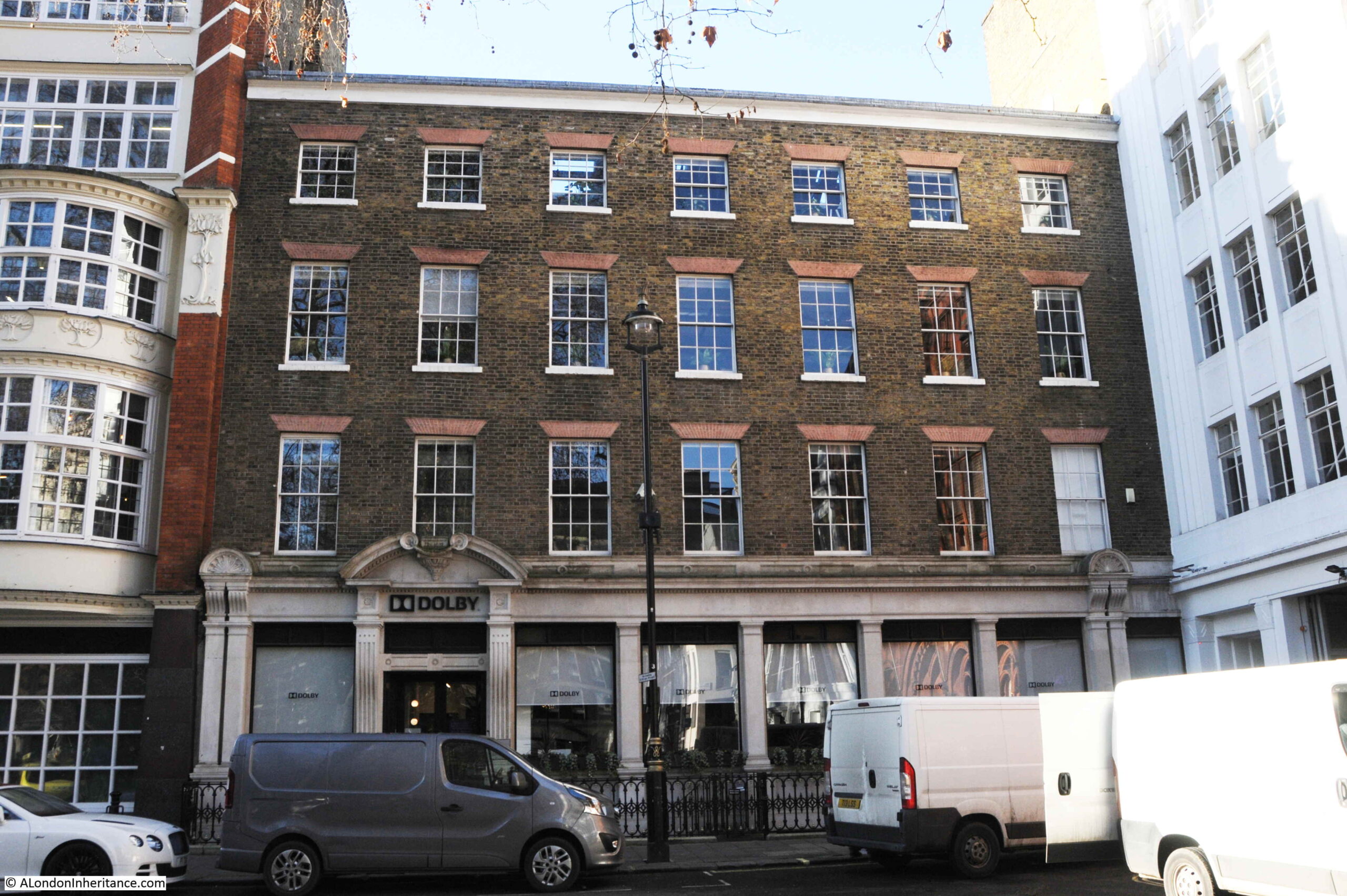
To the right of number 3, is a single building that now occupies the space of numbers 4 to 6, the corner brick building shown in the following photo:
The building was originally constructed as a warehouse in 1804 by John Trotter, a contractor for army supplies.
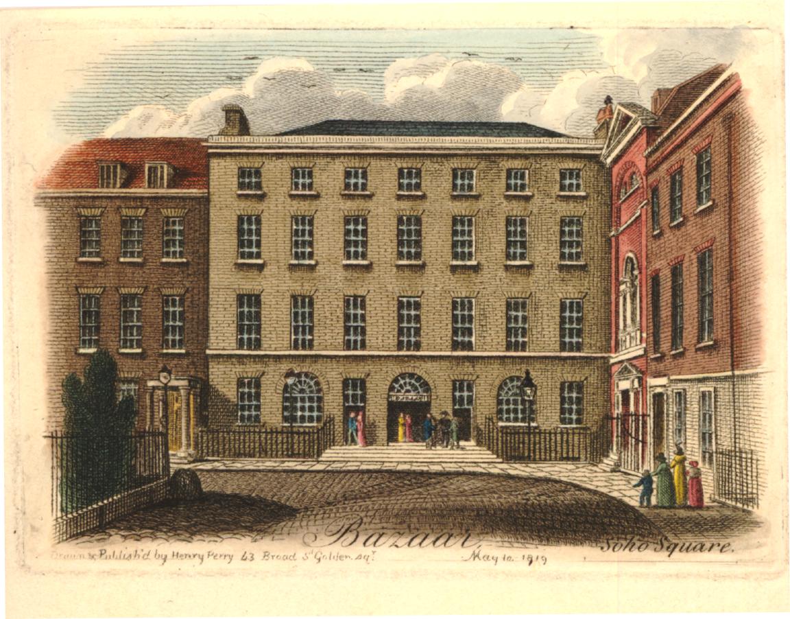
With the end of the Napoleonic Wars, just eleven years after the warehouse was completed, John Trotter converted the warehouse into the Soho Bazaar.
The Soho Bazaar was a market place for a wide range of goods, and the bazaar would last for much of the 19th century. A newspaper report from the later years of the bazaar provides a good description of what could be found inside, and also why the bazaar was under pressure from the shops opening on nearby Oxford Street, and across the city. Published on the 17th of October, 1885:
“It is a long time since I walked round the Soho Bazaar, for the pretty stalls there have been greatly superseded by the many fancy shops that are now everywhere in London. but the old place, though somewhat changed in character, is the depot for many specialties which of themselves would not pay if a whole shop had to be hired for their sale.
All sorts and kinds of fancy work, of contrivances for the comfort of invalids, and such like inventions are to be seen, and, moreover, there is a large register office for domestic servants and convenience for interviews with them, in connection with the bazaar, and one great recommendation of it to me is that all the stall holders are women, not flighty girls, and they are attentive and pleasant to inquirers or purchasers of their own sex, and not on the look out for a possible flirtation, which is the great drawback to most bazaars.
I went there the other day to see myself the ladies work stall, and its appearance is most encouraging, for the work I saw was well executed, attractive, and useful. Every lady who desires to sell her work there is expected to pay a fee of a guinea a year for expenses.”
The stalls in the bazaar seem to have sold all manner of homemade products, and there was also a kindergarten, where babies were given special rugs to play / crawl on. The rugs had cutout animals and other figures to attract attention.
Compare the above print with my 2022 photo of the building, and although the ground floor has been significantly remodeled, the upper floors are the same, after 200 years.
On the south side of the square is the Hospital for Women, which combined / rebuilt houses already on the site:
At the very top of the left building of the hospital, is the date “Founded 1842”. This refers to when the hospital was originally founded in Red Lion Square as the Hospital for the Diseases of Women, before moving to Soho Square in 1852.
Records in the National Archives state that “The Hospital was closed in 1939 on the outbreak of war, and a First Aid Post was opened in the Outpatients Department by Westminster City Council”, and that in 1948, the hospital “was amalgamated with St. Mary’s Hospital and The Hospital for Women became part of The Middlesex Hospital Group”.
The first building on the site of the Hospital for Women, was one of the earliest buildings to face onto Soho Square.
Monmouth House was built for the Duke of Monmouth, however he seems to have spent very little time there.
After Charles II’s death, Monmouth led a rebellion with the aim of taking the throne. He was defeated at the Battle of Sedgemoor on the 6th of July 1685. After capture, Monmouth was executed on Tower Hill on the 15th of July 1685.
The house was sold after Monmouth’s death, converted to auction rooms in 1717, and demolished in 1773.
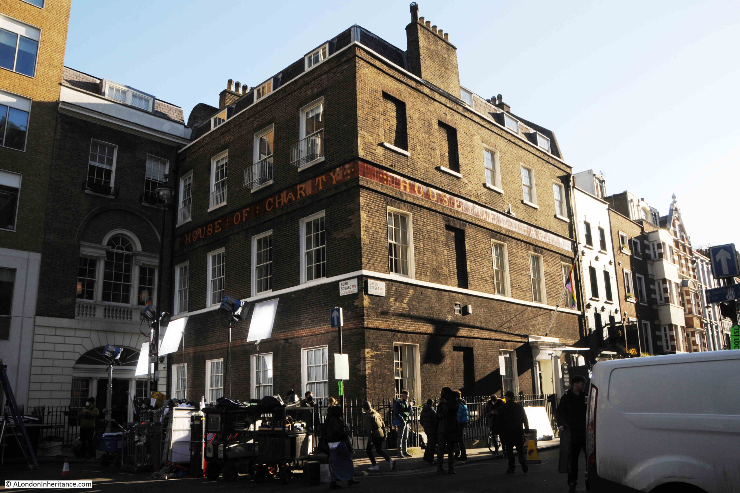
The house on the south east corner of Soho Square, at the junction with Greek Street, is the House of Charity / House of St Barnabas.
On the day of my visit, it was being used as a film set:
Despite appearances, the building is not one of the original houses on the square. The house we see today was completed in 1747 after the original house on the site was demolished.
The building was used by one of the organisations that would eventually become the GLC. In 1811, the Westminster Commissioners of Sewers occupied the building, then the Metropolitan Board of Works who stayed on Soho Square until their move to Spring Gardens, before moving to County Hall on the South Bank as the London County Council.
When the Metropolitan Board of Works moved out, it was sold to the House of Charity, which had been established in 1846 for the relief of the destitute and the homeless poor in London.
Now the House of St Barnabas, which works to get people into secure, paid employment, through training and support. The interior of the building still has many of the original features, and is why the building is attractive as a film set.
To the west of the square, Sutton Row provides a route to Charing Cross Road, and St Patrick’s Catholic Church is on the right:
On the left is Grade II listed, number 21 Soho Square, an 1838 / 1840 rebuild of the original house on the site, which, during the late 18th century had, as Old and New London tactfully described, been a “place of fashionable dissipation to which only the titled and wealthy classes had the privilege of admission”, basically a high-class brothel.
After being rebuilt, the building was taken on by Crosse & Blackwell, and numerous 19th century adverts give Soho Square as the address for Crosse & Blackwell – manufacturers of Pickles, Sauces & Jams etc.
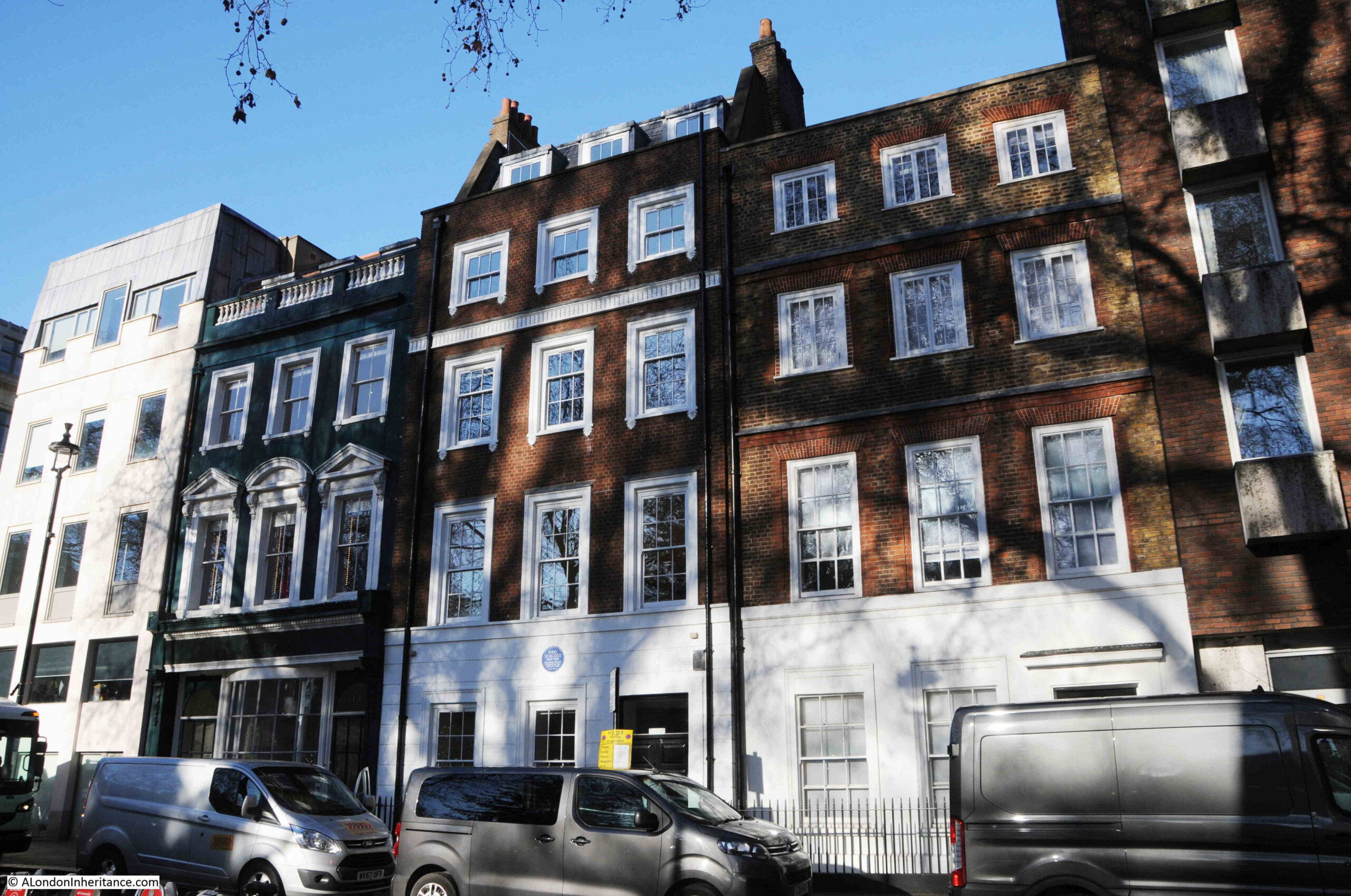
There are three interesting buildings in the north-east corner of Soho Square. The building on the right in the photo below is one of the original houses on the square. Although considerably modified, it does give an indication on what the terrace houses would have looked like as the square was completed.
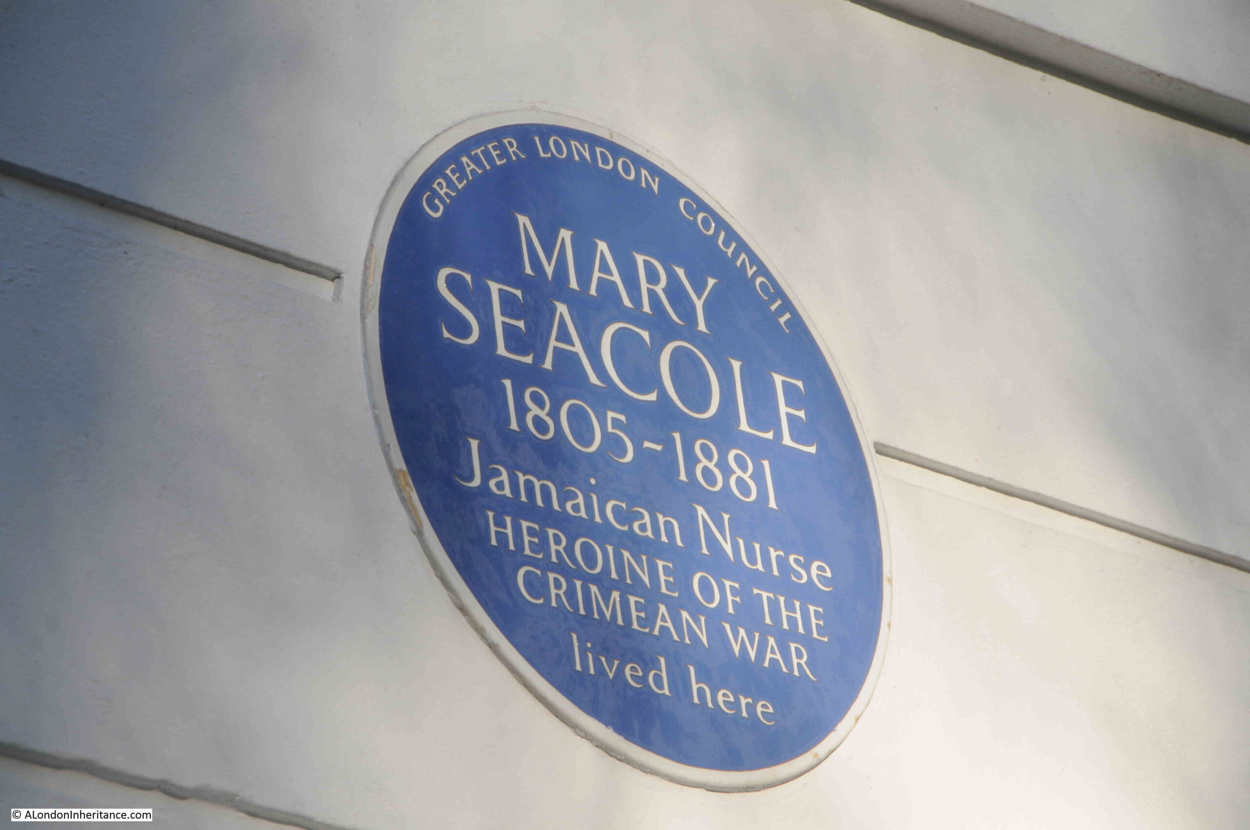
The centre house has a blue plaque, recording that Mary Seacole lived in the house:
Mary Seacole was a Jamaican nurse who learnt many of the local techniques for practicing medicine. She traveled widely, and was involved with the treatment of people suffering from cholera outbreaks in Jamaica and Panama.
In 1853 she was responsible for nursing services for the British Army in Jamaica, however she had heard about the suffering of soldiers in the Crimean War, and asked that she be sent to the Crimea to work as an army nurse.
This request was not approved, so she funded her own trip to Crimea where she set up the “British Hotel” to provide a place of rest and treatment for injured and sick soldiers. This was the same war where Florence Nightingale was also working, but Mary’s British Hotel was closer to the front.
After the end of the Crimean War she returned to Britain, however she had very little money left, having funded the trip to the Crimea, and in 1856 she was declared bankrupt, as the Globe on the 7th November 1856 reported:
“The bankrupts, Mrs Mary Seacole and Thomas Day the younger, are described as of Tavistock-street, Covent-garden, and Ratcliff-terrace, provision merchants, and formerly of Balaklava and Spring Hill, front of Sebastopol. Mrs. Seacole is a lady of colour, and has been honoured with four government medals for her kindness to British soldiery. She was present in person, and attracted much attention, the gaily coloured decorations on her breast being in perfect harmony with the rest of her attire.”
Whilst in London, she wrote and published her biography, and a review sums up how she was viewed:
“The Wonderful Adventures of Mrs Seacole in Many Lands has just been published by Mr James Blackwood of Paternoster Row. Of Mrs Seacole, Dr. Russell says in a brief preface ‘If singleness of heart, true charity and Christian works; if trials and sufferings, dangers and perils, encountered boldly by a helpless woman on her errand of mercy in the camp and battlefield, can excite sympathy and move curiosity, Mary Seacole will have many friends and many readers’. Mrs Seacole’s autobiography is interesting, includes many strange episodes, and, we doubt not, will obtain numerous readers.”
Proceeds from the book, along with a fund raised by the Prince of Wales provided Mary with sufficient funding to live in comfort for the rest of her life. She died in London in 1881, and newspaper announcements of her death started with the headline “DEATH OF A DISTINQUISHED NURSE”.
Over the following decades, her name disappeared, with Florence Nightingale being more associated with the Crimean War.
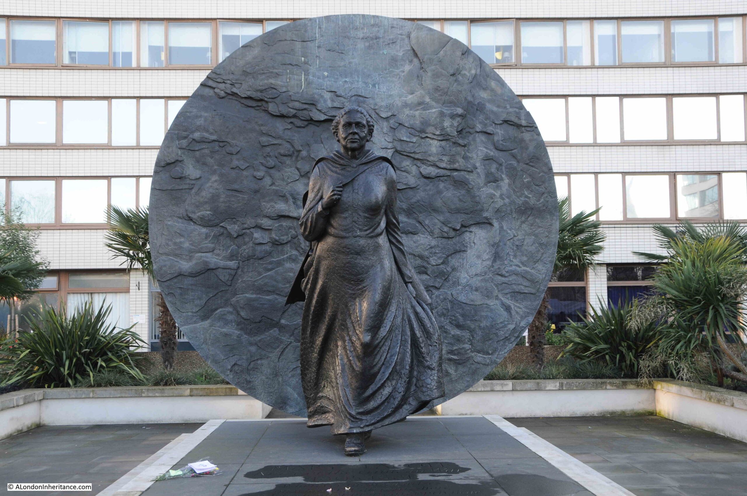
A group of nurses from the Caribbean visited Mary’s grave at St. Mary’s Roman Catholic Cemetery in Kensal Green, and started to campaign for greater recognition for her. This was supported by the local MP to Kensal Green and in 2016, a statue was unveiled in the grounds of St Thomas’ Hospital on the south bank of the Thames just to the west of Westminster Bridge.
The large disk behind the statue of Mary is an impression taken from the ground in the Crimea where Mary Seacole worked to help soldiers during the Crimean War.
I cannot find out exactly when Mary Seacole lived in Soho Square. Newspaper reports of her life after she returned from the war mention a number of different addresses in London so she seems to have moved around.
Very little of the original Soho Square remains, the statue of Charles II, and a couple of the houses, although all have been repaired and modified, but the square does show how London streets have changed and adapted to different uses over hundreds of years, and how much there is to find in a London square.
St Anne’s Soho, New River Company and Shaftesbury Avenue is a bit of a mix of very different subjects, however the following photo from one of the Wonderful London books provides the connection.
The caption to the photo reads: “Elm Trunks for Conduit Pipes dug up near St Anne’s, Soho. Wooden pipes like these were used to carry water from New River Head over the Holebourne for the citizens. Trunks used for conveying the fresh water supply were of elm which of all the timbers best withstands the exigencies of heat and cold. The New River Co. had a wharf at the bottom of Dorset Street where the elm trunks were landed and bored. Shaftesbury Avenue was opened February 26, 1887, and the excavations laid these old pipes bare.”
There is much to unpack in that single caption, far more than within the scope of a single post, but I will give it a go, starting with the elm trunk in the photo.
When the New River Company started to distribute water across the city from their pond at New River Head, the only method to carry water within pipes was to use bored tree trunks. Iron pipes would not become available for the New River Company to use for well over a hundred years from when the company started operations in 1613.
The photo shows how a tree trunk was converted into use as a pipe. A hole was bored through the centre of the pipe to carry water, and one end of the trunk was shaved down to a point around the hole so that it could be pushed into the next trunk in the series, trying to form as close a seal as possible to prevent the leakage of water.
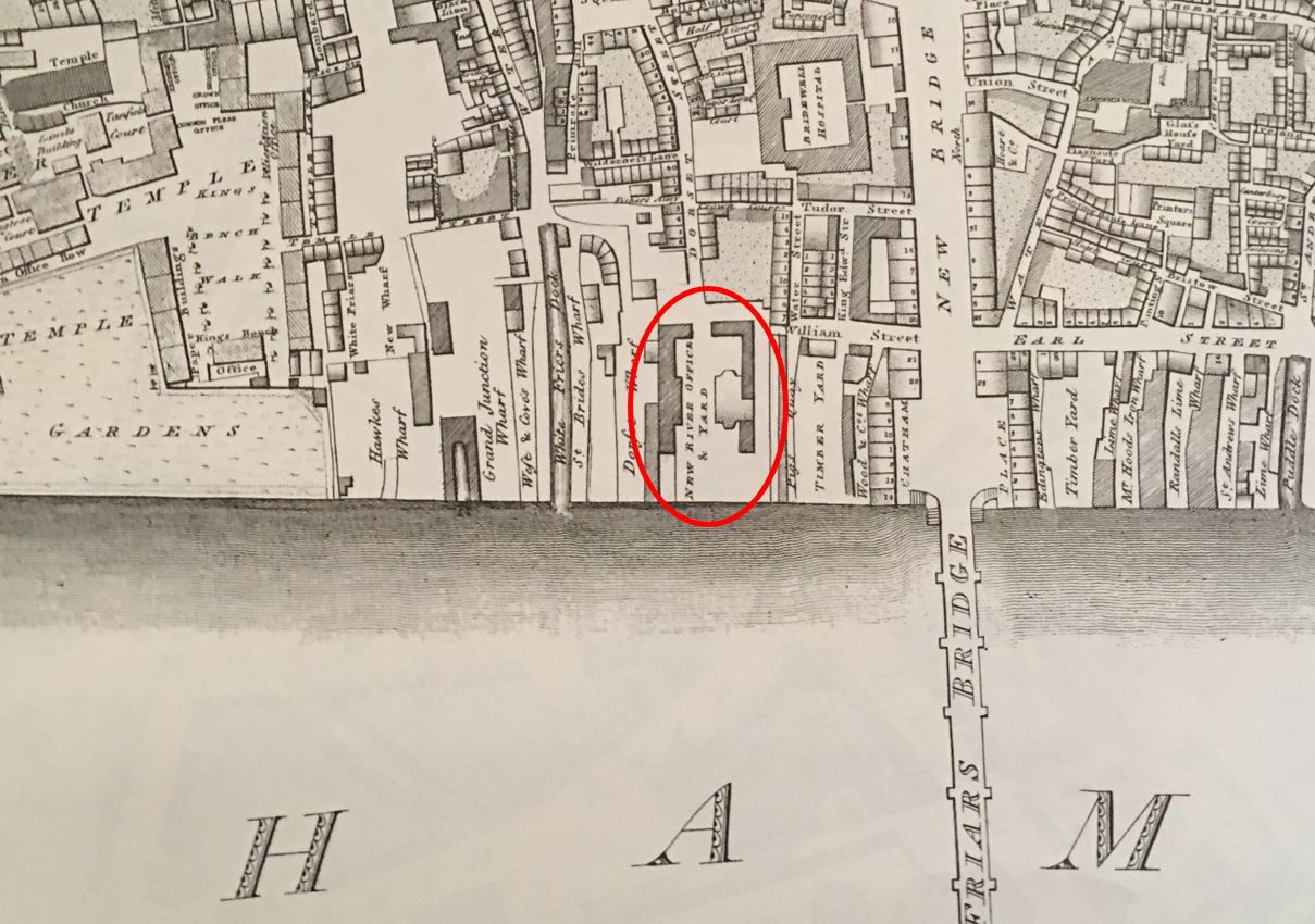
The New River Company had their main pond or reservoir at New River Head in north Clerkenwell, and their offices eventually moved to the same location, however as the caption states, they had a wharf at the bottom of Dorset Street, and their original offices were at the same location. It was here that elm trunks were delivered via the River Thames, bored and shaped ready to be used within their network of pipes.
The caption states that the wharf was at the bottom of Dorset Street. The offices, yard and wharf are marked on Horwood’s 1799 map of London, just to the west of Blackfriars Bridge, circled in the following extract:
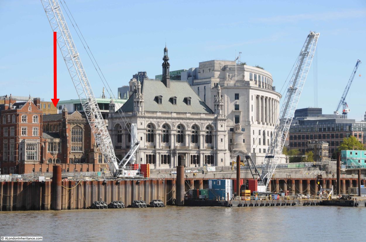
The location of the New River offices, yard and wharf are now separated from the river by the construction of the Victoria Embankment, however I have marked their location with the red arrow in the following photo, now covered by the brick building to the left of the old City of London School.
The area served by the New River Company was extensive, for example one of their large industrial customers was the Truman’s Brewery in Brick Lane to the east of the city, and as London expanded to the west, they buried their pipes along the streets to serve the new buildings.
Serving the new west London streets did however bring problems. New River Head was located at a height of 30 metres above sea level. The original customers in the City of London were at a height ranging from 15 metres in the north of the City down to 1 or 2 metres along the river. This worked well when gravity was being used to get the water from New River Head to the City.
The west of the city was a different matter, with the area around Shaftesbury Avenue and Soho being around 22 metres in height, only an 8 metre difference to New River Head and much higher than the City.
This led to supply problems along the new streets of Soho, with a good supply in the City, and poor supply due to low pressure in west London.
The New River Company was also facing competitive pressure from other water companies, and at the end of the 17th century, they brought in Christopher Wren to evaluate their water supply system, and make recommendations for improvements.
Wren’s view was that the system was an unplanned mess, that had grown without any planning or understanding of the areas being served and how water was affected by the length and size of pipes, and the difference in height across London.
Wren could not make any individual recommendations, he compared the system to a diseased body, with the New River Company looking only at one small part of the body to try and work out a cure. Wren recommended a system wide replanning that would take much of the following century to implement.
Wren’s recommendations were also supported by the ex-clergyman John Lowthorpe, also commissioned by the New River Company to examine the system. Lowthorpe also identified that the company had no audit or understanding of their pipe network, and that a single person should be responsible for the system’s design, the role of a Chief Surveyor.
The New River Company did build an upper pond at Claremont Square, and the additional height of this new pond did overcome some of the pressure problems, but it would not be until wooden pipes were replaced with iron pipes, and steam engines were used to pump pressurised water rather than use gravity, that the supply across London would become reliable.
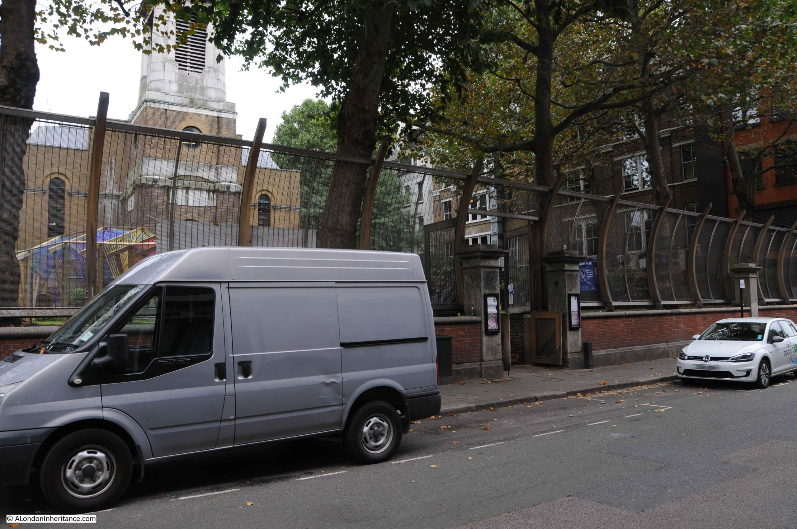
The photo of the elm pipe was taken outside the Wardour Street entrance to the church of St Anne’s, Soho. This is the same view today:
St Anne’s, Soho was built to serve the spiritual needs of those living in the expanding Soho streets. Plans for a new church were first being discussed in the 1670s, along with the search for a suitable location. The land on which the church would be built was owned by two speculators, brewer Joseph Girle and tiler and bricklayer Richard Frith (who would give his name to Frith Street).
There is no firm evidence of the architect of the church, there are references to both Christopher Wren, and one William Talman, but it is impossible at this distance in time, and loss of documentation over the years, to be clear of their individual role.
The new church was ready for use in 1685 and was consecrated by Bishop Henry Compton in either 1685 or 1686.
The church was very badly damaged during the blitz raids of September 1940. The body of the church was completely burnt out, the tower survived, but with considerable damage.
The church was partly restored in the decades after the war, before undergoing a full restoration between 1990 and 1991. The tower survives from the pre-war church, however the rest of the building is a modern rebuild.
The tower and church of St Anne’s, Soho:
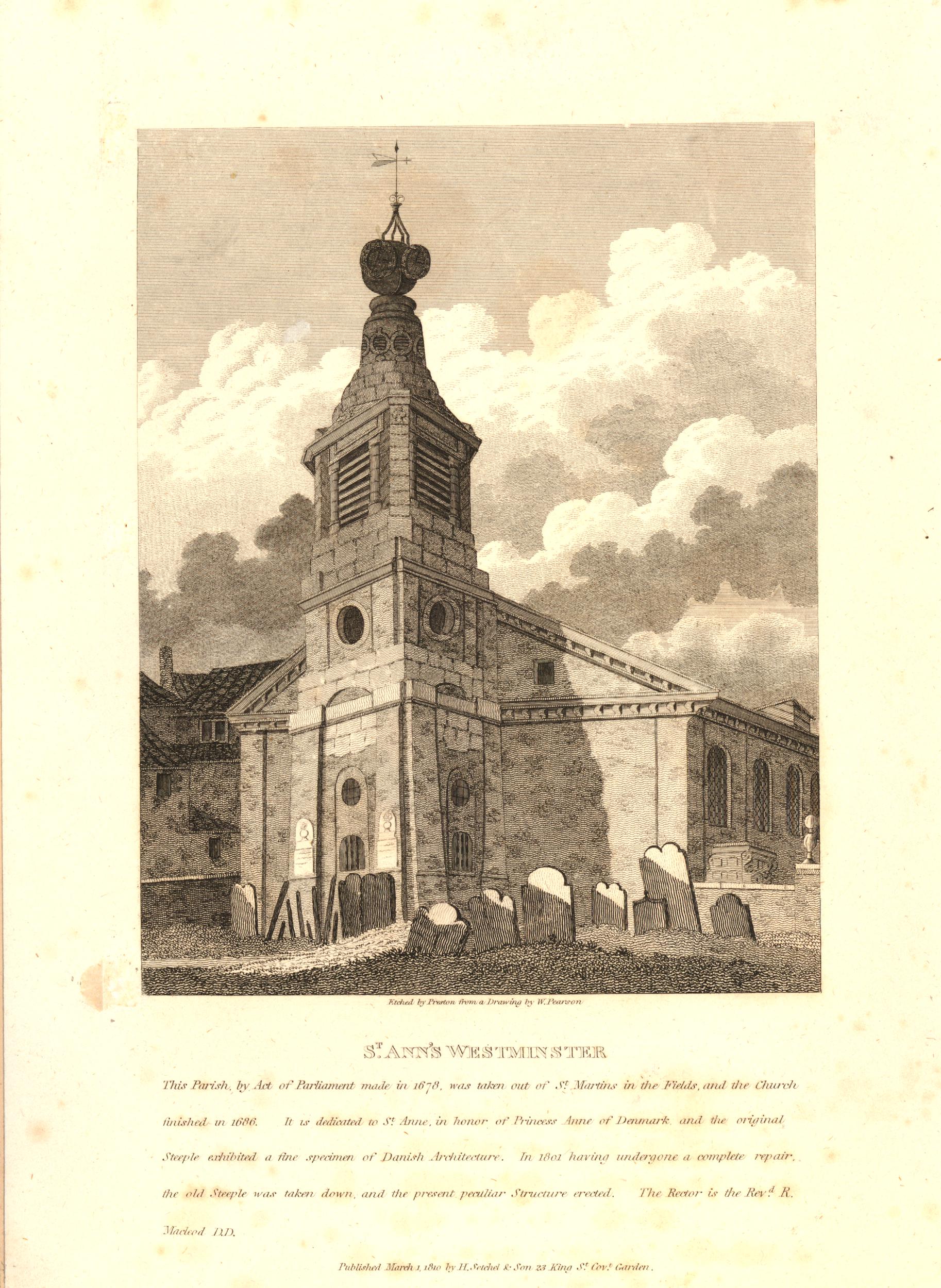
The church in 1810 (with the inclusion of Westminster in the name as it was within the parish):
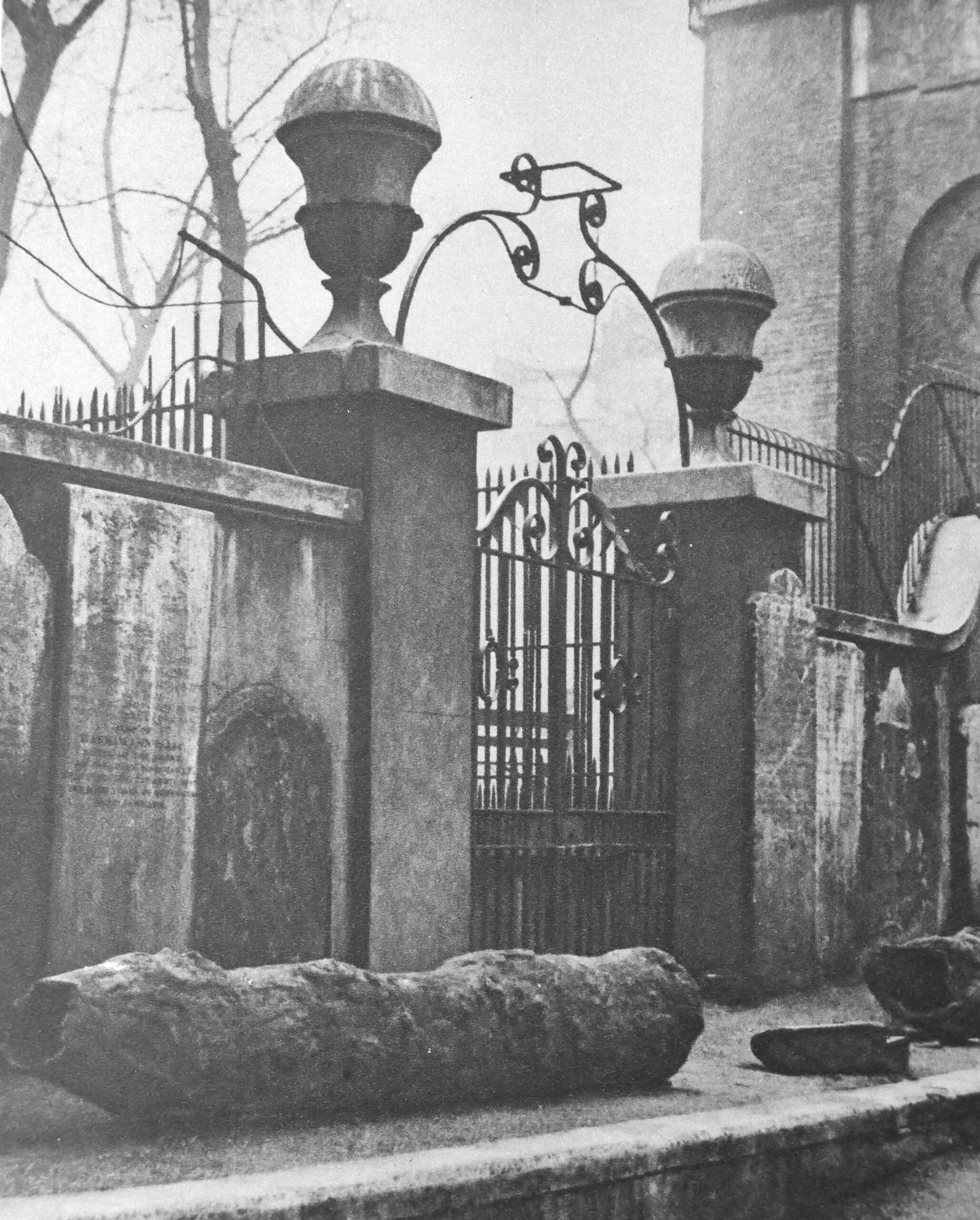
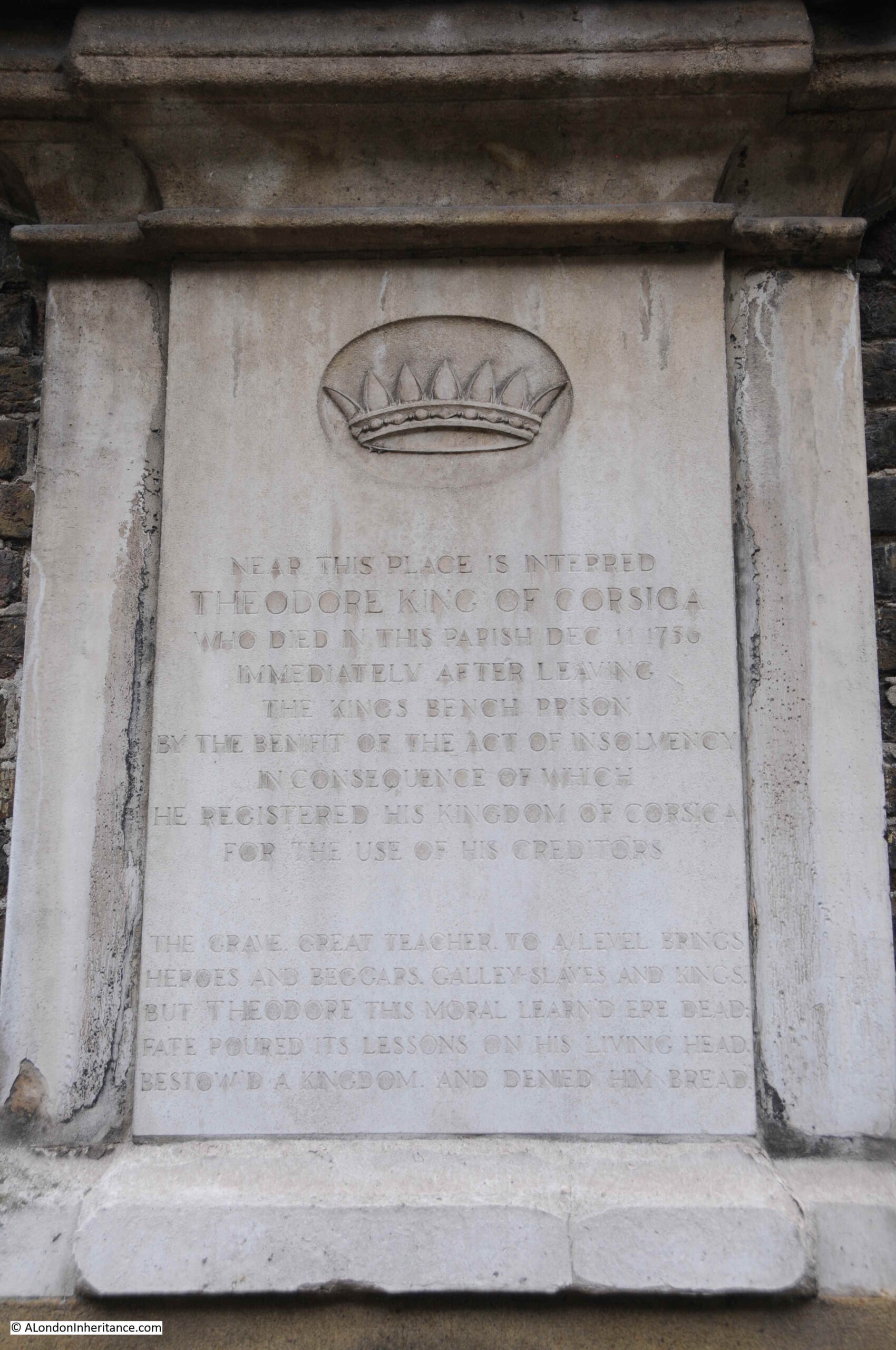
It is always easy to get distracted by the gravestones in the churchyard of an old London church, and St Anne’s is no exception. Although these are now separated from their original graves, they tell the story of some of the characters who were buried here:
In the above photo, the stone on the upper right is to Theodore, King of Corsica:
Theodore was born in Cologne, Germany in 1694, with the full name Theodor Stephan Freiherr von Neuhoff. He had a varied career, service with both the French and Swedish armies, negotiating on behalf of the Swedish king with England and Spain, and travelling widely.
It was whilst traveling in Italy that he became involved with rebels trying to free the island of Corsica from the rule of Genoa, one of the republics that made up Italy in the 18th century.
Theodore landed in Corsica in March 1736, and was made king of the island by the inhabitants. His rule did not last long. Disagreements within the rebels, and the Republic of Genoa putting a price on his head resulted in Theodore leaving the island in November of the same year.
He lived in the Netherlands for a while before moving to London, where he tried to get support for Corsica, and his role as king. He was not successful, had many money problems and ended up in the King’s Bench debtors prison.
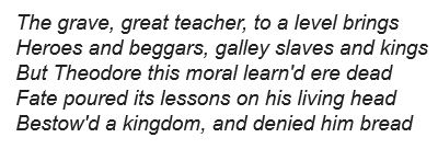
Released in 1755 after declaring bankrupt, and registering his Kingdom of Corsica for the use of his creditors. He died the following year in 1756, and the gravestone includes the following text:
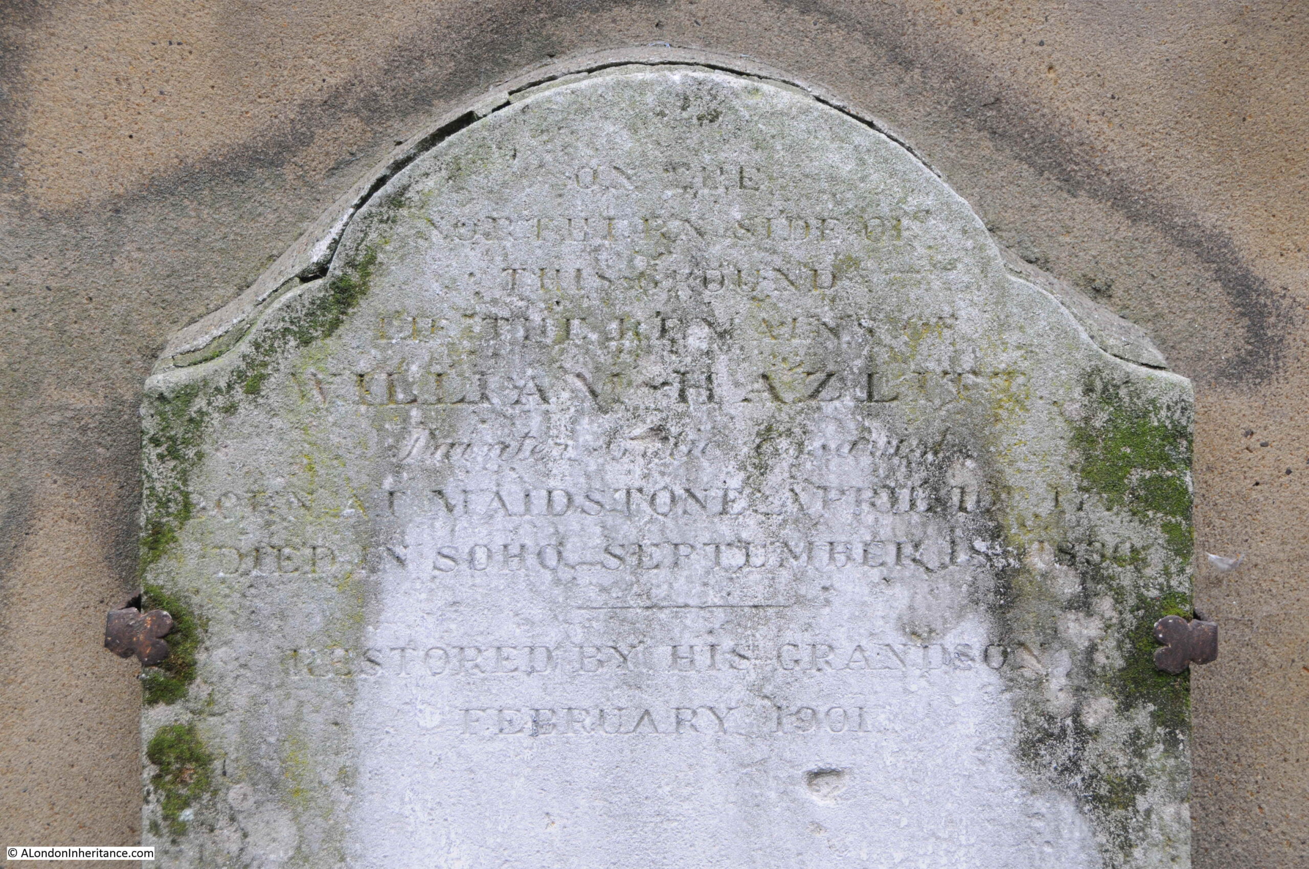
Another gravestone on the base of the tower is that of William Hazlitt, whose grave in the churchyard is marked by a recent memorial.
Hazlitt was one of the greatest English essayist’s of the late 18th and early 19th centuries, however he lived his last years in relative obscurity, partly in a flat in Frith Street which explains why he was buried in St Anne’s.
A report in The Atlas (A General Newspaper and Journal of Literature) on the 26th September 1830 finishes with a sentence that will probably ring true with the majority of authors:
“On Thursday last the body of William Hazlitt was borne beneath our windows; till that moment we were not aware that a man of genius, a popular writer – the author of no less that able a work than the life of Napoleon, which alas closed his literary labours – and an amiable man, had been our next door neighbour for months, enduring sickness and at length dying in indigence. We boast of our national generosity, glory on the flourishing state of our literature, and thunder forth the power of the press, the palladium of our liberties; in the meanwhile ‘the spirit of life’ is allowed to burn itself out in penury and privation. Publishers sport their carriages, or fail for a hundred thousand pounds; and those by whom they become publishers die for want of a dinner.”
So that covers a brief looks at the New River Company and their elm pipes, as well as St Anne’s, Soho. The caption to the photo has the following final sentence:
“Shaftesbury Avenue was opened February 26, 1887, and the excavations laid these old pipes bare.”
Which implies that the elm pipes were uncovered during the work to create Shaftesbury Avenue, so the creation of this famous West End street is what I wanted to explore next.
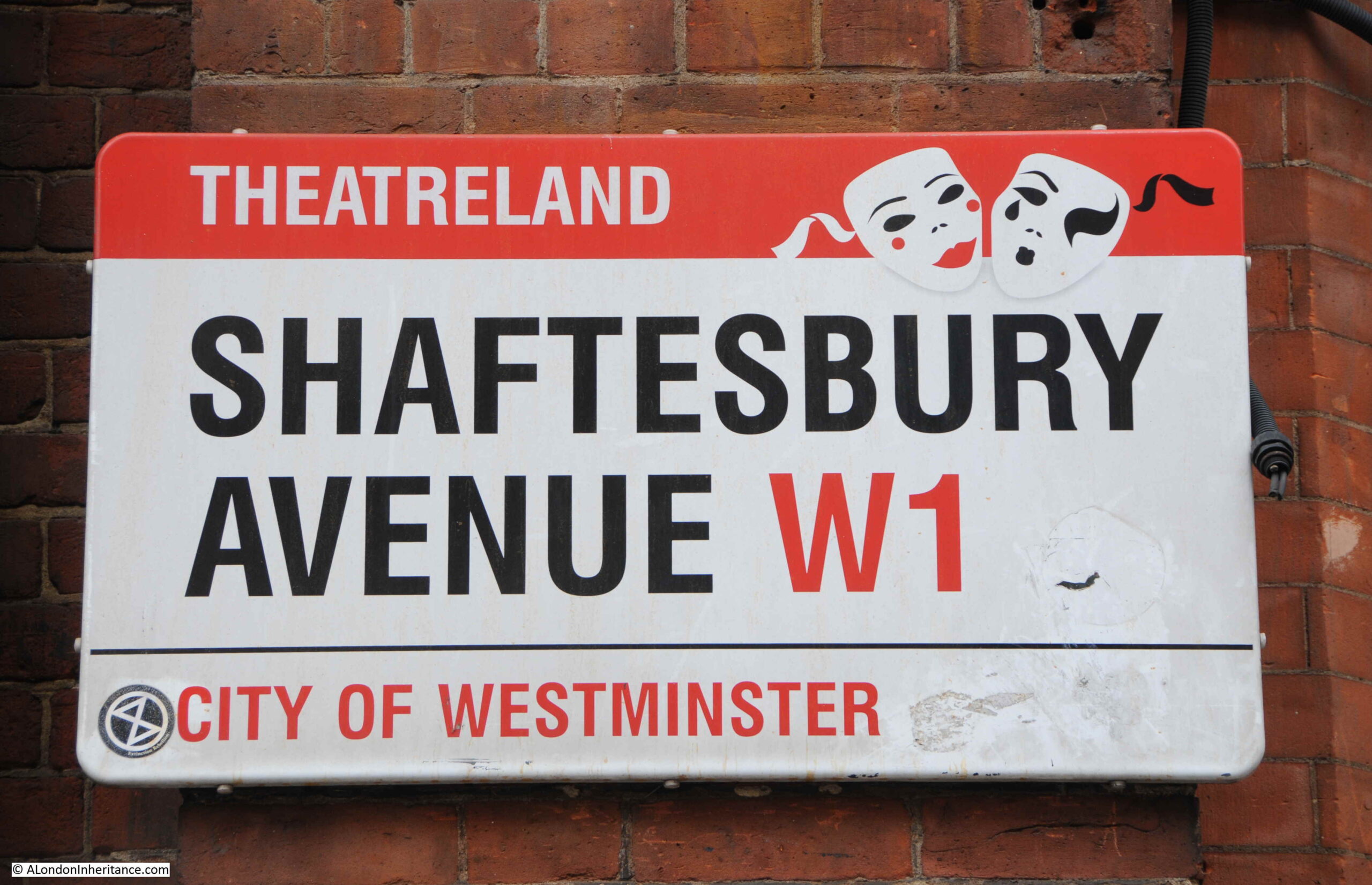
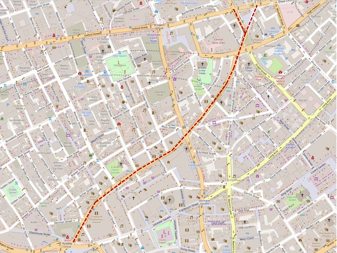
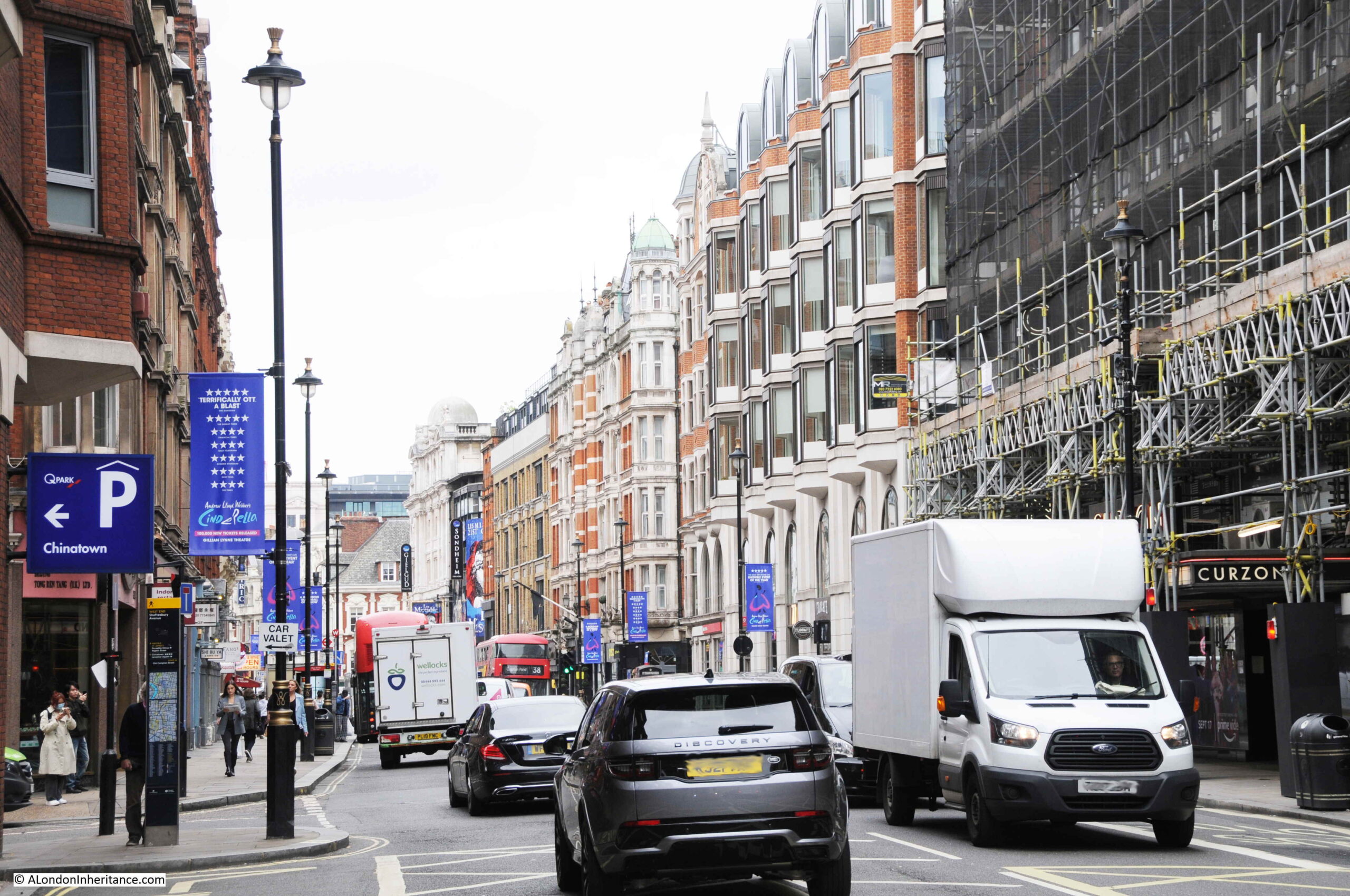
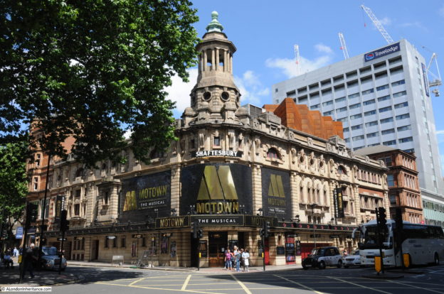
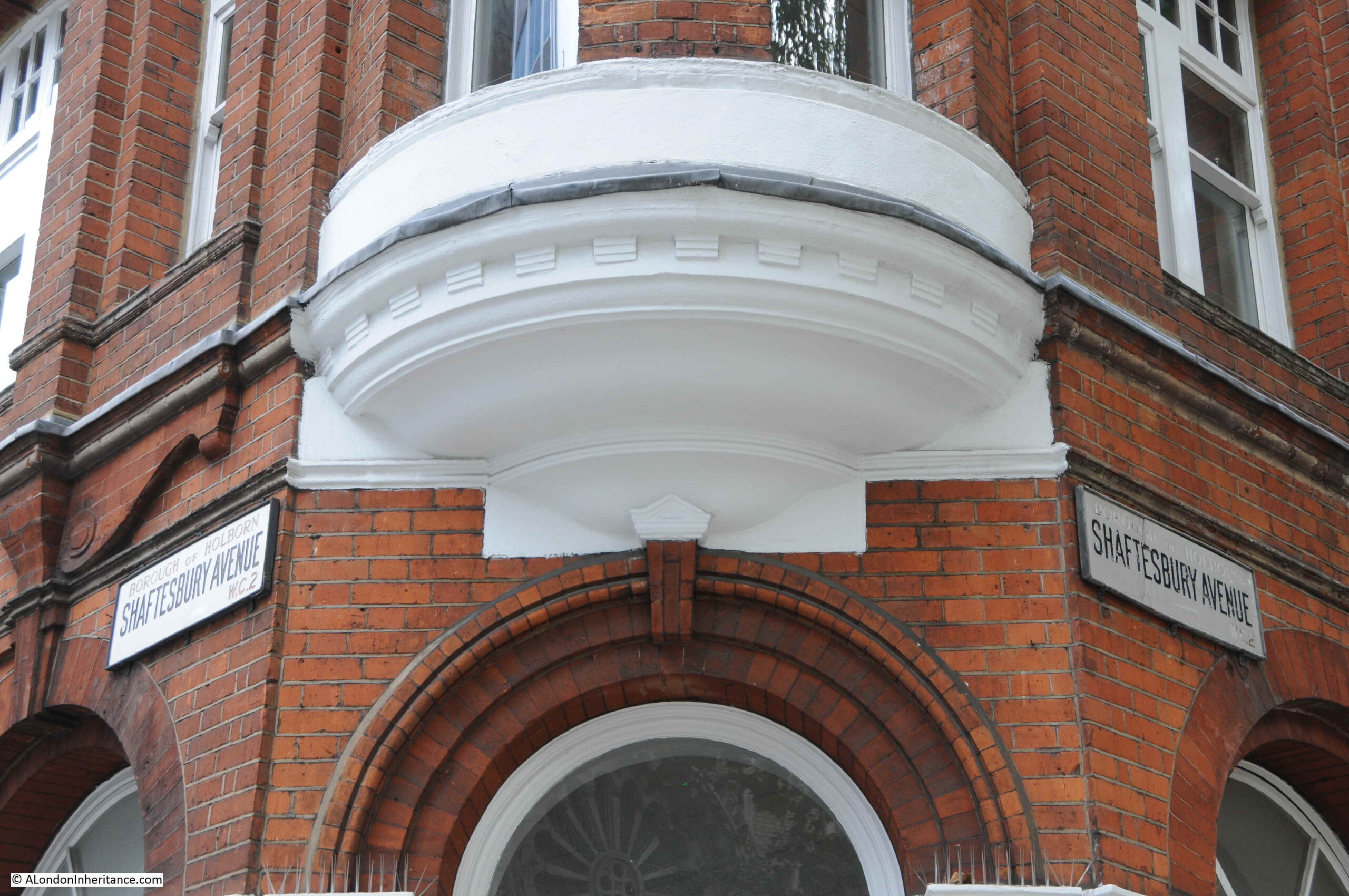
Shaftesbury Avenue is a long street that runs from New Oxford Street in the north down to Piccadilly Circus in the south. The street crosses Charing Cross Road, and it is the lower half that is probably best known as this is where the majority of the street’s theatres are located. As the street sign above confirms, Shaftesbury Avenue is in the heart of London’s theatre land.
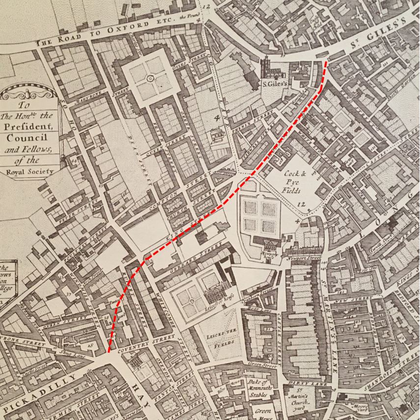
Shaftesbury Avenue cut through a series of streets and buildings that had existed from the time of London’s expansion westwards. The following map is from William Morgan’s 1682 map of London, again the red dashed line marks the future route of Shaftesbury Avenue.
Shaftesbury Avenue was part of the same scheme that included Charing Cross Road.
Proposals for roads improvements along the lines of Charing Cross Road and Shaftesbury Avenue dated back to the 1830s, when a Select Committee of the House of Commons stated that “several plans for affording greater convenience of intercourse between the southern and northern divisions of the metropolis” were considered due to increasing traffic flow and the need to provide much more direct and convenient links between locations such as the eastern end of Oxford Street, Charing Cross and Piccadilly Circus.
Nothing would come of these early proposals, and by the 1870s the situation was becoming more critical, with traffic added to by the arrival of railway stations to the north of the city and those along the river such as Charing Cross.
The Metropolitan Board of Works applied to parliament for permission to improve the streets between Oxford Street, Charing Cross and Piccadilly, and they were granted the powers to construct these streets through the Metropolitan Street Improvements Act of 1877.
Details of these improvements, along with so many others throughout London were published by the London County Council in a wonderful book published in 1898 called “History of London Street Improvements, 1855 – 1897”.
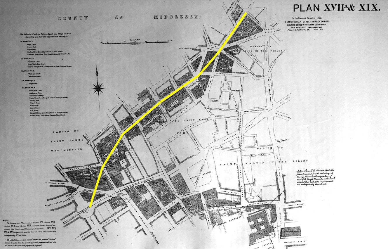
The book includes some detail on the Shaftesbury Avenue development, including the following two maps which detail the route. I have added a yellow line to highlight the route. The first map covers from Piccadilly Circus at lower left to just to the north west of Seven Dials at top right.
The following map includes a short overlap and covers the north eastern section of the street from Greek Street (top left) to New Oxford Street at lower right.
The route of Shaftesbury Avenue would take over and widen a number of existing streets and would run through a number of housing blocks.
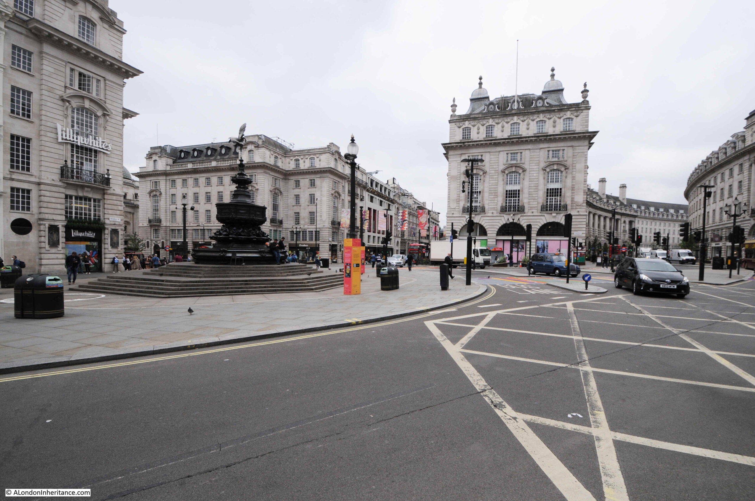
At the southern end of the route, Shaftesbury Avenue opens out onto Piccadilly Circus which is a major junction with Regent Street, Piccadilly, Regent Street St James, and Coventry Street.
The view along Shaftesbury Avenue from the junction with Piccadilly Circus:
The 1877 Act imposed some difficult conditions on the Metropolitan Board of Works. Previous acts had allowed development to take place with conditions for the rehousing of the “labouring classes” who would be displaced, however the new Act stated that the Metropolitan Board of Works was “forbidden to take, without the consent of the Secretary of State, 15 or more houses occupied wholly or partially by persons of the labouring classes, until the Board had proved to the satisfaction of the Secretary of State that other accommodation in suitable dwellings had been provided”.
The new street would pass through some of the most densely populated parts of London, requiring the rehousing of hundreds of people, so this was a difficult condition for the Board.
The Metropolitan Board of Works tried through the following years to get the condition regarding 15 or more houses either removed or modified, however Parliament refused to change the original Act.
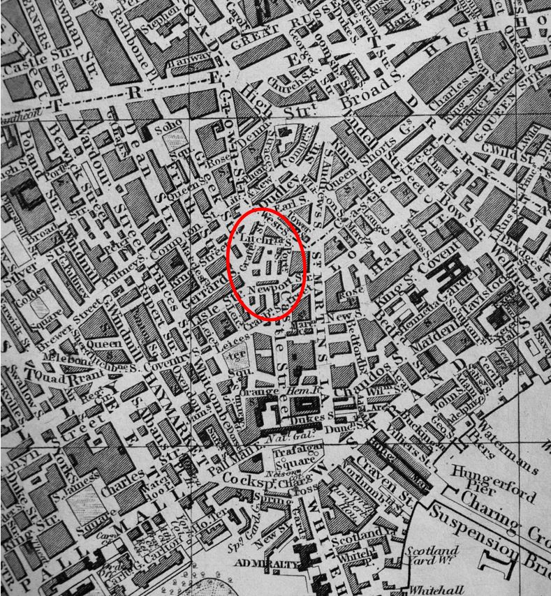
Whilst the Board had been trying to get the Act changed, it had also acquired the land of the old Newport Market and had been building large blocks of working class dwellings ready for those who would be displaced by the development of Charing Cross Road and Shaftesbury Avenue.
Newport Market was an area just to the south of the route of Shaftesbury Avenue. I have ringed the location in the following extract from Reynolds’s 1847 “Splendid New Map of London”:
The projects to build Charing Cross Road and Shaftesbury Avenue would eventually displace a total of 3,044 people, described of being of the “labouring classes”.
Starting to walk north along Shaftesbury Avenue. This stretch of the new road ran through areas of dense housing:
The Metropolitan Board of Works purchased the land for the new street. They tried to keep their purchases to a minimum as the costs were taken from the Rates.
In an example of how the ownership of land always was, and in many ways, continues to be a source of profit, without many of the associated costs, it was complained at the time that whilst the cost of improvements were recovered through the Rates, these were generally paid by the tenants of properties, not by the owner, although in developments such as Shaftesbury Avenue, the owner of land close to the new street would benefit by the increase in the value of his land due to the improvements to the area such a development would bring.
Very similar in the way that Crossrail increases the value of land around new stations.
Land purchased for the new road, often included land running along side. The Board was expected to sell excess land alongside the road to recover part of the construction costs.
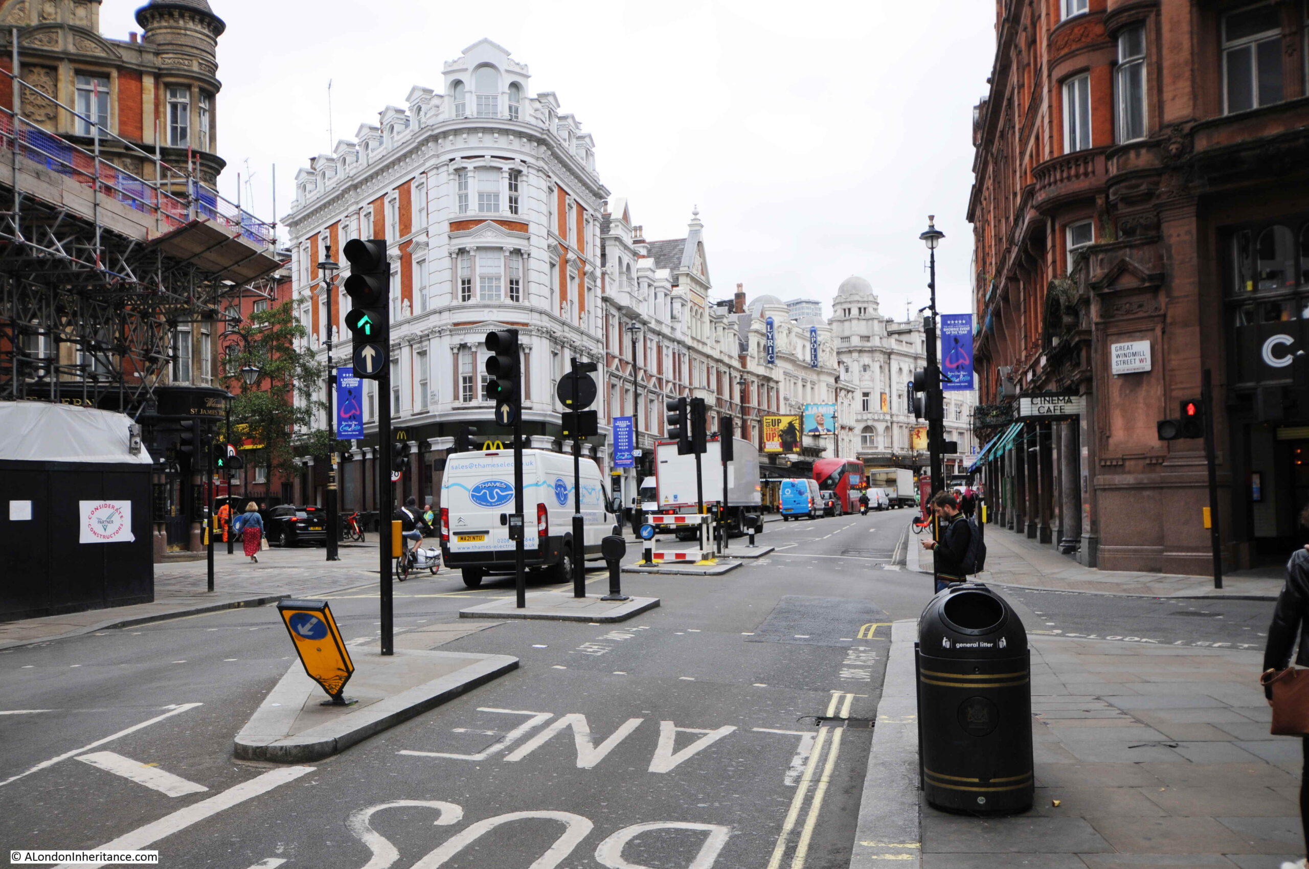
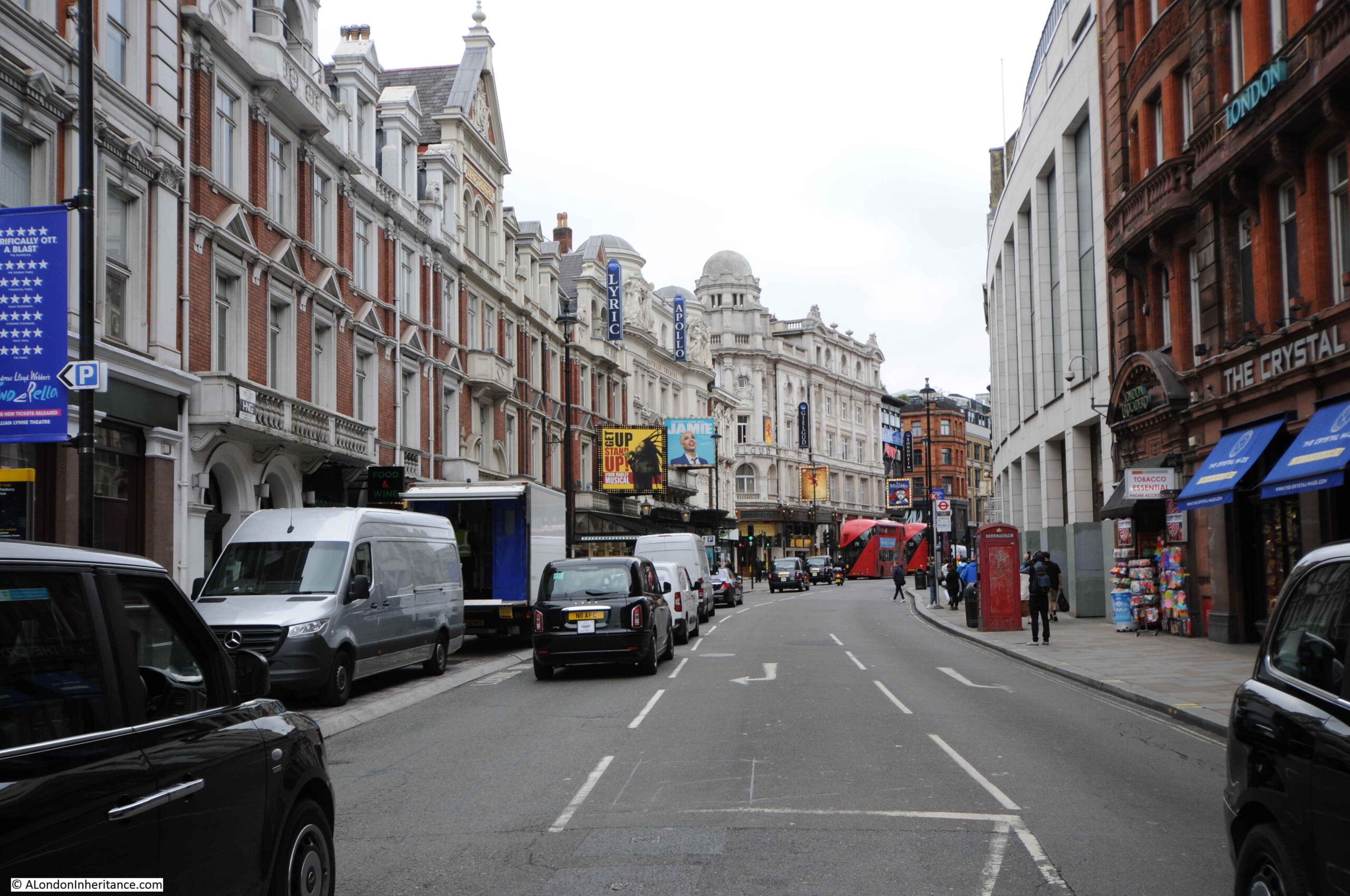
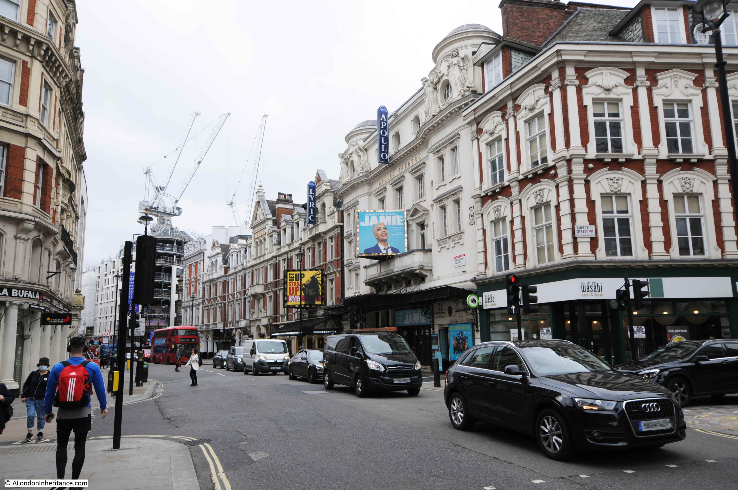
Completion of Shaftesbury Avenue would result in an explosion of building along the new route, which included many of the theatres that today line the street.
In the above photo, further from the camera on the right is the Lyric Theatre (1888) and with the “Jamie” advertising is the Apollo Theatre (1901).
At the junction with Wardour Street. The church of St Anne’s, Soho is just up the street to the right.
Remarkable that as the original buildings and streets were being cleared ready for the construction of Shaftesbury Avenue that the 17th century elm pipes were being removed from the ground, and that in the 1880s these were fortunately considered important enough to photograph.
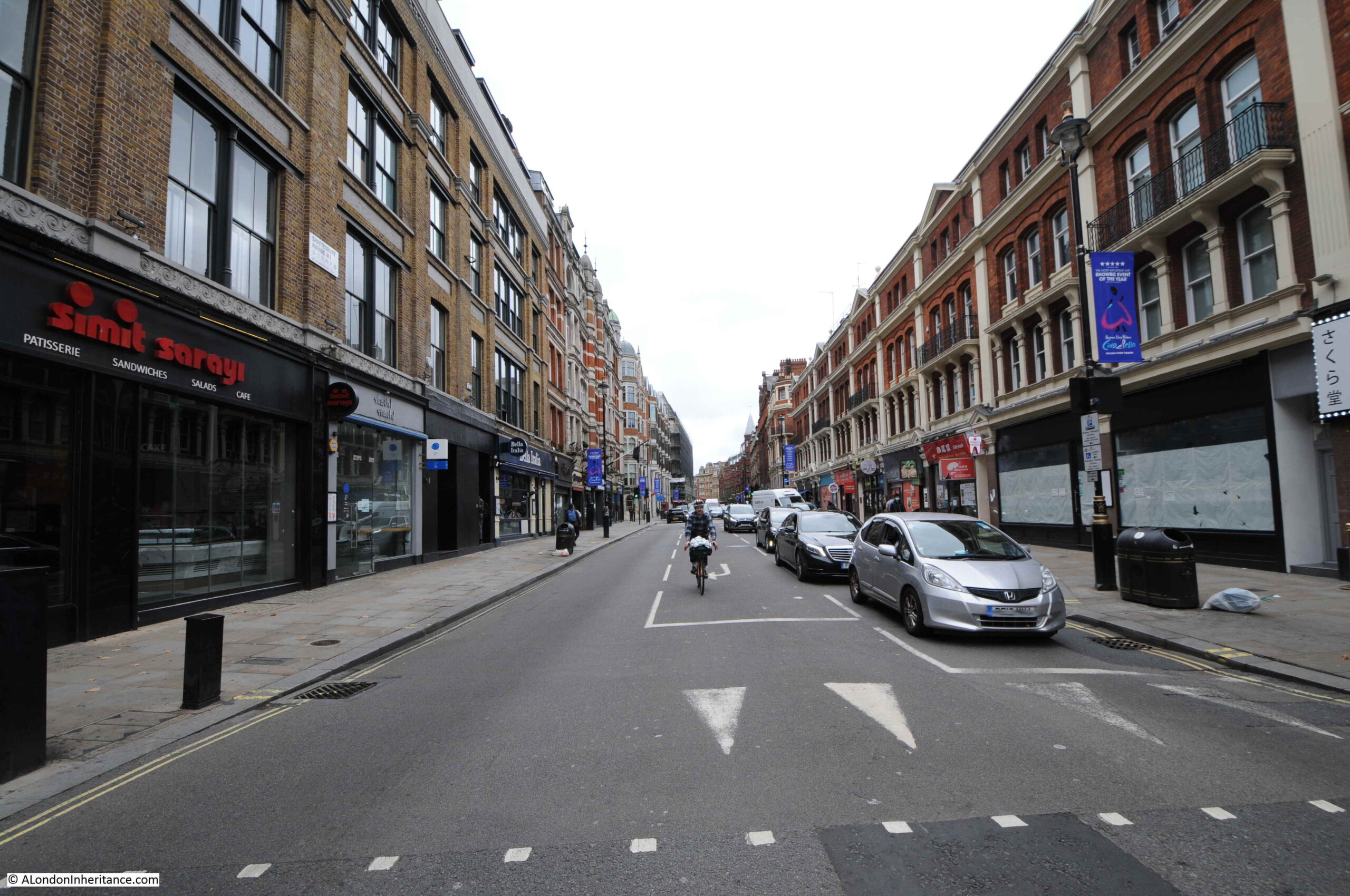
The following photo is looking north from the junction with Wardour Street, and is the stretch of Shaftesbury Avenue which was a much widened earlier King Street:
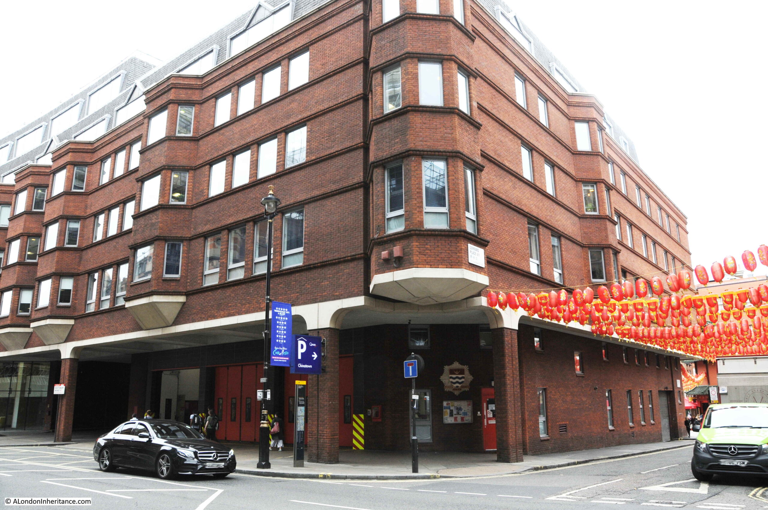
At the junction of Shaftesbury Avenue and Gerrard Place, there is a modern fire station:
The site has been a fire station from the construction of the street. In 1886, the Metropolitan Board of Works leased the land to a private fire fighting organisation, the London Salvage Corps, with the first fire station being built the following year in 1887. In 1920 the site was acquired by the London County Council as a site for the London Fire Brigade.
Looking south from outside the fire station:
Turning north, and it is here that Shaftesbury Avenue crosses Charing Cross Road, which was also being developed at the same time:
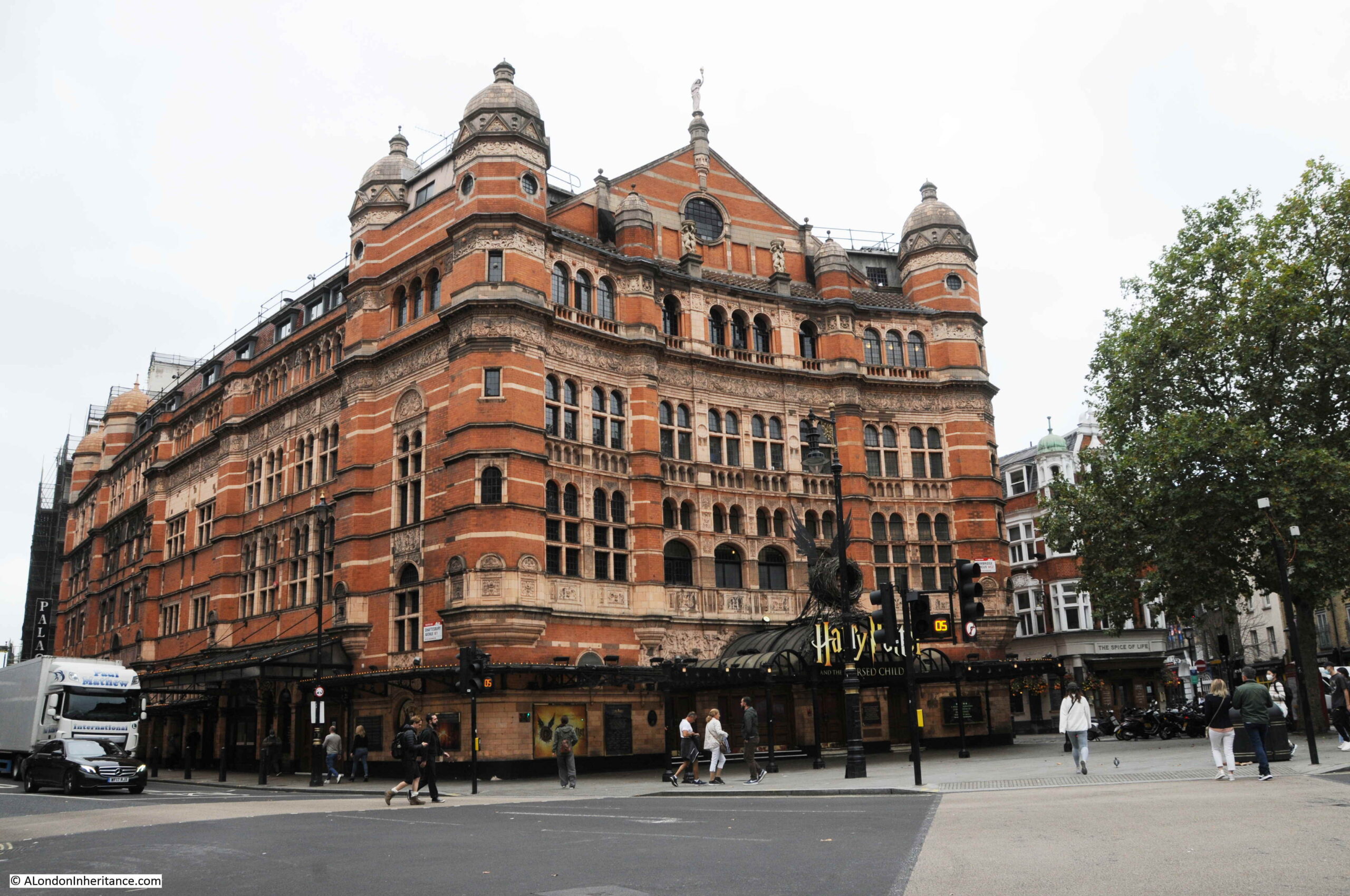
At the junction of Shaftesbury Avenue and Charing Cross Road is the Palace Theatre:
The Palace Theatre is a large, red brick building with a capacity for 1,400 theatre goers.
The theatre was opened in 1891 (soon after the completion of the two new streets) for Richard D’Oyly Carte who intended the theatre to be the home of English opera and on opening the theatre was known as the Royal English Opera House. The first production was Arthur Sullivan’s Ivanhoe, however when this closed there was no follow up production and the Royal English Opera House closed.
D’Oyly sold the building and in 1911 it opened as the Palace Theatre of Varieties, commencing a theme of musical productions which have run for most of the theatre’s time. With the emphasis on musicals rather than variety productions, the theatre dropped the last part of the name to become the Palace Theatre.
Today, the Palace Theatre is hosting probably one of the biggest productions in the West End for some years, J.K. Rowling’s “Harry Potter and the Cursed Child”.
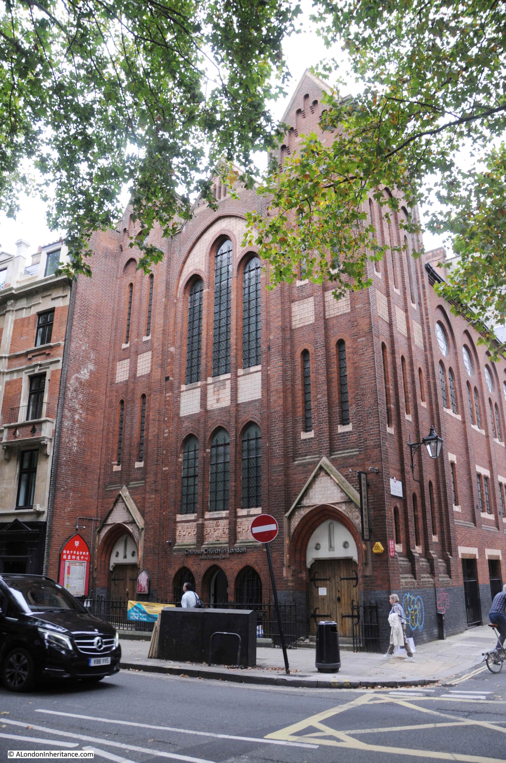
Continuing north along Shaftesbury Avenue and on the corner with Mercer Street is the Soho Baptist Chapel:
Built between 1887 and 1888 (the building work along the street in the few years after completion must have been considerable). The building is now the Chinese Church in London.
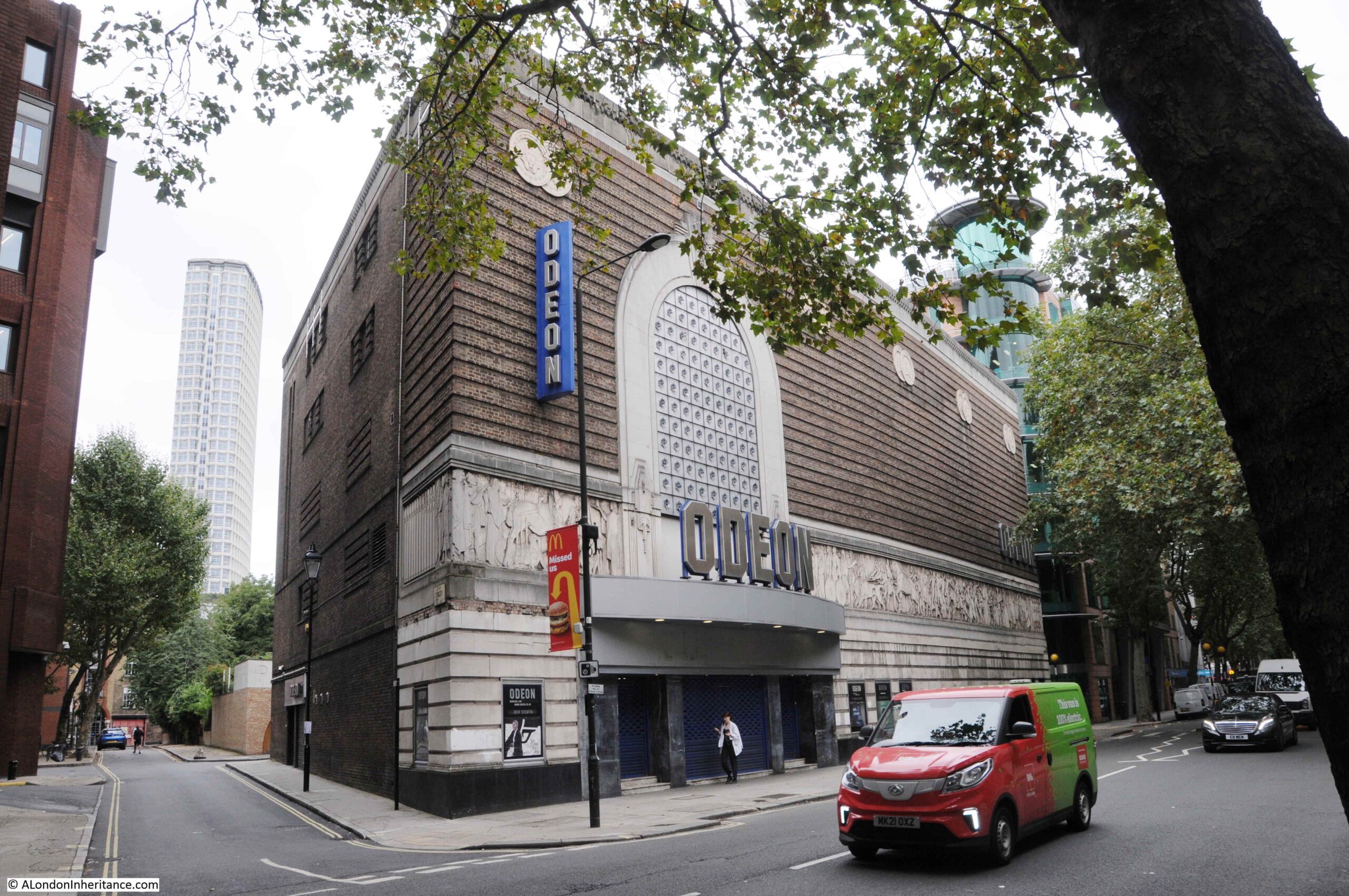
Further along is the Shaftesbury Avenue Odeon:
The facade is not what you would typically associate with a cinema and gives away the building’s original function. This building was originally the Saville Theatre.
The Saville Theatre opened in 1931 and according to an introduction to the theatre in one of the early theatre programmes was “built by Messrs Gee, Walker and Slater of 32, St. James’s Street, SW1 from plans of the Architects, Messrs T.P. Bennett and Son, of 41 Bedford Row, WC1 who were also responsible for the whole colour scheme, lighting, furnishing etc.”
The exterior of the building looks much the same today as when it first opened as the Saville Theatre, apart from the canopy over the entrance and the glass blocks that now replace the wrought iron windows in the enclosed area above the canopy.
Further along Shaftesbury Avenue is what was the “Hospital et Dispensaire Francais”, or the French Hospital:
The French Hospital was originally at 10 Leicester Place where it had been opened in 1867 by Eugene Rimmel, for “the benefit of distressed foreigners of all nations requiring medical relief”.
The hospital quickly outgrew the original site, and the land adjacent to Shaftesbury Avenue was acquired from the Metropolitan Board of Works, with the new hospital building opening in 1890. A hospital would continue on the site until 1992.
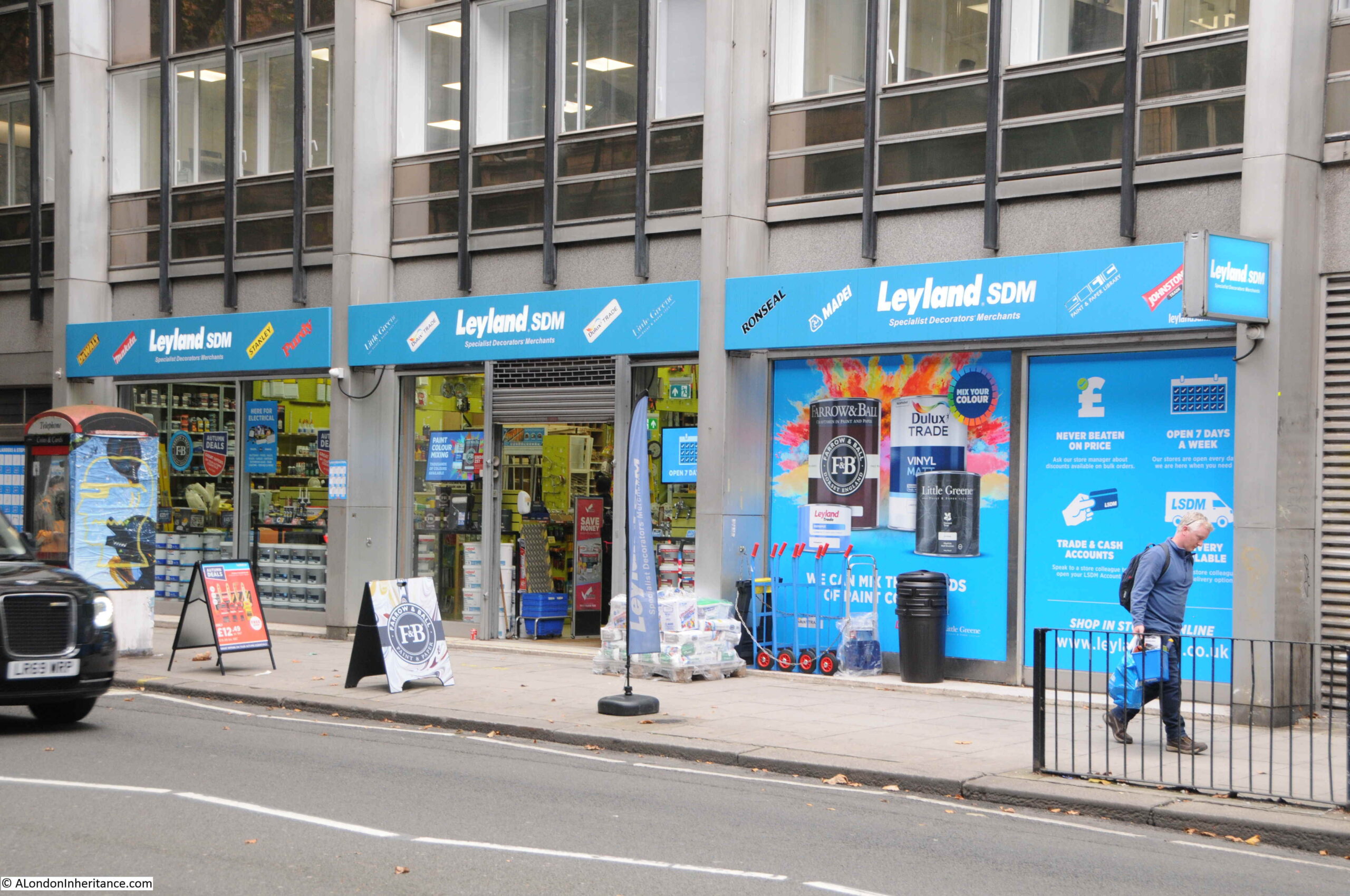
Towards the junction with St Giles High Street and High Holborn, Shaftesbury Avenue has left behind the theatres of the southern part of the street, and we find different types of shops, including a decorating / hardware store:
Forbidden Planet:
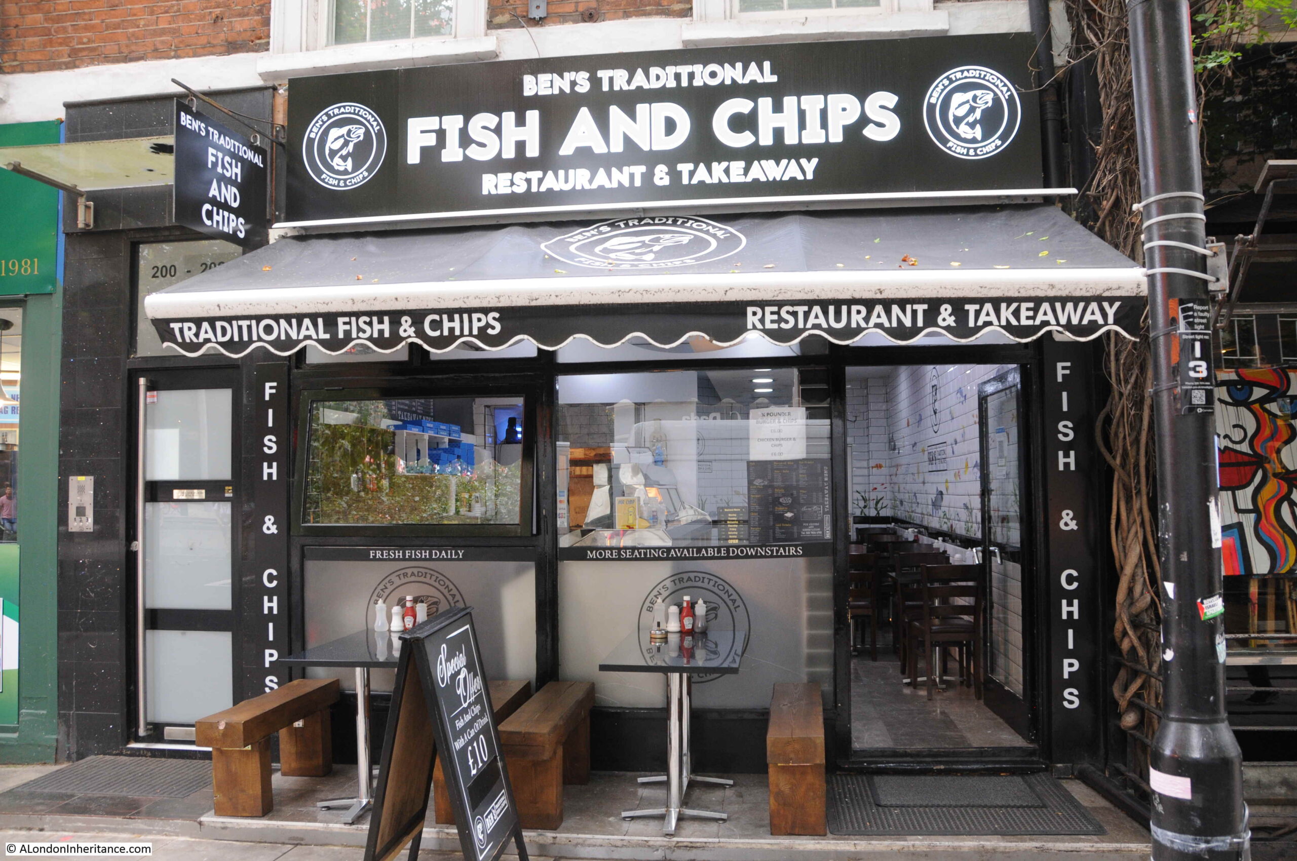
And Ben’s Traditional Fish and Chips:
This was also the site of the now closed Arthur Beale, ships chandler.
Looking north across the junction with St Giles High Street on the left and High Holborn on the right with Shaftesbury Avenue continuing north:
Although the majority of the street’s theatres are in the section of street between Charing Cross Road and Piccadilly Circus, there is another theatre on the corner of Shaftesbury Avenue and High Holborn – the Shaftesbury Theatre:
The Shaftesbury Theatre occupies a prominent corner location. Opened in 1911 it was originally called The Princes Theatre. For over a century the Shaftesbury Theatre has hosted musicals, plays and comedies and in 1968 the run of the musical Hair commenced in September, made possible by the ending of theatre censorship laws on the 26th September 1968 when after 231 years of theatre censorship, the Lord Chamberlain had his powers to censor plays removed.
Hair ran for almost 2,000 performances before it was forced to close owing to structural problems in the building that required urgent restoration work. During closure, there were attempts to redevelop the building, however it was saved as a theatre and reopened in 1974.
We are now coming into the final part of the street, where it joins New Oxford Street, however, there is a change to the original route.
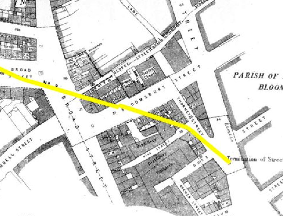
in the following map, the yellow line indicates the route of Shaftesbury Avenue to New Oxford Street on the right, with the text “Termination of Street” showing where the new street would end.
The above map shows the street cutting across a stretch of street labeled Bloomsbury Street, however today, both this small section of Bloomsbury Street and the new street are called Shaftesbury Avenue as shown on the building in the corner where the two sections of the street run to left and right:
Today, the original section of Shaftesbury Avenue is mainly paved, but with a short stretch of street running along one side:
This view is from New Oxford Street looking down where Shaftesbury Avenue originally joined New Oxford Street:
And this is the view down what was the short section of Bloomsbury Street that now forms the junction of Shaftesbury Avenue with New Oxford Street.
Shaftesbury Avenue was completed in January 1886, and provided a new direct route from New Oxford Street to Piccadilly Circus, as well as driving a considerable explosion of building that has resulted in the street we see today, a street that is at the heart of the West End theatre industry.
The street was 3,350 feet long and 60 feet wide. A subway was constructed along the length of the street for gas, water and other assorted pipes.
The gross cost of constructing Shaftesbury Avenue was £1,136,456. The net cost was £758,887 after the sale of surplus land at £377,569.
The street was named after Anthony Ashley-Cooper, 7th Earl of Shaftesbury, who had died in 1885, the year before the new street was completed. The Shaftesbury name was also given to the Shaftesbury Memorial Fountain (probably better known as Eros), in Piccadilly Circus.
Newspapers at the time of his death were full of the philanthropic work of the Earl of Shaftesbury, and his work in Parliament to try and improve working and living conditions. One of these was the so called “Ten Hours Bill”, which although not strictly living up to its name, did look to reduce the hours of work for children.
Considering that this was considered a great improvement, the changes that the bill looked to implement were still horrendous by today’s standards.
With the exception of silk and lace mills, children under the age of nine were not to be employed in factories, while the labour of those under thirteen was to be limited to 48 hours a week, and the employers of all children were required to provide them with not less than two hours schooling a week.
So, going back to the caption at the top of the post, unpacking everything in the photo from the New River Company’s elm pipe excavated when Shaftesbury Avenue was built, and the church of St Anne’s Soho reveals a fascinating history of a small part of the West End.
It would be brilliant to think that there are still some elm pipes buried below the city’s streets just waiting to be discovered.
Epidemiology has come to public attention as one of the key areas of expertise needed to reduce the spread of Covid-19. The pandemic has come as something of a shock given the significant reductions in disease over the last 100 plus years, although in reality, such a global event was probably only a matter of time given the background transmission of new diseases, and the interconnectedness of the world in the 21st century.
Contagious disease has long been a very significant problem. Outbreaks would rise and fall, killing many thousands of people, often in limited areas. Prior to the mid 19th century, thinking was often that disease was caused and transmitted by a miasma – a form of “bad air”.
It took the work of a number of Doctors and Scientists to prove this was not correct, and to trace the real cause of disease transmission, and one of these was Dr. John Snow, often called the founding father of Epidemiology. His work on the transmission of Cholera in London would demonstrate conclusively how this killer of large numbers of Londoners was transmitted.
The British Medical Journal describes Epidemiology as “the study of how often diseases occur in different groups of people and why. Epidemiological information is used to plan and evaluate strategies to prevent illness and as a guide to the management of patients in whom disease has already developed.”
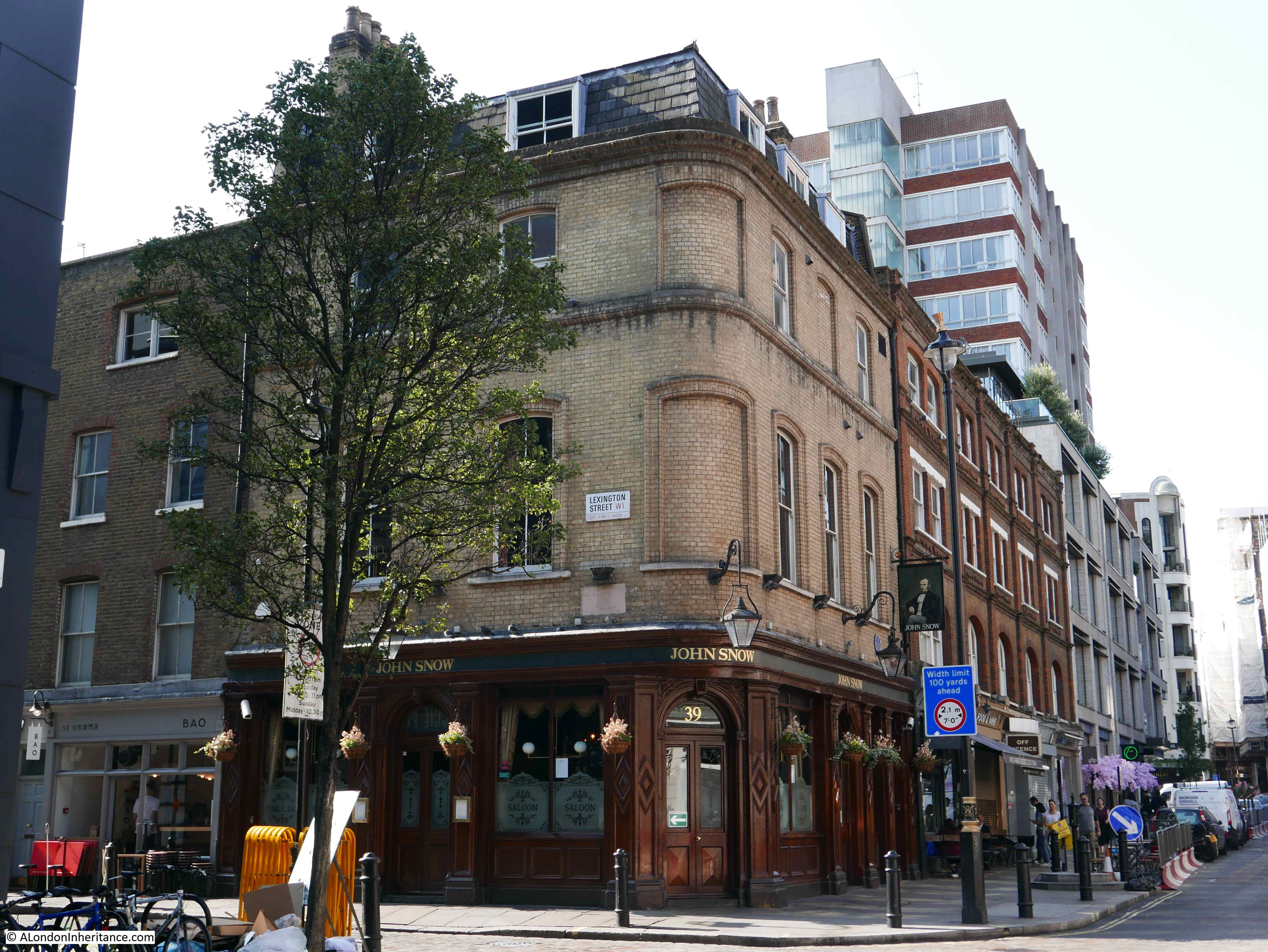
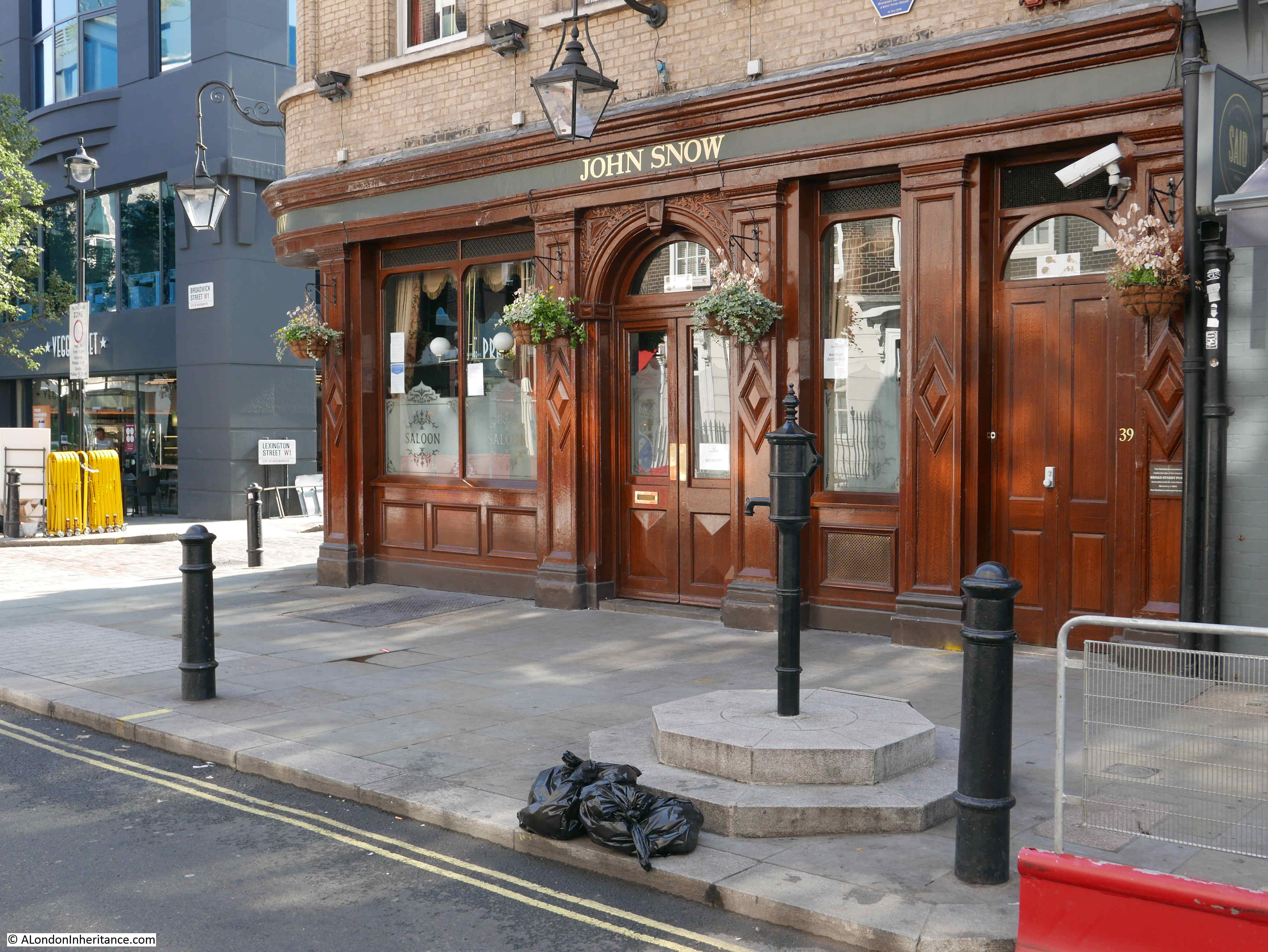
Although John Snow’s work on Cholera covered the whole country, including outbreaks across London, he is more widely known for one outbreak in 1854 in Broad Street, Soho, and a couple of weeks ago I had a walk around the area to find the focal point of the outbreak, and the pub that bears his name:
The John Snow pub stands on the corner of Broadwick Street (originally Broad Street) and Lexington Street (originally Cambridge Street). A number of streets in this area of Soho have changed their names since the mid 19th century.
The pub building dates from the 1870s, and was originally called the “Newcastle-upon-Tyne”, The name changed in 1955 to commemorate the centenary of the work in the area of John Snow.
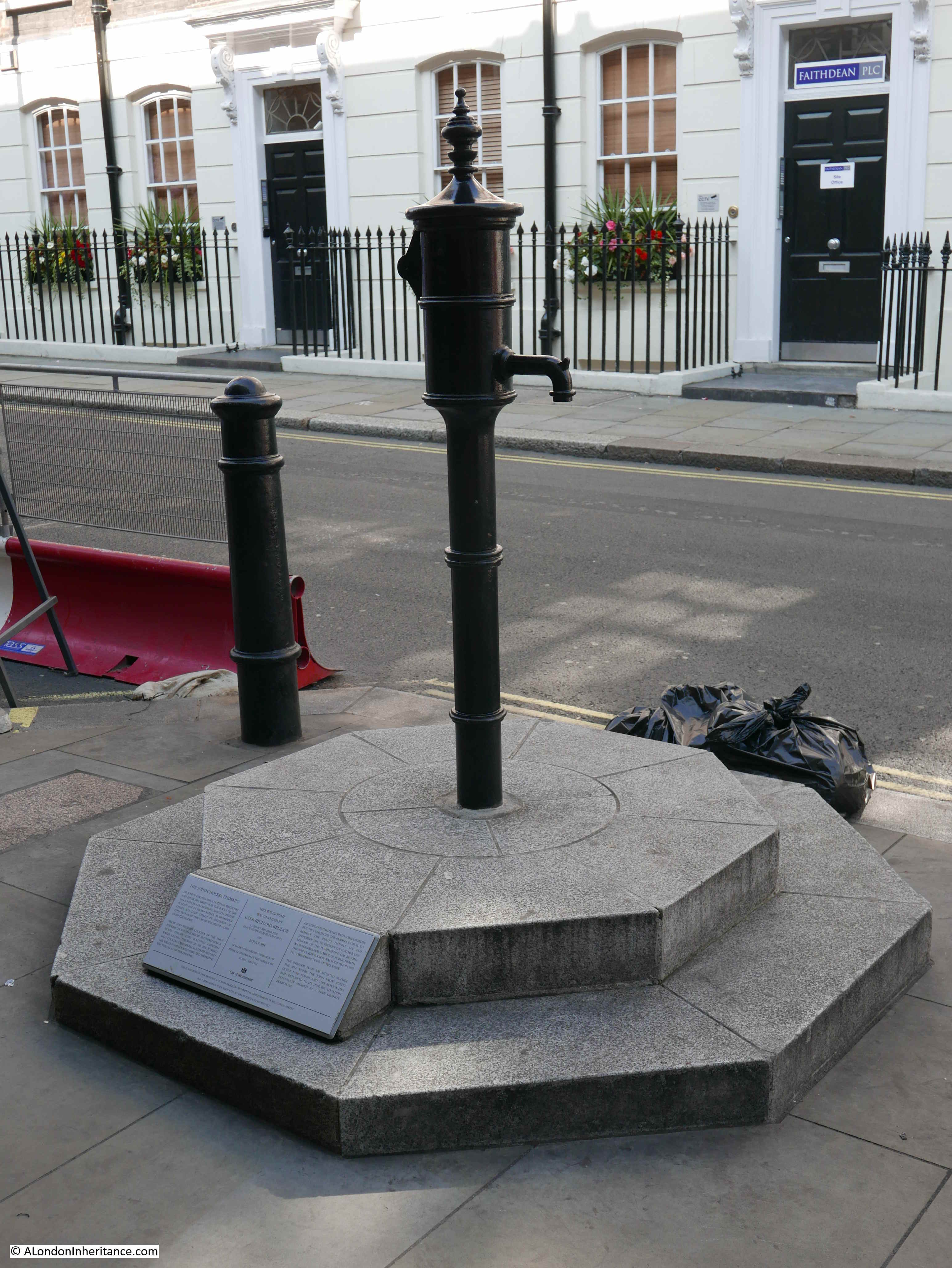
He traced the source of the local Cholera outbreak to a water pump that stood in the street outside the current pub. I will detail how he did this later in the post. Today, there is an imitation pump in the same spot:
The pump was installed in its current position in 2018, having been removed three years earlier due to building work which included extension of the pavement. The replica pump had been installed in a slightly different position to the original, and a pink granite curb stone had marked the location of the original pump.
One of the fascinations of London is that historical reminders tend to accumulate, and the pink granite curb stone was retained, and can now be seen to the left of the plinth on which the pump is mounted, now in the correct position.
The pump is also unusual in that it does not have a handle – the reason for this will be explained later in the post.
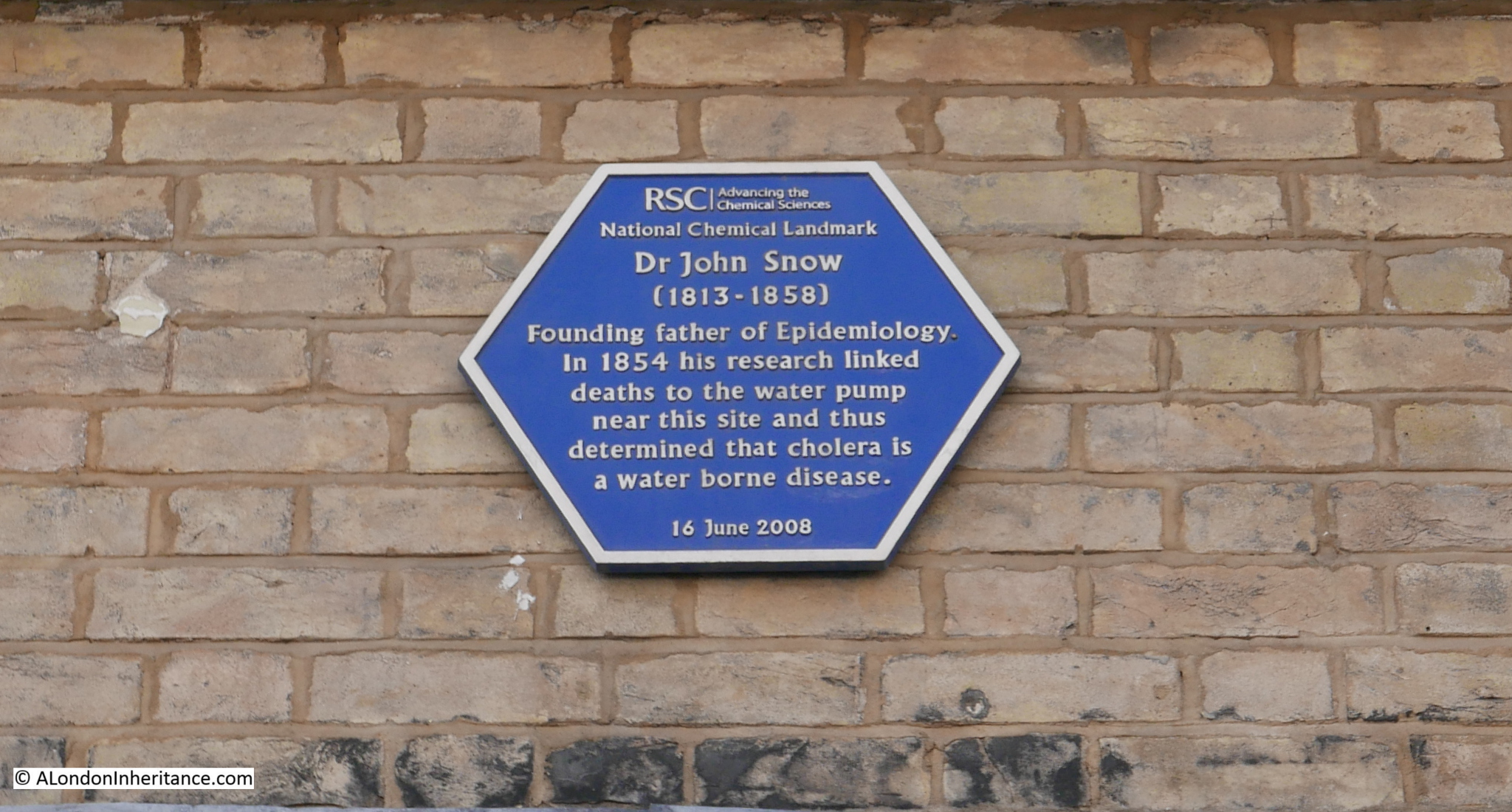
And on the pub wall is a plaque by the Royal Society of Chemistry naming John Snow as the founding father of Epidemiology for his work in the area:
The pump and pub in Broadwick Street:
John Snow was born in York on the 15th of March 1813. A career in medicine seems to have been defined at an early age,. When he was 14 he started work as an apprentice for William Hardcastle, a surgeon in Newcastle-upon-Tyne.
He had early experience with cholera outbreaks, and during 1831 he worked on an outbreak at Killingworth Colliery. It was here that he appears to have started making detailed notes on the outbreak – gathering the data that would be essential in understanding the root cause.
He moved to London in 1836 to study at the Hunterian School of Medicine, and a year later started hospital practice at the Westminster Hospital. The following year, 1838, he became a member of the Royal College of Surgeons, and in 1850 became a member of the Royal College of Physicians.
Doctor John Snow:
Data gathering in 19th century London was actually rather good. The Registrar General published regular returns detailing the number of deaths by date, cause and location. Where possible, information also included age, gender and profession, so a mass of data was available for evaluation, however outdated theories often prevented the use of data to find the root cause of disease outbreaks.
London could be absolutely filthy. Much of London was not yet connected to the expanding sewer network. Houses often had cesspools directly underneath, raw sewage was pumped into the Thames, contaminated water would be dumped in the streets and ditches.
The city’s cemeteries were overflowing, with bodies piled high in crypts and churchyards.
One of the main theories was that disease was carried in dirty air. Air polluted by rotting vegetables, dirty water, the waste from industry, and from the city’s cemeteries.
There was also no real separation between drinking water and contaminated water. For example, raw sewage was pumped into the Thames, a short distance from where water was taken out for distribution to houses and pumps.
There were frequent outbreaks of cholera. 1849 being the year of the most recent outbreak, however there was also a background rate of cholera deaths happening every year.
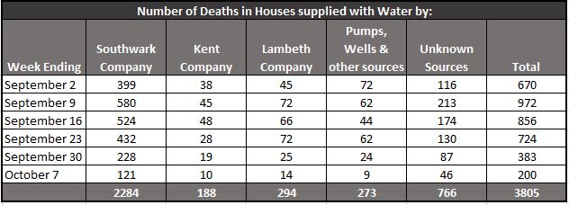
Data recorded by the Registrar General identified the number of deaths per week, aligned with the source of water for the house where the person lived, or the death occurred. The following table shows a period of six weeks in 1854. The table focused on south London, an area where there were significant numbers of cholera deaths.:
The table shows the source of the water supplied to each house where there was a death. The “Unknown Sources” column included a large number of houses where the residents did not know where their water came from as the landlord would pay the bill (and therefore they had no control of the source of their water).
The table implies significant problems with the supply of water by the Southwark Company, but this may have been down to a much larger population.
Much of the evaluation of the data was by John Snow. He obtained the addresses for houses where deaths had occurred from the Registrar General, and spent time going house to house to gather more information.
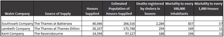
Evaluation of the data enabled a comparison of the mortality rate for each of the water companies to be identified, and this confirmed the issues with the Southwark Company, who had a mortality rate of 857 per 100,000 inhabitants compared with 169 and 194 for the Lambeth and Kent companies:
The Lambeth Company had problems during a previous outbreak in 1849, but had since moved their intake from the Thames upriver to Thames Ditton, which was above the tidal limit of the river at Teddington.
At Thames Ditton, water flowed towards London and there was no wash back in of water due to the tide. This meant that water was less polluted. In central London, there was more inflow of sewage, and this was often swept back in on a rising tide, increasing significantly the level of pollution.
The Southwark Company were still drawing their water from the river at Battersea, not far from a number of sewage outlets at Vauxhall.
Lambeth was the only company to change where they took water following the 1849 outbreak. In 1854, the Southwark Water Company was classed as having the most impure waters, and would not change their water intake till later in the year.
John Snow investigated the source of water used by as many of those who died from cholera as he could find. Some of his records are truly appalling by modern standards:
At 4, Bermondsey Wall, on 23rd July, the daughter of a bookseller, aged 4 years, cholera 9 hours – Thames water, by dipping a pail in the water
At Falcon Lane, Wandsworth, on 3rd August, the daughter of a chemist deceased, aged 14 years, premonitory diarhoea 4 hours, cholera 24 hours – Water from a ditch into which cesspools empty themselves
At Charlotte Place, Charlotte Row, Rotherhithe, July 29th, the son of a barge-builder, aged 3 years, cholera 3 days – Tidal ditch
At 5 Slater’s Alley, Rotherhithe, July 29th, a labourer, aged 33, cholera 3.5 days – Thames Tunnel water, fetched from John’s Place
Rotherhithe was badly effected. and John Snow mentions Charlotte Row, Ram Alley and Silver Street as “places where the scourge fell with tremendous severity”.
He also states that Rotherhithe had been badly supplied by water for many ages past, and that people were forced to drink from old wells, old pumps, open ditches, and the muddy stream of the Thames.
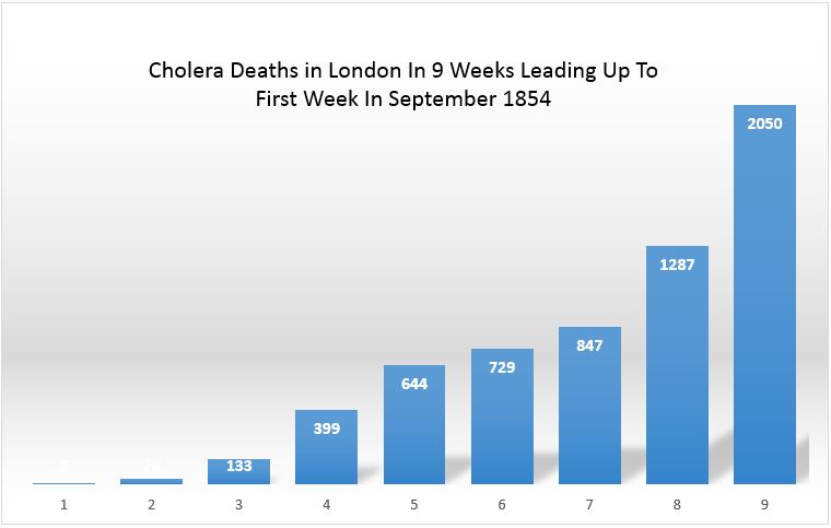
Cholera deaths across London were increasing rapidly during the months leading up to the first week of September. I took the weekly total from the Registrar Generals report, put them in a spreadsheet, and created the following graph which gives a good visual view of the increase.
So in the summer of 1854, cholera was causing deaths across the city, and John Snow was using methods that would become common in epidemiology to understand the impact, and to identify the cause. As well as the cases caused by infected water supplies, the case for which he would be remembered was an outbreak in Soho – a poor area where many of the residents were dependent on water from water pumps.
John Snow investigated the Soho outbreak, and he provided a comprehensive report to the St James, Westminster Cholera Inquiry Committee in July 1855.
Some houses in the area who could afford the cost were supplied by piped water from the Grand Junction and the New River Companies, and in houses that took this water he had found very few instances of cholera. His examination of the water pumps in the streets found the majority had impurities visible to the naked eye. Residents of Broad Street had also informed Snow that water from their local pump had an offensive smell.
At the start of his investigation, Snow requested data on deaths from the General Register Office. He found that the majority of these deaths had taken place near the Broad Street water pump, and after interviewing many of the residents found that those who had died from the disease had regularly drank water from the pump.
There was no other major outbreak in the area, and the common factor was the Broad Street water pump, so on the evening of Thursday 7th September 1854, John Snow had a meeting with the Board of Guardians of St James’s Parish and presented his findings. As a result, the handle of the pump was removed on the following day.
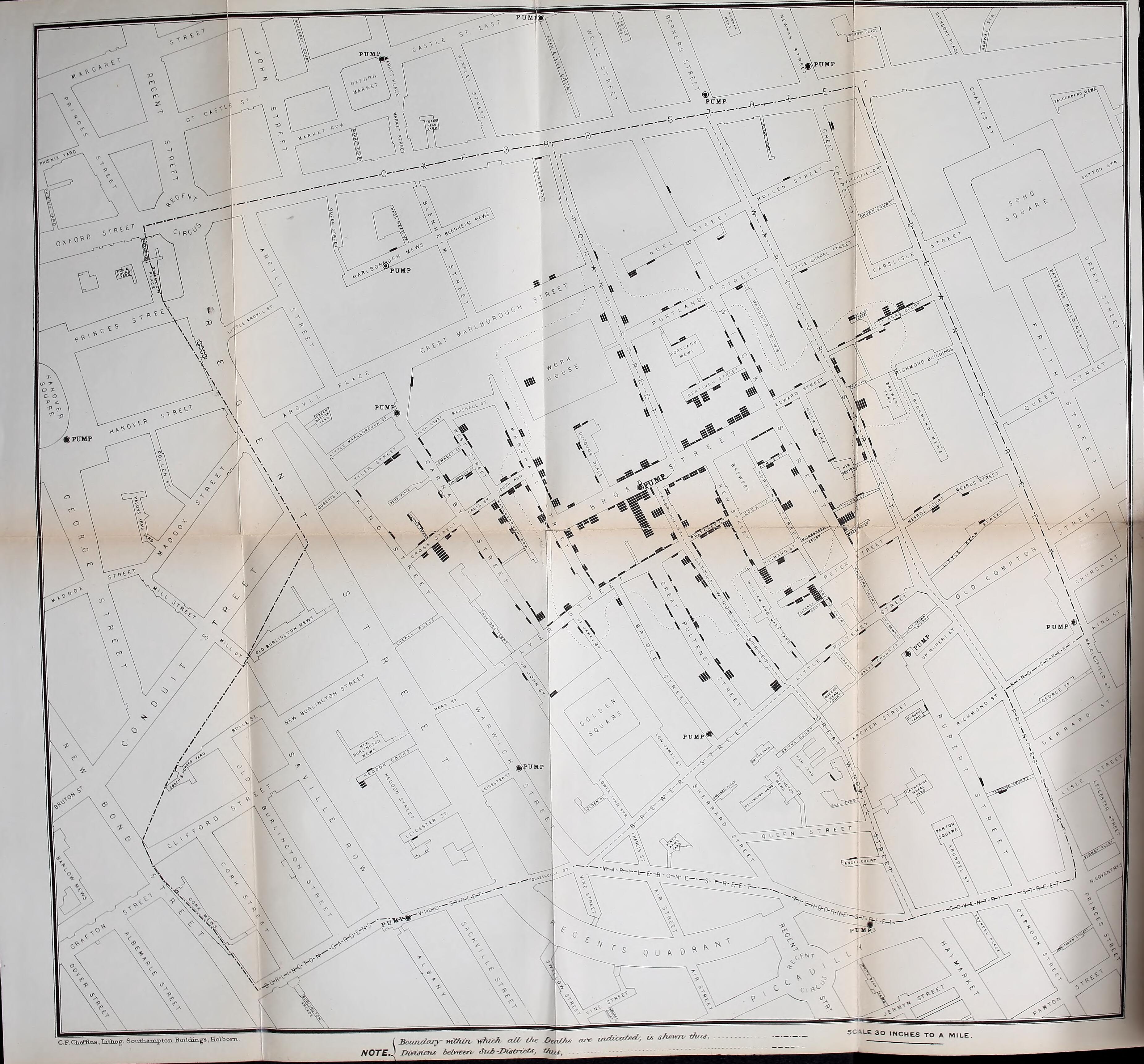
John Snow plotted cholera deaths on a map of the area, with the number of bars representing the number of deaths at each location. The Broad Street pump was close to the long dark line just to the right of centre of the map.
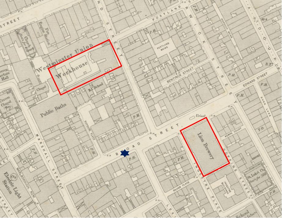
There were a high number of deaths in Poland Street (21), and many of these occurred at the workhouse which is represented by the black rectangle in the above map.
Some of the deaths recorded by Snow at the workhouse are really sad, as often these would be recorded as “female unknown, age unknown”.
The workhouse is also shown in this extract from the 1894 Ordnance Survey map. The pump is again marked by the dark blue star. A short distance to the right is another building that demonstrated to John Snow that the pump was the source (‘Reproduced with the permission of the National Library of Scotland’).
None of the workers at the Lion Brewery caught cholera, despite being in the centre of the outbreak. On interviewing those at the brewery, it was found that “none of the workers drink water” – so perhaps they only drank beer.
John Snow wrote to the Medical Times and Gazette, describing his findings:
“I had an interview with the Board of Guardians of St. James’s parish, on the evening of the 7th, and represented the circumstances to them. In consequence of what I said, the handle of the pump was removed on the following day. The number of attacks of cholera had been diminished before this measure was adopted, but whether they had diminished in a greater proportion than might be accounted for by the flight of the great bulk of the population I am unable to say. In two or three days after the use of the water was discontinued the number of fresh attacks became very few.
The pump-well in Broad-street is from 28 to 30 feet in depth and the sewer which passes a few yards away from it is 22 feet below the surface. the sewer proceeds from Marshall-street, where some cases of cholera had occurred before the great outbreak.
I am of the opinion that the contamination of the water of the pump-wells of large towns is a matter of vital importance. Most of the pumps in this neighbourhood yield water that is very impure; and I believe that it is merely to the accident of cholera evacuations not having passed along the sewers nearest to the wells that many localities in London near a favourite pump have escaped a catastrophe similar to that which occurred in this parish. ”
The lack of a handle on the replica pump we see today is a reminder of the work by John Snow to get the handle removed.
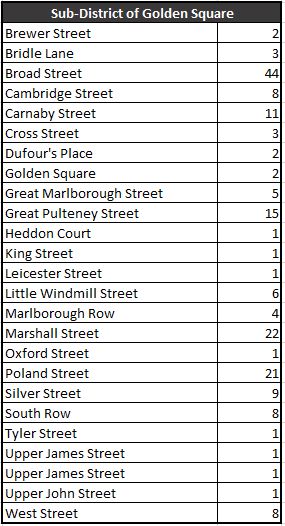
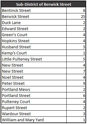
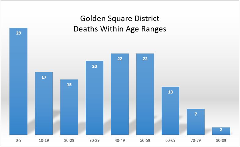
The affected area formed the sub districts of Golden Square and Berwick Street. The number of deaths for each street in these two districts are shown in the following tables:
There is other interesting data to be extracted from the Registrar General’s lists. They also include the age of each of those who had died (where known). I extracted these to a spreadsheet, sorted and created the following graph to show the numbers that died within each age range.
The fall off at later ages is not a reflection of reduced impact of cholera, rather there were fewer people to infect in these age groups – London was a young city.
This is reflected in the high death rate of those aged between 0 and 9 years. The reduction between the ages of 10 and 29 was a surprise as there would be more people of these age groups in the area. Perhaps people of these age groups worked away from the pump, were not at the stage when they were in the workhouse, or perhaps being younger and stronger there was a higher survival rate.
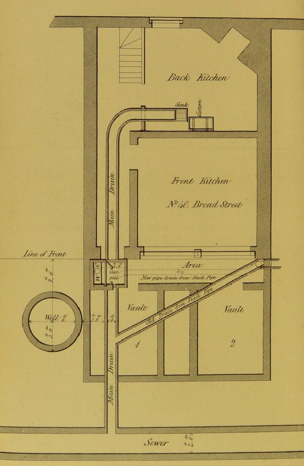
The Westminster Cholera Inquiry Committee in July 1855 included a detailed investigation of the sewer and water infrastructure in the street and the house closest to the pump. The report produced by the Committee included the following drawing:
The diagram shows how close the drains were to the well. The inquiry also examined the cesspool shown by the front of the house and the well. It found the cesspool in very poor condition, and that the mortar between the bricks of the cesspool had decayed allowing the contents to leak into the ground, only a very short distance from the well.
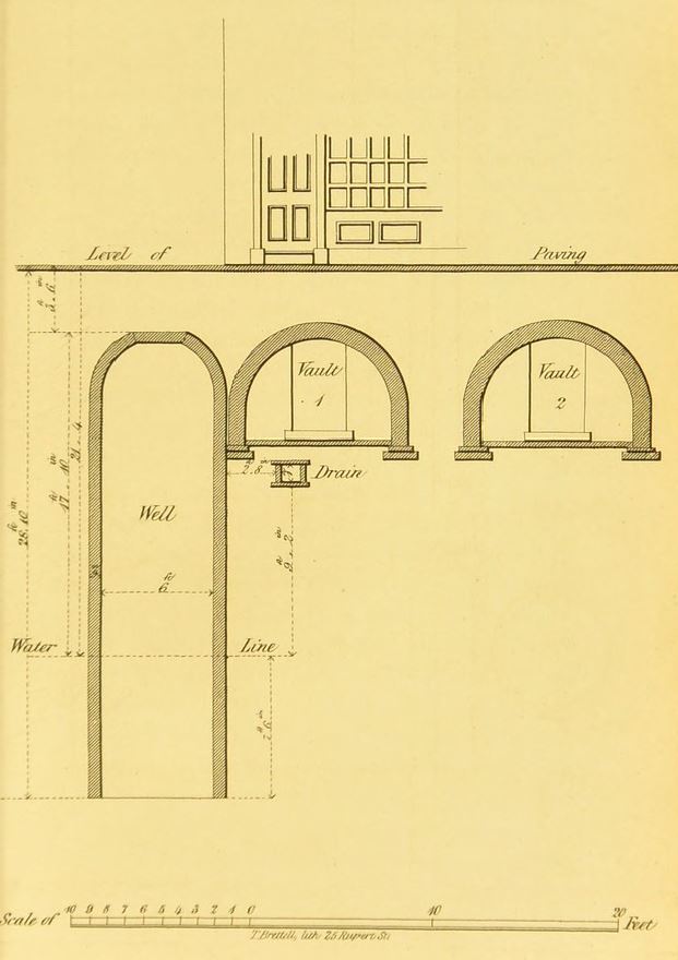
The report also includes the following drawing showing the front of the house, the vaults underneath the pavement, drain and well.
The Westminster Cholera Inquiry Committee report of July 1855 includes a substantial section from the Reverend Henry Whitehead who was assistant curate of St Luke’s Church in Soho during the 1854 outbreak. Whitehead had assisted John Snow with many of the interviews of those living in the streets around the water pump.
Whitehead had initially been sceptical about the cause of the outbreak, being a believer of the miasma theory however he came to the same conclusions as Snow, and was very diligent in his research and interviews of the population.
In his report to the committee, Henry Whitehead recorded the challenges of follow-up research as so many people had moved out of Broad Street, and that approaching the summer of 1855 there was a general feeling of uneasiness in the street – concern that cholera would once again return with warmer weather.
Henry Whitehead identified two houses opposite the pump. One had deaths from cholera and confirmed that they took water from the pump. The adjacent house used water from the New River Company and had no illness.
Although the initial findings to identify the source of the outbreak concentrated on deaths, the follow-up inquiry found that there were 50 cases where people had survived.
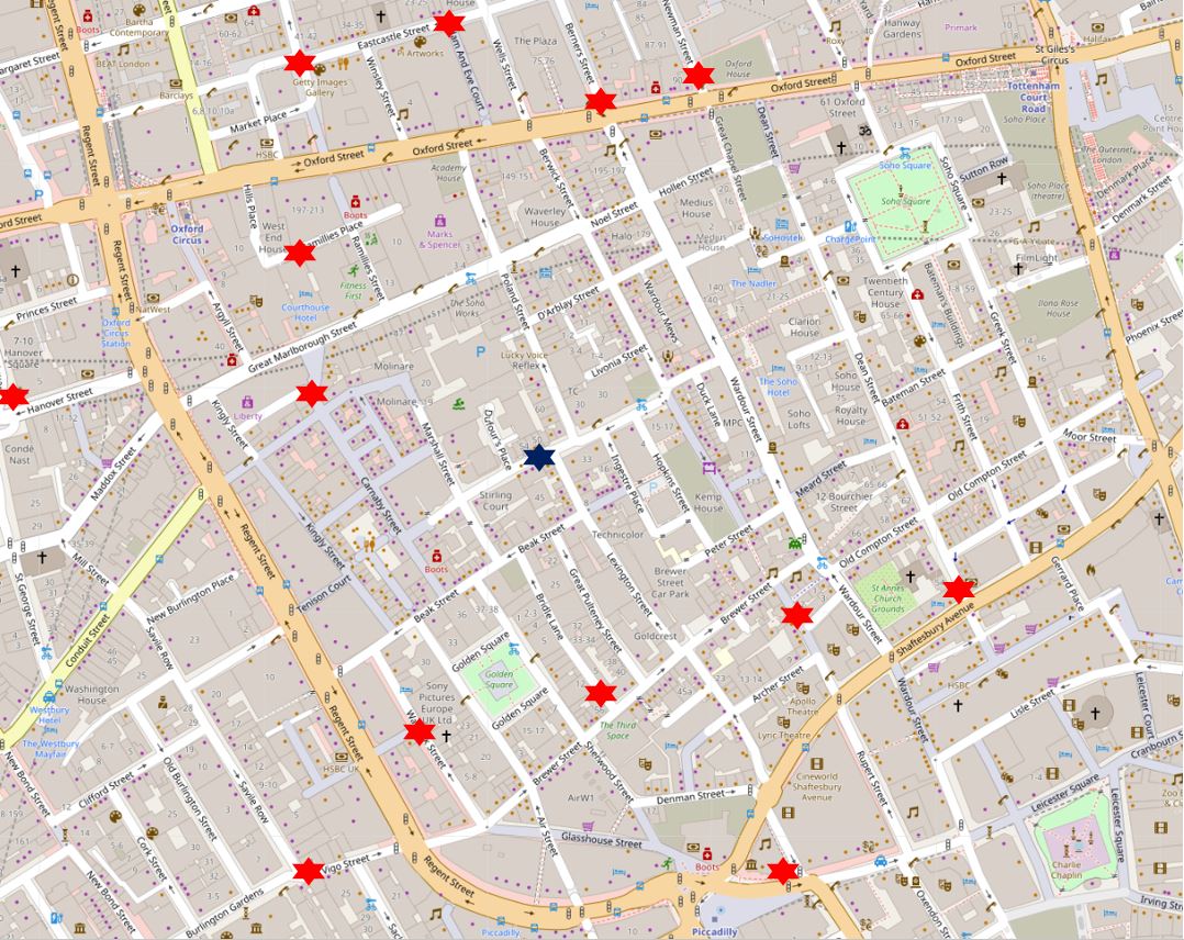
John Snow’s map shows the water pumps of the area. I plotted these on a modern day map to show where the water pumps of 1854 would have been located on today’s streets. Again, the Broad Street pump is the dark blue star, red stars the other water pumps:
Comparing the above map with the map of deaths does again show the high values clustered around the Broad Street pump, with lower numbers as other water pumps became closer.
Broad Street is today named Broadwick Street. the name change happened in 1936 when the eastern section leading to Wardour Street was included – this small section had formerly been called Edward Street (named after Edward Wardour who also gave his name to Wardour Street).
Much of Broadwick Street has changed since the cholera outbreak of 1854, however almost opposite the John Snow pub is a terrace of houses that were there, having been built between 1718 and 1723 as part of the westwards expansion of Broad Street. The terrace is shown in the following photo:
The following photo shows the view looking west along Broadwick Street from close to the Berwick Street junction. The Lion Brewery, which did not have any cholera deaths as none of the workers drank water, occupied the block on the left which now has the brick facing to the upper floors. The brewery was demolished in 1937.
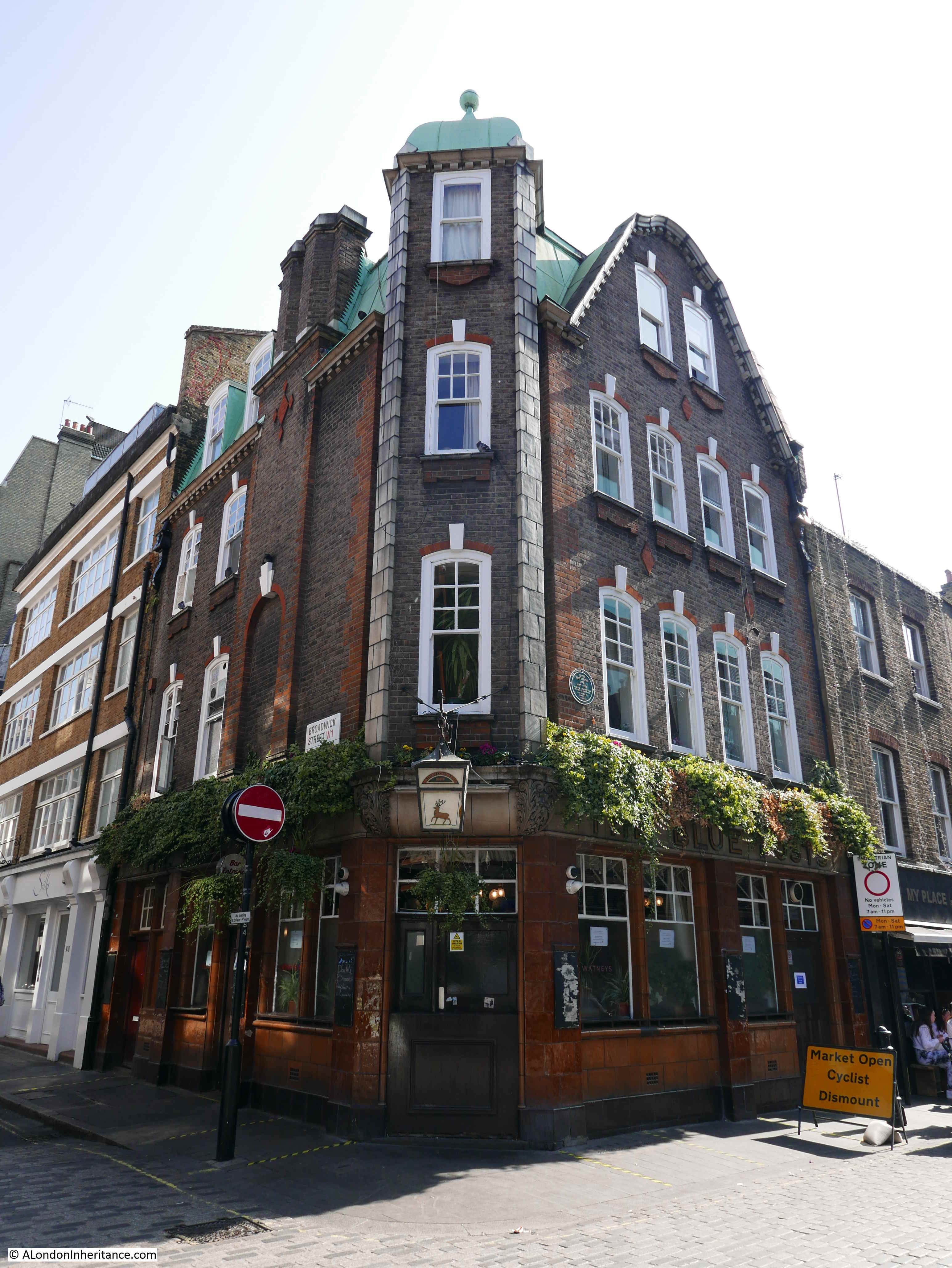
On the corner of Broadwick Street and Berwick Street is the Blue Posts pub. The current rather attractive building dates from a 1914 rebuild, however there had been a pub on the site since the original development of the area, and it is shown on the 1894 OS map.
A rather obscure claim to fame for the Blue Posts pub is that a model of the pub was destroyed by a brontosaurus in the 1925 film Lost World. The following clip shows the pub just before the brontosaurus crashes in and demolishes the building.
Apparently the animators, who created a rather impressive animated film for the 1920s, drank in the pub they chose to destroy for the film.
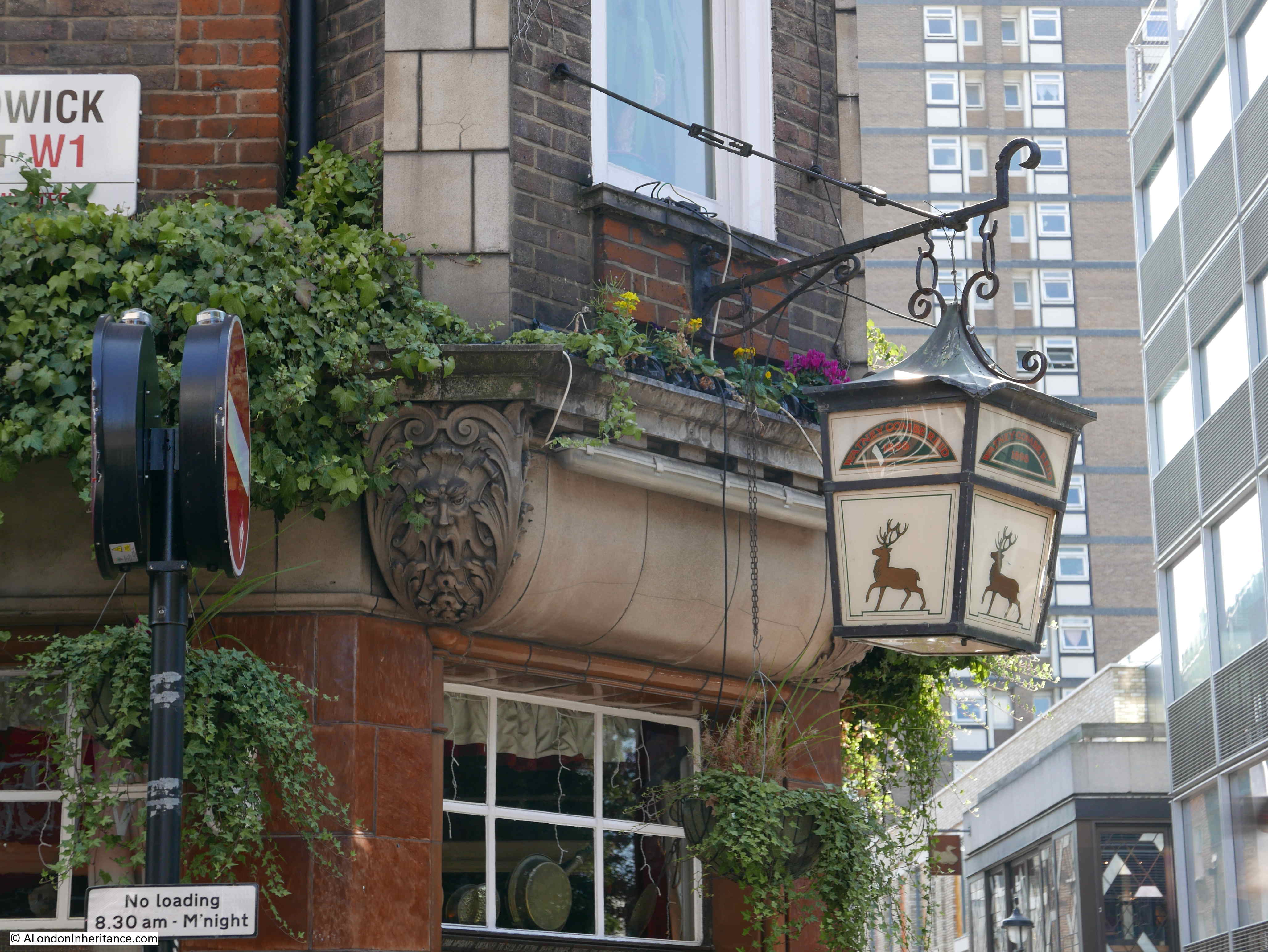
Lantern over the corner of the Blue Posts pub:
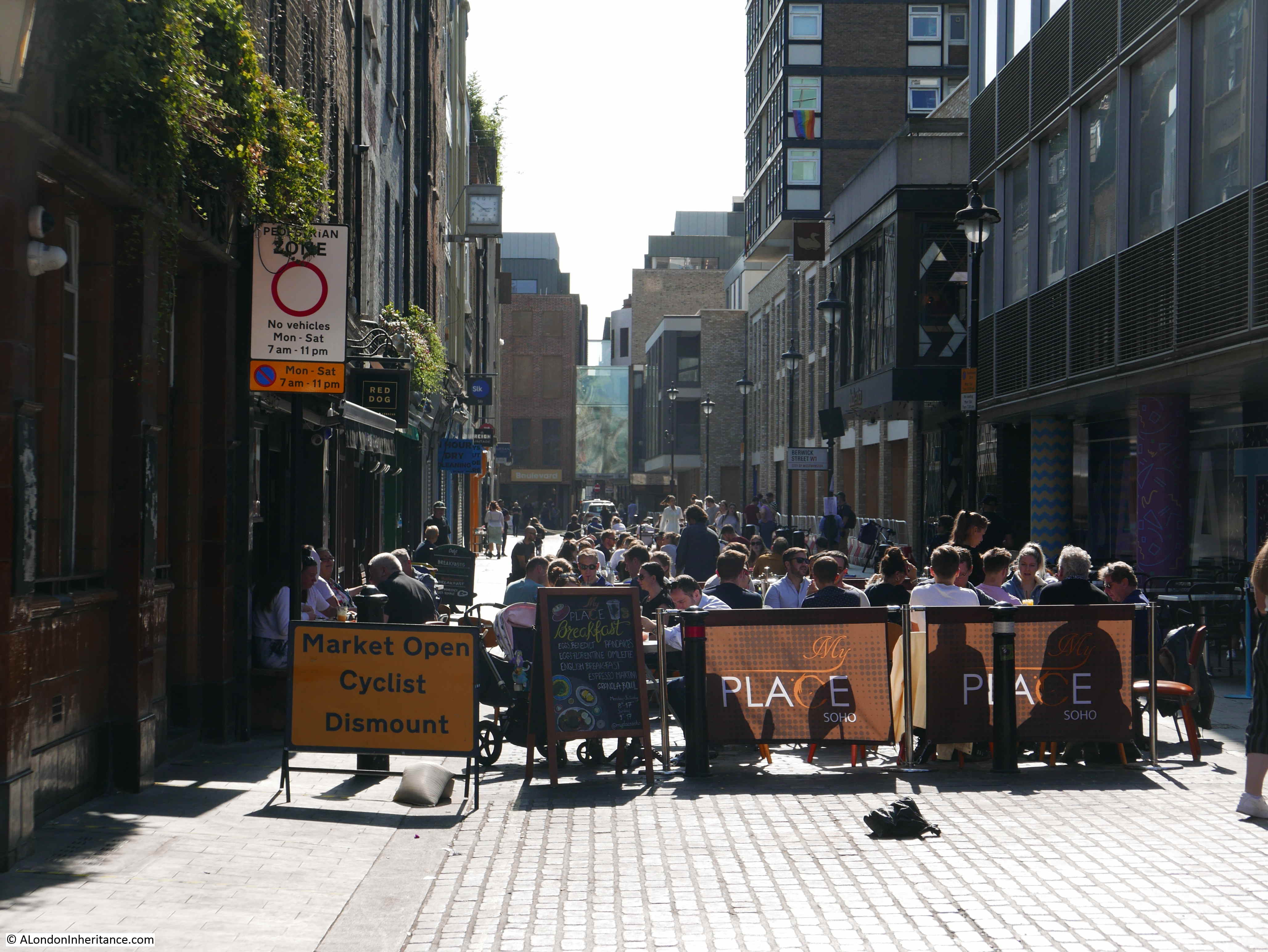
View down Berwick Street showing how a present day pandemic has effected the restaurant trade in Soho:
North western corner of Broadwick Street and Berwick Street with demolished building leaving only the corner façade for inclusion in whatever comes next:
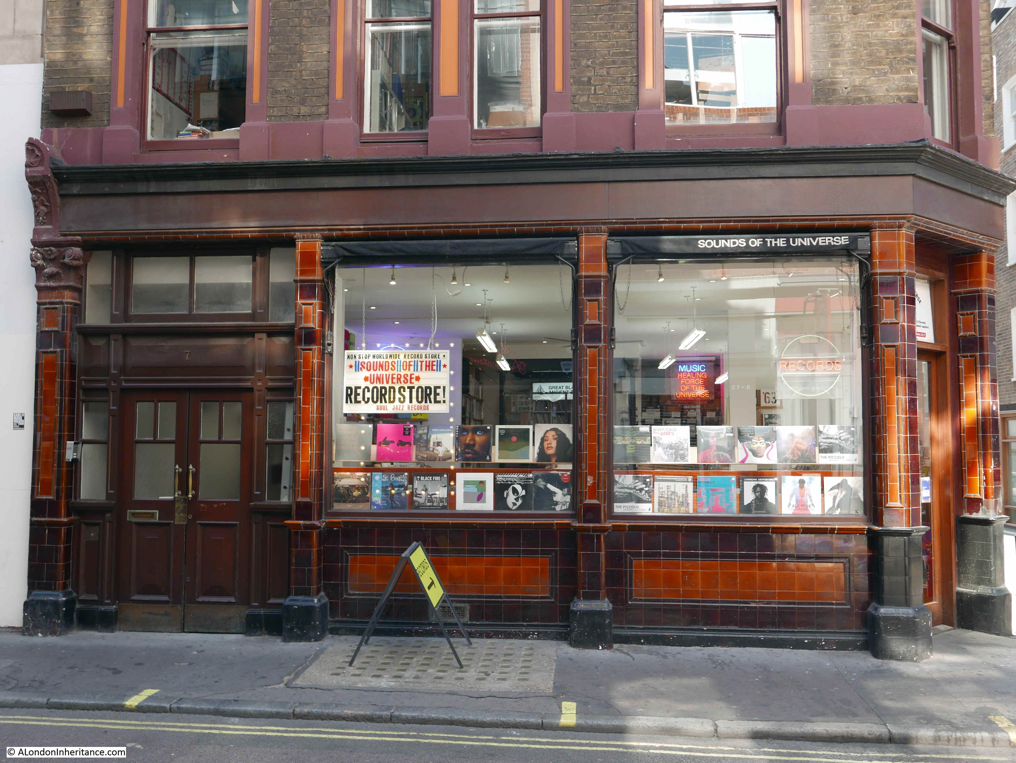
Further back towards Wardour Street, and the following building is on the corner of Broadwick Street (the part that was Edward Street), and Duck Lane, which being towards the Wardour Street end of Broad Street “only” suffered two deaths during the outbreak of 1854.
The ground floor of the building is occupied by the Sounds of the Universe record store:
John Snow’s work was not only around research into the causes of cholera. He was a practicing physician at the Westminster Hospital, and also worked on the technique of anesthesia including how different doses of anesthetic effected the human body.
When Queen Victoria gave birth to Prince Leopold in 1853 and Princess Beatrice in 1857, it was John Snow who administered the obstetric anesthesia.
During the 1854 outbreak he was living at 18 Sackville Street, off Piccadilly. He was a teetotaler and vegetarian for much of his life. He died in 1858 at the young age of 45.
The second edition of John Snow’s “On the mode of communication of cholera” can be found on Google Books here.
Reading these publications really does make you appreciate the engineering, rules and regulations that are behind the clean water when you do something as simple as turn on a tap.
And the next time an epidemiologist comes on the TV or Radio to talk about the current pandemic, think about John Snow, knocking on doors across London, gathering data on the many cholera outbreaks of the mid 19th century.