
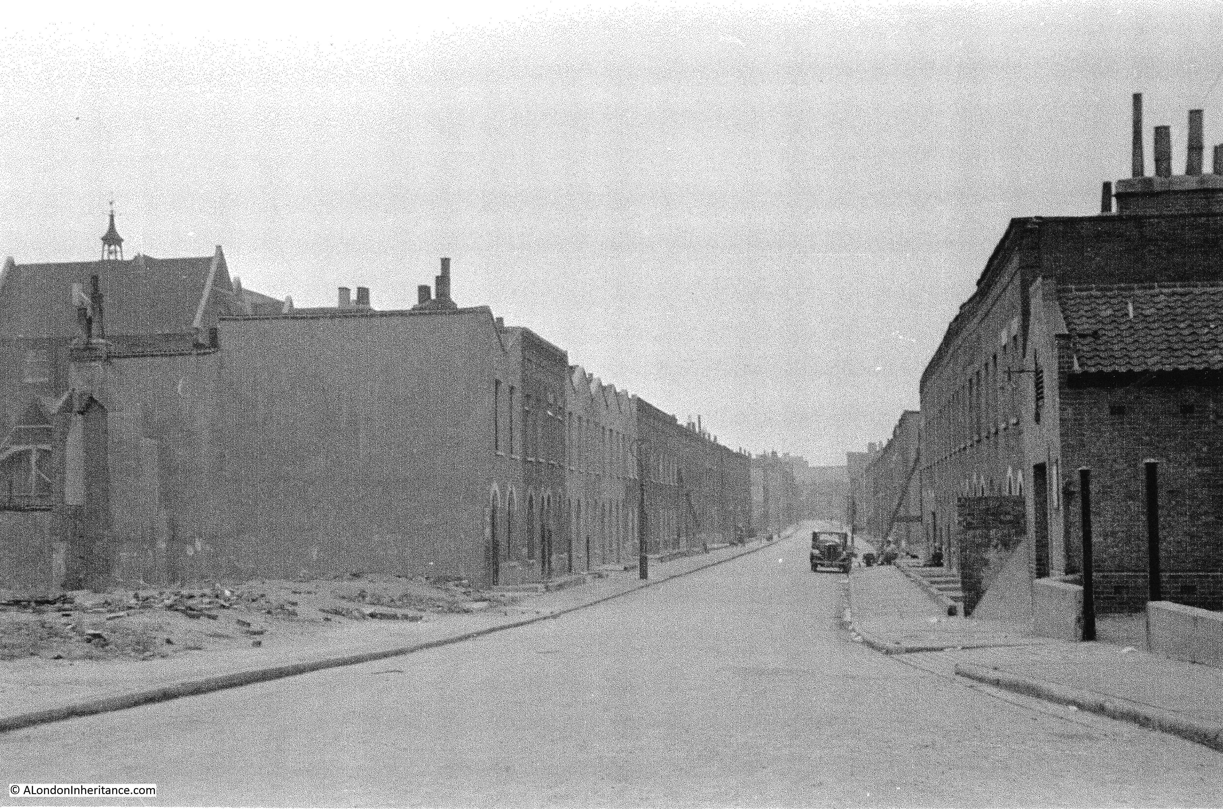
The location for this week’s post is a bit of a mystery. The notes my father wrote for the following photo were “Flockton Street looking south from Bermondsey Wall. 19th century slum dwellings ravaged by the blitz – Summer 1948”.
I will explain why this photo is a bit of a mystery as I go through the post, but firstly, where was / is Flockton Street?
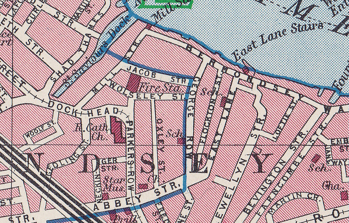
The location is on the south of the River Thames, east of Tower Bridge. The street ran south from Bermondsey Wall, a short distance to the east of St. Saviour’s Dock. The following extract from the 1895 Ordnance Survey map shows the location. I have rotated the map so north, and the River Thames is at the bottom of the map and south at the top of the map. This rotation is to align the map with my father’s photo.
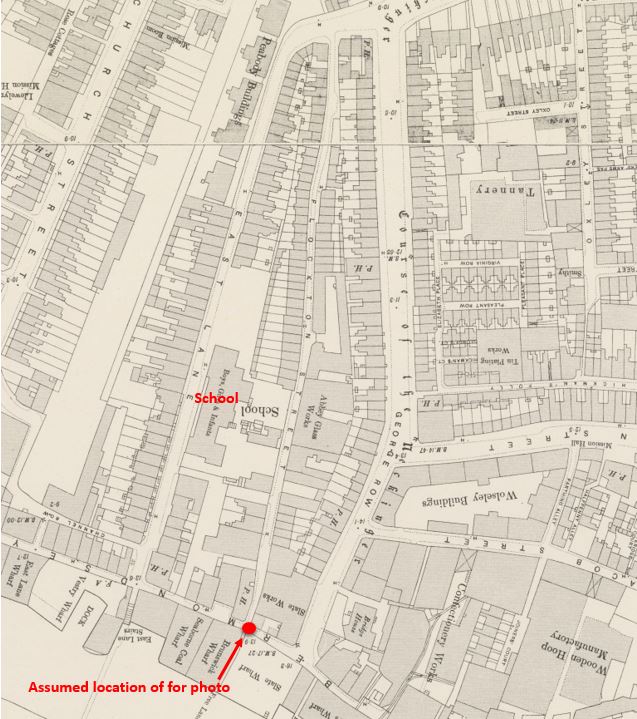
So far, all looks good. I have marked the position from where I assume the photo was taken, and Flockton Street is the street running upwards from the red circle. My father’s photo is looking along a street with housing either side (although not as much housing in the map close to the camera as there is in the photo). The space on the right of the photo could be the location of the slate works shown on the 1895 map.
In my father’s photo there is a taller building on the left, behind the terrace houses. In the 1895 map, roughly where this building would have been located there is a school, and the limited view of the building in the photo does look like a typical Victorian London school.
But when I went to find the site, I started to have doubts.
As would be expected, the area is very different today. Flockton Street was a long street in the 1895 map, but today, only a couple of short stretches remain, one of which did not exist in 1895,
The following map shows the area today (with north and the River Thames at the top of the map). (Map “© OpenStreetMap contributors”)
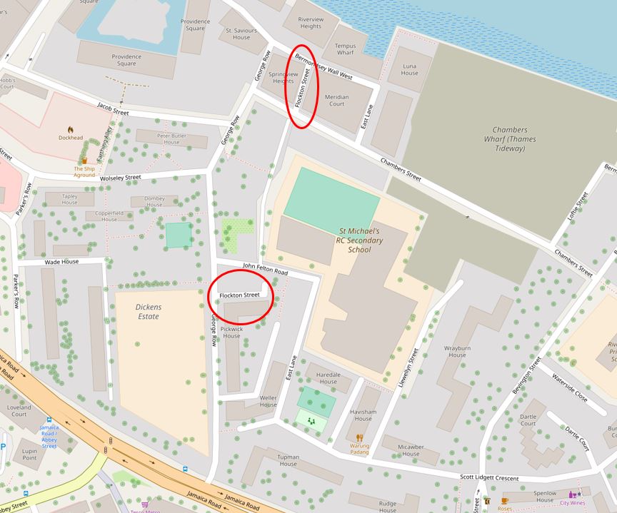
I have circled one stretch of Flockton Street at the top of the map. This stretch meets Bermondsey Wall at the top of the map, and presumably the point from where my father took the photo.
At the other end of this short stretch is Chambers Street, a street that did not exist in 1895.
I have circled the next identifiable stretch of Flockton Street in the middle of the map. This is a short length from George Row that also did not exist in 1895.
Flockton Street in its original alignment has all but disappeared, although there is what appears to be an unnamed street running from Chambers Street roughly where Flockton Street would have been, although today this is more a walkway in between the flats that now cover the area, rather than a street.
Whilst walking around the site of Flockton Street, there were two main issues with confirming it was the location of my father’s 1948 photo. The first is the short stub of Flockton Street where it joins Bermondsey Wall.
Bermondsey Wall is an old street, that as its name implies was at one time aligned or part of the wall / embankment along the edge of the river. I am not sure when the name Bermondsey was used for the street, in Rocque’s map of 1746 it is called Redriff Wall for the section just east of St. Saviours Dock, then Rotherhithe or Redriff Wall for the rest of the street (Redriff was one of the earlier names for Rotherhithe, hence the alternatives shown on Rocque’s map).
Flockton Street is also not the original name. The London Evening Standard on the 8th August 1878 reported that “Salisbury Lane, Neckinger Road, Bermondsey will be renamed Flockton Street and also renumbered”. There is no additional information to explain why the renaming was needed, or why the name Flockton was chosen. The only person named Flockton that appears in 19th century newspapers is a Thomas Flockton of Leadenhall Street who was a shipping and insurance broker.
Today, Bermondsey Wall has been divided into two sections (with the addition of east and west to the street name) by the works for the Thames Tideway Tunnel.
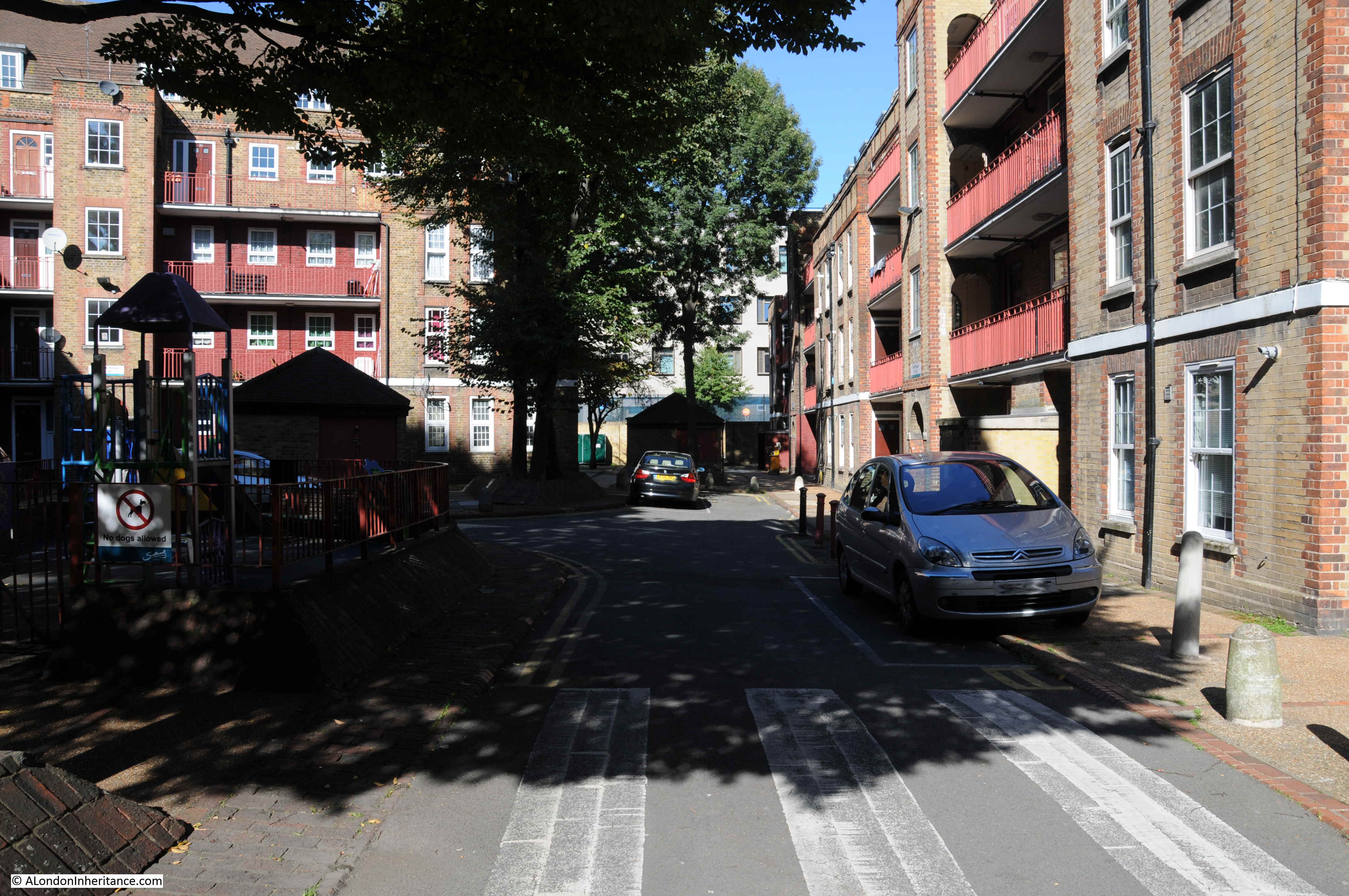
In the following photo I am standing in Chambers Street looking down Flockton Street towards Bermondsey Wall.
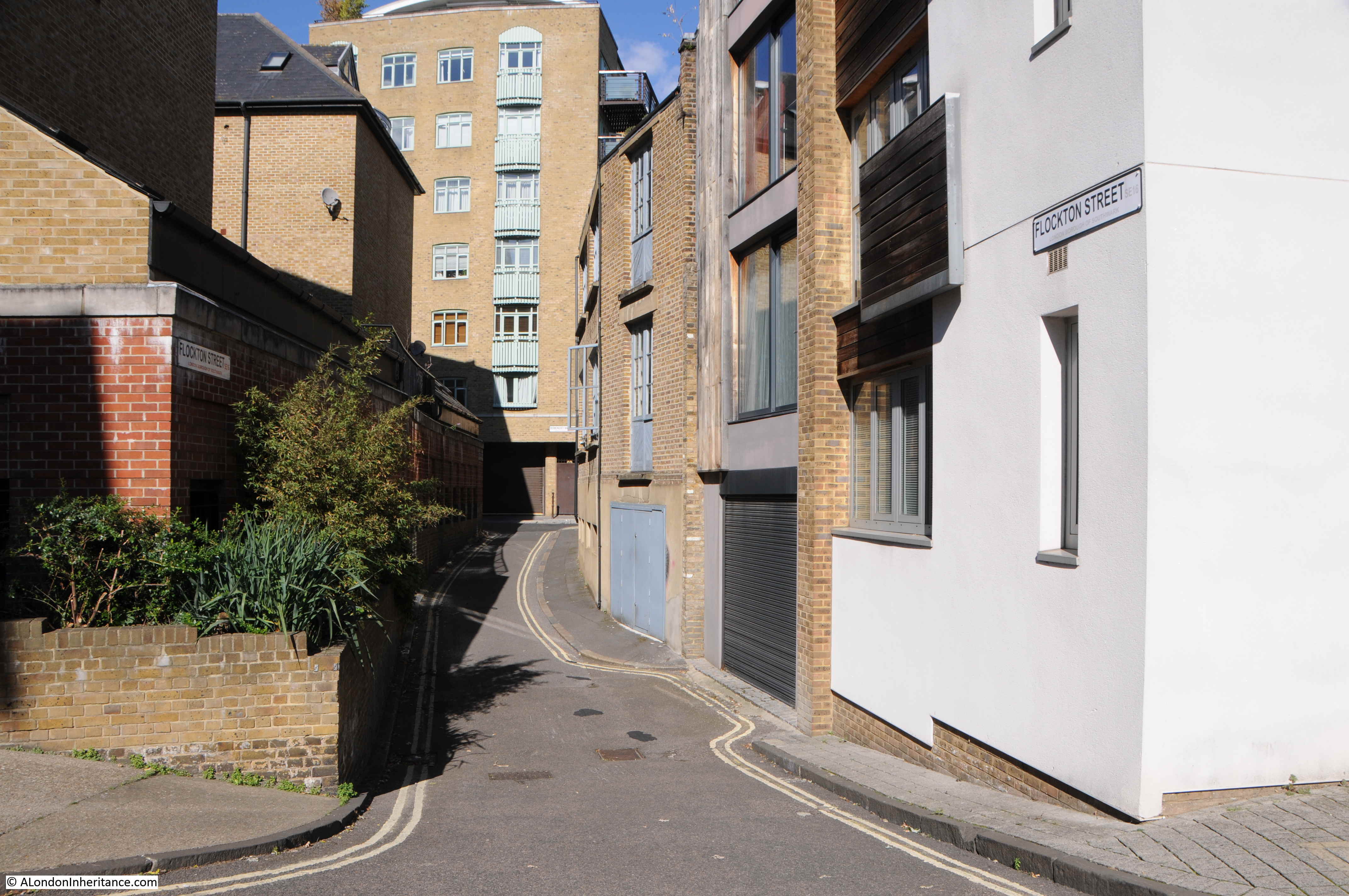
And in the following photo I am at the Bermondsey Wall end of Flockton Street looking in the direction of my father’s photo.
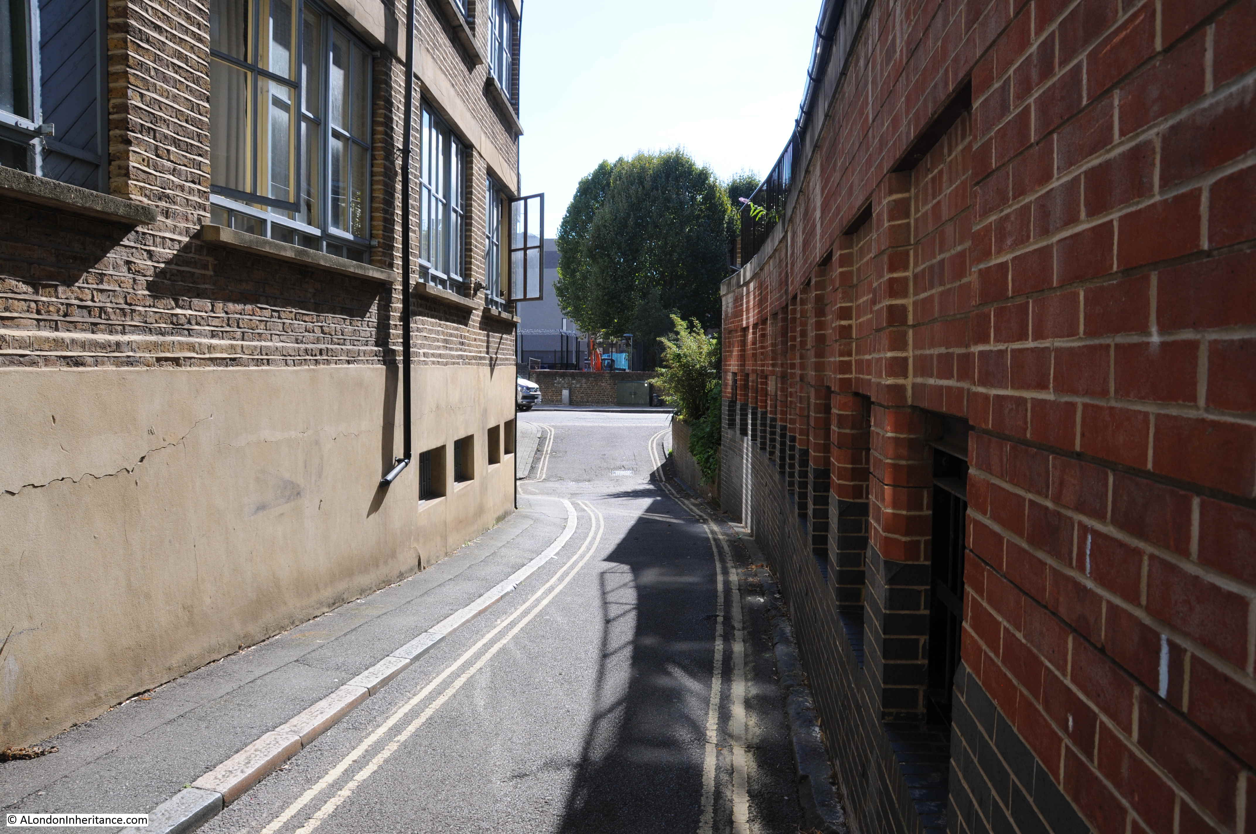
There is a significant difference between my father’s photo and the above view. The street is very narrow (as confirmed in the 1895 map) and there is a significant dip in the street unlike my father’s photo which shows a much broader, flat street.
The dip in the street is significant as this hints at the undisturbed nature of this section of Flockton Street.
One of the documents that the Thames Tideway Tunnel had to complete as part of the application for development consent was a Heritage Statement. This document provides an interesting read to get a better idea of the history of the area. For Flockton Street there is the following text:
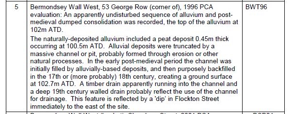
The dip in this section of Flockton Street is therefore the evidence for a deep 19th century drainage channel. It does not appear in my father’s photo.
My next thought was whether the 1948 photo was taken from Chambers Street looking along Flockton Street, rather than from Bermondsey Wall. I checked the 1940 edition of Batholomew’s Atlas of Greater London and Chambers Street was not there in 1940. The following extract shows Flockton Street (just to the right of centre of the map) running up to Bermondsey Wall.
The 1940 map does show the school in the same possible as in 1895 and in the right position as regards the 1948 photo. I doubt that Chambers Street would have been built between 1940 and 1948.
Walking to the other side of Chambers Street, opposite the entrance to the small stretch of Flockton Street is this view.
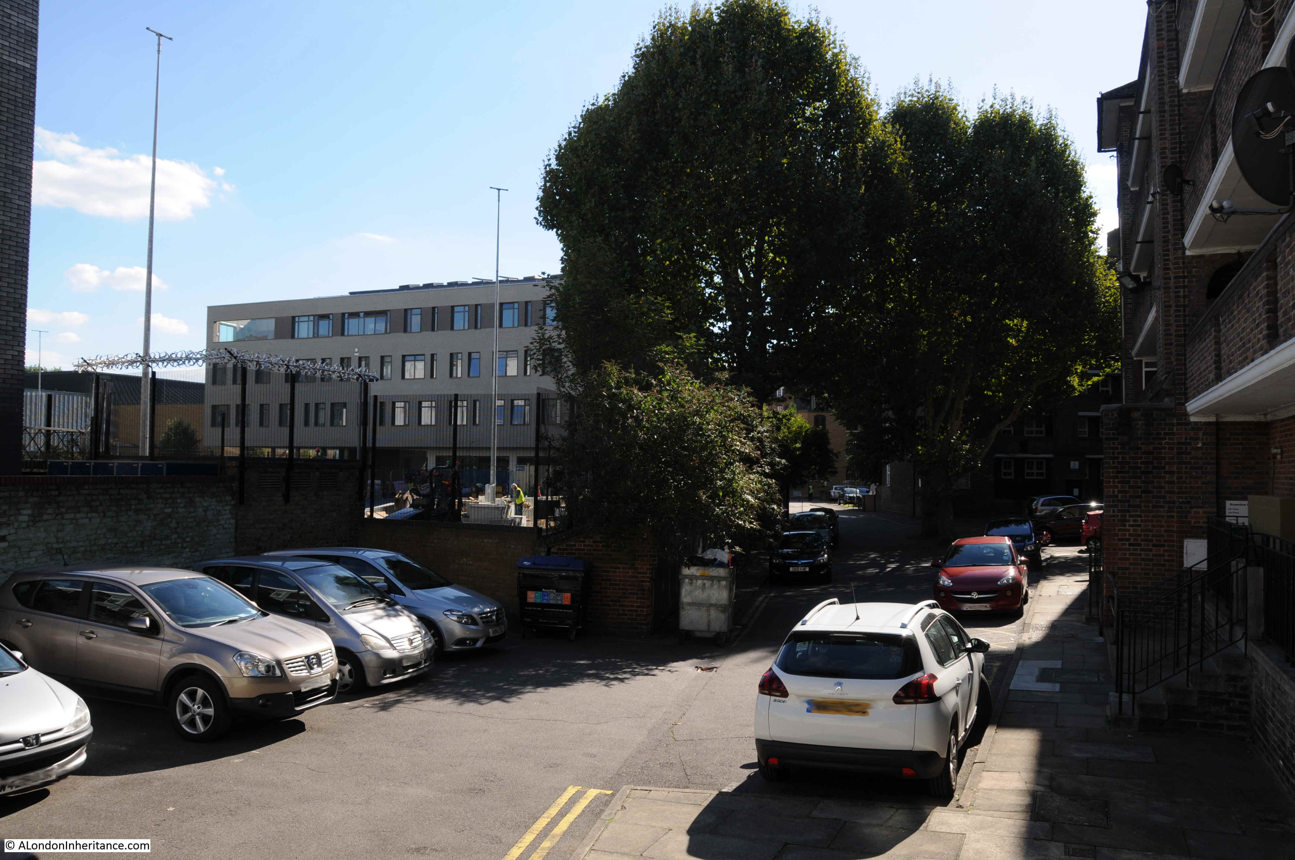
This is looking along where Flockton Street was on the 1895 Ordnance Survey map. In this lower part of Flockton Street, there is an open area on the left and the new school buildings that have replaced the Victorian building.
On the right is a block of flats, the first of the flats that cover the land up to where Flockton Street originally met George Row to the south.
It is the design of these flats that also gave me a problem with confirming that this was the location of my father’s photo. Another view of the flats is shown in the photo below, standing in the open space that would once have been Flockton Street.
My problem with these buildings is that they do not look like post war design, and indeed they are not. I could not find the exact date of construction, however there are newspaper reports which mention some of these blocks in the 1930s. One of these reports, from the Daily Herald on the 9th November 1938 concerns Weller House, one of the blocks of flats between George Row and the original southern end of Flockton Street. The report itself hints at what appears to have been some rather tragic events in the area:
“Police Seek Clue From Blonde – South London police are seeking a young, fair haired girl, who, they think, may be able to help them trace 16 year-old Violet Rose Dicker missing from Weller House, George-row, Bermondsey. Violet is the fifth girl to disappear from Weller House, a block of flats, in six weeks.
Rosie seemed quite happy until she went to a dance a fortnight ago, her mother said last night. She said she had stayed away two nights, and said she had been with a girl friend.”
I can find no further reports of what happened to Violet Rose Dicker or the other four girls who disappeared from Weller House so no idea whether this was normal teenage rebellion, or something more sinister.
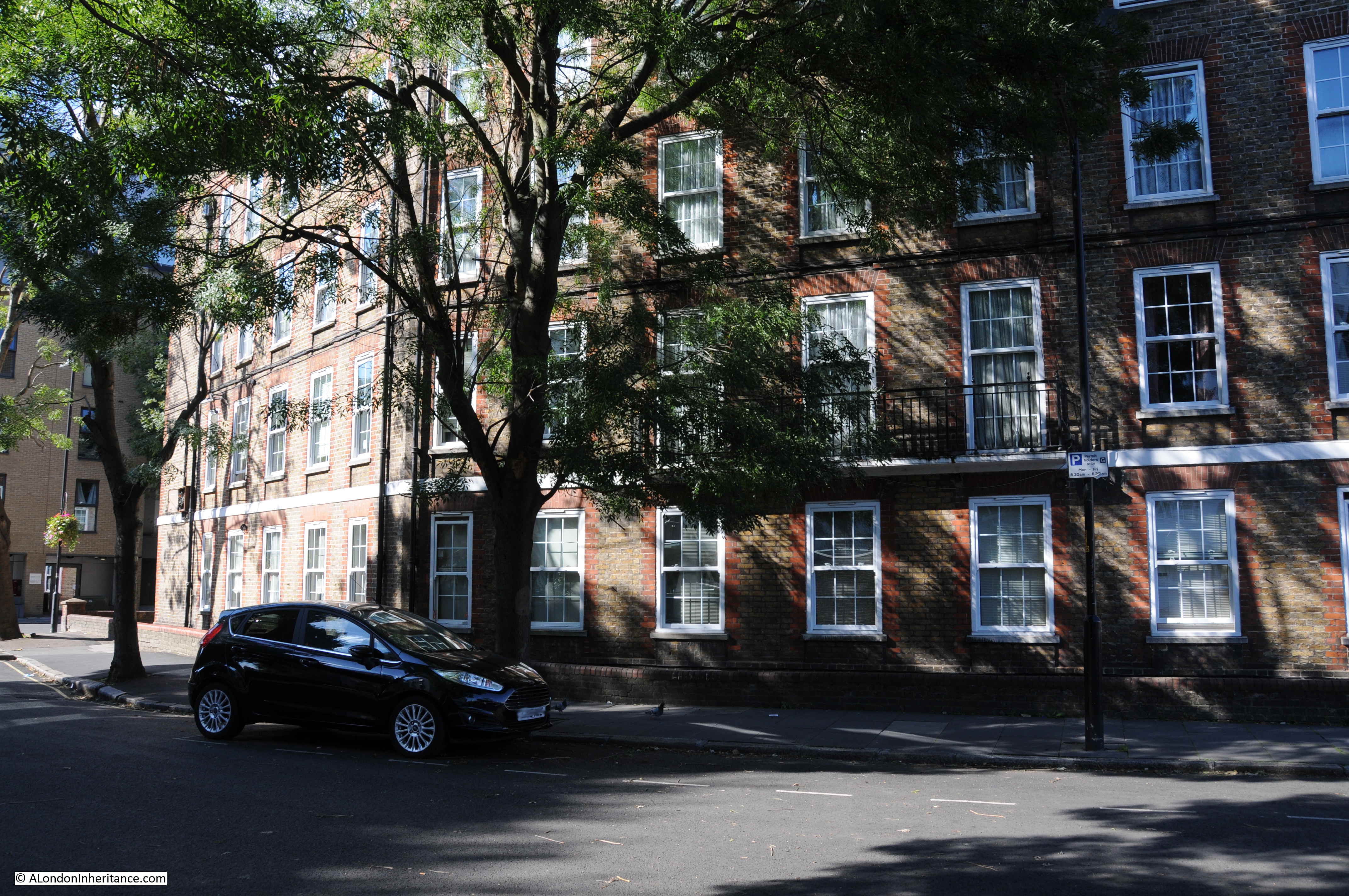
This is the view of Weller House from Scott Lidgett Crescent (part of what was East lane in the 1895 map). The southern end of Flockton Street would have been through the middle of the flats, roughly where the building moves from light to shade.
So I am still not sure whether Flockton Street is the location of my father’s photo. The notes were generally written after he had taken the original photo, often after he had developed the negatives and printed some of the photos. As I have worked through his photos, it is very rare for the written notes to be wrong, however I suspect with this photo the location may well be wrong.
The school is in the right position, but if the view of Flockton Street is from Bermondsey Wall, the narrow section with the dip is not visible and I doubt Chambers Street was in existence in 1948 – it was not on the 1940 map.
Also the blocks of flats between George Row and Flockton Street appear to be of pre-war construction, certainly those to the southern end of what was Flockton Street are pre-war.
The photo is in Bermondsey, photos on the same negative strip either side of this photo are in Bermondsey. Perhaps some time spent in local archives may reveal the location, but at the moment, this is still a mystery location.
I came across Flockton when I was researching chemicals in east London and he was buying tar from the gas works in 1825. I said then: “Webster Flockton had a tar works in Spa Road, Bermondsey. This was adjacent to the Greenwich Railway, with which Flockton involved. He was to become a director of the Deptford, Rotherhithe and Bermondsey Gas Co. (ex-Greenwich Railway Gas Co.). He held patents in the preservation of timber by tar distillates. “
Thanks Mary – I assumed there must have been a relevant source for the new name and Webster Flockton is a good candidate being active locally.
I came across Flockton when I was researching chemicals in east London and he was buying tar from the gas works in 1825. I said then: “Webster Flockton had a tar works in Spa Road, Bermondsey. This was adjacent to the Greenwich Railway, with which Flockton involved. He was to become a director of the Deptford, Rotherhithe and Bermondsey Gas Co. (ex-Greenwich Railway Gas Co.). He held patents in the preservation of timber by tar distillates. “
Hi,
Very interesting as always. Have a look at page 77 in the Bomb Damage Maps book (I think you have a copy as I’m sure I have seen you reference it in the past). This shows that the southern end of Flockton street had been redeveloped before the war. The street had beeen shortened and re-routed and, as you rightly say, new blocks of flats had been built. However, at the north end of Flockton Street, the map does not seen to show a row of terraced houses, although the area on the east side (the left of your father’s photograph) is marked for clearance.
I came across Flockton when I was researching chemicals in east London, Webster Flockton had a tar works in Spa Road, Bermondsey . This was adjacent to the Greenwich Railway, with which Flockton involved. He was to become a director of the Deptford, Rotherhithe and Bermondsey Gas Co. (ex-Greenwich Railway Gas Co.). He held patents in the preservation of timber by tar distillates.
Another fascinating post. The street in your father’s photo looks far too wide to be Flockton Street, represented to scale on the OS map and really quite narrow. Also, the map shows a change of direction to the left after the school – there is no evidence of this in the photo. The mystery remains!
Fascinating, as always. Chambers St not marked on the 1960 Geographia Greater London Atlas and Flockton St is shorter, curving into George Row. Violet Rose Dicker is referred to as Rosie in the 1938 news report and a Rose V Dicker married Henry Murray at Bermondsey, 2Q 1939. Rose V Murray living at Weller House in the 1939 Register (Sept), d.o.b. 2/2/1921. Must be her? She ran away to get married (prob round the corner!)
Rob, thanks for this information. I did wonder if something like that could have been the reason. Possibly also the other 4 who disappeared around the same time – a bit of youthful rebellion.
Your Flockton Street photo is Bevington Street.
See Google Images: https://tinyurl.com/yascwmlu
and 1950 OS Mapping at: https://tinyurl.com/yb2dlc4s
Substation and school have survived.
(Always look forward to your posts. Keep them coming!!)
As someone that walks this way every morning, Bebington Street was my thought too. I suspect this will have been taken bear the Old Justice/Waldetcote pub
Apologies Michael, your post wasn’t published when I replied,
Michael – thanks very much for this. I can understand that the school has survived, but amazing that the same substation building is still there. I should have walked a bit further to find Bevington Street, but my father’s notes are usually right – he was just out by a few streets for this photo.
Looking at a 1947-60 map, it appears that the school was marked as a ‘ruin’ so possibly bombed during the war? However, there is a very similar wide road called Bevington Street with an adjacent school in a similar position, situated some metres east along Bermondsey Wall and on the same alignment as Flockton Street. This looks like a possibility to me but by no means certain – there also appears to be a gap in the terraced houses behind the chap with the ladder, in your father’s photograph. This also shows in the 1947 map of Bevington Street.
Hi Mick, thanks for the comment. Yes, Bevington Street is the correct street – the small building on the right, apparently an electricity substation is still there. I should have explored the area in a bit more depth.
Does this riverscape help? https://www.museumoflondonprints.com/image/322766/avery-illustrations-thames-riverscape-showing-east-lane-wharf-bermondsey-boro-council-east-lane-stairs-london-grist-mills-and-seaborne-coal-wharf-1937 You can see the turret of what you suggest is the school in East Lane.
This was interesting. Found these (and am tempted to do the walks) which shed light.
http://www.infed.org/socialaction/bermondsey_print_version.htm
artuk.org/discover/artworks/colonel-samuel-bourne-bevington-mayor-of-bermondsey-193280
http://www.southwarknews.co.uk/history/our-colonel-really-cut-the-mustard/
Farncombe Street also has a school to the left and I guess it’s that street and not Flockton street, I am a member to a Facebook group about Bermondsey and Rotherhithe history and I am sure I’ve seen this photo before,
Thanks as ever for the research work; I was particularly impressed by the detail on the drainage ditch featuring a timber drain, wow.
The OS map extract includes one of those horrible tanneries. London Metropolitan Archive’s current and excellent Picturing Forgotten London exhib (free entry and running until the end of Oct) has a photo of one showing its collection of pools, fortunately without a scratch-n-sniff multimedia component. The photo’s description says words to the effect of “because of their unpleasant smells tanneries were not situated in the City but instead across the river in areas such an Bermondsey”. The unintended slight brought a wry but sympathetic smile to this visitor’s countenance.
https://www.cityoflondon.gov.uk/things-to-do/london-metropolitan-archives/news-events/Pages/picturing-forgotten-london.aspx
This defiantly 100% bevington st, substation is still there on the right. Walk past it everyday
I was wondering if anyone can help me with Flockton Street? In the early sixties there was a pub in Flockton Street (George Row/John Fenton Rd end) and we use to use it as a short cut to get home from St Michaels.
Have been trying for years to get its name. Any help please???
Kind regards
https://www.closedpubs.co.uk/london/se16_rotherhithe.html
See link above. There were several pubs in George Row, including the wonderfully named Old Margate Town.
I think it must have been The George at 19 George Row. It was there all the time I was at school over the road 1952-1958. There was a bomb site next to it where we used to set fire to things! Other crazy pranks were to do with barges and foreshore, stealing dry ice from Chambers, and breaking windows in Peabody Buildings East Lane before they were demolished.
In May 2018 I revisited. I reckon I had walked up or down Chambers Street some 15000 times. From the tube I approached it from Janeway Street and was totally disorientated by the new builds. I actually went east the wrong way for my planned trip to the Mayflower..
Thanks Alan, some of the locals said it was the Anchor and Hope pub? I think this could have been the same pub but had its name changed at sometime, but I do realise that in the early days you could get several pubs in one street! I remember it had an outside loo that rarely got cleaned and we always got told off by the landlord for using it on the way to and from school!
Happy days!