
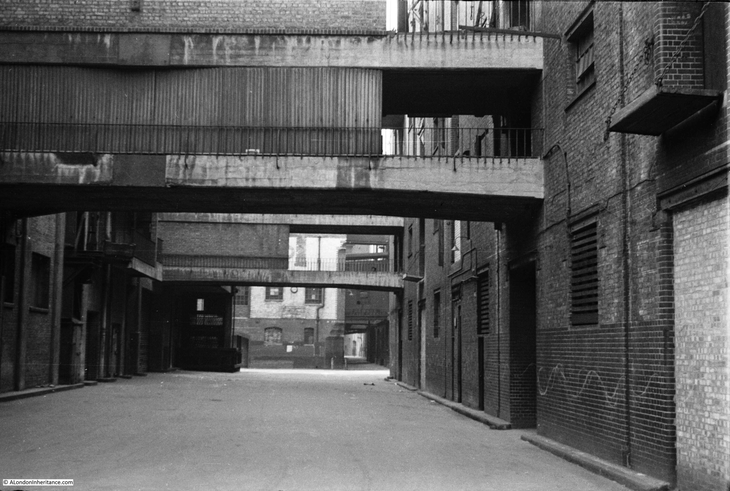
It is remarkable how some places in London have changed beyond all recognition within living memory, and this week’s photo is a prime example. It was taken by my father in 1947 in Pickle Herring Street, a lost street that ran behind the warehouses on the south bank of the Thames, west from Tower Bridge.
I last wrote about Pickle Herring Street six years ago, when I featured a photo taken from underneath the arch on the approach road to Tower Bridge. This photo was on the same strip of negatives, but I was not sure of the location, whether west of Tower Bridge, or east along Shad Thames, so I put the photo aside to look at later.
I recently spent some time checking maps, and aligning some of the features between map and photo and can now confirm that the following 1947 photo shows an additional section of Pickle Herring Street, not seen in my original 2015 post.
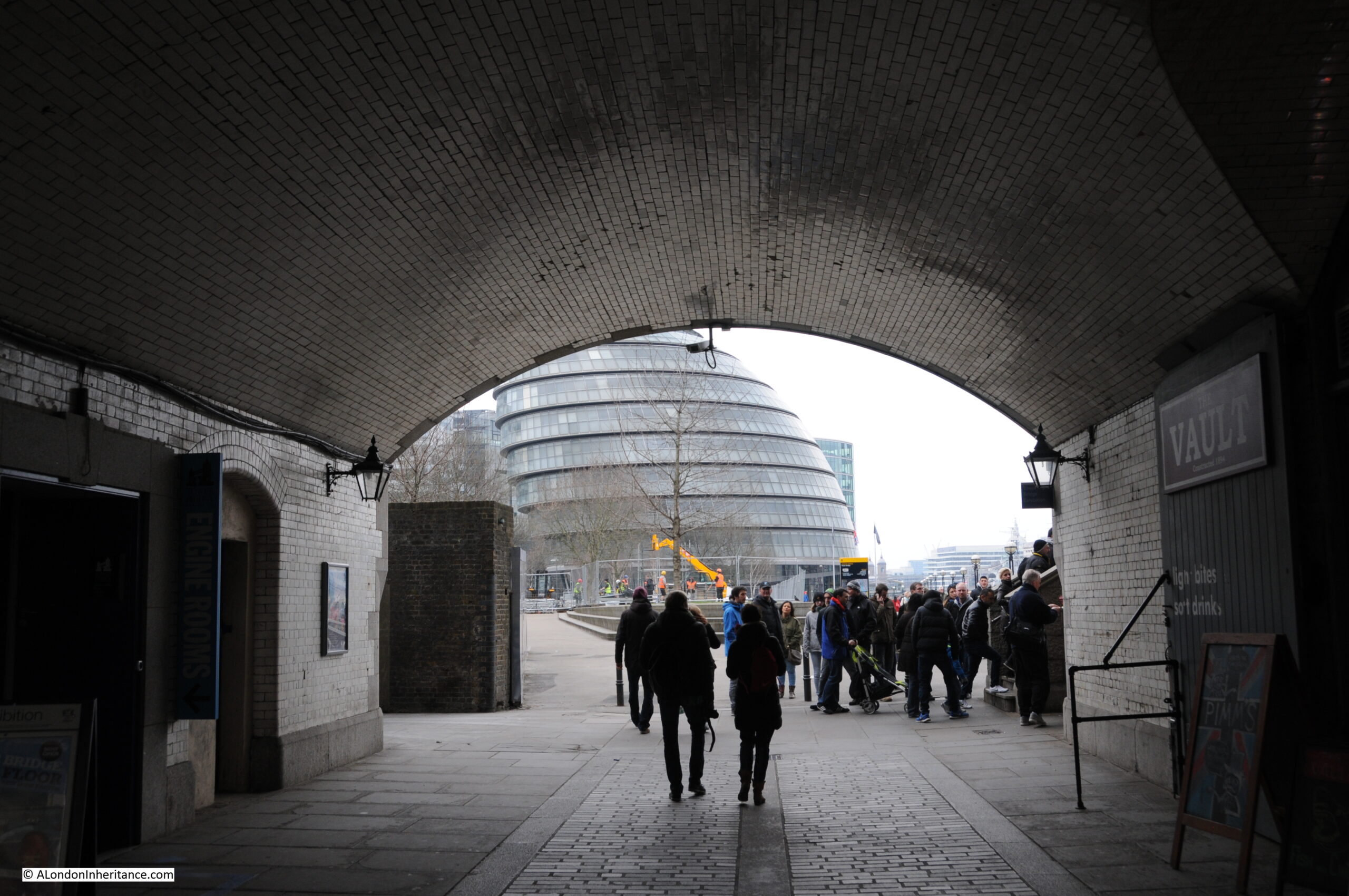
It is difficult to be precise with the exact location of the photo given the total redevelopment of the area, however as best as I can estimate, my father was standing somewhere on the grass between where I am standing to take the photo, and the tree, looking towards City Hall:
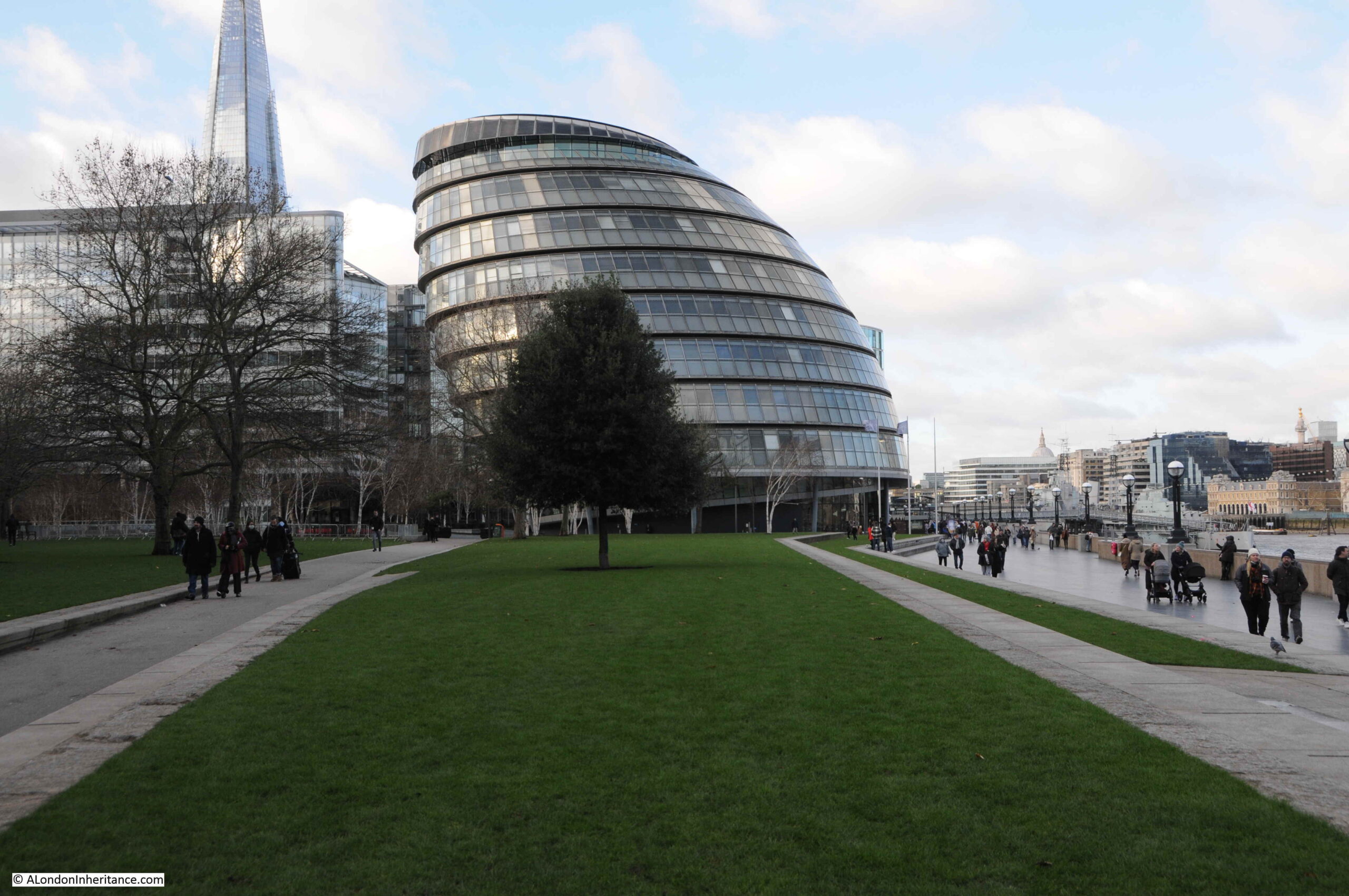
The building behind the tree is City Hall, the current home of the Mayor of London, which will soon be moving to an existing building called the “Crystal” at the Royal Docks in Newham. (Strangely on the Mayor of London website, the pages describing City Hall have text that refer to the existing building, but with a photo of the new building at the Royal Docks).
To find the location of the photo, I checked the features in the scene against the 1950 revision of the Ordnance Survey map, published three years after the photo had been taken.
In the following graphic, I have aligned features in the photo with those on the map (‘Reproduced with the permission of the National Library of Scotland“):
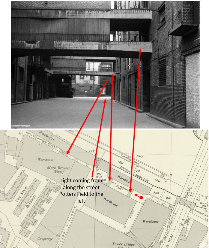
The red dot and arrow show where my father was standing to take the photo and the arrow is the direction of view.
The first two arrows point to the overhead walkways connecting warehouses on either side of Pickle Herring Street.
A patch of light can then be seen on the street, this is coming from the street Potters Fields which runs to the left of the photo.
The street than narrows with a building seen blocking part of the street, and a narrow section to the right, where in the distance, a larger overhead structure can be seen spanning the street. This is the greyed in block in the map with an X which shows this is an upper floor which runs over a street.
The southern approach to Tower Bridge can be seen on the right of the map.
So having located this 1947 photo, I can add to the photo from my 2015 post to give a fuller view of Pickle Herring Street. This was the view from under the approach to Tower Bridge:
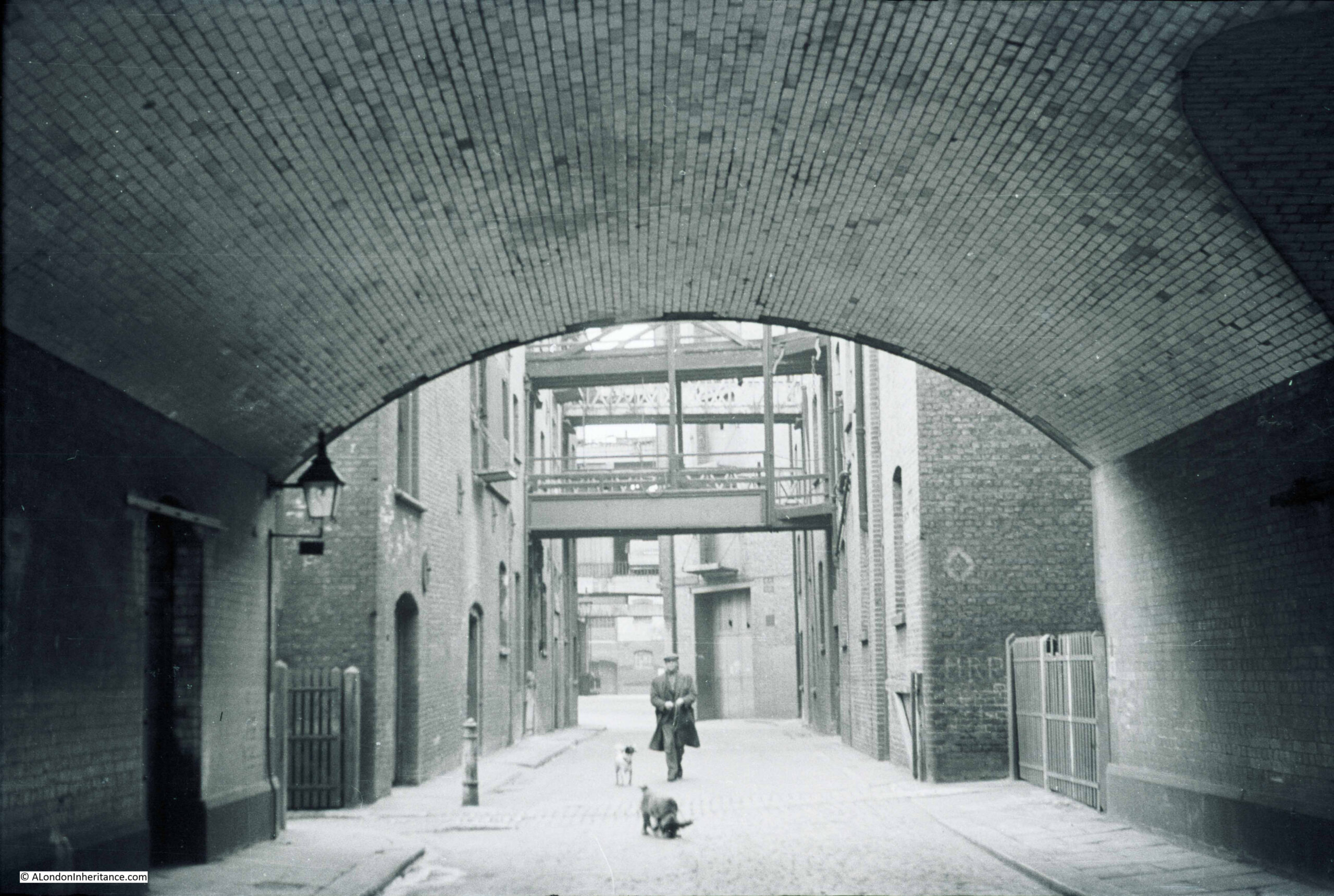
If you refer to the 1950 map, you can see the point in the street where the building on the right juts out into Pickle Herring Street, and it was there that my father was standing to take the photo at the top of today’s post.
The following photo is my 2015 version of the above, from underneath the approach to Tower Bridge:
Pickle Herring Street is an old street, and is shown in Rocque’s 1746 map of London. The following extract shows the western extent of the street, the part in my father’s photo was in the join on my printed copy of the map so did not photograph well.

The map does show that there was also a Pickle Herring Stairs to the western end of the street. I do not know what came first, the stairs or the street, but I suspect the stairs as the river stairs are some of the oldest features along the river’s edge.
There are also multiple theories as to the source of the name of the street and stairs. I cannot find any confirmed written reference to the source, but it is probably safe to assume it has some reference to the fish herring that may have been landed at the stairs, but it is impossible to be sure.
The first written references to activities within the street date to the start of the 19th century, and a newspaper advert from the Public Ledger and Daily Advertiser on the 14th of February, 1805 refers to the street, and also an interesting way of buying access to a property at the time:
“WHARF, DWELLING-HOUSE and WAREHOUSE, PICKLE HERRING STREET, Southwark, at Garraway’s Coffee-House, Cornhill. The Life Interest of Two Persons, aged 45 and 44, in the above estate, is now to be sold, and the purchaser will be entitled to the property for the life of the longest liver; both are insurable at a very trifling premium, but as there are now two lives, no insurance is necessary”.
Interesting way of buying access to a set of buildings, where the length of time you have access is entirely dependent on the remaining length of life of two people. Presumably they still held the freehold, which at the death of the last, would then pass to whoever was named in their will, and the person who had purchased the property would either have to leave, or negotiate with the new owner.
There is an earlier written reference to Pickle Herring Stairs, which dates from the 16th October 1727, when a newspaper reported that a Waterman’s Boy had fallen in the Thames at the stairs and drowned.
It is safe to assume that Pickle Herring Street has been in existence for centuries, and served the warehouses and wharves that lined the river.
That would all end not long after my father took the above photos. The 1953 edition of London Wharves and Docks, published by Commercial Motor lists the two wharves that were still in operation.
Mark Brown’s Wharf and Cold Stores are the buildings in the first photo at the top of the post. These were owned by the Hay’s Wharf Company and dealt with “provisions, dried fruit, spices, canned goods and refrigerated produce”.
As seen in the 1950 map, there was a long jetty in the river to serve the wharf, with travelling cranes. The jetty could accommodate and fully unload ships up to 420 feet in length.
The buildings seen from underneath the approach to Tower Bridge in the second photo were part of Tower Bridge Wharf, which dealt with “hides, skins, wool and leather”.
The buildings were empty and derelict for much of the 1960s and 70s, were demolished, and for some years the space became a temporary car and lorry park before the building of the area as we see it today.
The grass in the photo is part of Potters Fields green space, an area that runs from close to Tower Bridge, round the back of City Hall and up to Tooley Street.
The space where City Hall is located occupies the western end of Pickle Herring Street, at the far end of the photo at the start of the post.
It is interesting how streets dissapear, and the space occupied by these streets become part of private developments.
Large parts of London have long been owned by individuals. In the past these tended to be members of the aristocracy, who owned the land, then built and developed as the city expanded, and ended up owning large areas of streets and buildings. Many of these are still in existence, however they have reduced from their peak.
Property companies have built significant collections of buildings, and a change over the last few decades has been the rise of the foreigh property owner.
The area from City Hall, almost to Hays Galleria and up to Tooley Street now goes under the name of More London.
The area is owned by St Martins Property, which is the UK investment vehicle of the sovereign wealth fund of Kuwait.
So the space occupied by Pickle Herring Street is now under private ownership, and in common with many of these spaces, is patrolled by private security.
The name Potters Fields referred to the street that ran from Tooley Street to Pickle Herring Street and was the street that allowed light to fall on the street in the distance in my father’s photo. It can still be found as a small stub of the street remains off Tooley Street, and in the name of the green space.
Originally, Potters Fields was the name given to the space to the west of the approach to Tower Bridge, and today occupied by City hall. Part of this space was occupied by a pottery, set up by the Dutchman Christian Wilhelm in around 1618, and which went by the name of Pickle Herring Pottery.
I suspect the name of the pottery came from the street or stairs as it is a rather strange name to give to a pottery.
The pottery operated on the site for around 100 years, before moving to Horsley Down to the east of Tower Bridge, early in the 18th century.
The British Museum has a collection of what is attributed as Pickle Herring Pottery, including the following dish dating from 1668 and showing Charles II crowned and in armour (© The Trustees of the British Museum):

Much of the early output of the Pickle Herring Pottery appears to have had a delftware influence, which was probably down to the Dutch founder of the pottery.
Sad that the centuries old name Pickle Herring which referred to both the street and river stairs can no longer be found in the area, however I am pleased to have confirmed the location of another of my father’s photos and at least these two photos help to remember this lost London street.
Very interesting, as always. Thank you.
As I expect you know, there are various trade tokens issued in the 1660s from Pickle Herring Stairs, the most common being Edward Brent’s of 1668.
fascinating history – seem to remember there are 1930s photos of that side of the Thames with ships tied up – published by museum of London?
Sarsons Vinegar was built in Tanner Street, in the 1700’s. Between London and Tower Bridges.
Hi David(?). Thanks so much for your latest blog on an area close to where my father grew up.
1. As I use my phone I can’t seem to get anywhere with clicking on the maps – ie it only gives me a weird ref number, a website relating to the pub or whatever and never ‘more details’. Is using my phone the issue here?
2. Do you have any blogs about ‘Snowsfields’? (Or close to there, incl Borough High St, London Bridge etc and the arches underneath which has various industries working there. It was by Guys Hospital and led from Borough High Street to Bermondsey St.
my family going back to my great great grandparents up until 1960 when the old (Georgian?) houses were knocked down. By that point my parents had me – That makes 5 generations!
3. My father is 87 and is still relating his memories both to me and an interviewer/journalist who is due to write his story for me. Anything I can find out ASAP will of course be very helpful. At the end of this process there will be just 4 books published for the family.
4. One final request: do you know where it’s possible to find records of London schools that no longer exist? For example my great-aunt went to ‘Saffron Hill school’ in 1909. This I was able to see on ancestry.com but other members of the family ancestry doesn’t seem to have records for their particular schools. The Saffron Hill school is now partly included into a new building called ‘The Goldsmiths Centre’, doubly interesting since my gt gt grandfather on my father’s mother’s side was registered at Goldsmith’s Hall in 1903. I once saw his signature in the enrolment/entry book.
If there is any help you can give me, anyone! on the above I’d be so grateful. Reccomemations on books of that area, it’s history, industries, conditions etc. I’m desperate to find out more and have access at least to previous blogs of that area.
My father remembers the smell of hops, wine wholesalers and leather producers. Where the name Snowsfields relates to.
Thank you so much for reading this, any of you that do and many thanks for a brilliant blog which I will now forward to my Pa. Best wishes.
Bella, thanks for your feedback on the blog. Some comments on your points:
1. There is a problem with the maps which I have not yet been able to sort out – sorry.
2. Not yet, but on the very long list of subjects for future posts.
4. The London Metropolitan Archives are a good source of information. I did a quick search in their catalogue for Saffron Hill School and there were a number of results. I also use the British Newspaper Archives for background information and a search for the school brought up a large number of results so these two sources may help.
Good luck with your project and recording your father memories.
Hi Bella – Delighted to see a mention of Snowsfields. I went to La Salette school which was beside La Salette Church. Alas I can find no mention that the school ever existed!! The balconies of the Snowsfields flats looked out on to our playground and a friend of mine used to speak with her mum at play time. I was there from 1955 to 1959 having come from St Joseph’s Infant School in the Borough. I lived in a place that is also long gone – Horseshoe Alley/Park Street. Horseshoe Alley has also disappeared. We used to look out at the groups of tourists in amazement who were so interested in the plaque commemorating the Globe. Rose Gardens, Bear Alley, Emerson Street and Cardinal Cap alley were our playground- being completely deserted at the weekends.
Really interesting and enjoyable read..thank you
Thanks for the fascinating update. As I think I posted before, Pickleherring Street still existed as a postal address in about 1972 when the company I worked for (Cleveland Bridge – now sadly defunct) set up a site compound and temporary offices in a fenced-off section of the Potters Fields car park to carry out the modernisation of the Tower Bridge machinery. (That’s something worth an article in itself). The fact that Pickleherring Street no longer existed on the map made it hard for delivery drivers to find it, and I was (as junior engineer) occasionally sent out to meet lorries carrying machinery in Tooley Street to guide them in!
All the articles from you are so very delightful to read and the photos amazing. The information and details give me goose bumps across the many years. Thank you
I am so impressed with the research you put in to your individual articles. I realise that change is inevitable, and often for the better. But I find it rather sad that areas can be bought and sold to overseas companies who then make these areas out of bounds to the public. What a wonderful street name this was. I enjoy reading all the links to the local trades and crafts that you make. It’s fascinating how you begin with a photo and delve in to maps, other photos, museum pieces etc, to create a wider understanding of a specific area in London. Thank you.
Another fascinating article. It is so sad that developers do not seem able to spare a thought for the history of site and reflect it in their designs resulting in fascinating names like Pickle Herring Street becoming obliterated. It is so important to record ‘every day’ local history, not just the great and the good (and not so good) who get blue plaques. Perhaps the Mayor of London could start a scheme of information plaques? It might encourage people to get out and about really value their city. I guess the off-shore owners care more about monetary value and security. Perhaps there should be a scheme in cities like ‘access land’ in the country, before private security locks us all out.
Another fascinating trawl through history. I worked for Courage Eastern in Horsley Down in the early eighties, just after they had stopped brewing on site, and still find myself returning to the area to walk the streets.
When I left Courage I crossed the river to set up my own business aboard the SS Yarmouth. The Yarmouth, along with the Belfast, The Tower of London, Tower Bridge, Tower Hotel and St Katharine by The Tower were all members of the local tourism body set up to promote the area.
Very interesting thank you. My great grandmother and her family lived and worked in Smiths Building St Olaves, but I can find no reference to that building now. Maybe a Peabody building. This would have been from 1850s to around 1900.
Your Father left you with a magnificent historical heritage and as a result we are able to enjoy this great privilege. Thank you so much. The first members of our family (which goes back to Newbury in 1485) arrived in Bermondsey in the 1600’s and sadly the last member of our family moved from Bermondsey last year, leaving me with a feeling of great sadness. However, features such as yours give me great pride in my birthplace and upbringing and I look forward to Sunday morning.
I find the connection to an early pottery turning out Delft pottery in the Dutch manner is the most interesting side topic . These early remaining London delft pieces are some of the rarest of all British ceramics and highly collectible . They fascinate me . I find every post of yours most interesting but for me , this one grabs my imagination . Thank you .
Thank you for all the London Inheritance articles. Having never lived in London but I find it very interesting with all it’s relative history. My favourite area being around the docks particularly on the South side. My Father was a Transport driver and used to deliver into London on a weekly basis and would have delivered into the docks complex. I have been searching for The London Wharves & Docks book published by Commercial Motor which you mention in your article for some time and wondered if you know where I might locate a copy. I have tried Ebay numerous times and book shops but to no avail. Thank you.
You could try searching Commercial Motor’s archive https://archive.commercialmotor.com/
Thank you for your interest, I will follow up your suggestion.
Kind Regards.
The photos are so atmospheric Very enjoyable read as usual.
Pickle Herring Street see entry on the Victorian Web site.
I live in Shad Thames. Wikipedia says the Shad family of fish has four genera. One is Alosa, or river herrings. So I wonder whether Pickle Herring Street and Shad Thames are referring to the same sort of fish. Perhaps caught or landed at the Shad Thames end of the street and pickled at the end named Pickle Herring Street. Maybe with vinegar from the local breweries.
I came here after watching the film Pool of London which features scenes shot in Pickle Herring Street. It’s a brilliant snapshot of the area immediately post-war as it was released 1951so I imagine filmed 1950
Thank you so much for this article, it’s a lovely surprise given my current research interest. Pickle Herring as a name is likely inspired the name of the late 16th-century early modern stock clown character (analogous to Pulcinella in Italian commedia dell’arte). It was a character that seemed to achieve more fame abroad throughout Germany and the Netherlands where he can still be seen today in a different guise.
There is reason to believe that pickle herring street and pickle herring stairs go back into at least the 17th century, since the pickle herring stairs are mentioned by name twice or thrice, in a 1691 printing of the trial of a Mr. Ashby, accusing him of high treason against William and Mary in some attempt to remove them from the throne. It’s on google books!
As to the pottery, I’m curious to learn more! By the first quarter of the 17th century, Pickle Herring seems to have made a name for himself as the favorite improvising, singing, acrobat, slapstick master actor. (Perhaps his namesake comes from the Christopher Marlowe play of Dr. Faustus c.1604, but it’s likely a bit older) Several melodies attached to his clowning survive in manuscripts and tabulatures throughout the continent and there are several depictions of him in Dutch art (and the painting of him appearing in other paintings!) I’ll have to poke around there to see if there are any more connections with this Christian Wilhelm!
This may be of interest…
I have discovered that my 6 GG Father, Maltis Ryall Kt., and his father Francis, owned a dung wharf at Pickle Herring Stairs. Francis had had it since c1685. A court case, Trinity House v Ryall, (1722 and onwards – details available online) gives these details. Maltis was selling dung to ships, and they used it as ballast. But, Trinity House said they had the rights to sell ballast between Tower Bridge and the sea, and eventually Maltis lost the case and had to pay reparations.
Maltis was quite a character – later on in 1742 he had a run in with the Customs and Excise re: Coal Duty, and had a Treasury Warrant of £8000 issued against him.
If it’s of any interest to anyone I lived at Dockhead,Jacob’s Island ,from 1958 to 1964 and used to walk through Shad Thames to get to St.Olaves school which was a matter of yards inland from Pickleherring street.I remember that the Shad Thames warehouses smelt strongly of various spices which were stored there and the smell impregnated the brickwork.Local people imagined that Pickle Herring Street and stairs were named after the fish that was unloaded from the barges there,rightly or wrongly.Further West Hays wharf was where butter and other dairy products were unloaded.The other side of Tooley Street was where the tanneries were situated and warehouses which stored the leather…
Opposite PickleHerring Street,below the Tower,was a sandy beach accessed by a rickety wooden staircase.My Grandmother used to take my Cousin and I for a paddle there when I was about 5 or 6.