
For today’s post, I am returning to one of my favourite subjects, the old stairs that lined the river and provided such an important connection between the Thames and the streets of London on both the north and south banks of the river. The stairs for today’s post are Old Barge House Stairs:
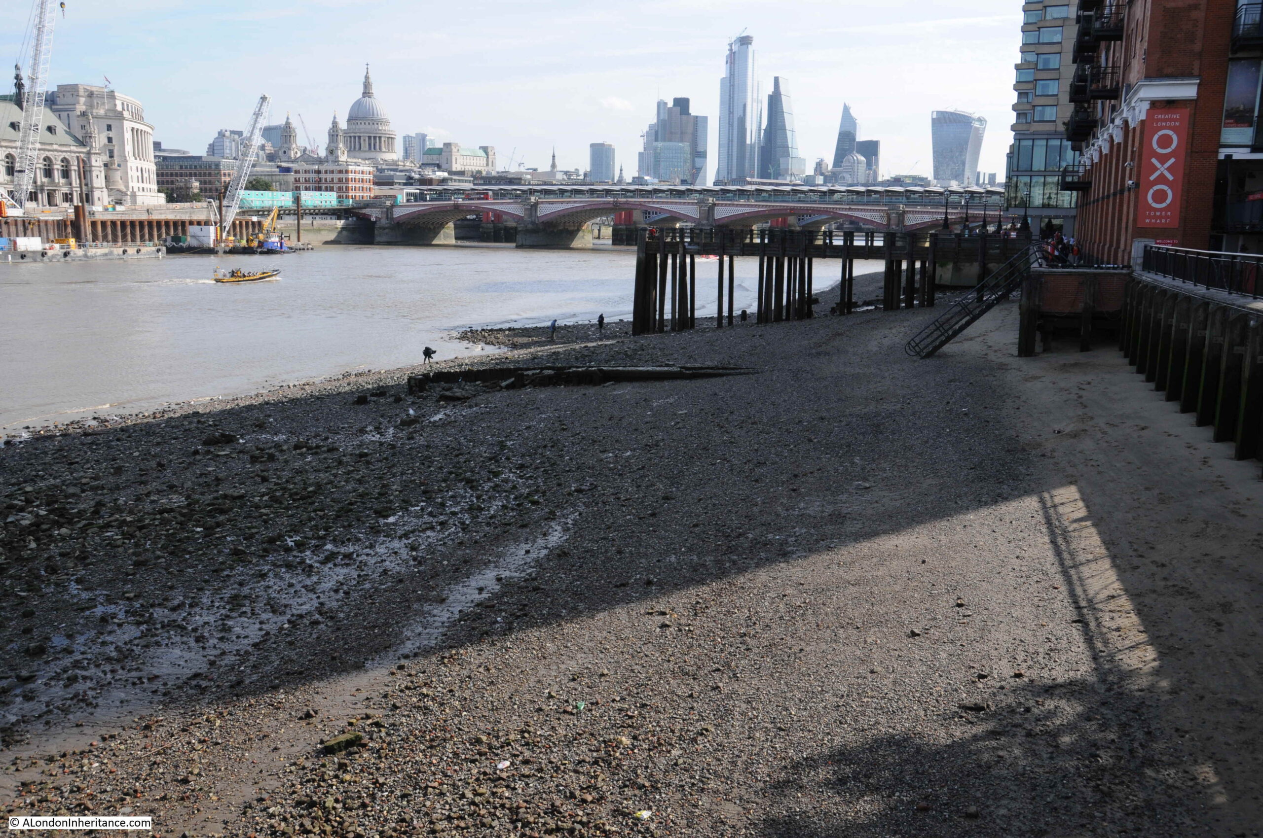
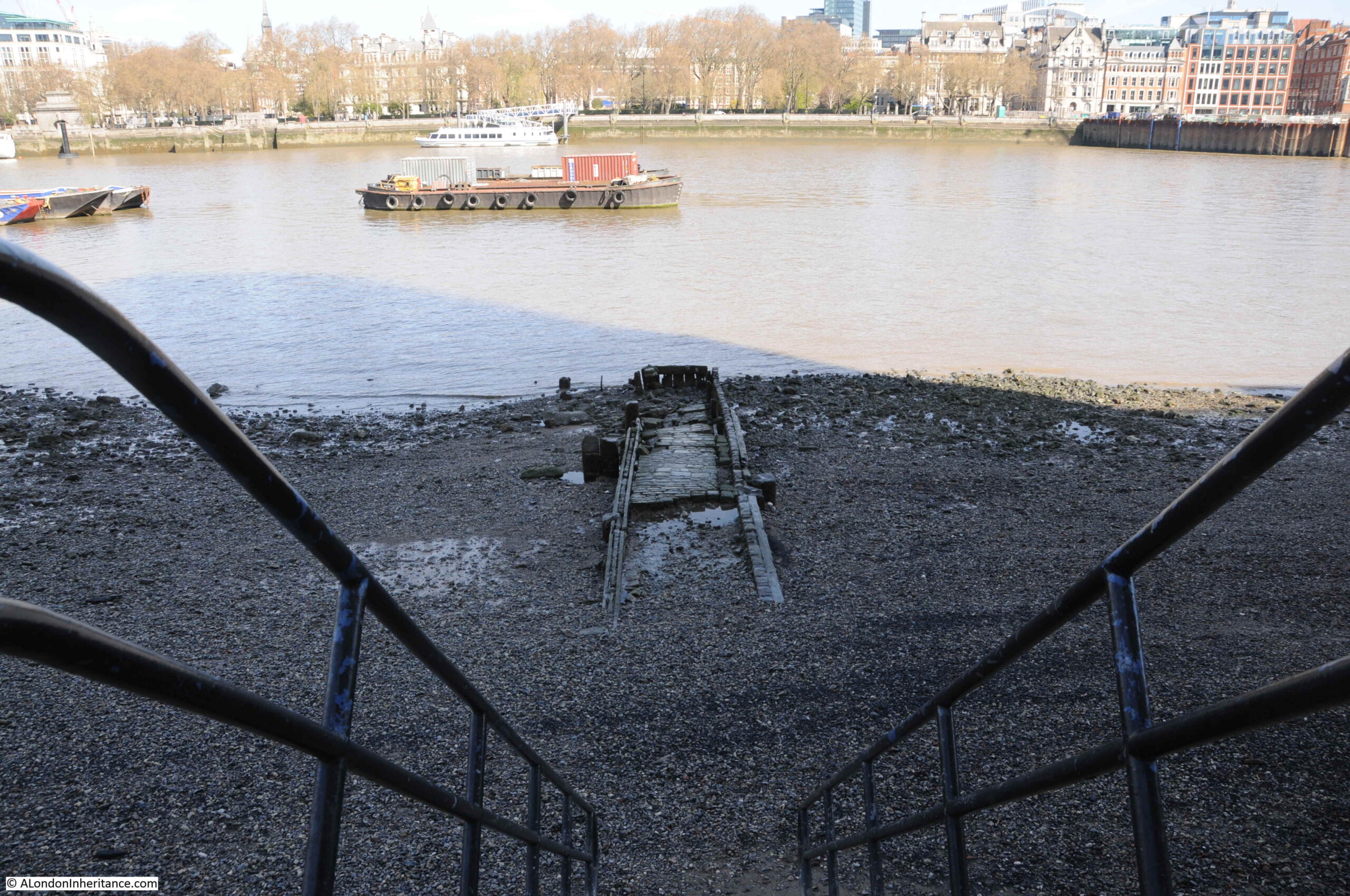
In the above photo, there are some modern steps descending from the river wall, just to the left of the large OXO sign. The remains of a wood and stone causeway can be seen to the left of the base of the steps towards the river.
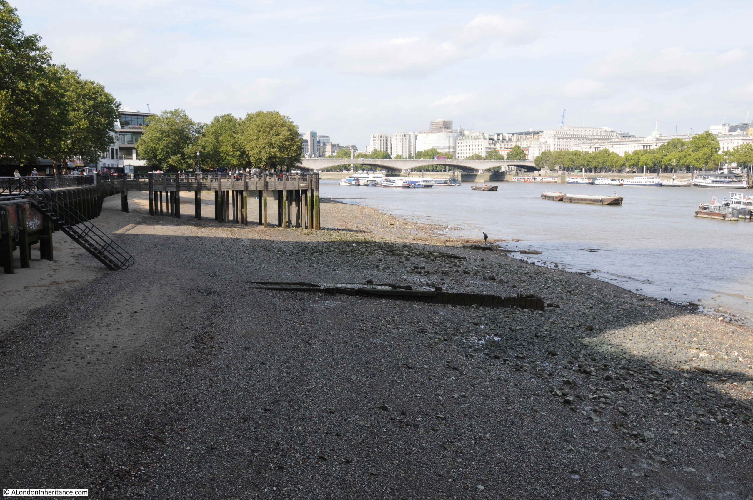
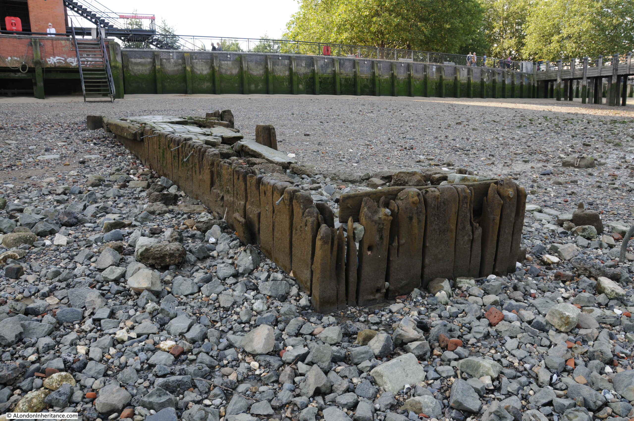
The causeway is all that is left of Old Barge House Stairs. The following view shows the stairs from the opposite direction to the above photo:
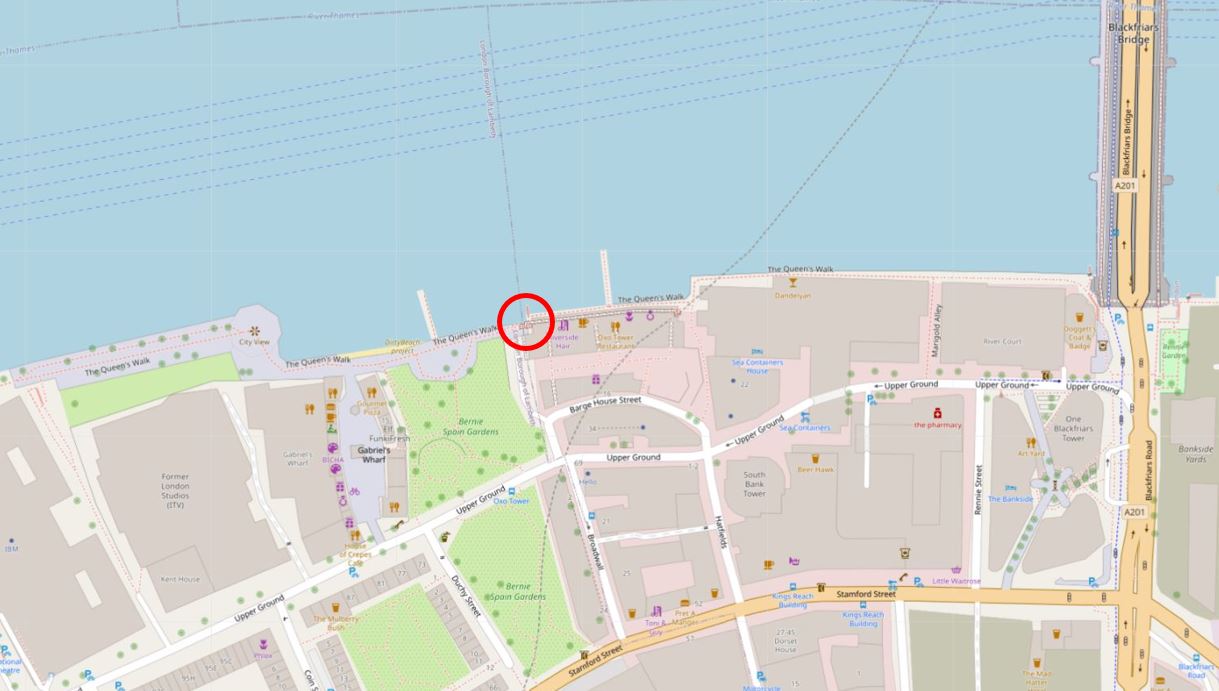
The stairs are located on the north western corner of the Oxo building on the south bank of the river, a short distance to the west of Blackfriars Bridge. I have ringed their location in the following map. The two piers on either side are the piers from where I took the above photos (Map © OpenStreetMap contributors).
The name Old Barge House Stairs comes from their proximity to the King’s Barge House, along with accommodation for the Royal Barge Master. It was here in the time of Henry VIII that the King’s Barge was stored.
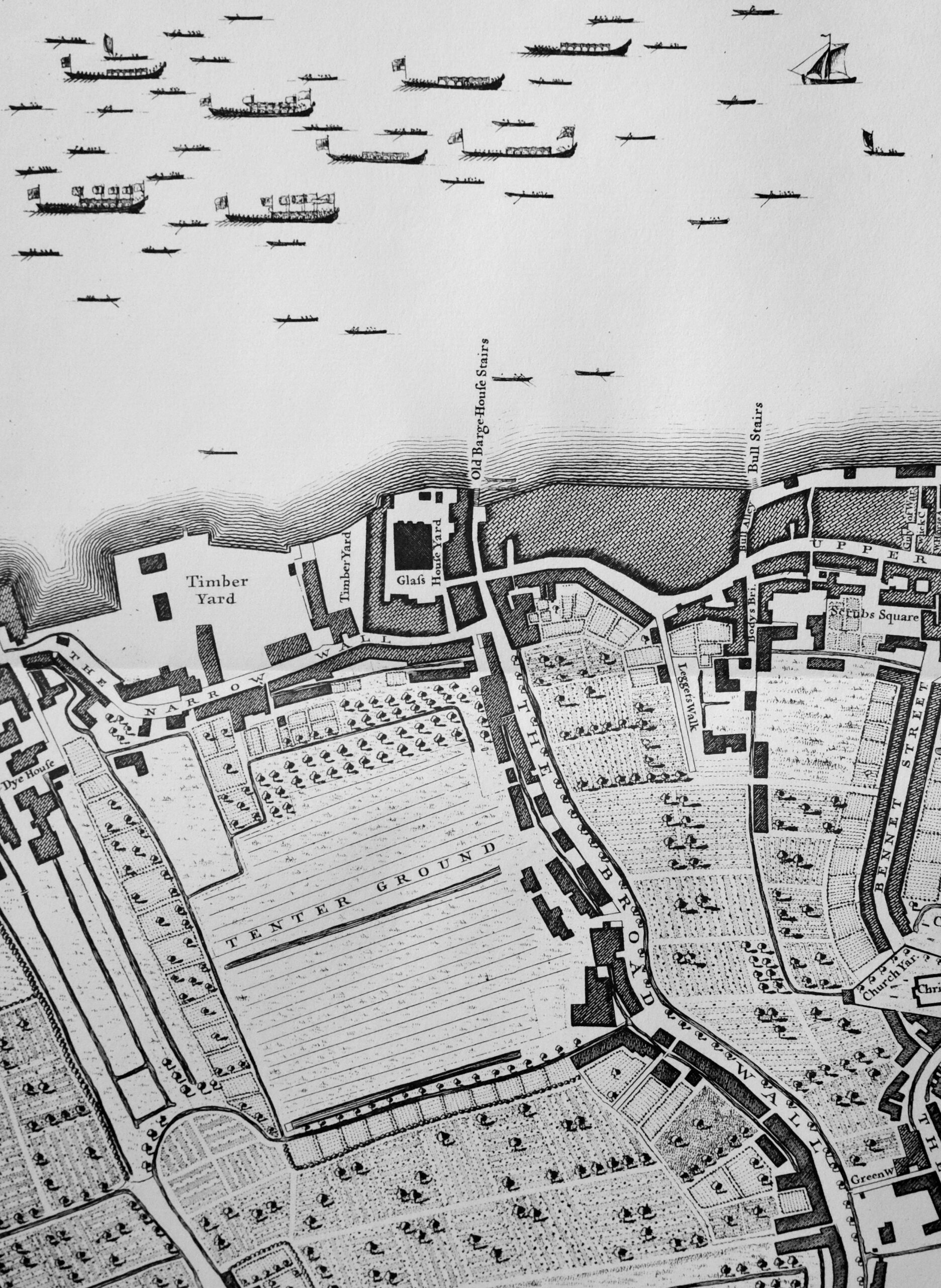
The stairs appeared on maps as early as 1720, as shown in this extract from “A Plan of the City’s of London, Westminster and Borough of Southwark”, where Old Barge House Stairs are shown in the centre of the map:
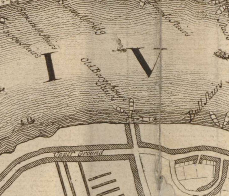
I do like the way that the map shows the boats that were probably used by the watermen associated with the stairs, clustered around the stairs.
If you visit Old Barge House Stairs when the tide is high, you will find just the top of a modern set of metal stairs that run down from the walkway in front of the north western corner of the Oxo building. Visit at low tide, and the causeway that would have once led from the original stairs is visible:
I doubt that the causeway we see today dates back to the time of the above 1720 map. These stairs and their causeways were remade several times over the centuries due to continual erosion by the river, as well their changing importance relative to other river stairs.

What I find so fascinating about these river stairs is that they provide a fixed point between two very different worlds – the land and the river. They are where people moved between the two, and they provided a fixed point of reference to understand what was happening in these two very different worlds.
On the land around the stairs, they would be used as a reference to events happening near-by. This would help people find a location, or the best way to travel. For example, the following advert from the Morning Chronicle on the 5th September 1806 is the equivalent of today using an underground station as a point of reference:
“Oak Scantlings, Mahogany Plank and Boards, and Two Thousand Deals &c. By Mr Farebrother at Mr Gresham’s Wharf (late Gales) near the Old Barge-house-stairs, Narrow Wall, Lambeth, on Monday next at 12.”
Newspapers mainly report bad news, and the River Thames has been the scene of so many tragic events over the centuries. A quick scan of old newspapers reveals an almost daily report of accidents and deaths on the river. It was a very dangerous place, as well as the scene of tragedies such as that reported in the Morning Chronicle on the 8th April 1831:
“On Tuesday evening, about five o’clock, a middle aged French lady, elegantly attired, hired a waterman, named Oxley, belonging to Waterloo-bridge stairs, to row her to the Old Barge House stairs. On the man being about to land her, she desired to return back and proceed to Westminster-bridge. He instantly pulled round, but previous to his arriving near the bridge, he asked the lady which stairs she would like to be landed at? To which she replied the lower one. When nearing them the lady placed her muff and purse in the boat and taking a portrait out of her bosom, and her bonnet off, she precipitated herself into the river before the waterman could prevent her. By great exertion, however, he succeeded in catching hold of her after she floated through the second arch, and by prompt assistance, she was rescued from the death she meditated. She was conveyed into the Swan tap, where every attention was paid her, but she would neither give any explanation of her rash conduct, nor her name or place of residence. her friends, however, by some means, became acquainted with the circumstance and they sent a coach for her, the coachman being desired to drive to Thornhaugh-street.”
And this very sad report from the Kentish Mercury on the 16th February 1847:
“On Wednesday an inquest was held by Mr. W. Carter at the Mitre, Broadwall, Blackfriars-road, relative to the death of a newly-born male child, found under very remarkable circumstances. Mark Marten, a lighterman, deposed that he was proceeding down the river on Friday morning last, and whilst passing Raymond’s-roads on the upper side of Blackfriars-bridge, he saw a market basket floating down with the tide.
He pulled it into his boat, and rowed ashore at Old Barge House Stairs, where he opened it, and found the body of a child wrapt in a piece of flannel, and covered with meadow hay. On the top of the basket was a label, to the following effect ‘to be opened with care, from an old friend’. Witness gave the body to the police, and inadvertently destroyed the label, which in a moment of excitement, threw into a fire. Mr. E. Doubleday, surgeon, said that he had examined the body, which was that of a male child, fully developed. There was sufficient evidence of the child having breathed, but he was unable to say to what extent. The deceased from the appearance of the body, had clearly received the necessary attention at his birth.
The coroner remarked that the fact of the paper being destroyed by the first witness was an unfortunate occurrence as all chance of tracing the guilty party was lost. He left the case in the hands of the jury, who returned an open verdict of Found Dead in the River Thames.”
The above two reports cover some of the more unusual events where the stairs were involved. There were also very many more tragedies at the river in the vicinity of each of the stairs, for example in August 1880 at old Barge House Stairs, 16 year old John Thomas Glue, who drowned after simply going for a swim during his dinner hour. Ten or eleven yards from the bank, he suddenly had cramp, was swept by the tide under a barge near the steps where he drowned.
What would not have been reported in the newspapers are the thousands of people who have used these stairs, using the services of the watermen who gathered around the stairs like taxis in a taxi rank, waiting to take their fare to their destination of choice.

Today, Old Barge House Stairs are found between the Oxo building and Bernie Spain Gardens. The gardens are one of the few places of grassed, open space in the immediate area as this is a very built up area.
The old ITV Studios buildings, IBM Offices and the National Theatre are found to the west. Housing, offices and streets inland. In terms of London’s development, building around Old Barge House Stairs has been relatively recent, with the majority taking place during the 19th century.
For centuries the land around Old Barge House Stairs was part of Lambeth Marsh, an area of land roughly between Lambeth and Blackfriars Bridges and inland to St George’s Circus.
In the following extract from Rocque’s 1746 map of London, Old Barge House Stairs is marked in the centre of the map:
The map shows that by 1746, the land along the river had been built on, however inland it was mainly fields and agriculture. The Tenter Ground was an area used for the drying of newly manufactured cloth. Frames were set up across the field and the cloth was stretched across the frame to dry. If you look on the left side of the map, there is a building marked Dye House, so it is possible that cloth dyed in this building would be dried on the Tenter Ground.
The street running from the left is called Narrow Wall. This street ran from the current location of Westminster Bridge, running along the length of the south bank. The first written mentions of Narrow Wall date back to 1443, and it seems to have been a raised causeway or walkway with the sandy foreshore to the north. The name describes its original appearance as a Narrow Wall which would have helped prevent high tides coming too far inland.
Today, Narrow Wall is better known as Belevdere Road and Upper Ground. This later street name can be seen continuing to the right of the map, with the name again describing the physical characteristics of the street, when so much of the surrounding land was low lying, marshy, and would have been regularly threatened with flooding.
A long street called Broad Wall runs south from Old Barge House Stairs for the length of the map.
The name Broad Wall again defines how this street originally formed. It was also along the line of the western boundary of an area of land known as Paris Garden. The boundary was formed by one of the branches of the River Neckinger, which also seems to have gone by the name of Widefleet.
There was a syndicated article about Paris Garden in a number of newspapers in March 1890, which mention the boundary, and how the stream eventually became a sewer which entered the Thames at Old Barge House Stairs:
“Paris Garden, known as the King’s manor as appertaining to its lord and copyholders, formerly lay in St. Saviour’s Parish, and was famed for its mill, water-courses, pastures and wild plants. In 1670 nearly all of it was taken for the new parish of Christchurch, as constituted under the will of John Marshall, who had died 40 years before. Comprising the ancient hide of Wideflete, and covering nearly 100 acres, it had been given in 1113 by one Robert Marmion to the Cluniac Monastery of Bermondsey, whence, almost fifty years later, it passed to the Knights Templar, who set up a chapelry there, and from them to the Knights Hospitaler of St. John.
In the early years of the fifteenth century it became a sanctuary for offenders. Ultimately passing to Henry VIII, it was granted as dowry for Jane Seymour. Lord Hundens and others, who got the manor from Queen Elizabeth, conveyed the land and manor house to Thomas Cure, a benefactor to the parish. The manor house has been identified with the Holland’s Leaguer, or Nob’s Island, one of the many houses of ill-fame that formerly flourished on Bankside. The moated and castellated ‘Leaguer’ which was kept by one Susan Holland, in 1630, stood south-westwards of the present Falcon drawing dock. Latterly known as Beggars Hall, it was pulled down in making the southern approach to Blackfriars Bridge; yet some authorities question the survival of the original building to that time. The Widefleet was converted into a sewer, having its outlet by Barge House-stairs.”
The outline of streams can be seen in the 1746 map, however these can be more clearly seen in the Agas map which shows London in the mid 16th century. The map does not show Old Barge House Stairs, however the land of Paris Garden is shown as the built and cultivated area in the centre of the map, with Paris Garden stairs to the right of the line of buildings along the river. In the following extract of the Agas map, I have marked the location of Old Barge House Stairs (red circle):

The map does illustrate the number of streams in this part of the south bank, and running south from the future location of the stairs is a street (Broad Wall), with a stream running along the west side of the street, one of the branches of the Neckinger, or the Widefleet, which drained into the Thames at the location of the stairs.
The Neckinger / Widefleet is not visible today and does not drain into the river next to the stairs. Presumably any running water from the stream is now part of the sewer system.
The river walls here are high, protecting the low lying land from the waters of the Thames:

The causeway will gradually erode over the years as the daily tides cover and roll back from the structure. It would be interesting to know if the causeway extends further towards the river wall, under the sand of the foreshore.
Thames stairs are so much more than the physical remains we see today. They are a reference point between the land and river, which help tell a story of the area, and the many thousands of people who have in some way come into contact with them.
The problem with researching these posts, is finding a reference to the subject of a post which raises a whole set of new questions, which I frequently do not have time to follow up. One example concerns a potential bridge across the River Thames which would have landed at Old Barge House Stairs.
In 1862 the London Gazette reported on the incorporation of a new compnay, for the making of new bridges over the River Thames. Application was being made by the new company for a new Act that the company was intending to bring before Parliament. The Act proposed a range of new bridges, including:
- A bridge, to be called the Tower Bridge, for horses, animals, trucks and passengers across the River Thames. Works to commence at Irongate Stairs near the Tower of London, and to terminate at Horseleydown Old Stairs.
- A bridge, to be called St Paul’s Bridge, for horses, animals, trucks and passengers across the River Thames, commencing from the foot of St Paul’s Steam-boat Pier and terminating at Mason’s Stairs, Bankside.
- A bridge, to be called the Temple Bridge, for horses, animals, trucks and passengers across the River Thames, commencing on the north side at a point distant 100 yards or thereabouts in a south-easterly direction from the commencement of the Temple Steam-boat Pier near Essex Street, and terminating at certain Stairs called Old Barge-house Stairs at the end of Old Barge-house Alley
As well as the above, the Act also proposed the New Chelsea and Battersea Bridge and the Wandsworth Bridge.
Tower Bridge would be built, however construction was not started for a further 24 years after the above Act.
St Paul’s Bridge continued to be a proposed solution in the early decades of the 20th century, but was never built.
As well as the 1862 Act, a Temple Bridge was proposed in the 1943, Abercrombie County of London Plan, published by the London County Council, but would also not be built.
Today, there is a short stretch of Barge House Street from Upper Ground to behind the Oxo building, and there is a stretch of Broadwall from Upper Ground to Stamford Street, so some of these old street names, and reminders of the history of the area can still be found when walking today.
Thank you for another fascinating Thames insight.
Thanks. I pass there after and I am disappointed by the rapid erosion that has taken place in the last few years. Thanks for capturing and documenting the location.
Many thanks for this post. I went mudlarking there once on one of my trips to England. A wonderful memory. I still have the “treasures” I found. I will enjoy reading the history of the area in your post, since I just went through it fairly quickly at first.
The proposed location of the St Paul’s Bridge must have been very close to the Millennium Bridge, eventually built over 130 years later. Those proposals and their limited implementation are worth remembering when people wonder why it will take so long to build HS2.
Fascinating post, thank you; great research. I wonder if relics of the past, along the River Thames, such as Barge House Stairs, should be preserved so that future generations can also enjoy them too, before it is too late?
But no sign of the actual Barge House itself? Not even on the Agas map, it seems. How placenames preserve ghosts of memories, eh?
I am delighted that the position of the street and the causeway show the rough whereabouts of the embarkation point. The present water’s edge cannot be in the same position in which the old stairs stood – the conformation of that part of the River Embankment is further away from Upper Ground than it was, so the real site of the old stairs has been lost under the made land of the present bank. That the causeway is still there at low tide is a remarkable fact which cheers me up no end! Thank-you so much for recording it, and for paying such close attention to these neglected stairs.
Hi David, I’ve just been sent a link to your blog by a UK relative and enjoyed this one on the Barge House Steps as our family lived at the Barge House itself from around early 1860s having moved from the other side of the river where they lived on Water Street near Bridewell. My Gt Grandafather was bapt i Bridewell church and became a printer, with fleet st on his doorstep how could he avoid it! I have been googling to find out more information about the Barge House itself and when it might have been demolished. A relative describes it as an old Tudor building. It sat just behind the position of the Kings Barge House which is marked on a couple of maps from around 1821/22. I have an old photo of the old oil works that were also nearby, a huge building. Other older maps show Hawes soap factory which in 1840 is reported to heve been there for 75 years. There is a Wikipedia page on it with loads of information. William Hawes was an amazing individual. He lived in the Barge House until 1830s apparently when it became a Glass House. Funny becuase older maps in 1700s show a glass house also, so not sure what really happened after the soap factory closed in the years between 1830 and 1860. The 1861 census was destroyed in then war so we will never know who actually lived there in that year. I might try to find an article in teh British Newspaper Archive online that might fill a bit of that gap. Loved the great photos of the remainign stairs thank you for those. You have a wonderful project!
Amanda (NZ)