Today’s photo from my father’s collection is one I scanned a while ago, but had not investigated until planning my guided walked between Bankside and Tower Bridge. It was taken from the foot of Pickle Herring Stairs. a name that will be familiar to readers as I have written a couple of posts about Pickle Herring Street.
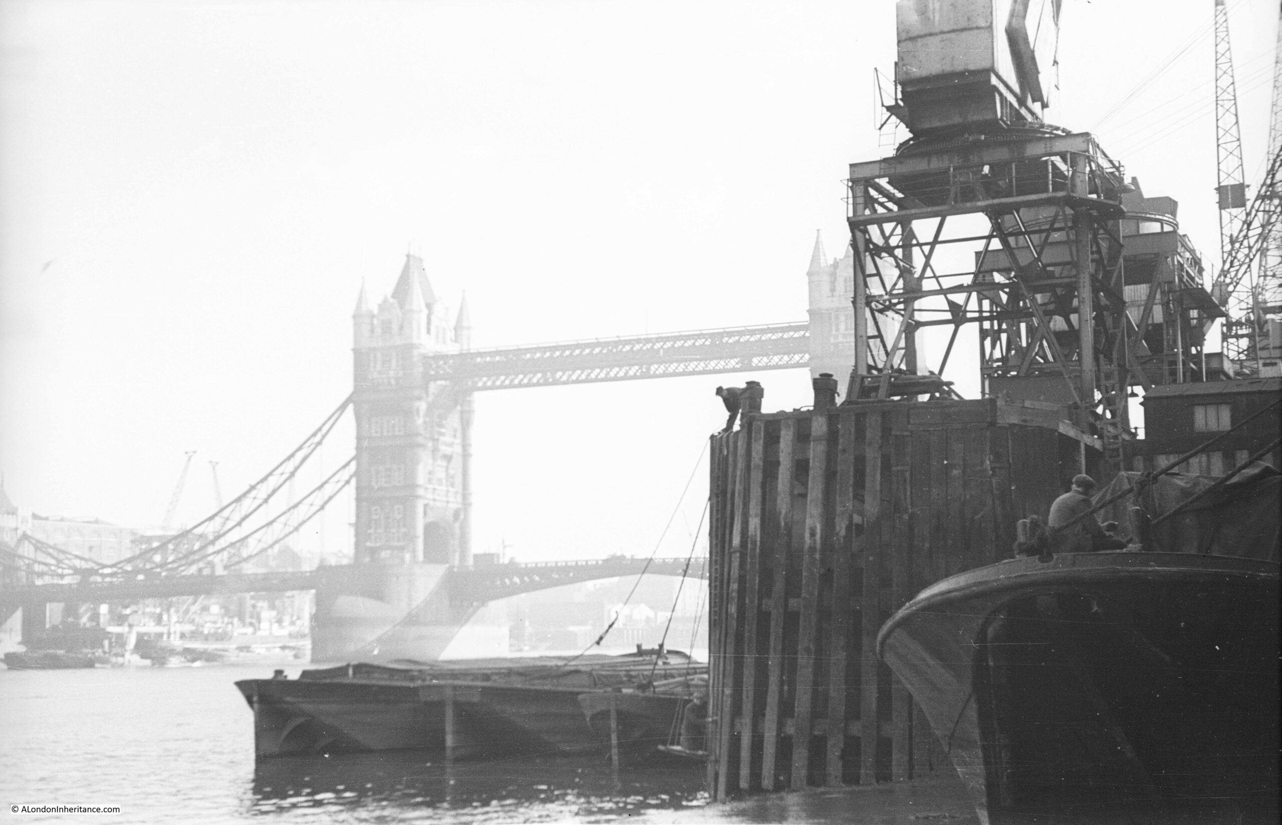
The photo was taken at the bottom of Pickle Herring Stairs, looking towards Tower Bridge, with the travelling cranes that lined the foreshore on the right.
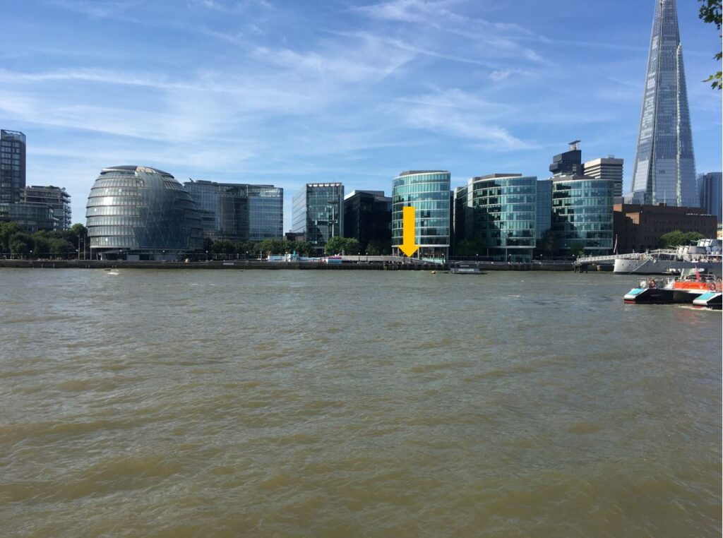
The stairs have disappeared in the considerable redevelopment of the area, and the walkway along the river and embankment have been extended into the river, so it is impossible today to be exactly sure where the stairs were located, however by lining up with features on the opposite side of the Thames, I suspect they were roughly where I took the following photo. The perspective is different as I used a wider lens compared to my father’s photo to show some of the nearby features to help with locating the stairs.
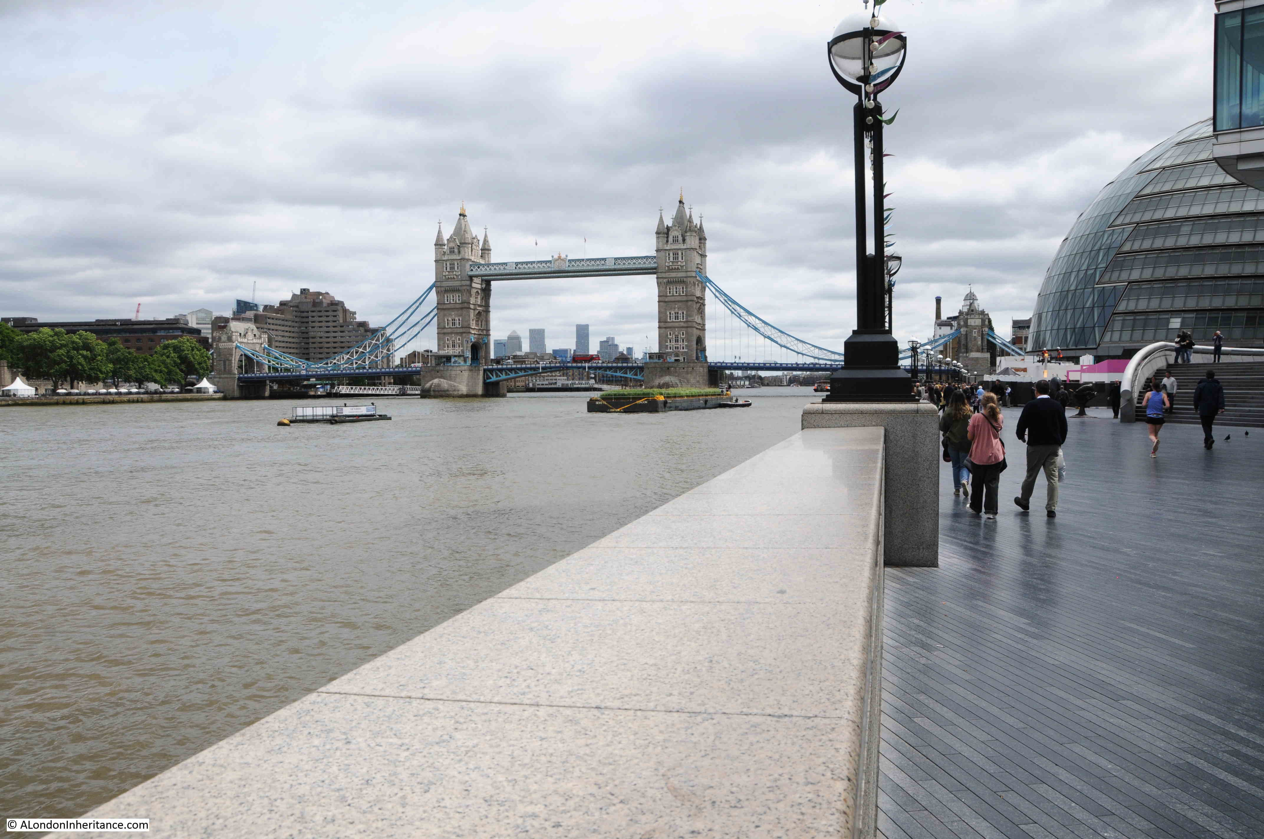
To the right is the old City Hall for the Mayor of London, now closed following the move of the Mayor’s office further east towards the Royal Docks.
The following extract from the 1895 Ordnance Survey map shows the exact location of Pickle Herring Stairs (‘Reproduced with the permission of the National Library of Scotland“):
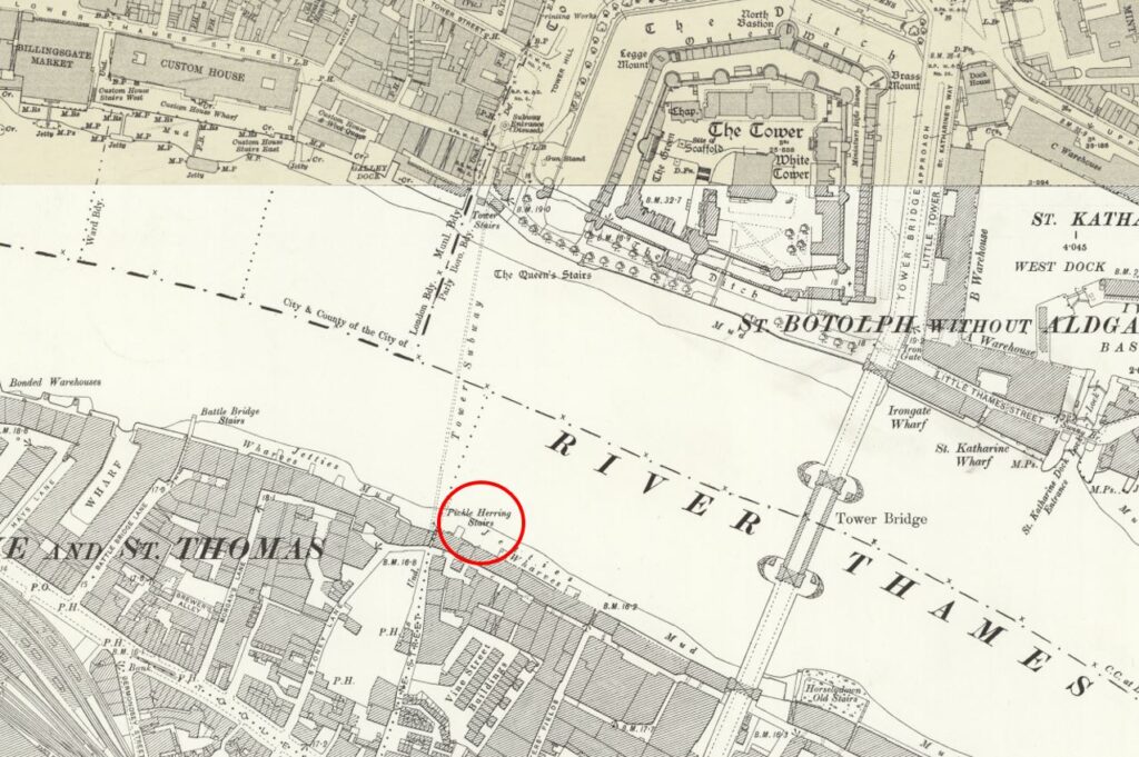
The above map shows that by the end of the 19th century, the side of the river was lined by warehouses, however the cranes seen in my father’s photo had not yet arrived.
These would be installed during the early decades of the 20th century when the warehouses were expanded, and large cranes were installed to handle the quantity and range of goods that needed to be moved from river to warehouse.
They were called “travelling cranes” as they moved on rails along the platform on which they were built, so they could easily get to the cargo that needed to be moved.
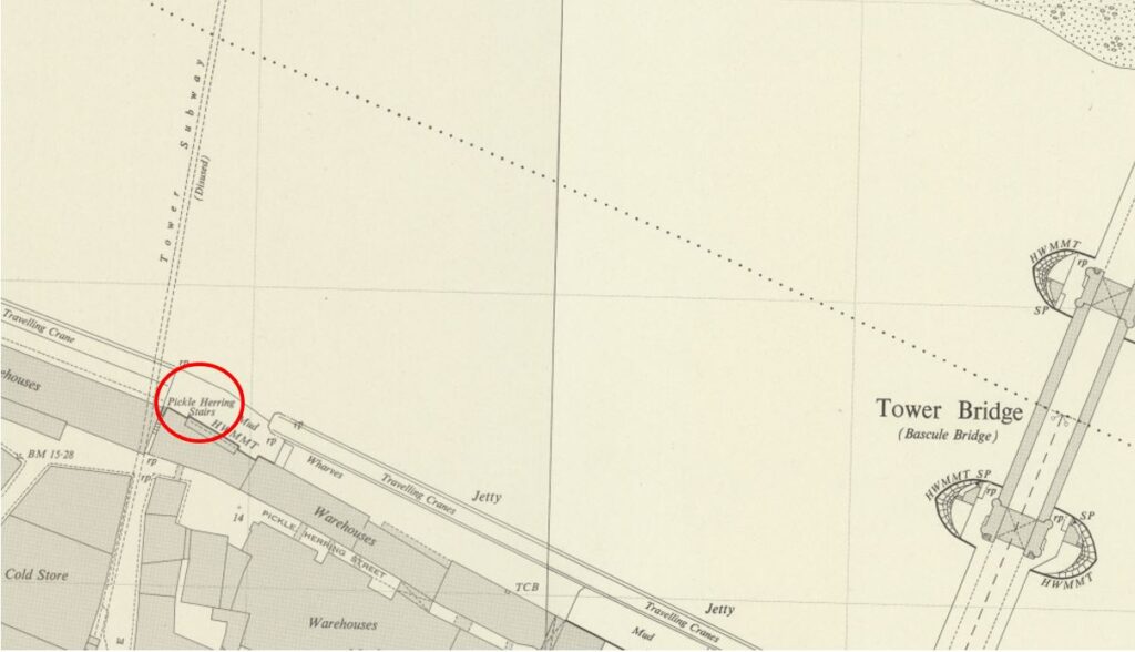
By the 1952 Ordnance Survey map (just a few years after my father’s photo), the jetties had been built on the foreshore, and the travelling cranes had been installed. The following extract from the map shows the length of the jetty which supported the cranes. Pickle Herring Stairs are circled to the left, and the map confirms that my father’s photo is looking at both Tower Bridge, and the end of the jetty (‘Reproduced with the permission of the National Library of Scotland“).
Looking from across the river, the following photo shows where the stairs were located:
I have written about the area, and Pickle Herring Street, including theories as to the origins of the name in two posts – The Lost Warehouses of Pickle Herring Street, and Pickle Herring Street Revisited.
What is not clear is what came first, the name of the stairs or the name of the street, or whether they were named at the same time.
I suspect the name of the stairs came first, and this could support one of the possible sources of the name down to the landing of Pickle Herring at this point on the river. however I have no evidence to support this.
What is certain is that both stairs and street are old names.
Regular readers will know that I find these stairs fascinating. Not only the physical stairs (where they remain), but that they can tell us so much about life in the area.
I looked back at some early newspaper articles that mentioned the stairs, and found the following sample from the 18th century.
The first is a report about a fire, a very common event in the warehouses full of inflammable goods along the river:
“15th January 1740: On Thursday night about 11 o’Clock, a fire broke out at Mr. Brooks’s a Hoop bender near Pickle Herring Stairs, opposite the Tower, that raged with such violence that in three hours time above 20 dwelling houses, besides warehouses were consumed.
A young fellow, a Waterman, who had rescued his wife and child, returning to preserve some of his goods, is missing, and supposed to have perished in the flames.
Last night, Joseph Chitty, one of the Candidates for the Borough of Southwark, sent over a present of 20 Guineas to be distributed among the most necessitous of the sufferers by the said fire.”
There were so many suicides along the Thames, and one of the methods used would be to get a Waterman to row you out into the centre of the river, as this very tragic report of a woman abandoned after becoming pregnant tells:
“26th January 1748: Yesterday a young woman took a boat at Pickle Herring Stairs and desired to be ferried over; when the boat came to the middle of the river, she threw down six pence, and jumped over. The Waterman with great difficulty drew her again into the boat; on which she confessed that being far gone with Child by a Noble Lord, and being refused any assistance, had determined her to put a period to her existence.”
Papers were full of so many strange events across the City. One, where someone was tarred and feathered, also ended with what was probably some of the day to day racism which foreign seamen had to endure:
“18th October 1784: Friday the following singular occurrence took place. A seaman arriving after being discharged from a vessel lying off Pickle Herring Stairs, on account of his having rendered himself extremely obnoxious to the rest of the crew, was imprudent enough to return on board the ship, upon which he was seized by some of the men, stripped, and tarred and feathered, with as much dexterity as ever that discipline was inflicted in the Country where it was invented, and still practiced.
In this situation he walked to the Public-Office in Shadwell, followed by an immense concourse of people, and exhibited his complaint before Peter Green, the presiding magistrate, by whole order of several pounds of butter and some quarts of oil, were administered, to clear the man from the disagreeable covering.
During the above operation, proper persons were dispatched by the Magistrate in search of the delinquents and in something more than an hour they brought to the Office the Mate and five of the seamen belonging to the ship on board of which the act had been committed, against whom a charge for an assault was substantiated. The Captain bailed the Mate and four of the men, but the other, a youth about twenty, a native of Nevis, was committed to New-Prison, Clerkenwell.”
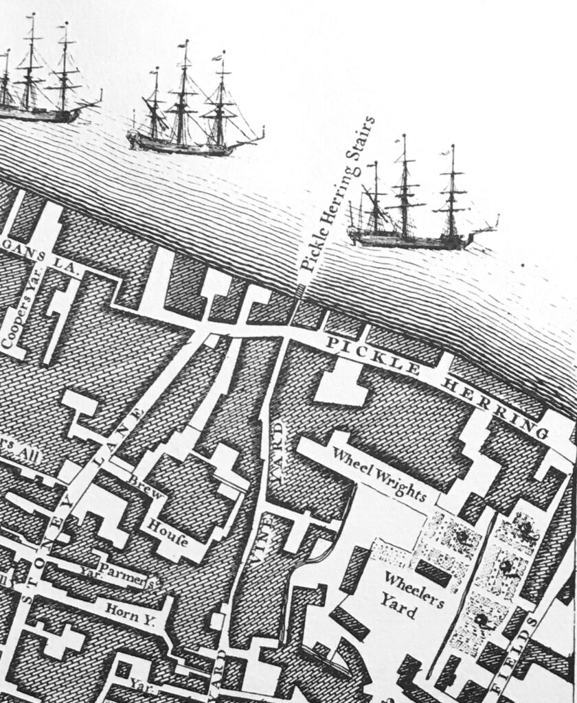
The earliest newspaper report I could find was the one from 1740, however the stairs are certainly much older. They appeared on the 1746 John Rocque map, as can be seen in the following extract:
I suspect these stairs went back to the medieval period, or even earlier. Stairs were such an important way of accessing the river, and naming stairs would have been incredibly important, as:
- If you were arriving or departing on a ship, you needed to know where on the river the ship would be moored, and the nearest set of stairs to use for arrival or departure. There are plenty of newspaper references where a name of stairs are quoted for the location of a ship;
- If you asked a Waterman to row you across or along the river, you would have needed to tell the Waterman the destination;
- For sales of cargo or goods, a location was needed to advertise the sale. There are very many adverts over the centuries using the names of stairs to locate a sale;
- For events on the river, the stairs provided a reference point, and newspapers used the stairs to refer to the many accidents, deaths, ships departing and leaving, thefts of goods, crimes against people, where press gangs were operating etc.
The unique naming of each individual stair was also important to avoid confusion, so even when stairs almost had the same name, and were in a very similar location, the name always had something to make them unique, for example Wapping Old Stairs and Wapping New Stairs on Wapping High Street.
An example of how the names of stairs were used can be seen in the following 17th century token, of the type issued by merchants and traders to be used instead of cash. The token references the trader’s location as at Pickle Herring Stairs (© The Trustees of the British Museum):
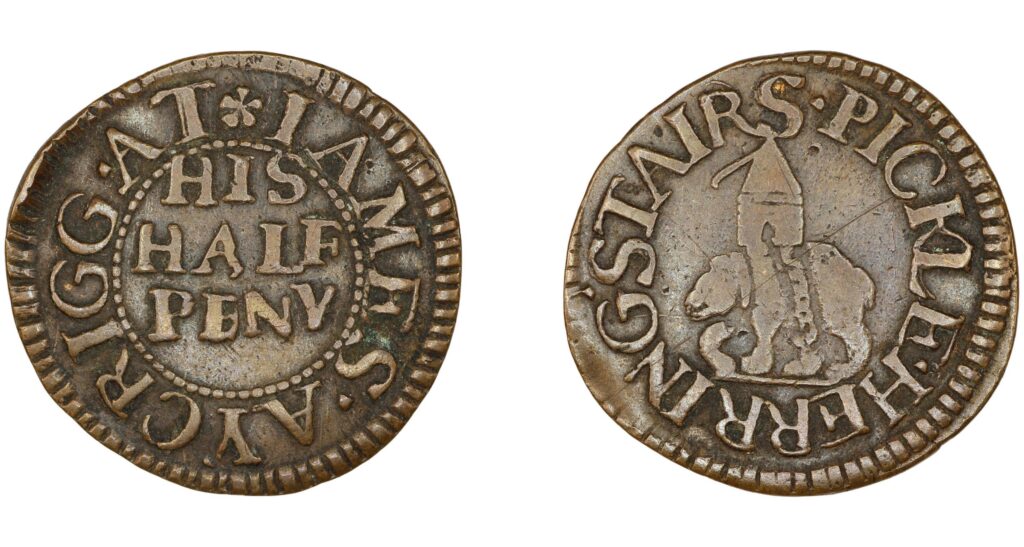
The name on the token is that of James Acrigg. The only record I could find of him was his marriage in London in February 1675.
The very last newspaper report I found about an event at Pickle Herring Stairs was dated the 16th of August 1928, when “The body of an unknown man aged about 40 was found today floating in the Thames near Pickle Herring Stairs. It is believed the man has been in the water for several hours.”
Following the above report, the story of Pickle Herring Stairs goes silent. They would still have been in use, however this would be much reduced. Better street and underground transport removed the need for a Waterman to row you along or across the river.
Access to ships on the river was now mainly from piers or when ships were docked alongside the infrastructure on the waters edge (such as the jetty seen in my father’s photo).
They were finally lost under the redevelopment of the area between London and Tower Bridges, when the open space and riverside walkway was built and extended out into the river.
I will leave the final words in today’s post to the London Rivers Association, who were quoted in the Illustrated London News on the 1st of May 1996, which reported on their campaign that “The London Rivers Association believes that the Thames should be made better use of for both public and freight transport. ‘Getting in touch with the Thames’ is endeavouring to open up all access points to the river – steps and stairs which once had such distinctive names as Elephant Stairs, Hoy Steps or Pickle Herring Stairs. Some of the Millennium projects are very glamorous, said a spokeswoman for the association. this scheme is more modest and will benefit everyone.”
Too late for Pickle Herring Stairs – but a scheme that I would fully support.

Very informative read as usual
Very interesting indeed!
I worked in the Liverpool St. area in 1975 and, if I had only known about it then, all the amazing Georgian/Victorian warehouses & docks around the Pool and further east were laying neglected and could so easily have been explored and photographed.
I do remember Tooley St. being lined with gaunt old warehouses but, of course, they’ve all now been swept away and lost forever.
There are a few tantalising glimpses of the docklands in old films (The Long Memory – 1953, Murder by Decree – 1979) but I wish I knew of more.
So, I never did get to explore Pickle Herring St and its environs, although at least Shad Thames is still there…
From TNA discovery
https://discovery.nationalarchives.gov.uk/details/r/C5711022
Reference: C 2/Eliz/W26/33
Description:
Short title: Welshaw v Bird.
Plaintiffs: John Welshaw.
Defendants: John Bird.
Subject: Claim by lease parol. A house and yard at Pickle Herring, in the parish of St Olave, Southwark,
Surrey, demised to the plaintiff by parol.
Document type: [Pleadings]
Note: Eliz/W26/33
Date: Between 1558 and 1603. [This may be 1597.]
Held by: The National Archives, Kew
Legal status: Public Record(s)
Closure status: Open Document, Open Description
John Bird is possibly the composer William Byrd’s older brother. He is known to have lived in Southwark was involved in shipping, some of which he inherited in 1585 from his father-in-law Olyffe Burr.
See writings by John Harley on William Byrd.
Also for some amazing scholarship see:
http://oro.open.ac.uk/56597/1/56597.pdf
P21-23 [8-10/26] for early references to the heavy drinkers of Southwark and the creation of an English stage clown persona. John Welshaw was a brewer!
Fascinating article – as usual! Many thanks. I spotted ‘Tower Subway’ and then ‘Tower Subway (disused)’ on the later map – do you have any information about it?
Many thanks
Wikipedia has an article on the Tower Subway: https://en.wikipedia.org/wiki/Tower_Subway
Many thanks, Malcolm, for the Wiki link. It sounds to have been an extremely claustrophobic subway tunnel – no wonder it couldn’t compete with Tower Bridge when that opened for pedestrians – I know which I would have preferred to use!
Perhaps your best post yet—loved this, thank you.
A very useful URL is the following:
https://maps.nls.uk/geo/explore/side-by-side/#zoom=18&lat=51.50556&lon=-0.07974&layers=168&right=ESRIWorld
You can change the map on the left and the Google Earth image will remain the same.
Best regards David S Wheatley (Facebook)
As someone who lived for thirty years in London, from the age of two, and worked at the Museum of London for ten years, I find the ‘London Inheritance’ postings hugely enjoyable and interesting. And the link to the NLS map/google earth facility is fascinating – thank you so much for introducing me to it! Hours of happy wanderings in favourite places and history at one and the same time.
This was so interesting as my Great Granddad drowned at this location in 1890 ish and an inquest was held, his father had also drowned in the same way. They were both only 33 when they drowned. They were Watermen along the Thames. I would love to find out more details as to there job/duties etc. I found this information when doing my Ancestry. Did they also live on their boats?
Pickled Herring Stairs and Pickled Herring Street, “I wonder what on earth went on there, “says my Grandson, “if only in2022 there was some way to find out,it’s a mystery”, my reply.Thanks for another great Sunday morning read.
Interesting. In the 1960s I was in London Division RNR then based on HMS President near the Temple. I was in a team of whaler pullers, and we used to take them downstream, have a few pints at the Prospect of Whitby and then attempt to row back up stream. On occasions the tide was very low and the downstream current fast and rowing became impossible. we were obliged to jump overboard and literally haul the waler back to President.
What you say about unique names for the stairs makes absolute sense. So it is difficult to explain the existence of two St Saviour’s Docks, one in Bermondsey and the other in Southwark. I wonder how many passengers, watermen and ships found themselves in the wrong one.
Could the name have originated as a humorous reference to the presence of Dutch immigrants producing tin glazed earthenware (Delftware)close to the stairs and that they may have been used for the delivery of clay from Norfolk during the 17th century?
I think it’s still possible to see the foot of the old stairs at low tide. It looks like it on Google Earth.
It’s typical of the arrogance of the recent era that these ancient stairs should have been wiped off the map in our lifetimes. I loathe that ugly city hall building and the hard – how very hard it is -‘ landscaping’ of that ancient spot. UGH! How much more interesting the place was in the past. Thank-you for another lovely post!
“Pickel hering stairs” appears on Wenceslaus Hollar’s Map of London 1675.