
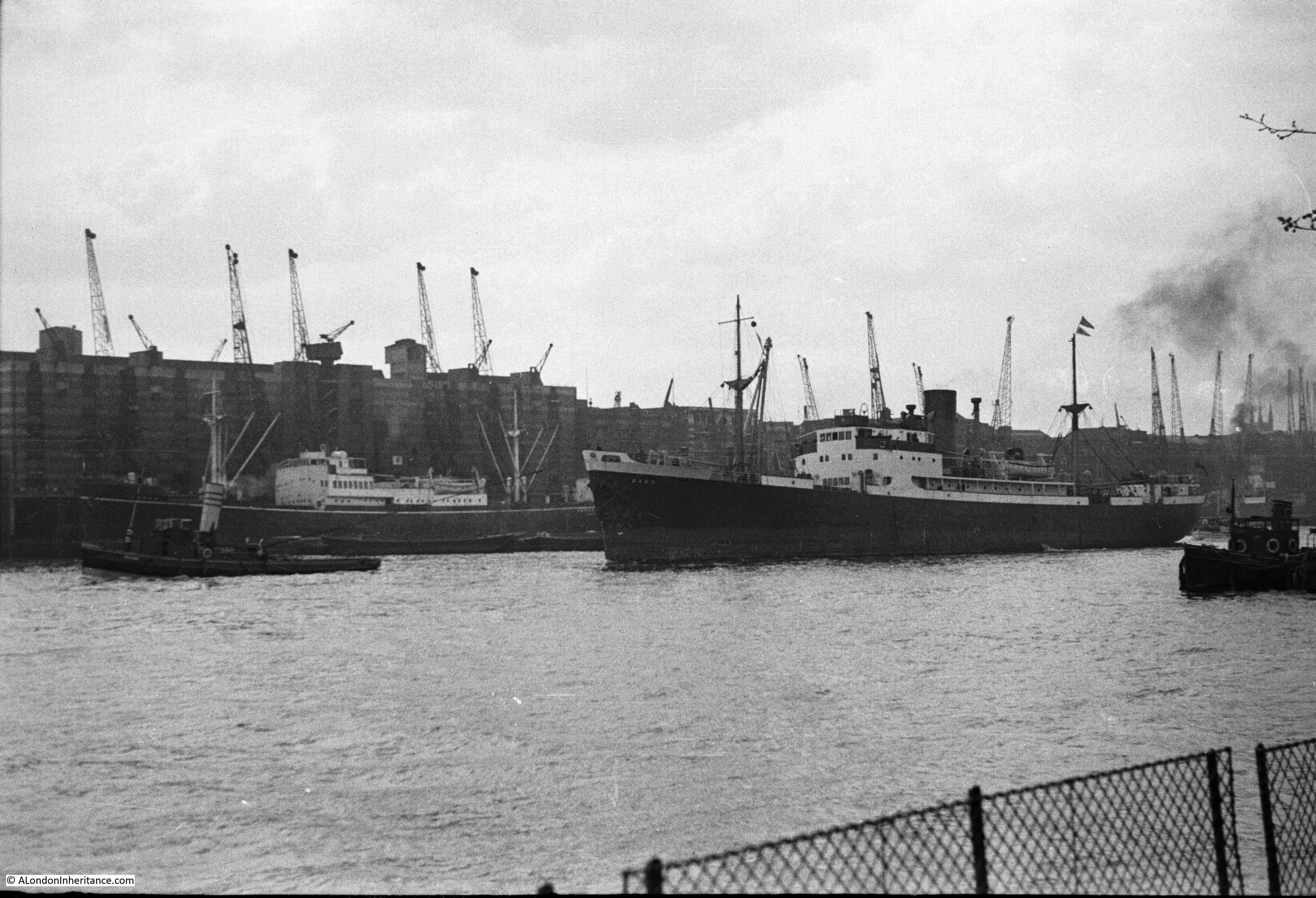
In August 1948, my father was on a boat sailing from Westminster to Greenwich, taking photos along the route. The following photo is after having just passed under London Bridge, looking down towards Tower Bridge, with the cranes and warehouses of the wharves that line the river opposite the City of London.
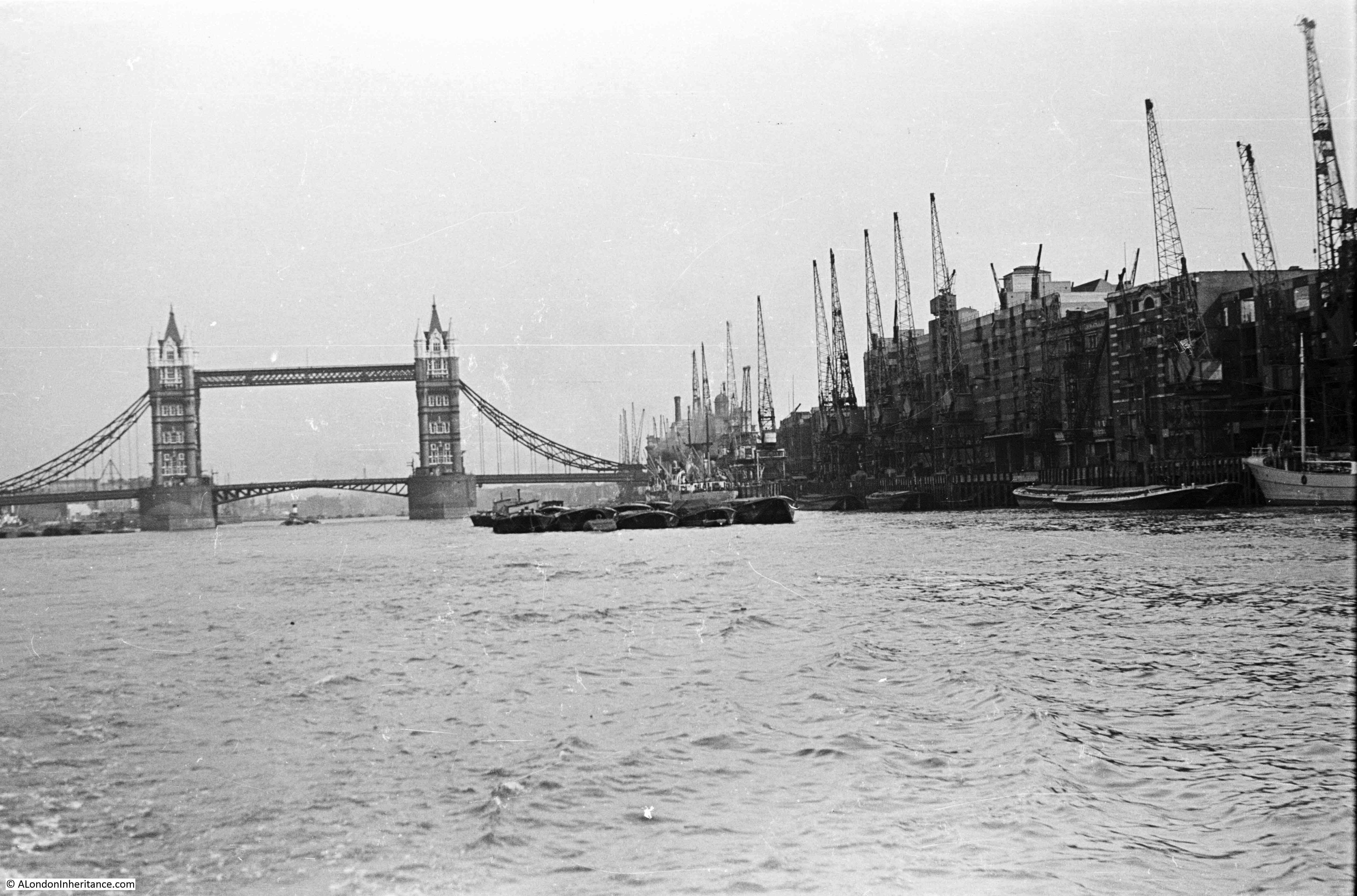
The Southwark side of the river between London Bridge and Tower Bridge was very different to the City side of the river. The Southwark side was full of wharves, warehouses, cranes and moored ships and barges.
The City had Billingsgate Market, the Customs House, New Fresh Wharf and the Tower of London. The difference between the two sides of the river can be seen in the following map from Commercial Motor’s 1953 edition of London Wharves and Docks:

This fascinating book lists all the wharves and docks between Teddington and Tilbury, and provides details of the trade that they handled and their facilities. The following tables cover the Southwark wharves between London and Tower Bridges:
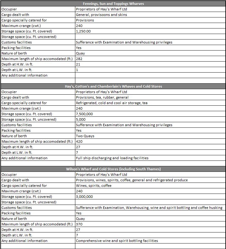
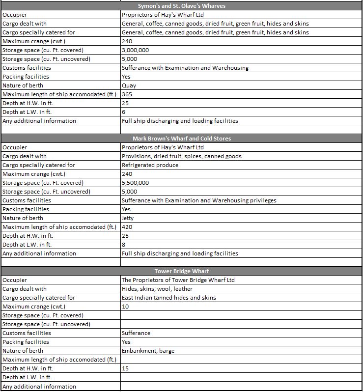
There was a remarkable 20,250,000 cubic feet of storage space within the warehouses along this relatively short stretch of the river, and there was a wide range of goods being stored. Chances are that if in 1953 you were drinking your morning cup of coffee, it would have been imported through one of these wharves.
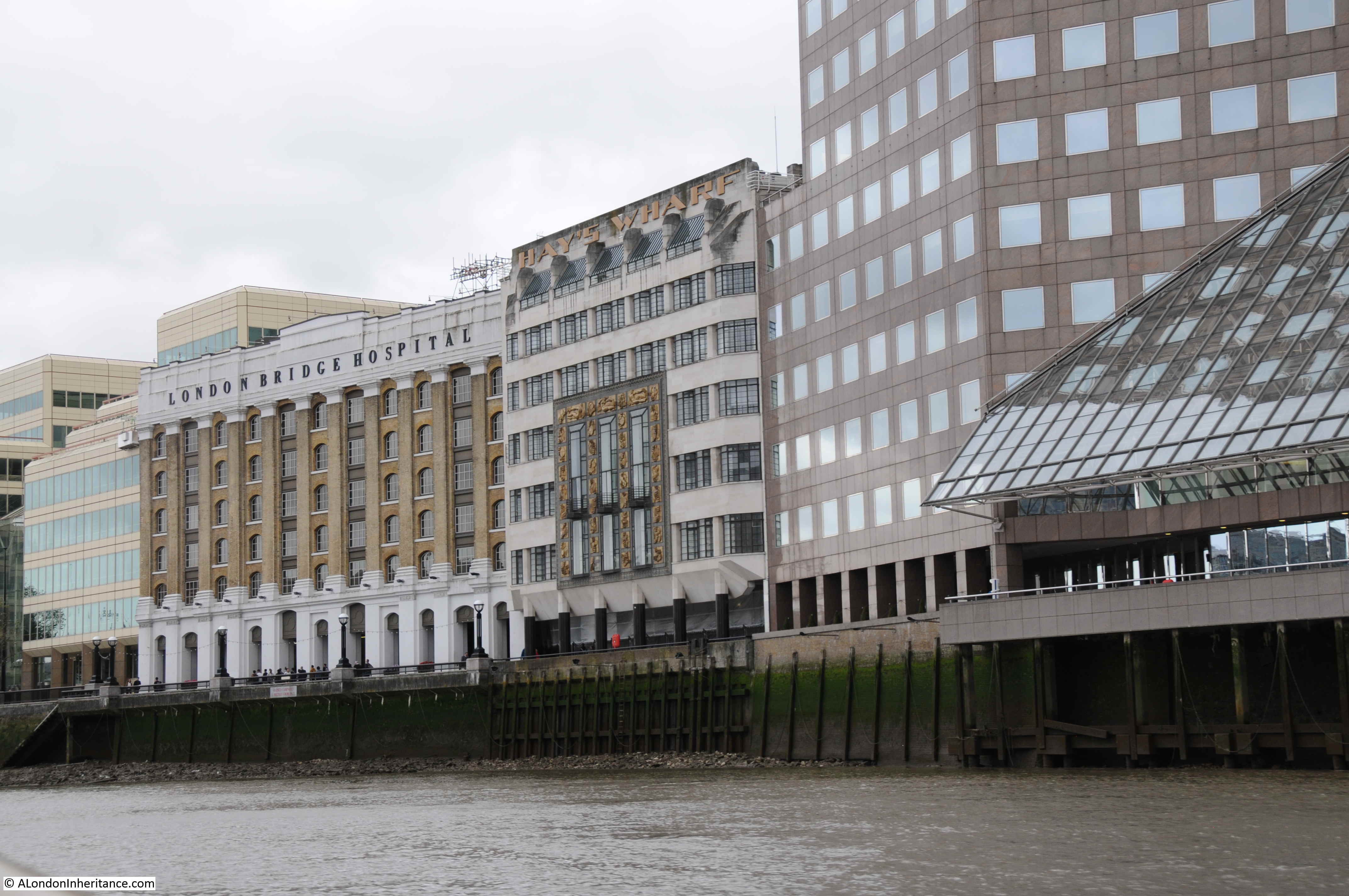
By 1953, all except the Tower Bridge Wharf were owned by Hay’s Wharf Ltd, a business that had been expanding rapidly, and a name that can still be found in this transformed stretch of the river.
Many of these wharves had been in existence for hundreds of years, and they would have had individual owners with the name often reflecting the original owner / builder of the wharf.
There is so much history associated with each wharf, and they can demonstrate how trade was conducted, and what life was like in this part of London. Close to London Bridge in the above map is Topping’s Wharf, and I have taken this single wharf to see what can be found of its history.
The first reference I could find of Topping’s Wharf was an advert in the Newcastle Courant on the 17th December 1774 where the new owners are setting up a cargo route between London and Newcastle and advertising Topping’s Wharf as a safe and insured site for goods to be stored:
“To the MERCHANTS, TRADERS and SHIPPERS of GOODS to and from London and Newcastle. We take this opportunity of acquainting you, that having lately taken a new, commodious, and convenient Wharf, situate in Tooley-street, Southwark, and adjoining to London bridge, known by the name of Topping’s Wharf, where there are exceeding good warehouses for lodging and securing goods from damage by weather, and where vessels of 300 tons burthen or upwards may load by cranes, which will be a considerable saving of expense and risk, incurred by the present method of shipping, by lighters from above bridge. The goods will be lodged in warehouses, upon which an insurance of £4000 from fire will be made till shipped and the policy deposited at the Bank of Newcastle. A set of good accustomed vessels are engaged, one of which will sail every week. We therefore solicit your favours, and assure you, that the greatest care will be taken to ship your goods with regularity and dispatch, by Your humble servants, CHINERY, RUDD and JOHNSON, London, December 9th 1774”.
These newspaper adverts and reports are interesting because they shed some light on how trade was conducted in the 18th century. They also mention fire insurance as a key feature of Topping’s Wharf, and from later events we can see why.
Warehouses held large volumes of highly flammable materials, and fires in London’s warehouses were very frequent, with often significant destruction of buildings, the goods stored in the warehouse and ships moored alongside.
I have already written about one fire in the area, called at the time the “Great Fire at London Bridge” in 1861. There had already been another major fire eighteen years earlier in 1843. This fire had destroyed Topping’s Wharf, as reported in the Globe on Saturday, August 19th, 1843:
“TERRIFIC FIRE THIS MORNING – Never since the too well remembered fire at the Royal Exchange in 1838, has it fallen to our lot to record a more terrific one than that which took place this morning at an early hour, at the premises known as Topping’s Wharf, situate on the east side of London bridge, near Fenning’s Wharf, which it will be recollected was destroyed by a similar calamity in 1836.
In magnitude it exceeded the above-named disaster, or any other that has occurred on the banks of the River Thames for many years past; for, in addition, we regret to say that Watson’s Telegraph, formerly a shot tower, the large turpentine and oil stores of Messrs. Ward and Co, in Tooley-street, and St Olave’s Church, all fell a sacrifice to the devouring element, besides doing extensive damage to a tier of shipping moored alongside Topping’s Wharf”.
The fire had started just before two in the morning and was spotted by a Police Constable. The Fire Brigade was soon on the scene, led by the superintendent of the brigade, Mr. James Braidwood (who would be killed in the fire in Tooley Street eighteen years later).
By four in the morning, St Olave’s Church, just behind Topping’s Wharf was on fire and the Globe reported that “there appeared very little chance of any of that ancient building being saved”.
The following print shows the 1843 fire at Topping’s Wharf (©Trustees of the British Museum):

The report in the Globe newspaper mentioned Watson’s Telegraph, and in the above print, just to the right of the church tower you can see the word Watson. I knew about Watson’s Telegraph, but did not know that the central London telegraph was based by St Olave’s Church and Topping’s Wharf, just to the east of the southern end of London Bridge.
The British Museum has a print of Watson’s Telegraph before the fire, with St Olave’s Church to the right, and Topping’s Wharf to the lower left (©Trustees of the British Museum).
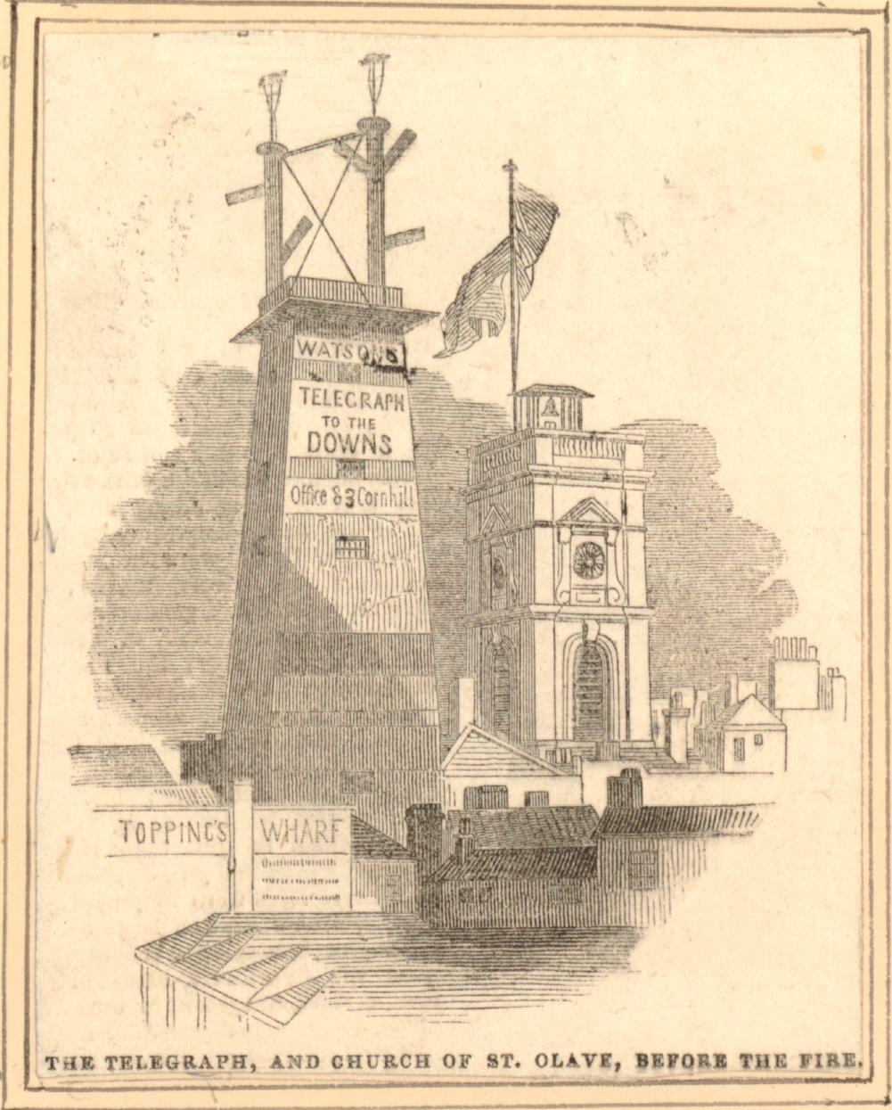
Watson’s Telegraph was the creation of a Mr. Watson of Cornhill. The purpose of the system was to rapidly pass messages to and from the coast and key ports. It was important to traders and ship owners in the City to know when their ship and cargo were getting close, or events such as a tragedy at sea.
Watson’s Telegraph system comprised of a number of towers with a semaphore signaling system on top. These were located at strategic points to allow a message to be passed along a chain of stations to the required destination. Each telegraph station needed to be able to see the telegraph stations on either side in the chain. For example, to pass a message between the City and Deal in Kent, the telegraph chain consisted of: “London-bridge; the second at Forest-hill; the third at Knockholt; and others at Wrotham-hill, Bluebell-hill, and three or four elevated spots between there and Deal”.
An article in the Illustrated London News provided the above list of locations, and I love the introduction to the article which paints a futuristic view of communications:
“In this miraculous age of improvements and discoveries when ‘the annihilation of time and space’ is no longer regarded as an idle chimera of the brain, it might hardly be considered necessary to occupy our space with a detail of the various schemes that have been adopted and put in operation to facilitate this most paramount and prevailing desire. So many of our readers must be naturally unconversant with those experiments in arts and science which the ‘great metropolis’ is continually eliciting, that we feel it a duty which we owe to our friends and supporters at a distance, to place before them those objects of interest and real usefulness in which the metropolis abounds, and which are only known to them by name”.
As well as the telegraph stations, a key part of the system was a Telegraphic Dictionary which was kept at each station and contained “several thousand words, names, phrases and directions, such as are likely to be most useful and required, and names of vessels, places, and certain nautical terms which have been selected with great care, as may best suit the object in view”.
The message entries in the dictionary have an associated unique number and the positions of the arms on the semaphore corresponded to different numbers, thereby allowing the position of the arms to send a message from the telegraphic dictionary.
The system was created in 1842. It is remarkable to think that 179 years later, on the evening before writing this post, I was watching a live stream over the Internet from the US of the Perseverance rover landing on Mars, with photos of the surface coming minutes after landing. How communications technology has changed in less than 200 years. I suspect the readers of the Illustrated London News in 1842, could not have imagined this new ‘the annihilation of time and space’.
It is difficult to track the ownership of Topping’s Wharf over the centuries of its existence. It seems to have been owned by Magdalen College, Oxford for some time, as in the Globe on the 28th October 1907, there is a record that: “the leasehold of Topping’s Wharf, Tooley-street, London-bridge, which Messrs. Jones, Lang, and Co. are to offer by the instructions of Magdalen College, Oxford”. There was also a description of Topping’s Wharf:
“The premises, which comprise ground floor, basement, and three large upper warehouse floors are supplied with loopholes to each floor, with hydraulic lifts, and cranes, back and front, and have recently been fitted with a London County Council staircase”.
I cannot find who took the lease in the 1907 auction, but in 1912 Topping’s Wharf was let to Nestle and the Anglo Swiss Condensed Milk Company. Hay’s Wharf Ltd seem to have taken on Topping’s Wharf in the 1920s.
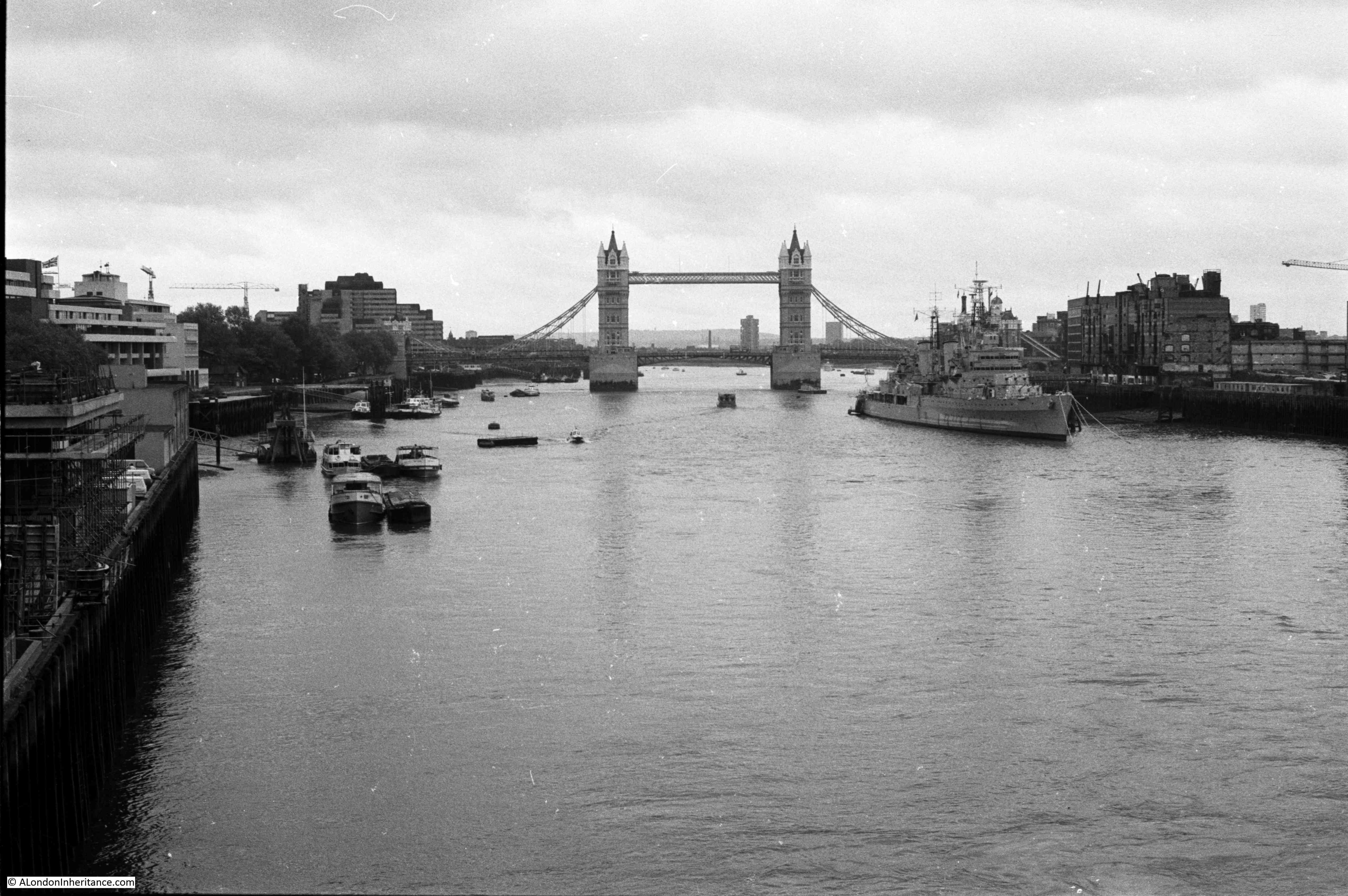
Back to the view of the river between London and Tower Bridges, and another view of the wharves along the river, and the ships that used these wharves is shown in the following photo which my father took from the open space outside the Tower of London.
When my father took the above photo and the photo at the top of the post, the wharves along this part of the river were really busy. Cranes lined the river and ships loaded and unloaded their cargo at this stretch of wharves which were then nearly all owned by Hay’s Wharf Ltd.
The introduction to the 1953 edition of Commercial Motor’s London Wharves and Docks gives an impression of how trade on the river was increasing:
“Commercial activity on the River Thames has increased considerably in the post-war years, due in large part to British Industry’s successful efforts to expand its export trade with world markets. Arising out of this intensified traffic in the industrial reaches of the Thames has come the need for an up to date, comprehensive guide to the many wharves and docks which line the banks of the River from Teddington to Gravesend”.
Despite the post-war increase in trade on the river, the wharves between London and Tower Bridges would not have too many years left. The increasing size of cargo ships and containerisation meant that inner London docks quickly became unsuitable for the type of shipping and new methods of moving cargo.
To show how quickly river trade changed, 26 years after the above description of increased activity on the river, I took the following photo in 1979, looking along the river from London Bridge:

The cranes lining the river have gone, some of the warehouses were still being used for storage, but the majority were derelict. The space where the cranes once moved cargo between ship and warehouse was then used for parking space.
Another photo from 1979 looking down the river. A few of the remaining cranes can be seen just to the right of HMS Belfast. These would have been on Mark Brown’s and Tower Bridge Wharves.
I took a couple of “now” photos in August 2020 to mirror my 1979 photos, and the following photo shows the redevelopment of the Southwark side of the river. Part of Hay’s Wharf remains, but the rest of the area has been transformed.
A riverside walk now runs where cranes once transferred goods between ship and warehouse, and where cars parked in 1979.
The following photo is an August 2020 view of my second 1979 photo and shows the redevelopment at the Southwark end of Tower Bridge, with the Mayor of London’s City Hall.
So what occupies the location of Topping’s Wharf today? The whole Southwark stretch of the river between London and Tower Bridges was marked for development in the 1980s, and by 1986 “Number 1 London” had been constructed. A two part building complex with a 13 storey tower adjacent to London Bridge and a smaller 10 storey section on the site of Topping’s Wharf.
In the following photo, taken from the top of the Shard, London Bridge is on the left. The two buildings of Number 1 London are of similar design and materials and can be seen to the right of the bridge, directly on the river. The smaller of the two buildings is where Topping’s Wharf was located.
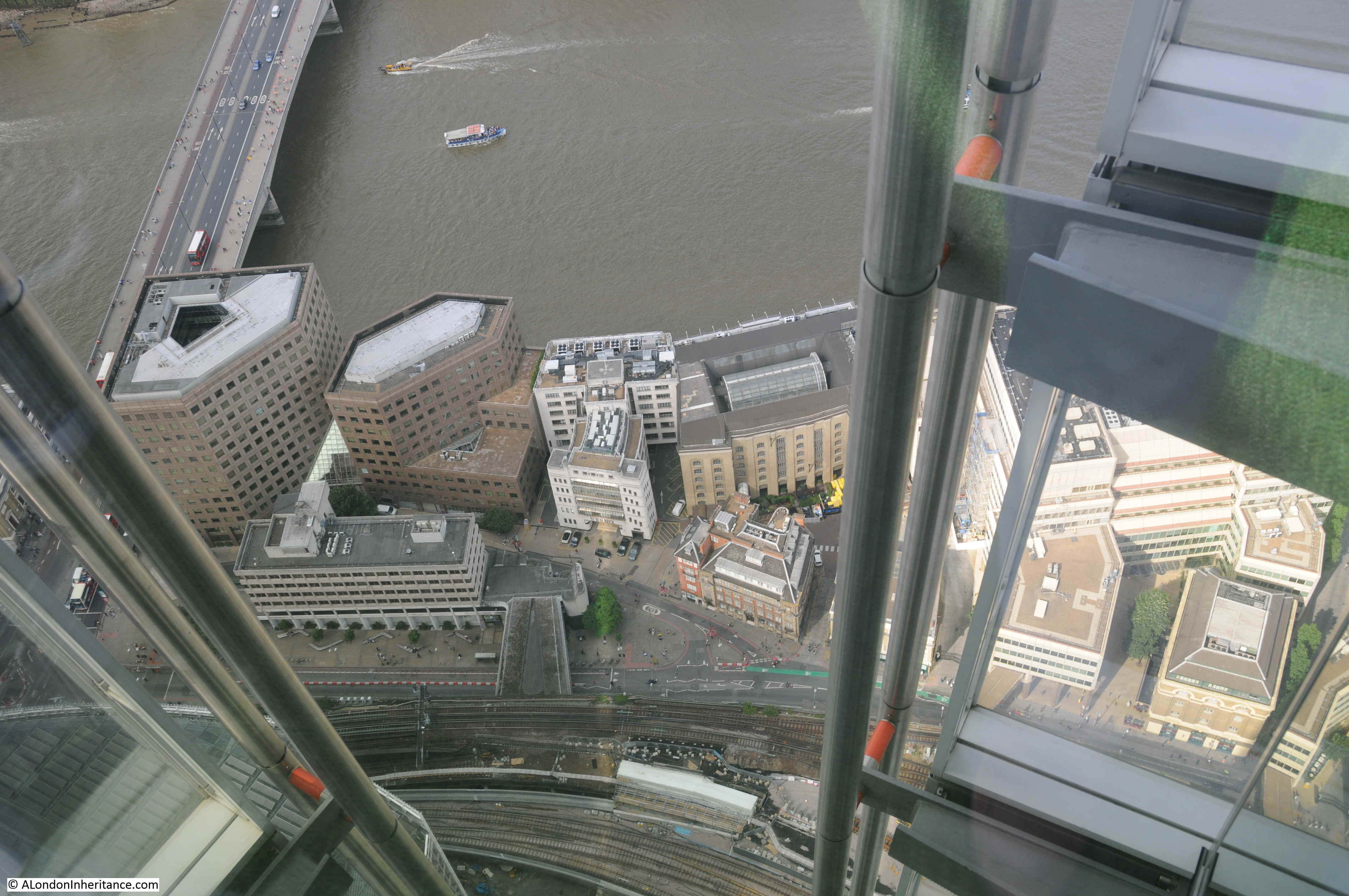
A view of the location from the river. Topping’s Wharf was located where part of the glass canopy and the building to the left of the canopy now stand.
In my father’s 1948 photo at the top of the post there are a line of identical cranes between the warehouses and river. These are the 240 cwt. or hundredweight (approximately 12,192 kg) cranes listed in the Commercial Motor specifications for each wharf.
The most newsworthy appearance of the cranes was during the funeral of Winston Churchill in 1965. His coffin was carried along this stretch of the Thames, and the cranes bowed in turn as the boat carrying his coffin passed. This can be seen in a British Pathé film of the funeral, which can be found here – the cranes can be seen starting at 9 minutes.
If you want to see part of the street that ran behind the warehouses at the Tower Bridge end of the river, then see my post on the Lost Warehouses of Pickle Herring Street.
There is far more to discover along this stretch of the river. The 300 year history of Hay’s Wharf and the lost church of St. Olave are just two examples. These will have to wait for future posts.
Two words: Just wonderful.
I especially enjoyed the detail in the 1843 fire print, and felt moved by the cranes bowing to Churchill; what a lovely gesture. A great post – thank you.
I lived in Wapping for several years, just before the redevelopment. I used to walk along Wapping High St,
through St Katherines Dock, and the Tower of London, to get to my employment at Three Quays, Lower Thames St; this office building now long gone and redeveloped. If you look at the first of your 1979 photos of the river frontage, on the extreme left of the picture, you can see half of the Three Quays building. We had a panoramic view from the office windows, with a superb vista of the entire Pool of London, right opposite the HMS Belfast.
On the far left of your second ’79 photo the finishing touches are being put on Magnus House by R. Seifert & Partners, 1973-81. It was built as a hotel but never used as such (note the porte cochere, vast upper-level terrace, presumably intended for open-air dining and one of the hidden spaces in London) and balconies further up the tower. It was one of the last such buildings to be put up as the government was withdrawing its funding for hotels, intended to get foreign money into the city after the war.
Memories of watching Churchill`s funeral on TV and visiting HMS Belfast in the early 1970`s.
I just love your posts. I wonder of you can help me. I have been researching my family tree since 1976. A very long time!! In 1976 my Great uncle gave me a lot of family history information. All of this has turned out to be correct so far. He told me that our family had owned Millers Wharf on the North Bank. I can see you have found quite a lot of info out on your wonderful travels. Years ago I was given a copy of an old document showing a” Miller” named on a document which doesn’t really help me so far. There does not seem to be much information about it at all on the internet and I did contact the docklands museum about it but was told I would have to visit them. I even rang the company renting Millers Wharf many years ago
Now it is an upmarket apartment conversation. Because of its location near tower bridge worth a lot of money . This is what I find on “My London Walks ”
“Millers Wharf that adjoins HMS President. Originally built in 1865 and restored in 1989, its frontage has been cleverly designed to look more like the warehouse it replaced.”
But not a lot else. Any ideas please would be hugely welcome. Thanks for reading
Take care
Rosemary Wilmot
My dad worked in Duke Street Hill in late 40’s to early 50’s. The company imported items from West Africa which came into the docks. I can remember the bales of fabrics with amazing designs. (I was only about 5 years old). The company then moved to the railway arches in Tooley Street, where they recycled cardboard boxes. (Well ahead of their time). I remember visiting him there and hearing about all the goods that came into the docks. Who remembers “Fernleaf Butter”?
Also we live near Telegraph Hill in New Cross, where there is a brilliant view of the Thames docks area.
I remember Fernleaf butter. My father, who worked for the New Zealand Dairy Board in the building at the foot of Duke Street Hill, once told me it was Anchor butter that was for some reason unpackaged and rechurned to then be sold under the Fernleaf name. I just cannot remember where Dairy Produce Packers were based in Tooley Street.
Love a bit of research and found ‘The Anchor Story’.
Not read it all yet, but it mentions Fernleaf Butter and the location of the packaging building.
I’m looking forward to learning more from you.
Hi
My father was the general manager at Tooley street Dairy Produce Packets and I also worked there for a short time. It was based where Hays galleria is now the arched entrance now is where the packing of the butter went on, Fernleaf, Anchor etc.
Hope this helps
Many thanks. It does indeed.
It was were Hays Galeria is now. The arches was where the butter was brought in off the river boats and straight into the factory DPP for testing churning packing and d as hopping. I worked there at Dairy produce Packers also my Dad
I am also trying to find out about Miller’s Warf. In an 1822 novel called Sir Andrew Wylie of that Ilk, the title character is trying to travel “from Miller’s Warf to find his way to Holborn” so I have a sense that there was a warf before the 1860s
Hello Sharon, did you ever find anything else out about Millers Wharf ??
What an absolutely fascinating read. I had never heard of semaphore being utilized at that time. Must have been very dependent on fog free days. My uncle worked in “Number One London” prior to being rebuilt in the 1980s. I recall him receiving a letter from overseas addressed simply to that address with no additions – no street or post code etc. It arrived safely with no delay.
That’s interesting. It’s address is actually “No.1 London Bridge.” The address ‘No.1 London’ is usually assigned to Apsley House at Hyde Park Corner. When the house was built in 1778, it was the first one on the north side of Piccadilly, standing next to the main turnpike or toll into central London. So it became known as ‘Number 1, London’, because it was was the first house you came to once you entered London from the west.
I am pretty sure that in the early 1980s it was known as “Number 1 London” prior to being redeveloped. Even today looking at Google there are bars etc with that name. Our administrator in this weeks marvellous read mentions “No 1 London”. Of course there is the well known place, Apsley House on Hyde Park Corner with the same name.
Thanks-most interesting as usual.
As a pupil of St Olave’s school between 1959 and 1967, I commuted into London Bridge Station and walked the length of Tooley St twice a day down to the school which was next to Tower Bridge Rd on the River side.
Since most of the wharves you mention faced the river and were accessed down little alleys, in a sense it was the backs of them that faced onto Tooley St and accordingly it was just doors and windows -‘nothing to see there’!
On the other side of Tooley street were the arches under the raised railway lines,which seemed to stretch back into miles of mystery – they were all occupied by warehouses full of mysterious smells of cheeses and vegetables and a myriad other things all of which came across the street from the wharves for easier access for vans and lorries etc.The entirety of the new London Bridge Station,-a veritable Cathedral, has been built into the space they occupied, which shows just how vast they were.
Fortunately the Shipwrights pub on that side of the road has survived and still retains all the wonderful wood and glass of a Victorian ale house. – and the beer to go with it – Adnams!
I have never seen a photo taken from opposite in Tower gardens/on Tower beach. Photographers seemed to always want to get the bridge itself in the shot. There is a great video of the cranes dipping at Churchill’s funeral at 47.55 https://www.youtube.com/watch?v=mUk_KD02E-w
Moved to London in’73 to work at the Tower Hotel when it first opened,after work used to have a drink down Wapping High Street or in the Courage Brewery”Anchor Tap”.From’76 to’80 did some freelance work on HMS Belfast(the stories I could tell),to walk down Tooley Street to London Bridge Station at midnight was pretty darned “atmospheric” ,to say the least.Also married a girl fromPoplar who worked for Tate and Lyle which was located between Billingsgate a nd The Tower of London,and lived on the Isle of Dogs for two years.Although coming from Birkenhead,I love The City and East End,great memories and happy days and thanks for your blogs.
Fascinating, as ever. I watched that film and recall, as a young child, watching the funeral on TV and the cranes. It is still very moving, with the planes roaring overhead in salute. I cannot imagine such an event happening again for a PM.
Thanks a lot, those earlier photos of the view between London and Tower bridges has solved a personal conundrum of mine: why could I never remember what was across the river from Tower of London during my childhood visits in the 1960s ? Simple… a wall of derelict wharves wouldn’t register with a little girl , just a blank.
Thanks for yet another fascinating blog. Also thanks to Peter for his descriptive comment on what the old Tooley St. looked like. Another mystery to me.
I could have written Peter Barnett’s post above : I went to St Olaves from 1959 to 1962 – (I can’t say that they were “the happiest days of my life” , very far from it) but I always enjoyed the walk along Tooley Street : seeing the dock-hands waiting outside the wharf gates to be picked for the day, the smells of all the exotic goods in the arches and so on.
I should have been embarking on a cruise from the city side of Tower Bridge in June but I cannot believe it will sail now.
Yet another really interesting post, many thanks.
Growing up by the river (Wapping) in the 50′ and 60’s these posts and especially the research behind them, give me a different perspective on the Thames and my childhood. There’s so much history there. In my mind I can still smell the spicy aroma from the old Traver’s Spice Mill site and the wine/port smell coming up through the ventilation flues of the barrel stores at St Katherine’s.
I am another one who went to St Olave’s School in Tooley St, in my case from 1965 until the School relocated to Orpington in 1968. I remember a geography “field trip” to Hays Wharf the highlight of which was a look inside a cold store where huge New Zealand cheddars were stored. Looking at your table of wharves it must have been Mark Browns although we thought of the whole stretch as Hays Wharf. We finished up on the roof of the building with superb views over the river. The port was still busy in those days, and it seemed fitting that we would sometimes sing “for those in peril on the sea” in assembly.
Quite often in the 70’s myself and a gang of neighbourhood kids would set off early from our Middlesex suburbs to go ‘up London’. With our Red Bus Rover tickets and packed lunches in hand we would slowly crawl on a no 18 routemaster bound for London Bridge Station. The thought of Tooley Street still sends a shiver down my spine, dark and dangerous, unchanged for what seemed centuries, it was ugly and creepy and the ghost of Bill Sykes never seemed far away.
The cranes remaining are I think on the roof of Symon’s Wharf – Mark Brown’s Wharf was the first to be demolished and had gone by 1971. Gun & Shot Wharf was another hold out in the middle of the Hay’s empire – owned by the Vestey’s.
A interesting read, my father would have seen all of the docks on the river when he was in the merchant navy. He loaded coal on the river Tyne at Jarrow for Battersea power station right up till 1966.
In 1964 I served on board the MV Baltic Sun, United Baltic Corporation. We sailed on a weekly service between Mark Browns Wharf and the Polish port of Gdynia. We sailed alternate Friday evening to Gdynia via the Kiel Canal, arriving on Sunday evening. sailing the following Friday evening, we arrived back at Mark Browns Wharf on the Sunday. The wharf and the Gdynia dock berth were vacant only on Friday and Saturday evenings as we alternated with a Polish Ocean Lines vessel on the route. We carried general cargo both ways and spent Monday to Friday each week having the cargo unloaded and loaded. We had a compartment for chilled cargo,which mainly held Polish Krakowska pork sausages. The Polish dockers were resentful at the export of the sausages because they are a national favorite but were almost unattainable in Communist Poland ,desperate for foreign currency for export. I recall one docker being arrested by the security police for trying to smuggle a couple of Krakowskas ashore in his jacket. Poor guy!
In 1969 I was 3rd Officer on board Ellerman Papayanni Lines Athenian .We sailed in the UK -Mediterranean ,bringing a Israeli citrus to the UK, including to New Fresh Wharf. We must have been one of the last ship trading there as most of our cargo was unloaded in the West India Dock canary wharf.
Peter Adams Master Mariner rtd
Fascinating to watch the Pathe film of Churchill’s funeral. It makes me feel terribly antiquated, to remember London as it was then!
As a kid growing up in the 70’s on the fringes of the city, we had a different reason to visit this specific part of London. In October 1977, London’s very first purpose built skate park was opened here on the site of several demolished warehouses at Symon’s Wharf – just at the top of Abbotts Lane if memory serves me. Skate City as it was known, became a hugely popular destination for kids from all over London to ride the concrete bowls at the height of the skateboarding craze. Despite its on-going popularity it closed 18 months later when the site was purchased with overseas money and along with docklands this entire part of London began to disappear for ever.
In your second photo from 1979 on the extreme right, you can just see the broken remains of the skate park under the end of the crane. On this stretch of the river only Hays Wharf survived whilst still undergoing extensive remodelling.
This part of London still holds much affection in my memories.
There is an aerial photogragh of Skate City, HMS Belfast and and Symon’s Wharf on the Getty Images website. In the photograph South Thames Wharf and Gun & Shot Wharf have already been demolished
https://www.gettyimages.co.uk/detail/news-photo/hays-wharf-in-london-with-the-skate-city-skateboarding-park-news-photo/1262959278
It was later revealed that the crane operators only agreed to lower their booms if they were paid, as the funeral was on a Saturday. The dockers’ union had not been on friendly terms with Churchill when in power.
Thanks again for another wonderfully researched and written piece – a great read!
It prompted me to try and locate the map source – The Commercial Motor’s 1953 edition of London Wharves and Docks, but without luck on Amazon or elsewhere so far. As a resident of an old Wapping wharf I’m interested in the old Wharves between St Katherine Docks and Limehouse Basin. Do you have suggestions for where I should look for a copy of the book?
Kind regards
Roy
Have you tried: https://www.amazon.co.uk/London-Wharves-Published-association-Commercial/dp/B0014LDK60
Hello Trevor,
I have tried that route thanks but it is ‘currently unavailable’ and I haven’t found an alternative as yet.
Thanks
Roy
Roy, my usual source for old books is Abebooks but they do not have a copy. If you are interested in the section between Wapping and St Katherine, I can scan and e-mail the pages to you.
That would be incredibly kind and generous of you if you have the time to help in that way.
Thank you
Roy
I now see that the Amazon offering is no longer available but there’s a similar publication here, although somewhat older – https://www.abebooks.co.uk/servlet/BookDetailsPL?bi=30838464778&searchurl=kn%3Dlondon%2Bwharves%2Bdocks%26sortby%3D17&cm_sp=snippet-_-srp5-_-title17
Great read would have loved to see the docks in there hey day.
I am also trying to find out about Miller’s Warf. In an 1822 novel called Sir Andrew Wylie of that Ilk, the title character is trying to travel “from Miller’s Warf to find his way to Holborn” so I have a sense that there was a warf before the 1860s