Tag Archives: Southwark

Winchester Palace and the Great Hall, Clink Street

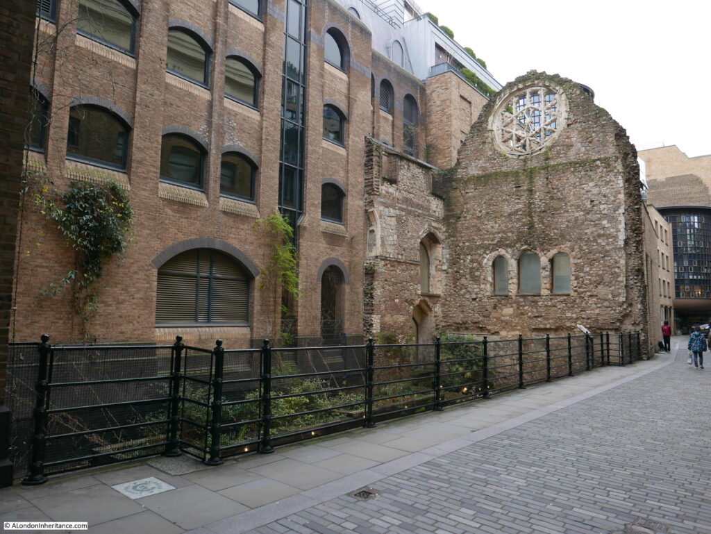
Clink Street in Southwark is close to Southwark Cathedral and Borough Market, and the street is part of the busy walk along the south of the river. Converted warehouses line the river side of Clink Street, but on one part of the southern side of the street, a remarkable survivor, the Great Hall of Winchester Palace can be seen; the Southwark residence of the Bishops of Winchester.
Winchester Palace

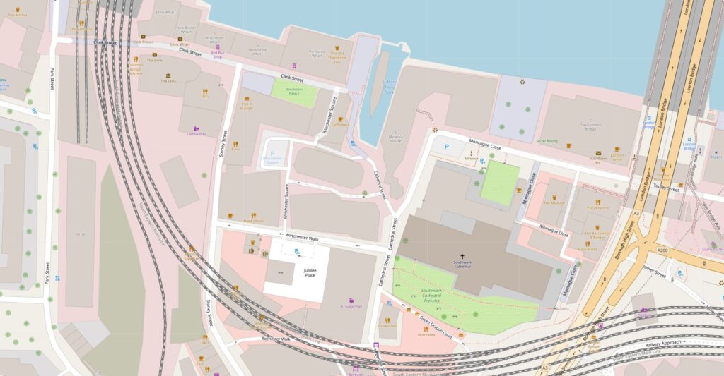
The following map extract shows the location – the green rectangle towards the middle, top of the map is the part of the palace that can be seen alongside Clink Street (Map © OpenStreetMap contributors).
Winchester Palace

The first evidence of a palace for the Bishops of Winchester dates back to the 12th century, with an eastern boundary wall, and some building of stone construction.

The 13th century saw the expansion of the palace estate with some major construction work. This work included a number of two storey blocks, a hall, chapel and courtyard. Work also included improvements to the wharf along the River Thames.

The 13th century also included the surfaced road that would become Clink Street, with the name Clink Street being in use by the start of the 17th century.

One of the earliest references to Winchester House (as it was also known) comes from the life of St. Thomas à Becket by William FitzStephen, who wrote that Archbishop Thomas received hospitality at the house of the Bishops of Winchester before making his final journey to Canterbury where he would meet his death.

The Bishops needed a London residence, not just for their religious duties. At the time there was not that much separation between religion and government, and the Bishops of Winchester also frequently held some of the great Offices of State.

The Palace was also frequently used for entertaining, and hosted events for the rich and powerful of the land. For example, in 1424 the wedding feast of James, King of Scotland, and Joan, daughter of the Earl of Somerset was held at the palace.

The palace appears to have been in possesion of the Bishops of Winchester through to the mid 17th century, when it was turned into a prison for Royalists during the Civil War. In 1649 it was sold for £4,380 to a Thomas Walker of Camberwell, but after the restoration of the monarchy, the palace estate was returned to the Bishops of Winchester.

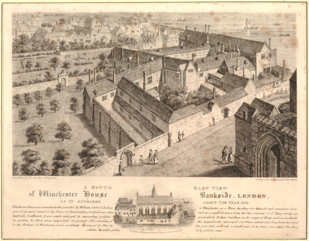
It was during the 1640s that a parliamentary survey of the palace was carried out, and around 1647 the artist Wenceslaus Hollar completed a drawing of the Palace, or Winchester House, the words Palace and House are frequently used in reference to the Bishops of Winchester residence  (Prints in this post are ©Trustees of the British Museum):
Winchester Palace

Hollar’s drawing shows an extensive range of buildings alongside the river. The Great Hall is to the right, with the rest of the buildings housing accommodation blocks, storage, kitchens, a chapel and stables. There were also extensive grounds to the palace.

The text below the above print provides some detail about Winchester House: “Winchester House founded in the year 1107 by William Gifford Bishop of Winchester as a Town dwelling for himself and successors on a piece of ground rented of the Priors of Bermondsey and which was situated at a small distance from the fine convent of St Mary Overy on Bankside Southwark. It was much enlarged by Succeeding prelates particularly Bishop Gardiner, in the reign of Mary and covered with its gardens &c. three acres and a half of ground”.

The small drawing at the bottom of the print shows the Great Hall, and it is the remains of this building that we can see alongside Clink Street today.

Although the palace was restored to the Bishops of Winchester on the restoration of Charles II, it was not really used again as their London residence. They now also had a property in Chelsea, provided to them by a 1661 Act of Parliament. Perhaps the location of their palace was not as pleasant for the bishops due to the growing population, the location of industry, entertainments and markets that were not allowed in the City of London, displaced to the south side of the river, and around the bishops palace.

The buildings of the palace were now let out to a large number of tenants and sub-tenants.

The bishops cannot have been too morally fussy in previous centuries, as the local area of Southwark and Bankside had a history of prostitution long before the Bishops left their palace in the 17th century, and they had a role in the governance, and profited from the brothels or “stews” that were found in the area. These had been banned in the City of London, so their south bank location, close to London Bridge was an ideal place to relocate.

The bishops let out buildings to be used as brothels and were also responsible for managing the “Ordinances Touching the Government of the Stewholders in Southwark under the Direction of the Bishop of Winchester” set out in the 15th century.

These ordinances dictate 36 specific rules and the fines associated with breaking these rules, for example:

  • Number 6: Owners of a stew (stewholder) could not lend a sex worker more then 6s 8d (this was done to prevent a stewholder from having too much control over a sex worker)
  • Number 9: a sex worker who paid the rent of 14d must be allowed to come and go at will. The owner of the stew must not interfere
  • Number 15: a fine of 40s if a stewholder’s wife solicited at a stew

Perhaps the most serious was for any sex worker who established a relationship with their procurer or what we would now call a pimp. For this they would be fined, they would also suffer a dunking on the cucking stool, possible imprisonment, and would also be banished from the borough.

Stewholders were also banned from selling food, drink and fuel from their premises.

The Bishops of Winchester profited from the rents from the buildings occupied by the stews and from the fines generated by any transgression of the rules. They were also expected to ensure the rules were adhered to, and manage law and order in the area.

The association of the Southwark stews with the Bishops of Winchester was such that the sex-workers in the stews became known as Winchester Birds or Winchester Geese.

The Bishops of Winchester probably made a considerable sum from the rents and fines, and it would be interesting to know if as supposedly religious men, they had a moral conflict with making money from women involved in sex work.

If they did feel any moral responsibility, it did not extend to the treatment of these women after death who were buried in unhallowed burial grounds, many at the nearby Cross Bones burial ground, today on the corner of Redcross Way and Union Street.

The Southwark stews were closed in 1546 when Henry VIII banned them.

During the late 17th and 18th centuries, the land occupied by Winchester Palace was further broken up and sold. Warehouses and docks now occupied the area as trade along the river expanded, and walls that remained from some of the old palace buildings were included in the new structures that grew up along the river and Clink Street.

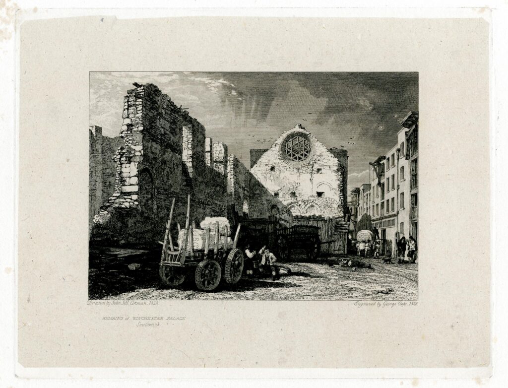
As was common in the 19th century, in 1814 a large fire destroyed a number of buildings in Clink Street, but whilst the fire appears to have destroyed later building, it did reveal part of the old Great Hall of Winchester Palace, and the following print from 1828 shows the remains of the Great Hall exposed after the fire, looking very much the same as they appear today.
Winchester Palace

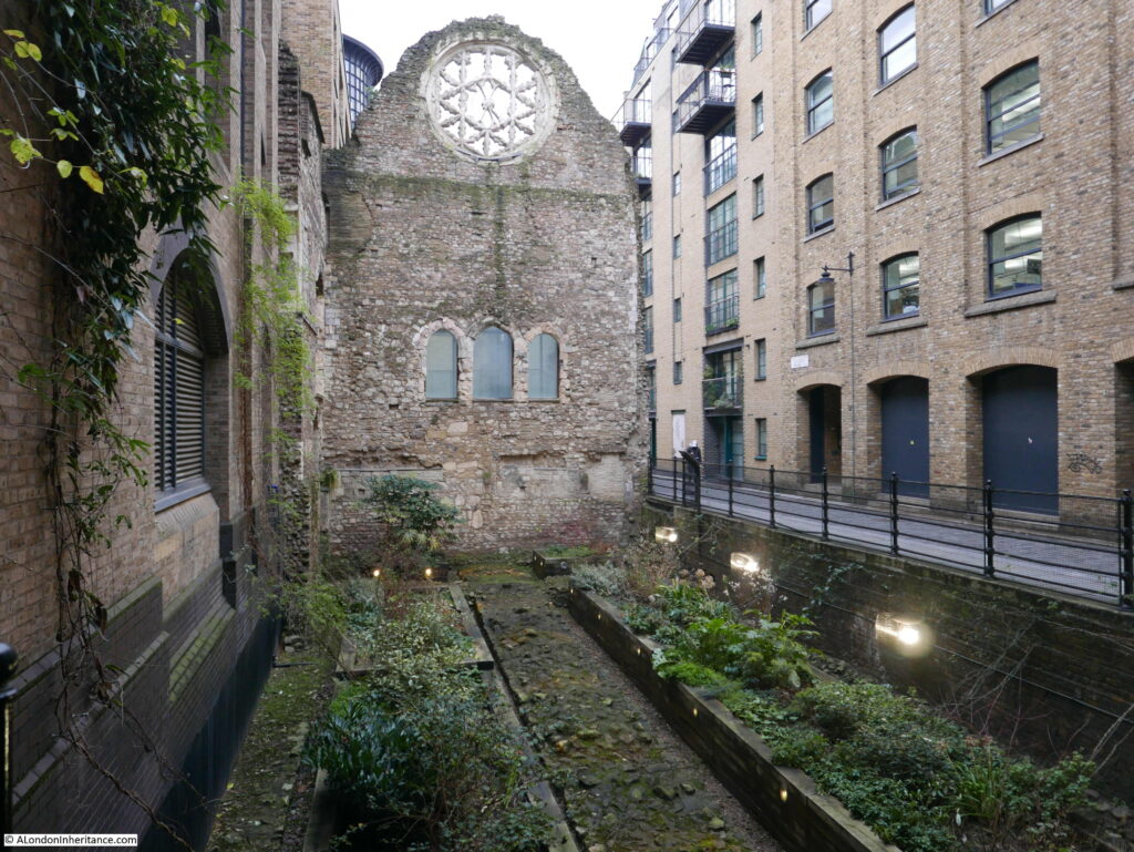
The following photo shows again the west wall of the Great Hall and Clink Street alongside. The three openings that look to be windows were doors from the first floor of the Great Hall to the kitchens on the other side. The space below was occupied by an undercroft or cellar.
Winchester Palace

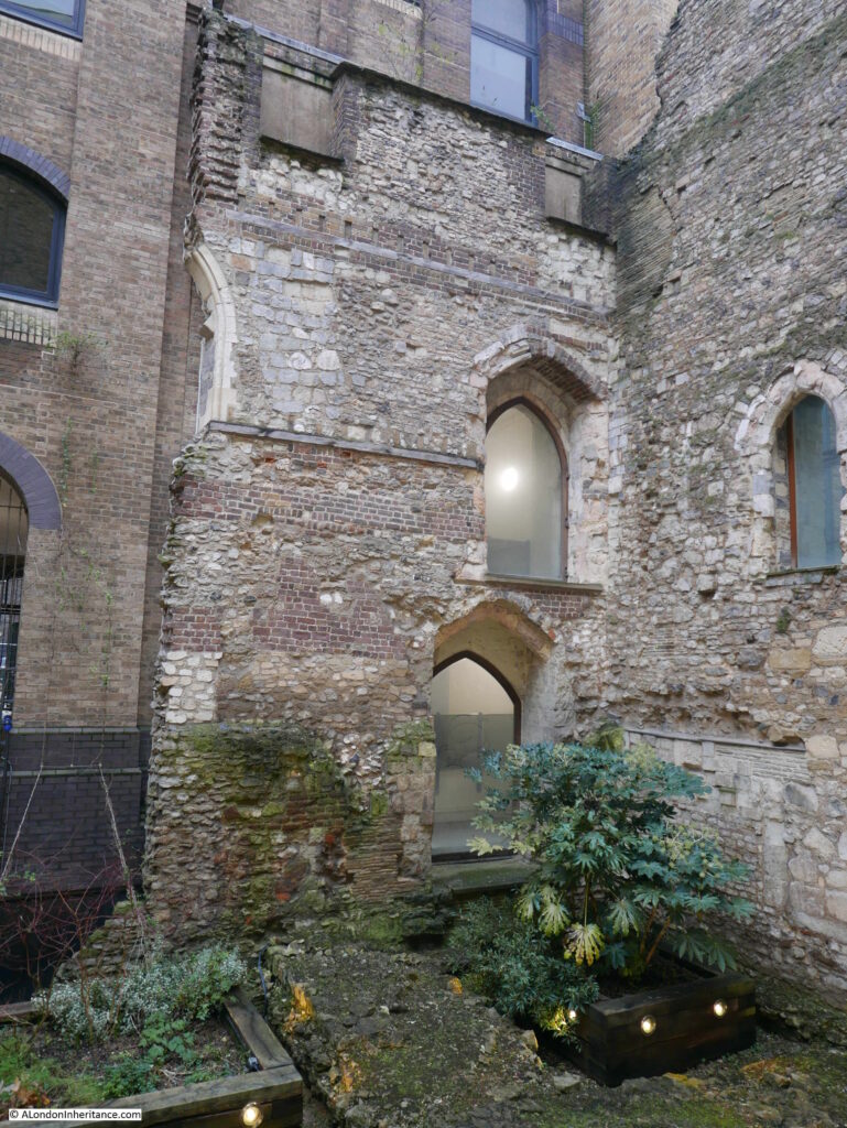
A small part of the southern wall of the Great Hall remains, up against the west wall. A ground floor door below with a first floor doorway above:
Winchester Palace

In the years after the 1814 fire, warehouse space along this part of river was in short supply, so it would not be long until a new warehouse was constructed over the site of the Great Hall, however, the approach of minimising costs by including any existing stone or brick structures into a new build continued, and the west wall and rose window of the Great Hall were included in the new warehouses.

There was some damage to warehouses in the area during the last war, however this does not appear to include the two warehouses that had been built either side of the west wall. In 1943 a Mr. Sidney Toy, of the Surrey Archaeological Society removed the brickwork on the seperating wall on the 3rd and 4th floor of the warehouses, and found the rose window, still showing blackened markings from the 1814 fire and with parts missing, and used in other parts of the structure.

There have been a number of early excavations of the palace, such as a 1962 excavation on the site where a new warehouse was planned. The major excavation of the site of Winchester Palace took place during 1983 and 1984. These excavations revealed a considerable amount of evidence of the original palace, including parts of the eastern range of the early 13th century building which were found under the current location of the Cafe Nero, on the corner of Palace House.

The following photo shows the other side of the west wall. The majority of the wall has been covered over by a glass frame that appears to be part of the new building to the right. The edge of a Pret coffee shop can be seen to the right.
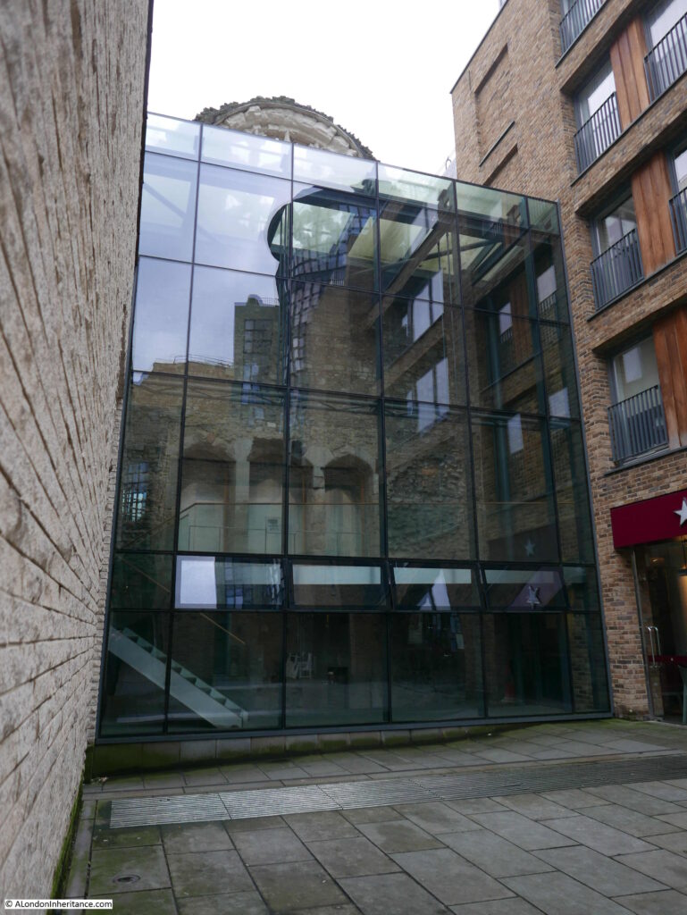
Winchester Palace

In the above view we can again see the three doors that led through to the kitchens that would have occupied this space.

The following print from 1815 shows the same side of the wall as in the above photo. The print was a year after the 1814 fire.
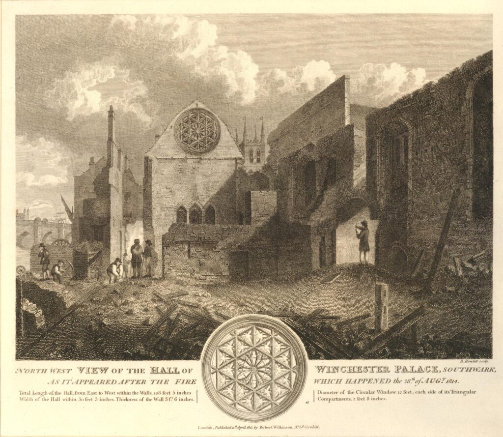
Winchester Palace

Behind the wall we can see the tower of St Mary Overy (today Southwark Cathedral), and on the left is London Bridge. The text at the bottom of the print provides some details as to the size of the Great Hall:

  • Total length of the Hall from East to West within the Walls, 108 feet, 5 inches
  • Width of the Hall within, 30 feet 3 inches
  • Thickness of the Wall, 3 ft, 6 inches
  • Diameter of the Circular Window, 12 feet
  • Each side of the Triangular Compartments (of the window) 2 feet 8 inches

The following print is dated 1812, so before the fire of 1814.
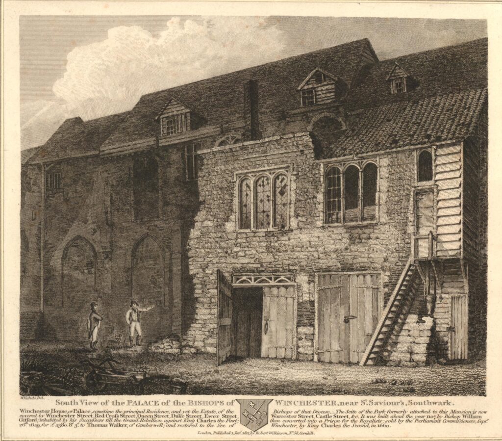
Winchester Palace

The print shows the south view of the Palace of the Bishops of Winchester. It is not clear whether it is a view of the Great Hall, however it does show the state of the buildings just over 150 years after the Bishops of Winchester had left their palace, and the buildings had been sold and let to multiple new owners and tenants.

It is interesting to compare the above view, with the following view of the same building on the right of the above print. This print is dated 1800, so just 12 years before the above print.
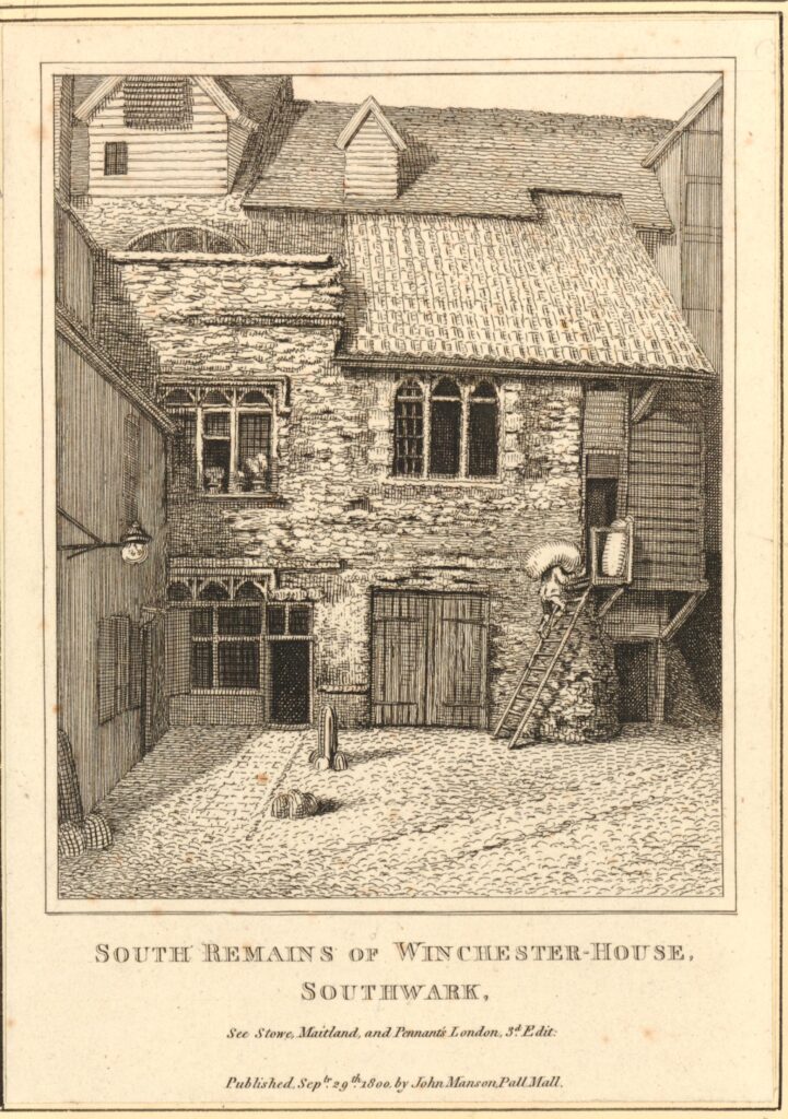
Winchester Palace

Given the age of the west wall of the Great Hall, and the amount of rebuilding over the centuries, it is a remarkable survivor from the original Winchester Palace.

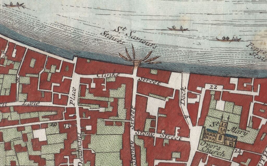
The following map extract is from a map of the Parish of St. Saviours Southwark by Richard Blome (late 17th century but published by John Stow in 1720). Clink Street is in the centre of the map, and the location of the Great Hall is under the word Street.
Winchester Palace

There is no mention of the palace that was once of considerable importance, so perhaps by the time of the above map, it was just another part of the buildings that lined the streets of the area. The white space in the centre of the block bordered by Clink Street and Stony Street is probably one of the old courtyards of the palace, possibly the space in front of the buildings in the above two prints from 1800 and 1812.

The palace occupied a far larger area than the remains of the Great Hall we see today. The Museum of London Archaeology Service published a richly detailed report in 2006 (Monograph 31) covering the history of the palace and focusing on the excavations of 1984 and 1985 and the finds discovered under the new and redeveloped buildings that occupy so much of this area.

The wall of the Great Hall has survived for so long because it was included in the structure of later buildings. This is how a number of other very old structures have survived in London, for example the Roman and Medieval bastions at Cripplegate and much of the Roman wall.

When we rebuild today, the approach seems to be a complete demolition of the previous building, including all the foundations and basements. It is interesting to consider how much 20th and early 21st century architecture will remain to be discovered in whatever form London takes in the future.

When the weather improves, and we can go out walking, sit outside the Pret with a tea and sandwich, in what was the kitchen of the Great Hall, and imagine the feasts that were prepared here and taken through the doors into the hall.

alondoninheritance.com

Topping’s Wharf and the Wharves between London and Tower Bridges

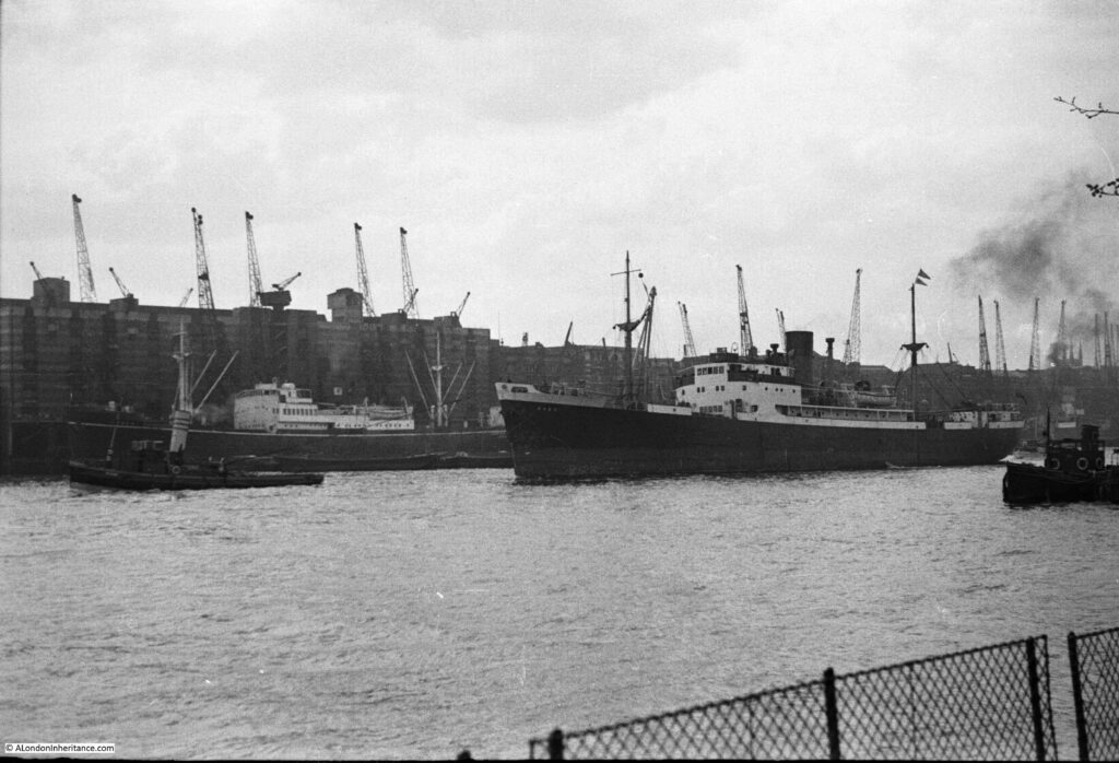
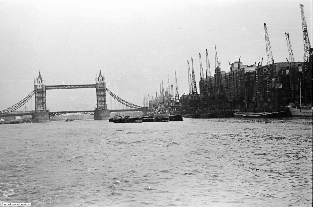
In August 1948, my father was on a boat sailing from Westminster to Greenwich, taking photos along the route. The following photo is after having just passed under London Bridge, looking down towards Tower Bridge, with the cranes and warehouses of the wharves that line the river opposite the City of London.

Topping's Wharf

The Southwark side of the river between London Bridge and Tower Bridge was very different to the City side of the river. The Southwark side was full of wharves, warehouses, cranes and moored ships and barges.

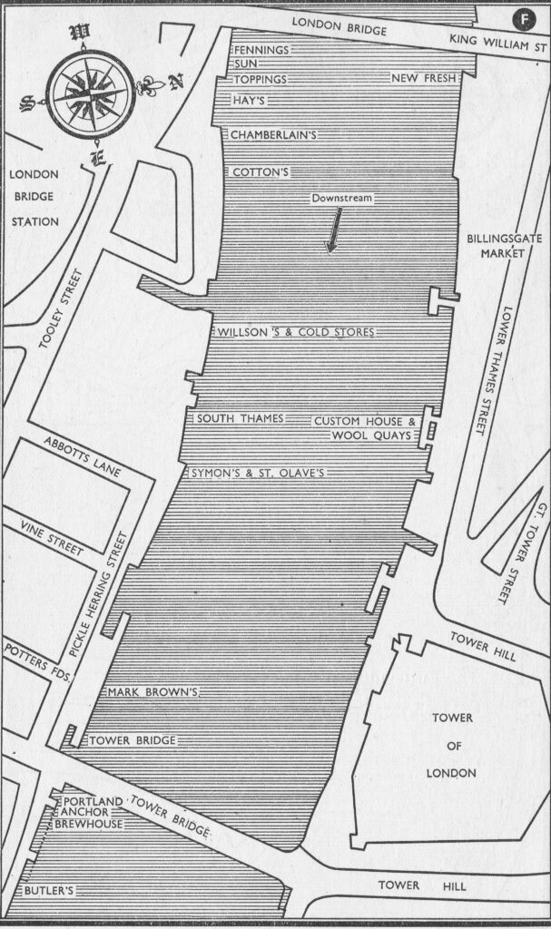
The City had Billingsgate Market, the Customs House, New Fresh Wharf and the Tower of London. The difference between the two sides of the river can be seen in the following map from Commercial Motor’s 1953 edition of London Wharves and Docks:

Topping's Wharf

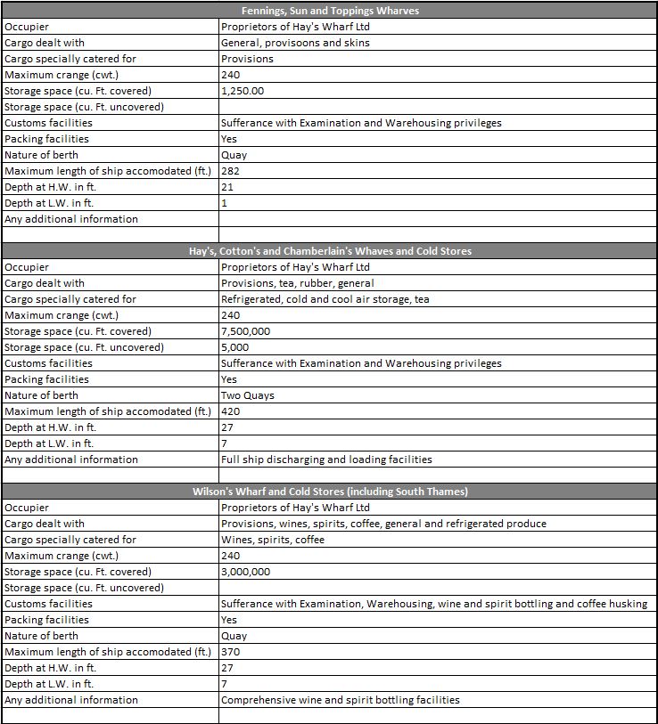
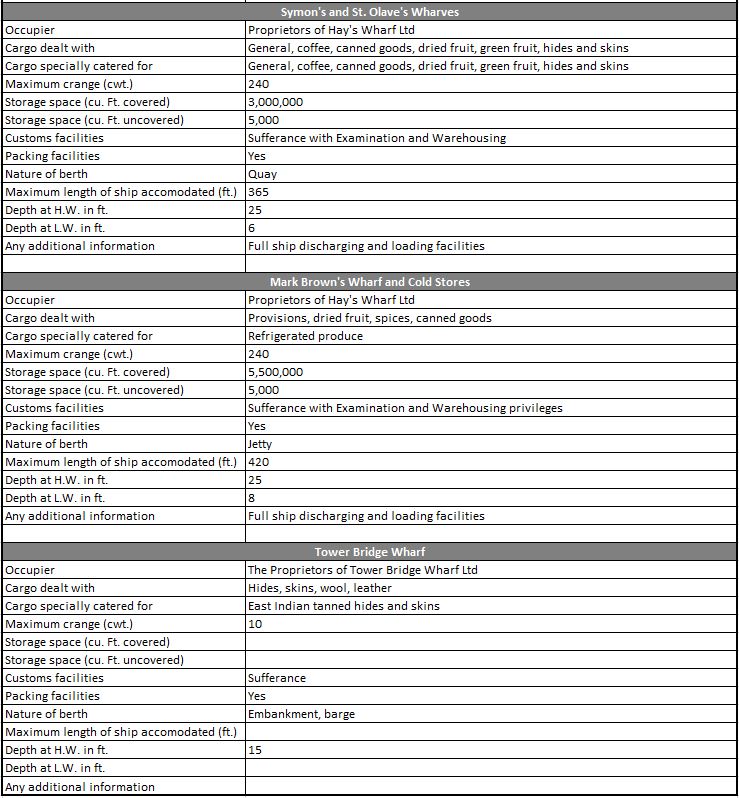
This fascinating book lists all the wharves and docks between Teddington and Tilbury, and provides details of the trade that they handled and their facilities. The following tables cover the Southwark wharves between London and Tower Bridges:

Topping's Wharf

Topping's Wharf

There was a remarkable 20,250,000 cubic feet of storage space within the warehouses along this relatively short stretch of the river, and there was a wide range of goods being stored. Chances are that if in 1953 you were drinking your morning cup of coffee, it would have been imported through one of these wharves.

By 1953, all except the Tower Bridge Wharf were owned by Hay’s Wharf Ltd, a business that had been expanding rapidly, and a name that can still be found in this transformed stretch of the river.

Many of these wharves had been in existence for hundreds of years, and they would have had individual owners with the name often reflecting the original owner / builder of the wharf.

There is so much history associated with each wharf, and they can demonstrate how trade was conducted, and what life was like in this part of London. Close to London Bridge in the above map is Topping’s Wharf, and I have taken this single wharf to see what can be found of its history.

The first reference I could find of Topping’s Wharf was an advert in the Newcastle Courant on the 17th December 1774 where the new owners are setting up a cargo route between London and Newcastle and advertising Topping’s Wharf as a safe and insured site for goods to be stored:

“To the MERCHANTS, TRADERS and SHIPPERS of GOODS to and from London and Newcastle. We take this opportunity of acquainting you, that having lately taken a new, commodious, and convenient Wharf, situate in Tooley-street, Southwark, and adjoining to London bridge, known by the name of Topping’s Wharf, where there are exceeding good warehouses for lodging and securing goods from damage by weather, and where vessels of 300 tons burthen or upwards may load by cranes, which will be a considerable saving of expense and risk, incurred by the present method of shipping, by lighters from above bridge. The goods will be lodged in warehouses, upon which an insurance of £4000 from fire will be made till shipped and the policy deposited at the Bank of Newcastle. A set of good accustomed vessels are engaged, one of which will sail every week. We therefore solicit your favours, and assure you, that the greatest care will be taken to ship your goods with regularity and dispatch, by Your humble servants, CHINERY, RUDD and JOHNSON, London, December 9th 1774”.

These newspaper adverts and reports are interesting because they shed some light on how trade was conducted in the 18th century. They also mention fire insurance as a key feature of Topping’s Wharf, and from later events we can see why.

Warehouses held large volumes of highly flammable materials, and fires in London’s warehouses were very frequent, with often significant destruction of buildings, the goods stored in the warehouse and ships moored alongside.

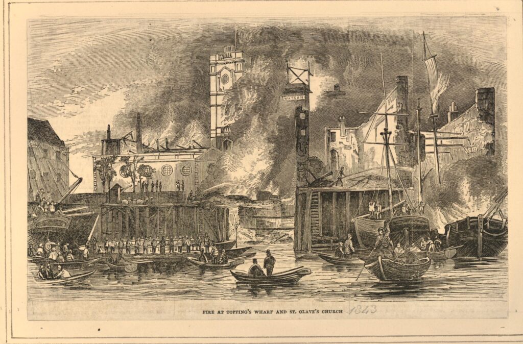
I have already written about one fire in the area, called at the time the “Great Fire at London Bridge” in 1861. There had already been another major fire eighteen years earlier in 1843. This fire had destroyed Topping’s Wharf, as reported in the Globe on Saturday, August 19th, 1843:

“TERRIFIC FIRE THIS MORNING – Never since the too well remembered fire at the Royal Exchange in 1838, has it fallen to our lot to record a more terrific one than that which took place this morning at an early hour, at the premises known as Topping’s Wharf, situate on the east side of London bridge, near Fenning’s Wharf, which it will be recollected was destroyed by a similar calamity in 1836.

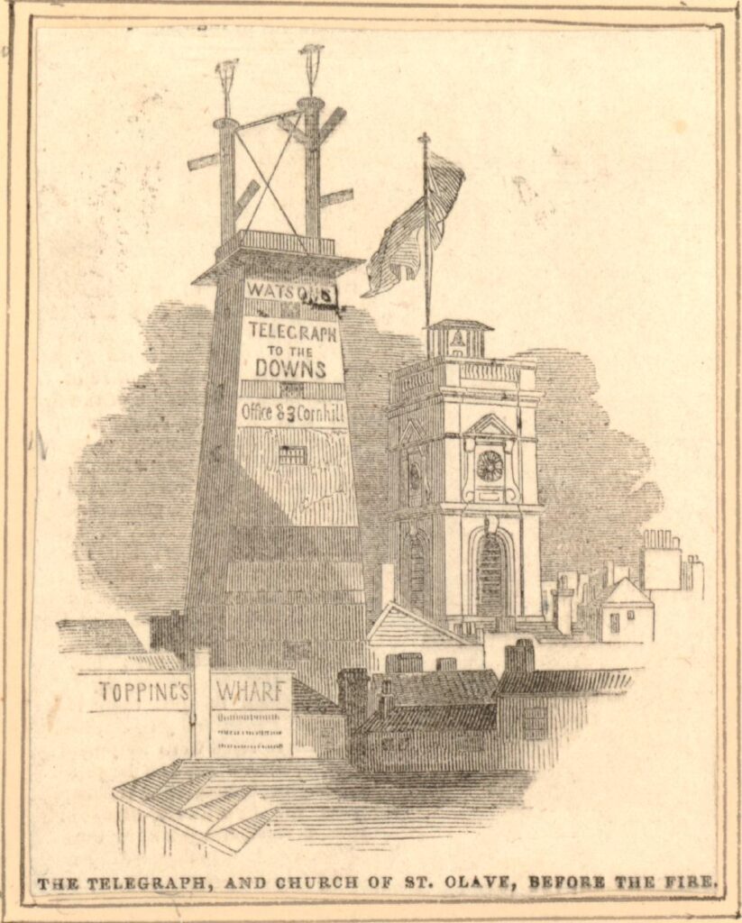
In magnitude it exceeded the above-named disaster, or any other that has occurred on the banks of the River Thames for many years past; for, in addition, we regret to say that Watson’s Telegraph, formerly a shot tower, the large turpentine and oil stores of Messrs. Ward and Co, in Tooley-street, and St Olave’s Church, all fell a sacrifice to the devouring element, besides doing extensive damage to a tier of shipping moored alongside Topping’s Wharf”.

The fire had started just before two in the morning and was spotted by a Police Constable. The Fire Brigade was soon on the scene, led by the superintendent of the brigade, Mr. James Braidwood (who would be killed in the fire in Tooley Street eighteen years later).

By four in the morning, St Olave’s Church, just behind Topping’s Wharf was on fire and the Globe reported that “there appeared very little chance of any of that ancient building being saved”.

The following print shows the 1843 fire at Topping’s Wharf  (©Trustees of the British Museum):

Topping's Wharf

The report in the Globe newspaper mentioned Watson’s Telegraph, and in the above print, just to the right of the church tower you can see the word Watson. I knew about Watson’s Telegraph, but did not know that the central London telegraph was based by St Olave’s Church and Topping’s Wharf, just to the east of the southern end of London Bridge.

The British Museum has a print of Watson’s Telegraph before the fire, with St Olave’s Church to the right, and Topping’s Wharf to the lower left  (©Trustees of the British Museum).

Topping's Wharf

Watson’s Telegraph was the creation of a Mr. Watson of Cornhill. The purpose of the system was to rapidly pass messages to and from the coast and key ports. It was important to traders and ship owners in the City to know when their ship and cargo were getting close, or events such as a tragedy at sea.

Watson’s Telegraph system comprised of a number of towers with a semaphore signaling system on top. These were located at strategic points to allow a message to be passed along a chain of stations to the required destination. Each telegraph station needed to be able to see the telegraph stations on either side in the chain.  For example, to pass a message between the City and Deal in Kent, the telegraph chain consisted of: “London-bridge; the second at Forest-hill; the third at Knockholt; and others at Wrotham-hill, Bluebell-hill, and three or four elevated spots between there and Deal”.

An article in the Illustrated London News provided the above list of locations, and I love the introduction to the article which paints a futuristic view of communications:

“In this miraculous age of improvements and discoveries when ‘the annihilation of time and space’ is no longer regarded as an idle chimera of the brain, it might hardly be considered necessary to occupy our space with a detail of the various schemes that have been adopted and put in operation to facilitate this most paramount and prevailing desire. So many of our readers must be naturally unconversant with those experiments in arts and science which the ‘great metropolis’ is continually eliciting, that we feel it a duty which we owe to our friends and supporters at a distance, to place before them those objects of interest and real usefulness in which the metropolis abounds, and which are only known to them by name”.

As well as the telegraph stations, a key part of the system was a Telegraphic Dictionary which was kept at each station and contained “several thousand words, names, phrases and directions, such as are likely to be most useful and required, and names of vessels, places, and certain nautical terms which have been selected with great care, as may best suit the object in view”.

The message entries in the dictionary have an associated unique number and the positions of the arms on the semaphore corresponded to different numbers, thereby allowing the position of the arms to send a message from the telegraphic dictionary.

The system was created in 1842. It is remarkable to think that 179 years later, on the evening before writing this post, I was watching a live stream over the Internet from the US of the Perseverance rover landing on Mars, with photos of the surface coming minutes after landing. How communications technology has changed in less than 200 years. I suspect the readers of the Illustrated London News in 1842, could not have imagined this new ‘the annihilation of time and space’.

It is difficult to track the ownership of Topping’s Wharf over the centuries of its existence. It seems to have been owned by Magdalen College, Oxford for some time, as in the Globe on the 28th October 1907, there is a record that: “the leasehold of Topping’s Wharf, Tooley-street, London-bridge, which Messrs. Jones, Lang, and Co. are to offer by the instructions of Magdalen College, Oxford”.  There was also a description of Topping’s Wharf:

“The premises, which comprise ground floor, basement, and three large upper warehouse floors are supplied with loopholes to each floor, with hydraulic lifts, and cranes, back and front, and have recently been fitted with a London County Council staircase”.

I cannot find who took the lease in the 1907 auction, but in 1912 Topping’s Wharf was let to Nestle and the Anglo Swiss Condensed Milk Company.  Hay’s Wharf Ltd seem to have taken on Topping’s Wharf in the 1920s.

Back to the view of the river between London and Tower Bridges, and another view of the wharves along the river, and the ships that used these wharves is shown in the following photo which my father took from the open space outside the Tower of London.

Topping's Wharf

When my father took the above photo and the photo at the top of the post, the wharves along this part of the river were really busy. Cranes lined the river and ships loaded and unloaded their cargo at this stretch of wharves which were then nearly all owned by Hay’s Wharf Ltd.

The introduction to the 1953 edition of Commercial Motor’s London Wharves and Docks gives an impression of how trade on the river was increasing:

“Commercial activity on the River Thames has increased considerably in the post-war years, due in large part to British Industry’s successful efforts to expand its export trade with world markets. Arising out of this intensified traffic in the industrial reaches of the Thames has come the need for an up to date, comprehensive guide to the many wharves and docks which line the banks of the River from Teddington to Gravesend”.

Despite the post-war increase in trade on the river, the wharves between London and Tower Bridges would not have too many years left. The increasing size of cargo ships and containerisation meant that inner London docks quickly became unsuitable for the type of shipping and new methods of moving cargo.

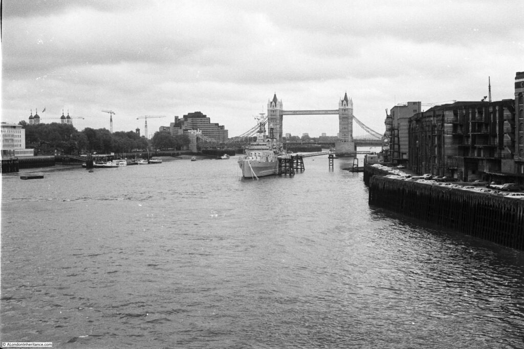
To show how quickly river trade changed, 26 years after the above description of increased activity on the river, I took the following photo in 1979, looking along the river from London Bridge:

Topping's Wharf

The cranes lining the river have gone, some of the warehouses were still being used for storage, but the majority were derelict. The space where the cranes once moved cargo between ship and warehouse was then used for parking space.

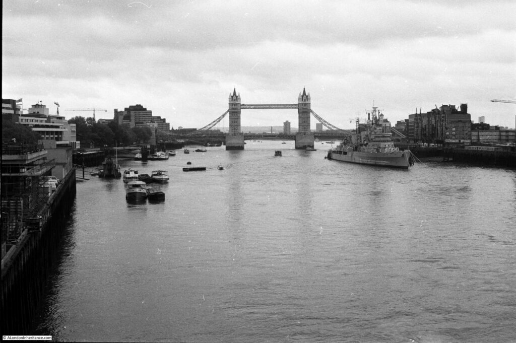
Another photo from 1979 looking down the river. A few of the remaining cranes can be seen just to the right of HMS Belfast. These would have been on Mark Brown’s and Tower Bridge Wharves.

Topping's Wharf

I took a couple of “now” photos in August 2020 to mirror my 1979 photos, and the following photo shows the redevelopment of the Southwark side of the river. Part of Hay’s Wharf remains, but the rest of the area has been transformed.

Topping's Wharf

A riverside walk now runs where cranes once transferred goods between ship and warehouse, and where cars parked in 1979.

The following photo is an August 2020 view of my second 1979 photo and shows the redevelopment at the Southwark end of Tower Bridge, with the Mayor of London’s City Hall.
Topping's Wharf

So what occupies the location of Topping’s Wharf today? The whole Southwark stretch of the river between London and Tower Bridges was marked for development in the 1980s, and by 1986 “Number 1 London” had been constructed. A two part building complex with a 13 storey tower adjacent to London Bridge and a smaller 10 storey section on the site of Topping’s Wharf.

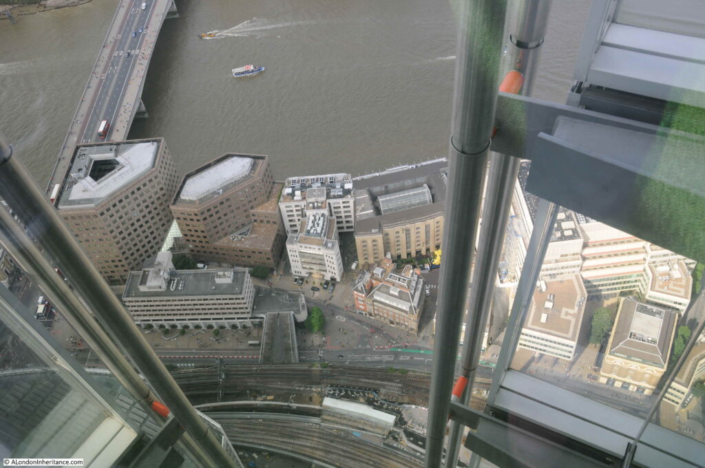
In the following photo, taken from the top of the Shard, London Bridge is on the left. The two buildings of Number 1 London are of similar design and materials and can be seen to the right of the bridge, directly on the river. The smaller of the two buildings is where Topping’s Wharf was located.

Topping's Wharf

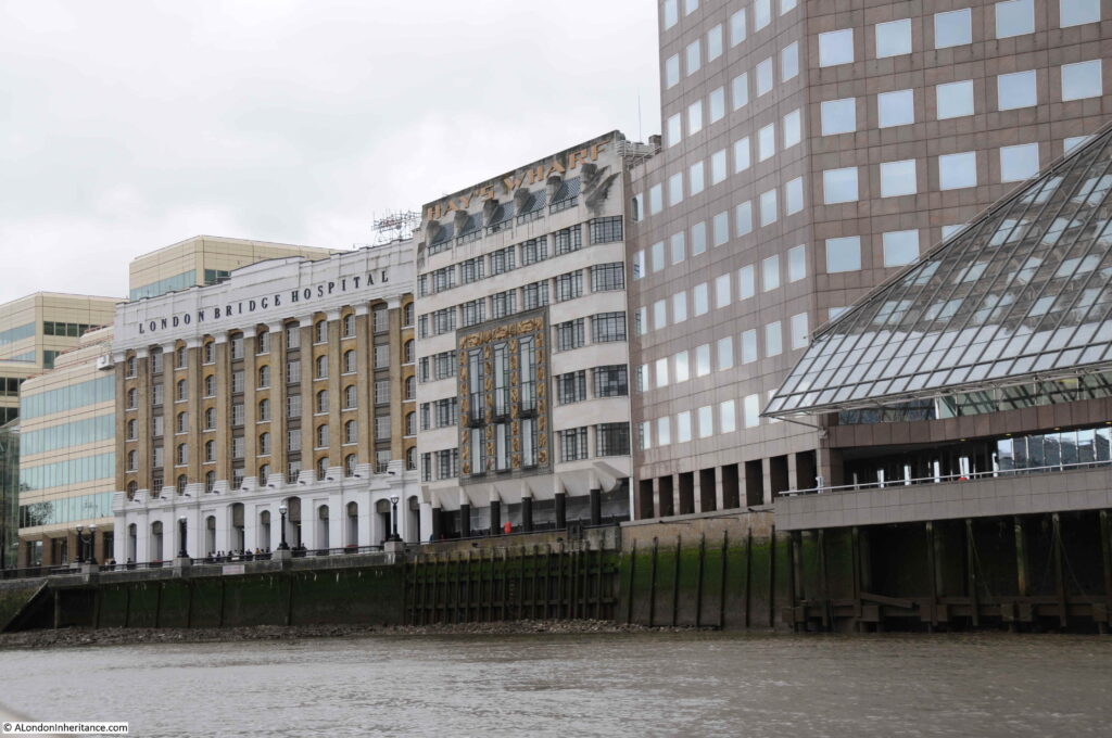
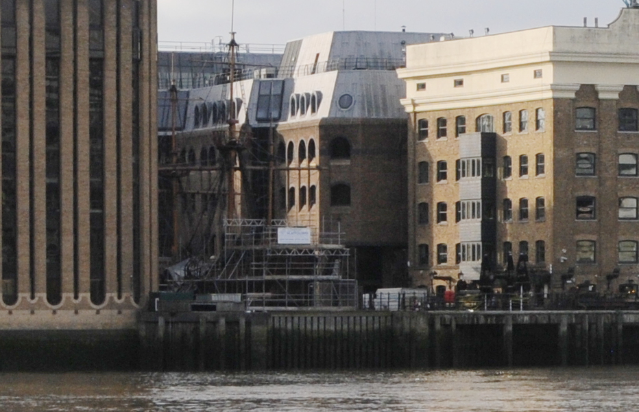
A view of the location from the river. Topping’s Wharf was located where part of the glass canopy and the building to the left of the canopy now stand.

Topping's Wharf

In my father’s 1948 photo at the top of the post there are a line of identical cranes between the warehouses and river. These are the 240 cwt. or hundredweight (approximately 12,192 kg) cranes listed in the Commercial Motor specifications for each wharf.

The most newsworthy appearance of the cranes was during the funeral of Winston Churchill in 1965. His coffin was carried along this stretch of the Thames, and the cranes bowed in turn as the boat carrying his coffin passed. This can be seen in a British Pathé film of the funeral, which can be found here – the cranes can be seen starting at 9 minutes.

If you want to see part of the street that ran behind the warehouses at the Tower Bridge end of the river, then see my post on the Lost Warehouses of Pickle Herring Street.

There is far more to discover along this stretch of the river. The 300 year history of Hay’s Wharf and the lost church of St. Olave are just two examples. These will have to wait for future posts.

alondoninheritance.com

Pickfords Wharf and the original Seven Dials Pillar

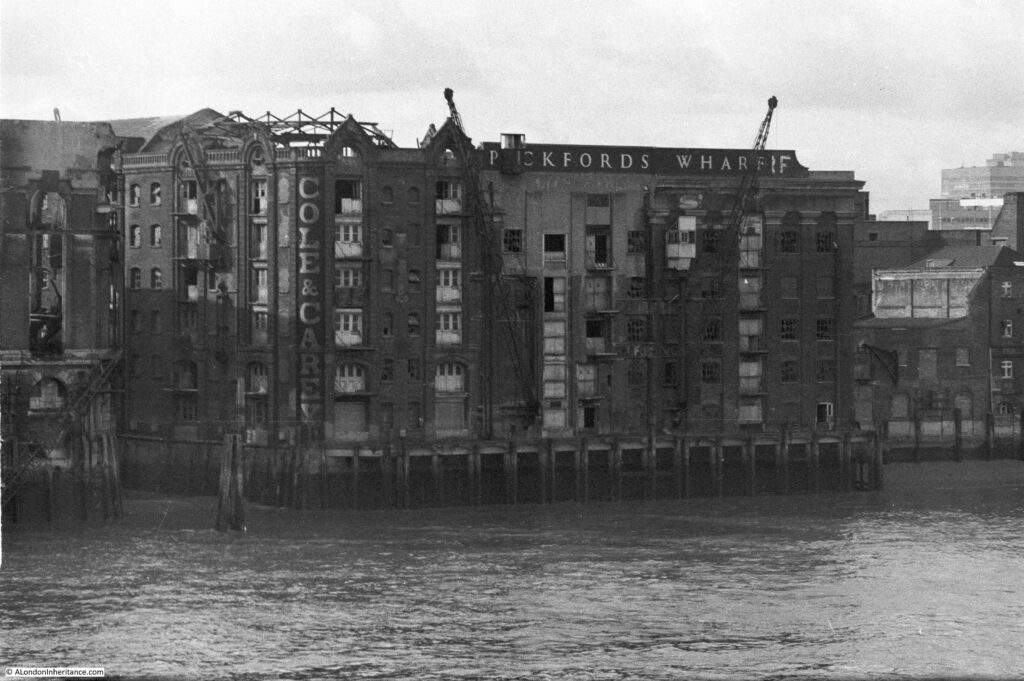
Pickfords Wharf and the original Seven Dials Pillar. A strange title for this week’s post about two subjects. The only relationship they have is one with London. The original Seven Dials pillar is a follow-up to my post on Seven Dials a couple of week’s ago, and Pickfords Wharf is the subject of the following photo that I took from London Bridge in 1979.

Pickfords Wharf

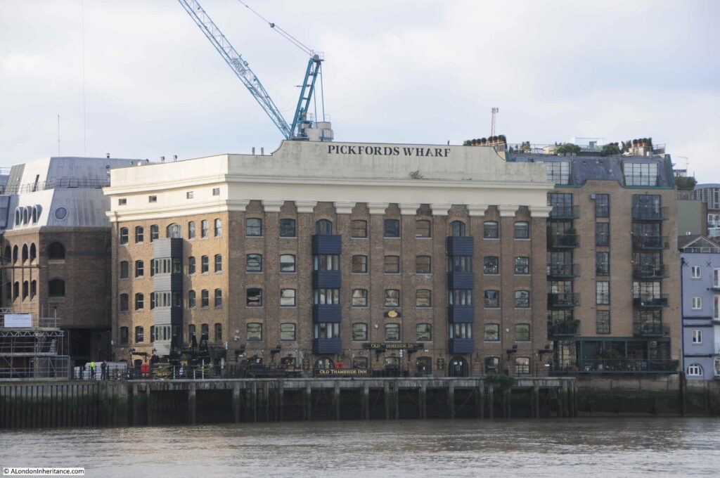
The same view of Pickfords Wharf from London Bridge, forty one years later, in 2020:

Pickfords Wharf

Much of the south bank of the river between London Bridge and Southwark Bridge is unrecognisable compared to the late 1970s. Some of the outer walls of some buildings have survived, but as can be seen with Pickfords Wharf, where they have, they have been subject to very substantial rebuild.

In my 1979 photo, there are two named buildings on the site. Pickfords Wharf and Cole & Carey.

Pickfords Wharf was originally Phoenix Wharf and comprised four warehouses that had been built and modified at different times over the life of the complex. The original riverside warehouse was built in 1864, however, as can be seen in the 1978 photo, the front of the building does have very different architectural styles, with the section to the right almost looking like an early example of facadism, where the ornate columns and facade have been retained on a modified building behind.

Some of the warehouses of Pickfords Wharf were on the other side of Clink Street to the rear of the building seen in the photo, and included parts of the walls of the original Winchester Palace.

Originally built by wharfingers (an owner or operator of a wharf) Fitch & Cozens, with the wharf being named Phoenix Wharf. The Pickfords name came in 1897 when Pickfords & Co purchased the site and renamed the wharf.

Although the wharf still carries the Pickfords name today, the company only owned the building for twenty four years as Hay’s Wharf Ltd. took over the site in 1921.

Pickfords Wharf was used for the storage of a wide variety of different products over the years. The 1954 edition of the Commercial Motor publication “London Wharves and Docks” has the following details for Pickfords Wharf:

  • Cargo dealt with: General canned goods, sugar
  • Cargo specially catered for: General
  • Maximum cranage: 60 cwt
  • Storage space: 400,000 cubic feet
  • Customs facilities: Sufferance and Warehousing privileges
  • Parking facilities: Yes
  • Nature of berth: Quay
  • Maximum length of ship accommodated: 150 feet
  • Depth at High Water: 17 feet

The building to the left of Pickfords Wharf with the Cole & Carey sign was St. Mary Overy’s Wharf. Originally built in 1882 for a George Doo, for use as a granary.

He would only use the building for eight years as in 1890, Cole & Carey, listed as general wharfingers would take over the building. It was purchased by the company behind Hay’s Wharf in 1948 to add to their adjacent Pickfords Wharf building.

Cole & Carey were still operating at the wharf when the 1954 edition of the Commercial Motor guide was published and the details for the wharf are recorded as:

  • Cargo dealt with: General canned goods, dried fruit
  • Cargo specially catered for: Canned goods
  • Maximum cranage: 25 cwt
  • Storage space: 380,000 cubic feet
  • Customs facilities: Sufferance and Warehousing privileges
  • Parking facilities: Yes
  • Nature of berth: Quay
  • Maximum length of ship accommodated: 60 feet
  • Depth at High Water: 17 feet

Cole & Carey had the benefit that their warehouse was alongside the river and also had a small inlet, St Mary Overy’s Dock alongside.

Both warehouses ceased to be used from the late 1960s, and they were left to slowly decay. There was a fire at the Cole & Carey building in 1979, not long before I took the photo, and the exposed metal frames of the roof, a result of the fire, can be seen.

The Cole & Carey building (St Mary Overy’s Wharf), and the core of Pickfords Wharf were demolished towards the end of 1983. Pickfords Wharf was substantially rebuilt to leave the building we see today, St Mary Overy’s Wharf was not rebuilt.

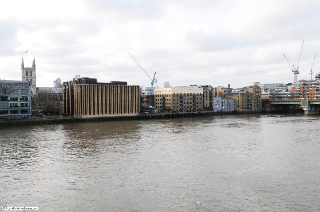
A wider view of the south bank of the river, east of Southwark Bridge, with Pickfords Wharf in the centre:

Pickfords Wharf

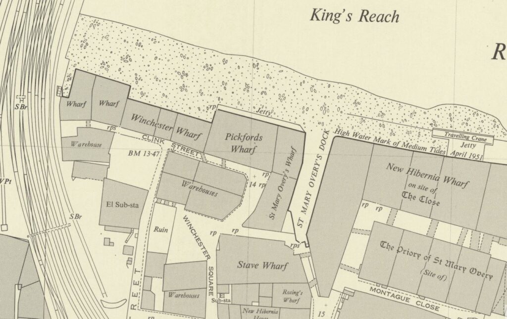
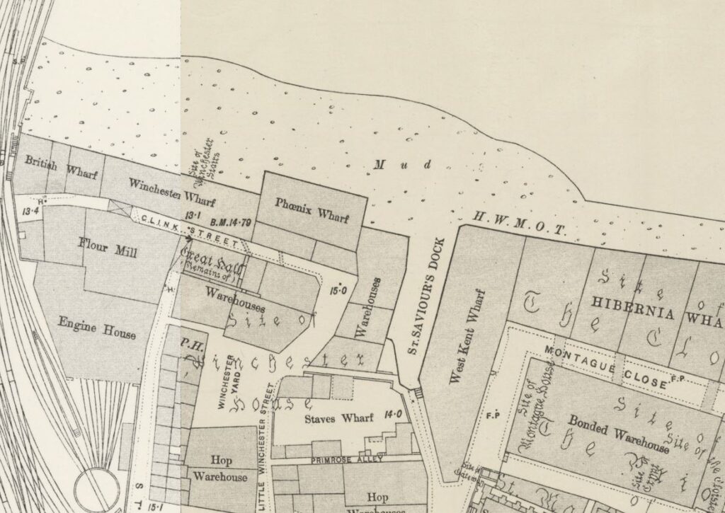
One of the 1950s editions of the Ordnance Survey map shows Pickfords Wharf with St Mary Overy’s Wharf alongside, with St Mary Overy’s Dock. Note the walkways constructed over Clink Street to the warehouses on the southern side of Clink Street which were part of the same warehouse complex (maps ‘Reproduced with the permission of the National Library of Scotland’).

Pickfords Wharf

The 1894 edition of the Ordnance Survey Map shows the building with its original name of Phoenix Wharf. St Mary Overy’s Wharf is labelled as a Warehouse and is alongside, but is yet to be extended out, and to be integrated with the jetty running along the river facing side of both buildings.

Pickfords Wharf

In 1894, the inlet alongside the warehouse appears to have been named St Saviour’s Dock. I need to research further, however perhaps the name was changed to avoid confusion with the St Saviour’s Dock to the east of Tower Bridge in Bermondsey.

The inlet that was St Mary Overy’s Dock is still there, but is now semi-closed off from the river and the space is used as a dock for the Golden Hinde, the early 1970s replica of the ship that Sir Francis Drake used to circumnavigate the world between 1577 and 1580.

The masts of the ship can just be seen in the following photo:

Pickfords Wharf

The replica Golden Hinde had a remarkable couple of decades sailing, including a circumnavigation of the world and a number of crossings of the Atlantic.

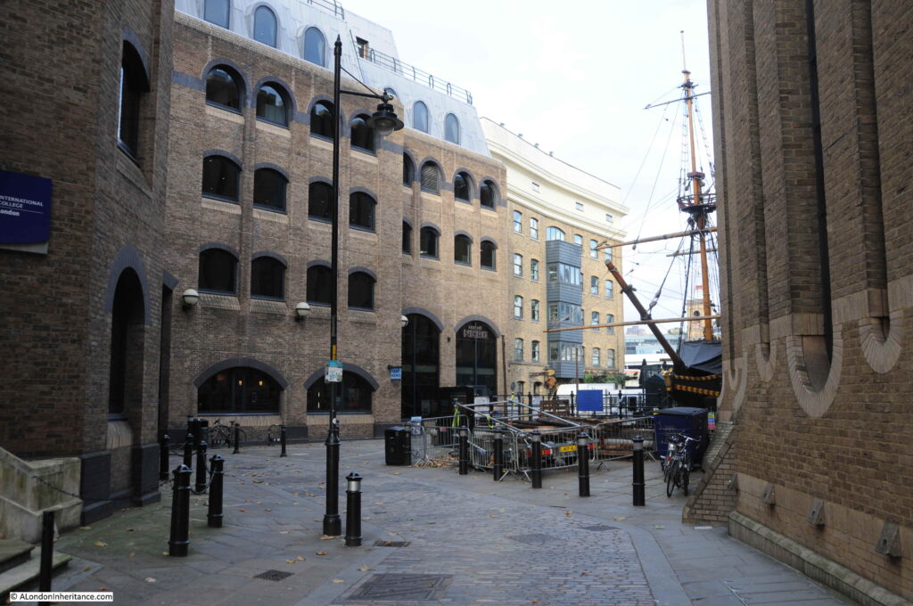
The following photo is of the bow of the Golden Hind, the eastern side of Pickfords Wharf, and some of the new buildings, built to resemble warehouses.

Pickfords Wharf

This is a fascinating area that needs a more detailed post. Winchester Palace could be found here, and the short distance between London and Southwark Bridges form a key part of Southwark’s history.

That will be for a future post, as for today’s post I also wanted to follow-up on my post of a couple of week’s ago on Seven Dials, as I went to find the:

Original Seven Dials Pillar

A couple of week’s ago I wrote about Seven Dials, and the pillar that now stands at the junction of the seven streets. The current pillar is a recent replica, as the original had been removed around 1773 as it had become the focal point for so called undesirables and the Paving Commissioners ordered the removal of the pillar to prevent this nuisance.

The remains of the demolished pillar were stored at the home of the architect James Paine, at Sayes Court, Addlestone.

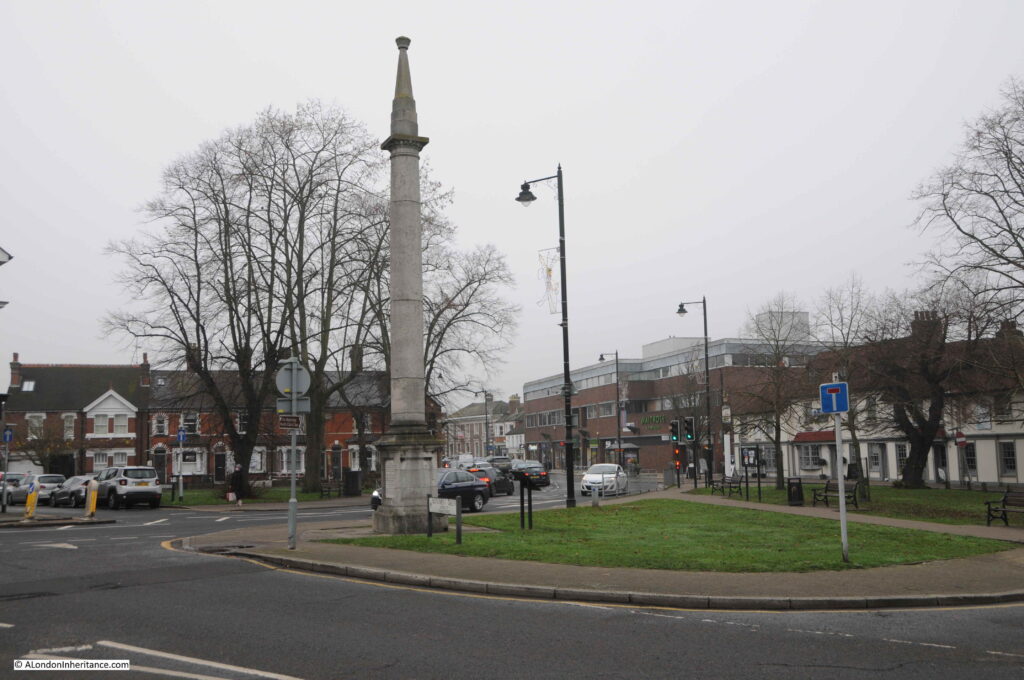
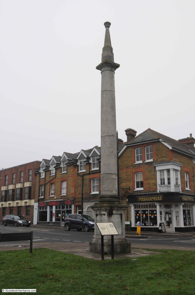
In 1822, the demolished pillar was re-erected at Weybridge, Surrey, and last week I was in the area so a short diversion took me to the place where the original, 1694, Seven Dials pillar can still be seen today:

Pickfords Wharf

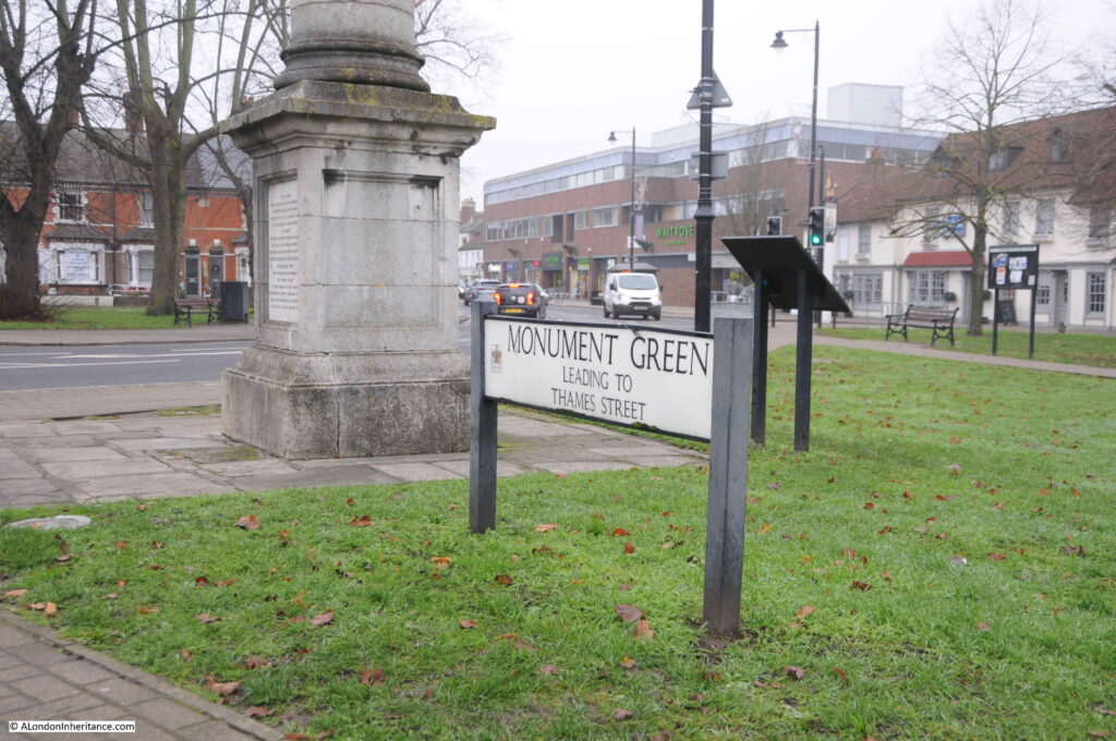
The pillar stands appropriately on Monument Green, alongside the street that leads to Thames Street, which leads down to as you have probably guessed, the River Thames.

Pickfords Wharf

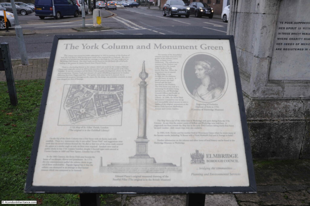
An information panel provides some history of the original location of the pillar (note the map of Seven Dials), and the reason for its relocation to a green in Weybridge, which was to commemorate local resident “Her Royal Highness The Most Excellent and Illustrious Frederica Charlotte Ulrica Catherina Duchess of York” who lived in the parish for upwards of thirty years, and died on the 6th of August 1820.

Pickfords Wharf

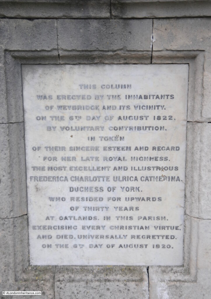
Panels added to the base of the pillar also explain why the pillar was erected in Weybridge:

Pickfords Wharf

The Duchess of York came to be living in Weybridge as her marriage to Prince Frederick, Duke of York was not a long term success and there were no children which as is often the case with royal marriages, having children appears to have been the main reason for the marriage. They separated towards the end of the 1790s, and the Duchess moved to Oatlands in Weybridge, a house owned by the Duke of York.

Pickfords Wharf

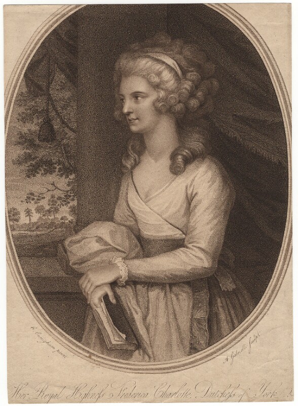
Frederica Charlotte Ulrica Catherina, Duchess of York and Albany  by A. Gabrielli, after Edward Francis Cunningham (Calze) stipple engraving, published 1792 NPG D8581 © National Portrait Gallery, London

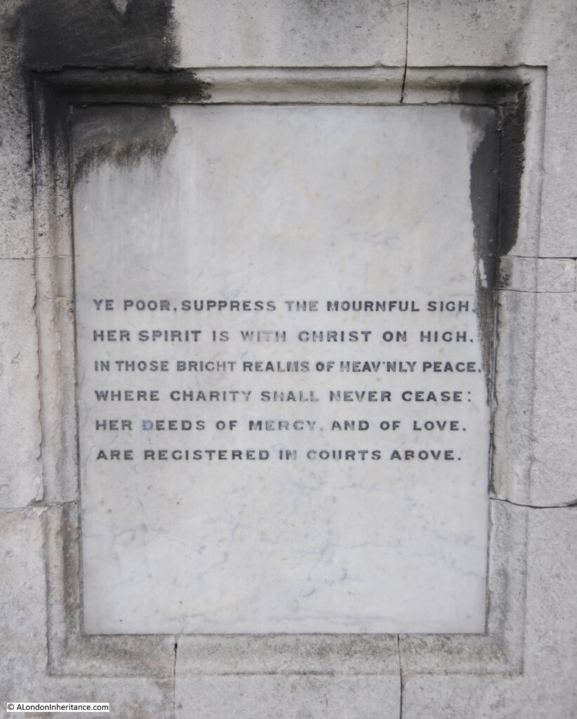
One of the panels at the base of the pillar implies that she must have been charitable to the poor of the parish as “Ye poor suppress the mournful sigh, her spirit is with Christ on high”.

Pickfords Wharf

When plans were being developed for the renovation of Seven Dials in the 1980s, which included the return of a pillar at the junction of the seven streets, attempts were made to move the original pillar back from Weybridge, however the local council were against the move and refused to allow the pillar to leave.

Frederica Charlotte Ulrica Catherina Duchess Of York, a Prussian Princess who married a British Prince, is buried in St James Church, Weybridge, and still commemorated 200 years after her death by a pillar that was originally erected in the late 17th century development of Seven Dials by Thomas Neale.

Pickfords Wharf and the original Seven Dials pillar – two very different subjects for today’s post, but share some similarities in that they have both survived an amount of demolition, and they are now serving very different purposes to those which were intended at the time of their creation.

alondoninheritance.com

George Inn, Borough High Street, Southwark

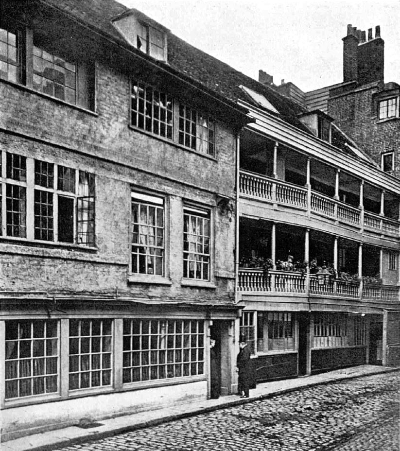
The George Inn, along Borough High Street, Southwark is the only remaining galleried coaching inn in London of the many that once serviced the numerous coaches that connected the city with the rest of the country.

The George remains thanks to the London and North Eastern Railway. Although they did demolish large parts of the original buildings leaving only one side of the complex, they sold to the National Trust in 1937, who continue to own the property with it currently being leased to the pub chain and brewer, Greene King.

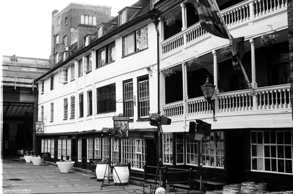
Back in 1977, I took the following photograph of the George with the main building and galleried upper floors.

George Inn

There was something being filmed at the time of my visit, as the lights facing into the building demonstrate – cannot remember what it was – a late 1970s period drama.

On a rather overcast September day, I went back to Borough High Street to photograph the George Inn.

George Inn

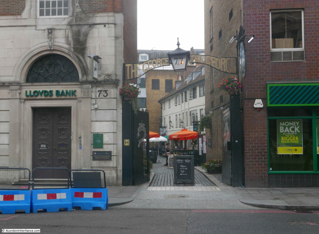
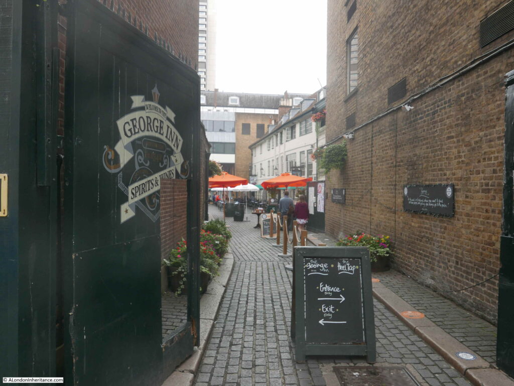
The George still has the narrow entrance from Borough High Street. These are days of COVID precautions and the sign indicated a separate side for entrance and exit.

George Inn

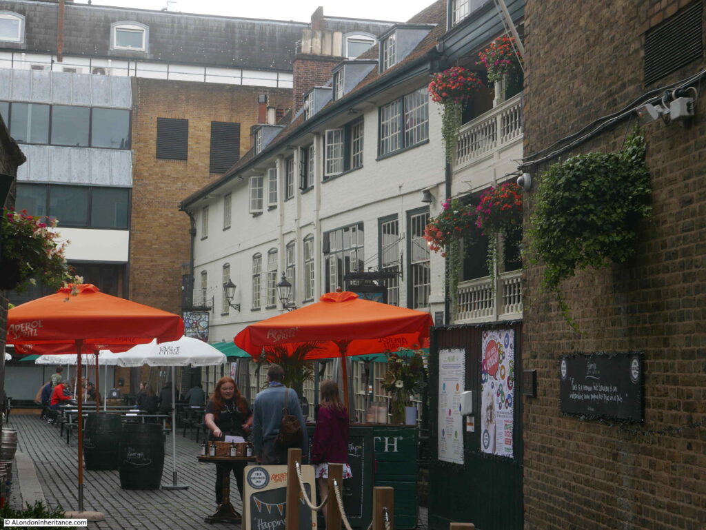
I did not want to challenge the restrictions in place, so did not walk into the yard just to take photos. I was short of time, having to be in Clerkenwell that afternoon so could not stop for a drink. The George is on the list for a return visit, and some better photos.

George Inn

The George looks much the same as in my 1977 photo, however the building at the end of the yard in 1977 has been demolished and replaced.

The George is a very old Inn, dating back to at least the 16th century. It was mentioned by Stowe in 1598 as one of the “fair inns” of London.

It was originally called the St. George, but because of changes in sentiment towards religious iconography, Popery and saints, the inn became the George in the mid 16th century.

In 1622 the inn is described as being built of “brick and timber”. In 1670 a Mark and Mary Wayland were running the George for an annual rent of £150. That year the pub was damaged by fire. Wayland rebuilt and had his rent reduced to £80 and a sugar loaf.

A much larger fire in 1676 that burnt through much of the surrounding area, totally destroyed the George, but again it was rebuilt by the tenant who had the rent further reduced to £50 and a sugar loaf, along with an extension of the lease.

In 1825, the George is recorded as being “a good commercial inn in the Boro High Street; well known, whence several coaches and many wagons depart laden with the merchandise of the metropolis, in return for which they bring back from various parts of Kent, that staple article of the country, the hop, to which we are indebted for the good quality of the London porter”.

In 1855, a description of the stables area of the inn included “a round room for the ostlers in the days of pack-horses, and a stable below ground with steps leading down to it”.

For many years, the George was owned by the trustees of Guy’s Hospital, which was on the eastern boundary of the original George Inn – the building we see today is a small part of the original inn and the associated buildings to support the coaching business.

In 1874, St Guy’s Hospital sold the George Inn to the Great Northern Railway. The coming of the railways had seen a rapid decline in travel by horse and coach, so the sale of the inn to the GNR, who used the site as a receiving station for goods to be transported on their rail network, was in many ways a logical continuation of the main transport function of the inn.

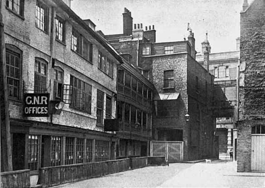
The following photo shows the courtyard of the George, looking towards Borough High Street, with a sign above the entrance to the offices of the Great Northern Railway:

George Inn

The location of the George Inn was key to the success of the inn as a coaching inn, as one of many inns located in courtyards along the main road that led south from London Bridge.

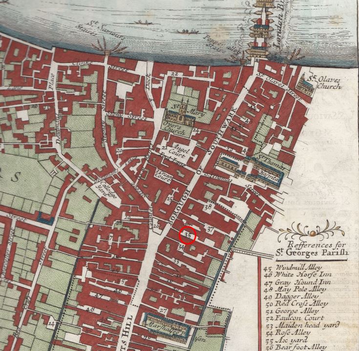
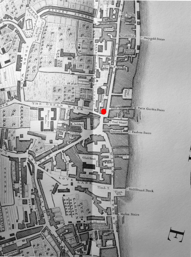
The following map extract is from a map of the Parish of St. Saviours Southwark by Richard Blome (late 17th century but published by John Stow in 1720).

It shows the road leading from London Bridge at the top of the map, down to the Marshalsea Prison at the bottom of the map. This road had long been the only southern route out of the City of London.

George Inn

To the right of the road are numerous alleys and courts. Many of these were inns such as the Spur Inn, Queen’s Head Inn, Talbot Inn, White Heart Inn, King’s Head Inn, Black Swan Inn, Ship Inn and Bores Head Inn. Southwark really did have a lot of Inns.

At number 35, with the red circle is the George Inn. The narrow access from the street leads on to a large courtyard.

There were a number of reasons for the high number of inns. The road was originally the only road from the City of London to the southern counties of England. The area was outside the control of the City of London, there was more land available and rents were cheaper than on the other side of London Bridge.

Catching a coach from one of the Inns in Southwark was almost the equivalent of walking across London Bridge today and catching a train at London Bridge Station.

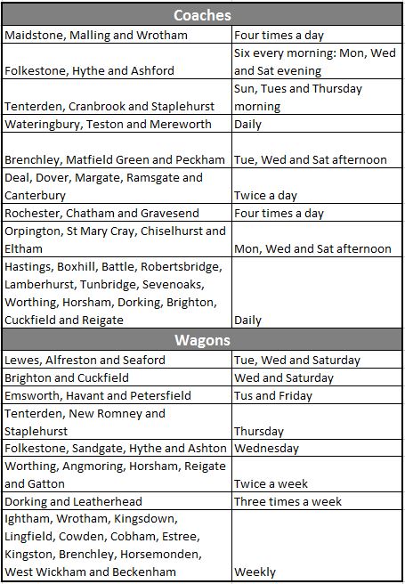
Coaches from the Southwark Inns served numerous destinations in the counties of Kent, Sussex and Hampshire and in 1809, W.S. Scholefield who was running the George at the time, published a list of the destinations from the inn, and their frequency:

George Inn

The table demonstrates just how busy the George Inn must have been. Numerous destinations, with some having four coaches a day. Horses being stabled at the George, passengers staying in the rooms of the George before an onward journey, luggage and other goods for onward transport across London.

The table includes coaches, which were mainly for passenger transport, and also wagons, which were used for the transport of goods, so the George was also the hub for a transport network for products, raw materials and personal / household goods that needed to be sent to destinations from Kent to Hampshire, and returning goods for sale in the City.

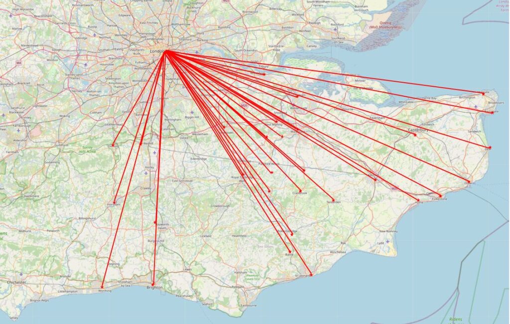
I plotted the coach network onto a map to give a graphical view of the geographic spread and number of destinations (Map © OpenStreetMap contributors):

George Inn

The majority of destinations are in the county of Kent, with some in Sussex. There is a  significant gap between the main Kent services and the five destinations to the west of the map, with no services to towns such as Edenbridge, East Grinstead, Uckfield and Lewes.

It may have been that there was no market for these destinations, or that they were served by coaches from other Southwark based coaching inns. I did consider trying to put together a map showing the destinations from the different inns, where these are known, colour coding based on the Southwark inn. An 18th century / early 19th century equivalent of a 21st century rail network map, but as usual have the idea but not the time.

What the list of destinations does not show is whether each was a single route with multiple stops, or whether these were individual destinations, or a mix of both. Or, whether some of these destinations were reached through a change in coach.

There is a brilliant book called “Paterson’s Roads – An Entirely Original and Accurate Description of all the Direct and Principal Cross Roads in England and Wales”.

I have the 1826 edition, and the book is basically an early 19th century SatNav, It provides detailed routes to get from Town A to Town B, listing all the intermediate towns, turnpikes, and where other destinations could be reached through turning off from the main route. The routes are annotated with descriptions of the towns and villages along the route, milestones, turnpikes and important buildings.

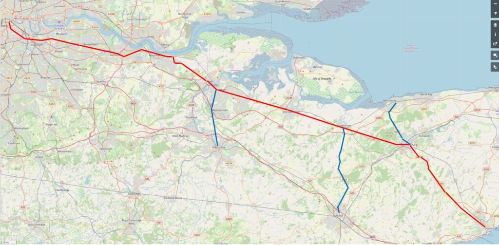
One of the routes is from London (the Surrey side of London Bridge) to Dover. An important destination, as from Dover boats provided the shortest crossing of the channel over to continental Europe. As Dover is one of the destinations from the George, I plotted the route from 1826 as the red line on the following map:

George Inn

The route is the most direct route, but with a short diversion for a stop at Gravesend – a long route in a horse drawn coach on 18th / early 19th century roads.

Paterson’s Roads describes Gravesend as “the first port in the Thames, and by a grant of Richard II, enjoys the privilege of conveying passengers to and from London; the vessels depart from Billingsgate every day at high water, on the ringing of a bell, and from Gravesend every flood tide. All outward bound vessels are obliged to bring-to here, till they have been examined by the proper officers, and receive their clearances; here also all foreigners are detained on arriving from abroad; till they have obtained permission from the Secretary of State’s office to proceed, and all foreigners departing must receive their clearance  from the Aliens office here”.

Paterson’s Roads also provides points where there is a route to a secondary destination, shown as the blue lines on the map. So a stop at Chatham provides a route south to Maidstone, a stop at Faversham provides a route to Ashford, and a stop at Canterbury provides a route north to Whitstable.

The infrastructure needed to support the number of coaches and wagons departing from and arriving at the George Inn was significant and originally the Inn was much larger than we see today.

The coming of the railways destroyed the coach and wagon business and Inns such as the George lost much of their business over a relatively short period of time.

Buildings and land that were originally part of the George were sold, and part was demolished or converted by the Great Northern Railway to be used as storage space.

The Great Northern Railway became the London and North Eastern Railway, and in 1937, the LNER sold the George to the National Trust, who still own the building. As part of the sale, the LNER produced a plan created in 1847 when the previous owner, Guy’s Hospital, had sold to the Great Northern Railway.

This plan provides a detailed view of the original scale of the George, not just the yard in front of the current pub, but extending much further back towards Guy’s Hospital, where there were a large number of stables for the horses that once pulled the coaches and wagons across the counties south of London:

George Inn

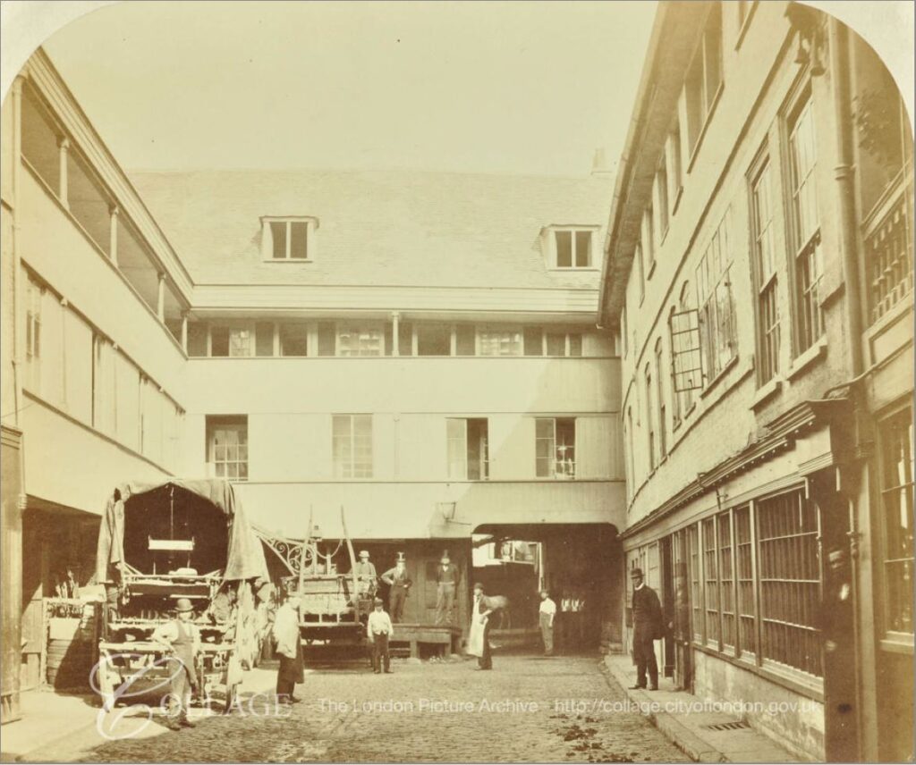
The following photo, dated to the 1880s shows the yard outside the current pub. The archway at the end of the yard is that shown in the plan above which leads into the stable yard and extensive stabling.

George Inn

Image credit: London Metropolitan Archives, City of London: catalogue ref: SC_PHL_02_0970_X72_310

Newspaper records mainly reference the George Inn for coaching services rather than the alcoholic problems that a 18th / 19th century inn would often have, for example, even in 1812 it was not a good idea to fraudulently claim expenses:

“28th October 1812 – MIDDLESEX SESSIONS. Thomas Pearson, lately employed as office keeper in the office of his Majesty’s Quarter-Master-General, stood indicted for fraudulently altering, in a bill from the coach-office of the George Inn, Southwark, the sum of 3s 1d to 13s 1d for the carriage and porterage of a parcel from Hythe; and thereby defrauding his Majesty”.

There were adverts of coach services from the George, and the mention of reduced fares probably indicates the competitive nature of coach services. From the Maidstone Advertiser on the 20th September 1842:

Reduced Fares. Direct to London in three and a half hours by the favorite 4-horse coach, from the Swan Inn, Maidstone, every afternoon at 4 o’clock. Returning from the Ship, Charing Cross, Belle Sauvage, Ludgate Hill; Bull and Mouth, St Martin’s Le Grand; Blossoms Inn, Lawrence-lane; every morning at nine o’clock; and the George Inn, Borough, at half past nine, Fares 10 Shillings Inside. 6 Shillings Outside”.

On the same page as the above advert, is another that tells of the coming demise of the horse drawn coach services, and is probably why the above advert was advertising reduced fares:

“South-Eastern Railway Booking Office. Swan-Inn, High-street, Maidstone.

To and from London in three and a quarter hours!

Superior appointed coaches start punctually at the stated times from the above office to the station Paddock Wood, passing through Testom, Wateringbury and Peckham. Fares 2 Shillings Inside, 1 Shilling Outside”.

The above advert is interesting as it shows the hybrid nature of early train services and how the railway companies used the coach services they wanted to replace as feeder services to their stations.

The South Eastern Railway had reached Paddock Wood in Kent in May 1842, but would not reach Maidstone until 1874, so the South Eastern Railway ran coach services to take customers from nearby towns such as Maidstone to the nearest station.  A clever idea as it not only grew traffic on the new rail network, but also encouraged those who had to use a feeder service to support the extension of the rail network to their own town.

The railways would quickly kill off the horse and coach services, and with them the need for coaching inns, and in the latter half of the 19th century London lost nearly all the coaching inns, with the exception of the George Inn. Even the nearby Tabard Inn, which seems to have been older than the George was demolished in 1873.

By 1899, the importance of the George was being recognised. From the 4th September 1899:

“I am glad to observe that London is not to be deprived of the old George Inn at Southwark – the last of the picturesque galleried hostelries of London. It was reported in one quarter that this ancient inn was to come down; in another, that it was to be turned into a common-place gin palace. 

It was frequently visited by the sixth Lord Digby, a benevolent member of the Peerage, who midway in the eighteenth century, used to disguise himself in a shabby old blue dress and visit the old Marshalsea prison, and free a number of prisoners by paying their debts in full. He did this twice a year, at Christmas and Easter, and then took them to the George, celebrating the occasion by entertaining the liberated prisoners to a repast”.
An earlier story about Lord Digby tells of thirty people he had released from the Marshalsea prison, sitting at dinner at the George Inn.

Late 19th century view of the George:

George Inn

The George Inn is one of the many London locations that claim an association with the author Charles Dickens, although with the George it is almost certainly true that he did visit the inn and it does get a brief mention in Little Dorrit.

There are many original features inside the pub, dating back to the 19th, 18th and 17th centuries, and there is possible reuse of medieval beams and stone.

The George Inn is still owned by the National Trust, is Grade I listed and the inn is currently run by Greene King.

The George was a key location for transport to Kent, and there are plenty of other reminders in this area of Southwark of how Kent produce was taken to, traded and sold in Borough.

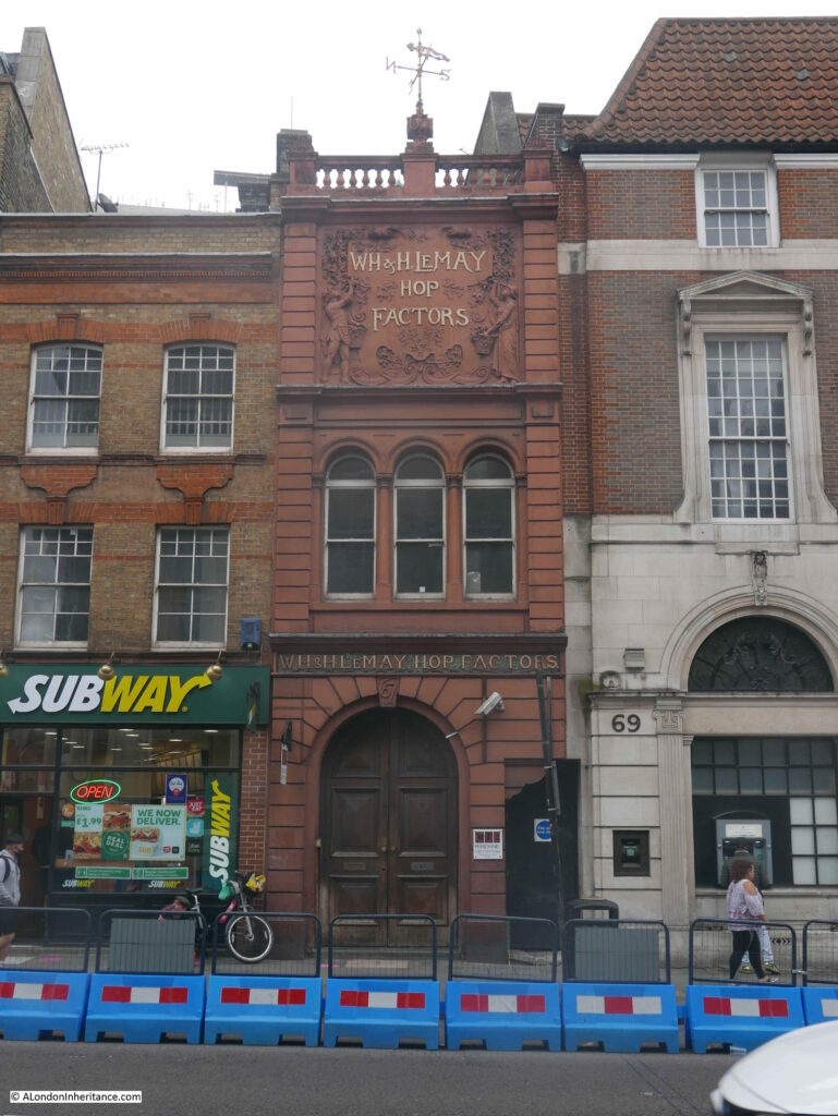
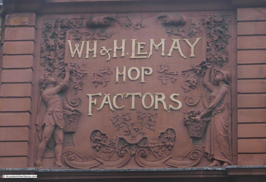
A couple of weeks ago I wrote about Borough Market and the Hop Exchange, and a short distance in Borough High Street from the George is this facade:

George Inn

WH and H Le May were William Henry and his brother Herbert. Born in Gun Lane, Limehouse, they went on to establish a very successful hop trading business based on Borough High Street.

Their trade extended to all the hop growing areas of the country, not just Kent, but counties such as Herefordshire where newspapers had adverts for the business encouraging growers to consign their hops to WH and H Le May, to be “sold in London, the best market for hops”.

Advertising included pricing updates and in 1911 they reported that “the demand for all types of hops continues, and prices have again advanced on all the hop markets of the world”.

George Inn

The business may be long gone, but the ornate facade provides a reminder of this area of Southwark’s connection with the trade of agricultural produce from Kent, southern England and further afield.

One of the books I have used to research this post is “The Old Inns of Southwark and their Associations”, by William Rendle and Philip Norman. The book was published in 1888.

Old books help as they provide information closer to the time they are recording. Some care must be taken to double check, but they are a good source of information.

These books also have their own history as they pass from owner to owner over the years, accumulating a memory of their time with some of the owners of the book.

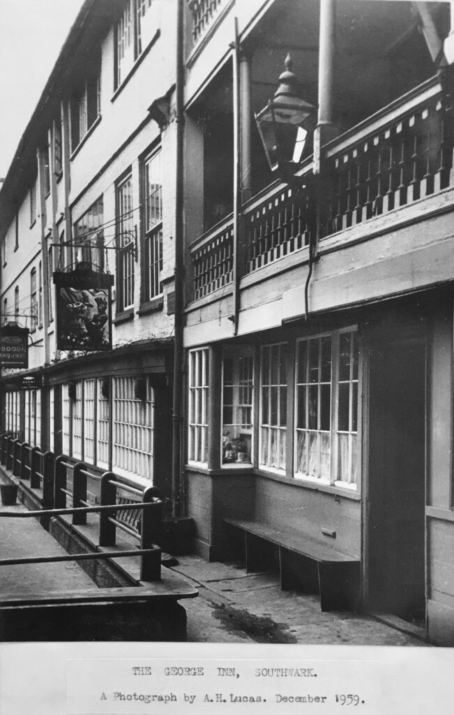
In the Old Inns of Southwark, on the rear of the title page, I found the following photo glued onto the page.

George Inn

I have no idea who A.H, Lucas was, perhaps the owner of the book in December 1959 when the photo was taken.

I was considering adding my 1977 photo, but I did not own the book at the time, so when it is possible to get back to the George, I will take another photo and add to the book.

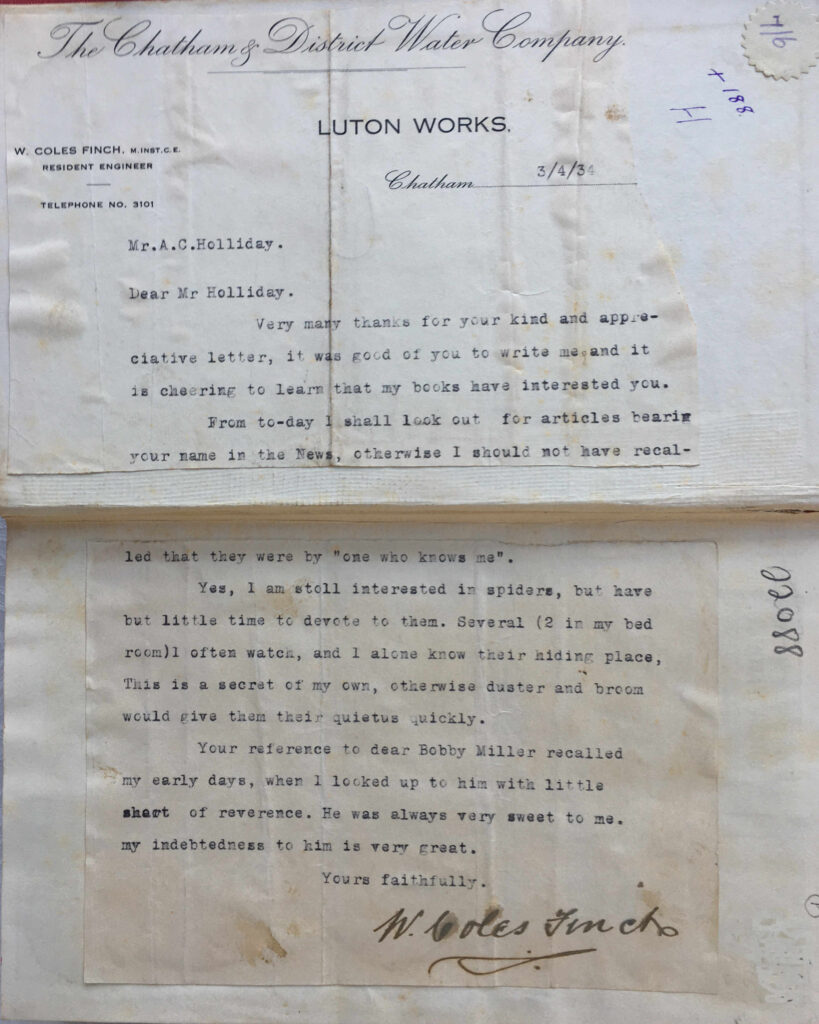
Another book which takes this to a more extreme level, with additions that tell of the coaching history of Chatham is “The Medway River and Valley” by William Coles Finch, an author and resident engineer of the Chatham and District Water Company. The book was published in 1929 and is a fascinating history of the River Medway, and the towns along the Medway.

The book was purchased when published by a Mr A.C. Holliday, a local teacher.

In 1934 A.C. Holliday had written to William Coles Finch, apparently praising his books as Coles Finch replied, and A.C. Holliday glued the reply into the book:

George Inn

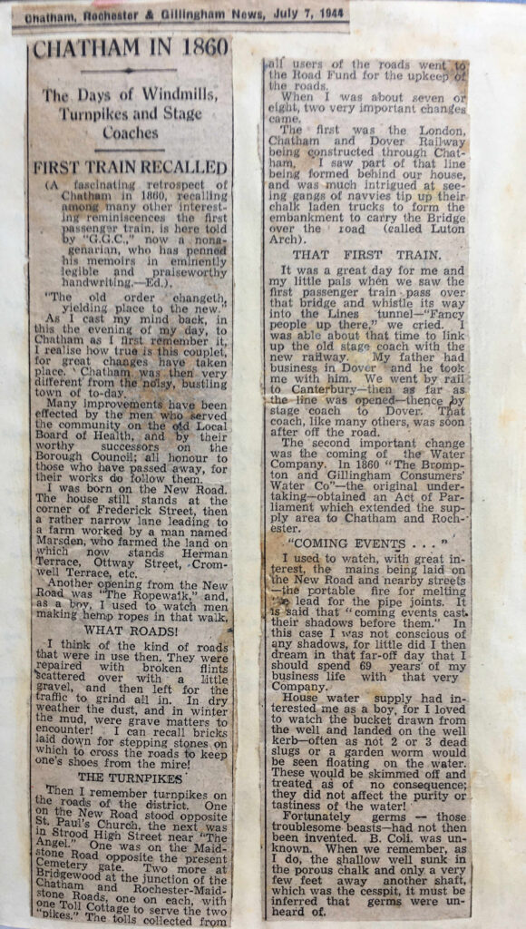
A.C. Holliday also glued into the book, on every empty page at the start and end of the book, newspaper cuttings on the history of Chatham.

This cutting tells of the first train to arrive in Chatham, and also recalls the state of the roads which the old horse drawn coaches would have used to reach Chatham from London from inns such as the George Inn, with dust in dry weather and mud in winter:

George Inn

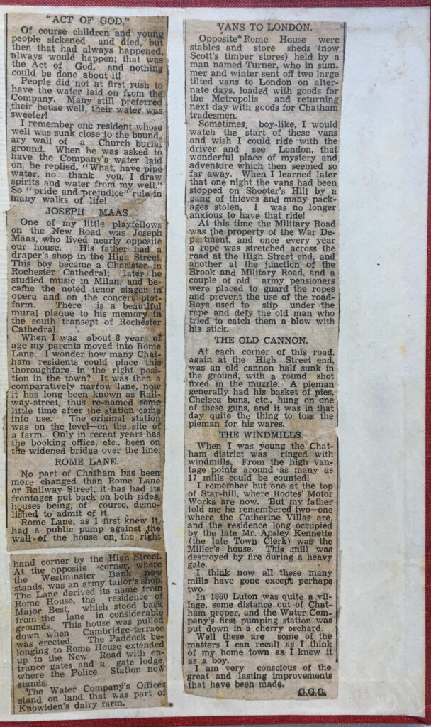
The article includes mention of the Vans that once ran to London, loaded with goods. The sense of London as being a distant place of mystery and adventure, and of the problems that a traveler would encounter with thieves on Shooters Hill:

George Inn

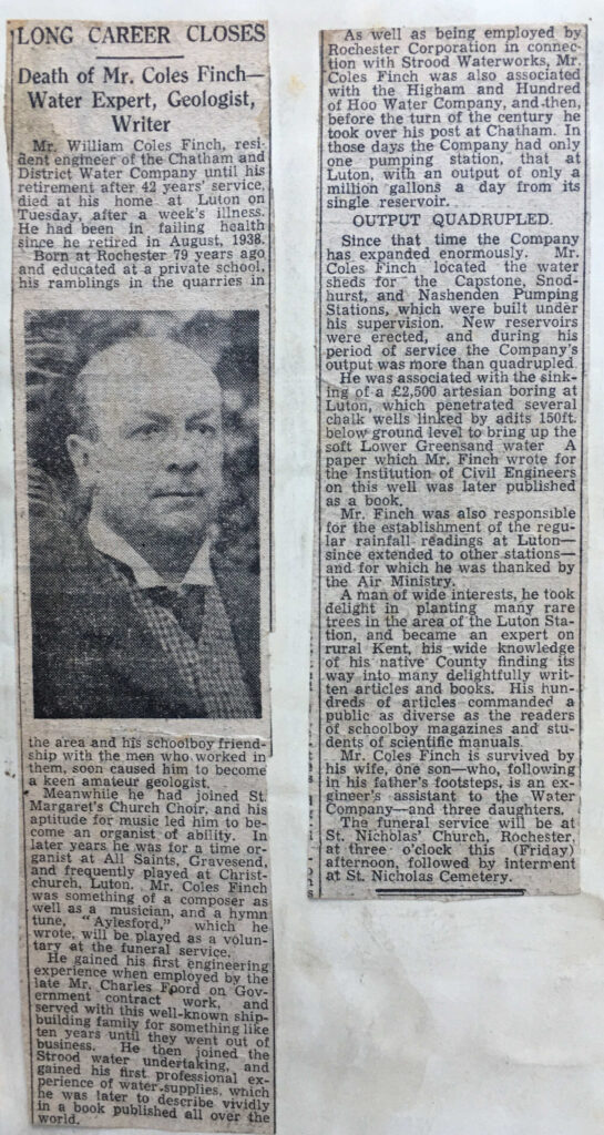
William Coles Finch died in 1945, and an obituary is glued in the book:

George Inn

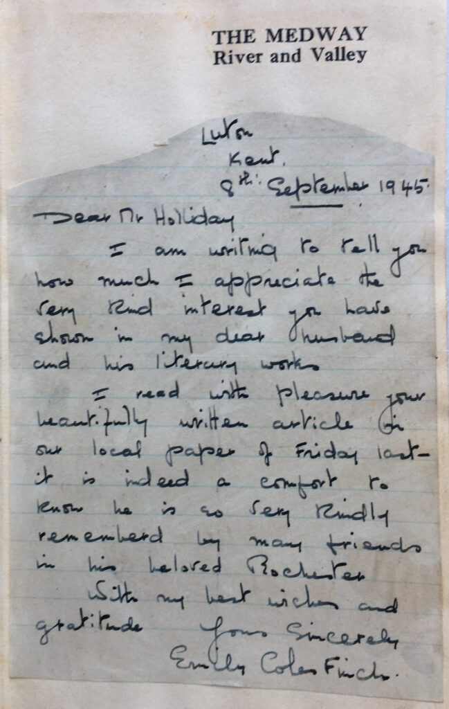
William Coles Finch wife, Emily wrote to A.C. Holliday regarding the article, and the letter is also glued into the book:

George Inn

There is no free space in the book to add any further contributions, however I printed one of my photos of the London Stone at Yantlet Creek to use as a book mark, and have this in the book as my addition to its history.

I have always used the latest London Underground folded maps, exhibition or concert tickets, or photos as bookmarks and leave these in the book when finished – my contribution to their history.

The George is now much smaller than the original establishment, when horses needed to be stabled and coaches and wagons set out for the southern counties, but it still shows what an inn would have looked like when horse drawn vehicles were the main mode of transport.

As the George Inn is owned by the National Trust (a brilliant decision by the LNER), the long term future looks assured, and it is the perfect place to stop for a drink and consider the many thousands of travelers who must have departed or arrived here, each on their own special journey through, what was described in Coles Finch’s book as “London, being a distant place of mystery and adventure”.

alondoninheritance.com

The Globe at Borough Market

In 1977 I was taking some photos around Southwark using my brand new Canon AE-1, purchased using hire purchase as at the time it was the only way I could afford such a camera, and I was desperate to replace the cheap Russian Zenit camera I had been using. The main feature of this camera seemed to be a sticking shutter which ruined far too many photos.

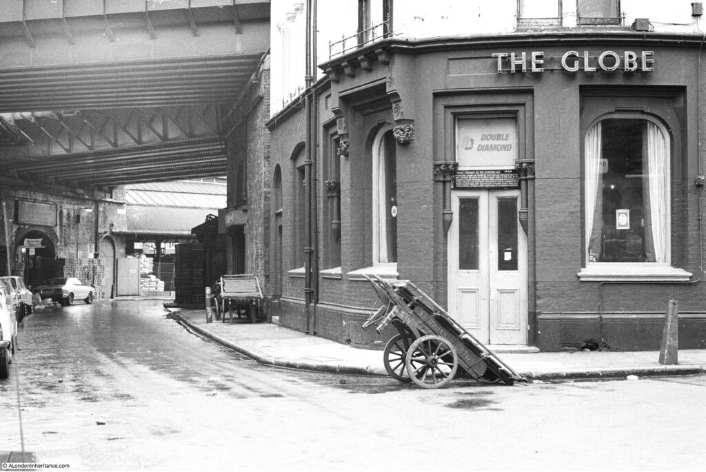
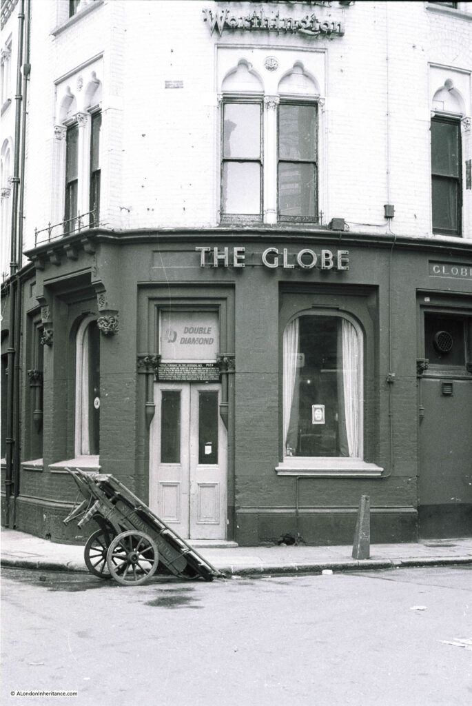
A couple of these photos were of the Globe at Borough Market. A very different market to the market of today.

Globe at Borough Market

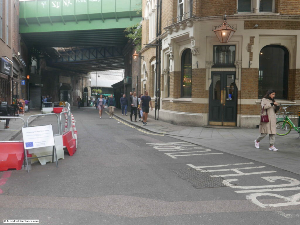
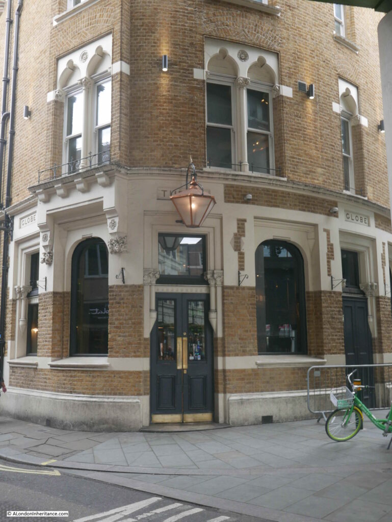
The same view 43 years later in 2020:

Globe at Borough Market

The Globe was built in 1872 to a design by architect Henry Jarvis. A lovely brick pub, the paint on the external walls in my 1977 photo has since been removed to reveal the original brickwork.

When I took the original photo, Borough Market was a very different place. Selling all types of fruit, vegetables, potatoes etc. The market started very early in the morning mainly selling to businesses such as the shops and restaurants of south London.

The narrow aisles between the market stalls meant that vehicles could not easily enter the market so porters were employed to transfer goods from lorries parked in the streets, into the market.

One of the barrows used by a porter is outside the corner entrance to the pub. This was why I took the photo as the barrow and pub seemed to be a good combination that in many ways summed up a London market at the time. There is another barrow parked alongside the Globe at left.

There were a number of pubs surrounding Borough Market, catering to the needs of those who worked in the market, which included being open much earlier in the morning than a normal London pub. Reading the licence information above the door of the Globe gives an indication of days and times that the pub served the market, and the trades of those who were expected in the Globe:

“NOTICE PURSUANT TO THE LICENSING ACT 1964 – Intoxicating liquors are permitted to be sold and supplied in these premises between the hours of six-thirty and eight-thirty of the clock on the morning of Tuesday, Wednesday, Thursday, Friday and Saturday of each week. Excepting Christmas Day, Good Friday and Bank Holidays for the accommodation of persons following their lawful trade of calling as Salesmen, Buyers, Carmen, Assistants or Porters and attending a Public Market at the Borough of Southwark”.

Another photo of the Globe in 1977:

Globe at Borough Market

And in 2020. The days of selling Double Diamond are long gone.

Globe at Borough Market

In the above photo, at the very top right corner, you can just see an edge of the Thameslink Viaduct that was built over Borough Market between 2009 and 2013.

The first floor of the Globe was the film location for Bridget Jones flat in the 2001 film Bridget Jones Diary.

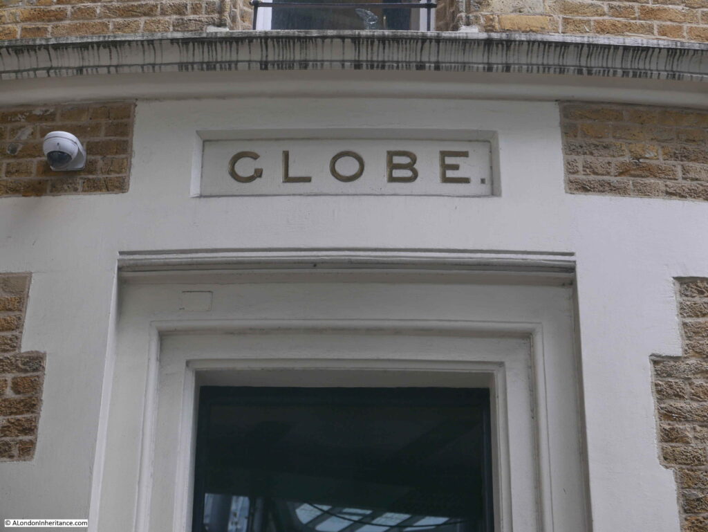
Globe – the name of the pub in stone above the windows, seen in both the 1977 and 2020 photos:

Globe at Borough Market

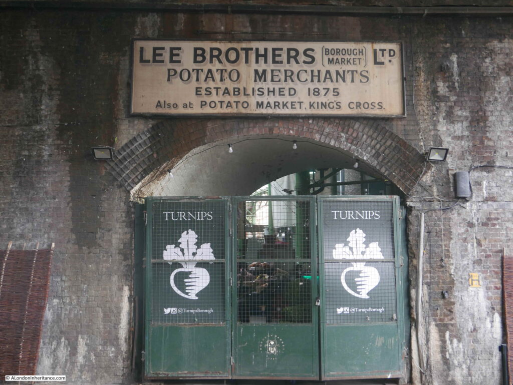
If you go back to the photo at the top of the post, and look along the left side of the street, and in the distance is an arch with a sign above. The sign still remains although Lee Brothers Potato Merchants have long gone.

Globe at Borough Market

The origins of Borough Market are ancient, dating back for at least 1,000 years. Originally a market at the southern end of London Bridge, however by 1754 the City of London was fed up with the Southwark entrance to the bridge being congested by a market, and that the market was taking business away from the City markets. A bill was introduced to Parliament to stop the market trading in March 1756.

The local residents were not happy with the loss of their market and raised £6,000 to buy an area of land called The Triangle, and this became the new home of what is today Borough Market.

The market flourished, and the arrival of the railways with their local goods yards increased the volume of fruit, veg, etc. being sold at the market.

The end of the wholesale market started in the late 1970s and continued in the early 1980s. The City of London constructed New Covent Garden market in Nine Elms. This was a much larger market with considerably easier access and plenty of parking, unlike at Borough Market.

In parallel was the gradual replacement of the traditional corner shop and green grocer by much larger supermarkets who had their own supply chain and had no need to purchase fruit and veg from a local market such as Borough.

The market’s renaissance started in the late 1990s when specialist food suppliers started to move in, and food fairs were organised. Borough Market has since gone from strength to strength, and on most days (prior to the Covid-19 pandemic) it would be crowded with tourists and shoppers.

When walking among the stalls, it almost looks as if you could buy a different cheese for every single day of the year.

Along with the market traders, a wide range of restaurants have opened surrounding the market, and the old pubs that once served the market porters at 6:30 in the morning, have a new lease of life and are serving a very different customer – no longer are barrows left outside the pub door.

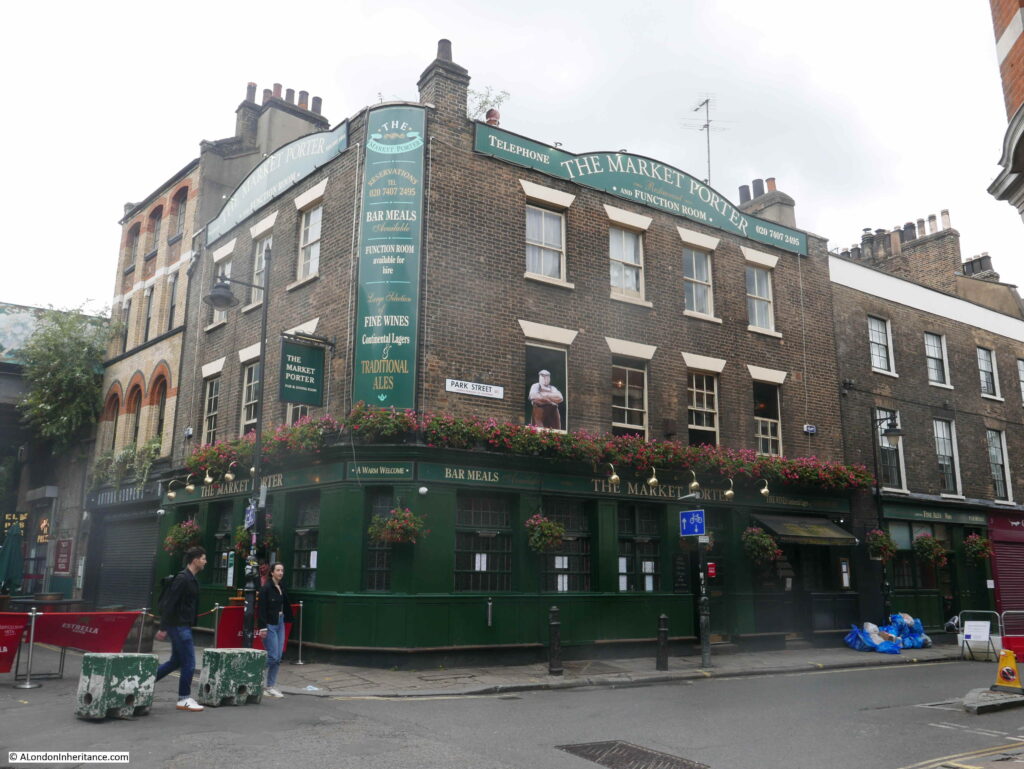
One of the pubs surrounding the market is the appropriately named The Market Porter on the corner of Stoney Street and Park Street.

Globe at Borough Market

The Market Porter dates from 1890, however the site was previously occupied by a pub named the Harrow.

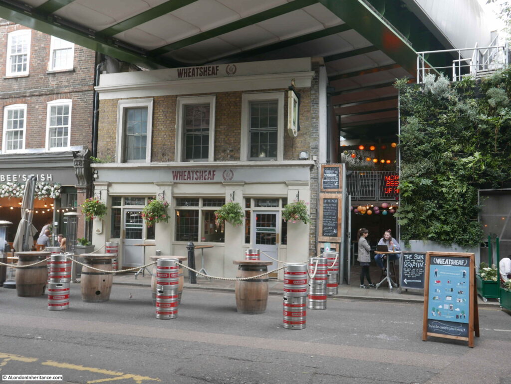
Further along Stoney Street is another pub that looks in a rather strange location, squashed by the railway bridge directly above the pub. This is the Wheatsheaf:

Globe at Borough Market

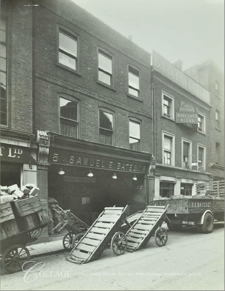
The current Wheatsheaf building dates from 1840, although a pub had been on the site since the 18th century. It originally had three floors and was part of a terrace. The pub lost the third floor when the pub closed in 2009 for the construction of the Thameslink Viaduct which now runs directly overhead. The Wheatsheaf reopened in 2014 in its new, cramped looking condition, however thankfully this historic pub survived such a dramatic change.

Construction of the Thameslink Viaduct was a significant engineering achievement, with building such a structure above a working market. The viaduct runs for 322 metres across the market, and during construction, work included the removal and replacement of the market’s historic roof.

The following photo shows the Wheatsheaf in 1943, in its original condition (the building on the right), along with the same style of barrow that I would photograph in 1977:

Globe at Borough Market

Image credit: London Metropolitan Archives, City of London: catalogue ref: SC_PHL_01_376_F1582

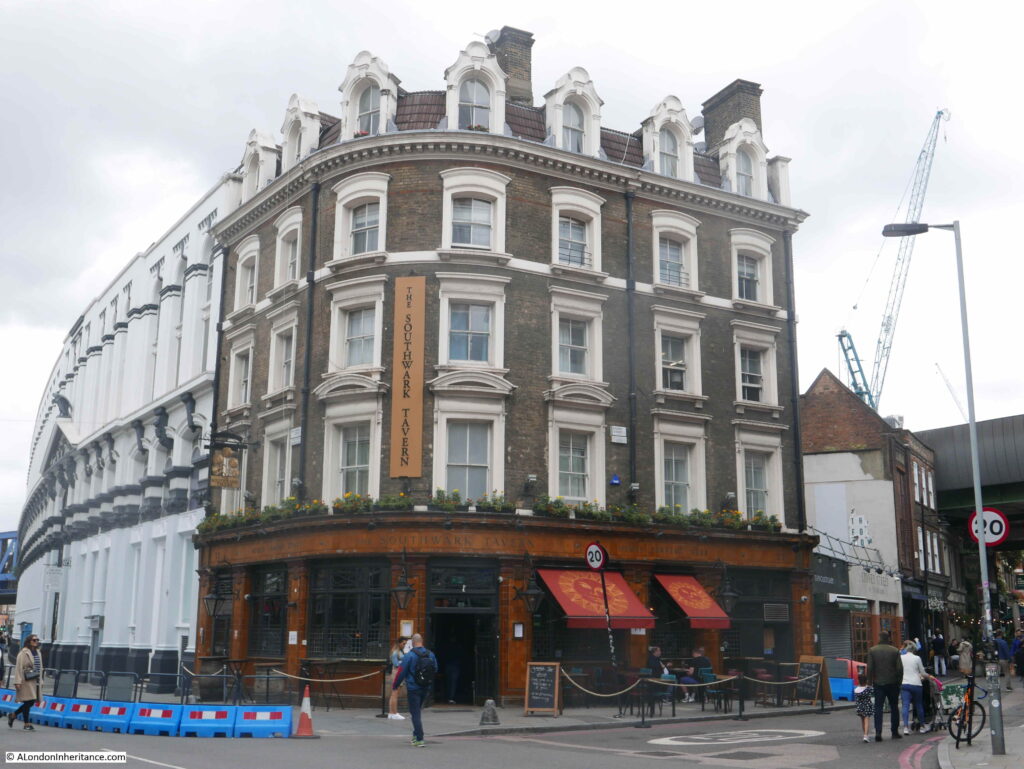
On the corner of Stoney Street and Southwark Street is the Southwark Tavern, a lovely Victorian corner pub dating from 1862:

Globe at Borough Market

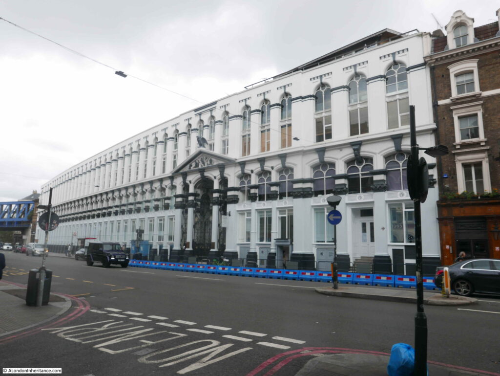
However a more remarkable building is alongside the Southwark Tavern. This is the imposing Hop and Malt Exchange.

Globe at Borough Market

The Hop and Malt Exchange dates from 1867 and was designed by the architect R.H. Moore, and was the premises of the Hop Planters Association.

The frontage along Southwark Street is 340 feet and it covered more than an acre of land.

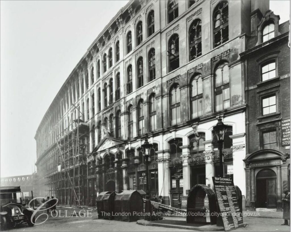
Although the building looks impressive today, it was originally a much taller building, however after a fire in 1920 which gutted much of the building, the top two floors were demolished. The original, larger facade just after the fire can be seen in the photo below:

Globe at Borough Market

Image credit: London Metropolitan Archives, City of London: catalogue ref: C_PHL_01_375_574c_2

The Hop and Malt Exchange was built in Southwark, as it was close to the main railway stations and goods depots that served the hop growing counties of Kent, Sussex and Surrey and provided a place were growers and buyers could meet in one place to conduct the sale of hops.

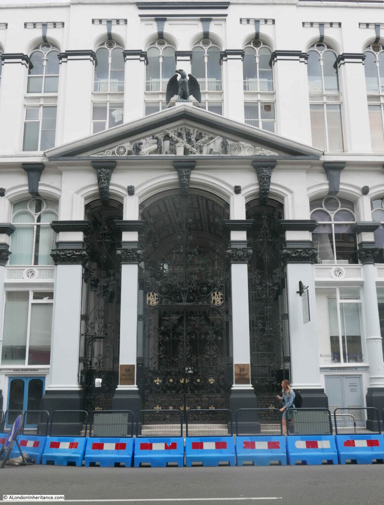
The main entrance to the Hop and Malt Exchange:

Globe at Borough Market

The pediment above the main entrance contains some wonderful decoration showing hop and malt production. Hops being grown and picked in the centre. Barley being grown on the right for the production of malt, with these products being carried in a sack on a barrow on the left.

Globe at Borough Market

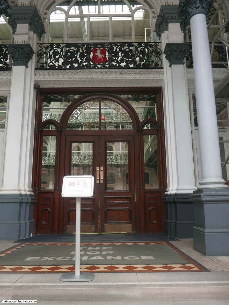
Looking through the iron gates of the entrance (which are also beautifully decorated), we can glimpse the main Exchange Room:

Globe at Borough Market

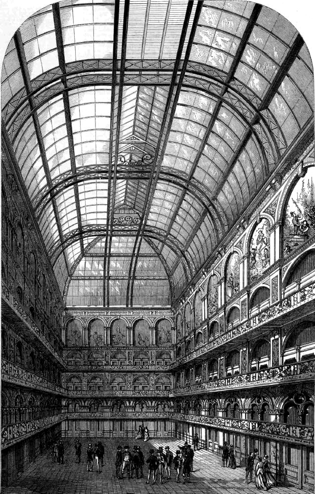
The Exchange Room was the central point for trading activities. It was 80 feet long by 50 feet wide and 75 feet was the original height to the top floor. The roof was glass allowing plenty of natural light to shine on the floor below. There was a central lantern feature running along the length of the roof, and in the pre-fire building, this was 115 feet above the floor of the Exchange Room.

The Exchange Room was surrounded by four floors of offices and show rooms where growers could show off their products to potential buyers. First and second class refreshment rooms were also provided. Presumably you used the first class when trying to impress a buyer, and the second class for normal refreshment.

A view of the Exchange Room after opening:

Globe at Borough Market

Today, the Hop and Malt Exchange has been restored and is currently a location providing office, corporate hospitality and a live events space, so in some ways is still true to the original use of the building – although no longer trading in hops and malt.

Borough Market and the Hop and Malt Exchange highlight that this area was a significant place for trading agricultural products. What started off as a market on the southern end of London Bridge, grew considerably with the arrival of the railways. Road and rail access to the southern agricultural counties turned this part of Southwark into a key location where London’s shops, restaurants and breweries could negotiate and buy the key agricultural products they needed for their business.

My 1977 photo captured the very end of that long period, but Borough Market still remains serving a new, 21st century customer.

alondoninheritance.com

Southwark Cathedral

There are a few places in London where I can stand in exactly the same position as my father and the view is almost identical. In Winchester Walk, approaching Southwark Cathedral, the subject of this week’s post, is one of these locations.
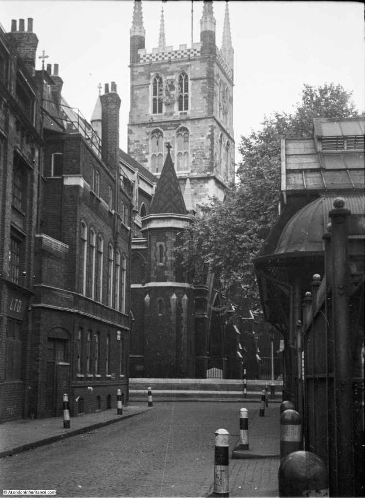
My father took the following photo of the Cathedral in 1953 from Winchester Walk.

Southwark Cathedral

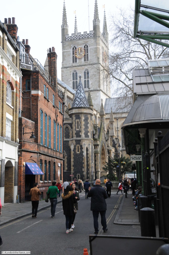
My 2017 photo from the same location:

Southwark Cathedral

I managed to get the alignment between these two photos almost exactly the same. The differences between the two are mainly cosmetic and if I had been there early in the morning with no people around and converted to black and white the photos would have been almost identical, amazing considering they are 64 years apart. The roof and air vents on the Borough Market building on the right are identical as is the roof line of the buildings on the left including the railing around the top of the wall at the base of the roof.

When I take photos at places where the view and surroundings are almost identical, knowing who was standing at this exact same place decades ago, it does bring home how quickly time passes and that we are all just very temporary occupants of these streets.

One of the differences between the two photos is the cleanliness of the buildings. It is perhaps difficult to appreciate how clean the buildings of London are today when compared to those of the city when the burning of coal in homes and factories was common across the city, and from the steam trains passing on the railway viaducts adjacent to the market and Cathedral.
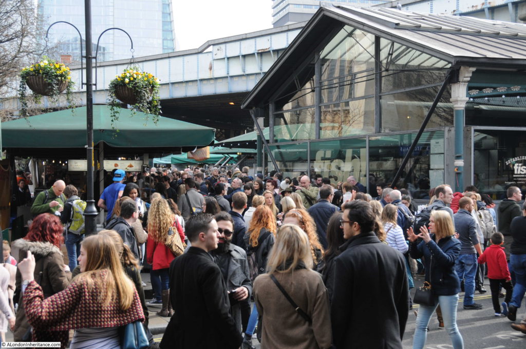
Southwark Cathedral is in the background and Borough Market on the right – Borough Market being the reason why there are so many people around this area.
There has been a church on the site of Southwark Cathedral for many centuries, and the location close to the southern end of London Bridge, a river crossing point since Roman times, perhaps explains the importance of this location.

The first church on the site was possibly built around the 7th century, allegedly by a ferryman who used his wealth to fund the construction of the church. Edward Walford in Old and New London includes a story which also refers to a ferryman, but attributes the building of the church to his daughter, Mary Audrey. Old and New London records that this story came from Stow, who chronicled it as the report of the last prior, Bishop Linsted. Walford does then go on to state that this story has been much discredited.

I suspect we will never know who was responsible for the original church, however it was rebuilt in the 9th Century by the Bishop of Winchester and then in 1106 the church was re-founded by two Norman Knights, William Pont de l’Arche and William Dauncey as a priory for Augustine Canons.  The church was dedicated to St. Mary and then later to St. Mary Overie. Walford in Old and New London suggests that Overie is a corruption of the surname of Mary Audrey, however I suspect this is part of the discredited story. The official explanation is that Overie means “over the river”.

In 1424 the church held its only royal wedding when James I of Scotland married Jane Beaufort, the daughter of the Earl of Somerset.

During the reformation, the priory was closed and the church taken by Henry VIII, when it became a parish church, dedicated to St. Saviour.

The church was purchased by the parishioners in 1614 and in 1689 the new tower was completed which is the tower we see today.

In the following centuries the church went through periods of decay and repair. The tower was in jeopardy on a number of occasions , Walford reports that once was due to vibration damage resulting from the ringing of the bells. The south-eastern pinnacle was struck by lightning and fell on the roof of the south transept. The wooden roof of the nave was demolished, followed by the original nave.

The church became Southwark Cathedral in 1905 to recognise the importance of the church and the considerable growth in population south of the river. The full title of the church retains the original dedications as the Collegiate Church of St. Saviour and St Mary Overie.

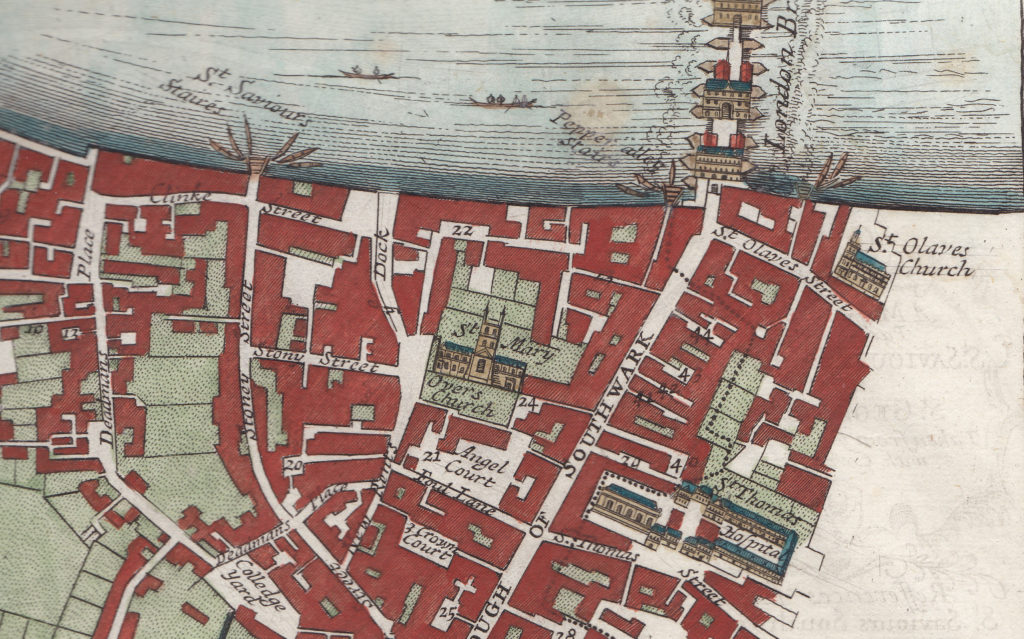
The following map extract from the late 17th century shows the church with the tower looking as it does today. To the left of the church is a small open area into which leads into Stony Street. This is the street from which the 1953 and 2017 photos were taken, however at some point it has changed its name to Winchester Walk. Borough Market now occupies the area south of the Cathedral on what was once Angel Court and the wonderfully named Foul Lane.

Southwark Cathedral

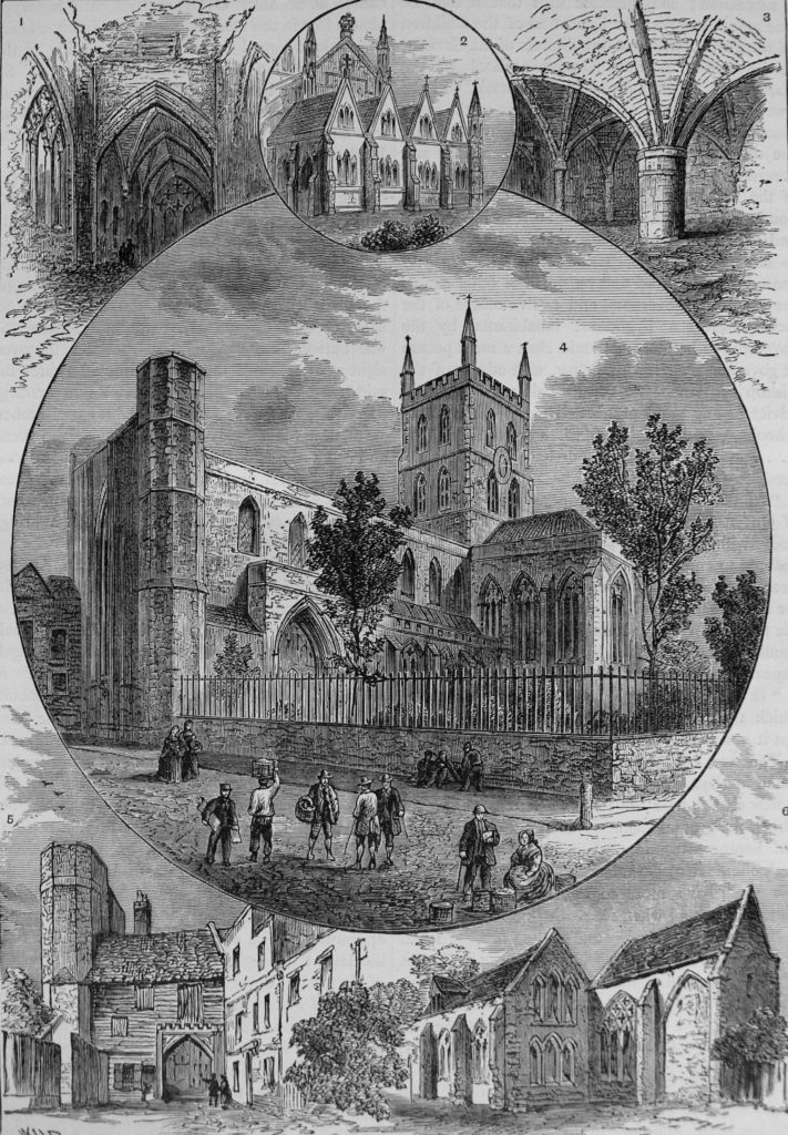
The current name Winchester Walk retains a link the area has had with the Bishops of Winchester. Winchester House or Palace once occupied a large area west of the Cathedral which included a hall of which the circular window can still be seen when walking from the Cathedral into Clink Street.

Views of Southwark Cathedral from Old and New London.

Southwark Cathedral

The top right drawing shows the part of the Priory of St. Saviour’s, the oldest part of the church and dating from the 13th century. This part of the church is still in existence and I will find this during a walk around the Cathedral.

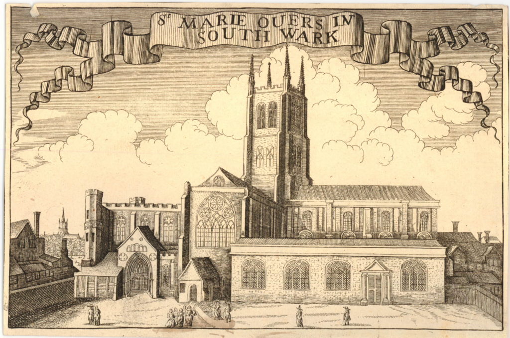
Wenceslaus Hollar also made a number of drawings of the Cathedral including the following showing the south front of the church. The print was published around 1690, although certainly drawn much earlier as Hollar died in 1677. The church in the distance to the left of the Cathedral is St. Paul’s Cathedral so this could be a pre-1666 print. The spire on the tower of St. Paul’s must have been added by Hollar as it collapsed in 1561.

Southwark Cathedral

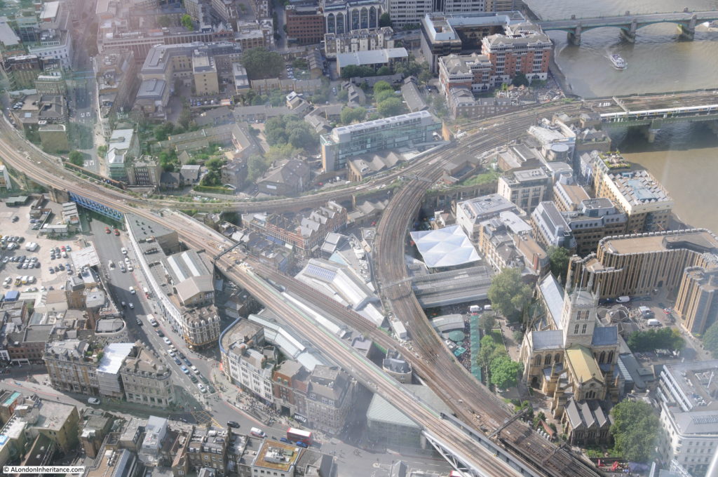
The future of the church was at risk during the 19th century when the church was still a parish church rather than a cathedral. During the 19th century, railways would cut through the south of London to reach stations along the south of the river such as Waterloo and cross the river to reach stations on the north bank. Walking around Borough Market shows how part of the market is enclosed within railway viaducts, and the impact of these on both the market and the church can really be appreciated from the top of the Shard.

The following photo shows the Cathedral to the lower right with the loop of railway viaduct heading round to the bridge to Cannon Street Station on the north side of the river.

Southwark Cathedral

There were proposals to demolish the church during the planning of the railways along the south of the river, fortunately these did not get put into practice, however the proximity of these viaducts clearly demonstrates the impact of the railway in the area around the Cathedral.

The area to the south west of the Cathedral and within the area enclosed by the railway viaducts is now occupied by Borough Market.

Southwark Cathedral

If you are there during a weekend, I recommend avoiding the crowds in Borough Market and visit the Cathedral instead. The interior of the church is fascinating and well worth a walk around.

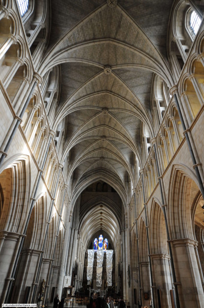
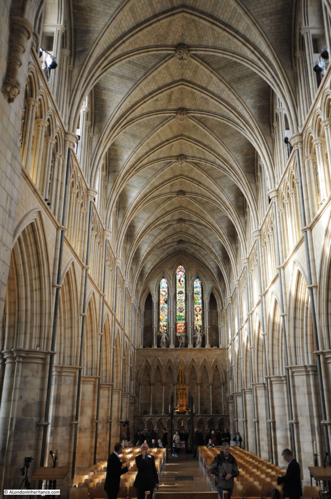
The view on entering the Cathedral, looking down the nave towards the Choir.

Southwark Cathedral

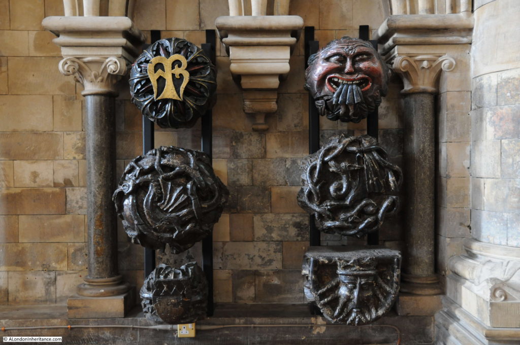
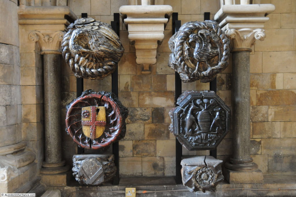
The following two photos show some of the medieval roof bosses from the 15th century wooden ceiling, installed following the collapse of the earlier stone ceiling.

Southwark Cathedral

Southwark Cathedral

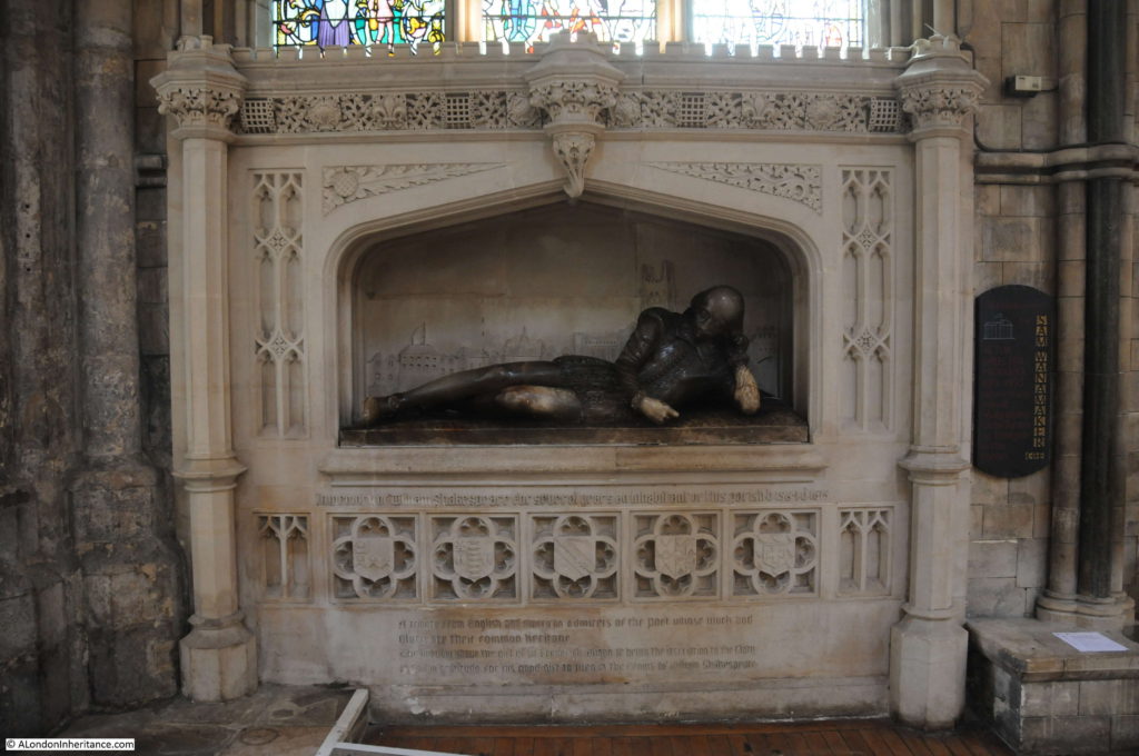
At the end of the nave is the Shakespeare memorial. The carved figure of Shakespeare is from 1912. Sir Walter Besant in London, South of the Thames mentions that Shakespeare’s brother Edmund was buried in Southwark Cathedral.

Southwark Cathedral

The tomb of Bishop Lancelot Andrewes who died in 1625. Andrewes was one of the translators of the King James version of the Bible.

Southwark Cathedral

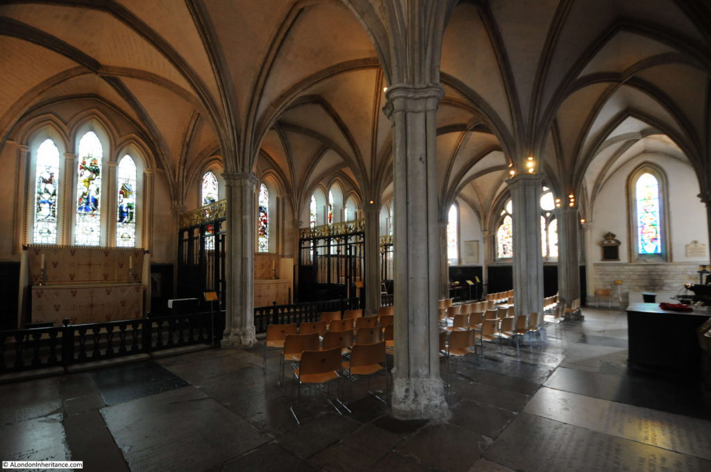
At the eastern end of the church is the retro choir. This is from the 13th century and is the oldest part of the Cathedral still standing (see the drawing of the retro choir in the drawings from Old and New London above).

Southwark Cathedral

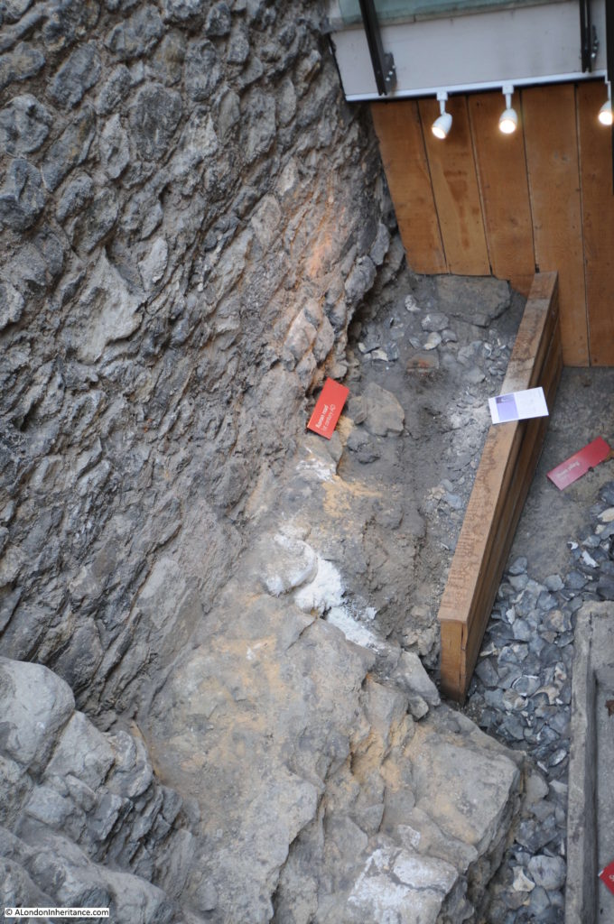
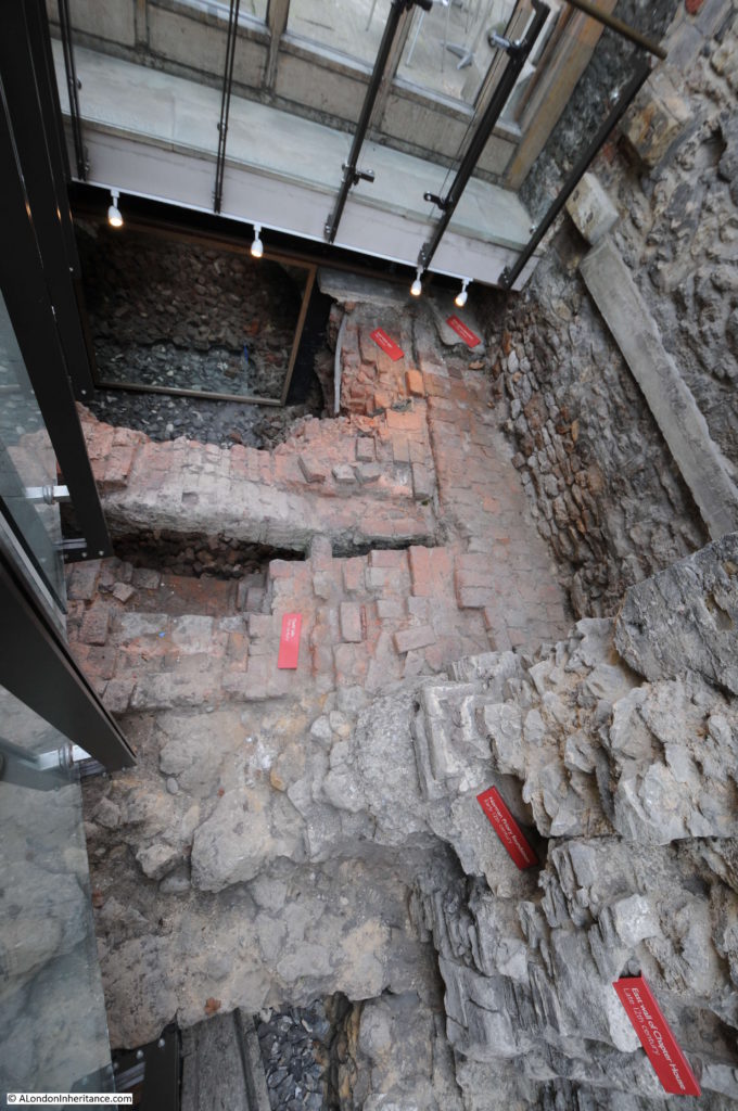
There is an open archaeological excavation outside the main church which I will come to later. This shows a 1st Century AD Roman road and has an information panel which shows that the original Watling Street ran along the eastern edge of the church, just outside the windows that run along the left of the photo above. The road cut through the far corner of the church.

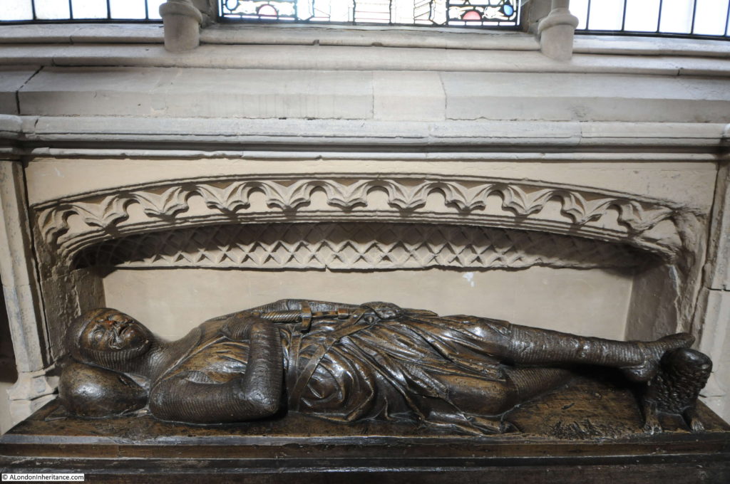
The majority of effigies are carved in stone, however Southwark Cathedral has a rather unusual effigy carved in wood which dates from the 13th century.

Southwark Cathedral

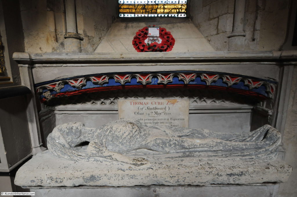
There is also an effigy of the rather shrunken body of Thomas Cure of Southwark who died on the 24th May 1588.

Southwark Cathedral

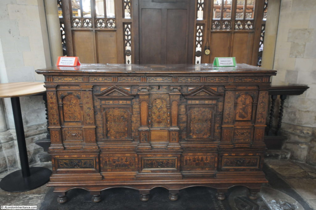
This superb wooden chest once held all the parish records. Made by German immigrants in the parish, it was given to the church in 1588.

Southwark Cathedral

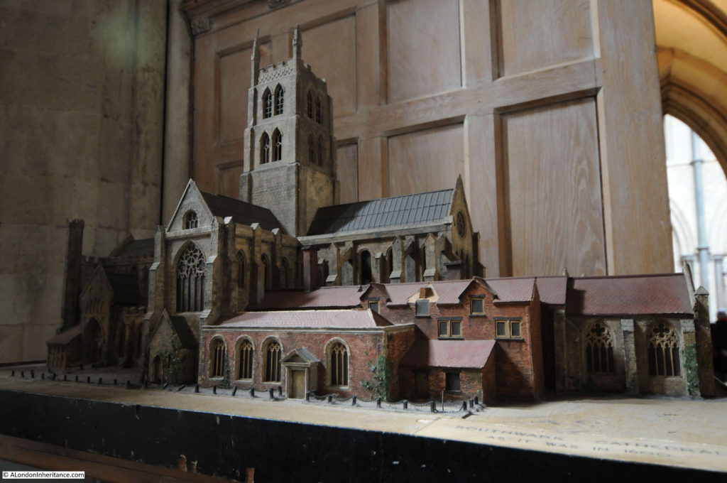
A wonderful model of the church, although a couple of the pinnacles on top of the tower appear to be missing, perhaps recreating the lightning strike that brought down one of the pinnacles onto the roof of the south transept.

Southwark Cathedral

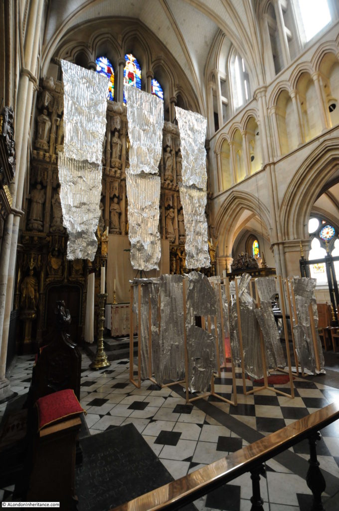
During my visit the High Altar Screen was partially hidden behind an artwork. The High Altar Screen dates from 1520, but with later added detail. The screen consists of carvings of saints and those who have been connected with the Cathedral.

Southwark Cathedral

Looking down the Nave from the Choir.

Southwark Cathedral

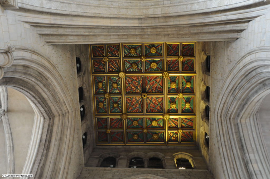
The painted ceiling on the base of the tower.

Southwark Cathedral

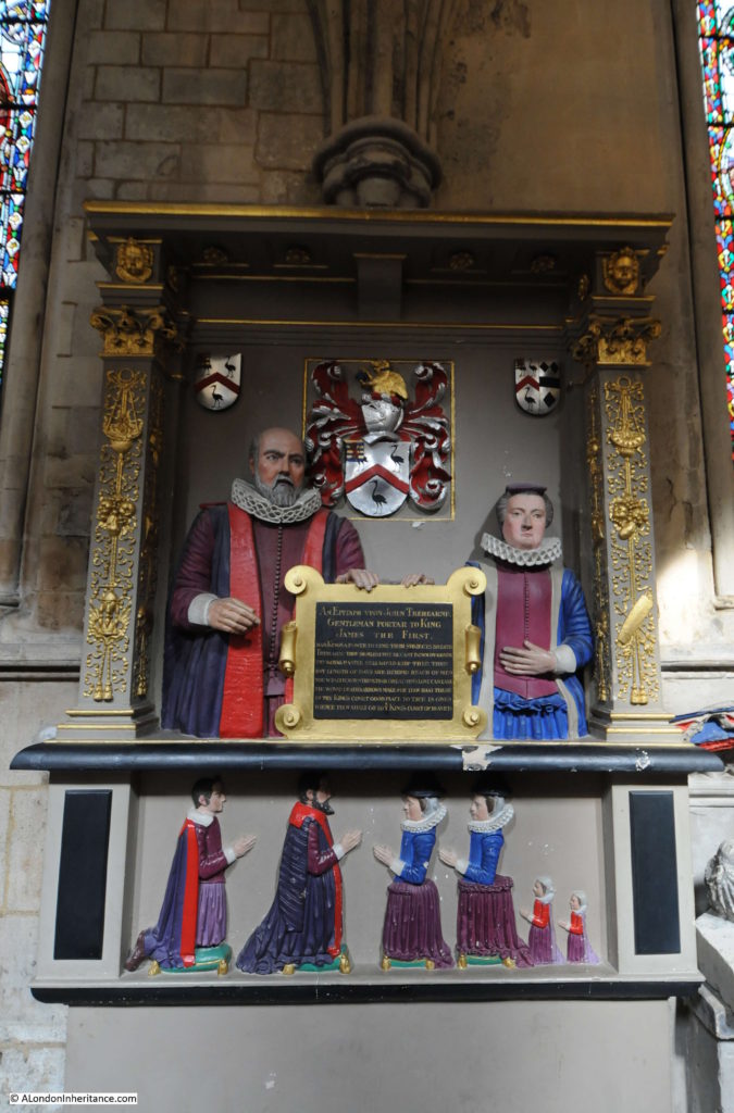
An epitaph to John Trehearne, Gentleman Portar to King James the First.

Southwark Cathedral

The epitaph reads:

“Had Kings a power to lend their subjects breath Trehearn thou should’st not be cast down by death. Thy royal master still would keep thee then but length of days are beyond reach of men, nor wealth, nor strength, nor greatmen’s love can ease the wound death’s arrows make. Thou hast these in thy King’s court good place to thee is given. When thou shalt go to ye King’s Court of Heaven.”

A salutary reminder that no matter your wealth or power, there is no escape from death.

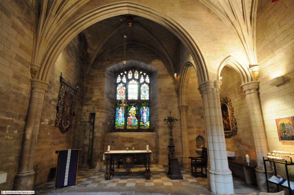
Along the northern side of the church is the Harvard Chapel which is named after John Harvard, the benefactor of Harvard University who was baptised in Southwark Cathedral, or St. Saviour’s as it was in 1607.

Southwark Cathedral

John Harvard was born in Southwark in 1607. He emigrated to America in 1637 and settled in Charlestown where he became a minister. He was only there for one year, as he died in 1638. He left his library and part of his estate to the college that had been established two years earlier and which would take his name.

The stained glass window in the Harvard Chapel was given to the church by the US Ambassador in 1907.

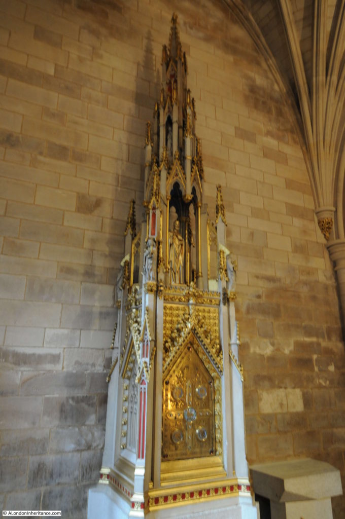
Also within the Harvard Chapel is a tabernacle designed by Augustus Pugin in 1851, the year before his death in 1852. It was Pugin who was responsible for so much of the design of the Palace of Westminster, including the Elizabeth Tower.

Southwark Cathedral

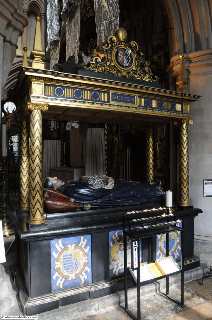
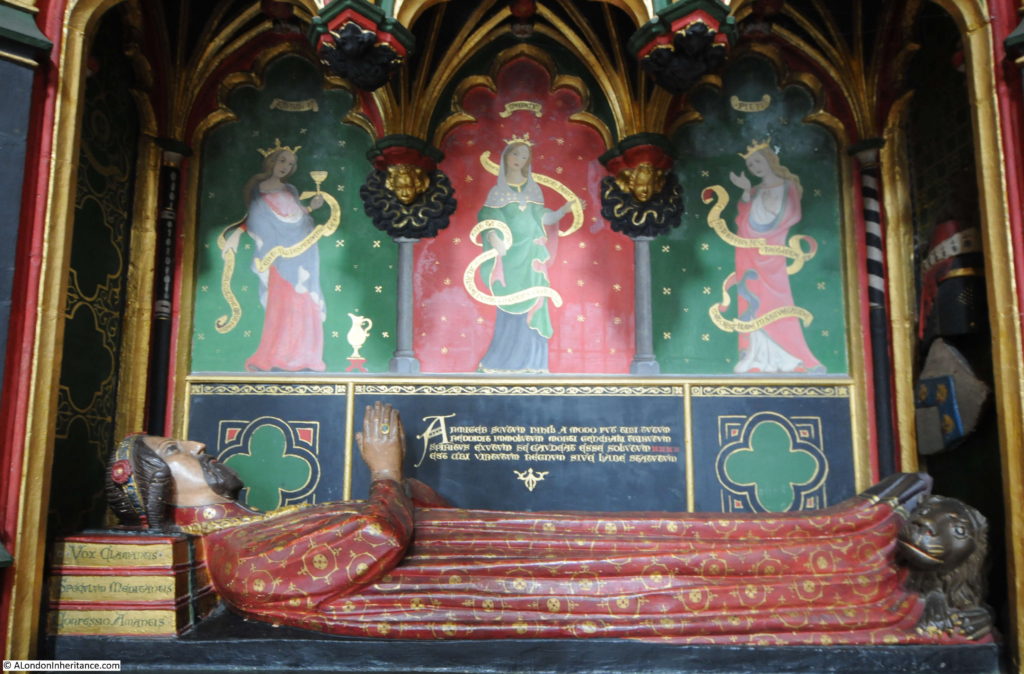
The tomb of John Gower. a poet to King Richard II and Henry IV. His head is resting on three books representing three of his greatest works.

Southwark Cathedral

The railway viaduct and market now occupies part of what was the churchyard of the Cathedral. There are some steps in the south-east corner of the churchyard from where the difference between the quiet churchyard of Southwark Cathedral and the crowds of Borough Market can be appreciated.

Southwark Cathedral

There were a fair number of visitors to the Cathedral during my visit, however what most people seemed to miss was perhaps one of the most interesting features. Walk back out the entrance to the Cathedral and there is a corridor where the Cathedral Shop is located. At the end of this corridor is the result of some of the archaeological excavations that took place prior to the building of the rooms on the north-side of the Cathedral in 1999.

The excavations show the layered history of the Cathedral, starting with the remains of a Roman road from the 1st Century AD, 12th Century foundations of the Norman Priory, 17th Century Delft Kiln, 18th Century stone pavement and a 19th century lead water pipe.

The remains of a 1st Century Roman road between the walls of the cathedral and the wooden retaining panels.

Southwark Cathedral

The information panel explains that the Roman road was a smaller road running diagonally across the church and appears to be running up to the river to meet at the same place where Watling Street met the river.

Lower right are 12th Century remains of the Norman church. In the middle is the 17th Century Delft Kiln and at the top is the lead piping and pavement.

Southwark Cathedral

Looking along the excavations with a coffin behind the kiln.

Southwark Cathedral

It is good to see these features in situ rather than as isolated exhibits. They show the layered history of London’s past and how London has always been built on earlier versions of the city.

It is also not just the stones of the city that have a layered history. All those who have lived and worked in the city over the centuries are also part of these layers, and it is this that I feel part of (although on a very much shorter time span) when taking photos in the same locations as those from 60 and 70 years ago.

alondoninheritance.com

The Founder’s Arms, Falcon Stairs, A Brothel And Confused Street Names

A couple of week’s ago, my post was on No.49 Bankside, one of the few remaining historic buildings in Bankside, and for this week, I have moved across to the other side of Tate Modern, and found how echoes of London’s long history are still visible today, despite what at first sight, appears to be a very recent landscape.

My photo for this week from my father’s collection was taken in 1950. As the street sign confirms, it is on Bankside and looking across to a fine Victorian pub. This is the Founder’s Arms.

Behind the pub is the viaduct, approaching Blackfriars railway bridge, carrying the rail lines across the Thames into Blackfriars Station. A couple of the arches underneath the railway can just be seen to the left of the pub.

Founders 1

Although this part of Bankside has changed dramatically, it is relatively easy to place the location of the Founder’s Arms. The following is my 2015 photo, taken not quite from the same location as the new buildings on the right hide the view of the location of the pub, but using the arches in the railway viaduct and the road layout as reference points, where the pub once stood is now occupied by the single storey building behind the white van. The arches in the viaduct can just be seen on the left.

To the right of the pub in the 1950 photo, the roadway continues down to the wharfs and stairs on the river. Although not a road, this is still a footpath shown in the 2015 photo by the yellow railings. Bankside still curves to the right (although moved slightly away from the river, the original route now occupied by the buildings on the right), and in the 1950 photo, just visible to the left, two cobbled streets appear to be separated by a small part of pavement that extends into the centre left of the photo.

Founders 2

An alternative viewpoint with a better view of the arches under the viaduct with the position of the Founder’s Arms on the right:

Founders 12

To help understand the area in more detail, maps covering the last few centuries tell so much of how the area has changed, and what has remained.

Below is the latest Google map of the location. Hopton Street is seen in the middle of the map, coming up to a T junction at the top, with just before this, a small side extension to join with Holland Street.

Turn left at the T junction and the walkway to the river past the original location of the pub is shown in grey. The map still shows a Founder’s Arms, now directly on the river, I will come back to this later.

2015 map

Working back in time, the following map is from the 1940 Bartholomew’s Reference Atlas of Greater London and shows the road layout as it was at the time of the 1950 photo. I have marked the position of the pub with a red dot.

Compare the roads Holland Street and Hopton Street. The 1940 map has these reversed compared to the Google map, and checking on site, Google is accurate, so was this just a map makers error?

1940 map with spot

Going back 10 years to the 1930 version of Bartholomew’s Atlas and it is even more confusing. Look at the same location near the top of the following map and now both are called Holland Street with no mention of Hopton Street.

1930 map

I checked the 1913 version of the same Atlas (yes, sadly I do have multiple editions of the same London Maps !!)  and the streets are both called Holland Street in this version as well, so I doubt this was an error.

So now, let’s jump back much further to John Rocque’s survey of London from 1746. I have again marked the approximate position of the pub by a red dot. In the John Rocque map, the reference point we can use that is still there today are the Hopton Almshouses which can be seen along The Green Walk. These can also be seen on the Bartholomew maps as the U-shaped building where Holland Street meets Southwark Street.

Founder 6a with spot So, in 1746, neither Hopton or Holland street names existed. Today’s Hopton Street was The Green Walk and today’s Holland Street was part of Gravel Lane.

To start with trying to explain the street name changes, George Cunningham in his survey of London’s streets, buildings and monuments gives an explanation for the name Holland Street:

“Location of the old moated Manor House of Paris Garden, subsequently notorious under the name of Holland’s Leaguer, from Holland, a procuress (an early name for a “woman who procures prostitutes”), who occupied it in Charles I’s time. The old Manor House was a favourite resort of James I and his Court, George Villiers, Duke of Buckingham and the nobility generally.”

Holland was Sarah Holland who in 1631 had been charged as an “incontinent women” and imprisoned in Newgate. The Manor House was very suitable for her needs as she said it was “near the theatres and baiting rings, with their wild beasts and gladiators”.

George Cunningham’s book was published in 1927 and there is no mention of Hopton Street.

So that explains the source of the name Holland Street, but does not explain why or when The Green Walk and Gravel Lane changed their name. The 1913 Bartholomew Atlas is therefore correct by labelling the two streets (which were in effect one, looping back after reaching Bankside) as Holland Street.

In the original The Green Walk are Hopton’s Almshouses. These were built around 1749 for “twenty-six decayed house-keepers, each to have an upper and lower room with £10 per annum and a chaldron of coals.” They have been occupied continuously since July 1752.

The money (and name) for these came from one Charles Hopton who on his death left a large sum of money to his sister, and on her death the money was used to build the Almshouses. Hopton was born around 1654 into a wealthy merchant family and was a member of the Guild of Fishmongers.

The Almshouses are still there today. A surprise to walk down Hopton Street in the summer and suddenly find these 18th century buildings with at their centre a wonderful colourful garden:

Founders 7

The Almshouses as they appeared around 1850. A far more austere appearance with no gardens:

Founders 11

In 1831 there is a description of these as being “those of Mr Hopton in Green Walk” – so it appears the name had not changed to Holland Street by 1831. By the time of Edward Walfords Old and New London (1890) the name had changed to Holland Street.

Hopton Street has one further surprise. This is No. 61 Hopton Street, or when it was first built, No. 9 Green Walk and is the oldest building in the area.

One of a number of houses built by James Price around 1703. This is the sole survivor and is surrounded on all sides by much later (and much larger) additions to Hopton Street. The changes that this house has seen over the centuries must be quite remarkable.

Founders 8

The change of part of Holland Street to Hopton Street probably occurred around the mid 1930s.

In Grace Golden’s history of Old Bankside, published in 1951, she refers to: “An apparently puritanical drive has recently changed Holland into Hopton Street, named after Charles Hopton”.

Also, the licensing records for the Founder’s Arms state that the original address was 8 Holland Street and the address was changed to 56 Hopton Street between 1934 and 1938.

From this, I assume that in the 1930s, there was an initiative to change from Holland to Hopton Street to erase the reference to what must have effectively been a brothel kept by Sarah Holland at the old Paris Garden’s Manor House.

The reversal of Holland and Hopton Streets between the 1940 and today’s maps was probably down to it being a very recent change in 1940 and an error in recording which leg of Holland Street had changed (although I cannot find out why only part of the street changed – it may have been down to the Almshouses wanting to have an address of their founder rather than the founder of a brothel !)

Before I return to the Founder’s Arms, there is one further name that persists in this small area. At the end of Hopton and Holland Streets is a paved area, planted with trees. This is Falcon Point Piazza:

Founders 3

Also, the new buildings to the right of the above photo are named Falcon Point:

Founders 4

If you return to the John Rocque map from 1746 and look on the river’s edge to the lower right of the red circle you will see Faulcon Stairs, one of the many old stairs that led down to the river.

The earliest explanation I can find for the name is from the sport of Falconry that took place in the Paris Gardens that occupied much of this area, so the buildings and the Piazza both retain the name of a sport that took place here hundreds of years ago.

The Falcon name has other associations with the area.

Between the end of Holland / Hopton Streets and the Hopton Almshouses was the Falcon Glass Works. Built in the late 18th century by the firm of Pellatt & Green, partly on the site of a Millpond (the millpond can be seen on John Rocque’s map above. Look slightly below the red dot and to the left and a small shaded area adjacent to the road is the original millpond. The curve of the current road still maintains the outline of the millpond)

Writing of the Glass Works in 1843 in his History of Surrey, Brayley states that “Their present importance and excellence are mainly due to the taste and exertions of the present proprietor and the employment of skilful hands on materials that science and experience approve. By these means the most elegant productions of the Continent are advantageously rivalled, and in some respects surpassed”. 

Falcon Glass Works as they appeared in 1827:

Founders 10

As can be seen, they were located at the point where Hopton / Holland Streets loop round, back to Southwark Street and Sumner Street. The same location now with the curve of the road (due to the original millpond) still very obvious:

Founders 9

I have read, but have been unable to corroborate, that the source of the name Founder’s Arms was due to the Glass Works or Foundry as a “Founder” is also an operator of a Foundry.

In addition to the Founder’s Arms, there was a much earlier pub on the site of the Falcon Drawing Dock, (closer to the river, near the stairs). This was the Falcon Tavern which was allegedly used by Shakespeare, but was definitely a major coaching inn, acting as the terminus for coaches to Kent, Surrey and Sussex. The Falcon Tavern was demolished in 1808.

Now if we walk past where the Founder’s Arms use to be back up to the walkway along the river we find both the latest the latest incarnation of the Founder’s Arms and steps leading down to the river, roughly in the location of the Falcon Stairs (I say roughly as with the building of the walkway and other changes it is impossible to be precise).

Founders 5

A very different pub to the Victorian original but good that for at least 176 years (the earliest record I can find for the Founder’s Arms is from 1839) a pub with the same name has been found in this small area of Bankside.

A rather convoluted story, but one that demonstrates how much is to be found in one very small area of London, and that despite so much reconstruction and change, links with the history of the site are still there to be discovered.

The sources I used to research this post are:

  • Old and New London by Walter Thornbury published in 1881
  • London, South of the Thames by Sir Walter Besant published in 1912
  • Survey of London, Volume XXII published by the London County Council in 1950
  • Old Bankside by Grace Golden published in 1951
  • London by George H. Cunningham published in 1927
  • Bartholomew’s Reference Atlas of Greater London, editions published in 1913, 1930 and 1940
  • A Plan of the Cities of London and Westminster and the Borough of Southwark by John Rocque published in 1746

 alondoninheritance.com