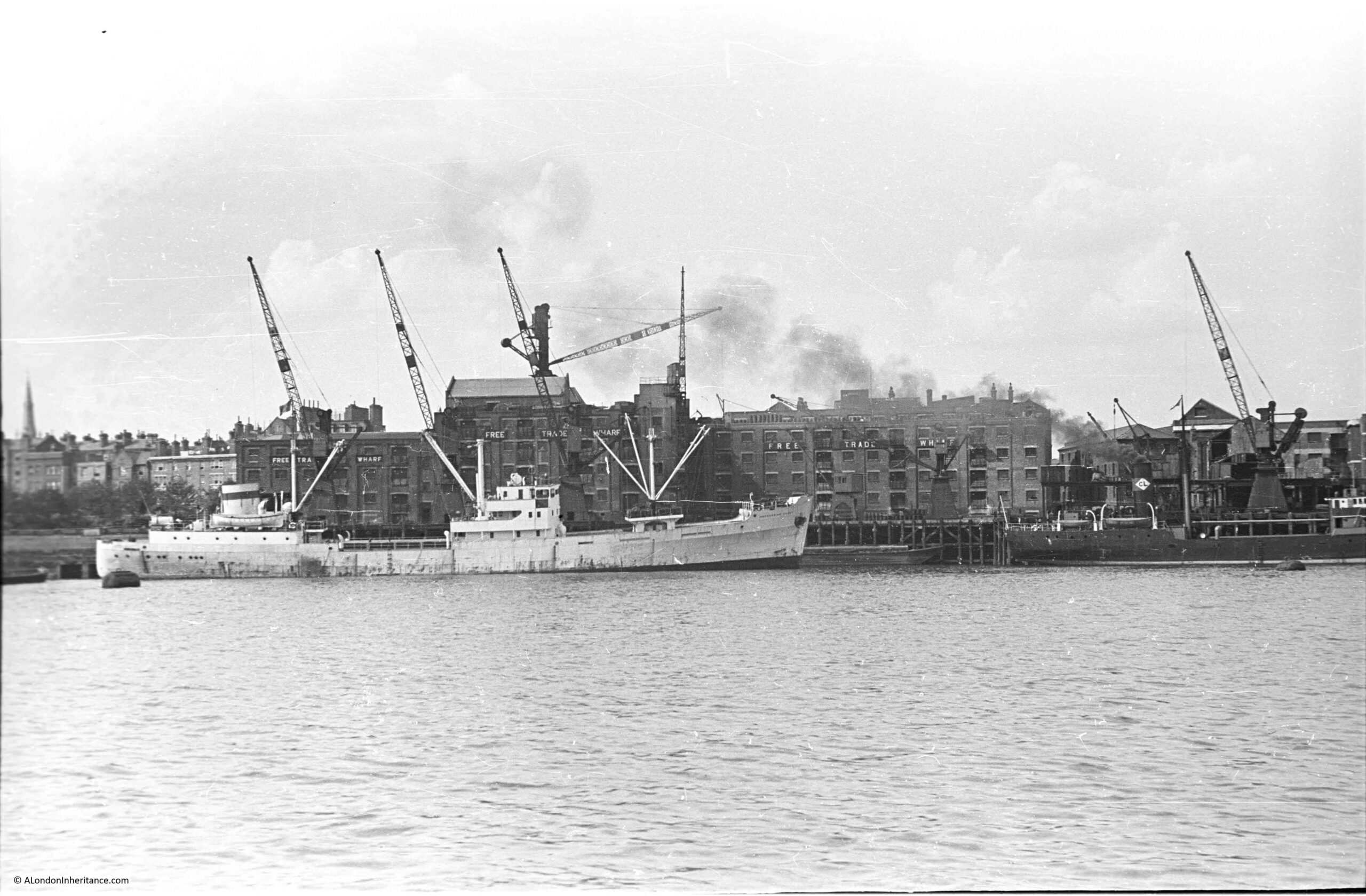
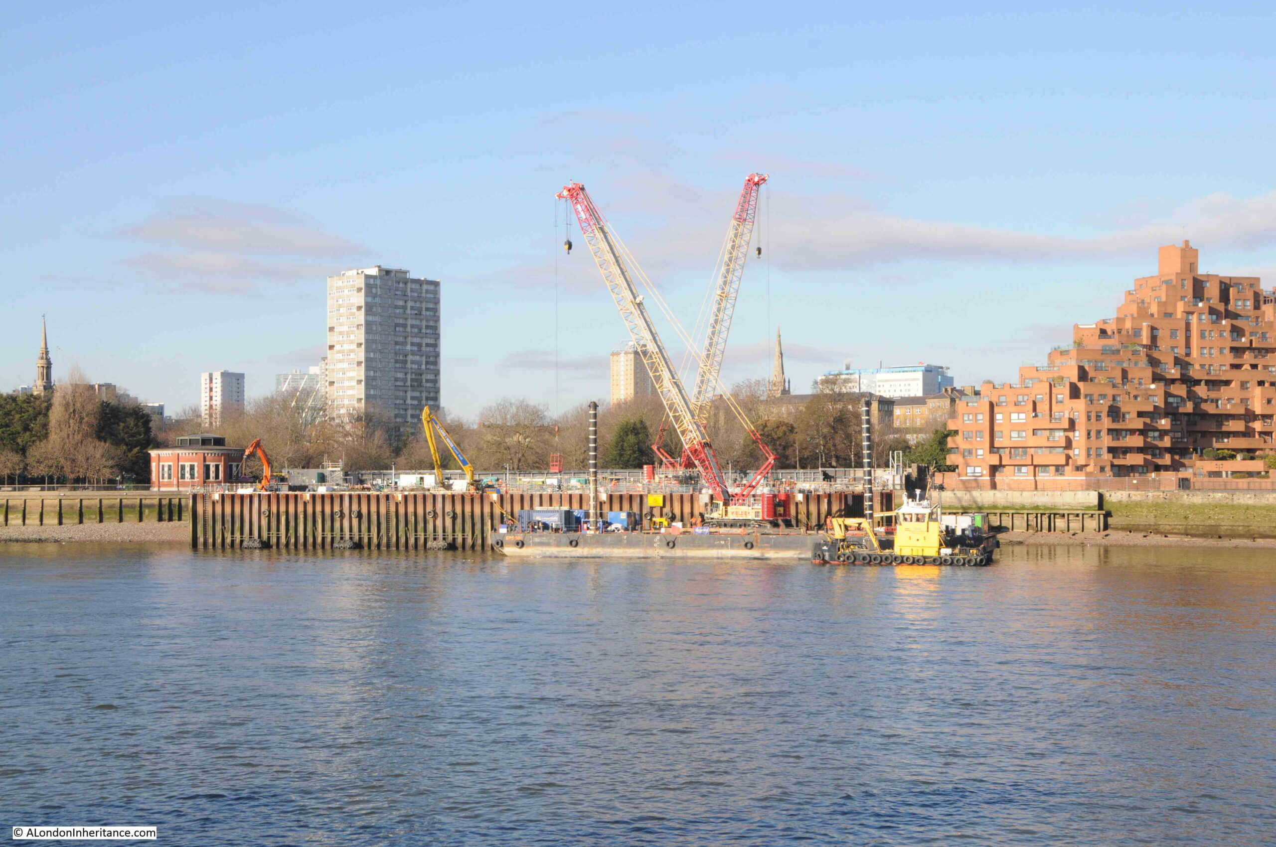
The following photo was taken by my father in August 1948, and shows the buildings of Free Trade Wharf in the old area of Ratcliffe:
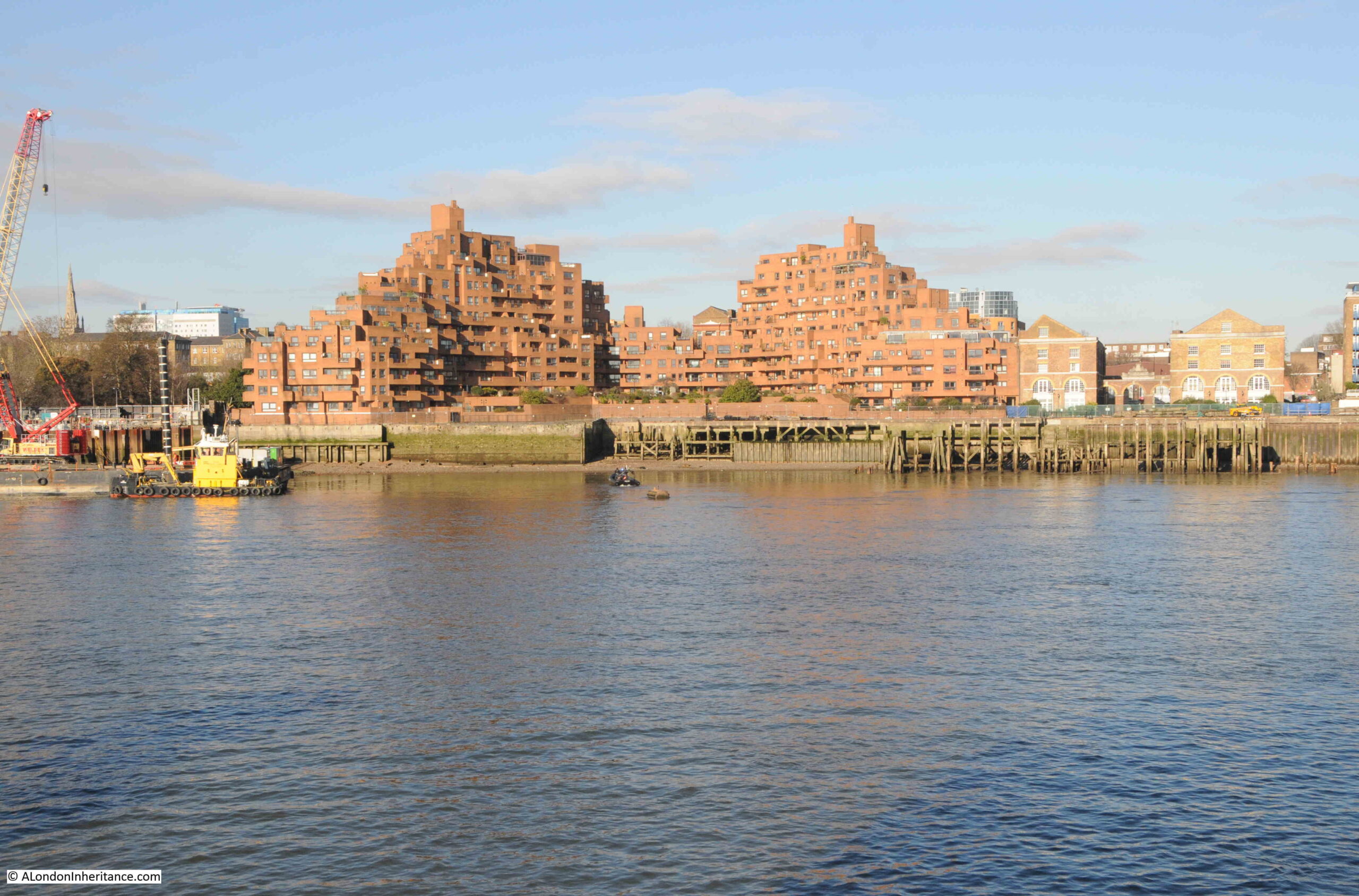
The same view, seventy six years later in 2024:
Despite the loss of the central Free Trade Wharf buildings, there are some features that can be found in both photos.
On the left of both photos, there are no buildings along the edge of the river, and trees can be seen in an open space leading back from the river. This is the King Edward VII memorial park.
Staying on the left of both photos, a church steeple can be seen in the background. This is St. Mary’s Cable Street.
The central part of the photo is very different. The Free Trade Wharf was purchased by the Inner London Education Authority in 1977 with the intention of building a campus for the City of London Polytechnic, which had been formed in 1970 with the consolidation of the City of London College, Sir John Cass College and the School of Navigation.
These plans did not follow through, and the site remained vacant until the early 1980s when the growing trend for the construction of residential properties along the banks of the Thames resulted in the purchase of the site for residential development, and the building on the site we see today was built.
It is one of the more distinctive residential buildings along the river, and was designed by the architects Holder Mathias Alcock, who are still practicing today, although the name Alcock has been dropped.
Their distinctive design has been described as being of “dramatic ziggurat-style terraces”, and also looking as if it could have been made out of Lego.
Faced by red brick, the building does look good in direct sunlight, and the from what I have read, one of the reasons for the shape of the building, where the sides step back towards the centre, was to maximise the number of apartments that had a river view, rather than being a flat building along the river.
This new development retains the name Free Trade Wharf, and looking at an extract of the 1948 photo, we can see this name was displayed in white lettering along the side of the building facing the river:
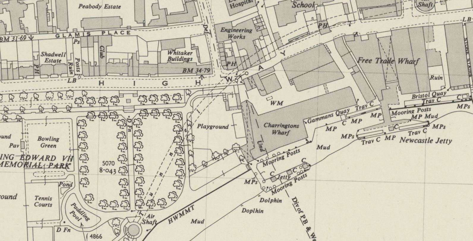
Although this very clear naming of the Free Trade Wharf did throw me into a momentary bit of doubt about whether I had identified the correct location for the photo, as in the OS map, published a couple of years after my father’s photo, the building is marked as Charringtons Wharf, as can be seen in the following map, along the river and to the right of the park (‘Reproduced with the permission of the National Library of Scotland“):
To confirm, I checked in the book “London Wharves and Docks”, published by Commercial Motor in 1953, and the entry for Charringtons Wharf included a reference that “Occupier: Free Trade Wharf Co. Ltd”.
The Charringtons name came from the ownership of the site by Charrington, Sells, Dale and Company, who traded in coal and coke. I cannot find exactly when this part of the site became known as Free Trade Wharf, however as you can see from the above map extract, this name was also in use for the buildings to the right, which are on the right of my father’s photo, but hidden behind the cranes, and the black coloured ship on the right.
The Commercial Motor book provides some detail on trade at the wharf in 1953:
“Facilities: a. General, b. Rubber, matches, canned goods. Maximum cranage (cwt) 45, Storage space (cubic feet, covered); 869,450, Storage Space (cubic feet, uncovered): 5,000.
Customs facilities included Sufferance Wharf, Dry Bond, Captain’s Imperfect Entry (a Sufferance Wharf is a licensed private wharf where goods can be kept until the duty is paid. A Dry Bond is where goods can be stored before customs duty is paid. Dry refers to the type,, so dry goods unlike wet goods such as alcohol. Captain’s Imperfect Entry is a strange one. Captain’s Entry is where the Captain of a ship has provided the details of the goods he wants to unload to the warehouse, but I am not sure what Imperfect refers to).
The wharf had a jetty and a quay, with 250 feet being the maximum length of ships accommodated at the jetty and 210 feet at the quay. and the depth of water went from 24 feet at high water down to 2 feet at the jetty, and from 19 feet to drying out at the quay. “
Just to the left of the site today, is one of the construction locations for the Thames Tideway Tunnel:
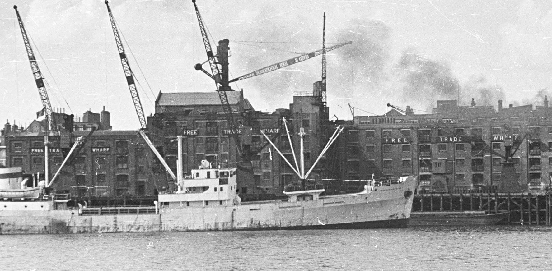
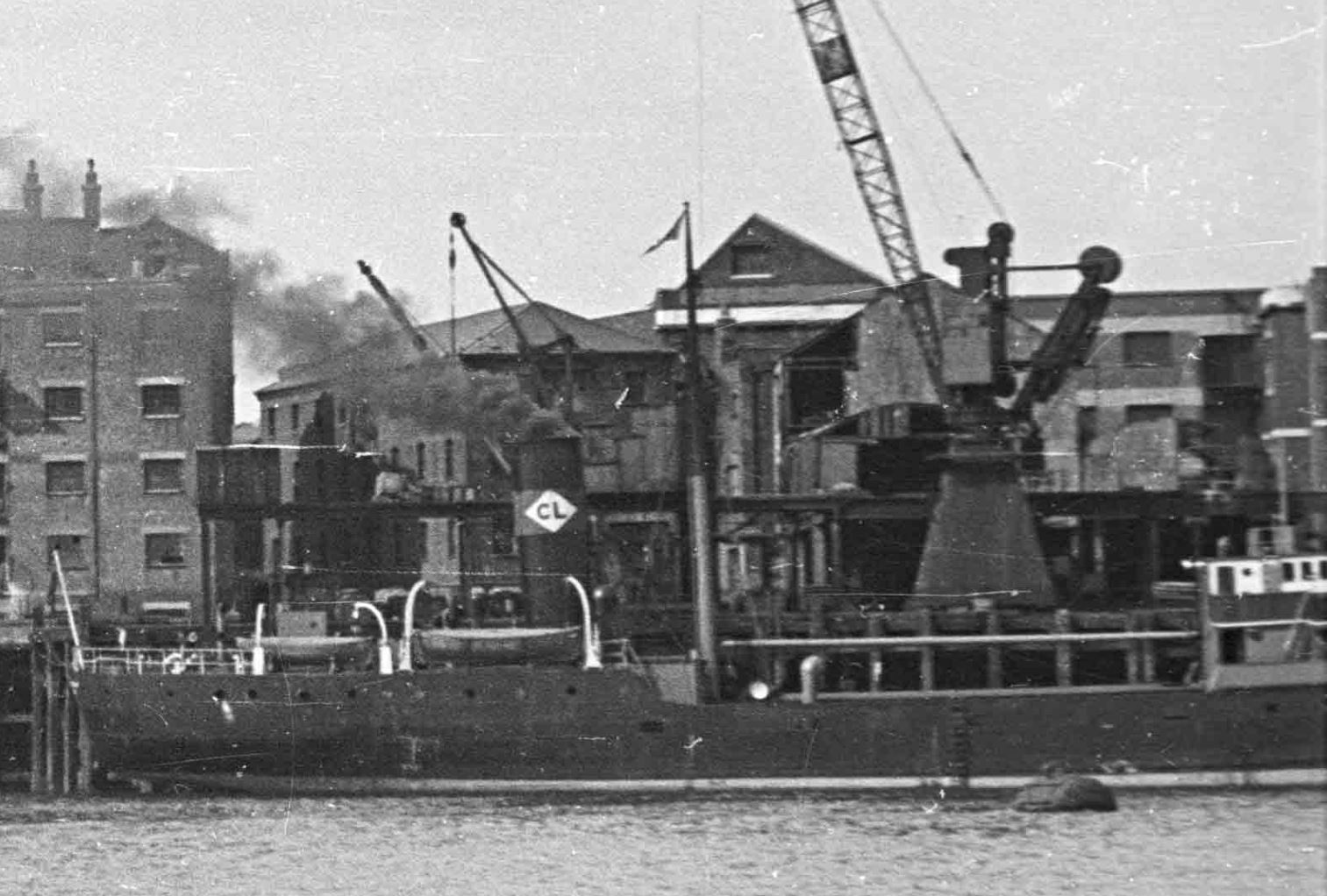
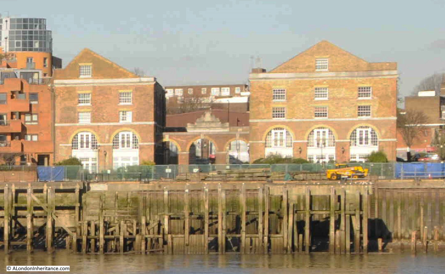
The OS map shows the buildings to the right of my father’s photo, labelled as Free Trade Wharf. These buildings are much earlier than the main block, but are hidden behind the ship and cranes in my father’s photo.
An extract from this photo showing the dark coloured ship, with part of these buildings just visible in the background:
The buildings, the ones labelled as Free Trade Wharf in the OS map as can be seen in 2024:
These buildings are Grade II listed and they date from 1796, although there have been many alterations over the years.
They were built for the East India Company, and handled a variety of goods, including saltpeter, which was used in the manufacture of gun power.
The site later became a place where colliers from the coal fields in the north east of the country would unload, and is presumably where the Charringtons connection comes from.
There are two ships in the 1948 photo. the ship on the left has no visible feature to help with identification. I use a high resolution scan for my father’s photos, and despite this, I cannot read the name of the ship on the bow.
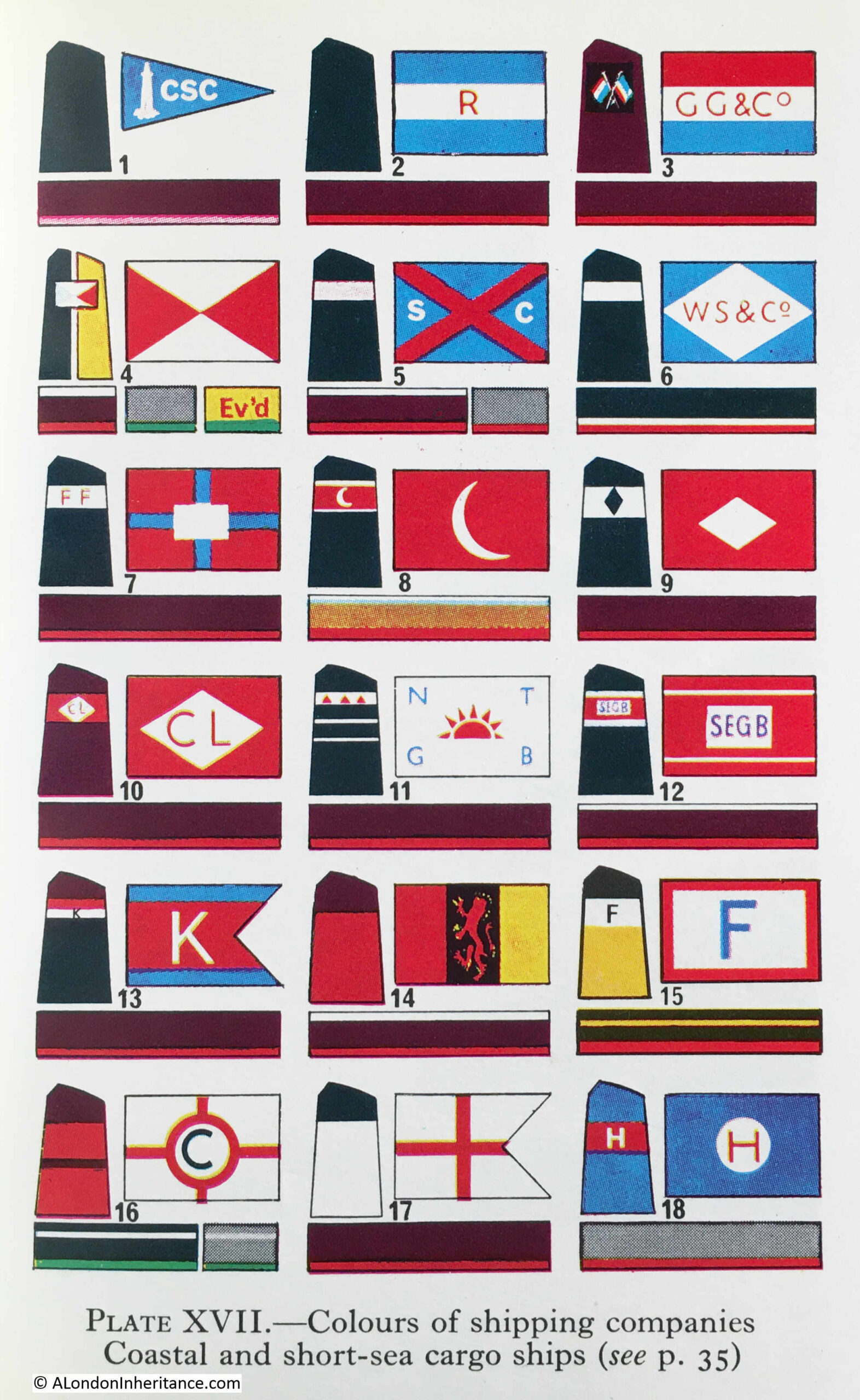
The ship on the right has no visible name, presumably it is on the bow and only the rear section of the ship is visible in the photo. What can be seen is the funnel, and this has the letters CL in a white diamond.
Ships with the identifier of the owning / operating company were once a frequent sight on the Thames, and as kids in the late 1960s / early 1970s, we would often go down to the Thames by Coal House Fort, through East Tilbury (which always fascinated with its village and Bata shoe factory in this isolated part of Essex).
I had the Observer’s Book of Ships and used this to check of the passing ships. I still have the book and checked it to see if the CL in a white diamond is listed, and fourth down, on the left column, I found it:
Turning to page 35, and CL is for Comben Longstaff & Co. Ltd of London, and who were listed as Colliers.
The company was named after William Comben Longstaff, who was born in Lambeth in 1896.
Comden Langstaff & Co. Ltd was originally involved in a range of maritime services including insurance, owning, managing and operating a fleet of ships that delivered raw materials and goods to the ports around the coast of the UK.
Newspapers of the time have many references to the purchase of new ships, sale of older ships, trade, routes etc. and the company seems to have been reasonably active.
The majority of their ships seem to have been built by John Lewis of Aberdeen, and the following article from the Aberdeen Press and Journal on the 9th of June 1948 is typical of the company’s coverage in the press:
“STEAM COASTER LAUNCHED – I have great faith in this country, but its only salvation is hard work, said Mr. Comben Longstaff at a gathering after the launching yesterday of the steam coaster Lancasterbrook, built by Messrs John Lewis and Sons Ltd, Aberdeen, for his firm, Messrs Comben Longstaff and Co. Ltd, London.
Mr. Andrew H.S. Lewis said the Lancasterbrook was a sister ship of the Londonbrook, built by his firm two years ago. She was an oil burner and was fitted with patent steel hatch covers.
They were building two other ships for the same owners.
Mrs. Comben Longstaff named the vessel which is 200ft in length and is of the raised quarterdeck type. The rudder is semi-balanced and streamlined and was made to the owners’ own design.”
The article mentions the Londonbrook, which had been built by the firm two years earlier, so presumably in 1946, and from checking photos of the Comben Longstaff ships, I believe the ship to the right of my father’s photo is the Londonbrook.
The company was sold in 1954, and William Comben Longstaff died in 1966.
Their ships continued operating around the coast of the country and in the late 1970s, two new ships were built, the Durhambrook and Devonbrook, continuing the Comben Longstaff tradition of adding “brook” to the end of their ship names.
The company ended operations in 1981, and all the ships were sold.
Both the Free Trade Wharf and the ships that docked at the wharf are from a time when you could sit on the river wall at Tilbury on a summer’s evening, and watch the ships passing along the river, checking them off in your Observer’s book.
For this week’s post, I am in Watney Market and Watney Street in Shadwell. A street that runs between Cable Street and Commercial Road.
It is a rather long post, however the post does what I really love about writing the blog. It takes one of my father’s photos and with some digging discovers so much about life in the area of a single street.
East London poverty, the relationship with the River Thames, a market that has traded for many years, a lost pub, Blackshirts, post-war Germany and post-war redevelopment which erased a long familiar street.
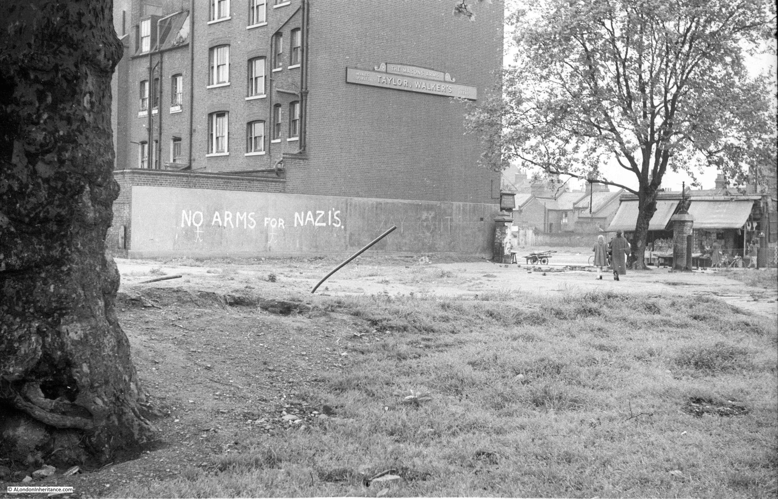
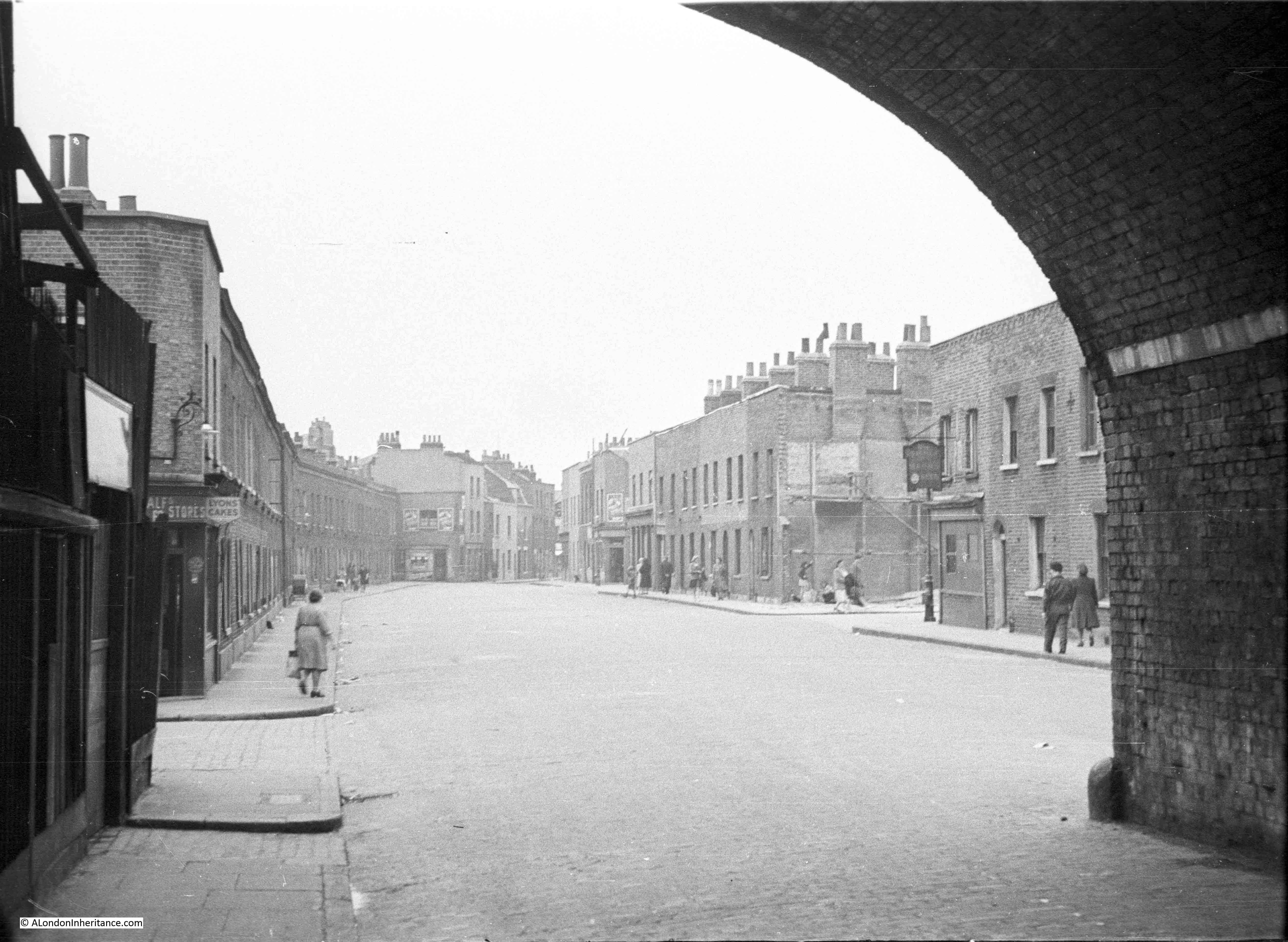
This is the photo, taken by my father in 1952:
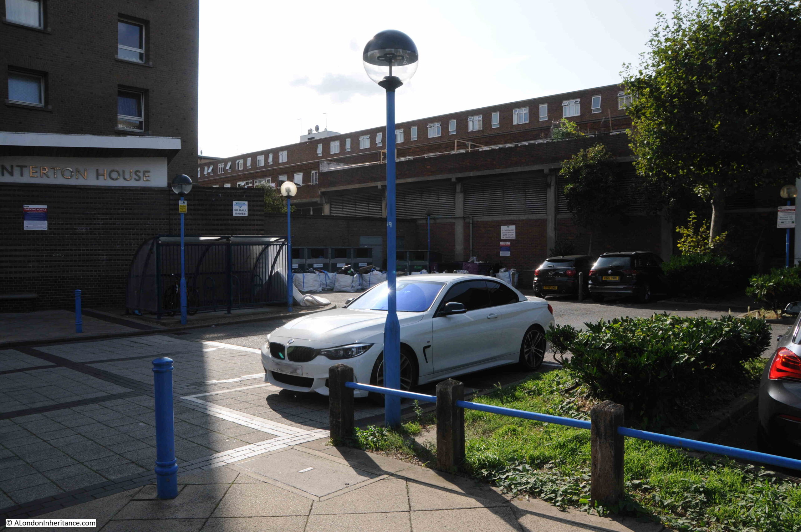
As c;lose as I could get to the same view today:
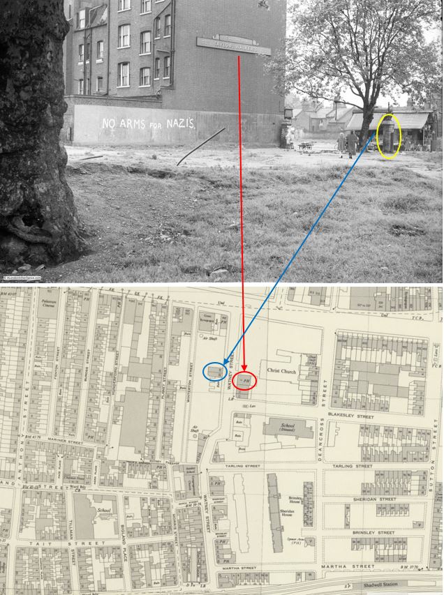
My father’s photo was taken from the bombed space once occupied by a church, and it was looking southwest towards a pub, the Masons Arms, which faced onto Watney Street and Watney Market.
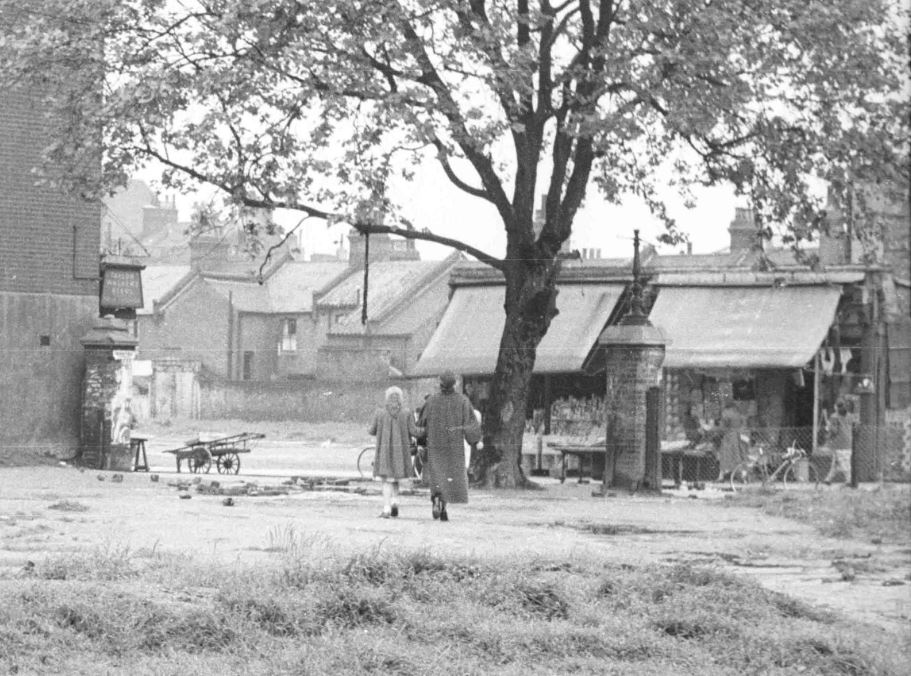
The following extract from the 1952 photo shows on the left, the large sign or perhaps a lantern on the front of the pub and two of the remaining shops which seem to have part survived the bombing which destroyed the area around them.
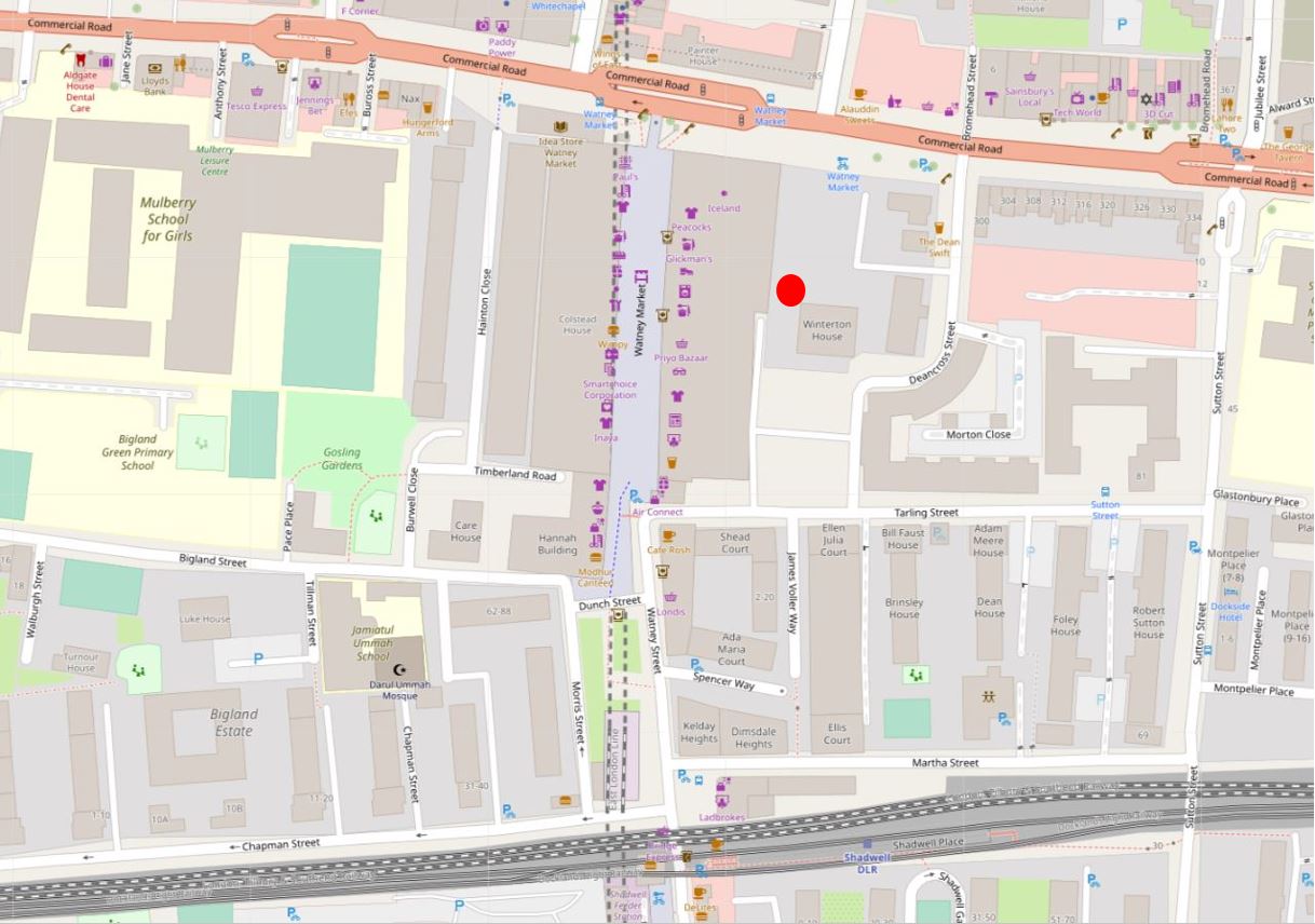
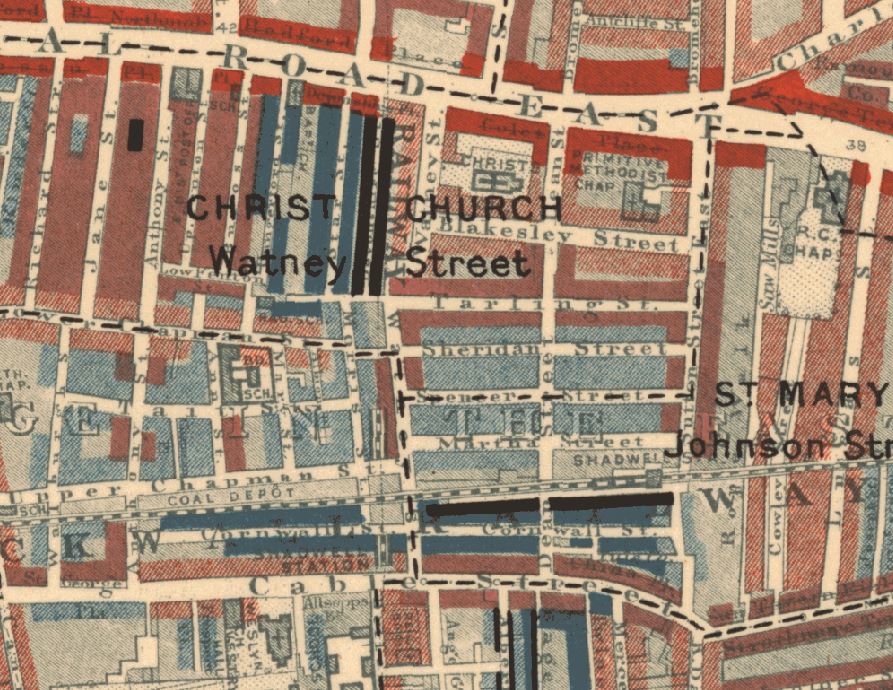
Commercial Road is the road running left to right at the top of the map. The train tracks at the bottom of the map is the Docklands Light Railway. Watney Street is running from the junction with Commercial Road at the top centre of the map, down to the DLR where it heads under the railway, down to Cable Street which is just below the bottom of the map
I have mapped some of the key features in the photo onto the map below.
The red line and arrow points from the Masons Arms pub in the photo to the pub in the map
The blue line and arrow points from the two remaining shops in this section of Watney Street to their location on the map
The yellow oval is around one of the pillars that originally stood either side of the main entrance into the open space in front of the church
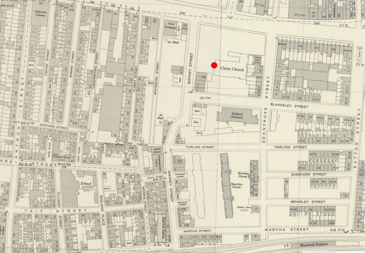
In the above maps, you will see that my father was standing in front of the outline of Christ Church.
These were the ruins of a church that had been very badly damaged by bombing in 1941, and had then been demolished. It was not rebuilt, and the land was integrated into the post war redevelopment.
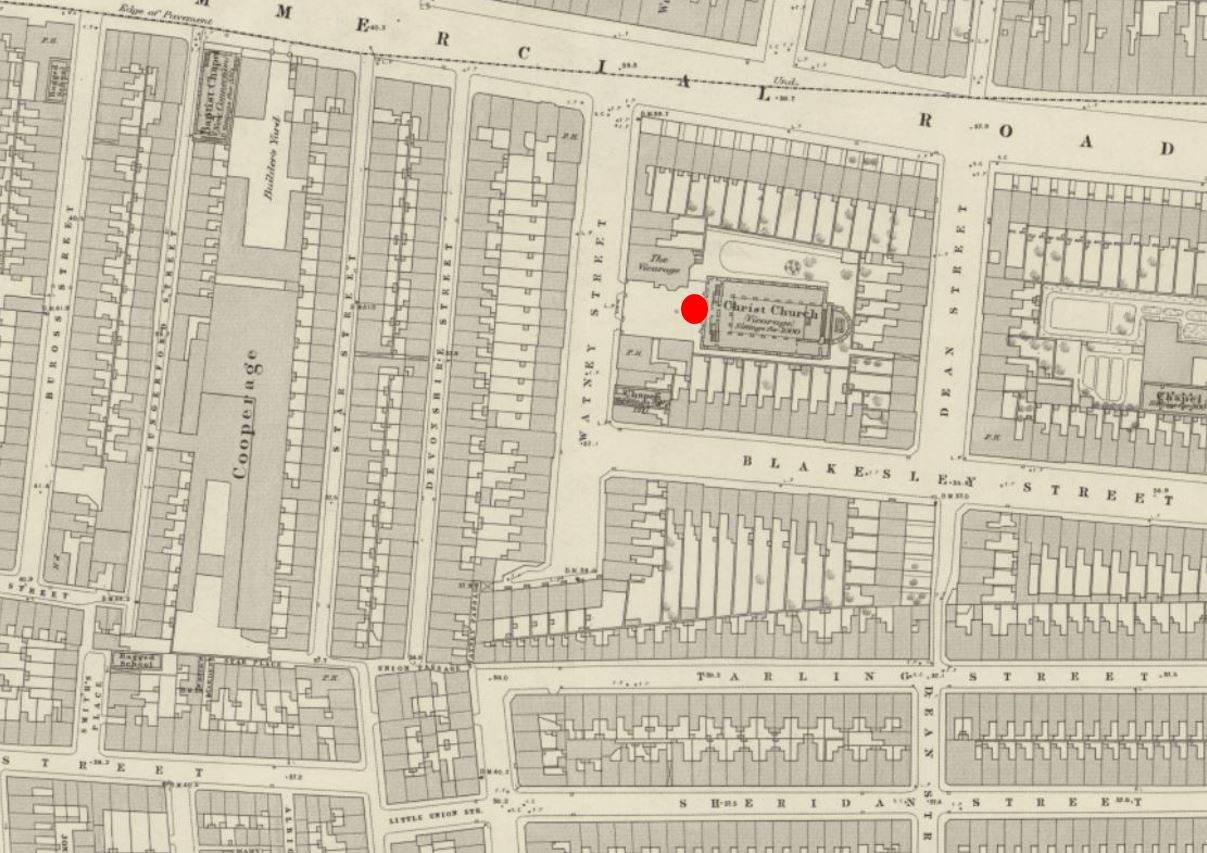
The church was not that old. The foundation stone was laid on the 11th of March, 1840, with the land being the site of three former houses on land owned by the Mercers Company, who conveyed the land to the church.
The site of the church, and the surrounding housing, before wartime bombing and post war redevelopment obliterated the area is shown in the following extract from the 1914 revision of the OS map (again the red circle indicates where my father was standing to take the photo) (‘Reproduced with the permission of the National Library of Scotland“).:
In my father’s photo, the slogan “No arms for Nazis” is painted on the wall running alongside the pub. This slogan represented a concern about the level of Nazi sympathies still remaining in Germany, rearming Germany, and the need to integrate Germany into the wider European community.
In 1953, British security services had made several arrests, and the US had undertaken a survey which revealed that the undercurrents of Nazi-ism in Germany should be taken seriously. It was claimed that the growth of “nationalistic discontent among young men is ominous”.
There was unemployment in Germany and economic grievances were being intensified by the numbers of refuges from the Eastern Zone.
At the time, Germany was not considered an equal partner with other countries in western Europe, and, to quote papers of the time “And the vagueness of British policy, the passive attitude of the Tories towards European co-operation – which they encouraged with words when not in power – has done nothing to speed things up”.
This had already been going on for some years, and when the German Chancellor, Konrad Adenauer was in London in December 1951, he was met by a demonstration when he arrived in Downing Street for a lunch with Churchill.
He was met with cries of “Adenauer go home”, “Sieg heil” and “Heil Hitler”.
Adenaur had been an opponent of the Nazis and had only just survived the war as he had lost all his property, money and position in the 1930s.
He was strongly anti-communist, wanted cooperation within Europe and the US, wanted to start the rearming of Germany, and he had earlier ended the de-Nazification process.
He was part of the negotiations that led to the Treaty of Paris in 1951, which established the European Coal and Steel Community (the predecessor of the European Union), not a popular move in Germany as it was seen to give France too much influence over German industry.
Adenaur also ensured that West Germany joined NATO in May 1955, and secured agreement for Germany to rearm (although agreeing that Germany would not have nuclear weapons).
When Adenaur visited Downing Street in 1951, leaflets were handed out to the crowd with the words “No arms for Nazis”. These leaflets, and the slogan were part of a campaign by the London Peace Council, based at New Compton Street, W.C.2.
The slogan appeared at many sites across London, and also across the country, for example an article in the East Kent Times reported that in Ramsgate “Motorists and residents were startled to see on the parapet of the viaduct, high above the main Margate Road, the words ‘No arms for Nazis’ painted in large white capitals.”
The use of white paint and capital letters seems to have been standard for where the slogan was found.
The slogan was on the wall that ran alongside the Masons Arms pub. The pub seems to date from the mid 19th century and features in numerous newspaper reports. All the usual issues of crime, drunkenness, change in licensee, meetings etc.
There were a couple of reports which gave an insight into life in 19th century London and the River Thames.
From the Kentish Gazette on the 17th of May, 1859:
“ENROLMENT OF NAVAL WOLUNTEERS – The recruiting officers of the Royal Navy had quite a field-day on the river of Tuesday. A steam boat, profusely decorated with union jacks, ensigns and other national colours, and manned by a dashing crew of blue jackets, with a powerful band on board, left the London-bridge-wharf shortly after eleven o’clock for a cruise down the river. The steamer on her paddle-box bore the words ‘Queen’s bounty’ and on her sides fore and aft, ‘£10 able seamen, £5 ordinary seamen’.
On leaving the band struck up ‘Hearts of Oak’. The sailors gave a most deafening cheer, which was taken up by the vast multitude which lined London-bridge and crowded the water side. The trip was continued to Gravesend, where the blue jackets landed and paraded through the principle thoroughfares, and the proclamation being frequently read. A vast crowd followed the recruiting party, and during their stay the town was kept in a most lively state of excitement. many volunteers were received and numbers promised to present themselves at the rendezvous on Tower-hill. Owing, however to the long prevalence of easterly winds there were not so many first class seamen in port, a large fleet of homeward-bounders being detained in the Channel.
As far as it has gone, however this new popular mode of beating up naval recruits has answered admirably; and the Masons Arms, Watney Street, Commercial Road (situated in a locality crowded with sailors), has been opened as a rendezvous. A change in wind must bring in large numbers of first-class men, who will doubtless avail themselves of the £10 bounty.”
There is so much in the above article. It tells us that in the mid 19th century:
Large numbers of sailors lived around Watney Street
Ships still being mainly powered by the wind could be stuck in the channel with an easterly wind as they could not round the eastern edge of Kent to access the Thames Estuary
That the Thames and the London Docks were a very important part in the life of London
As with most other East London pubs, inquests into unexpected and accidental deaths would be held in the Masons Arms. A newspaper report from October 1841 tells the story of 34 year old James Holland who worked as a coal-whipper (a coal-whipper brought up the coal from below decks using baskets attached to a pulley system).
He was working on the “Three Sons”, a collier from Sunderland which was moored in the river off Rotherhithe and whilst filling a basket with coal, he collapsed with blood pouring from his mouth and nose, and died almost immediately.
At the inquest in the Masons Arms, the verdict was “Died by a visitation of God”. No reference to his working conditions, long exposure to coal dust etc.
Time to have a look at Watney Street. The street has almost completely been rebuilt, with only a couple of pre-war buildings remaining at the very southern part of the street.
The alignment of the northern half of the street changed, and it has been rebuilt with new tiered housing on either side of a central raised section where the market is now located.
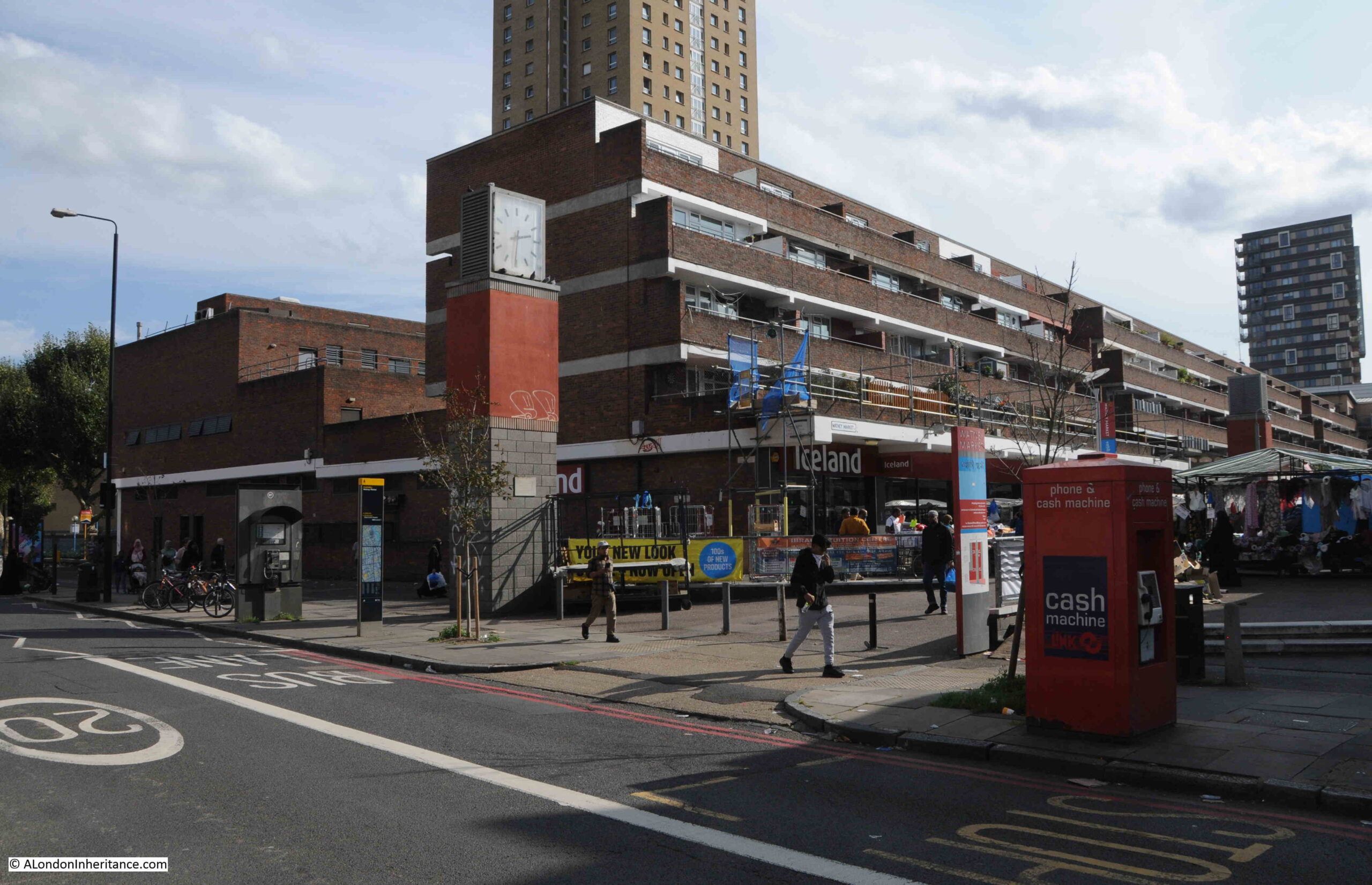
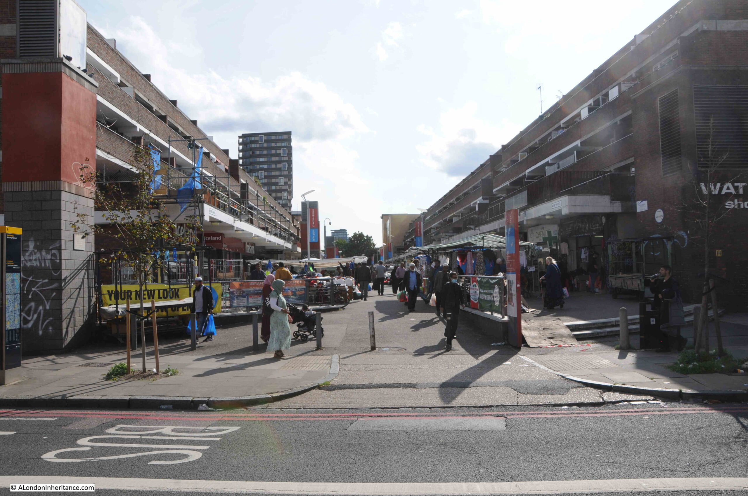
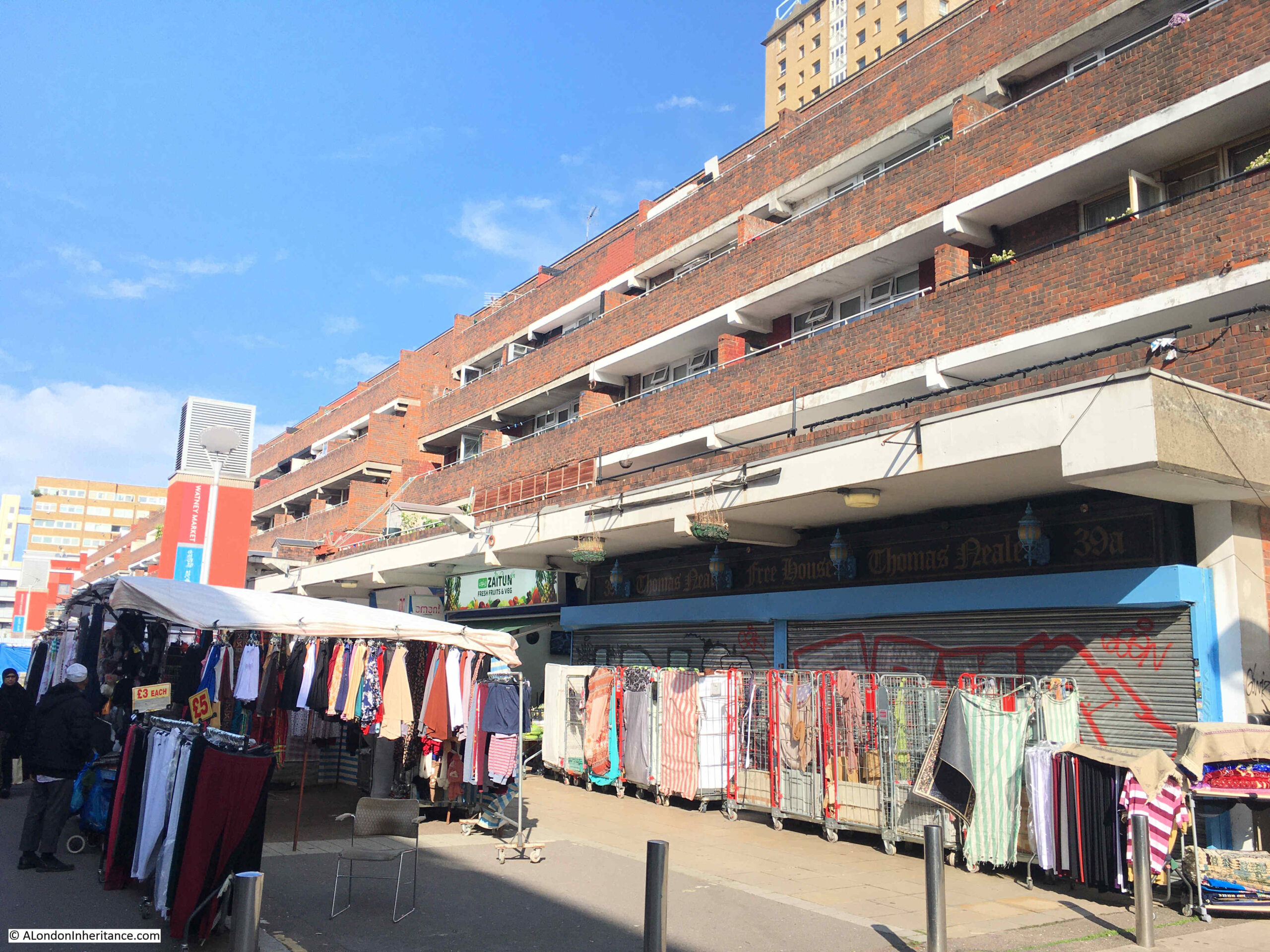
Walking along Commercial Road, this is the first view of Watney Street and Market:
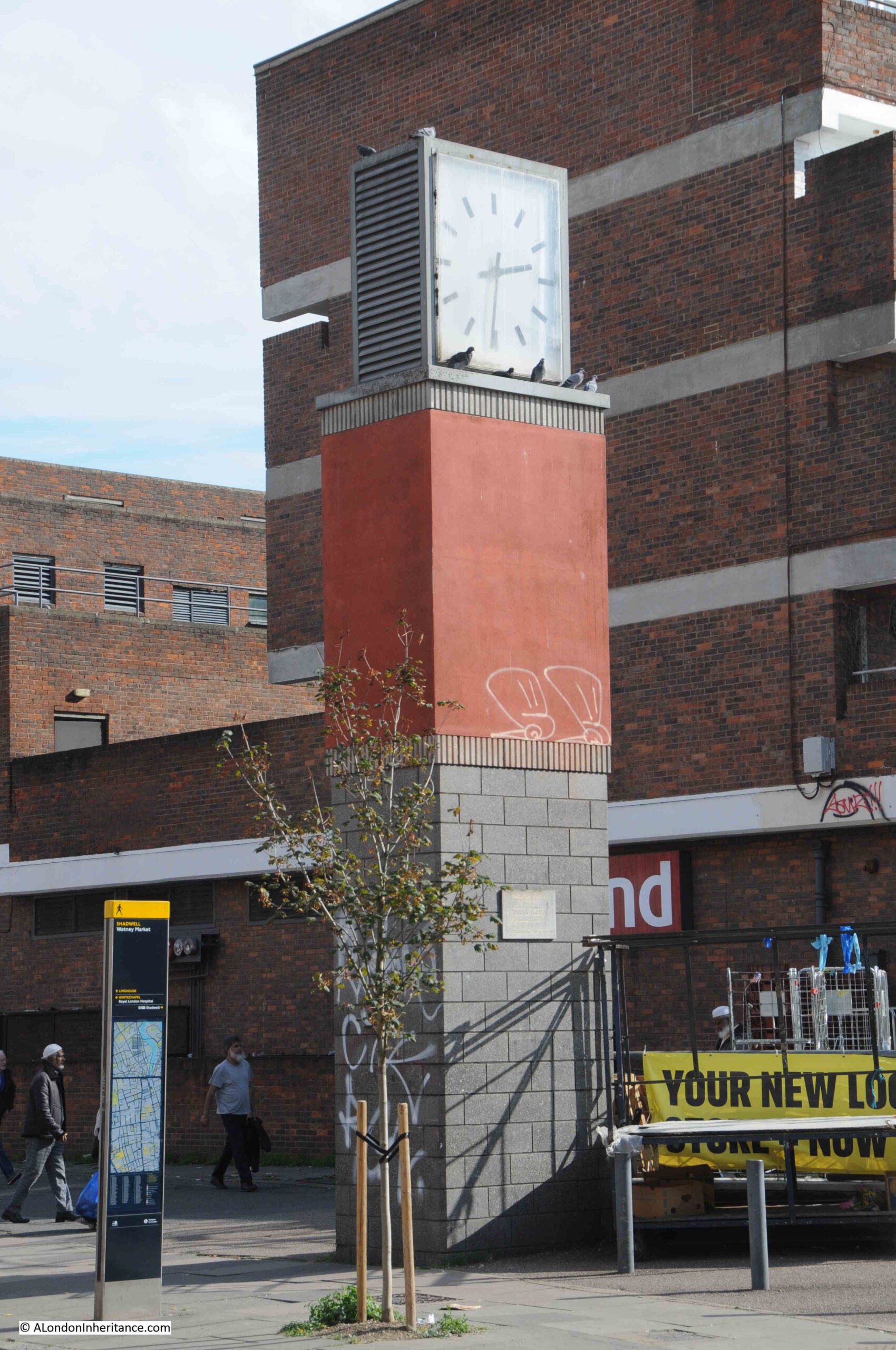
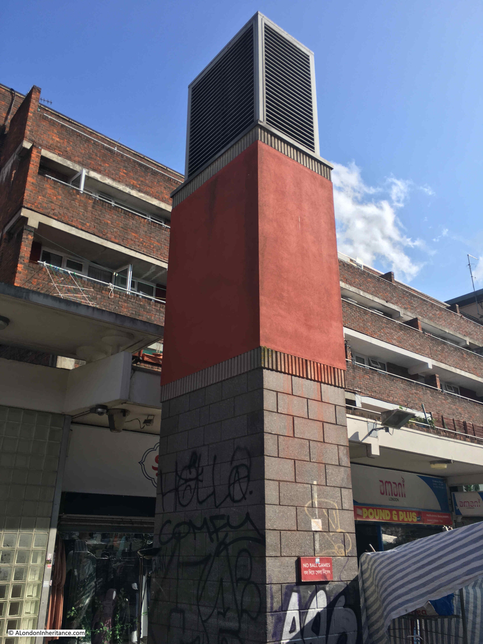
To the east of the entrance to the market is a clock tower:
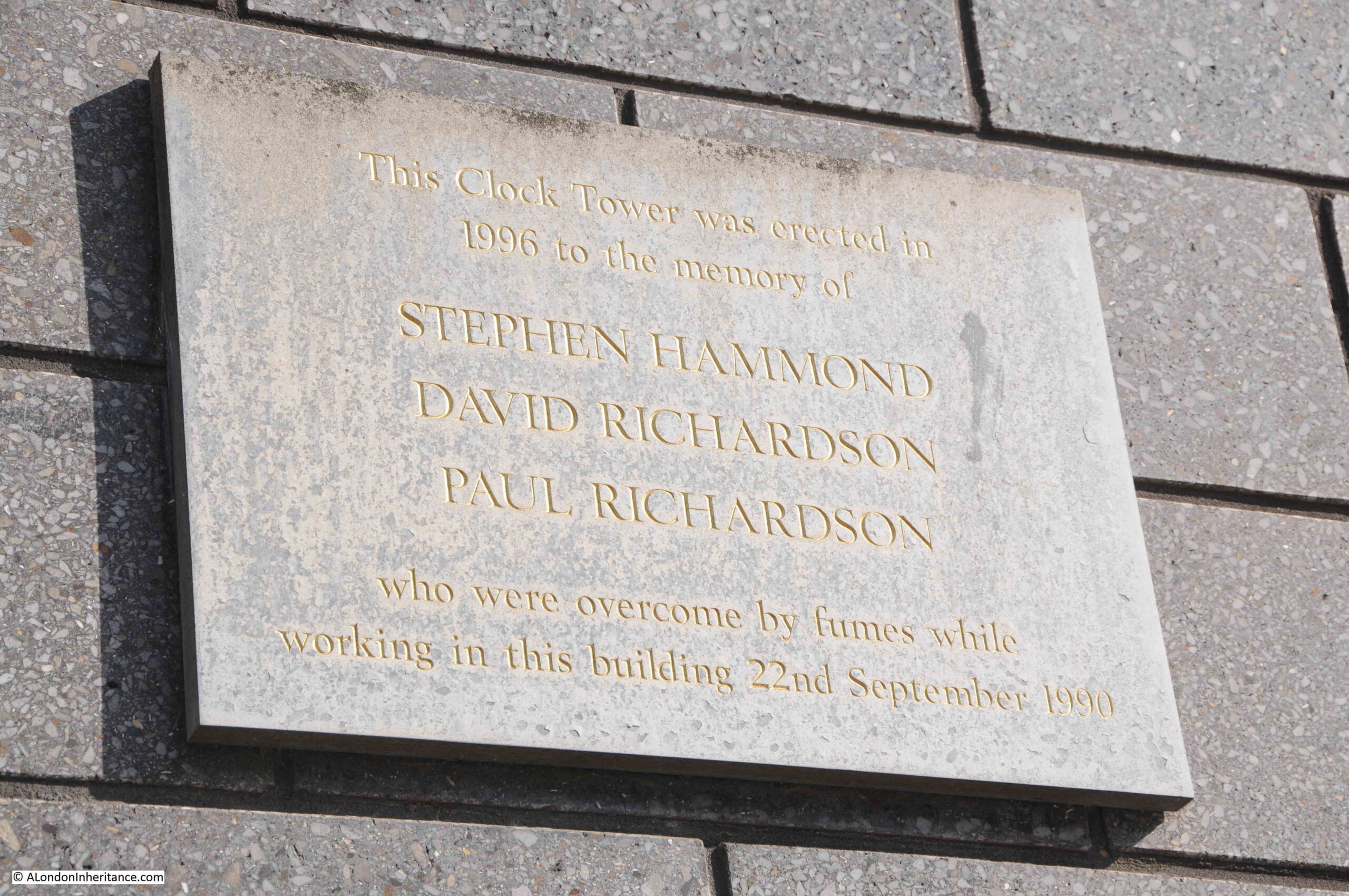
Which has a plaque mounted on the side:
The plaque recalls a dreadful tragedy when three workers died on the 22nd of September, 1990. At the time, they were investigating a blockage in a drain. There were four workers involved. One of them had descended into the drain which was at the bottom of a 9ft shaft. He was overcome by fumes, and in an attempt to rescue him, two other descended the shaft, but were in turn overcome by fumes.
The Fire Brigade was called, and firemen wearing breathing apparatus descended the shaft and pulled the three men out. The man who remained at the top of the shaft was also affected by fumes from the sewer.
It turned out they they have been overcome by hydrogen sulphide gas, and the three who descended all died.
They were not provided with any safety equipment, gas monitoring or breathing equipment, ropes and harnesses etc. and had received no training to undertake such work. It was the type of accident that would have happened in 1890 rather than 1990.
The three who died were trainee electrician Paul Richardson (aged 17), his brother trainee plumber David Richardson (aged 19) and electrician Steven Hammond (aged 32).
Their employer was fined £50,000 which even at the time seemed a ridiculously low amount for the loss of three lives in such avoidable circumstances.
A dreadfully sad loss of life which so easily could have been prevented if they had been provided with the correct equipment and training.
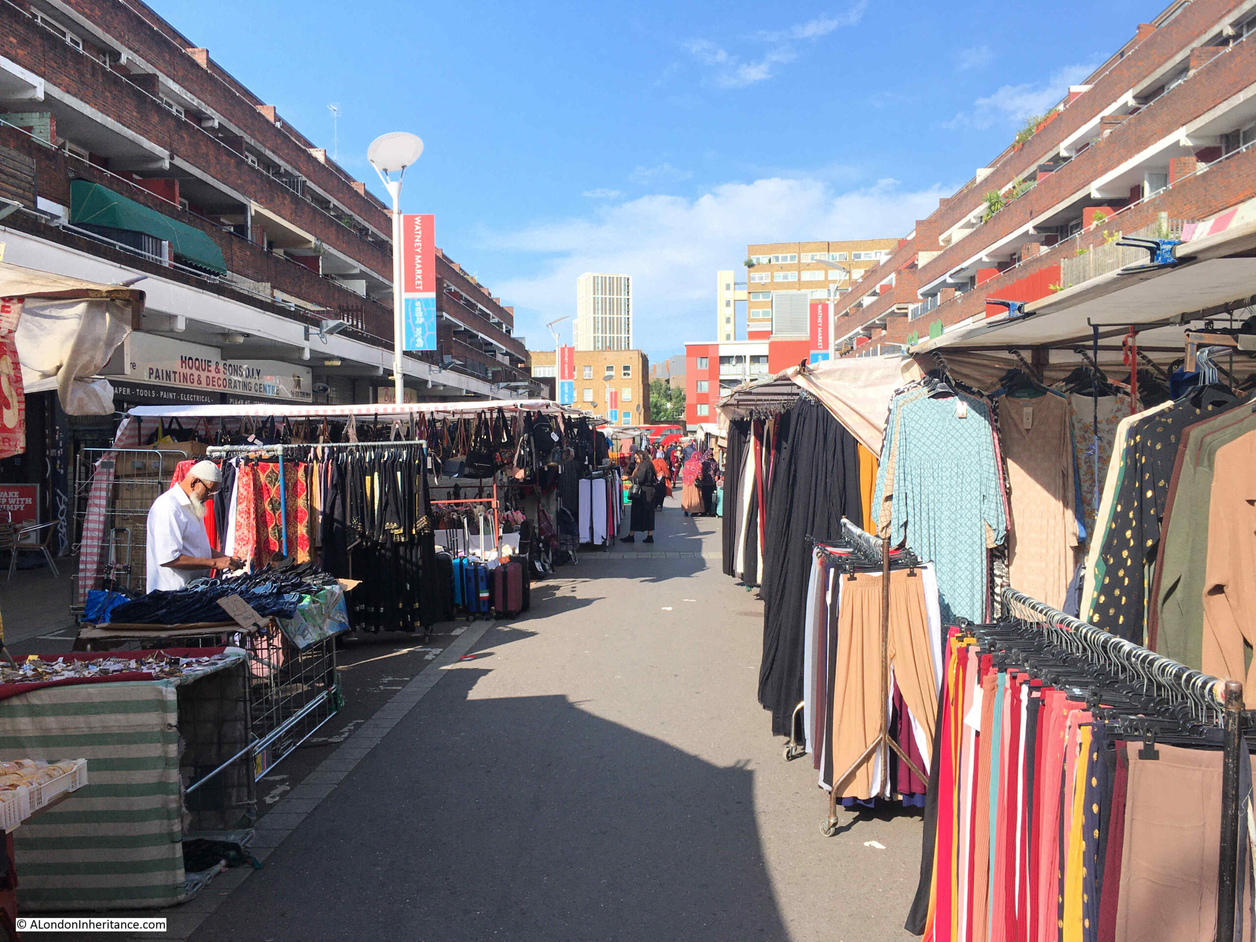
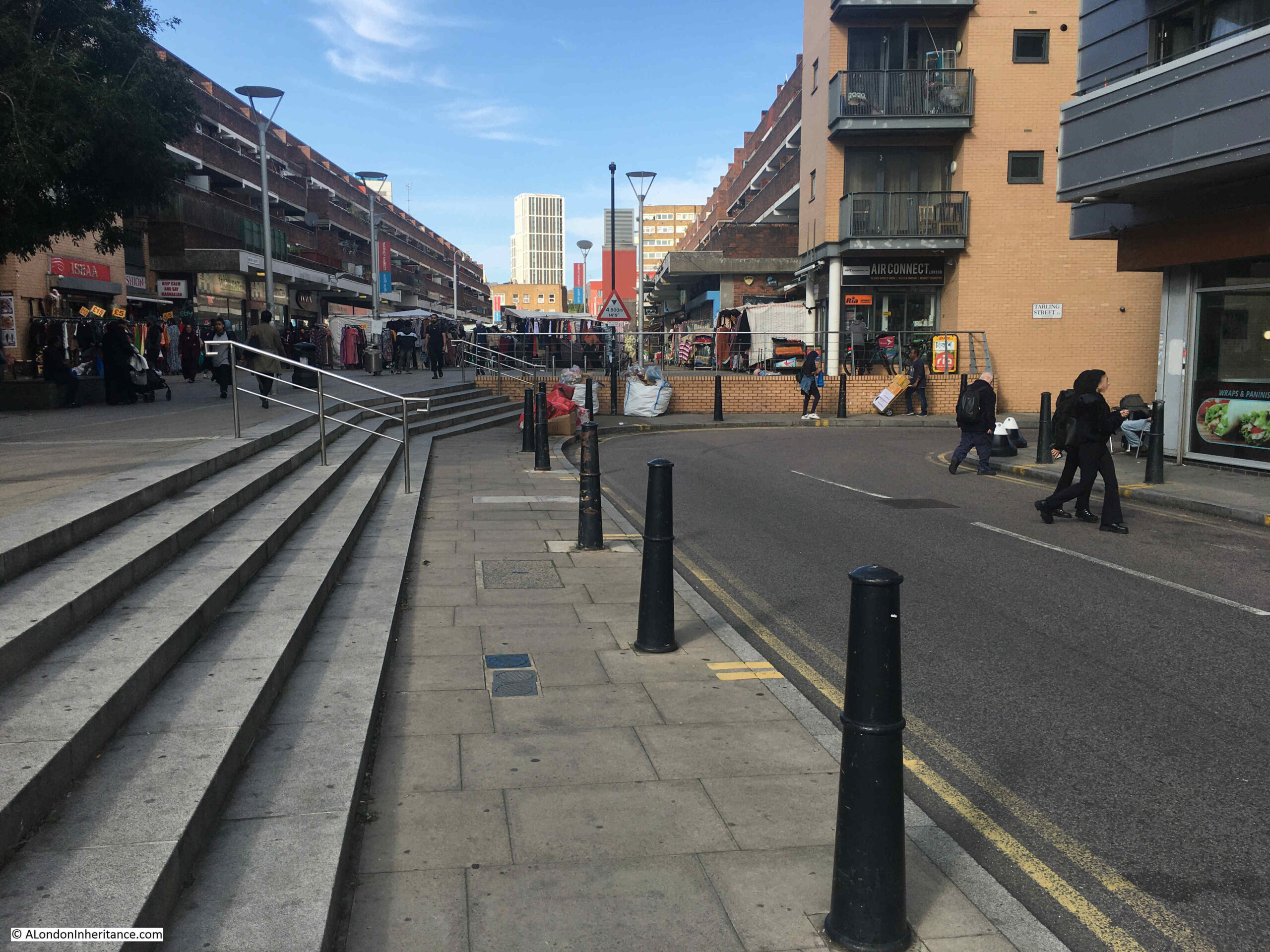
This is the view looking down into Watney Market from Commercial Road:
The London Overground between Shadwell and Whitechapel runs beneath Watney Market. If you go back to the 1952 OS map of the area, to the upper left of the original routing of Watney Street, just below Commercial Road, there is a circle with the words “Air Shaft”.
This was a ventilation shaft for the railway which runs just below the surface. In the rebuilt market, the above ground infrastructure of the airshaft can be seen, which is also used to advertise Watney Market:
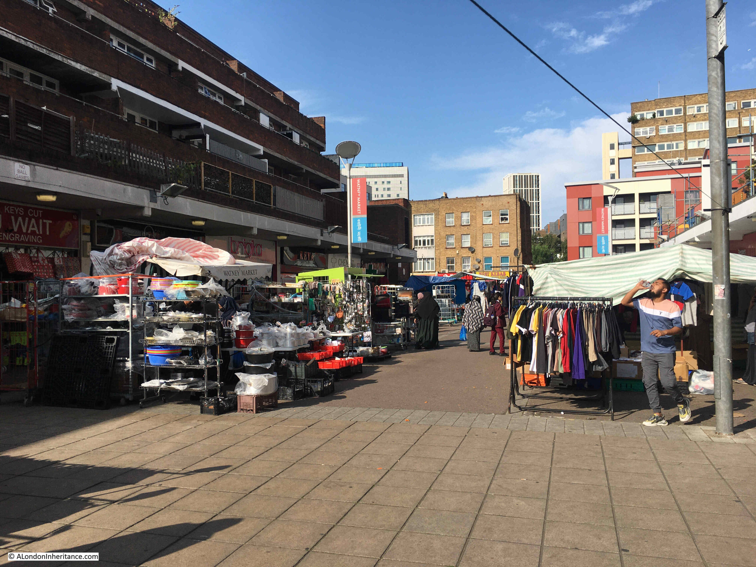
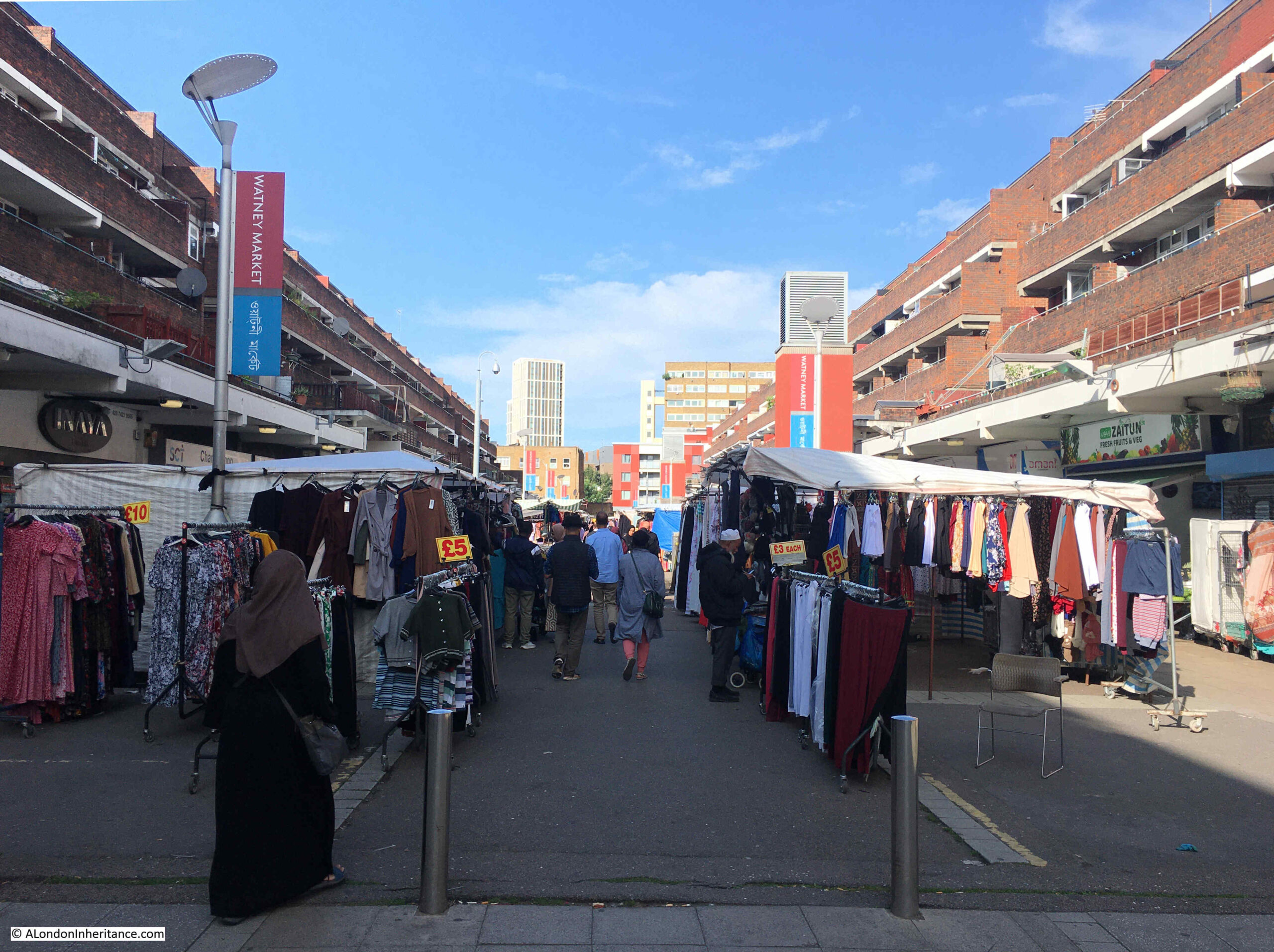
View looking through the market back up to Commercial Road:
There was an article in the East London Advertiser on Saturday the 21st of August, 1886 about Watney Market. It was a rather long article, however it does provide a really good view of the market, those who shopped there, and the conditions of many of those who lived in the area. The core of the article follows:
“WATNEY STREET MARKET – How, when, or by whom this market was commenced no one seems to know. It has no charter, nor any legal status but that of usage, and like Topsy, it seems to have ‘growed’. Nevertheless it has become an important market, and to the poor inhabitants of St. George’s and Shadwell it is a most useful institution.
At first the market seems to have been confined mostly to the Cable-street end of Watney-street, the busiest being in the neighbourhood of the railway arch; but now, on some days, and particularly on Saturdays, it extends the whole length of the curved street, from Cable-street to Commercial-road and in it can be purchased almost everything needed in a household, from a pennyworth of pins to a suite of furniture, with bedding, bolsters, curtain lace, baby-linen, suits of clothing. washing machines, pianos and perambulators; whilst in the edible department it is always well stocked.
There is fish in every variety, from the lordly salmon down to a fresh herring, whilst the butchers cater for all classes, and in a manner suitable to the means of their numerous customers. Thus, on a Saturday, from morning till late at night, and particularly in the latter portion of the day, this market is crowded. in addition to the shops on both sides of the street, which are numerous, stalls are erected on and outside the footpath, leaving only a sufficient space for a limited amount of vehicular traffic.
A very large proportion of the purchasers in this market are women, and these mostly of the very poorest class, whose families live from hand to mouth. They can afford little at once, but they want that little every day when they can find the money to buy it; and hence the individual amounts spent at any one time are small, whilst their aggregate for a year must represent a very large sum. here the ‘ladies’ saunter about the market in dozens, in the most careless of deshabille, with hair unkempt, faces unwashed, and a general appearance of not having been dressed or undressed for a very considerable period. Each of them is accompanied by two, three or four children, equally elegantly attired. Whilst the mothers are looking out the cheapest bargains, these youngsters dive in, under and around the stalls, picking up rotten fruit, and anything else from the stalls on which the vendor does not keep a sharp eye.
And yet, notwithstanding all this squalor in dress and cleanliness, there is a general air of cheerfulness, frequently arising to hilarity, amongst the habitués of the market, and the general tone is one of careless happiness, especially when the weather is fine, when the women seem in no hurry about their business, but enjoy a thorough good gossip in the market place. Very few bags or baskets are brought by the buyers, they are not needed. A pound of bits of meat for about four pence, a couple of pounds of potatoes for two pence, and a cabbage for a penny, with perhaps a pennyworth of onions, and there is a dinner which has frequently to be eked out, with the aid of bread, for a family of six. An apron or the skirt of a dress will hold much more than this, and so the ladies who attend here will not encumber themselves with a basket, even if they have one, which in most cases is doubtful.
The women who purchase on Saturdays, are for the most part, wives of working men who are paid their wages on Friday; but there is a large class of men who are not paid until Saturday, and sometimes late even on that day. The bulk of these do not go straight home when they have received their wages, but remain about in public houses, where they are joined by their wives in very many instances, until it is too late, or they are too much overcome, to go shopping. What becomes of the children in the interval nobody knows and nobody seems to care. They play out on the street until they are all thoroughly tired out, and then made their way supperless and unwashed to such beds as they have, whilst their parents, with drunken recklessness, are wasting the food supplies on that which makes them utterly oblivious of the morrow and its responsibilities.”
The London Poverty Maps created by Charles Booth date from around the same time as the above report. Watney Street is in the centre of the following extract, and the streets around the street appear to have almost every category from Middle Class, Well-to-do (along Commercial Road), down to Lowest class. Vicious, semi-criminal (area in black).
There has been a constant battle regarding space in Watney Market which has been going on for over 100 years, both in the original market, and the post-war rebuild.
The market stalls operate in the central space, with shops in the ground floors of the buildings on either side. These shop owners have long complained about the market stalls hiding their shops. They have complained about the size of the market stalls, the volume of product on display, how close the stalls are to their shops, the amount of traders products also displayed on the floor, and all the problems which the shop owners believe prevent shoppers from seeing, and getting to their shops.
This has been a recurring issue in newspaper reports back to the mid 19th century, and the market today remains a busy place, with market traders using as much space as is possible for the stalls, and to display their goods.
There is only a narrow walkway through the centre of the market, and the shops that line the ground floors of the buildings on either side are quite hard to see:
The southern end of Watney Street is at Cable Street, a street that is well known as the scene of the “Battle of Cable Street”, when on the 4th of October 1936, there were clashes between the Police, ant-fascist demonstrators, and the British Union of Fascists, led by Oswald Mosley, who were attempting to march through the area.
Whilst Cable Street is remembered as the scene of the attempted march, and anti-march demonstrators, in the 1930s, this area of east London was the scene pf regular provocation of the mainly Jewish community who lived in the area, by members of fascist organistions.
Watney Street and Watney Market frequently appeared in newspaper reports of these events. For example, on the 30th of May 1936, the City and East London Observer carried a report titled “Fascists in Watney Street”:
“There was great excitement among the many shoppers and stallholders in Watney Street on Sunday morning when about a dozen Blackshirts paraded up and down the market selling Fascist newspapers amid cries of ‘More Stalls for Englishmen’, ‘Foreigners Last and Nowhere’, while from another section of the crowd there were cries of ‘Blackshirt Thugs’, ‘Rats’, etc.
A great crowd gathered, and a Jewish girl, going up to one of the Blackshirts, bought a paper, tore it to pieces and stamped on the fragments. After this the police took a hand but they found it very difficult to keep the crowd on the move owing to the barrows in the market. Somebody picked up a cucumber from one of the stalls, but was prevented from throwing it at a Blackshirt.
A surprising number of the people present appeared to be in sympathy with the Blackshirts. The Blackshirts are, it is believed, about to open a branch in Stepney.”
A few months later in July 1936 is was reported that the market place in Watney Street “seems to be the chief hunting ground for Blackshirts selling their propaganda, who, according to reports, do their best to encourage hatred of the Jewish community.”
Many of the traders in the market were concerned about the lack of action from the authorities, and “rightly or wrongly, are of the opinion that the police are pro-Fascist”.
The traders were concerned that the Blackshirts were having a negative impact on their trade. Their actions and language put off many of the customers of the market, and when they arrived many of the traders packed up and left.
This all came to a head with the Battle of Cable Street, which greatly diminished the impact of the Blackshirts in Watney Street.
Another air vent, half way along the market. Possibly another air vent to the railway below:
Post war redevelopment of Watney Street and surroundings took some time. It was being planned in the 1950s, however nothing happened on the ground until the 1960s when the market was relocated in 1965, the surviving buildings demolished and the area flattened.
Tiered sets of new flats were built on either side of the new routing of Watney Street and a raised area along the new alignment was created for the market.
This took a long time to complete, with work not being substantially finished until 1977.
The flats were not popular with the original inhabitants of the street. Flats had been planned in the last days of the war, and in 1944 there were protests against the plan for flats, with residents of the Watney Street area telling the Borough Council that “Working people with families must have decent houses in which they can rear them properly”.
The wholesale demolition of many streets of terrace housing across east London, and the construction of flats is one of the themes of post war redevelopment of the area.
Whilst the demolished houses were in very poor condition, often badly maintained by uninterested landlords, lacking basic facilities, and suffering from general war damage and lack of attention, very many could have been refurbished, and would have provided housing, at street level, suitable for a wide range of occupants.
The following photo is looking through the market showing the tiered flats on either side:
The whole scheme, including the tiered flats was designed by the Architect’s Department of the Greater London Council.
The redevelopment work took over ten years, and in 1977 graffiti was appearing in the area complaining that the market has been murdered.
Redevelopment and relocation resulted in a reduction of trade for those running stalls, and the number of market stalls was gradually declining so by the end of the 1970s there were only about 19 market stalls remaining.
It would take the 1980s and most of the 1990s for the market to recover, and to make use of the full space provided by the redevelopment work.
As well as the central market stalls, a large number and range of shops have occupied the buildings along the side. The supermarket Sainsbury’s was a long time resident of Watney Street, opening their first store in the street in 1881, expanding into a second building 13 years later.
Sainsbury’s were in Watney Street for over 100 years, finally moving to Whitechapel in 1994. Iceland then took over the store and are still in Watney Street, at the north-eastern corner, just behind the clock tower.
A couple of the shops are unoccupied, and the space directly in front is quickly occupied by the Watney Market traders:
As can be seen in the 1949 OS map earlier in the post, Watney Street had a rather strange routing. A short distance north along the street, it angled to the east before resuming a northerly route up to Commercial Road.
The point where this swerve to the east happened was at the junction with Tarling Street.
In the photo below, Watney Street is to the right, and where the road does a sharp turn to the right, that is Tarling Street. At this point, Watney Street angled to the right, under where the flats have been built, and continued north, under the flats.
It would seem that when the area was first developed in the early decades of the 19th century, Tarling Street ran left to right across the above photo, and the southern section of what is now Watney Street between Cable Street and Tarling Street was originally Charles Street.
After the junction with Tarling Street, Charles Street changed to Watney Street and was reached through a narrow street or alley, around a larger building to the main section of Watney Street.
This larger building was demolished at some point, replaced by terrace houses, which were also later demolished, and the angle to the right then went through where these buildings was located.
I suspect the name Watney Street displaced Charles Street as the market grew in size and popularity.
I cannot find a firm source for the origin of the name. The general consensus seems to be it comes from the Watney Brewery in Whitechapel, although this was a little distance to the north west so there is no obvious connection.
Watney Market and Watney Street. A working market for well over 150 years. A place once occupied by those working on the river and by the poor of east London, a large Jewish community, and an area targeted by the Blackshirts of the 1930s. Badly bombed during the 1940s then with a lengthy redevelopment that would not see the market busy again until the 1990s.
When I started this post, it was going to be a brief mid-week post about a bowling green in the King Edward VII Memorial Park, Shadwell, East London, sandwiched between the River Thames and the very busy road that is now called The Highway. Instead, it has turned into a much longer post as I discovered more about the area, and what was here before.
One of my favourite walks is from the Isle of Dogs to central London. There are so many different routes, all through interesting and historic places. A couple of routes are along the Thames path, or along the Highway. Both routes take you past the King Edward VII Memorial Park and it was here that I found a scene, more expected within a leafy suburb than in Shadwell.
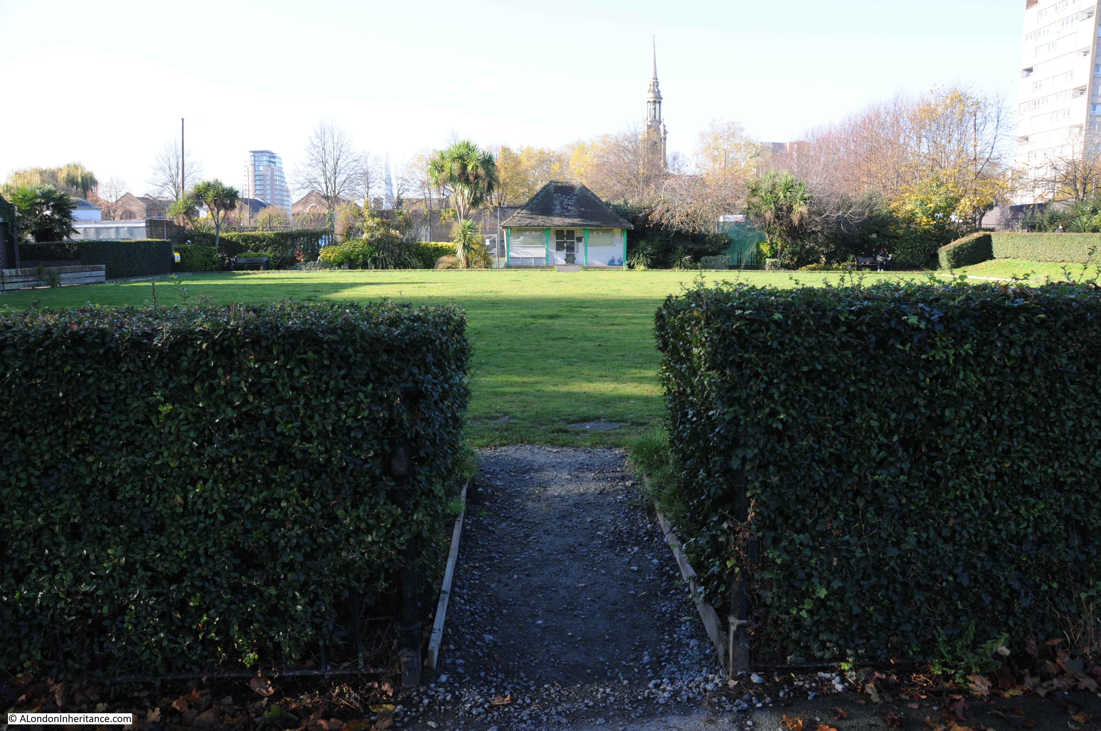
Last November I walked through the park and found the rather impressive bowling green. I am not sure if it is still in use, the grass, although still very flat and green, does not look perfect.
The pavilion at the far end:
It appears to be used as a store room:
The site was used by the Shadwell Bowls Club. The last reference I can find to the club is in the Tower Hamlets King Edward Memorial Park Management Plan January 2008, when the club was listed as active. In the 2016 Masterplan for the park, the site of the bowling green is shown as tennis courts, so the green may not be here for much longer.
Looking back over the green, with the well-kept hedge running around the edge and the wooden boarding around the side of the green, it is not hard to imagine a game of bowls in this most unlikely of places:
The following map shows the location of the King Edward VII Memorial Park. Just to the north east of the Shadwell Basin and between the Highway and the River Thames. The map shows a road crossing the park, however this is the Rotherhithe Tunnel, so instead of running across the surface of the park, it is some 50 feet below.
After the death of King Edward VII in May 1910, a memorial committee was formed to identify suitable memorials to the king. One of the proposals put forward was the creation of a public park in east London, on land partly owned by the City Corporation.
Terms were agreed for the transfer of the land to the council, funding was put in place and on the 23rd December 1911, the East London Observer recorded that the plan for the King Edward VII Memorial Park was approved by the City Corporation, the London County Council and the Memorial Committee, and that “unless anything unforeseen occurs, it will become an accomplished fact in a very short time”.
Unfortunately, there was an unforeseen event, the First War which delayed completion of the park until 1922 when it was finally opened by King George V on the 26th June.
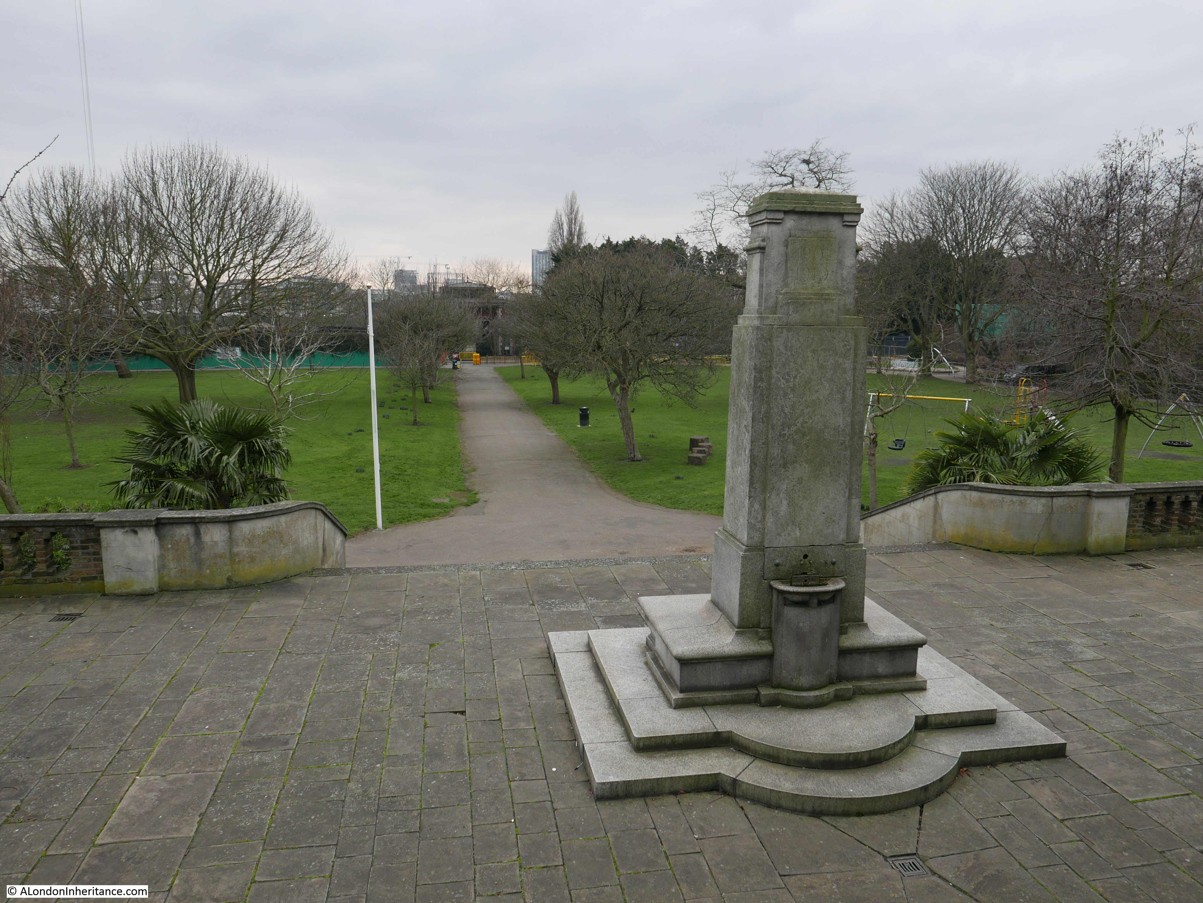
The park is a good example of Edwardian design. A terrace runs the full length of the park along the Highway. In the centre of the terrace is a monument to King Edward VII, with steps leading down to the large open area which runs down to the river walkway.
There were clear benefits of the park to the residents of east London at the time of planning. It would provide the only large area of public riverside access between Tower Bridge and the Isle of Dogs and it was the only public park in Stepney.
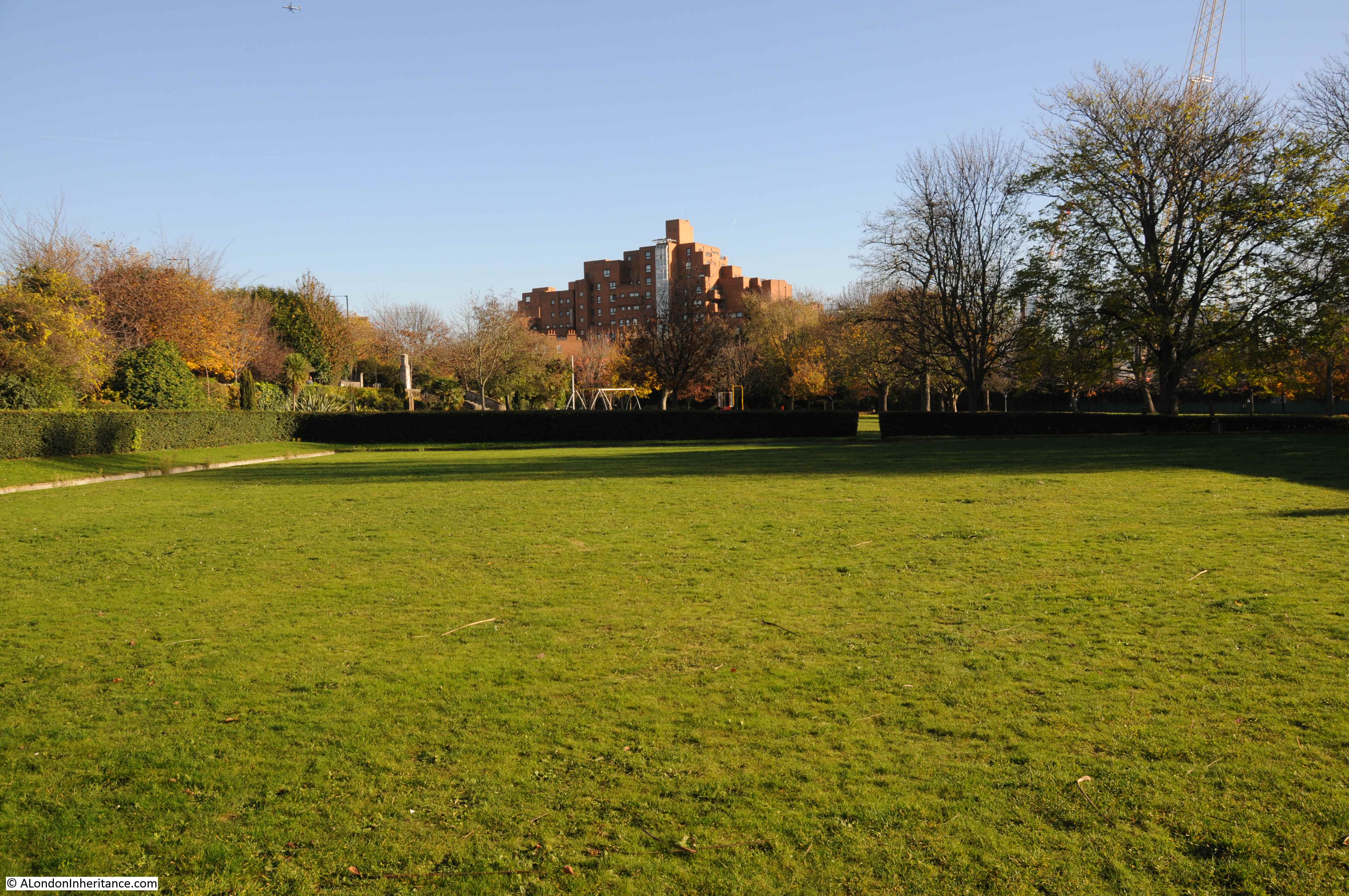
Over the years, the park has included glasshouses, a bandstand and children’s playground.
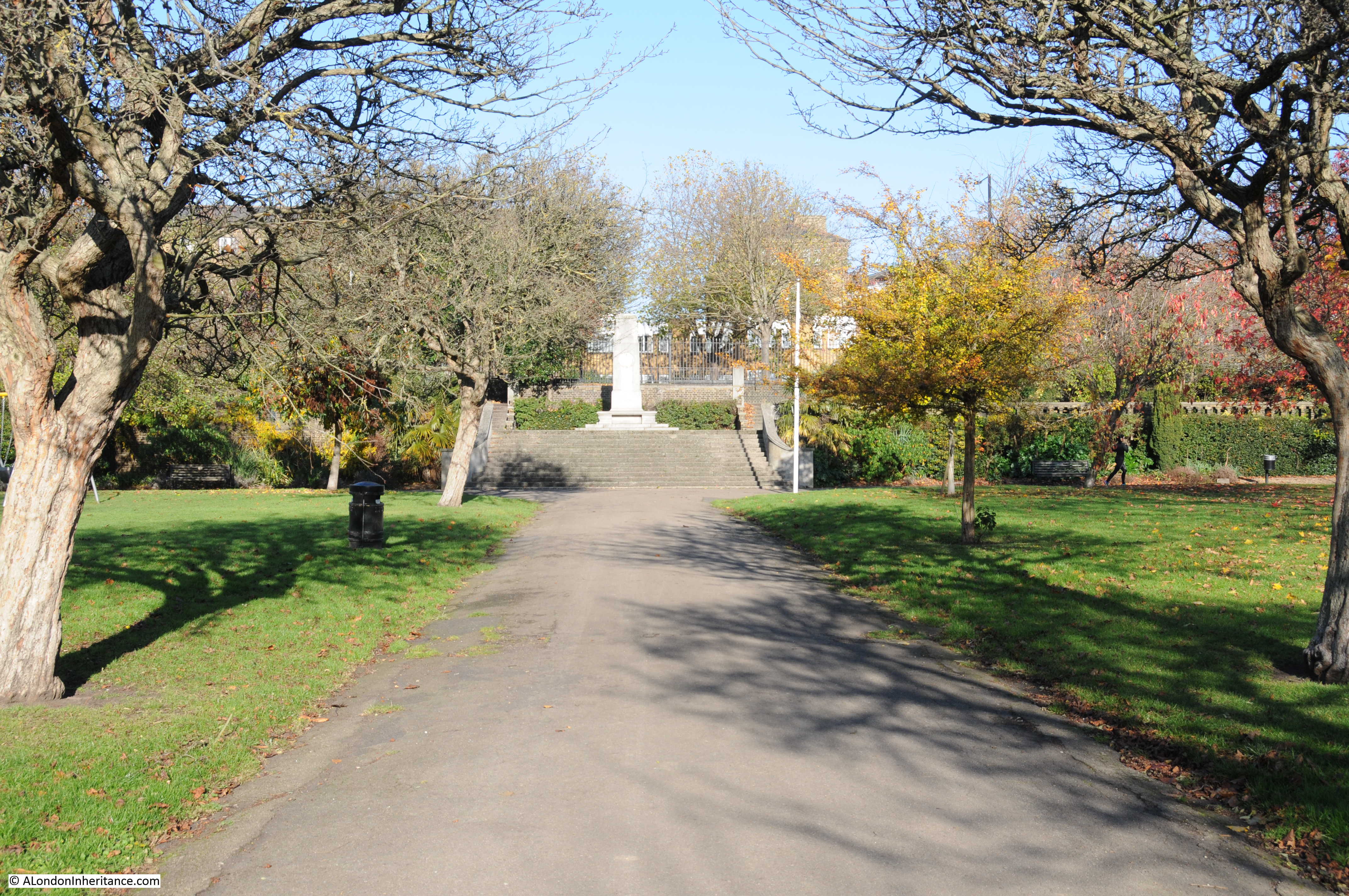
The following photo shows the pathway through the centre of the park from the river up to the monument on the terrace. There was a bronze medallion depicting King Edward VII on the centre of the monument, however this was apparently stolen some years ago.
On the wall at the rear of the monument, between the terrace and the Highway is the following plaque:
It reads:
“The King Edward, Memorial London Committee, of which Colonel the Right Honourable Sir Vezey Strong KCVO, Lord Mayor 1910 – 1911 was chairman acquired the freehold of this site for the purpose of a public park out of funds voluntarily subscribed. The Corporation of the City of London who were the owners generously cooperated with the subscribers in thus perpetuating the memory of King Edward VII”
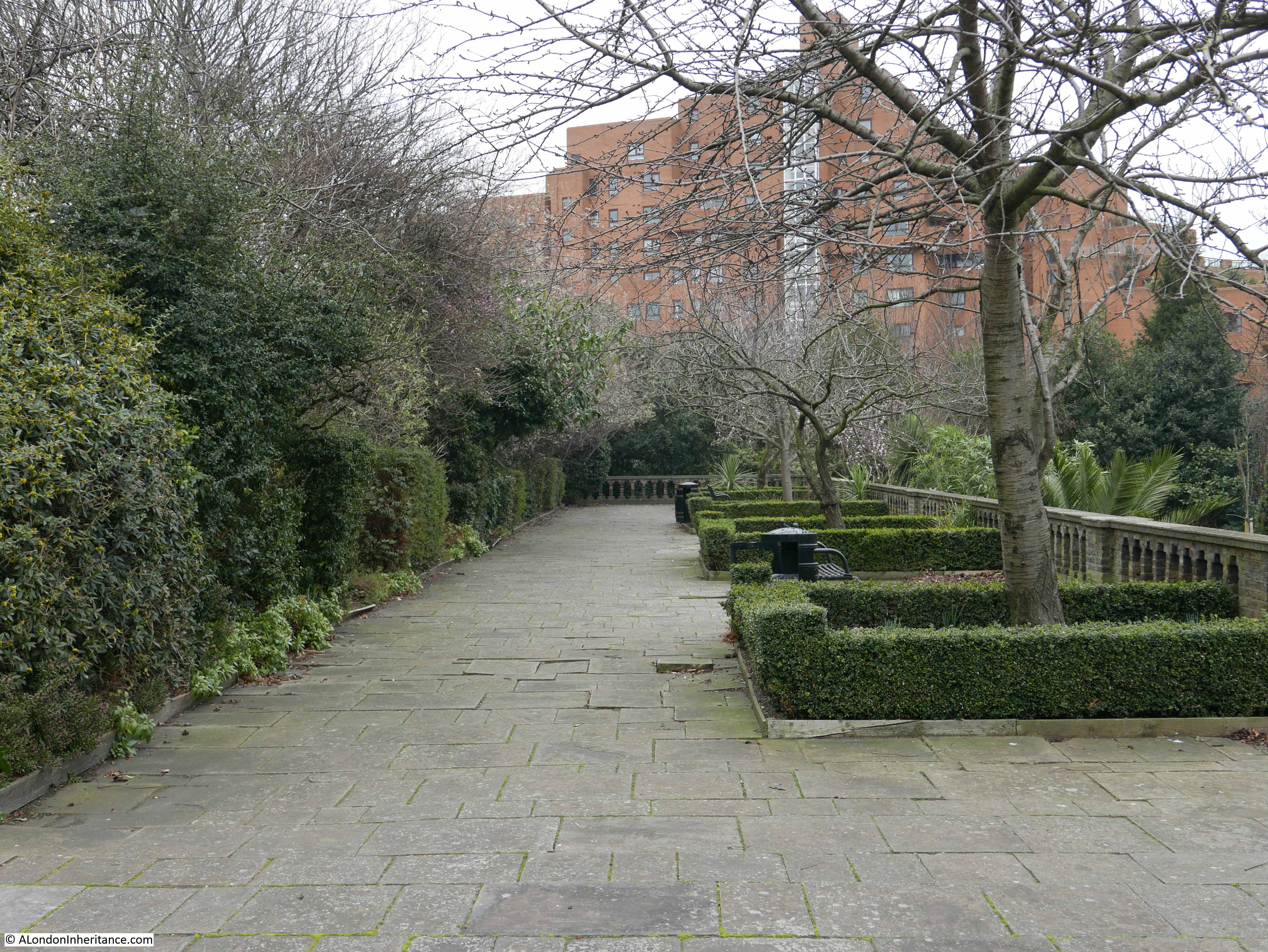
The view along the terrace to the east:
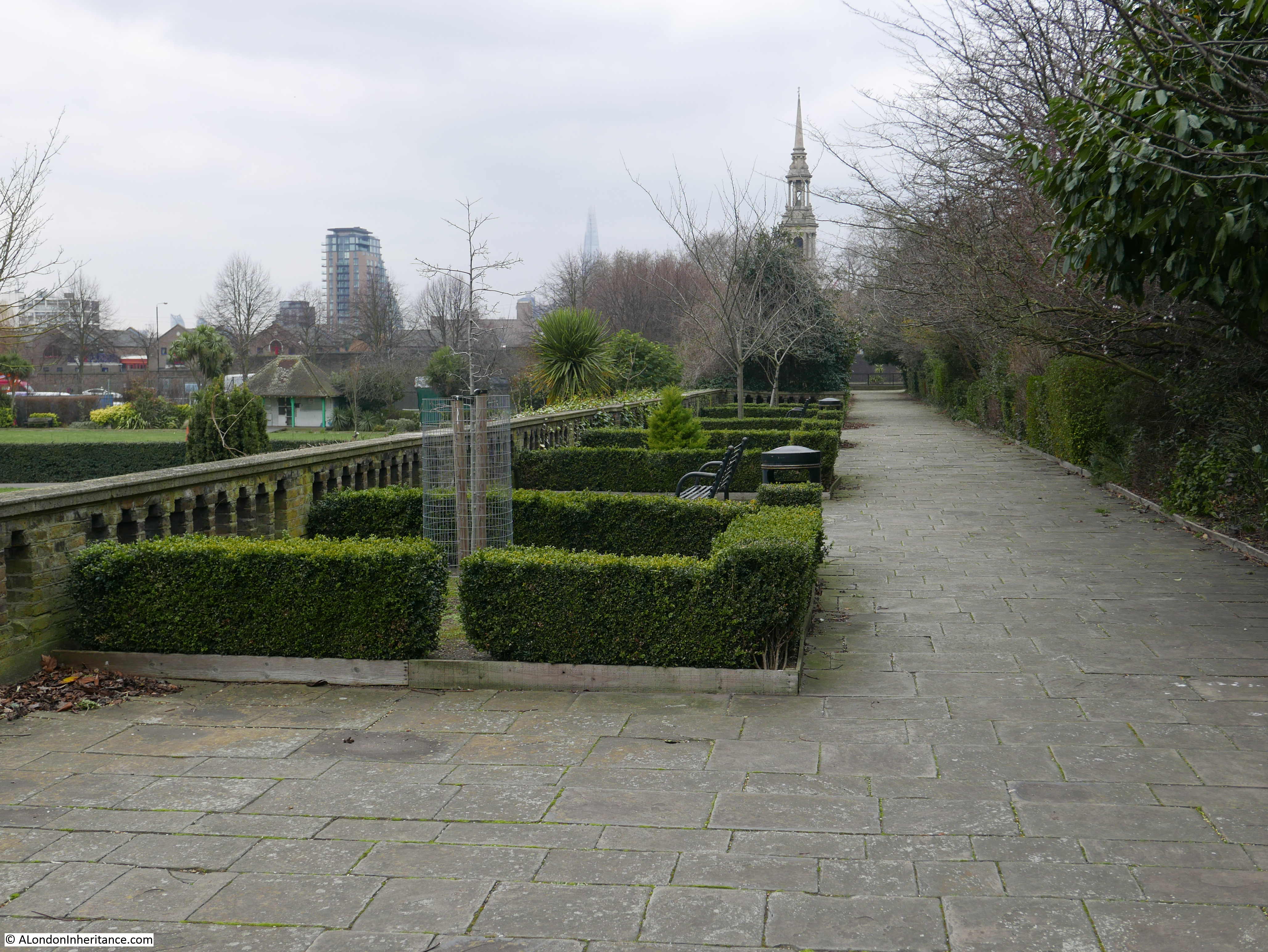
The view along the terrace to the west. The church steeple is that of St. Paul’s Shadwell.
The view down from behind the monument towards the river. When the park was opened, the view of the river was open. It must have been a fantastic place to watch the shipping on the river.
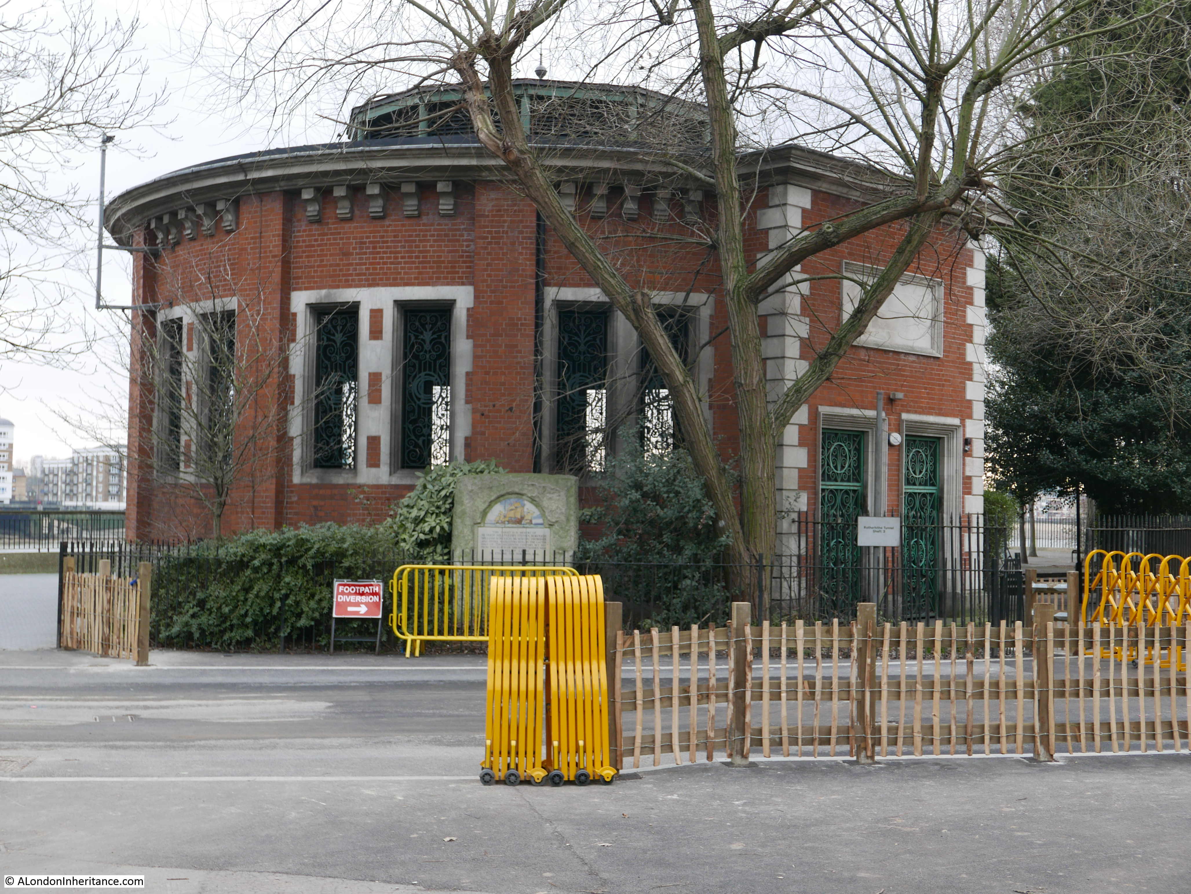
At the river end of the central walkway is one of the four shafts down to the Rotherhithe tunnel. Originally this provided pedestrian access to the tunnel as well as ventilation, so it was possible to walk along the river, down the shaft and under the Thames and emerge on the opposite side of the river.
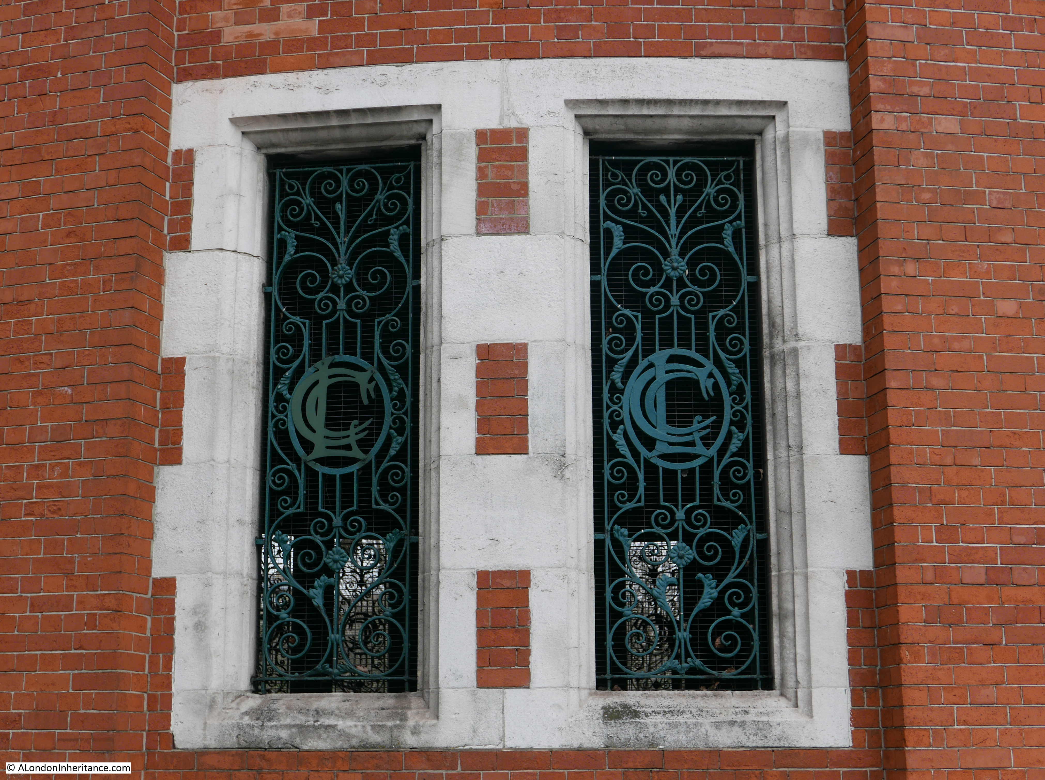
There is some lovely London County Council design detail in the building surrounding the shaft. The open windows have metal grills and within the centre of each grill are the letters LCC.
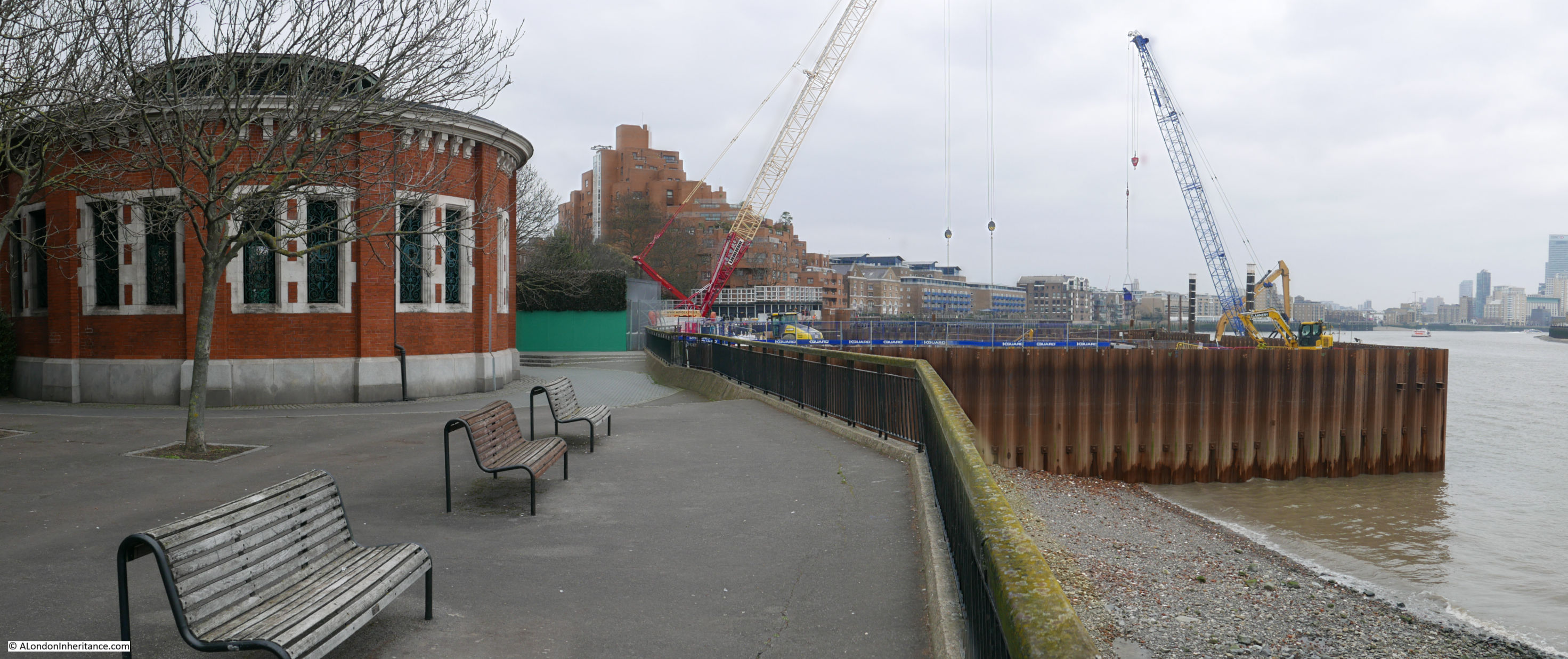
It was possible to walk along the river without entering the park, however this is one of the construction sites for the Thames Tideway project to build a new sewer and provide the capacity to take the overflow which currently runs into the Thames. The site at the King Edward VII Memorial Park will be used to intercept the existing local combined sewer overflow, and when complete will provide an extension to the park out into the river, which will cover the construction site.
There are many accounts of the popularity of the park after it opened. Newspaper reports call the park a “green lung” in east London and during the summer the park was full with children of all ages.
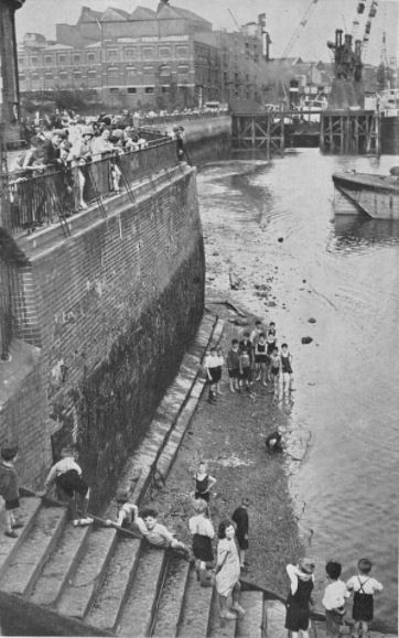
During the hot August of 1933, access to the river from the park was very popular:
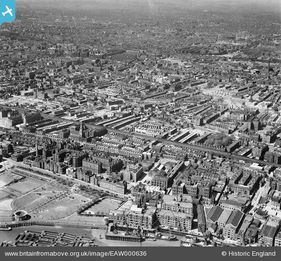
The following photo dated 1946 from Britain from Above shows the park at lower left. Note the round access shaft to the Rotherhithe tunnel. In the photo the shaft has no roof. The original glass roof was removed in the 1930s to improve ventilation. The current roof was installed in 2007.
The King Edward VII Memorial Park is interesting enough, however I wanted to find out more about the site before the park was built.
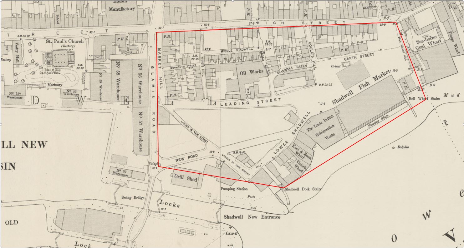
The 1895 Ordnance Survey map provides a detailed view of the site, and I have marked the boundaries of the park by the red lines to show exactly the area covered.
There were some fascinating features. In the lower right section of the park, was the Shadwell Fish Market – I will come onto this location later in the post along with the adjacent refrigeration works.
Above the fish market is Garth Street. The public house (PH) shown in Garth Street was the King of Prussia. I cannot find too much about the pub apart from the usual newspaper reports of auctions and inquests being held at the pub, however there were a number of reports of a disastrous fire which destroyed the pub on the 14th November 1890. Two small children, Agnes Pass aged seven and Elizabeth Pass aged two died in the fire which started in the bar and spread rapidly through the pub. The location of the pub today is just in front of the eastern terrace, about half way along.
Interesting that in the map, there are urinals shown directly in front of the pub – a very convenient location.
To the left of centre of the park can be found a large building identified as an Oil Works. The left hand part of this building is covering part of the bowling green.
One of the streets in the lower right is called Labour In Vain Street, an interesting street name which could also be found in a couple of other London locations.
In 1895 the Rotherhithe Tunnel had not yet been built (it was constructed between the years 1904 and 1908), so the access shaft does not feature in the map. It would be built over the riverside half of the Kent and Essex Wharf building.
The main feature in the map is the Shadwell Fish Market. This was a short-lived alternative to Billingsgate Fish Market.
In the 19th century there were a number of proposals to relocate Billingsgate Fish Market. It had a relatively short frontage to the river and was located in a very crowded part of London with limited space to expand.
Shadwell was put forward as an alternative location. In September 1868, the Tower Hamlets and East End Local Advertiser reported on the petition put forward by the Board of Works for the Limehouse District to campaign for the Shadwell Fish Market. The petition put forward a number of reasons why Shadwell was the right place to relocate Billingsgate:
That it is the nearest site to the city of London, abutting upon the river for the purposes of a fish market;
That an area of land upwards of seven acres in extent could be obtained upon very reasonable terms;
That by means of a short branch of railway to be constructed, communications can be made with every railway from London north and south of the Thames.
That by means of the Commercial-road and Back-road (recently renamed Cable-street) and other thoroughfares, convenient approaches exist to the proposed site of the market from all parts of London;
That in consequence of the bend in the river at Shadwell, which forms a bay, ample accommodation exists for the mooring of vessels engaged in the fishing trade, without interfering with the navigation of the river;
That easy communication can be made with the south side of the Thames by means of a steam ferry, which would also be available for ordinary traffic, and which to a large extent would prevent the overcrowding of the traffic in the City, especially over London-bridge;
That there is no other site on the River Thames which presents so many advantages as that proposed at Shadwell;
That the establishment of a fish market at Shadwell would be a great boon to the whole of the East-end of London;
That should Billingsgate-market be removed, the fish salesmen are in favour of the market being established at Shadwell.
A very compelling case, however there were a number of vested interests in the continuation of the fish market at Billingsgate and no progress was made with approval for a fish market at Shadwell.
However the issue never went away, and in 1884 a company was formed to “give effect to the London Riverside Fish Market Act of 1882”. The company had “on its Board of Directors, three of the best known and most popular men in the East of London – men who taken a considerable interest in the welfare of the people of the district, and have embarked in this enterprise, feeling assured not only of its value to the public, but with confidence that it will prove a commercial success.”
The Directors of the company were Mr. E.R. Cook, Mr. Spencer Charrington, Mr. T.H. Bryant, Mr. E. Hart and Mr. Robert Hewett.
Robert Hewett was a member of the Hewett family who owned the Short Blue Fishing Fleet and was keen to leave Billingsgate due to the lack of space. He would transfer his fleet of ships from Billingsgate to Shadwell.
Work progressed on the construction of the market and at a ceremony to mark the pile driving, the local MP, Mr Samuel Morley, “confidently communicated to the assembled company the burning desire of the Home Secretary to find remunerative labour for the unemployed in East London. Mr Morley is now in a position to inform that the fish market at Shadwell will afford employment to many working men”.
Shares in the fish market company were advertised in the East London Local Advertiser and “those of the East London public who have not yet practically interested themselves in a scheme which promises so well, the opportunity once more offers itself. Applications for shares should, however, be made without delay.”
The new market opened at the end of 1885 and whilst it appeared to start well, the challenges of attracting business from Billigsgate were already very apparent. The London Daily News reported on the 1st March 1886:
“The new fish market at Shadwell has been going now for about three months, and the fact that a hundred tons of fish can be readily disposed of here every morning indicates pretty satisfactorily that already buyers have begun to find out that the market has at least some advantages over Billingsgate. As regards the supply of this new market, so far as it goes it cannot very well be better. Messrs. Hewett and Co., who are at present practically the only smack owners having to do with it, have 150 vessels out in the North Sea, and a service of steamers plying to and fro between the fleet and the market.”
Interesting how fish were brought in from the north sea fishing boats by a fleet of steamers – a rather efficient method for bringing fish quickly ashore and keeping the fishing boats fishing.
The article indicates the problem that would result in the eventual failure of the Shadwell Fish Market, It was only the Hewett Company that relocated from Billingsgate. None of the other traders could be convinced to move, and there was an extension of the Billingsgate Market which addressed many of the issues with lack of space.
The market continued in business, but Billingsgate continued as the main fish market for London. The Shadwell market was sold to the City of London Corporation in 1904, and in less than a decade later the market closed in preparation for the construction of the King Edward VII Memorial Park.
In total the Shadwell Fish Market had lasted for less than twenty years.
The building adjacent to the fish market was the Linde British Refrigeration Works. A company formed to use the refrigeration technology developed by the German academic Carl von Linde. The Shadwell works were capable of producing 150 tons of ice a day.
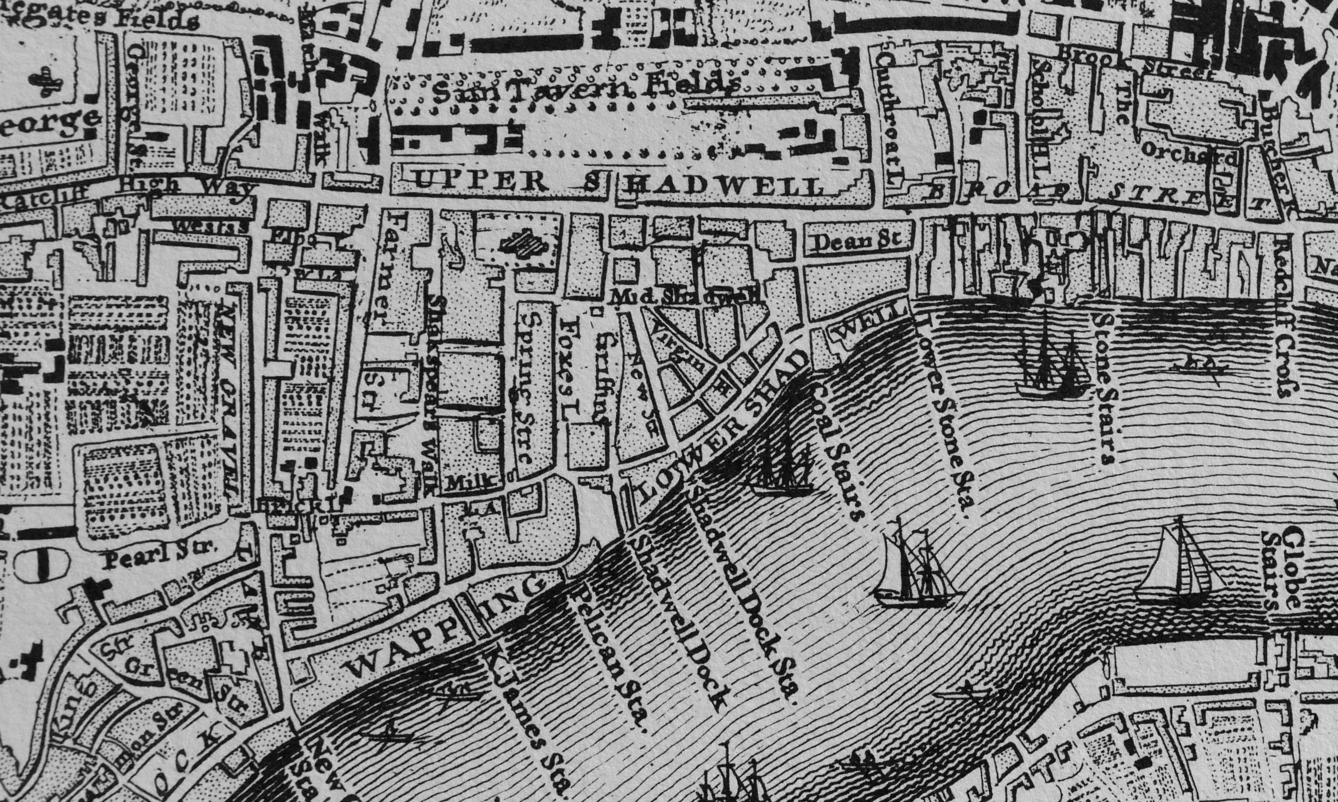
Before taking a look at the area just before demolition ready for the new park, we can look back a bit earlier to Rocque’s map of 1746.
The road labelled Upper Shadwell is the Highway. Just below the two LLs of Shadwell can be seen Dean Street, this was the original Garth Street. Shadwell Dock Stairs can be seen under the W of Lower Shadwell and to the right is Coal Stairs which was lost with the development of the fish market.
To the right of Coal Stairs is Lower Stone Stairs. By 1895 these had changed name to Bell Wharf Stairs.
The map illustrates how in 1746 the area between the Highway and the river was already densely populated.
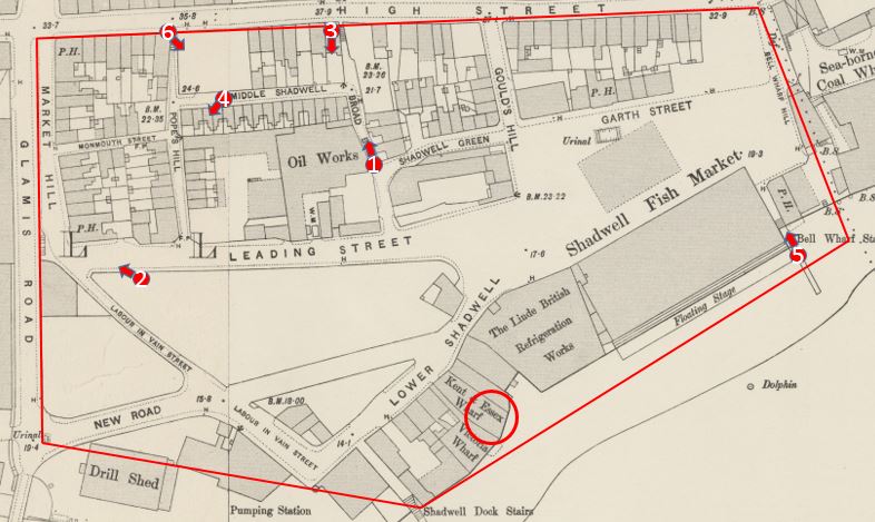
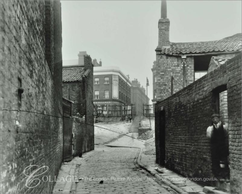
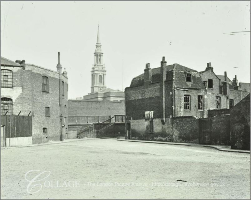
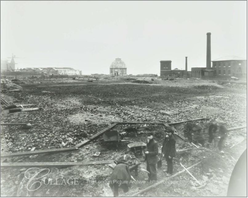
To see if there are any photos of the area, I check on the London Metropolitan Archives, Collage site and found a number of photos of the streets prior to, and during demolition. These are shown below and I have marked the location from where the photos were taken on the 1895 map.
Site 1: Looking up towards the High Street (the Highway) along Broad Bridge. The building on the left is the Oil Works and residential houses are on the right. Note the steps leading up to the High Street, confirming that the high difference between the Highway and the main body of the park has always been a feature of the area, and is visible today with the terrace and steps leading down to the main body of the park.
Site 2: This photo was taken to the south of Leading Street and is looking across to the steps leading up to Glamis Road, a road that is still there today. The church of St. Paul’s Shadwell is in the background.
Site 3: This photo was taken from the High Street (Highway) hence the height difference. It is looking down towards the river with the shaft of the Rotherhithe Tunnel one of the few remaining buildings – and the only building still to be found in the area. The remains of the metal framework of the fish market sheds can be seen to the left of the access shaft.
Site 4: This photo was taken in the street Middle Shadwell (the buildings being already demolished) looking down towards a terrace of houses remaining on Pope’s Hill. the buildings in the background are Number 56 and 57 Warehouse of the Shadwell New Basin on the opposite side of Glamis Road.
Site 5: This photo is taken looking up Bell Wharf Stairs from the Thames foreshore. The sheds of the Shadwell Fish Market are on the left. The building on the right is the remains of the pub the Coal Meters Arms.
A possible source for the name Coal Meters Arms may be found in the following strange story from John Bull dated the 3rd April 1843:
“Jeremiah John Kelly, the man who entered the lobby of the House of Commons on Friday evening, in a half-mad, half-drunken state, and who was taken into custody by the police, with a carving-knife in his possession, is a person of wayward character and habits., who has given much trouble to the Thames Police Magistrates, and there can be little doubt that he intended to commit an assault on Lord J. Russell, and perpetuate an outrage on that Nobleman. Kelly has made no secret of his intention of attacking Lord John Russell for some time past, and fancies he has some claims on his Lordship for services performed during the last election for the city of London. A few years since Kelly was in business as a licensed victualler, and kept the Coal Meters Arms , in Lower Shadwell, where he also carried on the business of a coal merchant, and an agent for the delivery of colliers in the Pool.”
So perhaps an element of Kelly’s trade was used for the name of the pub.
Site 6: Is at the top of Pope’s Hill where it meets the Highway and is looking back at the remaining terrace houses on the southern side of Middle Shadwell.
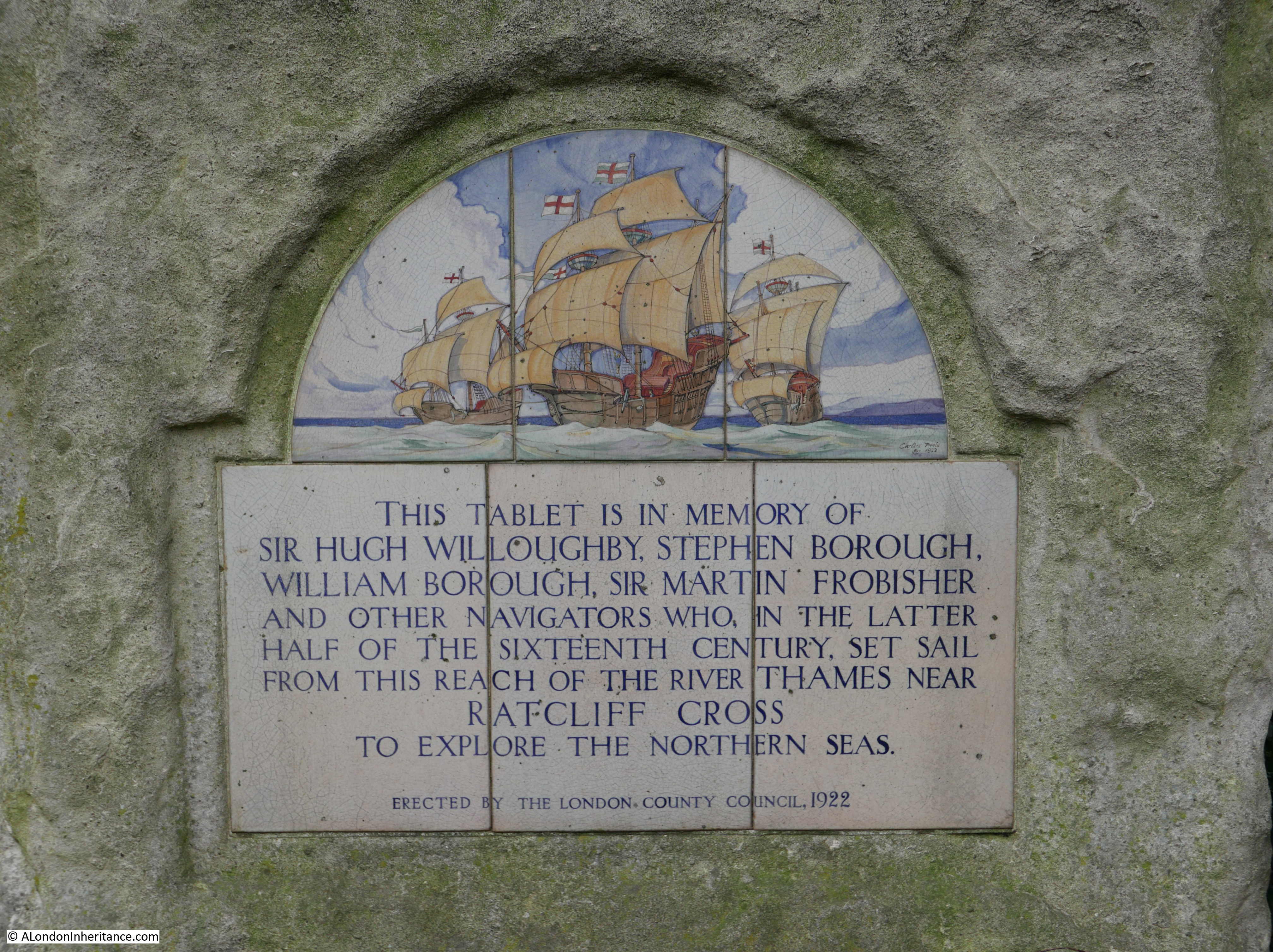
There is one final story to be found in the King Edward VII Memorial Park. Next to the Rotherhithe Tunnel entrance shaft is the following plaque:
The plaque was put in place in the year that the park was opened, and records among others, Sir Hugh Willoughby, a 16th century adventurer and explorer. He died in 1554 whilst trying to find a route around the north of Norway to trade with Russia.
The title page to The English Pilot published in 1671 includes a picture of Willoughby in the top panel of the page, standing to the right of centre.
The lower half of the page shows the Pool of London, the original London Bridge and St. Paul’s Cathedral. Below this are two figures pouring water into the river, one representing the Thames and the other representing the Medway.
This title page fascinates me. It highlights the connections between London, the River Thames, shipping, navigation and the high seas – a connection that is not so relevant to London today, but was so key in the development of London over the centuries.
And on the subject of connections, this post demonstrates why I love exploring London, in that one small area can have the most fascinating connections with the past and how London has developed over the centuries, and it all started with finding a bowling green in Shadwell.
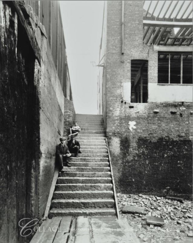
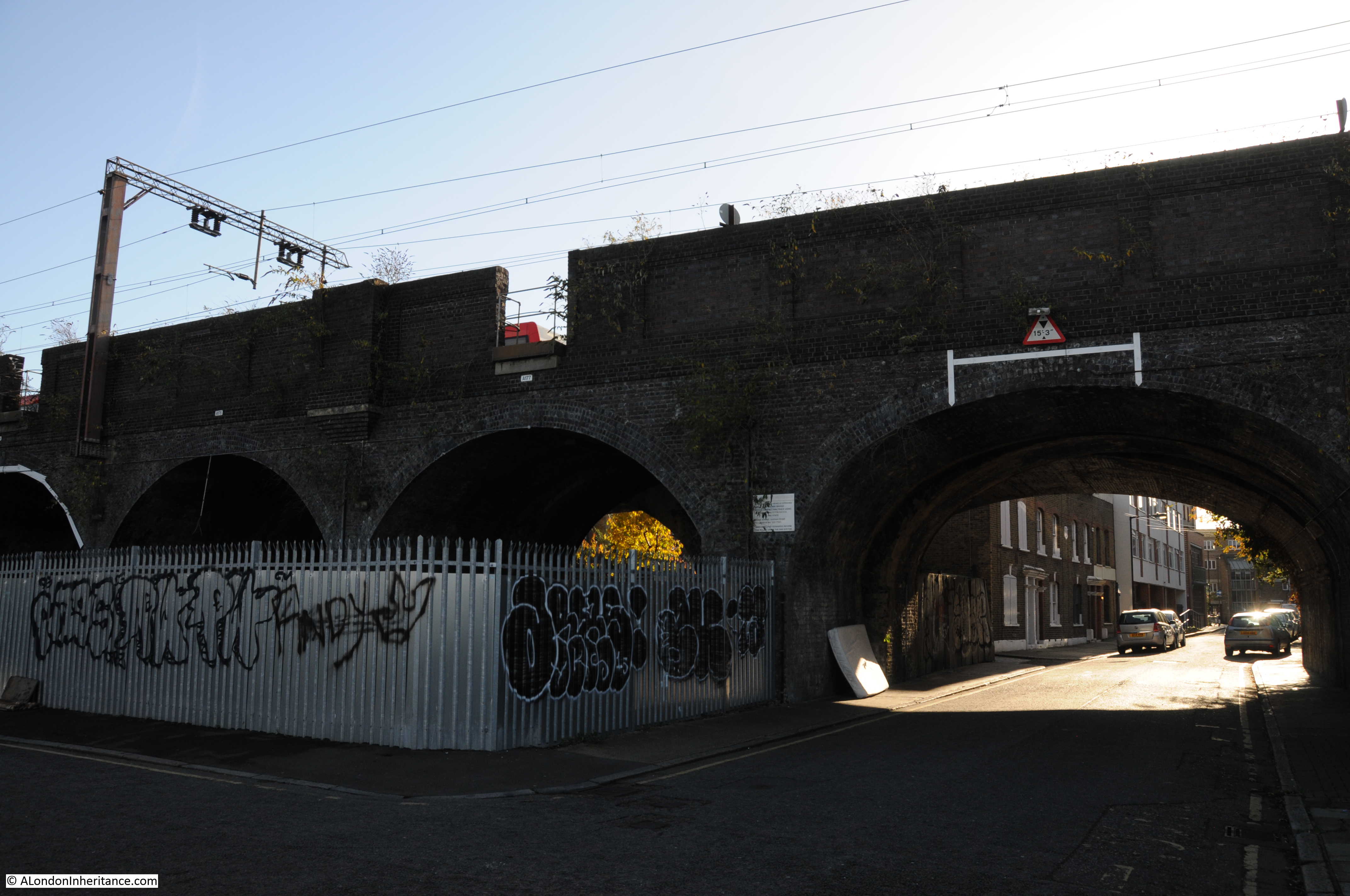
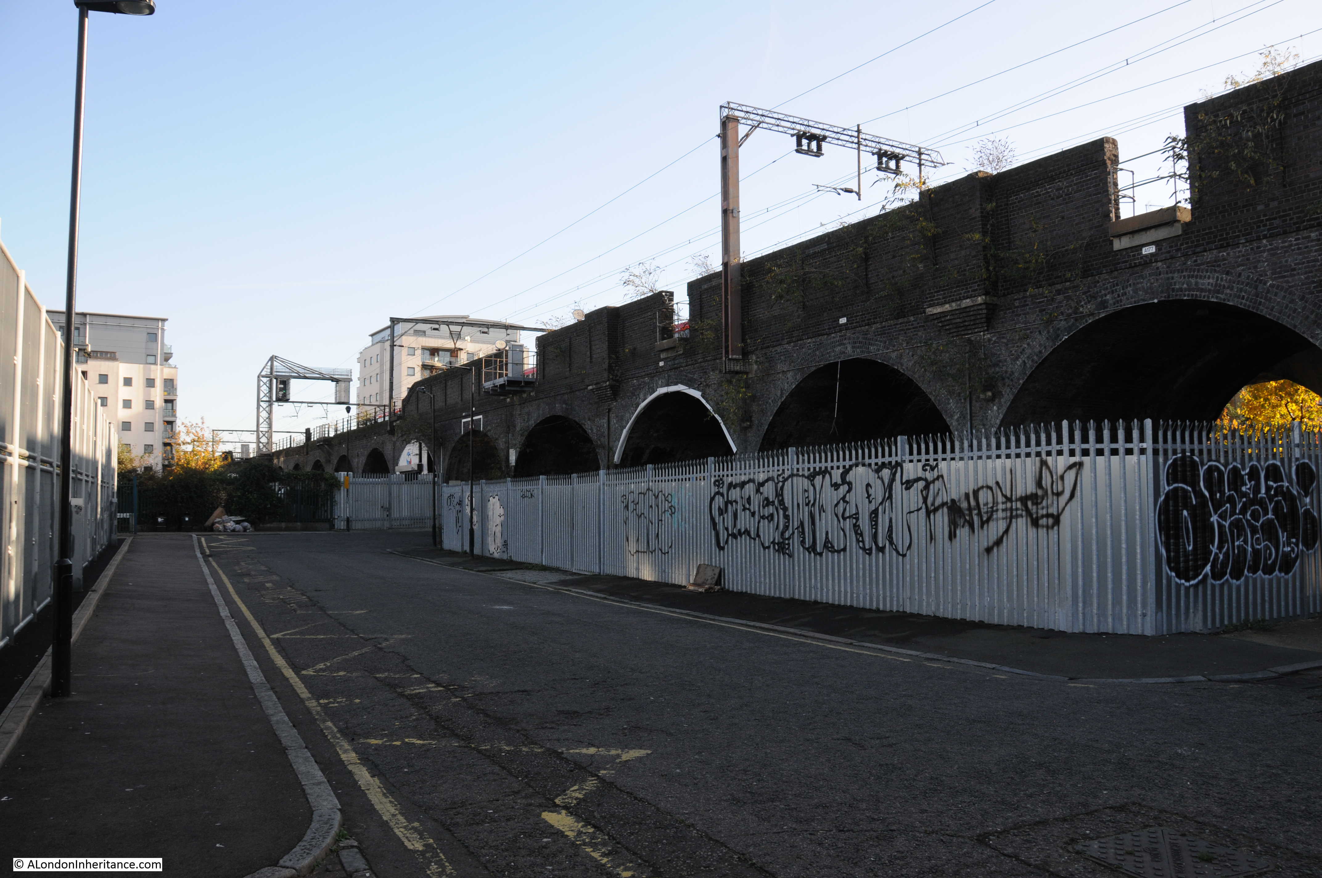
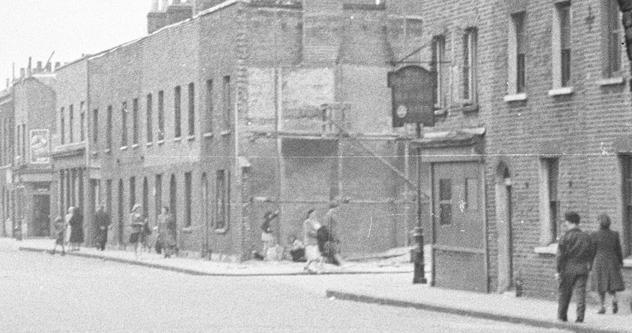
For this week’s post, it was a short walk after leaving last week’s location at Westferry Road, to find what remains of a street my father photographed in 1949. When sorting through his photos this was one location I was doubtful I would find. I did not recognise the scene and there were no clues to place the photo, apart from being taken from within what looks like a railway arch. I published the photo in one of my mystery location posts in 2015 and was really pleased when it was identified as Hardinge Street, just off Cable Street, a third of a mile east of Shadwell Station.
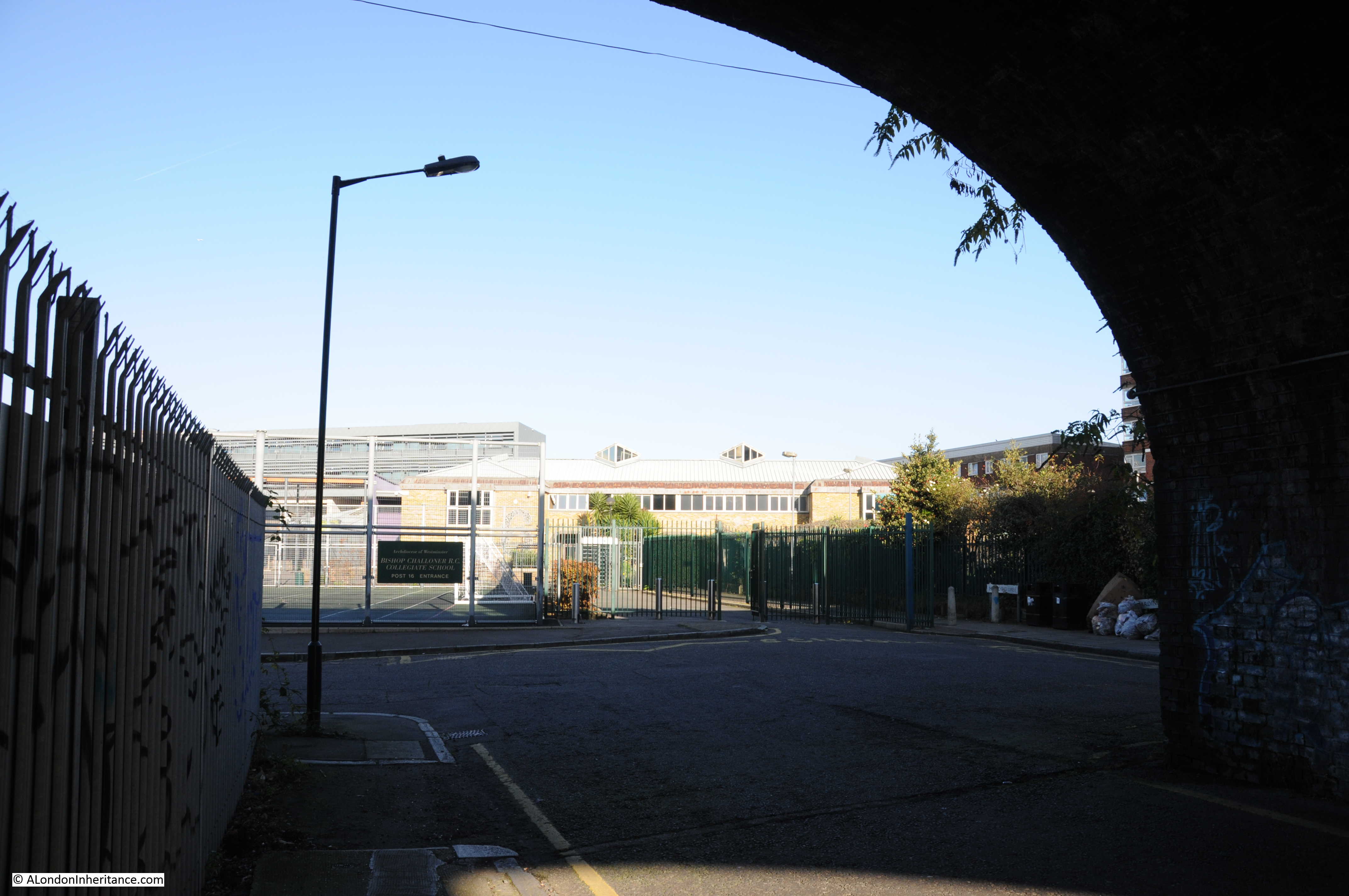
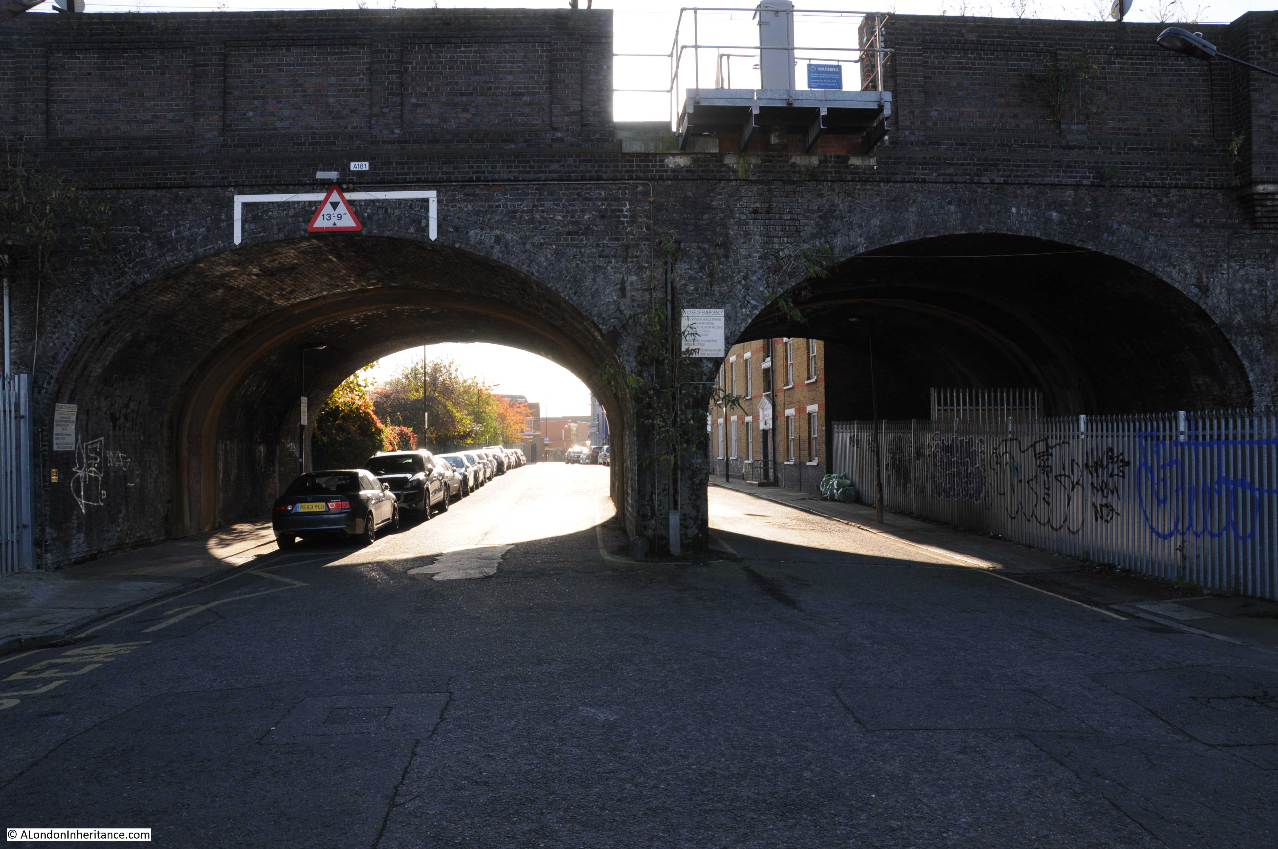
And this is the view from the same location today:
Hard to believe that this is the same place, however there are a number of clues. In addition to the obvious railway arch, in both photos the left hand section of the arch is fenced off, it was probably some form of workshop or storage area in 1949. There is access from the street to the fenced off area in both photos, and just past this there is another street leading off to the left.
There are also the sort of small details I love finding. On the pavement and kerb edge of the street, just before the street on the left there is a manhole cover on the pavement and a drain cover next to the kerb in the street. These are in the same locations in both photos – when the street above changes, often the utilities below the streets follow the same routes for decades.
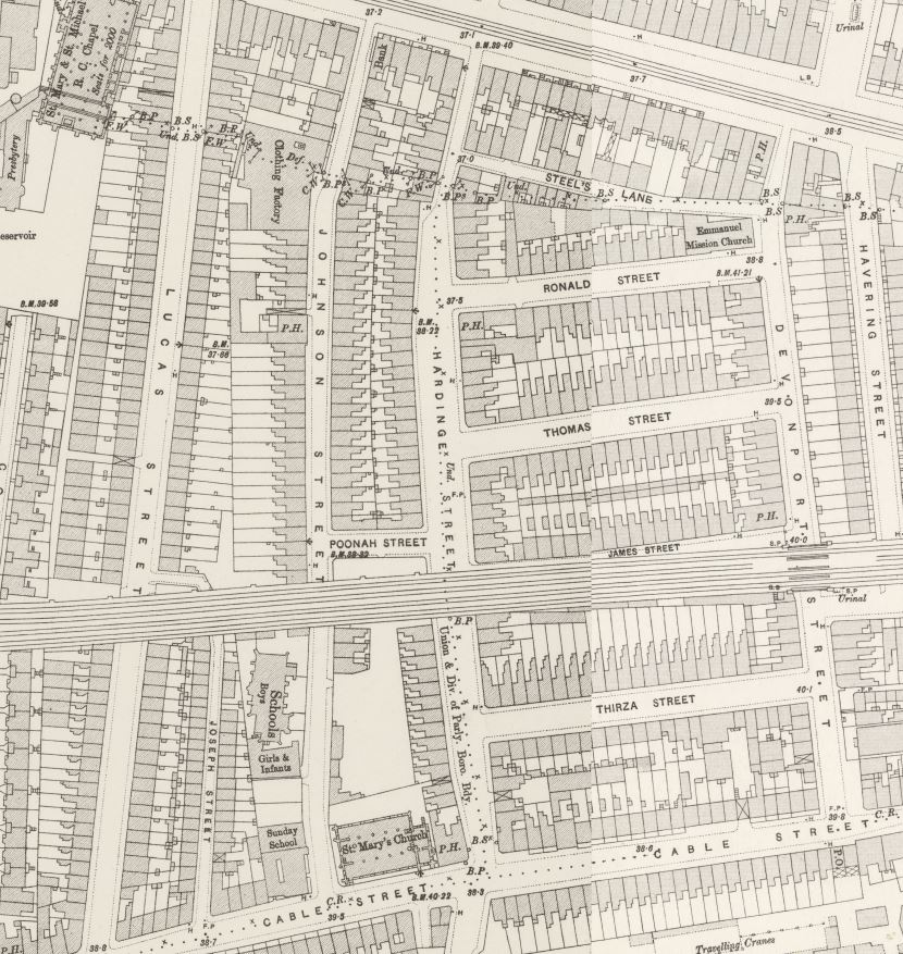
Hardinge Street is one of the many streets that ran between Cable Street and Commercial Road. The following extract from the 1895 OS map shows Cable Street along the bottom, Commercial Road along the top and in the centre of the map, Hardinge Street running between the two.
The railway, built in the late 1830s that runs into Fenchurch Street can be seen cutting Hardinge Street in two.
The streets are densely packed with houses, as can be seen in my father’s photo. The street on the left is named as Poonah Street in the map. The streets running off to the right can be seen in both map and photo.
Perhaps surprising is that the street looks intact after the heavy bombing east London suffered during the war. I checked the London County Council Bomb Damage Maps and the houses in my father’s photo are coloured yellow – “Blast damage, minor in nature”. the only exception is on the right side of the photo, the building on the corner of the street leading off to the right, there appears to damage and scaffolding. This building is coloured orange for “General blast damage, not structural”. A bomb must have fallen in the street leading off to the right as in the map there is a row of houses on both sides of the street coloured purple for “Damaged beyond repair” and black for “Total destruction”. It is the blast from this bomb that must have caused the blast damage to Hardinge Street.
The fate of Hardinge Street is very different either side of the railway. To the north, the view in my father’s photo, all the buildings, Hardinge Street and most of the side streets have all been demolished and replaced with the Bishop Challoner School. The map extract of the area today shows roughly the same area as the 1895 map and highlights how significantly the area has changed.
It is fascinating to trace the history of the area. Hardinge is an unusual name. I could not find any reference to why the street was given this name, however Poonah Street gave me a clue.
Poona was the name given by the British to the Indian city of Pune during the 19th century – I suspect the ‘h’ at the end was added as the pronunciation of the word probably ended with ..ah.
Following the Indian connection, Henry Hardinge, 1st Viscount Hardinge was Governor General of India between 1844 and 1848, so I suspect that when the street was redeveloped at some point between the 1850s and the 1895 OS map, it took the name of a Governor General of India.
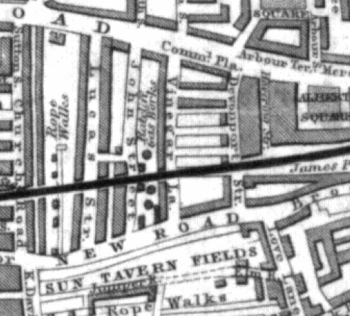
Why do I say redeveloped? This is an extract from an 1844 map of the same area.
The name Cable Street had not extended for the full length of the street covered today – in 1844 this section was called New Road. What would become Hardinge Street is again in the centre of the map, but in 1844 was called Vinegar Lane. The railway is in the same position and comparing the map with later maps, Devonport Street on the right is the only street that has survived with the same name from 1844 to 2017. John Street on the left is now Johnson Street and next left, Lucas Street is now Lukin Street (and today follows a different route south of the railway).
To the left of Vinegar Street can be seen the Ratcliffe Gas Works along with the round symbols of gas holders. By 1895, the gas works had been demolished, Vinegar Street became Hardinge Street and the area was full of densely packed housing, corner shops and pubs.
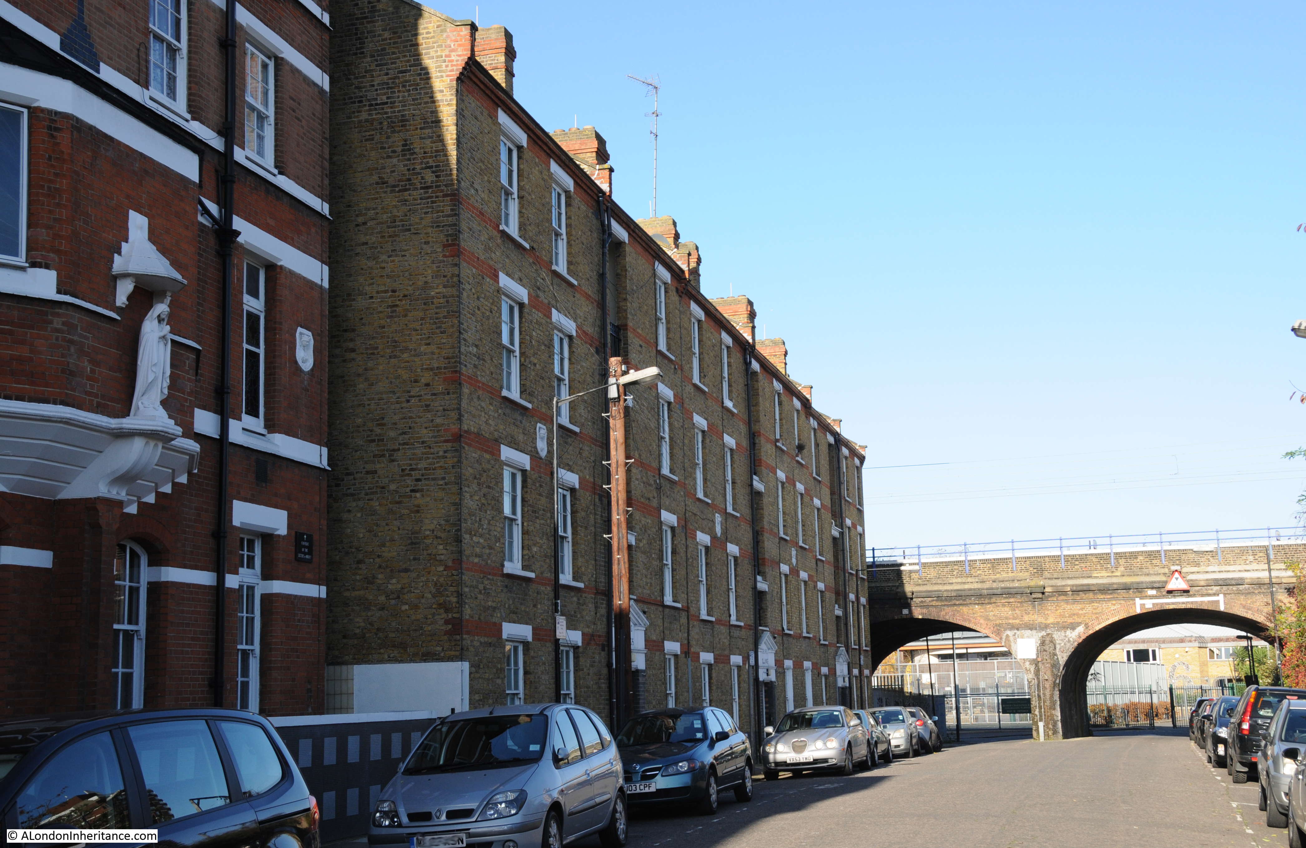
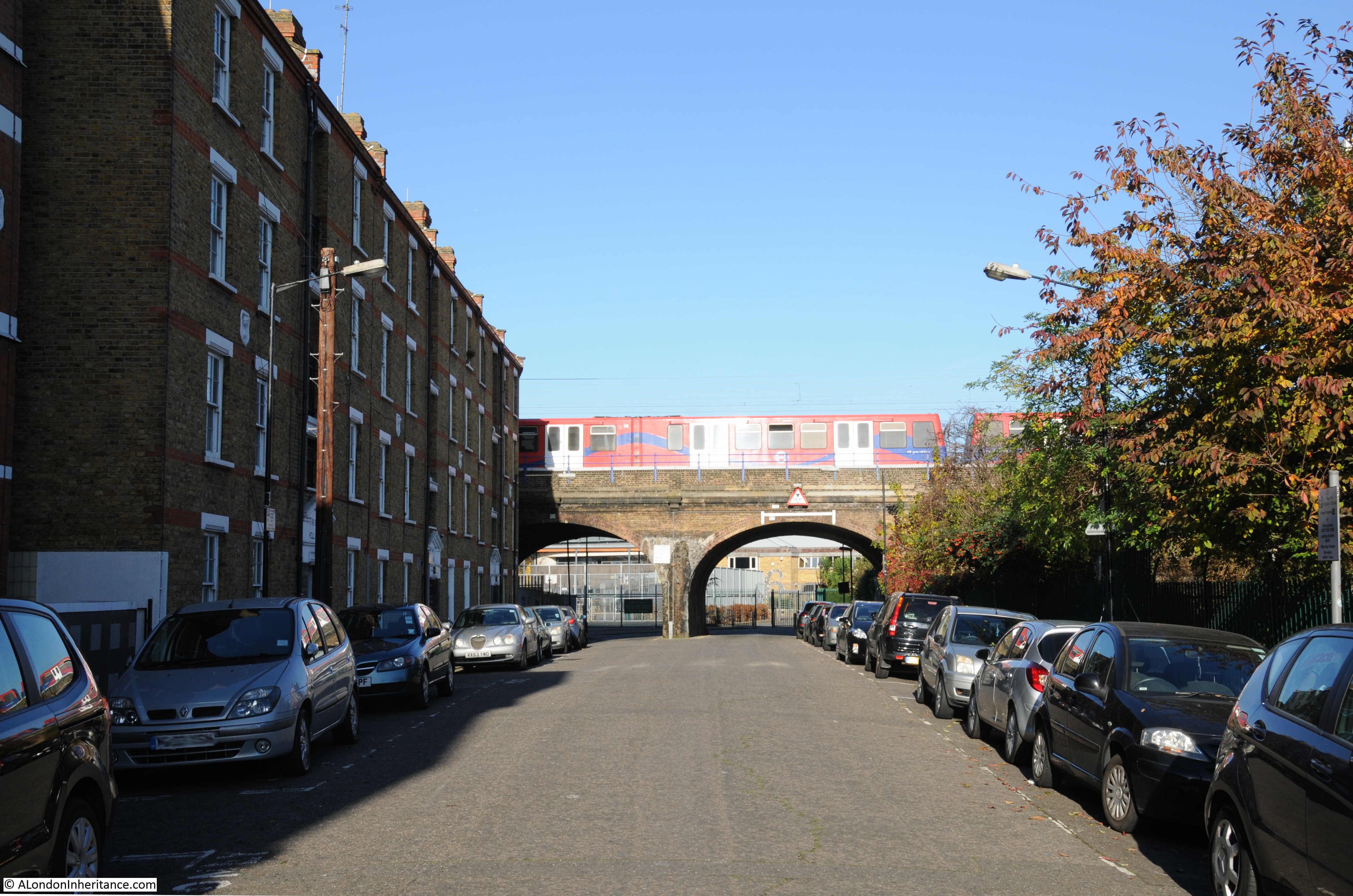
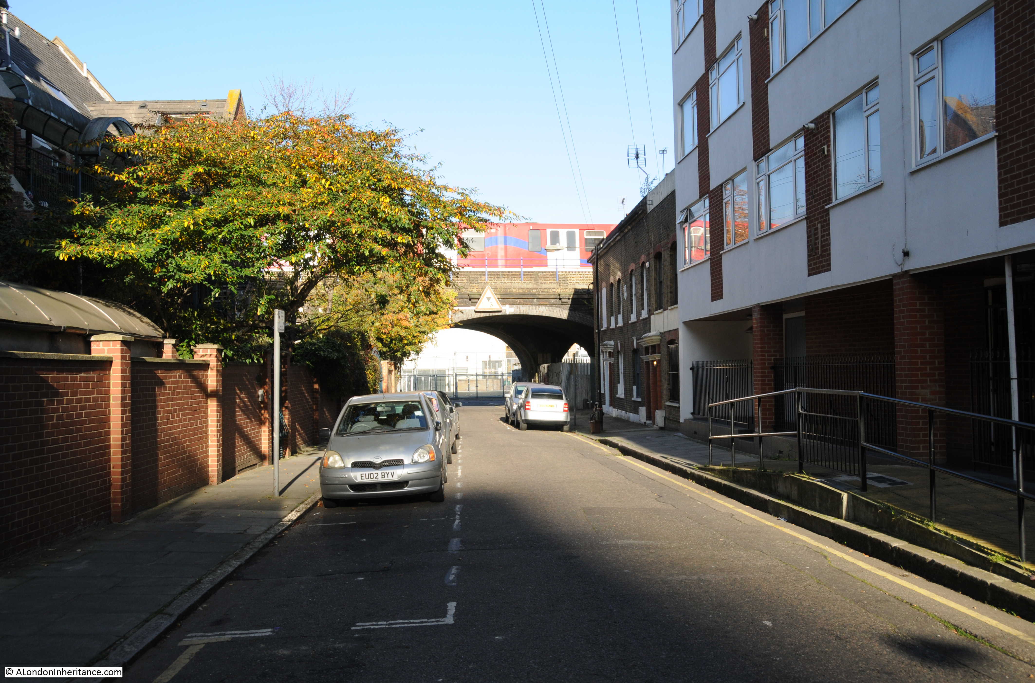
Time for a walk around the area. The following photo is looking south, through the arches to the southern end of Hardinge Street. The location of my father’s photo and my later photo is just inside the arch to the right, up against the metal fencing.
This is looking at the corner of Poonah Street and Hardinge Street. In the 1949 photo this was the location of the corner shop.
A footpath can be seen to the right of the above photo. Although Hardinge Street as a road has now been cut off from Commercial Road, a footpath runs along the side of the school up to Steel’s Lane (another survivor from the 1895 map) and then to Commercial Road. The footpath is called Hardinge Lane, retaining the name, but Lane reflecting the loss of the through street.
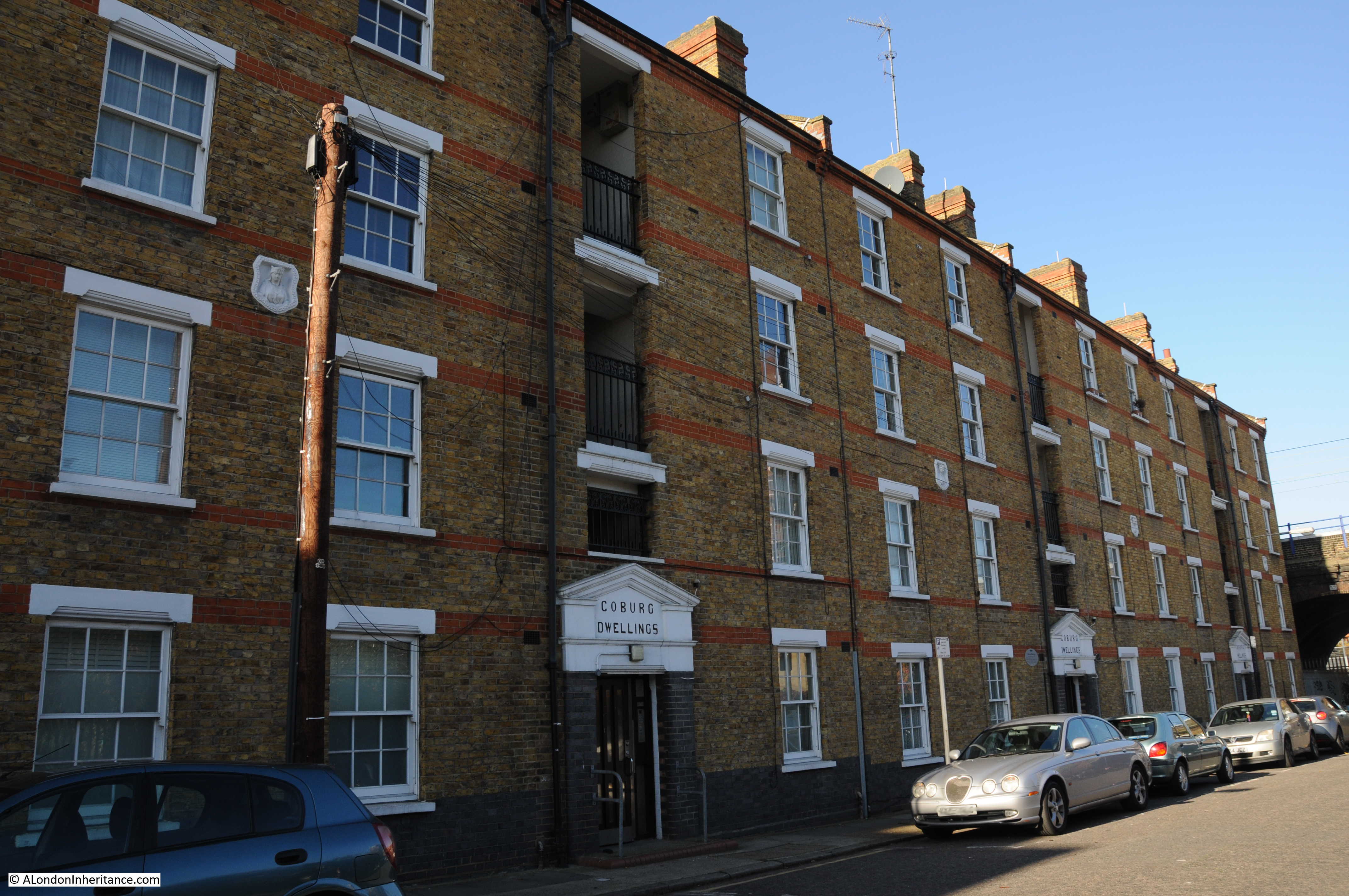
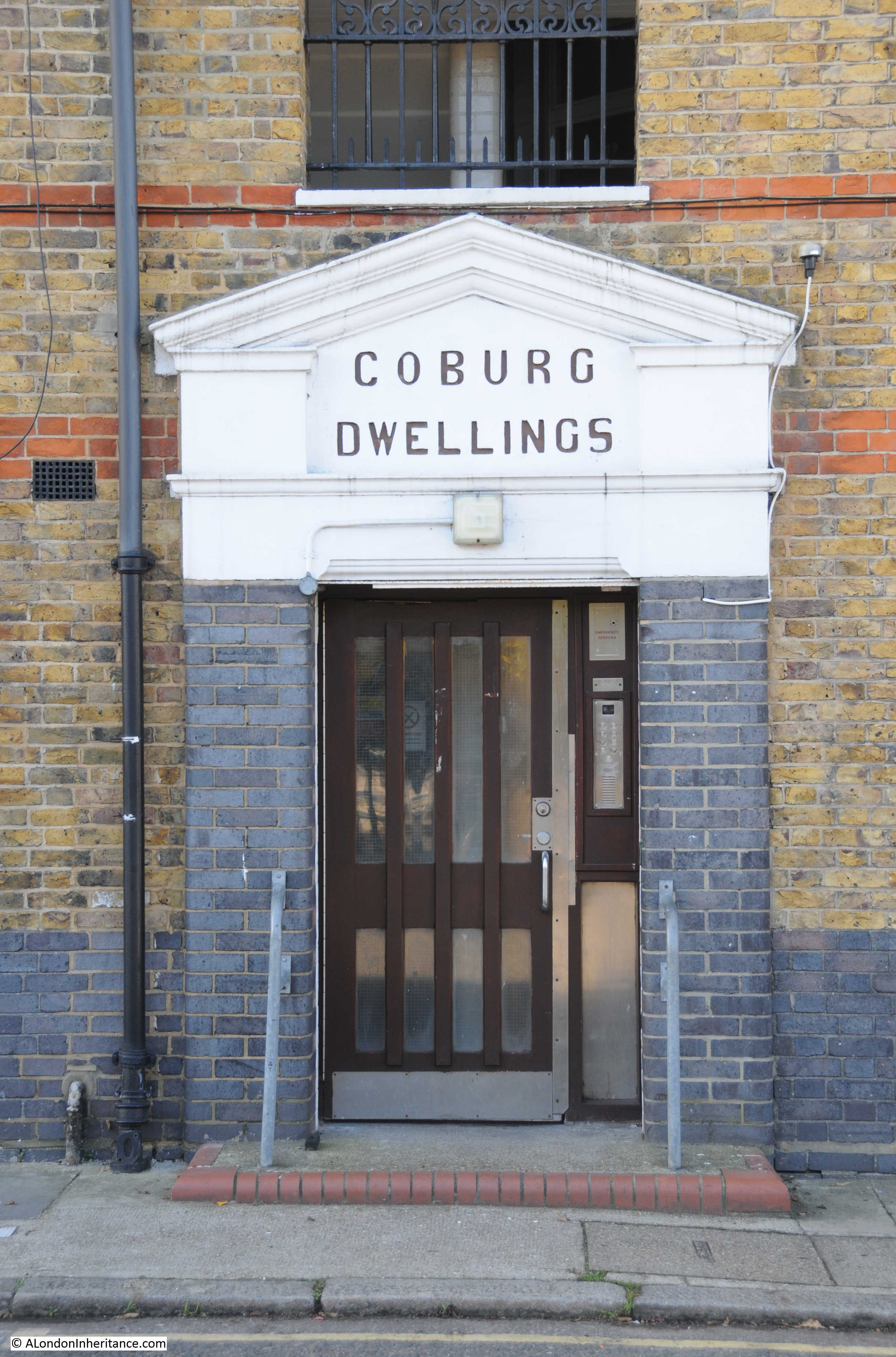
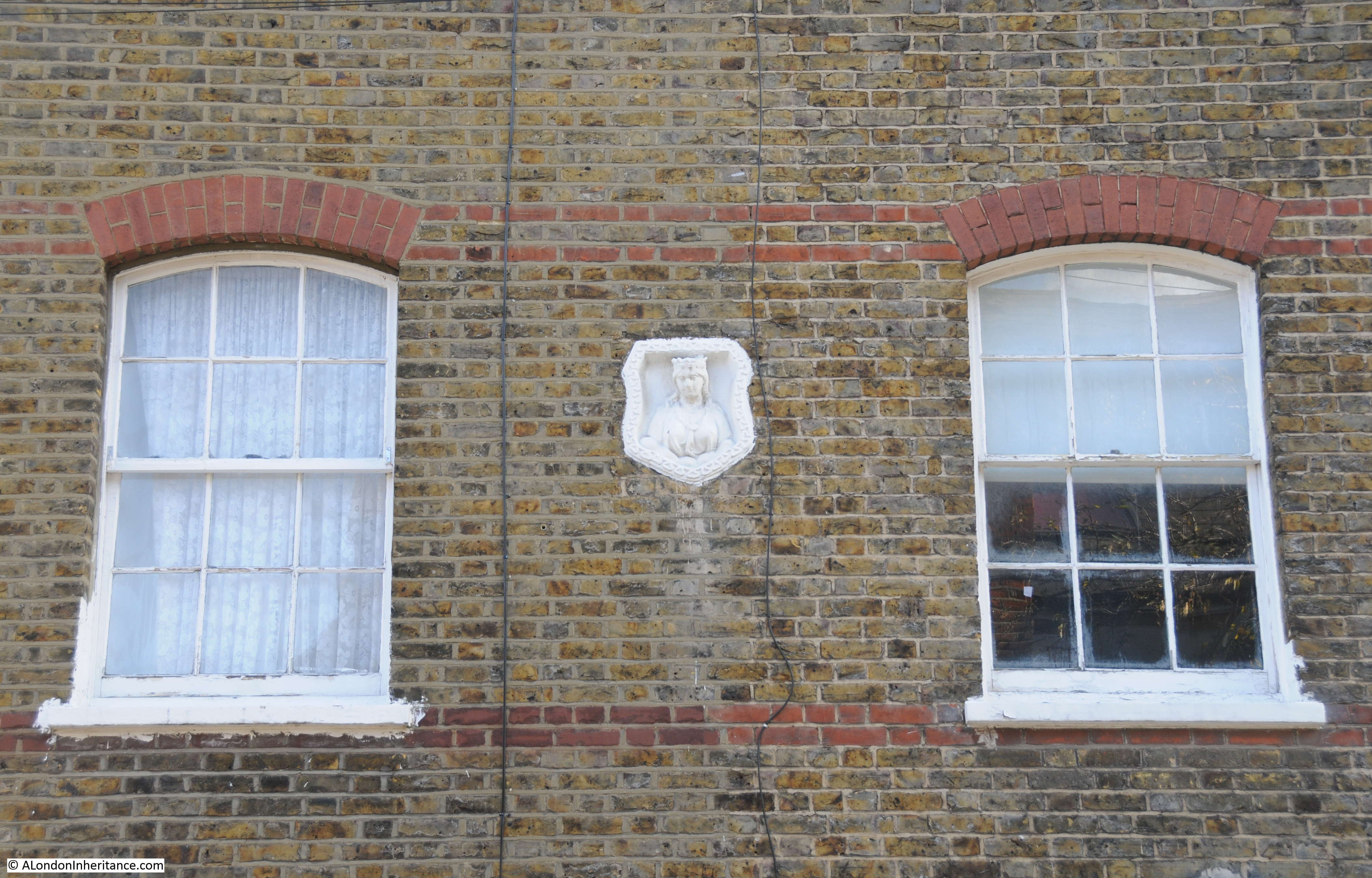
Walking back under the rail bridge, south towards Cable Street, on the western side of Hardinge Street are Coburg Dwellings. The building dates from 1904 and was constructed by the Mercers Company. The name comes from the region of Germany where Queen Victoria’s husband, Prince Albert was born.
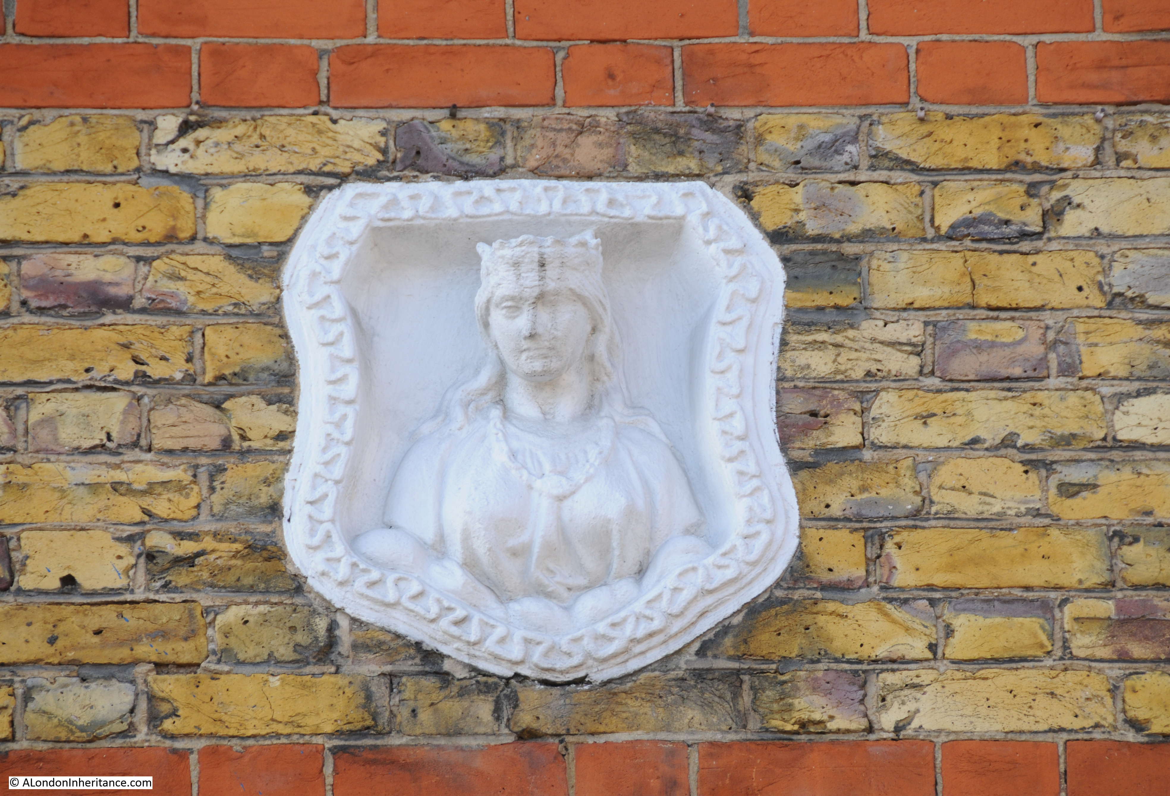
In the above photo, there are a number of white plaques between the first and second floors of Coburg Dwellings. These are Mercers’ maiden property marks to show that the land and buildings belonged to the Mercers Company. A Mercers’ maiden in close up:
The Mercers Company is one of the oldest of the City’s Companies. The earliest mention of the Mercers is the appointment of the fraternity in 1190 as patrons of the Hospital of St. Thomas of Acon, On the 13th January 1394 the “men of the Mistery of Mercery of the City of London” were incorporated by royal charter.
The Virgin is part of the Armorial Bearing of the Mercers Company and was used for the Maiden property marks on Mercers’ buildings. Many of these can still be found across London.
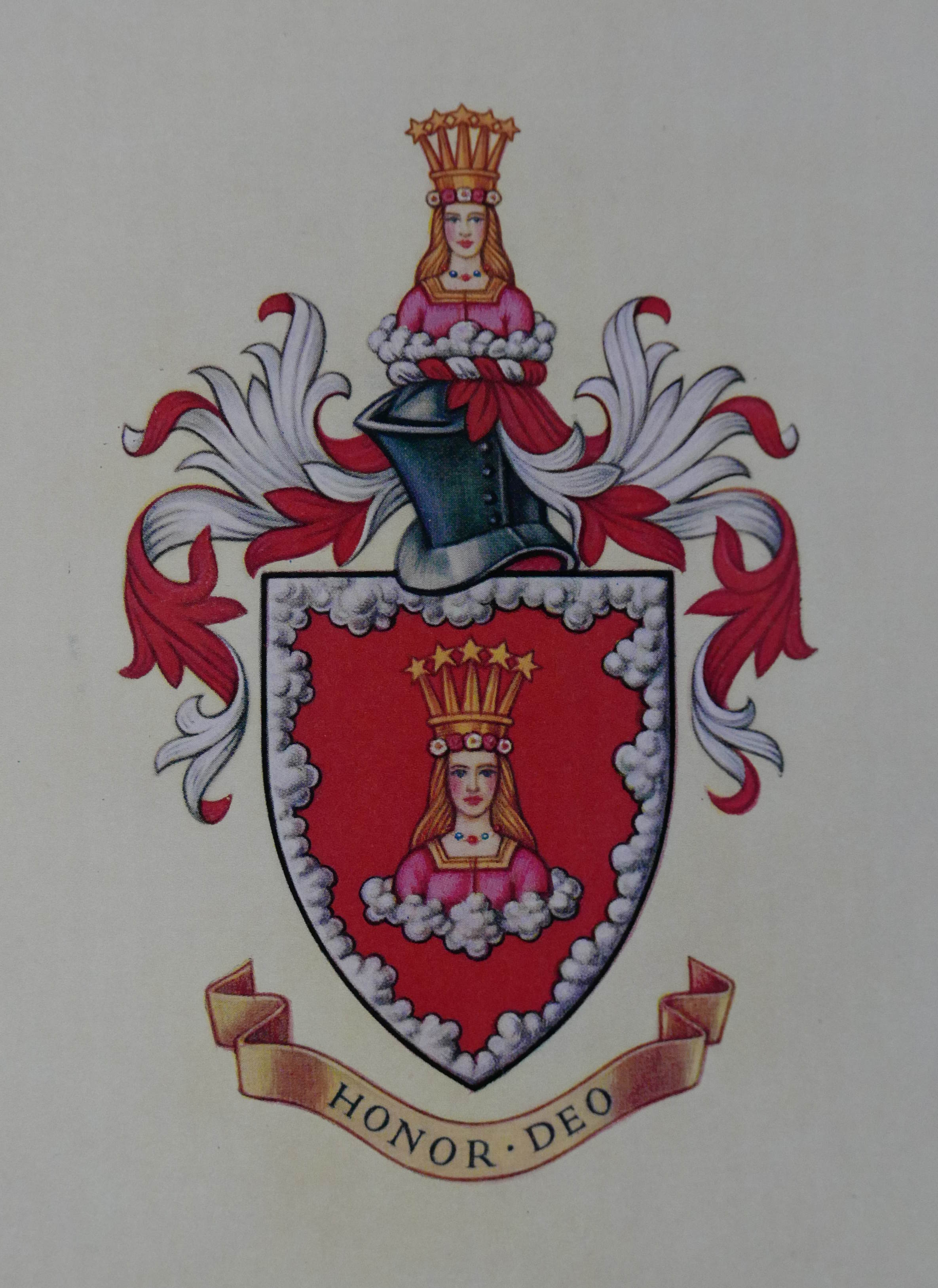
The Armorial Bearings of the Mercers Company:
One of the entrances to Coburg Dwellings:
Another Maiden mark is on the building to the left of Coburg Dwellings, built as a Convent for the Sisters of Mercy:
Looking up towards the railway arches. As I explored the area there were frequent DLR and mainline trains passing over Hardinge Street:
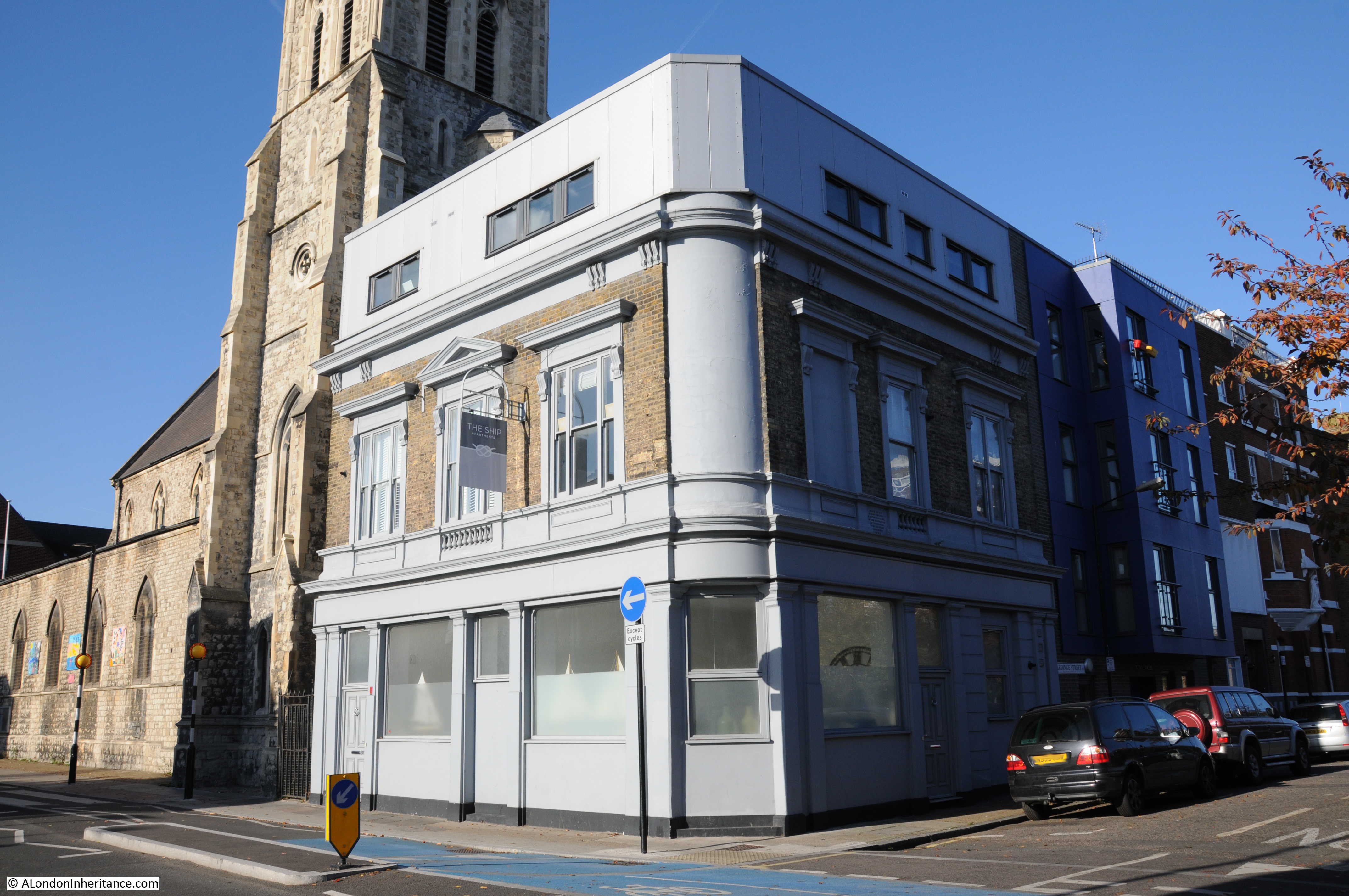
On the corner of Hardinge Street and Cable Street is the building that was once the Ship pub:
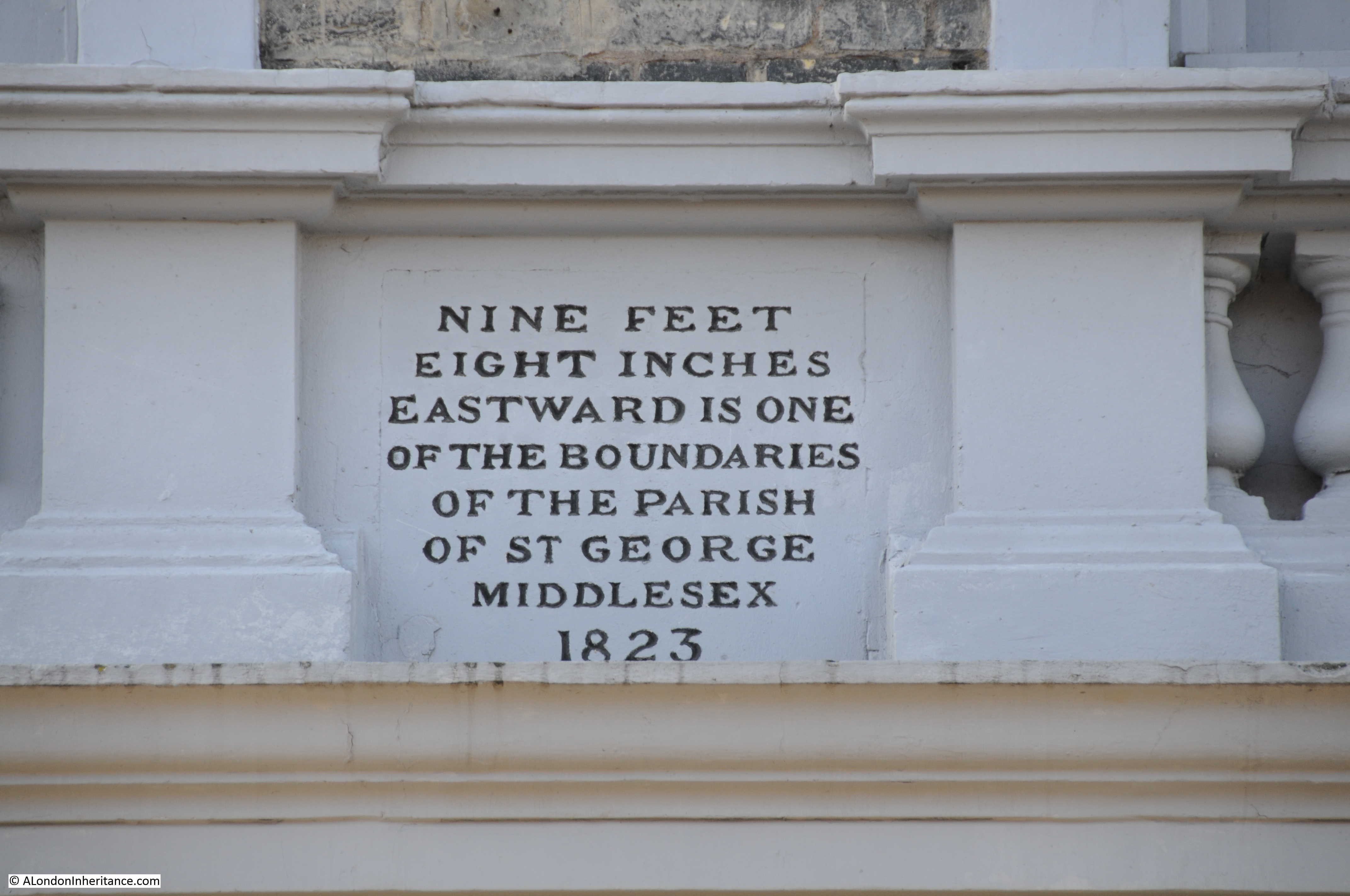
The pub closed in 2003 and has since been converted into flats with an additional floor added to the top of the building. Fortunately a boundary marker from 1823 (which probably dates the construction of the pub) remains on the Hardinge Street side of the pub, between the ground and first floors:
Newspapers during the 19th and early 20th century included the usual adverts for staff at the Ship and also using the pub as a contact address for sales, however in 1893 there is a report which would have made the landlord very unpopular with the residents of Hardinge and Cable Streets:
“At the Thames Police court, London, on Wednesday, William Williams of the ‘Ship’ public-house, Cable-street, St. George’s was summoned at the instance of the Excise Commissioners, for diluting beer. and for not entertaining his permits in the spirit stock-books, and for not cancelling said permits, whereby he had rendered himself liable to penalties amounting to £200. The defendant pleaded guilty. Mr Mead fined him £35 for the dilution and £5 each for the other two summonses.”
His fines seem light compared to what the maximum penalty could have been, however I can imagine the reception he received back at the pub after having been convicted of diluting the beer.
The church seen next to the pub is St. Mary, Cable Street. A relatively recent church having been consecrated on the 22 May 1850 to serve the growing population as the district developed.
After the church, I turned into Johnson Street. This street runs back up to Poonah Street to take me back to the location of the original photo. This is the view looking down Johnson Street:
The 1844 map had the location of the Ratcliffe Gas Works on the right of Johnson Street, filling in the area between Johnson Street and Hardinge Street, although there does look as if there was a narrow line of buildings along Hardinge Street.
When the use of gas for lighting and power started, the small scale of production and lack of large distribution systems meant that gas works would be built to serve a local area, very much within the centre of the area they were serving, even if that meant building a gas works in the middle of housing, or either side of a railway viaduct.
Gas works were dirty and dangerous places and would also produce fumes and smells that would blanket the local area. The following extract from the Essex Standard on the 31st October 1834 reports on an explosion at the Ratcliffe Gas Works:
EXPLOSION OF THE RATCLIFFE GAS-WORKS. On Tuesday morning, about five o’clock, a terrific explosion was heard to proceed from the Ratfcliffe Gas Works, which caused the greatest consternation and alarm in the neighbourhood. The inhabitants rose from their beds in all directions, and on proceeding to the spot, it was discovered that one of the large gasometers had burst at the back of the factory, adjoining Johnson Street and had carried away the outside case or vat in which the gasometer was placed, besides forcing down a brick wall, several feet in thickness, the materials of which were thrown in every direction.
It appears that the gasometer contained at the time of the accident not less than 16,000 feet of gas, and owing to the chive hoop, which binds the bottom of the tank giving way, the pressure became so great on the other parts of the gasometer, that it gave way, and sank with a tremendous crash on one side, forcing the gas out at the top, and splitting the massive timbers which composed the case, and the large upright beams which supported the whole fabric. Heavy pieces of timber were reduced to splinters and others forced to a considerable distance. A ponderous wheel, by which the gasometer was suspended, was hurled into the yard, a distance of 50 feet, and fell by the side of a man employed on the premises, who narrowly escaped destruction.
A stable by the side of the gasometer was blown in and reduced to ruins, the corn-bin, rack and everything were displaced, but singularly enough a horse within escaped unhurt.
After the explosion the place presented one mass of ruins – bricks, iron and wood lying about Johnson-street and the factory-yard in every direction. The damage is estimated at upwards of £20,000, but it is gratifying to add that no lives were lost, nor was any person injured; but if the explosion had taken place a few hours later, there is no doubt that a great many would have been killed, as Johnson Street is a very populous and much frequented thoroughfare, and several labourers were generally kept employed about the tank which burst.
Another gasometer only five feet from the other remained uninjured, which is accounted for by the great strength of the outer casing, which is formed of wrought iron, braced by large girders. A gas light in a lamp close to the tank was blown out; a circumstance which prevented the contents of the gasometer from being ignited, and probably saved property to a large amount from destruction.”
There are many other reports in the papers during the 19th century of the terrible fumes and smells that would come from the gas works, and of injuries to workers including the death of a worker during the construction of a new gasometer.
These were not good places to have in built up areas and the proximity to a busy rail viaduct cannot have helped. As can be seen in the 1895 OS map, the gasworks had been closed as part of the redevelopment of the area.
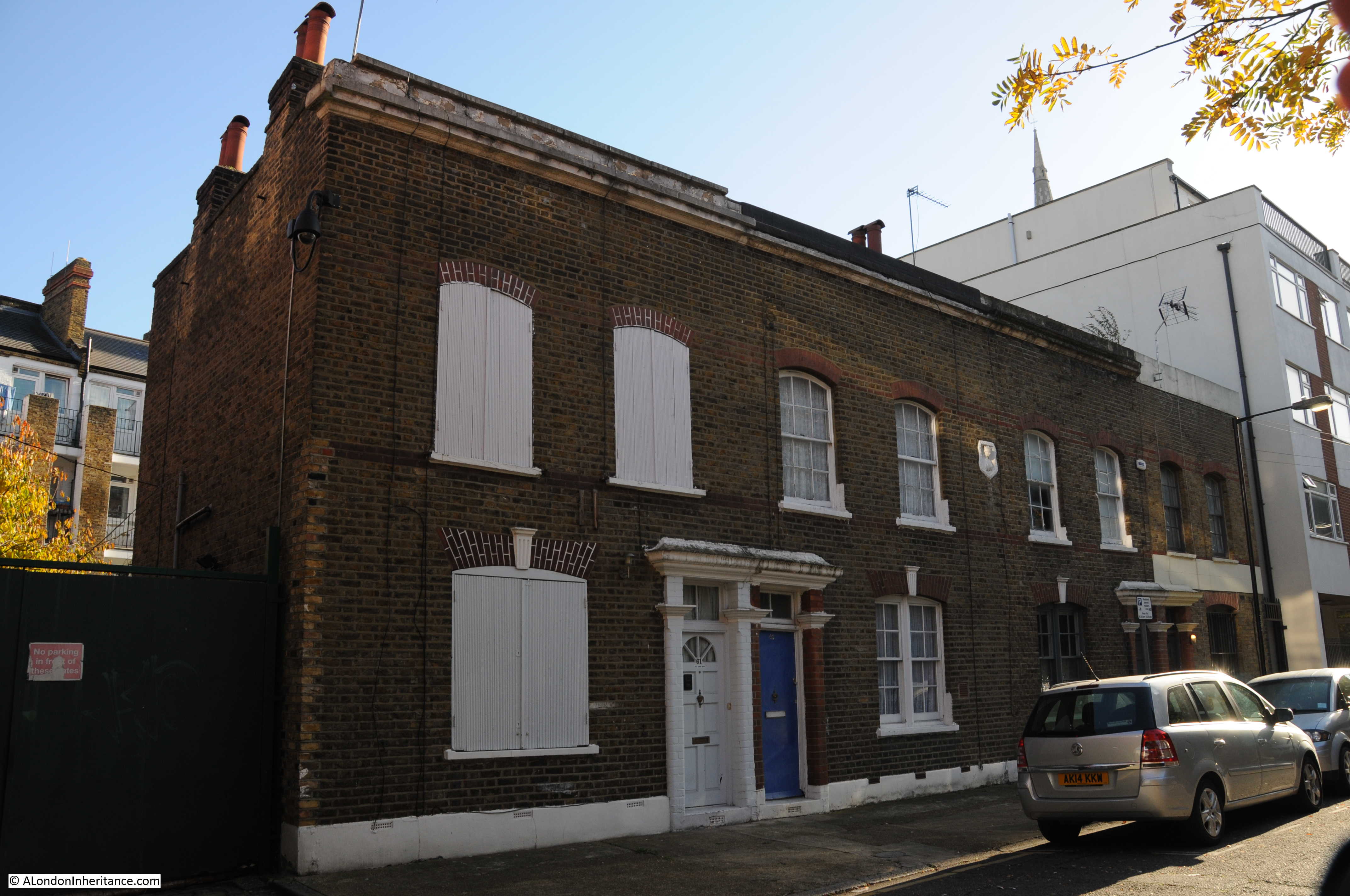
At the top of Johnson Street is this row of houses that have survived from the 19th century redevelopment of the area:
Again with a Mercers’ Maiden to show ownership. I assume that the Mercers owned the block of land that formed a rectangle between Hardinge Street, Cable Street, Johnson Street.
At the top of Johnson Street at the corner with Poonah Street:
The photo below is looking along Poonah Street towards the junction with Hardinge Street. In the above and below photos, the metal fencing that formed a boundary in the Hardinge Street arch can also be seen running along Poonah Street and to the arch in Johnson Street.
The Mercers Company owned the land before the railway was built and I suspect that the fencing shows the boundaries of the Mercers land as it is aligned with the buildings in Johnson and Hardinge Streets. This would explain why part of the area under the arch in Hardinge Street is fenced off – a reminder of land ownership from long before the railway was built, and that continues to this day.
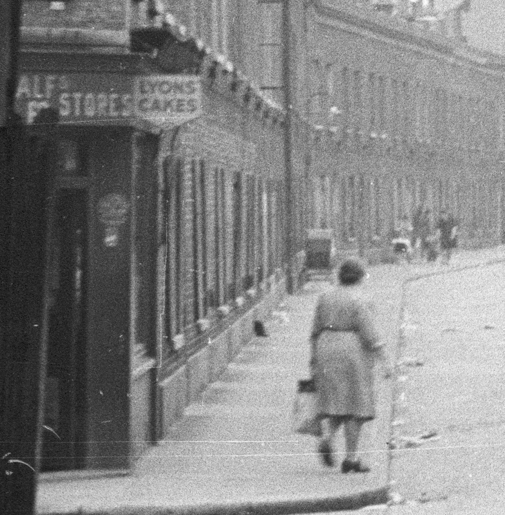
To finish of this week’s post, here are a couple of extracts from my original high-resolution scan of the negative. I find the detail in these photos fascinating and as a reminder that it is not just the buildings that have long since disappeared, but also the people who made this area their home.
The following extract shows the left side of Hardinge Street. A woman with a shopping bag has possibly just been shopping in the shop on the corner of Poonah Street and Hardinge Street.
There is a large pram parked outside the terrace of houses and further along what could be two women, a small child between them and a pushchair.
And on the right of Hardinge Street, there is a pub on the corner, people walking along the pavement and what looks to be a couple of children underneath the scaffolding on the corner of the house.
Hardinge Street along with Emmett Street and Westferry Road in last week’s post have changed dramatically over the past seventy years. The people in the original photos, outside the newsagent in Westferry Road and those in Hardinge Street could probably never have imagined how much their streets would change.