
Build Back Better has been a slogan much in evidence over the last year, however without a clear understanding of the problems that need to be fixed, or a plan for how to fix them, slogans often end up as meaningless statements.
In the 1940s there were a number of studies and plans published, recommending how London should rebuild after the devastation of the war. How this was an opportunity, to use the current slogan, to “Build Back Better”.
I have covered a number of these plans in previous posts such as the 1943 County of London Plan, 1944 Post War Reconstruction of the City of London, and the report of the 1944 Railway (London Plan) Committee.
London’s boroughs also wanted to improve the living conditions of their residents, and to fix many of the problems that had built up over decades of unrestricted growth that had resulted in some boroughs having the most over crowded, densely built housing in the country.
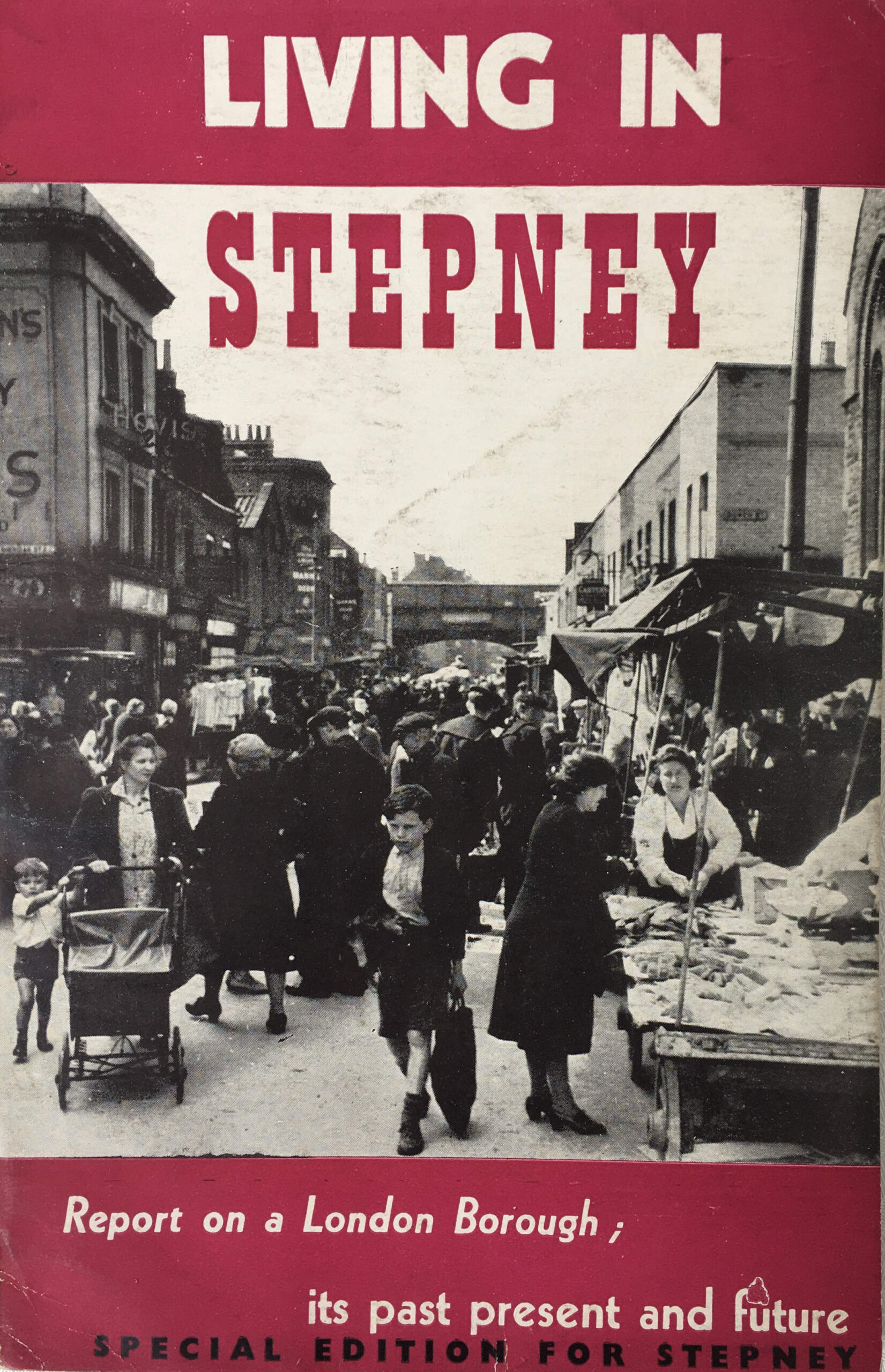
One such borough was Stepney, and the independent Stepney Reconstruction Group, Toynbee Hall published their report in 1945, detailing the past and present in Stepney with proposals for the future.
The report was titled “Living in Stepney”:
The Stepney Reconstruction Group was an unofficial group, led by Dr. J.J. Mallon, the Warden of Toynbee Hall. The group had been working through the early years of the 1940s, studying the causes of bad living conditions in the borough and the impact of various London wide plans that were being developed. In 1943 the group held an exhibition titled “Stepney Today and Tomorrow” at the Whitechapel Art Gallery.
The 1945 written report, Living in Stepney, was the group’s attempt to summarise the past, present and possible future of the borough, and to encourage those who lived in Stepney to engage with their elected representatives to ensure that their views were taken into account.
The first chapter of the report gives an indication of the themes that the report would address – Crowding, Congestion and Chaos.
The borough of Stepney was formed in 1900 through the consolidation of a number of east London parishes. It would last as an indepent borough through to 1965 when it was in turn consolidated into the larger London Borough of Tower Hamlets.
The key driver to the growth of Stepney was the Thames, along with the docks that would take over the southern part of the borough along the river. Docks, industry and the need to house thousands of workers created uncontrolled growth that would lead to dense housing with many people to a house. Lack of green space, health problems, poverty and misery would characterise much of the area.
Living in Stepney provides a comparison with the City of Plymouth. Before the war, Stepney had a population almost as large as Plymouth, but occupied less than a fifth of the area of Plymouth.
Proximity to the docks resulted in much damage through wartime bombing. The report highlights the democratic test for the future of the borough “Here came the blitz, where many had died before through poverty and slums, and little was done. Here the sincerity of democracy will be tested”.
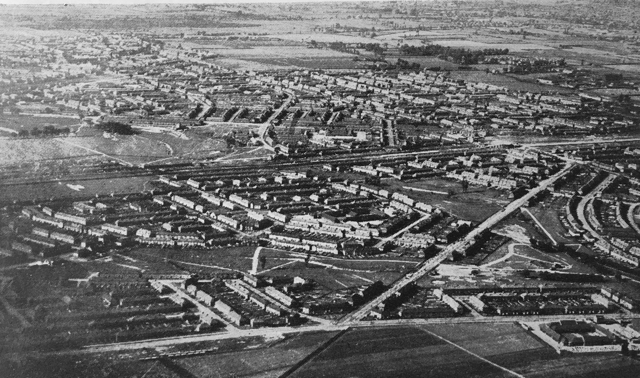
The central area in the following map dated from 1833 shows the area that would become the Borough of Stepney.
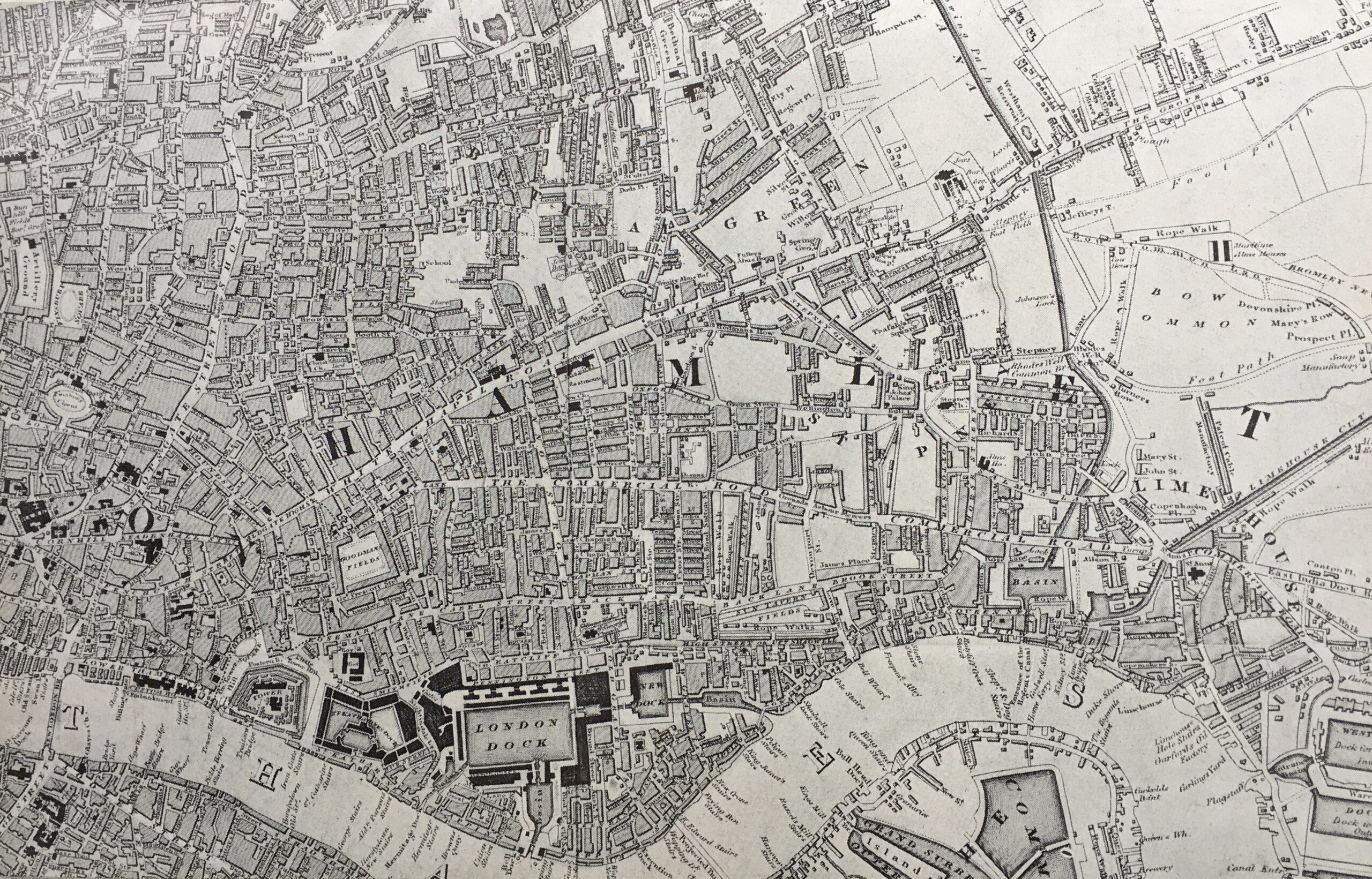
Building had initially extended along the river from the City to the left, and then continued in land to where the original village of Stepney was located, around the church of St. Dunstan And All Saints. In 1833, the area from Bow Common onwards was still mainly open land, but this would change during the rest of the 19th century as London continued its eastward expansion.
The report identifies four phases in the growth of the borough:
- 1000 to 1800: The Riverside Village
- 1800 to 1870: Unplanned Growth
- 1870 to 1914: No More Room
- 1919 to 1939: Half-Planned Social Services
The period from the end of the First to the start of the Second World Wars were characterised by Borough Council and London County Council attempts to improve housing conditions as these were the only organisations undertaking any new building, apart from some limited building by housing associations and larger private owners. Almost no rebuilding was undertaken by private estate owners and very few houses were reconditioned to modern standards and repairs to the housing stock were frequently neglected.
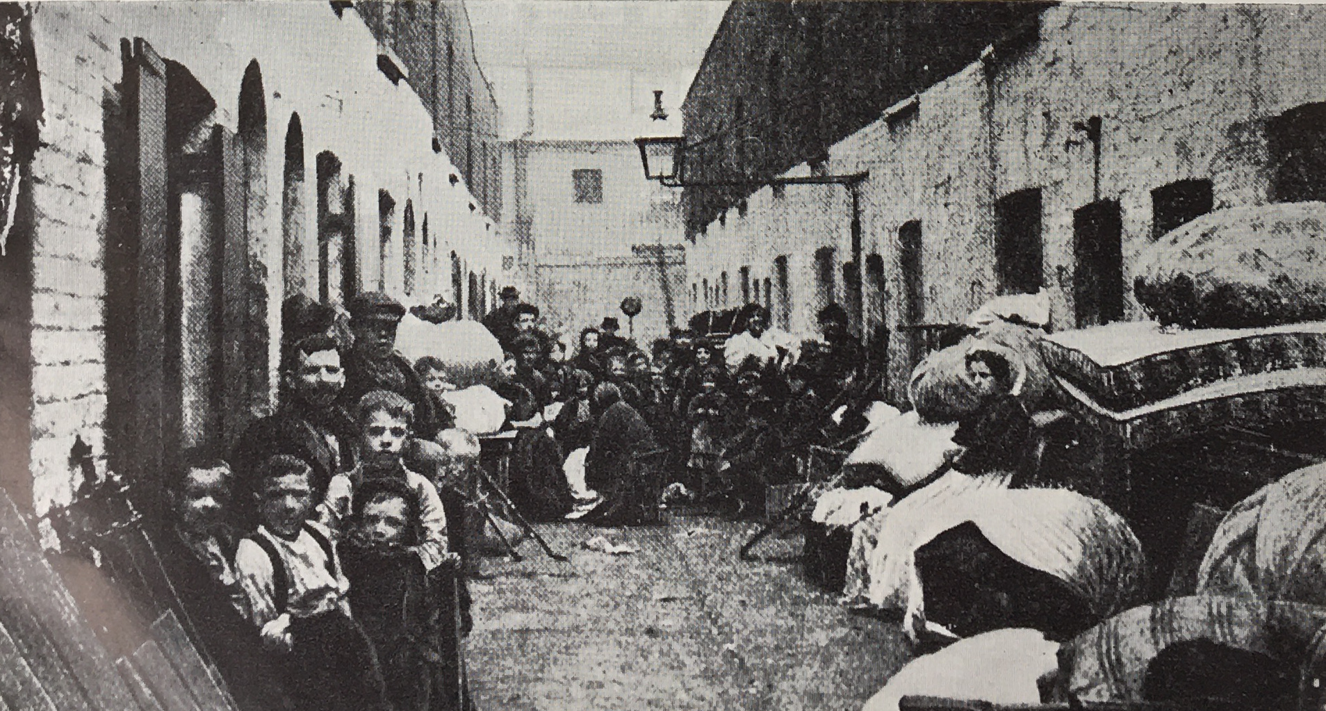
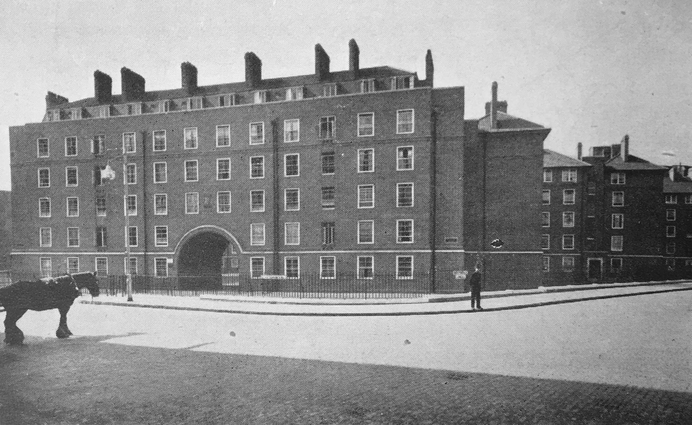
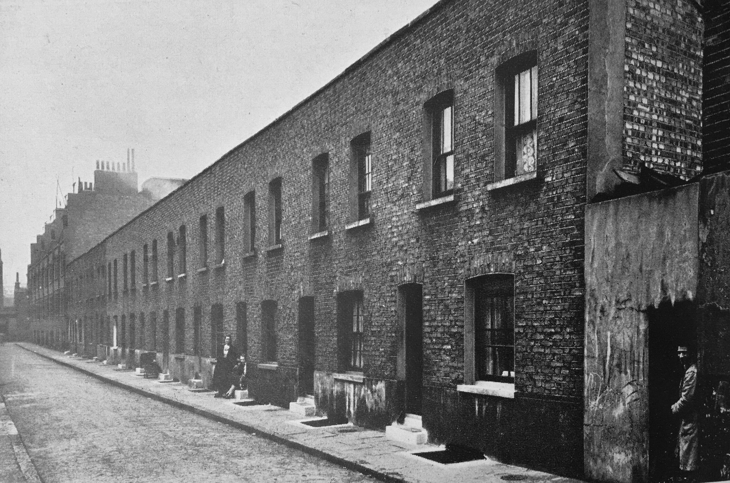
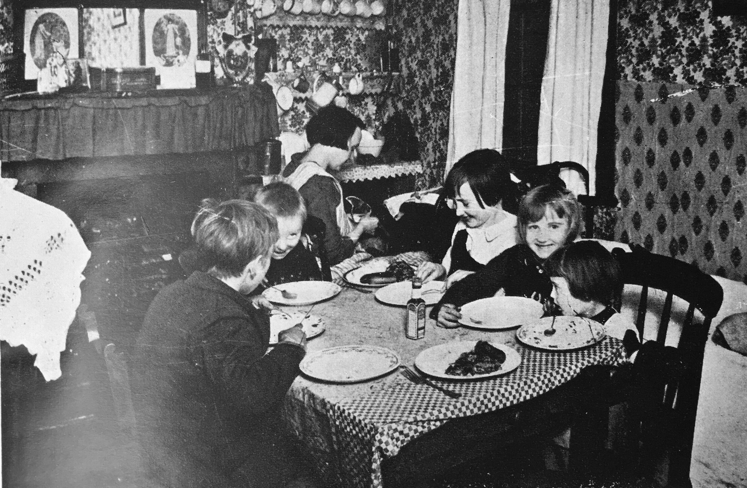
In the late 19th century, where rebuilding did take place, it was often at the expense of those living in the buildings to be demolished. The following photo from Living in Stepney is titled “Tenants evicted from slums for the new model blocks to be built”.
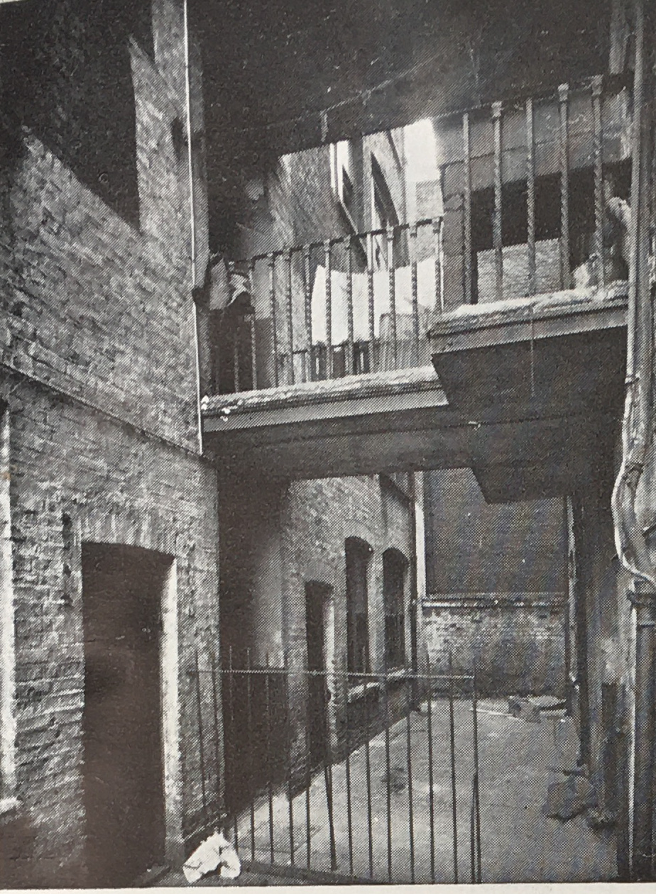
Also illustrated are some of the dense housing and limited outside space of many of the buildings in Stepney, including Paragon Mansions, Stepney Green:
Pre-war housing development by the London County Council, also had the effect of reducing the population of Stepney by relocating people as the slums were cleared. The following map shows the distribution of 3,478 Stepney families as they were moved out of the borough to new LCC estates during slum clearances between 1932 and 1938.
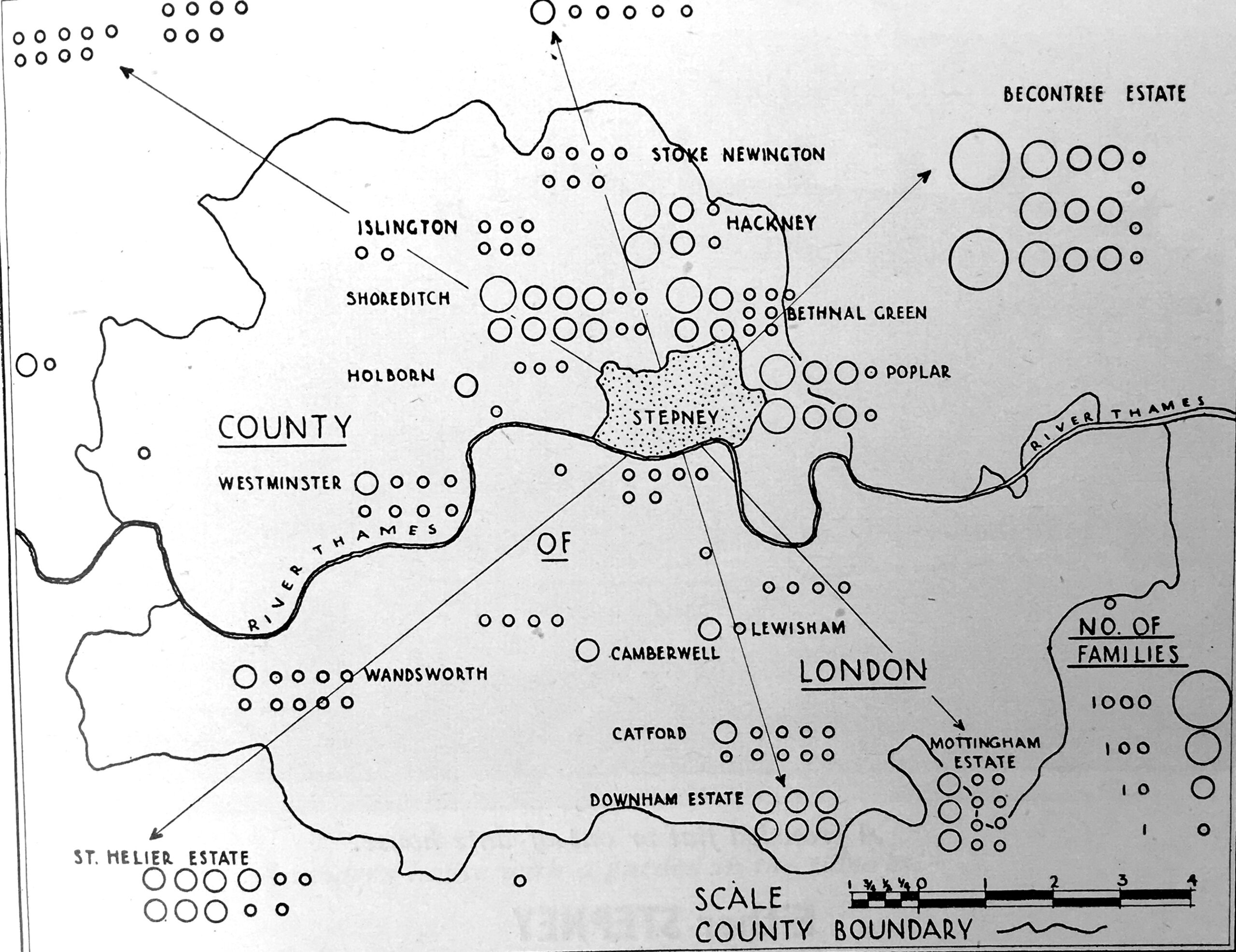
Whilst these clearances started to reduce overcrowding in the borough, the impact of these relocations was the break-up of established communities. The report states that whilst the new estates to which people were moved were more healthy locations, they “did not have the social amenities of Stepney. There were not enough pubs, or shops, and far too few clubs or social centres”.
Living in Stepney illustrates the pre-war choice offered to those being moved, from: “A crowded flat”:
“With work on top of you”:
To a “modern house with a garden in the suburbs (in Dagenham)”:
“But with a long journey to work”:
This was the challenge with pre-war housing strategy. The London County Council was making considerable improvements in housing standards, however these often meant relocation and the break up of communities which would take time to reestablish, along with the failure to provide social facilities in the new estate.
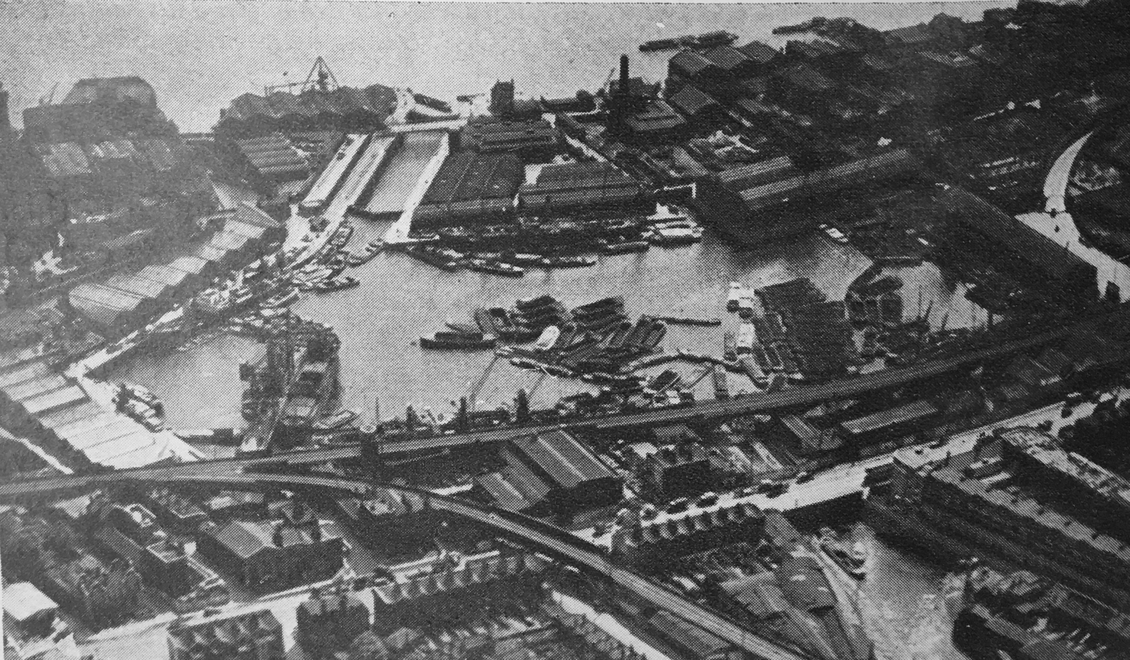
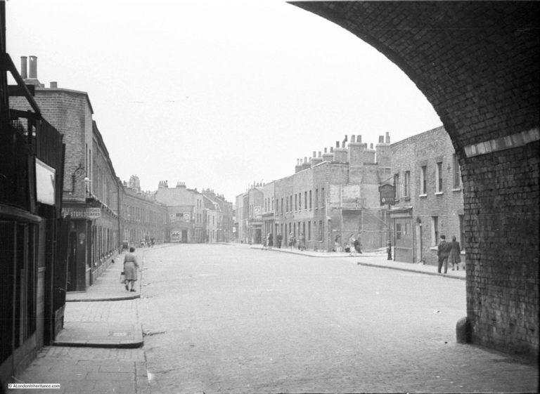
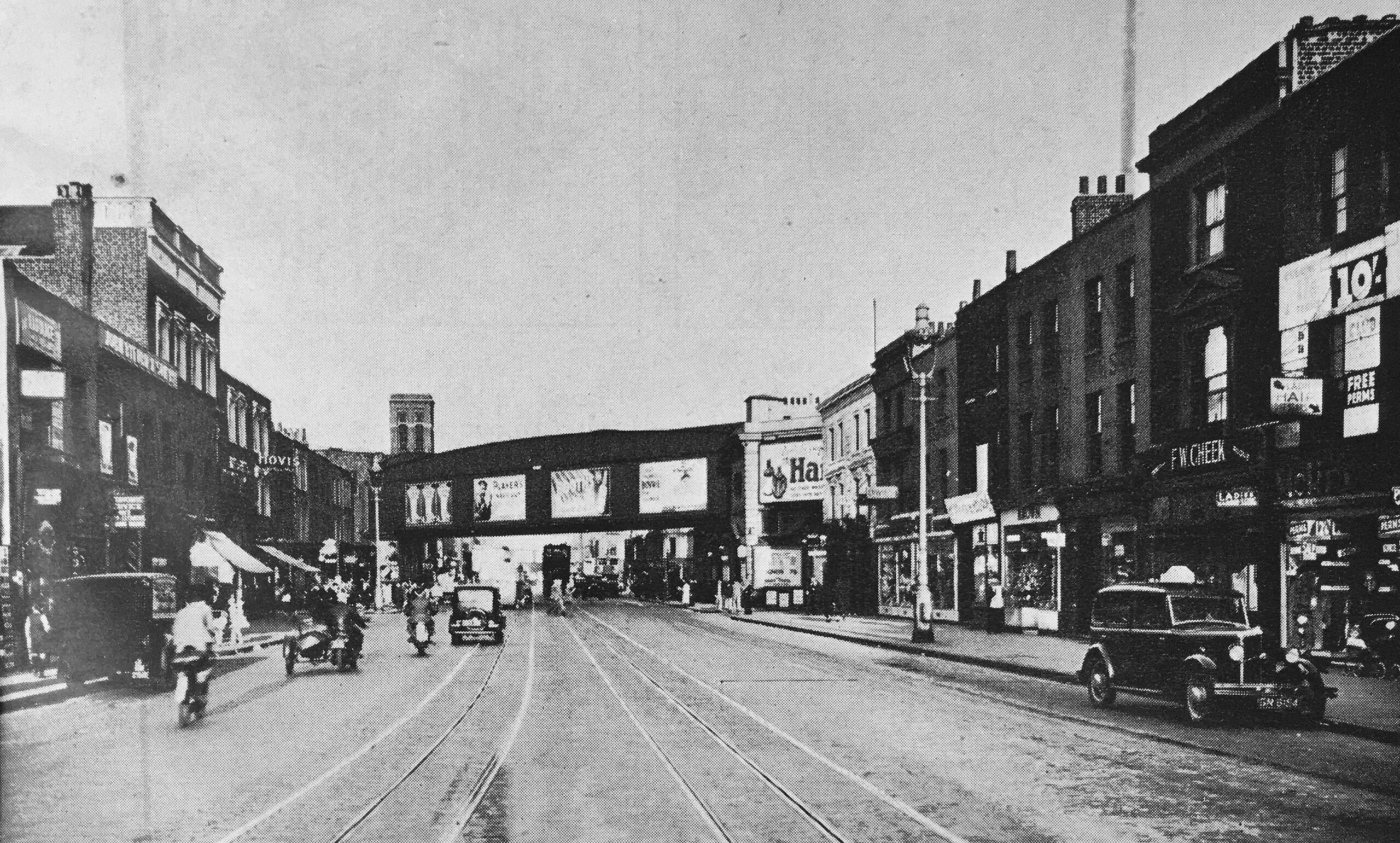
The impact to these communities was very clear to me when I went to find one of my father’s photos from east London in 1949. I wrote about Hardinge Street, Johnson Street And Ratcliffe Gas Works, with Hardinge Street being a street just off Cable Street, a third of a mile east of Shadwell Station. The was the view of the street in 1949:
And following post war redevelopment, all the streets, shops and pubs in the above photos were demolished and the population dispersed. This was exactly the same view a couple of years ago:
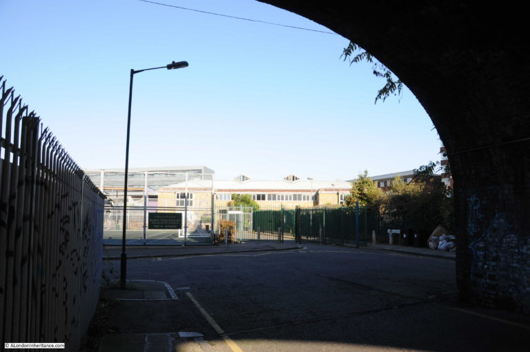
The arch of the railway bridge being the only part of the 1949 view that remains.
Living in Stepney has a section on “community”, and includes a description of the old parishes that consolidated into the Borough of Stepney. These parishes still had their own characteristics which the report describes:
“Wapping is an island which lives to itself. Access is not easy, as no buses pass that way, and there is only the underground line from Whitechapel. The nearest market is Watney Street, and there is no cinema nearby. The population is largely Irish in origin and is strongly attached to the area.
The areas adjoining the City are crowded with factories and warehouses. Spitalfields is a largely Jewish area, where old eighteenth century weavers’ houses, factories workshops, and old fashioned tenements jostle with a large number of common lodging houses. There are few open spaces.
Whitechapel is not so crowded, but presents similar problems. It is in these areas that industry has taken over space from housing, and there has been the largest fall in population.
Mile End and Bow Common were laid out at a later date. Around Burdett Road, once lived a wealthy class who kept carriages. The houses are larger, with gardens, and there are trees in the streets. There is not the same congestion as in the other areas in the West of the Borough.
Limehouse is still a place of ships and seamen and many work to provide their needs. It suffers from being cut up by the canal and railways, and from too much industry, but the old centre remains.
St George’s is one of the most crowded areas of Stepney. In the west live foreign seamen, and a coloured population. There are many Jewish people, but they do not extend much east of Cannon Street Road.
Towards Shadwell are to be found some of the most typical East End streets. Shadwell and Ratcliffe merge into St George’s and Limehouse, but across Commercial Road, Stepney is different. Here are better houses and squares and some well laid out streets, and the houses are old. But around the Commercial Road Gas Works, there was, before the blitz, an area of bad houses”
Living in Stepney illustrated a section titled “What is Wrong With Stepney”:
“Old Damp Houses, mostly 100 years old, with no bathrooms, usually only one tap and the lavatory outside and often shared”
“Crowded Houses, with no space for a garden or proper yard, block out light and air. Dull monotonous streets waste space”

“Overcrowding, which is intense, mainly hits large families with children. Stepney had more overcrowding than any London borough. 60 per cent of all families share houses”
“Small workshops crowd the ground, using valuable space, and creating unhealthy working conditions. This court was partly cleared in 1937, but there are many like it”

“Clubs and Social Centres have not proper buildings. Voluntary bodies have done wonders, but all needs have not been met. Some areas are badly served”

“Open Spaces hardly exist in Stepney – 45 acres for 200,000 people in 1938. Children have to play in the street, the great playground and meeting place”

“Commercial Road – typical combined main road and commercial centre, causing accidents and traffic congestion. With control of advertisements and buildings it could be a fine street”
Living in Stepney includes the following graphics which highlight the impact of overcrowding and compares Stepney with the more affluent and less crowded Lewisham:

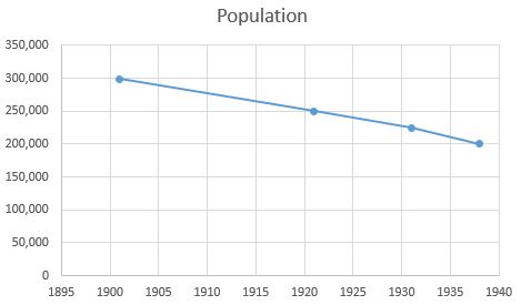
The lower part of the page identifies the causes of crowding, although in 1945, and just before the start of the war, the population of Stepney had been in decline since the start of the 20th century. The report provides the following summary of Stepney’s population:
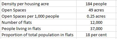
Along with some facts on the 1938 population:
The themes identified in the above graphics from the 1945 report can still be seen today. In 1945 there were a higher number of deaths per thousand in Stepney than Lewisham, and a considerably greater infant mortality.
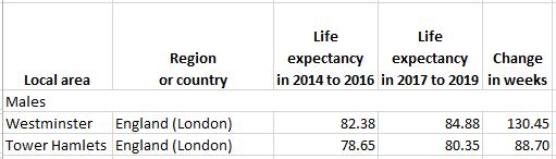
The same issues can be seen today, both nationally and within London. The following table comes from the Office for National Statistics latest release “Life expectancy for local areas of the UK: between 2001 to 2003 and 2017 to 2019“ and shows that for males within Westminster and Tower Hamlets (of which Stepney is now part), the life expectancy in Westminster is currently 4.53 years longer than that in Tower Hamlets:
The above graphic also identifies land prices as one of the problems with rebuilding at lower densities and with the provision of open space, with land in 1945 being worth between £10,000 and £30,000 per acre.
The situation is probably even worse today, with land prices explaining why most residential building today appears to be high density apartment blocks. According to the Economic Evidence Base published in 2016 by the Mayor of London, residential land prices in East London were £7.3 million per hectare. (A hectare is 2.47 acres, so the equivalent in 1945 would have been £74,100 to today’s £7.3M).
Living in Stepney also includes a graphic which identifies the cause of high land prices, with the landowner benefiting whilst the tenant pays in rent, rates and the cost of goods.
if landlords do not rebuild, the local authority has to house as many people on a site, so opts for higher density housing, and with more rents coming in for both private landlords and local authorities, the value of land increases – a vicious circle.
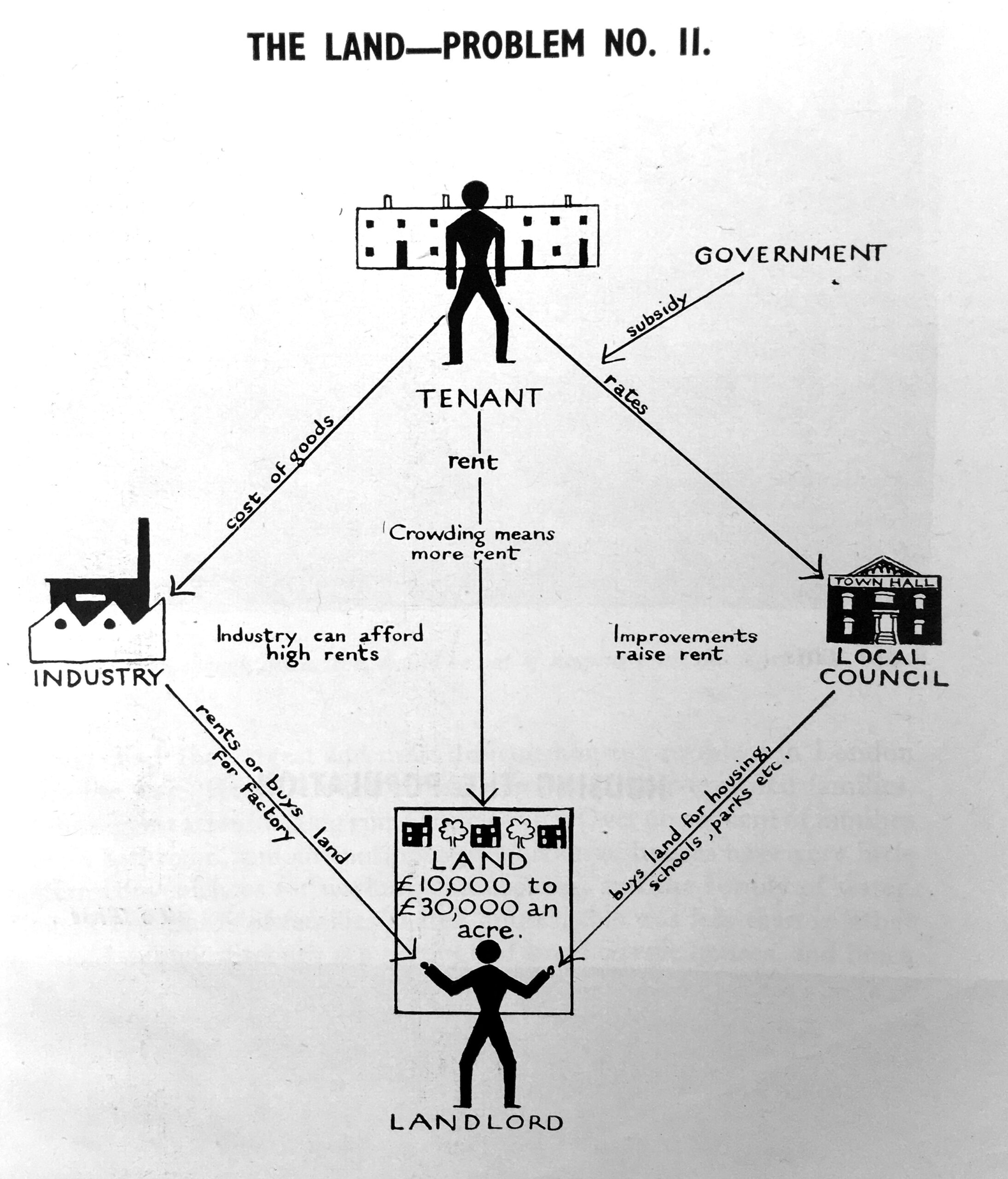
Many of these themes still drive land prices today, and is one of the reasons why London’s skyline is growing taller, and why Vauxhall in now growing a collection of densely built apartment towers.
On the left of the above graphic is Industry, and in 1938 there was a considerable range of industry in Stepney. In addition to the Docks, there were metal working firms, paint and oil seed crushing firms, printing works, drug, soap and other chemical works, wood, furniture and building firms, and the gas and electricity works. The clothing industry was the largest employer as illustrated in the following summary of how the 140,000 workers were employed in the borough (although slightly more were employed in the general business of buying, selling and distribution):
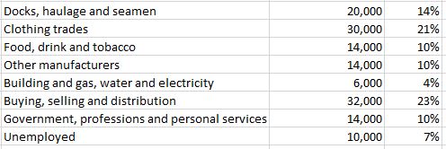
Living in Stepney notes that although the Clothing industry was the largest employer, work was carried out in few large factories, with the majority of workers employed in small, unhealthy workshops in houses and backyards.
The 7% unemployed may give the impression that compared to some impressions of employment in east London, the percentage in Stepney was relatively low, however 7% masks the highly variable nature of employment in the Docks and the Clothing trades, as for many work was precarious, and the unemployment figure could rise or fall considerably within a short period of time.
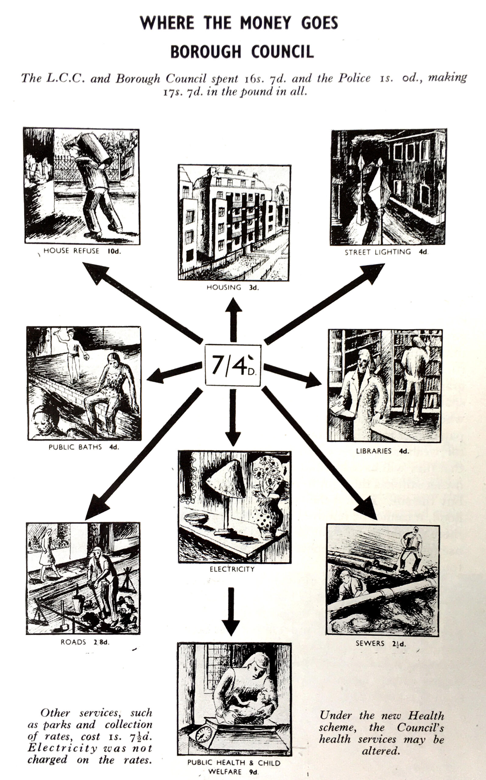
In asking “Who Governs Stepney”, the report illustrated how the rates were spent, by the two authorities responsible for different aspects of Stepney’s governance – the London County Council and the Borough Council.
Firstly, the responsibilities of the London County Council, and the money spent from the rates on each of their responsibilities:

The Borough Council was responsible for many local services, such as street lighting, libraries, public bathes, roads and sewers:
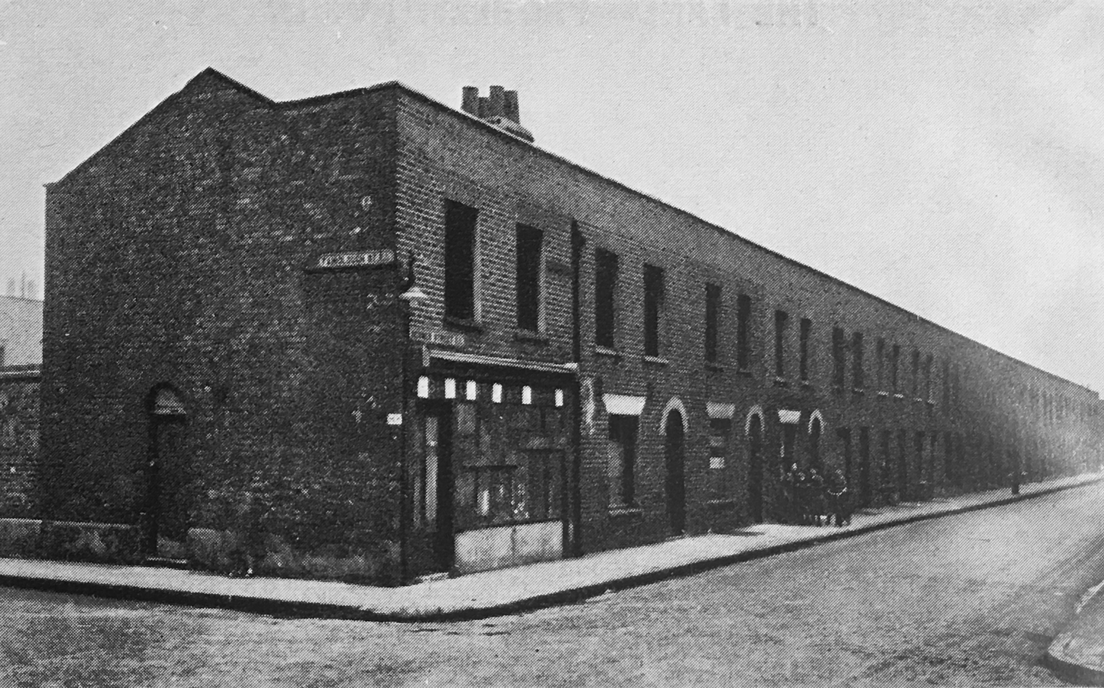
Living in Stepney makes a number of recommendations for how Stepney should be transformed. Housing was a big concern, for many of the reasons already stated. Over 90% of families in Stepney did not have a bathroom. Two thirds of families lived in a shared house, and whilst this was less than other parts of London, in Stepney, the high number of small terrace houses meant that where they shared, families lived in much smaller and more crowded conditions.
Many houses dated back to the 18th and 19th centuries, and the borough’s character of streets of terrace houses was seen as a positive rather than a borough of streamlined flats which was considered “entirely contrary to the spirit of the East End”. It was the decayed condition of the housing stock, lack of modern facilities and overcrowding that were the problems, not the concept of terrace housing.
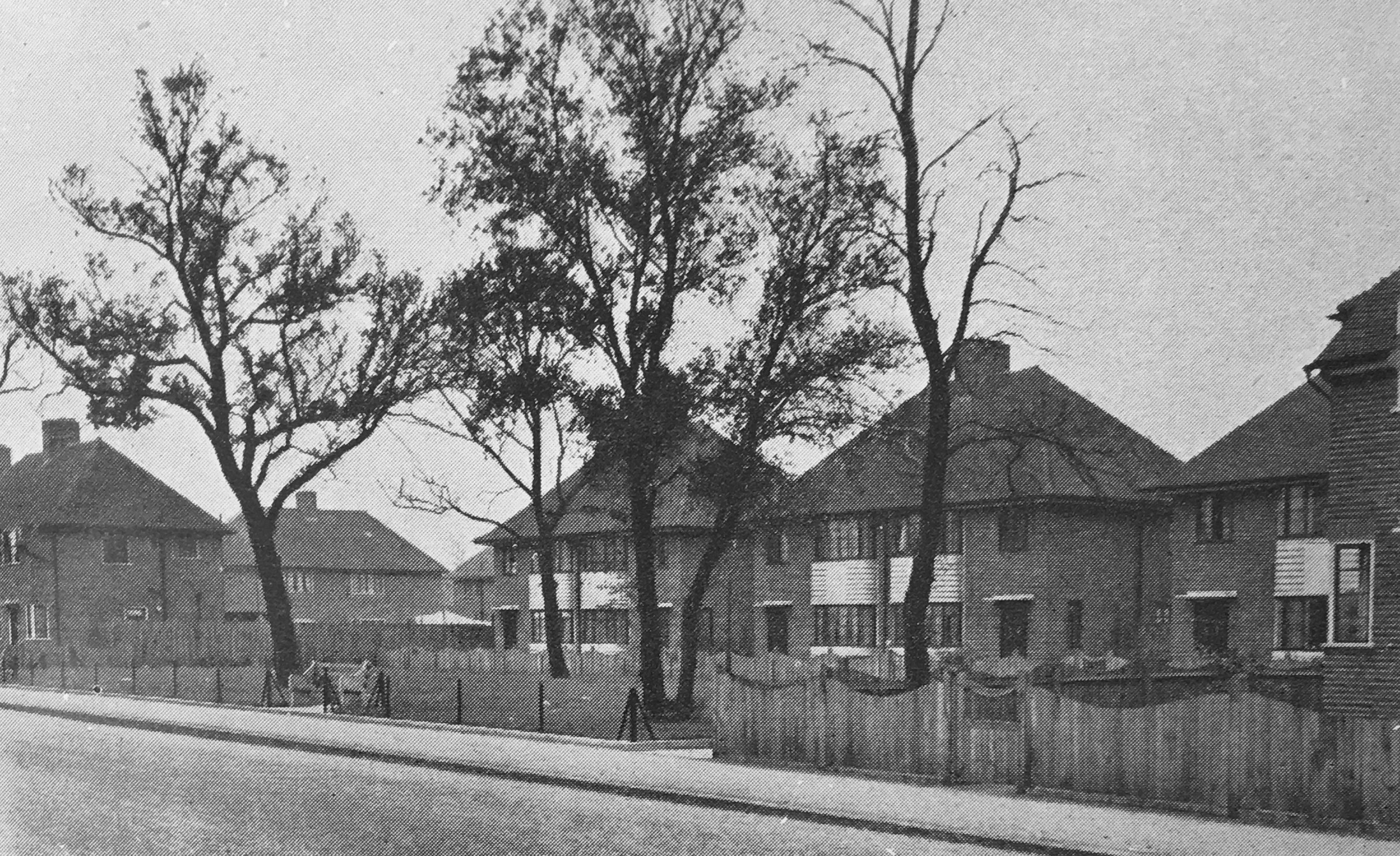
Living in Stepney recommended that housing the population should move from this:
To this:
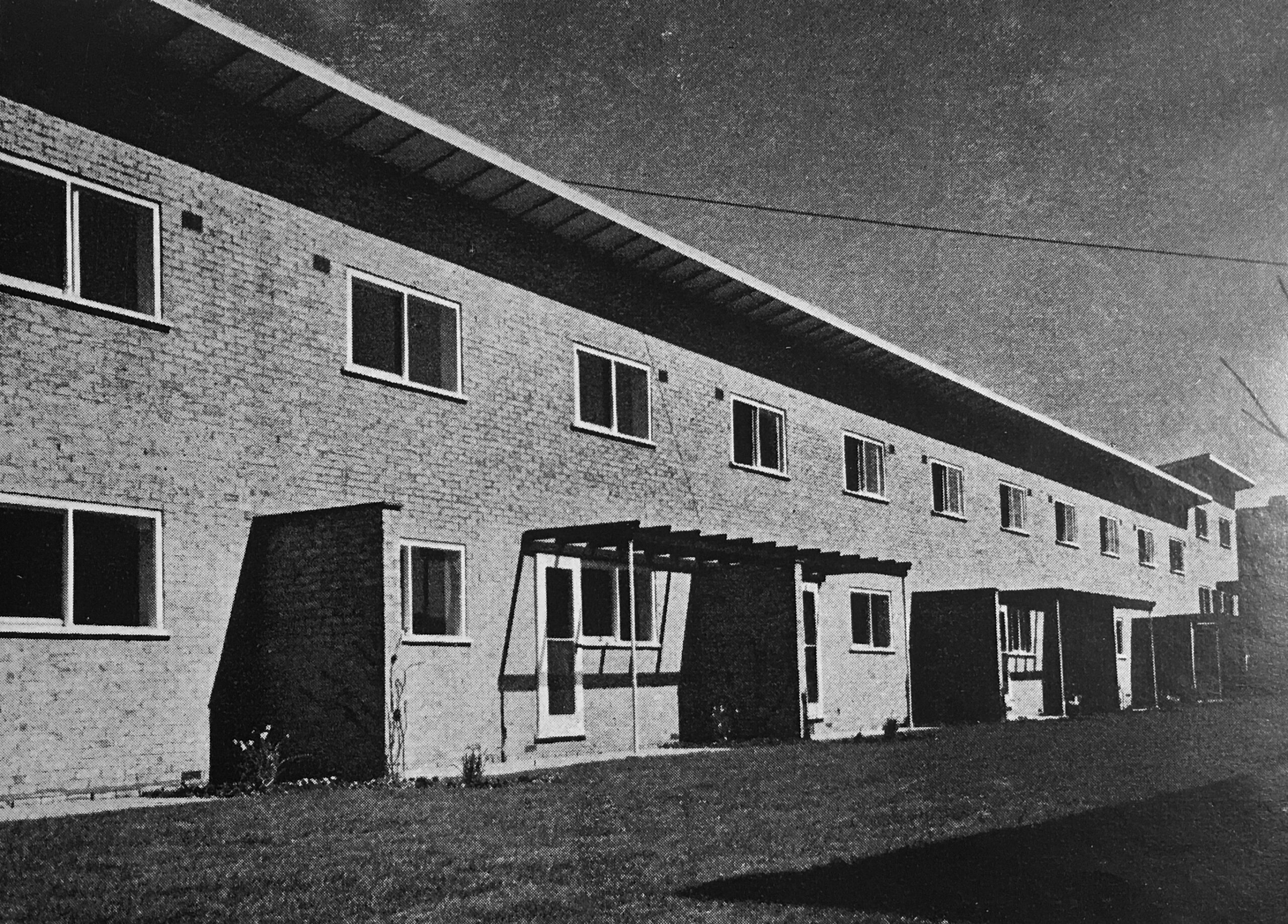
Where modern terrace housing replaced the old.
it is interesting to compare the photo of the old terrace housing that the report recommended replacing with one of my photos from last week’s post on Roupell Street.

Ignore the roof line, and the design of the terrace is basically the same, even the curved top of the doorway. The key issues in Stepney were overcrowding and the lack of maintenance and upgrading the housing stock. Fix these issues and the original terrace housing would probably today be worth a fortune.
The plan also included recommendations for transport through the borough. During the 1940s, the future of personal transport was seen to be the car, and in the majority of planning for post war reconstruction, major road routes were planned through and around London to support the expected growth in car numbers.
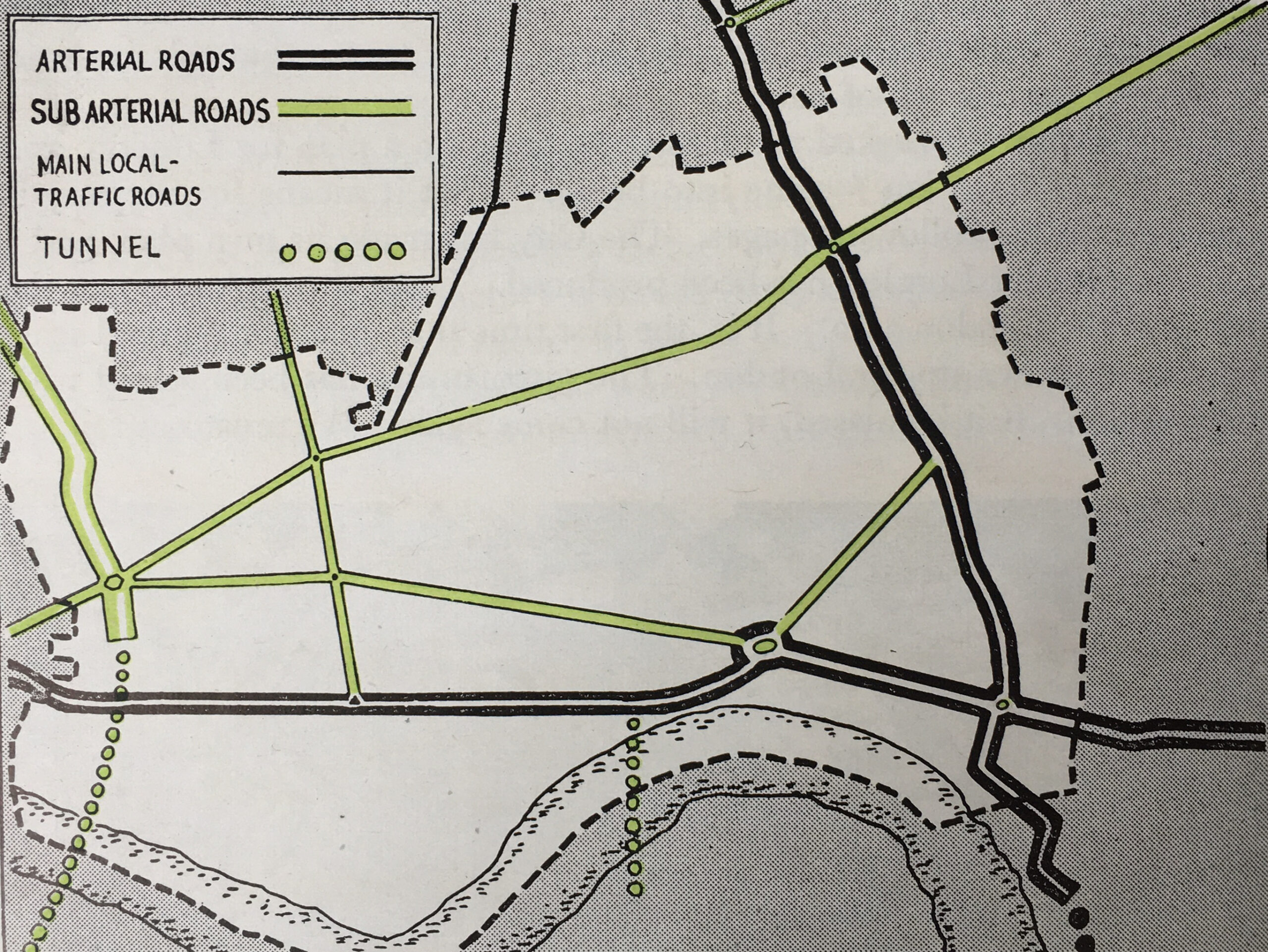
This would also impact Stepney, and plans had already been put forward in the 1943 County of London plan. This included new arterial roads. A sub arterial road to the west of Stepney crossing below the river in a new tunnel, along with an arterial road through the eastern side of the river to what was described as a “doubled Rotherhithe tunnel”.
New routes would also traverse the borough from east to west, however all these new arterial routes were mainly for through traffic with few access points recommended within the borough.
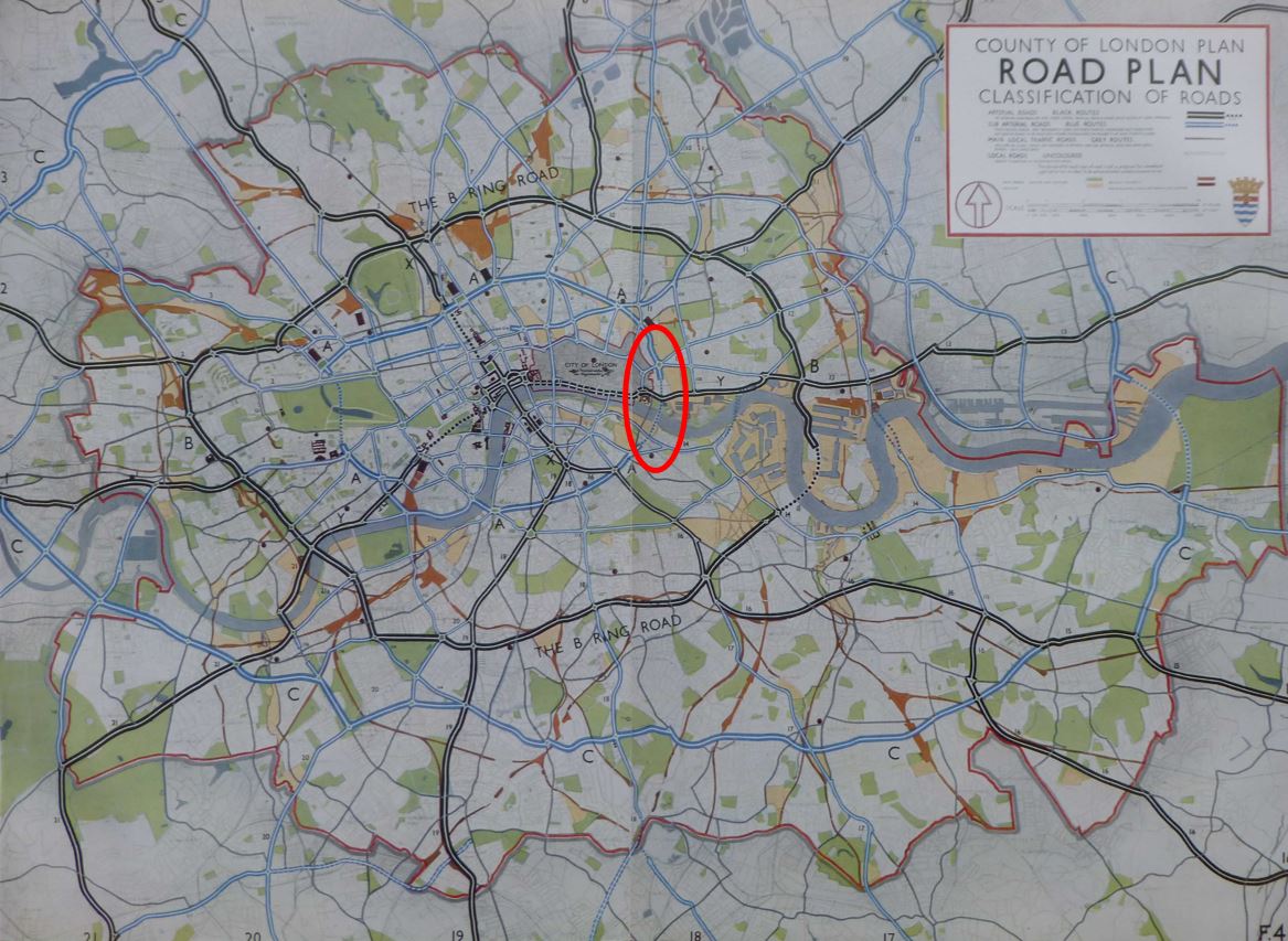
These arterial routes are shown in the following map.
These routes can also be seen in the road plan from the earlier 1943 County of London Plan. I have ringed the route to the left of the above map in red. It is this route that included a new tunnel under the river just to the east of the Tower of London. This would would act as an inner ring road.
Open space was a critical issue in the report. At the time of the report, Stepney had a total of 45 acres of open space. The County of London Plan recommended 4 acres for every 1,000 people, which would mean 376 acres for Stepney instead of 45, however the London County Council reduced the ratio down to 2.5 acres per 1,000.
The report recommended making use of the river front and stated that the river is the greatest advantage that Stepney has. At the time, there were three miles of river front within Stepney, but of this, only 700 yards were open to the public.
An example of how this could be achieved was provided by the following illustration where a riverside park stretching from St Katherine’s Dock to Shadwell Park would provide nearly one and a half miles of river front open to the public.
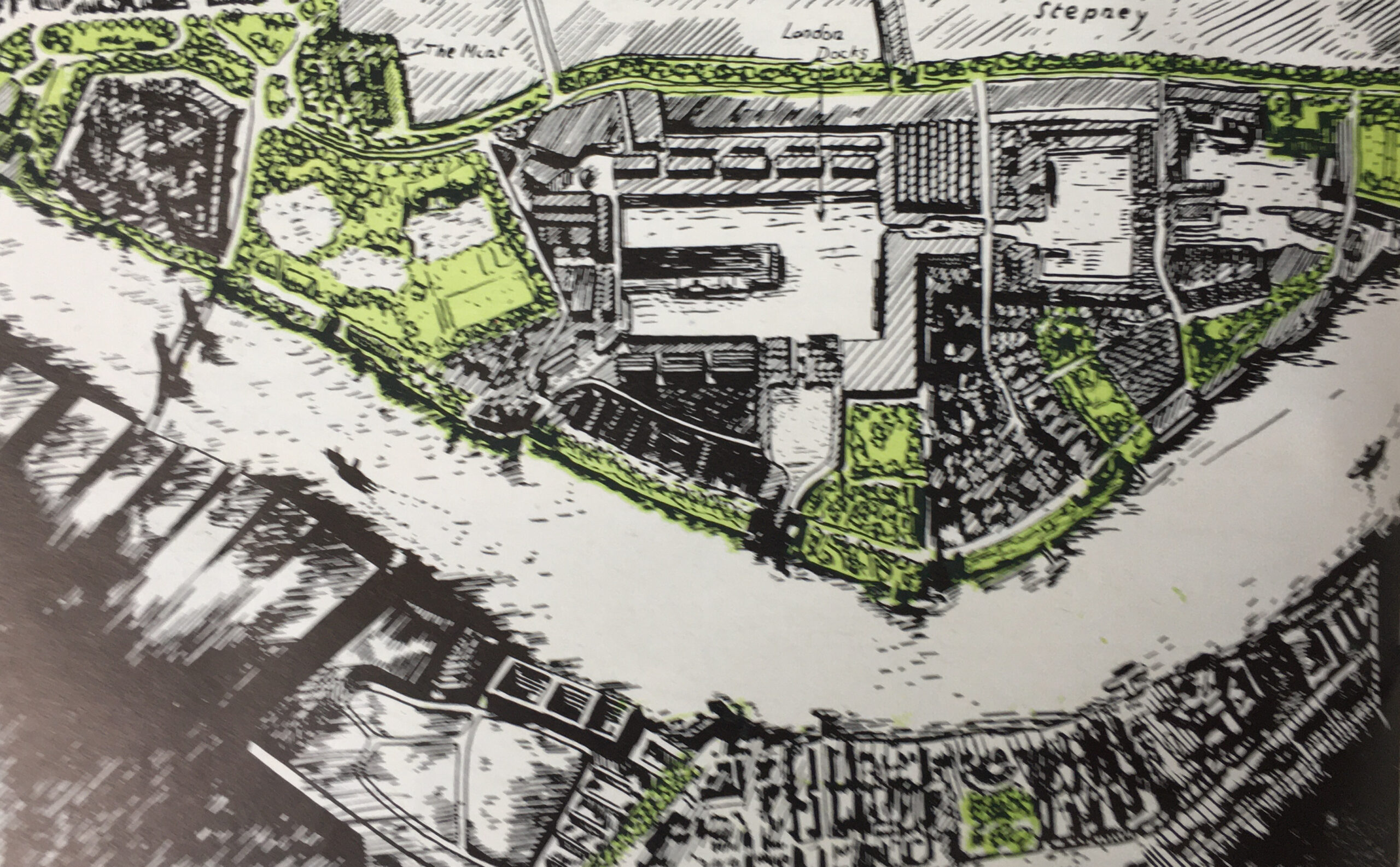
The Port of London Authority were not happy with this approach, stating that the wharves which occupy the space are particularly suited for the trades which use them, and that the approach would provide less employment in Stepney.
The County of London Plan included proposals that the Living In Stepney report did not agree with. The following table compares a number of key statistics for Stepney as they were in 1938 and as proposed in the County of London plan:
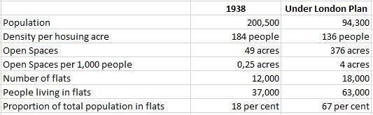
The County of London plan proposed a significant reduction of people living in the borough. This figure had already been gradually reducing during the early decades of the 20th century, however the plan proposed a significant further reduction (some of which had already been achieved by bomb damage to the housing stock).
Stepney Borough Council wanted the population target to be 130,000 rather than the much lower figure proposed by the County of London plan. The Council also wanted the majority (60 percent) to be in houses, rather than flats, which the council did not regard as the ideal location for families, older residents, or for the development of a community. The County of London plan had a much higher target of 67 per cent living in flats.
The County of London plan also targeted a density of 136 people to the acre, where the Council wanted this to be 100 people or less per acre.
Living in Stepney also recommended that where industries have been bombed, they should not be allowed to rebuild and start up again, unless it was of vital national interest that they remain in Stepney.
Although the council wanted a higher population than the County of London plan proposed, Living in Stepney was not encouraging a large scale return of those who had moved out of the borough during the war – only those who for personal or work reasons needed to live in Stepney.
Mid 1940s ideas for New Towns was part of the thinking for how Stepney would evolve.
New Towns were seen as the logical destination for industry, along with the workers that industry would need.
The report mentions a number of the possible locations for New Towns, with a focus on Essex – the county that has long been the destination for much east London migration.
New Towns were proposed at Chipping Ongar, Harlow and Margaretting, along with expansion around Brentwood, East Tilbury and Romford.
Harlow did become a new town, I was aware of the Chipping Ongar proposals, but not that Margaretting in Essex was a possible location for a new town. Margaretting is a small village on the old A12 to Chelmsford with a church that dates back to the 12th century – it would have looked very different today if it had become a new town.
Living in Stepney finished with a plea to residents to make sure they told their elected officials how they wanted their borough to develop. The report was concerned that very few people voted in local elections, or take an interest in their local councils. At the time, Stepney had 3 members of Parliament, 6 Members of the London County Council, and 60 Members of the Borough Council.
The local population was encouraged to make sure their representatives knew what they wanted.
It was interesting reading the report to see how many of the issues raised are still valid. The price of land, the root cause of land prices and the type of building that this price dictates.
The best type of housing and whether flats or houses are preferred. Maintenance and modernisation of housing and the impact of landlords. Access to open space, and access to the river, and the inner city location of industry.
The build of the new towns would see continued migration to the Essex new towns of Harlow and Basildon as well as many south Essex towns.
Stepney would change considerably in the following decades, much of which was down to issues outside the control of any local planner. Containerisation and the move of cargo ships to much larger ports resulted in the closure of all the docks within Stepney.
Reports such as Living In Stepney tell us much more about life and thinking at the time, rather than how the future would develop, which is almost always influenced by events that at the time seemed impossible to consider.
Fascinating report which did hit on the problem of redevelopment. The old streets were full of inadequate housing but packed with a sense of community. Move to a new town or development and this was lost. The spirit of the East End was lost in Harlow and elsewhere. What would today’s kids give to be able to walk out the front door into a playground packed with other kids and no concerns over safety?
Thanks for posting I always learn from these posts and enjoy reading them, thank you.
How was the riverside park to be achieved without land reclamation or demolition of the warehouses? The latter were all privately owned (in contrast to the docks themselves which were PLA-owned) which is why the presented a problem in the 60s after the closures, and why many were simply abandoned.
Great stuff!
Thanks!
Fascinating. My Dad’s family lived at 28 Tillman Street, Shadwell, until they were moved to Becontree as per your diagram. His Dad, my Grandfather, Jas F Burke, was a crane driver in the docks and ex-WW1 regular soldier with the Worcestershire Regiment and served with the BEF from 1914. I understand that preference was given to such ex-servicemen’s families who were gainfully employed. Seeing their new back garden in Becontree, my Dad asked “who owns the field?” when they moved in. My Grandad travelled to Mark Lane station to work I think. They knew lots of ex-Stepney people, scattered around Becontree estate. Part of Tillman Street is still there and the Victorian school is visible from the Docklands Light Railway. Given its proximity to the docks, there was a lot of damage done there in the Blitz so they were lucky to get out.
My family lived at 27 Tillman Street (Harrington) until we all moved out in 1960 – grandparents went to Bow and my parents and me went south of the river to foreign territory, Abbey Wood!!!
Really interesting and informative.
My parents were scuttled off to Harold Hill, which I believe must have been the first new town – a local historian told me the foundations for the houses were dug by German POW’s.
So interesting! Part of my family came from Stepney in the 19th century, living at the Commercial Road end of Johnson Street. A 4x great uncle worked at the Radcliffe Gas Works; my 2x great grandfather was a sailor. Things almost came full circle when my father moved from managing Basildon New Town Development Corporation to heading the short-lived Docklands Development Corporation set up by Tower Hamlets and neighbouring boroughs in the late 70s. This was killed off at birth by the Thatcher government when Heseltine set up the similarly named quango that gave rise to all that you see today in the docklands. Although he knew he came from an East End background, I don’t think my father ever knew his close family association with Stepney.
I have just read your enthralling book, “Ancestry”. In fact, this is why I am now researching the history of Stepney. I too have family history connections to this area, specifically a convict who was transported to Australia for her misdemeanour. I am seeking information about Stepney fair in the 1820’s. Can you provide any leads please?
I enjoyed your book immensely and plan to read more.
kind regards,
Beverley
Once again wishing I`d known all about the area years ago as my grandfather grew up in Cable St. Instead of following his father as a waterman/lighterman he went into office work. After WW1, marrying and buying a house in Romford, where my father grew up. He never spoke about his past as a child.
Perhaps like a friend of mine whose grandfather always replied to questions about his boyhood, “I don`t want to talk about it, all I remember was always being hungry.”
Really interesting history of the area.
My Grt Grandfather James Terry owned the pub called the Crown and Dolphin at 10 Stepney High Street in the 1880’s. Also other relatives of mine were Evans Undertakers at 13 and 15 Stepney High Street, very well known in the area.
I have all the details about the families.
I would have thought that, as St Dunstan’s church was a very short distance away from both premises there would have been some images/photographs of the public house or the undertakers before the area was demolished. I cannot find anything at all!
Thank You for another lovely Sunday Morning read in Canada. I grew up in Maida Vale West London. Working in the City as a young woman I never knew that my Mother’s family had originated in the East End. Doing genealogy I’ve come to enjoy old maps to track where family lived.
Outstandingly interesting and relevant for today. Thank you!
Living in Stepney has a section titled “What is Wrong With Stepney”: “Old Damp Houses, mostly 100 years old, with no bathrooms, usually only one tap and the lavatory outside and often shared”
That exactly describes my home in the late 1940’s at 41 Umberston St. where I lived as a youngster with my two brothers, our mother and two other families. The text didn’t mention we only had gas lighting, no electricity and a battery-powered radio was our link to the outside world. Great article !
Derek Bailey
Thank you, a fascinating piece of social history . But who were the land owners making such a profit out of the dense slums, the duchy of Cornwall? the Church of England?
My father’s family lived on the Highway at the corner of Dellow Street. My grandmother ran a cafe called the City of Dublin Dining Rooms. They moved out in 1936, to Forest Hill. The cafe was destroyed in the Blitz. In 1973 my father Louis wrote a book called Growing Up Poor In London, a very good read, but it annoyed my grandmother, who said: “You weren’t poor, you had food on the table, you had shoes on your feet. You should have called it Growing Up With the Poor In London!”
The answer to your question is that a lot of the land round there was owned by the Bowes-Lyon family, one of whose members was Queen Elizabeth the Queen Mother. Hence Glamis St and (now) the Glamis Adventure Playground, the name taken from Glamis Castle, the ancestral home of the Bowes-Lyons.
Truly fascinating, Thankyou. How much difference the Clean Air Act(s) made! And who could have predicted the effective death of the Docks?
Richard T
Thank-you so much for this. I am constantly amazed – and grateful for – the amount of work you do and effort you go to to provide such fascinating essays for complete strangers.
Very enjoyable read as usual .
Very enjoyable read. I was born in Stepney in 1946 and my mum and dad’s flat was in Shadwell, along the Highway, right next to St Paul’s church. Unfortunately for them the building of the arterial road shown on one of your maps involved the widening of the Highway; this reduced markedly the quality of life for everybody that still lived there (if their flats/houses hadn’t been knocked down for the widening).
Goering rightly gets the blame for the destruction of parts of Stepney during the Blitz (mind you I enjoyed playing on the bombsites in the early 1950s) but Stepney Borough Council should also take some share of the unfortunate redevelopment of wide swathes of the borough replacing 19th century terraced housing with high and low rise block of flats. (I know Roupell street quite well).
Finally as you said Stepney has a long history dating back to Saxon times and the Saxon parish of Stepney encompassed all of modern day Stepney along with Poplar and Bethnal Green and parts of Hackney. So in 1965 this long history was consigned to history and replaced by Tower Hamlets. I do feel for people living in Havering or Haringey.
Yes, playing on bombsites was great fun back then always with the expectation, or hope, that we would find buried treasures left behind after the bombing. One of my friends found a spectacular collection of cigarette cards that made him an overnight hero amongst the lads.
That’s a really interesting post. Thanks.